Embed Size (px)
Citation preview
GEOLOGIC MAP OF THE WESTERN GILA BEND AND SOUTHERN
EAGLETAIL MOUNTAINS, MARICOPA AND YUMA COUNTIES, ARIZONA
by
Wyatt G. Gilbert ',Daniel P. Laux 2,
Jon E. Spencer and Stephen M. Richard I
Arizona Geological Survey Open-File Report 92-5
May, 1992
Arizona Geological Survey 416 W. Congress, Suite #100, Tucson, Arizona 85701
IArizona Geological Survey, 416 w. Congress, Suite 100, Tucson, AZ 85701 2Department of Geology, Arizona State University, Tempe, AZ 85287
Jointly funded by the Arizona Geological Survey and the U.S. Geological Survey COGEOMAP Program.
Contract #14-0B-0001-AOB72,
Includes map, scale 1:24,000, and 17 page text,
This report is preliminary and has not been edited or reviewed for conformity with Arizona Geological Survey standards

INTRODUCTION
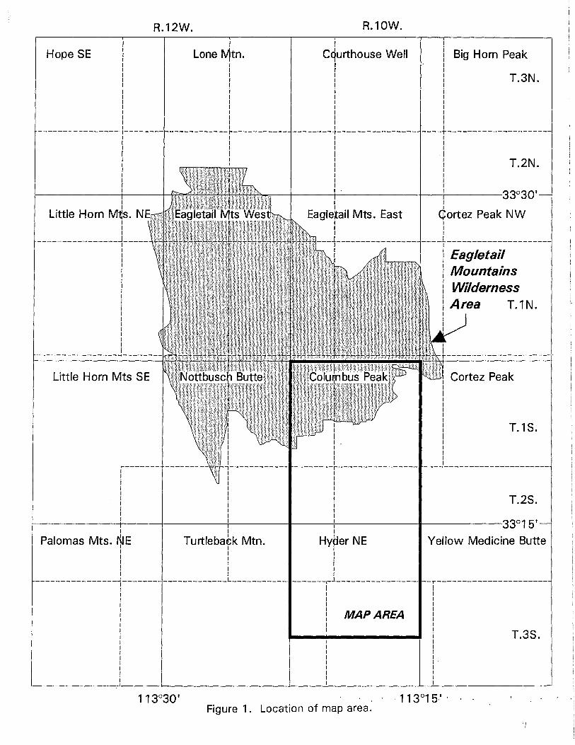
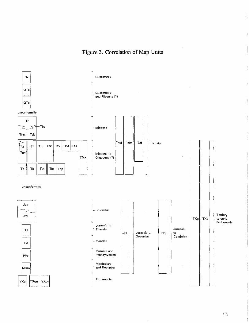
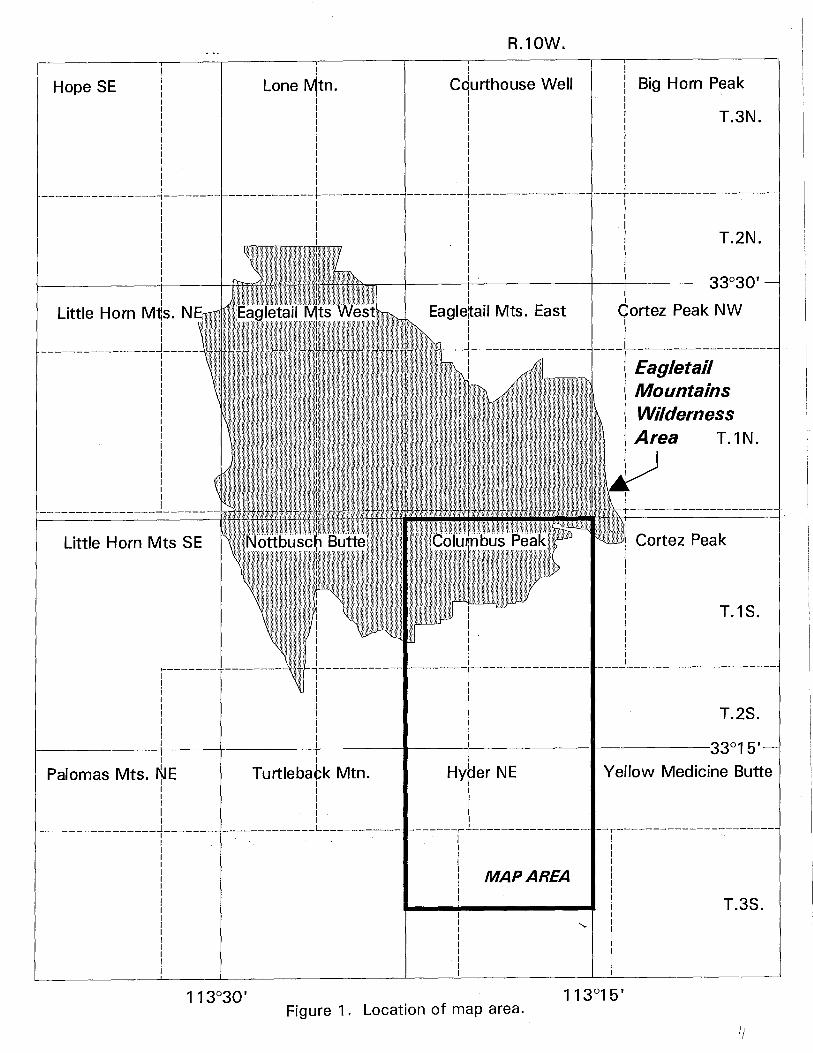
The area described in this study includes the western Gila Bend and the southern Eagletail mountains, Maricopa and La paz counties, Arizona. The study area encompasses all of the Columbus Peak Quadrangle (1:24,000) and the northern part of the Hyder Northeast Quadrangle (1:24,000), and is partially within the Eagletail Mountains Wilderness Area (Fig. 1). Bedrock in this area consists largely of scattered, limited exposures of Proterozoic to Jurassic metamorphic and igneous rocks intruded by a Miocene granitoid pluton and overlain by an extensive sequence of Miocene silicic volcanic rocks and subordinate mafic and intermediate volcanic units and continental clastic rocks (plate 1). Sources of data are shown in Figure 2, rock-unit correlations and relative ages are shown in Figure 3, and map symbols are shown in Table 1.
The area was mapped with funds provided to the Arizona Geological Survey by the U.S. Geological Survey COGEOMAP program, contract #14-08-0001-A0872. The views and conclusions contained in this document are those of the authors and should not be interpreted as necessarily representing the official policies, either expressed or implied, of the U.S. Government.
PREVIOUS INVESTIGATIONS
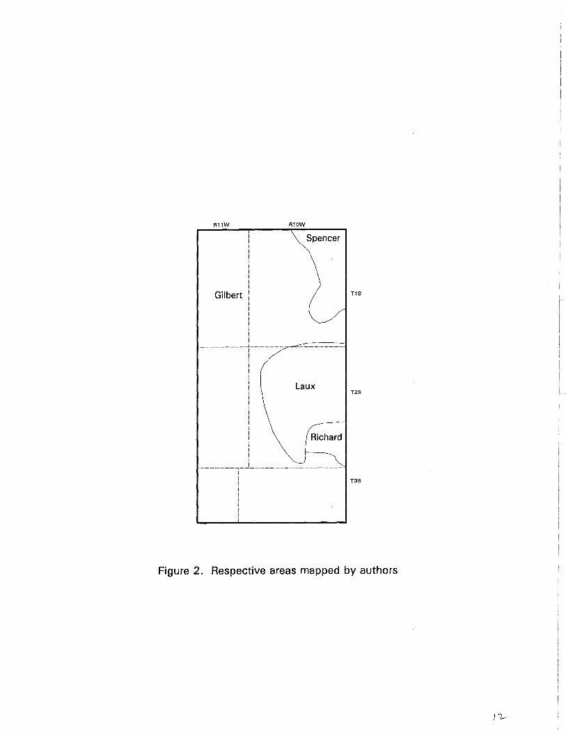
Previous geologic studies of the area include reconnaissance studies incorporated into State geologic maps by Wilson and others (1969) and Reynolds (1988), and reconnaissance mapping by Miller and others (1989) in the Eagletail Mountains. The area directly to the west of the study area was mapped by Gilbert and Spencer (1992) and the area directly to the north was mapped by Spencer and others (1992). Stratigraphic studies just east of the map area are presented by Scarborough and Wilt (1979). Some of the mineral deposits in the Gila Bend Mountains were described by Wilson (1933) and those in the southeastern Eagletail Mountains were described by Lane (1986) and Miller and others (1989). The upper Cenozoic surficial deposits were mapped and described by Demsey (1990).
GEOLOGIC SETTING
The study area is within the Basin and Range physiographic and tectonic province which underwent moderate to severe Tertiary extension and magmatism in west-central Arizona (Spencer and Reynolds, 1989). The study area and surrounding areas are characterized by northwest-trending normal faults and fault blocks.
Pre-Tertiary rocks consist of granitoid and amphibolite-grade crystalline rocks of probable Proterozoic age, and sparse, greenschist- to amphibolite(?)-grade metamorphosed Paleozoic and Mesozoic sedimentary and volcanic rocks. Sparse Paleozoic and Mesozoic strata were apparently metamorphosed and preserved from erosional destruction by regional Cretaceous thrusting and thrust burial (Reynolds and others, 1986; Spencer and Reynolds, 1990). Voluminous magmatism and normal faulting occurred in the early Miocene and were followed by middle Miocene basaltic magmatism.
STRUCTURE
Numerous northwest-trending high-angle faults cut all pre-Quaternary rock units in the map area. Displacements along these faults generally range from a few tens to a few hundred meters. In the western Gila Bend Mountains faults blocks generally dip moderately or steeply northeast to northwest. Vitrophyric and tuffaceous units, however, that cap the Picacho Hills are gently dipping, locally to the southwest. Rarely observed fault surfaces are characterized by up to a few meters of gouge and/or fault breccia.
2
A moderate- to low-angle fault juxtaposes mid-Tertiary granite (Tg) and mid-Tertiary volcanic units in the central part of the map area. Along this fault both upper- and lower-plate rocks are generally shattered for a few meters adjacent to the fault. The moderate to steep north and northeast dips of bedding in fault blocks above this fault suggests that displacement was top to the south or southwest. Normal faulting occurred largely before eruption of gently dipping vitrophyre (Tfv units) and gently southwest-dipping basalt (Tb).
Repetition of gently southwest-dipping basalt (Tb) capping the older mid-Tertiary volcanic rocks indicates the presence of one or more buried northwest-trending faults between the Eagletail Mountains and Cemetery Ridge.
MINERAL DEPOSITS
Several small mines are located within the southeastern Eagletail Mountains in the northeastern corner of the map area. This area is not within any of the mineral districts designated by Keith and others (1983). Two types of mineral deposit are present in this area. One type consists of fracture-filling specular hematite and chrysocolla with pervasive iron-oxide staining along steep, northwest-trending fractures and shear zones. Calcite, fluorite, chlorite, and relict sulfides are also present, and some shear zones host altered mafic dikes of probable Tertiary age (Lane, 1986). Galena and sphalerite are associated with fluorite at the Double Eagle Mine. Open-space-filling textures suggest a Tertiary age. These deposits resemble other middle Tertiary mineral deposits in western Arizona that are associated with mafic dikes (Spencer and Welty, 1989). The other type of deposit is represented by bull quartz veins in pre-Tertiary rocks. Some contain specular hematite and calcite, whereas others are not obviously associated with any other minerals.
Mineral deposits in the western Gila Bend Mountains form part of the Gila Bend Mountains mineral district, which has no reported production (Keith and others, 1983; see also Wilson, 1933). The deposits are characterized by open-space filling textures and typically contain pervasive iron-oxide staining and quartz with less abundant calcite and copper minerals (chrysocolla, malachite, relict chalcopyrite, and native copper). Open-space filling textures indicate a probable Tertiary age for the deposits. Two prospects are within or at the margin of the Miocene Columbus Wash pluton. Prospects discussed by Wilson (1933) in the western part of the map were not identified with certainty, but two prospects examined during this study (nos. 4 and 5 in Description of Mineral Deposits) probably are described by Wilson (1933).
A mid-Tertiary age for mineralization in the map area is indicated by four separate lines of evidence: (1) open-space filling textures, (2) occurrences of mineralization within the Columbus Wash pluton, (3) occurrences of mineralization within the Miocene-Oligocene(?) Ts map unit, and (4) association with Tertiary mafic dikes.
ACKNOWLEDGEMENTS
Assistance in the field by Thomas McGarvin (Arizona Geological Survey) and helpful discussions about the area's geology with Steve Reynolds (Arizona Geological Survey) are gratefully acknowledged. Financial support for Laux from Stanley B. Keith (Magmachem Exploration) is sincerely appreciated.
3
DESCRIPTION OF ROCK UNITS
Qs Surficial deposits (Quaternary)--Unconsolidated alluvium and colluvium, including talus, sand and gravel in modern washes, and unconsolidated to poorly consolidated gravel, sandy gravel, and sand, locally with silt or boulders, that typically forms flat, locally incised surfaces up to 5 meters above modern drainages.
QTc Pedogenic carbonate (Quaternary and Pliocene?)--Caliche-cemented gravel and sedimentary breccia (talus deposits?).
QTs Older surficial deposits (Quaternary to Miocene?)--Poorly to moderately consolidated fanglomerate with sub angular clasts, typically 1 to 10 cm, of mafic schist, granitoids, and Tertiary basalt. Possibly in part correlative with Tsb.
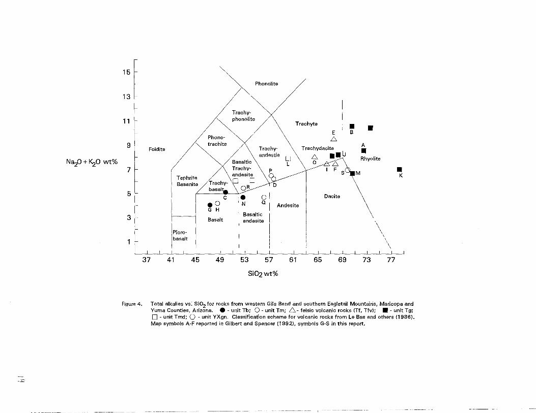
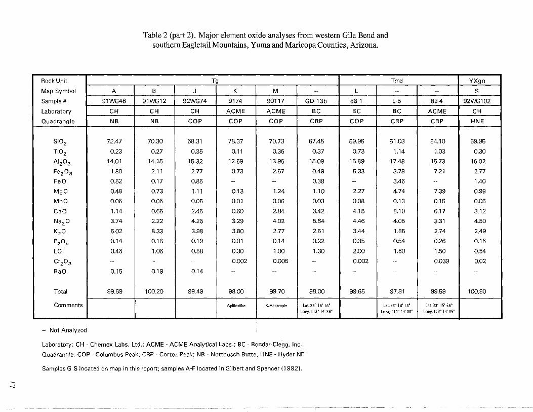
Th Basalt (middle to early Miocene)--Black to medium gray, fine-grained, locally porphyritic, olivine basalt. Groundmass is locally trachytic. Typically occurs as mesa-capping flows. Textural varieties include massive, vesicular to nonvesicular, platy, scoriaceous (red and black), and agglomeratic. Generally very resistant to weathering and weathers into resistant blocks. Major-element oxide chemistry of two samples (sample locations G and N) from this unit is reported in Table 2 and Figure 4.
Tbs Sandstone (early Miocene to late Oligocene)--Sandstone that underlies or is interbedded with map unit Th. Includes buff, medium- to coarse-grained, sub angular to sub rounded feldspatholithic sandstone with lenses of map unit Tsb up to 15 cm thick, and fine-grained, well-sorted, eolian, lithofeldspathic sandstone.
Tnrt Rhyolite tuff of Nottbusch Valley (early Miocene to late Oligocene)--Tan to cream to yellow lapilli crystal tuff and tuffaceous sandstone. Resembles map units Tft and Tst, and conformably underlies map unit Th. This unit is correlated with the Rhyolite of Nottbusch Valley as mapped and named by Grubensky and Demsy (1991).
Tsb Sedimentary breccia (early Miocene to late Oligocene)--Light tan, crudely stratified, sedimentary breccia (fanglomerate) with sub angular cobbles of granodiorite (Tgd) and foliated diorite (Jmi; 60-90%), felsic volcanic rocks (Tf; 10-40%), and minor basalt. At and near the top of the unit it is locally interbedded with sandstone of overlying map unit Tbs.
Tdf Felsic dikes (early Miocene to late Oligocene)--Gray, resistant, intermediate to felsic dikes and hypabyssal intrusions with approximately 1 % biotite and sparse plagioclase in a microcrystalline to aphanitic groundmass. Ridges underlain by Tdf in the western part of the map area consist predominantly of porphyritic hypabyssal rocks overlain by welded tuff.
Tdm Mafic dikes (early Miocene to late Oligocene)--Aphanitic, porphyro-aphanitic, and fine-grained mafic and intermediate dikes and small intrusions.
Tfu Felsite (early Miocene to late Oligocene)--Brick-red to light-pink, flow-banded felsite and felsite crystal tuff. Commonly contains fragments or phenocrysts of Plagioclase, biotite, and hornblende. Resembles Tf, but probably the youngest felsic volcanic unit.
Tfvt Vitrophyre and tuff (early Miocene to late Oligocene)--Heterogeneous unit characterized by dark gray to black vitrophyre and vitrophyre breccia interbedded with lapilli-crystal tuff as in unit Tft and crystal-vitric welded tuff as in unit Tf.
Tfvx Vitrophyre breccia (early Miocene to late Oligocene)--Buff weathering, light gray, partially devitrified vitrophyre breccia and subordinate dark gray vitrophyre in Picacho Hills.
Tfv Vitrophyre (early Miocene to late Oligocene)--Dark gray to black vitrophyre flows and breccia. Up to 30% of the rock consists of phenocrysts of hornblende, biotite, plagioclase, iron oxides, +/- quartz set in a glassy groundmass. Commonly light gray where partially devitrified. Locally grades into partially devitrified vitrophyre and then into map unit Tf. Major element oxide chemistry of these rocks (sample I from this map area) suggests that they
4
are cogenetic with felsic flows and tuff of map unit Tf (Table 2; Fig. 4). Tft Felsic tuffs, undivided (early Miocene to late Oligocene)--White to light-tan to yellow, fine-
grained felsic crystal tuff and lapilli crystal tuff. Moderately consolidated and commonly bedded. Locally contains approximately 1 % 1- to 2-mm euhedral biotite crystals. Locally grades into welded tuff and contains minor amounts of tuffaceous sandstone.
Tf Felsic volcanic rocks, undivided (early Miocene to late Oligocene)--Lavender to light pinkish tan to buff felsic flows, pyroclastic rocks, and probable hypabyssal intrusions. In the northeastern part of the map area this unit consists predominantly of red to purplish tan, flowbanded rhyolite that is generally brecciated. In this area Tf commonly displays red and gray bands 5 to 20 m long and 10 to 50 mm thick. Locally interbedded with and grades into dark gray vitrophyre. Major element oxide chemistry of unit Tf (includes sample 0 from this map area) indicates that the composition of the unit ranges from dacite to trachydacite (Table 2; Fig. 4).
Tfx Felsic volcanic breccia (early Miocene to late Oligocene)--Brown weathering felsic breccia composed of 30% to 90% felsite fragments up to 10 cm long set in a groundmass of pale gray aphyric rhyolite. Interbedded with Tm in eastern part of the map area, and forms spectacular cliffs along the eastern front of the Eagletail Mountains in the northeastern part of the map. Is found as a minor component of Tf throughout the map area.
Tst Tuffaceous sandstone and tuff (early Miocene to late Oligocene)--Yellow, medium- to coarse-grained tuffaceous sandstone and crystallapilli tuff. Resembles rocks of map units Tnrt and Tft, but generally interbedded with units Tc and Tm.
Tm Mafic and intermediate volcanic rocks (early Miocene to late Oligocene)--Gray-, brown-, and purple-weathering, fine- to medium-grained, mafic to intermediate volcanic rocks. Commonly contains plagioclase (altered), clinopyroxene, and hornblende phenocrysts. Locally displays secondary epidote. Massive to highly fractured and locally amygdaloidal. Commonly weathers into 1 to 10 cm diameter pieces. In the eastern part of the map area, this unit can be subdivided into lower and upper members separated by the Tfx and Tst map units. The lower member locally contains small, corroded quartz phenocrysts. Thin beds of volcaniclastic (arkosic) sediments are also intercalated with the lower member. The upper member commonly displays a mottled texture. In northeast part of the map area the unit is generally an andesitic volcanic breccia. The unit is cut by locally abundant silica and calcite veins and veinlets. Red to purple liesegang banding is present locally. Chemical classification of these rocks (samples H, P, Q, and R from this map) ranges from basalt to trachyandesite (Table 2, Fig. 4).
Tap Andesite porphyry (early Miocene to late Oligocene)--Brown-weathering, light-tan, porphyritic, intermediate intrusion. Typically contains 30% to 40% phenocrysts of plagioclase up to 2 cm long and of biotite and hornblende up to 1 cm long set in a light tan, plagioclasedominated, aphanitic to fine-grained groundmass. Probably hypabyssal equivalent of map unit Tm.
Tc Conglomerate (early Miocene to late Oligocene)--Red, gray, and green granule to boulder conglomerate. Clasts are well rounded and average approximately 7 to 10 cm across; maximum clast size ranges up to a meter across. The conglomerate displays crude stratigraphic layering and was possibly deposited as matrix-supported debris flows. In the central and eastern part of the map area, imbrication of tabular clasts generally indicates that the unit was derived from a source to the north. In the western part of the map area clasts were derived from granitic and metamorphic rocks, with about 30% of the clasts derived from megacrystic biotite granite (proterozoic?). In the central part of the map area, units bearing up to 30% volcanic clasts are present (Tcv), and in the eastern part of the map area clasts in
5
the conglomerate are of highly variable lithology, consisting of numerous plutonic, metamorphic, and volcanic rock types, including Jurassic(?) quartz porphyry and related volcaniclastic rock types. Includes local, thin, light-gray to pink, interbedded lapilli tuff.
Ts Sedimentary rocks, undivided (early Miocene to late Oligocene)--Conglomerate, sandstone, mudstone, and limestone. This unit is generally brick red, medium- to coarse-grained, moderately sorted to poorly sorted, subangular, feldspatholithic, pebbly sandstone with subordinate granule to pebble conglomerate layers up to 25 cm thick. The unit grades upward into the conglomerate unit (Tc). In the southeastern Eagletail Mountains pebbles and cobbles in this unit consist primarily of subrounded to sub angular bull quartz up to lO cm long with less abundant granitoids and Proterozoic metamorphic rocks. In eastern areas this unit consists of interbedded red mudstone, red to gray arkose, light to dark gray, commonly cherty limestone, and purple to gray shale. Based on the presence of charophyte fossils in the limestone, the unit formed in a lacustrine (freshwater) environment. Similar sedimentary rocks are present along the Arlington-Agua Caleinte Road to the southeast. An interbedded tuff in this section has yielded an age of 23.7 Ma (Scarborough and Wilt, 1979). The contact between this unit and the overlying conglomerate is an angular unconformity.
Tmd Microdiorite (early Miocene to late Oligocene)--Green, fine-grained micro diorite forms WNWtrending elongate intrusions within Tgd. The micro diorite is composed of subequal amounts of plagioclase and hornblende. The hornblende displays both equigranular and wispy, acicular textures; the plagioclase is equigranular. Major element oxide chemistry of these rocks suggests that they are more likely to be cogenetic with older mafic and intermediate volcanic rocks (Tm) than with younger basalts (Tb) (Table 2; Fig. 4).
Tga Altered granodiorite (early Miocene to late Oligocene)--The southeast part of the Columbus Wash granodiorite contains a zone of pervasive propylitic alteration (Tga) along the fault contact with amphibolite (YXa).
Tg Columbus Wash granodiorite (early Miocene to late Oligocene)--White, medium-grained, equigranular, hornblende-biotite granodiorite that locally grades into quartz monzonite. Generally comprises approximately 35-40% plagioclase, 20-25% quartz, 20-25% pink sanidine, 15% biotite, 2-4% hornblende, and accessory magnetite and sphene. The presence of sanidine is uncommon in plutonic rocks and indicates that the pluton cooled rapidly. Pink to white aplite dikes and sills are common. The aplite contains abundant miarolitic cavities lined with euhedral quartz, feldspar, and epidote. The aplite also contains accessory sphene. All younger bounding units are in fault contact with the pluton. The pluton locally grades into unit TXg. Major element oxide chemistry of three samples (J, K, and M) from the Columbus Wash Granodiorite is reported in Table 2 and Figure. 4. A sample of the Columbus Wash granodiorite yielded a biotite K-Ar date of 22.9±0.5 Ma (M. Shafiqullah, written communication, 1992).
TXq Quartz vein (Miocene to Proterozoic)--A prominent quartz vein cuts TXq in the southern Eagletail Mountains (SE 114, Sec. 9, T. 1 S., R. lO W.).
TXg Granite to Granodiorite (Miocene to Proterozoic)-- Reddish-brown weathering, medium to fine-grained leucocratic granitoids, equigranular, nonfoliated to moderately foliated, and commonly strongly fractured. Feldspars and mafic minerals are commonly altered to sericite, chlorite, and epidote. Mafic minerals are altered to iron oxides except locally where some biotite is preserved. Sparse 1- to lO-cm-thick bull-quartz veins are characteristic in the southern Eagletail Mountains and indicate that this unit is probably pre-Tertiary in age.
In the southern Eagletail Mountains this unit includes local, small, irregular intrusions of dark-green hypabyssal mafic rock (map unit Jmi) that contain little or no quartz. Both rock types may have a strong fracture cleavage. Intrusions of Jmi are not obviously associated
6
with any mineral deposits, in contrast to younger, northwest-trending mafic dikes (map unit Tmd) that do not have strong fracture foliation and are mineralized (see deposit #2 in Description of Mineral Deposits, and Lane, 1986).
Jvs Schist derived from Jurassic volcanic and volcaniclastic rocks (Jurassic)--Light green, purple, or light gray sericite-feldspar schist and phyllite. Contains porphyroclasts of quartz and feldspar. Probably derived from a mixture of tuffaceous and pelitic sediments. Lithologic variations are interpreted as reflecting original compositional variations in Jurassic volcaniclastic rocks and minor interbedded nonvolcaniclastic sedimentary rocks.
Jmi Mafic and intermediate metaigneous rocks (Jurassic)--Dark-green, medium- to fine-grained, foliated, actinolitic diorite and dark-green, fine-grained, foliated actinolitic metabasite. This unit contains minor amounts of light-gray, lavender and green phyllite and banded quartzite. In the southwestern part of the map area this unit grades over several tens of meters into schist (map unit Jvs).
JTrs Schist, undivided (Jurassic to Triassic)--Green, quartz-poor schist and light gray sericite-quartz schist. Locally includes phyllite and minor iron-stained calc-schist and layers of black quartzite up to 1m thick. Commonly displays crenulations and S2 cleavage. May vary over distance of as little as a few meters from blocky and mica-poor to sericitic or chloritic and very platy.
Pc Coconino Sandstone (permian)--Pure white quartzite, pink to black weathering. PPc Supai Group (permian and Pennsylvanian)--Impure and possibly calcareous quartzite with
1 to 5 cm thick limestone interbeds. MDm Dolomite and calcite marble (Mississippian and Devonian)--Largely pale-tan to pale-gray
dolomitic marble correlative with the Devonian Martin Formation and the Mississippian Redwall Limestone. Locally contains siliceous laminations that are revealed by differential weathering and color (siliceous laminations form brown protruding layers).
JDI Limestone (Jurassic to Devonian)--A ten meter thick gray limestone bounds quartzite of JCq on the northwest in NE 1/4, sec. 15, and SE 114, sec. 10, T. 2 S., R. 11 W. The limestone generally contains silty partings up to 1 cm thick but is locally massive.
JCq Quartzite (Jurassic to Cambrian)--Brown to lavender weathering, gray, banded quartzite (with minor feldspar) in the southwest edge of the map (NE 114, sec. 15, and SE 114, sec. 10, T. 2 S., R. 11 W.). This unit includes iron-stained, white and gray, medium to coarse-grained schistose quartzose sandstone.
YXgn Gneiss (middle to early Proterozoic)--Undivided, highly variable, hornblende-biotite quartzofeldspathic gneiss. Probably derived from both igneous and sedimentary protoliths. Cut by common magnetite-bearing pegmatite dikes. Also contains local amphibolitic gneiss bands. Although the contact with amphibolite unit (YXa) is not well exposed, it is probably gradational. In the southern part of the map area the unit is predominantly a foliated, biotite granodiorite. Major-element oxide chemistry of one sample (sample S) from foliated granodiorite is reported in Table 2 and Figure 4.
YXa Amphibolite (middle to early Proterozoic)--Mostly dark-green, coarse- to fine-grained, foliated amphibolite consisting dominantly of hornblende and plagioclase. Hornblende porphyroblasts are present locally. Calc-silicate alteration (epidote and garnet?) is widespread but minor volumetrically. The amphibolite is intruded by common, generally concordant, foliated felsic dikes. A prominent NNE-trending ferruginous chert (exhalite?) occurs within this unit in the eastern area of exposure.
YXps Pelitic schist (middle to early Proterozoic)--Biotite-feldspar schist with porphyroblasts of garnet and staurolite. Small amounts of quartz and kyanite(?) are also present.
7
DESCRIPTION OF MINERAL DEPOSITS (The following descriptions correspond to numbered locations on the geologic map.)
Southern Eagletail Mountains
(1) White and black calcite veins and bull quartz veins, 2 to 10 cm thick. Iron oxide staining is common. (2) Fracture-filling specular hematite and chrysocolla and pervasive iron-oxide staining on fracture
surfaces that tend to be steep and northwest striking. Sparse relict pyrite that formed crystals up to 1 cm across are represented by amorphous iron oxides. This type of mineral deposit is present at many prospects in this general area (see also Lane, 1986). At this specific location mineralization was pervasive and resultant deposits are associated with a highly altered, northwest-trending (N50"W 800 SW) mafic dike up to 1 m thick. Bull quartz veins were also mined in this area but are not directly associated with fracture-filling iron-oxide bearing deposits. It appears that two types of deposit are coincidentally present in the same area here.
(3) Double Eagle Mine. Mine shaft in Quaternary surficial deposits adjacent to hill of Paleozoic dolomite marble. Mine dump contains abundant fragments of silvery gray, fine-grained schist that is just slightly more recrystallized than a phyllite. Protolith was probably Mesozoic tuffaceous or finegrained sedimentary rocks. Dump samples contain fracture-filling clear fluorite up to 15 mm diameter and sparse fracture-fIlling malachite and relict pyrite (now iron oxides) up to 1 cm diameter. Open-space filling textures and local vugs are present.
Gila Bend Mountains
(4) Outlaw mine. Highly fractured bull quartz veins, 10 to 100 cm thick, contain pervasive fracturecoating iron oxides. Host rocks are Cortez Peak granite and metamorphic rocks intruded by the granite. Veins are broadly associated with intrusive margin of granite.
Wilson (1933) describes the Bill Taft Group, Belle Mackeever Group, and Yellow Breast Prospect in the Gila Bend Mountains. Localities 4 and 5 probably correlate with one or more of these claim groups. The U.S. Bureau of Land Management (1987) identifies the Outlaw Mine as the Taft group.
(5) Stardust mine. Large mine dump indicates many hundreds of feet of mine workings. Dump consists of pre-Cretaceous mafic gneisses with fracture-coating iron oxides. Sparse bull quartz is highly fractured and contains iron oxides and local manganese oxides on fracture surfaces. Local open-space filling textures associated with vein quartz and very sparse chrysocolla. Probably the Camp Creek Prospect discussed by Wilson (1933).
(6) Black Silver mine. A 1 O-m-deep , inclined adit is driven on a 1-m-thick vein trending NlOoE and dipping 28 oW. The hanging wall of the vein consists of highly shattered Columbus Wash pluton with a matrix of brown calcite and quartz. The vein consists of white, medium-grained quartz and irregular zones of brown calcite. Both the vein and brecciated granite are cut by dark gray to black, coarse-grained calcite (2-20 mm). Material observed on the adit dump includes banded and colloform chalcedonic quartz veins, copper oxides (chrysocolla and malachite), and hematite. North of the inclined adit is a caved-in shaft; the upper 10 m of the shaft is within alluvium. Common copper oxides and brecciated granite are present on the dump adjacent to the shaft.
(7) Copper Camp area (GF claims). Copper and iron deposits are present within highly fractured, pervasively limonitized amphibolite and gneiss, and are predominantly localized by moderate- to highangle, W to WSW-trending, south-dipping shear zones. Copper deposits are generally confined to relatively narrow « 1 m thick) zones within strongly limonitized host rock. The deposits consist predominantly of chrysocolla with lesser malachite. Rare chalcopyrite and native copper are locally present. Mineral deposits are commonly associated with limonitized, silicified breccia, open-space
8
quartz (locally amethystine) filings, chalcedonic quartz, and specular hematite. White, coarsely crystalline barite veins are also common and widespread. Local, irregular, bleached, highly-altered dikes are associated with mineralization. Geochemically, mineral deposits are characterized by strongly anomalous copper, moderately to strongly anomalous zinc, lead, and barium, and weakly to moderately anomalous silver, manganese, bismuth, boron, and gold. Generally Ag:Au ratios tend to be high, and arsenic, antimony, and mercury values are typically not anomalous. Older NNEtrending ferruginous chert zones (exhalite?) are also present within the amphibolite unit (YXa) in the area.
(8) A steep, 2- to 5-cm-thick, chrysocolla vein cuts the Ts map unit at this locality. Economically this mineralization is insignificant, but it does provide important geologic constraints. Charophyte microfossils present within limestone strata of this unit range from the Middle Eocene to the present, precluding a Laramide age for copper mineralization. Local, minor copper deposits are also present in other outcrops of map unit Ts and in the Tc and Tm map units.
9
REFERENCES CITED
Demsey, K.A., 1990, Geologic map of Quaternary and upper Tertiary alluvium in the Little Horn Mountains 30 x 60-minute quadrangle, Arizona: Arizona Geological Survey Open-File Report 90-8, scale 1:100,000.
Gilbert, W.G., and Spencer, J.E., 1992, Geology of Cemetery Ridge, Clanton Hills, and westernmost Gila Bend Mountains, La paz and Yuma Counties, Arizona: Arizona Geological Survey Open-File Report 92-4, scale 1:24,000.
Grubensky, M.J., and Demsey, K.A., 1991, Geologic map of the Little Horn Mountains 15' Quadrangle, southwestern Arizona: Arizona Geological Survey Map 29, scale 1:50,000, 10 p.
Keith, S.B., Gest, D.E., DeWitt, Ed, Woode-Toll, Netta, and Everson, B.A., 1983, Metallic mineral districts and production in Arizona: Arizona Bureau of Geology and Mineral Technology Bulletin 194, 58 p.
Lane, M.E., 1986, Mineral investigation of a part of the Eagletail Mountains Wilderness Study Area (AZ-020-128), La Paz, Maricopa, and Yuma Counties, Arizona: U.S. Bureau of Mines Open-File Report MLA 45-86, 16 p.
Le Bas, M.J., Le Maitre, R.W., Streckeisen, A., and Zanettin, B., 1986, A chemical classification of volcanic rocks based on the total alkali-silica diagram: Journal of Petrology, v. 27, p. 745-750.
Miller, R.J., Gray, F., Hassemer, J.R., Hanna, W.F., Pitkin, J.A., Hornberger, M.I., Jones, S.L., and Lane, M.E., 1989, Mineral resources of the Eagletail Mountains wilderness study area, La Paz, Maricopa, and Yuma Counties, Arizona: U.S. Geological Survey Bulletin 1702, scale 1:50,000, 18 p.
Reynolds, S.J., 1988, Geologic map of Arizona: Arizona Geological Survey Map 26, scale 1:1,000,000. Reynolds, S. J., Spencer, J. E., Richard, S. M., and Laubach, S. E., 1986, Mesozoic structures of
west-central Arizona, in Beatty, B., and Wilkinson, P., eds., Frontiers in the geology and ore deposits of Arizona and the Southwest: Arizona Geological Society Digest, v. 16, p. 35-51.
Scarborough, R., and Wilt, J.C., 1979, A study of uranium favorability of Cenozoic sedimentary rocks, Basin and Range Province, Arizona, Part I, General geology and chronology of pre-late Miocene Cenozoic sedimentary rocks: Arizona Bureau of Geology and Mineral Technology Open-File Report 79-1, 101 p.
Spencer, J. E., and Reynolds, S. J., 1989, Middle Tertiary tectonics of Arizona and the Southwest, in Jenney, J. P., and Reynolds, S. J., eds., Geologic evolution of Arizona: Arizona Geological Society Digest, v. 17., p. 539-574.
Spencer, J. E., and Reynolds, S. 1., 1990, Relationship between Mesozoic and Cenozoic tectonic features in west-central Arizona and adjacent southeastern California: Journal of Geophysical Research, v. 95, p.539-555.
Spencer, 1. E., and Welty, J. W., 1989, Mid-Tertiary ore-deposits in Arizona, in Jenney, 1. P., and Reynolds, S. J., eds., Geologic evolution of Arizona: Arizona Geological Society Digest, v. 17., p. 585-607.
Spencer, I.E., Gilbert, W.G., and Richard, S.M., 1992, Geologic map of the eastern Eagletail Mountains, Maricopa, La Paz, and Yuma counties, Arizona: Arizona Geological Survey Open-File Report 92-3, scale 1:24,000.
U.S. Bureau of Land Management, 1987, Lower Gila South final wilderness environmental impact statement, 321 p.
Wilson, E.D., 1933, Geology and mineral deposits of southern Yuma County, Arizona: Arizona Bureau of Mines Bulletin 134, 236 p.
Wilson, E.D., Moore, R.T., and Cooper, J.R., compilers, 1969, Geologic map of Arizona: Tucson, Arizona Bureau of Mines and U.S. Geological Survey, Scale 1:500,000.
10
R.12W. R.10W.
Hope SE Lone rthouse Well Big Hom Peak
T.3N. I I I I I I I I I I I I I I I
I -------------"1----------I-------------t------ I I --------t------------·-----i----t"------------------I I I
I I I I I I
I I
I I I I T.2N. I
I I
I I I I I I
I I
~--+-----~------------~---T'---------33°30'
Little Hom . N
I _______________ J ____ _ I I I I I I I I I I I I i I I I I I I I I
------------~------
Little Horn Mts SE
I I I I I I I I
l---------I·-----------'"":i+..j------------· .. --------~----------------I I I I I I i I I I I I I I I I I I Iii
I I I I I
I
qortez Peak NW I I I _1 _______________ _ I
! Eagletail ! Mountains ! Wilderness I
I Area T.1N.
I I I I I I I I I I I I I I
---------------_._--_.+
T.1S.
__ J ____________________ _
T.2S.
r-----------~----~--------r-------~-----r-----------+-----------33°15' I
Palomas Mts. ~E Turtleback Mtn. I I I I I I
I : I I
Hy(Jer NE I I I I
-------------j--------i-----·--------L---------·---tl--------,-..... _-_._--_._--I I I I I I I I I i I I I I I I !
MAP AREA
Figure 1. Location of map area.
Yellow Medicine Butte
-------------_.-----------j
T.3S.
R11W
I I I I I I I I I I I
Gilbert i I I I I I I I i
---------~-------I I I I I !
R10W
Spencer
Laux
-------,---------------------
T1S
T2S
: T3S i I I I I I I
Figure 2. Respective areas mapped by authors
unconformity
~b
Tbs
Tnrt Tsb
r.l tJ
Tt Tft Tfx Ttv I Tfvt I Ttu
G GEJEEJ unconformity
~ L:J EJ B EJ EJ
I YXa I IYXgnl IYXPSI
Figure 3. Correlation of Map Units
Tfvx
'----
} Quaternary
)
Quaternary and Pliocene (7)
Tmd Tdm Tdf Tertiary
Miocene to Oligocene (?)
}
Jurassic to Triassic
} Permian
}
Permian and Pennsylvanian
}
Missippian and Devonian
} Proterozoic
JDI Jurassic to Devonian
JCq Jurassic to Cambrian
TXg TXq Tertiary to early Proterozoic
Na:p+~O wt%
-S::
15
13 t ~PhO""';t,
Trachy-
11 f-- /"'-. phonolite / \ Trachyte • • E B
Phono- X L::,. 9 f-- /~ trachite
Trachy-A
Foidite • andestie 0 Rhyolite
7 ~ / Basaltic L Trachy- P • andesite CO
M K Tephrite 0 Basanite OR D
5 ~ C • 0 Dacite
.0 N Q Andesite
G H
3 f-- Basaltic Basalt andesite
Picro-
1 f-- I basalt
37 41 45 49 53 57 61 65 69 73 77
Si02wt%
Figure 4. Total alkalies vs: Si02 for rocks from western Gila Bend and southern Eagletail Mountain"s, Maricopa and Yuma Counties, Arizona. • - unit Tb; 0 - unit Tm; L::,. - felsic volcanic rocks (Tf, Tfv); • - unit Tg; o -unit Tmd; 0 - unit YXgn. Classification scheme for volcanic rocks from Le Bas and others (1986). Map symbols A-F reported in Gilbert and Spencer (1992), symbols G-S in this report.
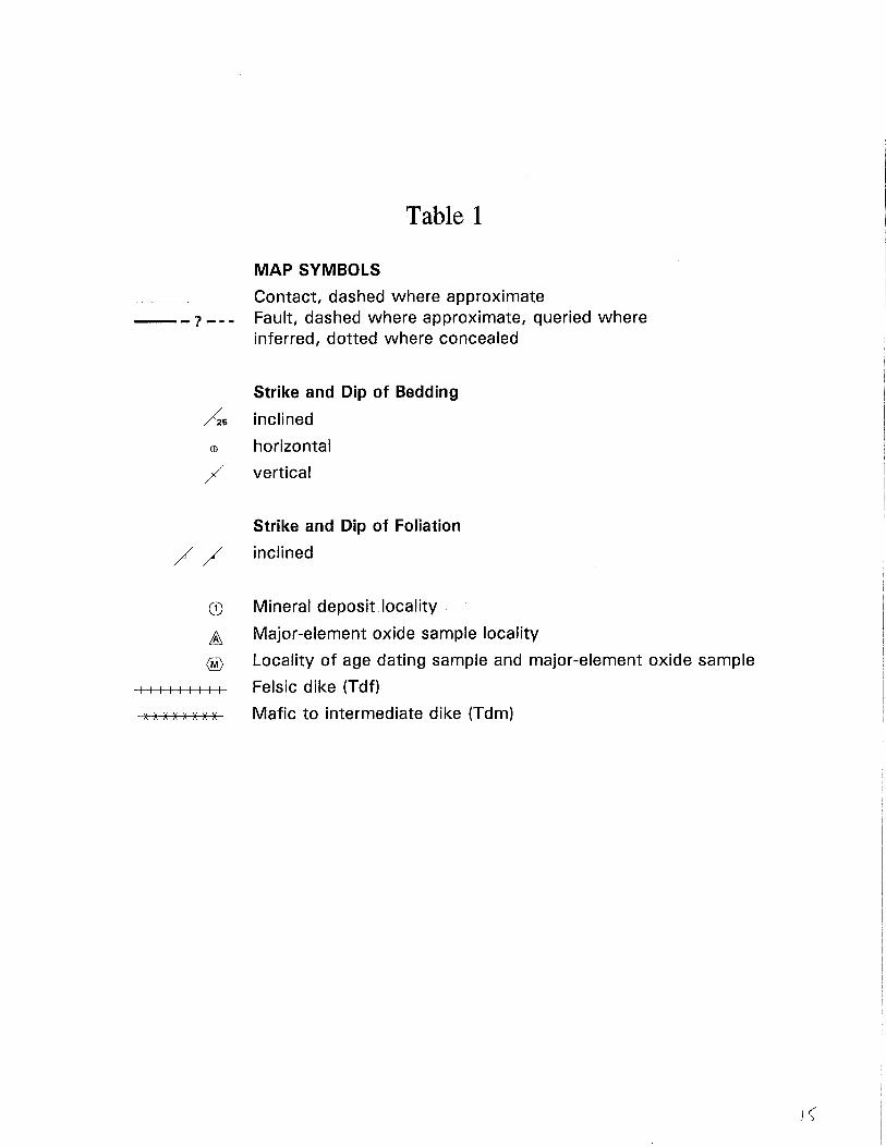
Table 1
MAP SYMBOLS
Contact, dashed where approximate ___ ? _. • Fault, dashed where approximate, queried where
inferred, dotted where concealed
Strike and Dip of Bedding
As inclined
Ell horizontal
/ vertical
Strike and Dip of Foliation
/ / inclined
CD Mineral deposit locality
~ Major-element oxide sample locality
® Locality of age dating sample and major-element oxide sample
I I I I I I I I I Felsic dike (Tdf)
x x )( )( )( )( )( )( Mafic to intermediate dike (Tdm)
0--
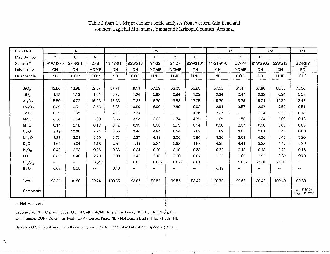
Table 2 (part 1). Major element oxide analyses from western Gila Bend and southern Eag1etail Mountains, Yuma and Maricopa Counties, Arizona.
Rock Unit Tb Tm
Map Symbol C G N D H P Q
Sample # 91WG33b 2-6-92-1 CFB 11-18-91-5 92WG16 91-32 91-27
Laboratory CH CH ACME CH CH ACME ACME
Quadrangle NB COP COP NB COP HNE HNE
Si02 49.50 46.95 52.57 57.71 48.13 57.29 56.20
Ti02 1.15 1.13 1.04 0.82 1.24 0.88 0.94
AI2 0 3 15.50 14.72 16.98 16.38 17.32 16.70 16.53
Fe2 0 3 9.30 9.51 8.63 6.36 10.50 6.90 7.89
FeO 0.39 6.05 -- 4.19 2.24 -- --
MgO 8.30 10.54 5.39 3.55 3.93 3.03 3.74
MnO 0.14 0.15 0.13 0.12 0.15 0.08 0.09
CaO 8.18 10.65 7.74 6.55 9.40 4.84 6.24
Na 2 0 3.38 3.01 3.60 3.78 2.97 4.19 3.68
K2 0 1.64 1.04 1.18 2.54 1.18 2.34 0.99
P2 0 5 0.48 0.63 0.26 0.33 0.34 0.20 0.19
LOI 0.65 0.40 2.20 1.80 3.46 3.10 3.20
Cr2 0 3 -- -- 0.017 -- 0.03 0.002 0.022
BaO 0.08 0.08 -- 0.10 -- -- --
Total 98.30 98.80 99.74 100.05 98.65 99.55 99.55
Comments
-- Not Analyzed
Laboratory: CH - Chemex Labs, Ltd.; ACME - ACME Analytical Labs.; BC - Bondar-Clegg, Inc.
Quadrangle: COP - Columbus Peak; CRP - Cortez Peak; NB - Nottbusch Butte; HNE - Hyder NE
Samples G-S located on map in this report; samples A-F located in Gilbert and Spencer (1992).
Tf
R E ° 92WG104 11-21-91-6 CWPP
CH CH ACME
HNE NB COP
52.50 67.63 64.41
1.02 0.34 0.47
17.05 15.79 15.79
8.92 2.91 3.57
4.66 2.07 --
4.75 1.05 1.56
0.14 0.06 0.07
7.63 1.69 2.81
3.84 3.36 3.63
1.58 6.25 4.41
0.33 0.22 0.19
0.67 1.23 3.00
0.01 -- 0.002
-- 0.19 --
98.42 100.70 99.63
Tfv Tdf
F I --
91WG96a 92WG13 GD-RHY
CH CH BC
NB HNE CRP
67.86 66.35 73.56
0.38 0.34 0.08
15.01 14.52 13.46
2.67 2.58 0.51
1.04 0.29 0.19
1.04 1.03 0.13
0.06 0.05 0.03
2.61 2.46 0.60
4.20 3.42 5.20
3.39 4.17 5.30
0.18 0.19 0.13
2.98 5.30 0.70
I <0.01 <0.01 --
-- -- --
100.40 100.40 99.89
Lat.33" 16' 00" Long.113" 14' 25"
-.)
Table 2 (part 2). Major element oxide analyses from western Gila Bend and southern Eagletail Mountains, Yuma and Maricopa Counties, Arizona.
Rock Unit Tg
Map Symbol A B J K M --
Sample # 91WG46 91WG12 92WG74 9174 90117 GD-13b
Laboratory CH CH CH ACME ACME BC
Quadrangle NB NB COP COP COP CRP
Si02 72.47 70.30 68.31 78.37 70.73 67.45
Ti02 0.23 0.27 0.35 0.11 0.36 0.37
AI20 3 14.01 14.15 15.32 12.59 13.96 15.09
Fe2 0 3 1.80 2.11 2.77 0.73 2.57 0.49
FeO 0.52 0.17 0.85 -- -- 0.38
MgO 0.48 0.73 1.11 0.13 1.24 1.10
MnO 0.05 0.05 0.05 0.01 0.06 0.03
CaO 1.14 0.65 2.45 0.60 2.84 3.42
Na2 0 3.74 2.22 4.25 3.29 4.02 5.64
K2 0 5.02 8.33 3.98 3.80 2.77 2.51
P2 0 5 0.14 0.16 0.19 0.01 0.14 0.22
LOI 0.46 1.06 0.58 0.30 1.00 1.30
Cr20 3 -- -- -- 0.002 0.006 --
BaO 0.15 0.19 0.14 -- -- --
Total 99.69 100.20 99.49 98.00 99.70 98.00
Comments Aplite dike K1Arsample Lat.33· 16' 16" Long. I 13· 14' 36"
-- Not Analyzed
Laboratory: CH - Chemex Labs, Ltd.; ACME - ACME Analytical Labs.; BC - Bondar-Clegg, Inc.
Quadrangle: COP - Columbus Peak; CRP - Cortez Peak; NB - Nottbusch Butte; HNE - Hyder NE
Samples G-S located on map in this report; samples A-F located in Gilbert and Spencer (1992).
Tmd
L --
88-1 L-5
BC BC
COP CRP
59.95 51.03
0.73 1.14
16.89 17.48
5.33 3.79
-- 3.46
2.27 4.74
0.08 0.13
4.15 8.10
4.46 4.05
3.44 1.85
0.35 0.54
2.00 1.60
0.002 ---- --
99.65 97.91
Lat.33· 16' 16" Long. I 13· 14' 00"
YXgn
-- S
89-4 92WG102
ACME CH
CRP HNE
54.10 69.95
1.03 0.30
15.73 16.02
7.21 2.77
-- 1.40
7.39 0.99 I
0.15 0.05
6.17 3.12
3.31 4.50
2.74 2.49
0.26 0.16
1.50 0.54
0.039 0.02
-- --
99.59 100.90
Lat.33· 15' 56" Long. 113· 14' 35"
I
Hope SE i Lone Njtn. I I I I I I I I I I i I I I I I I I I I I I
I I I i I I I I I I
R.10W.
rthouse Well Big Horn Peak
T.3N.
I I I I -------------j---------f---------------t----------- ________ ~-----------------l-----+-------------------------I I I I I I I I I I I I
I I I I I I I I I I
T.2N.
...----+---+------+-+----33°30'
Little Horn
________________ ..J
I I I I I I I I I I i I I I I I I I
N
______________ J ___ _
Little Horn Mts SE
.--------+-I I i I I I I
I I I
I I I I I I I I I I ,------------.------- ---r---------------I I I I I I I I I I I I
i I I
I
q:ortez Peak NW I I I
i Eagletail I i Mountains I
: Wilderness I
I Area T.1N.
Cortez Peak
T.1S.
T.2S.
r------------+-----+---------+--------~-----+'------------*------------33°15' I I
Palomas Mts. ~E Turtleba k Mtn. HyUer NE Yellow Medicine Butte I I i I I I I I I I I I I I I
______________ .l _______ ..JI _____________ L ___________ .. ____ -----r.l----------------..... -r-------------------------I
i I I I I I I I I I ! I I I I I I I !
MAP AREA
Figure 1. Location of map area.
T.3S.
I;