Embed Size (px)
Citation preview
Tectonics 1
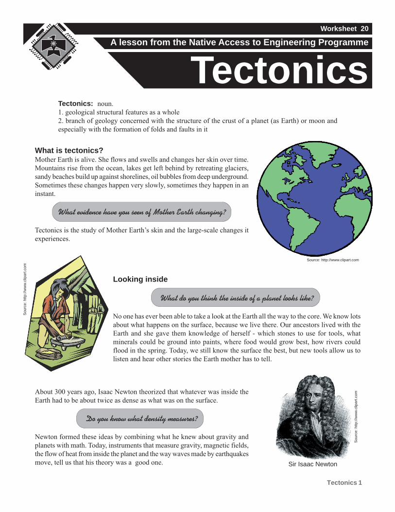
About 300 years ago, Isaac Newton theorized that whatever was inside the
Earth had to be about twice as dense as what was on the surface.
Do you know what density measures?
Newton formed these ideas by combining what he knew about gravity and
planets with math. Today, instruments that measure gravity, magnetic fields,
the flow of heat from inside the planet and the way waves made by earthquakes
move, tell us that his theory was a good one.
Looking inside
What do you think the inside of a planet looks like?
No one has ever been able to take a look at the Earth all the way to the core. We know lots
about what happens on the surface, because we live there. Our ancestors lived with the
Earth and she gave them knowledge of herself - which stones to use for tools, what
minerals could be ground into paints, where food would grow best, how rivers could
flood in the spring. Today, we still know the surface the best, but new tools allow us to
listen and hear other stories the Earth mother has to tell.
What is tectonics?Mother Earth is alive. She flows and swells and changes her skin over time.
Mountains rise from the ocean, lakes get left behind by retreating glaciers,
sandy beaches build up against shorelines, oil bubbles from deep underground.
Sometimes these changes happen very slowly, sometimes they happen in an
instant.
What evidence have you seen of Mother Earth changing?
Tectonics is the study of Mother Earth’s skin and the large-scale changes it
experiences.
A lesson from the Native Access to Engineering Programme
Worksheet 20
TectonicsTectonics: noun.
1. geological structural features as a whole
2. branch of geology concerned with the structure of the crust of a planet (as Earth) or moon and
especially with the formation of folds and faults in it
Source: http://www.clipart.com
Sou
rce:
http
://w
ww
.clip
art.c
om
Sou
rce:
http
://w
ww
.clip
art.c
om
Sir Isaac Newton
Tectonics 2
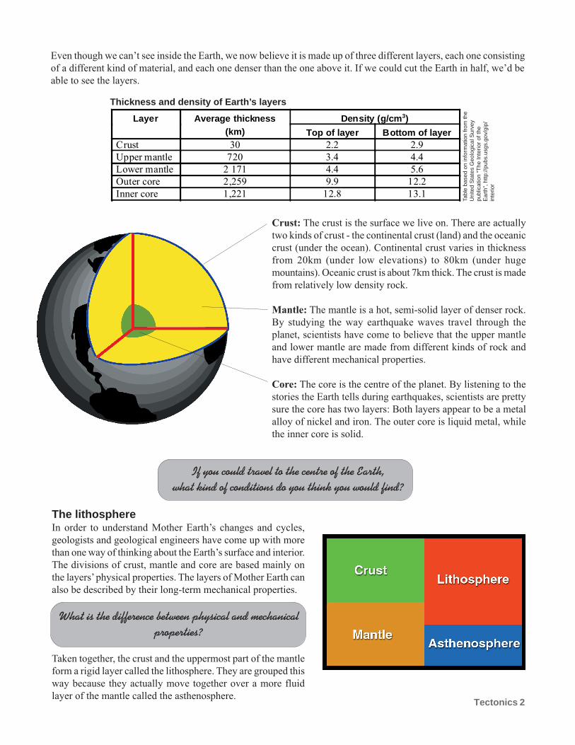
Even though we can’t see inside the Earth, we now believe it is made up of three different layers, each one consisting
of a different kind of material, and each one denser than the one above it. If we could cut the Earth in half, we’d be
able to see the layers.
Density (g/cm3)Layer Average thickness(km) Top of layer Bottom of layer
Crust 30 2.2 2.9
Upper mantle 720 3.4 4.4
Lower mantle 2 171 4.4 5.6
Outer core 2,259 9.9 12.2
Inner core 1,221 12.8 13.1
Crust: The crust is the surface we live on. There are actually
two kinds of crust - the continental crust (land) and the oceanic
crust (under the ocean). Continental crust varies in thickness
from 20km (under low elevations) to 80km (under huge
mountains). Oceanic crust is about 7km thick. The crust is made
from relatively low density rock.
Mantle: The mantle is a hot, semi-solid layer of denser rock.
By studying the way earthquake waves travel through the
planet, scientists have come to believe that the upper mantle
and lower mantle are made from different kinds of rock and
have different mechanical properties.
Core: The core is the centre of the planet. By listening to the
stories the Earth tells during earthquakes, scientists are pretty
sure the core has two layers: Both layers appear to be a metal
alloy of nickel and iron. The outer core is liquid metal, while
the inner core is solid.
If you could travel to the centre of the Earth,what kind of conditions do you think you would find?
The lithosphereIn order to understand Mother Earth’s changes and cycles,
geologists and geological engineers have come up with more
than one way of thinking about the Earth’s surface and interior.
The divisions of crust, mantle and core are based mainly on
the layers’ physical properties. The layers of Mother Earth can
also be described by their long-term mechanical properties.
What is the difference between physical and mechanicalproperties?
Taken together, the crust and the uppermost part of the mantle
form a rigid layer called the lithosphere. They are grouped this
way because they actually move together over a more fluid
layer of the mantle called the asthenosphere.
Thickness and density of Earth’s layers
Tabl
e ba
sed
on in
form
atio
n fr
om th
eU
nite
d S
tate
s G
eolo
gica
l Sur
vey
publ
icat
ion
“The
Inte
rior
of th
eE
arth
”, h
ttp://
pubs
.usg
s.go
v/gi
p/in
terio
r
Tectonics 3
The lithosphere isn’t one solid piece. It is made up of about 12 pieces, some incredibly large and others much
smaller. Each of these pieces is a tectonic plate. The plates move towards and away from each other; they move over
and under each other; and sometimes they bump and grind together with earth shattering results.
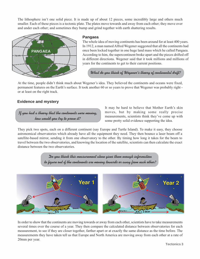
PangaeaThe whole idea of moving continents has been around for at least 400 years.
In 1912, a man named Alfred Wegener suggested that all the continents had
once been locked together in one huge land mass which he called Pangaea.
According to him, the supercontinent broke apart and the pieces drifted off
in different directions. Wegener said that it took millions and millions of
years for the continents to get to their current positions.
What do you think of Wegener’s theory of continental drift?
Evidence and mystery
Do you think this measurement alone gives them enough informationto figure out if the continents are moving towards or away from each other?
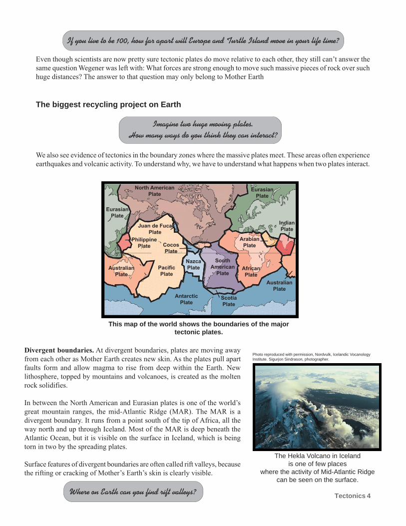
In order to show that the continents are moving towards or away from each other, scientists have to take measurements
several times over the course of a year. They then compare the calculated distance between observatories for each
measurement, to see if they are closer together, farther apart or at exactly the same distance as the time before. The
measurements they have taken tell us that Europe and North America are moving away from each other at a rate of
20mm per year.
At the time, people didn’t think much about Wegener’s idea. They believed the continents and oceans were fixed,
permanent features on the Earth’s surface. It took another 60 or so years to prove that Wegener was probably right -
or at least on the right track.
It may be hard to believe that Mother Earth’s skin
moves, but by making some really precise
measurements, scientists think they’ve come up with
some pretty solid evidence supporting the idea.
They pick two spots, each on a different continent (say Europe and Turtle Island). To make it easy, they choose
astronomical observatories which already have all the equipment they need. They then bounce a laser beam off a
satellite-based mirror, sending it from one observatory to the other. By timing how long it takes for the beam to
travel between the two observatories, and knowing the location of the satellite, scientists can then calculate the exact
distance between the two observatories.
If you had a theory that the continents were moving,how would you try to prove it?
Tectonics 4
If you live to be 100, how far apart will Europe and Turtle Island move in your life time?
Even though scientists are now pretty sure tectonic plates do move relative to each other, they still can’t answer the
same question Wegener was left with: What forces are strong enough to move such massive pieces of rock over such
huge distances? The answer to that question may only belong to Mother Earth
The biggest recycling project on Earth
Imagine two huge moving plates.How many ways do you think they can interact?
North American
Plate
Pacific
Plate
Antarctic
Plate
South
American
Plate
African
Plate
Eurasian
Plate
Eurasian
Plate
Nazca
PlateAustralian
Plate
Australian
Plate
Cocos
Plate
Philippine
Plate
Juan de Fuca
Plate
Scotia
Plate
Arabian
Plate
Indian
Plate
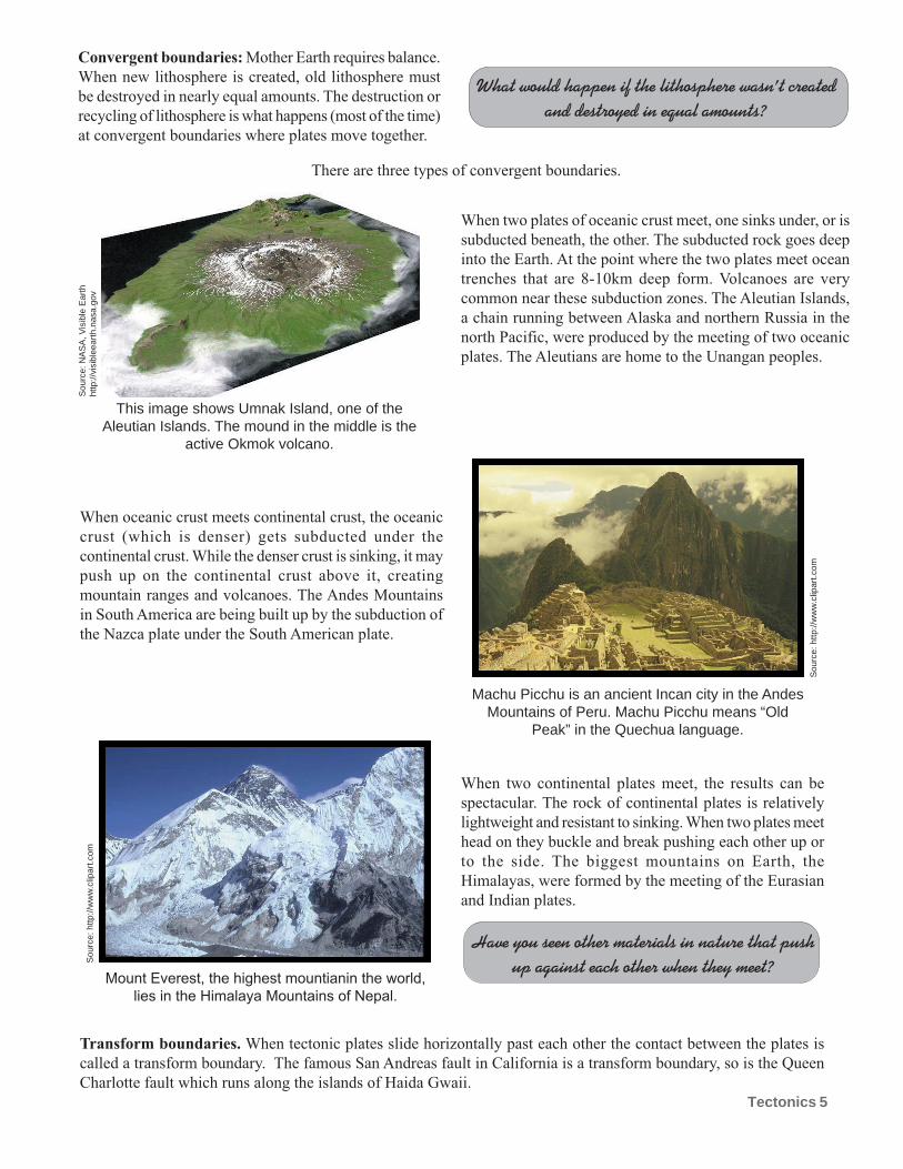
This map of the world shows the boundaries of the majortectonic plates.
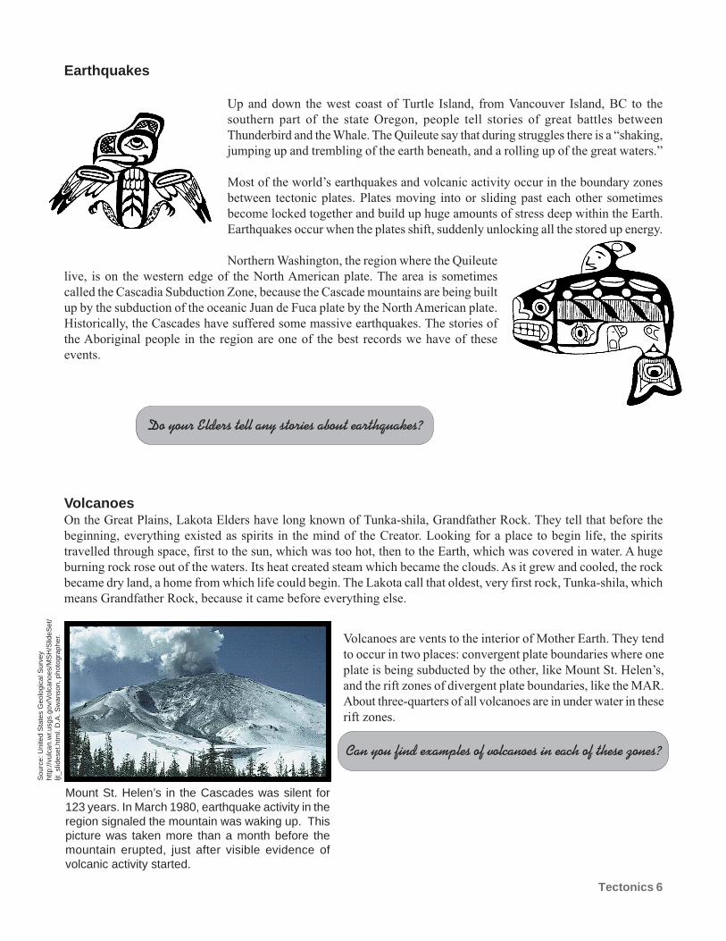
Divergent boundaries. At divergent boundaries, plates are moving away
from each other as Mother Earth creates new skin. As the plates pull apart
faults form and allow magma to rise from deep within the Earth. New
lithosphere, topped by mountains and volcanoes, is created as the molten
rock solidifies.
In between the North American and Eurasian plates is one of the world’s
great mountain ranges, the mid-Atlantic Ridge (MAR). The MAR is a
divergent boundary. It runs from a point south of the tip of Africa, all the
way north and up through Iceland. Most of the MAR is deep beneath the
Atlantic Ocean, but it is visible on the surface in Iceland, which is being
torn in two by the spreading plates.
Surface features of divergent boundaries are often called rift valleys, because
the rifting or cracking of Mother’s Earth’s skin is clearly visible.
Where on Earth can you find rift valleys?
We also see evidence of tectonics in the boundary zones where the massive plates meet. These areas often experience
earthquakes and volcanic activity. To understand why, we have to understand what happens when two plates interact.
The Hekla Volcano in Icelandis one of few places
where the activity of Mid-Atlantic Ridgecan be seen on the surface.
Photo reproduced with permission, Nordvulk, Icelandic VocanologyInstitute. Sigurjon Sindrason, photographer.
Tectonics 5
Convergent boundaries: Mother Earth requires balance.
When new lithosphere is created, old lithosphere must
be destroyed in nearly equal amounts. The destruction or
recycling of lithosphere is what happens (most of the time)
at convergent boundaries where plates move together.
When two plates of oceanic crust meet, one sinks under, or is
subducted beneath, the other. The subducted rock goes deep
into the Earth. At the point where the two plates meet ocean
trenches that are 8-10km deep form. Volcanoes are very
common near these subduction zones. The Aleutian Islands,
a chain running between Alaska and northern Russia in the
north Pacific, were produced by the meeting of two oceanic
plates. The Aleutians are home to the Unangan peoples.
When oceanic crust meets continental crust, the oceanic
crust (which is denser) gets subducted under the
continental crust. While the denser crust is sinking, it may
push up on the continental crust above it, creating
mountain ranges and volcanoes. The Andes Mountains
in South America are being built up by the subduction of
the Nazca plate under the South American plate.
What would happen if the lithosphere wasn’t createdand destroyed in equal amounts?
There are three types of convergent boundaries.
When two continental plates meet, the results can be
spectacular. The rock of continental plates is relatively
lightweight and resistant to sinking. When two plates meet
head on they buckle and break pushing each other up or
to the side. The biggest mountains on Earth, the
Himalayas, were formed by the meeting of the Eurasian
and Indian plates.
Have you seen other materials in nature that pushup against each other when they meet?
Sou
rce:
NA
SA
, Vis
ible
Ear
thht
tp://
visi
blee
arth
.nas
a.go
v
This image shows Umnak Island, one of theAleutian Islands. The mound in the middle is the
active Okmok volcano.
Machu Picchu is an ancient Incan city in the AndesMountains of Peru. Machu Picchu means “Old
Peak” in the Quechua language.
Mount Everest, the highest mountianin the world,
lies in the Himalaya Mountains of Nepal.
Transform boundaries. When tectonic plates slide horizontally past each other the contact between the plates is
called a transform boundary. The famous San Andreas fault in California is a transform boundary, so is the Queen
Charlotte fault which runs along the islands of Haida Gwaii.
Sou
rce:
http
://w
ww
.clip
art.c
om
Sou
rce:
http
://w
ww
.clip
art.c
om
Tectonics 6
Earthquakes
Up and down the west coast of Turtle Island, from Vancouver Island, BC to the
southern part of the state Oregon, people tell stories of great battles between
Thunderbird and the Whale. The Quileute say that during struggles there is a “shaking,
jumping up and trembling of the earth beneath, and a rolling up of the great waters.”
Most of the world’s earthquakes and volcanic activity occur in the boundary zones
between tectonic plates. Plates moving into or sliding past each other sometimes
become locked together and build up huge amounts of stress deep within the Earth.
Earthquakes occur when the plates shift, suddenly unlocking all the stored up energy.
Northern Washington, the region where the Quileute
live, is on the western edge of the North American plate. The area is sometimes
called the Cascadia Subduction Zone, because the Cascade mountains are being built
up by the subduction of the oceanic Juan de Fuca plate by the North American plate.
Historically, the Cascades have suffered some massive earthquakes. The stories of
the Aboriginal people in the region are one of the best records we have of these
events.
VolcanoesOn the Great Plains, Lakota Elders have long known of Tunka-shila, Grandfather Rock. They tell that before the
beginning, everything existed as spirits in the mind of the Creator. Looking for a place to begin life, the spirits
travelled through space, first to the sun, which was too hot, then to the Earth, which was covered in water. A huge
burning rock rose out of the waters. Its heat created steam which became the clouds. As it grew and cooled, the rock
became dry land, a home from which life could begin. The Lakota call that oldest, very first rock, Tunka-shila, which
means Grandfather Rock, because it came before everything else.
Volcanoes are vents to the interior of Mother Earth. They tend
to occur in two places: convergent plate boundaries where one
plate is being subducted by the other, like Mount St. Helen’s,
and the rift zones of divergent plate boundaries, like the MAR.
About three-quarters of all volcanoes are in under water in these
rift zones.
Can you find examples of volcanoes in each of these zones?
Mount St. Helen’s in the Cascades was silent for123 years. In March 1980, earthquake activity in theregion signaled the mountain was waking up. Thispicture was taken more than a month before themountain erupted, just after visible evidence ofvolcanic activity started.
Sou
rce:
Uni
ted
Sta
tes
Geo
logi
cal S
urve
yht
tp://
vulc
an.w
r.usg
s.go
v/V
olca
noes
/MS
H/S
lideS
et/
ljt_s
lides
et.h
tml.
D.A
. Sw
anso
n, p
hoto
grap
her.
Do your Elders tell any stories about earthquakes?
Tectonics 7
Volcanoes also occur in the middle of tectonic plates far away from either convergent or divergent boundaries. These
volcanoes are built through a different process. In places called hotspots, the mantle is extremely hot with very low
density. This hot material flows upward and can melt through the overlying plate, to produce molten rock or magma.
Magma spills onto the sea floor, where it cools and solidifies. Over long periods of time, these under water volcanoes
grow large enough to break the surface of the ocean and form new land. Eventually the tectonic plate moves enough
to cut the volcano off from its source of magma, and the process starts again as another island begins forming under
the ocean.
There is a word to describe volcanoes that no longer have a supply of magma.Do you know what it is?
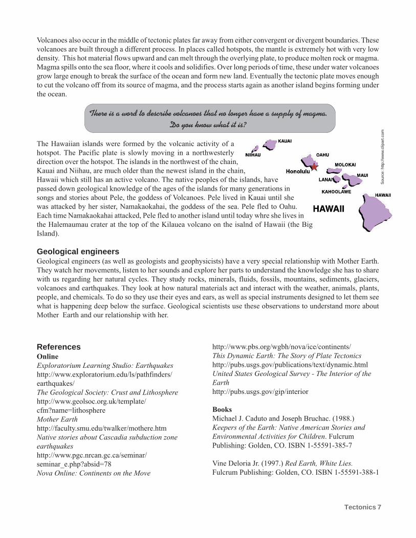
The Hawaiian islands were formed by the volcanic activity of a
hotspot. The Pacific plate is slowly moving in a northwesterly
direction over the hotspot. The islands in the northwest of the chain,
Kauai and Niihau, are much older than the newest island in the chain,
Hawaii which still has an active volcano. The native peoples of the islands, have
passed down geological knowledge of the ages of the islands for many generations in
songs and stories about Pele, the goddess of Volcanoes. Pele lived in Kauai until she
was attacked by her sister, Namakaokahai, the goddess of the sea. Pele fled to Oahu.
Each time Namakaokahai attacked, Pele fled to another island until today whre she lives in
the Halemaumau crater at the top of the Kilauea volcano on the isalnd of Hawaii (the Big
Island).
Geological engineersGeological engineers (as well as geologists and geophysicists) have a very special relationship with Mother Earth.
They watch her movements, listen to her sounds and explore her parts to understand the knowledge she has to share
with us regarding her natural cycles. They study rocks, minerals, fluids, fossils, mountains, sediments, glaciers,
volcanoes and earthquakes. They look at how natural materials act and interact with the weather, animals, plants,
people, and chemicals. To do so they use their eyes and ears, as well as special instruments designed to let them see
what is happening deep below the surface. Geological scientists use these observations to understand more about
Mother Earth and our relationship with her.
ReferencesOnline
Exploratorium Learning Studio: Earthquakes
http://www.exploratorium.edu/ls/pathfinders/
earthquakes/
The Geological Society: Crust and Lithosphere
http://www.geolsoc.org.uk/template/
cfm?name=lithosphere
Mother Earth
http://faculty.smu.edu/twalker/mothere.htm
Native stories about Cascadia subduction zone
earthquakes
http://www.pgc.nrcan.gc.ca/seminar/
seminar_e.php?absid=78
Nova Online: Continents on the Move
http://www.pbs.org/wgbh/nova/ice/continents/
This Dynamic Earth: The Story of Plate Tectonics
http://pubs.usgs.gov/publications/text/dynamic.html
United States Geological Survey - The Interior of the
Earth
http://pubs.usgs.gov/gip/interior
Books
Michael J. Caduto and Joseph Bruchac. (1988.)
Keepers of the Earth: Native American Stories and
Environmental Activities for Children. Fulcrum
Publishing: Golden, CO. ISBN 1-55591-385-7
Vine Deloria Jr. (1997.) Red Earth, White Lies.
Fulcrum Publishing: Golden, CO. ISBN 1-55591-388-1
Sou
rce:
http
://w
ww
.clip
art.c
om
Tectonics 8
Connecting to Math
ISS
N 1
494-
4944
The Klickitat people call Mount St. Helens Louwalla-Clough which means smoking mountain. In one of the stories
they tell, the mountain was once a beautiful woman named Loowit. When two sons of the Great Spirit, Wyeast and
Klickitat, fell in love with her, Loowit could not choose between them. So, the two men fought over her, each trying
to win her heart, and in the process burying villages and destroying forests. Their father, angry with the devastation
they had caused, killed the young lovers and erected mountains where they died. Every now and again, these mountains
(Mount St. Helens, Mount Hood and Mount Adams) still burst forth causing destruction.
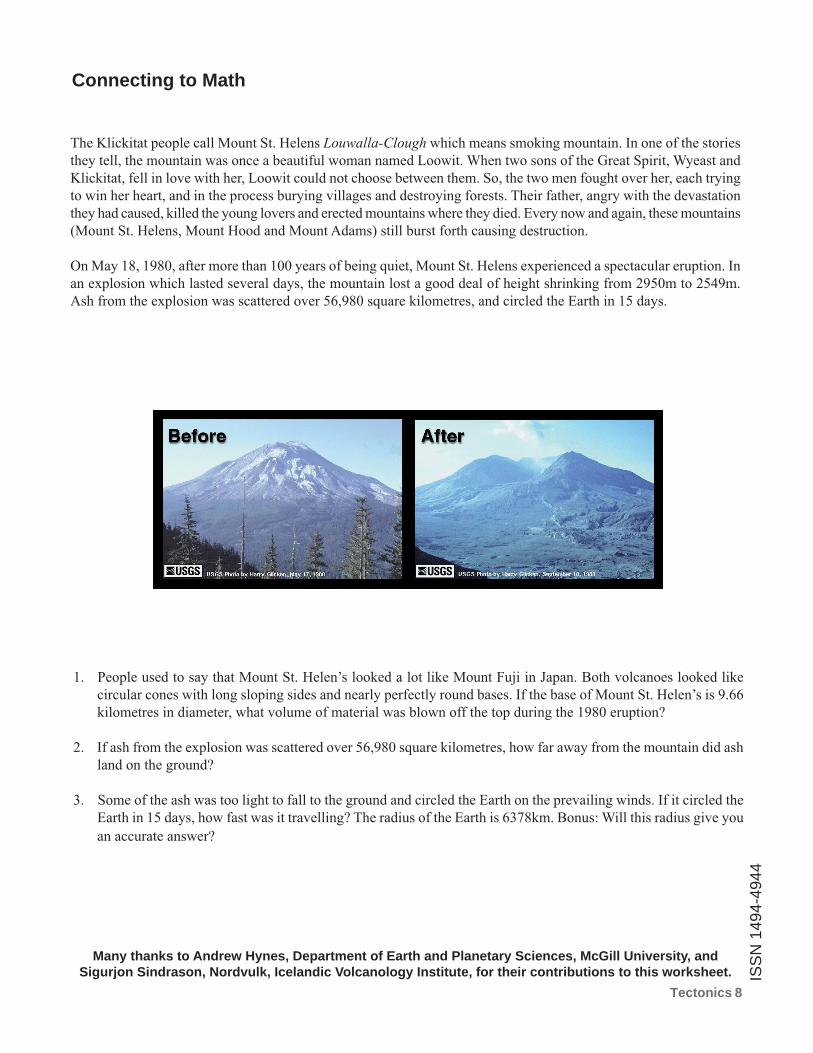
On May 18, 1980, after more than 100 years of being quiet, Mount St. Helens experienced a spectacular eruption. In
an explosion which lasted several days, the mountain lost a good deal of height shrinking from 2950m to 2549m.
Ash from the explosion was scattered over 56,980 square kilometres, and circled the Earth in 15 days.
1. People used to say that Mount St. Helen’s looked a lot like Mount Fuji in Japan. Both volcanoes looked like
circular cones with long sloping sides and nearly perfectly round bases. If the base of Mount St. Helen’s is 9.66
kilometres in diameter, what volume of material was blown off the top during the 1980 eruption?
2. If ash from the explosion was scattered over 56,980 square kilometres, how far away from the mountain did ash
land on the ground?
3. Some of the ash was too light to fall to the ground and circled the Earth on the prevailing winds. If it circled the
Earth in 15 days, how fast was it travelling? The radius of the Earth is 6378km. Bonus: Will this radius give you
an accurate answer?
Many thanks to Andrew Hynes, Department of Earth and Planetary Sciences, McGill University, andSigurjon Sindrason, Nordvulk, Icelandic Volcanology Institute, for their contributions to this worksheet.