Embed Size (px)
Citation preview

Geological Methods in Mineral Explorationand Mining
Roger Marjoribanks
Geological Methodsin Mineral Explorationand Mining
Second Edition
123
Roger Marjoribanks27A Axford StreetPerth WA [email protected]
ISBN 978-3-540-74370-5 e-ISBN 978-3-540-74375-0DOI 10.1007/978-3-540-74375-0Springer Heidelberg Dordrecht London New York
Library of Congress Control Number: 2010926490
© Springer-Verlag Berlin Heidelberg 1997, 2010This work is subject to copyright. All rights are reserved, whether the whole or part of the material isconcerned, specifically the rights of translation, reprinting, reuse of illustrations, recitation, broadcasting,reproduction on microfilm or in any other way, and storage in data banks. Duplication of this publicationor parts thereof is permitted only under the provisions of the German Copyright Law of September 9,1965, in its current version, and permission for use must always be obtained from Springer. Violationsare liable to prosecution under the German Copyright Law.The use of general descriptive names, registered names, trademarks, etc. in this publication does notimply, even in the absence of a specific statement, that such names are exempt from the relevant protectivelaws and regulations and therefore free for general use.
Printed on acid-free paper
Springer is part of Springer Science+Business Media (www.springer.com)
Preface
This book is written as a practical field manual to be used by geologists engagedin mineral exploration. It is also hoped that it will serve as a text and referencefor students in Applied Geology courses of universities and colleges. The bookaims to outline some of the practical skills that turn the graduate geologist intoan explorationist. It is intended as a practical “how to” book, rather than as a text ongeological or ore deposit theory.
An explorationist1 is a professional, usually a geologist, who searches for orebodies in a scientific and structured way. Mineral exploration professionals includea range of people: business people involved in financial and entrepreneurial activ-ities in the mining industry, board members and company management no longerinvolved in day to day exploration but often with past hands-on experience, tech-nical assistants, tenement managers, environmental and safety personnel, drillers,surveyors, IT specialists, geophysicists and geochemists, ore reserve specialists, var-ious types of consultants, and the exploration geologists. Typically the explorationgeologists are the jacks-of-all-trades with an overview of the team and the project.Although explorationist is a somewhat awkward and artificial term, this is the onlyavailable word to describe the totality of the skills that are needed to locate anddefine economic mineralization. Even the mine geologist, attempting to define oreblocks ahead of the mining crews, is an explorationist. The most fundamental andcost-effective skills of the explorationist relate to the acquisition, recording and pre-sentation of geological knowledge so that it can be used to predict the presence ofore – these are the skills that are the subject of this book.
Practical field techniques taught at undergraduate level are often forgotten andsometimes, although taught, are not reinforced by subsequent practice; some skillsthat the explorationist needs may never be adequately taught in the academic envi-ronment of universities. Special techniques and skills – or example, identifyingprospective ground for acquisition, detailed prospect mapping or logging drill core
1 Throughout the book, the rules of English grammar compel me, from time to time, to ascribe a sexto my protagonist. In the first edition I got around this by using the expression “he or she”; but thisnow seems to me an awkward circumlocution. In this edition I simply ascribe gender alternately.
v
vi Preface
or cuttings – seldom figure in basic training courses. Although no book can substi-tute for hands-on experience and demonstration, this manual aims to address someof these deficiencies.
The book does not offer a set of standard rules that must be invariably followed. Itdescribes practical skills and techniques that, through the experience of many geol-ogists, have been found to be effective. However, it is not the author’s intention to beprescriptive; each geologist has to develop their own techniques and will ultimatelybe judged on results, not the process by which these results were reached. In mineralexploration, the only “right” way of doing anything is the way that locates ore in thequickest and most cost-effective manner. It is preferable, however, for an individualto develop their own method of operation after having tried, and become aware of,those procedures that experience has shown to work well and which are generallyaccepted in industry as good exploration practice.
New ideas and techniques are constantly emerging and no book such as this canbe regarded as being a final statement. To make this a useful document and to keepit up to date and relevant, geologists should use it critically.
The chapters of the book approximately follow the steps that a typical explo-ration programme would go through. In Chap. 1, the generation of new projectsand prospects and the nature of the exploration process are described. In Chaps. 2and 3 are descriptions of the various techniques employed in making geologicalmaps from remote sensed reflectance imagery, surface outcrop and mine openings.Chapter 4 covers techniques employed by the explorationist to create new rock expo-sure – trenching, pitting, stripping and underground development. Chapters 5, 6 and7 (supported by several Appendices) cover all aspects of drilling. These chaptersconstitute a major part of this book, reflecting the supreme importance of drilling tothe explorationist. In Chap. 8 is a detailed description of the remote sensed imagesprovided by Land observation satellites – a modern day boon to explorationists.Although this book is primarily concerned with geological methods, in Chap. 9 abrief overview is given of the more commonly used techniques of exploration geo-physics and geochemistry. Finally, Chap. 10 discusses digital exploration data basesand outlines the use of geographical information systems (GIS) and explorationsoftware for the storage, manipulation and presentation of digital exploration andmining data.
This second edition has been greatly expanded from the original 1997 editionto reflect changes that have taken place in exploration methods over last 10 years.Basic geological field techniques still constitute the core skill for the explorationistand are the subject of a significant part of the book. However new technologicaladvances have expanded the range of tools available to her. In diamond drilling,faster and more reliable systems for orienting core have made this procedure almostroutine and have led to an increased awareness on the value to be got from quan-titative structural logging. Satellite navigation systems have become much moreaccurate thus expanding the role that GPS can play in providing survey controlsfor detailed geological mapping, and the collection of geochemical and geophysicaldata. New, very high resolution, commercial land observation satellites increasinglyoffer imagery that rival the best of air photography both in resolution and price.
Preface vii
The desk top and laptop computers of today offer an almost exponential increase inprocessing power, memory capacity and graphics ability which, combined with newpowerful software packages and sophisticated instrumentation, have revolutionisedtraditional geophysical and geochemical techniques.
New software programs available today allow vast amounts of data to be pro-cessed and analysed, and this leads to a tendency for the present day explorationistto spend more time in front of a monitor than in the field. Digital data, massaged andpresented as multi colour 3-D surfaces can acquire a life of its own, quite divorcedfrom the reality it is supposed to represent. There is an increasing danger that byfocussing on data handling the explorationist loses sight of the need for quality dataacquisition. The underlying philosophy behind much of this book is that, if geolog-ical data is to be of value in finding ore bodies, ideas and insights must be used in astructured way to control all stages of data handling from field collection through tofinal presentation. In these days of electronic storage and processing of mass data,it is worth remembering the well-known quote2:
Data is not informationInformation is not knowledgeKnowledge is not understandingUnderstanding is not wisdom
The book outlines some geological techniques for acquiring knowledge. The restis up to the reader.
2 Anonymous, but almost certainly adapted from: “Where is the wisdom we have lost inknowledge? Where is the knowledge we have lost in information” (T.S. Eliot)
Acknowledgments
I am indebted to the many skilled field geologists with whom I have been privilegedto work over the years and from whom I have acquired many of the exploration andgeological ideas, techniques and procedures that are described here. Among theseare: Ray Crawford, Neville George, Don Bowes, Frank Hughes, Dave McKenzie,Don Berkman, Mike Rickard, Ilmars Gemuts, Doug Dunnet, John Thoms, DickSillitoe and Gary Arnold.
The Australian Institute of Geoscientists kindly gave their permission toreproduce a number of diagrams that previously appeared in AIG Handbook5 – Structural logging of drill core – that I authored in 2001 (2nd Edition 2007).The diagrams in question are 6.1, 6.6, 6.9, 6.10, 6.14, B.5, B.7, B.13, C.1, C.2 andC.3. The permission of Ivanhoe Mining Limited and Newcrest Limited is acknowl-edged to publish the descriptions of some of their exploration projects that appearat the end of Chap. 4.
Geological maps and sections appearing in the book are based on actual projectsthat the author has worked on. They have been re-drafted, modified and re-namedto make them suitable for this publication and to preserve their anonymity.
Gary Arnold kindly undertook to read a draft of the text and the book has ben-efited greatly from his many constructive comments. His input particularly intoSect. 9.2 (magnetic surveys) and Sect. 10.3 (GIS and digital databases) is gratefullyacknowledged.
Needless to say, I accept full responsibility for all biases and errors that mightstill remain in this work.
ix
Contents
1 Prospecting and the Exploration Process . . . . . . . . . . . . . . . 11.1 Definition of Terms . . . . . . . . . . . . . . . . . . . . . . . . 11.2 Generating New Projects and Prospects . . . . . . . . . . . . . 11.3 Some Ways of Generating New Exploration Ideas . . . . . . . . 31.4 A Check-List of Negative Assumptions . . . . . . . . . . . . . 41.5 Stages in Prospect Exploration . . . . . . . . . . . . . . . . . . 5
1.5.1 Target Generation . . . . . . . . . . . . . . . . . . . . 51.5.2 Target Drilling . . . . . . . . . . . . . . . . . . . . . . 61.5.3 Resource Evaluation Drilling . . . . . . . . . . . . . . 61.5.4 Feasibility Study . . . . . . . . . . . . . . . . . . . . 6
1.6 Maximizing Success in Exploration Programmes . . . . . . . . 71.7 Different Types of Exploration Strategy . . . . . . . . . . . . . 91.8 Exploration Feedbacks . . . . . . . . . . . . . . . . . . . . . . 91.9 Breaking Occam’s Razor . . . . . . . . . . . . . . . . . . . . . 10References . . . . . . . . . . . . . . . . . . . . . . . . . . . . . . . . 11
2 Geological Mapping in Exploration . . . . . . . . . . . . . . . . . . 132.1 General Considerations . . . . . . . . . . . . . . . . . . . . . . 13
2.1.1 Why Make a Map? . . . . . . . . . . . . . . . . . . . 132.1.2 The Nature of a Geological Map . . . . . . . . . . . . 142.1.3 Intelligent Mapping . . . . . . . . . . . . . . . . . . . 152.1.4 Choosing the Best Technique . . . . . . . . . . . . . . 182.1.5 Choosing the Best Scale . . . . . . . . . . . . . . . . . 202.1.6 Measuring and Recording Structures . . . . . . . . . . 222.1.7 Using Satellite Navigation (GPS) . . . . . . . . . . . . 23
2.2 Mapping Using Reflectance Imagery as a Map Base . . . . . . 252.2.1 General . . . . . . . . . . . . . . . . . . . . . . . . . 252.2.2 Acquiring Air Photographs . . . . . . . . . . . . . . . 262.2.3 Geological Interpretation . . . . . . . . . . . . . . . . 262.2.4 Determining Scale . . . . . . . . . . . . . . . . . . . . 272.2.5 Stereoscopic Image Pairs . . . . . . . . . . . . . . . . 292.2.6 Image Handling Techniques . . . . . . . . . . . . . . 312.2.7 Working with Enlarged Air Photographs . . . . . . . . 34
xi
xii Contents
2.2.8 Data Transfer to Base Map . . . . . . . . . . . . . . . 372.3 Mapping with a Plane Table . . . . . . . . . . . . . . . . . . . 382.4 Mapping on a Pegged Grid . . . . . . . . . . . . . . . . . . . . 41
2.4.1 Requirements of the Grid . . . . . . . . . . . . . . . . 412.4.2 Making the Map . . . . . . . . . . . . . . . . . . . . . 43
2.5 Mapping with Tape and Compass . . . . . . . . . . . . . . . . 47References . . . . . . . . . . . . . . . . . . . . . . . . . . . . . . . . 49
3 Mine Mapping . . . . . . . . . . . . . . . . . . . . . . . . . . . . . 513.1 General . . . . . . . . . . . . . . . . . . . . . . . . . . . . . . 513.2 Mapping in Open Cuts . . . . . . . . . . . . . . . . . . . . . . 513.3 Mapping Underground Openings . . . . . . . . . . . . . . . . 563.4 Safety in Mines . . . . . . . . . . . . . . . . . . . . . . . . . . 60References . . . . . . . . . . . . . . . . . . . . . . . . . . . . . . . . 61
4 Trenching and Underground Development . . . . . . . . . . . . . . 634.1 Preamble . . . . . . . . . . . . . . . . . . . . . . . . . . . . . 634.2 Pitting and Trenching . . . . . . . . . . . . . . . . . . . . . . . 634.3 Underground Development . . . . . . . . . . . . . . . . . . . . 644.4 Safety and Logistics in Trenching . . . . . . . . . . . . . . . . 654.5 Geological Mapping . . . . . . . . . . . . . . . . . . . . . . . 664.6 Geochemical Sampling . . . . . . . . . . . . . . . . . . . . . . 694.7 Examples of Successful Exploration Programmes . . . . . . . . 71References . . . . . . . . . . . . . . . . . . . . . . . . . . . . . . . . 72
5 Drilling: A General Discussion the Importance of Drilling . . . . . 755.1 Types of Drilling . . . . . . . . . . . . . . . . . . . . . . . . . 755.2 Choosing the Right Technique . . . . . . . . . . . . . . . . . . 765.3 Targeting Holes . . . . . . . . . . . . . . . . . . . . . . . . . . 795.4 Drilling on Section . . . . . . . . . . . . . . . . . . . . . . . . 83References . . . . . . . . . . . . . . . . . . . . . . . . . . . . . . . . 84
6 Rotary Percussion and Auger Drilling . . . . . . . . . . . . . . . . 856.1 Rotary Percussion Drilling . . . . . . . . . . . . . . . . . . . . 85
6.1.1 Reverse Circulation Drilling (RC) . . . . . . . . . . . 856.1.2 Air Core Drilling . . . . . . . . . . . . . . . . . . . . 936.1.3 Rotary Air Blast (RAB) Drilling . . . . . . . . . . . . 93
6.2 Auger Drilling . . . . . . . . . . . . . . . . . . . . . . . . . . 96References . . . . . . . . . . . . . . . . . . . . . . . . . . . . . . . . 97
7 Diamond Drilling . . . . . . . . . . . . . . . . . . . . . . . . . . . . 997.1 Preamble . . . . . . . . . . . . . . . . . . . . . . . . . . . . . 997.2 Some Definitions . . . . . . . . . . . . . . . . . . . . . . . . . 1007.3 Before You Begin . . . . . . . . . . . . . . . . . . . . . . . . . 1027.4 Setting Up a Diamond Hole . . . . . . . . . . . . . . . . . . . 1027.5 Geological Observation . . . . . . . . . . . . . . . . . . . . . 1037.6 Recognizing and Interpreting Structures in Core . . . . . . . . . 104
Contents xiii
7.6.1 Statement of the Problem . . . . . . . . . . . . . . . . 1047.6.2 Planar Structures . . . . . . . . . . . . . . . . . . . . 1047.6.3 Faults . . . . . . . . . . . . . . . . . . . . . . . . . . 1057.6.4 Linear Structures . . . . . . . . . . . . . . . . . . . . 1077.6.5 Folds . . . . . . . . . . . . . . . . . . . . . . . . . . . 1097.6.6 The Scale Problem . . . . . . . . . . . . . . . . . . . 1107.6.7 Vergence . . . . . . . . . . . . . . . . . . . . . . . . . 112
7.7 Measuring and Recording Structures in Core . . . . . . . . . . 1137.8 Core Logging Systems . . . . . . . . . . . . . . . . . . . . . . 116
7.8.1 Prose Logging . . . . . . . . . . . . . . . . . . . . . . 1167.8.2 Graphical Scale Logging . . . . . . . . . . . . . . . . 1177.8.3 Analytical Spreadsheet Logging . . . . . . . . . . . . 119
7.9 Down-Hole Surveying . . . . . . . . . . . . . . . . . . . . . . 1237.9.1 Procedure . . . . . . . . . . . . . . . . . . . . . . . . 1237.9.2 Using Down-Hole Survey Data to Plot Sections
and Plans . . . . . . . . . . . . . . . . . . . . . . . . 1247.10 When Should Core Be Oriented? . . . . . . . . . . . . . . . . . 1277.11 Sampling and Assaying . . . . . . . . . . . . . . . . . . . . . . 1277.12 Core Handling . . . . . . . . . . . . . . . . . . . . . . . . . . 1307.13 Core Photography . . . . . . . . . . . . . . . . . . . . . . . . 135References . . . . . . . . . . . . . . . . . . . . . . . . . . . . . . . . 136
8 Satellite Imagery . . . . . . . . . . . . . . . . . . . . . . . . . . . . 1378.1 General Discussion . . . . . . . . . . . . . . . . . . . . . . . . 1378.2 How Earth Observation Satellites Work . . . . . . . . . . . . . 1398.3 Display of Satellite Images . . . . . . . . . . . . . . . . . . . . 1408.4 Geological Interpretation . . . . . . . . . . . . . . . . . . . . . 1408.5 Analysis of Reflectance Data . . . . . . . . . . . . . . . . . . . 142References . . . . . . . . . . . . . . . . . . . . . . . . . . . . . . . . 142
9 Geophysical and Geochemical Methods . . . . . . . . . . . . . . . 1439.1 General Discussion . . . . . . . . . . . . . . . . . . . . . . . . 1439.2 Magnetic Surveys . . . . . . . . . . . . . . . . . . . . . . . . . 1469.3 Gravity Surveys . . . . . . . . . . . . . . . . . . . . . . . . . . 1499.4 Radiometric Surveys . . . . . . . . . . . . . . . . . . . . . . . 1509.5 Electromagnetic (EM) Surveys . . . . . . . . . . . . . . . . . . 1509.6 Electrical Surveys . . . . . . . . . . . . . . . . . . . . . . . . 1519.7 Hybrid Electrical and Magnetic Surveys . . . . . . . . . . . . . 1529.8 Advances in Instrumentation and Data Modelling . . . . . . . . 1539.9 Stream Sediment Sampling . . . . . . . . . . . . . . . . . . . . 1559.10 Soil Sampling . . . . . . . . . . . . . . . . . . . . . . . . . . . 1579.11 Heavy Mineral Concentrate (HMC) Sampling . . . . . . . . . . 1589.12 Rock Chip Sampling . . . . . . . . . . . . . . . . . . . . . . . 1609.13 Laterite Sampling . . . . . . . . . . . . . . . . . . . . . . . . . 161References . . . . . . . . . . . . . . . . . . . . . . . . . . . . . . . . 162
xiv Contents
10 Geographical Information Systems and Exploration Databases . . 16510.1 Definition . . . . . . . . . . . . . . . . . . . . . . . . . . . . . 16510.2 The Need for Digital Exploration Databases . . . . . . . . . . . 16510.3 GIS Storage of Map Data . . . . . . . . . . . . . . . . . . . . . 168
10.3.1 Digitised Line Format . . . . . . . . . . . . . . . . . . 16810.3.2 Polygon or Vector Format . . . . . . . . . . . . . . . . 17010.3.3 Raster Format . . . . . . . . . . . . . . . . . . . . . . 170
10.4 Validation . . . . . . . . . . . . . . . . . . . . . . . . . . . . . 17010.5 Georeferencing . . . . . . . . . . . . . . . . . . . . . . . . . . 171
10.5.1 Geographical Coordinates . . . . . . . . . . . . . . . . 17110.5.2 Cartesian Coordinates . . . . . . . . . . . . . . . . . . 17110.5.3 Map Datums . . . . . . . . . . . . . . . . . . . . . . . 17210.5.4 Map Registering . . . . . . . . . . . . . . . . . . . . . 173
10.6 Manipulation of GIS Data . . . . . . . . . . . . . . . . . . . . 17310.7 Presentation of GIS Data . . . . . . . . . . . . . . . . . . . . . 174
Appendix ANotes on the Use of Graphical Scale Logging . . . . . . . . . . . . . 179A.1 Column 1 (Hole Depth) . . . . . . . . . . . . . . . . . . . . . 180A.2 Column 2 (Core Recovery) . . . . . . . . . . . . . . . . . . . . 180A.3 Column 3 (Core Quality) . . . . . . . . . . . . . . . . . . . . . 180A.4 Column 4 (Sample No.) . . . . . . . . . . . . . . . . . . . . . 180A.5 Column 5 (Assay Results) . . . . . . . . . . . . . . . . . . . . 180A.6 Column 6 (Mapping Logs) . . . . . . . . . . . . . . . . . . . . 180A.7 Column 7 (Histogram Logs) . . . . . . . . . . . . . . . . . . . 181A.8 Column 8 (Geology Notes) . . . . . . . . . . . . . . . . . . . . 182A.9 Column 9 (Summary Log) . . . . . . . . . . . . . . . . . . . . 182A.10 Remarks Area . . . . . . . . . . . . . . . . . . . . . . . . . . . 182
Appendix BOriented Drill Core: Techniques and Procedures . . . . . . . . . . 183B.1 Techniques for Orienting Drill Core . . . . . . . . . . . . . . . 183
B.1.1 Non-mechanical Means . . . . . . . . . . . . . . . . 183B.1.2 Mechanical Means . . . . . . . . . . . . . . . . . . . 183
B.2 How to Handle Oriented Core . . . . . . . . . . . . . . . . . . 188B.3 How to Measure Structures in Oriented Core . . . . . . . . . . 190
B.3.1 Before You Measure . . . . . . . . . . . . . . . . . . 190B.3.2 How Many Measurements Are Needed? . . . . . . . . 191B.3.3 Using a Core Frame . . . . . . . . . . . . . . . . . . . 192B.3.4 Using Internal Core Angles . . . . . . . . . . . . . . . 195B.3.5 Discussion on the Best Measuring Technique . . . . . 201B.3.6 Plotting Structure Measurements on Drill Section . . . 202
Appendix CCalculating Strike and Dip from Multiple Diamond Drill Holes . . 205C.1 The Three Point Problem . . . . . . . . . . . . . . . . . . . . . 205
Contents xv
C.2 Solution Using Structure Contours . . . . . . . . . . . . . . . . 205C.3 Solution Using a Stereonet . . . . . . . . . . . . . . . . . . . . 206C.4 An Elegant Solution to Determining the Attitude of
Planes in Non-oriented Core . . . . . . . . . . . . . . . . . . . 208
Appendix DHow to Use a Stereo Net to Convert Internal Core Anglesto Geographic Coordinates . . . . . . . . . . . . . . . . . . . . . . 211D.1 The Solution for Planar Structures . . . . . . . . . . . . . . . . 211D.2 The Solution for Linear Structures . . . . . . . . . . . . . . . . 213
Appendix EPractical Field Techniques . . . . . . . . . . . . . . . . . . . . . . . 215E.1 Choosing the Right Compass . . . . . . . . . . . . . . . . . . . 215E.2 Understanding Your Compass . . . . . . . . . . . . . . . . . . 215E.3 Measuring the Strike and Dip of Planes . . . . . . . . . . . . . 217E.4 Measuring the Trend and Plunge of Lineations . . . . . . . . . 218
Appendix FSuggested Further Reading . . . . . . . . . . . . . . . . . . . . . . 223
Acronyms and Abbreviations . . . . . . . . . . . . . . . . . . . . . . . . 229
Index . . . . . . . . . . . . . . . . . . . . . . . . . . . . . . . . . . . . . 233
Chapter 1Prospecting and the Exploration Process
This chapter attempts to put the detailed exploration procedures outlined in thisbook into the wider context of the whole exploration process from first concept toore discovery.
1.1 Definition of Terms
Exploration field activities take place as part of a strategy (often called a “play”) tolocate and define a particular economically mineable mineral commodity (ore) ina mineral province. Large exploration plays are often broken down into individualprojects (often a particular tenement1 group) and each project may contain one ormore prospects.
A prospect is a restricted volume of ground that is considered to have the possi-bility of directly hosting an ore body and is usually a named geographical location.The prospect could be outcropping mineralization, an old mine, an area selectedon the basis of some geological idea, or perhaps some anomalous feature of theenvironment (usually a geophysical or geochemical measurement) that can be inter-preted as having a close spatial link with ore. Prospects are the basic units withwhich explorationists work. The explorationist’s job is to generate new prospectsand then to explore them in order to locate and define any ore body that might liewithin them.
1.2 Generating New Projects and Prospects
Generating new prospects is the critical first stage in the exploration process and isknown as prospecting. Traditionally, prospecting was the search for simple visualsurface indications of mineralization. Nowadays the range of surface indications
1The legal title to explore and mine an area goes by different names in different countries andcarries a wide variety of rights and obligations. The word “tenement” is used in this book in anon-specific way to refer to all such titles.
1R. Marjoribanks, Geological Methods in Mineral Exploration and Mining, 2nd ed.,DOI 10.1007/978-3-540-74375-0_1, C© Springer-Verlag Berlin Heidelberg 2010
2 1 Prospecting and the Exploration Process
that can be recognized by the explorationist is expanded by the use of sophisticatedgeophysical and geochemical techniques. However, the skills and abilities involvedin successful prospecting are common to all techniques. They involve activity,observation, knowledge, insight, opportunism, persistence, lateral thinking and luck.A description of traditional prospecting skills will therefore serve to illustrate thesekey attributes of success.
During the nineteenth century, in places like Australia or North America, it wasstill possible to stumble on a kilometres-long prominent ridge of secondary leadand zinc minerals, or a district where ubiquitous green secondary copper mineralsindicated the huge porphyry system beneath. Even as late as the second half ofthe twentieth century, prominent and extensive mineralized outcrop were still beingidentified in the more remote parts of the world. Discoveries such as Red Dog inAlaska (Kelley and Jennings, 2004; Koehler and Tikkanen, 1991), Porgera in PapuaNew Guinea (Handley and Henry, 1990) and Ertsberg in West Irian (Van Leeuwen,1994), belong to this era. Few places are left in the world today which offer suchreadily identified prizes. For that reason, exploration is increasingly focused on thesearch for ore bodies that have either subtle outcrop or no outcrop at all.
In spite of this, experience shows that simple prospecting methods can still findore bodies. Good examples of this are the 1964 discovery of the West Australianickel sulphide deposits at Kambalda (Gresham, 1991); the 1982 discovery ofthe massive Ladolam Gold Deposit of Lihir Island, Papua New Guinea (Moyleet al., 1990), the 1993 discovery of the outcropping gossans which overlay the richVoisey Bay Cu/Ni/Co massive sulphide ore body in Labrador, Canada (Kerr andRyan, 2000), the discovery in 1996 of the massive Oyu Tolgoi Cu/Au porphyry inMongolia (Perello et al., 2001) and the discovery of the large Sukari gold deposit inthe eastern desert of Egypt2 (Helmy et al., 2004).
If recent mineral discoveries are examined, it seems that success has come fromthree main factors:
1. The explorer searched where no one had searched before. This may be becausehistorical or political opportunity made an area accessible that previously wasinaccessible. However, very often the reason for the discovery was simply thatno one had previously thought to look in that particular place.
2. The explorer identified and tested subtle or non-typical indications of mineral-ization that had previously been overlooked, either because they were very smallor, more usually, because he recognized as significant some feature that previousobservers had seen but dismissed as unimportant. As Dick Sillitoe3 has recentlywritten (Sillitoe, 2004):
2Oyu Tolgoi and Sukari were both areas of minor known mineralisation and artisanal mining goingback thousands of years. However, their true size was not suspected until modern exploration wasundertaken.3Richard Sillitoe is a well known international economic geology consultant.
1.3 Some Ways of Generating New Exploration Ideas 3
Careful scrutiny of bedrock outcrops, some perhaps only meters across, is a key part ofsuccessful exploration—because it may reveal the subtle distal signatures of concealedmineralisation. Recent experience shows, however, that such detailed traversing, even ofthe most highly explored terranes, by experienced practitioners can also pinpoint partlyoutcropping deposits which have simply gone undiscovered because the subtle surfaceexpressions are both invisible from the air and on satellite imagery. The oft quotednotion that all wholly or partly exposed deposits have been found in the world’s maturebelts is, to my mind, a myth.
3. In areas of known mineralisation (“brownfield” exploration), the exploreremployed step-out holes to locate non-outcropping (“blind”) mineralisationbelow cover. This type of exploration can only be successful where geologicalknowledge gained from the established mines and prospects gives the explorerconfidence to embark on extensive (and expensive) drilling programs in areasthat lack outstanding surface indications. Examples of successes from this typeof exploration are the discovery by Newcrest at Cadia, NSW, Australia of theRidgeway porphyry Cu/Au deposit below 450 m of overlying sediment (Holidayet al., 1999) and the 2009 discovery of Merlin Cu/Mo/Au prospect by IvanhoeAustralia Ltd.4
One of the most important ingredients of prospecting success has been lateralthinking. By this is meant the ability to:
• see familiar rocks in new contexts• question all assumptions (but especially one’s own5) and accepted wisdom• be alert for small anomalies or aberrations• know when to follow a hunch6 (since some of the above attributes are as much
subconscious as conscious).
1.3 Some Ways of Generating New Exploration Ideas
New ideas may come “out of the blue”, but more often are the result of certainwell-recognized situations that the explorationist is able to combine fruitfully withknowledge that they already have. It pays him to be alert for these situations so asto take advantage of the opportunities that they offer. Here are some of them:
4In 2009, Ivanhoe Australia announced discovery of a significant new Mo/Rh/Cu deposit (calledMerlin) in the Mt Isa Inlier, Queensland, Australia. The discovery was the result of persistence anda commitment to step-out drilling around known mineralisation in one of Australia’s most exploredCu/Au provinces. A preliminary paper on Merlin by Florinio Lazo and Tamal Lal can be found atwww.smedg.org.au (Accessed Dec 2009).5As the famous twentieth century physicist Richard Feynman said: “The first principle is that youmust not fool yourself – and you are the easiest person to fool.”6A current theory is that intuitive and often subconscious processes take place in the right side ofthe brain, while rational, deductive reasoning derives from the left side. Both processes play a partin successful ore finding.
4 1 Prospecting and the Exploration Process
Scenario 1: New knowledge of the geology or geophysics of an area becomesavailable from new mapping (either your own or Geological Survey maps).Combined with your own understanding of mineralization, the new mappingindicates the possibility of different styles of mineralization being present ordifferent places to look.
Scenario 2: Elsewhere in a district that you are exploring, a discovery is madewhich can be used as a new and more relevant model for mineralization thanthe one that you have been using.
Scenario 3: A visit to other mining camps, maybe even on the other side ofthe world, provides new insight into your exploration property. The formaldescription of an ore body in the literature is no substitute for seeing it foryourself – particularly if there is an opportunity to see the discovery outcrop.
Scenario 4: Newly developed exploration technologies and/or methodologiesmake it possible to explore effectively in an area where earlier prospectingmethods were unsuccessful.
Scenario 5: Political changes make available for exploration and mining a partof the world that previously had not been subject to modern methods ofexploration.
1.4 A Check-List of Negative Assumptions
Sooner or later in most exploration programmes on an area, an impasse is reachedin the ability to generate new exploration ideas. At this point, it is always easy tothink of many good reasons why the effort should be abandoned. However, beforethis decision is made, it is worthwhile to critically check through a list of the beliefsthat are held about the area. On examination, these beliefs might turn out to be mereassumptions, and the assumptions might be wrong. To assist in this process, here isa check-list of five negative assumptions commonly made by explorationists aboutthe prospectivity of an area.
• The area is not prospective because it is underlain by rock type X.
Comment: How do you know? The geological map you are using might be wrongor insufficiently detailed. In any case, if rock type X is not prospective for your targetcommodity, perhaps it is prospective for some other commodity.
• The area has already been exhaustively explored.
Comment: An area or prospect can almost never be exhaustively tested. Earlierexplorers gave up because they ran out of ideas, time or money. The best any explo-rationist can ever hope to do is to exhaustively test some idea or model that they haveabout mineralization using the best tools at their disposal at that time. Generate anew model, develop a new tool or simply find new access to risk capital, and thearea may turn out to be under-explored.
1.5 Stages in Prospect Exploration 5
• All prospective rocks in the area are pegged (staked) by competitors.
Comment: When was the last check made on the existing tenements plan? Haveall the opportunities for joint venture or acquisition been explored? If you have ideasabout the ground which the existing tenement holder does not, then you are in a verygood position to negotiate a favourable entry.7
• No existing ore-body model fits the area.
Comment: Mineral deposits may belong to broad classes, but each one is unique:detailed models are usually formulated after an ore body is found. Beware of lookingtoo closely for the last ore body, rather than the next.
• The prospective belt is excluded from exploration by reason of competing landuse claims (environmental, native title, etc.).
Comment: This one is tougher; in the regulatory climate of many countriestoday, the chances are very high that beliefs in this area are not mere assumptions.However, with reason, common sense and preparedness to compromise, patienceand negotiation can often achieve much.
1.5 Stages in Prospect Exploration
Once a prospect has been identified, and the right to explore it acquired, assessingit involves advancing through a progressive series of definable exploration stages.Positive results in any stage will lead to advance to the next stage and an escalationof the exploration effort. Negative results mean that the prospect will be discarded,sold or joint ventured to another party, or simply put on hold until the acquisition offresh information/ideas/technology leads to its being reactivated.
Although the great variety of possible prospect types mean that there willbe some differences in the exploration process for individual cases, prospectexploration will generally go through the stages listed below.
1.5.1 Target Generation
This includes all exploration on the prospect undertaken prior to the drilling of holesdirectly targeted on potential ore. The aim of the exploration is to define such targets.The procedures carried out in this stage could include some or all of the following:
7It is usually a legal (and also a moral) requirement that all relevant factual data be made availableto all parties in any negotiation on an area. Ideas, however, are your intellectual property, and donot have to be communicated to anyone (you could after all be wrong).
6 1 Prospecting and the Exploration Process
• a review of all available information on the prospect, such as government geo-logical mapping and geophysical surveys, the results of previous exploration andthe known occurrence of minerals;
• preliminary geological interpretations of air photographs and remote sensedimagery;
• regional and detailed geological mapping;• detailed rock-chip and soil sampling for geochemistry;• regional and detailed geophysical surveys;• shallow pattern drilling for regolith or bedrock geochemistry;• drilling aimed at increasing geological knowledge.
1.5.2 Target Drilling
This stage is aimed at achieving an intersection of ore, or potential ore. The testingwill usually be by means of carefully targeted diamond or rotary-percussion drillholes, but more rarely trenching, pitting, sinking a shaft or driving an adit may beemployed. This is probably the most critical stage of exploration since, dependingon its results, decisions involving high costs and potential costs have to be made.If a decision is made that a potential ore body has been located, the costs of explo-ration will then dramatically escalate, often at the expense of other prospects. If it isdecided to write a prospect off after this stage, there is always the possibility that anore body has been missed.
1.5.3 Resource Evaluation Drilling
This stage provides answers to economic questions relating to the grade, tonnes andmining/metallurgical characteristics of the potential ore body. A good understand-ing of the nature of the mineralization should already have been achieved – thatunderstanding was probably a big factor in the confidence needed to move to thisstage. Providing the data to answer the economic questions requires detailed patterndrilling and sampling. Because this can be such an expensive and time-consumingprocess, this drilling will often be carried out in two sub-stages with a minor decisionpoint in between: an initial evaluation drilling and a later definition drilling stage.Evaluation and definition drilling provide the detail and confidence levels requiredto proceed to the final feasibility study.
1.5.4 Feasibility Study
This, the final stage in the process, is a desk-top due-diligence study that assessesall factors – geological, mining, environmental, political, economic – relevant tothe decision to mine. With very large projects, the costs involved in evaluation are
1.6 Maximizing Success in Exploration Programmes 7
such that a preliminary feasibility study is often carried out during the precedingresource evaluation stage. The preliminary feasibility study will identify whetherthe costs involved in exploration are appropriate to the returns that can be expected,as well as identify the nature of the data that must be acquired in order to bring theproject to the final feasibility stage.
1.6 Maximizing Success in Exploration Programmes
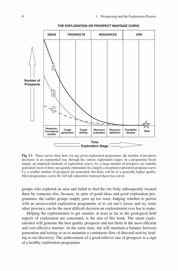
Obviously not all prospects that are generated will make it through to a mine. Mostwill be discarded at the target generation or target drilling stages. Of the small num-bers that survive to evaluation drilling, only a few will reach feasibility stage, andeven they may fail at this last hurdle. The total number of prospects that have tobe initially generated in order to provide one new mine discovery will vary accord-ing to many factors (some of these are discussed below) but will generally be alarge number. Some idea of what is involved in locating an ore body can be gainedby considering a prospect wastage or exploration curve (Fig. 1.1). This is a graphon which the number of prospects in any given exploration play (the vertical axis)is plotted against the exploration stage reached or against time, which is the samething (the horizontal axis). The large number of prospects initially generated declinethrough the exploration stages in an exponential manner indicated by the prospectwastage curve. On Fig. 1.1, the curve labelled A represents a successful explorationplay resulting in an ore body discovery. The curve labelled C represents anothersuccessful exploration play, but in this case, although fewer prospects were initiallygenerated, the slope of the line is much less than for play A. It can be deduced thatthe prospects generated for play C must have been generally of higher quality thanthe prospects of play A because a higher percentage of them survived the initialexploration stages. The line B is a more typical prospect wastage curve: that of afailed exploration play.
It should be clear from Fig. 1.1 that there are only two ways to turn an unsuc-cessful exploration programme into a successful one; the exploration programmeeither has to get bigger (i.e. increase the starting number of prospects generated)or the explorationist has to get smarter (i.e. decrease the rate of prospect wastageand hence the slope of the exploration curve). There is of course a third way: to getluckier.
Getting bigger does not necessarily mean hiring more explorationists and spend-ing money at a faster rate. Prospects are generated over time, so the injunction to getbigger can also read as “get bigger and/or hang in there longer”. There is, however,usually a limit to the number of worthwhile prospects which can be generated inany given exploration programme. The limits are not always (or even normally) inthe ideas or anomalies that can be generated by the explorationist, but more oftenare to be found in the confidence of the explorationist or of those who pay the bills.This factor is often referred to as “project fatigue”. Another common limiting factoris the availability of ground for exploration. In the industry, examples are legion of
8 1 Prospecting and the Exploration Process
TimeExploration Stage
Number ofProspects
IDEAS PROSPECTS RESOURCES ORE
Research;Conceptual
studies
Targetgeneration
Targetdrilling
Resourceevaluation
Resourcedefinition
FeasibilityStudies
Mine
THE EXPLORATION OR PROSPECT WASTAGE CURVE
Fig. 1.1 These curves show how, for any given exploration programme, the number of prospectsdecreases in an exponential way through the various exploration stages. In a programme basedlargely on empirical methods of exploration (curve A), a large number of prospects are initiallygenerated; most of these are quickly eliminated. In a largely conceptual exploration program (curveC), a smaller number of prospects are generated, but these will be of a generally higher quality.Most programmes (curve B) will fall somewhere between these two curves
groups who explored an area and failed to find the ore body subsequently locatedthere by someone else, because, in spite of good ideas and good exploration pro-grammes, the earlier groups simply gave up too soon. Judging whether to persistwith an unsuccessful exploration programme or to cut one’s losses and try someother province can be the most difficult decision an explorationist ever has to make.
Helping the explorationist to get smarter, at least as far as the geological fieldaspects of exploration are concerned, is the aim of this book. The smart explo-rationist will generate the best quality prospects and test them in the most efficientand cost-effective manner. At the same time, she will maintain a balance betweengeneration and testing so as to maintain a continuous flow of directed activity lead-ing to ore discovery. The achievement of a good rollover rate of prospects is a signof a healthy exploration programme.
1.8 Exploration Feedbacks 9
1.7 Different Types of Exploration Strategy
The exploration curve provides a convenient way of illustrating another aspect ofthe present day exploration process. Some regional exploration methods involvewidespread systematic collection of geophysical or geochemical measurements andtypically result in the production of large numbers of anomalies. This is an empiricalexploration style. Generally little will be known about any of these anomalies otherthan the fact of their existence, but any one anomaly could reflect an ore body andmust be regarded as a prospect to be followed up with a preliminary assessment –usually a field visit. Relatively few anomalies will survive the initial assessment pro-cess. The exploration curve for a programme that makes use of empirical prospectgeneration will therefore have a very steep slope and look something like the uppercurve (A) of Fig. 1.1.
The opposite type of prospect generation involves applying the theories of ore-forming processes to the known geology and mineralization of a region, so asto predict where ore might be found. This is a conceptual exploration approach.Conceptual exploration will generally lead to only a small number of prospectsbeing defined. These are much more likely to be “quality” prospects, in the sensethat the chances are higher that any one of these prospects will contain an ore bodycompared to prospects generated by empirical methods. An exploration play basedon conceptual target generation will have a relatively flat exploration curve and willtend to resemble the lower line (curve C) on Fig. 1.1.
Empirical and conceptual generation and targeting are two end members of aspectrum of exploration techniques, and few actual exploration programmes wouldbe characterized as purely one or the other. Conceptual generation and targetingtends to play a major role where there are high levels of regional geological knowl-edge and the style of mineralization sought is relatively well understood. Suchconditions usually apply in established and well-known mining camps such as (forexample) the Kambalda area in the Eastern Goldfields of Western Australia, theNoranda camp in the Canadian Abitibi Province or the Bushveld region of SouthAfrica. Empirical techniques tend to play a greater role in greenfield8 explorationprogrammes, where the levels of regional geological knowledge are much lower andapplicable mineralisation models less well defined.
Most exploration programmes employ elements of both conceptual and empir-ical approaches and their exploration curves lie somewhere between the two endmember curves shown on Fig. 1.1.
1.8 Exploration Feedbacks
There are many, many times more explorationists than there are orebodies to befound. It is entirely feasible for a competent explorationist to go through a career
8Greenfield exploration is where there are no pre-existing mines or prospects. This contrasts withbrownfield exploration, which is conducted in the vicinity of existing mines.
10 1 Prospecting and the Exploration Process
and never be able to claim sole credit for an economic mineral discovery. It is evenpossible, for no other reason than sheer bad luck, to never have been part of a teamresponsible for major new discovery. If the sole criterion for success in an explo-ration program is ore discovery, then the overwhelming majority of programs areunsuccessful, and most explorationists spend most of their time supervising failure.
But that is too gloomy an assessment. Ore discovery is the ultimate prize andeconomic justification for what we do, but cannot be the sole basis for measuringthe quality of our efforts. The skill and knowledge of the experienced explorationistreduces the element of luck in a discovery, but can never eliminate it. How do wejudge when an exploration program was well targeted and did everything right, butmissed out through this unknown and uncontrollable factor? How do we know howclose we came to success? If successful, what did we do right? And the corollary isthis; if we are successful, how do we know it was not merely luck, rather than a justreward for our skills and cleverness? If we cannot answer these questions, it will notbe possible to improve our game or repeat our successes.
What is needed is a way to measure the success of an exploration program thatis not dependent on actual ore discovery. Probably the best way to judge the suc-cess of an exploration program is whether it has been able to define a target fromwhich at least one drill intersection of mineralisation with a potentially economicwidth and grade has been achieved. This “foot-in-ore” situation may of course haveresulted from sheer serendipity rather than from any particular skill on the part ofthe explorer, but if an explorationist or exploration group can consistently generateprospects which achieve this result, then they must be doing something right. It willonly be a matter of time before they find an orebody.
1.9 Breaking Occam’s Razor
Occam’s razor9 is a well known philosophical principle that has universal applica-tion in all fields of problem solving. It states that, given a range of possible solutions,the simplest solution – the one that rests on fewest assumptions – is always to bepreferred. For this reason the maxim is often referred to as the principle of econ-omy, or even, with more impact, as the KISS principle (Keep It Simple, Stupid).However, Occam’s razor – conjuring up an image of a ruthless slicing away of overcomplex and uncontrolled ideas – has a certain cachet which the other terms don’tquite capture.
All stages of mineral exploration involve making decisions based on inadequatedata. To overcome this, assumptions have to be made and hypotheses constructed toguide decision making. Applying Occam’s razor is an important guiding principlefor this process, and one that every explorationist should apply. This is especiallytrue when selecting areas for exploration, and in all the processes which that entails,such as literature search and regional and semi-regional geological, geochemical
9Named after the fourteenth century English philosopher William of Occam.
References 11
and geophysical mapping. However, as the exploration process moves progressivelycloser to a potential orebody – from region to project to prospect to target drilling –the successful explorationist has to be prepared to abandon the principle of economy.The reason for this is that ore bodies are inherently unlikely objects that are the resultof unusual combinations of geological factors. If this were not so, then metals wouldbe cheap and plentiful and you and I would be working in some other profession.
When interpreting the geology of a mineral prospect, the aim is to identify posi-tions where ore bodies might occur and to target them with a drilling program.Almost always, a number of different geological interpretations of the available dataare possible. Interpretations that provide a target for drilling should be preferredover interpretations that yield no targets, even although the latter might actuallyrepresent a more likely scenario, or better satisfies Occam. However, this is not alicence for interpretation to be driven by mere wish-fulfilment. All interpretationsof geology still have to be feasible, that is, it they must satisfy the rules of geology.There still has to be at least some geological evidence or a logically valid reasoningprocess behind each assumption. If unit A is younger than unit B in one part of anarea, it cannot become older in another; beds do not appear or disappear, thicken orthin without some geological explanation; if two faults cross, one must displace theother; faults of varying orientation cannot be simply invented so as to solve eachdetail of complexity. And so on.
It is relatively easy to find a number of good reasons why a property might notcontain an orebody (any fool can do that), but it takes an expert explorationist tofind the one good reason why it might.
References
Gresham JJ (1991) The discovery of the Kambalda nickel deposits, Western Australia. Econ GeolMonogr 8:286–288
Handley GA, Henry DD (1990) Porgera gold deposit. In: Hughes FE (ed) Geology of the mineraldeposits of Australia and Papua New Guinea. Australasian Institute of Mining and Metallurgy,Melbourne, 1073–1077
Helmy HH, Kaindl R, Fritz H, Loizenbauer J (2004) The Sukari gold mine, Eastern Desert, Egypt –Structural setting, mineralogy and fluid inclusions. Miner Deposita 39:495–511
Holiday J, McMillan C, Tedder I (1999) Discovery of the Cadia Au–Cu deposit. In: New genera-tion gold mines ’99 – Case histories of discovery. Conference Proceedings, Australian MineralFoundation, Perth, 101–107
Kelley KD, Jennings S (2004) Preface: A special issue devoted to barite and Zn–Pd–Ag depositsin the Red Dog district, Western Brooks Range, Alaska. Econ Geol 99:1267–1280
Kerr A, Ryan B (2000) Threading the eye of the needle: Lessons from the search for anotherVoisey’s Bay in Northern Labrador. Econ Geol 95:725–748
Koehler GF, Tikkanen GD (1991) Red Dog, Alaska: Discovery and definition of a major zinc–lead–silver deposit. Econ Geol Monogr 8:268–274
Moyle AJ, Doyle BJ, Hoogvliet H, Ware AR (1990) Ladolam gold deposit, Lihir Island. In: HughesFE (ed) Geology of the mineral deposits of Australia and Papua New Guinea. AustralasianInstitute of Mining and Metallurgy, Melbourne, 1793–1805
Perello J, Cox D, Garamjav D, Diakov S, Schissel D, Munkhbat T, Oyun G (2001) Oyu Tolgoi,Mongolia: Siluro-Devonian porphyry Cu–Au–(Mo) and high sulphidation Cu mineralisationwith a cretaceous chalcocite blanket. Econ Geol 96:1407–1428

12 1 Prospecting and the Exploration Process
Sillitoe RH (2004) Targeting under cover: The exploration challenge. In: Muhling J, Goldfarb N,Vielreicher N, Bierlin E, Stumpfl E, Groves DI, Kenworthy S (eds) Predictive mineral discoveryunder cover. SEG 2004 extended abstracts, vol 33. University of Western Australia, Centre forGlobal Metallogeny, Nedlands, WA, 16–21
Van Leeuwen TM (1994) 25 years of mineral exploration and discovery in Indonesia. J GeochemExplor 50:13–90
Chapter 2Geological Mapping in Exploration
2.1 General Considerations
2.1.1 Why Make a Map?
A geological map is a graphical presentation of geological observations and inter-pretations on a horizontal plane.1 A geological section is identical in nature toa map except that data are recorded and interpreted on a vertical rather than ahorizontal surface. Maps and sections are essential tools in visualizing spatial, three-dimensional, geological relationships. They allow theories on ore deposit controlsto be applied and lead (hopefully) to predictions being made on the location, size,shape and grade of potential ore bodies. They are the essential tool to aid in devel-oping 3-dimentional concepts about geology and mineralisation at all scales. AsJohn Proffett – widely regarded as one of the most skilled geological mappers in theexploration industry of recent decades – has written (Proffett, 2004):
Because geological mapping is a method of recording and organising observations, muchof its power in targeting lies in providing conceptual insight of value. Conceptual tools canthen help in the interpretation of isolated outcrops and drill hole intercepts that might beavailable in and adjacent to covered areas.
Making, or otherwise acquiring, a geological map is invariably the first step inany mineral exploration programme, and it remains an important control documentfor all subsequent stages of exploration and mining, including drilling, geochem-istry, geophysics, geostatistics and mine planning. In an operating mine, geologicalmapping records the limits to visible ore in mine openings, and provides the essen-tial data and ideas to enable projection of assay information beyond the samplepoints.
Making a geological map is thus a fundamental skill for any exploration or minegeologist.
1The ground surface is, of course, not always horizontal and, although this can usually be ignoredin small-scale maps, it can have profound effects on the outcrop patterns of large-scale maps.
13R. Marjoribanks, Geological Methods in Mineral Exploration and Mining, 2nd ed.,DOI 10.1007/978-3-540-74375-0_2, C© Springer-Verlag Berlin Heidelberg 2010