Embed Size (px)
Citation preview
Geology of the Renton, Auburn, and Black Diamond Quadrangles, King County, WashingtonGEOLOGICAL SURVEY PROFESSIONAL PAPER 672
Geology of the Renton, Auburn, and Black Diamond Quadrangles, King County, WashingtonBy DONAL R. MULLINEAUX
GEOLOGICAL SURVEY PROFESSIONAL PAPER 672
A study of Cenoxoic bedrock and
surficial deposits in the southeastern part
of the Puget Sound lowland
UNITED STATES GOVERNMENT PRINTING OFFICE, WASHINGTON : 1970
UNITED STATES DEPARTMENT OF THE INTERIOR
WALTER J. HICKEL, Secretary
GEOLOGICAL SURVEY
William T. Pecora, Director
Library of Congress catalog-card No. 78-607547
For sale by the Superintendent of Documents, U.S. Government Printing Office Washington, D.C. 20402 - Price $1. (paper cover)
CONTENTS
PageAbstract-,___________________________________________ iIntroduction. ________________________________________ 3
Location, purpose, and scope.______________________ 3Acknowledgments. _ _____________________________ 4Other studies-__-_________________________________ 5
Geography___________________________________________ QTopography and drainage___--_____________________ 6Climate.________________________________________ gVegetation.______________________________________ 9Culture._________________________________________ 9
Tertiary rocks.-_---_--_---_-------___-_______________ 9Lower Tertiary sedimentary rocks._________________ 10
Puget Group_____-____-________._____________ 10Undifferentiated Puget Group near Black
Diamond_ ____________________________ nTukwila Formation_______________________ 15Renton Formation._______________________ 17Environment of the Puget Group.__________ 19
Lincoln Creek(?") Formation____________________ 19Correlation of lower Tertiary formations.__ ______ 22
Intrusive rocks.__________________________________ 22Upper Tertiary rocks Hammer Bluff Formation_____ 24
Pleistocene deposits.__________________________________ 27Sources of detrital material._______________________ 27Criteria used to establish stratigraphy.______________ 29
Provenance._________________________________ 29Climate.____________________________________ 30Weathering._________________________________ 30
Stratigraphic sequence..___________________________ 31Orting(?) Drift____________________.______________ 31Intermediate drift. _______________________________ 35Puyallup(?) Formation,___________________________ 39Salmon Springs Drift ___________________________ 41Undifferentiated drift in the Cedar River valley______ 42Vashon Drift-_-_-___-_____--____________-________ 43
Til-___-_- --- _ --._ _ _ 44Topographic expression__________________ 45Lithology_ __---___---___-_-_-__-_________ 45Weathering. _____________________________ 45
Advance stratified drift..______________________ 46Recessional stratified drift________-_-.-________ 46
Deposits of locally derived melt water. ______ 46Deposits of the ice-marginal river.__________ 47
Age and correlation of Pleistocene deposits.__________ 49
P-ge
Postglacial deposits_________._______________________ 50Lacustrine deposits____--__-------__---__-_-_-__ 51Terrace alluvium_______________________________ 52Colluvium. ____________________________________ 53Osceola Mudflow_____--___-_--____-_______-_-__ 54Flood-plain alluvium.___________________________ 56
Cedar River valley ______________________ 57Green River valley.________________________ 57White River valley_-_--_--___--_-_--_-__.__ 58Duwamish Valley._______--_____--___-_-____ 59
Geomorphology _ ____-____--__-_----_--_----------_- 61Origin of Duwamish Valley and adjacent drift plain_ 62Development of the present drainage pattern ____ 63
Effects of the Vashon glacier_________________ 64Postglacial changes____________-_-_- _____ 65
River characteristics.___--__-_-____-----__--___- 66Green River._________-_______-_-_-_-_____- 66White River...___._ _________ 66In Duwamish Valley._______________________ 68
Flood-plain development ____________________ 68Structure._________-__----__-------------.--------- 69
Lower Tertiary rocks____________________________ 69Upper Tertiary rocks ________________________ 72Pleistocene deposits._________--__-_--__________- 72
Summary of geologic history.________________________ 72Tertiary Period __________--__-__--_____-_-_- 75Quaternary Period.___________-__-___-___-_-_-_- 76
Economic geology.-______-_-____--.-----_-_-_-----_- 77Engineering geology _____-_--.-____-_____----__ 77
Geologic conditions that influence land use __ 77Overconsolidation of fine-grained sediments. 77Ground water._________________________ 80Heterogeneity of glacial till._-____-_-____ 80Landslides- ____________________________ 81
Construction materials._____________________ 82Sand and gravel.__----____-_-__--______ 82Stone._______-___----------____------- 83
Silica sand.____-____-___-_-_-_-____-__--_---__- 83Oil and gas.________________--.______-_-_-_-___- 84Clay. ________________-______..____-_---_-_-_--- 84Coal_ __-________-__--_ -__.--_-__-_---- 85Peat and topsoil-____________-,.__-_______-_-_--- 85
References cited._________---__-__-_______-_--_-___- 86Index______ _---_ ---, ---- - 91
rn
IV CONTENTS
ILLUSTRATIONS
FIGURES 1-7. Maps: Page1. Index of Washington_______-______--_-__--__-_-__________________________________________ 42. Index of recent geologic quadrangle mapping by the U.S. Geological Survey._-_-_---____________ 53. Major physiographic elements in the southeastern part of the Puget Sound lowland._____________ 64. Principal physiographic units in the Renton, Auburn, Black Diamond, and Maple Valley quad
rangles_-__-__---__-_-_-______--__-___----_---_______-__---__-____-________________ 75. Changes of course and nomenclature of rivers-__-_-___---_-_-__-__-___-_____________________ 86. Pattern of drainage on drift plain,_________________________________________________________ 97. Principal populated areas and centers of communities referred to in text ________________________ 10
8. Diagram showing generalized stratigraphic section of the Puget Group in the vicinity of Black Diamond - 119. Graph showing cumulative curves of Puget Group arkose samples.___________________________________ 13
10. Chart showing late Eocene and early Oligocene fossil stages and zones.________________________________ 1411. Generalized column of stratigraphic sequence at Renton_______--_-_-__-_--___-____-__-______________ 1512. Chart showing generalized lithologic correlation of Eocene and lower Oligocene formations.______________ 2313. Diagram showing direction of movement of ice______-_____--____---_-__----___--___-________________ 2714. Stratigraphic sections of Orting(?) Drift.____-____--____-_-___----__--__--______..-_-_-_-_________ _ 3315. Photographs showing comparison of textures of representative till deposits____________________________ 3416. Graph showing cumulative particle-size distribution curves of glacial till.______________________________ 35
17-19. Stratigraphic sections:17. Intermediate drift.___________________________-_______-___---_-_-__--------_-_--______-_- 3718. Salmon Springs Drift__________________________________________________________________ 4219. Undifferentiated drift__________________________________________________________________ 44
20. Map showin-g distribution of the Osceola Mudflow___________________________ _____--___--_--_ ___ 5521. Topographic map and section of upper part of postglacial fill_________________________________________ 6022. Map showing location of abandoned segments of preglacial courses of Cedar and Green Rivers and post
glacial pre-Osceola course of White River_ ___________________-______-_____-______-_-_-_--__----_ 6423. Generalized profiles of segments of the White, Green, and Cedar Rivers-______________________________ 6724. Map showing principal structural features in lower Tertiary rocks..___________________________________ 7025. Summary of Tertiary stratigraphy and geologic history in the Puget Sound lowland southeast of Seattle, _ _ 73
TABLES
Page TABLE 1. Sequence of geologic-climate units recognized in the southeastern part of the Puget Sound lowland and the
probable correlative geologic units exposed in the Renton, Auburn, and Black Diamond quadrangles._ _ _ _ 272. Heavy-mineral suites in modern alluvium.__-____--______-________-_----____-___----____-_--_--_--- 283. Heavy-mineral suites in Pleistocene sediments__-----_--_--__-----_-------------_-_----------------- 294. Mineralogy of silt and clay fraction of tuls-----_--_-_-__---__--_-_---------__---------__----------- 365. Summary of Quaternary stratigraphy-and geologic history in the Puget Sound lowland southeast of Seattle.- _ _ 746. Generalized description of engineering properties of principal mapped units in the Renton, Auburn, and
Black Diamond quadrangles. _______-_______--_-_-__-__________---______--__-______-_____----- 78
GEOLOGY OF THE RENTON, AUBURN, AND BLACK DIAMOND QUADRANGLES, KING COUNTY, WASHINGTON
By DONAL E. MULLHSTEAUX
ABSTRACT
The Renton, Auburn, and Black Diamond quadrangles lie southeast of Seattle, Wash., in the southeastern part of the Puget Sound lowland. Largely rural only a few years ago, this area is being increasingly used for suburban and ur ban development. These three mapped quadrangles are domi nated physiographically by a broad drift plain of low relief, which stands several hundred feet above sea level. The drift plain consists chiefly of Pleistocene deposits that are overlain locally by thin postglacial sediments; it forms the ground surface in more than three-fourths of the mapped area. Steep- sided valleys subdivide it into several segments and bound it on the west. The narrow valleys of the Cedar, Green, and White Rivers, three master streams that rise in the Cascade Range to the east, cut west and northwest across it to reach the broader Duwamish Valley that lies along the boundaries of the two western quadrangles. Postglacial alluvium on these valley floors forms the surface in about a fifth of the mapped area.
Exposures of pre-Quaternary rocks are few. Formations older than Tertiary are not known, and Tertiary rocks crop out only in very limited areas in the northwestern and south eastern parts of the area, near the cities of Renton and Black Diamond.
Tertiary rocks consist of sedimentary rocks of early Terti ary age, a few small bodies of intrusive andesite, and poorly indurated sedimentary rocks of late Tertiary age. Most of the lower Tertiary rocks belong to the Puget Group which, in the Puget Sound lowland, consists of a thick sequence of brackish- to fresh-water arkosic rocks that locally encloses a formation of andesitic sedimentary rocks. Near Black Dia mond, the Puget Group is represented only by arkosic rocks, but they are at least 6,000 feet thick. The sequence in that area consists chiefly of sandstone and shale but also includes thin layers of claystone and coal. The rocks in the lower part of the sequence are generally similar to those in the upper part, though minor differences are known; therefore, the Puget Group near Black Diamond is not subdivided into forma tions.
Near Renton, two formations of the Puget Group are rec ognized. The lower, more than 2,000 feet thick, is the Tukwila Formation. It consists mainly of sandstone, conglomerate, shale, and mudstone composed of fragments of volcanic rock, but it contains a middle member of arkosic sandstone and shale. The upper formation, about 2,500 feet thick, is the Renton Formation. The Renton consists of arkosic rocks much like the Puget Group rocks that are exposed near Black Dia mond. Puget Group rocks of the Black Diamond and Renton districts are predominantly late Eocene in age.
The thick arkosic rocks of the Puget Group were laid down under generally uniform conditions over a wide, subsiding
coastal plain by westerly flowing, continuously aggrading riv ers. Subsidence was equaled by aggradation and the surface of the plain remained near sea level. Locally, volcanic ac tivity resulted in construction of broad uplands of volcanic materials that stood above the surface of the arkosic plain; one such upland, represented by the Tukwila Formation, ex tended over the site of Renton. Cessation of volcanic activity, but continuation of both subsidence and arkosic aggrada tion, led to burial of the Tukwila by the Renton Formation. Beyond the limits of any of the volcanic uplands, as at the site of Black Diamond, arkosic sedimentation was continuous.
Near the end of Eocene time, arkosic sedimentation ceased, the mapped area subsided, and deposition of volcanic detritus derived from the east began. About 1,600 feet of the resulting Lincoln Creek (?) Formation is exposed at Renton. The Lin coln Creek (?) is dominated by volcanic sandstone and pebble conglomerate partly cemented by calcite and zeolite. At Ren ton, the formation contains only minor amounts of finer grained marine rocks and no coal. These marine rocks nx ay be late Eocene or early Oligocene in age, or both.
A few small bodies of intrusive andesite that have been mapped intruded the Puget Group and are therefore younger, but their age is not closely known.
By late Miocene time, the Lincoln Creek (?) and older ro?ks had been folded, raised above sea level, and eroded to a sur face of low relief. In late Miocene time, thin continertal sediments of the Hammer Bluff Formation were laid down on this low-relief surface near Black Diamond. The lov^er member of this formation is quartzose and kaolinitic and v?as derived from the arkosic rocks of the Puget Group. The up"»er member, however, consists chiefly of volcanic sandstone rnd conglomerate derived from farther east. The Hammer Bluff also contains volcanic ash and pumice similar to the pumice- ous detritus that is characteristic of several other Miocene and Pliocene formations along both sides of the Cascade Range in Washington.
Repeated glaciation in the Puget Sound lowland during Pleistocene time is recorded by interbedding of glacial drift and nonglacial deposits; glacial deposits in the mapped quad rangles include drift sheets laid down during at least four major glaciations. Sediments of only one intervening intergla- ciation, however, were recognized. The Pleistocene glacial and interglacial formations of the mapped area are, from oldest to youngest, Orting(?) Drift, intermediate drift, Puyallup(?) Formation (interglacial), Salmon Springs Drift, and Vashon Drift. Each of the drift sheets was deposited by a tongue, the Puget lobe, of a continental glacier that originated in British Columbia the Puget lobe moved from there sovth- ward into and across the Puget Sound lowland. The d~ift sheets of the Puget lobe are recognized as having a northern origin because of the suite of rocks and minerals they con-
GEOLOGY OF RENTON, AUBURN, AND BLACK DIAMOND QUADRANGLES, WASHINGTON
tain. A significant proportion of the rocks and minerals is typical of the mountains of British Columbia and northern AVashington, but these rocks and minerals are sparse or ab sent from the parts of the Cascade Range drained by rivers that flow into the mapped area. No till of Cascade alpine glaciers was identified in the three quadrangles. The climate of the interglaciation represented by the Puyallup(?) Forma tion, according to included pollen and diatom remains, be came at least as warm as the climate is today.
The Orting(?) Drift consists mainly of gravel and sand, with intercalated stony till layers that record at least three advances of the ice across the outcrop sites. Almost all these sediments are stained brown, and montmorillonite is the pre dominant clay mineral in the till. No interglacial deposits were found directly above the Orting(?). Instead, it is di rectly overlain, with a sharp erosional unconformity, by intermediate drift, which is very different from the Orting(?) in lithologic character. The intermediate drift is composed predominantly of sand, silt, and clay rather than gravel and sand. It includes two extensive till members, which are com posed almost completely of silt and clay they contain few stones. Gray sediments are common though not predominant in the intermediate drift; and though montmorillonite is a major constituent of the tills, it is not as prevalent as in the Orting(?) Drift. The tills of the intermediate drift are sim ilar to some glaciomarine "tills" and may have been deposited by ice that advanced into or even floated in proglacial lakes.
Locally, thin sediments of the Puyallup(?) Formation con formably overlie the intermediate drift; elsewhere they are disconformable. The Puyallup(?) sediments are characterized by reddish-gray volcanic sand probably derived from an an cestral Mount Rainier and also by volcanic ash and peat. In the mapped area they also contain at least one volcanic mud- flow. The pollen and diatoms that are abundant in the peat and ash beds, respectively, indicate a deposition during a warm climatic interval.
The Salmon Springs Drift is composed of beds of sand and gravel that include interbeds of silt and clay, and of less ex tensive lenses or sheets of till that record at least two ad vances of the ice. It overlies the Puyallup(?) Formation with erosional disconformity. Locally, the mapped Salmon Springs includes gravel and sand derived from adjacent parts of the Cascade Range; this gravel and sand lies both below and above outwash and till of northern origin. The Salmon Springs Drift is several hundred feet thick along the Duwamish Val ley in the Auburn quadrangle, yet it is less than 100 feet thick farther east under the drift plain along the Green and White Rivers. Sand and gravel in the formation typically is stained pale or yellowish brown; montmorillonite is an im portant clay mineral constituent, but it is not markedly less abundant in Salmon Springs till than in older tills of the in termediate drift, nor is it significantly more abundant than in the younger Vashon till.
Along the Cedar River valley, a succession of strata, con sisting of several layers of till and interbedded glacial and nonglacial sediments, reaches several hundred feet in thick ness. Yet no distinctive drift formations or till members and no sediments derived from Mount Rainier were recognized. Peat layers occur at several stratigraphic horizons, but pollen from several layers that were sampled indicated only gen erally cool moist conditions and no warm period such as is represented by the Puyallup(?) Formation. Because of the absence of distinctive marker units and absence of evidence that any warm-climate periods separated the various glacial
units, the sediments along the Cedar River were not sub divided.
Over most of the drift plain, either Vashon till or stratified drift covers the older Pleistocene formations. Till l'°s at the surface on about half the drift plain and probably underlies most of the younger deposits that locally form th-* surface. The till varies widely in thickness; it commonly is 10-20 feet thick, but locally it is as much as 70 feet thick. It consists of compact lodgment till generally the hardpan of local usage and looser ablation till. These materials constitute the ground moraine, which forms an irregular surface with a local relief of about 100-200 feet. Closed depressions in the ground moraine are common, and locally the moraine shows strong drumlinization in a south-southeast direction.
Vashon stratified deposits, chiefly recessional, cover broad plains, terraces, and channel floors in the southeastern and central parts of the area, but farther northwest they occur only as small bodies along valleys. The more extensive de posits are products of a large melt-water river, composed of Puget lobe melt water and drainage from the Cascade Range, which flowed west and southwest across parts of the Black Diamond and Auburn quadrangles. The stratified drift con sists chiefly of loose friable gravel and sand.
Only the youngest drift of the Pleistocene sediments can be closely dated and correlated. Vashon Drift in tl« mapped area, dated by radiocarbon methods, is between about 15,000 and 13,500 years old. It is correlative with part of the "classi cal" or later part of the Wisconsin drift of midwesfc^rn United States. Older formations are not dated by radiometric meth ods, but some can be tentatively correlated with rridwestern formations. The Salmon Springs Drift and the Puyallup(?) Formation probably are correlative with part of tl ? Wiscon sin drift and with deposits of the Sangamon Inte^glaciation of the midwest, respectively. For the older drifts, no specific correlations are -suggested.
Principal postglacial sediments are lacustrine deposits, ter race alluvium, colluvium, the Osceola Mudfiow, and modern flood-plain alluvium. Peat and other lacustrine sediments oc cur in small deposits on the drift plain and valley floors. Colluvium, ranging from large landslide blocks to thin slope wash, covers much of the valley walls of minor streams, as well as valley walls of the Cedar, Green, and White Rivers. The Osceola. a bouldery montmorillonite-rich mu^fiow that swept down the White River valley from Mount Rainier about 5,000 years ago, flooded and now covers the topo.rrraphically lower parts of the drift plain south of the Green F'ver. Mod ern flood-plain alluvium is thin in tributary valleys and is also thin in valleys of the major rivers where they enter the mapped quadrangles. But lower in these valleys and in Du wamish Valley, the alluvium becomes progressively thicker and finer grained. In Duwamish Valley itself, postglacial al luvium is at least several hundred feet thick. Most of the upper 200-300 feet of that alluvium, and perhaps more, con sists of detritus from Mount Rainier, deposited by the White River after the time of the Osceola Mudflow.
A thick, broad postglacial alluvial fill in Duwamish Valley shows that the Duwamish existed as a large valley at the time of the Vashon glacier retreat. Yet the possibility of its pre-Vashon existence, once generally accepted, is problematic. It is possible that the valley was formed before Vrshon time, by either fluvial or glacial erosion, and that it was only modi- fled by the Vashon ice, but it is also possible that it was formed entirely by ice scour during the Vashon Stade. In contrast, there seems no doubt that valleys of the Cedar and
INTRODUCTION
Green Rivers were cut in postglacial time, along consequent courses that were established on the drift plain during and shortly after ice retreat. The White also initially followed a consequent course over the drift plain in postglacial time, but it flowed south into the Puyallup River. The White en tered the mapped quadrangles after the Osceola Mudflow, when the river established a course along the mudflow axis between the mountain front and Auburn. In its new position, it cut rapidly into the mudflow and drift plain, and became the principal supplier of sediment to the alluvial fill of the Duwamish Valley.
Though the White and Green Rivers are similar in size and formerly joined at Auburn, the White River has a notably steeper gradient and it carries a coarser and probably more abundant load. The White also swings fairly rapidly across its valley floor by migration of meanders, constantly rework ing overbank deposits that have accumulated. As a conse quence, its valley floor is covered mostly by channel deposits. The Green River, in contrast, migrates by meandering at a comparable rate only locally and within its own valley. Down stream, the Green migrates progressively less by meandering, and in the northern part of Duwamish Valley it shifts chiefly by avulsion. The Green does not rework the intervening over- bank deposits as it shifts by avulsion and leaves the northern reaches of Duwamish Valley covered largely by overbank materials.
Structural features in the lower Tertiary bedrock include complex folds and faults produced before late Miocene time. Near Renton, many folds and faults are nearly alined with a regional west-northwest structural trend. Near Black Diamond, however, the major trend of folds is nearly north. Later wide spread but relatively minor folding and faulting have affected upper Tertiary sediments and all but the youngest Pleistocene and Holocene sediments.
Of major economic importance in this area is the effect of geologic conditions on land use. The geologic deposits have highly diverse inherent engineering properties. Yet in a gen eral way, values or ranges of values for some .engineering properties can be correlated with individual geologic forma tions or with groups of them. Thus, engineering behavior of geologic units, to a certain extent, can be anticipated on the basis of identity of the units. Special conditions that involve factors other than inherent properties, such as landslides, are also highly relevant to land utilization.
Mineral resources that are exploited include construction sand and gravel, which is widespread, abundant, and in many places of good quality. Construction stone is valuable but scarce. Silica sand and clay are also mined, though in re cent years production has not been large. Coal mining, formerly economically important here, has been suspended.
INTRODUCTION
LOCATION, PURPOSE, AND SCOPE
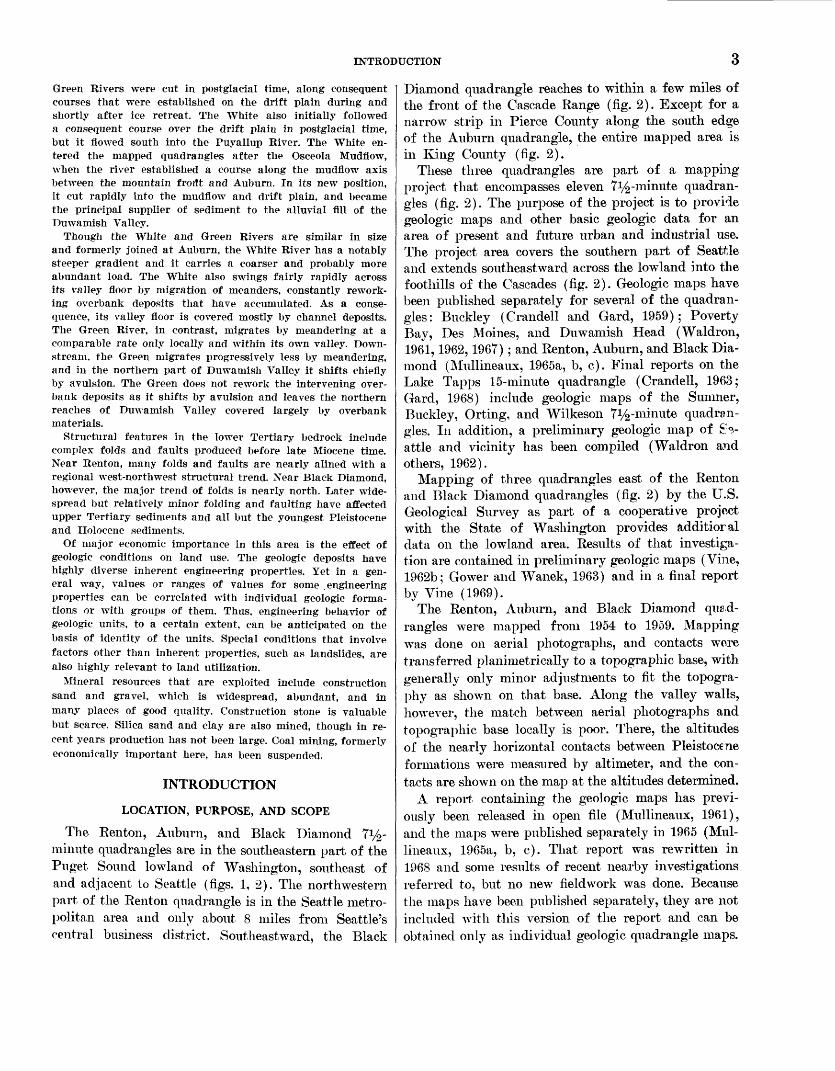
The Renton, Auburn, and Black Diamond T1/^- minute quadrangles are in the southeastern part of the Puget Sound lowland of Washington, southeast of and adjacent to Seattle (figs. 1, 2). The northwestern part of the Renton quadrangle is in the Seattle metro politan area and only about 8 miles from Seattle's central business district. Southeastward, the Black
Diamond quadrangle reaches to within a few miles of the front of the Cascade Range (fig. 2). Except for a narrow strip in Pierce County along the south edge of the Auburn quadrangle, the entire mapped area is in King County (fig. 2).
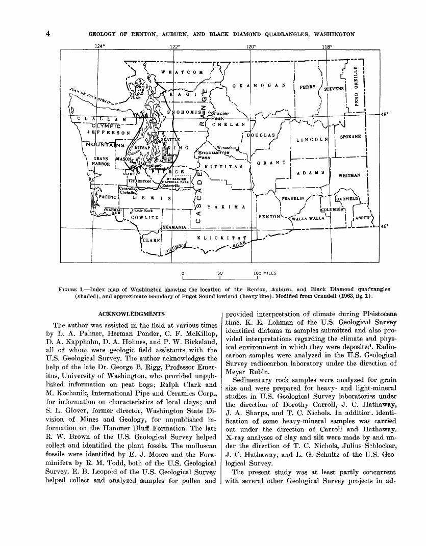
These three quadrangles are part of a mapping project that encompasses eleven T1/^-minute quadran gles (fig. 2). The purpose of the project is to provide geologic maps and other basic geologic data for an area of present and future urban and industrial use. The project area covers the southern part of Seattle and extends southeastward across the lowland into the foothills of the Cascades (fig. 2). Geologic maps have been published separately for several of the quadran gles: Buckley (Crandell and Gard, 1959); Poverty Bay, Des Moines, and Duwamish Head (Waldron, 1961,1962,1967); and Renton, Auburn, and Black Dia mond (Mullineaux, 1965a, b, c). Final reports on the Lake Tapps 15-minute quadrangle (Crandell, 1963; Gard, 1968) include geologic maps of the Sumner, Buckley, Orting, and Wilkeson T^-minute quadran gles. In addition, a preliminary geologic map of Se attle and vicinity has been compiled (Waldron and others, 1962).
Mapping of three quadrangles east of the Renton and Black Diamond quadrangles (fig. 2) by the U.S. Geological Survey as part of a cooperative project with the State of Washington provides additioral data on the lowland area. Results of that investiga tion are contained in preliminary geologic maps (Vine, 1962b; Gower and Wanek, 1963) and in a final report by Vine (1969).
The Renton, Auburn, and Black Diamond quad rangles were mapped from 1954 to 1959. Mapping was done on aerial photographs, and contacts wore transferred planimetrically to a topographic base, with generally only minor adjustments to fit the topogra phy as shown on that base. Along the valley walls, however, the match between aerial photographs and topographic base locally is poor. There, the altitudes of the nearly horizontal contacts between Pleistocene formations were measured by altimeter, and the con tacts are shown on the map at the altitudes determined.
A report containing the geologic maps has previ ously been released in open file (Mullineaux, 1961), and the maps were published separately in 1965 (Mul lineaux, 1965a, b, c). That report was rewritten in 1968 and some results of recent nearby investigations referred to, but no new fieldwork was done. Because the maps have been published separately, they are not included with this version of the report and can be obtained only as individual geologic quadrangle maps.
GEOLOGY OP RENTON, AUBURN, AND BLACK DIAMOND QUADRANGLES, WASHINGTON
124° 122° 120° 118°
N 0 G A N I PERRY
p i-ea* 7
Q:( C H E L A N
i ._._
' U-- <' ^,' "\ /-X-U- v ' \ FRANKLIN^ p [GARFIELDl J
I / ..r-i^lT ¥T%«DT«W I >
I ' «^»r »^y* L, E, W 1 S y^
JSK"^r°clssrfi;K:ir~ r ~ ~ ~ "T J< ^ COWLITZ , - Q
46°
50 I
100 MILES
FIGURE 1. Index map of Washington showing the location of the Renton, Auburn, and Black Diamond quadrangles (shaded), and approximate boundary of Puget Sound lowland (heavy line). Modified from Crandell (1963, fig. 1).
ACKNOWLEDGMENTS
The author was assisted in the field at various times by L. A. Palmer, Herman Ponder, C. F. McKillop, D. A. Kapphahn, D. A. Holmes, and P. W. Birkeland, all of whom were geologic field assistants with the U.S. Geological Survey. The author acknowledges the help of the late Dr. George B. Kigg, Professor Emer itus, University of Washington, who provided unpub lished information on peat bogs; Ralph Clark and M. Kochanik, International Pipe and Ceramics Corp., for information on characteristics of local clays; and S. L. Glover, former director, Washington State Di vision of Mines and Geology, for unpublished in formation on the Hammer Bluff Formation. The late R. W. Brown of the U.S. Geological Survey helped collect and identified the plant fossils. The molluscan fossils were identified by E. J. Moore and the Fora- minifera by R. M. Todd, both of the U.S. Geological Survey. E. B. Leopold of the U.S. Geological Survey helped collect and analyzed samples for pollen and
provided interpretation of climate during Pleistocene jtime. K. E. Lohman of the U.S. Geological Survey identified diatoms in samples submitted and also pro vided interpretations regarding the climate and phys ical environment in which they were deposited. Radio carbon samples were analyzed in the U.S. Geological Survey radiocarbon laboratory under the direction of Meyer Rubin.
Sedimentary rock samples were analyzed for grain size and were prepared for heavy- and light-mineral studies in U.S. Geological Survey laboratories under the direction of Dorothy Carroll, J. C. Hathaway, J. A. Sharps, and T. C. Nichols. In additior, identi fication of some heavy-mineral samples was carried out under the direction of Carroll and Hathaway. X-ray analyses of clay and silt were made by and un der the direction of T. C. Nichols, Julius S^hlocker, J. C. Hathaway, and L. G. Schultz of the U.S. Geo logical Survey.
The present study was at least partly concurrent with several other Geological Survey projects in ad-
123°00'
INTRODUCTION
122*00' 121-00'
^Mountain Front - (Approximate)
Newcastle Hills - promontory z
Snoqualmie
47"00'
FIGURE 2. Index of recent geologic quadrangle mapping by the U.S. Geological Survey in the southeastern part of the Puget Sound lowland. The project of which this work is a part includes the Duwamish Head, Seattle South, D~<: Moines, Poverty Bay, Renton, Auburn, Black Diamond, Sunnier, Buckley, Orting, and Wilkeson 7^-minute quad rangles. The last-named four compose the Lake Tapps 15-minute quadrangle. The Maple Valley, Hobart, and Cum berland quadrangles were mapped as part of another project, in cooperation with the State of Washington.
jacent areas, and the author has benefited greatly from information made available by the geologists respon sible: D. R. Crandell, H. H. Waldron, L. M. Gard, Jr., J. D. Vine, H. D. Gower, A. A. Wanek, and J. E. Luzier. The late Dr. J. Hoover Mackiii, formerly Pro fessor at the University of Washington and the Uni versity of Texas, contributed significantly to the in vestigation through discussion, field conferences, and review of the text. Reviews of the text were also pro vided by Professors J. D. Barksdale, V. S. Mallory, and Peter Misch of the University of Washington, and by Crandell, Waldron, and Vine.
OTHER STUDIES
The discovery of coal near Renton shortly after 1850 and later at Black Diamond stimulated interest in the geology of the area, but most of the early re ports and references to the coal and bedrock contained little discussion of areal geology. The first published results of areal geologic studies are those of Willis (1886; 1898a, c) and Willis and Smith (1899); the stratigraphic divisions of bedrock and surficial de posits established in these reports have been followed since then with surprisingly little change. Willis' studies and those of White (1888, 1889) established
380-731 O - 70 - 2
6 GEOLOGY OF RENTON, AUBURN, AND BLACK DIAMOND QUADRANGLES, WASHINGTON
the use, for example, of the name Puget Group for the arkosic nonmarine rocks in the Puget Sound low land. Willis (1898c) also established the name Vashoii Drift for the youngest drift sheet in the area, and recognized the future necessity of subdividing his pre- Vashon drift unit.
Bedrock of this area has been discussed in many reports since the early reports of Willis. In 1912, Evans described in detail the bedrock and coal beds in King County and divided the rocks exposed along the Green River into three useries." Weaver (1916, 1937) published detailed descriptions of sections meas ured along the Green River during the study with Evans and further described the bedrock near Renton. Glover (1941) described previously unknown but eco nomically important upper Tertiary clay and sand along the Green River, distinguishing them from the bedrock and less weathered Pleistocene deposits. In 1945, Warren, Norbisrath, Grivetti, and Brown pub lished a detailed map of the bedrock and, locally, the depth to rock under the cover of drift. More recently, Gard (in Crandell and Gard, 1959; Gard, 1968) re- described the bedrock in the area where Willis origi nally subdivided the Puget Group. Waldron (1962) and Vine (1962a), as a result of mapping west and east, respectively, of the Renton, Auburn, and Black Diamond quadrangles, defined and named lithologi- cally distinguishable subdivisions of the Puget Group. Vine (1969) restudied the Puget rocks in the Maple Valley, Hobart, and Cumberland quadrangles (fig. 2) and with Gower and Wolfe (Wolfe, Gower, and Vine, 1961; Wolfe, 1968) established a stratigraphic column of Puget Group rocks based on floral zones.
Prior to this study, the Pleistocene deposits of the three quadrangles had not been mapped since Willis' time, though a soils map of King County by Poulson, Miller, Fowler, and Flannery (1952) shows the ap proximate outlines of some surficial geologic units, and many other studies in the lowland dealt in part with the area. Bretz (1913) made an extensive reconnais sance of glaciation in the Puget Sound lowland. His major contribution, the recessional history of the Vashon glacial episode, describes events near Renton and Auburn. Mackin (1941) studied the relation be tween continental and alpine glaciers along the west flank of the Cascades and described a major drainage diversion that brought great volumes of water across the Black Diamond and Auburn quadrangles. Later, Hansen and Mackin (1949) showed that there are at least two pre-Vashon drift sheets in the Puget Sound lowland and that the pollen content of sediments can be used to separate pre-Vashon drifts. In 1958, Cran dell, Mullineaux, and Waldron established the se
quence of three pre-Vashon drift units that is used in this report, and, in 1963, Crandell published a com prehensive study of surficial geology and geomorphol- ogy in the Lake Tapps quadrangle to the south. Re cently, the geologic maps of the Renton, Auburn, and Black Diamond quadrangles have been incorporated into a smaller scale geologic map and report that covers all of southwestern King County (Luzier, 1969).
GEOGRAPHY
TOPOGRAPHY AND DRAINAGE
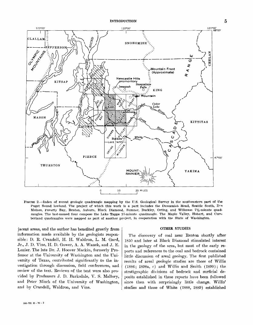
The Renton, Auburn, and Black Diamond quad rangles lie in the broad lowland between the Olympic Mountains and the Cascade Range (fig. 2), where the terrain is dominated by a broad drift plain that stands several hundred feet above the floors of valleys cut into it. Though subdivided into many segrreiits by troughs and valleys, this drift plain extends from the Olympics across the entire lowland to the Cascades. Segments of it are the features called plateaus or islands by Willis (1898c) and later by Newcomb (1952), and Liesch, Price, and Walters (1963). In the vicinity of the mapped area, the drift plain is bounded on the north by a large bedrock ridge herein called the Newcastle Hills promontory (fig. 3), which
; i '///"I-''? ^ Renton '///''""Tiger Mountain
U/
DRIFT
PLAIN
47M5'
47°00'
10I
20I
30 MILES
FIGURE 3. Major physiographic elements in the southeastern part of the Puget Sound lowland (Renton-Auburn-Black Diamond area outlined), showing troughs and highlands that bound the drift plain of that area.
GEOGRAPHY
is a northwest-trending highland that projects far out into the lowland from the Cascade Range. On the east and south, the drift plain is bordered by the southwest-trending front of the Cascades (fig. 3). It is separated from other parts of the drift plain farther west by the trough of the Duwamish Valley.
The drift plain constitutes about 80 percent of the mapped area; its surface is gently rolling, with a re lief of 100-200 feet, and is underlain chiefly by ground moraine. The average altitude increases southeastward, from about 400 feet near the city of Renton to about 600 feet in the southeast corner of the area. The high est point, in the southeast corner of the Black Dia mond quadrangle, is slightly more than 850 feet. Steep- sided valleys of the Cedar, Green, and White Rivers subdivide the drift plain in this area, and the largest of the resulting segments is nearly bisected by a melt- water trench that will be termed the "Covington channel" (fig. 4). The drift plain between the Green and White River valleys is similar to that in other
122-15' 7'30" 122-00'47*30'
22'30"
47°15'
5 MILES
FIGURE 4. Principal physiographic units in the Renton, Au burn, Black Diamond, and Maple Valley quadrangles. Shaded area is drift plain.
parts of the area, except that its lower parts have b^-en covered by the Osceola Mudflow, which forms a flatfish surface that slopes gently northwestward.
The principal valleys that border and subdivide the drift plain locally are the Cedar, Green, and WHte River valleys and the trough of the Duwamish Valley (fig. 4). The largest is the Duwamish Valley, which trends northward along the west side of the Renton and Auburn quadrangles. It is wide, about 2 miles across, and is characterized by gently sloping valley walls. This valley, or trough, is part of an extensive system of troughs in this part of the lowland. To the south, it merges with a similar trough that contrins the Puyallup River (fig. 3). To the north, it divides at Renton; one arm extends northwest to the Puget Sound at Seattle, and the other continues north, where it contains Lake Washington. These troughs are not valleys cut by postglacial rivers; instead they are former extensions of the Puget Sound waterway that have become partly filled to above sea level with lacus trine and alluvial deposits. The part of the trough system herein called the Duwamish Valley (after Willis, 1898c) was occasionally called the White River valley when the White River flowed north to Seattle before 1906, and was called the Green River valley after diversion of the White. But these terms involve a name change and also suggest that the wide trough was cut by one or both of the rivers. The Duwamish Valley is herein regarded as extending from the junc tion with the Puyallup Valley at Sumner, north to Renton, and thence northwest to Seattle (fig. 3).
In contrast to the Duwamish Valley, the valleyp of the Cedar, Green, and White Rivers, which have been cut in postglacial time, are narrow and steep walled.
The lowest altitude in the mapped area, about 10-15 feet above mean sea level, is on the Duwamish Valley floor west of Renton. From there, the altitude of the valley floor increases gradually southward to at out 100 feet at the mouth of the White River valley, then decreases southward. The valley floors of the Cedar, Green, and White Rivers rise somewhat more steeply and reach altitudes of more than 100, 225, and 275 feet, respectively, at the quadrangle boundaries.
The three master streams, the Cedar, Green, and White Rivers, all head in the Cascade Range and flow in well-defined valleys across the mapped area to the Duwamish Valley (figs. 2, 4). Both the Ceiar and the White Rivers form fans on the floor of the Duwamish Valley and in the past have established north- and south-flowing distributaries on these fans. Within this century, the courses of both rivers have been shifted, that of the White River chiefly by nat ural change and that of the Cedar by artificial change.
8 GEOLOGY OP RENTON, AUBURN, AND BLACK DIAMOND QUADRANGLES, WASHINGTON
These drainage changes have been accompanied by several changes in the names applied to various parts of the river system in the Duwamish Valley in the last 60 years (Dart, 1952). Figure 5 shows the river system and the names applied in 1899, when the Ta- coma 30-minute quadrangle map was published, and also the river system and the names applied in 1959. As of 1899, the main distributary of the White Eiver flowed northward to join the Green Eiver near Au burn and the Black River near Kenton and to enter the Puget Sound at Seattle. A smaller distributary flowed southward to join the Puyallup River and en ter the Puget Sound at Tacoma. The north-flowing distributary was known as the White River as far as its junction with the Black, and as the Duwamish River from the junction to the Sound. The smaller distributary was known as the Stuck River down to its junction with the Puyallup River. During a flood
122'15' 122°15'
4 7° 30'
FIGURE 5. Changes of course and nomenclature of rivers in the Duwamish Valley, 1899-1959.
in 1906, most of the White River discharge shifted southward and occupied the Stuck River channel. Shortly thereafter the White River was artificially confined to the Stuck channel, and only the Green River occupied the channel from Auburn north to the junction with the Black River.
The Cedar River has been prevented froir joining the Green by way of the Black River since 1917, when a ship canal was dug connecting Lake Washington to Puget Sound. The lake was lowered several feet, the Cedar River was artificially directed into the lake, and the lake outflow was controlled by navigation locks. The Black River, which formerly contrined the discharge of both Lake Washington and Cedar River, was then reduced to a small brook. The name Du wamish is still usually applied to the river in the Duwamish Valley north of the former junction of the Green and Black Rivers, although the river is now merely the lower reach of the Green River.
In contrast to the master streams, most tributary streams head on the drift plain, where drrinage is only partly integrated. Lakes and bogs are abundant, and many smaller streams flow from swamp to swamp across the plain; only the larger streams r,nd even those only near their mouths have cut well-defined valleys. Northwest of the Coviiigton channel, streams are controlled by a topographic alinement that trends slightly east of south, in the direction of last ice move ment (fig. 6). As a result, many small streams that head just east of the Duwamish Valley do not flow westward into that valley, but instead flow southeast ward. Big Soos Creek, for example, originates only a mile or two from the Duwamish Valley near Renton, then flows south-southeastward nearly parallel to the valley for about 8 miles, and enters the Covington channel leading to the Green River. Southeast of the Covington channel and north of the Green River, most streams flow in abandoned melt-water channels that lead westward and northwestward to the Covington channel or southward to the Green River valley (fig. 6). South of the Green, much of the flattish surface of the Osceola Mudflow is artificially drrlned by ditches. The largest stream, Newaukum Cre°<k, flows northward across the mudflow to the Green River valley.
CLIMATE
The climate of the Puget Sound lowland is mild, with wet winters and dry summers. The mean annual temperature at Seattle and at Kent, in Duwamish Valley between Renton and Auburn, is about 52°F (U.S. Weather Bureau, 1961). The highest mean monthly temperature in Seattle, about 65°F, occurs in July, and the lowest mean, about 40 °F, occurs in
TERTIARY ROCKS 9
122-15' 7'30"
47°15'
FIGURE 6. Pattern of drainage on drift plain (shaded) in Renton, Auburn, and Black Diamond quadrangles, and in Maple Valley quadrangle southwest of Cedar River Valley.
January. Extreme annual temperatures are usually well within limits of 0° and 100°F.
Precipitation is concentrated in the winter months, and it increases from west to east across this part of the Puget Sound lowland. Seattle and Kent, which are typical of the western part of the mapped area, re ceive about 30 35 inches of precipitation annually. Buckley, Snoqualmie Falls, and Landsburg, all of which lie along the east side of the lowland near the Cascade mountain front, receive about 50-60 inches; Cedar Lake, on the western slope of the Cascade Range, receives more than 100 inches annually. About 75 percent of the rainfall occurs in the 6-month period from October through March; the peak rainfall is in December, when rainfall is frequent although usually not heavy.
VEGETATION
The mild and moist climate of the lowland results in a luxuriant growth of vegetation. The natural for est, which at one time consisted principally of large
conifers (Hansen, 1947), has been logged off and only the second growth remains. The second growth is composed of closely spaced smaller trees, chiefly big- leaf maple, alder, Douglas-fir, lowland hemlock, and vine maple. A dense tangle of shrubs and smaller plants grows under the second-growth trees and on cutover land.
Plants grow virtually everywhere except on ve^y rapidly eroded slopes, but the plant types differ mark edly from place to place. These differences are strongly influenced by soil moisture, which in turn is influ enced by the character of the underlying deposit. As a result, the distribution of certain plants locally indicates the identity and distribution of certain geo logic deposits. For example, large deciduous treQ,s rarely grow on terraces of well-drained, gravelly gla cial out wash; stands of Douglas-fir and sparse under brush characterize such deposits. In contrast, abundant deciduous trees and much brushy undergrowth char acterize more clay-rich deposits such as glacial till. Few large trees of any kind grow on deep peat bogs; as a result, in wooded areas the bogs can be recognized readily on the ground or on aerial photographs. On valley walls, plants that prefer very wet ground, such as devilsclub, skunkcabbage, and nettles, suggest the presence of springs or landslide deposits.
CULTURE
In 1960, most of the population of the area was in cities and towns in the Duwamish Valley, along the west edge of the area. Renton, the largest city, with about 18,500 people in 1960, adjoins Seattle on the south. Kent, with about 9,000 people in 1960, and Au- burii, with about 12,000, as well as several smaller cities, are situated farther south along the valley (frg. 7). The largest city east of the Duwamish Valley is Black Diamond, a former coal-mining center at the east edge of the Black Diamond quadrangle.
TERTIARY ROCKS
Tertiary rocks exposed in the Renton, Auburn, and Black Diamond quadrangles are the bedrock, which consists of sedimentary rocks of early Tertiary age and some intrusive rocks, and poorly indurated sedi mentary rocks of late Tertiary age. Rocks older than Tertiary are not known in the mapped area; the nearest outcrops of pre-Tertiary rocks are in the Cascade Range about 20 miles east of Renton (Weaver, 1937). The lower Tertiary sedimentary rocks consist chiefly of the Puget Group of Eocene and Oligocene age, which is several thousand feet thick and which crops out in the northwestern and southeastern parts of the
10 GEOLOGY OF RENTON, AUBURN, AND BLACK DIAMOND QUADRANGLES, WASHINGTON
122-15' 122°00'47-30'
Maple Valley
Covington
Black Diamo^cl^//; '////
22'30"
5 MILES
FIGURE 7. Principal populated areas and centers of communi ties referred to in text.
area near the cities of Renton and Black Diamond (Miillineaux, 1965a, c). The Puget Group is overlain by the Lincoln Creek (?) Formation which is possibly of Eocene or Oligocene age or of both ages; this formation is more than 1,000 feet thick along the Cedar River east of Renton (Miillineaux, 1965a). South and west of Renton, the lower Tertiary rocks have been intruded by small bodies of andesite. The upper Tertiary rocks, the Hammer Bluff Formation, are but a few tens of feet thick and crop out only in a limited area along the Green River near Black Dia mond (Miillineaux, 1965c).
LOWER TERTIARY SEDIMENTARY ROCKS
PUGET GROUP
The Puget Group in this area consists of a thick sequence of arkosic sandstone and interbedded shale and coal, which locally includes a formation of sedi mentary rocks composed almost entirely of fragments of volcanic rock. The Puget probably underlies the entire area, but it crops out only in valley walls and
in a few hills that stand above the surface of the drift plain.
Rocks of the Puget Group were first described by Willis (1886), who referred to them as tK "Coal measures of the Puget Sound basin." A study of mol- luscan fossils from these beds led White (1888) to conclude that although the rocks enclosing th*, fossils were equivalent in age to the Laramie Formation, they had been deposited in a separate basin and de served a different name. Accordingly, he proposed the name Puget Group (White, 1888, p. 446-447). Since then, the name Puget has been used consistently to refer to the coal-bearing brackish- and fresh-water arkosic sandstone and shale of Eocene and locally younger age in the Puget Sound lowland (Willis, 1898a; Landes, 1902; Smith, 1902; Evan?,, 1912; Weaver, 1916, 1937; Warren and others, 1945; Cran- dell and Gard, 1959; Waldron, 1962; Vine, 1962a). Most writers have followed White's usage of the name Puget Group, but some (Willis, 1898a; Evans, 1912) have referred to these rocks as the Puget Formation and Puget Series.
Willis and Smith (1899, p. 8) subdivided the Puget Group near Carbonado (in the Lake Tapps quadran gle) into three formations of arkosic rocks: the Car bonado (oldest), the Wilkeson, and the Burnett (youngest). Evans (1912, p. 42) subdivided the Puget near Black Diamond into three "series," all arkosic, that he called the Bayne (oldest), the FranHin, and the Kiimmer (youngest). These subdivisions ^ere use ful locally, but Willis and Evans (Willis, 1886, p. 759; Evans, 1912, p. 49) pointed out that, owing to such characteristics as the lack of marker h^ds, the similarity of strata from bottom to top, and the len ticular nature of the beds, projection of these subdivi sions from one locality to another was not generally possible.
In some places, however, the Puget Group can be subdivided and correlated on the basis of lithology, because it contains a formation composed chiefly of andesitic sedimentary rocks between the arkoric rocks. Such an andesitic formation lies within the Puget Group from west of Renton eastward to tl x ?, Tiger Mountain area near Issaquah. In this region, the group has been subdivided into three formations. They are, from oldest to youngest, the Tiger Mountain Forma tion (Vine, 1962a), which is typically arkosic; the Tukwila Formation (Waldron, 1962), composed most ly of volcanic materials; and the Renton Formation (Waldron, 1962), composed of arkosic strata. The up per two of these formations crop out in the Renton quadrangle. The Tukwila Formation does not extend southward to the exposures in the Black Diamond
TERTIARY ROCKS 11
district, however, and in that area the arkosic Puget Group was not subdivided for mapping purposes. Be cause of the marked difference in the lithologic se quences that make up the Puget Group in the Black Diamond and Renton districts, the rocks in the two areas are described separately.
UNDIFFERENT1ATED PUGET GROUP NEAR BLACK DIAMOND
Arkosic rocks of the Puget Group are well exposed in the canyon walls of the Green River in sees. 26, 27, and 28, T. 21 N., R. 6 E., and are sparsely exposed in the town of Black Diamond. Coal-mine maps show that these rocks are present also under a thin cover of Quaternary deposits throughout an area of several square miles near Black Diamond (Warren and others, 1945).
The exposures along the Green River extend north eastward into the Cumberland quadrangle for many miles (Gower and Wanek, 1963); these extensive out crops provide one of the best exposed and most studied sequences of Puget Group rocks in this region. Willis (1886, p. 759) first reported the Puget Group of this area to be, not including the top or bottom beds, 6,200- 8,200 feet thick; he later reported that measured sec tions in the area, though they did not represent the complete sequence, totaled 5,800 feet (Willis, 1898b, p. 5). Evans (1912, p. 42) and Weaver (1937, p. 56- 61) measured more than 8,300 feet of Puget Group rocks, and Warren, Norbisrath, Grivetti, and Brown (1945) reported the thickness to be at least 6,500 feet. This great variation in reported thickness probably arises from variations in tentative correlations across several anticlines and synclines as well as across cov ered zones. Vine (1969) recently restudied the section; he reported that though the measurements of Evans and Weaver were accurate for the upper part of the sequence, they were too great for the lower part. Vine estimated the total exposed thickness along the Green River near Black Diamond to be about 6,200 feet (fig. 8; Vine, 1969).
The thickest exposed sequence of the Puget Group within the mapped area, about 1,600 feet thick, crops out along the Green River from the east boundary of the Black Diamond quadrangle westward for 1-2 miles (Mullineaux, 1965c). These beds, which are exposed in the limbs of the Black Diamond anticline of Evans (1912), include parts of the Franklin and Kummer Series of Evans (1912; fig. 8, this report). The 1,600 feet that is exposed within the quadrangle, however, is a small part of the total thickness known in this particular locality. Nearly 1,300 feet of strata that are higher in the Kummer Series crop out between the quadrangle boundary and the axis of the Kummer
syncline of Evans (1912) about half a mile farther east. In addition, drilling records suggest that' at least 4,200 feet of older Puget rocks lie below those exposed
EKummer No. 0* a
Flintclay Kummer sandstone
Harris* --Gem*
-McKay*-
Is0 =
o
ll y C
JS n OlQ
£ o** (o
82 I-4) 3
£
O
ll,-! (0
1-* Oc jo !I«n
£
n o
o>
FEET 0
-1COO
FIGURE 8. Generalized stratigraphic section of the Puget Group in the vicinity of Black Diamond, showing app~ox- imate stratigraphic intervals exposed and penetrated1 by drilling, positions of the Bayne, Franklin, and Kummer Series of Evans (1912), and of several key strata. Data in part from Evans (1912), Anderson (1959), and T7ine (1969). * indicates coal bed.
12 GEOLOGY OF RENTON, AUBURN, AND BLACK DIAMOND QUADRANGLES, WASHINGTON
in the Black Diamond anticline; one of several deep wells drilled near the crest of the anticline reached a depth of 6,023 feet in Puget Group strata that dip less than 45° (Livingston, 1958; Anderson, 1959). The thickness suggested by drill records and exposures is thus about 7,000 feet, without the base of the group being reached.
In the part of the town of Black Diamond within the quadrangle, the Puget strata that are intermit tently exposed represent a stratigraphic interval of about 1,000 feet of the Franklin Series that is strati - graphically lower than the rocks exposed along the Green Eiver to the south (fig. 8). These older rocks, reach the surface in the town because the Black Dia mond anticline rises north of the Green Eiver. The anticline is also offset to the east; consequently, the Puget strata exposed at Black Diamond within the quadrangle are on the west limb of the anticline.
LlTHOLOGY
Rocks in the Black Diamond district are mostly light-gray to light-brown sandstone and interbedded shale. The sandstone encloses at least one thin bed of granule conglomerate and an intraformational con glomerate. The latter is composed of shale fragments, ranging from pebble to boulder size, in a matrix of fine-grained sandstone and is exposed in the Green River valley at the east edge of the quadrangle. High- alumina claystone, the Kummer flint clay of Glover (1941), which is associated with coal and carbonaceous shale, lies a few feet below the intraformational con glomerate. Carbonaceous beds are numerous. More than 10 coal and carbonaceous shale zones, including the Gem, Harris, and Kummer No. 0 coal beds (fig. 8; Evans, 1912; Beikman and others, 1961, p. 52), are present in the strata exposed along the Green River within the quadrangle. At Black Diamond, strata that reach the surface include the McKay coal bed and an other economic coal bed about 300 feet above the Mc Kay (Evans, 1912, p. 151).
The sandstones are mostly medium to very fine grained. Coarser deposits are typically crossbedded, but bedding commonly is obscure except where it is ac centuated by concentrations of carbonaceous material or iron oxide. Some fine-grained rocks are crossbed ded; others are flat bedded. Sandstone samples ana lyzed for grain size range from well sorted to nor mally sorted in the terminology of Trask (1932, p. 72), with sorting coefficient values of about 2.1 to 3.5. Trask's sorting coefficient is based on the central half of the particle-size distribution curve, and fairly well sorted sand grains represent that part of the curve for these rocks. All the samples of sandstones that were
examined, however, contained 20 percent or more of silt and clay (fig. 9). Some other sorting values, such as those of Folk and Ward (1957), which ar°, based on a larger portion of the distribution curve, take into account part of the silt and clay in these reel's. As a result, the sandstones are, in the terminology of Folk and Ward, poorly sorted to very poorly sorted. Indi vidual sand grains in the Puget rocks are mostly sub- angular to subrounded, but every sample that we ex amined contained a few well-rounded grains.
Most of the sandstone is poorly cemented, micaceous, salt-and-pepper arkose, whose predominant minerals are quartz and feldspar. Judged from examinations of one thin section and stained grain mounts from seven samples, quartz constitutes about 50 percent of the grains; potassium feldspar, 20-35 percent; and plagio- clase, 5-20 percent. In stratigraphically lower rocks of the Puget Group nearby, however, plagioclase is reported to be more abundant than potassium feldspar (Vine, 1969). Chert, quartzite, and other rock frag ments make up less than 10 percent of the grains. Muscovite, biotite, and chlorite are distributed through out the sandstones; the micas are conspicuous in hand specimens, yet they probably compose less than 5 per cent of the grains. Suites of heavy minerals (specific gravity > 2.8) generally are dominated by mica, opaque minerals, and brown, earthy aggregates that an X-ray diffraction analysis indicates are composed largely of kaolinite, siderite, and limonite (L. G. Schultz, oral commun., 1960). Other heavy minerals are sparse but consist of a wide variety of species; garnet and zircon are the most common, but tourma line, staurolite, kyanite, rutile, pyroxene, and epidote are also common. In the Kummer Series along the Green River, just east of the quadrangle boundary, garnet is more abundant than zircon; ratios of garnet to zircon in three samples ranged from 2:1 to 5:1. Ratios of these two minerals in Kummer rocks re ported by Bond (1959) are similar. In the Franklin Series within the quadrangle, in contrast, garnet is generally only about half as abundant as zircon.
Coarse and fine silt- and clay-size detritus (fig. 9), plus varying amounts of chemical cement, makes up the matrix of the sandstones. The principal clay min erals identified in the matrix of silty sandstone from the Kummer Series are kaolinite and smaller amounts of illite. Kaolinite and lesser amounts of mica (illite), mixed-layer minerals, and montmorillonite are re ported to' be the clay minerals typical of the upper part of the Puget Group farther east along the Green River (Vine, 1969). The cement is largely calcite. The cal- cite is widely but very unevenly distributed r.nd typ-
TERTIARY ROCKS 13
0.01
SIZE OF PARTICLES, IN MILLIMETERS
0.1 1.0 10.0
CLAY GRANULES PEBBLES
FIGURE 9. Cumulative curves of Puget Group arkose samples. Numbers 1-8 are from the undifferentiated Puget Group in Black Diamond area. Numbers 9-12 are from the Renton Formation at Renton.
ically forms bulbous concretions or lenticular concre tionary lenses. Locally, it composes as much as a third of the rock, not only filling intergranular spaces, but also replacing parts of grains along their margins.
Shale probably makes up less than a third of the Puget strata exposed in the quadrangle, forming less of the rocks in the upper part of the Puget Group along the Green River than it does in the lower part (Weaver, 1937; Vine, 1969). Siltstone is predominant over claystone, and both locally are carbonaceous. One of the claystones, the Kummer flint clay, is a high- alumina deposit, containing as much as 51 percent ALO3 (Glover, 1941); it consists mostly of kaolinite, gibbsite, and boehmite (Nichols, 1946).
WEATHERING
The Puget Group locally has undergone severe weathering. One locality of deep weathering is at Hammer Bluff, on the north side of the Green River in the NWi/4 sec. 28, T. 21 N., R. 6 E. In that area, arkose in the Puget is weathered and leached to a depth of as much as 30 feet and is now a light-gray friable sand composed mostly of quartz and kaolinitic clay. For an additional few tens of feet downward, in less weathered rocks, iron oxide has stained the ar
kose to brown or greenish-brown. Enough feldspar has been altered to clay and enough cement and iron oxide have been leached away so that the weathered arkose at Hammer Bluff has been used as a source of silica sand.
STRATIGRAPHIG RELATIONS
The Puget Group is the oldest rock unit exposed in the Black Diamond district; it is overlain by andesitic sedimentary rocks of Oligocene age (Warren and others, 1945; Wolfe, Gower, and Vine, 1961). NeitHr the lower nor the upper contact of the group is exposed in the mapped area; .the approximate position of the upper contact is known just east of the Black Diamond quadrangle in the Kummer syncline, but it is hidden beneath a large landslide. The attitudes of the Puget Group and the andesitic sedimentary rocks indicate little if any angular unconformity between the t^o formations. The andesitic sedimentary rocks are not exposed within the Black Diamond quadrangle; here, the Puget Group is unconformably overlain by the upper Miocene Hammer Bluff Formation.
FOSSILS AND AGE
Fossil leaves and fragments of petrified wood occur at many horizons in the Puget Group. According to
380-731 O - 70 - 3
14 GEOLOGY OP RENTON, AUBURN, AND BLACK DIAMOND QUADRANGLES, WASHINGTON
Willis (1898a), the fossil flora represented was cor related by Newberry with that of the Laramie Forma tion, and the Puget was dated as Late Cretaceous or early Eocene. F. H. Knowlton (in Willis and Smith, 1899, p. 3) noted that many species are represented and that there are well-marked differences between plants from the lower beds of the Puget and those from the upper beds at such places as the Kummer flint clay mine along the Green Kiver. Willis (1898a, p. 403) stated that Knowlton, on the basis of a pre liminary examination, reported the lower beds to be Eocene in age and the upper beds to be possibly younger than Eocene. As a result of a study of fossil leaves collected recently, Wolfe (in Wolfe, Gower, and Vine, 1961; Wolfe, 1968) recognized several biostrati- graphic subdivisions in the Puget Group near Black Diamond. He (1968) assigned most of that part of the sequence exposed along the Green Kiver within the Black Diamond quadrangle to the upper part of his Eavenian Stage, which he regards as of late Eocene age and approximately equivalent to the Tejon and lowermost part of the Keasey Stages of the standard Pacific Coast section (fig. 10; Weaver and others, 1944).
A few pelecypods have been recovered from the Puget in the Green Kiver valley,, mostly from or near the old Kummer clay mine, wThich is near the east edge of the Black Diamond quadrangle. The only fossils identified are a species of Corbicula, a genus reported to inhabit brackish and fresh water (White, 1889), and Batissa new'be-rryi White (F. S. McNeil, written comniun., 1962), which also inhabits fresh w?,ter, and perhaps brackish water.
SOURCE
Angularity and abundance of quartz and feldspar grains as compared with lithic fragments are regarded as suggesting that the rocks of the Puget Group were derived chiefly from silicic, plutonic igneous, or meta- morphic rocks (Petti John, 1957, p. 512). The few well- rounded sand-sized grains of quartz, garnet, and zir con indicate that a small part of the material was derived from preexisting sediments. An abundance of feldspar grains indicates also that the source of the grains either was subject to a rigorous climate or had a high relief (PettiJohn, 1957, p. 328). F. H. Knowl ton (in Willis and Smith, 1899, p. 3) pointed out that the climate in both eastern and western Washington
Wolfev i yooy
Age
OLIGOCENE
EOCENE
Stages
Kummerian
Ravenian
Informal substages
Lower
Upper
Standard Pacific Coast section(Weaver and others, 1944)
Based on marinemegafossils
Stages
"Lincoln"
"Keasey"
"Tejon"
Age
OLIGOCENE
EOCENE
Based on marinemicrofossils
Age
OLIGOCENE
"EO- OLIGOCENE"
EOCENE
Stages
Refugian
Unnamed
Rau (1958, 1966); Beikman
Stages
Refugian ofSchenck
Kleinpell (1936)
Upperpart of Narizian ofMallory (1959)
Zones
Cassadulina galvinensis(FormerlyEponideskleinpelli)
Sigmomorphina schencki
Buliminaschencki Plecto-frondicularia cf . P. jenkinsi
Age
OLIGOCENE
"EO- OLIGOCENE"
EOCENE
FIGURE 10. Late Eocene and early Oligocene fossil stages and zones, based on studies of plants by Wolfe (196:7 ) and of Foraminifera by Rau (1966) and on correlations suggested by Wolfe and Rau with the standard Pacific Coast section.
TERTIARY ROCKS 15
during Eocene time was mild; thus, high relief prob ably was the controlling factor.
Heavy-mineral suites show distinct changes from the lower to the upper parts of the Puget Group. Progres sive upward change also occurs in types of clay min erals and feldspars present (Vine, 1969). Hence, the character or location of the source changed somewhat during deposition of the Puget rocks. Perhaps erosion uncovered different rock types in the same source area, or one or more streams from a different source entered the depositional basin.
Weaver (1937, p. 9, 67) suggested that the sources of the Puget Group lay generally east of the Puget Sound lowland in northeastern Washington, British Columbia, and Idaho. Bressler (1957), however, named the source of the Roslyn Formation, regarded by Weaver as an upstream equivalent of at least part- of the Puget, as the Mount Stuart batholith of central Washington. The problem of source is complicated by the fact that not only the suggested source rocks, but also the probable sedimentary correlatives of the Puget Group and the Puget Group itself, show considerable variations in mineral content. There is general agree ment that the Puget rocks were derived from some where to the east, but a specific source has not been located.
TUKWILA FORMATION
The Tukwila Formation, which underlies the Renton Formation in the Renton district, was named for the city of that name on the west side of the Duwamish Valley about 2 miles southwest of Renton (Waldron, 1962). The Tukwila crops out extensively in northwest Renton, and sparsely just south of the city. These rocks are part of the "tuffs and breccias" described by War ren, Norbisrath, Grivetti, and Brown (1945) as the "Eocene volcanic series,11 and have been described by others (Willis and Smith, 1899; Weaver, 1937) to in clude aiiclesitic flows, tuffs, breccias, and dikes.
The thickest, section of the formation known in this district is in the hill in northwest Renton, where the rocks of the Tukwila Formation crop out intermit tently along the strike of the beds for about a mile. Dips here range from slightly less than 20° to about 40°; the exposed thickness is inferred to be between 2,000 and 3,000 feet, and the total thickness is not known. The Tukwila Formation probably thickens toward the east; it is estimated to be nearly 7,000 feet thick about 10 miles east of Renton (Warren and others, 1945; Vine, 1969).
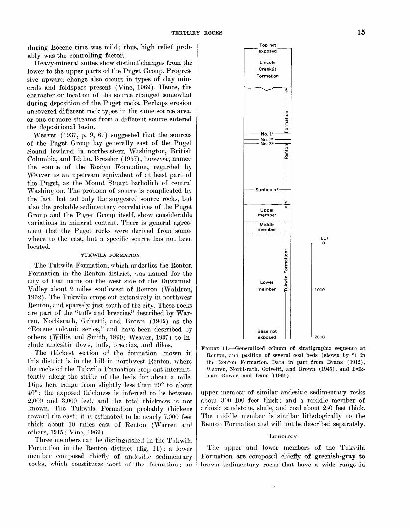
Three members can be distinguished in the Tukwila Formation in the Renton district (fig. 11) : a lower member composed chiefly of andesitic sedimentary rocks, which constitutes most of the formation; an
Top not exposed
Lincoln
Creek(?)
Formation
No. 1*-No. 2*- No. 3*-
Sunbeam*-
Upper member
Middle member
Lower
member
Base not exposed
FEET 0
L 2000
FIGURE 11. Generalized column of stratigraphic sequence at Renton, and position of several coal beds (shown by *) in the Renton Formation. Data in part from Evans (1912), Warren, Norbisrath, Grivetti, and Brown (1945), and B<nk- man, Gower, and Dana '(1961).
upper member of similar andesitic sedimentary ro°.ks about 300-400 feet thick; and a middle member of arkosic sandstone, shale, and coal about 250 feet thick. The middle member is similar lithologically to the Renton Formation and will not be described separately.
LlTHOLOGY
The upper and lower members of the Tukvdla Formation are composed chiefly of greenish-gray to brown sedimentary rocks that have a wide range in
16 GEOLOGY OF RENTON, AUBURN, AND BLACK DIAMOND QUADRANGLES, WASHINGTON
texture. Poorly sorted, locally conglomeratic and tuf- faceous sandstone apparently is predominant, and con glomerate, mudstone, shale, and tuff are common. A boulder conglomerate that includes subangular as well as rounded fragments crops out in the middle of the upper member along State Highway 900 about a mile west of the center of Renton, and bouldery poorly sorted volcanic mudstones that probably are mudflows are exposed in both members. Small outcrops of lava occur in a few places in the Tukwila, but it is not- evident whether these rocks are parts of flows or in trusions. Several beds of fine-grahied silicified tuff lie about 500 feet below the top of the lower member. Coal is uncommon, although a layer of soft brown coal 1-2 feet thick was temporarily exposed in the upper part of the lower member west of Renton.
Most sandstones, conglomerates, and mudstones are poorly sorted and are poorly stratified or massive. Many of these rocks are intensely fractured in an ir regular pattern. Only in the upper parts of the lower and upper members do normally sorted and clearly stratified sandstones seem to be common.
Boulders, cobbles, pebbles, and most sand grains of the upper and lower members are fragments of por- phyritic andesite or basalt, and most other readily identifiable grains are plagioclase. Altered mafic, min erals and opaque iron minerals are common, and quartz and apatite are accessory minerals. Nearly all the sand stone and conglomerate beds contain a considerable proportion of silt and clay, which consists chiefly of rock and plagioclase fragments in a matrix of green and brown minerals that include moiitmorillonite, zeo lite, and iron oxides. Calcium moiitmorillonite is the dominant clay mineral in several mudstone samples analyzed by X-ray diffraction. Yellowish-brown to dark-brown iron oxide is widely scattered throughout both the lower and the upper members. Organic ma terial is common, as coatings on grains and as particles ranging from silt size to more than G inches in diam eter. Most of the larger fragments of organic material are partly replaced by iron oxide and silica.
Tukwila rocks are mostly moderately to poorly in durated. Some, however, especially a few breccias and tuffs, are hard and resistant. Clay minerals, and per haps iron oxide, apparently provide the coherence for most of the rocks, though chemical cement also is com mon. Calcite probably is the most abundant cement, although silica and zeolite may cement some rocks. Thin siliceous tuff beds probably are the hardest rocks in the formation. Along Highway 900 west of Renton, in the NWVi sec. 13, the upper member of the Tukwila is cut by numerous veins composed chiefly of calcite
and quartz. The veins are similar to those in an intru sive body that is exposed half a mile farther south, and they probably were deposited from solutions de rived from the intrusive body.
ALTERATION
Tukwila rocks are noticeably altered, as seen both in outcrop and under the microscope. Many exposures exhibit soft brown nearly unidentifiable rock in which structure and texture are obscure. Grains as well as matrix are strongly affected and are changed mostly to moiitmorillonite, calcite, chlorite, and zeolite. Alter ation is relatively strong near the large intrusive body 2 miles west of the center of Renton, and it probably is due to hydrothermal action. In other places, nirficial weathering has changed sandstone and conglomerate to clay in which little granular texture is retained. Most of this weathering probably occurred after depo sition and deformation of the Puget Group. However, a buried weathering profile that formed at the top of the lower member during Tukwila time is exposed in Renton along Renton Avenue in the SWi/iNW1/^ sec. 18. At this locality, hard and relatively unweT.thered volcanic sandstone grades upward into softer deeply weathered sandstone in which the sedimentary texture is only faintly preserved and most grains are altered to clay. This weathered volcanic sandstone is cverlain by and appears to grade upward into a gray kaolinitic claystone, which is overlain by coal at the base of the middle member. How the bed of kaolinitic claystone was formed is not clear. It could hare been formed by weathering of the sandstone before deposition of the coal, but it could instead have been formed by ill-place alteration beneath the coal or even simply by deposi tion of a bed of kaolinitic clay. If formed by weather ing, a pause in deposition would be indicated that would be much longer than that shown by weathering of the still-recognizable volcanic sandstone, which in itself records a considerable pause in deposition during Tukwila time.
STRATIGRAPHIC RELATIONS
Neither the base of the Tukwila Formation nor the rocks directly underlying it are exposed in this area. At a locality 3 miles northwest of Renton, the Tukwila is in apparent fault contact with older marine sedi mentary rocks (Waldron, 1962). About 10-15 miles east of Renton, near Tiger Mountain, the Tukwila conformably overlies and iiiterfingers with the Tiger Mountain Formation (Vine, 1962a). In northwest and south Renton the apparently conformable contact of the Tukwila with the overlying Renton Formation,
TERTIARY ROCKS 17
though it is not exposed, can be located within a few feet.
The contact between the lower and middle members of the Tukwila Formation is exposed in Renton. along Renton Avenue in sec. 18. The lower member here is strongly weathered, which indicates a time break be tween deposition of the two members; no evidence of erosion or angular unconformity, however, is exposed. The arkosic middle member contains volcanic rock fragments near its top, and its upper contact, which is not exposed, may be gradational.
FOSSILS AND AGE
Plant fragments were the only fossils found in the Tukwila Formation during this investigation. They occur throughout almost all the fine-grained andesitic sedimentary rocks and are especially abundant and well preserved in a zone about 200 feet thick in the upper part of the lower member. In 1958, these fossilif- erous rocks were well exposed in many excavations in the NWViNWi/i sec. 13, T. 23 K, R. 4 E. Fossil leaves collected from the NWi/iNW1/^ sec. 13 during this in vestigation were identified by R. W. BrowTn (written commun., 1957) of the U.S. Geological Survey as Las- trea, fischeri Heer, Woodivardia sp., Equisetum sp., FmUax sp., Sabal sp., Carya or Aescidus sp., Tetracera sp., Phttanophyttum angustilobum (Lesquereux) Mac- Ginitie, and Cercldipliyllum sp. The fossiliferous zone is exposed intermittently westward to the wall of the Duwamish Valley in the Des Moines quadrangle at the south boundary of sec. 11, T. 23 N., R. 4 E., where several fossil collections have been made at a site known as the Steels Crossing locality (F. H. Knowl- ton, in Willis and Smith, 1899). Fossil leaves collected by H. H. Waldron at the Steels Crossing locality were also identified by R. W. Brown, who reported the fol lowing forms not found in sec. 13 (written commun., 1958) : Allantodiopsis erosa (Lesquereux) Knowlton and Maxon, Chaetoptelea sp., Platanus sp., Cinnamo- muin dttleri Knowlton, (Jastanea castaneaefolia (Un- ger) Knowton, and Alangium sp. According to Brown, the assemblage of leaves from this zone indicates that the enclosing rocks date from the latter half of the Eocene, J. A. Wolfe (written commun., 1964) stated that the assemblage from sec. 13 could represent either the lower or the upper part of the Ravenian Stage; both zones are regarded as late Eocene in age (fig. 10; Wolfe, 1968). The assemblage from Steels Crossing was assigned by Wolfe (written commun., 1964) to the lower part of the Ravenian. The Tukwila Formation of the Tiger Mountain area was assigned a late Eocene age by Vine (1962a) and a late Eocene and early Oligocene age by Wolfe (1968).
SOURCE
The coarse texture and volcanic detritus of the Tuk wila Formation suggest that the formation was de rived mostly from a nearby volcanic center. Typically poor sorting, angularity of even coarse detritus, and tuff beds as much as 2 feet thick also indicate that the source was not far distant. Interbeddiiig of arkosic and volcanic material in the formation suggests fur ther that the lithologic character of detritus supplied to the depositing rivers changed rapidly. This and the evidence of contemporaneous volcanism indicate that newly erupted material rather than older voles -nic rocks provided the volcanic detritus for the Tukwila Formation.
Evidence for location of the source of the Tukvnla comes largely from outside the mapped area. Warren, Norbisrath, Grivetti, and Brown (1945) concluded that the source of rocks here described as Tukvila probably was near Issaquah, where the greatest thick ness of the rocks was found. From there, the Tukvila thins southward and interfingers with arkosic rockr of the Puget Group (Warren and others, 1945; Vine, 1962a). The volcanic formation is missing farther south in the Green River gorge, where volcanic detritus was found in only a few thin beds within the Puget Group (Vine, 1962a). Thinning of the formation toward Renton is probable but cannot be demonstrated, but the more abundant coarse breccias and lava flows near Issaquah Mountain indicate that the source was nearer that locality than it was to Renton.
RENTON FORMATION
The Renton Formation consists of the arkosic sand stone, shale, mudstone, and coal that make up the up per part of the Puget Group in the Renton distrct; the formation was named for the city of Renton by Waldron (1962). It crops out typically in valley wr.lls in Renton in sees. 17, 18, and 19 and also crops out in sec. 30, 23, and 24 south and west of Renton. It has been regarded as part of the Puget Group since the Puget was first described by Willis (Willis, 189°a; Evans, 1912; Weaver, 1937; Warren and others, 1945).
The thickness of the formation near Renton appar ently is about 2,500 feet, Along the Cedar River, about 1,000 feet of the upper part of the formation overlies the Renton No. 1 coal bed (fig. 11). Along the Du wamish Valley wall, intermittent exposures indicate that the thickness under the same coal bed is about 1,500 feet. The Renton Formation in the Tiger Moun tain area east of Renton is reported to be at least 2,250 feet thick (Vine, 1962a), and near Issaquah, northeast of Renton, it is 3,000-3,200 feet thick (Warren and others, 1945).
18 GEOLOGY OF RENTON, AUBURN, AND BLACK DIAMOND QUADRANGLES, WASHINGTON
LlTHOLOGY
The Rentoii Formation is composed mostly of arko- sic sandstone and shale. In the upper third of the formation, probably a little more than half the rock is sandstone, but scattered exposures and one drill rec ord suggest that the lower two-thirds is mainly fine- and medium-grained sandstone. The formation also locally contains thin beds of sandy granule conglom erate and layers of mudstone. Several intraf ormational conglomerates, composed of fragments of shale in a sandstone matrix, are exposed in a commercial claypit in Renton on the south side of the Cedar River. Three coal beds that were mined for many years at Renton, known as the Renton No. 1, Renton No. 2, and Renton No. 3 (fig. 11; Evans, 1912, p. 110), lie just above the middle of the formation. Several other coal beds that have been mined occasionally, notably the Sunbeam bed (fig. 11; Warren and others, 1945), lie a short dis tance above the base of the formation. In addition, thin coal and carbonaceous shale beds are distributed throughout most of the formation.
The overall composition, grain size (fig. 9), struc ture, and texture of rocks of the Renton Formation are similar to those of the rocks of the undifferentiated Puget Group exposed in the Black Diamond district. The Renton Formation consists mainly of quartz and feldspar and contains virtually the same accessory minerals as the rocks in the Black Diamond district. However, plagioclase appears to be as abundant as potassium feldspar in the Renton Formation, garnet is the dominant nonmicaceous nonopaque heavy mineral in all samples examined, and siderite is much less abundant than in the undifferentiated Puget Group at Black Diamond. Kaolinite, mica (illite), montmoril- lonite, and chlorite are the most common clay minerals in the formation at Renton.
STRATIGRAPHIC RELATIONS
The Renton Formation conformably overlies the Tukwila Formation and is overlain with at least minor clisconforniity by andesitic sedimentary rocks of the Lincoln Creek(?) Formation. About a mile east of the center of the city of Renton, the upper contact of the Renton Formation is exposed in a railroad cut- bank on the south side of the Cedar River in the SE^- SEi/4 sec, 17, and in a highway cutbaiik 011 the north side of the river in the SW^SW^ sec. 16. In the ex posure along the railroad, the base of a volcanic con glomerate truncates bedding planes in the Renton at angles of 10°-15°. This crosscutting relation appar ently was interpreted by Warren, Norbisrath, Grivetti, and Brown (1945) as a slight angular unconformity. The relation is not clear because the attitude of the
conglomerate is obscure, and because dips in the Ren ton and the overlying formation vary by several de grees even in single exposures. Overall, however, strata in the two formations appear to be parallel, and the contact probably represents a disconformity rather than an angular unconformity. Even the disconformity may be local, for the contact in the highway exposure 011 the north side of the river appears to be conform able.
Locally, arkosic strata crop out apparently strati- graphically above the upper contact of the Renton Formation. Along the railroad in sec. 17, a 30- to 40- foot-thick sequence of arkosic rocks crops out appar ently more than 50 feet stratigraphically above the contact. Arkosic strata also occur in several smaller exposures above the contact, Stratification in the larg est exposure is parallel to that in the Renton Forma tion, and the arkosic rocks at first appear to be an interbed in the overlying andesitic sedimentary rocks. The attitudes in most of these small exporures of arkosic rocks, however, differ markedly from the atti tude in the Renton Formation, and in some erposures these arkosic rocks can be seen bounded by faults. Willis (1898a) described an exposure at this locality in which a sequence of thin-bedded sandstone with an attitude much different from that of Renton Forma tion strata was bounded 011 top and bottom b7 faults. Furthermore, faults mapped in coal mines at Renton a mile to the west strike directly toward these outcrops (Evans, 1912). Although the arkosic strata above the upper contact of the Renton Formation might be inter- bedded in the andesitic sedimentary formation, they presently are regarded as fault slices of Renton strata.
FOSSILS AND AGE
No fossils were found in the Renton Formation near Rentoii, thus its age assignment depends on ages de termined for underlying and overlying rocks. Plant fossils in the Tukwila Formation west of Renton are assigned to the late Eocene lower part of the Kavenian Stage by J. A. Wolfe (written commim., 1964; fig. 10, this report). The few Foraminifera identified from the overlying Lincoln Creek (?) Formation at Renton do not distinguish between a late Eocene or early Oligo- ceiie age for the Lincoln Creek(?). A more definitive assemblage of forams from similar Lincoln Cv>eek(?) rocks about 5 miles to the northwest in Seattle, how ever, are assigned to the boundary-straddling "Eo- Oligocene1 '' age (W. W. Ran, written commun., 1967, H. H. Waldroii, unpub. data, 1967). Therefore, the author regards the underlying Rentoii Formation at Renton as late Eocene in age as defined by forams. The formation is considered by Wolfe (1968), on the
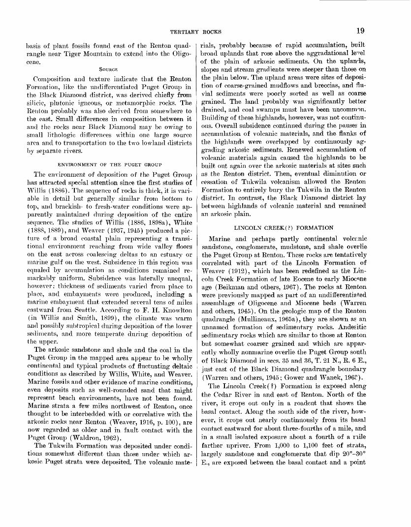
TERTIARY ROCKS 19
basis of plant fossils found east of the Renton quad rangle near Tiger Mountain to extend into the Oligo- cene.
SOURCE
Composition and texture indicate that the Renton Formation, like the undifferentiated Puget Group in the Black Diamond district, was derived chiefly from silicic, plutoiiic igneous, or metamorphic rocks. The Renton probably was also derived from somewhere to the east. Small differences in composition between it and the rocks near Black Diamond may be owing to small lithologic differences within one large source area and to transportation to the two lowland districts by separate rivers.
ENVIRONMENT OF THE PUGET GROUP
The environment of deposition of the Puget Group has attracted special attention since the first studies of Willis (1886). The sequence of rocks is thick, it is vari able in detail but generally similar from bottom to top, and brackish- to fresh-water conditions were ap parently maintained during deposition of the entire sequence. The studies of Willis (1886, 1898a), White (1888, 1889), and Weaver (1937,1945) produced a pic ture of a broad coastal plain representing a transi tional environment reaching from wide valley floors on the east across coalescing deltas to an estuary or marine gulf on the west. Subsidence in this region was equaled by accumulation as conditions remained re markably uniform. Subsidence was laterally unequal, however; thickness of sediments varied from place to place, and embayments were produced, including a marine embayment that extended several tens of miles eastward from Seattle. According to F. H. Knowlton (in Willis and Smith, 1899), the climate was warm and possibly subtropical during deposition of the lower sediments, and more temperate during deposition of the upper.
The arkosic sandstone and shale and the coal in the Puget Group in the mapped area appear to be wholly continental and typical products of fluctuating deltaic conditions as described by Willis, White, and Weaver. Marine fossils and other evidence of marine conditions, even deposits such as well-rounded sand that might represent beach environments, have not been found. Marine strata a few miles northwest of Renton, once thought to be interbedcled with or correlative with the arkosic rocks near Renton (Weaver, 1916, p. 100), are now regarded as older and in fault contact with the Puget Group (Waldron, 1962).
The Tukwila Formation was deposited under condi tions somewhat different than those under which ar kosic Puget strata were deposited. The volcanic mate
rials, probably because of rapid accumulation, built broad uplands that rose above the aggradational le^el of the plain of arkosic sediments. On the uplands, slopes and stream gradients were steeper than those on the plain below. The upland areas were sites of deposi tion of coarse-grained rnudflows and breccias, and flu vial sediments were poorly sorted as well as coarse grained. The land probably was significantly better drained, and coal swamps must have been uncommon. Building of these highlands, however, was not continu ous. Overall subsidence continued during the pauses in accumulation of volcanic materials, and the flanks of the highlands were overlapped by continuously ag grading arkosic sediments. Renewed accumulation of volcanic materials again caused the highlands to be built out again over the arkosic materials at sites such as the Renton district. Then, eventual diminution or cessation of Tukwila volcanism allowed the Renton Formation to entirely bury the Tukwila in the Renton district. In contrast, the Black Diamond district lay between highlands of volcanic material and remained an arkosic plain.
LINCOLN GREEK(?) FORMATION
Marine and perhaps partly continental volcmic sandstone, conglomerate, mudstone, and shale overlie the Puget Group at Renton. These rocks are tentatively correlated with part of the Lincoln Formation of Weaver (1912), which has been redefined as the Lin coln Creek Formation of late Eocene to early Miocene age (Beikman and others, 1967). The rocks at Renton were previously mapped as part of an undifferentiated assemblage of Oligocene and Miocene beds (Warren and others, 1945). On the geologic map of the Renton quadrangle (Mullineaux, 1965a), they are shown as an unnamed formation of sedimentary rocks. Andes itic sedimentary rocks which are similar to those at Renton but somewhat coarser grained and which are appar ently wholly nonmarine overlie the Puget Group south of Black Diamond in sees. 35 and 36, T. 21 N., R. 6 E., just east of the Black Diamond quadrangle boundary (Warren and others, 1945; Gower and Wanek, 196").
The Lincoln Creek(?) Formation is exposed along the Cedar River in and east of Renton. North of the river, it crops out only in a readout that shows the basal contact. Along the south side of the river, how ever, it crops out nearly continuously from its basal contact eastward for about three-fourths of a mile, and in a small isolated exposure about a fourth of a nile farther upriver. From 1,000 to 1,100 feet of strata, largely sandstone and conglomerate that dip 20°-30° E., are exposed between the basal contact and a point
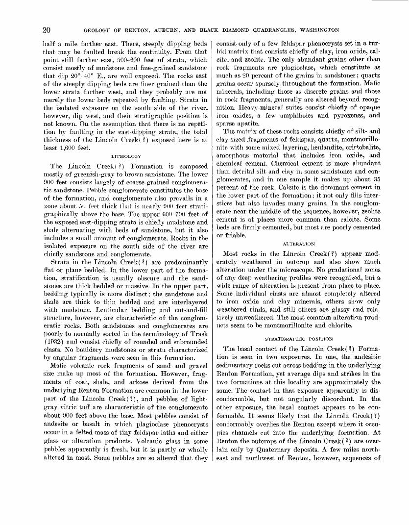
20 GEOLOGY OF RENTON, AUBURN, AND BLACK DIAMOND QUADRANGLES, WASHINGTON
half a mile farther east. There, steeply dipping beds that may be faulted break the continuity. From that point still farther east, 500-600 feet of strata, which consist mostly of mudstoiie and fine-grained sandstone that dip 20°-40° E., are well exposed. The rocks east of the steeply dipping beds are finer grained than the lower strata farther west, and they probably are not merely the lower beds repeated by faulting. Strata in the isolated exposure on the south side of the river, however, dip west, and their stratigraphic position is not known. On the assumption that there is no repeti tion by faulting in the east-dipping strata, the total thickness of the Lincoln Creek ( ?) exposed here is at least 1,600 feet.
LITHOLOGY
The Lincoln Creek ( ?) Formation is composed mostly of greenish-gray to brown sandstone. The lower 900 feet consists largely of coarse-grained conglomera tic sandstone. Pebble conglomerate constitutes the base of the formation, and conglomerate also prevails in a zone about 50 feet thick that is nearly 900 feet strati- graphically above the base. The upper 600-700 feet of the exposed east-dipping strata is chiefly mudstone and shale alternating with beds of sandstone, but it also includes a small amount of conglomerate. Rocks in the isolated exposure on the south side of the river are chiefly sandstone and conglomerate.
Strata in the Lincoln Creek(?) are predominantly flat or plane bedded. In the lower part of the forma tion, stratification is usually obscure and the sand stones are thick bedded or massive. In the upper part, bedding typically is more distinct; the sandstone and shale are thick to thin bedded and are interlayered with mudstone. Lenticular bedding and cut-and-fill structure, however, are characteristic of the conglom eratic rocks. Both sandstones and conglomerates are poorly to normally sorted in the terminology of Trask (1932) and consist chiefly of rounded and subrounded clasts. No boulclery mudstones or strata characterized by angular fragments were seen in this formation.
Mafic volcanic rock fragments of sand and gravel size make up most of the formation. However, frag ments of coal, shale, and arkose derived from the underlying Rent on Formation are common in the lower part of the Lincoln Creek(?), and pebbles of light- gray vitric tuff are characteristic of the conglomerate about 900 feet above the base. Most pebbles consist of andesite or basalt in which plagioclase phenocrysts occur in a felted mass of tiny feldspar laths and either glass or alteration products. Volcanic glass in some pebbles apparently is fresh, but it is partly or wholly altered in most. Some pebbles are so altered that they
consist only of a few feldspar phenocrysts set in a tur bid matrix that consists chiefly of clay, iron oride, cal- cite, and zeolite. The only abundant grains other than rock fragments are plagioclase, which constitute as much as 20 percent of the grains in sandstones; quartz grains occur sparsely throughout the formation. Mafic minerals, including those as discrete grains and those in rock fragments, generally are altered beyond recog nition. Heavy-mineral suites, consist chiefly of opaque iron oxides, a few amphiboles and pyroxenes, and sparse apatite.
The matrix of these rocks consists chiefly of silt- and clay-sized .fragments of feldspar, quartz, montmorillo- nite with some mixed layering, heulandite, crirtobalite, amorphous material that includes iron oxide, and chemical cement. Chemical cement is more abundant than detrital silt and clay in some sandstones and con glomerates, and in one sample it makes up about 35 percent of the rock. Calcite is the dominant cement in the lower part of the formation; it not only fills inter stices but also invades many grains. In the conglom erate near the middle of the sequence, however, zeolite cement is at places more common than calcite. Some beds are firmly cemented, but most are poorly cemented or friable.
ALTERATION
Most rocks in the Lincoln Creek(?) appear mod erately weathered in outcrop and also show much alteration under the microscope. No gradational zones of any deep weathering profiles were recognized, but a wide range of alteration is present from place to place. Some individual clasts are almost completely altered to iron oxide and clay minerals, others show only weathered rinds, and still others are glassy r,nd rela tively unweathered. The most common alteration prod ucts seem to be montmorillonite and chlorite.
STRATIGRAPHIC POSITION
The basal contact of the Lincoln Creek(?) Forma tion is seen in two exposures. In one, the andesitic sedimentary rocks cut across bedding in the UB derlying Renton Formation, yet average dips and strikes in the two formations at this locality are approximately the same. The contact in that exposure apparently is dis- conformable, but not angularly discordant. In the other exposure, the basal contact appears to be con formable. It seems likely that the Lincoln Creek(?) conformably overlies the Renton except where it occu pies channels cut into the underlying formation. At Renton the outcrops of the Lincoln Creek (?) are over lain only by Quaternary deposits. A few miles north east and northwest of Renton, however, sequences of
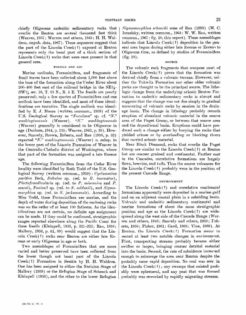
TERTIARY ROCKS 21
chiefly Oligocene andesitic sedimentary rocks that overlie the Renton are several thousand feet thick (Weaver, 1937; Warren and others, 1945; H. H. Wal- dron, unpub. data, 1967). These sequences suggest that the part of the Lincoln Creek(?) exposed at Renton represents only the basal part of a thick section of Lincoln Creek( ?) rocks that were once present in that general area.
FOSSILS AND AGE
Marine mollusks, Foraminifera, and fragments of fossil leaves have been collected about 1,000 feet above the base of the formation along the 'Cedar River about 200-400 feet east of the railroad bridge in the SEi/i- SWi/4 sec. 16, T. 23 N., R. 5 E. The fossils are poorly preserved; only a few species of Foraminifera and one mollusk have been identified, and most of these identi fications are tentative. The single mollusk was identi fied by E. J. Moore (written commun., 1959) of the U.S. Geological Survey as "Nuculana" sp. cf. 'W." washingtonensis (Weaver). "AV washingtonensis (Weaver) generally is considered to be Oligocene in age (Durham, 1944, p. 135; Weaver, 1942, p. 38). How ever, Snavely, Brown, Roberts, and Ran (1958, p. 52) reported 'W.' 1 waxhingtonemis (Weaver) n. subsp. in the lower part of the Lincoln Formation of Weaver in the Centralia-Chehalis district of Washington, where that part of the formation was assigned a late Eocene age.
The following Foraminifera from the Cedar River locality were identified by Ruth Todd of the U.S. Geo logical Survey (written commun., 1959) : Cyclaftntnina, paciftca Beck, Robulus sp. (rel. to R. inornatus}, Plectofrondicularia sp. (rel. to P. miocenica and P. searsi}, Nonionl. sp. (rel. to N. soldanii), and Sigmo- morphina sp. (rel. to 8. jacksonensis]. According to Miss Todd, these Foraminifera are marine, and the depth of water during deposition of the enclosing rocks was on the order of at least 100 fathoms. As the iden tifications are not certain, no definite age assignment can be made. If they could be confirmed, stratigraphic ranges reported elsewhere along the Pacific Coast for these fossils (Kleinpell, 1938, p. 221-222; Rau, 1958; Mallory, 1959, p. 61, 89) would suggest that the Lin coln Creek(?) rocks near Renton are either late Eo cene or early Oligocene in age or both.
Two assemblages of Foraminifera that are more varied and better preserved have been collected from the lower though not basal part of the Lincoln Creek(?) Formation in Seattle by H. H. Waldron. One has been assigned to either the Narizian Stage of Mallory (1959) or the Refugian Stage of Schenck and Kleinpell (1936), and the other to the lower Refugian
Rigmomorpliina schencki zone of Rau (1958) (M. C. Israelsky, written commun., 1964; W. W. Rau, written commun., 1967; fig. 10, this report). These assemblages indicate that Lincoln Creek(?) deposition in the gen eral area began during either late Eocene or Eocene to Oligocene time, as defined by studies of Foraminifera (fig. 10).
SOURCE
The volcanic rock fragments that compose mos^ of the Lincoln Creek(?) prove that the formation was derived chiefly from a volcanic terrane. However, nei ther the Tukwila Formation nor other older volcanic rocks are thought to be the principal source. The litho- logic change from the underlying arkosic Renton For mation to andesitic sedimentary rocks is abrupt and suggests that the change was not due simply to gradual uncovering of volcanic rocks by erosion in the drain age basin. The change in lithology probably records eruption of abundant volcanic material in the source area of the Puget Group, or between that source area and the depositional basin. Eruptions could have pro duced such a change either by burying the rocks that yielded arkose or by overloading or blocking rivers that carried arkosic material.
Near Black Diamond, rocks that overlie the Puget Group are similar to the Lincoln Creek (?) at Renton but are coarser grained and continental. Farther east in the Cascades, correlative formations are largely flows, breccias, and tuffs. Thus the source volcanoes for the Lincoln Creek (?) probably were in the position of the present Cascade Range.
ENVIRONMENT
The Lincoln Creek (?) and correlative continental formations apparently were deposited in a marine gulf and on an adjacent coastal plain in a subsiding basin. Volcanic and andesitic sedimentary continental and marine formations of about the same stratigraphic position and age as the Lincoln Creek (?) are wide spread along the west side of the Cascade Range (War ren and others, 1945; Snavely and others, 1958; F.ob- erts, 1958; Fisher, 1961; Gard, 1968; Vine, 1969). At Renton, the Lincoln Creek ( ?) Formation seem? to record at least two notable changes in environment. First, transporting streams probably became either swifter or larger, bringing coarser detrital material into the basin. Second, the rate of subsidence merersed enough to submerge the area near Renton despite the probably more rapid deposition. No coal was seer in the Lincoln Creek (?) ; any swamps that existed prob ably were ephemeral, and any peat that was formed probably was reworked by rapidly migrating streams.
380-731 O - 70 - 4
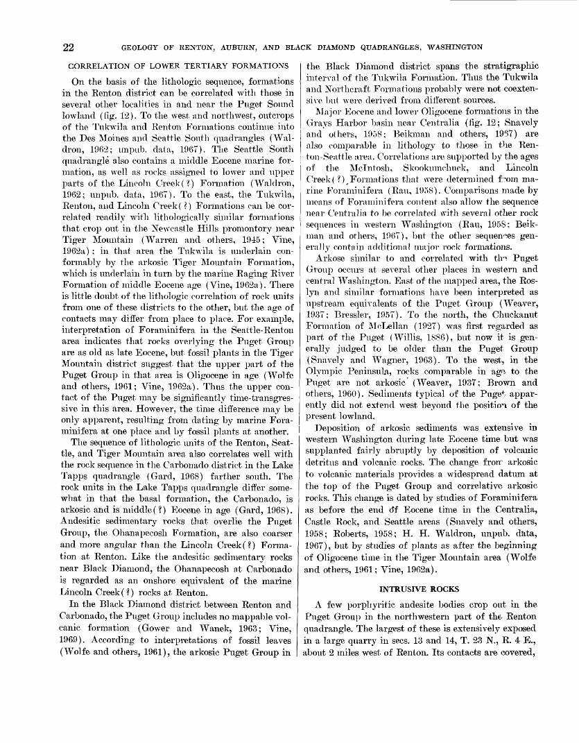
22 GEOLOGY OF RENTON, AUBURN, AND BLACK DIAMOND QUADRANGLES, WASHINGTON
CORRELATION OF LOWER TERTIARY FORMATIONS
On the basis of the lithologic sequence, formations in the Renton district can be correlated with those in several other localities in and near the Puget Sound lowland (fig. 12). To the west and northwest, outcrops of the Tukwila and Renton Formations continue into the Des Moines and Seattle South quadrangles (Wal- dron, 1962; unpub. data, 1967). The Seattle South quadrangle also contains a middle Eocene marine for mation, as well as rocks assigned to lower and upper parts of the Lincoln Creek(?) Formation (Waldron, 1962; unpub. data, 1967). To the east, the Tukwila, Renton, and Lincoln Creek ( ?) Formations can be cor related readily with lithologically similar formations that crop out in the Newcastle Hills promontory near Tiger Mountain (Warren and others, 1945; Vine, 1962a) ; in that area the Tukwila is underlain con formably by the arkosic Tiger Mountain Formation, which is underlain in turn by the marine Raging River Formation of middle Eocene age (Vine, 1962a). There is little doubt of the lithologic correlation of rock units from one of these districts to the other, but the age of contacts may differ from place to place. For example, interpretation of Foraminifera in the Seattle-Rentoii area indicates that rocks overlying the Puget Group are as old as late Eocene, but fossil plants in the Tiger Mountain district suggest that the upper part of the Puget Group in that area is Oligocene in age (Wolfe and others, 1961; Vine, 1962a). Thus the upper con tact of the Puget may be significantly time-transgres- sive in this area. However, the time difference may be only apparent, resulting from dating by marine Fora minifera at one place and by fossil plants at another.
The sequence of lithologic units of the Renton, Seat tle, and Tiger Mountain area also correlates well with the rock sequence in the Carbonado district in the Lake Tapps quadrangle (Gard, 1968) farther south. The rock units in the Lake Tapps quadrangle differ some what in that the basal formation, the Carbonado, is arkosic and is middle(?) Eocene in age (Gard, 1968). Andesitic sedimentary rocks that overlie the Puget Group, the Ohaiiapecosh Formation, are also coarser and more angular than the Lincoln Creek(?) Forma tion at Renton. Like the andesitic sedimentary rocks near Black Diamond, the Ohanapecosh at Carbonado is regarded as an onshore equivalent of the marine Lincoln Creek(?) rocks at Renton.
In the Black Diamond district between Renton and Carbonado, the Puget Group includes no mappable vol canic formation (Gower and Wanek, 1963; Vine, 1969). According to interpretations of fossil leaves (Wolfe and others, 1961), the arkosic Puget Group in
the Black Diamond district spans the stratigrapliic interval of the Tukwila Formation. Thus the Tukwila and Northcraft Formations probably were not coexten sive but were derived from different sources.
Major Eocene and lower Oligocene formations in the Grays Harbor basin near Ceiitralia (fig. 12; Suavely and others, 1958; Beikman and others, 19*37) are also comparable in lithology to those in the Ren- ton-Seattle area. Correlations are supported by the ages of the Mcliitosh, Skookumcliuck, and Lincoln Creek( ?)^Formations that were determined from ma rine Foraminifera (Ran, 1958). Comparisons made by means of Foraminifera content also allow the sequence near Ceiitralia to be correlated with several other rock sequences in western Washington (Rau, 1958; Beik man and others, 1967), but the other sequences gen erally contain additional major rock formations.
Arkose similar to and correlated with th°, Puget Group occurs at several other places in western and central Washington. East of the mapped area, the Ros- lyn and similar formations have been interpreted as upstream equivalents of the Puget Group (Weaver, 1937; Bressler, 1957). To the north, the Chuckanut Formation of McLellan (1927) was first regarded as part of the Puget (Willis, 1886), but now it is gen erally judged to be older than the Puget Group (Suavely and Wagner, 1963). To the west, in the Olympic Peninsula, rocks comparable in age to the Puget are not arkosic (Weaver, 1937; Brown and others, 1960). Sediments typical of the Puget appar ently did not extend west beyond the position of the present lowland.
Deposition of arkosic sediments was extensive in western Washington during late Eocene time but was supplanted fairly abruptly by deposition of volcanic detritus and volcanic rocks. The change from arkosic to volcanic materials provides a widespread datum at the top of the Puget Group and correlative arkosic rocks. This change is dated by studies of Foraminifera as before the end o*f Eocene time in the Centralia, Castle Rock, and Seattle areas (Suavely and others, 1958; Roberts, 1958; H. H. Waldron, unpub. data, 1967), but by studies of plants as after the beginning of Oligocene time in the Tiger Mountain area (Wolfe and others, 1961; Vine, 1962a).
INTRUSIVE ROCKS
A few porphyritic andesite bodies crop out in the Puget Group in the northwestern part of the Rentoii quadrangle. The largest of these is extensively exposed in a large quarry in sees. 13 and 14, T. 23 N., R. 4 E., about 2 miles west of Renton. Its contacts are covered,
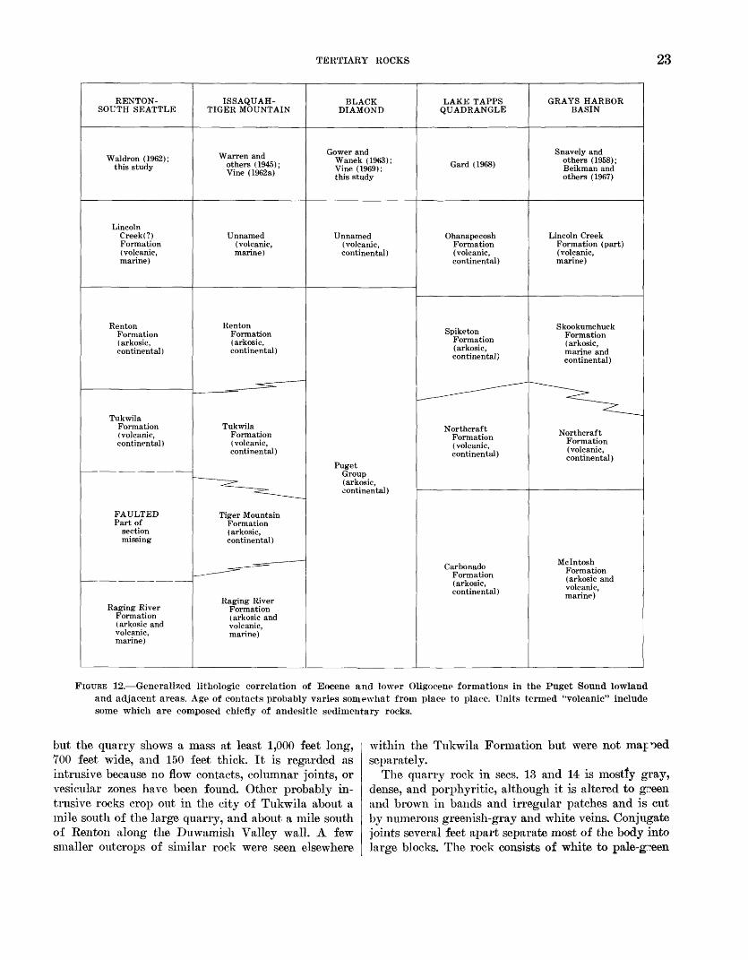
TERTIARY ROCKS 23
RENTON-SOUTH SEATTLE
Waldron (1962); this study
LincolnCreek(?)Formation(volcanic,marine)
Renton Formation (arkosic, continental)
TukwilaFormation ( volcanic, continental)
FAULTEDPart of
sectionmissing
Raging RiverFormation (arkosic andvolcanic,marine)
ISSAQUAH-TIGER MOUNTAIN
Warren and others (1945); Vine (1962a)
Unnamed(volcanic,marine)
Renton Formation ( arkosic, continental)
^^____j^^S-
Tukwila Formation ( volcanic, continental)
~~^^__^
Tiger MountainFormation( arkosic,continental)
Raging River Formation(arkosic and volcanic,marine)
BLACKDIAMOND
Grower and Wanek (1963); Vine (1969); this study
Unnamed(volcanic,continental)
PugetGroup(arkosic,continental)
LAKE TAPPSQUADRANGLE
Gard (1968)
OhanapecoshFormation(volcanic,continental)
Spiketon Formation (arkosic, continental)
_- -
Northcraft Formation (volcanic, continental)
Carbonado Formation (arkosic, continental)
GRAYS HARBORBASIN
Snavely and others (1958); Beikman and others (1967)
Lincoln CreekFormation (part)(volcanic,marine)
Skookumchuck Formation (arkosic, marine and continental)
~~^_
Northcraft Formation (volcanic, continental)
Mclntosh Formation (arkosic and volcanic, marine)
FIGURE 12. Generalized lithologic correlation of Eocene and lower Oligocene formations in the Puget Sound lowland and adjacent areas. Age of contacts probably varies somewhat from place to place. Units termed "volcanic" include some which are composed chiefly of andesitic sedimentary rocks.
but the quarry shows a mass at least 1,000 feet long, TOO feet wide, and 150 feet thick. It is regarded as intrusive because no flow contacts, columnar joints, or vesicular zones have been found. Other probably in trusive rocks crop out in the city of Tukwila about a mile south of the large quarry, and about a mile south of Renton along the Duwamish Valley wall. A few smaller outcrops of similar rock were seen elsewhere
within the Tukwila Formation but were not mapioed separately.
The quarry rock in sees. 13 and 14 is mostly gray, dense, and porphyritic, although it is altered to green and brown in bands and irregular patches and is cut by numerous greenish-gray and white veins. Conjugate joints several feet apart separate most of the body into large blocks. The rock consists of white to pale-g^een
24 GEOLOGY OF RENTON, AUBURN, AND BLACK DIAMOND QUADRANGLES, WASHINGTON
feldspar and dark greenish-gray mafic phenocrysts set in a medium-gray to greenish-gray dense groundmass. The feldspars, some of which are as long as 5 mm, typically are strongly zoned and twinned andesine or labradorite. The mafic phenocrysts, some, of which are as long as 7 mm, are slightly to strongly altered. All appear to have been pyroxenes, with clinopyroxene more abundant than orthopyroxene. The groundmass consists of small feldspar crystals interspersed with pyroxene, opaque iron minerals, glass, calcite, and alteration products.
Both phenocrysts and groundmass are altered. The most common alteration product is a brown to brown ish-green clay, identified as moiitmorillonite from X-ray diffraction patterns by Julius Schlocker of the U.S. Geological Survey. It has replaced glass, mafic minerals, feldspar and, locally, the complete rock. The colors of the montmorillonite suggest that it is iron rich, but its index of refraction is lower than that of nontronite. Calcite and chlorite are also common in both phenocrysts and groundmass.
Montmorillonite, calcite, and quartz are common vein minerals. Veins of montmorillonite are as much as 6 inches wide in places, and veins of calcite and quartz are as wide as 8 inches. Pyrite is disseminated through out the veins, and the presence of native coppec was reported by the quarry operator.
A single sample of quarry rock that appeared repre sentative was analyzed by rapid chemical methods, giving the following results:
K2O_ ______________ 0.62H2 O-_______________ 1.4H20+_-------------- 1.0TiO2_.._.--_.._..,__. .17P2 O8----------------- .19MnO- _______________ . 10CO________ _________ .95
The rock is classified as andesite according to silica content (Williams and others 1954) or according to a comparison of silica content with several other con stituents (Rit tin ami, 1952). However, the rock locally is dark and frequently is called basalt for commercial purposes.
The andesite intrudes and is younger than the Eo cene and Oligocene Puget Group but is overlain only by Pleistocene deposits. Presence of glass in the matrix suggests that the mass was intruded near the surface, but the shape of the mass is not known.
UPPER TERTIARY ROCKS HAMMER BLUFF FORMATION
The Hammer Bluff Formation is the only upper Ter tiary rock unit known in the mapped area. The Ham mer Bluff was described and named by Glover (1936; 1941, p. 137, 144) for a truncated spur on the north
Si02 _. _______A1203 _________Fe203 --_---__FeO._. _-.-_.MgO_________CaO.__...._Na,O________
- - _ _ _ _ 56. 2--__-__ 17. 2
_______ 4 1_______ 3.6
________ 7. 4________ 3.4
side of the Green River in the NE*4 sec. 28, T. 21 1ST., R. 6 E. Glover described the formation as composed of quartzose sand and distinctive plastic buff-firing clay that were derived chiefly from arkosic sandstones of the Puget Group and that are characterized by woody lignite. Residually weathered arkose of the Puget Group at Hammer Bluff apparently has been considered part of the Hammer Bluff Formation in some reports, but it is not included in the formation as described herein. As used here, the Hammer Bluff contains two members: a lower member that mainly contains the clayey, quartzose sediments described by Glover, and an upper member that consists mostly of volcanic sand and gravel.
The Hammer Bluff Formation crops out in stream- banks and artificial excavations in the Green River valley in sees. 21, 27, and 28, T. 21 N., R. 6 E., in the southeastern part of the Black Diamond quadrangle. Exposures are few because colluvium covers much of the formation. The formation is well exposed in three places: on the south side of the river across from Ham mer Bluff in the SE1/^ sec. 28, where it crops out in a meander scarp for about half a mile; on the north side of the river in commercial sandpits at Hammer Bluff; and in a meander scarp half a mile northeast of Ham mer Bluff. The formation probably also underlies the wide undulating terrace on the north valley wall in sees. 21 and 28. Landslides that cover the northwestern part of the terrace appear to be as much as several tens of feet thick, and the formation has not been mapped in that area; it has been mapped, however, in the southeastern part of the terrace because prospect pits indicate in that part of the terrace the formation is within a few feet of the surface. Although the Ham mer Bluff Formation is exposed intermittently along the valley for about 2 miles, the thickest observed stratigraphic section was across the river from Ham mer Bluff, where it is only about 60 feet thick. Addi tional nearby exposures indicate that the formation is at least 100 feet thick.
LITHOLOGY
Both members are typically cohesive and compact, because they are clayey and have been compressed by thick Pleistocene sediments and ice, but they have not been consolidated into firm rock. The lower member is composed mostly of light-gray poorly sorted and poorly stratified clayey sand and sandy clay, which are at least 28 feet thick (Glover, 1941, p. 138). West and northwest of Hammer Bluff, however, it contains some fairly well sorted and stratified sand. The sr.nd con sists mostly of quartz, but it also contains feldspar,
TERTIAKY ROCKS 25
chert, and quartzite; some basalt fragments were re ported in it by Glover (1941, p. 143). The heavy- mineral suite of the lower member consists largely of epidote, zircon, garnet, tourmaline, amphiboles, and opaque iron oxide minerals. The clay minerals, as de termined by X-ray diffraction methods, are almost en tirely kaolinite. Lignitic wood is distributed sparsely throughout the lower member except in one bed 2-3 feet thick, which consists mostly of flattened fragments of limbs and stems.
The upper member consists of brownish-green to brown sand, clay, and pebble gravel, some of which is crossbedded. Pebbles are mostly rounded porphyritic andesite or basalt, and sand grains are chiefly frag ments of similar volcanic rock, quartz, and feldspar. About equal parts of kaolinite and montmorillonite are the only clay minerals identified in the single sample examined by X-ray methods. Lignitic wood is dis tributed throughout and is abundant near the base. Some wood fragments are as large as 15 feet in length and iy2 feet in diameter. Light-gray pumiceous sand beds that are rich in green hornblende crop out in land slide blocks of the formation a mile northwest of Hammer Bluff, and volcanic ash beds were reported in the formation by Glover (1941, p. 138).
WEATHERING
The Hammer Bluff Formation is conspicuously weathered. The quartz sand and kaolinitic clay in the lower member probably are products of weathering of Puget Group arkose. Much of that weathering, how ever, presumably occurred in place within the Puget rocks, and still more weathering might have occurred during transportation. How much weathering took place after deposition of the materials in the Hammer Bluff Formation is not known. The upper member, however, clearly has been weathered in place, for most constituent rock fragments are now soft and altered, partly to clay. About 60 percent of the pebbles in one pebbly sand exposed in the commercial sandpit at Hammer Bluff are weathered enough to be broken by a gentle blow of a hammer. In some sand layers in the upper member, sand grains are soft, ugreasy,v and altered almost completely to clay, even though the tex ture of sand is retained.
STRATIGRAPHIC RELATIONS
The Hammer Bluff Formation is underlain by the Puget Group and is overlain by Pleistocene sediments. Both contacts are angular unconformities. In 1960, both were exposed in the commercial sandpit at Ham mer Bluff and in a meander scarp to the south across
the river. On the south side of the river, the Hammer Bluff Formation dips about 10° SW. and overlies sandstone of the Puget Group that dips 20°-25° S. In some exposures, iron-stained Hammer Bluff sedi ments of the upper member overlie Puget Group sand stone that is weathered and leached of iron oxide. Thus the Puget must have been leached before the Hamrier Bluff was deposited. Nearly flat-lying Orting( ?) Drft, the oldest glacial drift in the area, unconformably overlies the Hammer Bluff Formation. A much higher percentage of volcanic pebbles in the Hammer Bluff are soft than in the Orting( ?) ; presumably a period of weathering occurred between deposition of the two formations.
SOURCE AND ENVIRONMENT
The source rocks of the Hammer Bluff Formation probably were the arkosic rocks of the Puget Group and later the widespread Tertiary volcanic rocks, which were largely in the position of the present Cas cade Range. Features such as the thinness and discon tinuity of beds, the uniform composition, and the abundance of wood in the lower member of the Ham mer Bluff, and the lithologic similarity of the lower member to Puget Group rocks, led Glover (1941; unpub. data, 1956) to suggest that it was derived locally from the Puget Group, which is the only nearby source for such abundant quartz. The upper member was derived mostly from preexisting volcanic rocks; older volcanic rocks underlie most of the area nQ-ar Hammer Bluff that is not underlain by the Puget Group. The abundance of volcanic material in the up per member could have resulted either from uplift of the older volcanic rocks or from renewed volcanic activ ity in the area of the present Cascade Range. The vol canic ash, reported by Glover, and the pumiceous sedi ments in the formation show that eruptions did oc^ur during Hammer Bluff time.
Crossbedding and channeling in the sand and gravel suggest that part of the formation is fluvial, but the woody silt and clay and lignite indicate that much of it is lacustrine, as suggested by Glover (1936). The presence of poorly sorted, thin, and interbedded fluvial and lacustrine sediments suggests that the Hammer Bluff Formation was deposited on a piedmont surface of low relief, which was characterized by flood plains and lakes. At the time of deposition of the Hammer Bluff, the Puget Sound lowland was bounded on the east by a low range at the position of Cascade Range that was not high and continuous enough to form a major moisture barrier (Chaney, 1938, p. 641).
26 GEOLOGY OF RENTON, AUBURN, AND BLACK DIAMOND QUADRANGLES, WASHINGTON
AGE AND CORRELATION
Glover (1936; 1941, p. 137) assigned the Hammer Bluff Formation to the Pliocene or preglacial Pleisto cene; and Warren, Norbisrath, Grivetti, and Brown (1945) assigned it to the early Pleistocene. Each of these age assignments was based not on fossil evidence but on interpretation of physical evidence the Ham mer Bluff is more like Pleistocene deposits than lower Tertiary bedrock. Fossil leaves collected during this investigation suggest that the Hammer Bluff is late Miocene in age (R. W. Brown, written commun., 1956). The leaves were collected in the NW^SEi/i sec. 28, T. 21 N., E. 6 E., across the Green Kiver from Hammer Bluff, where they occur in lenses of silt and clay near the base of the upper member. The following species were identified by R. W. Brown of the U.S. Geological Survey (written commun., 1956) : Ghamae- cyparis sp., Fagus washoeitsis LaMotte, Uhnus sp., Gary a egregia (Lesquereux) LaMotte now called Gary a bendirei (Lesquereux) Chaney and Axelrod (J. A. Wolfe, written commun., 1969) ? /Sassafras sp., and Acer sp. Samples from the same strata were analyzed for pollen by E. B. Leopold of the U.S. Geo logical Survey, and the following pollen were identi fied: Garya, Pinus, Pterocarya, TJlmus or Zelkova, Polypodiaceae, Alnus, Picea, Quercus, and fungal spores. According to Brown, the assemblage of plant fossils indicates a middle to late Tertiary age, and Fagus 'washoensis LaMotte is not known to have sur vived the Miocene in this area. On the basis of plant fossils from the Hammer Bluff and apparently correla tive formations 10-15 miles farther south (Mullineaux and others, 1959), the formation is assigned a late Miocene age.
Sand and clay that contains woody lignite recovered from holes drilled for the Kent water system along Rock Creek in the NE^SEi/i sec. 26, T. 22 N., R. 6 E. (Ross Ellis, oral commun., 1957) probably is correla tive with the Hammer Bluff Formation. These sedi ments, which are covered by drift of late Pleistocene age, are lithologically similar to those of the lower member of the Hammer Bluff Formation and are very different from recognized Pleistocene deposits in the area.
The Hammer Bluff Formation was correlated by Glover (1941) and by Warren, Norbisrath, Grivetti, and Brown (1945) with similar sand and clay in the Green River valley near Palmer, about 8 miles north east of Hammer Bluff. Gower and Wanek (1963) ten tatively assigned the late Miocene age determined for the Hammer Bluff Formation by Brown to the Palmer deposit, but they did not use the same name because
they did not believe the two deposits were coertensive. A preliminary evaluation of seeds and pollen from the sediments at Palmer led R. W. Brown (written commun., 1957) to suggest that the Palmer deposit is younger than the deposit at Hammer Bluff. However, no sufficient further study could be made to confirm or deny this possibility.
On the basis of contained volcanic detritus and fos sil leaves, some lacustrine and fluvial sediments ex posed in the Lake Tapps quadrangle are also correlated with the Hammer Bluff Formation (Mullineaux and others, 1959; Gard, 1968). These sediments crop out along Voight and Wilkeson (Gale) Creeks 10-15 miles south of the Hammer Bluff locality. They cl aracter- istically are mudflows and alluvium that contain abundant pumice in some beds. The pumice is unusual in this area, because it contains abundant green horn blende and virtually no other ferromagnesian mineral. In contrast, most other Tertiary and Quaternary vol canic rocks in this area contain abundant pyroxene. Hornblende pumice is sparse but is also present in the Hammer Bluff Formation, and it probably was derived from the same general source as was the pumice in the deposits along Voight and Wilkeson Creeks.
Similar sediments of probable late Miocene age that also are characterized by content of hornblende pumice are exposed farther south along the west sid0. of the Cascade Range. Near Eatonville, the pumiceou^ Mashel Formation (Walters, 1965) is a fluvial and Ir^ustrine deposit of middle to late Miocene age. Farther south near Castle Rock, the locally pumiceous fluvial and lacustrine Wilkes Formation is also considered to be late Miocene in age (Roberts, 1958).
The hornblende pumice in the Hammer Bluff and correlative formations is similar to the volcanic detritus in part of the Ellensburg Formation, which h of late Miocene and early Pliocene age. The Ellensburg crops out along the east flank of the Cascade Range from near Wenatchee (fig. 1) south to the Columbia River (Smith, 1903; Laval, 1956). Coombs (1941) noted that green hornblende and magnetite were virtually the only heavy minerals characteristic of the Ellensburg and suggested use of the distinctive mineralogic char acter for correlation. Later, J. E. Sceva of the U.S. Geological Survey (oral commun., 1954) mapped the Mashel Formation on the west side of the Cascades and proposed that it was equivalent to the Ellensburg Formation on the east side. The similarity of pumice in widespread formations on both sides of the Cascade Range suggests that the volcanic material waf derived from widely distributed volcanic vents in the position of the present Cascades (Gard, 1960; Fiske and others, 1963).
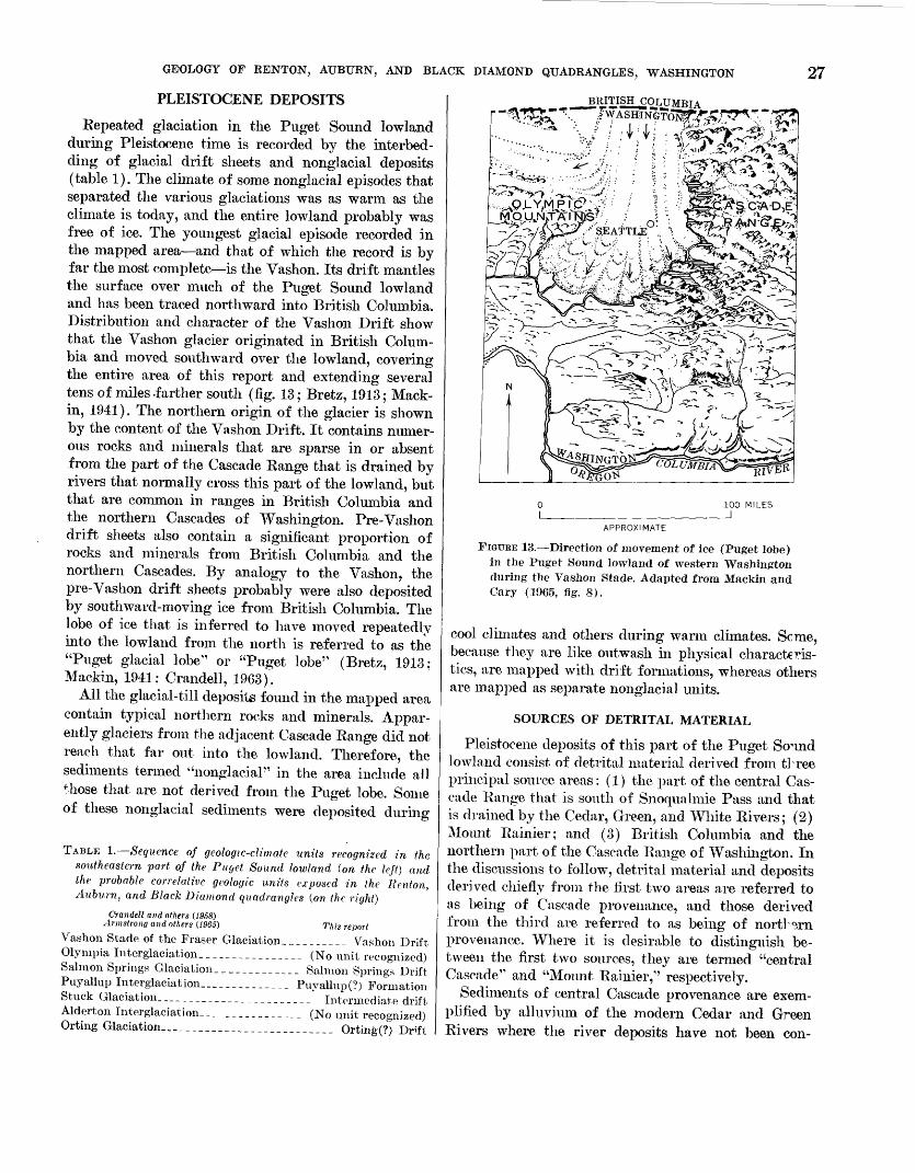
GEOLOGY OF RENTON, AUBURN, AND BLACK DIAMOND QUADRANGLES, WASHINGTON 27PLEISTOCENE DEPOSITS
Repeated glaciation in the Puget Sound lowland during Pleistocene time is recorded by the interbed- ding of glacial drift sheets and nonglacial deposits (table 1). The climate of some nonglacial episodes that separated the various glaciations was as warm as the climate is today, and the entire lowland probably was free of ice. The youngest glacial episode recorded in the mapped area and that of which the record is by far the most complete is the Vashon. Its drift mantles the surface over much of the Puget Sound lowland and has been traced northward into British Columbia. Distribution and character of the Vashon Drift show that the Vashon glacier originated in British Colum bia and moved southward over the lowland, covering the entire area of this report and extending several tens of miles -farther south (fig. 13; Bretz, 1913; Mack- in, 1941). The northern origin of the glacier is shown by the content of the Vashon Drift. It contains numer ous rocks and minerals that are sparse in or absent from the part of the Cascade Range that is drained by rivers that normally cross this part of the lowland, but that are common in ranges in British Columbia and the northern Cascades of Washington. Pre-Vashon drift sheets also contain a significant proportion of rocks and minerals from British Columbia and the northern Cascades. By analogy to the Vashon, the pre-Vashon drift sheets probably were also deposited by southward-moving ice from British Columbia. The lobe of ice that is inferred to have moved repeatedly into the lowland from the north is referred to as the "Puget glacial lobe" or "Puget lobe" (Bretz, 1913; Mackin, 1941; Crandell, 1963).
All the glacial-till deposits found in the mapped area contain typical northern rocks and minerals. Appar ently glaciers from the adjacent Cascade Range did not reach that far out into the lowland. Therefore, the sediments termed "nonglacial" in the area include all those that are not derived from the Puget lobe. Some of these nonglacial sediments were deposited during
TABLE 1. Sequence of geologic-climate units recognized in the southeastern part of the Puget Sound lowland (on the left) and the -probable correlative geologic units exposed in the Renton, Auburn, and Black Diamond quadrangles (on the right)
Crandell and others (1958) Armstrong and others (1965) This report
Vashon Stade of the Eraser Glaciation,_________ Vashon DriftOlympia Interglaciation. _______________ (No unit recognized)Salmon Springs Glaciatioii_____________ Salmon Springs DriftPuyallup Interglaciation._____________ Puyallup(?) FormationStuck Glaciation_ ______________________ Intermediate driftAlderton Interglaciation..______________ (No unit recognized)Orting Glaciation ---------.______________ Orting(?) Drift
__BRITISH COLUMPT A -~r A-
100 MILES_J
APPROXIMATE
FIGURE 13. Direction of movement of ice (Puget lobe) in the Puget Sound lowland of western Washington during the Vashon Stade. Adapted from Mackin and Cary (1965, fig. 8).
cool climates and others during warm climates. Seme, because they are like outwash in physical characteris tics, are mapped with drift formations, whereas others are mapped as separate nonglacial units.
SOURCES OF DETRITAL MATERIAL
Pleistocene deposits of this part of the Puget So^ind lowland consist of detrital material derived from tl^ree principal source areas: (1) the part of the central Cas cade Range that is south of Snoqualmie Pass and that is drained by the Cedar, Green, and White Rivers; (2) Mount Rainier; and (3) British Columbia and the northern part of the Cascade Range of Washington. In the discussions to follow, detrital material and deposits derived chiefly from the first two areas are referred to as being of Cascade provenance, and those derived from the third are referred to as being of nortHrn provenance. Where it is desirable to distinguish be tween the first two sources, they are termed "central Cascade" and "Mount Rainier," respectively.
Sediments of central Cascade provenance are exem plified by alluvium of the modern Cedar and Green Rivers where the river deposits have not been con-
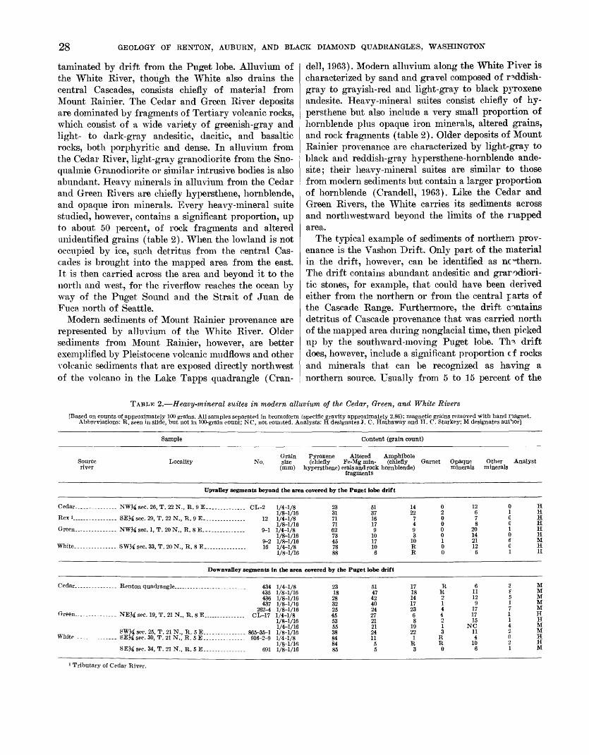
28 GEOLOGY OF RENTON, AUBURN, AND BLACK DIAMOND QUADRANGLES, WASHINGTON
taminated by drift from the Puget lobe. Alluvium of the White Kiver, though the White also drains the central Cascades, consists chiefly of material from Mount Rainier. The Cedar and Green Kiver deposits are dominated by fragments of Tertiary volcanic rocks, which consist of a wide variety of greenish-gray and light- to dark-gray andesitic, dacitic, and basaltic rocks, both porphyritic and dense. In alluvium from the Cedar River, light-gray granodiorite from the Sno- qualmie Granodiorite or similar intrusive bodies is also abundant. Heavy minerals in alluvium from the Cedar and Green Rivers are chiefly hypersthene, hornblende, and opaque iron minerals. Every heavy-mineral suite studied, however, contains a significant proportion, up to about 50 percent, of rock fragments and altered unidentified grains (table 2). When the lowland is not occupied by ice, such detritus from the central Cas cades is brought into the mapped area from the east. It is then carried across the area and beyond it to the north and west, for the riverflow reaches the ocean by way of the Puget Sound and the Strait of Juan de Fuca north of Seattle.
Modern sediments of Mount Rainier provenance are represented by alluvium of the White River. Older sediments from Mount Rainier, however, are better exemplified by Pleistocene volcanic mudflows and other volcanic sediments that are exposed directly northwest of the volcano in the Lake Tapps quadrangle (Cran-
dell, 1963). Modern alluvium along the White Piver is characterized by sand and gravel composed of reddish- gray to grayish-red and light-gray to black pyroxene andesite. Heavy-mineral suites consist chiefly of hy persthene but also include a very small proportion of hornblende plus opaque iron minerals, altered grains, and rock fragments (table 2). Older deposits of Mount Rainier provenance are characterized by light-gray to black and reddish-gray hypersthene-hornblende ande site; their heavy-mineral suites are similar to those from modern sediments but contain a larger proportion of hornblende (Crandell, 1963). Like the Cedar and Green Rivers, the White carries its sediments across and northwestward beyond the limits of the mapped area.
The typical example of sediments of northern prov enance is the Vashon Drift. Only part of the material in the drift, however, can be identified as northern. The drift contains abundant andesitic and grarodiori- tic stones, for example, that could have been derived either from the northern or from the central parts of the Cascade Range. Furthermore, the drift contains detritus of Cascade provenance that was carried north of the mapped area during nonglacial time, then picked up by the southward-moving Puget lobe. Th0- drift does, however, include a significant proportion cf rocks and minerals that can be recognized as having a northern source. Usually from 5 to 15 percent of the
TABLE 2. Heavy-mineral suites in modern alluvium of the Cedar, Green, and White Rivers
[Based on counts of approximately 100 grains. All samples separated in bromoform (specific gravity approximately 2.86); magnetic grains removed with hand nagnet. Abbreviations: R, seen in slide, but not in 100-grain count; NC, not counted. Analysts: H designates J. C. Hathaway and H. C. Starkey; M designates author]
Sample Content (grain count)
Source river
GrainLocality No. size
(mm)
Pyroxene Altered Amnhibole(chiefly Fe-Mgmin- (cHiefly Garnet
hypersthene) erals and rock hornblende)fragments
Opaque minerals
Other minerals
Analyst
Upvalley segments beyond the area covered by the Puget lobe drift
Cedar.............. NWM sec. 26, T. 22 N., R. 9 E. ............. C
Bex ...... ........... SE^sec. 29, T. 22 N., R. 9E...... . ......
Green......---.- NWM sec. 1, T. 20 N., E. 8 E. ............. .
White--_.....-_..._ SWM sec. 33, T. 20 N., R. 8 E..
!L-2
12
9-1
9-2 16
1/4-1/8 1/8-1/16 1/4-1/81/8-1/16 1/4-1/8 1/8-1/16 1/8-1/16 1/4-1/81/8-1/16
23 31 7171 62 73 4570
88
51 37 1617 9
10 17
6
14 22
74 9 3
10 RR
0 2 00 0 0 1 00
12 678
20 14 21 126
0 H 1 HC HC H 1 H 0 H6 M C H1 H
Downvalley segments in the area covered by the Puget lobe drift
Cedar.......
Green _ _.
White......
.---.-- NEM sec. 19, T. 21 N
SWM sec. 25, T. 21 N.------ SEM sec. 30, T. 21 N.
SEM sec. 34, T. 21 N.
,, R. 5E.._... _.., R.5E. .............
, R.5E-. _-_...-
434435 436 437
262-4 CL 17
865-35-1916-2-9
691
1/4-1/81/8-1/16 1/8-1/16 1/8-1/16 1/8-1/161/4-1/81/8-1/16 1/4-1/16 1/8-1/161/4-1/8 1/8-1/16 1/8-1/16
2318
28 32 25 4553 55 3884 84 85
5147 42 40 24 2721 21 2411
5 5
1718 14 17 23 68
19 22
1 R 3
RR21 44
1 3
R R 0
611 12 9
17 1715
NC 114
10 6
3? 5 1 7 I\420 21
MM M M M HH M MH H M
1 Tributary of Cedar River.
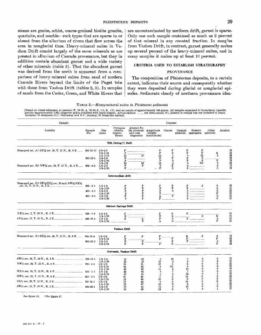
PLEISTOCENE DEPOSITS 29
stones are gneiss, schist, coarse-grained biotite granite, quartzite, and marble rock types that are sparse in or absent from the alluvium of rivers that flow across the area in nonglacial time. Heavy-mineral suites in Va- shon Drift consist largely of the same minerals as are present in alluvium of Cascade provenance, but they in addition contain abundant garnet and a wide variety of other minerals (table 3). That the abundant garnet was derived from the north is apparent from a com parison of heavy-mineral suites from sand of modern Cascade Rivers beyond the limits of the Puget lobe with those from Vashon Drift (tables 2, 3). In samples of sands from the Cedar, Green, and White Rivers that
are uncontaminated by northern drift, garnet is sparse. Only one such sample contained as much as 2 percent of that mineral in any counted fraction. In samples from Vashon Drift, in contrast, garnet generally makes up several percent of the heavy-mineral suites, and in many samples it makes up at least 10 percent.
CRITERIA USED TO ESTABLISH STRATIGRAPHY
PROVENANCE
The composition of Pleistocene deposits, to a certain extent, indicates their source and consequently whether they were deposited during glacial or nonglacial epi sodes. Sediments clearly of northern provenance iden-
TABLE 3. Heavy-mineral suites in Pleistocene sediments
[Based on visual estimates, in percent (F, 10-25; A, 70-90; S, <5; R, <1), and on counts of approximately 100 grains. All samples separated in bromoform (specific gravity approximately 2.86); magnetic grains removed with hand magnet. Abbreviations: ...., not determined; NI, present in sample but not included in count. Analysts: H designates J.C. Hathaway and H.C. Starkey; M designates author]
Sample
Locality Sample No.
Measured sec. A;<- SEJ£ sec. 28, T. 21 N., R. 6 E 862-22-17
862-25^1
Measured sec. B;i NWJ£ sec. 29, T. 21 N., R. 6 E. ... 863- 4-3
Content
Size (mm)
Till
1/4-1/8 1/8-1/16 1/8-1/16 1/4-1/8 1/8-1/16 1/4-1/8 1/4-1/8 1/8-1/16
Pyroxene (chiefly
hypers- thene)
Altered Fe- Mg minerals and rock fragments
Amphibole (chiefly
hornblende)
Garnet Opaque minerals
Siderite aggregates
Other minerals
Analyst
, Orting(?) Drift
F F 15 F F 35 F F
27
35 F
F F 13 F F 15 S
-J F
FS 1 F S 4 F S
F F9 F F 6SS
F F 31 F F
NI
R 3
F 5S S
H H M H H M H H
Intermediate drift
Measured sec sec. 21, T. :
. D;2 SWMSEM sec. 16 and NW^NEM 21 N., R. 5 E.. ...... . . 863- 4-1
867- 5-1
867- 6-1
1/4-1/8 1/8-1/16 1/4-1/8 1/8-1/16 1/4-1/8 1/8-1/16
F F FS FS
F F F F F F
F F F FAF
F FS
F
F F ....S ....S ....S ....s ....
S s s sFss
H H H H H H
Salmon Springs Drift
NEM sec. 2,
SEH sec. 17,
T. 20 N., R. 5 E
T.21N., R.5E. ...... ........ .
920- 7-6
845-16-5
1/4-1/8 1/8-1/16 1/4-1/8 1/8-1/16 .
F .........F .........F A
F
F F F A
FS ....Ss ....
F
F ....S R
S F
H H H H
Vashon Drift
Measured sec . A;i 8EH sec. 28, T. 21 N., R. 6 E 845-16-6
862-25-2
1/4-1/8 1/8-1/16 1/4-1/8 1/8-1/16
F F .........F F
F
F .....F
F ...F
F
F F F ....
R F .....F ....
S S F S F
H H H H
Outwash, Vashon Drift
SWJi sec. 14,
NWJ4 sec. 34:
NEHsec. 16,
NWH sec. 21,
SEJ4 sec. 26,
SWH sec. 17,
T.23N., R.5E-. ...... .....
, T. 22 N., R. 6E
T. 21 N., R. 6 E.. .........
, T. 21 N., R. 6E
T. 22 N., R. 5E
T. 21 N., R. 5E...
261-11-1
792- 1-1
852- 1-1
852- 2-1
787-18-1
845-43-1
1/4-1/8 1/8-1/16 1/4-1/8 1/8-1/16 1/8-1/16 1/4-1/8 1/8-1/16 1/4-1/8 1/8-1/16 1/4-1/8 1/8-1/16 1/4-1/8 1/8-1/16
22 31 29 44 30 36 47 31 24 27 23 29 29
52 25 51 34 39 46 31 43 48 48 47 41 36
9 27 10
9 11
5
7 19
5 23
24
10 5 2
NI 6 7 6 5 3 5 3 5 3
7 9 8 9
10 7
13 15
6 16
3 13 7
0 0 0 0 0 0 0 0 0 0 0 0 0
0 3 0 34 0 1 0 0 0 201
H H H H M H H H H H H H H
See figure 14. 2 See figure 17.
380-731 O - 70 - 5
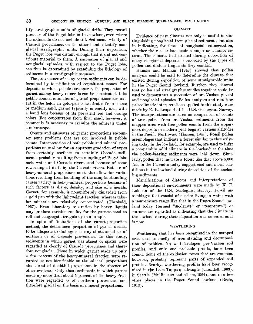
30 GEOLOGY OF RENTON, AUBURN, AND BLACK DIAMOND QUADRANGLES, WASHINGTON
tify stratigraphic units of glacial drift. They record presence of the Puget lobe in the lowland, even where the sediments do not include till. Sediments wholly of Cascade provenance, on the other hand, identify non- glacial stratigraphic units. During their deposition, the Puget lobe was distant enough that it did not con tribute material to them. A succession of glacial and nonglacial episodes, with respect to the Puget lobe, can thus be determined by examining the lithology of sediments in a stratigraphic sequence.
The provenance of many coarse sediments can be de termined by identification of constituent stones. For deposits in which pebbles are sparse, the proportion of garnet among heavy minerals can be substituted. Like pebble counts, estimates of garnet proportions are use ful in the field; in gold-pan concentrates from coarse or medium sand, garnet typically is readily seen with a hand lens because of its prevalent red and orange colors. For concentrates from finer sand, however, it commonly is necessary to examine the minerals under a microscope.
Counts and estimates of garnet proportions encoun ter some problems that are not involved in pebble counts. Interpretation of both pebble and mineral pro portions must allow for an apparent gradation of types from certainly northern to certainly Cascade sedi ments, probably resulting from mingling of Puget lobe melt water and Cascade rivers, and because of some reworking of drift by the Cascade rivers. But use of heavy-mineral proportions must also allow for varia tions resulting from handling of the sample. Handling causes variety in heavy-mineral proportions because of such factors as shape, density, and size of minerals. Garnet, for example, is nonimiformly discarded from a gold pan with the lightweight fraction, whereas tabu lar minerals are relatively concentrated (Theobald, 1957). Even laboratory separation by heavy liquids may produce variable results, for the garnets tend to roll and congregate irregularly in a sample.
In spite of limitations of the garnet-proportion method, the determined proportion of garnet seemed to be adequate to distinguish many strata as either of northern or of Cascade provenance. In this study, sediments in which garnet was absent or sparse were regarded as clearly of Cascade provenance and there fore nonglacial. Those in which garnet made up only a few percent of the heavy-mineral fraction were re garded as not identifiable on the mineral proportions alone, and of doubtful provenance in the absence of other evidence. Only those sediments in which garnet made up more than about 5 percent of the heavy frac tion were regarded as of northern provenance and therefore glacial on the basis of mineral proportions.
CLIMATE
Evidence of past climates not only is useful in dis tinguishing nonglacial from glacial sediments, but also in indicating, for times of nonglacial sedimentation, whether the glacier had made a major or a minor re treat. The climate that existed during deposition of many nonglacial deposits is recorded by the t;Tpes of pollen and diatom fragments they contain.
Hansen and Mackin (1949) showed that pollen analyses could be used to determine the climste that existed during deposition of some stratigraphic units in the Puget Sound lowland. Further, they showed that pollen and stratigraphic studies together could be used to demonstrate a succession of pre-Vashon glacial and nonglacial episodes. Pollen analyses and resulting paleoclimatic interpretations applied to this study were made by E. B. Leopold of the U.S. Geological Survey. The interpretations are based on comparison of counts of tree pollen from pre-Vashon sediments from the mapped area with tree-pollen counts from the upper most deposits in modern peat bogs at various altitudes in the Pacific Northwest (Hansen, 1947). Fossil pollen assemblages that indicate a forest similar to the.t exist ing today in the lowland, for example, are used to infer a comparably mild climate in the lowland at the time the pollen-bearing sediments were laid down. Simi larly, pollen that indicate a forest like that abo^e 5,000 feet in the Cascades today suggest cool and moist con ditions in the lowland during deposition of the enclos ing sediments.
Identifications of diatoms and interpretations of their depositional environments were made by K. E. Loliman of the U.S. Geological Survey. Fossil as semblages that consist of species living in water with a temperature range like that in the Puget Sound low land today (termed "moderate" or "temperate") or warmer are regarded as indicating that the climate in the lowland during their deposition was as warm as itis now.
WEATHERING
Weathering that has been recognized in the mapped area consists chiefly of iron staining and decomposi tion of pebbles. No well-developed pre-Vashon soil profiles, and only one probable profile, have been found. Some of the oxidation zones that are common, however, probably represent parts of expanded soil profiles. Nearby, weathering profiles have beer recog nized in the Lake Tapps quadrangle (Crandell, 1963), in Seattle (Mullineaux and others, 1964), and in a few other places in the Puget Sound lowland (Bretz, 1913).
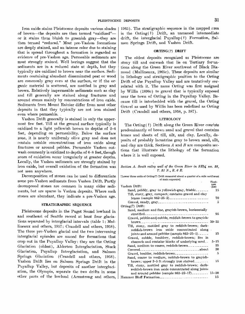
PLEISTOCENE DEPOSITS 31
Iron oxide stains Pleistocene deposits various shades of brown the deposits are then termed "oxidized" or it stains them bluish to greenish gray they are then termed "reduced." Most pre-Vashon formations are deeply stained, and an intense color due to staining that is spread throughout a formation is regarded as evidence of pre-Vashon age. Permeable sediments are most strongly stained. Well borings suggest that the sediments are in a reduced state at depth, but they typically are oxidized to brown near the surface. Sedi ments containing abundant disseminated peat or wood are commonly gray even at the surface, or if the or ganic material is scattered, are mottled in gray and brown. Relatively impermeable sediments such as clay and till generally are stained along fractures and around stones mainly by concentrations of iron oxide. Sediments from Mount Rainier differ from most other deposits in that they typically are not iron stained even where permeable. .
Vashon Drift generally is stained in only the upper most few feet. Till at the ground surface typically is oxidized to a light yellowish brown to depths of 2-4 feet, depending on permeability. Below the surface zone, it is nearly uniformly olive gray and does not contain notable concentrations of iron oxide along fractures or around pebbles. Permeable Vashon out- wash commonly is oxidized to depths of 6-8 feet, though zones of oxidation occur irregularly at greater depths. Locally, the Vashon sediments are strongly stained by iron oxide, but overall oxidation of the formation was not seen anywhere.
Decomposition of stones can be used to differentiate some pre-Vashon sediments from Vashon Drift. Partly decomposed stones are common in many older sedi ments, but are sparse in Vashon deposits. Where such stones are abundant, they indicate a pre-Vashon age.
STRATIGRAPHIC SEQUENCE
Pleistocene deposits in the Puget Sound lowland in and southeast of Seattle record at least four glacia- tions separated by interglacial intervals (table 1; Mul- lineaux and others, 1957; Crandell and others, 1958). The, three pre-Vashon glacial and the two intervening interglacial episodes are named for formations that crop out in the Puyallup Valley; they are the Orting Glaciation (oldest), Alderton Interglaciation, Stuck Glaciatioii, Puyallup Interglaciation, and Salmon Springs Glaciation (Crandell and others, 1958). Vashon Drift lies on Salmon Springs Drift in the Puyallup Valley, but deposits of another interglaci- ation, the Olympia, separate the two drifts in some other parts of the lowland (Armstrong and others,
1965). The stratigraphic sequence in the mapped r.rea is the Ortiiig(?) Drift, an unnamed intermediate drift, the interglacial Puyallup (?) Formation, Sal mon Springs Drift, and Vashon Drift.
ORTING (?) DRIFT
The oldest deposits recognized as Pleistocene are stony till and outwash that lie on Tertiary fonaa- tions along the Green River southwest of Black Dia mond (Mullineaux, 1965c). These deposits are similar in lithology and stratigraphic position to the Orting Drift of the Puyallup Valley and are tentatively cor related with it. The name Orting was first assigned by Willis (1898c) to gravel that is typically exposed near the town of Orting in the Puyallup Valley. Be cause till is interbedded with the gravel, the Orting Gravel as used by Willis has been redefined as Orting Drift (Crandell and others, 1958, p. 387).
LITHOLOGY
The Orting (?) Drift along the Green River consists predominantly of brown sand and gravel that contains lenses and sheets of till, silt, and clay. Locally, de posits of probably lacustrine gray to brown sand, silt, and clay are thick. Sections A and B are composite sec tions that illustrate the lithology of the formation where it is well exposed.
Section A. South valley wall of the Green River in T. 21 N., R. 6 E.
sec. 28,
{Lower three units of Orting(?) Drift measured about a quarter of a mile northwest of main exposure]
Tliick-
(feet)15
Vashon Drift:Sand, pebbly, gray to yellowish-gray, friable___.Till, stony, gray, compact; contains gravel and clay
lenses (sample 862-25-2)...____________________ 70Gravel, sandy, gray.__________---__--_-__----__- 5
Orting(?) Drift:Sand, medium and fine, grayish-brown, horizontally
stratified . _ ________-______--_-------___--__- 95Gravel, pebble-ands-cobble, reddish-brown to grayish-
brown. _____________-_---__---_--------___-_- 30-35Till, stony, mottled gray to reddish-brown; dark-
reddish-brown iron oxide concentrated along joints and around pebbles (sample 862-25-1)._ _ __ . 15
Gravel, cobble, bouldery, reddish-brown; lies in channels and contains blocks of underlying sand__ 5-15
Sand, medium to coarse, reddish-brown..__________ 35Covered._ _______________________________.about 30Gravel, boulder, reddish-brown.__________________ 5Sand, coarse to medium, reddish-brown to grayish-
brown; upper 3-5 ft strongly iron stained________ 15Till, stony, mottled gray to reddish-brown; dark-
reddish-brown iron oxide concentrated along joints and around pebbles (sample 862-22-17)_________ 15-20
Hammer Bluff Formation._______-____-______-_------ 15
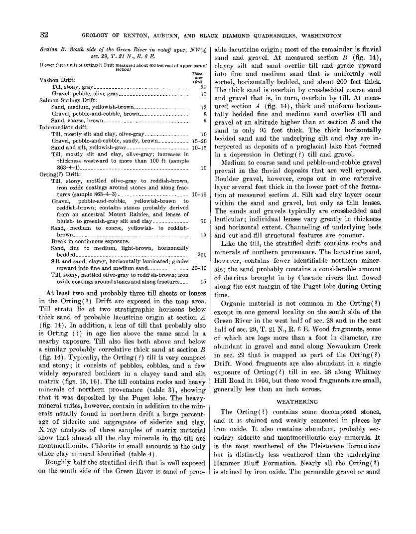
32 GEOLOGY OF RENTON, AUBURN, AND BLACK DIAMOND QUADRANGLES, WASHINGTON
Section B. South side of the Green River in cutoff spur, sec. 29, T. 21 N., R. 6 E.
[Lower three units of Orting(?) Drift measured about 600 feet east of upper part ofsection]
Thick-Vashon Drift: $%
Till, stony, gray________________________________ 35Gravel, pebble, olive-gray....____________________ 15
Salmon Springs Drift:Sand, medium, yellowish-brown_________________ 13Gravel, pebble-and-cobble, brown.._______________ 8Sand, coarse, brown. ____________________________ 8
Intermediate drift:Till, mostly silt and clay, olive-gray_______________ 10Gravel, pebble-and-cobble, sandy, brown.._________ 15-20Sand and silt, yellowish-gray.____________________ 10-15Till, mostly silt and clay, olive-gray; increases in
thickness westward to more than 100 ft (sample 863-4-1)_.___.___- -_---__.___-_._-_---__.____ 10
Orting(?) Drift:Till, stony, mottled olive-gray to reddish-brown,
iron oxide coatings around stones and along frac tures (sample 863-4-3) ________________________ 10-15
Gravel, pebble-and-cobble, yellowish-brown to reddish-brown; contains stones probably derived from an ancestral Mount Rainier, and lenses of bluish- to greenish-gray silt and clay____________ 50
Sand, medium to coarse, yellowish- to reddish- brown. ______________________________________ 15
Break in continuous exposure.Sand, fine to medium, light-brown, horizontally
bedded.__-__---_--------_-__-_---------__--. 200Silt and sand, clayey, horizontally laminated; grades
upward into fine and medium sand.-_______-___- 20-30Till, stony, mottled olive-gray to redd;sh-brown; iron
oxide coatings around stones and along fractures. _ _ 15
At least two and probably three till sheets or lenses in the Orting (?) Drift are exposed in the map area. Till strata lie at two stratigraphic horizons below thick sand of probable lacustrine origin at section A (fig. 14). In addition, a lens of till that probably also is Orting (?) in age lies above the same sand in a nearby exposure. Till also lies both above and below a similar probably correlative thick sand at section B (fig. 14). Typically, the Orting(?) till is very compact and stony; it consists of pebbles, cobbles, and a few widely separated boulders in a clayey sand and silt matrix (figs. 15, 16). The till contains rocks and heavy minerals of northern provenance (table 3), showing that it was deposited by the Puget lobe. The heavy- mineral suites, however, contain in addition to the min erals usually found in northern drift a large percent age of siderite and aggregates of siderite and clay. X-ray analyses of three samples of matrix material show that almost all the clay minerals in the till are montmorillonite. Chlorite in small amounts is the only other clay mineral identified (table 4).
Roughly half the stratified drift that is well exposed 011 the south side of the Green River is sand of prob
able lacustrine origin; most of the remainder is fluvial sand and gravel. At measured section B (fig. 14), clayey silt and sand overlie till and grade upward into fine and medium sand that is uniformly well sorted, horizontally bedded, and about 200 feet thick. The thick sand is overlain by crossbedded coarse sand and gravel that is, in turn, overlain by till. At meas ured section A (fig. 14), thick and uniform horizon tally bedded fine and medium sand overlies till and gravel at an altitude higher than at section B and the sand is only 95 feet thick. The thick horizontally bedded sand and the underlying silt and clay are in terpreted as deposits of a proglacial lake that formed in a depression in Orting(?) till and gravel.
Medium to coarse sand and pebble-and-cobble gravel prevail in the fluvial deposits that are well erposed. Boulder gravel, however, crops out in one expensive layer several feet thick in the lower part of the forma tion at measured section A. Silt and clay layerr occur within the sand and gravel, but only as thin lenses. The sands and gravels typically are crossbedded and lenticular; individual lenses vary greatly in thickness and horizontal extent. Channeling of underlying beds and cut-and-fill structural features are commor.
Like the till, the stratified drift contains roc^s and minerals of northern provenance. The lacustrine sand, however, contains fewer identifiable northern miner als; the sand probably contains a considerable a.mount of detritus brought in by Cascade rivers that flowed along the east margin of the Puget lobe during Orting time.
Organic material is not common in the Ort:iig(?) except in one general locality on the south side of the Green River in the west half of sec. 28 and in the east half of sec. 29, T. 21 K, R. 6 E. Wood fragments, some of which are logs more than a foot in diameter, are abundant in gravel and sand along Newaukum Creek in sec. 29 that is mapped as part of the Ort: ng(?) Drift. Wood fragments are also abundant in a single exposure of Orting(?) till in sec. 28 along Whitney Hill Road in 1956, but these wood fragments are small, generally less than an inch across.
WEATHERING
The Orting (?) contains some decomposed stones, and it is stained and weakly cemented in places by iron oxide. It also contains abundant, probably sec ondary siderite and niontmorillonite clay minerals. It is the most weathered of the Pleistocene formations but is distinctly less weathered than the underlying Hammer Bluff Formation. Nearly all the Ortmg(?) is stained by iron oxide. The permeable gravel or sand
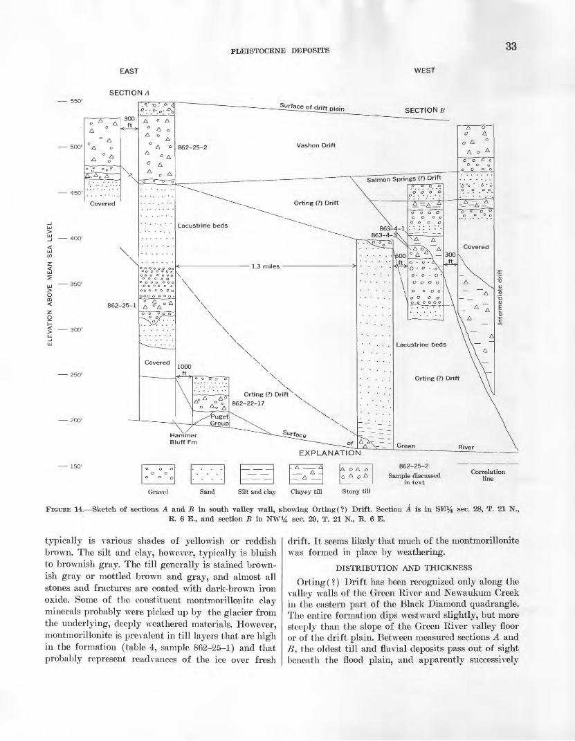
PLEISTOCENE DEPOSITS 33
EAST WEST
SECTION A550'
SECTION B
350'
300'
250'
200'
Sample discussed in text
Correlation line
Gravel Sand Silt and clay Clayey till Stony till
FIGURE 14. Sketch of sections A and B in south valley wall, showing Orting(?) Drift. Section A is in SE}4 sec. 28, T. 21 N.,R. 6 E., and section B in NW1̂ sec. 29, T. 21 N., R. 6 E.
typically is various shades of yellowish or reddish brown. The silt and clay, however, typically is bluish to brownish gray. The till generally is stained brown ish gray or mottled brown and gray, and almost all stones and fractures are coated with dark-brown iron oxide. Some of the constituent montmorillonite clay minerals probably were picked up by the glacier from the underlying, deeply weathered materials. However, montmorillonite is prevalent in till layers that are high in the formation (table 4, sample 862-25-1) and that probably represent readvances of the ice over fresh
drift. It seems likely that much of the montmorillonite was formed in place by weathering.
DISTRIBUTION AND THICKNESS
Orting( ?) Drift has been recognized only along the valley walls of the Green River and Newaukum Creek in the eastern part of the Black Diamond quadrangle. The entire formation dips westward slightly, but more steeply than the slope of the Green River valley floor or of the drift plain. Between measured sections A and B. the oldest till and fluvial deposits pass out of sight beneath the flood plain, and apparently successively
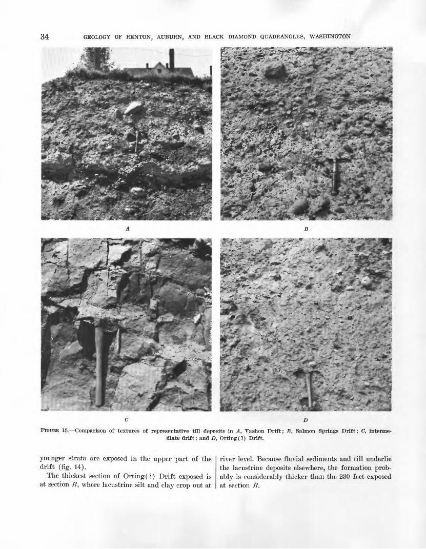
34 GEOLOGY OF RENTON, AUBURN, AND BLACK DIAMOND QUADRANGLES, WASHINGTON
c D
FIGURE 15. Comparison of textures of representative till deposits in A, Vashon Drift; B, Salmon Springs Drift; C, interme diate drift; and D, Orting(?) Drift.
younger strata are exposed in the upper part of the drift (fig. 14).
The thickest section of Orting(?) Drift exposed is at section B, where lacustrine silt and clay crop out at
river level. Because fluvial sediments and till underlie the lacustrine deposits elsewhere, the formation prob ably is considerably thicker than the 230 feet exposed at section B.
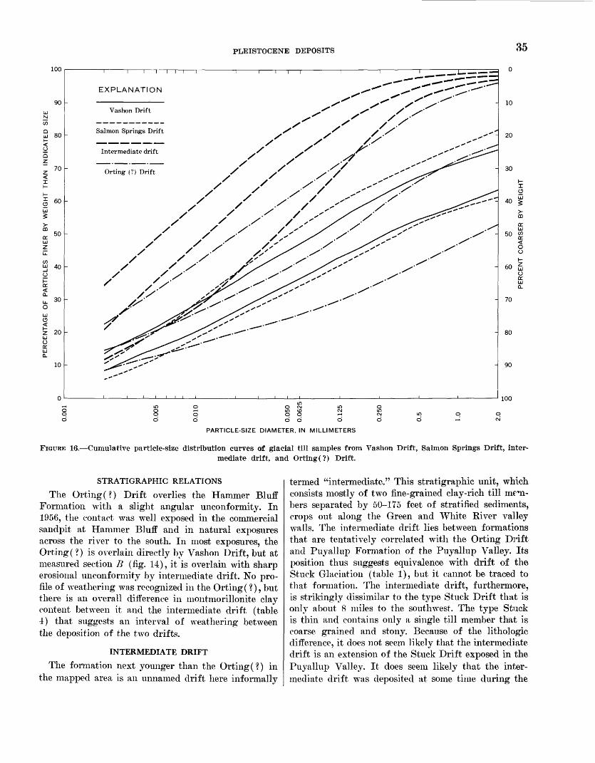
PLEISTOCENE DEPOSITS 35
100
90
Qid 80
70
60
50
I I I I
EXPLANATION
Vashon Drift
Salmon Springs Drift
Intermediate drift
Orting (?) Drift
100
PARTICLE-SIZE DIAMETER, IN MILLIMETERS
FIGURE 16. Cumulative particle-size distribution curves of glacial till samples from Vashon Drift, Salmon Springs Drift, inter mediate drift, and Orting(?) Drift.
STRATIGRAPHIC RELATIONS
The Orting(?) Drift overlies the Hammer Bluff Formation with a slight angular unconformity. In 1956, the contact was well exposed in the commercial sandpit at Hammer Bluff and in natural exposures across the river to the south. In most exposures, the Orting (?) is overlain directly by Vashon Drift, but at measured section B (fig. 1-t), it is overlain with sharp erosional unconformity by intermediate drift. No pro file of weathering was recognized in the Orting(?), but there is an overall difference in montmorillonite clay content between it and the intermediate drift (table 4) that suggests an interval of weathering between the deposition of the two drifts.
INTERMEDIATE DRIFT
The formation next younger than the Orting(?) in the mapped area is an unnamed drift here informally
termed "intermediate." This stratigraphic unit, which consists mostly of two fine-grained clay-rich till mem bers separated by 50-175 feet of stratified sediments, crops out along the Green and White River valley walls. The intermediate drift lies between formations that are tentatively correlated with the Orting Drift and Puyallup Formation of the Puyallup Valley. Its position thus suggests equivalence with drift of the Stuck Glaciation (table 1), but it cannot be traced to that formation. The intermediate drift, furthermore, is strikingly dissimilar to the type Stuck Drift that is only about 8 miles to the southwest. The type Stuck is thin and contains only a single till member that is coarse grained and stony. Because of the lithologic difference, it does not seem likely that the intermediate drift is an extension of the Stuck Drift exposed in the Puyallup Valley. It does seem likely that the inter mediate drift was deposited at some time during the
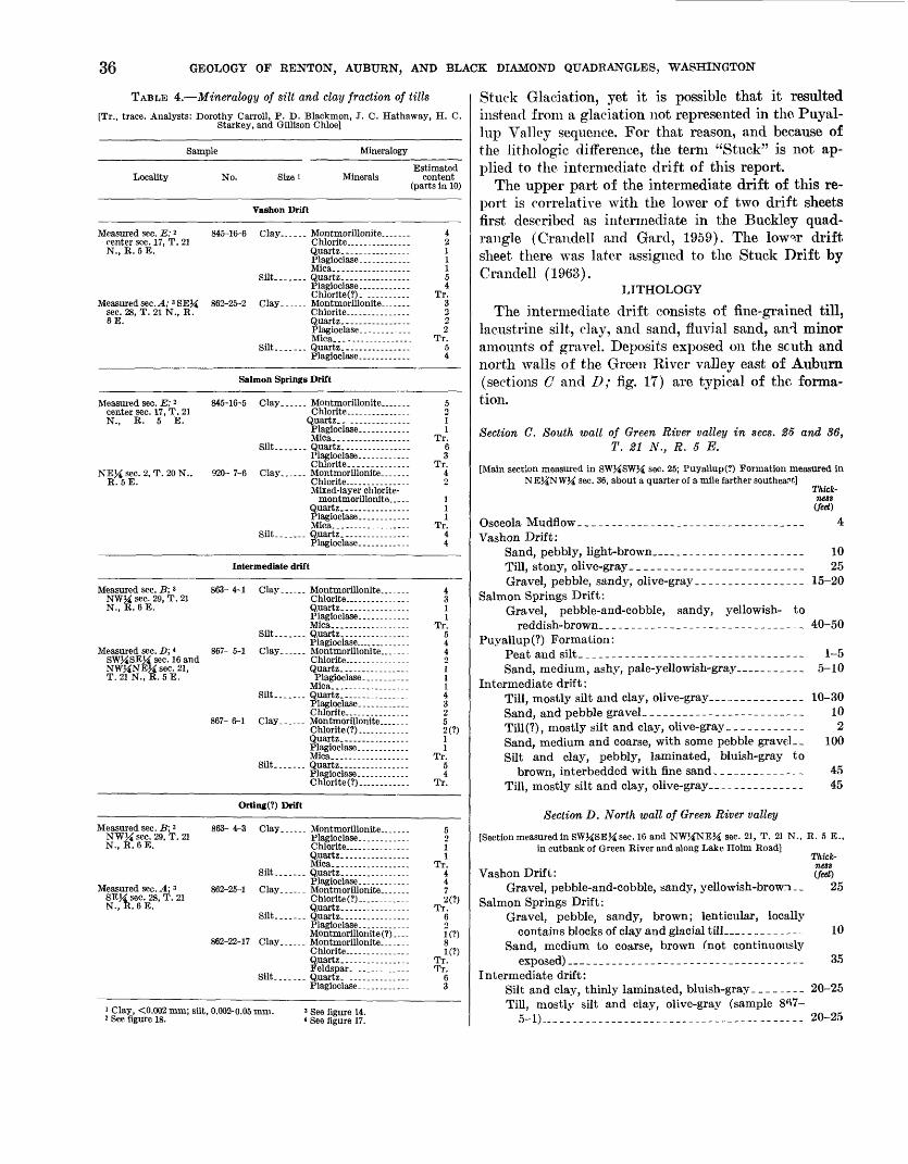
36 GEOLOGY OF RENTON, AUBURN, AND BLACK DIAMOND QUADRANGLES, WASHINGTON
TABLE 4. Mineralogy of silt and day fraction of tills
[Tr., trace. Analysts: Dorothy Carroll, P. D. Blackmon, J. C. Hathaway, H. C. Starkey, and Gillison Chloe]
Sample Mineralogy
Locality No. Size i MineralsEstimated
content (parts in 10)
Vashon Drift
Measured sec. E; 2 center sec. 17, T. 21 N., E. 5E.
Measured sec. A; ' SEM sec. 28, T. 21 N., E. 6E.
Mica.. ....... ......
Chlorite(7). ..........
4 2 1 1 1 5 4
Tr. 3 2 2 2
Tr. 5 4
Salmon Springs Drift
Measured sec. E; 2 center sec. 17, T. 21 N., E. 5 E.
NEM sec. 2, T. 20 N., E. 5E.
Mica..- -..-----.---Silt. ...... Quartz................
Mixed-layer chlorite- montmorillonite _ . .
5 o1 1
Tr. 6 3
Tr. 4
1 11
Tr. 4 4
Intermediate drift
Measured sec. B; 3 NWJi sec. 29, T. 21 N., E. 6E.
Measured sec. D; 4 SWJiSEK sec. 16 and NW^NEM sec. 21, T. 21 N., E. 5E.
Mica..................
867- 5-1 Clay...... Montmorillonite..- _-._Chlorite _ ...........
Silt....... Quartz...-.-.-.... _._Plagioclase. .......... _
Chlorite (?)...., .._--. -
Mica..................
Chlorite (?).... ........
4 3 1 1
Tr. 5 4 4 o1 11 4 3 2 5 2(?) 1 1
Tr. 5 4
Tr.
Orting(?) Drift
Measured sec. B; 3 NWJi sec. 29, T. 21 N., E. 6E.
Measured sec. A; 3 SE}£ sec. 28, T. 21 N., E. 6E.
i Clay, <0.002 mm; silt, 3 See figure 18.
863-4-3 Clay...... Montmorillonite.. ....
Chlorite...............
Mica.. ................
Chlorite(?)_ ...........
Montmorillonite (?).... 862-22-17 Clay.--.__ Montmorillonite. . .
Chlorite ........ _._Quartz ................
Plagioclase .........
0.002-0.05 mm. 3 See figure 14.
5 2 1 1
Tr. 4 4 7 2(1)
Tr. 6 o1(?)8K?)
Tr. Tr.
6 3
Stuck Glaciation, yet it is possible that it resulted instead from a glaciation not represented in the Puyal- lup Valley sequence. For that reason, and because of the lithologic difference, the term "Stuck" is not ap plied to the intermediate drift of this report.
The upper part of the intermediate drift of this re port is correlative with the lower of two drift sheets first described as intermediate in the Buckley quad rangle (CrandeU and Gard, 1959). The low-,r drift sheet there was later assigned to the Stuck Drift by Crandell (1963).
LITHOLOGY
The intermediate drift consists of fine-grained till, lacustrine silt, clay, and sand, fluvial sand, and minor amounts of gravel. Deposits exposed on the scuth and north walls of the Green Kiver valley east of Auburn (sections C and D; fig. 17) are typical of the forma tion.
Section C. South wall of Green River valley in sees. 25 and 36, T. 21 N., R. 5 E.
[Main section measured in SW^SW}^ sec. 25; Puyallup(?) Formation measured in NEj£NW}^ sec. 36, about a quarter of a mile farther southeast]
Thick ness (feet)
Vashon Drift: Sand, pebbly, light-brown. __ __ _ _ _ 10Till, stony, olive-gray _ __ ___ __ _- 25Gravel, pebble, sandy, olive-gray. _ ___ - 15-20
Salmon Springs Drift: Gravel, pebble-and-cobble, sandy, yellowish- to
Puyallup(?) Formation:
Sand, medium, ashy, pale-yellowish-gray-- _ 5-10Intermediate drift:
Till, mostly silt and clay, olive-gray. ______ _ _ _ 10-30Sand, and pebble gravel. _______-_--__---_---__-- 10Till(?), mostly silt and clay, olive-gray __ __.__.__ 2Sand, medium and coarse, with some pebble gravel-- 100 Silt and clay, pebbly, laminated, bluish-gray to
Till, mostly silt and clay, olive-gray __ ______ 45
Section D. North wall of Green River valley
[Section measured in SW^SEM sec. 16 and NWJiNEM sec. 21, T. 21 N., E. 5 E.. in cutbank of Green Eiver and along Lake Holm Eoad]
Thick ness
Vashon Drift: (feet)Gravel, pebble-and-cobble, sandy, yellowish-brown . _ 25
Salmon Springs Drift: Gravel, pebble, sandy, brown; lenticular, locally
contains blocks of clay and glacial till. ___ ._. 10Sand, medium to coarse, brown (not continuously
exposed) _ _ _ 35Intermediate drift:
Silt and clay, thinly laminated, bluish-gray _ _ _ 20-25
Till, mostly silt and clay, olive-gray (sample 8^7- 5-1) " _ ____________-_____-- --__- 20-25
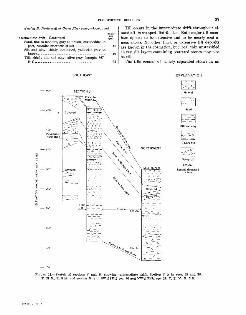
PLEISTOCENE DEPOSITS 37
Section D. North watt of Green River valley Continued
Thkk-
Intermediate drift Continued (feet) Sand, fine to medium, gray to brown; crossbedded in
part, contains interbeds of silt__________________ 40Silt and clay, thinly laminated, yellowish-gray to
brown-______________________________________ 10Till, chiefly silt and clay, olive-gray (sample 867-
6-1).________._.______.__.____._____.___._.__ 65
Till occurs in the intermediate drift throughout al most all its mapped distribution. Both major till mem bers appear to be extensive and to be nearly contin uous sheets. No other thick or extensive till deposits are known in the formation, but local thin unstratified clayey silt layers containing scattered stones may tflso be till.
The tills consist of widely separated stones in an
SOUTHEAST EXPLANATION
500'SECTION C
400'
Puyallup (? Formation
350'
300'
200'
100'
Covered
Covered
-Osceola Mudflowv
o o.o- o
o A
1300 - -
NORTHWEST
3 miles -867-5-1
867-6-1
_ A ~_ A
Stony till
867-5-1
Sample discussed in text
FIGURE 17. Sketch of sections C and D, showing intermediate drift. Section C is in sees. 25 and 36, T. 21 N., B. 5 E., and section D is in SW^SE^ sec. 16 and NW^iNE^i sec. 21, T. 21 N., B. 5 E.
380-731 O - 70 - 6
38 GEOLOGY OF RENTON, AUBURN, AND BLACK DIAMOND QUADRANGLES, WASHINGTON
unsorted olive-gray to bluish-gray matrix of silt, sand, and clay. Overall, they are much less stony than most deposits of till in this region. Pebble- and granule- sized material, which makes up large parts of till in other formations in the mapped area, constitutes only a few percent of samples of intermediate till (fig. 16). Locally, however, till in the intermediate drift is relatively coarse, especially at the tops of the two prin cipal till members, and is somewhat similar in texture to other till deposits. Although the fine-grained tills contain thin lenses and blocks of stratified sand and silt, they are unstratified. They are also compact and cohesive, and fracture in a typically blocky pattern (fig. 15).
The fine-grained tills contain a slightly higher per centage of stones of northern provenance but other wise are similar in composition to other glacial tills in the area. White marble and quartz pebbles are es pecially noticeable, because they are readily visible against the fairly uniform gray matrix. Clay minerals are chiefly montmorillonite and chlorite, but small amounts of fine-grained mica or illite are also found (table 4).
Exposed stratified drift consists mainly of sand, silt, and clay. Gravel is present but is sparse. Hori zontally stratified, laminated, and thin-bedded silt and clay from a few feet to 50 feet thick generally overlies the lower till. Similar but thinner deposits also com monly overlie the upper till. Most of the other sedi ments are flat-bedded sands that probably also are lacustrine. Crossbedded coarse pebbly fluvial sand and even some gravel, characterized by cut-and-fill struc tures, occur, mainly in the middle and upper parts of the strata between the two till deposits. The stratified drift contains rocks and heavy minerals of northern provenance, but the proportion locally is low, especially in the fluvial materials. Between the two ice advances, which are represented by fine-grained till, the Puget lobe retreated enough to permit draining of the pro- glacial lake in which the lacustrine sediments were deposited. Fluvial sediments laid down next probably were derived in part from rivers heading in the Cas cade Range.
WEATHERING
The intermediate drift appears considerably less weathered than the underlying Orting(?) Drift. Few stones in it are decomposed, and iron staining is less strong than in the Orting(?). The relatively weak iron staining probably is partly but not wholly due to the abundance of fine-grained strata. The fine grained tills generally are gray and show only small amounts of iron oxide accumulation around stones and along fractures. The abundant silt and clay strata are
also generally gray; they show minor oxidation except for concentrations at the top where they are overlain by sand. Even some sand deposits are not noticeably oxidized. Overall, however, the sand is lightly stained to yellowish brown, and locally to a strong' brown color. Along the White River, a thin zone of greenish- brown probably weathered clay occurs in th°- top of the formation below the Salmon Springs Drft. The weathered clay is at the same horizon at which a thin humified zone occurs in the Lake Tapps quadrangle (Crandell, 1963, p. A24).
DISTRIBUTION AND THICKNESS
The intermediate drift crops out in both valley walls of the Green River from about 1 mile east of Auburn to the middle of the Black Diamond quadrangle. The two fine-grained tills crop out along most of this dis tance and increase in altitude from west to e^st (fig. IT). The formation is well exposed at measured sec tion O and also at section D (fig. IT). The drift also crops out along Big Soos Creek valley, but its extent there is poorly known because exposures are poor and distinctive fine-grained tills were not found more than a few hundred feet above the valley mouth.
The intermediate drift is also exposed in the White River valley. Outcrops of the drift are nearly continu ous from about 1 mile from Auburn southeastward into the Lake Tapps quadrangle. The formation there dips less steeply than the gradient of the White River. Although both fine-grained tills crop out in down- valley exposures, upvalley the lower till passes below the flood-plain level before the quadrangle boundary is reached.
A mile north of Auburn, gray lacustrine clay, silt, and sand crop out in small exposures along the Du- wamish Valley wall. Although typical fine-grained till is not exposed there, the sediments are mapped as in termediate drift, because lithologically they are similar to and only 2 miles from well-exposed intermediate drift at measured section D.
The maximum exposed thickness of intermediate drift is about 225 feet, in the Green River valley (measured section C; fig. IT). The upper till is gen erally from 10 to 35 feet thick, but the lower till is more variable in thickness. It commonly is about 40 feet thick, but is more than 60 feet thick ir several exposures, and apparently is nearly 200 feet thick at the east margin of the drift (fig. 14).
STRATIGRAPHIC RELATIONS
The intermediate drift overlies the Orting(?) Drift with a sharp erosional disconformity. Locally it is con-

PLEISTOCENE DEPOSITS 39
formably overlain by the Puyallup (?) Formation, but in most places it is overlain and channeled by Salmon Springs Drift. The conformable contact at its top is exposed in the south valley wall of the Green River at section O.
ENVIRONMENT
Lakes seemingly were widespread during the glacia- tion that produced the intermediate drift. That pond ing was common in the Green River area is shown by abundant lacustrine sediments in the drift. Moreover, lakes apparently were widespread farther north in the lowland, where the Puget lobe must have picked up much of its load. Both the abundance of silt and clay and the low proportion of Cascade stones in inter mediate tills suggest that, north of the Green River, the Puget lobe overrode more lake deposits and less coarse alluvium of Cascade Rivers during the inter mediate glacial episode than during other glaciations.
The fine-grained tills typical of the intermediate drift are very similar in texture and structure to ma rine "tills" in British Columbia (Armstrong and Brown, 1954, p. 353) and in northern Washington (Easterbrook, 1963). No marine fossils, however, were found in the tills in the intermediate drift. Nor have exchangeable sodium cations, which suggest a marine origin for some similar deposits in Seattle (Mulli- neaux, 1967), been recognized in several analyzed samples. The textural similarity of the fine-grained tills to the marine "tills," as well as the abundant la custrine sediments, suggests that the Puget lobe of the intermediate glacial episode advanced into and per haps even floated in a proglacial lake.
PUYALLUP (?) FORMATION
Thin beds of sand of central Cascade and Mount Rainier provenance, and silt, clay, and peat lie above the intermediate drift and below Salmon Springs Drift. These sediments contain climatic evidence of in- terglacial conditions, but they could not be traced into either the Alderton or the Puyallup interglacial de posits of the Puyallup Valley. They are tentatively correlated with the Puyallup Formation because they directly underlie Salmon Springs Drift.
The name Puyallup Sand was established by Willis (1898c), who applied it to the compact gray sand of Mount Rainier provenance that is exposed along the Puyallup Valley, and to the interglacial episode rep resented by the sand. The name has since been changed to Puyallup Formation because the sand at the type locality is a facies of an assemblage of sand, gravel,
and mudflow deposits of Mount Rainier provenr.nce (Crandell and others, 1958).
LITHOLOGY
The Puyallup (?) Formation consists chiefly of sand, silt, clay, and peat but also contains volcanic ash and a volcanic mudflow. The deposits are characterized by reddish-gray sand from Mount Rainier, by volcanic ash, and by peat deposits; peat is present in all de posits mapped as Puyallup (?). Peat exposed in the formation at the mouth of the Green River valley dur- kig this investigation is thin and mixed with silt and clay. Thicker, purer beds, however, from which black smiths regularly obtained "coke" many years ago, v^ere reported at that locality by local residents. In the Green River valley east of Auburn, peat in the forma tion ranges in thickness from a few inches to 4 feet. It is highly compressed, breaks with a distinct shaly fracture, and is classed as lignite (Cooper and Aber- nethy, 1941, p. 36). Several of these peat or lignite beds on the south wall of the valley have been pros pected in the belief that they were coal beds in the Puget Group (Geer, 1941, p. 41). The deposits are high in inorganic material, however, and in the nat ural state contain more than 50 percent moisture (Cooper and Abernethy, 1941, p. 38).
Volcanic ash crops out in the Puyallup (?) Forma tion at the mouth of the White River valley south of Auburn (Mullineaux, 1965b) and on the south wall of the Green River valley in sees. 25 and 36 about 6 miles east of Auburn (Mullineaux, 1965c). At the first local ity, ash associated with peat, silt, and clay occur*' in several beds from river level to about 15 feet higher. The ash bed at river level is as much as 3 feet tlick. At the second locality, several ash beds, one of which is 21/2 feet thick, are also exposed; here the ash is also associated with peat, silt, and clay. Diatom remains are abundant in the ash at both places.
Sand of Mount Rainier provenance, comparable to that in the type locality of the Puyallup Formation (Crandell and others, 1958), crops out along the Du- wamish Valley north of Auburn, and along the White River valley. Similar sand, shown by augering to be more than 40 feet thick, underlies exposed Pryal- lup(?) deposits at the mouth of the Green River val ley. It is a purplish-gray medium to coarse sand that is characterized by abundant red and gray and?.site fragments and hypersthene.
Puyallup(?) deposits at the mouth of the Green River valley include a lens or sheet of till-like material interpreted as a volcanic mudflow from Mount Rainier. The mudflow is a hard, compact, and unsorted and
40 GEOLOGY OP RENTON, AUBURN, AND BLACK DIAMOND QUADRANGLES, WASHINGTON
unstratified stony mixture of sand, silt, and clay. It is distinguished from till by an abundance of angular mineral grains and stones, an abundance of material of Mount Rainier provenance, and its association with peat-bearing sediments.
WEATHERING
The Puyallup (?) Formation generally is light to dark gray, is not iron stained, and appears fresh. Few dense stones are soft, but many light-gray open-tex- tured volcanic rocks are at least partly decomposed. No weathering profile on Puyallup (?) deposits has been found in the mapped area, though the top of the Puyallup Formation in the Lake Tapps quadrangle is locally weathered to the clay mineral halloysite to depths of about 10 inches * (Crandell, 1963). The weathering profile in the Lake Tapps quadrangle probably represents a period of weathering of several tens of thousands of years, for not even rinds have formed on stones in the Vashon Drift, which has been exposed to weathering for about 14,000 years (Wal- dron and others, 1957; Mullineaux and others, 1965).
DISTRIBUTION AND THICKNESS
Deposits assigned to the Puyallup (?) are thin and discontinuous and are exposed in only the southwest ern part, of the mapped area. In the Lake Tapps quad rangle 10 miles south of Auburn, the Puyallup Forma tion is about 135 feet thick, and its top is at an alti tude of 175 feet (Crandell, 1963). It thins and de creases in altitude northward to less than 100 feet in altitude about 1 mile south of the Auburn quadrangle boundary. In the Auburn quadrangle, Puyallup(?) deposits are exposed near flood-plain level at the mouth of the White River valley and intermittently farther north nearly to Kent. A thin unmapped lens of ashy sand, clay, and peat that crops out half a mile south east of Kent may be the northernmost Puyallup(?) exposed in the mapped area. In the Green River val ley, the only deposits continuous enough to be mapped crop out about 6 miles east of Auburn on the south valley wall (Mullineaux, 1965b, c). In the White River valley east of its mouth, the only deposits discovered, near the south boundary of the Auburn quadrangle, are thin and discontinuous and were not mapped.
The maximum known thickness of the Puyallup(?) in the mapped area is about 55 feet, at the mouth of the Green River valley. Fifteen feet of the formation is exposed at that locality, and another 40 feet is known from angering. Along the Green and White River valleys, the formation probably is not more than 25 feet thick.
STRATIGRAPHIC RELATIONS
The Puyallup(?) Formation conformably overlies intermediate drift and is disconformably overlain by Salmon Springs Drift. Both the upper and lower con tacts of the Puyallup (?) are exposed along the Green River valley at section C (fig. 17). There the forma tion lies conformably 011 fine-grained till of thQ, inter mediate drift and is overlain and channeled by gravel of the Salmon Springs Drift. In the Duwamish Val ley, Puyallup(?) sediments generally extend below flooci-plain level. They are overlain and channeled by sand and gravel of Cascade provenance that is mapped as part of the Salmon Springs Drift. Although weath ering that probably represents tens of thousands of years and erosional relief of about 100 feet occurs on the Puyallup Formation in the Lake Tapps quad rangle (Crandell, 1963), the channeling of the, top of the Puyallup (?) is the predominant evidence seen of the time break in the mapped area.
FOSSILS AND ENVIRONMENT
The Puyallup(?) contains pollen and diatoms that indicate at least part of the formation was deposited during a warm inter glacial period. Pollen in a se quence of samples of Puyallup (?) sediments from the Green River valley, studied by E. B. Leopold, indicate that the climate became as warm as that of the Puget Sound lowland at present. Miss Leopold reported (written comniun., 1958) that a prevalence of lowland hemlock pollen in the middle of the se quence reflects lowland wet conditions similar to those now in parts of the Puget Sound lowland where rain fall is more than 40 inches annually. A predominance of lowland hemlock over mountain hemlock in this phase of the sequence implies warm growing seasons with an average July temperature of at least 60°F, as is true of the Puget Sound lowland now. Shifts from dominance of Douglas-fir to lowland hemlock and back to Douglas-fir in the sequence are attributed to changes of rainfall during the clepositioiial interval.
Diatoms from the sequence along the Green River valley, and also from ashy Puyallup (?) beds exposed at the mouth of the White River valley, ^ere ex amined by Mr. Lohman. Diatoms from both localities are fresh-water forms. Bottom-dwelling types are com mon at both localities, indicating that the lake or lakes in which they lived were shallow. The Green River valley samples contained a few warm-water and a few cold-water forms, but most are types that live now in a temperate climate comparable to that of tH Puget Sound lowland at present. The White River valley samples contain only types now living in temperate
PLEISTOCENE DEPOSITS 41
or wanner climates. According to Lohman, the diatom assemblage from each locality indicates interglacial, temperate conditions as warm as those in the Puget Sound lowland now.
Puyallup (?) sediments exposed along the Duwamish Valley are chiefly alluvium similar to that now being deposited on the Duwamish Valley floor, and they in clude water-laid ash and a volcanic mudflow. These deposits probably were laid down on the wide flood plain of a river that headed on Mount Rainier. Puyal lup (?) deposits exposed along the Green River valley are thin, lenticular, and characterized by at least partly lacustrine sediments that were slowly accumulated. They probably were laid down on an undulating inter- fluvial plain of intermediate drift very like the surface of the Vashon drift plain of the present. Beds of vol canic ash in all the deposits show that a volcano, pre sumably Mount Rainier, was active during Puyal lup (?) time.
SALMON SPRINGS DRIFT
Stony till and outwash sand and gravel assigned to the Salmon Springs Drift overlie Puyallup(?) de posits and underlie Vashon Drift along the Green River, White River, and Duwamish Valleys. Along the Duwamish Valley walls, these deposits can be traced into the type Salmon Springs Drift in the Lake Tapps quadrangle. The Salmon Springs Drift is named for springs on the east wall of the Duwamish Valley about 6 miles south of Auburn (Craiidell and others, 1958).
Fluvial sand and gravel of Cascade provenance locally underlies and overlies Salmon Springs outwash gravel and locally is iiiterbedded with northern out- wash along the Duwamish Valley wall near Auburn. These Cascade-derived sediments are closely associated with and are similar in grain size to the Salmon Springs stratified drift, and they are mapped and de scribed as part of the Salmon Springs deposits.
LITHOLOGY
The Salmon Springs Drift consists chiefly of fluvial sand and gravel. The formation locally includes one or two till layers, and in places its lowermost and upper most beds are fluvial sand and gravel mainly of Cas cade provenance. The formation is well exposed in northeast Auburn in the Duwamish and Green River valley walls. There, the formation consists of thick sand and gravel of Cascade or mixed Cascade and northern provenance at the base; this sand and gravel is overlain by northern sand and gravel that includes two layers of till, which in turn is overlain by sand and gravel of Cascade provenance (section E, fig. 18).
Section E. Composite section in center sec.. 17, T. 21 N., R. 5 E., in Green River and Duwamish Valley walls
Thick-Vashon Drift: (ffef)
Sand and pebble gravel, gray to light-brown, fri able.-- ______________________________________ >40
Till, stony, gray (sample 845-16-6)_______________ 30Gravel, pebble and sand, gray____________________ 15
Salmon Springs Drift:Sand and pebble gravel, reddish-gray to gray; Mount
Rainier provenance,__________________________ >20Sand and gravel, olive-gray to brown; northern
provenance-____-----_----__----_____________ 5-10Till, stony, olive- to brownish-gray (sample 845-
16-5)________________________________________ 15Sand and pebble gravel, brown; northern provenance. 40Till, stony, olive-to brownish-gray______________ .__ 5-10Sand and gravel, brown; northern provenance.----- 5-10Gravel, pebble-and-cobble, and pale-yellowish-
brown to brown sand; Cascade or mixed Cascade and northern provenance; grades into overlying northern sand and gravel- ________-___-___-_-_- 20
Silt and clay, peaty; contains scattered stones__--__ 3Gravel, pebble-and-cobble, and pale-yellowish-brown,
light-brown, and brownish-gray sand; Cascade or mixed Cascade and northern provenance- ____-__- 50
Sand and silt, blusish-gray to reddish-brown; containswood and peat____-_______--__-____-_-____-_- 5
Sand and pebble gravel, reddish-brown____________ 5Puyallup (?) Formation:
Silt and sand, peaty, reddish-gray to brown; MountRainier provenance.________________---_--_--- 5-10
Mudflow, hard, compact stony silt and sand_ ________ > 5
Till is common in the formation only in the vicriity of Auburn, where at least two separate layers are ex posed. From section E, till is intermittently exposed northward for about 3 miles in the Duwamish Valley wall. It is also exposed eastward from the Duwamish Valley wall for about a quarter of a mile in the Green River valley wall. In the White River valley, till is exposed intermittently from the south boundary of the quadrangle northwestward for about a mile and a 1 alf. Elsewhere along Duwamish Valley and the valleys of the Green and White Rivers, however, till was fcmid either sparsely or not at all.
The till generally is olive gray to yellowish brown, hard and compact, and unsorted and unstratifieci. It consists of numerous stones in a silty sand matrix; the stones and heavy minerals indicate a northern prov enance. The till is similar in texture and composition to Vashon till and is distinctly more stony than typical tills of the underlying intermediate drift (figs. 15, 16).
Stratified drift from the Puget lobe at section E is mostly brown sandy gravel and coarse sand. It is loose and well sorted in a few places, but generally it is com pact and has a matrix of grayish-yellow silt and clay.
42 GEOLOGY OF RENTON, AUBURN, AND BLACK DIAMOND QUADRANGLES, WASHINGTON
350'
300'
250'
150'
100'
50 J
o- o- o o o o-o o . o o .
O . o . o o . o o o . o o o o o . o . o
o o-o- o to o . o o o . o . o . o o.
O O O o O-O
EXPLANATION
Vashon
Drift 845-16-6
845-16-5
SalmonSprings
Drift
Silt and clay
A o
oo
A
Till
Mudflow
845-16-6
Sample discussed in text
Puyallup (?) Formation
FIGURE 18. Sketch of section E, showing Salmon Springs Drift. Section E is in center sec. 17, T. 21 N., B. 5 E.
A few fragments of wood have been found in it be tween the two tills. Cascade-derived fluvial sediments and those of mixed Cascade and northern origin are sandy pebble-and-cobble gravel that contains lenses of sand and even of clayey silt. Most of this fluvial detri tus is of central Cascade origin, but pebbles derived from Mount Rainier are common, and several lenses of sand are largely of Mount Rainier provenance. Peat and flattened wood fragments are common in clayey silt and sand near the base of the Salmon Springs sequence at section E, and organic material occurs sparsely in a lens of clayey silt about 55 feet higher. Pollen samples from these organic sediments, analyzed by Miss Leopold, are dominated by pine and spruce; the pollen are suggestive of but not diagnostic of a cool climate.
Salmon Springs stratified sediments along Du- wamish Valley north and south of Auburn appear to be mostly interbedded gravels and sands similar to those at section E. Stratified drift exposed in the Green and White River valleys is chiefly brown sand and pebble-and-cobble gravel.
WEATHERING
The Salmon Springs Drift is somewhat iron stained, and a few stones in it are decomposed. Strati fied sediments, even those along Duwamish Valley that have a silt and clay matrix, generally are stained yel lowish brown. Although some deposits in the Salmon Springs are gray and appear fresh, iron staining is widespread enough to be useful in differertiating Salmon Springs from Vashon Drift. The staining sug gests that the Salmon Springs Drift was weathered before Vashon time, but no weathering profile has been found on it.
DISTRIBUTION AND THICKNESS
Salmon Springs Drift is inferred to compose most of the east wall of Duwamish Valley from Kent to the south boundary of the Auburn quadrangle, where it extends on into the Lake Tapps quadrangle. At section E in Auburn, the formation is about 200 fee4: thick. Near the south boundary of the Auburn quadra ngle, it is intermittently exposed from near flood-plain level up to about 450 feet above sea level; thus it miM be at least 400 feet thick in that vicinity. It also crops out for several miles in the Green and White River valleys upstream from Auburn. In the Green River valley, it generally is less than 100 feet thick; and in the White River valley, it is less than 50 feet thick.
STRATIGRAPHIC RELATIONS
The Salmon Springs Drift lies unconformably on the Puyallup (?) Formation or the intermediate drift and is unconformably overlain by Vashon Dr'ft. The base of the Salmon Springs is exposed at sections C and E, where the formation lies in channels cut into the underlying Puyallup (?) and intermediate drift formations. The base of the Salmon Springs is more than a hundred feet lower along Duwamish Valley than it is along the Green and White River valleys a few miles to the east. A north-trending valley, whose east wall was a short distance east of Auburn, may have been filled by Salmon Springs Drift.
Along the Green River valley east of Auburn, brown Salmon Springs Drift locally is overlain by gray gravel and stony till that underlie Vashon till. This gray drift has been mapped as part of the Salmon Springs, though it may be younger.
UNDIFFERENTIATED DRIFT IN THE CEDAR RIVER VALLEY
Several layers of till and intervening stratified sedi ments including peat underlie the Vashon Drift along the Cedar River east of Renton. In this strati graphic
PLEISTOCENE DEPOSITS 43
sequence, no till layers were found with markedly dif ferent textural or weathering characteristics, compar able to, for example, the fine-grained tills in inter mediate drift or the weathered Orting(?). Neither were distinctive sediments from Mount Rainier found anywhere to serve as marker layers. Consequently, no stratigraphic sequence similar to that in the Green River valley and in Duwamish Valley was recognized. Because the Cedar River valley strata could not be traced to the other valleys, they are not correlated with or described as part of the named formations mapped farther south. Not only were no distinctive marker layers recognized in the Cedar River valley sequence, but analyses of pollen layers from three different hori zons in the sequence failed to show evidence of a dis tinctly warm climate separating episodes of till depo sition. As a result, the entire sequence has been mapped as and will be described as undiffereiitiated.
LITHOLOGY
At least three layers of pre-Vashon till, separated by fluvial sand and gravel and lacustrine sand of pre dominantly northern provenance and by silt and clay, are exposed in the Cedar River valley walls. The stratigraphy of these deposits is illustrated by sections F, G, and ZT, in figure 19. Composite section F at Ren- ton includes at least three, and perhaps four, layers of pre-Vashon till. Two of the layers are exposed nearly as far east as the quadrangle boundary. Each of the layers that clearly is till is gray and not noticeably oxidized; the one other layer that may be till, which directly overlies a woody silt and peat deposit, is gray ish brown.
The pre-Vashon tills of the Cedar River valley area are generally similar in texture and composition to the Vashon till and were deposited by the Puget lobe. Overall, they are somewhat finer grained than Vashon till, but they are not as fine grained, nor do they show the fractures typical of till in the intermediate drift.
The prevalent stratified deposits along the Cedar River valley are sand. Uniform horizontally bedded lacustrine sand with silt and clay is widespread and as much as 100 feet thick in exposures on the north side of the valley (fig. 19). Probable lacustrine sand at the base of section H is of central Cascade provenance and is nonglacial. Till and varved clay and silt at higher altitudes, however, show that a considerable part of the sequence is glacial. Fluvial deposits include sand, peb ble gravel, and locally boulder gravel. One bouldery cobble gravel 15-20 feet thick occurs in channels at the top of thick lacustrine deposits at sections G and H (fig. 19).
WEATHERING
The drift along the Cedar River valley shows little weathering other than partial iron oxide staining of permeable sediments. Tills, with the possible exception of one, are not notably more oxidized than the Vashon till. Near Renton, iron staining generally is limited to a few beds, and even some very coarse and permeable gravels are not stained. However, farther east, the staining is more intense and more widespread. Part of the more strongly stained deposits in the eastern part of the quadrangle may be equivalent to unstained strata nearer Renton, but the basal strata to the east certainly underlie the beds exposed at Renton. No weathering profiles have been found either within or on top of the undifferentiated drift in the Cedar River valley.
DISTRIBUTION AND THICKNESS
Pre-Vashon drift makes up most of the Cedar River valley walls from Renton eastward to the quadrargle boundary. The deposits dip as much as 350 feet per mile to the northwest, thus progressively older strata are exposed upvalley. The pre-Vashon beds are irore than 200 feet thick about 3 miles east of Renton. Un- oxidized drift like that in the Cedar River valley also crops out in a few places along Duwamish Valley in and slightly south of Renton.
FOSSILS AND ENVIRONMENT
The undifferentiated deposits include peat in two, and probably three, stratigraphic horizons. The warm est climate indicated by pollen in several samples from the peat beds is definitely cooler than the present cli mate in the Puget Sound lowland. Pollen has been examined from peat at the top of the pre-Vashon sequence at section H and across the valley from sec tion F, and from peat at 75-90 feet above sea level at section F. According to Miss Leopold, pollen from sec tion H indicates that the climate was cool, similar to that which now characterizes altitudes of 4,000-5,000 feet on the west flank of the Cascade Range in Wash ington. Pollen from peat across the valley from section F is almost entirely pine, so no climatic interpretation can be made. Pollen from section F is largely compar able to pollen in modern peat at altitudes of 3,000- 4,000 feet in the Cascade Range. The assemblage con tains a few species typical of the present Puget Sound lowland, however, which may indicate the climate was somewhat warmer than that now at 3,000-4,000 feet.
VASHON DRIFT
Till or stratified drift of Vashon age lies at the sur face of the drift plain in almost all of the area mapped. The name Vashon was first used by Willis (1898c, p.
44 GEOLOGY OF RENTON, AUBURN, AND BLACK DIAMOND QUADRANGLES, WASHINGTON
NORTHWEST SOUTHEAST
SECTION H350'
300'
250'
200'
150'
SECTION F
Woody f" and <
peaty I
Peat
EXPLANATION
o O 0
o
Gravel
Till
Correlation line
FIGURE 19. Sketch of sections of undifferentiated drift exposed on the north side of the Cedar River valley near Renton. Section F is in SWy4 NE% and NW%SE% sec. 17, T. 23 N., R. 5 E.; section G, in NE^NWi/i sec. 22; and
section H, in NE^4NEi4 sec. 22, T. 23 N., R. 5 E.
126) for "the episode represented by the latest occupa tion of the Puget Sound basin by the northern ice tongue and its deposits." The term is derived from Vashon Island in Puget Sound southwest of Seattle, where according to Willis (1898c, p. 126), characteris tic gravelly till occurs "typically, although not heav ily." The Vashon Drift as used by Willis is still called Vashon Drift, but his Vashon Glaciation is now known as the Vashon Stade of the Fraser Glaciation (Arm strong and others, 1965).
The Vashon Drift extends entirely across the mapped area, and as much as 25 miles farther south (Bretz, 1913; Crandell, 1963). Twelve miles east of Kenton, the glacier rose to a height of about 3,000 feet on Tiger Mountain (also known as Mount Issaquah) (Bretz, 1913, p. 36; Vine, 1969). In the Lake Tapps quad
rangle south of Black Diamond, the glacier rose to alti tudes of 1,600-1,800 feet along the Cascade mountain front (Crandell, 1963). Thus the ice probably was at least 2,500 feet thick over the drift-plain surface near Renton, and at least 1,500 feet thick over that surface even in the southernmost part of the mapped area.
TILL
Vashon till forms the present surface of about half the drift plain, and probably extends under most other deposits that lie at the surface. It is the most widely exposed unit in the mapped area. In thickness, it is highly variable; the maximum exposed is about 70 feet, but the average thickness probably is 110 more than 20 feet, and exposures in which it is less than 5 feet thick are common. It is generally thinner on north-facing
PLEISTOCENE DEPOSITS 45
than on comparably steep south-facing slopes. Locally, the Vashon Drift appears to contain two layers or zones of lodgment till, but in most places it contains only a single layer.
TOPOGRAPHIC EXPRESSION
Vashon till mantles rather than forms major topo graphic units. It veneers almost all the drift plain (though it is covered itself in places), and it laps up over bedrock highlands as well as over some valley walls, such as those in Duwamish Valley. On a minor scale, however, the Vashon till forms the characteristic topography of undulating ground moraine. On that scale, the ground moraine has a rolling surface that is characterized by a relief of a few tens of feet and by numerous closed depressions. On a larger scale, the surface displays a rough south to south-southeast elongation of hills and swales; locally, the hills are very elongate, cigar shaped, and closely alined in drum- linized topography. Such an alinement is formed by actively flowing ice (Flint, 1957, p. 72) and indicates the direction of ice movement. Most of the hills in the drumlinized ground moraine appear to be only ve- iieered by till, but some small hills probably are drum- lins constructed entirely of Vashon till. The relief and alinement probably result from scour and fill by the glacier.
The surface of the till has been very little modified except where it has been eroded by large melt-water rivers on the drift plain and by postglacial rivers that have cut valleys down through it. On most of the ground moraine, postglacial change has been limited to minor erosion by small streams.
LITHOLOGY
Vashon till consists of an unstratified, nearly unsorted mixture of pebbles and cobbles in a clayey silt and sand matrix (figs. 15, 16), and it contains scattered boulders as large as several feet across. Till that is often re garded as typical is compact, hard, and coherent. Silt and clay particles are tightly packed into spaces be tween grains of sand and gravel, and as a result the till is highly impermeable. This tight, dense till is re garded as lodgment till, deposited at the base of and compacted by the weight of the glacier. It generally is the "harclpan" of local well drillers and construc tion workers. A second f acies can be recognized almost everywhere the till lies at the surface. This facies is less compact, less coherent, locally somewhat sorted, and usually only a few feet thick. The looser material probably is chiefly ablation till, let down from the sur face of the glacier as the ice melted, and is not appre ciably compressed by ice. The less compact material
may also include some lodgment till that has been loosened by frost, root, and animal action. Locally, it grades into thin stratified drift.
Although the till is unstratified, it does contain rome blocks and lenses of stratified drift. In addition, lodg ment till commonly shows thin partings, close to and approximately parallel to the ground surface; the re sulting structure is called fissility by Flint (1957, p. 113). In places, Vashon till also shows horizontal or gently dipping partings that are spaced several feet apart.
The till everywhere in the mapped area is a mixture that is characterized by a substantial amount of mate rial in each of many size grades (fig. 16). It differs significantly in average grain size and in degree of sorting, however, from place to place in the mapped area. Just north of the Cedar River, for example, the till consists mostly of silty sand. Over most of the rest of the area, however, as Willis (1898c) noted, it typi cally is gravelly. Most of the pebbles and cobbler are rounded rather than angular, and only a few are strongly faceted or striated. The roimding of the stones probably resulted from a pre-Vashon history of stream abrasion, and perhaps short transport by the Vashon Puget lobe. Most constituent pebbles, though their ulti mate source was the mountains of Washington, prob ably were transported first by rivers into the part of the lowland north of the mapped area. These stones, rounded by rolling along streambeds, were later picked up by the Puget lobe and incorporated into its de posits.
Generally about 5-15 percent of the rocks and min erals in Vashon till can be identified as of northern provenance, but the rest are of Cascade or of doubtful origin. Locally, especially in till just south of Puget Group outcrops near Renton, the till also contains abundant fragments of soft sandstone and shale. Gar net commonly makes up at least 5 percent of the sand- size heavy-mineral grains. Clay-size particles, smaller than 2/i, (microns), are approximately half norclay minerals and half clay minerals; the clay minerals are mostly montmorillonite and chlorite (table 4).
WEATHERING
Weathering generally is limited to oxidation ir the upper few feet and to development of a weak brown podzolic soil profile (Poulson and others, 1952; C an- dell, 1963). Where the ablation till is more than 3 feet thick, oxidation commonly extends to a depth of about 30-36 inches. In relatively permeable ablation till, it may extend a foot or two deeper. Where the ablation till is only a foot or two thick, the oxidized zone ex tends down through it and a few inches beyond into
46 GEOLOGY OF RENTON, AUBURN, AND BLACK DIAMOND QUADRANGLES, WASHINGTON
compact lodgment till. A thin rim of accretionary iron oxide occurs on stones within the oxidized zone; but lower in the till, iron oxide is generally not concen trated around stones or along fractures.
ADVANCE STRATIFIED DRIFT
Advance stratified drift occurs in all parts of the mapped area but generally is thin and discontinuous and covered by Vashon till. The advance deposits are especially well exposed along the major river valleys that were cut in postglacial time. Advance drift is simi lar in texture and composition to recessional stratified deposits and in general can be distinguished from re cessional drift only where it is overlain by Vashon till. A few deposits, however, can be recognized as probable advance drift, because their surfaces apparently have been modeled by overriding ice.
Advance drift locally fills depressions in the pre- Vashon topography and is highly variable in thick ness. The thickest exposed deposits crop out along Big Soos Creek and Duwamish Valley, where they locally are more than 100 feet thick. However, advance drift generally is less than 50 feet thick and probably aver ages less than 30 feet in thickness. The variations from place to place suggest a few features of the pre-Vashon topography, but exposures are not adequate to outline the older drainage pattern. Thin widespread sand and gravel under Vashon till along the Cedar, Green, and White River valleys suggests that the pre-Vashon drift plain in those areas was broad and similar to the present one. Thick deposits that suggest former deep valleys are sparse; at only two sites, along the Big Soos Creek and Duwamish Valleys, do advance sedi ments show the existence of depressions of 100 feet or more in the pre-Vashon surface. Thus neither an ex tensive nor a deep pre-Vashon valley system is indi cated by the exposed advance stratified drift.
Advance sediments consist chiefly of gray unoxi- dized pebble-and-cobble gravel and pebbly sand. The gravel is typically compact and indistinctly stratified, and in places it contains substantial amounts of inter stitial silt and clay. Although such a matrix is not uni versal in the mapped area, it appears to be more com mon in advance gravels than in recessional deposits. Sand is also common in the advance drift, which locally also includes lenses of silt and clay. No oxidized zone characterizes the top of the advance drift, because it was immediately covered by Vashon till. Brown, oxi dized layers, however, are present within it in a few localities.
RECESSIONAL STRATIFIED DRIFT
Stratified drift laid down as the glacier retreated is composed of a wide variety of deposits, which are
divided into two groups on the basis of inferred origin. One group consists of small deposits laid dovm by melt-water streams that probably issued directly from the nearby ice front. These are the generally small and discontinuous bodies of recessional outwash that lie in the Renton quadrangle and in the part of the Auburn quadrangle that is northwest of the Covington chan nel. The second group, representing a much larger volume of sediments, was deposited by a large ice- marginal river that originated not locally but much farther north along the Puget lobe. This river flowed southward along the east flank of the lobe to the ice front, then southwest ward along the front and across the mapped area. It included, besides Puget lob^ melt water, considerable drainage from the Cascade Kange, which flowed west to the Puget lobe and joined the ice-marginal stream flowing along the flank. The ice- marginal river laid down broad, continuous deposits over much of the Black Diamond quadrangle, along the Covington channel, and, to a lesser extent, along the Cedar River valley.
DEPOSITS OF LOCALLY DERIVED MELT WATER
Recessional stratified drift deposited by melt water from the local ice front consists of scattered kames and small valley trains on the drift plain, and kame terraces and glaciolacustrine deposits along th?. Du wamish Valley.
KAME DEPOSITS
The kames are few in number and widely separated. The largest is a low ridge of sand about 1 mil0, long but less than a quarter of a mile wide that is located about 1 mile east of Kent. Four other kam^s are mapped 011 the drift plain between Renton anc1 Lake Youngs south of the Cedar River (Mullineaux, 1965a) ; all consist chiefly of pebbly sand. A single small kame in the northeast corner of the Auburn quadrangle consists of sandy pebble-and-cobble gravel.
VALLEY-TRAIN DEPOSITS
Small valley trains, composed chiefly of sand and pebble gravel, were formed in some shallow troughs that led from the ice front southward over the drift plain. The valley-train deposits are terrace remnants and collapsed masses of sand and gravel, mostly in the trough of Big Soos Creek and in a trough between the Cedar River valley and Lake Youngs. The deposits indicate that irregular masses of stagnant ice lay in parts of these depressions during formation of the val ley trains. Melting of the ice resulted in collapse of parts of these deposits and destruction of their con structional surfaces. Recent peat and alluvium now cover some of the collapsed sediments.
PLEISTOCENE DEPOSITS 47
The least collapsed valley-train deposit probably records a temporary stillstand of the ice front in the shallow trough of the drift plain in which Big Soos Creek now flows. The deposit forms a continuous pair of terraces in the trough from the Covington channel northward for about a mile and a half. For the next 2 miles farther north, however, deposits at the surface along the creek are chiefly lacustrine silt, clay, and peat. Ice apparently filled the part of the trough now floored by lacustrine sediments while the valley train leading to the Covington channel was deposited. The ice then retreated rapidly from that position, and silt and clay were laid down in a temporary lake formed in the trough behind the valley-train deposits.
KAME-TERRACE DEPOSITS
Many small kame terraces were formed along Du wamish Valley north of Auburn, adjacent to a tongue of ice that lay in the Duwamish Valley after the glacier had retreated from the drift plain. Streams from the drift plain descended to the ice margin, and there joined melt water flowing between the valley wall and the ice. Deposits of these streams include some relatively undisturbed cut-and-fill terraces and some extensively collapsed fill terraces.
Directly east of Auburn, two kame terraces cover about a quarter of a section each in sees. 8, 9, and 17. They are high on the valley wall, at about 350 feet above sea level, and may have been formed while the Puget lobe still covered part of the drift plain nearby. Both appear to be composed of well-sorted gravelly sand and pebble gravel from about 15 to 40 feet thick.
In Kent, several small terraces were cut across a spur on the Duwamish Valley wall while ice in the valley served as the northwest bank of a channel. The sand and pebble gravel that underlies these terraces probably is only about 10-20 feet thick.
Several kame-terrace deposits that collapsed ex tensively are located along the valley wall north of Kent. The highest and largest of these, composed of well-sorted sand and pebbly sand, is about a mile and a half northeast of Kent. Collapsed deposits on the valley wall below the high terrace generally consist of less well sorted material, and near the valley floor they grade into mixtures of clayey sand and bouldery gravel that may represent lateral moraines. The "moraines" and some of the adjacent extensively collapsed kame- terrace deposits have been mapped together as undif- ferentiated Vashon Drift (Mullineaux, 1965a).
LACUSTRINE DEPOSITS
Two lacustrine sand and silt deposits crop out in Kenton. These were laid down in a lake in Duwamish
Valley that stood at least 25 feet above the level of the present flood plain. One deposit is a fan-shaped bcdy at the mouth of a small stream south of the business district of Kenton. It grades from pebbly sand near its apex to clayey silt and sand at its distal edge. The second is a mass of horizontally bedded sand and silt exposed in sec. 18, from about 20 to 40 feet above sea level. Although these deposits were laid down ir a lake ponded by the Puget lobe, they are free of kettles or any other evidence that they were deposited against ice.
DEPOSITS OF THE ICE-MARGINAL RIVER
A large ice-marginal river, fed by melt water is^i- ing directly from the east flank of the Puget lobe, by large and small streams draining the adjacent Cascade Kange, and by combined melt water and Cascade drainage from farther north by way of the Cedar Spill way of Mackin (1941, p. 465; see fig. 22, this report), formed along the east flank of the Puget lobe during the retreat of the lobe. The river occupied many suc cessively lower and more northerly channels as the ice retreated across the lowland southeast of Seattle (Bretz, 1913; Crandell, 1963). Owing to variation of the overall slope of the drift plain in the mapped ar^a, the melt-water river occupied many closely spaced, poorly defined channels southeast of the Covington channel but crossed the northwestern part of the mapped area only along the route of the present Cedar Kiver. The part of the drift plain southeast of Coving- ton decreases in overall altitude to the northwest to a broad shallow sag that trends northeast from Auburn. Farther northwest, the overall altitude of the drift plain increases again. As the Puget lobe retreated north and northwest, the ice-marginal river occupied suc cessively lower, southwest-trending courses, mortly along the ice front but locally over ice, until it reached the broad sag. The glacier continued its northwestward retreat, but the river remained in the sag, which be came the Covington channel, until it shifted to the position of the Cedar Kiver.
Large volumes of stratified drift were deposited by the ice-marginal river in kames, a broad pitted mt- wash plain, valley trains, a kame terrace, and a delta. Although some of the sediments were laid down in contact with ice, they are almost entirely channel de posits of a large river. Consequently, they are typicrlly coarse, well sorted, and well stratified.
KAME DEPOSITS
The kames are irregularly shaped mounds of strati fied drift that owe their shape to collapse caused by melting of underlying or adjacent ice. They occur in
48 GEOLOGY OF RENTON, AUBURN, AND BLACK DIAMOND QUADRANGLES, WASHINGTON
three groups or fields in the Black Diamond quad rangle. Each field is characterized by the hummocky shape of mounds and intermound depressions that is called kame-and-kettle topography. Two of the kame fields grade, by decrease in proportion of collapsed surface, into the adjacent pitted outwash plain. Be cause of their formation adjacent to or on ice, these kame deposits are more variable in texture and struc ture than most other outwash deposits. Horizontal con tinuity of individual strata locally is limited, and beds of markedly different grain size are interbedded. Scat tered boulders are common, and, locally, sorting is poor. Thickness is highly variable from place to place in the kame deposits; a minimum thickness can be estimated from the height of the kames.
The largest of the three kame fields, about 2 square miles, is south of the Green River, in the southeast corner of the quadrangle. It is partly covered by the Osceola Mudflow, and one kame is separated at the surface from the remainder of the field by lacustrine and terrace deposits. Apparently, pebbly medium to coarse sand predominates in the southern and western parts of this field, and pebble-and-cobble gravel in the northern part. A smaller field, composed chiefly of pebbly sand, covers about half a square mile just west of the town of Black Diamond. A third, poorly defined kame field, which grades into the surrounding outwash plain on all sides, lies 4 miles farther west, mostly in sec. 18, T. 21 K, E. 6 E. Kames in this field probably consist largely of pebble-and-cobble gravel, but they also include medium and coarse sand.
OUTWASH-PLAIN DEPOSITS
Pitted outwash terraces and channels that form a broad low-relief surface over much of the Black Dia mond quadrangle are mapped together as an outwash plain. Locally, topographic units of that plain are well defined, but over most of the plain they are indistinct or discontinuous. Furthermore, surfaces that formed during a single stream-flow regime even those that can be traced southwestward in the direction of flow are commonly now preserved as terraces at one place and channel floors at another. The drift-plain surface itself decreases gradually in altitude to the southwest along these channels and terraces. It also decreases in altitude to the northwest, by steps, from one set of surfaces to the next. In places, scarps-separating the steps are several tens of feet high and are sharp and long. More commonly, however, they are low, indistinct, and laterally discontinuous.
Outwash-plain gravel occurs in about half the Black Diamond quadrangle. It is prevalent at the surface from the Covington channel to the Green River, sur
rounding nearly all the hills of ground moraine and kame deposits. It also extends southward beyond the quadrangle boundaries, but south of the Green River it is covered by the Osceola Mudflow. Deep kettles and high scarps show that the gravel locally is more than 50 feet thick and commonly is more than 20 fee* thick. Gravel-pit exposures in an area west of Lake Sawyer, however, show that the gravel there, at least loyally, is only 10-20 feet thick. Gravel of similar thickness under lies a wide terrace in sec. 1, T. 21 N., R. 5 E.
Well-sorted and stratified pebble-and-cobble gravel make up most of the upper 10-20 feet of the ontwash- plain deposits, though pebbly sand and bouldery cob ble gravel are locally present. Below the upper 10-20 feet, there appears to be a greater variation in grain size. The lower deposits may represent, at least in part, kame or kame-terrace deposits of which the upper part was reworked later by the ice-marginal river.
Most of the outwash-plain sand and gravel was deposited as the ice-marginal river ran in a chute which had been formed between the glacier front and the sloping drift plain. On the northwest, the river chan nels were bounded partly by ice and partly by ground- moraine hills. The highest terrace gravels in th?/ south eastern part of the outwash plain were deposited first. When they were laid down, the site of the northwest ern part of the outwash plain was still largely covered by ice. Frequent small changes in the positior of the ice front allowed concurrent small shifts of tlie river into successive channels, each of which was only slightly lower and farther northwest than the previous one. Such frequent shifts could account for the many closely spaced channels and terraces, which differ only slightly in altitude, that characterize the outwash plain.
VALLEY-TRAIN DEPOSITS
Valley trains were formed along the Covington channel as higher ground to the northwest prevented continuation of progressive northward shifting of the ice-marginal river. The principal valley train ranges in width from about half a mile to 2 miles and lies in the Covington channel from Maple Valley southwest to Duwamish Valley at Auburn. Terraces along the channel suggest that the melt-water river first formed a gravel fill at high level. It then cut into the fill, pausing enough during the cutting to form other broad flood plains at levels below the fill surface. Th<v upper fill terraces appear to consist of pebble-and-cobble gravel'as much as 50 feet thick. At lower levels, cut terraces consist mostly of pebble gravel that probably is only 10-20 feet thick. In the northeastern part of the channel, the channel floor is covered with sand. The
PLEISTOCENE DEPOSITS 49
sand, by its size, records a decrease in carrying capac ity of the ice-marginal river and probably was laid down after part and perhaps most of the river had shifted its flow to a channel farther north.
Formation of the valley-train fill resulted in the blocking of some small tributary valleys along the Covington channel. Foresets in valley-train gravel, exposed in borrow pits in the SE. cor. sec. 26 and in the NE. cor. sec. 35, T. 22 N., R. 5 E., dip across and up the Big Soos Creek valley, suggesting that the gravel at least partly blocked the trough of Big Soos Creek. In sees. 3 and 10, T. 21 N., R. 5 E. the valley- train surface slopes from the Covington channel across and slightly up another small tributary valley. Grain size of the valley-train deposit decreases up the tribu tary valley, from pebble-and-cobble gravel in the main channel to sand half a mile to the north. Farther north, lacustrine sediments were laid down behind the dam of sand and gravel. Silt and clay more than 18 feet thick were penetrated by angering in a branch of the tributary near the center of sec. 34, T. 22 N., R. 5 E.
KAME-TERRACE DEPOSITS
One large kame terrace was formed by the ice- marginal river in an embayment of Duwamish Valley wall in sees. 28, 29, 32, and 33, T. 21 N., R, 5 E. The kame terrace has been partly eroded by the White River, but it still covers about 1 square mile on the south side of the White River valley. Gravel is exposed intermittently from the level of the White River, which is less than 125 feet above sea level, up to about 425 feet in the valley wall. Gravel and sand nearly 200 feet thick crop out in a single exposure in the western part of the terrace. The terrace deposits are largely well- sorted and stratified pebble-and-cobble gravel, with lesser amounts of sand. In the westernmost, extensively collapsed, part of the terrace, however, the prevalent material at the surface is well-sorted medium and coarse sand.
DELTA
The Auburn delta (Bretz, 1913, p. 134) was built into an ice-dammed and partly ice-filled lake in Du wamish Valley at Auburn at the end of the Covington channel. At least one large iceblock was buried in the delta; melting of the iceblock formed the kettle now occupied by White Lake. Gravel of the Auburn delta forms most of the wall of Duwamish Valley between the Green and White Rivers. The gravel crops out for about a mile and a half in a north-south direction but extends, as a thick deposit, only about a quarter of a mile east of the delta face. The part of the delta west of White Lake stands about 150 feet above the adjacent
Duwamish Valley floor, and gravel is exposed from the top to the level of the valley floor. Thus, the gravel is at least 150 feet thick. Furthermore, because the floor of the Duwamish trough was several hundred feet lower during late glacial time than it is now, the deposit probably extends several hundred feet farther down the old valley wall and is now buried by allu vium. The surface of the delta east of the White Lr.ke kettle merges smoothly with the surface of the valley- train deposits of the Covington channel.
The delta gravel is chiefly well-sorted, well-stratif <xl pebble-and-cobble gravel. Topset and foreset beds are well exposed in a gravel-pit wall nearly 125 feet high southwest of White Lake. The topset beds are about 20 feet thick, and long unbroken foreset beds make up the rest of the exposed deposit. Similar foreset beds w^re exposed in 1959 along a railroad spur west of White Lake and along the railroad and highway north of the lake. In the high pit wall southwest of the lake, the foreset beds dip west; northward their dip swings progressively more toward the north so that in the northernmost exposure along the delta face the dip is northwest. Topset and long foreset beds were also w^ll exposed in 1959 in a gravel pit in the southwesternmost part of the delta.
The principal surface of the delta terminates along its west margin at altitudes of slightly more than 250 feet. Bretz (1913) recognized a 260-foot level as wQll as a level at 235 feet, and he proposed that the Auburn delta was deposited in an arm of Lake Tacoma. Lake Tacoma, according to Bretz (1913, p. 133, 134), oc cupied the Duwamish and Puyallup troughs south of Auburn and spilled through a channel in South Tacoma.
AGE AND CORRELATION OF PLEISTOCENE DEPOSITS
Although at least four episodes of glaciation are re corded by the Pleistocene deposits, only the youngest drift, the Vashon, can be dated closely or correlated with confidence with Pleistocene deposits outside the lowland. The Vashon can be dated the most accurately because it is young enough to fall within the range of radiocarbon dating methods used to measure ages back to about 38,000 years. Recognized p re-Vashon forma tions in the mapped area, in contrast, are all older than 38,000 years. The age of these older formations is esti mated on the basis of the number of events that sepa rate them from the Vashon, and the probable time- spans of the events. Estimates of time spans, in turn, are based on such factors as overall weathering or existence of weathering profiles, periods of erosion, and evidence of significant changes of climate.
50 GEOLOGY OF RENTON, AUBURN, AND BLACK DIAMOND QUADRANGLES, WASHINGTON
The Vashon Drift was deposited during the Fraser Glaciation (Armstrong and others, 1965) ; the Vashon was the only stade of that glaciation in which the Puget lobe extended into the southeastern part of the lowland. The Vashon Drift has been most closely dated at, Seattle. A sequence of nonglacial beds below the drift, at Seattle contains wood fragments ranging in age from about 24,000 to about 15,000 years old (Mul- lineaux and others, 1965). Radiocarbon dates from material overlying the drift are as old as 13,500 years (Rigg and Gould, 195T). Thus the Puget lobe of Vashon age did not reach Seattle (or Renton) until after 15,000 years ago, and it had retreated by 13,500 years ago. The Vashon Stade, then, represents only a brief glacier advance that occurred late in the Fraser Glaciation.
The youngest glaciation of the Puget Sound low land has, since early investigations, generally been re garded as equivalent to the Wisconsin Glaciation in central United States, because the Vashon Drift has undergone only slight weathering or other modifica tion. Radiocarbon dates show that the Fraser Glacia tion is approximately equivalent to the "classical" Wis consin of Flint (1957) and the Woodfordian Substage of the Wiscoiisinan Stage (Frye and Willman, 1960). The first few radiocarbon dates from above the Vashon Drift in the Puget Sound lowland suggested that the Vashon advance was approximately contemporaneous with the maximum (Tazewell Stade) advance of con tinental ice into central United States (Waldron and others, 1957; Rigg and Gould, 1957; Crandell and others, 1958). The dates obtained later from below the drift at Seattle, however, show that the Vashon ad vance did not occur until well after the time of the Tazewell maximum of central United States.
The Salmon Springs Glaciation is older than the classical Wisconsin of Flint, but it may not be older than the earliest parts of the Wisconsin Gla ciation of central United States. A sample of peat (W-672) from between two drift members of the Salmon Springs Drift at the type section has been dated as more than 38,000 years old (Crandell, 1963). Another sample from the same peat bed has been dated definitely as at least 50,000 years old, and possibly no older than about that age, by Dr. J. C. Vogel of the Natuurkundig Laboratorium of the Rijks-Universiteit at Groningen (J. C. Vogel, written conimun., 1965; and reported in Easter brook and others, 1967). No strong weathering of the Salmon Springs Drift is known that would record a long interglacial interval comparable to the Saiigamon Interglaciation of central United States. Neither is there evidence of a climate as warm as that of Sangamon time in nonglacial sedi
ments that separate members of the Salmon Springs Drift (Crandell and others, 1958) or that separate the Salmon Springs from Vashon Drift (Mullineaux and others, 1965; Armstrong and others, 1965). Conse quently, the Salmon Springs Drift is regarded as younger than the Sangamon Interglaciation. If that is correct, the Salmon Springs Glaciation is correlative with some older part of the Wisconsin Glaciation. Such an episode is the Altonian Substage of the Wiscon- sinan Stage (Frye and Willman, 1960). The Altonian may have included more than one glacier advance, ac cording to Frye and Willman (1960, p. 6), jurt as did the Salmon Springs.
The Puyallup Interglaciation is interpreted to be a major interglacial episode because of (1) the fairly warm climate recorded by pollen and diatoms in the Puyallup Formation and the probably correlative for mation in the mapped area, (2) the amount of weather ing in the top of the formation, and (3) the occurrence of a period of erosion between deposition of the for mation and the Salmon Springs Glaciation (Crandell and others, 1958). The Puyallup Interglaciation is tentatively correlated with the Sangamon Interglacia tion, but it may be as old as the Yarmouth Interglacia tion of central United States.
The Orting (?) Drift and the intermediate drift ap pear to be middle (?) Pleistocene in age and older, but both their ages and their correlations with glaciations elsewhere are uncertain. A nonglacial interval (Alder- ton Interglaciation) in which the climate was as warm as present, as well as another glacial episode, is re corded between Orting and Puyallup time in the Lake Tapps quadrangle (Crandell, 1963). In the mapped area, both Orting (?) and intermediate drifts record more than one glacier advance. The multiple advances in each glaciation, the Alderton warm episode that probably intervened between the glaciations, and the fact that the Orting(?) is the oldest known drift in the area suggest that the'Orting(?) may be as old as the earliest glaciation (Nebraskan) of the central United States.
POSTGLACIAL DEPOSITS
Deposits termed "postglacial" are postglacial in a local sense and are not necessarily all post-Pleistocene in age. At any particular locality, postglacial sedi mentation began as the Puget lobe retreated to a point where it no longer contributed sediment to tl x at local ity. But for a considerable time after such sedimenta tion began in the mapped area, glaciation continued in the northern part of the lowland, during parts of the
POSTGLACIAL DEPOSITS 51
Vashon and Sumas Stades of the Fraser Glaciation (Armstrong and others, 1965; Crandell, 1965). Con sequently, a few postglacial deposits of the mapped area may be late Pleistocene in age. More, however, are partly late Pleistocene but mostly Holocene in age, and some are entirely Holocene in age.
LACUSTRINE DEPOSITS
Lacustrine deposits that consist of peat and lesser amounts of silt, clay, and sand occupy closed depres sions and other poorly drained areas on the glacial drift plain and on the floors of the major valleys. Those on the drift plain occur chiefly in ice-scoured basins in ground moraine, in kettles in outwash, and along small stream courses. Two small bogs that lie in shallow swales on the drift plain south of the Green River are dammed by the Osceola Mudflow. On the valley floors, lacustrine sediments generally occur in broad thin lay ers in flood-plain basins. A few other small peat bogs lie on the valley walls in depressions behind landslide blocks.
The constituent that is typical of the lacustrine de posits is the organic material. According to Rigg (1958, p. 5), the organic material in local peat bogs is chiefly woody, fibrous, sedimentary, and moss peat. Woody peat contains all sizes of plant material from large logs to small fragments. Fibrous peat consists chiefly of the remains of small sedges; logs and other wood frag ments do occur but are much less common than in woody peat. Sedimentary peat consists of the remains of small aquatic plants and animals, and moss peat consists mainly of small fragments of leaves and stems of sphagnum mosses. Most shallow bogs and the upper parts of deeper ones consist of fibrous or woody peat; but in a few, moss peat is extensive. Sedimentary peat generally is confined to the lower part of thick lacus trine deposits. Rifle, Mukilteo, and Greenwood bog or peat soils are composed chiefly of woody, fibrous, and moss peats, respectively (Poulson and others, 1952, p. 102; Rigg, 1958, p. 9).
Lacustrine deposits on the drift plain are largely peat and are relatively low in mineral material except along permanent streams such as Big Soos Creek. In bogs that lie on ground moraine, the peat generally is underlain by thin deposits of lacustrine silt, clay, or sand; in bogs on permeable outwash, organic material more commonly overlies gravel or sand directly. Locally, silt and clay was deposited in ponds formed temporarily by ice. Marl occurs in some peat deposits (Rigg, 1958, p. 10), as does diatomite. A single vol canic ash layer i/4-2 inches thick, which extends over much of the Puget Sound lowland, occurs persistently
in the peat bogs (Hansen, 1947; Rigg, 1958). The ages of peat samples from just below this ash layer in one bog in sec. 32, T. 22 N., R. 6 E., about 2 miles east of Covington, and in another at Arrow Lake about 13 miles farther west, have been determined by radiocar bon analyses to be about 6,500 and 6,600 years, reflec tively (Rigg and Gould, 1957, p. 354; Rubin and Alex ander, 1960, p. 164). Until recently, the ash of this layer was believed to have come from Glacier Peak volcano in northern Washington (Hansen, 1947; Rigg and Gould, 1957). Subsequent work, however, that in cluded comparison of analyses of pumice and ash from Glacier Peak and from Mount Mazama at Crater Lake, Oreg., and more detailed petrographic examination of the ash layer in the Puget Sound lowland has shown that the ash layer of the peat bogs originated at Mount Mazama (Powers and Wilcox, 1964). Ash samples from the Covington and the Arrow Lake bogs are among those identified as part of the Mazama ash layer (R. E. Wilcox, oral commun., 1966).
Three drift-plain peat bogs in the mapped area were studied in detail by Rigg (1958) as a part of ar in ventory of peat deposits in Washington. Two ar^. on outwash in the Black Diamond quadrangle, and an other is on ground moraine in the Renton quadrangle. Each bog is isolated from large drift-plain streams, is fairly free from silt and clay, and contains the Ma zama ash layer. The thinnest of the three deposits- lies on ground moraine at Panther Lake in sec. 4, T. 22 1ST., R. 5 E.; its maximum known thickness is about 23 feet (Rigg, 1958, p. 84). Peat is about 32 feet thick in a kettle bog in sees. 2 and 3, T. 21 K, R. 6 E., about 2 miles north of Black Diamond (Rigg, 1958, p. 88). The thickest peat found by Rigg (1958, p. 77) in the P+ate is in the Covington bog in sec. 32, T. 22 N., R. 6 E., which is also in a kettle; this peat is at least 63 feet thick. Other thick peat deposits on the drift plain probably are similar to those examined by Rigg. The numerous peat layers along Big Soos Creek and other smaller creeks generally are much thinner and contain relatively abundant mineral matter.
Two silt and clay deposits that contain very little peat lie on the ground moraine northeast of AuHirn, one in sec. 4, T. 21 N., R. 5 E., and another in s?.c. 3 of that township and in sec. 34 of T. 22 N., R. 5 E. The former was laid down in a short-lived ice-dairmed lake, and the latter in a temporary basin dammed by outwash sand and gravel.
Valley-floor lacustrine sediments occur mostly in Du- wamish Valley; in other major valleys, lacustrine de posits have not been separated from fine-grained over- bank alluvium. The lacustrine sediments are chiefly
52 GEOLOGY OF RENTON, AUBURN, AND BLACK DIAMOND QUADRANGLES, WASHINGTON
thin peat deposits, which lie at the surface along the edge of the flood plain and which also are interbedded in the upper few feet of alluvium. Only one peat de posit within the mapped quadrangles is large; this one is about 2 miles south of Kenton on the east side of the valley floor. Typically, peat in that area is much mixed with inorganic material, and it grades laterally to organic-rich silt and clay. This bog was also examined by Eigg (1958, p. 74), but he drew no profile, prob ably because of the large proportion of mineral mat ter. Although the peat contains much silt and clay, it is still soft enough so that in places it can be pene trated readily as much as 15 feet deep by a peat auger.
Pollen is abundant in lacustrine sediments, as are diatom fragments just above the Mazama ash layer, and mollusks have been recovered from a few bogs. Pollen from a peat bog in sees. 2 and 3, T. 21 N., E. 6 E., about 2 miles north of Black Diamond, has been studied by Hansen (1941). He concluded that the pol len profile there records the change from a cool to the warmer climate of the present, but not other fluctua tions that are indicated by evidence elsewhere in the Pacific Northwest (Hansen, 1947). Mollusks recovered from marl at the bottom of the Covington bog have been identified by D. W. Taylor of the U.S. Geological Survey as follows: Pisidiwn casertanum (Poli), Val- vata* Lymtutea palustrls (MiUler), and GyrauTus par- vus (Say). According to Taylor, all these are restricted to fresh-water environments.
Although two lacustrine silt and clay deposits prob ably are late Pleistocene in age, most of the postglacial lacustrine deposits are of late Pleistocene and Holo- cene age. A few deposits, notably those on the valley floors and the two adjacent to the Osceola Mudflow, are entirely Holocene in age. The postglacial sedimenta tion in. the area started shortly after retreat of the Puget lobe; postglacial peat samples from Lake Wash ington and a bog 60 miles farther north have been dated as approximately 13,600 and 12,900 years old, re spectively (Eigg and Gould, 1957; Eubin and Alex ander, 1958, p. 1476). Eigg and Gould (1957) also attempted to date the start of peat formation in the deep Covington bog, but a sample of basal peat from a depth of 63 feet at the deepest probed site in the bog was dated as only about 10,200 years old. It is possible that the material sampled was not the oldest peat in the bog or that contamination during deep sampling resulted in an anomalously young date. But it is also known that the site of the Covington bog was occupied by a thick block of stagnant ice, and a considerable amount of time must have passed before it melted and allowed peat formation to begin.
TERRACE ALLUVIUM
Alluvium deposited on flood plains by the White, Green, and Cedar Eivers as they cut down into the drift plain is preserved locally on terraces along the present valley walls. Flood-plain remnants regarded herein as terraces include only those standing dis tinctly above the present valley floors; even relatively high parts of the present valley floors that only occa sionally are flooded are regarded as part of the nodern flood plain.
Within the mapped area, extensive postglacial ter races occur only along the Green Eiver in the Black Diamond quadrangle. Elsewhere, they are small or ha\Te been so disturbed by landsliding that the deposits are described as part of the colluvium. The most ex tensive terraces occur high on both walls of the Green Eiver valley at the east edge of the Black Diamond quadrangle. Farther west along the north side of the river, a flight of rock-defended terraces is preserved in sec. 27, T. 21 N., E. 6 E., and a single broad terrace is preserved in sec. 25, T. 21 N., E. 5 E., near tre west edge of the quadrangle. In sec. 27, terraces form a series of steps from nearly the top to the bottom of the north valley wall, which is underlain by bedrock. In contrast, only one questionable river terrace is pre served on the opposite side of the valley, where the valley wall is underlain chiefly by Pleistocene sedi ments. Smaller, mostly unmapped terraces occur else where along the Green Eiver valley and along the val leys of the White and Cedar Eivers, but they are not abundant. Sandy gravel, probably derived from a post glacial terrace, occurs on slump blocks halfway up the south valley wall of the Green Eiver in sec. 30, T. 21 N., E. 6 E., but no terrace landform is evidert now. Probable terrace sand and gravel also occurs on land slide blocks along the southwest side of the White Eiver valley in sec. 34, T. 21 N., E. 5 E. Very likely, terraces were once much more extensive along each of the major valleys, but they have been removed as the valley walls retreated by landsliding.
Terrace alluvium along the Green Eiver occurs in sheets of gravel and sand only about 15-30 feet thick rather than in thick fill deposits. In the easternmost group of terraces, the alluvium consists chiefly of well- sorted sandy pebble-and-cobble gravel. In the fl ; ?ht of rock-defended terraces farther west, the terrace de posits also consist of sand and gravel but exhibit a wide range in grain size. The upper terraces, at alti tudes of about 350-400 feet, are capped chiefly by sandy pebble-and-cobble gravel and only a fe^ boul ders. An extensive intermediate terrace at about 325 feet, however, is veneered mostly by boulder-and-cob-
POSTGLACIAL DEPOSITS 53
ble gravel, and the lower terraces are covered chiefly by sand and pebble-and-cobble gravel. On the single broad terrace at the west edge of the Black Diamond quadrangle, the alluvium is mostly well-sorted sand and pebble gravel.
The terraces were formed by lateral swinging of the various rivers against their valley walls as they cut downward through the drift plain in postglacial time. Along the Green and Cedar Rivers, terrace formation started soon after retreat of the glacier and continued into Holocene time. A remnant of the 5,000-year-old Osceola Mudflow that lies at about the level of the present flood plain in the Green River valley proves that in this valley the river had cut clown to at least its present altitude by that time. Consequently, terraces along the Green must be between about 14,000 and 5,000 years old. In contrast, terrace remnants in the White River valley in the Auburn quadrangle are less than 5,000 years old, because the river was emplaced along that course by the Osceola Mudflow (Crandell, 1963, p. A68).
COLLUVIUM
Deposits mapped as colluvium consist chiefly of landslide debris but also include slope wash and even some alluvium on valley walls. The landslides are of widely varying types, but can be separated into two groups (see Sharpe, 1938, or Varnes, 1958, for landslide classifications) : slides, which move mostly as discrete blocks; and flows, which move with much internal de formation and take a form resembling that of a viscous fluid (Varnes, 1958, p. 32). All gradations between slides and flows occur, however, and individual land slides may exhibit both types of movement. Most large slides are slump blocks that are tilted backward as a result of rotation; downslope they often progressively break into smaller blocks and grade to earthflows. Smaller discrete slides are mostly slump blocks or debris slides. A particularly common type of small debris slide consists of one or of perhaps a few trees and the material in which they are rooted. Landslides classed as flows are very abundant, especially mud- flows, debris avalanches and debris flows, earthflows, and creep. Flows commonly are interbedded with slope wash and alluvium and probably grade into those de posits. Material described as slope wash is intermediate between landslide debris and alluvium; it is defined as the material moved downslope predominantly by grav ity assisted by running water that is not concentrated in channels (Stokes and Varnes, 1955). Alluvium treated as part of the colluvial deposits herein is that alluvium which is moved intermittently by small
streams on valley walls, where it is intimately asso ciated with landslide debris and slope wash.
Nearly all steep slopes in the three mapped quad rangles are covered by a mantle of colluvium; this col luvium is thickest and most active on valley walls of streams that have cut deeply into the drift plain in postglacial time. Large block slides are especially ex tensive in the Black Diamond quadrangle along the Green River and Newaukum Creek, where locally most of the valley wall is laden with slumps as much as several hundred feet long. These slumps are sur rounded by smaller blocks, flows, and slope wash. Large slumps are also common in the Auburn quadrangle along the southwest side of the White River and along Soos Creek in sec, 11, T. 21 N., R. 5 E. In the Cedar River valley, large slumps are less abundant, but one large feature in sec, 21 about 1 mile east of Renton (Mullineaux, 1965a) is interpreted to be an ancient slump block. Smaller block slides and other colluvium are widespread elsewhere along the White, Green, and Cedar Rivers and along Soos Creek, even where not shown on the geologic maps, for these deposits were mapped only where thick and continuous enough to prevent identification of the underlying strata.
Slopes modified by the Vashon ice, in contrast, carry considerably less colluvium. Along Duwamish Vr.lley, for example, colluvium other than a thin creep mantle is not extensive except where the Green River has re cently cut against the valley wall, as it has about 1 mile north of Auburn. Similarly, colluvium on the drift plain is thick and abundant only where late glacial or postglacial streams have cut sharply into the drift, and generally only creep has aifected constructional slopes on ground moraine and outwash gravel.
Colluvium typically is represented by hummocky slide-block topography and the smoother profiles of flows and slope wash. Most landslide areas include slump blocks whose elongate upper surfaces arc ap proximately parallel to and tilted back toward the val ley wall. Ponds and swamps commonly form ir the depressions behind the blocks. Locally, mudflows, slope wash, and alluvium between the blocks smooth mcst of the valley wall. The flow materials may make rather steep coalescing aprons along the base of a valley wall or extend as separate fans out onto the floor of the valley. In a few places, slide blocks also have ridden out onto the valley floor. Landslide topography that develops in the flat-lying Pleistocene deposits is well illustrated along the Green River valley in the Black Diamond quadrangle. Along the valley, the drift plain in several places is bounded abruptly by a steep arcu ate scarp that leads down to a broad flatter slope
54 GEOLOGY OP RENTON, AUBURN, AND BLACK DIAMOND QUADRANGLES, WASHINGTON
formed by a jumble of block slides seemingly afloat in mudflow and alluvial deposits.
Thickness of the colluvium is highly irregular, espe cially where it is composed partly of large slide blocks. The shapes of some large slumps in the Green River valley indicate that they are at least 50 feet and per haps more than 100 feet thick, but blocks ranging in thickness from a few feet to probably 20 feet appear to be more common. Other colluvium also is locally thick; near the west edge of sec. 22, at the base of the south valley wall of the Cedar River, a colluvial se quence composed mostly of mudflows is at least 30 feet thick. However, the landslide flow deposits and asso ciated slope wash and alluvium probably are generally thinner than the slide blocks that they encompass.
Both the composition and the texture of colluvial de posits are widely variable, reflecting the variation of source sediments and amount of disturbance. Collu vium exhibits as much diversity as the geologic forma tions that crop out in the valley walls, for part is de rived from each older formation. Because most is de rived from nonindurated Pleistocene deposits that con sist largely of clay, silt, and sand, colluvium typically is fine grained. Locally, however, debris flows heading in thick gravels have spread deposits of the gravel far down valley walls and even onto flood plains. Dis turbance of component strata is minor in large slide blocks, which may retain structural features of the source beds with little change, but materials in flow deposits generally are much reworked. In the latter, beds of clay, sand, and gravel commonly are broken and juxtaposed or intimately mixed. Changes in grain size and sorting are abrupt, a silty or clayey matrix is almost universal, and bedding is usually crude or absent.
Weak Pleistocene formations, vertical and lateral river erosion, man's activities, and rainfall are the most important of the many factors that cause landslides in the mapped area. (See Sharpe, 1938; and Varnes, 1958, and references therein for discussions of landslide causes.) Some of the factors are nearly constant condi tions that operate mostly to determine the location of slides; others change rapidly and tend to determine the timing. Lithologic factors such as weak formations, for example, are almost constant, and so their effect is to determine sites of abundant landslides. In the Green River valley, slides are sparse in the bedrock gorge but are abundant just down valley where the river has cut into weathered clay-rich Hammer Bluff Formation and Orting(?) Drift. Erosion that pro duces steep slopes occasionally is rapid enough to trig ger slides, but generally it also only determines locali ties that are especially subject to landsliding. Man's
activities, particularly those that undercut or overload slopes, often produce slopes that are subject to sliding. But excavation and filling also commonly disturb slope conditions enough to set slides in motion. The trigger ing cause of most landslides here, however, probably is rainfall. The water adversely affects slope stability in many ways, and enough so that most landslides occur during the rainy season.
Most of the colluvium mapped is Holocene in age. Older colluvial materials very likely have beer com pletely reworked or removed, particularly in valleys that were widened and deepened in Holocene time. Locally, landslides are known to be younger than the 5,000-year-old Osceola Mudflow, because they occur in the White River and Newaukum Creek valleys that themselves postdate the mudflow.
OSCEOLA MUDFLOW
The Osceola Mudflow is a mass of bouldery sandy clay that flowed down the White River valley from Mount Rainier and spread out as a digitate lot«, over at least 65 square miles of the Puget Sound lowland (fig. 20; Crandell and Waldron, 1954, 1956; Crmdell, 1963). It was first described by Willis (1898c) as the Osceola Till, but it has since been redefined as the Osceola Mudflow (Crandell and Waldron, 1956, p. 361).
Only a small thin part of the Osceola extends into the Black Diamond and Auburn quadrangles. South of the Green River in these two quadrangles, it covers parts of the drift plain over an area about 6 miles long and 2 miles wide (fig. 20; Mullineaux, 1965b, c). In addition, one small remnant forms a terrace 5-10 feet above the Green River flood plain in sec. 25 about 5 miles east of Auburn. Another remnant has been iden tified by Luzier (1969) at a depth of 265 feet in r, water well in Duwamish Valley, 4 miles northwest of Auburn (fig. 20). The nmdflow generally lies at the surface; thus, its character is well exposed at the tops of valley walls and in drainage ditches. Near Enumclaw (fig. 20), it is as thick as 75 feet (Crandell, 1963, p. A47), but in the mapped area the maximum observed thick ness is about 15 feet, and the average probably is less than 10 feet.
The mudflow has a nearly flat surface, but locally it laps up onto hillocks of the rolling drift plain. The mudflow surface is poorly drained naturally, and drainage ditches have been dug in most cultivated areas. The average slope of the surface in the direction of flow is only about 25 feet per mile in the western most 4 miles of outcrop between the Green and White Rivers. On the flanks of Vashon Drift hills, tH thin
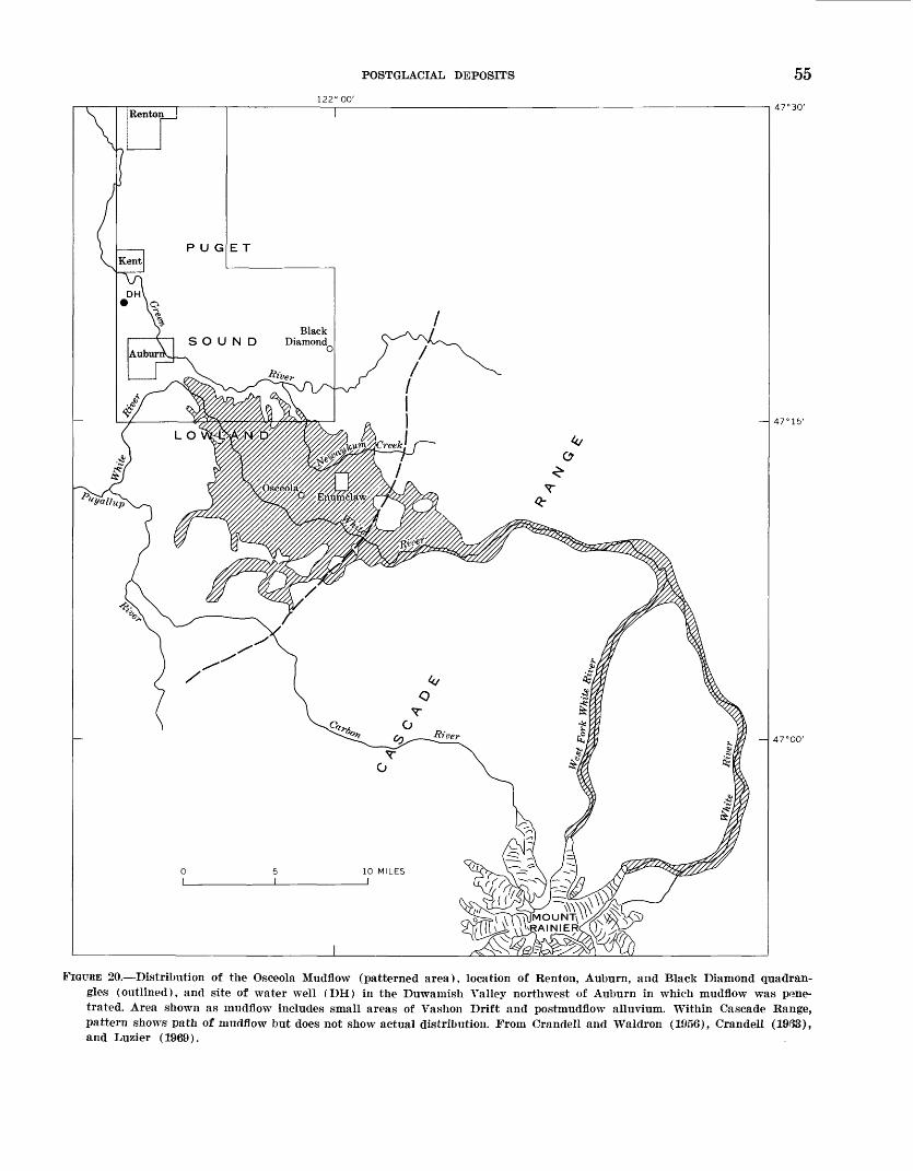
POSTGLACIAL DEPOSITS 55122° 00'
47°30'
47°00'
FIGURE 20. Distribution of the Osceola Mudflow (patterned area), location of Renton, Auburn, and Black Diamond quadran gles (outlined), and site of water well (DH) in the Duwatnish Valley northwest of Auburn in which mudflow was pene trated. Area shown as mudflow includes small areas of Vashon Drift and postmudflow alluvium. Within Cascade Range, pattern shows path of mudflow but does not show actual distribution. From Crandell and Waldron (1956), Crandell (19(33), and Luzier (1969).
56 GEOLOGY OF RENTON, AUBURN, AND BLACK DIAMOND QUADRANGLES, WASHINGTON
mantle of mudflow generally rises only a few feet above the overall surface of the Osceola, but a thin layer may cover drift mounds that are only a few feet higher than the general mudflow surface. Thus, the top of the mud- flow apparently was once higher than it is now. Its lowering probably resulted chiefly from compaction after emplacement, but it may have resulted partly from outflow of still mobile mud from under a sta tionary crust.
The Osceola is an unsorted and unstratified deposit that contains clay, silt, sand, and stones of all sizes up to large boulders. A sample collected by D. R. Crandell from the south valley wall of the Green River near Auburn, from which cobbles and boulders were ex cluded, consisted of 20 percent silt and clay, 36 percent sand, and 44 percent gravel. Cobbles are common; boulders are scattered only sparsely in and on top of the formation near the Green River but become more abundant southeastward toward the source. Most out crops that expose both bottom and top of the mudflow show a distinct decrease in size of stones from bottom to top, a feature that is characteristic of this as well as other mudflows (Crandell and Waldron, 1956, p. 352; Crandell, 1957).
The mudflow is composed chiefly of volcanic mate rial from Mount Rainier and from Tertiary andesitic rocks in the Cascade Range. Pebble counts at several Puget Sound localities, involving about 900 stones, in dicate that from 1/3 to y2 the pebbles are derived from Mount Rainier and that most of the others are derived from Tertiary volcanic rocks (Crandell, 1963). The sand fraction consists largely of volcanic rock frag ments, volcanic glass, feldspar, and heavy minerals, of which hyperstheiie constitutes as much as 95 percent. Montmorillonite is the predominant clay mineral in all samples examined; however, kaolinite, mica (illite), and mixed-layer clay minerals also occur, and in a few samples are nearly as abundant as montmorillonite. Wood is common and generally appears fresh.
The distribution of the Osceola in the lowland shows that it was emplaced as a fluid mass, flowing generally around rather than over obstacles; and its character indicates that it is a volcanic mudflow (Crandell and Waldron, 1956, p. 351). The mudflow has been traced up the White River valley to Mount Rainier, where its distribution indicates that it originated high on the northeast side of the volcano. Crandell and Waldron (1956, p. 360) originally suggested that the mudflow was initiated by partial collapse or explosive destruc tion of part of the volcano as a result of eruption. After studies of surficial deposits at Mount Rainier, Crandell (1963) proposed that the Osceola resulted
from one of several major avalanches that destroyed the former summit of the mountain. Phreatic explo sions were regarded as the most likely cause, but initia tion by earthquakes or slope failure after oversteepen- ing by glacier erosion was considered possible. In con trast to these hypotheses, Fiske, Hopson, and Waters (1963) proposed that the mudflow was formed by the collapse and the flowing out of a thick fill of water- saturated sediments in the upper part of the White River valley. Distribution of remnants of the Osceola on the flanks of the volcano well above the White River valley, however, seems to show clearly that the mud- flow originated somewhere 011 the volcano fr.r above the White River valley.
Discovery of a brown podzolic soil profile in Vashon Drift beneath the mudflow (Crandell and Yraldron, 1956, p. 357) first showed that the Osceola was sig nificantly younger than the Vashon Drift. Shortly thereafter, three wood samples from the mudflow in the lowland and along the edge of the Cascade Range were elated by radiocarbon methods as about 4,700, 4,- 800 and 4,950 years old (Crandell, 1963, p. A49). An other wood sample, from the mudflow buried in allu vium in the Duwamish Valley northwest of Auburn, was determined to be about 5,000 years old (Luzier, 1969). Consequently, the Osceola is regarded to be, in round figures, 5,000 years old.
FLOOD-PLAIN ALLUVIUM
Modern flood-plain alluvium includes some small de posits from creeks that head on the drift plain, but it consists mainly of alluvium from the Cedar, Green, and White Rivers. The topographically higher parts of alluvium on the major valley floors could be classified as terrace deposits according to an interpretation of Wohnan and Leopold (1957, p. 105), inasmucl as they stand above the level of annual or biennial flooding. However, definition according to flood frequency is not used herein. First, the deposits appear to be a litho- logic unit that is continuous from the high, lQ-ast fre quently flooded parts of the valley floors to tl>0* lower, more regularly inundated parts. Second, in a large part of Duwamish Valley, levees along the modern, channel are among the least frequently flooded parts of the valley floor. Perhaps more important, food fre quency in these valleys has been altered by man's activities. The present flood frequency is net repre sentative of that of the recent past, and additional river control might further protect the valley bottoms from flooding. Consequently, all the main-stream allu vium on the valley floors is considered to be modern flood-plain alluvium.
POSTGLACIAL DEPOSITS 57
Deposits of small streams that head on the drift plain are all small, and they vary widely in content, width, and thickness. Creeks that cross the surface of the drift plain necessarily have low gradients, and they have had to alternately cut and fill to attain their present profiles. Consequently, the deposits are highly diverse even along a single stream. Where such a creek has cut into the drift, its alluvium typically consists of only a thin and narrow band of sand and silt. Where it has filled instead, the deposit is broader and thicker, and the sand and silt are interlayered and flanked with clay and peat. Along the margins of the drift plain, a few of the larger drift-plain streams such as Newau- kum and Soos Creeks have cut deep trenches that lead steeply down to the major valley floors. Along the deep reaches, alluvium of these creeks consists of thin and narrow strips of gravel and sand with little asso ciated silt, clay, or peat. Alluvium of Newaukum Creek, for example, forms a continuous band of pebble- and-cobble gravel and sand only a few tens of feet wide except in its broader terminal fan on the Green River valley floor. Alluvium of Big Soos Creek is simi lar (though somewhat finer grained) except in the lower mile or two of its valley, where the deposit widens to about 500 feet and probably thickens to at least 50 feet. In that area, the deposits at the surface consist of gravel and sand 50-100 feet wide along the creek, and of sand and silt elsewhere on the surface of the flood plain.
Smallest of the alluvial deposits are those of streams flowing directly down the valley walls. They typically are not only narrow and thin but commonly grade into or are interbedded with colluvium. Generally such al luvium has not been mapped except where it broadens into a fan at the base of a valley wall. The deposits consist largely of sand and silt but locally are pebble or cobble gravel.
In contrast, deposits of the three major rivers in their own valleys and in Duwamish Valley are thick and widespread, covering about a fifth of the total area of the Renton, Auburn, and Black Diamond quad rangles.
CEDAR RIVER VALLEY
The major part of the Cedar River valley floor in the 4-mile-long segment in the Renton quadrangle is covered by alluvium, although colluvium and side- stream alluvium are proportionately more abundant there than on the floor of any other major valley. In the upvalley segment of about 3 miles, valley-bottom sediments are about a third of a mile wide; westward they narrow to about 400 feet in a bedrock gorge 1 mile east of the center of Renton (Mullineaux, 1965a).
The depth of main-stream alluvium is not well along any part of the valley. A thick fill in Duwamish Valley at Renton suggests that alluvium is at least 300 feet thick at the valley mouth, but the bedrock 1 mile upstream might have limited the downcutting so tl at the deposits farther up the valley are no more th'Mi 20-30 feet thick.
Although the Cedar River heads high in the Cas cade Range, most of its alluvium in the lower valley is derived from the lower part of the drainage basin, for Cedar Lake in the Cascades traps most material de rived from the upper part. Constituent rock fragments and minerals are obtained principally from volcanic rocks of the Puget Group and younger Tertiary ande- sitic rocks, and to only a minor extent from the Sno- qualmie Granodiorite and similar plutonic bodies and glacial drift. Gravel of the Cedar River at Renton, therefore, is composed chiefly of greenish-gray and gray volcanic rocks. Light-gray granitic rocks and metamorphic rocks from the drift are common, though they make up only a small proportion of the gravel. Heavy-mineral suites from sand consist largely of hypersthene, amphibole, clinopyroxene, altered light- gray and yellow minerals, small rock fragments, and opaque minerals (table 2).
Sediments on the floor of the Cedar River valley consist largely of narrow strips of pebble-and-cobble gravel and coarse sand in and near the river channel, and broader flanking deposits of finer sand and silt. In several places, however, the coarse channel materials widen to cover as much as half the breadth of the flood plain. Grain-size studies of channel deposits by L. A. Palmer (written commun., 1957) indicate that more than half a typical channel bar in the Renton quad rangle consists of pebble-size stones and that a third to a quarter of the bar consists of cobbles. The flank: ng silt and sand appears to be only a few feet thick over gravel in much of the valley, but locally, gravel-free deposits as much as 10 feet thick have been exposed in trenches.
GREEN RIVER VALLEY
Alluvium of the Green River that thickens progres sively westward covers the floor of the Green Rrrer valley except for the parts covered by minor amounts of colluvium and side-stream deposits and for a small area at the valley mouth that is covered by WHte River deposits. In the bedrock gorge near the east margin of the Black Diamond quadrangle, flood-plain alluvium of the Green River is thin and as little as a few hundred feet wide. About 1 mile west, however, the alluvial floor widens to about a mile and, concur rently, the deposits thicken. A maximum thickness at
58 GEOLOGY OF RENTON, AUBURN, AND BLACK DIAMOND QUADRANGLES, WASHINGTON
the valley mouth of more than 75 feet is probable, because the Green River must have aggraded at least that much in response to White River aggradation in Duwamish Valley. Records and logs of wells in sees. 16 and 21, a mile up from the valley mouth, according to Luzier (1969), indicate that the Green River de posits there may be at least 120 feet thick.
Alluvium of the Green River is composed chiefly of greenish-gray and dark-gray volcanic rock and min eral fragments that were derived from Tertiary ande- sitic rocks in the Cascade Range. Although the Green River flows through a gorge cut into Puget Group arkose just east of the Black Diamond quadrangle, no more than a few percent of pebbles in the alluvium are derived from the Puget Group. Somewhat more mate rial appears to have been derived from Pleistocene sediments, because pebbles of northern provenance are more common than those from the Puget. Heavy min erals from the Green River sediments are mostly hy- persthene, amphibole, clinopyroxene, altered green and yellow minerals, rock fragments, and opaque minerals (table 2). Hypersthene and clinopyroxene are more abundant than in alluvium along the Cedar River, and light-gray altered minerals are much less common.
Channel gravel and sand, flanked by overbank sand and silt that grades laterally into flood-basin silt, clay, and peat, compose the valley-floor alluvium at the sur face. Although coarse channel material appears only as narrow strips along much of the valley, it broadens greatly at two localities where the river has recently been migrating rapidly by cutting against the outside banks of meanders. For about 3 miles below the mouth of Newaukum Creek, the band of coarse channel de posits, though fluctuating greatly in width, probably averages about 1,000 feet in width and covers nearly a third of the flood-plain surface. Similarly, in the mile downvalley from the mouth of Big Soos Creek, gravel and coarse sand form the flood-plain surface in a band that averages about 500 feet in width.
Channel gravel of the Green River in the Auburn and Black Diamond quadrangles consists chiefly of pebbles, with lesser amounts of cobbles and sand. To determine the grain size of bedload being carried, samples were taken at low water from bars at several points along the river between the bedrock gorge on the east and the valley mouth near Auburn. After the lag pavement or armor (Straub, 1942) of stones was cleared from the bar surface, 40-50 pounds of mate rial, excluding boulders, was dug and sieved at each sample site. In the sample from the easternmost site, near the mouth of the bedrock gorge, the mean diam eter of all particles was about 4 cm, and about 30 per cent of the sample was of cobble size (>6.4 cm). Boul
ders as large as 40 cm across are scattered over the bar, and several much larger ones, probably derived from the adjacent valley wall, lie on the surface of the bar. In the sample taken nearest the valley mouth, the mean diameter was slightly more than 2 cm, and only about 10 percent of the stones were of cobble size. Boulders as large as 20 cm across are present on the bar at this point, but noticeably larger boulders are absent, probably because any such boulders derived from valley walls here were buried during aggrada tion of this part of the flood plain.
Overbank sediments in the Green River v&lley in clude sand deposits similar to those called flood-plain splays by Happ, Rittenhouse, and Dobson (1940), and channel-fill and flood-basin deposits of sand, silt, clay, and peat. In the part of the valley in the Bk.ck Dia mond quadrangle, overbank material appears to be chiefly sand in flood-plain splay and channel-fill de posits that apparently rapidly cover coarse channel sediments. Coarse channel deposits along sever?! mean der segments cut off and abandoned since 1987 were largely covered by silty sand by 1959; several inches of overbank sand and silt were laid down in the same part of the valley during floods early in 195f. Expo sures along the present channel show that, at least locally, these overbank deposits are no more than a few feet thick.
Flood-basin sediments are more abundant in the Auburn than in the Black Diamond quadrangle, although sand or" uncertain origin is a major constitu ent of the alluvium there. Sand without grr.vel, for example, was predominant in the walls of a pipeline trench excavated across the valley floor in sec. 22, T. 21 N., R. 5 E., along nearly half its length. Sard inter- bedded with channel gravel was exposed along nearly a quarter of the trench, which also intersected one abandoned and filled channel that contained several buried logs. Flood-basin silt, clay, and intcrbedded peat as much as 10 feet thick formed the walls of the trench along approximately a third of its length. Nearer the valley mouth, fine-grained deposits may be even more abundant; in sees. 20 and 21, 10-20 feet of peaty silt and clay was penetrated in several auger holes. In addition, the log of a 70-foot well in-sec. 21 shows only "peaty sand" (Luzier, 1969).
WHITE RIVER VALLEY
The valley floor is occupied by thin coarse alluvium and a little side-stream alluvium or colluvium. In the 4-mile segment in the Auburn quadrangle, the valley floor is about half a mile wide, and the thi^Tiess of sediments probably is about equal only to the depth of scour of the river, perhaps 20-30 feet. This alluvium is
POSTGLACIAL DEPOSITS 59
inferred to be thin because the White River valley has been cut concurrently with, rather than before, the filling of Duwamish Valley. Hence, little or no aggra dation in the White River valley would be expected in response to filling of the Duwamish Valley.
Alluvium of the White River is distinctive because of its high proportion of material derived from Mount Rainier. This proportion is far greater than would be expected from the small area of the drainage basin occupied by the volcano. Several factors probably con tributed to this abundance of Mount Rainier detritus. Fragmental or weakly agglutinated pyroclastic rocks and breccias, for example, are abundant on the vol cano (Russell, 1898; Coombs, 1936; Fiske and others, 1963). Glaciers on the mountain contribute a large amount of detritus to the rivers. Mechanical weather ing is probably more effective at the heights reached by the volcano than at the lower altitudes of the nearby Cascades, and the White River and its tribu taries rework abundant mudflow and debris flow de posits that line their valleys between the volcano and the Puget Sound lowland (Crandell, 1963, p. A54). Pebbles and cobbles in the alluvium are mostly open- textured to dense dark-gray to brick-red andesite from Mount Rainier and greenish- to dark-gray volcanic rocks from older volcanic rocks in the Cascades. Heavy minerals are predominantly hypersthene, which com poses as much as 90 percent of the heavy fraction of some samples. The remainder of heavy-mineral suites consists largely of clinopyroxene, amphibole, rock fragments, and opaque minerals (table 2). Many min eral grains are coated with red hematite(?); hence, sandbeds as well as gravel deposits have a reddish cast that distinguishes them from Cedar or Green River sediments.
Channel deposits of pebble-and-cobble gravel and sand cover nearly all the floor of the valley, and only discontinuous strips of medium and fine sand along the edges of the valley appear to be overbank material. Two samples of modern bar gravel along the White River were taken and sieved, in the same manner as those from Green River bars. One was taken approxi mately where the river enters the Auburn quadrangle, and the other where it leaves the quadrangle. In the upstream sample, the mean diameter was approxi mately 7 cm, and about half the stones were of cobble size. Boulders as much as 50 cm across were common at the site, and much larger ones derived from the Osce- ola Mudflow and from drift in the valley walls were evident on the flood plain nearby. In the downstream sample, the mean diameter was nearly 5 cm, and about 30 percent of the stones were of cobble size. Boulders
as large as about 25 cm were fairly common, but sig nificantly larger ones were absent. Large boulders would seldom be carried to the downstream site, which is near the center of Duwamish Valley, and those that were would soon be buried by aggradation there.
DUWAMISH VALLEY
Alluvium in the mapped part of Duwamish Valley forms a thick deposit that partly fills the deep, wide glacial trough that lies along the west side of the mapped area. Unconsolidated deposits underlying the valley floor are known from well borings to be at least several hundred feet thick (Luzier, 1969). In places, Vashon Drift, mantles the valley wall and passes down under the flood-plain sediments; lacustrine or fluvial stratified drift, as well as till, undoubtedly locally un derlies the postglacial material at depth. The upper part of the postglacial sediments, of which about 100 feet was penetrated by auger during this study, con sists almost entirely of alluvium from the three major rivers of the area. Both White River and Cedar fiver alluvial sediments form extensive, distinct lithologic units in Duwamish Valley, although these units are interfingered and gradational along their margin"*. In contrast, alluvium of the Green River probably occurs only as a buried delta or fan that underlies YHiite River sediments at Auburn (fig. 21), as narrow tands of channel sediments along the modern river course, and as a minor constituent of the alluvium of the com bined White and Green Rivers.
Alluvium of the Cedar River forms a distinct fan in Duwamish Valley at Renton. It slopes at about 15-20 feet per mile from the mouth of Cedar River valley at the east edge of the city northward to and ber°-ath Lake Washington, westward to the opposite valley wall, and southwestward toward Tukwila. About 1^2 miles southwest of the valley mouth, the fan passes under deposits of the White River. About 1 mile far ther southwest at Longacres, Cedar River sediments underlie White River deposits at about 50 feet below the surface and extend to a depth of at least 90 feet. Logs of holes drilled in 1956 at the site of a Boeing Co. plant in the northern part of Renton, in the NW1̂ sec. 8, T. 23 N., R. 5 E., show that the alluvium of the Cedar River there extends from the surface to a depth of at least 130 feet, about 100 feet below present sea level. The Cedar River fan consists largely of sand and gravel but includes interbedded layers of silt, clay, and peat and at least one layer of volcanic ash. With in creasing distance from the mouth of the Cedar Piver valley, the gravel and sand not only become finer grained but are interbedded and overlapped by in creasingly thicker deposits of sand and silt. Although
60 GEOLOGY OF RENTON, AUBURN, AND BLACK DIAMOND QUADRANGLES, WASHINGTON
DRIFT PLAIN
13
100
A'-100'
*-s Sand, ~>CEDAR gravel, ^ and peat
RIVERCAM V°ICaniCFAN ash
_SEA LEVEL
h- 50'
-100'
FIGURE 21. Topographic map and section of upper part of postglacial fill in Duwamish Valley. Contours are in feet, sketched from U.S. Army Corps of Engineers map of Green and Duwamish Rivers, No. E-12-7-37; datum is mean lower low water. Hole 1 (black dot) is boring at Boeing Co. site; all others are U.S. Geological Survey auger holes.
largely covered by artificial fill now, peat formerly was fairly extensive at the surface along Duwamish Val ley walls near Renton.
Most of the alluvium in Duwamish Valley, however, is included in a unit that is a fan of the White Kiver. The White Kiver fan forms the floor of the entire Duwamish Valley (except for that part formed by the Cedar River fan) from the Puyallup Valley northward to the Duwamish River mouth at Seattle (Willis, 1898c). Lithologically, the fan consists dominantly of White River material, but north of the city of Auburn it contains a small proportion of detritus carried in by the Green River, which prior to 1906 joined the White at Auburn. Near its apex at the mouth of the White River valley, the fan is a smooth topographic feature that slopes outward at about 40 feet per mile. This dis tinct, relatively steep part of the fan is readily recog nizable from the south boundary of the Auburn quad rangle northward to about the north edge of Auburn. Detailed contours of the valley floor (fig. 21) show that the White River fan even extends a few hundred yards up the Green River valley at Auburn. North of Au
burn, the fan shape is much less distinct. The valley floor north of the city shows increasingly mor^ local relief and becomes characterized by multiple meander ing channels, broad curved natural levees, and low flood-basin areas.
The main component of the White River fan is chan nel sand and gravel composed almost entirely of detri tus from the White River. Where the river issues from its own valley, the channel deposits lie at the rurf ace, though farther down the fan .they become buried by a thickening wedge of overbank silt, sand, clay, ard peat. At the fan apex, the alluvium is chiefly coblxl e-and- pebble gravel overlain by at most a few feet cf sand. The gravel becomes progressively smaller in size, and the overlying sand thickens with increasing distance from the apex. In three auger holes (nos. 9, 11, and 12, fig. 21), all between 2 and 3 miles from the apex, gravel was struck below 20-40 feet of sand; and in two 95- foot holes (nos. 13 and 8, fig. 21) in alluvium of the White River about 3 and 4 miles southwest anc1 north west, respectively, from the apex, no gravel was en countered. North of Auburn, several other augor holes
GE OMORPHOLOGY 61
show that coarse to fine sand forms most of the allu vium under the thin wedge of finer overbank materials at the surface. From Auburn north to Tukwila, the sand unit was found to extend to at least 95 feet below the present surface (fig. 21). Clay and silt in minor amounts were recovered with the sand, but they appar ently do not form thick layers. No peat layers were identified, though pieces of wood appeared to be dis tributed sparsely throughout the sand xmit.
Deposits at the surface from Auburn north consist chiefly of overbank silt, sand, and clay laid down partly by the Green River but mostly by the combined Green and White Rivers during times when the White flowed northward in Duwamish Valley. In the upper few tens of feet, channel gravel and sand apparently occurs only along present and abandoned channels of the main rivers; in abandoned channels, it probably is overlain by silt, clay, and peat. The overbank deposits generally range in thickness from a few feet to about 40 feet. At a borrow-pit site in sec. 23, west of Kent, fine sand and clayey silt from 15 to 20 feet thick overlie coarse to medium sand, and in sec. 24 about 2 miles southwest of Renton, auger holes indicate that silt, clay, fine sand, and interbedded peat averaging about 30 feet in thickness overlie coarse to medium sand. At the surface, material in natural levees consists mostly of fine sand and coarse silt, whereas finer silt, clay, and peat form the surface in flood basins between the levees and adjacent to the valley walls. Peat is especially abundant along the east and west sides of Duwamish Valley just south of Renton and Tukwila.
Fossils are widespread in Duwamish Valley fill and also in the Puyallup River valley fill to the south (Crandell, 1963). In Duwamish Valley, fossils have been recovered from an auger hole west of Kent at about 40 feet below mean sea level, from another auger hole near the Longacres race track southwest of Ren ton at about 40 feet to more than 50 feet below sea level, and from drill holes at a Boeing Co. plant site in northern Renton at about 75 feet below sea level (fig. 21). Fossils from the Kent, Longacres, and Boeing plant holes, identified by E. J. Moore of the U.S. Geo logical Survey, were limpets (Acmaea), periwinkles (Littorina) , mussels (mytilid), Cryptomya, My a, bar nacles, and a few echinoid spines, all of which are marine. According to Mrs. Moore, no fossils in these collections suggest a depth of water greater than a- few fathoms; and the limpets, periwinkles, mytilid mus sels, and barnacles presumably lived where they were exposed at low tide. Hence, the fossils show that Du wamish Valley was an arm of Puget Sound during some parts of postglacial time. Furthermore, the pres
ence of these tidal-range fossils at depths of as much as 75 feet below present sea level suggests that relative sea level during part of postglacial time was several tens of feet lower than at present.
Postglacial sediments have accumulated continu ously in Duwamish Valley since retreat of the Vashon glacier. They began to form as the Cedar and Green Rivers built deltas or fans into the valley. The Ce'lar River continued to build its fan rapidly until the fan extended across the main valley and blocked off Lake Washington from Puget Sound. Studies of Lake Wrsh- ington (Rigg and Gould, 1957; Gould and Budinger, 1958) suggest that the lake was established by about 13,500 years ago. Marine shells that may have t^en deposited while the lake was an arm of the sound are overlain by peat, two samples of which were dated as about 13,600 and 14,000 years old, respectively (Bi^g and Gould, 1957; Broecker and Kulp, 1957, samples L-330, L-346A). The layer of volcanic ash found in drill holes at the Boeing plant site in Renton may be part of the widespread Mazama ash that is about 6,600 years old (Powers and Wilcox, 1964). If so, the 60 feet of alluvium of the Cedar River overlying the ash has been laid down at a rate of about 1 foot each hundred years.
However, most of the sediment in the valley in the White River fan was deposited in less than 5,000 ye^rs, or since the Osceola Mudflow diverted the lower seg ment of the river to Duwamish Valley at Auburn (Crandell, 1963). Deposition of White River material, as much as 300 feet thick (Luzier, 1969), thus occurred much more rapidly than deposition of the Cedar River sediments. Furthermore, deposition of the lower gravel and sand unit of the White River fan might have re quired only a small part of post-Osceola time.
GEOMORPHOLOGY
The dominant landscape features of the mapped area are the drift plain; the wide north-trending Du wamish Valley; and the narrower west- to northwest- trending Cedar, Green, and White River valleys. All these features originated during Quaternary time. The drift plain is part of a widespread, complex fill in the lowland that is composed largely of glacial sediments. The Duwamish Valley was excavated during or before the Vashon Stade the time and manner of origin of that and similar valleys (and the intervening drift- plain segments) probably has been the most discussed geomorphic problem of the area. Most of the present drainage pattern was developed as the Vashon glacier retreated, though the White River was positioned Kter by the Osceola Mudflow. Entrenchment of the major
62 GEOLOGY OF RENTON, AUBURN, AND BLACK DIAMOND QUADRANGLES, WASHINGTON
river valleys and aggradation of the Duwamish Valley floor have been effected chiefly or wholly by the Cedar, Green, and White Rivers in postglacial time.
ORIGIN OF DUWAMISH VALLEY AND ADJACENT DRIFTPLAIN
Duwamish Valley ahd the adjacent segments of drift plain exhibit a relation typical of the Puget Sound lowland in that low-relief "plateaus" stand several hun dred feet above wide northerly trending deep "troughs." Some of these troughs are arms of Puget Sound; others, like Duwamish Valley, formerly were arms of the sound but now are aggraded to above sea level.
The origin of the "troughs" and "plateaus" has been repeatedly discussed in the literature (LeConte, 1874; Kimball, 1897; Willis, 1898c; Bretz, 1913; Crandell and others, 1965). In most early reports, origin was attributed to either subaerial erosion of a preexisting plain by rivers or glaciers (LeConte, 1874) or preser vation of preglacial valleys as the intervening divides were built up into plateaus (Willis, 1898c). Willis (1898c) first discussed the two ideas in detail, largely on the basis of his work in the Puyallup-Duwamish Valley. He referred to the first idea as the erosion hypothesis and to the second as the construction hy pothesis. Willis noted that Vashon Drift not only mantled much of the Duwamish Valley wall, but also raised the adjacent drift-plain margins by deposition. Because he reasoned that the available evidence fav ored the construction hypothesis, he proposed that the Duwamish and similar valleys probably had been pre served through Pleistocene time by ice tongues that occupied preglacial valleys and had been maintained by them as ice-marginal outwash built up the adjacent divides into plateaus.
Later investigations, however, led to general accept ance of a version of the erosion hypothesis. Bretz (1913) noted that the plateaus were not constructed over bedrock divides and that continuity of some for mations from plateau to plateau showed that they were parts of a continuous fill. According to Bretz, the fill formed during a single glaciation, the Admiralty. The troughs originated when rivers cut down into the fill as a result of as much as 1,000 feet of uplift during the interglacial interval prior to the Vashon advance. The valleys were then modified by the Vashon glacier and were drowned by submergence.
Hansen and Mackin (1949), Sceva (1957), and Cran dell, Mullineaux, and Waldron (1958) confirmed that the valleys were cut into an overall fill, but they showed that the fill consisted of deposits of several different glacial and nonglacial episodes. No evidence was found
to negate Bretz' hypothesis of pre-Vashon origin by fluvial erosion caused by uplift, and of only modifica tion of the valleys by the Vashon glacier.
As a result of recent detailed work in and near Seat tle, however, Crandell, Mullineaux, and Waldron (1965) proposed that the Vashon Puget lobe formed at least one major trough in the lowland rather than merely modifying a preexisting valley into a trough. At Seattle, the deep Puget Sound trough is bounded by sea cliffs that expose a conformable sequence of nonglacial sediments of Olympia age and overlying Vashon advance outwash. Nonglacial sediments in the sea cliffs contain wood that ranges in age from 24,000 to 18,000 years; elsewhere in the city, wood from the nonglacial sediments is as young as 15,000 years (Mul lineaux and others, 1965). The stratigraphic sequence shows that the locality of the present Puget Sound trough was a site of aggradation as much as several tens of feet above present sea level thus near'y 1,000 feet higher than the floor of the modern trough dur ing the Olympia Interglaciation. Moreover, aggrada tion continued to several hundred feet higher before the site was overridden by the ice. But the, Puget Sound trough had already been fashioned in virtually its modern form when the glacier retreated; thus, the trough was formed under the ice and must lave re sulted from ice scour. No regional uplift, fluvial ero sion, or later submergence was required. Though the position of the modern Puget Sound trough might have been influenced by a previous valley, the trough was scoured by the Vashon glacier.
The manner of origin of the Puget Sound trough suggests that Duwamish Valley, once regarded as pre served from preglacial time and later as eroded by pre- Vashon rivers, might alternately have been scoured by the Vashon Puget lobe. However, pertinent evidence along Duwamish Valley is meager and not adeauate to either prove or disprove such an origin. Some raising of the valley margins during Vashon time, as proposed by Willis, seems certain. But the troughs were not pre served from preglacial valleys, for remnants of the interglacial Puyallup Formation in both walls of the Puyallup-Duwamish trough show that the deep trough could not have persisted throughout Pleistocene time. Vashon Drift that was formerly thought to show that Duwamish Valley predated the Vashon advance is largely subglacial material that could have l^en de posited under the ice long after its first advance. Strati fied drift deposited in front of the ice is very limited in size and distribution along the valley and does not prove existence of more than small, local depressions prior to the Vashon advance. Thus, no large Duwamish Valley formed by erosion can be shown to have existed
GEOMORPHOLOGY 63
during Olympia time. Finally, it cannot be demon strated for Duwamish Valley (because of the absence of iionglacial sediments of Olympia age) that the site of the present valley was wholly or partly filled just before the ice advance, and that therefore the valley must have been produced by ice scour.
The available evidence does indicate that consider able ice erosion occurred. The very absence of non- glacial sediments of Olympia age suggests that any former valley along the same alinement must have been narrower than the present valley. If a former val ley had been as wide, some remnants of iionglacial sediments should be found now in positions of former embayments or gullies in the valley walls. Second, aggradation to high levels along the Puget Sound at Seattle during noiiglacial time indicates that any pre- Vashon Duwamish Valley would not have been as deep as the postglacial Duwamish trough. Aggradation at Seattle records a high local base level, and a pre- Vashon Duwamish Valley should also have been ag graded to about the same level. Thus, a Duwamish Val ley during Olympia time that was either as wide or deep as the one is now seems very unlikely. Ice scour, at the very least, must be responsible for much of the width and especially for the depth of the postglacial trough. The question of whether the valley was first or principally excavated by a river or by the Vashon glacier and, therefore, whether it originated during a pre-Vashon episode or during the Vashon Stade is still not answered. But similarity of the Duwamish to the Puget Sound trough suggests strongly that the valley was excavated chiefly by scouring by the Vashon Puget lobe.
DEVELOPMENT OF THE PRESENT DRAINAGE PATTERN
The modern drainage pattern within the mapped area developed almost completely in late Pleistocene and Holocene time, though the general system of major rivers formed much earlier. The river system began to develop during the Miocene, as rocks in the Cascade Range and the Puget Sound lowland were folded along north-northwest-trending axes (Weaver, 1937). A new drainage system then became established along those structural trends (Mackin and Gary, 1965). By the end of Pliocene time, the Cedar, Green, and White Rivers probably all were flowing from the flanks of the rising Cascade Range northwestward across the Puget Sound lowland. The Cedar River at that time, however, was north of the bedrock barrier formed by the Newcastle Hills promontory (Mackin, 1941). Later, in Pleistocene time, the Cedar River was diverted into the lowland south of that promontory by the Puget lobe (Mackin, 1941). The Puget lobe also
shifted the Green River so that it emerged from the Cascades several miles south of its preglacial exit (fig. 22; Campbell and others, 1915). Mackin and Campbell presented evidence that initial diversion of each river occurred before Vashon time.
Thus, each of the major rivers had, before Vashon time, temporarily or permanently been directed into the lowland south of the Newcastle Hills promontory. Within the mapped quadrangles, coarse detritus of Mount Rainier origin clearly shows the presence of a river, presumably the White River, heading on the volcano. These sediments crop out along the east wall of Duwamish Valley north to about Kent and along the west wall to about Tukwila (H. H. Waldron, o~al cominun., 1966). Gravels of central Cascade prove nance, which crop out along all the valleys east of the Duwamish, record the presence of one or both of the Cedar and Green Rivers.
Although deposits in the mapped quadrangles show the presence of the major rivers during at least parts of pre-Vashon Pleistocene time, distribution of what deposits are exposed gives little evidence of specific river courses. Only the sediments from Mount Rainier appear in a fairly linear distribution, which suggests a valley fill. These sediments are almost all along the western part of the area, a distribution that suggests early existence of a pre-Vashon north-south valley much like the Duwamish of today. Each of the other rivers probably flowed across many different parts of the area from time to time and at other times probably did not even enter the mapped area. Diversion of the Green River at the mountain front obviously required the river to find a new route at least once, and each river might have taken a virtually new course across the lowland after each glaciation.
It is possible that the Cedar, Green, or White Rivers did not cross the mapped area immediately prior to the Vashon advance. No extensive Vashon outwash and no sediments of Olympia age at all have been identified along the present valleys of those rivers. Absence of such deposits and continuity of pre-Vashon sediments along present valley walls suggest that the rivers are not now following courses established in pre-Vasl on time. In the Cedar River valley, a small deposit of stratified drift suggests the possibility that some de pression existed there just prior to the Vashon advance, but no other similar deposits indicate that the depres sion was extensive. Thick Vashon stratified drift n°-ar Maple Valley and the low trough in the drift plain from there southwest to Auburn suggests a pre-Vashon depression along that route. However, fairly good ex posures and apparent continuity of pre-Vashon forma tions in valley walls near Auburn indicate that the
64 GEOLOGY OF RENTON, AUBURN, AND BLACK DIAMOND QUADRANGLES, WASHINGTON
122°00'
r r-
Newcastle Hills promontory
MILES
47°30'
47°00'
EXPLANATION
Abandoned preglacial courses of Cedar and Green Rivers near mountain front
Abandoned postglacial pre-Osceola course of White River
FIGURE 22. Location of abandoned segments of preglacial courses of Cedar and Green Rivers near front of Cs scade Range and of abandoned segment of postglacial pre-Osceola course of White River.
depression was not a major valley. That one or more rivers followed the route of the present Duwamish Valley seems possible, but supporting evidence is lack ing.
EFFECTS OF THE VASHON GLACIER
Vashon Drift apparently smoothed over and con cealed the drainage system over which the glacier ad vanced, and it constructed a new surface on which a consequent drainage developed. In general, the post glacial drainage was directed by the overall west to
northwest slope of the drift plain that characterizes this part of the lowland. In detail, the drainage was controlled somewhat by the alinement of ground- moraine ridges, but mostly by the pattern of late glacial melt-water channels. The positions of the melt-water channels were in turn controlled by successive positions and configurations of the receding ice front.
As the Vashon Puget lobe retreated, first th°> White River and then the Green and Cedar Rivers became established in consequent courses along melt-water
GE OMORPHOLOGY 65
channels in the lowland. The White flowed southwest- ward along the mountain front in a channel that led to the Puyallup Eiver by way of the present South Prairie Creek valley (fig. 22; Crandell, 1963). The White remained in that course until it was relocated by the Osceola Mudflow; thus, it did not flow into the mapped area in early postglacial time.
The Green Kiver joined an ice-marginal river at the mountain front and flowed with it southwest for sev eral miles. For the first few miles, the combined melt water and Green River flowed in a broad spillway between bedrock hills that probably had been cut by repeated ice scour and melt-water erosion during the Pleistocene (fig. 22). Southwest of that spillway, the stream was held along or near the front of the Puget lobe by the overall northwest slope of the drift plain. As the lobe retreated, the combined flow occupied sev eral successively lower and more northward courses. It occupied several different channels in the Lake Tapps quadrangle (Crandell, 1963) and several in the southern parts of the Black Diamond and Auburn quadrangles before reaching the present route of the Green River. Further retreat of the Puget lobe along the mountain front eventually allowed the melt water to find a more northern course, so that the ice-marginal stream on longer joined the Green River at the moun tain front. The Green River, however, was prevented from taking a shorter, northwest- or west-trending course to the lowland by the combination of the south- westward gradient of the melt-water channel floor and the barriers formed by bedrock hills and stagnant ice- blocks.
The Cedar River was deflected, along with abundant melt water, through the Cedar Spillway (Mackin, 1941) into the lowland south of the Newcastle Hills promontory (fig. 22). The Cedar River and the melt water flowed from the spillway down the slope of the drift plain and across the Black Diamond quadrangle in front of the Puget lobe. The Cedar was probably only a small part of the large ice-marginal river that shifted gradually northwestward, forming, as it shifted, the broad outwash plain and later forming the valley train in the Covington channel. The Covington channel was abandoned when the river found a lower course to Duwamish Valley at Ren- ton. By the time the river shifted to Renton, however, it may have consisted chiefly of the Cedar River itself rather than of ice-marginal melt water. At about the time of the shift, the ice-marginal river abandoned the Cedar Spillway to flow north of the Newcastle Hills promontory. Like the Green River, the Cedar was held in a southwest-trending spillway, even
after ice retreat allowed the melt water to reach the lowland by a shorter, lower route.
Many minor streams on the drift plain also followed melt-water channels, but others were controlled by the lineation of the Vashon ground moraine. Southeast of the Covington channel, the drift-plain streams almost all followed south- to west-trending melt-water chan nels that led away from the retreating ice front or laterally along it. Northwest of the Covington channel, the drainage is mostly consequent on drumlinized ground moraine. As a result, streams flow in a north- northwest or south-southeast direction. The southeast- trending streams enter the Covington channel, wliere they join Big or Little Soos Creek and flow southwest to the Green River.
POSTGLACIAL CHANGES
Postglacial changes along the streams consist chiefly of entrenchment, distributary shifting on alluvial fr/iis, and relocations caused by the Osceola Mudflow. Both the Cedar and Green Rivers probably became quickly entrenched after retreat of the Vashon ice. As they did so, each built a fan and delta into the marine emtay- ment that then occupied the Duwamish Valley. The Cedar River probably blocked off Lake Washington from the Duwamish embayment very shortly after ice retreat (Gould and Budinger, 1958). The lake then drained to the^embayment by way of the Black River around the toe of the Cedar River fan. As the Ceiar continued to build its fan, it flowed at various times to Lake Washington, to the Black River, and directly to Duwamish Valley. Such shifting has been prevented since 1916, when Lake Washington was lowered and the Cedar River channeled artificially into the lake.
The principal change caused by the Osceola Mud- flow was the deflection of the White River to Duwam ish Valley at Auburn, evidence for which is found along both the old and new courses of the river (Cran dell, 1963). Exposures along the modern White River valley southeast of Auburn indicate that no mp.jor valley existed there prior to inundation of the drift plain by the Osceola. No alluvium of the White River underlies the mudflow along that route, and the mud- flow nowhere is seen as a thick valley fill. Instead, it occurs as a thin broad deposit over the surface of the drift plain. In the valley of South Prairie Creek, in contrast, the mudflow overlies coarse gravels of Meant Rainier provenance. The only possible source for the alluvium, according to Crandell (1963), was the White River, for South Prairie Creek does not head on the volcano. This and other evidence led Crandell to con clude that prior to Osceola time the White River flowed through the South Prairie Creek valley and that it
66 GEOLOGY OF RENTON, AUBURN, AND BLACK DIAMOND QUADRANGLES, WASHINGTON
was later relocated to its present position by the mud- flow.
After diversion to Duwamish Valley at Auburn, the White River entrenched itself and built a fan and delta in Duwamish Valley that rapidly raised the valley floor above sea level. As Willis (1898c) pointed out, the alluvial cone of the White River extended from the end of the Puyallup Valley at Tacoma to Elliott Bay at the end of Duwamish Valley at Seattle. The river flowed alternately north and south on its fan until 1906, when during a flood the main flow shifted from the northern to a southern > distributary. Since that time, the river has been held artificially in the southern part.
The Osceola not only relocated the White River but also diverted many small streams on the drift plain. One such stream, Newaukum Creek, enters the Lake Tapps quadrangle about 2 miles south of the Black Diamond quadrangle along a southwest-trending melt- water channel. The creek probably once continued to the Puyallup Valley in that channel. But the channel was overwhelmed by the Osceola, which directed Newaukum Creek north to flow down the gradient of the mudflow to the Green River in the Black Diamond quadrangle.
RIVER CHARACTERISTICS
Each of the three major rivers flows across the mapped area on a fairly smooth gradient, and each may be at or nearly at grade within the mapped quad rangles. The channel and flood-plain characteristics of the closely adjacent Green and White Rivers east of Duwamish Valley, however, are markedly different, even though these rivers formerly joined in Duwamish Valley at Auburn. The two rivers are similar in that they carry about the same discharge, they both rise in the Cascade Range and flow across the lowland in valleys cut into the drift plain, and until recently they both had a common local base level at their confluence. Yet above the former junction at Auburn, they differ conspicuously in size of bedload carried, gradient, chan nel patterns, migration habits, and flood-plain char acteristics. There is also a conspicuous contrast between channel and flood-plain characteristics of the rivers east of Duwamish Valley and those in Duwamish Val ley itself.
GREEN RIVER
Green River discharge as measured near Auburn averaged about 1,330 cfs (cubic feet per second) be tween 1936 and I960.1 The maximum recorded dis-
1 Data on river discharge used In discussion, unless otherwise stated, are taken from Water Supply Papers entitled "Surface Water Supply of the United States, Part 12, Pacific Slope Basins in Washington and upper Columbia River basin," published annually (to 1960) by the U.S. Geological Survey.
charge during the same period was 28,100 cfs in 1959. The gradient along the river from the east boundary of the Black Diamond quadrangle to Auburn decreases from about 20 to 5 feet per mile (fig. 23); the material that composes the bedload along the same stretch of the river decreases in median grain size from about 4 to 2 cm. (Seep. 58.)
The Green River in its valley east of Auburn migrates primarily by cutting on the outside of me anders. Meander migration is rapid, and braiding is common along only two stretches of the river. These two are the localities where channel deposits are broad (p. 58), just down valley from the mouths of New aukum and Big Soos Creeks. Below Newaukum Creek, comparison of the Auburn topographic map, made from aerial photographs taken in 1943, with field ob servations in 1957 shows shifting of the channel at one place as much as 1,500 feet in 14 years. Below Pig Soos Creek, comparison of the map with aerial photographs taken in 1953 shows migration of about 500 feet in 10 years. Elsewhere on the valley floor, however, presence of large trees and old farms indicates that the river does not migrate nearly that rapidly over the flood plain as a whole.
WHITE RIVER
White River discharge measured at Buckley, 15 miles upstream from Auburn, averaged about 1,40C cfs for 26 years of record before 1960, an average very close to that of the Green River. Some 600-900 cfs was diverted from the White River just below Buckley, however, and did not pass through the Auburn quad rangle. The average discharge at a station b?low the diversion over a period of 15 years was about 620 cfs. The maximum recorded discharge of the White be tween 1928 and 1960 was only about 17,000 cfs. How ever, an unrecorded maximum was estimated from flood marks at the gaging station to have reached about 28,000 cfs in 1933, about the same as the maximum re corded flood along the Green River.
The southern distributary in which the White River now flows near Auburn has almost exactly the same length and gradient as did the northern distributary that formerly joined the Green River at Auburn; it is assumed that the White had approximately the same characteristics in both distributaries. The gradient of the White River from the point at which it eiters the Auburn quadrangle to where it leaves decreases from about 30 to 20 feet per mile (fig. 23). The median di ameter of bar gravels along the same river reach de creases from about 7 to 5 cm. (See p. 59.) The White River thus carries a coarser load and maintains a steeper slope along a reach like the one above its former

mco
<
m
m>
Cf
&
e-
W (*
2
Elli
ott B
ay (
Pug
et S
ound
)m
oo
<m
m
>
W
est
edge
of
Ren
ton
quadra
ngle
moo
<
mm
>
Lake
Wa
shin
gto
n (
leve
l va
rie
s sl
igh
tly
acc
ord
ing t
o s
easo
n)
E
ast
edge
of
Ren
ton
quadra
ngle
Fo
rme
r ju
nct
ion o
f W
hite
and
Gre
en R
iver
s
S
outh
edg
e o
f A
ub
urn
qu
ad
ran
gle
E
ast
edge
of
Au
bu
rn q
uadra
ngle
E
ast
edge
of
Bla
ck D
iam
on
d q
uadra
ngle
£|.
ei-
p
e*
®P
' P
J P
-,
M.
£»
vT
CD
I 03
O
68 GEOLOGY OF RENTON, AUBURN, AND BLACK DIAMOND QUADRANGLES, WASHINGTON
meanders as well as by braiding. From the amount of the flood plain covered by fresh channel deposits that are nearly bare of vegetation, it seems certain that the White River moved across its flood plain as a whole much more rapidly than did the Green River. The more rapid migration may also be a result of the load supplied to the White River just upstream from Auburn quadrangle. A coarse load and high velocity are factors that lead to rapid lateral migration (Mackin, 1948).
IN DUWAMISH VALLEY
Stream gradient, bedload size, and rate of progres sive channel migration along both the Green and White Rivers are distinctly less in Duwamish Valley than in the Green and White River valleys. Along the White River south of the Auburn quadrangle, natural changes are somewhat masked by several artificial factors, in cluding the effect of reintroduction of diverted water to the river without bedload (Crandell, 1963, p. A55). North from Auburn, however, grain size and gradient decrease notably down the distinct White River fan and along the present channel of the Green River (fig. 23). The size of most bedload particles has decreased to that of sand where the Green River leaves the mapped area at Tukwila, and the gradient of the river has decreased to about 1 foot per mile at. that point. The river does meander in Duwamish Valley north of Auburn, but cutting along the outside of the meanders, especially north of Kent, is slow. Levees that form on both sides of the river along the meanders, and peat layers interbedded in the overbank materials, provide evidence that the river does not shift rapidly by pro gressive migration of meanders. Another method of channel migration, that of avulsion or the shifting of whole segments of the channel at a time, appears to be much more important. Two long segments of abandoned channel that are similar in form to the present channel indicate that the river shifted exten sive portions of its course at a single time rather than by progressive lateral migration.
FLOOD-PLAIN DEVELOPMENT
Flood plains of the Green and White Rivers within the mapped area are made up of widely varying pro portions of the materials defined as channel deposits (deposits of lateral accretion) and of overbank ma terial (deposits of vertical accretion) (Fenneman, 1906; Mackin, 1937; Jahns, 1947). The importance of over- bank material in the formation of flood plains has been questioned by Wolman and Leopold (1957, p. 106), who concluded that for average flood plains "the pro portion of overbank material appears to be small." The
flood plains of the Green and White Rivers in some places include very little overbank material; in other places they have more significant proportions cf over- bank material, and in still other places they are com posed largely of overbank deposits. The origin of the coarse channel gravel is easily recognizable, but, as Wolman and Leopold pointed out, the origin of the finer deposits may not be so evident. Deposits described as overbank sediments herein are identified by their occurrence on natural levees or by the presence c f inter- bedded peat material that should have been removed if the channel had migrated laterally past that site.
The flood plain of the White River east of Auburn serves as a local example of a flood plain with very little overbank material. The rate of channel migration there is rapid compared with the rate of overbank deposition; consequently, the flood plain consists largely of gravel or gravelly sand that clear1 y is a channel deposit.
The flood plain in the Green River valley contains considerably more fine material than that in the White River valley, but only a small proportion of it can be identified as overbank deposits. Channel migration over the whole flood plain is slower than along the White, and only a small part of the material at the surface is clearly channel gravel and sand. Finer ma terials that are probably of overbank origin, which are thin in the Black Diamond quadrangle, increase in thickness and volume westward toward Auburn. Al though not certain, it seems likely that the trick silt and clay and peaty sands near Auburn are largely of overbank origin.
In Duwamish Valley, overbank material increases in proportion to channel deposits northward along the former course of the White River until, north of Kent, nearly the entire valley floor is formed of overbank sediments. Overbank materials are relatively tHck and extensive there because the river migrates mostly by avulsion, rather than by meandering, and thus it does not continuously rework the flood plain. Levees on both sides of the channel and presence of peat interbedded with fine-grained sediments between channels show that the active channel remains in place for long periods of time compared with the channels in the Green or White River valleys east of Auburn. Modern conditions in Duwamish Valley north of Kent ap parently are similar to those in the Puyallup Valley in the Lake Tapps quadrangle, where remnants of volcanic mudflows on the flood plain show that the river has remained in a narrow course for at l°iast the last 500 years (Crandell, 1963, p. A55).
Thus, flood plains along the Green and White Rivers exhibit a wide variety in proportion of channel and
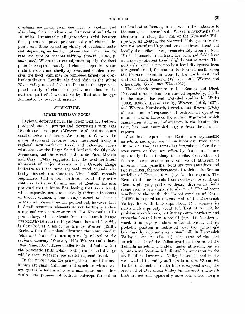
STRUCTURE 69
overbank materials, from one river to another and also along the same river over distances of as little as 10 miles. Presumably all gradations eiist between flood plains composed predominantly of channel de posits and those consisting chiefly of overbank mate rial, depending on local conditions that determine the rate and type of channel shifting (Mackin, 1948, p. 503; 1956). Where the river migrates rapidly, the flood plain is composed mostly of channel deposits; where it shifts slowly and chiefly by occasional sudden diver sion, the flood plain may be composed largely of over- bank sediments. Locally, the flood plain in the White River valley east of Auburn illustrates the type com posed mostly of channel deposits, and that in the northern part of Duwamish Valley illustrates the type dominated by overbank material.
STRUCTURE
LOWER TERTIARY ROCKS
Regional deformation in the lower Tertiary bedrock produced major up warps and downwarps with axes 10 miles or more apart (Weaver, 1916) and numerous smaller folds and faults. According to Weaver, the major structural features were developed along a regional west-northwest trend and extended acrqss what are now the Puget Sound lowland, the Olympic Mountains, and the Strait of Juan de Fuca. Mackin and Gary (1965) suggested that the west-northwest alinement of major streams in the Cascade Range indicates that the same regional trend extends vir tually through the Cascades. Vine (1969) recently emphasized that a west-north west trend of gravity contours exists north and east of Renton. He also proposed that a hinge line having that same trend, which separates areas of markedly different thickness of Eocene sediments, was a major structural element as early as Eocene time, He pointed out, however, that in detail, structural elements do not faithfully follow a regional west-northwest trend. The Newcastle Hills promontory, which extends from the Cascade Range west-northwest into the Puget Sound lowland (fig. 22), is described as a major up warp by Weaver (1916). Rocks within this upland illustrate the many smaller folds and faults that are apparently related to the regional orogeny (Weaver, 1916; Warren and others, 1945; Vine, 1969). These smaller folds and faults within the Newcastle Hills upland both parallel and diverge widely from Weaver's postulated regional trend.
In the report area, the principal structural features known are small anticlines and synclines whose axes are generally half a mile to a mile apart and a few faults. The presence of bedrock outcrops far out in
the lowland at Renton, in contrast to their absence to the south, is in accord with Weaver's hypothesis that this area lies along the flank of the Newcastle Fills upwarp. At Renton, the observed folds generally fol low the postulated 'regional west-northwest trend but locally the strikes diverge considerably from it. Near Black Diamond, in contrast, the principal folds have a markedly different trend, slightly east of north. This northerly trend is not merely a local divergence from a regional trend, for similar folds trend north along the Cascade mountain front to the north, east, and south of Black Diamond (Weaver, 1916; Warren and others, 1945 ; Gard, 1968; Vine, 1969).
The bedrock structure in the Renton and Black Diamond districts has been studied repeatedly, chiefly in the search for coal. Detailed studies by Willis (1886, 1898a), Evans (1912), Weaver, (1916, 193T), and Warren, Norbisrath, Grivetti, and Brown (1945) all made use of exposures of bedrock in operating mines as well as those on the surface. Figure 24, which summarizes structure information in the Renton dis trict, has been assembled largely from these earlier reports.
Most folds exposed near Renton are asymmetric anticlines and synclines whose limbs dip from about 10° to 65°. They are somewhat irregular; either their axes curve or they are offset by faults, and some apparently die out along the strike. Correlation of features across even a mile or two of alluvium is uncertain. The principal folds are two anticlines and two synclines, the northernmost of which is the Renton anticline of Evans (1912) (fig. 24, this report). The Renton anticline extends from northwest to southeast Renton, plunging gently southeast; dips on its limbs range from a few degrees to about 30°. The adjacent syncline to the south, the Talbot syncline of Evans (1912), is exposed on the east wall of the Duwamish Valley. Its south limb dips about 65°, whereas its north limb dips only about 10°. East of sec. 19, its position is not known, but it may curve northeast and cross the Cedar River in sec. 21 (fig. 24). Northwest ward, it is largely hidden under alluvium, but its probable position is indicated near the quadrangle boundary by exposures on a small hill in Duwamish Valley in sec. 24 (fig. 24). The crest of the next anticline south of the Talbot syncline, here called the Tukwila anticline, is hidden under alluvium, but its approximate location is indicated by exposures in the small hill in Duwamish Valley in sec. 24 and in the west wall of the valley at Tukwila in sees. 23 and 24. To the southeast, its north limb is exposed along the east wall of Duwamish Valley but its crest and south limb are not and apparently have been offset alorg a
70 GEOLOGY OF RENTON, AUBURN, AND BLACK DIAMOND QUADRANGLES, WASHINGTON
R. 4 E. R. 5 E.
EXPLANATION
Selected contact in bedrock Approximately located Strike and dip of beds
65
Anticline, approximately located Shows crestline. Dashed where inferred
Strike and dip of beds underground in mine workingsAmount of dip shown when known
Horizontal beds
Syncline, approximately located Shows troughline. Dashed where inferred
U
Fault, approximately locatedDashed where inferred. U,upthrown side; D,downthrown
side. Arrows show relative horizontal movement
FIGURE. 24. Principal structural features in lower Tertiary rocks of the Renton district, showing inferred correlation across Duwamish Valley. Data in part from Willis (1886, 1898a), Evans (1912), Weaver (1916, 1937), and Warren, Norbisratli Grivetti, and Brown (1945).
STRUCTURE 71
fault. Another syncline, here called the Springbrook syncline, lies south of this fault and is also exposed along the east valley wall.
The existence of another anticline, about 1,000 feet south of the Springbrook syncline (Warren and others, 1945), could not be confirmed because the key outcrops along Panther Creek (fig.» 24) are so poor that the attitude of the beds there could not be determined. Willis (1898a), however, indicated that a lignite bed in the Panther Creek area dipped north rather than south as shown by Warren, Norbisrath, Grivetti, and Brown (1945). If the dip is actually to the north, no anticline is indicated just north of the Panther Creek exposures.
A few other folds are indicated by the outcrop pat tern and by isolated outcrops. The curve of the outcrop of the middle member of the Tukwila Formation in northwest Renton suggests that in that locality a small syncline and anticline lie across the southwest limb of the Eenton anticline. Along the Cedar River east of Renton, reversal of dips in the Lincoln Creek(?) Formation indicates the presence of a northeast-trend ing syncline.
Two faults in the Renton district are large, but most known faults are small, with only a few feet displace ment. The largest, here called the Sunbeam fault, trends eastward across the Duwamish Valley wall in sec. 30 (fig. 24; Warren and others, 1945). It brings the lower member of the Tukwila Formation up ad jacent to the Renton Formation, separated from the Renton along the valley wall by only a small intrusive body. The fault apparently extends east-northeast, north of the outcrops of the Tukwila Formation in sec. 29. This fault probably is responsible for the reversal of dip in the Tukwila Formation between sees. 30 and 29; the axis of the Tukwila anticline south of the fault apparently has been shifted to the northeast. If so, the Sunbeam fault has at least 3,000 feet of left-lateral strike-slip displacement. Warren, Norbisrath, Grivetti, and Brown (1945) show a fault at the southeast end of the Sunbeam mine in sec. 29 as a part of this fault zone.
The second large east-trending fault has been in ferred by Warren, Norbisrath, Grivetti, and Brown (1945) to underlie alluvium in the Cedar River valley. The Renton Formation strikes directly across the val ley, yet the top of the formation on the north side is about 1,000 feet farther east than on the south side. A strike-slip fault with about 1,000 feet of the right- lateral displacement or a high-angle fault with the south block downthrown about 500 feet could account for the apparent displacement of the formation top.
Only one other fault, which is in northeast Eentcn, has been mapped in the Renton district in this in vestigation. The many small faults observed and shovm on mine maps and in earlier reports are typically high- angle faults, and most are reported to be normal.
Near Black Diamond, the structure is dominated by a series of anticlines and synclines that trend generally north and are best exposed in the Green River valhy (Evans, 1912). The westernmost known anticline and syncline of this group lie about 1 mile apart in the Black Diamond quadrangle (Mullineaux, 1965c). T" 3 anticline, the Black Diamond anticline of Evans (1912), is asymmetric and plunges north where it crosses the river; beds pn its east limb dip about 45°, and those on its west limb about 20°, indicating a west ward dip of its axial surface. Between the Green River and the town of Black Diamond, this fold is inter rupted by a small transverse syncline and by a fault (Willis, 1898a), which is the Franklin fault of Evans (1912). North of the fault the plunge reverses and the fold rises northward under the town; it then re verses again and plunges northeastward as the fcM axis curves just north of the town. At Black Diamord, the crest of the fold has been offset to the east and cut of the Black Diamond quadrangle. The rocks witliin the quadrangle lie on its west limb in a small we.it- plunging transverse anticline whose core contains the oldest beds exposed within the quadrangle boundaries. A north-trending syncline west of the Black Diamond anticline is indicated in the Green River valley by re versal of dips between isolated exposures, which also indicate that the axis of the fold plunges south (Mul lineaux, 1965c).
Exposures, drill records, and mine records show tl at the bedrock near Black Diamond is broken by many small faults, but only one major fault is known in the quadrangle. It is the Franklin fault or fault zone, which was discovered during early mining and geo logical explorations (Evans, 1912). The Franklin is a strike-slip fault that passes just south of the town of Black Diamond and shows about 1,000 feet of right- lateral displacement along a west-northwest tre^d (Warren and others, 1945; Vine, 1969). Most smaller faults observed and reported from the mines are high angle and normal. Anderson (1959), however, sug gested by a cross section of the rocks near Black Dia mond that reverse faults are also common.
From evidence in the mapped area, the major de formation can be dated only as younger than upper Eocene and lower Oligocene Puget Group rocks near Black Diamond and older than the overlying upper Miocene Hammer Bluff Formation. Major regional diastrophism in this region, according to Weaver
72 GEOLOGY OP RENTON, AUBURN, AND BLACK DIAMOND QUADRANGLES, WASHINGTON
(1937), occurred in late Miocene time, after deposition of the Oligocene and Miocene rocks that crop out near Issaquah. Strong deformation, however, was not limited to one episode but occurred at several times during the Oligocene and Miocene and at various localities (Fiske and others, 1963; Gard, 1968; Vine 1969). Thus, folding of the lower Tertiary rocks of the report area might have occurred at any time be tween early Oligocene and late Miocene time.
UPPER TERTIARY ROCKS
The upper Tertiary Hammer Bluff Formation shows minor deformation that occurred after the folding of the lower Tertiary bedrock. Exposed Hammer Bluff lacustrine clays and lignite show dips as high as 10°; dips as high as 25°-30° have been reported in the for mation by Glover (1941). It is not certain how much of the steeper dips is due to deformation and how much represents initial dip. Attitudes in this formation vary considerably within individual exposures, and their determination is complicated by numerous landslides. However, near Hammer Bluff, observed dips were con sistently to the north and northwest on the north side of the river and to the southwest on the south side. Half a mile east of Hammer Bluff, the formation dips gently eastward. Glover (1941), measured northwest dips at Hammer Bluff and a northeast dip only a quarter of a mile to the southeast. He pointed out that there apparently is a gentle arch or anticline in the formation at the Hammer Bluff locality (Glover, 1941, 1936). Although faults have been found in deposits in the Lake Tapps quadrangle that are correlated with the Hammer Bluff Formation (Mullineaux and others, 1959), none have been observed in the Hammer Bluff itself.
The deformation of the Hammer Bluff Formation apparently does not represent recurrent folding along the structural features shown in the bedrock, because the arch in the Hammer Bluff beds lies over a synclinal trough in the bedrock. Gentle dips are common in various deposits that have been correlated with the Hammer Bluff Formation (Glover, 1941; Mullineaux and others, 1959) ; thus, the deformation apparently was widespread.
PLEISTOCENE DEPOSITS
Pleistocene sediments generally are nearly flat lying and are little deformed, but they show an apparent gentle overall tilt to the west, a few small folds, and numerous small faults. The tilt to the west is best shown by the Pleistocene sediments exposed along the Green and Cedar River valleys. Along the Green River, the lower (?) Pleistocene Orting(?) Drift dips gently
west and passes under the middle (?) Pleistocene inter mediate drift. At one place, Orting(?) lacustrine beds that dip 2°-3° W. are well exposed along the river for several hundred feet. The overlying intermediate drift also appears to dip gently west, but at only abcnt 30-40 feet per mile. Along the Cedar River valley at Renton, thin nonglacial lacustrine beds that dip as much as 5° to the northwest can be traced for more than 1,000 feet. The general westward dip of Pleistocene sediments along the Green and Cedar Rivers is inferred to be a result of broad tilting associated with relative sub sidence of the Puget Sound lowland, the central part of which is west of the mapped area. Along tlie Cedar River, the effects of local tectonic deformation or un equal compaction might have been superimposed on the overall gentle dip.
Small folds have been seen in all mapped Pleistocene formations except the Vashon Drift. Dips that exceed a few degrees occur mostly in foreset beds and collapsed strata in glacial drift. Elsewhere, dips are low, and very few exposures are large enough to show whether the dipping sediments occur in small folds or fault blocks. In a few places, series of small folds have been observed. Along the White River, well-exposed lacus trine beds in the intermediate drift are folded into a series of anticlines and synclines only a few tens of feet across. Although the origin of most dips in the Pleistocene sediments is obscure, it seems likely that one of the most common causes is differential settle ment over irregular topography and that oth^r causes are subaqueous sliding and ice shove.
Faults that are common in the Pleistocene deposits typically are high angle and small. The largest known fault shows only about 30 feet of displacement, and most faults show only a few inches to a foo* or two. The largest fault, which is exposed along the Green River (Mullineaux, 1965c), is downthrown about 30 feet on the east side. It cuts through 200 fee* of Ort- ing (?) glaciolacustrine and fluvial sediments and is not associated with smaller faults. Most smaller faults occur in clusters in stratified drift, but some cut through peat-bearing nonglacial sediments. Probably ice shove or ice melting and subsequent collapse are responsible for most small faults in drift units, but larger faults that occur alone seem to indicate a tectonic origin. No faults were seen that cut entirely through the Vashon Drift.
SUMMARY OF GEOLOGIC HISTOPY
The stratigraphy and geologic history of tK area of the Renton, Auburn, and Black Diamond quadrangles and nearby parts of the Puget Sound lowland are sum marized in figure 25 and table 5. The following inter-
H*
S-
'"I
ff
O5
Oto
OR
P
1-0
B
r?
Eoc
ene
v
» J \
xi
Mid
dle
v O
ligo
cene
Lat
e s x
\
Puget
Gro
up
fo^^
-
P"1
9
*<
ft!
3'
3£.g
-|<
*
(/) p
3
»-j
K
ED
^
& & §
3
K
rt*
§l:l
"-( -( 1 CO
o85
ff °
§rt
o o
~. uous deposition on subsiding
tal
plain.
Submergence,
locally
?low
sea level.
Probable
volcanis:
>me places in
lowland 3
nn
^ H
I-I3
3
'B
H
3 §
" |
3 S
'o °
rt 3
C
P
ft
^co
3^ 3
5"
>-( O co_
rs'
37*
CO
Tuk
wil
a F
orm
atio
n
rJ 3 °
£*!*
* 3
~> 1
!T
£,
^
CO
ft!
O,
^30
111
S-'"
^ o'
^?
^
m"
l-j
Jj
Q
3£
s.CO
! 5J 3 Hh £!
g^p
3 s
:e
S. <B
0-
5T
3 rT
1
ITP
*< >
w o 2.S' >-( o n 9? CO
pi!
1 sr
P *<
>-<
co
3
C
TO
Uj
a n.
<BJiT
'
coCO
3
ft
ft HJ
V!
W TO 3 ? S1 C
ft! 5' >
w g. n *i O n 7? CO
Unb
roke
n se
quen
ce o
f ar
kosi
c ro
cks
in s
ome
plac
es
Con
tinu
ous
aggr
adat
ion
of a
rkos
ic s
edim
ents
Formerly
submerged area rj
above sea level B
.CO n.
Inte
rmit
tent
volc
anis
m,
atm
ore
than
one
cen
ter
on
coas
tal
plai
n
Volcanis]
3
Pause
in
volcai
surficial
wea ft t
i 3*
55<B
a3.
-3.3
Arkosic
aggra
overlaps
pai
volcanic
mo g S
o-
^2,5
'3
Volcanism res
volcanic ma
spread over
of
arkosic
p
rt
r-1
ft!
^3
(fc
5
3 »
I'-
8?
Volcanism
ceases. Arkosic
aggi
buries
volcanic
formation B. P o" 3
O (B £ (B 3 Hh
S' a. Local
erosion
r
22
^3
'M
fs.
3- <
L3 3
£ 1
' §' »
CO rs a
co
3
O
3
&
Q,
3- ^
&
co^'
P' 3
ft"
(B <B
g n'
^ n,
i-J
e<< 3 rs -w
_
..^
_
Qro
IT
<5
y.f
3 9
o fT
0
^
P
ft!
(g ^
3 3
.p.
3
<B
co n in
position of
Cascade
Range;
volcanic
detritus
brought into
1;
locally, subsidenc
e rapi
d to
subme
rge area below
sea leve
Mio
cene
o 3 51 S Hh n.
O >-J O 1 x ft! g,
C "S.
Hh
W rosion
and
surficial
weathering
W*^
w S
°
3*
3
3
Ml
(B
o' 3
r
2 1
3 *<
0"
(B
,O r£ 2.^
K N
3.8
£*-.
(B
n
CO
^§
^ ^
J
3 £X :athering; fluvia
l and
lacustri
ne edimentati
on in
lowland
d il 3 "<
$ W
<
2 £-
Q,a
f<3
P
3
£- 1
. 1_
o'
3
<;
^P
p .
co n
M
S
3
3
f CO
o £
. nanism
and
possible
uplift in
>sition
of
present Cascad
e Rang
e
2 o' o (B Z I £ 3 5 n. ^ 'athering and
mino
r deformatio
n
g W STRATI
O
W *0 W n d | en EVENTS
w CO
74 GEOLOGY OF RENTON, AUBURN, AND BLACK DIAMOND QUADRANGLES, WASHINGTON
TABLE 5. Summary of Quaternary stratigraphy and geologic history in Puget Sound lowland southeast of Seattle
[Modified from Crandell (1963, table 4)]
Time
HOLOCENE
MIDDLE(?) AND LATE PLEISTOCENE
EARLY(?) AND MIDDLE PLEISTOCENE
FRASER GLACIATION, VASHON STADE
OLYMPIA INTERGLA-
CIATION
SALMON SPRINGS
GLACI
ATION
PUYALLUP INTER GLACI
ATION
STUCK GLACI
ATION
ALDERTON INTER GLA
CIATION
O
Approx imate age
(years)
5,000 6,600
13,500
15,000
>38,000
Deposit
Postglacial fluvial and lacustrine deposits
Vashon Drift
Salmon Springs
Drift
Puyallup Formation
Intermediate drift; Stuck Drift in
Lake Tapps quadrangle
S3 3? o &
Ipri
n*
Alluvii
Osceols Volcan
Cedar
1-2-SK
Till.-.
Advant
Nongla
Gravel Gravel Till...Volcan Nongla Till...Sand a
Peat-.Volcan Volcan Alluvii
Silt am Till...Fluvia Till...
Alluvii
Till...Laeust Till...Sand a Till...
,e drift.. ._..._..._-.__..__._......._..___
Event
Rise in relative sea level. § Duwamish Valley fill emplaced.
'fcj
"jq O
J 3 White River emplaced in present course. 5 Eruption of Mount Mazama.
g i Relative sea level lower than at present.
-all'> m Formation of Lake Washington.3
Marine water invades Puget Sound.
Proglacial lakes formed in Puget Sound. Retreat of Puget lobe.
Occupation by Puget lobe.
Advance of Puget lobe.
Fluvial and lacustrine sedimentation. Surflcial weathering.
Reestablishment of northwesterly flowing streams. Retreat of Puget lobe. Occupation by Puget lobe. Eruption of Mount Rainier (?). Some climatic warming. Occupation by Puget lobe. Alluviation. Onset of glaciation(?).
2) o w S « Erosion and surficial weathering. .3 "S rt g § Lacustrine sedimentation in closed basins. 'a S'-S J3 8 Volcanic eruptions of Mount Rainier(?). i ? 3 % o. Reestablishment of northwesterly flowing streams.
Formation of proglacial lake during retreat of Puget lobe. Occupation by Puget lobe. Retreat of Puget lobe. Occupation by Puget lobe.
Erosion (in Black Diamond district). Fluvial and mudflow accumulation in Lake Tapps quadrangle . Northwesterly flowing streams reestablished or established.
Occupation by Puget lobe. Retreat and formation of proglaeial lake. Occupation by Puget lobe. Retreat of Puget lobe. Occupation by Puget lobe.
SUMMARY OF GEOLOGIC HISTORY 75
pretation of history is based on geologic evidence in the three mapped quadrangles, 011 the literature cited previously, and in part on as-yet-impublished results of U.S. Geological Survey investigations in adjacent areas. The known history of the area starts in the Tertiary with the oldest rocks exposed in this part of the lowland, which are of middle Eocene age.
TERTIARY PERIOD
In middle and late Eocene time, the Puget Sound lowland was part of a coastal plain in a subsiding basin or geosyncline. Sediments accumulated in the basin at about the same rate as it subsided. The basin fill con sisted mostly of slowly and continuously deposited arkosic sediments of the Puget Group derived from the east and locally of more rapidly but intermittently deposited volcanic rocks and sediments of the Tukwila and similar formations derived from eruptive centers on the coastal plain. The plain extended from south of Washington north at least as far as Renton and Seattle; it extended east at least to the position of the present Cascade Range and locally farther, into what is now central Washington. No high mountain range like the Cascade Range of today existed in Eocene time, and the coastal plain may have covered a large part of the area of the present central Cascades. The climate dur ing middle and late Eocene time was subtropical or temperate.
During part of the middle Eocene, a marine embay - ment in western Washington reached north as far as Seattle and, at that latitude, east as far as Tiger Mountain. Twenty-five miles south of Tiger Mountain, however, it apparently did not extend as far east and did not reach Carbonado. Andesitic and arkosic sedi ments were deposited in the marine embayment in the vicinity of Seattle and Tiger Mountain. Subsequently, the sea retreated and continental sediments of the Puget Group were deposited on the marine sediments.
In late Eocene time, volcanic activity either began or became more intense at eruptive centers on the coastal plain, one of which was somewhere east of Renton near Issaquah. Volcanic rocks and sediments, the Tukwila Formation, derived from this center, accumulated rapidly. These deposits raised the surface of the coastal plain near Renton higher than the aggradational sur face of the arkosic sediments. Rocks in the Tukwila Formation record both explosive and quiet eruptions during this part of the period. Deposition of the vol canic detritus was intermittent; during pauses in depo sition, exposed sediments in some places were weathered to clay and then were overlapped and covered by con tinuously aggrading arkosic sediments. Later, these
arkosic sediments were covered by more volcanic detritus during another episode of rapid accumulation of Tukwila volcanic material. Farther from the erup tive center, near Black Diamond, aggradation of arkosic sediments continued virtually undisturbed by the volcanic activity.
After volcanism ceased in Tukwila time, arkosic sediments of the Renton Formation overlapped and covered the Tukwila Formation. During depositior of the Renton, the area of the southeastern part of the Puget Sound lowland still was mostly a continental coastal plain of low relief near sea level. The plain probably was similar to the surface of large mocVrii deltas; bedloads of sand were carried by the rivers that crossed the plain, and the areas between the rivers were occupied by swamps, lakes, and lagoons. The rivers aggraded and shifted back and forth across the plain as it subsided, and they deposited a sequence of interbedded sand, silt, clay, and peat more than 2,000 feet thick.
Near the end of Eocene time, volcanic activity and perhaps uplift in the position of the present Cascade Range cut off the area of the Puget Sound lowland from the source of arkosic sediments, and deposition of the Renton Formation ended. A volcanic mountain range formed east of the position of the present Jow- laiid. Volcanic detritus from this range was brorght into the basin, and deposition of the Lincoln Creek (?) and correlative continental formations began. Rivers became swifter or increased in volume enough to carry boulder gravel nearly to Black Diamond and pebble gravel as far west as Renton. At the same time, the rate of subsidence at Renton increased markedly; al though the rate of deposition probably also increased, the Renton district was submerged to several hundred feet below sea level during deposition of part of the Lincoln Creek (?) Formation. At Black Diamond the coastal plain remained above sea level, but its charac ter had changed from that of Renton time. During Lincoln Creek (?) time the coastal plain was narrower, it was crossed by swifter, more rapidly aggrading streams, and swamps on it were ephemeral or abrent.
Deposition of marine andesitic sediments like those of the Lincoln Creek (?) continued in the region near Renton, at least intermittently, through much of the Oligocene Epoch. In middle or late Miocene time, after rocks in western Washington had been folded and faulted, the area of the Puget Sound lowland was raised above sea level. After this deformation and before the end of Miocene time, the region was eroded to a surface of low relief, and the rocks were weathered and leached.
76 GEOLOGY OF RENTON, AUBURN, AND BLACK DIAMOND QUADRANGLES, WASHINGTON
111 late Miocene time fluvial and lacustrine sedi ments of the Hammer Bluff Formation were deposited near Black Diamond. The lithologic change upward in the Hammer Bluff to andesitic sediments derived from Tertiary andesitic rocks of the Cascade Range from the sediments that were derived locally from arkose suggests that some uplift of a nearby range to the east occurred in late Miocene time. However, the range did -not become high enough or continuous enough to be a climatic barrier, as it is at present.
During Hammer Bluff time, volcanic eruptions in the Cascade Range produced andesitic rocks that are rich in green hornblende and notably different from most volcanic rocks in the Cascades. Detritus from these eruptive centers was deposited along both the east and the west flanks of the range. It forms much of the upper Miocene and lower Pliocene Ellensburg Formation in central Washington and occurs in sev eral upper Miocene formations along the west side of the Cascade Range from Hammer Bluff southward.
During late Miocene or Pliocene time, the Hammer Bluff Formation was mildly folded. In addition, it was exposed to weathering during much of Pliocenetime.
QUATERNARY PERIOD
In Pleistocene time, the Puget Sound lowland re peatedly was occupied by a lobe of the Cordilleran glacier, which advanced southward from British Co lumbia. The oldest glaciation recognized in the low land, the Orting, may have occurred in early Pleisto cene time (table 5), but its precise age is not known. The Puget lobe of Orting age advanced to the front of the Cascade Range southeast of Seattle and proba bly extended several tens of miles south of Seattle. The glacier advanced across the Black Diamond dis trict two or three times, retreating an unknown dis tance between advances. Gravel in the drift contains stones probably derived from an ancestral Mount Rainier, indicating that such a volcano would have been in existence before the end of the Orting Glaciation.
The Alderton Formation was deposited on the Orting Drift during the interglaciation that followed the deposition of the drift. Pollen studies show that the climate during part of Alderton time was as warm as it is in the Puget Sound lowland today. The Aider- ton Formation attests to the fact that streams carried volcanic detritus derived from Mount Rainier more than 30 miles northwest of the volcano into the Lake Tapps quadrangle. However, no Alderton deposits are exposed in the Renton, Auburn, and Black Diamond quadrangles to show that the Alderton reached as far north as the mapped area.
The Stuck Glaciation followed the Alderton Inter glaciation. Probably at some time during this episode, the drift formation termed "intermediate" was de posited in the area between Auburn and Black Dia mond by the Puget lobe. The lobe advanced across the mapped area least twice and deposited two wide spread sheets of clayey till and an intervening 100 feet of stratified sediments.
The climate during part of the succeeding Puyallup Interglaciation was again as warm as it is in the low land now. Streams in the southeastern part of the lowland were reestablished in northwesterly courses, and they carried sediments derived from Mount Rainier at least as far as Kent, about 50 miles north west of the mountain. Alluvium and mudflows derived from Mount Rainier, together with lacustrine silt and clay, volcanic ash, and peat, were deposited in the lowland during the Puyallup interval. In places these deposits were eroded and subjected to a long period of weathering during a later part of the long P lyallup Interglaciation.
Early in the Salmon Springs Glaciation, which fol lowed the Puyallup interval, and before the Puget lobe reached the mapped area, much of the region near Auburn was covered with gravel and sand deposited by rivers heading in the Cascade Range. The Puget lobe then, during the Salmon Springs Glaciation, ad vanced south of Auburn at least twice. At Auburn, no significant time interval between the two advances is evident. A few miles farther south, however, a climate somewhat warmer than glacial, but still cool and moist, is recorded between the two S.almon, Springs advances. After the glacier retreated, streams were again established in northwesterly courses, bringing sediments of Mount Rainier provenance again about as far north as Kent.
In late Pleistocene time, the Puget lobe of Vashon age occupied the entire Puget Sound lowland, extend ing about 50 miles south of Renton. Virtually the entire mapped area was covered with ground noraine. The glacier probably was at least 3,000 feet thick at Renton; it rose to nearly 3,000 feet above sea level,on Tiger Mountain east of Renton and to about 1,500 feet against the Cascade Mountains southeast of Blrck Dia mond. North-trending valleys were formed or deep ened by scour during the glaciation, but most west- trending valleys were filled with drift.
As the Vashon glacier retreated across the mapped area about 14,000 years ago, a large ice-marginal river flowed along its east boundary, then flowed westward across the drift plain to Duwamish Valley. The Du- wamish and similar valleys in the lowland then con tained proglacial lakes, because the glacier still blocked
ECONOMIC GEOLOGY 77
drainage to the Strait of Juan de Fuca. One lake in Duwamish Valley stood more than 250 feet above present sea level when the ice-marginal river built a large delta into it at Auburn.
By 13,500 years ago, the glacier had retreated north ward far enough to permit marine water to enter Puget Sound and Duwamish Valley. A short time after the sea invaded Duwamish Valley, alluvium of the Cedar River blocked the valley at Renton, and Lake Washington was formed north of the dam. Duwamish Valley began to fill slowly with sediment brought in by the Cedar and Green Rivers, but part of it remained an arm of Puget Sound until after 5,000 years ago. About 6,600 years ago, volcanic ash was spread over the Puget Sound lowland, becoming inter- bedded with postglacial lacustrine and alluvial sedi ments over the entire area. During these times, the land stood several tens of feet higher, relative to the sea, than it does now, and it remained higher until some time after 5,000 years ago.
About 5,000 years ago, a large volcanic mudflow came down the White River valley from Mount Rainier. As it spread out in a digitate lobe on the drift plain, it partly filled the premudflow course of the White River, which was across the plain into the South Prairie Creek and Puyallup River valleys. The White River then became established in a consequent course down the axis of the mudflow lobe, emptying into Duwamish Valley at Auburn. The river cut into the mudflow and the underlying drift and carried the material derived from these deposits into Duwamish Valley. Heavily loaded, it built a broad fan in the valley, aggrading the valley to above sea level. Dis tributaries flowed alternately south and north along Duwamish Valley, the southern distributary extending the fan to the Puget Sound at Tacoma and the north ern one extending it to the sound at Seattle. The river continued to flow alternately north and south until 1906, when it shifted to the southern route during a flood. Since that time, the river has been artificially restricted to the southern channel.
ECONOMIC GEOLOGY
This description of economic geology treats engineer ing implications as well as rock and mineral resources. Application of geology to land use is even now an important aspect of the economic geology of the mapped area, and it will become more important as urbanization spreads southeast from Seattle. Natural resources being exploited are principally sand and gravel and construction stone. Mining of coal and clay formerly was important within the mapped area, but
by 1961, coal mining had ceased and clay mining tad dwindled to minor operations. Production of silica sand, however, was still maintained after 1961. Pos sibility of economic oil and gas resources in the Puget Group continued to attract attention, although no producing wells had been drilled. Peat and topsoil production was sporadic; only one operator was re ported in production in 1960 by Thorsen (1961).
ENGINEERING GEOLOGY
GEOLOGIC CONDITIONS THAT INFLUENCE LAND USE
Land use in glaciated areas such as the Puget Sound lowland is especially influenced by the character of underlying materials. To make the advantageous use of the land, availability of both generalized geologic information and site data is desirable. Geologic maps, resulting from this study (Mullineaux, 1965a, b, c) and table 6, which briefly summarizes principal engineering properties of map units, are intended to provide some generalized geologic data. Engineering properties of some widespread ground conditions have also been provided by McLerran and Krashevski (1954) in an engineering soils manual designed to be used with the soils map of King County (Poulson and others, 1952). None of the generalized data, however, should be considered a substitute for site studies for specific projects. Geologic formations in glaciated areas are characterized by a wide range of physical propert;<1s. Generalized data can provide an idea of the range of properties or of an average, but local conditions can vary crucially from the average.
Besides providing a qualitative comparison of prop erties of various units, table 6 is intended to provide some warning of special geologic conditions that co^ld significantly affect engineering projects. Some of ttase conditions, and sources of further information regard ing them, are treated in the following paragraphs.
OVERCONSOLIDATION OF BINE-GRAINED SEDIMENTS
A great difference in physical properties exists among the fine-grained deposits simply called silt, clay, and peat in this report. These differences, result ing chiefly from the compression of some deposits by thick glacier ice, are widely recognized by local geolo gists and engineers but should be emphasized never theless. For that reason, table 6 separates fine-grained sediments above the Vashon Drift from other such sediments in and below it. Postglacial silt, clay, r.nd peat deposits are, in general, normally consolidated in a soils engineering sense. Typically they are loose r.nd soft, have high water contents, and have low bear;ng and shear strengths. Heavily overconsolidated (or p^e- consolidated) pre-Vashon silt, clay, and peat deposits,
78 GEOLOGY OF RENTON, AUBURN, AND BLACK DIAMOND QUADRANGLES, WASHINGTON
TABLE 6. Generalized description of engineering properties of principal
[From Mullineaux (1965a, b, c). Soil groups
Units (Symbols used are from Mullineaux, 1965a, b, c)
Special features Drainage Ground water
Artiflcialflll (af)..------------------_--- Includes wide variety of natural and man- Highly variable, dependent on content Highly variable, dependent or content andmade inorganic and organic debris. and method of emplacement. method of emplacement.
Alluvium of major rivers (Qac) (Qag) (Qaw).
Material varies widely in size and charac- Infiltration slow to fast, dependent on Water table usually near surface. Perme-teristics along various rivers. See text. grain size. Runoff generally poor be- ability greater horizontally than verti-
cause of low surface slope. Susceptible cally because of interbedcJed layers ofto flooding. fine and coarse material.
Deposits of mass-wasting processes (Qmc) (Qms).
Includes intimately mixed material and discrete blocks from other mapped units. Movement as blocks and flows common.
Infiltration slow. Runoff locally good but in many places poor because of closed depressions. Springs common.
Water table often near ability generally low.
surface. Penne-
Lacustrinepeat andmuck (Qlp) (Qlm)..
Lacustrine silt and clay (Qlc).
Consists mostly of flne-grained, highly compressible material with low shear strength. Locally thick. Some bogs con tain abundant interlocked fibrous woody material especially in upper part; low pH typical.
Mostly mixtures of bedded silt, sand, and clay. Overlain in places by thin peat deposits.
Runofl poor, unit occupies closed depres sions. Frequently flooded.
Infiltration slow. Runofl generally poor because unit has low surface slope.
Water table usually at or near surface. Per meability variable.
Water table generally near surface. Perme ability low, probably greater horizontally than vertically.
Osceola Mudflow (Qom).
Ice-contact stratified drift of small melt- water streams (Qsr, Qiv, Qis; Qit and Qik north of Auburn).
Unsorted mixture of stones, sand, silt and Infiltration very slow. Runofl poor be- Water table may be very near surface. Per-clay. Boulders common. Contains abun- cause of flattish surface. Generally meability low.dant montmorillonite. drained by ditches.
Sand deposits, mostly gravelly except for Infiltration generally moderate to fast on Water table low where deposit lies on slope; silty fine sand (Qis). Collapsed strata natural surfaces; fast on stripped sur- high where it lies on valley floor or in common. Boulders and blocks tff till faces. Runoff generally poor to mod- drift-plain depression. Permeability gen- scattered, erate. erally high.
Proglacial stratified drift of large melt- Well-sorted (uniform) loose gravel and Infiltration generally moderate to fast on Water table generally low. Springs in basalwater rivers (Qpd, Qpo, Qpv, Qpa). sand. Deposits of large rivers in various natural surfaces; fast on stripped sur- zone common where it overlies till. Per-
topographic positions. Locally thick. faces. Runoff generally poor because of meability generally high.infiltration and low surface slope.
Ice-contact stratified drift of large melt- Irregularly shaped, collapsed deposits of Infiltration moderate to fast on natural .... .do....--..-... -._-..- . water rivers (Qik in Black Diamond sand and gravel. Contain scattered surfaces, fast on stripped surfaces. Run- quadrangle; Q it south of Auburn). boulders and blocks of till. off generally poor because of infiltration.
All deposits below have been overridden and compacted
Vashon Drift, ground-moraine deposits Intimately graded mixture of clay to Infiltration very slow. Runoff good on Generally above water table but perched(Qgt). slopes, but undrained depressions are
common.water "common over till. Permeability low except locally in sani and gravel lenses.
gravel sizes. Contains local lenses of sand and gravel. Hardpan of common usage. Here refers to subglacial lodgment till which is overlain by a few feet of lesscompact ablation till (see text). , .
Undifferentiated pre-Vashon deposits Interbedded strata of sand, silt, clay, Exposed only on valley walls. Runoff good Contains much water, locally percnea. '~ v ' < except where affected by landslides. Interbedding restricts vertical perme
ability. Springs abundant.(Qu). gravel, and till.
Salmon Springs Drift (Qss).
Puyallup(?) Formation (Qpy)~
Chiefiy sand and gravel with interbedded stony till and minor silt and clay strata.
Chiefly volcanic sand. Contains some silt and clay, peat, and a compact volcanic mudflow.
Infiltration generally slow to moderate. Generally exposed only on slopes where runofl is good, except where affected by landslides.
Infiltration slow to moderate. Runoff gen erally good because formation exposed only on steep slope.
Contains much water, perched in places, and confined elsewhere. Permeability highly variable, even in sand and gravel because of localized occurrence of silt and clay matrix. Springs abundant.
Commonly contains some water. Perme ability low to moderate. Interbedding restricts vertical penneabiTty.
Intermediate drift (Qid).
Ortlng(?) Drift (Qor).
Chiefly two fine-grained till sheets sepa rated by interbedded sand, silt, and clay.
Mostly sand and gravel, but includes silt and clay beds and stony till.
Infiltration slow because exposed on slopes, and contains numerous fine grained beds. Runoff generally good because of slope, except where affected by landslides.
Infiltration slow to moderate. Runoff good because of slope except hi landslide areas.
Generally contains water, perched in places. Permeability locally high in gravel; low in till and clay. Interbedding restricts vertical permeability. Springs abundant.
Generally contains water, perched in places. Permeability moderate to high in gravelly and coarse sand; low in till and clay. Springs abundant.
Hammer Blufl Formation (Th). Lower member mostly quartz sand and Infiltration generally slow. Runoff fair,kaolinitic clay. Upper member mostly Formation generally is exposed onclayey weathered volcanic sand and slopes, but sliding produces numerousgravel. undrained depressions.
Contains abundant water. Permeability generally low, but may bo moderate to high hi clean quartz sand beds near base.
ECONOMIC GEOLOGY 79
mapped units in the Renton, A uburn, and Black Diamond quadrangles
from U.S. Army Corps of Engineers (1953)]
Ease of excavation Foundation stability Slope stability Reported or possible usesPrincipal
soil groups(Unified Soil
Classiflcat'on)
Highly variable, dependent on content and method of emplacement.
Generally easy to excavate with hand or power equipment. Much could be dredged.
Highly variable, dependent on con tent and method of emplacement. May contain high proportion of voids, and both rapidly compressi ble and slowly decaying, slowly compressible material.
Fair to excellent depending on grain size, In Duwamish Valley, locally contains compressible layers of or ganic material.
Highly variable, dependent on con tent and method of emplacement.
Generally fair to poor because loose and saturated to near surface. May stand in steep cuts where above water table.
Generally easy to excavate with hand Mostly subject to further movement. Both natural and cut slopes generally or power equipment. Locally con- Corrective measures needed. of limited or temporary stability, tains large stones. Commonly cohe sive.
Fill, topsoil. Channel gravel is a Includes virtu major source of commercial sand ally all. and gravel. Alluvium in White River valley and Duwamish Val ley contains porous glassy volcanic rocks that may be chemically re active in high-alkali concrete.
Generally easy to excavate with hand Very poor. Low shear strength, and or power equipment; fibrous woody will settle significantly under load, material containing interwoven stems much more difficult. May con-
Includes virtu ally all ex cept GF.GW, SP, SW.
Topsoilbeneficiation, _.____-_-_._- Ft, OH, OL.
tain large crisscrossed logs.
Some shallow deposits could be re moved prior to construction.
Easy to excavate with hand or power Generally fair to poor. Contains some equipment. May be cohesive. compressible strata.
Difficult to excavate with hand or light power equipment. Dense, tough and cohesive; lacks bedding, contains scattered large boulders.
Generally easy to excavate with hand or power equipment. Contains few boulders.
Generally easy to excavate with hand or power equipment. Noncohesive.
Generally easy to excavate with hand or power equipment. Contains scattered boulders and blocks of till.
Fair to good in crust near surface. Lo cally has low shear strength below water table in thick deposits. (See Crandell, 1963, p. A74-A75.)
Good to excellent....-.....-.--....-..
-do_
-do_
Not generally found on natural slopes. Cutbanks variable; fibrous peat in
upper part of deposit may stand in steep cuts, yet lower peat runs freely.
Will stand in steep cuts where dry, but Topsoil-------- ...-- ----- ML, OL, CL.much less stable where wet. Cut slopes are subject to gullying and landsliding
Stands in steep natural and cut slopes Fill.-.-.----...-.--- -.-. ...... GC, GM.where moderately dry. Small amounts of water can decrease sta bility markedly.
Generally unstable in steep cuts be cause of lack of binder, but may stand for short periods. Failures generally extend only a few feet be low surface. Cut slopes in sand sub ject to gullying.
Generally unstable in steep cuts be cause of lack of binder, but may stand for short periods. Failures gen erally extend only a few feet below surface.
.....do.__------_ .. . - Fill. Commercial sand and gravel. GP, SP.
-do.....--.---.----..--..---..--- SP, SW, SM.
Fill. A major source of commercial GP, SP. sand and gravel.
by one or more glaciers at least 1,500 feet thick
Very difficult to excavate with hand or light power equipment. Stony, dense, tough, and coherent. Gener ally lacks bedding or extensive frac turing. Contains scattered large boulders.
Highly variable. Except till, generally can be excavated with hand or light power equipment. Till difficult to excavate.
Most sand and gravel strata can be ex cavated with hand or light power equipment, but locally they contain firm binder. Till similar to Vashon till, very difficult to excavate.
Generally can be excavated with hand or light power equipment except mudflow and compact peat beds, both of which are tough, coherent, and difficult to excavate.
Except till, generally can be excavated with hand or light power equip ment. Till is tough and cohesive, but commonly fractured, and less diffi cult to excavate than stony till.
Sand and gravel generally can be exca vated with hand or light power equipment. Stony till very difficult to excavate.
Clean quartz sand beds can be exca vated by hand or light power equipment. Clay and clayey sand and gravel are tough, cohesive, and more difficult.
Excellent. No settlement expectable._. Stands in steep natural and artificialcuts for long periods. Stability less ened locally by lenses of stratified material.
Fill..---------------------------- GC, GM.
Fair to poor. Crops out on slopes where water is abundant. Virtually no consolidation expectable, but subject to landsliding dependent on slope, moisture, and distribution of silt and clay.
Good to poor. Crops out on slopes where water is abundant. Virtually no consolidation expectable, but subject to landsliding dependent on slope, moisture, and distribution of silt and clay.
----do.-----------.--.---------....-.
Fair to poor. Crops out on slopes where water is abundant. Virtually no consolidation expectable, but subject to landsliding dependent on slope, moisture, and distribution of silt and clay.
Good to poor. Crops out on slopes where water is abundant. Virtually no consolidation expectable, but subject to landsliding dependent on slope, moisture, and distribution of silt and clay. Landsliding especially widespread where underlain by Hammer Bluff Formation.
Poor. Crops out on slopes; springs and landslides abound in nearly all areas underlain by formation.
Locally stands in steep natural and _.. ..do. artificial cuts. Landslides common.
Locally stands in relatively steep nat- Fill, common and select.. -..-...-- ural or cut slopes for long periods. Stony till forms ledges resistant to stream erosion and mass wasting. Locally subject to landsliding.
Locally stands in steep artificial and Fill. Sand contains some glassy vol- natural slopes. Mudfiow and peat canic rocks that may be chemi- deposits form resistant ledges. cally reactive in high-alkali
concrete.
Locally stands in steep natural and cut Fill.'common clay products. _.-. -- slopes. Landslides common.
Locally stands in steep natural and cut Fill, common and select- slopes for long periods. Stony till forms ledges resistant to erosion. Landslides common.
Can stand in steep natural and cut Semirefractory and common clay slopes for short dry periods, but products. Silica sand, generally is wet. Landslides very common.
80 GEOLOGY OF RENTON, AUBURN, AND BLACK DIAMOND QUADRANGLES, WASHINGTON
TABLE 6. Generalized description of engineering properties of principal mapped
[From Mullineaux (1965a, b, c) Soil groups
Units (Symbols used are from Mullineaux, 1965a, b, c)
Special features Drainage Ground water
All formations
Intrusive rocks (Ti).._--._.....
Lincoln Creek(?) Formation (Ts).
Puget Group undifferentiated, Renton Formation, and middle member of Tukwila Formation (Tp, Tr, Tta).
Tukwila Formation upper and lower members (Ttu, Ttl).
Igneous rock cooled from melt. Numerous Infiltration slow. Runoff excellent.crosscutting fractures. Contains clayzones and veins.
Partly cemented. Contains zeolite and .....do..-.-. .-------------------glassy volcanic rocks. Fragments com monly altered, many are soft.
Partly cemented quartzose feldspathic .....do_.---..--....-.--.-...---..sandstone. Cement generally is calcite. Locally friable.
Partly cemented, locally weathered sand- .....do...-.------...-..--.-.-------stone, conglomerate, and mudstone composed of fragments of volcanic rock. Contains some bouldery beds.
Ground water occurs in fractures; Perme ability very low except along fractures.
. Ground water meager. Permeability low.
.do.
.do.
however, are relatively compact and hard, have low water contents, and have high bearing and shear strengths. These are fairly "strong" sediments, but they present special problems of their own, among which are vertical and horizontal rebound on unload ing. Horizontal rebound apparently is especially criti cal, and it has been credited with causing damaging landslides in Seattle (Wilson and Johnson, 1964).
GROUND WATER
Ground water, which can be expected to present problems for both light and heavy construction, is abundant, and the water table in the drift plain typi cally is high above the level of nearby valley floors. Ground water occurs at many different stratigraphic positions, some perched within the typically interbed- ded impervious and pervious layers of Pleistocene sediments. Moreover, artesian conditions are not un common. On the Duwamish Valley floor north of Kent, a drilled well that intersected Pleistocene sedi ments under the alluvium produced more than 1,700 gallons per minute under pressure equivalent to a water surface 90 feet above the valley floor (Luzier, 1969). These conditions obviously can be of major concern for developments that require cutting along valley walls or tunneling through the drift plain. Valley-floor sediments also include interbedded de posits that carry highly diverse amounts of water. One hazard involved in trenching or other excavation in the alluvium, for example, is the possibility of intersecting linear meandering deposits of channel gravel that can produce very large flows of water.
Extensive information on ground-water conditions in the mapped area, much of wrhich is pertinent to engineering projects, is included in the ground-water report by Luzier (1969).
HETEROGENEITY OF GLACIAL TILL
Knowledge of glacial till is important to engineer ing practice because the till is so widespreecl and so variable in physical properties and thickness. As mapped, glacial till includes all unsorted and unstrati- fied material deposited by the glacier. It may be com pact or loose and may be composed largely of silt and clay or largely of gravel and sand. The concretelike lodgment member of the Vashon till (commonly called hardpan) is widely recognized as till; but the looser ablation member is not so often recognized,'because it is so different from the "typical" lodgment till. Nor are the abrupt changes that characterize the till, or the great variety of grain sizes that compose it, always recognized. The objective of this discussion is to em phasize that (1) till, especially the Vashon, consists of two members that are very different ir physical properties, chiefly compactness and coherence; (2) either of these members can, at any one point, com pose most or all of the till mapped; (3) till sheets as a whole (and the lodgment and ablation members individually) typically vary widely in thickness from place to place; and (4) even compact lodgment till contains weak zones. The importance of any one of these factors as compared with another factor proba bly depends mostly on the type of project, ^mall con struction jobs in Vashon till, for example, might be much more affected by the diversity in compactness than large jobs would be.
The Vashon till, which covers about half tl <», mapped area, illustrates the great heterogeneity of till. Where mapped, it usually consists of thin ablation over lodg ment till, but at any one place might consist mostly of either member. Important variable features of the lodgment member are thickness, amount of silt and clay "binder," and presence or absence of weak zones.
ECONOMIC GEOLOGY 81
units in the Renton, Auburn, and Black Diamond quadrangles Continued
from U.S. Army Corps of Engineers (1953)]
Ease of excavation Foundation stability Slope stability Reported or possible usesPrincipal
soil groups(Unified SoU
Classification)
below are bedrock
Very difficult. Requires blasting. Breaks along cross joints.
Heavy power equipment or blasting generally required for excavation, although some zones are friable and more easily excavated.
--..do. -----------------------------
.do.
Excellent_-.-..-. --.-.--.-- ..-.- Excellent-
Good, but subject to limitation of steep slopes on which formation crops out.
Generally very good; less so where relatively altered.
Excellent__------------------------- Generally very good.
Generally good to excellent but locally weathered partly to clay.
Generally very good; less so where weathered.
Riprap, fill, ballast, decorative stone. Crushed for road metal, concrete, and asphalt aggregate.
Fill, contains zeolite and glassy vol canic rocks that may react with some cement.
Fill, riprap (cemented strata). Coal. Refractory, semirefractory, and common clay products. Silica sand.
Riprap, fill__._-__...........
Thickness' commonly ranges from a few inches to about 20 feet, though lodgment till as thick as 70 feet is ex posed. In places, as in Renton north of the Cedar River, it is nearly all silty and gravelly sand; elsewhere it contains as much as 50 percent silt and clay. With low silt and clay content, it is friable enough that frag ments can be crushed in the hand, yet even that ma terial might require ripping before it could be removed effectively with large earthmoving equipment. With higher silt and clay content (for example, 20-40 per cent), till is typically coherent, tough, hard and re sistant to penetration, and nearly uniformly resistant to breaking. With still higher silt and clay content, the till tends to remain coherent but be less hard and more likely to contain fractures along which blocks can be separated from the main mass. In many places, lodgment till contains lenses of gravel or sand, but the location of such lenses cannot be predicted. The lenses are important, however; they can give up large amounts of water for short periods, and they are weaker zones that make the till easier to excavate but that reduce its ability to stand in opencuts.
Vashon ablation till is not as compact or as coherent as lodgment till, because it has not been heavily loaded by ice. Generally it is less than 5 feet thick, but it locally has been seen as thick as about 10 feet. It is mostly a poorly sorted clayey, gravelly sand. Locally it grades into better sorted gravel and sand that by in crease in thickness and continuity grade into the mapped deposits of recessional outwash. Ablation till generally presents only minor excavation problems, but it does contain widely distributed large boulders. It is not nearly as stable in opencuts as lodgment till, however, and it is more permeable.
Differences between lodgment and ablation members in the pre-Vashon tills are of less importance, because
all have been overridden by thick ice. Orting(?) and Salmon Springs tills are generally stony and are simi lar to Vashon lodgment till. Till in the intermediate drift typically contains more silt and clay and is softer than any of the other tills, and it contains numerous joints along which the unit breaks (fig. 15).
LANDSLIDES
Existing and potential landslides in this area r.re worthy of considerable attention. They are a problem now and will affect an ever increasing number of people as urban development spreads across the area. Many hazardous landslide areas are shown on geologic maps (Mullineaux, 1965a, b, c), on which they f.re mapped as part of the colluvium. But it is to be em phasized that not nearly all landslides are mapped, and areas of potential landslides are not differentiated as a map unit. Urban development may well proceed, faster than zoning that would provide warning of potential landslide areas. Thus, companies and indi viduals concerned with development probably shovld recognize for themselves the problem that landslides embody.
Simply recognizing the areas of potential sliding is an important step. Once a possible landslide danger is recognized, each area of interest can be treated a? a site problem, and whatever examinations are necessary can be made. This recognition of areas where slides either exist or might occur can be gained to some ex tent by examination of available topographic and geo logic maps. Examination on the ground, however, is more desirable.
Available maps can be used to a certain extent to locate areas of existing or potential slides, but tl ̂ y probably are more useful toward distinguishing areas where site evaluation is needed. The topographic mr.ps show factors such as location, height, and steepness of
82 GEOLOGY OP RENTON, AUBURN, AND BLACK DIAMOND QUADRANGLES, WASHINGTON
slopes. As has been described, landslides are concen trated and should be expected along any steep slope, and especially along the walls of postglacial stream valleys. The topographic maps also show positions of rivers and creeks in some places it is possible to esti mate the points at which a stream will undercut adja cent valley walls. Geologic maps not only show the location of many areas in which landslides are the dominant surficial material, but also show the types of materials that make up the various slopes. Map ex planations, to a certain extent, and table 6 indicate relative susceptibility to sliding; landslides are much more abundant and probable on slopes in the Hammer Bluff Formation, for example, than on comparable slopes in Vashon Drift.
Field examination is desirable because sites of exist ing and potential slides in many places are more clearly evident by such examination than on maps, and because local conditions not evident from maps can strongly influence susceptibility to sliding. Landslides probably are most readily recognized by surface expressions, though recognition can be furthered through examina tion of internal features and stratigraphic relations. Descriptions of features characteristic of landslide types that are common in the mapped area (p. 53) are contained in many studies, such as those of Sharpe (1938) and Eckel (1958) and in the references con tained in those studies. Surface features that particu larly help to identify landslides locally are hummocky surfaces, tilted blocks, subparallel ridges that run across rather than down the slope, ponds and other dis ruptions of drainage, tilted trees, lobate surfaces that are convex downslope, cracks in the ground surface, and steep and often curved scarps that are bare or nearly bare of vegetation. Internal features that are helpful are randomly oriented blocks and small chips of stratified sediments in a nonstratified matrix, crude layering or slickensided surfaces that parallel the slope, and a matrix which is largely nonsorted and non- stratified like till but which is soft and sticky. Down- slope displacement of identifiable stratigraphic units is an excellent criterion of past landsliding, but the recognition of this displacement usually requires de tailed study.
Not only the natural conditions conducive to land- sliding, but also the effects of artificial changes should be considered. Undercutting, loading, and addition of water probably are the most important artificial changes that cause sliding in the mapped area. Under cutting of slopes by excavation and loading (usually by artificial fill) are typical of urban or suburban de velopments. Artificial concentrations of natural rain
fall and increases in the amount of water applied to the ground, which commonly result from paring and lawn watering that accompany residential develop ment, can cause sliding on slopes that have been stable for many years.
CONSTRUCTION MATERIALS
SAND AND GRAVEL
Sand and gravel suitable for construction material is abundant in the area. For some purposes it can be used as taken from natural deposits, but probably most of it is processed. It is used locally for a wide variety of purposes, especially railroad ballast, common and select fill, roadbase and surface courses, and concrete and mortar aggregate.
Some physical properties that make a s^.tid and gravel deposit desirable for construction material are abundance of gravel, uniformity in grain size ?,nd qual ity, and ease of excavation. The component materials should also be durable, clean, and not chemically reac tive in concrete. These requirements locally are best fulfilled by Vashon recessional gravels, especially the outwash deposits of the large ice-marginal river in the Black Diamond and Auburn quadrangles. T ?,se out- wash deposits generally contain abundant gravel but few boulders too large for crushers, they are friable, and they occur in large accessible bodies. TH gravel consists largely of hard volcanic rocks that are not chemically reactive in concrete, and it contains only small amounts of clay, iron oxide, and other deleteri ous materials. Smaller Vashon recessional outwash deposits elsewhere in the quadrangles and channel de posits of the Cedar and Green Rivers are generally similar to the ice-marginal river gravels, except that they are usually finer grained and less voluminous. Alluvium of the White River, however, contains abun dant glassy porous volcanic rocks that might be chem ically reactive. Although sand and gravel is also abun dant in Vashon advance outwash and in pre-Vashon formations, these sediments usually are accessible only where exposed in valley walls or on other steep slopes. Pre-Vashon gravels, moreover, typically arc at least partly coated with clay and iron oxide, and some stones are partly weathered. The only pre-Vashon sand and gravel deposits that typically are not iron stained con tain abundant glassy volcanic rock fragment? like the material in modern alluvium along the White River.
The outwash of the large ice-marginal stream has been most widely exploited, and probably the most utilized part of the outwash deposits has been the delta at Auburn. The Auburn delta, because it formed as a fill in the Duwamish trough at the end of the long
ECONOMIC GEOLOGY 83
valley train, is thick, coarse grained, and well sorted. It consists of loose uniform pebble-and-cobble gravel and sand; it is more than 150 feet thick above the level of the modern flood plain; and it crops out for more than a mile and a half along the readily accessible Du- wamish Valley between the Green and White Rivers. In the past, this deposit has been mined by a railroad company, by at least two commercial sand and gravel companies, by public agencies, and by numerous indi viduals. A large kame-terrace deposit laid down by the same ice-marginal river lies south of the White River across from the Auburn delta, but the terrace deposits are much less uniform overall and, in places, much more sandy than the delta. The kame terrace appears to have been exploited only intermittently and on a small scale.
East and northeast of the Auburn delta, valley-train, outwash-plain, and kame-field gravels cover 15-20 square miles in the Black Diamond quadrangle and generally are from 10 feet to several tens of feet thick. Although these gravels are similar to those in the delta, they are less uniform in grain size and are thin ner. Generally they have been excavated in pits, and this type of excavation is more complicated than that in the face of the Auburn delta. Many pits, however, have been established in the outwash, the largest of which is a county-owned pit in sec. 26, T. 22 N., R. 5 E. Most of this gravel is used locally, largely for road construction.
Smaller outwash deposits are widely distributed over the Renton quadrangle, but their small size, inter nal variation, and abundance of sand make them less desirable than the ice-marginal outwash gravels. Fairly extensive terrace and delta deposits in Renton on the north side of the Cedar River in sees. 16 and 17 are the most extensively worked of these deposits. The sedi ments in that locality are reasonably uniform but con tain much more sand than the Auburn delta.
Of the modern river gravels, only the Cedar River deposits were being used as a major source of sand and gravel in 1961. Cedar River channel deposits at Renton have been mined for sand and gravel for many years by a commercial firm, and the alluvium has also been used as a source of sand for special purposes by other producers. Mining from the river channel is aided by the continual replenishment of the deposits by the river. Some older Cedar River bars also are being mined upstream, near the edge of the Renton quad rangle. Green River channel deposits east of Auburn appear to be a comparably good source of gravel but probably are not now economically competitive with gravel of the Auburn delta. The wide gravel flood plain of the White River could also be a source of
abundant gravel for uses in which the porous glarsy volcanic rocks would not be detrimental.
STONE
The Seattle metropolitan area generates a large de mand for many types of stone, but only a limited source of broken stone is known in the mapped area, and 110 economic source of dimension stone or otl Q.r building stone (Moen, 1967) has been discovered. Broken stone is used in large quantities as riprap f.or bank protection along rivers, for bulkhead protection along the Puget Sound, for utilitarian retaining walls, and for protective blankets for slopes. It is also ured widely for decorative landscaping where slope protec tion is not a problem. Smaller pieces of the stone are crushed and used for ballast, fill, and concrete aggre gate, and poor-quality stone and quarry strippings are used as fill.
Broken stone should be hard, tough, and durable; the rock body should be accessible, large enough to de velop economically, and capable of being easily broken into blocks of a desirable size. Its value is considerably greater if it is also decorative. Very little rock in the area meets these standards. In general, only the int^u- sive rocks are suitable; sedimentary rocks of the Tuk- wila, Renton, and Lincoln Creek (1) Formations gen erally are not used because they are too poorly or too irregularly indurated. In 1961, only the large intrusive body west of Renton was being quarried. Earlier, one small quarry was operated in Tukwila volcanic brec°ia and flow rocks in northwest Renton and another vas operated in a sill at Tukwila, but in 1961 both were in active and nearly surrounded by residences. An intru sive rock body south of Renton along Duwamish Val ley is small but otherwise appears to be suitable for quarrying. No other suitable rock bodies are known in the Aiiburn and Black Diamond quadrangles, althorgh good sources exist east of the Black Diamond quad rangle.
The active quarry is in a body of hard, dense green ish-gray andesite about 2 miles west of Renton. Because of cross jointing, the rock breaks readily into blocks, many of which are large enough for riprap and also for decorative landscaping stone. The quality of the rock is generally regarded as good, but it varies considerably within the body, depending on amount of alteration and distribution of veins.
SILICA SAND
Silica sand is mined from the Hammer Bluff For mation and the Puget Group. At Hammer Bluff, in sec. 28, T. 21 K, R. 6 E., sand was being mined in 1961 from the quartzose lower member of the Hammer Bluff
84 GEOLOGY OF RENTON, AUBURN, AND BLACK DIAMOND QUADRANGLES, WASHINGTON
and from the underlying weathered Puget arkose. It was trucked to Seattle and was used chiefly in the manufacture of colored bottles. Both the Hammer Bluff Formation and the Puget arkosic rocks have been reported as being used for molding sand (Valentine, 1949), but no sand was being produced in the mapped area in 1961.
Hammer Bluff quartzose sands have proved suitable as a source for glass sand, chiefly because of the altera tion of feldspar to clay. Some of the feldspar was weathered to clay while the sand grains were still part of the Puget Group arkoses. Weathering after the grains were redeposited in beds of the Hammer Bluff Formation further reduced the feldspar content, so that now an adequate concentration of quartz can be obtained by washing out the clay. In some parts of the lower member, however, sand-size aggregates of sid- erite and clay, or other concentrations of iron oxide, ex ceed the limit of iron currently permissible for use of the sand for glass. No sand in the upper member of the formation is likely to prove satisfactory as a source, because it contains very little quartz and much iron.
Parts of the Puget arkose at Hammer Bluff are also suitable for glass sand, because alteration and leaching have reduced the amount of feldspar, iron, and cement, thus producing a workable sand from which the clay can be washed satisfactorily. The topmost part of the weathered Puget Group at Hammer Bluff is so low in iron that it has been used to "sweeten" other less- weathered arkose that contains too much iron for glass sand, thus increasing the usable tonnage. Distribution of iron oxide from leaching and redeposition strongly affects the amount of usable material, because the iron- bearing detrital minerals nearly equals currently allow able limits. Siderite and most other iron-bearing grains are susceptible to laboratory removal by chemical, mechanical, and magnetic methods, but apparently it is not now economic to remove them on a large scale.
OIL AND GAS
Gas was discovered in the Lawson test hole drilled in 1911 in Puget Group rocks near Black Diamond in the SMjE^ sec. 27, T. 21 N., R. 6 E., during a search for coal (Livingston, 1958). Oil shows were reported in holes drilled nearby in the late 1920's and early 1930's, but the first confirmed report of an oil show was in 1936 in the Bobb 1 well drilled in the NE^ sec. 34 (Livington, 1958). Since that time, the Puget Group has been investigated fairly extensively by several oil companies, but only a few holes have been drilled. Since the drilling of the Lawson test hole, 13 holes have been drilled on the Black Diamond anticline
south of the Green Eiver, 11 of which are within the mapped area (Livingston, 1958).
Exploration has been spurred by both the evidence of oil and gas and by conditions regarded as favorable for their occurrence. In virtually all parts of the strati- graphic section of the Puget Group near Bk.ck Dia mond, for example, oil shows have been reported. Porosity and permeability of the rocks, though vari able, locally are high. Marine rocks of the same age as part of the sequence at Black Diamond are known both north (Warren and others, 1945; Vine, 1969) and southwest of the area (Weaver, 193T; Snavely and others, 1958). Within the Black Diamond arer., brack ish-water fossils have long been known, and s$ It water has been reported from test holes. The Puget Group is also folded into well-known anticlines and rynclines and is cut by numerous though mostly small faults that could have formed structural traps.
The Black Diamond anticline has attracted most of the attention so far, chiefly because previous drilling in it has shown some gas and oil. To and including 1961, no drilling had been done in similar, well-known anticlines in the Puget Group to the northeast. The deepest hole on the Black Diamond anticline pene trated about 6,000 feet of the Puget Group, with oil shows virtually all the way to the bottom. No closure of this north-plunging anticline is known, although an interpretation of it by Anderson (1959) show? several faults, the importance of which he notes as possible oil traps. A sketch map by Anderson (1959) also shows other north-trending anticlines west of the Black Dia mond anticline, where the bedrock is covered by Qua ternary deposits; he, however, did not present evidence for the existence of the anticlines. A lack of surface evidence of structure features restricts efforts to sys tematically explore for oil in that part of the area.
At Renton, Puget Group arkose is also locally por ous and permeable, but the section of arkosic rocks is much thinner, and a thick section of andesitic sedi mentary rocks appears to occupy the stratigraphic in terval in which oil shows have been found ne^.r Black Diamond. However, possible source rocks of marine origin crop out nearby below the Puget Group (Wal- dron, 1962).
CLAY
Clay suitable for a wide range of products is avail able in the mapped area, both in Tertiary and Quater nary formations. Some clay has been produced from the Renton Formation near Renton, but most has come from the Puget Group and Hammer Bluff Formation near Black Diamond. Quaternary glacial c^ays are abundant but little used, principally because they are
ECONOMIC GEOLOGY 85
neither as abundant nor as accessible as are similar clays in the city of Seattle. The Tertiary clay has been used for refractory ware (for this ware it is generally mixed with other clay), semirefractory and nonrefrac- tory pottery, terra cotta, sewer pipe, paving brick, hol low brick, common brick, face brick, and common draintile. Between 1950 and 1960, however, Tertiary clays were mined only intermittently, and as far as is known, no glacial clay was taken out. Earlier in the century, a commercial plant at Renton used Hammer Bluff clay and Puget shale from the Renton and Black Diamond districts; the Hammer Bluff clay was also shipped to Seattle and Auburn for processing (Glover, 1941).
Only one deposit in the mapped area, the flint clay- stone in the Puget Group at Kummer south of Black Diamond, meets the specifications for a refractory clay (Glover, 1941). Its refractory properties are suitable because it consists largely of the high-alumina clay kaolinite and of aluminum oxides or hydroxides; ac cording to Nichols (1946), the Kummer claystone is composed chiefly of kaolinite and gibbsite and prob ably alumina gel. Cone fusion (or pyrometric cone equivalent) values of the claystone reported by Glover (1941) are as high as 32. The claystone has been mined on both sides of the Green River in the east limb of the Black Diamond anticline. The claystone has been re ported to also be on the west limb of the Black Dia mond anticline, but this area is largely covered by Quaternary deposits. As late as 1959, the claystone was being mined underground in the east limb of the Black Diamond anticline on the south side of the river.
Semirefractory and nonrefractory clays occur in arkosic strata of the Puget Group and in the Hammer Bluff Formation. A large amount of Puget shale has been taken from the south side of the Cedar River valley in Renton, but little was being mined in 1961. Similarly, in several places near Black Diamond, Puget shale and Hammer Bluff clay have been re peatedly mined for shipment to Renton, Auburn, and Seattle, but little was being mined in 1961. Clay min erals in the shale from the Puget are mostly kaolinite, but they also include mica or illite, and chlorite; the shale also contains much feldspar. Cone fusion values for various samples of Puget shales from the mapped area reported by Glover (1941) ranged from about 6 to 13. Shale of comparable quality probably is wide spread in the Puget Group.
Cone fusion values for Hammer Bluff sediments re ported by Glover ranged from about 15 to 26. One light-gray clay collected from the lower member of the Hammer Bluff during this investigation, identified by X-ray methods as composed almost entirely of kaolin
ite, fused at cone fusion value 28. A sample of brown clay from the upper member, composed of about equal amounts of kaolinite and montmorillonite, fused at about cone fusion value 15.
Glacial clay that should be suitable for common and face brick occurs in the intermediate drift and in the undifferentiated drift along the Cedar River valley. These clays consist chiefly of mixtures of chlorite, mica or illite, and montmorillonite, plus quartz and feld spar ; they are similar to the glacial clay in Seattle that ha&been used for common brick for many years. Glover (1941) reported cone fusion values of 2-5 for most glacial clays from Seattle, and cone fusion values for five Pleistocene clays sampled during this investigation ranged from about 1 to 8.
COAL
Coal is abundant in the bedrock, both in the Renton Formation and in the undifferentiated Puget Group near Black Diamond; it was mined intermittently for about 100 years at Renton and for about 75 years at Black Diamond. Most coal of the Black Diamond dis trict is bituminous, and most in the Renton district, is subbituminous (Beikman and others, 1961). The Puget Group in both districts is folded and cut by faults that make tracing and mining of the coal beds difficult. P~o- duction has declined irregularly in this area since about the end of World-War I; in 1961 no coal was produced from the mapped area.
In the Renton district, the best coal occurs near the middle of the formation in the Renton No. 1, Renton No. 2, and Renton No. 3 beds, biit other coal beds n^ar the base of the formation have also been mined. Car bonaceous shale occurs higher than the Renton No 1 bed, but no coal is known. At Black Diamond, in the western part of the Green River district, coal occnrs throughout most of the stratigraphic sequence. The principal coal bed is the McKay (Beikman and others, 1961), near the base of the sequence exposed within the quadrangle. Stratigraphically higher coal is reported to be of lower rank. These coal fields were studied ex tensively during mining operations and were described by Willis (1886, 1898a), Evans (1912), and Warren, Norbisrath, Grivetti, and Brown (1945); the reserves of coal that remain have been described by Beikman, Gower, and Dana (1961). No new coal beds were dis covered during the present investigation.
PEAT AND TOPS01L
Peat and topsoil are mined locally for soil beneficia- tion, chiefly for commercial and private landscaping. At various places, moss peat, shallow bog deposits of
86 GEOLOGY OF RENTON, AUBURN, AND BLACK DIAMOND QUADRANGLES, WASHINGTON
fibrous and sedimentary peat mixed with inorganic silt and clay, and overbank silt and fine sand are being exploited and either used locally or trucked to the Seattle metropolitan area. According to Thorsen (1961), one operator was mining peat within the mapped area in 1960, at the south end of Lake Meri dian. Overbank deposits have been mined sporadically from the upper 20 feet of the Duwamish Valley flood plain west of Kent for many years.
Peat and mixtures of silt, clay, and peat are wide spread in bogs on the upland. These bogs could become important local sources of soil conditioners, and some probably will become nursery sites as suburban de velopment spreads southeast from Eenton. Because these deposits contain little pure moss peat, they prob ably will be used only locally. Peat also occurs in a few deposits on the floor of Duwamish Valley; they are concentrated along the margins of the White Eiver fan near Auburn and the Cedar Eiver fan near Eenton. Peaty overbank silt and fine sand, similar to that being mined west of Kent, is abundant at and near the sur face on most of the Duwamish Valley floor between Kent and the north boundary of the Eenton quad rangle.
REFERENCES CITED
Anderson, J. Q., 1959, Puget Sound area [Washington] has sev eral prospective oil and gas basins: World Oil, v. 149, no. 1, p. 111-113.
Armstrong, J. E., and Brown, W. L., 1954, Late Wisconsin marine drift and associated sediments of the Lower Fraser Valley, British Columbia, Canada: Geol. Soc. America Bull., v. 65, no. 4, p. 349-363.
Armstrong, J. E., Crandell, D. R., Easterbrook, D. J., and Noble, J. B., 1965, Late Pleistocene stratigraphy and chronology in southwestern British Columbia and northwestern Wash ington: Geol. Soc. America Bull., v. 76, no. 3, p. 321-330.
Beikman, H. M., Gower, H. D., and Dana, T. A. M., 1961, Coal reserves of Washington: Washington Div. Mines and Geol ogy Bull. 47, 115 p.
Beikman, H. M., Rau, W. W., and Wagner, H. C., 1967, The Lincoln Creek Formation, Grays Harbor basin, southwest ern Washington: U.S. Geol. Survey Bull. 1244-1, 14 p.
Bond, J. G., 1959, Sedimentary analysis of [Eocene] Kummer formation within the Green River Canyon, King County, Washington: Washington Univ., unpub. M.S. thesis.
Bressler, C. T., 1957, The petrology of the Roslyn arkose a study in tectonic control of sedimentation in the Cascade Range, central Washington, in v. 2 of Relaciones entre la tectonica y la sedimentacion: Internat. Geol. Cong., 20th, Mexico 1956, sec. 5, p. 439-453.
Bretz, J H., 1913, Glaciation of the Puget Sound region: Wash ington Geol. Survey Bull. 8, 244 p.
Broecker, W. S., and Kulp, J. L., 1957, Lament natural radio carbon measurements [Pt.] 4: Science, v. 126, no. 3287, p. 1324-1334.
Brown, R. D., Jr., Gower, H. D., and Snavely, P.D., Jr., 1960, Geology of the Port Angeles-Lake Crescent area, Clallam County, Washington: U.S. Geol. Survey Oil and Gas Inv. MapOM-203 [1961].
Campbell, M. R., and others, 1915, Guidebook of the western United States, Pt. A, The Northern Pacific Route, with a side trip to Yellowstone Park: U.S. Geol. Survey Bull. 611, 212 p.
Chaney, R. W., 1938, Ancient forests of Oregon, A study of earth history in western America: Carnegie Inst. Washing ton Pub. 501, p. 631-648.
Coombs, H. A., 1936, The geology of Mount Rainier National Park: Washington Univ. [Seattle] Pub. Geology, v. 3, no. 2, p. 131-212.
_____1941, Hornblende and magnetite heavies in the Ellens- burg of central Washington: Jour. Sed. Petrolo-^y, v. 11, no. 3, p. 142-144.
Cooper, H. M., and Abernethy, R. F., 1941, Analysis of mine samples, in Analyses of Washington coals: U.S. Eiir. Mines Tech. Paper 618, p. 33-47.
Crandell, D. R., 1957, Some features of mudfiow deposits [Washington] [abs.] : Geol. Soc. America Bull., v. 68, no. 12, pt. 2, p. 1821.
_____1963, Surficial geology and geomorphology of the Lake Tapps quadrangle, Washington: U.S. Geol. Survey Prof. Paper 388-A, 84 p.
_____1965, The glacial history of western Washington andOregon, in Wright, H. E., Jr., and Frey, D. G., eds., The Quaternary of the United States: Princeton Urfv. Press, p. 341-353.
Crandell, D. R., and Gard, L. M., Jr., 1959, Geolory of the Buckley quadrangle, Washington: U.S. Geol. Survey Geol. Quad. Map GQ-125.
Crandell, D. R., Mullineaux, D. R., and Waldron, H. H., 1958, Pleistocene sequence in southeastern part of the Puget Sound lowland, Washington: Am. Jour. Sci., v. 256, no. 6, p. 384-397.
_____1965, Age and origin of the Puget Sound trough in western Washington, in Geological Survey research 1965: U.S. Geol. Survey Prof. Paper 525-B, p. B132-B136.
Crandell, D. R; , and Waldron, H. H., 1954, Recent irudfiow of exceptional dimensions from Mt. Rainier, Washington, [abs.]: Geol. Soc. America Bull., v. 65, no. 12, pt. 2, p. 1337.
1956, A recent volcanic mudflow of exceptional dimen sions from Mount Rainier,-Washington: Am. Jonr. Sci., v. 254, no. 6, p. 349-362.
Dart, J. O., 1952, The changing hydrologic pattern of the Ren- ton-Sumner lowland, Washington: Assoc. Pacific Coast Ge ographers Yearbook, v. 14, p. 19-23.
Durham, J. W., 1944, Megafaunal zones of the Oligocene of northwestern Washington: California Univ. Prbs. Geol. Sci., v. 27, no. 5, p. 101-211.
Easterbrook, D. J., 1963, Late Pleistocene glacial events and relative sea-level changes in the northern Puget Lowland, Washington: Geol. Soc. America Bull., v. 74, no. 12, p. 1465-1483.
Easterbrook, D. J., Crandell, D. R., and Leopold, E. B., 1967, Pre-Olympia Pleistocene stratigraphy and chronology in the central Puget Lowland, Washington: Geol. Foe. Amer ica Bull., v. 78, no. 1, p. 13-20.
REFERENCES CITED
Eckel, E. B., ed., 1958, Landslides and engineering practice: Natl. Acad. Sci. Natl. Research Council Highway Re search Board Spec. Rept. 29, 232 p.
Evans, G. W., 1912, The coal fields of King County: Washing ton Geol. Survey Bull. 3, 247 p.
Fenneman, N. M., 1906, Floodplains produced without floods: Am. Geog. Soc. Bull., v. 38, p. 89-91.
Fisher, R. V., 1961, Stratigraphy of the Ashford area, southern Cascades, Washington: Geol. Soc. America Bull., v. 72, no. 9, p. 1395-1407.
Fiske, R. S., Hopson, C. A., and Waters, A. C., 1963, Geology of Mount Rainier National Park, Washington: U.S. Geol. Survey Prof. Paper 444, 93 p. [1964].
Flint, R. F., 1957, Glacial and Pleistocene geology: New York, John Wiley & Sons, Inc., 553 p.
Folk, R. L., and Ward, W. C., 1957, Brazos River bar [Texas] a study in the significance of grain size parameters: Jour. Sed. Petrology, v. 27, no. 1, p. 3-26.
Frye, J. C., and Willman, H. B., 1960, Classification of the Wisconsinan Stage in the Lake Michigan glacial lobe: Illinois Geol. Survey Circ. 285,16 p.
Gard, L. M., Jr., 1960, Suggested source of Miocene volcanic detritus flanking the central Cascade Range, Washington, in Short papers in the Geological sciences: U.S. Geol. Sur vey Prof. Paper 400-B, p. B306-B307.
_____1968, Bedrock geology of the Lake Tapps quadrangle, Pierce County, Washington: U.S. Geol. Survey Prof. Paper 388-B, 33 p.
Geer, M. R., 1941, Description of mine samples, in Analyses of Washington coals: U.S. Bur. Mines Tech. Paper 618, p. 48-78.
Glover, S. L., 1936, Hammer Bluff formation of western Wash ington [abs.] : Pam-Am. Geologist, v. 65, no. 1, p. 77-78.
_____1941, Clays and shales of Washington: Washington Div. Mines and Geology Bull. 24, 368 p.
Gould, H. R., and Budinger, T. F., 1958, Control of sedimenta tion and bottom configuration by convection currents, Lake Washington, Washington: Jour. Marine Research, v. 17, p. 183-198.
Gower, H. D., and Wanek, A. A., 1963, Preliminary geologic map of the Cumberland quadrangle, King County, Wash ington : Washington Div. Mines and Geology Geol. Map GM-2.
Hansen, H. P., 1941, Further pollen studies of post Pleistocene bogs in the Puget lowland of Washington: Torrey Bot. Club Bull., v. 68, no. 3, p. 133-147.
_____ 1947, Postglacial forest succession, climate, and chronology in the Pacific Northwest: Am. Philos. Soc. Trans., v. 37, pt. 1, 130 p.
Hansen, H. P., and Mackin, J. H., 1949, A pre-Wisconsin forest succession in the Puget Lowland, Washington: Am. Jour. Sci., v. 247, no. 12, p. 833-855.
Happ, S. C., Rittenhouse, Gordon, and Dobson, G. C., 1940, Some principles of accelerated stream and valley sedimen tation : U.S. Dept. Agriculture Tech. Bull. 695, 134 p.
Jahns, R. H., 1947, Geologic features of the Connecticut Val ley, Massachusetts, as related to recent floods: U.S. Geol. Survey Water-Supply Paper 996, 158 p.
Kimball, J. P., 1897, Physiographic geology of the Puget Sound basin: Am. Geologist, v. 19, p. 225-237, 304-322.
Kleinpell, R. M., 1938, Miocene stratigraphy of California: Am. Assoc. Petroleum Geologists, 450 p.
Landes, Henry, 1902, The coal deposits of Washington: Wash ington State Geologist's Ann. Rept. 1, pt. 4, p. 257-281.
Laval, W. N., 1956, Stratigraphy and structural geology of portions of south-central Washington: Washington Univ., unpub. Ph. D. thesis.
LeConte, J. L., 1874, On the great lava flood of the Northwest; and on the structure and age of the Cascade Mountains: Am. Jour. Sci., ser. 3, v. 7, p. 167-180, 259-267.
Liesch, B. A., Price, C. E., and Walters, K. C., 1963, Geology and ground water resources of northwestern King County, Washington: Washington Div. Water Resources Water Supply Bull. 20, 241 p.
Livingston, V. E., Jr., 1958, Oil and gas exploration in Wa^h- ington, 1900-1957: Washington Div. Mines and Geology Inf. Cir. 29, 61 p.
Luzier, J. E., 1969, Geology and ground-water resources of south western King County, Washington: Washington Dent. Water Resources Water-Supply Bull. 28, 260 p.
Mackin, J. H., 1937, Erosional history of the Big Horn Bar*n, Wyoming: Geol. Soc. America Bull., v. 48, no. 6, p. 813- 893.
_____ 1938, Eastern margin of the Puget glacial lobe [ab£-.] : Geol. Soc. America Proc. 1937, p. 248.
_____ 1941, Glacial geology of the Snoqualmie-Cedar area, Washington: Jour. Geology, v. 49, no. 5, p. 449-481.
1948, Concept of the graded river: Geol. Soc. Airer-ica Bull., v. 59, no. 5, p. 463-511.
1956, Cause of braiding by a graded river [Idaho][abs.] : Geol. Soc. America Bull., v. 67, no. 12, pt. 2, p. 1717-1718.
Mackin, J. H., and Cary, A. S., 1965, Origin of Cascade land scapes: Washington Div. Mines and Geology Inf. Circ. 41, 35 p.
McLellan, R. D., 1927, The geology of the San Juan Islands: Washington Univ. [Seattle] Pub. Geology, v. 2, 185 p.
McLerran, J. H., and Krashevski, S. H., 1954, State of Wash ington Engineering Soils Manual, Pt. 3, Soils of King County: Washington State Council Highway Research, 107 p.
Mallory, V. S., 1959, Lower Tertiary biostratigraphy of the California Coast Ranges: Am. Assoc. Petroleum Geologists, 416 p.
Moen, W. S., 1967, Building stone of Washington: Washington Div. Mines and Geology Bull. 55, 85 p.
Mullineaux, D. R., 1961, Geology of the Renton, Auburn, and Black Diamond quadrangles, Washington: U.S. Geol. £''ir- vey open-file report, 202 p.
_____ 1965a, Geologic map of the Renton quadrangle, King County, Washington: U.S. Geol. Survey Geol. Quad. Map GQ-405.
_____ 1965b, Geologic map of the Auburn quadrangle, Kingand Pierce Counties, Washington: U.S. Geol. Survey Geol. Quad. Map GQ-406.
___1965c, Geologic map of the Black Diamond quadrangle, King County, Washington: U.S. Geol. Survey Geol. Quad. Map GQ-407. ___ 1967, Gross composition of Pleistocene clays in Seattle, Washington, in Geological Survey research 1967: U.S. Geol. Survey Prof. Paper 575-B, p. B69-B76.
88 GEOLOGY OF RENTON, AUBURN, AND BLACK DIAMOND QUADRANGLES, WASHINGTON
Mullineaux, D. R., Crandell, D. R., and Waldron, H. H., 1957, Multiple glaciation in the Puget Sound basin, Washington [abs.] : Geol. Soc. America Bull., v. 68, no. 12, pt. 2, p. 1772.
Mullineaux, D. R., Gard, L. M., Jr., and Crandell, D. R., 1959, Continental sediments of Miocene age in Puget Sound lowland, Washington: Am. Assoc. Petroleum Geologists Bull., v. 43, no. 3, p. 688-696.
Mullineaux, D. R., Nichols, T. C., and Speirer, R. A., 1964, A zone of montmorillonitic weathered clay in Pleistocene deposits at Seattle, Washington, in Geological Survey re search 1964: U.S. Geol. Survey Prof. Paper 501-D, p. D99-D103 [1965].
Mullineaux, D. R., Waldron, H. H., and Rubin, Meyer, 1965, Stratigraphy and chronology of late interglacial and early Vashon glacial time in the Seattle area, Washington: U.S. Geol. Survey Bull. 1194-O, 10 p.
Newconib, R. C., 1952, Ground-water resources of Snohomish County, Washington: U.S. Geol. Survey Water-Supply Paper 1135, 133 p. [1953].
Nichols, R. L., 1946, Preliminary report on King County, Wash ington, high-alumina clay deposits: U.S. Geol. Survey open- file report, 41 p.
Pettijohn, F. J., 1957, Sedimentary rocks [2d ed.] : New York, Harper & Brothers, 718 p.
Poulson, E. N., Miller, J. T., Fowler, R. H., and Flannery, R- D-, 1952, Soil survey of King County, Washington: U.S. Soil Conserv. Service Soil Survey Rept, ser. 1938, no. 31, 106 p.
Powers, H. A., and Wilcox, R. E., 1964, Volcanic ash from Mount Mazama (Crater Lake) and from Glacier Peak: Science, v. 144, no. 3624, p. 1334-1336.
Rau, W. W., 1958, Stratigraphy and foraminiferal zonation in some of the Tertiary rocks of southwestern Washington: U.S. Geol. Survey Oil and Gas Inv. Chart OC-57.
_____ 1966, Stratigraphy and Foraminifera of the Satsop River area, southern Olympic Peninsula, Washington: Washington Div. Mines and Geology Bull. 53, 66 p.
Rigg, G. B., 1958, Peat resources of Washington: Washington Div. Mines and Geology Bull. 44, 272 p.
Rigg, G. B., and Gould, H. R., 1957, Age of Glacier Peak erup tion and chronology of post-glacial peat deposits in Wash ington and surrounding areas: Am. Jour. Sci., v. 255, no. 5, p. 341-363.
Rittmann, Alfred, 1952, Nomenclature of volcanic rocks pro posed for the use in the catalogue of volcanoes, and key- tables for the determination of volcanic rocks: Bull. Vol- canol., -ser. 2. v. 12, p. 75-102.
Roberts, A. E., 1958, Geology and coal resources of the Toledo- Castle Rock district, Cowlitz and Lewis Counties, Wash ington: U.S. Geol. Survey Bull. 1062, 71 p.
Rubin, Meyer, and Alexander, Corrinne, 1958, U.S. Geological Survey radiocarbon dates, [Pt.] 4: Science, v. 127, no. 3313, p. 1476-1487.
1960, U.S. Geological Survey radiocarbon dates, [Pt.] 5: Am. Jour. Sci. Radiocarbon Supp., v. 2, p. 129-185.
Russell, I. C., 1898, Glaciers of Mount Rainier, with a paper on the rocks of Mount Rainier, by G. O. Smith: U.S. Geol. Survey 18th Ann. Rept., pt. 2, p. 349-423.
Sceva, J. E., 1957, Geology and ground-water resources of Kitsap County, Washington: U.S. Geol. Survey Water- Supply Paper 1413, 178 p.
Schenck, H. G., and Kleinpell, R. M., 1936, Refugian stage of Pacific coast Tertiary: Am. Assoc. Petroleum Geologists Bull., v. 20, no. 2, p. 215-225.
Sharpe, C. F. S., 1938, Landslides and related pheromena; a study of mass-movements of soil and rock: F>w York, Columbia Univ. Press, 136 p.
Smith, G. O., 1902, The coal fields of the Pacific C^ast: U.S. Geol. Survey 22d Ann. Rept., pt. 3, p. 479-513.
_____ 1903, Description of the Ellensburg quadrangle [Washington] : U.S. Geol. Survey Geol. Atlas, Folio 86, 7 p.
Snavely, P. D., Jr., Brown, R. D., Jr., Roberts, A. E., and Rau, W. W., 1958, Geology and coal resources of the Centralia- Chehalis district, Washington, with a section on Micro scopical character of the Centralia-Chehalis coal, by J. M. Schopf: U.S. Geol. Survey Bull. 1053, 159 p.
Snavely, P. D., Jr., and Wagner, H. C., 1963, Tertiary geologic history of western Oregon and Washington: Washington Div. Mines and Geology Rept. Inv. 22, 25 p.
Stokes, W. L., and Varnes, D. J., 1955, Glossary of selected geologic terms with special reference to their use in en gineering: Colorado Sci. Soc. Proc., v. 16, 165 p.
Straub, L. G., 1942, Mechanics of rivers, in Meinzer, O. E., ed., Physics of the earth, Pt. 9. Hydrology: New York, Mc- Graw-Hill Book Co., p. 614-636.
Theobald, P. K., Jr., 1957, The gold pan as a quantitative geo logic tool: U.S. Geol. Survey Bull. 1071-A, p. 1-54.
Thorsen, G. W., 1961, Directory of Washington miring opera tions 1960: Washington Div. Mines and Geology Inf. Circ. 35, 84 p.
Trask, P. D., 1932, Origin and environment of source sediments of petroleum: Am. Petroleum Inst, 323 p.
U.S. Army Corps of Engineers, 1953, The Unified Soil Classi fication System: U.S. Army Corps of Engineers Tech. Memo. 3-357, v. 1-3.
U.S. Weather Bureau, 1961, Climatic guide for Seattle, Wash ington and adjacent Puget Sound area: 48 p.
Valentine, G. M., 1949, Inventory of Washington minerals, Pt. 1, Nonmetallic minerals: Washington Div. Mines and Geol ogy Bull. 37, 113 p.
Varnes, D. J., 1958, Landslide types and processes, Chap. 3 of Eckel, E. B., ed., Landslides and engineering practice: Natl. Acad. Sci. Natl. Research Council Highway Re search Board Spec. Rept. 29, p. 20-47.
Vine, J. D., 1962a, Stratigraphy of Eocene rocks ir a part of King County, Washington: Washington Div. Mines and Geology Rept. Inv. 21, 20 p.
_____ 1962b, Preliminary geologic map of the ITobart and Maple Valley quadrangles, King County, Washington: Washington Div. Mines and Geology Geol. Map GM-1.
Vine, J. D., 1969, Geology and coal resources of tl ? Cumber land, Hobart, and Maple Valley quadrangles, King County, Washington: U.S. Geol. Survey Prof. Paper 624, 67 p. [1970].
Waldron, H. H., 1961, Geology of the Poverty Bay quadrangle, Washington: U.S. Geol. Survey Geol. Quad. Map GQ-158.
_____1962, Geology of the Des Moines quadrarsle, Wash ington: U.S. Geol. Survey Geol. Quad. Map GQ-159.
.1967, Geologic map of the Duwamish Head quadrangle, King and Kitsap Counties, Washington: U.S. Geol. Survey Geol. Quad. Map GQ-706.
REFERENCES CITED
Waldron, H. H., Liesch, B. A., Mullineaux, D. R., and Cran- dell, D. B., 1962, Preliminary geologic map of Seattle an-d vicinity, Washington: U.S. Geol. Survey Misc. Geol. Inv. Map 1-354.
Waldron, H. H., Mullineaux, D. B., and Crandell, D. B., 1957, Age of the Vashon glaciation in the southern and central parts of the Puget Sound basin, Washington [abs.] : Geol. Soc. America Bull., v. 68, no. 12, pt. 2, p. 1849-1850.
Walters, K. L., 1965, Mashel Formation of southwestern Pierce County, Washington, in Cohee, G. V., and West, W. S., Changes in stratigraphic nomenclature by the U.S. Geo logical Survey 1964: U.S. Geol. Survey Bull. 1224-A, p. A55-A59.
Warren, W. C., Norbisrath, Hans, Grivetti, R. M., and Brown, S. P., 1945, Preliminary geologic map and brief description of the coal fields of King County, Washington: U.S. Geol. Survey Coal Inv. Map.
Weaver, C. E., 1912, A preliminary report on the Tertiary paleontology of western Washington: Washington Geol. Survey Bull. 15, 80 p.
_____ 1916, The Tertiary formations of western Washing ton : Washington Geol. Survey Bull. 13, 327 p.
_____ 1937, Tertiary stratigraphy of western Washingtonand northwestern Oregon: Washington Univ. [Seattle] Pub. Geology, v. 4, 266 p. ___ 1942, Paleontology of the marine Tertiary formationsof Oregon and Washington: Washington Univ. [Seattle] Pub. Geology, v. 5, pts. 1-3, 789 p.
___1945, Geology of Oregon and Washington and its relation to occurrence of oil and gas: Am. Assoc. Petroleum Geologists Bull., v. 29, no. 10, p. 1377-1415.
Weaver, C. E., and others, 1944, Correlation of marine Ceno- zoic formations of western North America [chart 11]: Geol. Soc. America BulL, v. 55, no. 5, p. 569-598.
White, C. A., 1888, On the Puget group of Washington Terri tory: Am. Jour. Set, v. 36, p. 443-450.
_____1889, On invertebrate fossils from the Pacific coast: U.S. Geol. Survey Bull. 51, 102 p.
Williams, Howel, Turner, F. J., and Gilbert, C. M., 1954, Pe trography an introduction to the study of rocks in tl in sections: San Francisco, W. H. Freeman and Co., 406 p.
Willis, Bailey, 1886, Beport on the coal fields of Washington Territory: U.S. 10th Census, v. 15, p. 759-771.
_____1898a, Some coal fields of Puget Sound: U.S. Geol. Survey 18th Ann. Bept., pt. 3, p. 393-436.
._____ 1898b, Stratigraphy and structure of the Puget groTTp,Washington: Geol. Soc. America BulL, v. 9, p. 2-6. ___1898c, Drift phenomena of Puget Sound: Geol.America Bull., v. 9, p. 111-162.
Willis, Bailey, and Smith, G. O., 1899, Description of the ^a- coma quadrangle [Washington] : U.S. Geoh Survey Gool. Altas, Folio 54, 10 p.
Wilson, S. D., and Johnson, K. A., 1964, Slides in over-consoli dated clays along the Seattle Freeway, in 2d Ann. E^T- Geology and Soils Eng. Symposium Proc., Pocatello, Idaho, 1964: p. 29-43.
Wolfe, J. A., 1968, Paleogene biostratigraphy of nonmarine rocks in King County, Washington: U.S. Geol. Surrey Prof. Paper 571, 33 p.
Wolfe, J. A., Gower, H. D., and Vine, J. D., 1961, Age and correlation of the Puget group, King County, Washington, in Short papers in the geologic and hydrologic sciences: U.S. Geol. Survey Prof. Paper 424C, p. C230-C232.
Wolman, M. G., and Leopold, L. B., 1957, River flood plains; Some observations on their formation: U.S. Geol. Surrey Prof. Paper 282-C, p. 87-109.

INDEX
A Page Acknowledgments _______..--. ---. --- 4AldertonInterglaciation_................... 27,31Altitudes, range...._.............__.--.-. 7Analyses, chemical............._........... 24
heavy-mineral.................__------- 28,29X-ray.................................... 36
Andesite, intrusive.._...........__... 10,#0,83Andesitic sedimentary rocks, correlation...... 22
Lincoln Creek Formation..-.---._-.----. 19Puget Group..-.--...-..-......-.....---. 10,13Tukwila Formation...................... 15
Arkose, correlation...........__..._..... 22Puget Group.....-..-_----.---....-...... 10,13Renton Formation....................... 18silica sand.__........................... 84Tukwila Formation...---..__-.--.-_... 16
B
Bayne Series, Puget Group. __ .......... _ 10, 11Bedrock, previous studies..-------------.---- 6Big Soos Creek............................... 8,57Black Diamond anticline. -------------------- 11, 71Black River _ ............................... 8Blackmon, P. D., analyst--.... ... ...----.. 36Brown, R. W., fossil identification. .... ... 26
C Carbonado Formation.............. _ ..Carroll, Dorothy, analyst--..-. .........Cedar River, diversions. -.-_._. ...-.-..-Cedar River fan... ....... _ ... _ __ ..Cedar River valley, alluvium, lithology.
alluvium, thickness.-.------.------.drainage __ .........................topography. .........................
Cedar Spillway. ....... __ ............
22 36 63 59 57 57 64
765
Cedar Spillway of Mackin... ................. 47Central Cascade detrital material _ ---------- 27C hannel deposits. ............................ 68Chemical analysis, andesite. ................. 24Chloe, Gillison, analyst.... .................. 36Chlorite.. ...... ...... -.-.......-..---..-..-.. 20Clay, refractory.................. __ ........ 85Clay-mineral content, Hammer Bluff Forma
tion... -.-______________.___..____ 25intermediate drift... ........ ............. 38Lincoln Creek Formation. ............... 20Orting Drift -- ..... ............... 32Puget Group----.... ..................... 12Renton Formation--....-... ............. 18Tukwila Formation. ..................... 16Vashon Drift till..... ..................... 45
Climate, Pleistocene..... ..................... 30,72present................................... 8
Coal.......................................... 85Construction materials..-..-. _ ... _ ....... 82C ovington bog. .............................. 52C ovington channel. ..................... 7, 47, 48, 65
D Delta, at Auburn _ .......................... 49Drainage................................. 6,9,63,78
effects of postglacial changes .............. 65historic changes. . _ ..................... 8
[Italic page numbers indicate major references]
PageDrift plain, relief............................. 7,45D uwamish Valley, alluvium, dating.......... 61
alluvium, lithology of fans.. _. 59thickness.... -..._....__ _ _ 59
definition... .- 7drainage. 62origin.................................... 62topography__...... .-...-... ...-- 7
E Economic geology.-----.------------.
clay......._........_...........coal.-........_......._.-..---..._oil and gas__.___-_. . _.. peat and topsoil----..............silica sand-...-----------.--------
Engineering geology.-------.--------.construction materials..-..----.--engineering properties of deposits- ground water.....................landslides. -----------------------overconsolidation problems. ------
7784858485837782788081 77
till, heterogeneity_.-.-.. .-...--...... 80Excavation properties........--....-..--.---. 79
Faults.... -.-.....-........--_-.......-...-.-. 69Folds................................-... . 69Fossils, diatoms..... ------- - 30,40
Forminifera---.- - _ . - 18,21 plants.... ........._._._._...._.-... 14,17,21,26pollen.. ...._. ... ...... 26,30,40,43stages. _____...__.-_- --._-. 14
Foundation stability. ......... ...........- . 79Franklin fault... .......... ...... .. ... 71Franklin Series, Puget Group..- 10,11Fraser Glaciation. .........---.......--..-. 27, 44, 50
G
modern alluvium. ........................P leistocene deposits ............ ..........Puget Group. -.....-....--.......-.--....Renton Formation. ______ ... .____ .- VashonDrift till . ......................
Geologic history. _..______ ______ _ _. .Geologic quadrangle maps _ ............----.Geomorphology... .................. .- -
flood -plain development ..-.-......-. ...river characteristics. .....................
Glacierice, thickness.. _..__._ ..............Grain size, arkose.. _ _ _ .....................
channel gravel... ._.-._.__-_-...__._-- 58, Green River, diversions. ... ................
streamflow .......................... ...Green River valley, alluvium, channel ma
terial-... ..--..-... ....-----alluvium, flood -plain material ________-
thickness. _ ................. . .-...drainage _ ............-.--...-...- ...-.topography. _ __. - - - --
Ground moraine. ................. ...---..--.Ground water. ...............................
30282912184572
36168664412
59,6663
58585764
74578
H PageHammer Bluff Formation ... ... 84 Hathaway, J. C., analyst..-.--.---.-.- 28,29,36 Heavy-mineral content, Cedar River valley
alluvium..___... . . ... 57 Green River valley alluvium.. __. __. 58 Hammer Bluff Formation----..-..... 25modern alluvium............. ......... 28Pleistocene deposits...................... 29Puget Group.----..------ ------- 12White River valley alluvium............ 59
Hornblende, as characteristic mineral..... 25,26,28Hypersthene, as characteristic mineral.... 28,56,59
Intermediate drift............ ._ . SBIntrusive rocks, location and analysis. ..... 22 Israelsky, M. C., fossil Foraminiferaidentifica
tion...---.-..----......-.----- 21
Kaolinite, as characteristic mineral. _ _ 16Kummer flint clay. __________ __.- . --. 13Kummer Series, Puget Group..-....---...... 10,11Kummer syiicline...._____ .- - - 11
Land use, geologic influence on............... 77vegetation_............................. 9
Landslides, causes_ 54,82recognition criteria__ .- - _ 53,82 types.----...----.......------------------ 53See also Engineering geology, landslides.
Leopold, E. B., fossil identification..... 26,30,40,43Lincoln C reek Formation.....-.....---...... 19Location of area..--- .-- --- -------- 3Lohman, K. E., fossil diatom identification.. 30,40 Lower Tertiary rocks............-..-...-----. 10
correlation..____._._ ._._- _. -. 22structure.. - . -- ....... 69
M
McNeil, F. S., fossil identifications........... 14MarinetQl 39Melt-water rivers . . 46,47,48,65 Montniorillonite, as characteristic mineral.. 24,32,56 Moore, E.J., fossil identification.--------- 21,61Mount Rainier detrital material-_... 27
N Newaukum Creek........ 8,57Newcastle Hills promontory..... - - 6Nonglacialsediments..___. -- -. 27,30Northcraft Formation.. 22Northern Cascade detrital material........... 27
O
Ohanapecosh Formation...-_-- ............ 22Olympia Interglaciation- .... 27,31,62Orting Drift SIOsceola Mudfiow....___. _ - - -- 54
91
92 INDEX
P PagePeat deposits . . .. ... ..... 51Petroleum_. -- --.. .......__.... 84Physiography..--..--------------..-..... 6Pleistocene deposits-.. .----.-.---........ 27
age and correlation............__....... 49climate-----------------------....... 30,72heavy-mineral content --- . _. . 29mineralogy of silt and clay....__....... 36previous studies. _ - . ___. _______ 6provenance.... -----_-------.---....---. 29sources of material_ . ...______ 27stratigraphic sequence.................... 27,31structure _ 72weathering-. . . . ......... 30
Pleistocene geologic history..... _ ........... 76Postglacial deposits. __. -...-......___ SO
colluvium, composition............-----.. 53landslides........ .................. 54location and thickness........... ... 53
flood-plain alluvium...-- ..... ... ... 56heavy-mineral content.. _. _. ._.._. 28lacustrine deposits, composition.......... 51
dating ...- . ..-.. ........ 52location ----- - - ._ 51
Osceola Mudflow, age. ................... 56composition. ---------_ -. .. .-. 56distribution__...............__ £4effect on drainage. ______ 7,65
terrace alluvium_-.__ __ ___ _ 52Postglacial geologic history................... 76Previous work.--_-. .._.__-. ._.....-. 3,5Puget glacial lobe_-- -- _ 27Puget Group, depth of weathering............ 13
environment of deposition __ __ 19fossils and age............................ 13gross composition................ .-_ - 10lithology..--.....-..........-.-.-..--.-- 12named__ .--.--............... ----_. 6,10near Black Diamond....._ _........ 11previous work.............._ __.__._.. 10Renton Formation..........__..__....... 17source._._ . ........-._..-.. ,.. 14stratigraphic relations.----.-..-.......... 13subdivision.---....--.. .....-.._........ 10thickness-.-.--------..---....-........... 11Tukwila Formation. 15
Puget Sound trough, origin__............... 62
PagePumice.----.._.....__.__..._------- 25,26Purpose and scope..----...---.-..-.--------- 3Puyallup Formation.......----_.---.-. ... 39
Rau, W. W., fossil Foraminifera identifica tion..--......-.........--.-----.. 18,21
References cited.................--..--.---.-. 86Renton anticline..-..............-.....--..-- 69Renton Formation....----_--.....--.-- ... 17River channel migration_............... 66,67,68River gradients_........................... 66River overbank deposits........--.--.--.-...- 68Roslyn Formation___...---.--_.----..-- 15Rubin, Meyer, radiocarbon analyses.......... 4
S Salmon Springs Drift__.................... 41Sand and gravel.............................. 82Schlocker, Julius, analyst..-.-..--......-.... 24Siderite.....-....--............ .... ... 32Slope stability__................ ... ... 79South Prairie Creek.......-----.---------- 65Springbrooksyncline.---..-----.------------- 71Starkey, H. C., analyst. ..... . ..... 28,29,36Steele Crossing locality....-. . . .... 17Stone.... . .... . - ... 83Streamflowmeasurements____..__. - 66Structure-.-..--.-.-.. -------------- 69Stuck Qlaciation.......................... 27,31,35Sunbeamfanlt. .....- --- - 71
T Talbotsyncline....-.............---._.-.-..- 69Taylor, D. W.,molluskidentification......... 52Tertiary geologic history._..... ..... .... 75Tertiary rocks....-.. .. --.- ..- 9Tiger Mountain area__..-.-... .. --- 17,19,22 Tiger Mountain Formation....-.......--- 10,16,22Till deposits, ablation----.-----.------------- 45
engineering properties.._.-..-...-.---- 80lodgment..-................__.. . . 45mineralogv of silt and clay fractions...... 36particle-size distribution.._ _- 35texture-..-.-...._..........-...--..--.- 34
Todd, Ruth, fossil Foraminifera identification. 21 Troughs, geomorphic, origin.................. 62
Tuff. Tukwila anticline Tukwila Formation..
Page 16 69IS
uUnconformity, Hammer Bluff Formation __ 25
intermediate drift....-.-.----------._..-- 38Lincoln Creek Formation... ____..... 20Renton Formation.._. . _ . 18Salmon Springs Drift....__..._...__ 42
Uiidifferentiated drift._..___......__ IflUpper Tertiary rocks, structure..._ ------- 72
See also Hammer Bluff Formation.
Vashon Drift..... . 43,80Vashon glacier, effects on drainage............ 64Vegetation, relation to geologic deposits. -. 9 Volcanicash 25,39
Mazama layer__... . .. .. 51,61 Volcanic mudflows...--------------- 16,26,39,54,68Volcanic rocks, history._ ------------ 75
See also Tukwila Formation.
W
Weathering, Hammer Bluff Formation ------- 25,84intermediate drift. . 38Orting Drift 32Pleistocene deposits- - 30Puget Group-------...--- ... ------- 13Puyallup Formation.........-....----..- 40Tukwila Formation..---.--.----.- -..- 16
White River, diversions. _ .- 63streamflow..----------------------------- 66
White River fan.... . - 60White River vaUey, aUuvium, litholopiy and
source.------------------ ------- 59alluvium, thickness._-----.-----.--.---- 58drainage_..__---------- ... ... 64topography . - - ---- - 7
Willis, BaUey, quoted......-.------..------ 43,44Wolfe, J. A., fossil plant identification..___-.. 17,18
Y, Z Yucca Formation. _. ._ --- ------ 36Zircon, as characteristic mineral-------------- 12
U. S. GOVERNMENT PRINTING OFFICE : 1970 O - 380-731