Embed Size (px)
Citation preview
Information included in this document may not be disclosed to third parties unless with explicit written approval from ESRI Inc.
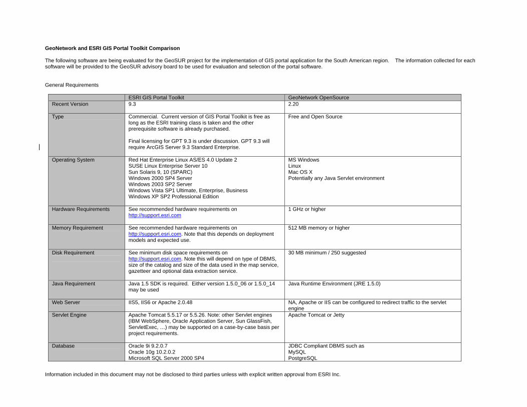
GeoNetwork and ESRI GIS Portal Toolkit Comparison The following software are being evaluated for the GeoSUR project for the implementation of GIS portal application for the South American region. The information collected for each software will be provided to the GeoSUR advisory board to be used for evaluation and selection of the portal software. General Requirements
ESRI GIS Portal Toolkit GeoNetwork OpenSource Recent Version 9.3
2.20
Type Commercial. Current version of GIS Portal Toolkit is free as long as the ESRI training class is taken and the other prerequisite software is already purchased. Final licensing for GPT 9.3 is under discussion. GPT 9.3 will require ArcGIS Server 9.3 Standard Enterprise.
Free and Open Source
Operating System Red Hat Enterprise Linux AS/ES 4.0 Update 2 SUSE Linux Enterprise Server 10 Sun Solaris 9, 10 (SPARC) Windows 2000 SP4 Server Windows 2003 SP2 Server Windows Vista SP1 Ultimate, Enterprise, Business Windows XP SP2 Professional Edition
MS Windows Linux Mac OS X Potentially any Java Servlet environment
Hardware Requirements See recommended hardware requirements on http://support.esri.com
1 GHz or higher
Memory Requirement
See recommended hardware requirements on http://support.esri.com. Note that this depends on deployment models and expected use.
512 MB memory or higher
Disk Requirement
See minimum disk space requirements on http://support.esri.com. Note this will depend on type of DBMS, size of the catalog and size of the data used in the map service, gazetteer and optional data extraction service.
30 MB minimum / 250 suggested
Java Requirement Java 1.5 SDK is required. Either version 1.5.0_06 or 1.5.0_14 may be used
Java Runtime Environment (JRE 1.5.0)
Web Server IIS5, IIS6 or Apache 2.0.48
NA, Apache or IIS can be configured to redirect traffic to the servlet engine
Servlet Engine Apache Tomcat 5.5.17 or 5.5.26. Note: other Servlet engines (IBM WebSphere, Oracle Application Server, Sun GlassFish, ServletExec, …) may be supported on a case-by-case basis per project requirements.
Apache Tomcat or Jetty
Database Oracle 9i 9.2.0.7 Oracle 10g 10.2.0.2 Microsoft SQL Server 2000 SP4
JDBC Compliant DBMS such as MySQL PostgreSQL
Information included in this document may not be disclosed to third parties unless with explicit written approval from ESRI Inc.
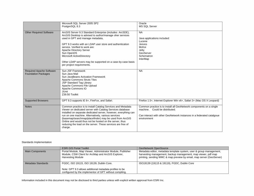
Microsoft SQL Server 2005 SP2 PostgreSQL 8.3
Oracle MS SQL Server
Other Required Software ArcGIS Server 9.3 Standard Enterprise (includes ArcSDE), ArcGIS Desktop is advised to author/manage oher services used in GPT and manage metadata, GPT 9.3 works with an LDAP user store and authentication service. Verified to work are: Apache Directory Server Sun OpenDS Microsoft ActiveDirectory Other LDAP servers may be supported on a case-by-case basis per project requirements.
NA Java applications included: Lucene Jeeves McKoi Jetty GeoServer Schematron InterMap
Required Apache Software Foundation Packages
Sun JSF Framework Sun Java Mail Sun JavaBeans Activation Framework Apache Commons Struts Tiles JSP Standard Tag Library Apache Commons File Upload Apache Commons IO JUnit Z39.50 Toolkit
NA
Supported Browsers GPT 9.3 supports IE 6+, FireFox, and Safari.
Firefox 1.5+, Internet Explorer Win v6+, Safari 3+ (Mac OS X Leopard)
Notes Common practice is to install Catalog Services and Metadata Viewer on dedicated server with Catalog Services database installed on separate dedicated server, however, everything can run on one machine. Alternatively, various services (basemap/searchmap/placefinder) may be used from ArcGIS Online and would thus not be hosted on the server, thus reducing the load on the server. These services are free of charge.
Common practice is to install all GeoNetwork components on a single machine. Could be distributed. Can interact with other GeoNetwork instances in a federated catalgoue environment
Standards Implementation
ESRI GIS Portal Toolkit GeoNetwork OpenSource Main Components Portal Module, Map Viewer, Administrator Module, Publisher
Module, CSW Client for ArcMap and ArcGIS Explorer, Harvesting Module
Metadata editor, metadata template system, user & group management, harvesting management, backup management, map viewer, pdf map printing, sending WMC & map preview by email, map server (GeoServer)
Metadata Standards FGDC, ISO 19115, ISO 19139, Dublin Core. Note: GPT 9.3 allows additional metadata profiles to be configured by the implementor of GPT without compiling.
ISO19139 (19115 & 19119), FGDC, Dublin Core
Information included in this document may not be disclosed to third parties unless with explicit written approval from ESRI Inc.
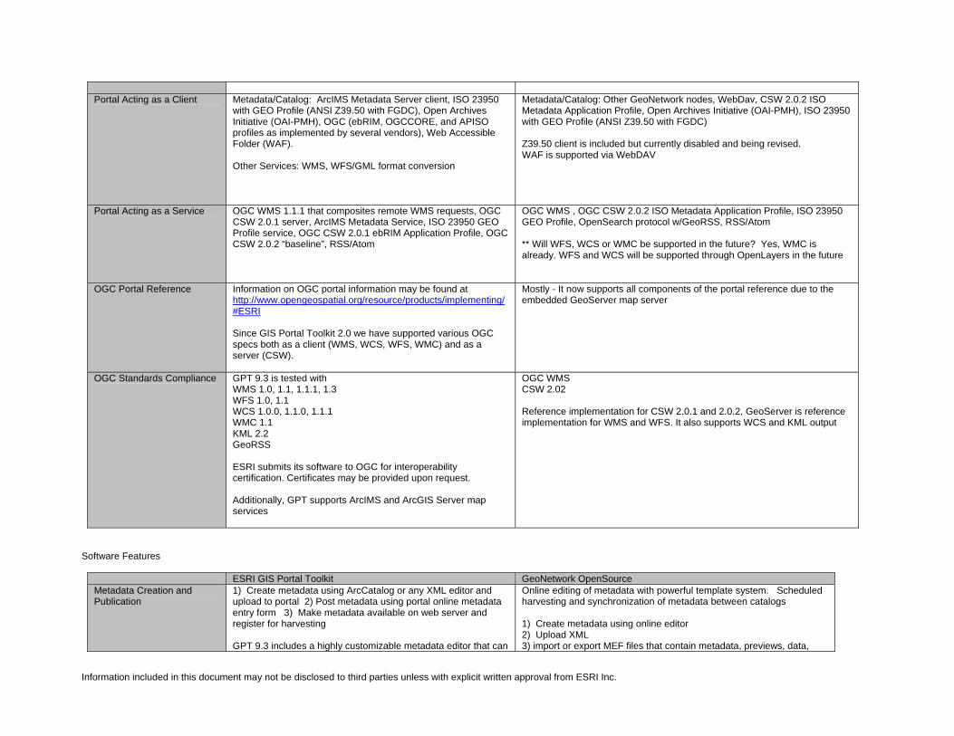
Portal Acting as a Client
Metadata/Catalog: ArcIMS Metadata Server client, ISO 23950 with GEO Profile (ANSI Z39.50 with FGDC), Open Archives Initiative (OAI-PMH), OGC (ebRIM, OGCCORE, and APISO profiles as implemented by several vendors), Web Accessible Folder (WAF). Other Services: WMS, WFS/GML format conversion
Metadata/Catalog: Other GeoNetwork nodes, WebDav, CSW 2.0.2 ISO Metadata Application Profile, Open Archives Initiative (OAI-PMH), ISO 23950 with GEO Profile (ANSI Z39.50 with FGDC) Z39.50 client is included but currently disabled and being revised. WAF is supported via WebDAV
Portal Acting as a Service OGC WMS 1.1.1 that composites remote WMS requests, OGC CSW 2.0.1 server, ArcIMS Metadata Service, ISO 23950 GEO Profile service, OGC CSW 2.0.1 ebRIM Application Profile, OGC CSW 2.0.2 “baseline”, RSS/Atom
OGC WMS , OGC CSW 2.0.2 ISO Metadata Application Profile, ISO 23950 GEO Profile, OpenSearch protocol w/GeoRSS, RSS/Atom ** Will WFS, WCS or WMC be supported in the future? Yes, WMC is already. WFS and WCS will be supported through OpenLayers in the future
OGC Portal Reference Information on OGC portal information may be found at http://www.opengeospatial.org/resource/products/implementing/#ESRI Since GIS Portal Toolkit 2.0 we have supported various OGC specs both as a client (WMS, WCS, WFS, WMC) and as a server (CSW).
Mostly - It now supports all components of the portal reference due to the embedded GeoServer map server
OGC Standards Compliance
GPT 9.3 is tested with WMS 1.0, 1.1, 1.1.1, 1.3 WFS 1.0, 1.1 WCS 1.0.0, 1.1.0, 1.1.1 WMC 1.1 KML 2.2 GeoRSS ESRI submits its software to OGC for interoperability certification. Certificates may be provided upon request. Additionally, GPT supports ArcIMS and ArcGIS Server map services
OGC WMS CSW 2.02 Reference implementation for CSW 2.0.1 and 2.0.2, GeoServer is reference implementation for WMS and WFS. It also supports WCS and KML output
Software Features
ESRI GIS Portal Toolkit GeoNetwork OpenSource Metadata Creation and Publication
1) Create metadata using ArcCatalog or any XML editor and upload to portal 2) Post metadata using portal online metadata entry form 3) Make metadata available on web server and register for harvesting GPT 9.3 includes a highly customizable metadata editor that can
Online editing of metadata with powerful template system. Scheduled harvesting and synchronization of metadata between catalogs 1) Create metadata using online editor 2) Upload XML 3) import or export MEF files that contain metadata, previews, data,
Information included in this document may not be disclosed to third parties unless with explicit written approval from ESRI Inc.
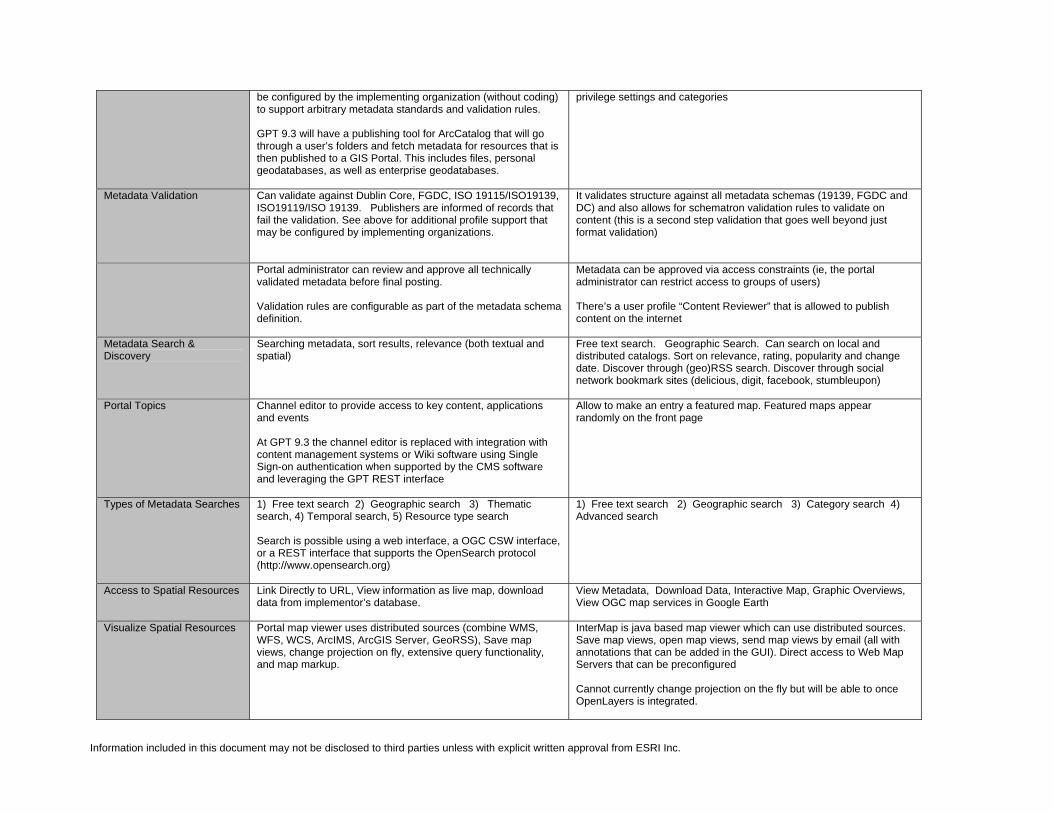
be configured by the implementing organization (without coding) to support arbitrary metadata standards and validation rules. GPT 9.3 will have a publishing tool for ArcCatalog that will go through a user’s folders and fetch metadata for resources that is then published to a GIS Portal. This includes files, personal geodatabases, as well as enterprise geodatabases.
privilege settings and categories
Metadata Validation Can validate against Dublin Core, FGDC, ISO 19115/ISO19139, ISO19119/ISO 19139. Publishers are informed of records that fail the validation. See above for additional profile support that may be configured by implementing organizations.
It validates structure against all metadata schemas (19139, FGDC and DC) and also allows for schematron validation rules to validate on content (this is a second step validation that goes well beyond just format validation)
Portal administrator can review and approve all technically validated metadata before final posting. Validation rules are configurable as part of the metadata schema definition.
Metadata can be approved via access constraints (ie, the portal administrator can restrict access to groups of users) There’s a user profile “Content Reviewer” that is allowed to publish content on the internet
Metadata Search & Discovery
Searching metadata, sort results, relevance (both textual and spatial)
Free text search. Geographic Search. Can search on local and distributed catalogs. Sort on relevance, rating, popularity and change date. Discover through (geo)RSS search. Discover through social network bookmark sites (delicious, digit, facebook, stumbleupon)
Portal Topics Channel editor to provide access to key content, applications and events At GPT 9.3 the channel editor is replaced with integration with content management systems or Wiki software using Single Sign-on authentication when supported by the CMS software and leveraging the GPT REST interface
Allow to make an entry a featured map. Featured maps appear randomly on the front page
Types of Metadata Searches 1) Free text search 2) Geographic search 3) Thematic search, 4) Temporal search, 5) Resource type search Search is possible using a web interface, a OGC CSW interface, or a REST interface that supports the OpenSearch protocol (http://www.opensearch.org)
1) Free text search 2) Geographic search 3) Category search 4) Advanced search
Access to Spatial Resources Link Directly to URL, View information as live map, download data from implementor’s database.
View Metadata, Download Data, Interactive Map, Graphic Overviews, View OGC map services in Google Earth
Visualize Spatial Resources Portal map viewer uses distributed sources (combine WMS, WFS, WCS, ArcIMS, ArcGIS Server, GeoRSS), Save map views, change projection on fly, extensive query functionality, and map markup.
InterMap is java based map viewer which can use distributed sources. Save map views, open map views, send map views by email (all with annotations that can be added in the GUI). Direct access to Web Map Servers that can be preconfigured Cannot currently change projection on the fly but will be able to once OpenLayers is integrated.
Information included in this document may not be disclosed to third parties unless with explicit written approval from ESRI Inc.
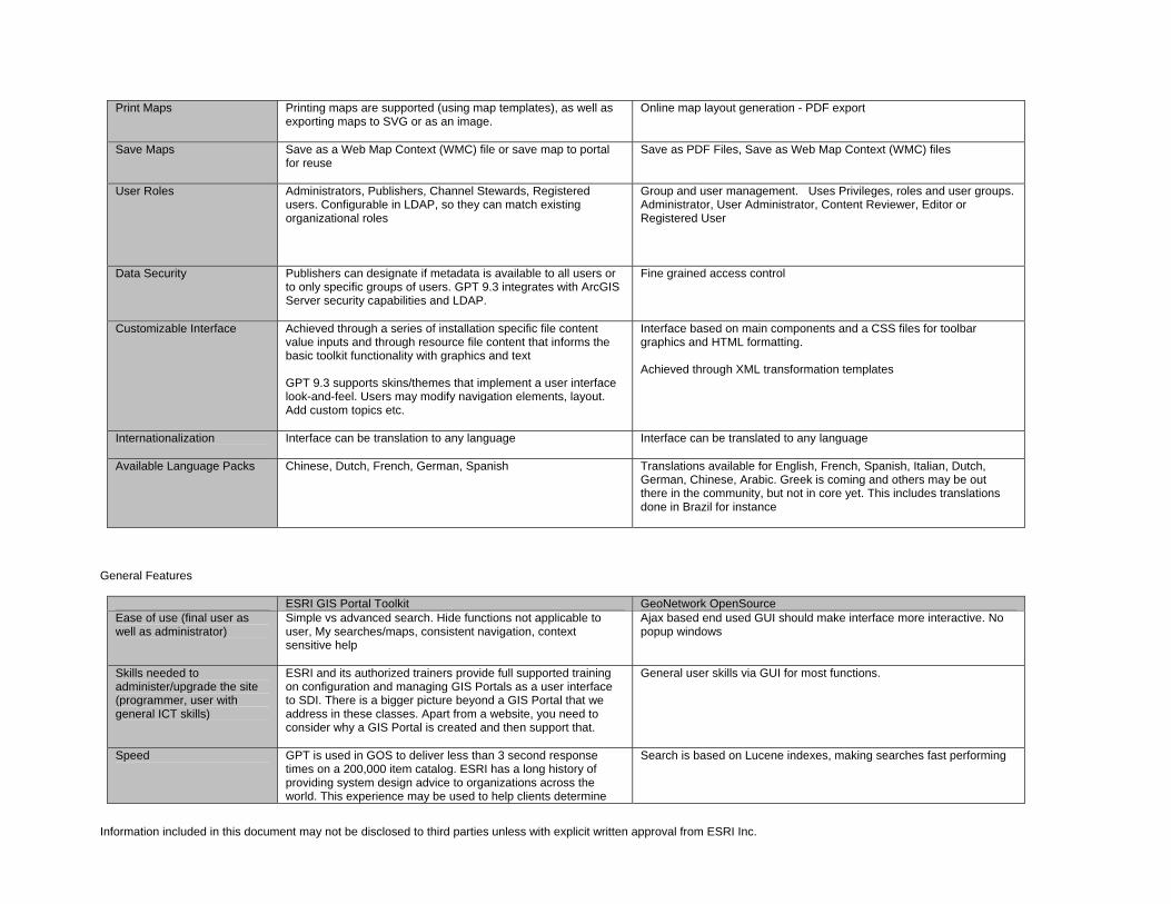
Print Maps Printing maps are supported (using map templates), as well as exporting maps to SVG or as an image.
Online map layout generation - PDF export
Save Maps Save as a Web Map Context (WMC) file or save map to portal for reuse
Save as PDF Files, Save as Web Map Context (WMC) files
User Roles Administrators, Publishers, Channel Stewards, Registered users. Configurable in LDAP, so they can match existing organizational roles
Group and user management. Uses Privileges, roles and user groups. Administrator, User Administrator, Content Reviewer, Editor or Registered User
Data Security Publishers can designate if metadata is available to all users or to only specific groups of users. GPT 9.3 integrates with ArcGIS Server security capabilities and LDAP.
Fine grained access control
Customizable Interface Achieved through a series of installation specific file content value inputs and through resource file content that informs the basic toolkit functionality with graphics and text GPT 9.3 supports skins/themes that implement a user interface look-and-feel. Users may modify navigation elements, layout. Add custom topics etc.
Interface based on main components and a CSS files for toolbar graphics and HTML formatting. Achieved through XML transformation templates
Internationalization Interface can be translation to any language
Interface can be translated to any language
Available Language Packs Chinese, Dutch, French, German, Spanish
Translations available for English, French, Spanish, Italian, Dutch, German, Chinese, Arabic. Greek is coming and others may be out there in the community, but not in core yet. This includes translations done in Brazil for instance
General Features
ESRI GIS Portal Toolkit GeoNetwork OpenSource Ease of use (final user as well as administrator)
Simple vs advanced search. Hide functions not applicable to user, My searches/maps, consistent navigation, context sensitive help
Ajax based end used GUI should make interface more interactive. No popup windows
Skills needed to administer/upgrade the site (programmer, user with general ICT skills)
ESRI and its authorized trainers provide full supported training on configuration and managing GIS Portals as a user interface to SDI. There is a bigger picture beyond a GIS Portal that we address in these classes. Apart from a website, you need to consider why a GIS Portal is created and then support that.
General user skills via GUI for most functions.
Speed
GPT is used in GOS to deliver less than 3 second response times on a 200,000 item catalog. ESRI has a long history of providing system design advice to organizations across the world. This experience may be used to help clients determine
Search is based on Lucene indexes, making searches fast performing
Information included in this document may not be disclosed to third parties unless with explicit written approval from ESRI Inc.
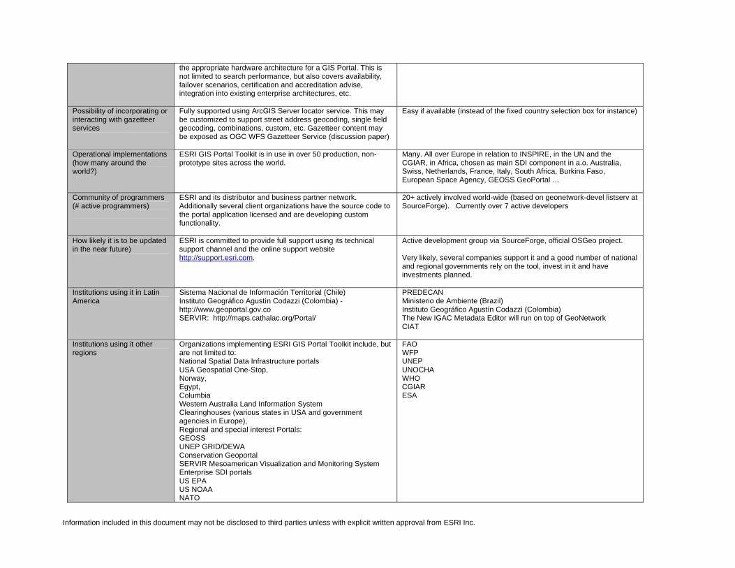
the appropriate hardware architecture for a GIS Portal. This is not limited to search performance, but also covers availability, failover scenarios, certification and accreditation advise, integration into existing enterprise architectures, etc.
Possibility of incorporating or interacting with gazetteer services
Fully supported using ArcGIS Server locator service. This may be customized to support street address geocoding, single field geocoding, combinations, custom, etc. Gazetteer content may be exposed as OGC WFS Gazetteer Service (discussion paper)
Easy if available (instead of the fixed country selection box for instance)
Operational implementations (how many around the world?)
ESRI GIS Portal Toolkit is in use in over 50 production, non-prototype sites across the world.
Many. All over Europe in relation to INSPIRE, in the UN and the CGIAR, in Africa, chosen as main SDI component in a.o. Australia, Swiss, Netherlands, France, Italy, South Africa, Burkina Faso, European Space Agency, GEOSS GeoPortal …
Community of programmers (# active programmers)
ESRI and its distributor and business partner network. Additionally several client organizations have the source code to the portal application licensed and are developing custom functionality.
20+ actively involved world-wide (based on geonetwork-devel listserv at SourceForge). Currently over 7 active developers
How likely it is to be updated in the near future)
ESRI is committed to provide full support using its technical support channel and the online support website http://support.esri.com.
Active development group via SourceForge, official OSGeo project. Very likely, several companies support it and a good number of national and regional governments rely on the tool, invest in it and have investments planned.
Institutions using it in Latin America
Sistema Nacional de Información Territorial (Chile) Instituto Geográfico Agustín Codazzi (Colombia) - http://www.geoportal.gov.co SERVIR: http://maps.cathalac.org/Portal/
PREDECAN Ministerio de Ambiente (Brazil) Instituto Geográfico Agustín Codazzi (Colombia) The New IGAC Metadata Editor will run on top of GeoNetwork CIAT
Institutions using it other regions
Organizations implementing ESRI GIS Portal Toolkit include, but are not limited to: National Spatial Data Infrastructure portals USA Geospatial One-Stop, Norway, Egypt, Columbia Western Australia Land Information System Clearinghouses (various states in USA and government agencies in Europe), Regional and special interest Portals: GEOSS UNEP GRID/DEWA Conservation Geoportal SERVIR Mesoamerican Visualization and Monitoring System Enterprise SDI portals US EPA US NOAA NATO
FAO WFP UNEP UNOCHA WHO CGIAR ESA

Information included in this document may not be disclosed to third parties unless with explicit written approval from ESRI Inc.
Multi-national commercial enterprises. Reference sites can be provided upon request. Case Studies - /www.esri.com/software/arcgis/gisportal-toolkit/about/case-studies.html