Embed Size (px)
Citation preview
4th
International Conference on Earthquake Geotechnical Engineering
June 25-28, 2007 Paper No. 1441
GEOTECHNICAL EARTHQUAKE HAZARD ASSESSMENT BASED
ON A GIS PLATFORM
C. Papatheodorou (1)
, N. Klimis (2)
, Pr. Moutsokapas (3)
, S. Koutrakis (4)
and B. Margaris (2)
ABSTRACT
The present work explores the ability of a GIS platform based tool to estimate potential losses of
geotechnical earthquake hazard. Phenomena, such as liquefaction, dynamic settlements, lateral
spreading, landslides and permanent ground displacements are assessed in both qualitative and
quantitative way, under a probabilistic hazard scenario that corresponds to the earthquake of 14th
August 2003 that stroke the island of Lefkada. Post earthquake observations of geotechnical failures
triggered by the above seismic event, meticulously registered in situ, are directly compared to
theoretical scenarios of anticipated losses of geotechnical earthquake hazards, as depicted in relevant
thematic maps. Theoretical results directly compared to observed geotechnical earthquake hazards are
quite concluding in a considerable number if issues. However, a certain number of discrepancies that
have been detected between calculations and observations are qualitatively explained, whilst
perspectives for improvement of the computational GIS based approach are highlighted.
Keywords: GIS, landslides, hazard, slope stability, liquefaction, deformation, acceleration
INTRODUCTION
At 8:15am on 14 August 2003 (05:15 GMT) an earthquake Mw=6.2 occurred at the NW Lefkada
coast at the Ionian Sea. The main shock was strongly felt throughout Lefkada island and the other
Ionian islands (from Corfu to Zakynthos) and in an extensive area of the western mainland of Greece.
The shock was also felt as far as Athens, almost 280 km away. At the town of Lefkada island a low-
resolution tri-axial strong motion instrument, recorded the main shock. The strong ground motion
triggered seven more accelerographic stations of the permanent network of IESEE, located at the
islands of Cephalonia and Zakynthos, as well as in the western mainland of Greece. Peak ground
acceleration values of the recordings varied from 0.02 to 0.41g.
The island of Lefkada has been affected several times by strong seismic events causing structural and
non-structural damage, injuries and human losses. During the last century the area of Lefkada was
hitten by the earthquakes of 27th November 1914 (Mw=6.3), of 22nd April 1948 (Mw=6.4) and of
30th June 1948 (Mw=6.4). Those seismic events of magnitude Mw>6.0 caused severe damage
(Papazachos and Papazachou, 2003) such as: landslides, rockfalls, permanent ground displacements,
lateral spreading, dynamic settlements, liquefaction, failures in harbors, houses, monuments,
churches, lifelines etc, similar to the damage and failures observed at the recent earthquake of 14th
August 2003 (Figure 1). In this work, results from a comprehensive, earthquake geotechnical loss
1 Assistant Professor, Technological Educational Institute of Serres – Geomatics & Surveying Dept. (TEI Serres)
2 Dr Civil Engineer, Researcher, Institute of Engineering Seismology & Earthquake Engineering (ITSAK), 46,
Georgikis Scholis str., P.O. Box 53, GR-55102, Finikas, Thessaloniki, HELLAS (email: [email protected]) 3 Diploma at Geomatics & Surveying (TEI Serres), Post Graduate student at University of Athens, HELLAS
4 M.Sc Seismologist, Geophysical Laboratory (AUTh – GL), Thessaloniki, HELLAS
5 Dr Seismologist, Researcher, Institute of Engineering Seismology & Earthquake Engineering (ITSAK),
Thessaloniki, HELLAS
scenario, based on the MW=6.2 earthquake of 13 August 2003, are critically presented and adequately
compared to geotechnical damages as registered after the above seismic event at a regional scale
covering the entity of Lefkada island.
SEISMOLOGICAL AND STRONG GROUND MOTION DATA
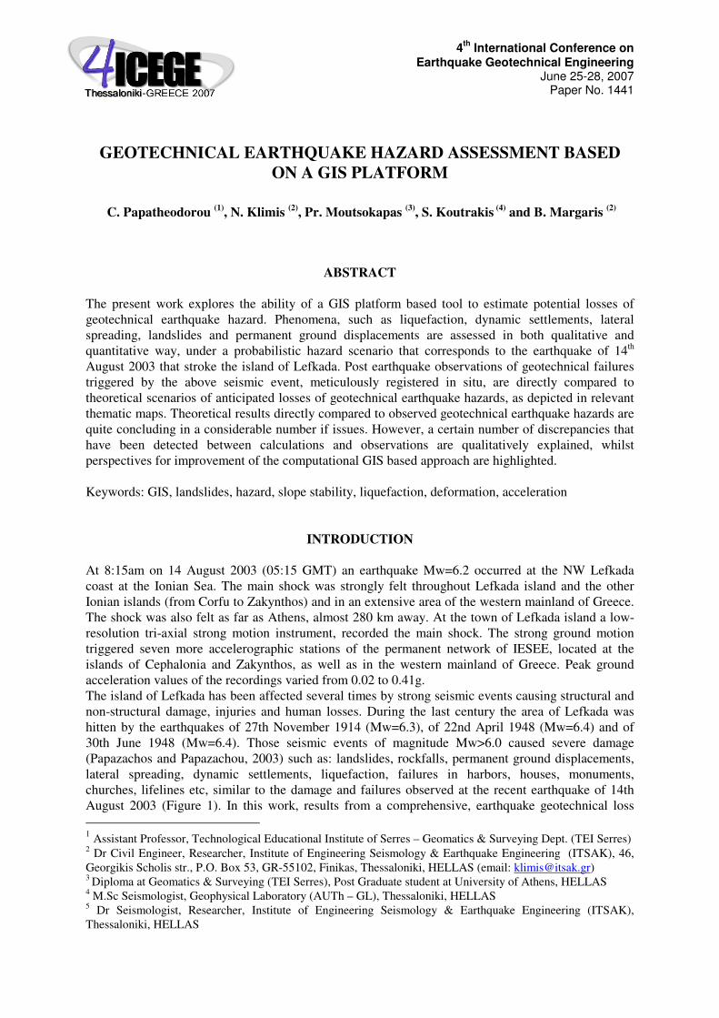
The earthquake of August 14th 2003, MW=6.2, occurred at the northern part of CTFZ, in the northern
segment (LS) and is characterized by a dextral strike-slip motion with a thrust component, striking in
a NNE direction and dipping in a SSE direction. The island of Lefkada is located at the most
seismically active area of Greece. Karakostas et al. (2004), determined the properties of this seismic
sequence, and using a great number of aftershock foci proposed a NNE-SSE seismic band which is in
a good agreement with the strike of the main shock nodal planes in accordance to Harvard CTM
solution (strike=18o, dip=60
o, slip= -175
o). Determination of the seismic source mechanism of the
Lefkada earthquake (2003), was carried out by Zahradnik et al. (2005), using a moment tensor
inversion for a multiple point source extended to full waveform data at regional / local distances.
Their model concludes two main events, which dominated the rupture process, the first (including 3
different sub-events) at Lefkada island and the second (one sub-event) at Cephalonian area.
Figure 1 The Cephalonian Transform Fault Zone (CTFZ), showing the Cephalonian (CS) and
Lefkada (LS) segments. The epicentre of the earthquake under study along with the epicentres
of past strong earthquakes in the same area, are shown with asterisks (Benetatos et al., 2005)
Benetatos et al. (2005), using teleseismic long period digital data to determine the source parameters
and regional broadband waveforms to study the focal mechanisms of the aftershocks of the sequence,
defined the earthquake as a multiple source event.
The strong earthquake ground motion of the main shock was recorded by accelerometers located at
the cities of Lefkada (LEF1), Preveza (PRE1), Amfilochia (AML1), Agrinio (AGR1), Argostoli
(ARG1), Zakynthos (ZAK1) and Vartholomio (VAR2) (Margaris et al., 2003). Some of those sites
(Lefkada, Preveza, and Argostoli) are presented in Figure 1. A peak horizontal ground acceleration of
0.42g was recorded at the station located at the city of Lefkada. The 5%-pseudoacceleration spectral
values of the main record recorded at the Lefkada city, exhibit amplitudes Sa>0.9g for a period range
of 0.2 to 0.7sec revealing a spectral peak value of about 1.7g around 0.5 sec. For the same station, a
fundamental period of the soil column was estimated around 0.5sec utilizing strong motion excitation
(Dimitriou et al., 1999).
METHODOLOGICAL APPROACH AND IMPLEMENTATION
HAZUS methodology was selected due to its sound scientific background, its flexibility and
reliability. HAZUS is a multidisciplinary, modular based tool that local and state authorities can use
for earthquake-hazard mitigation, development of seismic risk and loss scenario, emergency
preparedness and any kind of disaster response planning (NIBS 1999). In this particular project,
attention is specifically drawn on PESH module where geotechnical implications are described upon a
user-provided probabilistic seismic hazard map based on local source and path seismological
characteristics, as well as local site conditions.
The main goal of this work is to evaluate the possibility of using FEMA’s loss estimation
methodology incorporated in HAZUS software at an area outside USA. Lefkada island has been
selected as a case study, since a serious number of geotechnical damage was registered as a
consequence of the severe seismic event of the 14th of August 2003.
A straightforward comparison of results provided by the methodology, using an earthquake scenario
equivalent to the 14/08/2003 earthquake (MW=6.2), with the actual damage induced by the
aforementioned earthquake, consist the base of a critical evaluation of HAZUS methodology.
Application of the methodology avoiding direct use of HAZUS software, involved the use of Arc GIS
v8.3 software, the characterization of the earthquake hazard input using area specific geologic,
geotechnical and seismological data and the creation of new geo-databases. Loss calculations were
performed using a fairly dense grid of about 0.5 x 0.5km, leading to relatively dense geotechnical
damage estimation.
Evaluation of HAZUS methodology in this case was carried out in three stages:
i) Calculation of the 14th August 2003 scenario earthquake ground motion based on a probabilistic
seismic hazard regional map estimated only for rock conditions (site class B, according to 1997
NEHRP site classification system). Ground shaking is amplified by soil amplification factors as
proposed by NEHRP 1997 site classification system. NEHRP Provisions originally do not provide soil
amplification factors for PGA values. However, HAZUS methodology amplifies rock (i.e. site class
B) PGA by the same factor as that specified in Table 1 for short period (0.3sec) spectral acceleration,
as expressed in equation (1):
PGAi = PGA * FAi (1)
ii) Evaluation of liquefaction, ground settlement, permanent ground displacement and earthquake
induced potential landslides using ground motion maps of the area based on the above probabilistic
seismic hazard maps.
iii) Comparison of the previous stage resultant maps to maps depicting actual geotechnical damage.
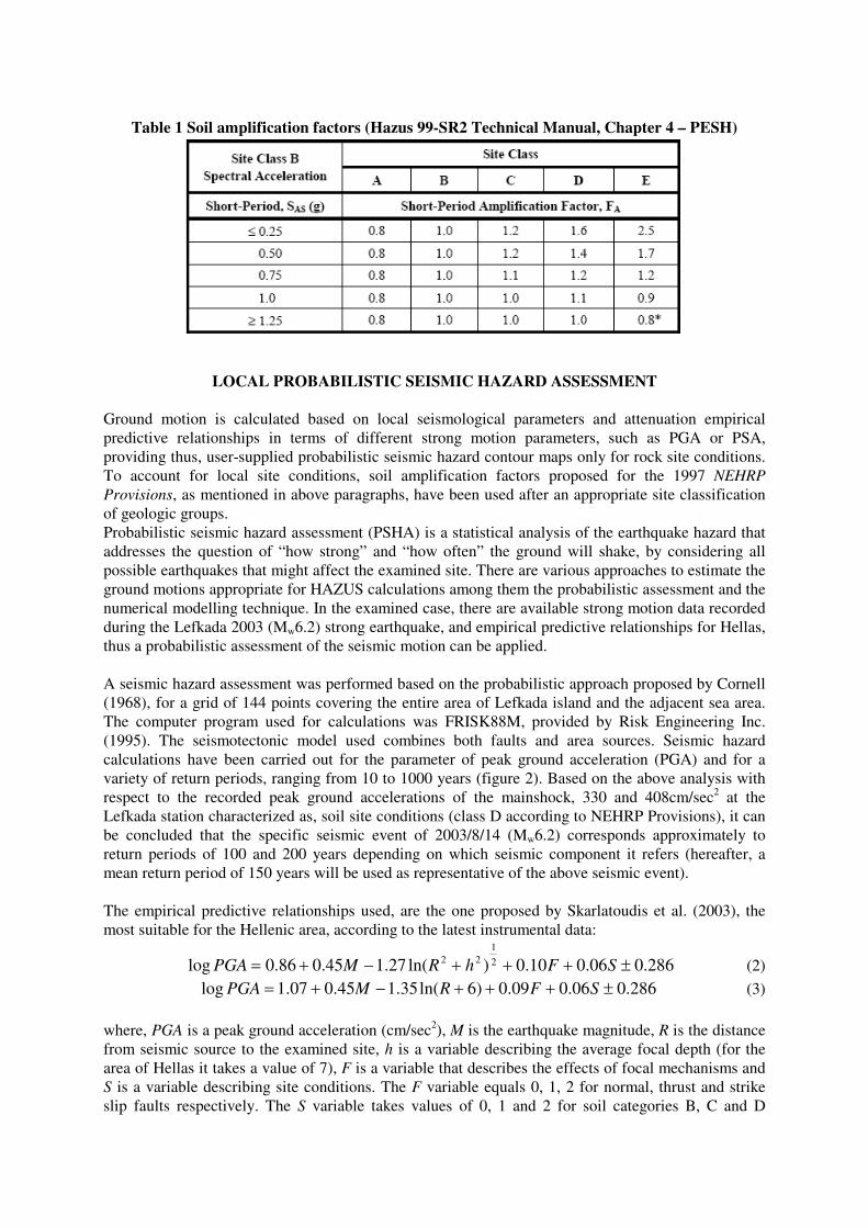
Table 1 Soil amplification factors (Hazus 99-SR2 Technical Manual, Chapter 4 – PESH)
LOCAL PROBABILISTIC SEISMIC HAZARD ASSESSMENT
Ground motion is calculated based on local seismological parameters and attenuation empirical
predictive relationships in terms of different strong motion parameters, such as PGA or PSA,
providing thus, user-supplied probabilistic seismic hazard contour maps only for rock site conditions.
To account for local site conditions, soil amplification factors proposed for the 1997 NEHRP
Provisions, as mentioned in above paragraphs, have been used after an appropriate site classification
of geologic groups.
Probabilistic seismic hazard assessment (PSHA) is a statistical analysis of the earthquake hazard that
addresses the question of “how strong” and “how often” the ground will shake, by considering all
possible earthquakes that might affect the examined site. There are various approaches to estimate the
ground motions appropriate for HAZUS calculations among them the probabilistic assessment and the
numerical modelling technique. In the examined case, there are available strong motion data recorded
during the Lefkada 2003 (Mw6.2) strong earthquake, and empirical predictive relationships for Hellas,
thus a probabilistic assessment of the seismic motion can be applied.
A seismic hazard assessment was performed based on the probabilistic approach proposed by Cornell
(1968), for a grid of 144 points covering the entire area of Lefkada island and the adjacent sea area.
The computer program used for calculations was FRISK88M, provided by Risk Engineering Inc.
(1995). The seismotectonic model used combines both faults and area sources. Seismic hazard
calculations have been carried out for the parameter of peak ground acceleration (PGA) and for a
variety of return periods, ranging from 10 to 1000 years (figure 2). Based on the above analysis with
respect to the recorded peak ground accelerations of the mainshock, 330 and 408cm/sec2 at the
Lefkada station characterized as, soil site conditions (class D according to NEHRP Provisions), it can
be concluded that the specific seismic event of 2003/8/14 (Mw6.2) corresponds approximately to
return periods of 100 and 200 years depending on which seismic component it refers (hereafter, a
mean return period of 150 years will be used as representative of the above seismic event).
The empirical predictive relationships used, are the one proposed by Skarlatoudis et al. (2003), the
most suitable for the Hellenic area, according to the latest instrumental data:
286.006.010.0)ln(27.145.086.0log 2
1
22±+++−+= SFhRMPGA (2)
286.006.009.0)6ln(35.145.007.1log ±+++−+= SFRMPGA (3)
where, PGA is a peak ground acceleration (cm/sec2), M is the earthquake magnitude, R is the distance
from seismic source to the examined site, h is a variable describing the average focal depth (for the
area of Hellas it takes a value of 7), F is a variable that describes the effects of focal mechanisms and
S is a variable describing site conditions. The F variable equals 0, 1, 2 for normal, thrust and strike
slip faults respectively. The S variable takes values of 0, 1 and 2 for soil categories B, C and D
(according to the classification proposed by NEHRP 1997) respectively. In the current study, seismic
hazard was estimated for all soil categories, but only site conditions representing class B (rock) have
been adopted as a basis on which NEHRP amplification factors were afterwards applied. The
difference between equations (2) and (3) is that the first one uses hypocentral distance, whereas the
second one, uses epicentral distance. In practice, the two relations are almost identical apart from
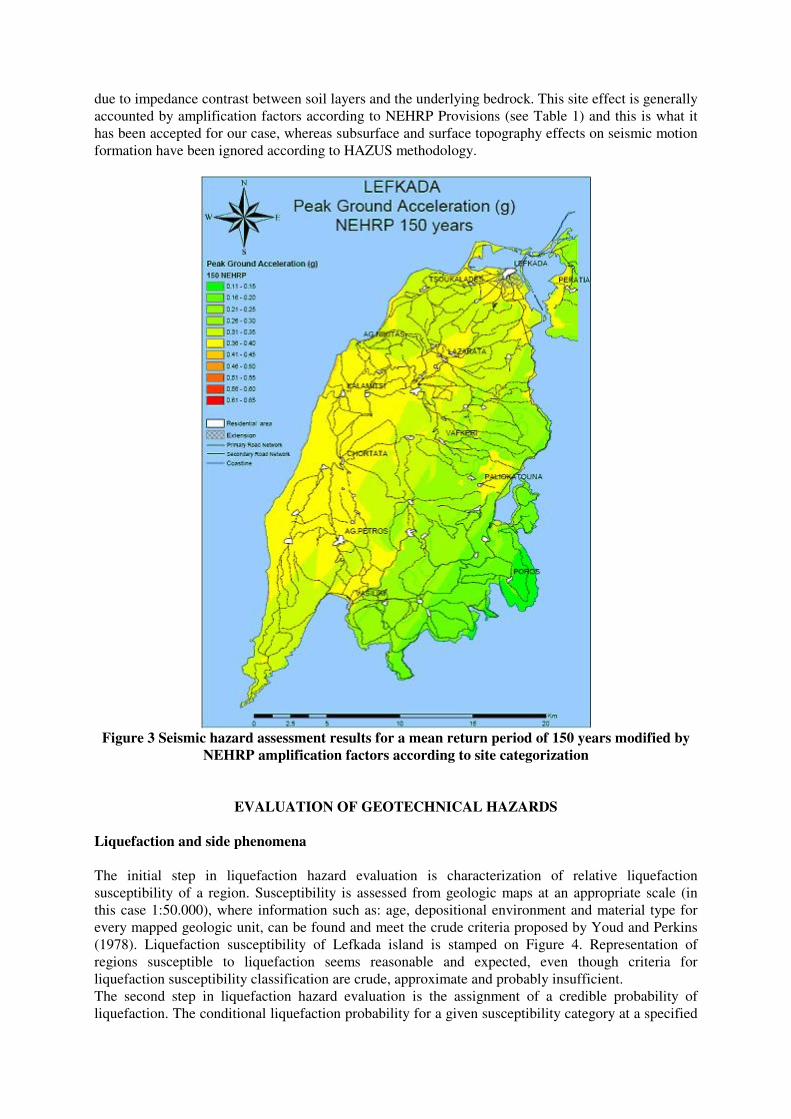
slight differences in the near field. Results of seismic hazard assessment as a PGA thematic map, are
depicted for a mean return period of 150 years, corresponding to the seismic event of 14/08/2003
(MW=6.2) in figure 3.
Figure 2 Seismic hazard curves showing the relationship between expected peak ground
acceleration (cm/sec2) in terms of return period (years) for two different site conditions of
subsurface geology (B to account for rock and D to account for soil)
At this point of analysis, a direct comparison between estimated geotechnical damage level and
observed post-earthquake geotechnical damage data is undertaken, as a consequence of the ‘Lefkada’
earthquake, a seismic event corresponding at a mean return period of approximately 150 years. This
case study serves as a reliability test for HAZUS methodology focused on estimation of potential
geotechnical hazards.
The PESH module estimates ground motion and ground failures (landslides, liquefaction, lateral
spreading, dynamic settlements, permanent ground displacements, surface fault ruptures among
others). In a previous chapter, regional ground motion is defined for rock outcropping conditions
based on a probabilistic seismic hazard assessment in terms of peak ground accelerations (PGA),
taking into account the amplifying effect of soil layers. This parameter is by far the simplest to
describe the dynamic ground motion, but it is also well known that in a lot of cases it is not sufficient
to account for the duration and the complexity of ground shaking. However, in this case only PGA
values have been used in order to conform to HAZUS methodology used.
Dynamic ground shaking depends not only on magnitude and distance of the seismic source, but also
upon local site conditions, such as subsurface and surface topography and also amplification of
seismic motion subjected to the impedance contrast between sediments and underlying bedrock. The
fundamental phenomenon responsible for ground motion amplification is trapping of seismic waves
due to impedance contrast between soil layers and the underlying bedrock. This site effect is generally
accounted by amplification factors according to NEHRP Provisions (see Table 1) and this is what it
has been accepted for our case, whereas subsurface and surface topography effects on seismic motion
formation have been ignored according to HAZUS methodology.
Figure 3 Seismic hazard assessment results for a mean return period of 150 years modified by
NEHRP amplification factors according to site categorization
EVALUATION OF GEOTECHNICAL HAZARDS
Liquefaction and side phenomena
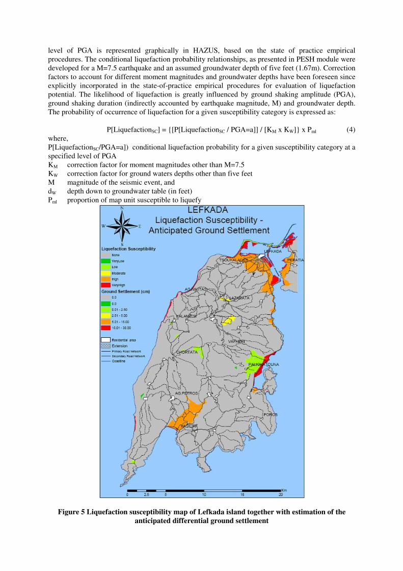
The initial step in liquefaction hazard evaluation is characterization of relative liquefaction
susceptibility of a region. Susceptibility is assessed from geologic maps at an appropriate scale (in
this case 1:50.000), where information such as: age, depositional environment and material type for
every mapped geologic unit, can be found and meet the crude criteria proposed by Youd and Perkins
(1978). Liquefaction susceptibility of Lefkada island is stamped on Figure 4. Representation of
regions susceptible to liquefaction seems reasonable and expected, even though criteria for
liquefaction susceptibility classification are crude, approximate and probably insufficient.
The second step in liquefaction hazard evaluation is the assignment of a credible probability of
liquefaction. The conditional liquefaction probability for a given susceptibility category at a specified
level of PGA is represented graphically in HAZUS, based on the state of practice empirical
procedures. The conditional liquefaction probability relationships, as presented in PESH module were
developed for a M=7.5 earthquake and an assumed groundwater depth of five feet (1.67m). Correction
factors to account for different moment magnitudes and groundwater depths have been foreseen since
explicitly incorporated in the state-of-practice empirical procedures for evaluation of liquefaction
potential. The likelihood of liquefaction is greatly influenced by ground shaking amplitude (PGA),
ground shaking duration (indirectly accounted by earthquake magnitude, M) and groundwater depth.
The probability of occurrence of liquefaction for a given susceptibility category is expressed as:
P[LiquefactionSC] = {[P[LiquefactionSC / PGA=a]] / [KM x KW]} x Pml (4)
where,
P[LiquefactionSC/PGA=a]) conditional liquefaction probability for a given susceptibility category at a
specified level of PGA
KM correction factor for moment magnitudes other than M=7.5
KW correction factor for ground waters depths other than five feet
M magnitude of the seismic event, and
dW depth down to groundwater table (in feet)
Pml proportion of map unit susceptible to liquefy
Figure 5 Liquefaction susceptibility map of Lefkada island together with estimation of the
anticipated differential ground settlement
Modification factors are computed via the following relationships:
KM = 0.0027M3 – 0.0267M
2 – 0.2055M + 2.9188 (5)
KW = 0.022dW +0.93 (6)
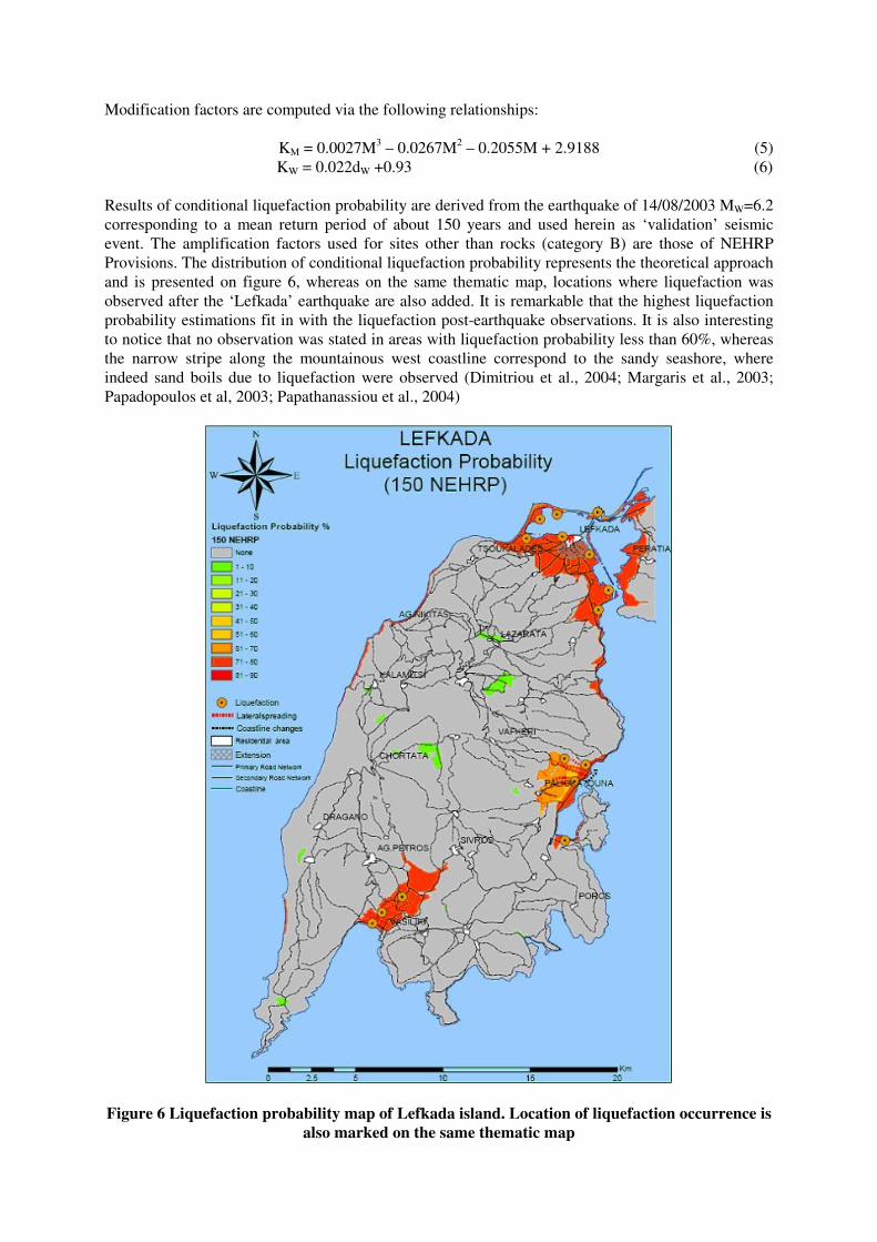
Results of conditional liquefaction probability are derived from the earthquake of 14/08/2003 MW=6.2
corresponding to a mean return period of about 150 years and used herein as ‘validation’ seismic
event. The amplification factors used for sites other than rocks (category B) are those of NEHRP
Provisions. The distribution of conditional liquefaction probability represents the theoretical approach
and is presented on figure 6, whereas on the same thematic map, locations where liquefaction was
observed after the ‘Lefkada’ earthquake are also added. It is remarkable that the highest liquefaction
probability estimations fit in with the liquefaction post-earthquake observations. It is also interesting
to notice that no observation was stated in areas with liquefaction probability less than 60%, whereas
the narrow stripe along the mountainous west coastline correspond to the sandy seashore, where
indeed sand boils due to liquefaction were observed (Dimitriou et al., 2004; Margaris et al., 2003;
Papadopoulos et al, 2003; Papathanassiou et al., 2004)
Figure 6 Liquefaction probability map of Lefkada island. Location of liquefaction occurrence is
also marked on the same thematic map
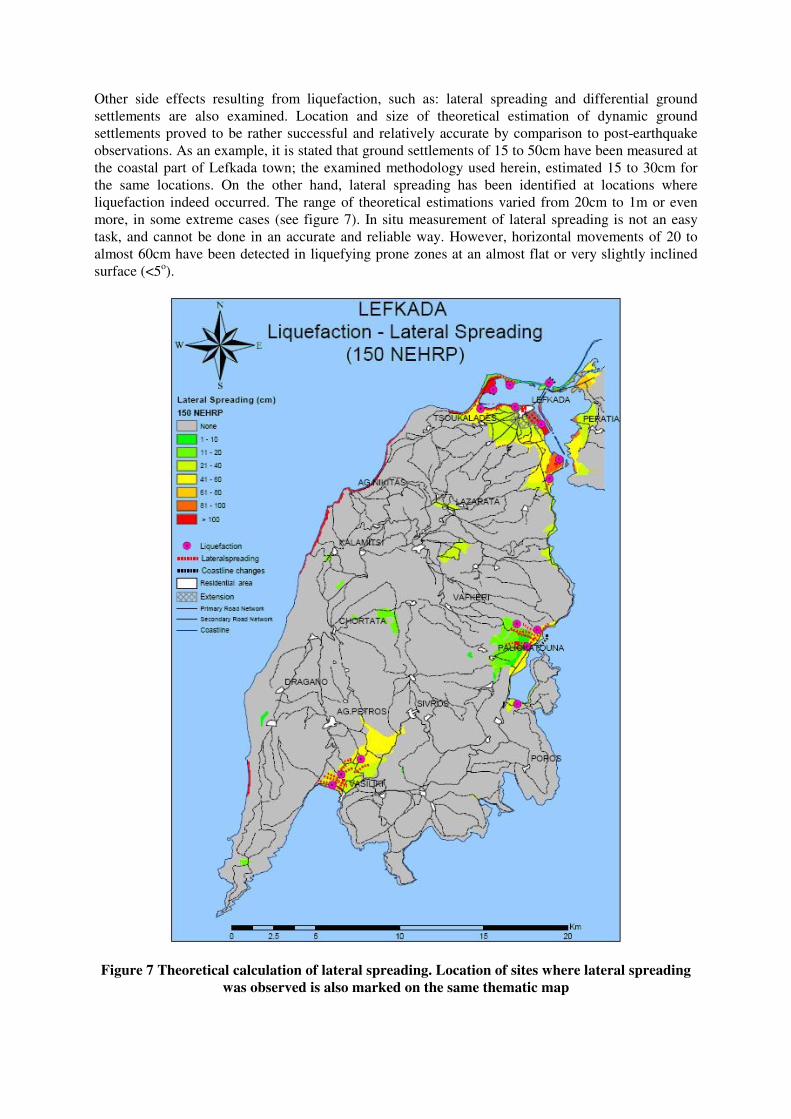
Other side effects resulting from liquefaction, such as: lateral spreading and differential ground
settlements are also examined. Location and size of theoretical estimation of dynamic ground
settlements proved to be rather successful and relatively accurate by comparison to post-earthquake
observations. As an example, it is stated that ground settlements of 15 to 50cm have been measured at
the coastal part of Lefkada town; the examined methodology used herein, estimated 15 to 30cm for
the same locations. On the other hand, lateral spreading has been identified at locations where
liquefaction indeed occurred. The range of theoretical estimations varied from 20cm to 1m or even
more, in some extreme cases (see figure 7). In situ measurement of lateral spreading is not an easy
task, and cannot be done in an accurate and reliable way. However, horizontal movements of 20 to
almost 60cm have been detected in liquefying prone zones at an almost flat or very slightly inclined
surface (<5o).
Figure 7 Theoretical calculation of lateral spreading. Location of sites where lateral spreading
was observed is also marked on the same thematic map
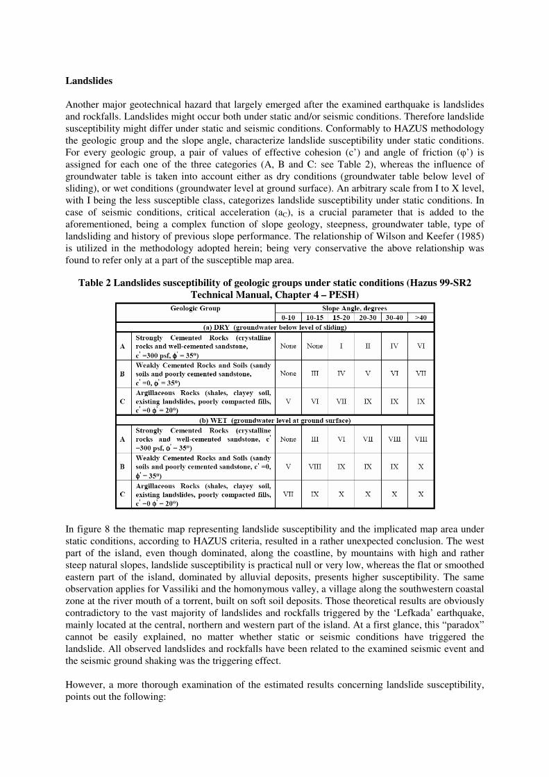
Landslides
Another major geotechnical hazard that largely emerged after the examined earthquake is landslides
and rockfalls. Landslides might occur both under static and/or seismic conditions. Therefore landslide
susceptibility might differ under static and seismic conditions. Conformably to HAZUS methodology
the geologic group and the slope angle, characterize landslide susceptibility under static conditions.
For every geologic group, a pair of values of effective cohesion (c’) and angle of friction (φ’) is
assigned for each one of the three categories (A, B and C: see Table 2), whereas the influence of
groundwater table is taken into account either as dry conditions (groundwater table below level of
sliding), or wet conditions (groundwater level at ground surface). An arbitrary scale from I to X level,
with I being the less susceptible class, categorizes landslide susceptibility under static conditions. In
case of seismic conditions, critical acceleration (aC), is a crucial parameter that is added to the
aforementioned, being a complex function of slope geology, steepness, groundwater table, type of
landsliding and history of previous slope performance. The relationship of Wilson and Keefer (1985)
is utilized in the methodology adopted herein; being very conservative the above relationship was
found to refer only at a part of the susceptible map area.
Table 2 Landslides susceptibility of geologic groups under static conditions (Hazus 99-SR2
Technical Manual, Chapter 4 – PESH)
In figure 8 the thematic map representing landslide susceptibility and the implicated map area under
static conditions, according to HAZUS criteria, resulted in a rather unexpected conclusion. The west
part of the island, even though dominated, along the coastline, by mountains with high and rather
steep natural slopes, landslide susceptibility is practical null or very low, whereas the flat or smoothed
eastern part of the island, dominated by alluvial deposits, presents higher susceptibility. The same
observation applies for Vassiliki and the homonymous valley, a village along the southwestern coastal
zone at the river mouth of a torrent, built on soft soil deposits. Those theoretical results are obviously
contradictory to the vast majority of landslides and rockfalls triggered by the ‘Lefkada’ earthquake,
mainly located at the central, northern and western part of the island. At a first glance, this “paradox”
cannot be easily explained, no matter whether static or seismic conditions have triggered the
landslide. All observed landslides and rockfalls have been related to the examined seismic event and
the seismic ground shaking was the triggering effect.
However, a more thorough examination of the estimated results concerning landslide susceptibility,
points out the following:
1. The estimated landslide susceptibility refers exclusively to static conditions
2. Most of the landslides and rockfalls observed were detected on cut slopes, as well as on
downstream slopes of road embankments. As survey and geological data used for the relevant
thematic maps did not include any information about those cut slopes and downstream road
embankment slopes, consequently, no damages could also be estimated for this kind of
earthworks. Therefore, the only direct comparison of estimated and observed landslides and
rockfalls that can be realistically evaluated is the one on natural slopes
Figure 8 Landslide susceptibility under static conditions and percentage of the affected map area
having a landslide – susceptible deposit
Once, the parameter of critical acceleration (aC) is taken into account as a function of the geologic
group and the slope angle (Wilson and Keefer, 1985) then, ratio aC/PGA, is calculated and can be
presented as a new thematic map in figure 9. The above ratio can serve as an index relative to the
probability of slide occurrence, triggered by a seismic event equivalent to the one of 14 August 2003.
Observations of slides triggered by the ‘Lefkada’ earthquake are sited on the same thematic map of
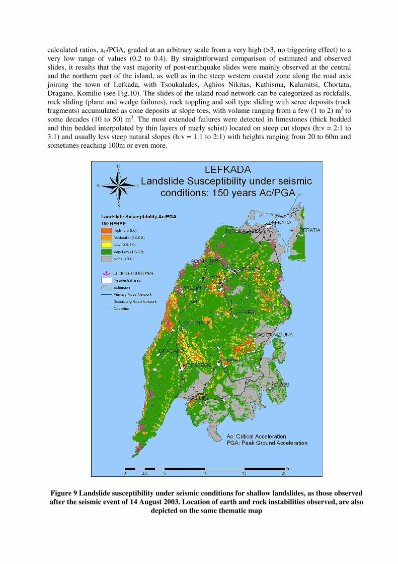
calculated ratios, aC/PGA, graded at an arbitrary scale from a very high (>3, no triggering effect) to a
very low range of values (0.2 to 0.4). By straightforward comparison of estimated and observed
slides, it results that the vast majority of post-earthquake slides were mainly observed at the central
and the northern part of the island, as well as in the steep western coastal zone along the road axis
joining the town of Lefkada, with Tsoukalades, Aghios Nikitas, Kathisma, Kalamitsi, Chortata,
Dragano, Komilio (see Fig.10). The slides of the island road network can be categorized as rockfalls,
rock sliding (plane and wedge failures), rock toppling and soil type sliding with scree deposits (rock
fragments) accumulated as cone deposits at slope toes, with volume ranging from a few (1 to 2) m3 to
some decades (10 to 50) m3. The most extended failures were detected in limestones (thick bedded
and thin bedded interpolated by thin layers of marly schist) located on steep cut slopes (h:v = 2:1 to
3:1) and usually less steep natural slopes (h:v = 1:1 to 2:1) with heights ranging from 20 to 60m and
sometimes reaching 100m or even more.
Figure 9 Landslide susceptibility under seismic conditions for shallow landslides, as those observed
after the seismic event of 14 August 2003. Location of earth and rock instabilities observed, are also
depicted on the same thematic map
Direct comparison between earth and rock slopes instabilities observed after the examined seismic
event and expected by the thematic map highlights the following points:
� Location of landslides, rockfalls or other type instabilities is only partly redundant with the
predicted sites of landslide susceptibility under seismic conditions, equivalent to the
registered seismic event of 14 August 2003. There are sites where, even though, the expected
possibility of earth or rock instability triggered by the aforementioned seismic event is high,
no observation of geotechnical damage is reported. This does not necessarily mean that
instabilities did not occur, but also is often due to difficulties in approaching the site for
reporting
� In some other cases, the opposite is noticed; the GIS based tool did not predict geotechnical
failures of natural slopes, triggered by the above seismic ground shaking. This also can be
attributed either to the accuracy of the data used (survey at a scale 1:50.000), or to the fact
that a meaningful part of the emerged landslides or other soil instabilities along some road
networks was located at cut slopes or downstream road embankment slopes, which were not
included in the survey background (such a detail at the examined scale is not feasible).
A characteristic example of this kind of discrepancy can be observed at the northern part of the
western coastal road axis joining Aghios Nikitas to Tsoukalades. The southern part of the above road
axis is well predicted by the GIS based tool, as well as geotechnical failures located at the secondary
road axis joining Lazarata to the mid way of Aghios Nikitas – Tsoukalades road axis, since natural
slopes are more vulnerable to sliding under seismic conditions. On the other hand, the northern part of
the road axis Tsoukalades – Aghios Nikitas, even though it suffered from an important number of
rockfalls and landslides, the examined tool did not correctly predict them, because the vast majority of
them took place on the road cut slopes, which were not stamped at the thematic map (figure 9), and
not on the overlying natural slopes less steep than the cut slopes.
Permanent ground displacements
Permanent ground displacements are determined using the following expression (Hazus 99-SR2):
E[PGD] = E[d/Ais]*Ais*n (9)
where,
E[d/Ais] is the expected displacement factor
Ais is the induced acceleration (in decimal fraction of g’s)
n is the number of cycles (see equation 3)
A relationship between number of cycles and earthquake moment magnitude (Mw) based on Seed and
Idriss (1982) is expressed as follows:
n = 0.3419Mw3 – 5.5214Mw
2 + 33.6154Mw – 70.7692 (10)
Therefore, for a known moment magnitude (Mw), the number of cycles is determined. In the examined
case, the moment of magnitude corresponds to a mean return period of 150 years, M150=6.2. The
induced peak ground acceleration within the slide mass, Ais, represents the average peak acceleration
within the entire sliding mass. For relatively “shallow” and laterally small slides, Ais, is not
significantly different from the induced peak ground surface acceleration, PGA. Once, the induced
peak acceleration and the number of cycles are known, then the expected displacement factor is
calculated either as an upper, or a lower bound according to Makdisi and Seed, 1978.
In this work, only the upper bound is calculated, in order to estimate in a conservative way the
expected permanent downslope ground displacements triggered by a seismic ground motion,
equivalent to the 14th August 2003 earthquake.
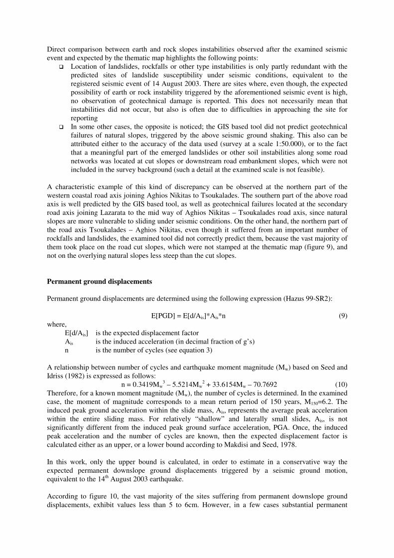
According to figure 10, the vast majority of the sites suffering from permanent downslope ground
displacements, exhibit values less than 5 to 6cm. However, in a few cases substantial permanent
displacements exceeding 10cm are expected, whereas in some rare cases they might reach extreme
values of about 30cm or even more. Nevertheless, important landslides where the GIS tool, along the
western coastal road axis, joining Tsoukalades – Aghios Nikitas, should predict induced downslope
permanent displacements, are missing for the reasons presented previously. Also, the western and
southwestern coastal part of the island that suffered an important number of landslides, rockfalls and
scree deposits at the toe of the slope, presents a very low number of estimated permanent downslope
displacements. This might be explained by the fact that a lot of landslides took place in a very shallow
way, throughout a weathered zone of a few meters, where the mechanical properties of the rockmass
were seriously degraded compared to the geologic group where they have been originally classified.
In that way, the GIS tool prediction corresponded to the expected permanent displacements for a
sound rockmass, such as an unweathered thick-bedded limestone, whilst the sliding in reality occurred
in the superficial weathered zone of the above rockmass. This kind of details might prove to be crucial
for a correct geotechnical failure prediction, and definitely demand a more elaborated approach of the
subject, by implementation of an improved methodology.
Figure 10 Upper bound for expected permanent ground downslope displacements for “shallow”
landslides triggered by a seismic event of a mean return period of approximately 150 years,
equivalent to the one of 14th
August 2003
CONCLUSIONS
A methodological approach essentially designated by HAZUS, to estimate potential geotechnical
earthquake hazards under static and seismic conditions is implemented on a GIS platform, based on a
probabilistic seismic hazard scenario simulating the seismic ground motion of the earthquake of 14th
August 2003 that stroke the island of Lefkada. The reliability of the aforementioned computational
tool, is evaluated via direct comparison of expected to observed geotechnical losses, reported after the
earthquake that stroke the island of Lefkada at the 14th of August 2003.
Liquefaction hazards, as well as side phenomena, such as lateral spreading and dynamic settlements
are quite satisfactory estimated by the above tool, based on a probabilistic seismic hazard scenario
equivalent to the real seismic event that stroke Lefkada island. The methodological approach
implemented, even though relative crude, proved to be suitable and reliable for the construction of
relevant thematic maps depicting the above hazards in a both qualitative and quantitative way, for the
requirements imposed by a regional scale of 1:50.000.
On the other hand, assessment of susceptibility for “shallow” landslides and permanent ground
displacements triggered by the examined earthquake has been only partially successful, since decisive
details could not be reported, due to the regional scale used. Landslides on cut slopes and road
embankment slopes, even though quite numerous, could not be successfully predicted by the
evaluated GIS based computational tool, since neither the former, nor the latter could be reported on
the thematic maps produced. Concluding, geotechnical losses can be fairly enough predicted by the
above tool at a regional scale, at least for a meaningful number of cases. However, for a more detailed
study at a greater scale, a more elaborated tool needs to be designed and implemented for detailed and
accurate prediction of expected geotechnical hazards, along road network and lifelines for engineering
purposes.
AKNOWLEDGEMENTS
The financial support from the European Union and the General Secretary of Research of Greece
(EPAN-DP24 / X-SOILS research project) is gratefully acknowledged.
REFERENCES
1. Benetatos, C., Kiratzi, A., Roumelioti Z., Stavrakakis, G., Drakatos, G. and Latousakis, I.,
(2005). “The 14 August 2003 Lefkada Island (Greece) earthquake: Focal mechanisms of the
mainshock and of the aftershock sequence”. Journal of Seismology, 9, 171-190.
2. Cornell, C.A., (1968). “Engineering seismic risk analysis”. Bull Seism. Soc. Am., 58, 1583-1606.
3. Dimitriou, P, Kalogeras, and Theodulidis, N. (1999). “Evidence of non-linear site response in
horizontal - to - vertical spectral ratio from near-filed earthquake”, Soil Dyn. & Earthquake
Eng., 18, 423-435.
4. HAZUS 99 (SR2), Technical Manual, Chapter 4: Potential Earth Seismic Hazard (PESH), 1999.
5. Karakostas, V.G., Papadimitriou, E.E. and Papazachos, C.B., (2004). “Properties of the 2003
Lefkada, Ionian Islands, Greece, earthquake seismic sequence and seismicity triggering”,
Bull. Seismol. Soc. Am. 94, 1976-1981.
6. Makdisi, F. I. and Seed, H. B., 1978. “Simplified procedure for estimating dam and embankment
earthquake-induced deformations”, Journal of the Geotechnical Engineering Division, ASCE,
vol 104, No GT7, July, pp.849-867.
7. Margaris, B., C. Papaioannou, N Theodulidis, A Savvaidis, A Anastasiadis, A., Klimis, N.,
Makra K., Demosthenous, M., Karakostas, C., Lekidis, V., Makarios T., Salonikios, T., Sous,
I., Carydis, P., Lekkas, E., Lozios, S., Skourtsos, E. and Damanos, G. (2003). “Preliminary
observations on the August 14, 2003, Lefkada Island (Western Greece) Earthquake”, EERI,
Special Earthquake Report, Nov. 2003.
8. NIBS National Institute of Buildings Sciences, (1999). “HAZUS: Earthquake Loss Estimation
Methodology”, Technical Manuals I, II, & III, prepared for the Federal Emergency
Management Agency, Washington, D.C.
9. Papadopoulos, G. A., Karastathis, V., Ganas, A., Pavlides, S., Fokaefs, A., and Orfanogiannaki,
K. (2003), “The Lefkada, Ionian Sea (Greece), shock (Mw=6.2) of the 14 August 2003:
Evidence for the characteristic earthquake from seismicity and ground failures”, Lett. Earth
Planets Space, 55, 713-718.
10. Papazachos B., and Papazachou C. (2003). “The earthquake in Greece”, Ziti Editions Co., 286
pp. (in Greek).
11. Papathanassiou, G., Pavlides, Sp., Christaras, B.and Pitilakis, K., “Liquefaction phenomena
triggered by the earthquake of August 14, 2003, in the island of Lefkada, Greece”,
Proceedings of the 10th Int. Congress, p. 1796-1805, Thessaloniki, Greece, April 2004 (in
Greek).
12. Risk Engineering Inc., (1995). FRISK88M: User’s Manual.
13. Seed, H. B. and Idriss, I. M., 1982. “Ground motions and soil liquefaction during earthquakes”,
EERI, Oakland, California, Monograph Series, p.13.
14. Skarlatoudis, A.A., Papazachos C.B., Margaris B.N., Theodulidis N., Papaioannou Ch.,
Kalogeras I., Scordilis E.M. and Karakostas V., (2003). “Empirical peak ground-motion
predictive relations for shallow earthquakes in Greece”. Bull Seismol. Soc. Am., 93, 2591-
2603.
15. Youd, T. L. and Perkins, D. M., (1987). “Mapping of liquefaction induced ground failure
potential”, Journal of the Geotechnical Engineering Division, American Society of Civil
Engineers, vol. 118, no 11, p. 1374-1392.
16. Wilson, R. C., and Keefer, D. K., (1985) “Predicting areal limits of earthquake-induced
landsliding, evaluating earthquake hazards in the Los Angeles Region”, USGS Professional
Paper, Ziony, J. I., Editor, pp. 317-493.
17. Zahradnik, J., Serpetsidaki, A., Sokos, E., and G-A. Tselentis, (2005). “Iterative deconvolution of
regional waveforms and a double-event interpretation of the 2003 Lefkada earthquake”,
Greece, Bull. Seism. Soc. Am., 95, 159-172.