Embed Size (px)
Citation preview
GGeeooJJoouurrnnaall ooff TToouurriissmm aanndd GGeeoossiitteess Year IIVV no.2, vol. 8, NNoovveemmbbeerr 22001111,, pppp.. 228811--229944ISSN 22006655--00881177, E-ISSN 22006655--11119988 Article no. 0088111122--110000
http://gtg.webhost.uoradea.ro/
GEOTOURISM ROUTES IN URBAN AREAS: A PRELIMINARY APPROACH TO THE LISBON GEOHERITAGE SURVEY
MMaarriiaa LLuuííssaa RODRIGUES* Geographic Studies Centre, Lisbon University (CEG-UL), TERRITUR and Research Group on Geodiversity, Geotourism and Geomorphologic Heritage (GEOPAGE), Portuguese Association of Geotourism (APGeotur),
e-mail: [email protected]
CCaarrllooss RRuussssoo MMAACCHHAADDOO
Science and Technology Research Institute of Atlantica University, Research Centre for Global Change Portuguese Association of Geotourism (APGeotur), e-mail: [email protected]
EElliissaabbeettee FFRREEIIRREE
Research Centre for Architecture, Urban Studies and Design (CIAUD), Faculty of Architecture-Technical University of Lisbon (FA-UTL), Portuguese Association of Geotourism (APGeotur), e-mail: [email protected]
Abstract: Geodiversity and geoheritage, which is the base to the establishment of Geotourism routes, are best preserved in rural areas (where natural heritage was not yet destroyed by human intervention). However, many urban areas have preserved quite interesting examples of geoheritage. Urban geoheritage can and must be known and promoted, by setting up geotourism routes for national and foreign visitors. The value that these geotourism routes add to the common tourist guides may represent a precious asset to a segment of tourists increasingly interested on the integration of natural heritage and other types of heritage, and may contribute to the growth of national tourism industry. In this paper the basic conceptualization it will best set and applied to Lisbon Metropolitan Area and, as a still preliminary approach, to the Lisbon city itself. Key words: Geoheritage, Geotourism, Urban Geotourism, Lisbon Metropolitan Area, Lisbon city
* * * * * *
INTRODUCTION Nowadays, most of the population lives within urban centres, moving away from
the natural environments. Whereas people just love and preserve what they know and value, it is difficult to stimulate the urban population to fully appreciate the richness and diversity of natural resources in our country.
Among these resources, it is our aim to emphasize the landscape georesources and the geomorphologic, geologic and hydrologic heritages which are so common and of a rare beauty on the most rural areas of Portugal mainland, as well as, at the Islands of Madeira and Azores. * Corresponding author
Maria Luísa RODRIGUES, Carlos Russo MACHADO, Elisabete FREIRE
282
Thus, it is important to know the concepts of Geodiversity, Geoheritage and Geotourism, in order to safeguard and to promote the non biologic (or abiotic) natural heritage, and to understand how this valorisation may contribute to the sustainable regional development.
Geodiversity is the set of natural abiotic elements (geologic, geomorphologic, pedologic, hydrologic, scenic, etc.) that exists on a certain territory or region.
The higher the amount of these elements within a certain area, the larger is the existent geodiversity (Rodrigues and Fonseca, 2008). Serrano and Ruiz-Flaño (2007) present a summary table of the elements they consider to be geodiversity and consider that the most integrated vision of it is the one presented by Kozlowski (2004).
From the point of view of the establishment of urban tourist routes we are much more interested on the concept of Geoheritage, i.e., on the representative values of the geodiversity of a certain territory. According to Rodrigues and Fonseca (2008), geoheritage consists on the entire set of abiotic natural elements existing on the Earth's surface (emerged and submerged), which should be preserved due to its heritage value. Thus, geoheritage includes the geologic, geomorphologic, pedologic, hydrologic, scenic (etc) heritages.
In fact, this is the geoheritage notion, and its territorial patterns, which, after identification, classification, inventory and assessment, geotourism intends to promote as it will be discussed on the following topic.
URBAN GEOHERITAGE AND GEOTOURISM Most of the references on geoheritage and geotourism are related to non-urban
areas. However, there are also geoheritage within the urban areas and so it is possible to do urban geotourism.
In Portugal, the studies that were undertaken by Professor Galopim de Carvalho must be enhanced because of their importance on the dissemination and promotion of the national geoheritage. Although, among the Portuguese population it is best known his work related to the dinosaurs evidences (trails, skeletons, eggs etc), his main contribution, in this research field, was focused on the study and classification of what he designated as geomonuments. Some of these geomonuments, usually of a geologic type (as Galopim de Carvalho is a sedimentologist), were identified in Lisbon and he was able to make them to be classified and protected (Galopim de Carvalho, 1999; Câmara Municipal de Lisboa, 2009).
On an international level, it is relevant to mention the initiatives undertaken by the city of Montreal that, in 2007, became the first urban centre to sign the Geotourism Charter of National Geographic Society. This Charter, which includes 13 principles, focused on sustainable development, aims to support tourism that sustains or enhances the geographical character of a place, i.e., its environment, culture, aesthetics, heritage, and the well-being of its residents. In fact, as it is worldwide known, this is the definition of Geotourism advocated by the National Geographic Society's Center for Sustainable Development. Therefore, it is obvious that the director of the National Geographic, Jonathan Tourtellot, was the great mentor of this initiative, as well as, of the patronage and the dissemination of the Montreal Map Guide.
Among the scientific meetings promoted by the IAG (International Association of Geomorphologists) Working Group “Geomorphosites”, at the conference that was held in Lisbon (ICGG 2010), there were two presentations that were directly concerned to the urban Geoheritage and Geotourism (Pinto et al., 2010 and Rodrigues et al., 2010). In the first one has set out an assessment of the Lisbon city preserved geologic heritage. The second case was dedicated to the study of the issues that we are developing on the present paper and that are mainly related to the geoheritage: the geomorphologic heritage and the important geotourism assets not only of the Lisbon region, but also of the city itself.
Geotourism Routes in Urban Areas: A Preliminary Approach to Lisbon Geoheritage Survey
283
However, there is not yet an agreement about the concept of urban tourism. The very concept of geotourism is quite recent and it is a denomination that has appeared only at the beginning of the 1990’s. Even though, it is often erroneously confused with other types of tourism such as the nature tourism, which it is geared to the wildlife, or the ecotourism, that in its most pure format aims the untouched nature by humans in order to watch their flora and fauna.
Geotourism is a segment of tourism that some confuse with geological tourism, as “geo” would be synonymous with geological rather than Earth… One of the pioneers of the modern concept of geotourism was Hose (1995, see also 2005), who has described it as “…the provision of interpretive and service facilities to enable tourists to acquire knowledge and understanding of the geology and geomorphology of a site (including its contribution to the development of the Earth sciences) beyond the level of mere aesthetic appreciation…” (Hose, 1995, pp. 17). In the same tone Newsome and Dowling (2005) say that “…in our definition of geotourism the «geo» part pertains to geology and geomorphology and the natural resources of landscape, landforms, fossil beds, rocks and mineral, with emphasis on appreciating the processes that are creating and created such features…” (Newsome and Dowling, 2005: 3).
For us these definitions are still somewhat restrictive. While referring the geosites, which are the sites that represent the geoheritage, and in which Hose has worked on, related to the geologic and geomorphologic heritage, these definitions do not encompass other abiotic values like those of hydrology or soils (Rodrigues and Fonseca, 2008, 2009; Rodrigues, 2009a, 2009b). Therefore, we argue that the concept of geotourism must be considered both in broad and in strict senses (Rodrigues, 2009b, 2011).
In strict sense, geotourism is a tourism segment focused on the sustainable usufruct (by geotourists and local communities) of the geoheritage fruition.
Geoheritage must be considered here as defined by Rodrigues and Fonseca (2008, 2009 a): “…all the natural abiotic elements present in the Earth surface, emerged or submerged (representing the geodiversity of the Earth), that should be preserved due to its heritage value. So, geoheritage includes all types of abiotic heritage: from geology (fossils, minerals, structures, sediments, etc.), from geomorphology (landforms, correlative deposits, landscapes, etc.), from hydrology (sources, rivers, hydrographic basins, karst hydrology, etc.), from soil science (palaeo-soils, “pedosites”, etc.) or other types of heritage…”.
In broad sense, geotourism can be considered as a tourism segment mainly focused on the sustainable usufruct (by geotourists and local communities) of the geoheritage fruition, which can be added the cultural heritage (material and immaterial) of the areas. In this sense geoheritage is the driving force of the geotourism itineraries, but the cultural heritage it is also added to increase the value of the visited regions. This broad concept of geotourism strengthens its ability as an additional resource to be included in a sustainable model of promotion and development of areas that preserve a rich and diversified heritage.
Using these definitions of geotourism to urban environments we will obtain quite different amounts of data in the inventory of the urban sites. With the first definition the inventory sheets will be filled by all the urban geosites (geological geosites, geomorphologic ones, as well as hydrologic and pedologic geosites). Using the second definition we have to add also the principal elements of the cultural heritage (material and immaterial), such as principal monuments (with historical data and geological data related to the building materials), museums, gastronomic heritage, tourist information, etc.
At the present study, we are only working in the inventory of the data available to fulfil the definition of geotourism in strict sense, i.e., doing the inventory of the urban geoheritage.
Maria Luísa RODRIGUES, Carlos Russo MACHADO, Elisabete FREIRE
284
GEOTOURISM POTENTIALITIES IN LISBON METROPOLITAN AREA The Lisbon Metropolitan Area1 has, in the 18 municipalities that comprise it, urban
and rural areas with a vast potential in Geotourism terms, either in the strict or in the broad sense.
With a population of over 2.8 million inhabitants, the Lisbon Metropolitan Area (AML) is the largest urban agglomeration of Portugal, concentrating about 27% of its population in less than 1% of the national territory; but its influence clearly goes beyond its administrative boundaries.
However, far from being a homogeneous urbanised region, AML is the result of the overlapping elements of rural and urban landscapes, which are often linked trough a conflictuous way, with urban fabric, more or less dense and continuous, sprawling over the non-urban land, forming a mosaic that encompasses coastal, mountain or bottom valley areas, where the agricultural or forest spaces allocated to production or conservation denote very different levels of human intervention. Nevertheless, this mosaic equally reveals a potential for complementary relationships of these land cover types, in which the biotic natural heritage and the geoheritage can play an important role, both for the environmental management and for the metropolitan area economy as tourist attraction factors.
Although the ex-ante assessment included in the Operational Programme of the Lisbon and Tagus Valley region2 (CCDR-LVT, 2002) does not leave any doubts about some of the problems that, on the point of view of the environmental and landscape quality, stand up at the AML; this document also makes clear that despite this urban sprawl, the region presents still unique natural and heritage conditions whose potentialities for tourism and leisure in natural and rural areas should be developed (CCDR-LVT, 2002, pp. 231).
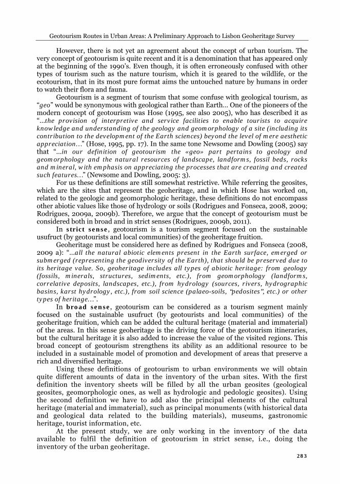
From the point of view of the Lisbon Metropolitan Area geoheritage, it is important to highlight the existence of certain elements, where geoheritage and cultural heritage (material and immaterial) come together to provide significant geotourism potentialities. Next, we are going to point out the most significant ones which are located in figure 1.
Natural Parks According to the Legal Framework for Nature Conservation and Biodiversity, national
parks are areas containing predominantly representative samples of distinctive natural regions, of natural and humanized landscapes, of elements of biodiversity and geosites with scientific, ecological or educational value (Decree-Law No. 142/2008 of 24 July).
In the Lisbon Metropolitan Area there are two national parks (figure 1): The Natural Park of Sintra-Cascais3 (Nº 1 of figure 1) was established with
the aim of protecting geomorphologic features, flora and landscape of an area subject to intense urban pressure. In this area there is a strong relationship with the cultural landscape, which led, in 1994, to the classification of part of the natural park in the UNESCO List of World Heritage Sites in the category of “Cultural Landscape”.
This natural park includes the Serra de Sintra, a magmatic massif that intruded the Mesozoic sedimentary formations, in which are carved the coastal platforms of São João das Lampas, to the north, and of Cascais to the south of the mountain. 1 The Lisbon Metropolitan Area, as a public collective person of associative nature and territorial scope, was
established in 2003 (under Law 10/2003 of May 13) being provided with three bodies: the Metropolitan Board, the executive body, the Metropolitan Assembly, the deliberative body, and the Metropolitan Council, an advisory body;
2 The Operational Programme of the Lisbon and Tagus Valley region is based on the Development Strategy for the Lisbon and Tagus Valley Region, which was prepared as part of the National Plan of Economic and Social Development (PNDES);
3 Established by the Regulatory Decree No.8/94, of March 11 that reclassified the Sintra-Cascais Protected Landscape Area established in 1981;
Geotourism Routes in Urban Areas: A Preliminary Approach to Lisbon Geoheritage Survey
285
Figure 1. Protected areas in Lisbon Metropolitan Area
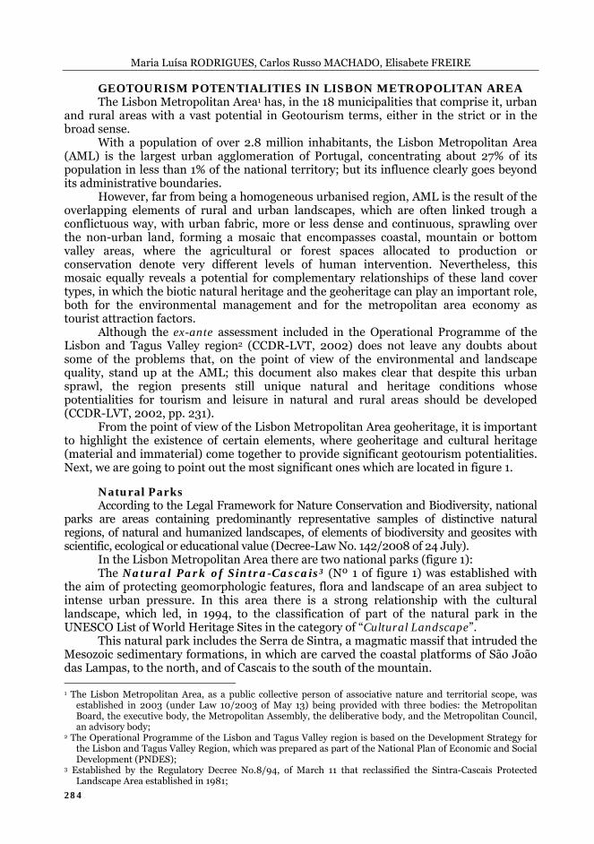
(Source: based on Caetano et al., 2008; APA, 2003) From the geotourism point of view it should be stressed the great interest for
observation of magnificent examples of granite morphology (figure 2), as is the case of inselbergs, castle koppies, nubbins or granite blockfields, apart from anthropomorphic or zoomorphic figures (Levratti et al., 2011). Furthermore, there is a particular geoheritage interest in areas located in the metamorphic aureole (contact of the magmatic massive with the sedimentary formations), the active dune systems of Guincho-Cresmina, the Oitavos hill formed by a consolidated paleo sand-dune, the manifestations of volcanic activity expressed in dykes and resulting morphology visible in the coastal cliffs, etc. In addition, the existing cultural heritage, including the level of concentration of palaces and lush gardens, gives an understanding of the ways human occupation relate to the physical environment.
The Natural Park of Arrábida4 (Nº 2 of figure 1) was established in order to protect the values of geology, flora, fauna and scenic locations as well as material evidence of cultural and historical significance.
This natural park, located on the Setúbal Peninsula, is formed by the Arrábida ridge that stretches for about 35km, with a general direction ENE-WSW, carved in limestone that were folded into an anticline faulted structure. The western sector of this natural park encompasses the coastal platform of Cape Espichel, a high marine abrasion surface.
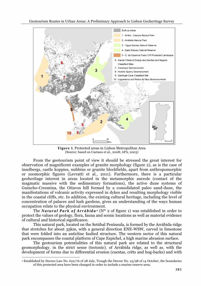
The geotourism potentialities of this natural park are related to the structural geomorphology, in the strict sense (tectonic), of Arrábida ridge, as well as, with the development of forms due to differential erosion (cuestas, crêts and hog-backs) and with 4 Established by Decree-Law No. 622/76 of 28 July, Trough the Decree No. 23/98 of 14 October, the boundaries
of this protected area have been changed in order to include a marine reserve area;
Maria Luísa RODRIGUES, Carlos Russo MACHADO, Elisabete FREIRE
286
the dissolution of limestone (karst morphology, figure 3). There are several viewpoints where one can admire the landscape and understand the relationships between the geological structure and landforms. In addition, in some viewpoints along the coastline, it is possible to identify the large escarpments of the coastal cliffs of Cape Espichel and the steep slopes of the southern coast of the Setúbal Peninsula.
Figure 2. Granite landform (castle koppie) in
Sintra Mountain (Source: Diogo Florindo and Rogério Santos)
Figure 3. Stalactites and stalagmites (Arrábida cave)
(Source: Francisco Rasteiro)
Protected Landscapes According to the Legal Framework for Nature Conservation and Biodiversity, it is
considered as “protected landscape” an area containing landscapes resulting from the harmonious interaction of man and nature, and which show great aesthetic, ecological or cultural value (Decree Law No. 142/2008 of 24 July).
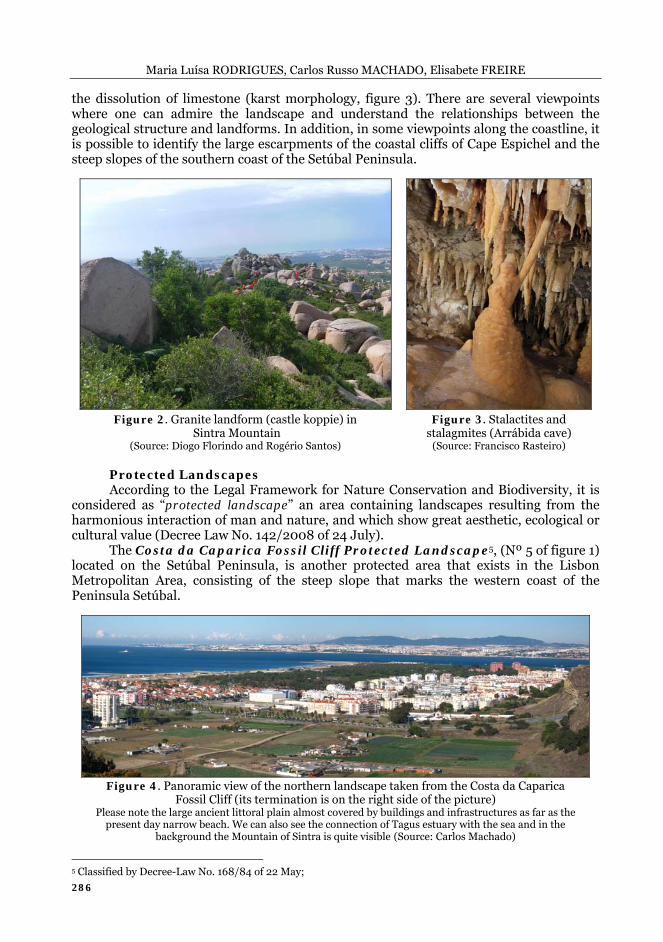
The Costa da Caparica Fossil Cliff Protected Landscape5, (Nº 5 of figure 1) located on the Setúbal Peninsula, is another protected area that exists in the Lisbon Metropolitan Area, consisting of the steep slope that marks the western coast of the Peninsula Setúbal.
Figure 4. Panoramic view of the northern landscape taken from the Costa da Caparica Fossil Cliff (its termination is on the right side of the picture)
Please note the large ancient littoral plain almost covered by buildings and infrastructures as far as the present day narrow beach. We can also see the connection of Tagus estuary with the sea and in the
background the Mountain of Sintra is quite visible (Source: Carlos Machado)
5 Classified by Decree-Law No. 168/84 of 22 May;
Geotourism Routes in Urban Areas: A Preliminary Approach to Lisbon Geoheritage Survey
287
Some viewpoints located near the northern end of the fossil cliff give an overview of the coastal platform, the limits of the scarp to the west and the coastal plain (figure 4). In addition, it is possible to understand the relationships established with the human settlement, particularly in terms of vulnerability to wide variety of environmental risks, mainly those related to the erosion of the coastline.
Nature Reserves The Legal Framework for Nature Conservation and Biodiversity (Decree-Law No.
142/2008 of 24 July) sets out the nature reserves, whilst a type of protected area regional or local scope, as areas containing ecological, geological and physiographical characteristics or other type of aspects with scientific, ecological or educational value, and which are not inhabited on a permanent or significant manner.
In the Lisbon Metropolitan Area, the estuaries of Tagus and Sado Rivers were classified as nature reserves (figure 1). These two reserves have a similar geotourism potentiality, related to the fact that both are coastal wetlands, making the transition between river environments and ocean environments, resulting in dynamic ecosystems, with high primary productivity and high vulnerability due to the strong anthropogenic pressures they are subject. In addition, it is visible the potential for observation and understanding of the phenomena related to the transport and accumulation of sediments, the variation of the tide, the evolution of the coastline and the changes in sea level.
The Tagus Estuary Nature Reserve6 (Nº 3 of figure 1) covers an area of about 14,000 hectares consisting of a large area of estuarine waters, muddy fields, islets, marshes, salt marshes and agricultural land. However, the areas adjoining to the Tagus River estuary also have a large population density, being this nature reserve subject to significant anthropogenic pressures related, namely, to harbour activities, occupation of the riverside and discharge of domestic sewage.
The Tagus estuary is the most extensive wetland in the country and presents a high biological and ecological value expressed on the great biodiversity and diversity of habitats. In addition, it should also be stressed its importance as habitat for migratory birds.
The geotourism potentialities of this nature reserve is related not only to the occurrence of larges floods in this sedimentation basin, but also to the existence of marshland, in particular the Marshland of Corroios, which play an important role as bio-accumulator of pollutants resulting from its self-purification capacity which operates in the removal and recycling of inorganic nutrients (Canário, et al., 2007).
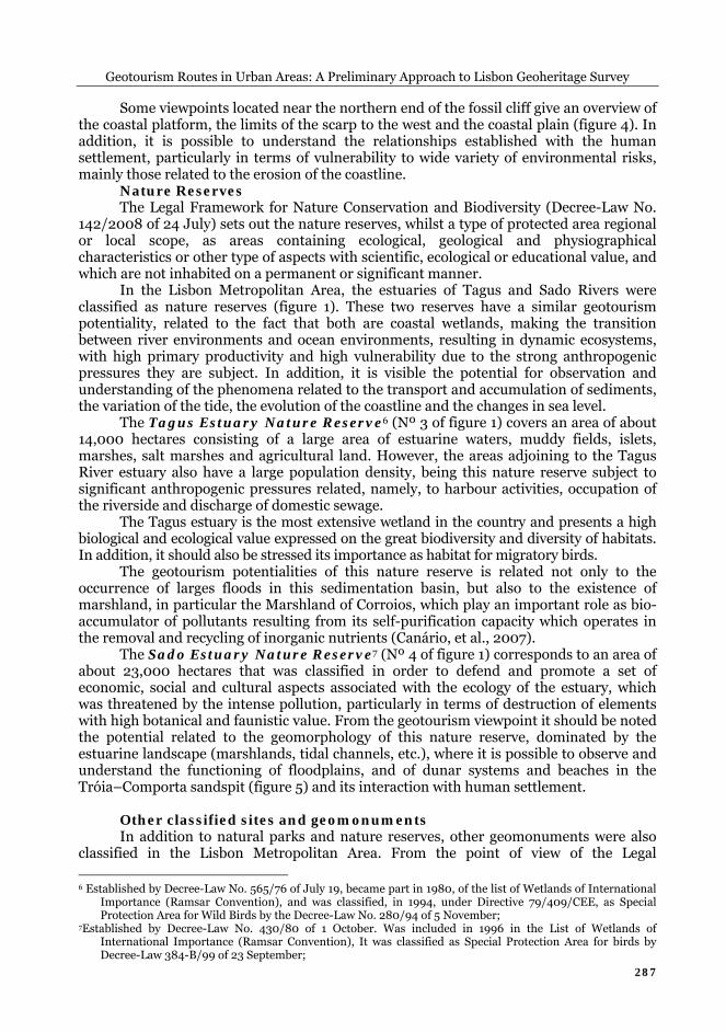
The Sado Estuary Nature Reserve7 (Nº 4 of figure 1) corresponds to an area of about 23,000 hectares that was classified in order to defend and promote a set of economic, social and cultural aspects associated with the ecology of the estuary, which was threatened by the intense pollution, particularly in terms of destruction of elements with high botanical and faunistic value. From the geotourism viewpoint it should be noted the potential related to the geomorphology of this nature reserve, dominated by the estuarine landscape (marshlands, tidal channels, etc.), where it is possible to observe and understand the functioning of floodplains, and of dunar systems and beaches in the Tróia–Comporta sandspit (figure 5) and its interaction with human settlement.
Other classified sites and geomonuments In addition to natural parks and nature reserves, other geomonuments were also
classified in the Lisbon Metropolitan Area. From the point of view of the Legal
6 Established by Decree-Law No. 565/76 of July 19, became part in 1980, of the list of Wetlands of International
Importance (Ramsar Convention), and was classified, in 1994, under Directive 79/409/CEE, as Special Protection Area for Wild Birds by the Decree-Law No. 280/94 of 5 November;
7Established by Decree-Law No. 430/80 of 1 October. Was included in 1996 in the List of Wetlands of International Importance (Ramsar Convention), It was classified as Special Protection Area for birds by Decree-Law 384-B/99 of 23 September;
Maria Luísa RODRIGUES, Carlos Russo MACHADO, Elisabete FREIRE
288
Framework for Nature Conservation and Biodiversity (Decree-Law No. 142/2008 of July 24) these sites correspond to areas containing one or more specific natural features which, by their uniqueness, rarity or representativeness in ecological, aesthetic, scientific and cultural terms, require preservation and maintenance of its integrity.
The Carenque Geomonument (Nº 7 of figure 1) was created8 in order to preserve and enhance a set of one hundred dinosaur footprints from the beginning of the Upper Cretaceous (with an age estimated at 90 to 95 million years) align along a track of almost 130 meters, discovered in 1986 in a inactive quarry.
The Lagosteiros, Pedra da Mua e Pedreira do Avelino Geomonuments, located at the Natural Park of Arrábida (Nº 10 and 8 of figure 1), were created9 in 1997 aiming at preserving and enhancing the tracks of dinosaur footprints located therein, which constitute one of the most important sets of paleontologic occurrences in Portugal, dating from the Late Jurassic to Early Cretaceous.
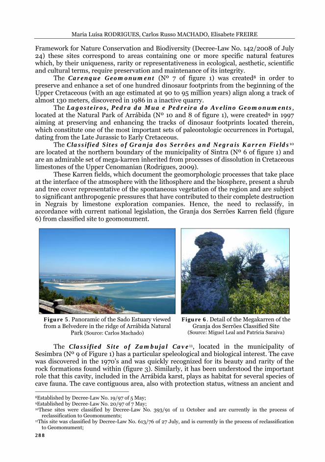
The Classified Sites of Granja dos Serrões and Negrais Karren Fields10 are located at the northern boundary of the municipality of Sintra (Nº 6 of figure 1) and are an admirable set of mega-karren inherited from processes of dissolution in Cretaceous limestones of the Upper Cenomanian (Rodrigues, 2009).
These Karren fields, which document the geomorphologic processes that take place at the interface of the atmosphere with the lithosphere and the biosphere, present a shrub and tree cover representative of the spontaneous vegetation of the region and are subject to significant anthropogenic pressures that have contributed to their complete destruction in Negrais by limestone exploration companies. Hence, the need to reclassify, in accordance with current national legislation, the Granja dos Serrões Karren field (figure 6) from classified site to geomonument.
Figure 5. Panoramic of the Sado Estuary viewed from a Belvedere in the ridge of Arrábida Natural
Park (Source: Carlos Machado)
Figure 6. Detail of the Megakarren of the Granja dos Serrões Classified Site
(Source: Miguel Leal and Patrícia Saraiva) The Classified Site of Zambujal Cave11, located in the municipality of
Sesimbra (Nº 9 of Figure 1) has a particular speleological and biological interest. The cave was discovered in the 1970’s and was quickly recognized for its beauty and rarity of the rock formations found within (figure 3). Similarly, it has been understood the important role that this cavity, included in the Arrábida karst, plays as habitat for several species of cave fauna. The cave contiguous area, also with protection status, witness an ancient and 8Established by Decree-Law No. 19/97 of 5 May; 9Established by Decree-Law No. 20/97 of 7 May; 10These sites were classified by Decree-Law No. 393/91 of 11 October and are currently in the process of
reclassification to Geomonuments; 11This site was classified by Decree-Law No. 613/76 of 27 July, and is currently in the process of reclassification
to Geomonument;
Geotourism Routes in Urban Areas: A Preliminary Approach to Lisbon Geoheritage Survey
289
diverse human presence, in addition to a strong pressure exerted by the owners of the limestone quarries that, due to the use of explosives, have already produced considerable damage in the cave formations.
CONTRIBUTION TO A GEOTOURIM ROUTE IN LISBON From the set out in the previous section, it can be seen that the Lisbon
Metropolitan Area has an enviable geoheritage wealth when compared to other European (or even world) metropolitan areas. The city of Lisbon also preserves traces of a diverse morphology typical of the right bank of the Tagus estuary.
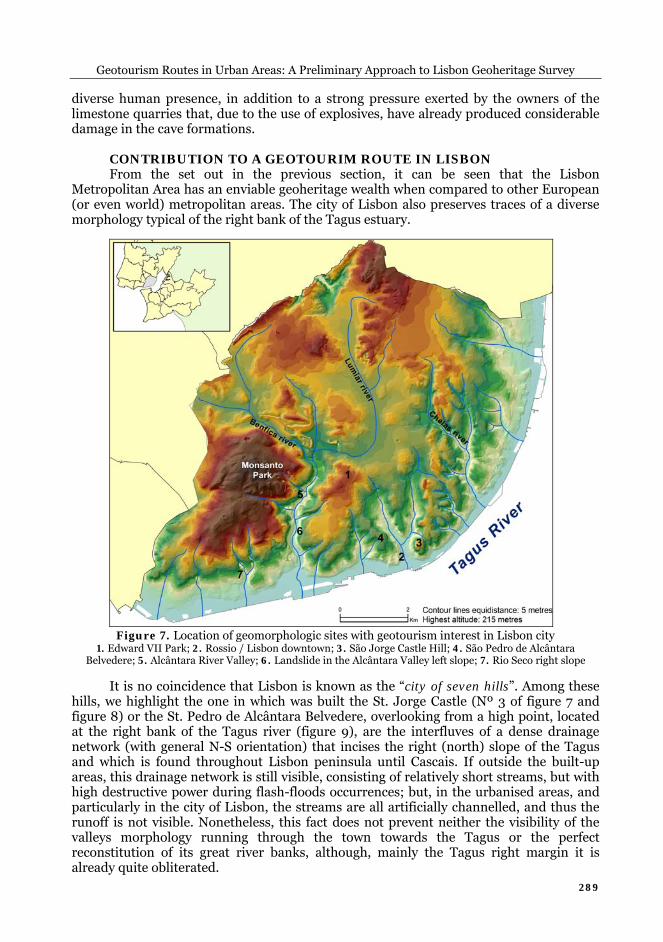
Figure 7. Location of geomorphologic sites with geotourism interest in Lisbon city 1. Edward VII Park; 2. Rossio / Lisbon downtown; 3. São Jorge Castle Hill; 4. São Pedro de Alcântara
Belvedere; 5. Alcântara River Valley; 6. Landslide in the Alcântara Valley left slope; 7. Rio Seco right slope It is no coincidence that Lisbon is known as the “city of seven hills”. Among these
hills, we highlight the one in which was built the St. Jorge Castle (Nº 3 of figure 7 and figure 8) or the St. Pedro de Alcântara Belvedere, overlooking from a high point, located at the right bank of the Tagus river (figure 9), are the interfluves of a dense drainage network (with general N-S orientation) that incises the right (north) slope of the Tagus and which is found throughout Lisbon peninsula until Cascais. If outside the built-up areas, this drainage network is still visible, consisting of relatively short streams, but with high destructive power during flash-floods occurrences; but, in the urbanised areas, and particularly in the city of Lisbon, the streams are all artificially channelled, and thus the runoff is not visible. Nonetheless, this fact does not prevent neither the visibility of the valleys morphology running through the town towards the Tagus or the perfect reconstitution of its great river banks, although, mainly the Tagus right margin it is already quite obliterated.
Maria Luísa RODRIGUES, Carlos Russo MACHADO, Elisabete FREIRE
290
Figure 8. São Jorge Castle Hill view from the
floor valley in the Martim Moniz Square (Source: Carlos Machado)
Figure 9. Panoramic view of the city taken from the Torel Garden belvedere
(Source: Carlos Machado) The Tagus river presents at the final sector of its estuary a large alluvial plain
dotted with marshes and islets that are included on the Tagus Estuary Nature Reserve, as it can be seen in figure 1. However, this same figure allows also to see that the Tagus river mouth is marked by a narrow passage, called the “Gargalo do Tejo” (neck of the Tagus) which is conditioned by tectonics. Thus, from the low and flooded alluvial plain, Tagus river reaches the ocean trough a gorge defined by two steep slopes very well-marked in the morphology: the right bank, in which the old city was built, with the buildings and infrastructures gradually occupying not only the hills and the river bank, but also the actual thalweg through land reclamation (figure 10); the left margin until today slightly urbanized and still maintaining their rectilinear and abrupt appearance (figure 11).
Figure 10. Steep slope of the Tagus right margin, in
the Rocha do Conde d’Óbidos area Notice how the stairway allows the communication from the
top to the bottom of the slope (Source: Carlos Machado)
Figure 11. Steep slope of the Tagus River left margin
Notice how this bank is relatively free of constructions (Source: Elisabete Freire)
With regard to the valleys that, going through the city of Lisbon, incise the right
bank towards the Tagus, its artificial channelling never stopped raising hydrologic problems in the city. In fact, all the tributaries of this right margin have a hydrologic regime featured by the occurrence of flash-floods, which is associated with very short stormwater time of concentration, in periods of intense and concentrated rainfall; this heavy precipitation may occur between November and March. These times of concentration have decreased significantly and proportionally to the urbanization of their watersheds, as shown by studies in the tributaries of the right bank located at the west of the city of Lisbon until Cascais. This is naturally associated with increasing soil sealing as a result of the buildings and streets, joining the other ever-present factor in this entire
Geotourism Routes in Urban Areas: A Preliminary Approach to Lisbon Geoheritage Survey
291
river margin related to the difficulties of river flow and rainwater drainage during periods of high tides. The tides are felt throughout the lower stretch of the Tagus visible in figure 1 (justifying the existence of marshes and a rich and diverse flora and fauna); the effect of the tide is deeply marked, at the right margin, which difficult, or even restraints the drainage during flood episodes.
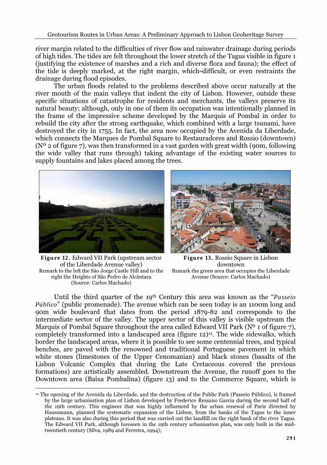
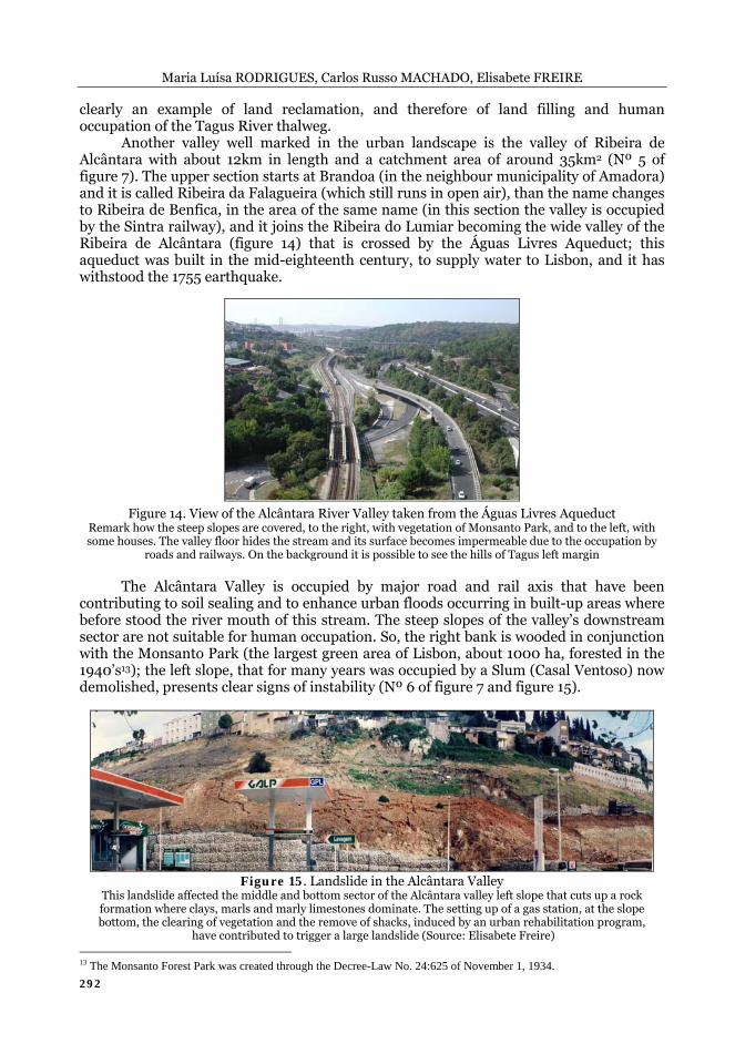
The urban floods related to the problems described above occur naturally at the river mouth of the main valleys that indent the city of Lisbon. However, outside these specific situations of catastrophe for residents and merchants, the valleys preserve its natural beauty; although, only in one of them its occupation was intentionally planned in the frame of the impressive scheme developed by the Marquis of Pombal in order to rebuild the city after the strong earthquake, which combined with a large tsunami, have destroyed the city in 1755. In fact, the area now occupied by the Avenida da Liberdade, which connects the Marques de Pombal Square to Restauradores and Rossio (downtown) (Nº 2 of figure 7), was then transformed in a vast garden with great width (90m, following the wide valley that runs through) taking advantage of the existing water sources to supply fountains and lakes placed among the trees.
Figure 12. Edward VII Park (upstream sector
of the Liberdade Avenue valley) Remark to the left the São Jorge Castle Hill and to the
right the Heights of São Pedro de Alcântara (Source: Carlos Machado)
Figure 13. Rossio Square in Lisbon downtown
Remark the green area that occupies the Liberdade Avenue (Source: Carlos Machado)
Until the third quarter of the 19th Century this area was known as the “Passeio
Público” (public promenade). The avenue which can be seen today is an 1100m long and 90m wide boulevard that dates from the period 1879-82 and corresponds to the intermediate sector of the valley. The upper sector of this valley is visible upstream the Marquis of Pombal Square throughout the area called Edward VII Park (Nº 1 of figure 7), completely transformed into a landscaped area (figure 12)12. The wide sidewalks, which border the landscaped areas, where it is possible to see some centennial trees, and typical benches, are paved with the renowned and traditional Portuguese pavement in which white stones (limestones of the Upper Cenomanian) and black stones (basalts of the Lisbon Volcanic Complex that during the Late Cretaceous covered the previous formations) are artistically assembled. Downstream the Avenue, the runoff goes to the Downtown area (Baixa Pombalina) (figure 13) and to the Commerce Square, which is 12 The opening of the Avenida da Liberdade, and the destruction of the Public Park (Passeio Público), is framed
by the large urbanisation plan of Lisbon developed by Frederico Ressano Garcia during the second half of the 19th century. This engineer that was highly influenced by the urban renewal of Paris directed by Haussmann, planned the systematic expansion of the Lisbon, from the banks of the Tagus to the inner plateaus. It was also during this period that was carried out the landfill on the right bank of the river Tagus. The Edward VII Park, although foreseen in the 19th century urbanisation plan, was only built in the mid-twentieth century (Silva, 1989 and Ferreira, 1994);
Maria Luísa RODRIGUES, Carlos Russo MACHADO, Elisabete FREIRE
292
clearly an example of land reclamation, and therefore of land filling and human occupation of the Tagus River thalweg.
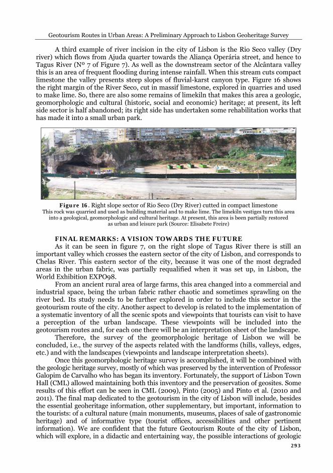
Another valley well marked in the urban landscape is the valley of Ribeira de Alcântara with about 12km in length and a catchment area of around 35km2 (Nº 5 of figure 7). The upper section starts at Brandoa (in the neighbour municipality of Amadora) and it is called Ribeira da Falagueira (which still runs in open air), than the name changes to Ribeira de Benfica, in the area of the same name (in this section the valley is occupied by the Sintra railway), and it joins the Ribeira do Lumiar becoming the wide valley of the Ribeira de Alcântara (figure 14) that is crossed by the Águas Livres Aqueduct; this aqueduct was built in the mid-eighteenth century, to supply water to Lisbon, and it has withstood the 1755 earthquake.
Figure 14. View of the Alcântara River Valley taken from the Águas Livres Aqueduct
Remark how the steep slopes are covered, to the right, with vegetation of Monsanto Park, and to the left, with some houses. The valley floor hides the stream and its surface becomes impermeable due to the occupation by
roads and railways. On the background it is possible to see the hills of Tagus left margin The Alcântara Valley is occupied by major road and rail axis that have been
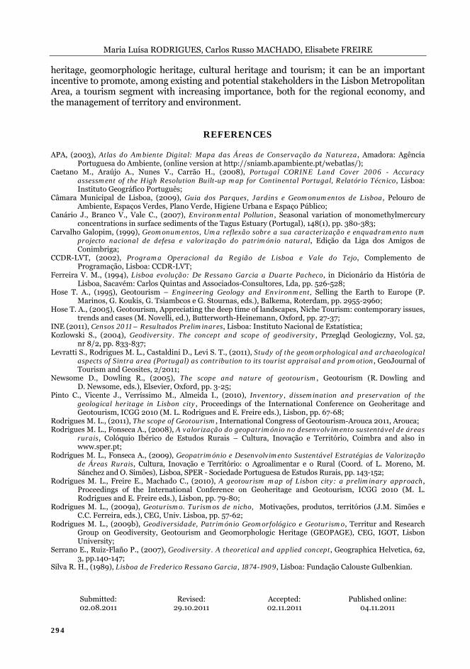
contributing to soil sealing and to enhance urban floods occurring in built-up areas where before stood the river mouth of this stream. The steep slopes of the valley’s downstream sector are not suitable for human occupation. So, the right bank is wooded in conjunction with the Monsanto Park (the largest green area of Lisbon, about 1000 ha, forested in the 1940’s13); the left slope, that for many years was occupied by a Slum (Casal Ventoso) now demolished, presents clear signs of instability (Nº 6 of figure 7 and figure 15).
Figure 15. Landslide in the Alcântara Valley This landslide affected the middle and bottom sector of the Alcântara valley left slope that cuts up a rock formation where clays, marls and marly limestones dominate. The setting up of a gas station, at the slope bottom, the clearing of vegetation and the remove of shacks, induced by an urban rehabilitation program,
have contributed to trigger a large landslide (Source: Elisabete Freire) 13 The Monsanto Forest Park was created through the Decree-Law No. 24:625 of November 1, 1934.
Geotourism Routes in Urban Areas: A Preliminary Approach to Lisbon Geoheritage Survey
293
A third example of river incision in the city of Lisbon is the Rio Seco valley (Dry river) which flows from Ajuda quarter towards the Aliança Operária street, and hence to Tagus River (Nº 7 of Figure 7). As well as the downstream sector of the Alcântara valley this is an area of frequent flooding during intense rainfall. When this stream cuts compact limestone the valley presents steep slopes of fluvial-karst canyon type. Figure 16 shows the right margin of the River Seco, cut in massif limestone, explored in quarries and used to make lime. So, there are also some remains of limekiln that makes this area a geologic, geomorphologic and cultural (historic, social and economic) heritage; at present, its left side sector is half abandoned; its right side has undertaken some rehabilitation works that has made it into a small urban park.
Figure 16. Right slope sector of Rio Seco (Dry River) cutted in compact limestone This rock was quarried and used as building material and to make lime. The limekiln vestiges turn this area
into a geological, geomorphologic and cultural heritage. At present, this area is been partially restored as urban and leisure park (Source: Elisabete Freire)
FINAL REMARKS: A VISION TOWARDS THE FUTURE As it can be seen in figure 7, on the right slope of Tagus River there is still an
important valley which crosses the eastern sector of the city of Lisbon, and corresponds to Chelas River. This eastern sector of the city, because it was one of the most degraded areas in the urban fabric, was partially requalified when it was set up, in Lisbon, the World Exhibition EXPO98.
From an ancient rural area of large farms, this area changed into a commercial and industrial space, being the urban fabric rather chaotic and sometimes sprawling on the river bed. Its study needs to be further explored in order to include this sector in the geotourism route of the city. Another aspect to develop is related to the implementation of a systematic inventory of all the scenic spots and viewpoints that tourists can visit to have a perception of the urban landscape. These viewpoints will be included into the geotourism routes and, for each one there will be an interpretation sheet of the landscape.
Therefore, the survey of the geomorphologic heritage of Lisbon we will be concluded, i.e., the survey of the aspects related with the landforms (hills, valleys, edges, etc.) and with the landscapes (viewpoints and landscape interpretation sheets).
Once this geomorphologic heritage survey is accomplished, it will be combined with the geologic heritage survey, mostly of which was preserved by the intervention of Professor Galopim de Carvalho who has began its inventory. Fortunately, the support of Lisbon Town Hall (CML) allowed maintaining both this inventory and the preservation of geosites. Some results of this effort can be seen in CML (2009), Pinto (2005) and Pinto et al. (2010 and 2011). The final map dedicated to the geotourism in the city of Lisbon will include, besides the essential geoheritage information, other supplementary, but important, information to the tourists: of a cultural nature (main monuments, museums, places of sale of gastronomic heritage) and of informative type (tourist offices, accessibilities and other pertinent information). We are confident that the future Geotourism Route of the city of Lisbon, which will explore, in a didactic and entertaining way, the possible interactions of geologic
Maria Luísa RODRIGUES, Carlos Russo MACHADO, Elisabete FREIRE
294
heritage, geomorphologic heritage, cultural heritage and tourism; it can be an important incentive to promote, among existing and potential stakeholders in the Lisbon Metropolitan Area, a tourism segment with increasing importance, both for the regional economy, and the management of territory and environment.
REFERENCES APA, (2003), Atlas do Ambiente Digital: Mapa das Áreas de Conservação da Natureza, Amadora: Agência
Portuguesa do Ambiente, (online version at http://sniamb.apambiente.pt/webatlas/); Caetano M., Araújo A., Nunes V., Carrão H., (2008), Portugal CORINE Land Cover 2006 - Accuracy
assessment of the High Resolution Built-up map for Continental Portugal, Relatório Técnico, Lisboa: Instituto Geográfico Português;
Câmara Municipal de Lisboa, (2009), Guia dos Parques, Jardins e Geomonumentos de Lisboa, Pelouro de Ambiente, Espaços Verdes, Plano Verde, Higiene Urbana e Espaço Público;
Canário J., Branco V., Vale C., (2007), Environmental Pollution, Seasonal variation of monomethylmercury concentrations in surface sediments of the Tagus Estuary (Portugal), 148(1), pp. 380-383;
Carvalho Galopim, (1999), Geomonumentos, Uma reflexão sobre a sua caracterização e enquadramento num projecto nacional de defesa e valorização do património natural, Edição da Liga dos Amigos de Conimbriga;
CCDR-LVT, (2002), Programa Operacional da Região de Lisboa e Vale do Tejo, Complemento de Programação, Lisboa: CCDR-LVT;
Ferreira V. M., (1994), Lisboa evolução: De Ressano Garcia a Duarte Pacheco, in Dicionário da História de Lisboa, Sacavém: Carlos Quintas and Associados-Consultores, Lda, pp. 526-528;
Hose T. A., (1995), Geotourism – Engineering Geology and Environment, Selling the Earth to Europe (P. Marinos, G. Koukis, G. Tsiambcos e G. Stournas, eds.), Balkema, Roterdam, pp. 2955-2960;
Hose T. A., (2005), Geotourism, Appreciating the deep time of landscapes, Niche Tourism: contemporary issues, trends and cases (M. Novelli, ed.), Butterworth-Heinemann, Oxford, pp. 27-37;
INE (2011), Censos 2011 – Resultados Preliminares, Lisboa: Instituto Nacional de Estatística; Kozlowski S., (2004), Geodiversity. The concept and scope of geodiversity, Przegląd Geologiczny, Vol. 52,
nr 8/2, pp. 833-837; Levratti S., Rodrigues M. L., Castaldini D., Levi S. T., (2011), Study of the geomorphological and archaeological
aspects of Sintra area (Portugal) as contribution to its tourist appraisal and promotion, GeoJournal of Tourism and Geosites, 2/2011;
Newsome D., Dowling R., (2005), The scope and nature of geotourism, Geotourism (R. Dowling and D. Newsome, eds.), Elsevier, Oxford, pp. 3-25;
Pinto C., Vicente J., Verríssimo M., Almeida I., (2010), Inventory, dissemination and preservation of the geological heritage in Lisbon city, Proceedings of the International Conference on Geoheritage and Geotourism, ICGG 2010 (M. L. Rodrigues and E. Freire eds.), Lisbon, pp. 67-68;
Rodrigues M. L., (2011), The scope of Geotourism, International Congress of Geotourism-Arouca 2011, Arouca; Rodrigues M. L., Fonseca A., (2008), A valorização do geopatrimónio no desenvolvimento sustentável de áreas
rurais, Colóquio Ibérico de Estudos Rurais – Cultura, Inovação e Território, Coimbra and also in www.sper.pt;
Rodrigues M. L., Fonseca A., (2009), Geopatrimónio e Desenvolvimento Sustentável Estratégias de Valorização de Áreas Rurais, Cultura, Inovação e Território: o Agroalimentar e o Rural (Coord. of L. Moreno, M. Sánchez and O. Simões), Lisboa, SPER - Sociedade Portuguesa de Estudos Rurais, pp. 143-152;
Rodrigues M. L., Freire E., Machado C., (2010), A geotourism map of Lisbon city: a preliminary approach, Proceedings of the International Conference on Geoheritage and Geotourism, ICGG 2010 (M. L. Rodrigues and E. Freire eds.), Lisbon, pp. 79-80;
Rodrigues M. L., (2009a), Geoturismo. Turismos de nicho, Motivações, produtos, territórios (J.M. Simões e C.C. Ferreira, eds.), CEG, Univ. Lisboa, pp. 57-62;
Rodrigues M. L., (2009b), Geodiversidade, Património Geomorfológico e Geoturismo, Territur and Research Group on Geodiversity, Geotourism and Geomorphologic Heritage (GEOPAGE), CEG, IGOT, Lisbon University;
Serrano E., Ruiz-Flaño P., (2007), Geodiversity. A theoretical and applied concept, Geographica Helvetica, 62, 3, pp.140-147;
Silva R. H., (1989), Lisboa de Frederico Ressano Garcia, 1874-1909, Lisboa: Fundação Calouste Gulbenkian.
Submitted: Revised: Accepted: Published online: 02.08.2011 29.10.2011 02.11.2011 04.11.2011