Embed Size (px)
Citation preview
Quaternary International 87 (2002) 119–140
Glacier-dammed lakes and geological work of glacial superfloods inthe Late Pleistocene, Southern Siberia, Altai Mountains
Alexei N. Rudoy
Laboratory of Pleistocene Geology and Palaeogeography, Tomsk Sate Pedagogical University, Komsomolsky Pr.75, 634041 Tomsk, Siberia, Russia
Abstract
Quaternary glacier-dammed lakes of Southern Siberia produced cataclysmic superfloods-floodstreams at the initial and final
glacial stages, when the ice dams were unstable. Consequently, the initial surface was greatly and geologically instantly transformed.Morphologic associations of mountainous scablands developed, similar to the diluvial complexes of the Channeled Scabland inNorth America: giant diluvial ramparts and terraces-bars, diluvial berms and giant current ripple relief. Diluvial-erosional and
evorsional forms, including spillways, outburst and oversplash gorges, and ‘‘dry waterfalls’’ are also present. The discharges of theglacial superfloods, which have been calculated by independent methods, were hundreds of cubic meters per second at the locationswhere the giant current ripple marks were formed, up to millions of cubic meters per second within the gorges. Maximum dischargesof 18� 106 m3 s�1 were characteristic of the diluvial floods in the runoff channel from the Chuya–Kuray system of the glacier-
dammed lakes below the mouth of the Kuray depression as far as the settlement of Chibit. The power of those floods reached106 W m�2. These values exceed the hydraulic parameters of the jok .ulhlaups from Late Quaternary Lake Missoula in NorthAmerica, the floods of which previously were considered the most powerful freshwater streams in Earth history.
The last phenomenal glacial superflood with discharges in excess of 1� 106 m3 s�1 occurred in the Chuya and Katun valleys nolater than 13 000 years ago. Afterwards, the glacier-dammed lakes degraded simultaneously with the degradation of the glaciers. Theglacier-dammed lakes of the intermontane basins in Southern Siberia disappeared completely at some time after 5000 years ago.
Calculations of the hydraulics and the estimates of the geological activity of the Quaternary jok .ulhlaups mean that the diluvialprocesses of relief formation can now be viewed as the most powerful exogenous process. r 2001 Published by Elsevier Science Ltd.
1. Introduction
All of the mountains from Eastern Kazakhstan (TienShan, Kazakh Altai) to the mountains in the Baikalregion belong to the mountains of Southern Siberia,which also includes those of Altai and Tuva. This grandmountainous chain forms a part of the Russian Stateboundary in the south.
The Altai is located near the centre of Asia (Fig. 1)and is the highest of all mountain ranges in Siberia(some of the maximum measured elevations are over4000 m). The Altai Mountains consist of vast inter-montane basins, which were occupied by near-glaciallakes in the Pleistocene, and of high mountain rangesthat carry the grandest of modern Siberian glaciers.Numerous climatic zones, which are also peculiar to acertain extent to the neighbouring mountainous coun-
tries, are present. The nival-glacial zone changes down-wards into the taiga and tundra, into the steppes and thedeserts of high-mountain basins, which in turn areadjacent to the mixed woods zone and the zone ofSouth-Siberian steppes. That is why, from the viewpointof physical geography, the Altai may be consideredrepresentative of the whole huge mountainous region ofSouthern Siberia. From the palaeogeographical andgeomorphologic aspects, the Altai is typical of the wholeof Central Asia.
It is in the Altai that a number of great scientificdiscoveries have been made during the last decades,which are important for Russian and world-wideGeomorphology, Palaeoglaciology and QuaternaryGeology in the 20th century. The chief ones are:
(1) Discovery and identification of geological-geomor-phological traces of giant Late-Quaternary glacier-dammed lakes whose regular outbursts resulted ingeneration of glacial superfloods. Those floods left
E-mail addresses: [email protected], [email protected]
(A.N. Rudoy).
1040-6182/02/$ - see front matter r 2001 Published by Elsevier Science Ltd.
PII: S 1 0 4 0 - 6 1 8 2 ( 0 1 ) 0 0 0 6 6 - 0

behind exotic relief forms and deposits (in the firstplace, giant current ripple marks and diluvial swellsand terraces-‘‘bars’’ according to Bretz, 1923),similar to the diluvial morpholithologic associationsof the Channeled Scabland in North America; and
(2) Discovery of the geological phenomenon of Qua-ternary Ledoyoms-huge amounts of ice in theintermontane basins. Those ice bodies have a verycomplicated paragenetic relationship with glacier-dammed lakes (Rudoy, 1991, 1998).
The present article deals with the problem ofgeological and geomorphological effects of the Qua-ternary jok .ulhlaups, and that of palaeohydrology andhydraulics of the glacier-dammed lakes and glacialsuperfloods.
2. Terminology problems
The word ‘‘cataclysm’’ is associated with somethingterrible in the minds of most people. Such a notion hasno physical sense, although, in reference to thoseprocesses, which take place when geologically momen-tary failures of huge near-glacial lakes occur, it is truewith respect to that emotional and physical effect whichall natural cataclysms produce on the human beings ingeneral.
To characterise the outbursting glacial superfloodsand their influence on the Earth’s surface the authoraccepts a short and well-turned, in his opinion,definition given by Arnold (1990, p. 8): ‘‘Cataclysmsare spasmodic alterations which occur as an abruptreaction of the system to smooth changes of theenvironment’’. Though the definition also contains someindeterminate terms (‘‘spasmodic, abrupt, smooth’’), itseems quite correct and convenient for the objectives ofQuaternary Glaciohydrology and Geology.
The term ‘‘intermontane basin’’ as interpreted byTimofeev et al. (1977) is a tectonically conditioneddepression located between mountainous ranges ormountainous range systems. An ‘‘intramontane basin’’is a relatively small trough located within a mountai-nous area. Both definitions imply the sense of the words‘‘basin’’, ‘‘depression’’ and ‘‘hollow’’. From the geolo-gical-geomorphological viewpoint all these terms arealso identified in the English-language literature. Thedefinitions ‘‘intermontane’’ and ‘‘intramontane’’ aresynonyms as well. In the geographical literature thesedefinitions are employed for the same basins nearlyeverywhere. Thus, by an intermontane basin I mean,regardless of their origin, all relatively large intra- (inter-)montane degradations (depressions, basins, hollows)surrounded by mountainous ranges or their systems.
Introducing new terms to describe cataclysmic failuresof the near-glacial lakes and their consequences, we usein most cases the phonetic type of importation of termsthat have already been adopted in western literature,into the Russian scientific vocabulary. Thus, the term‘‘scabland ’’ was used by Bretz, the discoverer of thefloods from Lake Missoula, with the literary meaning ofthe English word ‘‘scab’’. Since the word ‘‘valley’’ didnot express the morphologic peculiarities of the thick netof dry riverbeds that cut into the Columbian scabland,Bretz used the more precise word ‘‘channels’’, afterwhich the whole territory gained the name the ‘‘Chan-neled Scabland’’ (Bretz, 1923). Thus, erosional- andevorsional-diluvial forms of scabland served as the mainargument for giving such a name, i.e. coulee nets (fromthe names of the settlements of Grand Coulee and LindCoulee) and ‘‘dry waterfalls’’, which were discovered byBretz at the beginning of the 20th century. Evorsion isdestruction of rock caused by the rotation of water thatfalls subvertically.
One of the most characteristic elements knownnowadays, the relief of the giant current ripple marks,was correctly interpreted much later (Pardee, 1942). Inthe mountains of Southern Siberia the largest run-offchannels mainly inherited river valleys (with exceptionof outburst and oversplash gorges) (Rudoy, 1995;Grosswald and Rudoy, 1996a, b). They were not thefirst to witness and prove the diluvial origin of the Asianscabland, though it is namely they that chiefly describedits appearance. That is why I offered the name ‘‘scab-land’’ in the definition given below (also in Rudoy, 1995,1997, 1998; Rudoy and Baker, 1996) for the generalindication of the territories that have suffered theinfluence of cataclysmic glacial superfloods.
The term ‘‘spillway’’ simply means ‘‘water drainage’’,and some additional clarification is required to specifyorigin. In the Russian scientific literature the term‘‘spillway’’ has already been firmly adopted to denotethe routes of water drainage from ice-dammed lakesover low watersheds and mountain pass saddles-open
Fig. 1. Location of the Altai Mountains and largest intermontane
depressions in the Altai.
A.N. Rudoy / Quaternary International 87 (2002) 119–140120
valleys into neighbouring basins. One of the world’sgreatest spillways, for example, is the Turgay run-offchannel of the Great Siberian near-glacial seas into theAtlantic basin (Arkhipov et al., 1995; Grosswald, 1998).
The term ‘‘bar’’ according to Bretz refers to rampart-shaped or terrace-shaped thicknesses of detrital materi-al, which are excessively thick for a ‘‘normal’’ alluvialvalley and have distinctive lithology. The ‘‘bar’’sediments were deposited by the superfloods at suitablespots on the way of the lake water drainage. Because ofthe obvious inconvenience of the term caused by thepresence of a widely known notion ‘‘bar’’ in the Russianmarine geomorphology, I use the term ‘‘diluvial-accu-mulative terrace, rampart’’ to denote such thicknessesand relief forms, proceeding from the common name ofthe exogenic processes which resulted in the develop-ment of the ramparts and terraces.
The popular (in the West) term ‘‘giant current ripples’’is inconvenient, because unlike the English word‘‘ripple’’ the Russian equivalent does not have theplural–singular form differentiation. When describingthe relief of the giant current ripples, I employ moreconvenient and precise expressions and terms like‘‘diluvial (flood) ridges, dunes and antidunes’’ alongsidewith the traditional translated form in accordance withthe morphology and development mechanisms ofconcrete forms and deposits.
Boulder-block natural levees, spits and related fea-tures are called in the Western scientific literature‘‘Boulder Berms’’ (e.g. Carling, 1989). I also employthe term ‘‘diluvial berm’’ for the common indication ofsuch forms, at least, as long as the morphologic andgenetic classification of these forms is not developed anyfurther from the diluvial theory viewpoint.
Scientific day-to-day existence, especially duringpersonal discussions, broadens very often the primarymeaning of many terms. Folk words and notions thatdescribe a certain natural phenomenon have gainedmore general senses for whole groups of naturalphenomena and processes without being properlytranslated. Probably, such was the metamorphosis ofthe Icelandic term ‘‘jok .ulhlaup’’ which was (and is) usedto denote cataclysmic floods occurring when ice andsnow melt as a result of a volcanic eruption in the glacialzone. Nearly immediately after the first works whichdealt with Icelandic jok .ulhlaups, foreign scientists beganto employ the term to denote cataclysmic failures of anyice-dammed lakes (e.g. Clague and Mathews, 1973; Nye,1976). It certainly cannot be considered terminologicallycorrect. Nevertheless, the term ‘‘jok .ulhlaup’’ in its broadsense is used worldwide, Russia included. The future willshow if the more convenient term ‘‘floodstream’’ whichwas recently proposed by Grosswald and Rudoy (1996a)will gain popularity with the investigators. Grosswaldcalled a cataclysmic flood occurring as a result of ajok .ulhlaup a ‘‘floodstream’’.
The term ‘‘diluvium’’ is an anachronism. It wasproposed by Buckland in 1823 and denoted literally ‘theflood’Fthe Deluge from the Bible. Later on, theBiblical content was lost and it was employed in itsprecise meaning. In some countries, e.g. Germany, theterm ‘‘diluvial’’ had been used until the 1950s as asynonym of the Quaternary period. This meaning of theterm has been preserved in some dictionaries up to ourtime, noted as ‘‘obsolete’’. Applying the obsolete term tonew contexts, we assume that the word ‘‘diluvium’’ as ananachronism is well known to specialists, and the precisetranslation of the term corresponds to the new contextsenclosed in it. The term is convenient to use, and by itssound correlates perfectly with the names of many othergenetic types of unconsolidated sediments and reliefforms, such as alluvium, proluvium, and colluvium.
The criticism of some opponents of the termconcerning easy phonetic confusion of the ‘‘diluvium’’with ‘‘deluvium’’ is certainly worth attention. However,it should be no more than that paid to the criticism ofthe opponents of Pavlov, who more than a century agoproposed the latter term (to denote processes andproducts of the surface wash). It was the time when allnaturalists in the world associated the notion of‘‘diluvium’’ by no means with the Bible, but withglaciation and huge amounts of water. Pavlov putforward a strict requirement to the geological terminol-ogy, indicating that each term should define theformative processes of the given group of sediments(Pavlov, 1888, p. 5).
Taking into consideration the definition of ‘‘dilu-vium’’ given above, the geological activity of glacialmud-streams can also be framed within the complex ofdiluvial processes. Mud-streams of glacial origin are aparticular case of the diluvial processes. Glacial mud-streams are also temporary floods with similar run-offhydrographs. However, in their geological effect theoutbursting glacial mud-streams are as far from thediluvial superfloods as small forms of glaciation, forexample, cirque or slope glaciers, are far from glacial icesheets.
Description and study of all the aspects of the diluvialprocess generally cause much terminological compli-cation. The solving of the latter, I believe, lies inbroad inter-subject science cooperation and, generallyspeaking, is a question of time.
3. Late Pleistocene glacier-dammed lakes of the Altai
and geological effects of the floodstreams
3.1. Research review
In 1980s the first traces of cataclysmic outbursts ofhuge basinal glacier-dammed lakes were discovered inCentral Asia, in the Altai Mountains, in the river valleys
A.N. Rudoy / Quaternary International 87 (2002) 119–140 121
of the Chuya, the Katun, the Chulyshman, and theBashkaus (Rudoy, 1981, 1984; Butvilovskij, 1982;Butvilovskiy, 1985). By the end of the decade all thelargest locations of diluvial terraces, giant current ripplemarks, spillways, outburst and oversplash gorges, drywaterfalls, etc. had been described. There have alsoappeared data about a wide spread of giant currentripple marks and diluvial terraces-bars in the upperreaches of the Yenisei (Grosswald and Rudoy, 1996a, b).Calculated and analytic materials also showed thepossibility of immense Quaternary glacial flood-sFfloodstreamsFin the Baikal region (Rudoy, 1987;Grosswald and Rudoy, 1996a, b).
In the early 1990s, the first international expeditionsto study the consequence of the Pleistocene cataclysmicsuperfloods were organized under the author’s leader-ship to the Altai Mountains. The participants of thoseexpeditions were geologists and geomorphologists fromRussia (Rudoy, M.R. Kirianova), the United States(Baker), Great Britain (Carling) and Switzerland(C. Siegenthaler). As a result of those expeditions itwas ascertained, in particular, that the Altai assortmentof geological traces of the cataclysmic outbursts of theglacier-dammed lakes is basically identical to that ofNorth America (Rudoy and Baker, 1993). Structuraldifferences of form may be explained by the fact that theinitial relief of the regions under study in North Americaand Southern Siberia was also different. The mountainsof Southern Siberia and the volcanogenic plains ofAmerica carried different types of glaciers. That is whythe ancient dammed lakes were near-glacial, i.e.proglacial, while the ice-dammed lakes of the Siberianmountains were inner-glacial (intraglacial). That cir-cumstance caused some individual interesting peculia-rities in the history of those lakes at all the stages of theirevolution. The highly contrasting relief determined thehigh potential energy even of small dammed lakes inSiberia, caused by the steep slopes of the main run-offvalleys.
One of the scientific results of the internationalfieldwork was the conclusion that the term ‘‘scabland’’has chiefly a genetic interpretation and also a broaderone than had been previously adopted in America. Thename ‘‘scabland’’ should be given to all the territories ofglacial and pro-glacial zones, which undergo or under-went previously a repeated influence of cataclysmicfloods from outburst ice-dammed lakes. The latter leftbehind original natural forms according to which it ispossible to define the hydraulic parameters of theoutburst water streams.
Studies of the cyclic regimes of the Quaternaryglacier-dammed lakes in the mountainous countries,which began in the former Soviet Union over 20 yearsago, were conducted at first using traditional methods ofgeological-geomorphological research on qualitativegrounds. By the late 1980s two scientific approaches
had evolved-lithological-geomorphological and palaeo-glaciological. Each of the two approaches, having itsown specific methods, is useful in the solution of thesame problems. The main goal is to establish thefundamentals of the theory of diluvial morpholithogenesis.
3.2. Glacier-dammed lakes and the theory of diluvialmorpholithogenesis
The concept of diluvial morpholithogenesis, formu-lated in the second half of the 1980s (Rudoy, 1991), maybe briefly summarized as follows.
Pleistocene glaciation of dry land and continentalshelves was accompanied by the rise and growth of giantnear-glacier water bodies whose dimensions were manytimes greater than modern ones (Table 1). Discharges ofoutburst superfloods from these often exceeded1� 106 m3 s�1. Water velocities were dozens metresper second, and depths of some floods exceeded 100 m(Table 2).
The initial land surfaces underwent immense trans-formations during very short (minutes, hours, days) timeintervals as a result of the geological work of theseglacial outburst superfloods. The scales of thosetransformations might be compared with other knownnatural disastersFearthquakes, tsunami, and volcaniceruptions.
The widespread occurrence of glacier-dammed lakesof different types during glacier periods, their systematicfailures caused by unstable ice dams owing to low icedensity, their immense, sometimes cardinal, conse-quences of these failures, all led the author to identifya specific complex of diluvial exogenic processes.Diluvial processes of relief formation cause Earthsurface transformation by cataclysmic water streamsfrom outbursting ice-dammed lakes.
The very first classification of the morpholithologicalcomplex of the mountainous scablands was offered 15years ago (Rudoy, 1987). Since then, the classificationhas been changed. Firstly, some formations of adifferent genesis, which had been falsely interpretedaccording to the diluvial approach, were removed fromthe classification. Secondly, some newly discovered andinvestigated diluvial forms enriched the table. Both thediluvial forms which were preserved in the table andthose discovered during recent years have been investi-gated thoroughly in the Altai and Tuva from themorpholithological and palaeohydrological viewpoints.Owing to some new field research of the author, as wellas the works of Grosswald and Butvilovskij, theknowledge of the geography of the diluvial relief andsediment forms has been considerably broadened.
Nevertheless, the classification contains only thoseformations discovered, studied and identified by theauthor (Table 3). My own experience has shown thatgeneralization of the literature data given by other
A.N. Rudoy / Quaternary International 87 (2002) 119–140122
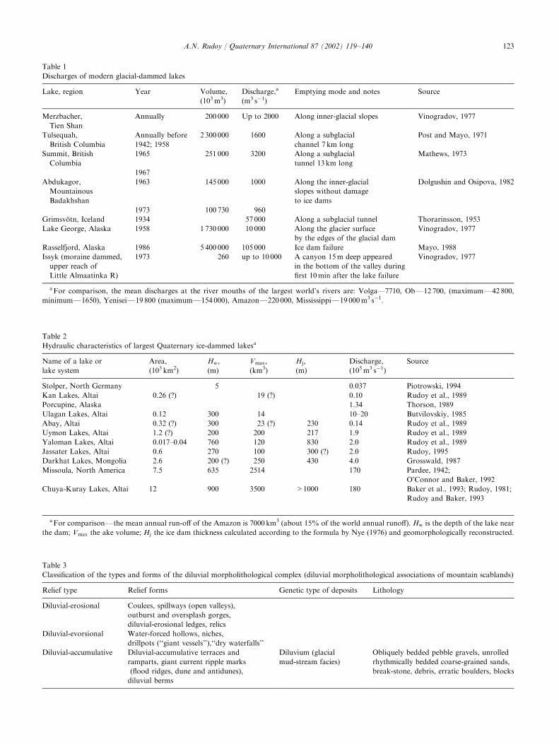
Table 1
Discharges of modern glacial-dammed lakes
Lake, region Year Volume,
(103 m3)
Discharge,a
(m3 s�1)
Emptying mode and notes Source
Merzbacher,
Tien Shan
Annually 200 000 Up to 2000 Along inner-glacial slopes Vinogradov, 1977
Tulsequah,
British Columbia
Annually before
1942; 1958
2 300 000 1600 Along a subglacial
channel 7 km long
Post and Mayo, 1971
Summit, British
Columbia
1965 251 000 3200 Along a subglacial
tunnel 13 km long
Mathews, 1973
1967
Abdukagor,
Mountainous
Badakhshan
1963 145 000 1000 Along the inner-glacial
slopes without damage
to ice dams
Dolgushin and Osipova, 1982
1973 100 730 960
Grimsv .otn, Iceland 1934 57 000 Along a subglacial tunnel Thorarinsson, 1953
Lake George, Alaska 1958 1 730 000 10 000 Along the glacier surface
by the edges of the glacial dam
Vinogradov, 1977
Rasselfjord, Alaska 1986 5 400 000 105 000 Ice dam failure Mayo, 1988
Issyk (moraine dammed,
upper reach of
Little Almaatinka R)
1973 260 up to 10 000 A canyon 15m deep appeared
in the bottom of the valley during
first 10min after the lake failure
Vinogradov, 1977
aFor comparison, the mean discharges at the river mouths of the largest world’s rivers are: Volga—7710, ObF12 700, (maximumF42 800,
minimumF1650), YeniseiF19 800 (maximumF154 000), AmazonF220 000, MississippiF19 000m3 s�1.
Table 2
Hydraulic characteristics of largest Quaternary ice-dammed lakesa
Name of a lake or
lake system
Area,
(103 km2)
Hw;(m)
Vmax;(km3)
Hj;(m)
Discharge,
(105 m3 s�1)
Source
Stolper, North Germany 5 0.037 Piotrowski, 1994
Kan Lakes, Altai 0.26 (?) 19 (?) 0.10 Rudoy et al., 1989
Porcupine, Alaska 1.34 Thorson, 1989
Ulagan Lakes, Altai 0.12 300 14 10–20 Butvilovskiy, 1985
Abay, Altai 0.32 (?) 300 23 (?) 230 0.14 Rudoy et al., 1989
Uymon Lakes, Altai 1.2 (?) 200 200 217 1.9 Rudoy et al., 1989
Yaloman Lakes, Altai 0.017–0.04 760 120 830 2.0 Rudoy et al., 1989
Jassater Lakes, Altai 0.6 270 100 300 (?) 2.0 Rudoy, 1995
Darkhat Lakes, Mongolia 2.6 200 (?) 250 430 4.0 Grosswald, 1987
Missoula, North America 7.5 635 2514 170 Pardee, 1942;
O’Connor and Baker, 1992
Chuya-Kuray Lakes, Altai 12 900 3500 >1000 180 Baker et al., 1993; Rudoy, 1981;
Rudoy and Baker, 1993
aFor comparisonFthe mean annual run-off of the Amazon is 7000 km3 (about 15% of the world annual runoff). Hw is the depth of the lake near
the dam; Vmax the ake volume; Hj the ice dam thickness calculated according to the formula by Nye (1976) and geomorphologically reconstructed.
Table 3
Classification of the types and forms of the diluvial morpholithological complex (diluvial morpholithological associations of mountain scablands)
Relief type Relief forms Genetic type of deposits Lithology
Diluvial-erosional Coulees, spillways (open valleys),
outburst and oversplash gorges,
diluvial-erosional ledges, relics
Diluvial-evorsional Water-forced hollows, niches,
drillpots (‘‘giant vessels’’),‘‘dry waterfalls’’
Diluvial-accumulative Diluvial-accumulative terraces and
ramparts, giant current ripple marks
(flood ridges, dune and antidunes),
diluvial berms
Diluvium (glacial
mud-stream facies)
Obliquely bedded pebble gravels, unrolled
rhythmically bedded coarse-grained sands,
break-stone, debris, erratic boulders, blocks
A.N. Rudoy / Quaternary International 87 (2002) 119–140 123
investigators may lead to mistakes in the diluviumdiagnosis in cases when no qualitative photographs ofthe corresponding relief and sections are given, even if adetailed description exists.
Where glaciers dam river valleys and impound lakes,the lakes break the glacial dams, and wash away orcompletely destroy glacial traces in the main runoffvalleys out of Lake Basins. Diluvial processes aregenetically connected with glacial processes of reliefformation, but they act at lower hypsometric levels,where in most cases their influence exceeds that of theglaciers that gave rise to these processes. This is theessence of the theory of diluvial morpholithogenesis.
The concept of the cause–consequence connections ofglacial and diluvial processes in the Altai Mountains hasbeen tested in all great river valleys of Southern Siberia
during the last decade. Presently it can be extrapolatedtheoretically to all the regions of the Earth having asimilar palaeoglaciohydrological situation for a giventime. The theory of diluvial morpholithogenesis objec-tively affords considering the probability of diluvialfloods within the river valleys of such mountaincountries whose morphostructural appearance is similarto that of the Altai, and where Quaternary glaciationwas able to block the river outflow from intermountainbasins. The mountains and uplands of the Baikal regionbelong to this category. Here, the whole mountainousdiluvial morpholithologic complex can be found. More-over, judging by the size of dammed reservoirs, it ismuch larger than in the Altai-Sayany mountain district.On the other hand, the diluvial morpholithogenesisconcept lets us solve another problem: to first assume
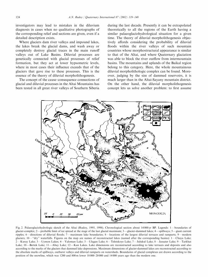
Fig. 2. Palaeoglaciohydrologic sketch of the Altai (Rudoy, 1995, 1998). Chronological section about 14 000 yr BP. Legends: 1Fboundaries of
glacier-complex; 2Fprobable limit of ice spread at the stage of the last glacial maximum; 3Fglacier-dammed lakes; 4Fspillways; 5Fgiant current
ripples; 6Fdirections of diluvial floods; 7Fmaximum lake boundaries; 8Flocations of the largest diluvial terraces and ramparts; 9Fmodern
glaciers; 10F‘‘dry’’ waterfalls. Figures on the map are names of reconstructed lakes (named after the corresponding basins): 1FChuya Lake;
2FKuray Lake; 3FUymon Lakes; 4FYaloman Lake; 5FUlagan Lake; 6FTeletskoye Lake; 7FJulukul Lake; 8FJassater Lake; 9FTarkhat
Lake; 10FBertek Lake; 11FAbay Lake; 12FKan Lakes. Lake dimensions are reconstructed according to lake terraces and deposits and also
according to the marks of the glaciers that dammed lake depressions. Maximum dimensions of glacier-dammed lakes are reconstructed according to
the absolute marks of spillways, outburst valleys and diluvial ramparts on watersheds. Boundaries of glacial complexes are drawn according to the
position of the snowline, which was 1200 and 800m lower 18 000–20 000 and 14 000 years ago than the modern one.
A.N. Rudoy / Quaternary International 87 (2002) 119–140124
the presence of large pro-glacial lakes at the upperreaches of the rivers containing evidence of diluvialfloods within these valleys, and consequently to recon-struct the dimensions of the glaciers. Geological agesof diluvial-accumulative deposits indicate both the ageof the corresponding ice-dammed lakes and the age ofglaciers blocking them. Such direct extrapolations aretrue for lowland regions as well (Rudoy, 1998).
Three types of the relief formation processes form thesurface of the scabland. They determine the totalassortment of the forms of the diluvial morpholithologiccomplex and the prevalence of one form over the othersdepending on the lake volumes, thickness of the icedams, the initial relief and the energy of floodstreams.These processes are those of diluvial accumulation,diluvial erosion, and diluvial evorsion.
3.3. Generation and composition of Quaternary diluvium
3.3.1. Diluvial-accumulative ramparts and terracesDiluvial-accumulative ramparts and terraces are
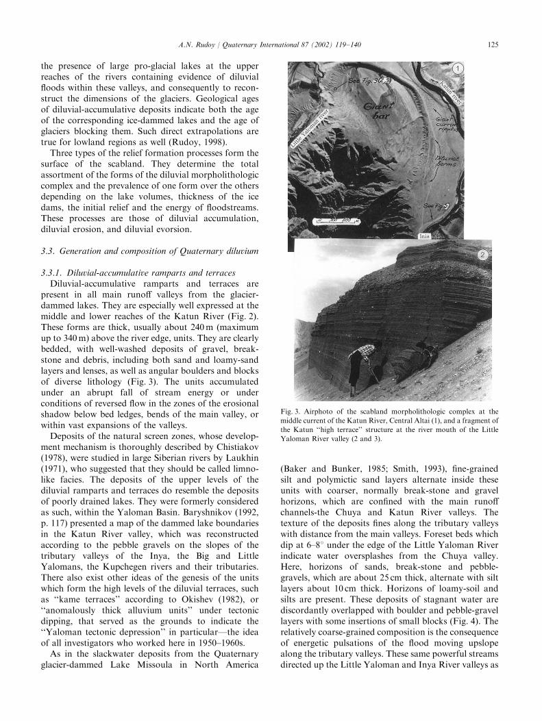
present in all main runoff valleys from the glacier-dammed lakes. They are especially well expressed at themiddle and lower reaches of the Katun River (Fig. 2).These forms are thick, usually about 240 m (maximumup to 340 m) above the river edge, units. They are clearlybedded, with well-washed deposits of gravel, break-stone and debris, including both sand and loamy-sandlayers and lenses, as well as angular boulders and blocksof diverse lithology (Fig. 3). The units accumulatedunder an abrupt fall of stream energy or underconditions of reversed flow in the zones of the erosionalshadow below bed ledges, bends of the main valley, orwithin vast expansions of the valleys.
Deposits of the natural screen zones, whose develop-ment mechanism is thoroughly described by Chistiakov(1978), were studied in large Siberian rivers by Laukhin(1971), who suggested that they should be called limno-like facies. The deposits of the upper levels of thediluvial ramparts and terraces do resemble the depositsof poorly drained lakes. They were formerly consideredas such, within the Yaloman Basin. Baryshnikov (1992,p. 117) presented a map of the dammed lake boundariesin the Katun River valley, which was reconstructedaccording to the pebble gravels on the slopes of thetributary valleys of the Inya, the Big and LittleYalomans, the Kupchegen rivers and their tributaries.There also exist other ideas of the genesis of the unitswhich form the high levels of the diluvial terraces, suchas ‘‘kame terraces’’ according to Okishev (1982), or‘‘anomalously thick alluvium units’’ under tectonicdipping, that served as the grounds to indicate the‘‘Yaloman tectonic depression’’ in particular—the ideaof all investigators who worked here in 1950–1960s.
As in the slackwater deposits from the Quaternaryglacier-dammed Lake Missoula in North America
(Baker and Bunker, 1985; Smith, 1993), fine-grainedsilt and polymictic sand layers alternate inside theseunits with coarser, normally break-stone and gravelhorizons, which are confined with the main runoffchannels-the Chuya and Katun River valleys. Thetexture of the deposits fines along the tributary valleyswith distance from the main valleys. Foreset beds whichdip at 6–81 under the edge of the Little Yaloman Riverindicate water oversplashes from the Chuya valley.Here, horizons of sands, break-stone and pebble-gravels, which are about 25 cm thick, alternate with siltlayers about 10 cm thick. Horizons of loamy-soil andsilts are present. These deposits of stagnant water arediscordantly overlapped with boulder and pebble-gravellayers with some insertions of small blocks (Fig. 4). Therelatively coarse-grained composition is the consequenceof energetic pulsations of the flood moving upslopealong the tributary valleys. These same powerful streamsdirected up the Little Yaloman and Inya River valleys as
Fig. 3. Airphoto of the scabland morpholithologic complex at the
middle current of the Katun River, Central Altai (1), and a fragment of
the Katun ‘‘high terrace’’ structure at the river mouth of the Little
Yaloman River valley (2 and 3).
A.N. Rudoy / Quaternary International 87 (2002) 119–140 125
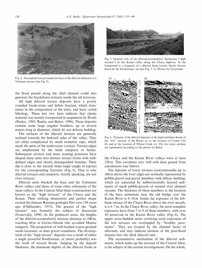
the flood passed along the chief channel could alsogenerate the breakdown textures inside the silt horizons.
All high diluvial terrace deposits have a poorlyrounded break-stone and debris fraction, which dom-inates in the composition of the units, and have variedlithology. These last two facts indicate that clasticmaterial was mainly transported in suspension by floods(Rudoy, 1995; Rudoy and Baker, 1996). These depositscontain some large angular boulders, up to severalmeters long in diameter, which do not deform bedding.
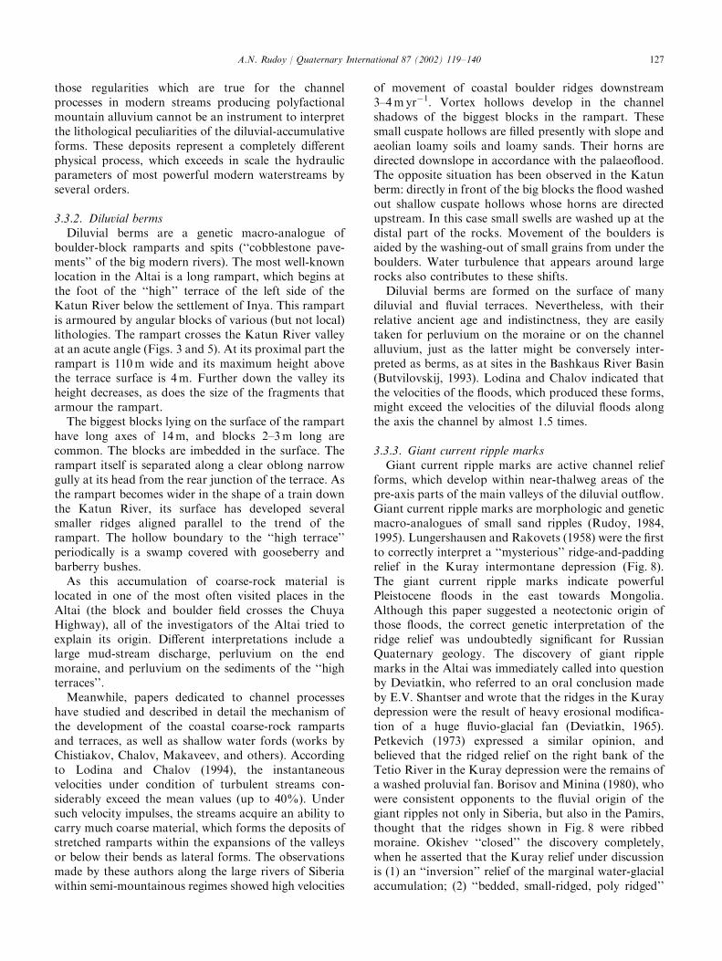
The surfaces of the diluvial terraces are generallyinclined towards the bedrock sides of the valley. Theyare often complicated by small isometric caps, whichmark the spots of the underwater vortices. Terrace edgesare emphasized by the bank ramparts or berms.Subsequent erosion and mass wasting processes haveshaped these units into distinct terrace forms with well-defined edges and clearly distinguished benches. Theirdip is close to the natural slope angle (angle of repose)for the corresponding fractures (Fig. 5). That is whydiluvial terraces and ramparts, strictly speaking, are notriver terraces.
Diluvial units blocked the Inya and the YalomansRiver valleys and those of some other tributaries of themain valleys. In the Central Altai these constructions areknown as the ‘‘high terraces’’ of the Chuya and theKatun. Their striking dimensions and perfect shapeexcited the famous Russian geologist Petr over 150 yearsago (Chikhachev, 1973). The genesis of the ‘‘highterraces’’ was formerly the subject of discussion(Ivanovskij, 1998). In the piedmont areas, the heightsof the diluvial-accumulative terraces decrease to 100 m,reaching 60 m at Gorno-Altaisk (the so-called Maimarampart). The proportion of well-washed coarse-grainedsands increases, as does gravel roundness. The develop-ment of the ‘‘high terrace’’ deposits was a result of eithera single powerful floodstream, or (more probably) wasthe work of several floods. Judging by the depositthickness, the minimum depths of the diluvial foods in
the Chuya and the Katun River valleys were at least250 m. This correlates very well with data gained fromcalculations (see below).
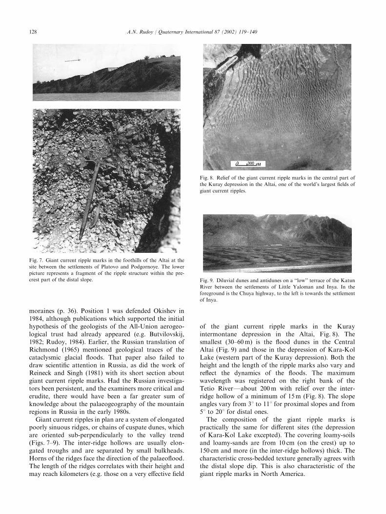
The deposits of lower terraces (conventionally-up to100 m above the river edge) are normally represented bypebble-gravel and gravel members with deltaic bedding,which are separated by subhorizontally layered sedi-ments of small pebble-gravels of normal river channelstreams. The thickness of these members at the locationof the Inya settlement near the old bridge over theKatun River is 8–10 m. Inside the exposure of the left-bank terrace of the Chuya River above the river mouth,it is 6–7 m. In the Chuya River valley, the most completeexposures have from 7 to 9 of these members, with over10 preserved in the Katun River valley (Fig. 6). Theupper cross-bedded series overlying most exposures ofthe low terraces are overlapped by ‘‘boulder pave-ments’’. They are formed by the channel facies ofalluvium, and may indicate incision of the post-floodstreams into the thick diluvial unit.
The accumulative mechanism of the diluvial sedi-ments, which make up the terraces of the Central Altai,is the subject of the current investigations. On the whole,
Fig. 4. Oversplash textures inside the base of the diluvial thickness of a
Yaloman terrace (see Fig. 3).
Fig. 5. General view of the diluvial-accumulative thicknesses (‘‘high
terraces’’) in the Katun valley along the Chuya highway. In the
foreground is a fragment of a diluvial berm (erratic blocks thrown
down by the floodstream, see also Fig. 3 -1). Picture by Grosswald.
Fig. 6. Textures of the diluvial deposits of the high-turbulent floods of
the ‘‘low’’ terraces of the Katun (a) at the location of Coulee City
(b) and at the location of Wilson Creek (c). The two latter sections
are represented according to the photos by Baker.
A.N. Rudoy / Quaternary International 87 (2002) 119–140126
those regularities which are true for the channelprocesses in modern streams producing polyfactionalmountain alluvium cannot be an instrument to interpretthe lithological peculiarities of the diluvial-accumulativeforms. These deposits represent a completely differentphysical process, which exceeds in scale the hydraulicparameters of most powerful modern waterstreams byseveral orders.
3.3.2. Diluvial bermsDiluvial berms are a genetic macro-analogue of
boulder-block ramparts and spits (‘‘cobblestone pave-ments’’ of the big modern rivers). The most well-knownlocation in the Altai is a long rampart, which begins atthe foot of the ‘‘high’’ terrace of the left side of theKatun River below the settlement of Inya. This rampartis armoured by angular blocks of various (but not local)lithologies. The rampart crosses the Katun River valleyat an acute angle (Figs. 3 and 5). At its proximal part therampart is 110 m wide and its maximum height abovethe terrace surface is 4m. Further down the valley itsheight decreases, as does the size of the fragments thatarmour the rampart.
The biggest blocks lying on the surface of the ramparthave long axes of 14m, and blocks 2–3 m long arecommon. The blocks are imbedded in the surface. Therampart itself is separated along a clear oblong narrowgully at its head from the rear junction of the terrace. Asthe rampart becomes wider in the shape of a train downthe Katun River, its surface has developed severalsmaller ridges aligned parallel to the trend of therampart. The hollow boundary to the ‘‘high terrace’’periodically is a swamp covered with gooseberry andbarberry bushes.
As this accumulation of coarse-rock material islocated in one of the most often visited places in theAltai (the block and boulder field crosses the ChuyaHighway), all of the investigators of the Altai tried toexplain its origin. Different interpretations include alarge mud-stream discharge, perluvium on the endmoraine, and perluvium on the sediments of the ‘‘highterraces’’.
Meanwhile, papers dedicated to channel processeshave studied and described in detail the mechanism ofthe development of the coastal coarse-rock rampartsand terraces, as well as shallow water fords (works byChistiakov, Chalov, Makaveev, and others). Accordingto Lodina and Chalov (1994), the instantaneousvelocities under condition of turbulent streams con-siderably exceed the mean values (up to 40%). Undersuch velocity impulses, the streams acquire an ability tocarry much coarse material, which forms the deposits ofstretched ramparts within the expansions of the valleysor below their bends as lateral forms. The observationsmade by these authors along the large rivers of Siberiawithin semi-mountainous regimes showed high velocities
of movement of coastal boulder ridges downstream3–4 m yr�1. Vortex hollows develop in the channelshadows of the biggest blocks in the rampart. Thesesmall cuspate hollows are filled presently with slope andaeolian loamy soils and loamy sands. Their horns aredirected downslope in accordance with the palaeoflood.The opposite situation has been observed in the Katunberm: directly in front of the big blocks the flood washedout shallow cuspate hollows whose horns are directedupstream. In this case small swells are washed up at thedistal part of the rocks. Movement of the boulders isaided by the washing-out of small grains from under theboulders. Water turbulence that appears around largerocks also contributes to these shifts.
Diluvial berms are formed on the surface of manydiluvial and fluvial terraces. Nevertheless, with theirrelative ancient age and indistinctness, they are easilytaken for perluvium on the moraine or on the channelalluvium, just as the latter might be conversely inter-preted as berms, as at sites in the Bashkaus River Basin(Butvilovskij, 1993). Lodina and Chalov indicated thatthe velocities of the floods, which produced these forms,might exceed the velocities of the diluvial floods alongthe axis the channel by almost 1.5 times.
3.3.3. Giant current ripple marksGiant current ripple marks are active channel relief
forms, which develop within near-thalweg areas of thepre-axis parts of the main valleys of the diluvial outflow.Giant current ripple marks are morphologic and geneticmacro-analogues of small sand ripples (Rudoy, 1984,1995). Lungershausen and Rakovets (1958) were the firstto correctly interpret a ‘‘mysterious’’ ridge-and-paddingrelief in the Kuray intermontane depression (Fig. 8).The giant current ripple marks indicate powerfulPleistocene floods in the east towards Mongolia.Although this paper suggested a neotectonic origin ofthose floods, the correct genetic interpretation of theridge relief was undoubtedly significant for RussianQuaternary geology. The discovery of giant ripplemarks in the Altai was immediately called into questionby Deviatkin, who referred to an oral conclusion madeby E.V. Shantser and wrote that the ridges in the Kuraydepression were the result of heavy erosional modifica-tion of a huge fluvio-glacial fan (Deviatkin, 1965).Petkevich (1973) expressed a similar opinion, andbelieved that the ridged relief on the right bank of theTetio River in the Kuray depression were the remains ofa washed proluvial fan. Borisov and Minina (1980), whowere consistent opponents to the fluvial origin of thegiant ripples not only in Siberia, but also in the Pamirs,thought that the ridges shown in Fig. 8 were ribbedmoraine. Okishev ‘‘closed’’ the discovery completely,when he asserted that the Kuray relief under discussionis (1) an ‘‘inversion’’ relief of the marginal water-glacialaccumulation; (2) ‘‘bedded, small-ridged, poly ridged’’
A.N. Rudoy / Quaternary International 87 (2002) 119–140 127
moraines (p. 36). Position 1 was defended Okishev in1984, although publications which supported the initialhypothesis of the geologists of the All-Union aerogeo-logical trust had already appeared (e.g. Butvilovskij,1982; Rudoy, 1984). Earlier, the Russian translation ofRichmond (1965) mentioned geological traces of thecataclysmic glacial floods. That paper also failed todraw scientific attention in Russia, as did the work ofReineck and Singh (1981) with its short section aboutgiant current ripple marks. Had the Russian investiga-tors been persistent, and the examiners more critical anderudite, there would have been a far greater sum ofknowledge about the palaeogeography of the mountainregions in Russia in the early 1980s.
Giant current ripples in plan are a system of elongatedpoorly sinuous ridges, or chains of cuspate dunes, whichare oriented sub-perpendicularly to the valley trend(Figs. 7–9). The inter-ridge hollows are usually elon-gated troughs and are separated by small bulkheads.Horns of the ridges face the direction of the palaeoflood.The length of the ridges correlates with their height andmay reach kilometers (e.g. those on a very effective field
of the giant current ripple marks in the Kurayintermontane depression in the Altai, Fig. 8). Thesmallest (30–60 m) is the flood dunes in the CentralAltai (Fig. 9) and those in the depression of Kara-KolLake (western part of the Kuray depression). Both theheight and the length of the ripple marks also vary andreflect the dynamics of the floods. The maximumwavelength was registered on the right bank of theTetio RiverFabout 200 m with relief over the inter-ridge hollow of a minimum of 15 m (Fig. 8). The slopeangles vary from 31 to 111 for proximal slopes and from51 to 201 for distal ones.
The composition of the giant ripple marks ispractically the same for different sites (the depressionof Kara-Kol Lake excepted). The covering loamy-soilsand loamy-sands are from 10 cm (on the crest) up to150 cm and more (in the inter-ridge hollows) thick. Thecharacteristic cross-bedded texture generally agrees withthe distal slope dip. This is also characteristic of thegiant ripple marks in North America.
Fig. 9. Diluvial dunes and antidunes on a ‘‘low’’ terrace of the Katun
River between the settlements of Little Yaloman and Inya. In the
foreground is the Chuya highway, to the left is towards the settlement
of Inya.
Fig. 7. Giant current ripple marks in the foothills of the Altai at the
site between the settlements of Platovo and Podgornoye. The lower
picture represents a fragment of the ripple structure within the pre-
crest part of the distal slope.
Fig. 8. Relief of the giant current ripple marks in the central part of
the Kuray depression in the Altai, one of the world’s largest fields of
giant current ripples.
A.N. Rudoy / Quaternary International 87 (2002) 119–140128
The bedding is conditioned by various granulometriccompositions of the horizons, which are 10–70 cm thick.The relatively coarse layers (fractions of pebbles andsmall boulders) are on average twice as thick as the fine-grained ones. The concentration of boulders and coarsepebbles is greatest in the lower parts of the sections. Thealternation of the granulometrically different layers maybe explained by the combination of mechanisms ofperiodic sliding of the coarse-grained material thataccumulates on the crest of the distal slope, by floodfluctuation and by periodic change in the granulometryof the bed-load. Carling (1996) believes that as thebedding dip angle in the flood dunes is close to therepose condition, the ridges in the channel should movemainly due to rolling of the mobile layers over the bendat the crest tops and due to the sedimentation on thedistal slope, rather than by collapsing and sliding.
The coarse rock material is well and moderatelyrounded at nearly all the locations of the giant ripplerelief. The lithologic composition of the biggest frag-ments is rather varied and is normally similar to thecomposition of the channel alluvium of a correspondingmodern river. In the Kuray depression the compositionof the biggest fragments (fractions exceeding 0.3 m) isrepresented by chlorite-epidote-quartz metosomatites,quartz porphyries, basalts, microdiorites, and meta-morphic slates. V.P. Parnachev made field determina-tions of lithology inside the giant current ripples in theKuray depression in August 1990. This composition isdifferent from the lithological assemblage of thedropstones lying in the depression, including those onthe flood dunes. The biggest dropstones, which are over1m along the long axes, are angular blocks of variousgranitoids.
In contrast, the ridged relief of the Kara-KolUrochishtshe includes coarse material of the local rock.All fragments are angular, although the bedding insidethe ripple marks is similar to that at the other locations.This suggests that the relief of the giant current ripplemarks developed very rapidly, and local rocks domi-nated in its formation, as they were incorporated fromthe underlying surface.
The Kara Kol Urochishtshe is adjacent to the rightslope of the Maashey River trough (Fig. 10). Here thetwo fields of the giant current ripples, which are situatedclose to each other, are oriented in opposite directions.The outer field, lying close to a small watershed ridgebetween the Chuya River valley and the Kara-KolBasin, is strictly related to the diluvial-erosional over-splash gorges of the palaeoflood from the Chuya Rivervalley onto Yeshtikkol Plateau. The gorge thalwegs andthe ripples are studded with large angular fragments oferratic rocks (granodiorites and dolerites), which are notfound in the bedrock of the North-Chuya MountainRange, and with blocks of Devonian deposits. The crestheight relative to the inter-ridge hollows is 120–130 cm.
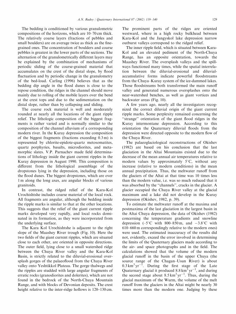
The prominent parts of the ridges are orientedwestward, where in a high rocky bulkhead betweenKara-Kol and the Jangyskol lake depression narrowoutburst valleys correspond to the ridged relief.
The inner ripple field, which is situated between Kara-Kol and an elevated pediment of the North-ChuyaRange, has an opposite orientation, towards theMaashey River. The oversplash valleys and the spill-ways functioned many times, while the spatial interrela-tion between the diluvial-erosional and diluvial-accumulative forms indicate powerful floodstreamsfrom the Chuya–Kuray system of the ice-dammed lakes.Those floodstreams both transformed the main runoffvalley and generated numerous oversplashes onto thenear-watershed benches, as well as giant vortices andbackwater areas (Fig. 10).
A few years ago, nearly all the investigators recog-nized the correct diluvial origin of the giant currentripple marks. Some perplexity remained concerning the‘‘strange’’ orientation of the giant flood ridges in theKuray intermontane depression. According to thisorientation the Quaternary diluvial floods from thedepression were directed opposite to the modern flow ofthe Chuya River.
The palaeoglaciological reconstructions of Okishev(1982) are based on his conclusion that the lastglaciation in the Altai Mountains existed due to thedecrease of the mean annual air temperatures relative tomodern values by approximately 51C, without anyincrease (relative to modern conditions) in the meanannual precipitation. Thus, the meltwater runoff fromthe glaciers of the Altai at that time was 10 times lessthan the modern value, i.e. was so much reduced that itwas absorbed by the ‘‘channels’’, cracks in the glacier. Aglacier occupied the Chuya River valley at the glacialmaximum and a lake did not develop in the Kuraydepression (Okishev, 1982, p. 39).
To estimate the meltwater runoff at the maxima andpostmaxima of the last glaciation in the largest basin inthe Altai Chuya depression, the data of Okishev (1982)concerning the temperature gradients and snowlinedepression (–51C with 800–850m, and �3.81C with610–660 m correspondingly relative to the modern ones)were used. The estimated inaccuracy of the results didnot, evidently, exceed the error involved in determiningthe limits of the Quaternary glaciers made according tothe air- and space photographs and in the field. Thecalculations showed that the volume of the modernglacial runoff in the basin of the upper Chuya (thesource range of the Chagan–Usun River) is about0.3 km3 yr�1. During the first stage of the LateQuaternary glacial it produced 8.8 km3 yr�1, and duringthe second stage about 8.5 km3 yr�1. Thus, during theglacial maximum of the Wurm, the volume of the meltrunoff from the glaciers in the Altai might be nearly 30times more than the modern one. Judging by these
A.N. Rudoy / Quaternary International 87 (2002) 119–140 129
estimates it is easy to calculate that to fill the ChuyaBasin up to the horizon of 2200 m (the limit level of thedeciphered shore lines) it would have taken only about ahundred years. The Kuray depression would have hadto be filled up at least three times as rapidly. Thus, untilthe establishment of the levels of the Kuray and Chuyaice-dammed lakes, the runoff should have been directedeastwards, into the basin of the Chuya Lake, which wasjust being filled (Rudoy et al., 1989).
Another probable scenario of palaeohydrologicevents may give a satisfactory explanation for the‘‘strange’’ orientation of the giant current ripple marksin the Kuray depression (Rudoy, 1995). Changes in theplan configuration of the river channel (a bend, anexpansion, etc.) will also cause some changes in thehydrodynamic regime, as well as in bottom and lateralerosion, shore and other types of accumulation. Theprocesses are controlled by the differentiation of thestream velocities at the different parts of the stream andof the changes in the longitudinal character of thelongitudinal and cross circulation. At some sites thereappear zones of energetic local vortices, and even widerareas of backwaters. Here, migrating ridged channel
forms develop, associated with maximum velocities anddepths in the stream.
In the Kuray depression, the palaeohydrologic situa-tion may resemble the scheme depicted in Fig. 10. Theoffered explanation is not a revelation for channelprocesses specialists, but it may appear an interestingone for the investigators in the sphere of dynamicgeology and geomorphology. These two scenarios arenot mutually exclusive. The cyclone turnover which hasbeen reconstructed in the Kuray depression in the Altai,and which had a more than 10-km radius, together withthe main longitudinal palaeoflood, might serve as amirror image of the modern circulation of the ArcticBasin (Grosswald and Rudoy, 1996a, b).
Ripple growth requires a short time under floodconditions. Dinehart (1992) ascertained from rivers ofthe northwest USA, that for river dunes of crest height0.2–0.4m, their length exceeds 30 m during 24–48 h.Gustavson (1976) observed during floods along modernrivers in Texas that ripples grew up to 2m with lengthsof 100m. Although direct physical analogies between themodern sand ripples and the giant boulder-and-pebblediluvial dunes may not be completely correct, it is
Fig. 10. Palaeohydrologic sketch of Kuray intermountain basin, Altai Mountains. (Rudoy, 1995, 1998). Chronological sectionFabout 11 500 yr.
BP. Legend: 1Fdirections of diluvial floods; 2Fprobable directions of diluvial floods; 3Ffields of giant current ripples; 4Fspillways, gorges of
outbursts and oversplashes; 5Fend moraines; 6Fboundaries of intermountain basins; 7Fmodern glaciers. The palaeoflood direction has been
reconstructed according to the orientation of the fields of diluvial dunes, spillways and oversplash gorges. Another field of ripple marks within the
backwater zone in the central part of the basin is represented in Fig. 8. The superflood maximum discharges of 18� 106 m3 s�1 have been calculated
for the site between the settlements of Chibit and Kuray. Maximum flood velocities equaled here 45m s�1, the flood depth at the hydrograph peak
exceeded 400m, the flood magnitude reached 106 Wm�2 (Baker et al., 1993; Rudoy and Baker, 1993).
A.N. Rudoy / Quaternary International 87 (2002) 119–140130
possible to assume that the development of the giantcurrent ripples within the channels of the diluvial floodswas also very rapid. The giant current ripple marks arechannel forms that cannot be analysed directly accord-ing to the observations in modern rivers (Rudoy andBaker, 1993).
In addition to the diluvial-accumulative terraces,ramparts, bars and berms, the giant current ripplemarks are an exclusive proof for the cataclysmicoutbursts of the huge glacier-dammed lakes. The out-burst and oversplash gorges, spillways and othererosional and evorsional forms of scabland (see below)may be mistakenly diagnosed according to somedifferent genetic interpretations, but in the complex withthe above-described accumulative forms they do notleave any doubt as to their only diluvial interpretation.
The diluvial-accumulative forms are more commonthan has occurred to many researchers before. To findthem, we lack only one thingFthe knowledge of whatexactly we should look for. Discovery and large-scalemapping of new locations of fields of giant currentripples and other accumulative forms of scabland willgive the investigator new scientific and methodologicalinstruments to reconstruct the large systems of perigla-cial palaeorunoff of all of Central and Northern Asia,which are known at present only in general terms.
3.4. Forms of diluvial erosion and evorsion
3.4.1. Diluvial erosionDiluvial supererosion leads first of all to the develop-
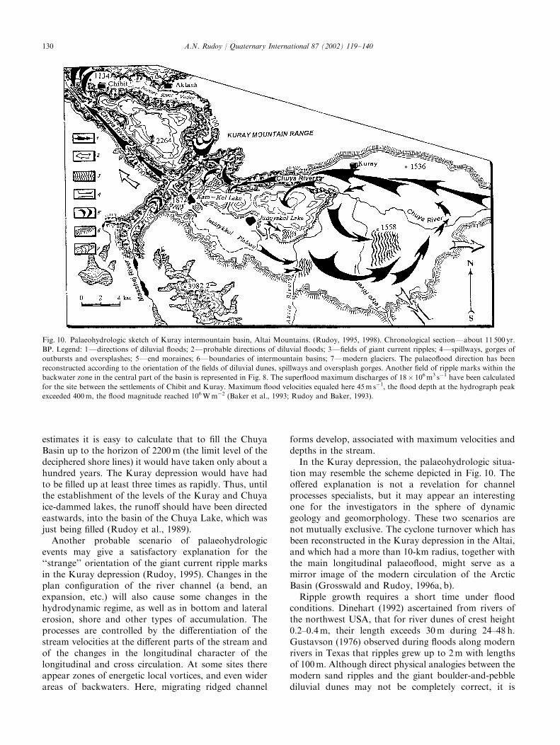
ment of deep gorges on the route of the water outlet(outburst gorges). The largest outburst gorges in theAltai are the majority of the canyons of the Bashkausand the Chulyshman Rivers, the upper reaches of theKatun River, and a young gorge on the site between theYeshtikkol Urochishtshes from the Maashey Rivermouth to the settlement of Chibit (Figs. 1 and 10).There are also outburst gorges at the mouths of manyother valleys of the Chuya depression basin: theChagan–Usun, the Chagan–Burgazy, the Tarkhaty,and others (Fig. 11). Most of the so-called epigeneticgorges, which were already described (Ivanovskij, 1967),are actually outburst valleys of diluvial origin, whichwere formed by powerful water streams during quiteshort periods.
Along the straight sites of the main runoff valleys therock material was either partly or completely washedout, the prominent slopes were destroyed, the ancientfans were intensively cut off, and the valleys deepened.For example, the cut-off proluvial fans are a mostcharacteristic element of the Chulyshman River valley,especially at its middle and lower reaches.
The mountain pass saddles, along which the watersurplus was thrown into the neighbouring basins eachtime the lake depression was full, turned into the open
valley-spillways. They had canyon-shaped, and lesscommonly narrow box-like cross profiles. Some of thespillways, for example the Kokoria spillway (the rightsource of the Chuya River); Kokoru (the upper leftsource of the Bashkaus River); Tobozhok (another rightsource of the Chuya); and the Karasy (a tributary of theBashkaus River, had been prepared by the ice floodswhich overflowed from the Chuya aufeis ledoyom intothe Bashkaus Basin (see Rudoy, 1990, 1998). The ‘‘opentrough’’ of the Tobozhok River was described bySperanskij (1937), who wrote in particular that practi-cally all the tributaries of the upper Chuya (the rightsources included) served as runoff channels for the ice ofthe Chuya ledoyom into the Bashkaus river valley.Subsequently, these concepts were rejected due to thefact that the Chuya depression was never occupied byglaciers during the Quaternary (Deviatkin, 1965), asthere are no moraine remnants on the depressionbottom. This last fact was used as the main proof ofthe Quaternary ledoyoms’ existence. The ideas ofSperanskij (1937) were denied and forgotten, but theopen valley remained.
Study of the open valleys at the upper reaches of theBashkaus ascertained that erosional gorges are cut intothe shallow (60–100 m deep), flat-bottomed, relativelywide (1.2–1.5 km) valleys. These gorges are locally verynarrow (up to 10 m wide between the upper benches),with step-like longitudinal profiles on the Bashkaus side.
When the theory of the aufeis ledoyoms appeared(Rudoy, 1981, 1990, 1998), it became clear that themechanism of the development of some ledoyom typesdiffers in principle from that mechanism of the inter-montane depression ice filling, which had been offered
Fig. 11. The outburst gorge of the Chagan River. The Chagan
Scabland, South-Eastern Altai, South-Chuya Range.
A.N. Rudoy / Quaternary International 87 (2002) 119–140 131
by Nekhoroshev (1930). Beside the ‘‘classical le-doyoms’’, which are intermontane depressions filledwith glacier ice that produced huge valley glaciers fromthe depressions within the outlet runoff channels, someother mechanism of ledoyom development in thedepressions was indicated. Depressions were alreadyoccupied by the glacier-dammed lakes [‘‘catch lakes’’and the ledoyoms of the aufeis type (Rudoy, 1998)]when mountain glaciers reached them. Thus, it wasproven that Speranskij (1937) had been right. TheChuya depression was a ledoyom, which producedglacial floods into the neighbouring basins, and theopen troughs were employed at the degradation stagesof the glaciers as spillways to partially move the waterfrom the Chuya ice-dammed lake into the neighbouringbasins.
Where the runoff valley was not able to contain thepassing water masses, the flood splashed high over thelocal watersheds and produced a series of diluvial-erosional valleys and oversplash gorges. The floodtransported and accumulated erratic material high onthe slopes of the watersheds, some fragments of whichwere rather sizeable: boulders and blocks weighinghundreds of tons. Unlike the erratic boulders of theglacial origin, the diluvial erratic material is, as a rule,rather poorly rounded.
From the palaeoglaciohydrolic viewpoint, an inter-esting system of variously oriented outburst and over-splash valleys is located on the Yeshtikkol plateau(Fig. 10). The outburst gorges here cross a lowwatershed between Kara-Kol Lake and the depressionof Jungyskol Lake, via a narrow, curved channelthrough the system of foothill diluvial bench-steps.These gorges (there are not less than five of them there)vary from 500 m to 1.5 km long. Their depth along thesubvertical slopes is 120–300 m, with their width fromdozens to a hundred of meters. Presently, all thesegorges are dry, as their bottoms are slightly higher thanboth depressions. Along the extreme northern gorgethere is a road connecting Kuray village to thesettlement of Chibit. All these gorges are abundantlypopulated.
The runoff and oversplash channel from the depres-sion of Kara-Kol Lake into the Chuya River valley isemployed presently by melt water as a temporary oneduring the period of heavy rains and during spring snowmelting. However, neither a modern stream bed nor bedalluvium is presently found in the channel along itswhole length. The channel looks like a canyon 80–100 mdeep and no more than 50 m wide, with steep, oftennearly vertical, walls. The longitudinal profile of thechannel is complicated with step-like benches, which fixthe cataracts formed by outthrows of the lake waterdown the gradient. The height of these benches is 2–3 m.Within the thalweg of the canyon along its whole lengthup to Kara-Kol are poorly rounded blocks of dolerites
and granodiorites (diluvial erratic boulders from theKuray Range). Their dimensions vary from boulders upto blocks 3 m in diameter. The gradient slope of thecanyon is covered with larches.
Two more diluvial-erosional canyons, which are muchlonger, have been studied farther westward. Theirstructure is generally similar to the one described above.Diluvial-erratic material has been also found on thebottom of the channels. These channels must have beenused by diluvial floods many times, both as outburst andoversplash gorges. The orientation of the giant currentripple marks at the Kara-Kol Urochishtshe alsoconfirms the fact (Rudoy, 1995).
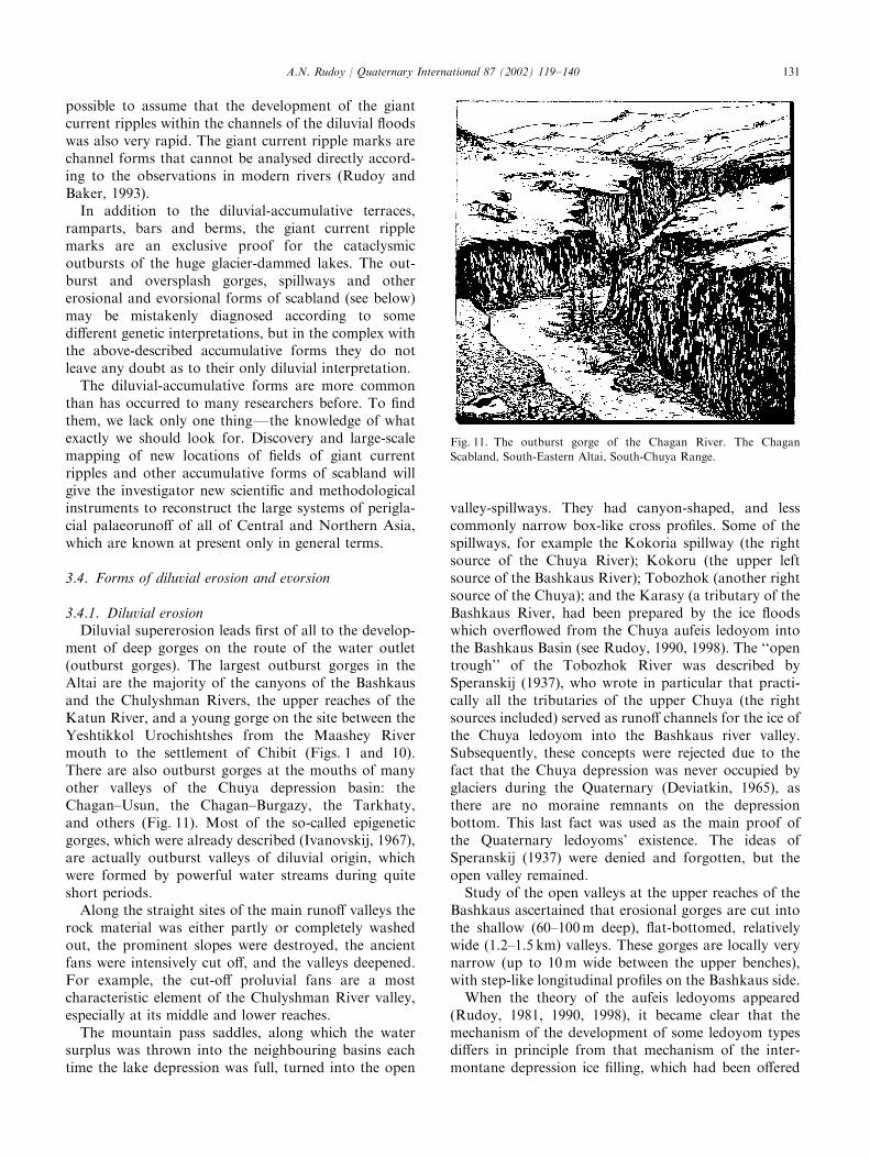
The diluvial-erosional channel-coulees, which weredistinguished in North America, are rarely found in themountains of Southern Siberia. It is possible that theirexistence simply has not been established. Further fieldstudies will show if such channels really exist in the areaswhere Quaternary basalt covers Eastern Tuva and thebasins of the Khubsugul and Darkhat intermontanedepressions. Grosswald and Rudoy (1996a, b) noted thediluvial genesis of the deep canyon of the Kyzyl-KhemRiver. This canyon cuts both granites and metamorphicrock, and huge thicknesses of Quaternary basalts(Fig. 12). Judging by the palaeo-glaciohydrologic situa-tion, a vast area of Putorana plateau also may containdiluvial runoff channels. It is possible that the largestAltai channels-coulees are the Chulyshman, the Bash-kaus and the Argut river valleys. Morphologicallythey look quite similar to the diluvial canyons inNorth America. The palaeohydrologic situations of theEastern and the Central Altai do not contradict thisassumption.
In the Altai Mountains, the only site of undoubtedscabland has been discovered where the system ofbranching, discontinuous, deep (50–70 m) coulees com-plicates the central part of the Chagan River valley
Fig. 12. Diluvial-erosional canyon-coulee of the Kysyl-Khem River
above the junction with the Ka-Khem River. Relief of the edge of the
interglacial basalt terrace over the channel is about 150m. Picture by
Grosswald (Grosswald and Rudoy, 1996a, b).
A.N. Rudoy / Quaternary International 87 (2002) 119–140132
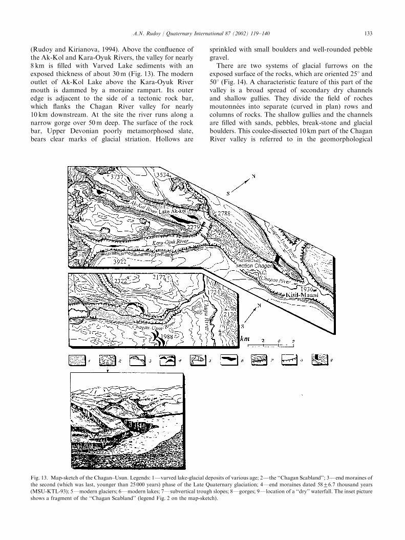
(Rudoy and Kirianova, 1994). Above the confluence ofthe Ak-Kol and Kara-Oyuk Rivers, the valley for nearly8 km is filled with Varved Lake sediments with anexposed thickness of about 30 m (Fig. 13). The modernoutlet of Ak-Kol Lake above the Kara-Oyuk Rivermouth is dammed by a moraine rampart. Its outeredge is adjacent to the side of a tectonic rock bar,which flanks the Chagan River valley for nearly10 km downstream. At the site the river runs along anarrow gorge over 50 m deep. The surface of the rockbar, Upper Devonian poorly metamorphosed slate,bears clear marks of glacial striation. Hollows are
sprinkled with small boulders and well-rounded pebblegravel.
There are two systems of glacial furrows on theexposed surface of the rocks, which are oriented 251 and501 (Fig. 14). A characteristic feature of this part of thevalley is a broad spread of secondary dry channelsand shallow gullies. They divide the field of rochesmoutonn!ees into separate (curved in plan) rows andcolumns of rocks. The shallow gullies and the channelsare filled with sands, pebbles, break-stone and glacialboulders. This coulee-dissected 10km part of the ChaganRiver valley is referred to in the geomorphological
Fig. 13. Map-sketch of the Chagan–Usun. Legends: 1Fvarved lake-glacial deposits of various age; 2Fthe ‘‘Chagan Scabland’’; 3Fend moraines of
the second (which was last, younger than 25 000 years) phase of the Late Quaternary glaciation; 4Fend moraines dated 5876.7 thousand years
(MSU-KTL-93); 5Fmodern glaciers; 6Fmodern lakes; 7Fsubvertical trough slopes; 8Fgorges; 9Flocation of a ‘‘dry’’ waterfall. The inset picture
shows a fragment of the ‘‘Chagan Scabland’’ (legend Fig. 2 on the map-sketch).
A.N. Rudoy / Quaternary International 87 (2002) 119–140 133
literature as the ‘‘Chagan Scabland’’. The exotic land-scape of the Chagan Scabland was formed no later than3000 years ago as a result of one or several outbursts ofAk-Kol ice-dammed lake (Rudoy and Kirianova, 1994).
3.4.2. Forms of diluvial evorsionDiluvial-evorsional forms are connected genetically
and spacially with spillways and diluvial-erosionaloutburst and oversplash valleys. Judging by thelaboratory data, the evorsion of the bedrock by thediluvial floodstreams might be very rapid, especially atthe sites with supercritical current velocities. This resultsfrom cavitation, which took place at the contact point ofthe bed with the mixture of air and water (Grosswaldand Rudoy, 1996a).
Short-lived but exceptionally energetic waterfalls veryoften appeared where lake water was thrown over localwatersheds and mountain pass-saddles. These waterfallsproduced huge (hundreds of meters in diameter anddozens of meters deep) water-forced hollows, funnelsand drillpots (‘‘giant vessels’’). Some of such diluvial-evorsional depressions are occupied nowadays bypicturesque lakes, while others are presently waterless.
An example of a diluvial-evorsional depressionpresently filled with water is the famous Altai-Aya Lake(Fig. 15). The depression of the lake, as well as theadjacent evorsional depressions ‘‘Moss Swamp’’ andPionerskaya, are situated on the left bank of the KatunRiver, 30 km upstream away from Platovo. All thesedepressions were developed in the surface of a 60 mpebble terrace, and their corresponding dimensions are1200� 200, 400� 390 and 200� 70 m. The water wasthrown via the spillways, which were sawn in a narrow,mainly gravel crest, which protrudes into the KatunRiver valley above the depressions. Maloletko (1980)discovered a washed denudation rock separating thedepressions of Aya Lake and Pionerskaya. He alsonoted fields of large erratic boulders brought by theflood onto the valley slopes nearly as high as thewatershed. The discovery of the evorsional origin of asystem of depressions at the location of Aya Lake (theso-called Aya depressions) also belongs to Maloletko.His studies of the bathymetry of Aya Lake and thegeneral geomorphologic situation, as well as his originalway of thinking, allowed him, despite the generalscepticism which was sometimes mingled with irony, tosolve correctly the problem of the origin of the AyaLake depression. Maloletko was not able to interpretproperly the appearance of huge water masses that cutthrough the local watersheds above the Aya depressionsand formed the spillways and the evorsional depressionsthemselves, although the outbursts of collapse-dammedlakes in the mountains, as Maloletko wrote about, arenot rare.
In the Altai Mountains, in addition to the Ayadepressions, ‘‘dry waterfalls’’ in the central part of theChulyshman valley at Katuyaryk Urochishtshe alsolook very impressive. Here, the water surplus movedfrom Ulagan ice-dammed lake during the Wurm glacialpostmaximum. Smaller, but also very effective, diluvial-evorsional forms may be observed on the south-eastern
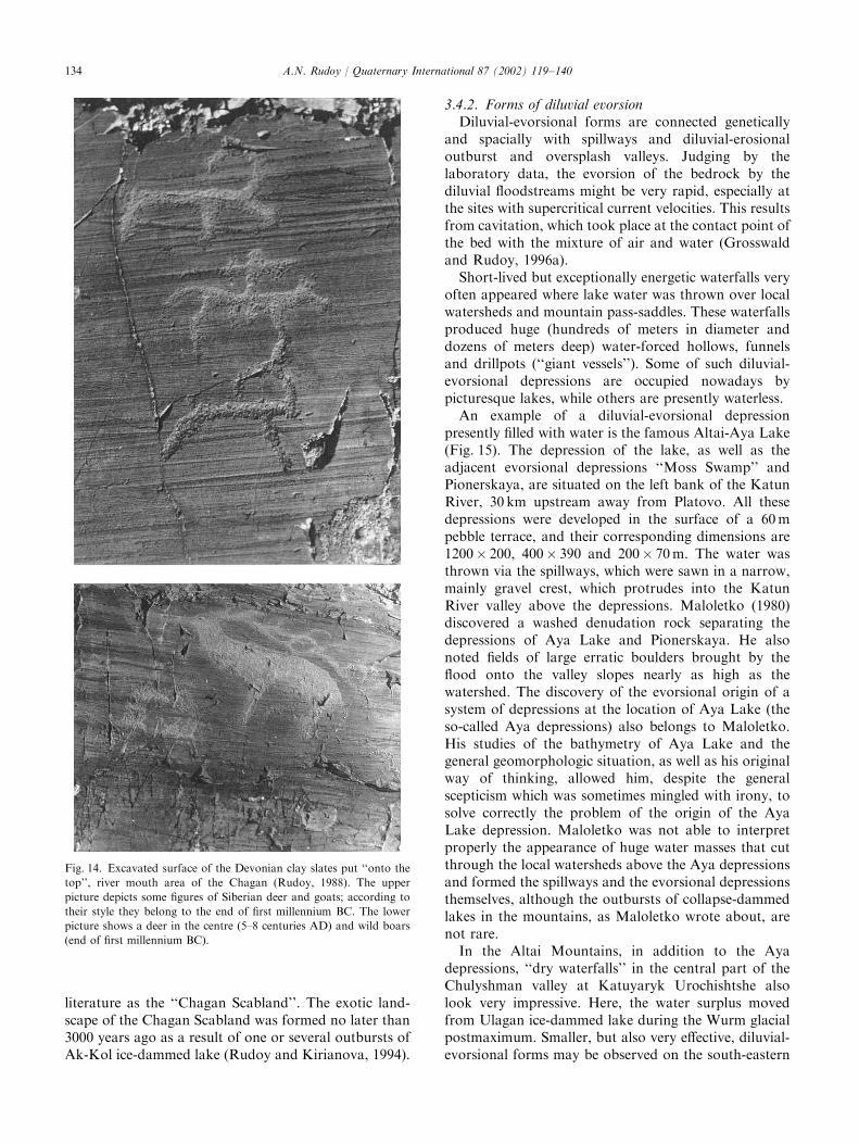
Fig. 14. Excavated surface of the Devonian clay slates put ‘‘onto the
top’’, river mouth area of the Chagan (Rudoy, 1988). The upper
picture depicts some figures of Siberian deer and goats; according to
their style they belong to the end of first millennium BC. The lower
picture shows a deer in the centre (5–8 centuries AD) and wild boars
(end of first millennium BC).
A.N. Rudoy / Quaternary International 87 (2002) 119–140134
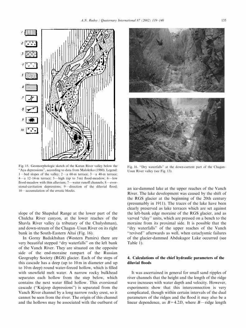
slope of the Shapshal Range at the lower part of theChulcha River canyon, at the lower reaches of theShavla River valley (a tributary of the Chulyshman),and down-stream of the Chagan–Usun River on its rightbank in the South-Eastern Altai (Fig. 16).
In Gorny Badakhshan (Western Pamirs) there arevery beautiful stepped ‘‘dry waterfalls’’ on the left bankof the Vanch River. They are situated on the oppositeside of the end-moraine rampart of the RussianGeography Society (RGS) glacier. Each of the steps ofthis cascade has a deep (up to 10 m in diameter and upto 10m deep) round water-forced hollow, which is filledwith snowfield melt water. A narrow rocky bulkheadseparates each hollow from the step below, whichcontains the next water filled hollow. This evorsionalcascade (‘‘Kujzop depressions’’) is separated from theVanch River channel by a long narrow rocky crest, so itcannot be seen from the river. The origin of this channeland the hollows may be associated with the outburst of
an ice-dammed lake at the upper reaches of the VanchRiver. The lake development was caused by the shift ofthe RGS glacier at the beginning of the 20th century(presumably in 1911). The traces of the lake have beenclearly preserved as lake terraces which are set againstthe left-bank edge moraine of the RGS glacier, and asvarved ‘‘clay’’ units, which are pressed on a bench to themoraine from its proximal side. It is possible that the‘‘dry waterfalls’’ of the upper reaches of the Vanch‘‘revived’’ afterwards as well, when cataclysmic failuresof the glacier-dammed Abdukagor Lake occurred (seeTable 1).
4. Calculations of the chief hydraulic parameters of the
diluvial floods
It was ascertained in general for small sand ripples ofriver channels that the height and the length of the ridgewave increases with water depth and velocity. However,experiments show that this interconnection is verycomplicated, though within certain intervals of the dualparameters of the ridges and the flood it may also be alinear dependence, as B=4.2D, where BFridge length
Fig. 15. Geomorphologic sketch of the Katun River valley below the
‘‘Aya depressions’’, according to data from Maloletko (1980). Legend:
1Fbed slopes of the valley; 2Fa 60-m terrace; 3Fa 40-m terrace;
4Fa 12–14-m terrace; 5Fhigh (up to 5m) flood-meadow; 6Flow
flood-meadow with thin alluvium; 7Fwater runoff channels; 8Fevor-
sional-cavitation depressions; 9Fdirection of the diluvial flood;
10Faccumulation of the erratic blocks.
Fig. 16. ‘‘Dry waterfalls’’ at the down-current part of the Chagan–
Usun River valley (see Fig. 13).
A.N. Rudoy / Quaternary International 87 (2002) 119–140 135
(wave length), and D—flood depth (Snishtshenko,1980). A similar dependent relationship is also givenby Yalin (1972): B=5D. At a certain critical flood depththis dependence may become inverse: the deeper theflood, the lower the dunes, but, probably, the longer thewave (Kondratiev et al., 1982). The first relationship isoften used to calculate channel processes in Russianliterature, and the second one is used in the westernscientific literature. As Dinehart (1992) notes, Yalin’srules are quite correct for small gravel channel forms.However, if we proceed from the given formulas, then ifthe length of a flood dune reaches 100 m, the flood depthshould be 20 m. With the depths of hundreds of meters,which were characteristic of the Quaternary diluvialfloodstreams, we should expect to see quite a differentmorphometry of the channel forms of scabland. Thus,the given relationships are of little use for the mesoformsof the ripples which were generated by high-energeticstreams (Table 4).
Initial calculations of the discharges of the diluvialfloodstreams from the Late Quaternary Lake Missoulaat different sites used the Schezi formula (Bretz, 1923;Pardee, 1942). The results were large: from 26 to106 m3 s�1. Nevertheless, the vagueness of the channelroughness coefficient led to considerable inaccuracy,while the results themselves seemed doubtful to manyscientists. Baker (1973) used statistical analysis ofnatural data to derive empirical relationships betweenthe ridge size (wave height and length) and the depthand the velocity of the floods in the channels:H ¼ 0:923V 0.455; B ¼ 37:8V 0.348 and B ¼ 8:24D0.87,where H is the mean height of the ripple wave, B themean wave length, D the flood depth over the ripple fieldand V the mean velocity of the water stream. Baker alsodetermined the range within which these interdependen-cies would be correct: flood depthFfrom 12 to 152 m;mean stream velocity 18 m s�1; size of the particleswhich compose the flood dunesFfrom gravel toboulders up to 1.5 m in the diameter; and some others.
According to the relationships derived by Baker(1973), the following data were determined for the siteof giant current ripples in the foothills of the Altai(between the settlements of Platovo and Podgornoye,see Fig. 7): mean flood velocitiesFabout 16 ms�1, flooddepthsFabout 60 m, and water discharges, regardingthe modern valley morphologyFnot less than600 000 m3 s�1. These data somewhat exceed the pre-viously published data (Rudoy, 1984) due to somespecification of the morphometry of the ridged relief bymeans of large-scale topography survey.
The Platovo–Podgornoye site is located nearly 300 kmaway from the probable place of the outburst (themouth of Chuya, Kuray or Uymon lakes, Figs. 1 and 2).The flood here turned flatter, and its depth and velocitydropped. But the depths and the velocities of thefloodstreams were much greater. For the field of diluvial
dunes at the site of the Little Yaloman and Inya Riversin the Central Altai, according to Baker’s equations,flood depths over 400 m and velocities about 30 m s�1
were determined, and the corresponding discharges wereover 106 m3 s�1. The data thus do not satisfy theconditions for which Baker’s formulas are thought tobe correct. They require some other, independent,proofs.
According to the calculations by Carling (1996),ordinary discharges of the diluvial floods over the areasof the ripple formation at the moment of stabilization ofthe floodstreams, varied within the interval from2� 104 m3 s�1 up to 5� 104 m3 s�1 with the maximumat the flood peak of 750 000 m3 s�1. The maximum floodvelocities reached 50 m s�1. These data are based on theresults of computer analyses of numerous granulometricsamples and large-scale topography surveys conductedat the base sites of Platovo–Podgornoye, the LittleYaloman–the Inya and on the fields of the giant currentripple marks in the Kuray depression. The calculationsby Carling do not contradict the data according to theformulas of Baker, although the very experimental andanalytical study procedure was undoubtedly morecomplicated. The hydraulic parameters of the diluvialstreams over the fields of the giant current ripple marks,especially at the backwater zones, do not reflect themaximum characteristics of the flood at the channel line,where both the velocities and the depths were muchgreater.
To evaluate the outbursts of pre-glacial lakes, theempirical formulas of Clague and Mathews (1973),Beget (1986), and J.E. Costa (1988) are often used. Theyimply a linear dependence between the volume of thefailed lakes and the jok .ulhlaup discharges at the rangeof the dam failure:
Qmax ¼ 0:0075V0:667; ð1Þ
Qmax ¼ 0:0065V0:69; ð2Þ
Qmax ¼ 0:0113V0:06; ð3Þ
where Qmax is the maximum jok .ulhlaup discharges, andV the lake volume.
According to these formulas, the Pleistocene systemof Chuya–Kuray ice-dammed lakes produced flood-streams with the discharges from 4 to 9� 105 m3 s�1.Presently, Formula (1) is more preferable, as it is moreprecise. This model is based on the regression equation,which was derived according to the results of theobservations of the outbursts of ten modern ice-dammed lakes. The drawbacks of this model (as wellas similar ones) are that (1) it does not consider thetopography of the outburst channels, and thus at somedistance from the lake depression it greatly reducesdischarge values; and (2) the relationship was derivedempirically for modern proglacial lakes whose
A.N. Rudoy / Quaternary International 87 (2002) 119–140136
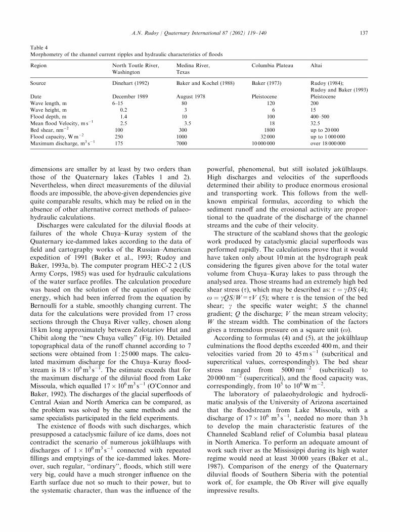
dimensions are smaller by at least by two orders thanthose of the Quaternary lakes (Tables 1 and 2).Nevertheless, when direct measurements of the diluvialfloods are impossible, the above-given dependencies givequite comparable results, which may be relied on in theabsence of other alternative correct methods of palaeo-hydraulic calculations.
Discharges were calculated for the diluvial floods atfailures of the whole Chuya–Kuray system of theQuaternary ice-dammed lakes according to the data offield and cartography works of the Russian–Americanexpedition of 1991 (Baker et al., 1993; Rudoy andBaker, 1993a, b). The computer program HEC-2 2 (USArmy Corps, 1985) was used for hydraulic calculationsof the water surface profiles. The calculation procedurewas based on the solution of the equation of specificenergy, which had been inferred from the equation byBernoulli for a stable, smoothly changing current. Thedata for the calculations were provided from 17 crosssections through the Chuya River valley, chosen along18 km long approximately between Zolotariov Hut andChibit along the ‘‘new Chuya valley’’ (Fig. 10). Detailedtopographical data of the runoff channel according to 7sections were obtained from 1 : 25 000 maps. The calcu-lated maximum discharge for the Chuya–Kuray flood-stream is 18� 106 m3 s�1. The estimate exceeds that forthe maximum discharge of the diluvial flood from LakeMissoula, which equalled 17� 106 m3 s�1 (O’Connor andBaker, 1992). The discharges of the glacial superfloods ofCentral Asian and North America can be compared, asthe problem was solved by the same methods and thesame specialists participated in the field experiments.
The existence of floods with such discharges, whichpresupposed a cataclysmic failure of ice dams, does notcontradict the scenario of numerous jok .ulhlaups withdischarges of 1� 106 m3 s�1 connected with repeatedfillings and emptyings of the ice-dammed lakes. More-over, such regular, ‘‘ordinary’’, floods, which still werevery big, could have a much stronger influence on theEarth surface due not so much to their power, but tothe systematic character, than was the influence of the
powerful, phenomenal, but still isolated jok .ulhlaups.High discharges and velocities of the superfloodsdetermined their ability to produce enormous erosionaland transporting work. This follows from the well-known empirical formulas, according to which thesediment runoff and the erosional activity are propor-tional to the quadrate of the discharge of the channelstreams and the cube of their velocity.
The structure of the scabland shows that the geologicwork produced by cataclysmic glacial superfloods wasperformed rapidly. The calculations prove that it wouldhave taken only about 10 min at the hydrograph peakconsidering the figures given above for the total watervolume from Chuya–Kuray lakes to pass through theanalysed area. Those streams had an extremely high bedshear stress (t), which may be described as: t ¼ gDS (4);o ¼ gQS/W=tV (5); where t is the tension of the bedshear; g the specific water weight; S the channelgradient; Q the discharge; V the mean stream velocity;W the stream width. The combination of the factorsgives a tremendous pressure on a square unit (o).
According to formulas (4) and (5), at the jok .ulhlaupculminations the flood depths exceeded 400 m, and theirvelocities varied from 20 to 45 m s�1 (subcritical andsupercritical values, correspondingly). The bed shearstress ranged from 5000 nm�2 (subcritical) to20 000 nm�2 (supercritical), and the flood capacity was,correspondingly, from 105 to 106 W m�2.
The laboratory of palaeohydrologic and hydrocli-matic analysis of the University of Arizona ascertainedthat the floodstream from Lake Missoula, with adischarge of 17� 106 m3 s�1, needed no more than 3 hto develop the main characteristic features of theChanneled Scabland relief of Columbia basal plateauin North America. To perform an adequate amount ofwork such river as the Mississippi during its high waterregime would need at least 30 000 years (Baker et al.,1987). Comparison of the energy of the Quaternarydiluvial floods of Southern Siberia with the potentialwork of, for example, the Ob River will give equallyimpressive results.
Table 4
Morphometry of the channel current ripples and hydraulic characteristics of floods
Region North Toutle River,
Washington
Medina River,
Texas
Columbia Plateau Altai
Source Dinehart (1992) Baker and Kochel (1988) Baker (1973) Rudoy (1984);
Rudoy and Baker (1993)
Date December 1989 August 1978 Pleistocene Pleistocene
Wave length, m 6–15 80 120 200
Wave height, m 0.2 3 6 15
Flood depth, m 1.4 10 100 400–500
Mean flood Velocity, m s�1 2.5 3.5 18 32.5
Bed shear, nm�2 100 300 1800 up to 20 000
Flood capacity, Wm�2 250 1000 32 000 up to 1 000 000
Maximum discharge, m3 s�1 175 7000 10 000 000 over 18 000 000
A.N. Rudoy / Quaternary International 87 (2002) 119–140 137
5. Geochronology
Nowadays there are several trustworthy radiocarbondates from various parts of the Altai Mountains, fromthe foothills up to the high-mountain basins. Thesedates show that the last phenomenal cataclysmic failureof the Chuya–Kuray system of glacier-dammed lakesleft giant current ripples in the Kuray and, probably,Yaloman Basins and at the site of Platovo–Podgornoyein the Altai foothills happened not later than 13 000years ago.
The age of vegetation remnants from lake loamysoil in frost mounds of the Yeshtikkol plateau inthe western part of the Kuray Basin is 10845780 14Cyr BP (CO AH-2346). Thus, there was no water in thatpart of the Kuray Basin later than approximately 11 000years ago. Marlstones and vegetation remnantswithin the sediments of the North Altai gave numericaldates of 138907200 and 12750765 14C yr BP (CO AH-779). Maloletko (1980) associates these dates with thetime of cavity-evorsional depressions of Ai and thecarrying of erratic boulders over the foothills of theAltai (Fig. 15). Thus, the last cataclysmic floodingtook place in the Katun river valley 13 000 years ago.After that date, the lakes would degrade simultaneouslywith the degradation of the glaciers that fed them.This does not, of course, exclude their cataclysmicoutbursts, but the hydraulics of those failures could notbe so great.
Rudoy discovered vegetation remnants in the expo-sure of a large frost mound (pingo) in the central part ofthe Chuya intermountain basin. Panitshev and Orlovaestimated the absolute age of the hold rock according tothose remnants as 38107105 14C yr BP (CO AH-2146).There are reasons to think that the frost moundsthemselves developed even later, about 2140 years ago(Rudoy, 1988). Thus, there was no lake in the basin bythat time, and there were no ice-dammed lakes in otherbasins of the mountains of Southern Siberia, either. It ispossible to say with certainty that glacier-dammed lakesof the intermontane basins in Siberia disappearedcompletely later than 5000 years ago. The once vastwater bodies split into a number of small lakes, theremnants of which are preserved today. Realizing thesynchronicity of the diluvial processes with the initialand final stages of the glaciation, we should be alsoaware that the scabland structure, which we observenowadays, is still conditioned by the work of the lastsuperfloods from the last glacial-dammed lakes, whichoutburst at the last glacial degradation.
6. Conclusion
Glacier-dammed lakes in the mountains and on plainsdeveloped whenever glaciers grew large enough to block
river valleys. The main hydraulic parameters of thediluvial floods, which were determined by independentmethods for the periglacial plains of North America andSouthern Siberian mountains, show that diluvial pro-cesses of relief-formation are among the most powerfulknown exogenous Pleistocene processes. Diluvial pro-cesses generated by glaciers transformed glacial and pre-glacial territories of many regions on the Earth and,probably, on other planets (Rudoy, 1999), and createdcharacteristic landscapes of plain and mountain scab-lands.
Despite their wide spread presence on all thecontinents of the Northern and, possibly, the SouthernHemispheres, diluvial-erosional and evorsional formsare still rather poorly studied. Without a completeassortment of the morpholithologic scabland associa-tions, giant current ripple marks ranking first amongthem, the diagnostics of the destructive diluvialforms is always problematic. The mechanisms of thegeologically momentary supererosion, which createdthe above-described gorges and canyons, are not quiteclear. Their geography, especially on the plains, is alsounder discussion. This latter fact may be partlyexplained by the fact that the very theory of the diluvialmorpholithogenesis has not yet gained its due develop-ment in Russia as a methodical palaeogeographicalinstrument only because some Russian geologists andpalaeogeographers still support extreme antiglacialpositions.
The social effect of the investigation of the diluvialprocesses is also obvious. Although the ecology expertsand representatives of some non-governmental natureprotecting organisations refer to our materials concern-ing the failures of the huge lakes to find analogies withthe consequences of probable seismic deformations ofbig hydrotechnical constructions on the mountainrivers, cardinal changes in the natural environment overimmense areas, which we have already studied ratherwell on the examples of the Pleistocene glacial super-floods, do not still strike the imagination of thoseinstitutions and governments which are responsible forthe solution of constructional problems. Even theproject of the construction of the Katun hydroelectricpower station in the Altai, which has failed to pass theecology examination many times, judging by the state ofaffairs, will be realized.
UNESCO declared the last decade of the past centuryas the decade of natural disaster reduction. With regardto the rapid assimilation of the mountainous territories,it is desirable to consider the role of short-term, butpowerful and systematically repeated, processes inestimating the degree of natural risk. Such processestransform during geologic moments things that havebeen created for thousands of years. The consequencesof these processes are more tragic as the disasters aremore unexpected.
A.N. Rudoy / Quaternary International 87 (2002) 119–140138
Acknowledgements
I thank Elena Hubert, who translated the manuscriptinto English and worked with me for many years in theexpeditions in the mountains of the Altai. I am gratefulto Professor Mikhail Grosswald for his support of myides and for our fruitful discussions over many years. Iam also thankful to the editors of Quaternary Interna-tional for the help in translating and editing the text ofthe paper. The research is supported by the RussianFoundation for Basic Research, Grants Nos. 97-05-65878, 00-05-65115.
References
Arkhipov, S.A., Ehlers, J., Johnson, G., Wright, H.E., 1995. Glacial
drainage towards the mediterranean during the middle and late
Pleistocene. Boreas 24, 196–206.
Arnold, V.I., 1990. Teoria katastrof (The Theory of Catastrophes).
Nauka, Moscow, 120pp (in Russian).
Baker, V.R. 1973. Paleohydrology and Sedimentology of Lake
Missoula Flooding in Eastern Washington. Special Paper 144,
Geological Society of America, Washington DC, 79pp.
Baker, V.R., Bunker, R.C., 1985. Cataclysmic late Pleistocene flooding
from glacial lake missoula: a review. Quaternary Science Reviews 4,
1–41.
Baker, V.R., Kochel, R.C., 1988. Flood sedimentation in bedrock
fluvial systems. In: Baker, V.R., Kochel, R.C., Patton, P.C. (Eds.),
Flood Geomorphology. Wiley, New York, pp. 123–137.
Baker, V.R., Greely, R., Komar, P.D., Swanson, D.A., Waitt, R.B.,
1987. The Columbia and Snake River Plains. In: Graf., W. (Ed.),
Geomorphologic Systems of North America, Special Vol. 2.
Geological Society of America, Washington DC, pp. 403–468.
Baker, V.R., Benito, G., Rudoy, A.N., 1993. Palaeohydrology of late
Pleistocene superflooding, Altay mountains, Siberia. Science 259,
348–350.
Baryshnikov, G.Ya., 1992. Relief Evolution in Transitional Zones of
Mountain Areas during the Cenozoic Era. University of Tomsk
Press, Tomsk, 182pp (in Russian).
Beget, J.E., 1986. Modelling the influence of till rheology on the flow
and profile of the Lake Michigan lobe, Southern Laurentide ice
sheet, USA. Jouranal of Glaciology 32, 235–241.
Borisov, B.A., Minina, E.A., 1980. Rebristyje osnovnyje moreny gor
Yuzhnoy Sibiri i ikh znachenije dlia stratigrafii i paleogeografii
pleistocena/Chetvertichnaja geologija i geomorfologija (Ribbed
ground moraines of the mountains of southern Siberia and their
significance for the Pleistocene stratigraphy and palaeogeography).
Quaternary Geology and geomorphology, Nauka, Moscow, pp.
21–23 (in Russian).
Bretz, J.H., 1923. The channelled scabland of the Columbia plateau.
Journal of Geology 31, 617–649.
Butvilovskij, V.V., 1982. O sledakh katastroficheskikh sbrosov
lednikovo-podprudnykh osior Vostochnogo Altaja (About the
traces of cataclysmic failures of the ice-dammed lakes in the
Eastern Altai). Evolutsija rechnykh sistem Altaiskogo kraja i
voprosy praktiki (Evolution of the river systems of the Altai region
and questions of practice), RAS, Barnaul, pp. 12–17 (in Russian).
Butvilovskiy, V.V., 1985. Catastrophic releases of waters of glacial
lakes of the South-Eastern Altai and their traces in relief.
Geomorphology 1985/1, 65–74 (in Russian).
Butvilovskij, V.V., 1993. Paleogeografija poslednego oledenenija i
golocena Altaja: sobytijno-katastroficheskaja model ( Palaeogeo-
graphy of the Last Glaciation and Holocene in the Altai: Event-
and-Catastrophe Model). Tomsk University, Tomsk, 253pp (in
Russian).
Carling, P.A., 1989. Hydrodynamic models of boulder berm deposi-
tion. Geomorphology 2, 319–340.
Carling, P.A., 1996. Morphology, sedimentology and palaeohydraulic
significance of large gravel dunes, Altai mountains, Siberia.
Sedimentology 43, 647–664.
Chikhachev, P.A., 1973. Puteshestvije v Vostochnyj Altai (Travels to
the Eastern Altai), Moscow, 360pp (in Russian).
Chistiakhov, A.A., 1978. Gornyj alluvij (Mountainous alluvium).
Nedra, Moscow, 278pp.
Clague, J.J., Mathews, W.H., 1973. The magnitude of Jok .ulhlaups.
Journal of Glaciology 13, 501–504.
Costa, J.E., 1988. Rheologic, geomorphic, and sedimentologic
differentiation of water floods, hyperconcentrated flows, and debris
flows. In: Baker, V.R., Kochel, R.C., Patton, P.C. (Eds.), Flood
Geomorphology. Wiley, New York, pp. 113–122.
Deviatkin, E.V., 1965. Kainozoiskije otlozhenija i noveishaja tektoni-
ka Yugo-vostochnogo Altaja (Neogene sediments and new
tectonics of the South-Eastern Altai). Trudy geologicheskogo
instituta AN SSSR (Works of the Geology Institute of the
Academy of Science of the USSR) Vol. 126. Nauka, Moscow,
244pp (in Russian).
Dinehart, R.L., 1992. Gravel-bed deposition and erosion by bedform
migration observed ultrasonically during storm flow, North Toutle
River, Washington. Journal of Hydrology 136, 51–71.
Dolgushin, L.D., Osipova, G.B., 1982. Pulsirujushije ledniki (Pulsating
glaciers). Hydrometeoizdat, Leningrad, 199pp (in Russian).
Grosswald, M.G., 1987. The Late-glacial of the Sayany-Tuva high-
land: morphology, and rate of filling of ice-dammed lakes. In:
Kotikov, V.M., Grosswald, M.G. (Eds.), Interaction of the Glaciation
with the Atmosphere and the Ocean. Academy of Sciences of the
USSR, Nauka Press, Moscow, pp. 152–170 (in Russian).
Grosswald, M.G., 1998. New Approach to the Ice Age Palaeohydrol-
ogy of Northern Eurasia. In: Benito, G., Baker, V.R., Gregory,
K.J. (Eds.), Palaeohydrology and Environmental Change. Wiley,
Chichester, pp. 199–214.
Grosswald, M.G., Rudoy, A.N., 1996a. Chetvertichnyie lednikovo-
podprudnyie ozyora v gorakh sibiri (quaternary ice-dammed lakes
in South Siberia mountains). Proceedings, Russian Academy of
Sciences, Geographia 6, 112–126.
Grosswald, M.G., Rudoy, A.N., 1996b. Quaternary glacier-dammed
lakes in the mountains of Siberia. Polar Geography 20, 180–198.
Gustavson, C.E., 1976. An ice age lake in the columbia basin: new
evidence. Geological Society of America Abstracts with Programs
8, 377–378.
Ivanovskij, L.N., 1967. Formy lednikovogo reliefa i ikh paleogeo-
graficheskoje znachenije na Altaje (Form of the Glacial Relief and
their Palaeogeographical Significance in the Altai). Nauka,
Leningrad, 263pp (in Russian).
Ivanovskij, L.N., 1998. Izuchenije rechnykh terras tsentralnogo Altaja
(investigations of the river terraces in the Central Altai. Geografija i
prirodnyje resursy (Geography and Natural Resources) 3, 133–140
(in Russian).
Kondratiev, N.E., Popov, I.V., Snishtshenko, B.F., 1982. Osnovy
gidromorfologicheskoj teorii ruslovogo protsessa (Basics of the
Hydromorphologic Theory of the Channel Process). Hydrome-
teoizdat, Leningrad, 272pp (in Russian).
Laukhin, S.A., 1971. Ob odnoj osobennosti strojenija alluvija v
dolinakh krupnykh rek sibiri (about a peculiarity of the allivium
composition in the valleys of the large siberian rivers). Geologia i
geofizika (Geology and geophysics) 2, 21–29 (in Russian).
Lodina, R.V., Chalov, R.S., 1994. Bulyzhnyje ‘‘mostovyje’’ na
bolshikh rekakh (Boulder ‘‘pavements’’ on the large rivers).
Priroda 7, 57–62.
Lungershausen, G.F., Rakovets, O.A., 1958. Nekotoryje novyje
dannyje o stratigrafii tretichnykh otlozhenij gornogo alatja (some
A.N. Rudoy / Quaternary International 87 (2002) 119–140 139
new data about the stratigraphy of the tertiary sediments in the
Altai mountains). Works of the All-Union Aerologic trust 4, 79–91
(in Russian).
Maloletko, A.M., 1980. About the origin of maima terrace (Altai).
Questions of Geography of Siberia 13, 89–92 (in Russian).
Mathews, W.H., 1973. Record of two jok .ulhlaups. Symposium on the
Hydrology of Glaciers, Cambridge, pp. 99–110.
Mayo, L.R., 1988. Advance of Hubbard Glacier and closure of Russell
Fiord, Alaska: environmental effects and hazards in the Yakutat
area. United States Geological Survey, Circular 1016.
Nekhoroshev, V.P., 1930. Sovremennoje i drevnee oledenenije altaja
(modern and ancient glaciation of the Altai). Works of the Third
Congress of the USSR Geologists. Tashkent 2, 371–389.
Nye, J.F., 1976. Water flow in glaciers: jok .ulhlaups, tunnels and veins.
Journal of Glaciology 17, 181–207.
O’Connor, J.T., Baker, V.R., 1992. Magnitudes and implications of
peak discharges from glacial lake Missoula. Geological Society of
America Bulletin 104, 267–279.
Okishev, P.A. 1982. Dinamika oledenenija Altaja v pozdnem
pleistocene i golocene (Dynamics of the Altai glaciation in Late
Pleistocene and Holocene). Tomsk, 209pp (in Russian).
Pardee, J.T., 1942. Unusual currents in glacial lake Missoula,
Montana. Geological Society of America Bulletin 53, 1569–1600.
Petkevich, M.V., 1973. Fiziko-geograficheskije aspekty razvitija
sklonovykh protsessov v Tsentralnom Altaje (Physical geography
aspects of the development of the slope processes in the Central
Altai). Thesis of the Geography candidate, Tomsk University,
180pp.
Piotrowski, J.A., 1994. Tunnel-valley formation in Northwest Ger-
many–geology, mechanisms of formation and subglacial bed
conditions for the Bornh .oved tunnel valley. Sedimentary Geology
89 (1/2), 107–141.
Post, A., Mayo, L.R., 1971. Glacier dammed Lakes and outburst
floods in Alaska. United States Geological Survey, Hydrological
Investigations Atlas HA-455, 10pp.
Reineck, H.E., Singh, I.B., 1981. Depositional Sedimentary Environ-
ments with Reference to Terrigenous Clastics. Springer, New York,
439pp.
Richmond, G.M., 1965. Glaciation of the Rocky Mountains. In:
Wright, H.E., Frey, D.G. (Eds.), The Quaternary of the United
States. Princeton University Press, Princeton, NJ, pp. 217–230.
Rudoy, A.N., 1981. K istorii prilednokovikh ozyor Chuyskoi
kotlovoni, Gorniy Altai (to the history of pre-glacial lakes of
Chuya Basin, Altai mountains). Data of Glacial Research,
Academy of Sciences USSR 41, 213–218 (in Russian).
Rudoy, A.N., 1984. Gigantskaia riab techeniaFdokazatelstvo katas-
trophicheskikh propyvov glacialnikh ozyor Gornogo Altaia (Giant
current ripples: proof of catastrophic breaches of glacial lakes in
the Altai Mountains). In: Modern Geomorphological Processes in
Altai, RAS, Biysk, pp. 60–64 (in Russian).
Rudoy, A.N., 1987. Zakonomernosti rezhima i mekhanizmy sbrosov
lednikovo-podprudnykh ozior mezhgornykh kotlovin (Regularities
of the regime and mechanisms of the failures of the ice-dammed
lakes of the intermontane depressions), Abstract for the thesis of
the Geography candidate. Geography Institute of the Academy of
Sciences of the USSR, Moscow, 21pp (in Russian).
Rudoy, A.N., 1988. About pingo (tebelers) age and the time of
Pleistocene ice-dammed lakes final disappearance in the Altai.
Russian Geographical Society Proceedings 120 (4), 344–348 (in
Russian).
Rudoy, A.N., 1990. Ledoyoms (ice-bodies) and glacial lakes in the
Altai during the pleistocene. Izvestija VGO 122/1, 43–52 (in
Russian).
Rudoy, A.N., 1991. Fundamentals of the Theory of Diluvial
Morpholithogenesis. XIII INQUA Congress Abstracts, Beijing,
pp. 310–311.
Rudoy, A.N., 1995. Geomorphologicheskij effekt i gidravlika pozdne-
pleistotsenovykh jok .ulhlaupov lednikovo-podprudnikh ozyor Al-
taia (geomorphological effect and hydraulics of the late Pleistocene
jok .ulhlaups of ice-dammed lakes in the Altai). Geomorphologia 4,
61–76 (in Russian).
Rudoy, A.N., 1997. Osnovy teorii diluvialnogo morfolitogenesa
(fundamentals of the theory of diluvial morpholithogenesi).
Proceedings of the Russian Geography Society 129, 12–22 (in
Russian).
Rudoy, A.N., 1998. Mountain ice-dammed lakes of southern Siberia
and their influence on the development and regime of the runoff
systems of North Asia in the late Pleistocene. In: Benito, G., Baker,
V.R., Gregory, K.J. (Eds.), Palaeohydrology and Environmental
Change, Chichester. Wiley, New York, pp. 215–234.
Rudoy, A.N., 1999. Earth analogues of the Channels on Mars. In: The
30th Vernadsky-Brown Microsymposium on Comparative Plane-
tology, Moscow 1999, pp. 91–92.
Rudoy, A.N., Baker, V.R., 1993. Sedimentary effects of cataclysmic
late pleistocene glacial outburst flooding, Altay mountains, Siberia.
Sedimentary Geology 85, 53–62.
Rudoy, A.N., Baker, V.R., 1996. Paleogidrologia skeiblenda tsen-
tralnoi asii (palaeohydrology of the Central Asia scabland). Data
of Glaciological Research, Russian Academy of Sciences 80,
103–115 (in Russian).
Rudoy, A.N., Kirianova, M.R., 1994. Oziorno-lednikovaia podprud-
naia formatsia i chetvertichnaia paleogeographia Altaia (lacustrine-
and glacial dam formation and Quaternary palaeogeography in the
Altai). Russia Geographical Society Proceedings 126 (6), 62–71 (in
Russian).
Rudoy, A.N., Galakhov, V.P., Danilin, A.L., 1989. Rekonstruktsija
lednokovogo stoka verhney Chui i pitanie lednikovo-podprudnikh
ozyor v pozdnem pleistotsene (reconstruction of glacial drainage of
the Upper Chuya and the feeding of ice-dammed lakes in the late
Pleistocene). All-Union Geographical Society Proceedings 121,
236–344 (in Russian).
Speranskij, B.F., 1937. Osnovnyje momenty kainozoiskoi istorii Altaja
(Main stages of the Neosoic history of the Altai). Bulletin of the
West-Siberian geology trust, Novosibirsk 5, 50–66 (in Russian).
Smith, G.A., 1993. Missoula flood dynamics and magnitudes inferred
from sedimentology of slack-water deposits on the Columbia
Plateau, Washington. Geological Society of America Bulletin 91,
77–100.
Snishtshenko, B.F., 1980. O sviazi vysoty peschannykh griad s
parametrami rechnogo potoka i rusla (about the interconnection
of the height of sand ridges with the parameters of the river stream
and channel). Meteorologia i gidrologia (Meteorology and
Hydrology) 6, 91 (in Russian).
Thorarinsson, S., 1953. Some new aspects of the Grimsv .otn problem.
Journal of Glaciology 2, 431–450.
Thorson, R.M., 1989. Late quaternary paleofloods along the
Porcupine River, Alaska: implications for regional correlation.
In: Carter, D.L., Hamilton, T.D., Galloway, J.P. (Eds.), Late
Cenozoic History of the Interior Basins of Alaska and the Yukon.
United States Geological Survey Circulation, Reston Virgina, pp.
51–54.
Timofeev, D.A., Ufimtsev, G.F., Onukhov, F.S., 1977. Terminologia
obshthsej geomorfologii (Terminology of General Geomorphol-
ogy). Nauka, Moscow, 199pp (in Russian).
US Army Corps of Engineers, 1985. HEC-2 Water Surface Profiles
Computer Program. US Army Corps of Engineers, Davis, CA.
Vinogradov, Yu.B., 1977. Glatsialnyje proryvnyje pavodki i selevyje
potoki (Glacial outburst floods and mud-torrents). Hydrometeoiz-
dat, Leningrad, 153pp (in Russian).
Yalin, M.S., 1972. Mechanisms of Sediment Transport. Pergamon
Press, Oxford, 292pp.
A.N. Rudoy / Quaternary International 87 (2002) 119–140140