Embed Size (px)
Citation preview
June 2018www.epa.gov/smartgrowth
Offi ce of Community RevitalizationSmart Growth Program
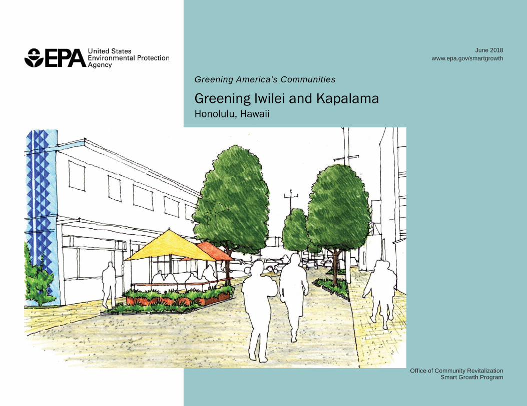
Greening America’s Communities
Greening Iwilei and KapalamaHonolulu, Hawaii
Greening America’s CommunitiesGreening America’s Communities is an EPA program to help cities and towns develop an implementable vision of environmentally friendly neighborhoods that incorporate innovative green infrastructure and other sustainable design strategies. EPA provides design assistance to help support sustainable communities that protect the environment, economy, and public health and to inspire local and state leaders to expand this work elsewhere.
Greening America’s Communities will help communities consider ways to incorporate sustainable design strategies into their planning and development to create and enhance interesting, distinctive neighborhoods that have multiple social, economic, and environmental benefi ts.
Honolulu, Hawaii was chosen in 2016 as one of six communities to receive this assistance along with Columbia, South Carolina; Brownsville, Texas; Multnomah County, Oregon; Muscatine, Iowa, and Oklahoma City, Oklahoma.
More information is available at: https://www.epa.gov/smartgrowth/greening-americas-communities
All images courtesy of Community Design + Architecture unless otherwise noted.
U.S. Environmental Protection Agency
Abby Hall, Offi ce of Community RevitalizationAsia Yeary, Region 9 Hawaii Transportation Lead
City and County of Honolulu
Harrison Rue, Community Building and Transit-Oriented Development AdministratorRenee Espiau, Transit-Oriented Development Division, Lead Planner, Department of Planning & PermittingCaterine Picardo Diaz, Transit-Oriented Development Division Planner, Department of Planning & Permitting
Community Design + Architecture
Connie Goldade, RLA, Principal in ChargePhil Erickson, AIA, Complete Streets AdvisorAshley Cruz, Urban DesignerKatrina Majewski, Urban Designer Ariella Levitch, Urban Designer
Roth Ecological Design International, LLC
Lauren C. Roth Venu, PrincipalElena Lekhter, CAD ManagerRuben Castro, Graphic Designer
Acknowledgements
Greening America’s CommunitiesHonolulu, HI
iii |
Executive Summary 1
1. Introduction 2
2. Design Workshop 5
3. Existing Conditions 6
4. Design Options 10
5. Next Steps and Funding 33
Appendix – Case Studies 41
Table of Contents
Greening Iwilei and KapalamaFinal Report
| 1
Executive SummaryMany areas of Honolulu, including the Iwilei and Kapalama neighborhoods, will be transformed as a new rail line is built and surrounding development responds to rezoning and transit-oriented development (TOD) policies. Iwilei and Kapalama are legacy mixed-use communities in Honolulu’s industrial core and are challenged by poor street connectivity, a lack of sidewalks and bike lanes, localized fl ooding, and susceptibility to sea level rise. The city and county of Honolulu, Hawaii requested technical assistance through the EPA’s Greening America’s Communities program to help imagine potential designs and strategies for more innovative, environmentally-friendly streets and neighborhoods. The designs presented in this report are intended to help Honolulu achieve multiple community benefi ts as Iwilei and Kapalama redevelop. The designs include approaches that: support economic development and public investment in transit, address current and future disaster risk, promote public art and placemaking, better manage stormwater with green infrastructure, and create streets that are safe, accessible, and usable by people of all abilities who are walking, taking transit, biking, or driving around the neighborhood.
This report includes a discussion of project goals, challenges, and opportunities identifi ed during the three-day workshop in Honolulu (Chapter 2); a project area assessment of existing conditions within Iwilei and Kapalama (Chapter 3); and a set of design options for select locations in Iwilei and Kapalama (Chapter 4). The fi nal chapter of this report, Next Steps and Funding, presents ideas about how to pay for and implement the designs, and possible actions that could catalyze improvements not only in Iwilei and Kapalama, but in other parts of Honolulu as well. An appendix features relevant case studies and shows how other communities addressed issues similar to those in Iwilei and Kapalama.
Greening America’s CommunitiesHonolulu, HI
2 | Introduction
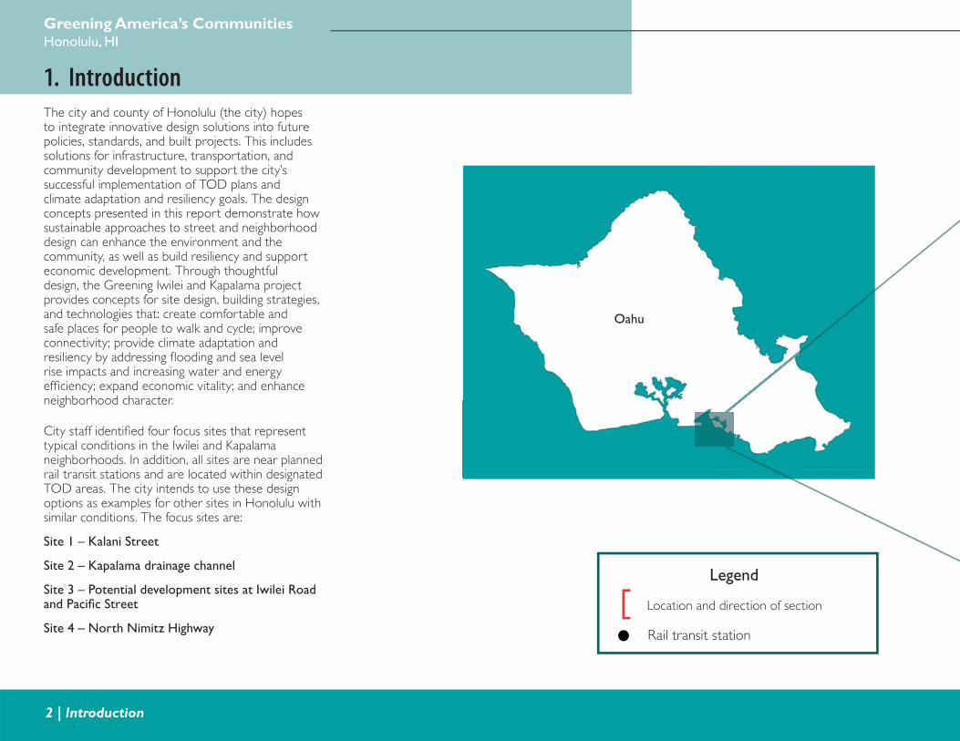
1. IntroductionThe city and county of Honolulu (the city) hopes to integrate innovative design solutions into future policies, standards, and built projects. This includes solutions for infrastructure, transportation, and community development to support the city’s successful implementation of TOD plans and climate adaptation and resiliency goals. The design concepts presented in this report demonstrate how sustainable approaches to street and neighborhood design can enhance the environment and the community, as well as build resiliency and support economic development. Through thoughtful design, the Greening Iwilei and Kapalama project provides concepts for site design, building strategies, and technologies that: create comfortable and safe places for people to walk and cycle; improve connectivity; provide climate adaptation and resiliency by addressing fl ooding and sea level rise impacts and increasing water and energy effi ciency; expand economic vitality; and enhance neighborhood character.
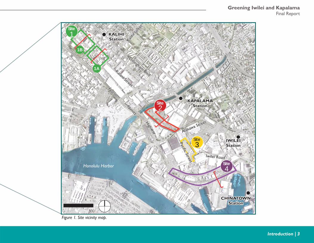
City staff identifi ed four focus sites that represent typical conditions in the Iwilei and Kapalama neighborhoods. In addition, all sites are near planned rail transit stations and are located within designated TOD areas. The city intends to use these design options as examples for other sites in Honolulu with similar conditions. The focus sites are:
Site 1 – Kalani Street
Site 2 – Kapalama drainage channel
Site 3 – Potential development sites at Iwilei Road and Pacifi c Street
Site 4 – North Nimitz Highway
Legend
Location and direction of section
Rail transit station
Oahu
Greening Iwilei and KapalamaFinal Report
Introduction | 3
1Site
2Site
3Site
4Site
1B
1A
NorthNorth
Kalani Street
Kalani Street
Iwilei RoadIwilei Road
Alakawa Street
Alakawa Street
Pacifi c Street
Pacifi c Street
Nimitz
Nimitz
Highw
ay
Highw
ay
Dillingham Blvd
Dillingham Blvd
Kalihi
Stre
et
Kalihi
Stre
et
KALIHIKALIHIStationStation
KAPALAMAKAPALAMAStationStation
IWILEIIWILEIStationStation
CHINATOWNCHINATOWNStationStation
Kapalam
a Cana
l
Honolulu Harbor
Figure 1. Site vicinity map.0 300
Greening America’s CommunitiesHonolulu, HI
4 | Introduction
Honolulu requested assistance from EPA’s Greening America’s Communities program to help:
• Improve multimodal connectivity and safety for all users.
• Enhance and provide walking and biking facilities.
• Provide sustainable practices for green streets, green infrastructure, and open space.
• Identify innovative and resilient approaches for sustainable building and infrastructure that can be modeled for new development or redevelopment projects.
• Develop places for recreation and community interaction.
Following an initial site visit, EPA staff, city staff, and the design team held a three-day workshop with stakeholders, local experts, and staff from city, state, and federal agencies to understand local priorities and challenges for the Iwilei and Kapalama neighborhoods. During the workshop, the design team presented and discussed preliminary design options at two public open houses. After collecting valuable comments and suggestions from community stakeholders and city staff, the design team refi ned the preliminary design options.
Following an initial site visit, EPA staff, city staff, and the design team held a three-day workshop with stakeholders, local experts, and staff from city, state, and federal agencies to understand local priorities and challenges for the Iwilei and Kapalama neighborhoods. During the workshop, the design team presented and discussed preliminary design options at two public open houses. After collecting valuable comments and suggestions from community stakeholders and city staff, the design team refi ned the preliminary design options.
The concept designs in this report illustrate complete streets strategies combined with green infrastructure and green building concepts to create pedestrian-friendly, sustainable, and climate resilient streets, buildings, and sites. Complete streets use a range of strategies to make streets and sidewalks safe for all users, including people walking, bicycling, or driving. Conventional street design was mostly focused on moving vehicles, thereby inducing traffi c congestion, pollution, and collision injuries. Complete streets, on the other hand, are designed so that people of all ages and abilities can travel easily and safely on a comfortable facility. In addition, a street can be more “complete” by improving its environmental performance. Green infrastructure includes a range of natural and built approaches to stormwater management–such as rain gardens, stormwater planters, and permeable paving–that mimic natural systems by capturing and treating polluted stormwater runoff and letting it absorb back into the ground rather than fl ow into the stormwater system. The use of landscaping green infrastructure can also cool the urban environment and support complete streets goals by making streets more comfortable for walking and cycling. Green building concepts also provide green and sustainable strategies, including elements such as green roofs, water reuse technologies, renewable energy generation, and energy effi cient building design.
The design concepts presented in this report envision Iwilei and Kapalama as interconnected, walkable and bikeable, sustainable and climate resilient neighborhoods. The design concepts can attract economic development to the area and support rail transit ridership, while also improving air and water quality to benefi t both current and future residents and visitors alike. Finally, the design options can enhance the overall quality of life and community identity for those living, working, and visiting Iwilei and Kapalama.
Greening Iwilei and KapalamaFinal Report
Design Workshop | 5
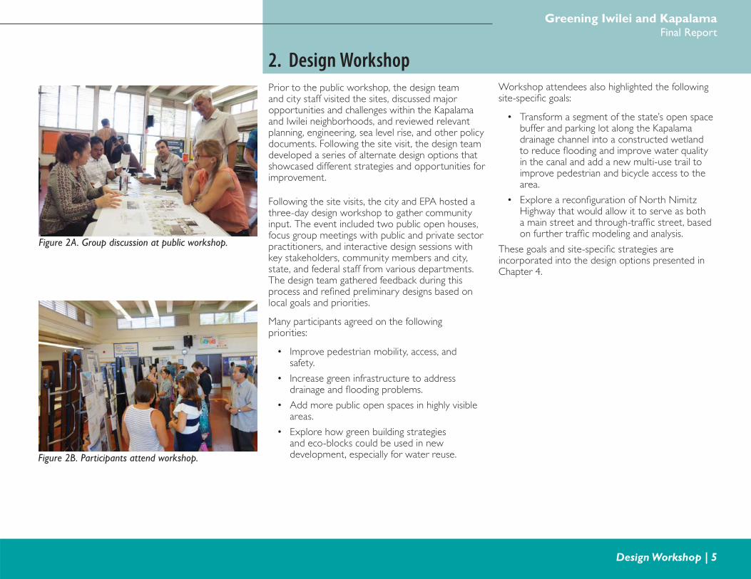
2. Design WorkshopPrior to the public workshop, the design team and city staff visited the sites, discussed major opportunities and challenges within the Kapalama and Iwilei neighborhoods, and reviewed relevant planning, engineering, sea level rise, and other policy documents. Following the site visit, the design team developed a series of alternate design options that showcased different strategies and opportunities for improvement.
Following the site visits, the city and EPA hosted a three-day design workshop to gather community input. The event included two public open houses, focus group meetings with public and private sector practitioners, and interactive design sessions with key stakeholders, community members and city, state, and federal staff from various departments. The design team gathered feedback during this process and refi ned preliminary designs based on local goals and priorities.
Many participants agreed on the following priorities:
• Improve pedestrian mobility, access, and safety.
• Increase green infrastructure to address drainage and fl ooding problems.
• Add more public open spaces in highly visible areas.
• Explore how green building strategies and eco-blocks could be used in new development, especially for water reuse.
Workshop attendees also highlighted the following site-specifi c goals:
• Transform a segment of the state’s open space buffer and parking lot along the Kapalama drainage channel into a constructed wetland to reduce fl ooding and improve water quality in the canal and add a new multi-use trail to improve pedestrian and bicycle access to the area.
• Explore a reconfi guration of North Nimitz Highway that would allow it to serve as both a main street and through-traffi c street, based on further traffi c modeling and analysis.
These goals and site-specifi c strategies are incorporated into the design options presented in Chapter 4.
Figure 2B. Participants attend workshop.
Figure 2A. Group discussion at public workshop.
Greening America’s CommunitiesHonolulu, HI
6 | Existing Conditions
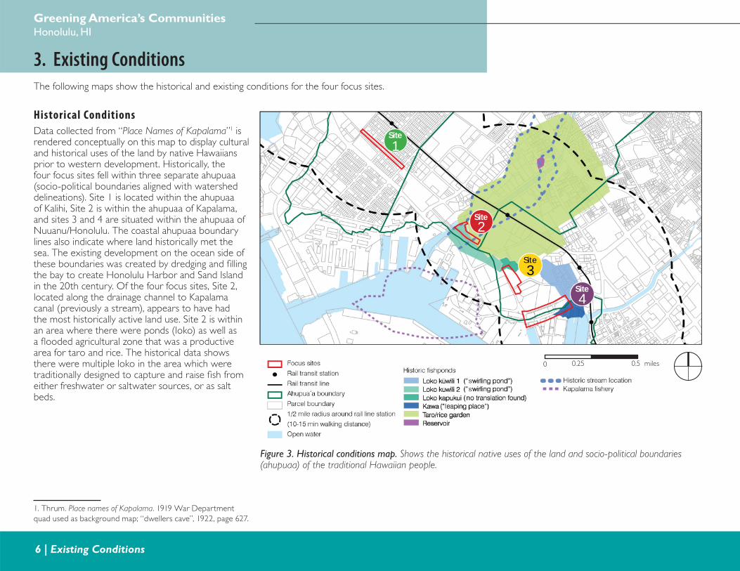
3. Existing ConditionsThe following maps show the historical and existing conditions for the four focus sites.
Figure 3. Historical conditions map. Shows the historical native uses of the land and socio-political boundaries (ahupuaa) of the traditional Hawaiian people.
Historical Conditions
Data collected from “Place Names of Kapalama”1 is rendered conceptually on this map to display cultural and historical uses of the land by native Hawaiians prior to western development. Historically, the four focus sites fell within three separate ahupuaa (socio-political boundaries aligned with watershed delineations). Site 1 is located within the ahupuaa of Kalihi, Site 2 is within the ahupuaa of Kapalama, and sites 3 and 4 are situated within the ahupuaa of Nuuanu/Honolulu. The coastal ahupuaa boundary lines also indicate where land historically met the sea. The existing development on the ocean side of these boundaries was created by dredging and fi lling the bay to create Honolulu Harbor and Sand Island in the 20th century. Of the four focus sites, Site 2, located along the drainage channel to Kapalama canal (previously a stream), appears to have had the most historically active land use. Site 2 is within an area where there were ponds (loko) as well as a fl ooded agricultural zone that was a productive area for taro and rice. The historical data shows there were multiple loko in the area which were traditionally designed to capture and raise fi sh from either freshwater or saltwater sources, or as salt beds.
1. Thrum. Place names of Kapalama. 1919 War Department
quad used as background map; “dwellers cave”, 1922, page 627.
0 0.5 miles0.25
1Site
2Site
3Site
4Site
Greening Iwilei and KapalamaFinal Report
Existing Conditions | 7
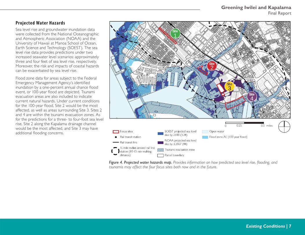
Projec ted Water Hazards
Sea level rise and groundwater inundation data were collected from the National Oceanographic and Atmospheric Association (NOAA) and the University of Hawaii at Manoa School of Ocean, Earth Science and Technology (SOEST). The sea level rise data provides predictions under two increased seawater level scenarios: approximately three and four feet of sea level rise, respectively. Moreover, the risk and impacts of coastal hazards can be exacerbated by sea level rise.
Flood zone data for areas subject to the Federal Emergency Management Agency’s identifi ed inundation by a one-percent annual chance fl ood event, or 100-year fl ood are depicted. Tsunami evacuation areas are also included to indicate current natural hazards. Under current conditions for the 100-year fl ood, Site 2 would be the most affected, as well as areas surrounding Site 3. Sites 2 and 4 are within the tsunami evacuation zones. As for the predictions for a three- to four-foot sea level rise, Site 2 along the Kapalama drainage channel would be the most affected, and Site 3 may have additional fl ooding concerns.
Figure 4. Projected water hazards map. Provides information on how predicted sea level rise, fl ooding, and tsunamis may affect the four focus sites both now and in the future.
0 0.5 miles0.25
1Site
2Site
3Site
4Site
Greening America’s CommunitiesHonolulu, HI
8 | Existing Conditions
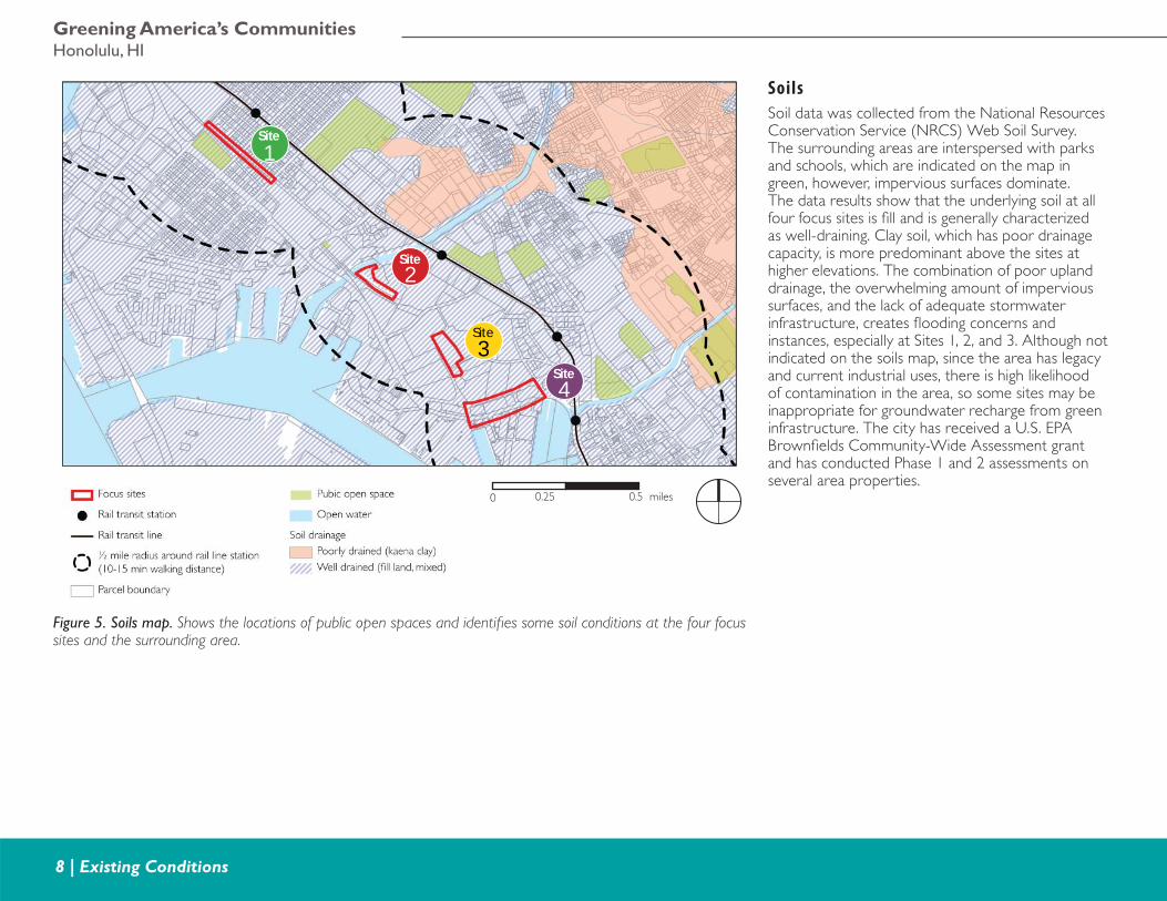
Soils
Soil data was collected from the National Resources Conservation Service (NRCS) Web Soil Survey. The surrounding areas are interspersed with parks and schools, which are indicated on the map in green, however, impervious surfaces dominate. The data results show that the underlying soil at all four focus sites is fi ll and is generally characterized as well-draining. Clay soil, which has poor drainage capacity, is more predominant above the sites at higher elevations. The combination of poor upland drainage, the overwhelming amount of impervious surfaces, and the lack of adequate stormwater infrastructure, creates fl ooding concerns and instances, especially at Sites 1, 2, and 3. Although not indicated on the soils map, since the area has legacy and current industrial uses, there is high likelihood of contamination in the area, so some sites may be inappropriate for groundwater recharge from green infrastructure. The city has received a U.S. EPA Brownfi elds Community-Wide Assessment grant and has conducted Phase 1 and 2 assessments on several area properties.
Figure 5. Soils map. Shows the locations of public open spaces and identifi es some soil conditions at the four focus sites and the surrounding area.
0 0.5 miles0.25
1Site
2Site
3Site
4Site
Greening Iwilei and KapalamaFinal Report
Existing Conditions | 9
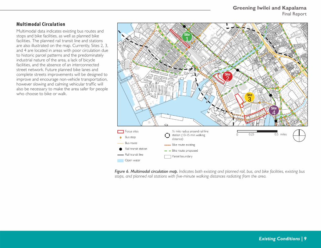
Multimodal Circulation
Multimodal data indicates existing bus routes and stops and bike facilities, as well as planned bike facilities. The planned rail transit line and stations are also illustrated on the map. Currently, Sites 2, 3, and 4 are located in areas with poor circulation due to historic parcel patterns and the predominately industrial nature of the area, a lack of bicycle facilities, and the absence of an interconnected street network. Future planned bike lanes and complete streets improvements will be designed to improve and encourage non-vehicle transportation, however slowing and calming vehicular traffi c will also be necessary to make the area safer for people who choose to bike or walk.
Figure 6. Multimodal circulation map. Indicates both existing and planned rail, bus, and bike facilities, existing bus stops, and planned rail stations with fi ve-minute walking distances radiating from the area.
0 0.5 miles0.25
1Site
2Site
3Site
4Site
Greening America’s CommunitiesHonolulu, HI
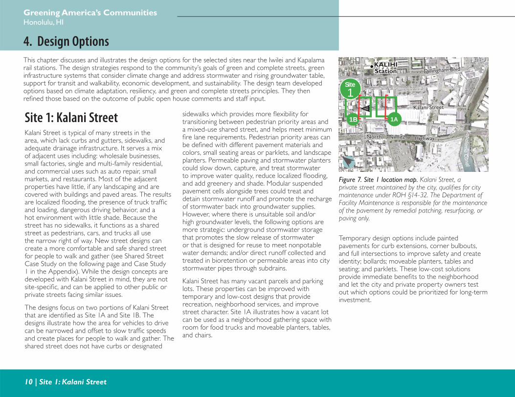
10 | Site 1: Kalani Street
4. Design OptionsThis chapter discusses and illustrates the design options for the selected sites near the Iwilei and Kapalama rail stations. The design strategies respond to the community’s goals of green and complete streets, green infrastructure systems that consider climate change and address stormwater and rising groundwater table, support for transit and walkability, economic development, and sustainability. The design team developed options based on climate adaptation, resiliency, and green and complete streets principles. They then refi ned those based on the outcome of public open house comments and staff input.
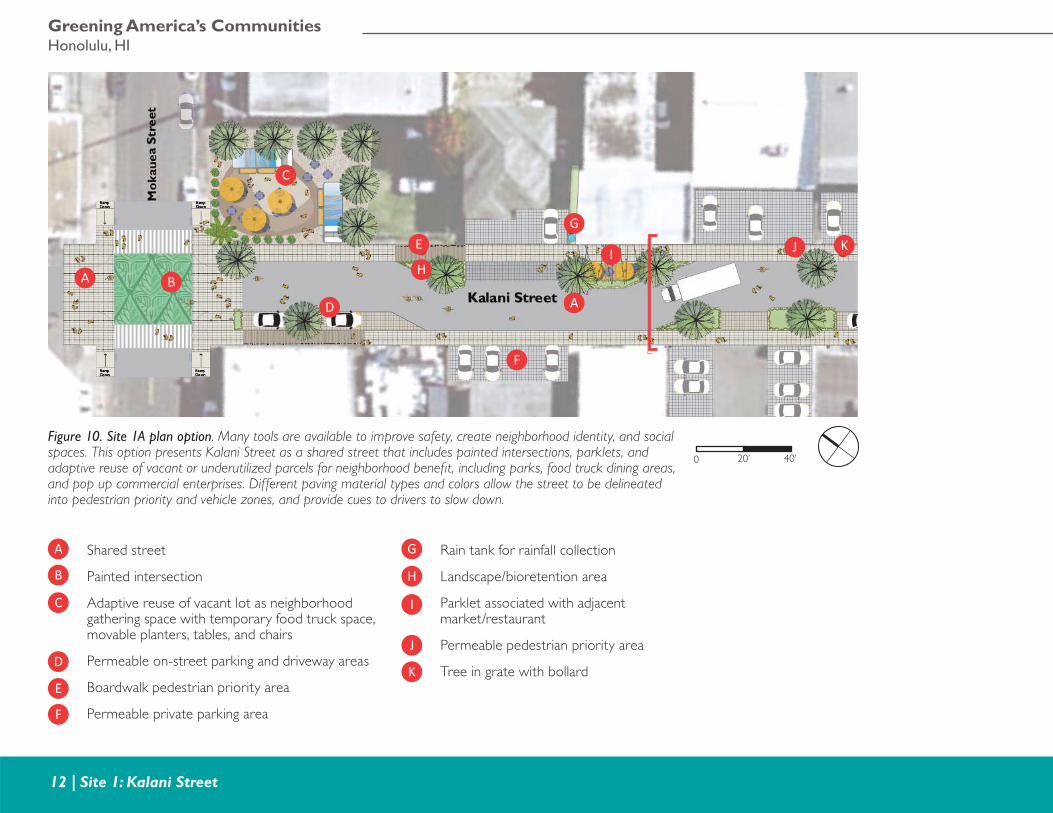
Site 1: Kalani StreetKalani Street is typical of many streets in the area, which lack curbs and gutters, sidewalks, and adequate drainage infrastructure. It serves a mix of adjacent uses including: wholesale businesses, small factories, single and multi-family residential, and commercial uses such as auto repair, small markets, and restaurants. Most of the adjacent properties have little, if any landscaping and are covered with buildings and paved areas. The results are localized fl ooding, the presence of truck traffi c and loading, dangerous driving behavior, and a hot environment with little shade. Because the street has no sidewalks, it functions as a shared street as pedestrians, cars, and trucks all use the narrow right of way. New street designs can create a more comfortable and safe shared street for people to walk and gather (see Shared Street Case Study on the following page and Case Study 1 in the Appendix). While the design concepts are developed with Kalani Street in mind, they are not site-specifi c, and can be applied to other public or private streets facing similar issues.
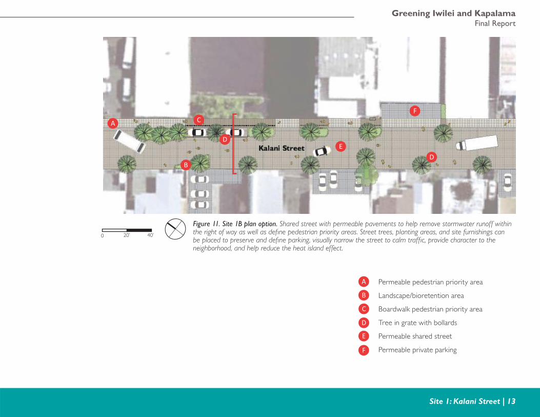
The designs focus on two portions of Kalani Street that are identifi ed as Site 1A and Site 1B. The designs illustrate how the area for vehicles to drive can be narrowed and offset to slow traffi c speeds and create places for people to walk and gather. The shared street does not have curbs or designated
sidewalks which provides more fl exibility for transitioning between pedestrian priority areas and a mixed-use shared street, and helps meet minimum fi re lane requirements. Pedestrian priority areas can be defi ned with different pavement materials and colors, small seating areas or parklets, and landscape planters. Permeable paving and stormwater planters could slow down, capture, and treat stormwater to improve water quality, reduce localized fl ooding, and add greenery and shade. Modular suspended pavement cells alongside trees could treat and detain stormwater runoff and promote the recharge of stormwater back into groundwater supplies. However, where there is unsuitable soil and/or high groundwater levels, the following options are more strategic: underground stormwater storage that promotes the slow release of stormwater or that is designed for reuse to meet nonpotable water demands; and/or direct runoff collected and treated in bioretention or permeable areas into city stormwater pipes through subdrains.
Kalani Street has many vacant parcels and parking lots. These properties can be improved with temporary and low-cost designs that provide recreation, neighborhood services, and improve street character. Site 1A illustrates how a vacant lot can be used as a neighborhood gathering space with room for food trucks and moveable planters, tables, and chairs.
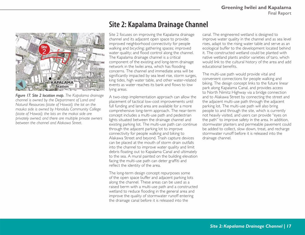
Figure 7. Site 1 location map. Kalani Street, a private street maintained by the city, qualifi es for city maintenance under ROH §14-32. The Department of Facility Maintenance is responsible for the maintenance of the pavement by remedial patching, resurfacing, or paving only.
1Site
1B 1A
NorthNorth
Kalani StreetKalani Street
Dillingham BlvdDillingham Blvd
NimitzNimitz HighwayHighway
KALIHIKALIHIStationStation
Kapalama Canal
Temporary design options include painted pavements for curb extensions, corner bulbouts, and full intersections to improve safety and create identity; bollards; moveable planters, tables and seating; and parklets. These low-cost solutions provide immediate benefi ts to the neighborhood and let the city and private property owners test out which options could be prioritized for long-term investment.
Greening Iwilei and KapalamaFinal Report
Site 1: Kalani Street | 11
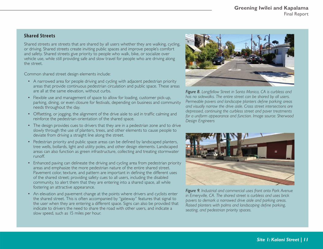
Shared Streets
Shared streets are streets that are shared by all users whether they are walking, cycling, or driving. Shared streets create inviting public spaces and improve people’s comfort and safety. Shared streets give priority to people who walk, bike, or socialize over vehicle use, while still providing safe and slow travel for people who are driving along the street.
Common shared street design elements include:
• A narrowed area for people driving and cycling with adjacent pedestrian priority areas that provide continuous pedestrian circulation and public space. These areas are all at the same elevation, without curbs.
• Flexible use and management of space to allow for loading, customer pick-up, parking, dining, or even closure for festivals, depending on business and community needs throughout the day.
• Offsetting, or jogging, the alignment of the drive aisle to aid in traffi c calming and reinforce the pedestrian-orientation of the shared space.
• The design provides cues to drivers that they are in a pedestrian zone and to drive slowly through the use of planters, trees, and other elements to cause people to deviate from driving a straight line along the street.
• Pedestrian priority and public space areas can be defi ned by landscaped planters, tree wells, bollards, light and utility poles, and other design elements. Landscaped areas can also function as green infrastructure, collecting and treating stormwater runoff.
• Enhanced paving can delineate the driving and cycling area from pedestrian priority areas and emphasize the more pedestrian nature of the entire shared street. Pavement color, texture, and pattern are important in defi ning the different uses of the shared street; providing safety cues to all users, including the disabled community, to alert them that they are entering into a shared space, all while fostering an attractive appearance.
• An elevation and pavement change at the points where drivers and cyclists enter the shared street. This is often accompanied by “gateway” features that signal to the user when they are entering a different space. Signs can also be provided that indicate to drivers the need to share the road with other users, and indicate a slow speed, such as 15 miles per hour.
Figure 8. Longfellow Street in Santa Monica, CA is curbless and has no sidewalks. The entire street can be shared by all users. Permeable pavers and landscape planters defi ne parking areas and visually narrow the drive aisle. Cross street intersections are depressed, continuing the curbless street and paver treatments for a uniform appearance and function. Image source: Sherwood Design Engineers
Figure 9. Industrial and commercial uses front onto Park Avenue in Emeryville, CA. The shared street is curbless and uses brick pavers to demark a narrowed drive aisle and parking areas. Raised planters with palms and landscaping defi ne parking, seating, and pedestrian priority spaces.
Greening America’s CommunitiesHonolulu, HI
12 | Site 1: Kalani Street
Shared street
Painted intersection
Adaptive reuse of vacant lot as neighborhood gathering space with temporary food truck space, movable planters, tables, and chairs
Permeable on-street parking and driveway areas
Boardwalk pedestrian priority area
Permeable private parking area
A
B
C
D
E
F
G
H
I
J
K
A
A
E
F
G
HI
B
C
D
KJ
0 40’20’
Rain tank for rainfall collection
Landscape/bioretention area
Parklet associated with adjacent market/restaurant
Permeable pedestrian priority area
Tree in grate with bollard
Figure 10. Site 1A plan option. Many tools are available to improve safety, create neighborhood identity, and social spaces. This option presents Kalani Street as a shared street that includes painted intersections, parklets, and adaptive reuse of vacant or underutilized parcels for neighborhood benefi t, including parks, food truck dining areas, and pop up commercial enterprises. Different paving material types and colors allow the street to be delineated into pedestrian priority and vehicle zones, and provide cues to drivers to slow down.
Greening Iwilei and KapalamaFinal Report
Site 1: Kalani Street | 13
0 40’20’
Permeable pedestrian priority area
Landscape/bioretention area
Boardwalk pedestrian priority area
Tree in grate with bollards
Permeable shared street
Permeable private parking
A
B
C
D
E
F
A
B
C
D
DE
F
Figure 11. Site 1B plan option. Shared street with permeable pavements to help remove stormwater runoff within the right of way as well as defi ne pedestrian priority areas. Street trees, planting areas, and site furnishings can be placed to preserve and defi ne parking, visually narrow the street to calm traffi c, provide character to the neighborhood, and help reduce the heat island effect.
Greening America’s CommunitiesHonolulu, HI
14 | Site 1: Kalani Street
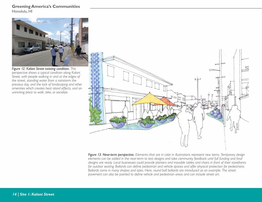
Figure 12. Kalani Street existing condition. This perspective shows a typical condition along Kalani Street, with people walking in and at the edges of the street, standing water from a rainstorm the previous day, and the lack of landscaping and other amenities which creates heat island effects, and an uninviting place to walk, bike, or socialize.
Figure 13. Near-term perspective. Elements that are in color in illustrations represent new items. Temporary design elements can be added in the near-term to test designs and take community feedback until full funding and fi nal designs are ready. Local businesses could provide planters and movable tables and chairs in front of their storefronts for outdoor seating. Bollards can defi ne pedestrian and vehicle spaces and offer physical protection for pedestrians. Bollards come in many shapes and sizes. Here, round ball bollards are introduced as an example. The street pavement can also be painted to defi ne vehicle and pedestrian areas and can include street art.
Greening Iwilei and KapalamaFinal Report
Site 1: Kalani Street | 15
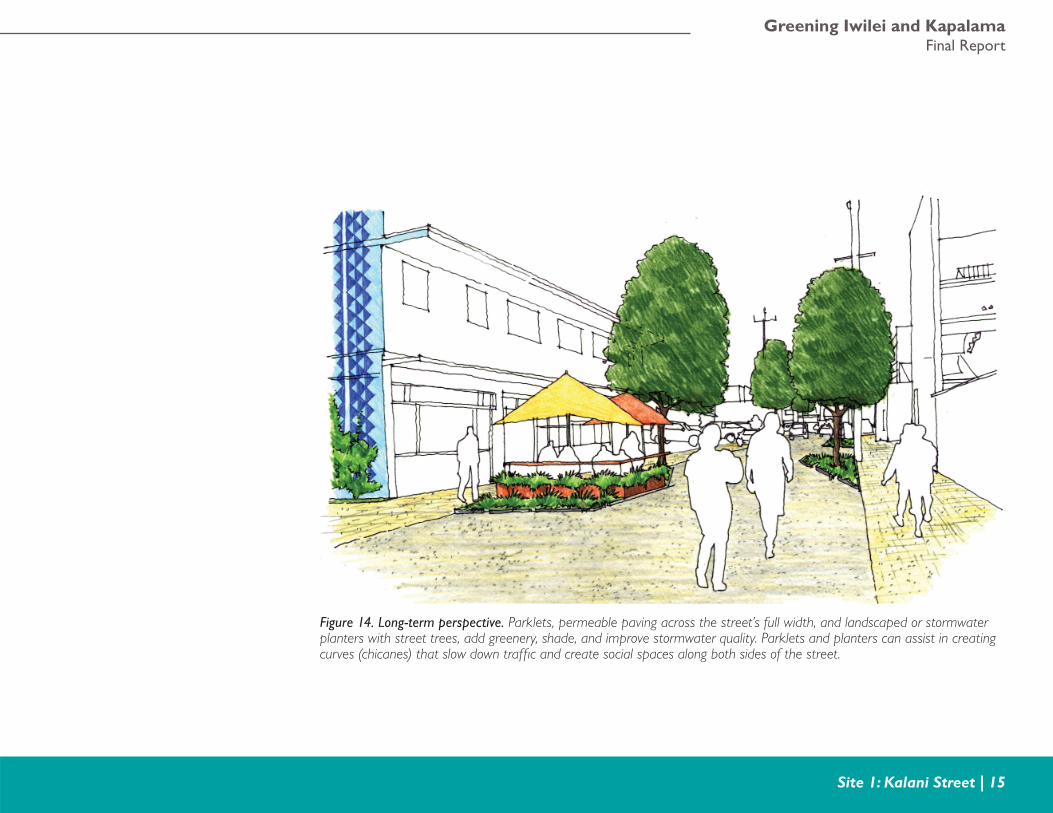
Figure 14. Long-term perspective. Parklets, permeable paving across the street’s full width, and landscaped or stormwater planters with street trees, add greenery, shade, and improve stormwater quality. Parklets and planters can assist in creating curves (chicanes) that slow down traffi c and create social spaces along both sides of the street.
Greening America’s CommunitiesHonolulu, HI
16 | Site 1: Kalani Street
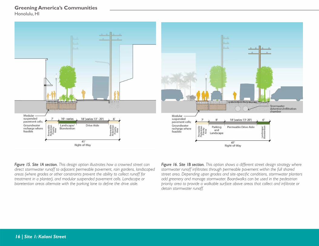
Figure 15. Site 1A section. This design option illustrates how a crowned street can direct stormwater runoff to adjacent permeable pavement, rain gardens, landscaped areas (where grades or other constraints prevent the ability to collect runoff for treatment in a planter), and modular suspended pavement cells. Landscape or bioretention areas alternate with the parking lane to defi ne the drive aisle.
Figure 16. Site 1B section. This option shows a different street design strategy where stormwater runoff infi ltrates through permeable pavement within the full shared street area. Depending upon grades and site-specifi c conditions, stormwater planters add greenery and manage stormwater. Boardwalks can be used in the pedestrian priority area to provide a walkable surface above areas that collect and infi ltrate or detain stormwater runoff.
Greening Iwilei and KapalamaFinal Report
Site 2: Kapalama Drainage Channel | 17
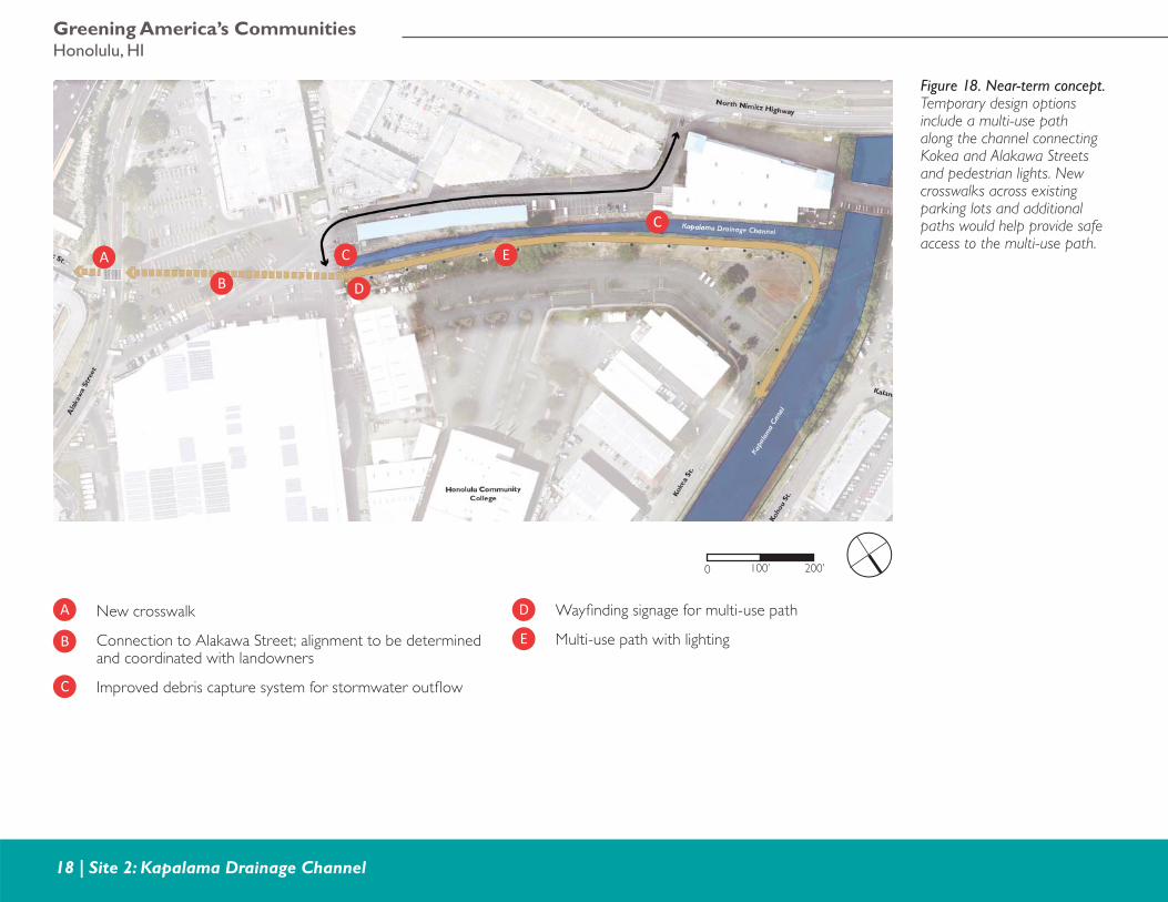
Site 2: Kapalama Drainage ChannelSite 2 focuses on improving the Kapalama drainage channel and its adjacent open space to provide: improved neighborhood connectivity for people walking and bicycling; gathering spaces; improved water quality; and fl ood control along the channel. The Kapalama drainage channel is a critical component of the existing and long-term drainage network in the Iwilei area, which has fl ooding concerns. The channel and immediate area will be signifi cantly impacted by sea level rise, storm surges, king tides, high water table, and other water-related events as water reaches its bank and fl ows to low lying areas.
A two-step implementation approach can allow the placement of tactical low-cost improvements until full funding and land area are available for a more comprehensive long-term approach. The near-term concept includes a multi-use path and pedestrian lights situated between the drainage channel and existing parking lot. The multi-use path can continue through the adjacent parking lot to improve connectivity for people walking and biking to Alakawa Street and beyond. Trash capture devices can be placed at the mouth of storm drain outfalls into the channel to improve water quality and limit debris fl oating out to Kapalama Canal and ultimately to the sea. A mural painted on the building elevation facing the multi-use path can deter graffi ti and refl ect the identity of the area.
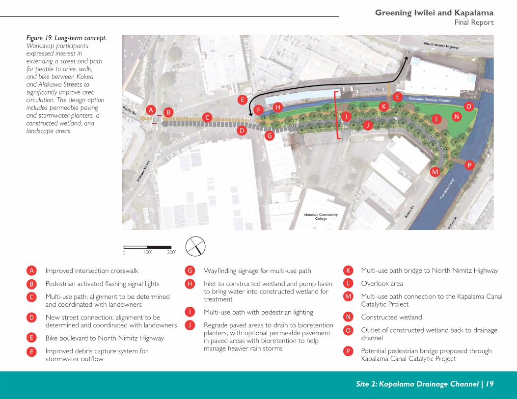
The long-term design concept repurposes some of the open space buffer and adjacent parking lots along the channel. These areas can be used as a raised berm with a multi-use path and a constructed wetland to reduce fl ooding in the general area and improve the quality of stormwater runoff entering the drainage canal before it is released into the
canal. The engineered wetland is designed to improve water quality in the channel and as sea level rises, adapt to the rising water table and serve as an ecological buffer to the development located behind it. The constructed wetland could be planted with native wetland plants and/or varieties of taro, which would link to the cultural history of the area and add educational benefi ts.
The multi-use path would provide vital and convenient connections for people walking and biking. The design concept links to the future linear park along Kapalama Canal, and provides access to North Nimitz Highway via a bridge connection and to Alakawa Street by connecting the street and the adjacent multi-use path through the adjacent parking lot. The multi-use path will also bring people to and through the site, which is currently not heavily visited, and users can provide “eyes on the path” to improve safety in the area. In addition, stormwater planters and permeable pavement could be added to collect, slow down, treat, and recharge stormwater runoff before it is released into the drainage channel.
2Site
NorthNorth
KAPALAMAKAPALAMAStationStation
Ala
kaw
a St
reet
Ala
kaw
a St
reet
Pacifi c Street
Pacifi c Street
Dillingham BoulevardDillingham Boulevard
Kalani StreetKalani Street
NimitzNimitz HighwayHighway
Kapa
lama
Cana
l
Figure 17. Site 2 location map. The Kapalama drainage channel is owned by the Department of Land and Natural Resources (state of Hawaii); the lot on the mauka side is owned by Honolulu Community College (state of Hawaii); the lots on the makai side are privately owned; and there are multiple private owners between the channel and Alakawa Street.
Greening America’s CommunitiesHonolulu, HI
18 | Site 2: Kapalama Drainage Channel
A
B
C
D
E
A
B
C
C
D
E
0 200’100’
Figure 18. Near-term concept. Temporary design options include a multi-use path along the channel connecting Kokea and Alakawa Streets and pedestrian lights. New crosswalks across existing parking lots and additional paths would help provide safe access to the multi-use path.
New crosswalk
Connection to Alakawa Street; alignment to be determined and coordinated with landowners
Improved debris capture system for stormwater outfl ow
Wayfi nding signage for multi-use path
Multi-use path with lighting
Greening Iwilei and KapalamaFinal Report
Site 2: Kapalama Drainage Channel | 19
A
B
C
D
E
F
G
H
I
J
K
L
M
Improved intersection crosswalk
Pedestrian activated fl ashing signal lights
Multi-use path; alignment to be determined and coordinated with landowners
New street connection; alignment to be determined and coordinated with landowners
Bike boulevard to North Nimitz Highway
Improved debris capture system for stormwater outfl ow
0 200’100’
A BC
D
E E
F
G
HI
J
K
M
L
P
ON
P
O
N
Figure 19. Long-term concept. Workshop participants expressed interest in extending a street and path for people to drive, walk, and bike between Kokea and Alakawa Streets to signifi cantly improve area circulation. The design option includes permeable paving and stormwater planters, a constructed wetland, and landscape areas.
Wayfi nding signage for multi-use path
Inlet to constructed wetland and pump basin to bring water into constructed wetland for treatment
Multi-use path with pedestrian lighting
Regrade paved areas to drain to bioretention planters, with optional permeable pavement in paved areas with bioretention to help manage heavier rain storms
Multi-use path bridge to North Nimitz Highway
Overlook area
Multi-use path connection to the Kapalama Canal Catalytic Project
Constructed wetland
Outlet of constructed wetland back to drainage channel
Potential pedestrian bridge proposed through Kapalama Canal Catalytic Project
Greening America’s CommunitiesHonolulu, HI
20 | Site 2: Kapalama Drainage Channel
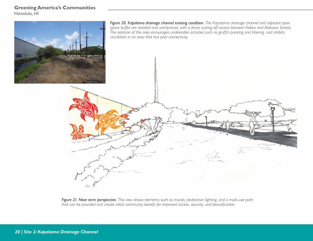
Figure 20. Kapalama drainage channel existing condition. The Kapalama drainage channel and adjacent open space buffer are isolated and unimproved, with a fence cutting off access between Kokea and Alakawa Streets. The isolation of the area encourages undesirable activities such as graffi ti painting and littering, and inhibits circulation in an area that has poor connectivity.
Figure 21. Near term perspective. This view shows elements such as murals, pedestrian lighting, and a multi-use path that can be provided and create initial community benefi t for improved access, security, and beautifi cation.
Greening Iwilei and KapalamaFinal Report
Site 2: Kapalama Drainage Channel | 21
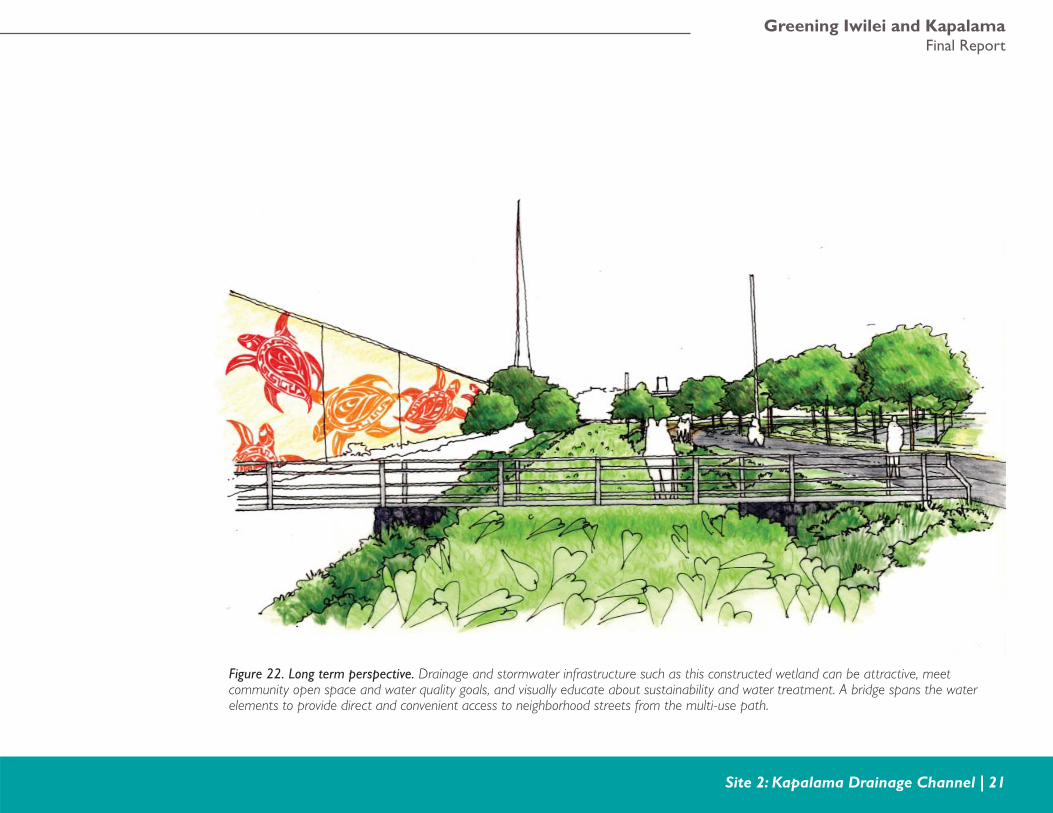
Figure 22. Long term perspective. Drainage and stormwater infrastructure such as this constructed wetland can be attractive, meet community open space and water quality goals, and visually educate about sustainability and water treatment. A bridge spans the water elements to provide direct and convenient access to neighborhood streets from the multi-use path.
Greening America’s CommunitiesHonolulu, HI
22 | Site 2: Kapalama Drainage Channel
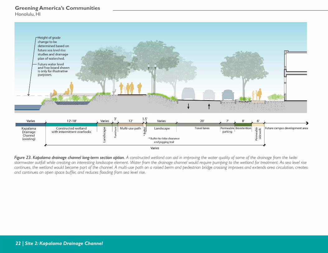
Figure 23. Kapalama drainage channel long-term section option. A constructed wetland can aid in improving the water quality of some of the drainage from the Iwilei stormwater outfall while creating an interesting landscape element. Water from the drainage channel would require pumping to the wetland for treatment. As sea level rise continues, the wetland would become part of the channel. A multi-use path on a raised berm and pedestrian bridge crossing improves and extends area circulation, creates and continues an open space buffer, and reduces fl ooding from sea level rise.
Greening Iwilei and KapalamaFinal Report
Site 3: Development Opportunities at Iwilei Road and Pacifi c Street | 23
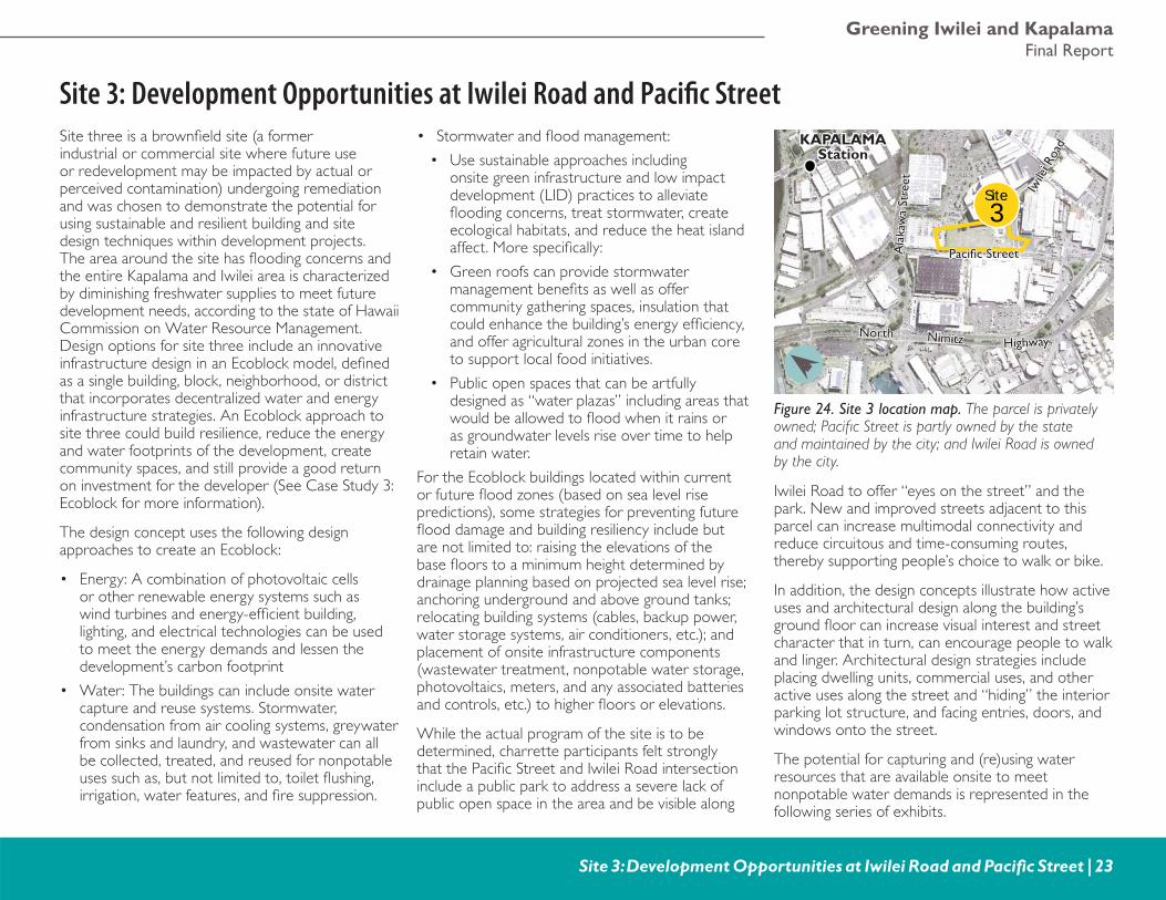
Site 3: Development Opportunities at Iwilei Road and Pacifi c StreetSite three is a brownfi eld site (a former industrial or commercial site where future use or redevelopment may be impacted by actual or perceived contamination) undergoing remediation and was chosen to demonstrate the potential for using sustainable and resilient building and site design techniques within development projects. The area around the site has fl ooding concerns and the entire Kapalama and Iwilei area is characterized by diminishing freshwater supplies to meet future development needs, according to the state of Hawaii Commission on Water Resource Management. Design options for site three include an innovative infrastructure design in an Ecoblock model, defi ned as a single building, block, neighborhood, or district that incorporates decentralized water and energy infrastructure strategies. An Ecoblock approach to site three could build resilience, reduce the energy and water footprints of the development, create community spaces, and still provide a good return on investment for the developer (See Case Study 3: Ecoblock for more information).
The design concept uses the following design approaches to create an Ecoblock:
• Energy: A combination of photovoltaic cells or other renewable energy systems such as wind turbines and energy-effi cient building, lighting, and electrical technologies can be used to meet the energy demands and lessen the development’s carbon footprint
• Water: The buildings can include onsite water capture and reuse systems. Stormwater, condensation from air cooling systems, greywater from sinks and laundry, and wastewater can all be collected, treated, and reused for nonpotable uses such as, but not limited to, toilet fl ushing, irrigation, water features, and fi re suppression.
• Stormwater and fl ood management:
• Use sustainable approaches including onsite green infrastructure and low impact development (LID) practices to alleviate fl ooding concerns, treat stormwater, create ecological habitats, and reduce the heat island affect. More specifi cally:
• Green roofs can provide stormwater management benefi ts as well as offer community gathering spaces, insulation that could enhance the building’s energy effi ciency, and offer agricultural zones in the urban core to support local food initiatives.
• Public open spaces that can be artfully designed as “water plazas” including areas that would be allowed to fl ood when it rains or as groundwater levels rise over time to help retain water.
For the Ecoblock buildings located within current or future fl ood zones (based on sea level rise predictions), some strategies for preventing future fl ood damage and building resiliency include but are not limited to: raising the elevations of the base fl oors to a minimum height determined by drainage planning based on projected sea level rise; anchoring underground and above ground tanks; relocating building systems (cables, backup power, water storage systems, air conditioners, etc.); and placement of onsite infrastructure components (wastewater treatment, nonpotable water storage, photovoltaics, meters, and any associated batteries and controls, etc.) to higher fl oors or elevations.
While the actual program of the site is to be determined, charrette participants felt strongly that the Pacifi c Street and Iwilei Road intersection include a public park to address a severe lack of public open space in the area and be visible along
Iwilei Road to offer “eyes on the street” and the park. New and improved streets adjacent to this parcel can increase multimodal connectivity and reduce circuitous and time-consuming routes, thereby supporting people’s choice to walk or bike.
In addition, the design concepts illustrate how active uses and architectural design along the building’s ground fl oor can increase visual interest and street character that in turn, can encourage people to walk and linger. Architectural design strategies include placing dwelling units, commercial uses, and other active uses along the street and “hiding” the interior parking lot structure, and facing entries, doors, and windows onto the street.
The potential for capturing and (re)using water resources that are available onsite to meet nonpotable water demands is represented in the following series of exhibits.
3Site
NorthNorth
Iwile
i Roa
d
Iwile
i Roa
d
Ala
kaw
a St
reet
Ala
kaw
a St
reet
Pacifi c StreetPacifi c Street
NimitzNimitz HighwayHighway
KAPALAMAKAPALAMAStationStation
Figure 24. Site 3 location map. The parcel is privately owned; Pacifi c Street is partly owned by the state and maintained by the city; and Iwilei Road is owned by the city.
Greening America’s CommunitiesHonolulu, HI
24 | Site 3: Development Opportunities at Iwilei Road and Pacifi c Street
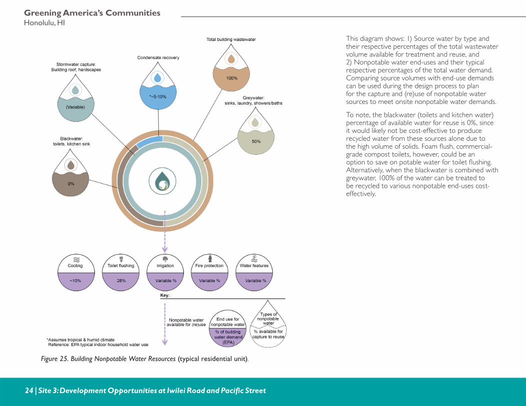
Figure 25. Building Nonpotable Water Resources (typical residential unit).
This diagram shows: 1) Source water by type and their respective percentages of the total wastewater volume available for treatment and reuse, and 2) Nonpotable water end-uses and their typical respective percentages of the total water demand. Comparing source volumes with end-use demands can be used during the design process to plan for the capture and (re)use of nonpotable water sources to meet onsite nonpotable water demands.
To note, the blackwater (toilets and kitchen water) percentage of available water for reuse is 0%, since it would likely not be cost-effective to produce recycled water from these sources alone due to the high volume of solids. Foam fl ush, commercial-grade compost toilets, however, could be an option to save on potable water for toilet fl ushing. Alternatively, when the blackwater is combined with greywater, 100% of the water can be treated to be recycled to various nonpotable end-uses cost-effectively.
Greening Iwilei and KapalamaFinal Report
Site 3: Development Opportunities at Iwilei Road and Pacifi c Street | 25
Rainwatercatchment Bioretention
Recharge groundwater
Biofilter
Water feature Irrigation Fire surppression Cooling Bathroom sink Washing machineShowerToilet
Constructed wetland (or other technology)
wastewater treatment plant
Kitchen sink
Rain
Nonpotablewater storage
LEGEND:
Nonpotable water
100% wastewaterfrom building
Sources of nonpotable water:
End uses receivingnonpotable water
Greywater
Stormwater
Blackwater
Condensate
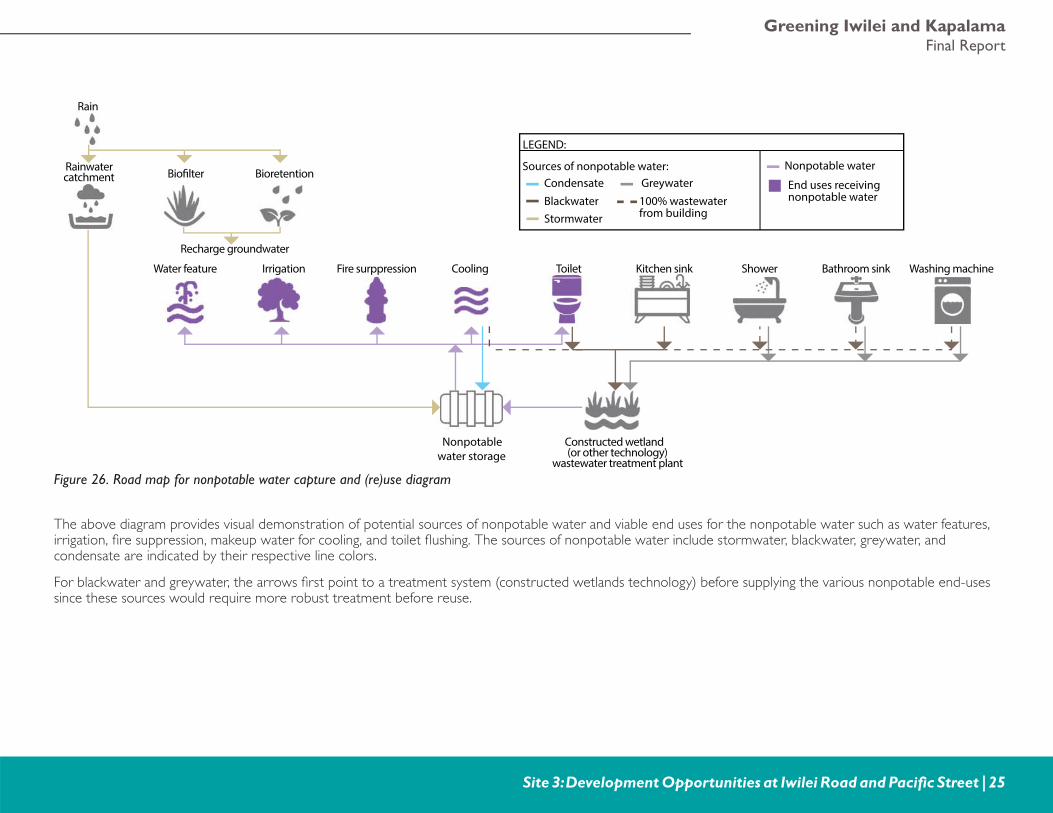
Figure 26. Road map for nonpotable water capture and (re)use diagram
The above diagram provides visual demonstration of potential sources of nonpotable water and viable end uses for the nonpotable water such as water features, irrigation, fi re suppression, makeup water for cooling, and toilet fl ushing. The sources of nonpotable water include stormwater, blackwater, greywater, and condensate are indicated by their respective line colors.
For blackwater and greywater, the arrows fi rst point to a treatment system (constructed wetlands technology) before supplying the various nonpotable end-uses since these sources would require more robust treatment before reuse.
Greening America’s CommunitiesHonolulu, HI
26 | Site 3: Development Opportunities at Iwilei Road and Pacifi c Street
A B C
D
0 40’20’
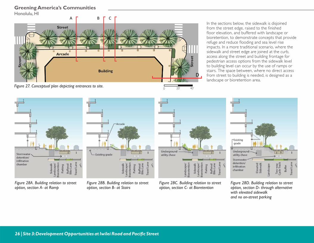
In the sections below, the sidewalk is disjoined from the street edge, raised to the fi nished fl oor elevation, and buffered with landscape or bioretention, to demonstrate concepts that provide refuge and reduce fl ooding and sea level rise impacts. In a more traditional scenario, where the sidewalk and street edge are joined at the curb, access along the street and building frontage for pedestrian access options from the sidewalk level to building level can occur by the use of ramps or stairs. The space between, where no direct access from street to building is needed, is designed as a landscape or bioretention area.
Figure 27. Conceptual plan depicting entrances to site.
Figure 28A. Building relation to street option, section A- at Ramp
Figure 28B. Building relation to street option, section B- at Stairs
Figure 28C. Building relation to street option, section C- at Bioretention
Figure 28D. Building relation to street option, section D- through alternative with elevated sidewalkand no on-street parking
Greening Iwilei and KapalamaFinal Report
Site 3: Development Opportunities at Iwilei Road and Pacifi c Street | 27
A
B
C
D
E
F
G
H
A B C
DE
F
H
G
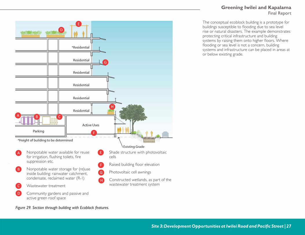
Nonpotable water available for reuse for irrigation, fl ushing toilets, fi re suppression etc.
Nonpotable water storage for (re)use inside building: rainwater catchment, condensate, reclaimed water (R-1)
Wastewater treatment
Community gardens and passive and active green roof space
Shade structure with photovoltaic cells
Raised building fl oor elevation
Photovoltaic cell awnings
Constructed wetlands, as part of the wastewater treatment system
The conceptual ecoblock building is a prototype for buildings susceptible to fl ooding due to sea level rise or natural disasters. The example demonstrates protecting critical infrastructure and building systems by raising them onto higher fl oors. Where fl ooding or sea level is not a concern, building systems and infrastructure can be placed in areas at or below existing grade.
Figure 29. Section through building with Ecoblock features.
Existing Grade
Greening America’s CommunitiesHonolulu, HI
28 | Site 4: North Nimitz Highway Couplet
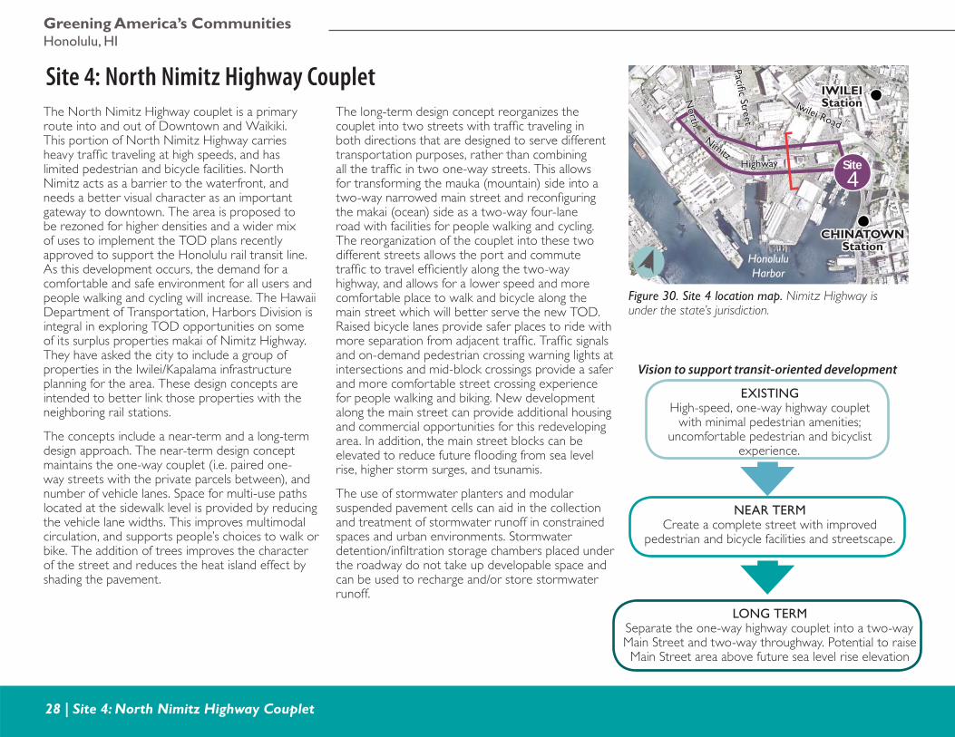
Site 4: North Nimitz Highway CoupletThe North Nimitz Highway couplet is a primary route into and out of Downtown and Waikiki. This portion of North Nimitz Highway carries heavy traffi c traveling at high speeds, and has limited pedestrian and bicycle facilities. North Nimitz acts as a barrier to the waterfront, and needs a better visual character as an important gateway to downtown. The area is proposed to be rezoned for higher densities and a wider mix of uses to implement the TOD plans recently approved to support the Honolulu rail transit line. As this development occurs, the demand for a comfortable and safe environment for all users and people walking and cycling will increase. The Hawaii Department of Transportation, Harbors Division is integral in exploring TOD opportunities on some of its surplus properties makai of Nimitz Highway. They have asked the city to include a group of properties in the Iwilei/Kapalama infrastructure planning for the area. These design concepts are intended to better link those properties with the neighboring rail stations.
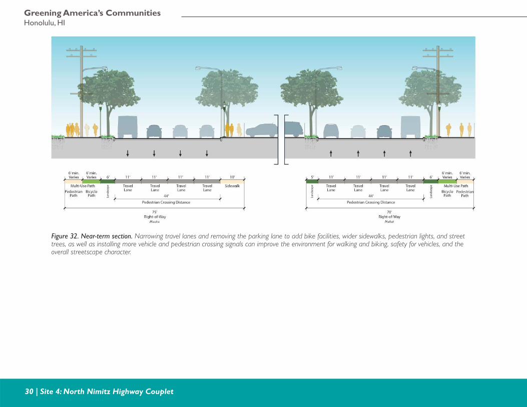
The concepts include a near-term and a long-term design approach. The near-term design concept maintains the one-way couplet (i.e. paired one-way streets with the private parcels between), and number of vehicle lanes. Space for multi-use paths located at the sidewalk level is provided by reducing the vehicle lane widths. This improves multimodal circulation, and supports people’s choices to walk or bike. The addition of trees improves the character of the street and reduces the heat island effect by shading the pavement.
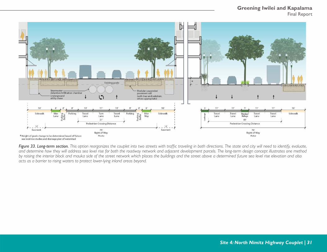
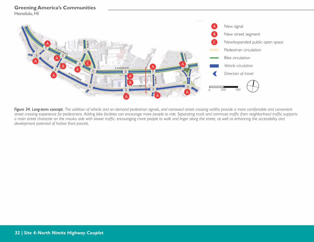
The long-term design concept reorganizes the couplet into two streets with traffi c traveling in both directions that are designed to serve different transportation purposes, rather than combining all the traffi c in two one-way streets. This allows for transforming the mauka (mountain) side into a two-way narrowed main street and reconfi guring the makai (ocean) side as a two-way four-lane road with facilities for people walking and cycling. The reorganization of the couplet into these two different streets allows the port and commute traffi c to travel effi ciently along the two-way highway, and allows for a lower speed and more comfortable place to walk and bicycle along the main street which will better serve the new TOD. Raised bicycle lanes provide safer places to ride with more separation from adjacent traffi c. Traffi c signals and on-demand pedestrian crossing warning lights at intersections and mid-block crossings provide a safer and more comfortable street crossing experience for people walking and biking. New development along the main street can provide additional housing and commercial opportunities for this redeveloping area. In addition, the main street blocks can be elevated to reduce future fl ooding from sea level rise, higher storm surges, and tsunamis.
The use of stormwater planters and modular suspended pavement cells can aid in the collection and treatment of stormwater runoff in constrained spaces and urban environments. Stormwater detention/infi ltration storage chambers placed under the roadway do not take up developable space and can be used to recharge and/or store stormwater runoff.
Figure 30. Site 4 location map. Nimitz Highway is under the state’s jurisdiction.
4Site
IWILEIIWILEIStationStation
CHINATOWNCHINATOWNStationStation
Iwilei Road
Iwilei Road
HonoluluHarbor
Pacifi c StreetPacifi c Street
NimitzNimitz
North
North
HighwayHighway
Vision to support transit-oriented development
EXISTINGHigh-speed, one-way highway couplet
with minimal pedestrian amenities; uncomfortable pedestrian and bicyclist
experience.
NEAR TERMCreate a complete street with improved
pedestrian and bicycle facilities and streetscape.
LONG TERMSeparate the one-way highway couplet into a two-way Main Street and two-way throughway. Potential to raise Main Street area above future sea level rise elevation
Greening Iwilei and KapalamaFinal Report
Site 4: North Nimitz Highway Couplet | 29
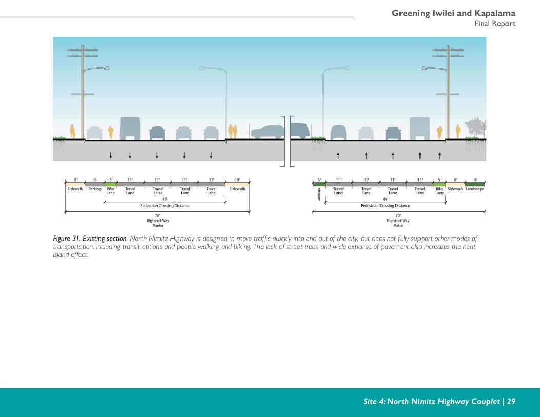
Figure 31. Existing section. North Nimitz Highway is designed to move traffi c quickly into and out of the city, but does not fully support other modes of transportation, including transit options and people walking and biking. The lack of street trees and wide expanse of pavement also increases the heat island effect.
Greening America’s CommunitiesHonolulu, HI
30 | Site 4: North Nimitz Highway Couplet
Figure 32. Near-term section. Narrowing travel lanes and removing the parking lane to add bike facilities, wider sidewalks, pedestrian lights, and street trees, as well as installing more vehicle and pedestrian crossing signals can improve the environment for walking and biking, safety for vehicles, and the overall streetscape character.
Greening Iwilei and KapalamaFinal Report
Site 4: North Nimitz Highway Couplet | 31
Figure 33. Long-term section. This option reorganizes the couplet into two streets with traffi c traveling in both directions. The state and city will need to identify, evaluate, and determine how they will address sea level rise for both the roadway network and adjacent development parcels. The long-term design concept illustrates one method by raising the interior block and mauka side of the street network which places the buildings and the street above a determined future sea level rise elevation and also acts as a barrier to rising waters to protect lower-lying inland areas beyond.
Greening America’s CommunitiesHonolulu, HI
32 | Site 4: North Nimitz Highway Couplet
A
A
A
AA
A
A
A
AA
A
B
B
C
0 400’200’
Figure 34. Long-term concept. The addition of vehicle and on-demand pedestrian signals, and narrowed street crossing widths provide a more comfortable and convenient street crossing experience for pedestrians. Adding bike facilities can encourage more people to ride. Separating truck and commute traffi c from neighborhood traffi c supports a main street character on the mauka side with slower traffi c, encouraging more people to walk and linger along the street, as well as enhancing the accessibility and development potential of harbor front parcels.
A
B
C
New signal
New street segment
New/expanded public open space
Pedestrian circulation
Bike circulation
Vehicle circulation
Direction of travel
Greening Iwilei and KapalamaFinal Report
Next Steps and Funding | 33
5. Next Steps and FundingThe design options presented in this report, as well as associated planning and policy efforts currently undertaken by the city, could catalyze a range of improvements in the Iwilei and Kapalama neighborhoods. During the three-day charrette, the various stakeholders and experts identifi ed the following policies, partnerships, and funding sources that could help the city and its partners implement the design options illustrated and discussed in this report.
Implementation Strategies
Polic y
• Develop policies and guidance for shared streets and living alleys. Develop a process and cohesive design guidance for designers and community members regarding how to achieve shared streets and living alleys.
• Develop shared street districts and plans. The adoption of a shared street district plan could expand the application and impact of design options for Kalani Street to different streets and neighborhoods.
• Study and implement green infrastructure design guidelines and policies. Develop green infrastructure design guidelines and policies, and especially focus on how these elements can be integrated into street and public space projects, and implement them. The design options identifi ed in this report illustrate how permeable paving, stormwater planters, tree wells, rain gardens, and other techniques can be used to capture, slow, treat, and infi ltrate runoff prior to it moving downstream.
• Incentivize green building practices through expedited permitting. Incentivize projects seeking Leadership in Energy and Environmental Design (LEED) or other green building standards to also include stormwater runoff reduction or other water resource management strategies by creating a “green permit program”
similar to other cities such as Chicago, where developments that are incorporating green features can qualify for expedited permitting and reduced permit fees, and property tax incentives
• Require or incentivize green roofs. Encourage developers to build green roofs as part of their resiliency and sustainability planning since fl ooding is a concern in these areas and green roofs would mitigate stormwater runoff. Some U.S. cities offer grants or other matching funds for integrating green roofs with new development projects, including Washington D.C.’s Green Roof Rebate Program, New York City’s tax rebate program, and Chicago’s Green Roof Grant and Cool Roofs Grant programs. In addition, San Francisco recently became the fi rst U.S. city to require that most new construction provide between 15 and 30 percent of the roof area to be covered with either landscape, solar panels, or both, under their Better Roofs Ordinance.2
• Update the Uniform Plumbing Code to include the (re)use of nonpotable water back inside buildings. Presently the city is using the 2006 Uniform Plumbing Code (UPC), which allows greywater reuse, but for irrigation only. Updating the base plumbing code to the UPC 2012 version and including chapters 16 and 17 within the
2. City and County of San Francisco. Ordinance amending
the Planning Code and Green Building Code to establish
requirements for certain new building construction facilitating
development of renewable energy facilities and living roofs:
setting an operative date of January 1, 2017, Ordinance No.
221-16, Amended in Committee 10/17/16. http://sfbos.org/sites/default/fi les/o0221-16.pdf. Accessed October 2, 2017.
Greening America’s CommunitiesHonolulu, HI
34 | Next Steps and Funding
code would provide a pathway for developers and building owners to replace potable water resources with nonpotable sources for use back inside the building.
• Develop an ordinance on new development in water-restricted areas. Require new developments within certain locations and of a certain size to use nonpotable water for end uses such as fl ushing toilets, irrigation, water features, fi re suppression, and cooling. The ordinance could support distributed infrastructure systems and reduce potable water use especially in areas where groundwater supplies are limited. This type of ordinance would also support disaster preparedness by diversifying available water supplies in these communities in the event repairs are required on the municipal water systems following a disaster.
• Incentivize on-site rainwater harvesting and stormwater management. Encourage on-site rainwater harvesting and stormwater management to property owners and developers through rebates, reduced fees, and public education to obtain and use cisterns and rain barrels, connect downspouts to landscape areas, and increase pervious surfaces to reduce the amount of runoff and fl ooding occurring in streets and other areas. The EPA’s Municipal Handbook, found at https://www.epa.gov/green-infrastructure/policy-guides, provides guidance for policies on rainwater harvesting and stormwater management.
• Implement a stormwater fee.Implementing a stormwater fee designed for developments of a certain scale could encourage developers to minimize impervious areas and implement green infrastructure strategies. The city could then use fees to support a rebate program to encourage
smaller land owners to also implement sustainable stormwater practices and fund maintenance of green infrastructure in public rights of way. Useful information on how to set up a stormwater fee and other funding options can be found at https://www.epa.gov/green-infrastructure/green-infrastructure-funding-opportunities#Funding%20Tools.
• Update building codes to address fl oods. Enact new building codes that include raising base fl oor elevations to designated heights in identifi ed future “fl ood-prone” areas or adopt other codes designed to protect critical building systems and new infrastructure from fl ood impacts and their strategic locations.
• Increase of city revenues to augment Capital Improvement Project (CIP) funding could aid in realizing more transportation and infrastructure improvements. Capital improvement projects could include multimodal complete streets, shared streets and living alleys, pedestrian and bicycle trail facilities, street trees and landscaping, green stormwater infrastructure, drainage and fl ood prevention infrastructure, Ecoblock distributed water and energy infrastructure, and other climate resiliency systems and infrastructure.
Planning and Design
• Identify and cultivate key partnerships. Identify and cultivate key partnerships with community stakeholders to implement green and complete street concepts, create gateways, improve and unify the streetscape, and support the larger goals for the Iwilei and Kapalama neighborhoods. Formal partnerships may also help the city identify clear roles for stakeholders, businesses, and others in sponsoring and maintaining interim improvements, such as parklets, planters, bulb outs, and pedestrian refuge islands.
• Work with the state and Honolulu Community College to design and construct an interim multi-use trail along Kapalama drainage channel and work on longer-term efforts. Work with state and college representatives to design and construct a temporary multi-use path to provide convenient and comfortable access for people to walk and bike in an area that limits public access. In the long-term, work on creating a constructed wetland and elevated multi-use trail along Kapalama drainage channel. Devise solutions to address sea level rise, pedestrian and bicycle connectivity and mobility, and water quality in a cohesive manner that meets the goals of all participants. As part of the College’s Long Range Development Plan update, they can evaluate and determine access and future space and use needs and how that may affect planning and circulation in this area (Kokea Street Campus). These actions should be done in conjunction with, or based upon, the forthcoming/future drainage master plan for this area. It would be strategic to plan for implementation of the drainage channel improvements in coordination with implementation of the strategies defi ned in the Kapalama Canal Catalytic Project.
Greening Iwilei and KapalamaFinal Report
Next Steps and Funding | 35
• Work with property owners in the vicinity of Alakawa Street and the Kapalama drainage channel to provide for safer pedestrian and bicycle travel. Work with adjacent property owners to obtain an access easement or right of way and provide improved pedestrian and bicycle facilities, so people can walk and bike in a more comfortable and safe way between Kapalama Canal, Alakawa Street, and North Nimitz Highway.
• Develop access, improvement, and maintenance agreements between neighborhood groups and the city for private streets. Various agreements will be needed for the city to design, construct, and/or maintain private street pavement, utilities, and other elements. The city and neighborhood representatives and property owners will need to resolve this issue before public work and funding can be used on a private street.
• Establish public/private agreements for shared collection and treatment facilities with adjacent private property owners. Defi ning responsibilities for implementation, operations, management, and maintenance of green infrastructure will help ensure that it is implemented and functional over the long term.
Techniques for near-term, temporary (to permanent), and pilot projects include:
• “Tactical urbanism” is an approach to temporary neighborhood interventions that uses short-term, low-cost, and scalable interventions and policies to catalyze long-term change.
• Pavement-to-parks projects repurpose portions of a street from vehicle use to public open space by closing off traffi c lanes or parking areas with the use of street furniture, paint, and/or planters to defi ne a pedestrian space.
• Installations could be scheduled to have their opening coupled with other community events, such as Bike to Work Day or Park(ING) Day (third Friday in September).
• Consider landscaped buffer separation between bicycle facilities and vehicle lanes. Recent protected bike lanes in Honolulu have been created using paint and bollards. Implement narrow landscape median planters as a buffer to separate and protect bicyclists from vehicles and to provide pervious areas and more attractive streetscapes.
• Implement pilot programs and pursue near-term and temporary street improvements. The placement of near-term options could be done through pilot projects and temporary street facilities to show the community the possibilities for reusing public rights of way, and serve as a showcase for the full project. The interventions could improve pedestrian safety, calm traffi c, and enhance the attractiveness of a street and neighborhood, as well as create a sense of place. Collect community feedback and comments on pilot project to inform longer-term, larger projects, as well as implement near-term and temporary street improvements.
At a later phase, as funding is obtained, bioretention planters, permeable paving, additional landscaping, seating and other pedestrian amenities, lighting, and overhead utilities placed underground could be installed. By implementing interim improvements, the city and neighborhood could promote a larger shared street project and spur additional private partnerships, create business reinvestment and development, or help to garner grant funding.
• Utilize pedestrian-activated crossing signals. On-demand pedestrian-activated crossing signals could be considered at “mid-block” locations along wide streets with fast-moving cars and where there are long distances between signalized intersections. These pedestrian-activated signals can make people safer and more comfortable crossing larger streets.
• Expand the use of public/private open space. Private developments could manage public open spaces and relieve the city of funding and maintaining these spaces. These privately-owned public open spaces could create an active community presence while creating value for private commercial and residential uses. San Francisco, CA has a program called Privately-owned Public Open Space (POPOS) in which developers provided publicly accessible open spaces such as plazas, small parks, and atriums that they maintain in exchange for receiving a density bonus, as a condition of project approval, or provided voluntarily for certain commercial and residential projects. Information on this program can be found at http://sf-planning.org/privately-owned-public-open-space-and-public-art-popos.
• Develop a city community garden program. There are many opportunities within the study areas where underutilized street right of way or other vacant lands could be turned into community gardens. The city can partner with the community to identify the appropriate areas to place community gardens and work together to establish the community gardens. Raised beds can be used in potentially contaminated areas.
• Identify maintenance responsibilities. Per city requirements, when construction plans are developed for projects, the identifi cation of maintenance responsibilities of landscape areas,
Greening America’s CommunitiesHonolulu, HI
36 | Next Steps and Funding
• Integrate design options into local Hazard Mitigation Plan (HMP). Work with the Oahu Hazard Mitigation Planning committee to include some of the resilience design approaches into the local HMP update, which could make them eligible for implementation funding through FEMA’s Hazard Mitigation Grant Program.
EPA’s Smart Growth Fixes for Climate Adaptation and Resilience: Changing Land Use and Building Codes to Prepare for Climate Change and other documents can provide information and form a basis of conversation. Smart Growth Fixes for Climate Adaptation and Resilience “outlines more than 70 policies local government offi cials, staff, and boards can consider using to help adapt to current or projected fl ooding and extreme precipitation, sea level rise and storm surge, extreme heat, drought, and wildfi re. These policies range from modest adjustments to wholesale changes, giving communities a range of options to consider depending on their needs and context. The publication includes examples of communities implementing these policies, resources for more information, and metrics that communities could use taken from three community-scale sustainability rating systems.”3
3. EPA. Smart Growth for Climate Adaptation and
Resilience, https://www.epa.gov/sites/production/fi les/2017-01/documents/smart_growth_fi xes_climate_adaptation_resilience.pdf . October 2, 2017.
trees, irrigation systems, parklets, special painted intersections/crosswalks, wetlands, bioretention/green infrastructure, permeable concrete/porous asphalt, and other special features will need to be identifi ed and coordinated with the city.
• Consider the use of green infrastructure measures not currently used or used infrequently. Explore the use of modular pavement support cells and permeable pavements to manage and treat stormwater. These systems are already used in many communities to limit stormwater runoff and improve tree health and irrigation. Many new technologies and products are available. Consider implementing pilot programs to construct and study these measures. This should include exploration of equipment needed for maintenance, such as on-going street sweeping and periodic vacuuming of the permeable pavement.
• Resolve jurisdictional ownership. As projects are considered and move forward, various jurisdictional issues will need to be addressed and resolved by all pertinent parties.
• Plan for future fl oods and sea level rise. Undertake a drainage study to determine future fl ood risks under future conditions, including during larger intensity storms (100-year and 500-year rainfall events), king tides, and storm surges. Results of such a study could help the city identify where to avoid new development and to identify strategies to address fl ooding.
• Reduce disaster risk. Coordinate with city and state agencies to identify shared goals, development strategies, funding, policies, and guidance for reducing risks within any new investments.
Greening Iwilei and KapalamaFinal Report
Next Steps and Funding | 37
FundingThe use of green and complete street techniques, and climate resiliency strategies can help projects compete for limited infrastructure and other improvement funding from regional, state, and federal agencies, and these approaches can be easily integrated with other street, building, and site improvements for multiple benefi ts.
Local stakeholders identifi ed several potential funding sources that the city and its partners can use to implement the design options described in this report. The city is currently developing an infrastructure assessment and district fi nancing strategy for the Iwilei/Kapalama area that could include funding for some of these longer-term strategies. The design team also researched and suggests additional potential funding sources. These funding sources include:
Federal and National Sources
EPA Programs
• The Water Infrastructure and Resiliency Finance Center provides the Water Finance Clearinghouse (Clearinghouse), “a web based portal, [which] helps communities make informed fi nancing decisions for their drinking water, wastewater, and stormwater infrastructure needs. The Water Finance Clearinghouse gives local decision makers an opportunity to search for available funding sources for water infrastructure as well as resources (such as reports, webpages, and webinars) on fi nancing mechanisms and approaches that can help communities access capital to meet their water infrastructure needs. State, federal, local, and foundation funding sources and resources on public-private partnerships, asset management practices, revenue models, and affordability
approaches are included in the Clearinghouse.”4
In addition, the Water Finance Center offers fi nancing information to aid in the protection of public health and the environment.”5
• The Offi ce of Water offers many grants and funding sources. The Clean Water State Revolving Fund (CWSRF) provides eligibility to projects aimed to manage nonpoint source pollution, recapture stormwater, and reduce water use. Another program is the Green Project Reserve which provides water quality fi nancing to help communities meet the goals of the Clean Water Act. Nonpoint source pollution control and green infrastructure can be eligible for funding through this program. Section 106 Water Pollution Control Grants provide assistance to build and sustain effective water quality programs.
• The Urban Waters Small Grants Program funds research, training, and studies that advance the restoration of urban waters by improving water quality through activities supportive of community revitalization and other local priorities. Grants of up to $60,000 have been awarded. About 19 percent of recent grants have been given to advance green infrastructure.
• Clean Water Act Section 319 grants are directed to demonstration projects that reduce nonpoint source pollution. Green infrastructure elements could be eligible for funding through this program.
• Brownfi elds Program works to protect the environment, promote partnerships, and facilitate sustainable reuse. Brownfi elds grants and technical assistance give communities and other
4. EPA. Water Finance Clearinghouse, https://www.epa.gov/waterfi nancecenter/water-fi nance-clearinghouse. Accessed
October 2, 2017.
5. EPA. Water Infrastructure and Resiliency Finance Center,
https://www.epa.gov/waterfi nancecenter. Accessed October
2, 2017.
stakeholders resources to prevent, assess, and cleanup properties where the potential presence of a hazardous substance may complicate sustainable reuse. Sites within the project area may be eligible. The city has already received a Brownfi elds Community-Wide Assessment Grant for TOD areas and has been accepted for a second round of funding.
• Under the Targeted Brownfi elds Assessment (TBA), EPA funds a contractor to assess a brownfi eld site where contamination is real or potential constraint, research historical property uses, conduct environmental sampling, identify cleanup options, and estimate associated cleanup costs. Applicants can access up to $100,000 worth of technical assistance for eligible properties. Privately owned properties are eligible under certain conditions. EPA also has a Brownfi elds Cleanup grant program established for each state. The city could apply for this grant to aid in the cleanup of contaminated sites.
National Oceanic and Atmospheric Administration’s (NOAA) Programs
• Coastal Resilience Grants provide assistance to coastal communities to “improve their ability to prepare for and recover from a variety of coastal threats, including hurricanes, tsunamis, and sea level rise. Project focus areas include fl ood protection, infrastructure improvement, restoration of coastal habitat, and proactive community planning initiatives. The emphasis is on protecting life and property, safeguarding people and infrastructure, strengthening the economy, and conserving and restoring coastal and marine resources.”6
6. National Oceanic and Atmospheric Administration. 2017
NOAA Resilience Grants, https://www.coast.noaa.gov/resilience-grant/. Accessed October 2, 2017.
Greening America’s CommunitiesHonolulu, HI
38 | Next Steps and Funding
• The Marine Debris Program provides funding for projects that help to prevent marine debris from entering the marine and coastal environments through targeted behavior change.
Federal Emergenc y Management Agenc y (FEMA) Hazard Mitigation Assistance Programs
• Pre-Disaster Mitigation (PDM) Grant Program. PDM grants assist in the development and implementation of sustained pre-disaster natural hazard mitigation programs. It aims to reduce the overall risk to people and structures from future hazard events, and to reduce reliance upon federal funding when such disasters occur. This program can help fund the preparation of a hazard mitigation plan for Honolulu as well as provide funding for projects identifi ed in FEMA’s approved hazard mitigation plan for the city that supports pre-disaster initiatives.7
• Flood Mitigation Assistance (FMA) Program. The FMA program is intended to help reduce or eliminate claims under the National Flood Insurance Program (NFIP). FMA provides funding both for planning and projects that aim to reduce or eliminate fl ood risk. For funding projects, an approved FEMA mitigation plan is required to qualify.
• Hazard Mitigation Grant Program (HMGP). HMGP helps communities to implement hazard mitigation measures following a Presidential Major Disaster Declaration. Hence, this funding can only be requested following a disaster.
7. FEMA. Pre-disaster Mitigation Grant Program, https://www.fema.gov/pre-disaster-mitigation-grant-program. Accessed
October 2, 2017.
U.S. Depar tment of Transpor tation Programs
• The Highway Safety Improvement Program (HSIP) makes annual allotments to HDOT, and complete streets are an eligible use of the funds.
• Better Utilizing Investments to Leverage Development, or BUILD, Transportation Discretionary Grant program replaces the TIGER grant program and provides grants to fund capital improvements in surface transportation infrastructure that have signifi cant local or regional impact. These are evaluated on criteria that includes safety, economic competitiveness, quality of life, environmental protection, state of good repair, innovation, partnership and additional non-Federal revenue for future transportation infrastructure investments.
U.S. Depar tment of Housing and Urban Development (HUD) Programs
• Community Compass Technical Assistance and Capacity Building Program can provide funding for projects that focus on community and economic development, disaster resilience, green infrastructure, and green development in public housing operations and programs.
• The Community Development Block Grant (CDBG) Program offers the Section 108 Loan Guarantee Program. Section 108 provides fi nancing for a range of development-related projects including public facilities and site improvements. These loans can act as a catalyst for private development. CDBG funds allocated to the city for use in low to moderate income areas could be used to implement the design options.
Other Programs
• Partners for Places (a partnership between the Urban Sustainability Directors Network (USDN) and the Funders’ Network for Smart Growth and Livable Communities (TFN)) provides grants to enable “cities and counties to improve communities by building partnerships between local government sustainability offi ces and place-based foundations. National funders invest in local projects to promote a healthy environment, a strong economy, and well-being of all residents.8 Funding for 2017 (Round Eleven) included “support [for] green stormwater infrastructure projects that advance water-related sustainability goals. The Green Infrastructure Leadership Exchange, a new practitioner network supporting green infrastructure communities, is a partner to USDN and TFN for the green stormwater infrastructure projects.”9
• The U.S. Climate Resilience Toolkit maintains a listing of funding sources related to a range of climate change and resiliency issues including sustainability, drought recovery, natural resources conservation, agricultural management assistance, urban heat adaptation, and more. It also provides information related to building resiliency, case studies, tools, and other topics.10 One section of
8. Funders Network for Smart Growth and Livable
Communities. Partners for Places, https://www.fundersnetwork.org/request-for-proposals-now-available-for-partners-for-places-round-eleven/. Accessed October 2, 2017.
9. Ibid. The “general grant program is supported by Bloomberg Philanthropies, The JPB Foundation, Kendeda Fund, New York Community Trust, The Summit Foundation, and Surdna Foundation, with support for green infrastructure projects
provided by the Fred A. and Barbara M. Erb Family Foundation and the Pisces Foundation.”
10. W.S. Climate Resilience Toolkit. Funding Opportunities,
https://toolkit.climate.gov/content/funding-opportunities. Accessed October 2, 2017.
Greening Iwilei and KapalamaFinal Report
Next Steps and Funding | 39
the website is dedicated to case study projects in Hawaii and the Pacifi c Islands.11
• The Federal Transit Administration provides an Emergency Relief Program grant, which can help fund public transportation project repair or replacement, or protection of facilities that are in danger of suffering or has suffered signifi cant damage from a disaster such as a fl ood or hurricane.
• The Economic Development Administration offers the Economic Development Assistance program, a grant which can provide funding for projects which foster job creation and attract private investors, and encourage development in economically distressed areas of the United States.
• New Market Tax Credits (NMTC) help to increase the fl ow of funds to low income communities and businesses by providing tax incentives to investors, helping economic development in communities that need it the most. Potential development sites in the project area may qualify for NMTC.
• Transportation for America, a program of Smart Growth America, “offers Cultural Corridor Consortium grants of $50,000 to three cities working to integrate creative placemaking with transportation investments. The program is focused on funding collaborative projects that expand transportation opportunities for communities that have experienced disproportionate disinvestment.”12
11. For more information, see https://toolkit.climate.gov/regions/hawai%E2%80%98i-and-pacifi c-islands.12. Transportation for America. Creative Placemaking,
Cultural Corridor Consortium, http://t4america.org/creative-placemaking-grants/. Accessed October 2, 2017.
• Through the Rivers, Trails, and Conservation Assistance Program, “the National Park Service works with local leaders to build partnerships and engage their communities in outdoor recreation and natural resource conservation projects.”13 This program provides technical assistance including design and planning, fundraising, implementation and other support.
• The U.S. Department of Agriculture Forest Service offers a cost-share grant program, through the National Urban and Community Forestry Advisory Council, aimed toward program development that addresses strategies in their Ten Year Action Plan. The Greening Iwilei and Kapalama projects and others could qualify for this grant through the priority strategy to “build human health through urban and community forestry.”
13. National Park Service. Rivers, Trails, and Conservation
Assistance Program, https://www.nps.gov/orgs/rtca/index.htm.
Accessed October 2, 2017.
Greening America’s CommunitiesHonolulu, HI
40 | Next Steps and Funding
State Sources
• The Hawaii Community Foundation has offered funding to support projects meeting Hawaii’s Freshwater Initiative goals.
• A Water Security Advisory Group was formed in 2017 to provide matching funds up to $100,00014 for water projects that met one or more of Hawaii’s Freshwater Initiative goals (conservation, reuse, and recharge).
• The Dr. Robert C. and Tina Sohn Foundation offers grants for projects that are focused on the environment, health and human services, education, and arts.
• The Hawaii Medical Service Association offers grants for projects that focus on healthy lifestyles and disease prevention including physical activity and projects that promote improvement of general social welfare, community programs for healthy communities, and community development. These three initiatives can be related to the Greening Iwilei and Kapalama goals including green infrastructure, complete streets, and bicycle and pedestrian access and safety.
• Through the Safe Routes to School program, the city’s Safe Routes to School Special Fund can provide funding for programs that encourage K through 8 students to walk and bicycle to school, and provide a safe commute that is focused on children’s health, public safety, traffi c congestion, and the environment.
14. Commission on Water Resource Management,
Department of Land and Natural Resources. Water Security
Grant Program. October 2017, https://dlnr.hawaii.gov/wp-content/uploads/2017/10/CW18-Water-Security-Grant-Rpt-FY17.pdf. Accessed November 24, 2017.
Community and Other Sources
• Smart Trees Pacifi c (Friends of Hawaii’s Urban Forest), supported by The Arbor Day Foundation, is a non-profi t urban forestry organization in Hawaii. They raise awareness and offer support for Hawaii’s tropical urban trees, providing education, resources, information, and expertise regarding urban forestry and urban stormwater forestry including rain gardens. Additionally, they offer a Citizen Forester Program which trains, educates, and certifi es interested community members to help urban trees.
• The Trust for Public Lands “collaborates with communities to plan, design, and build parks, playgrounds, gardens, and trails”.15 Residents and stakeholders may be able to obtain assistance to design and construct needed parks, playgrounds, gardens, and trails as identifi ed in the design options or in other areas of the neighborhood and city.
15. The Trust for Public Lands. Create, https://www.tpl.org/how-we-work/create#sm.000715acv182heu8zag1dsydri68d.
Accessed November 24, 2017.

Greening Iwilei and KapalamaFinal Report
Next Steps and Funding | 41
Appendix
Appendix | 41
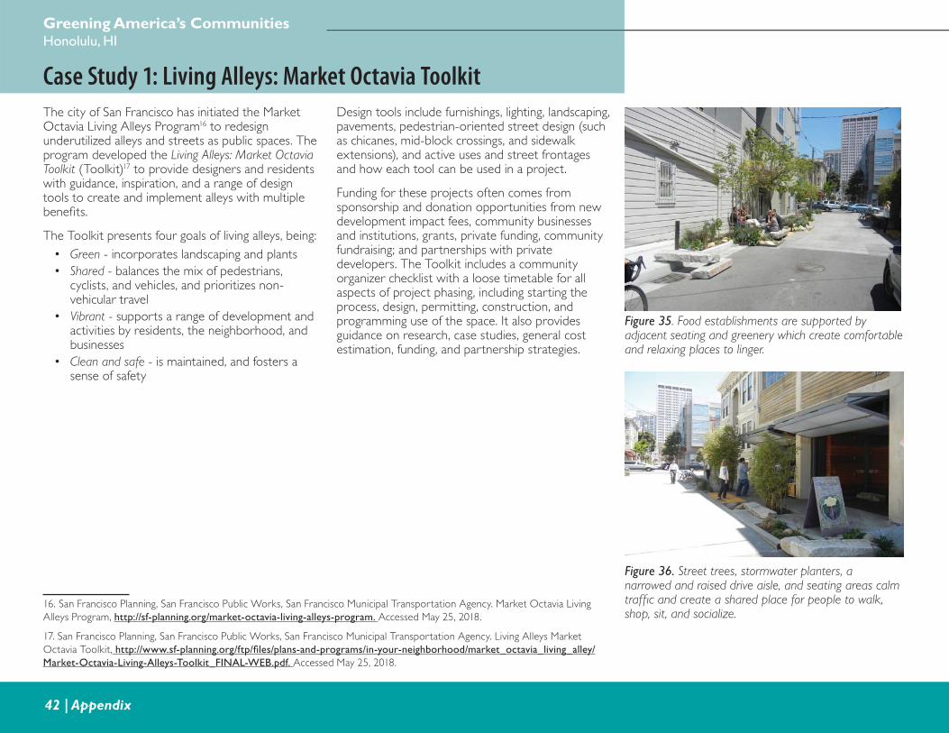
Greening America’s CommunitiesHonolulu, HI
42 | Appendix
Case Study 1: Living Alleys: Market Octavia ToolkitThe city of San Francisco has initiated the Market Octavia Living Alleys Program16 to redesign underutilized alleys and streets as public spaces. The program developed the Living Alleys: Market Octavia Toolkit (Toolkit)17 to provide designers and residents with guidance, inspiration, and a range of design tools to create and implement alleys with multiple benefi ts.
The Toolkit presents four goals of living alleys, being:
• Green - incorporates landscaping and plants
• Shared - balances the mix of pedestrians, cyclists, and vehicles, and prioritizes non-vehicular travel
• Vibrant - supports a range of development and activities by residents, the neighborhood, and businesses
• Clean and safe - is maintained, and fosters a sense of safety
Figure 35. Food establishments are supported by adjacent seating and greenery which create comfortable and relaxing places to linger.
Figure 36. Street trees, stormwater planters, a narrowed and raised drive aisle, and seating areas calm traffi c and create a shared place for people to walk, shop, sit, and socialize.
17. San Francisco Planning, San Francisco Public Works, San Francisco Municipal Transportation Agency. Living Alleys Market
Octavia Toolkit, http://www.sf-planning.org/ftp/fi les/plans-and-programs/in-your-neighborhood/market_octavia_living_alley/Market-Octavia-Living-Alleys-Toolkit_FINAL-WEB.pdf. Accessed May 25, 2018.
Design tools include furnishings, lighting, landscaping, pavements, pedestrian-oriented street design (such as chicanes, mid-block crossings, and sidewalk extensions), and active uses and street frontages and how each tool can be used in a project.
Funding for these projects often comes from sponsorship and donation opportunities from new development impact fees, community businesses and institutions, grants, private funding, community fundraising; and partnerships with private developers. The Toolkit includes a community organizer checklist with a loose timetable for all aspects of project phasing, including starting the process, design, permitting, construction, and programming use of the space. It also provides guidance on research, case studies, general cost estimation, funding, and partnership strategies.
16. San Francisco Planning, San Francisco Public Works, San Francisco Municipal Transportation Agency. Market Octavia Living
Alleys Program, http://sf-planning.org/market-octavia-living-alleys-program. Accessed May 25, 2018.
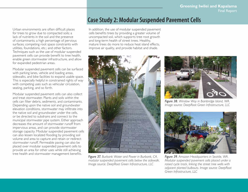
Greening Iwilei and KapalamaFinal Report
Appendix | 43
Case Study 2: Modular Suspended Pavement CellsUrban environments are often diffi cult places for trees to grow due to compacted soils; a lack of nutrients in the soil and the presence of contaminants; a high percentage of pervious surfaces; competing root space constraints with utilities, foundations, etc.; and other factors. Techniques such as the use of modular suspended pavement cells can provide benefi t to tree health, enable green stormwater infrastructure, and allow for expanded pedestrian areas.
Modular suspended pavement cells can be surfaced with parking lanes, vehicle and loading areas, sidewalks, and bike facilities to expand usable space. This is especially helpful in constrained rights of way with competing uses such as vehicular circulation, seating, parking, and so forth.
Modular suspended pavement cells can also collect and treat stormwater. Plants and soils within the cells can fi lter debris, sediments, and contaminants. Depending upon the native soil and groundwater elevation conditions, stormwater may infi ltrate into the native soil and groundwater under the cells, or be directed to subdrains and connect to the municipal stormwater pipe system. Either approach decreases the amount of stormwater runoff from impervious areas, and can provide stormwater storage capacity. Modular suspended pavement cells can also lessen localized fl ooding by providing soil volume and area to capture and retain or redirect stormwater runoff. Permeable paving can also be placed over modular suspended pavement cells to provide an area for other uses while still achieving tree health and stormwater management benefi ts.
Figure 38. Winslow Way in Bainbridge Island, WA. Image source: DeepRoot Green Infrastructure, LLC
Figure 39. Amazon Headquarters in Seattle, WA. Modular suspended pavement cells placed under a raised cycle track, linking the street tree wells with adjacent planted bulbouts. Image source: DeepRoot Green Infrastructure, LLC
Figure 37. Burbank Water and Power in Burbank, CA. modular suspended pavement cells below the sidewalk. Image source: DeepRoot Green Infrastructure, LLC
In addition, the use of modular suspended pavement cells benefi ts trees by providing a greater volume of uncompacted soil, which supports tree root growth and long-term health of street trees. Healthy, mature trees do more to reduce heat island effects, improve air quality, and provide habitat and shade.
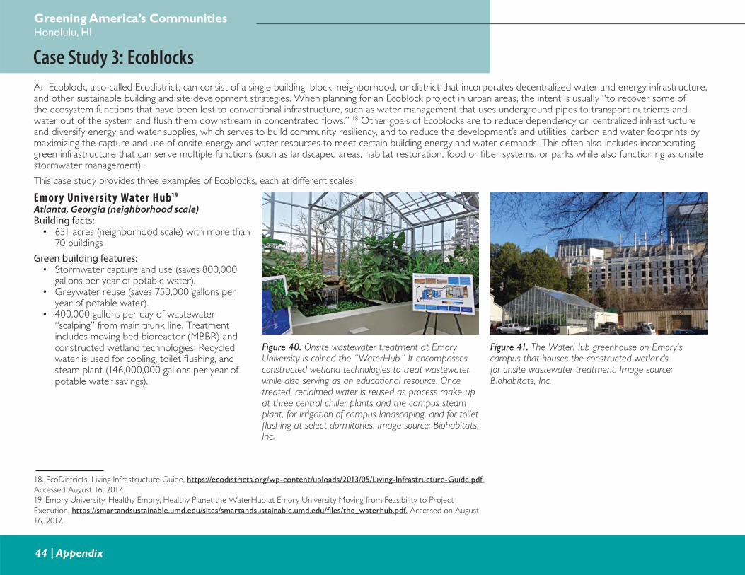
Greening America’s CommunitiesHonolulu, HI
44 | Appendix
Case Study 3: EcoblocksAn Ecoblock, also called Ecodistrict, can consist of a single building, block, neighborhood, or district that incorporates decentralized water and energy infrastructure, and other sustainable building and site development strategies. When planning for an Ecoblock project in urban areas, the intent is usually “to recover some of the ecosystem functions that have been lost to conventional infrastructure, such as water management that uses underground pipes to transport nutrients and water out of the system and fl ush them downstream in concentrated fl ows.” 18 Other goals of Ecoblocks are to reduce dependency on centralized infrastructure and diversify energy and water supplies, which serves to build community resiliency, and to reduce the development’s and utilities’ carbon and water footprints by maximizing the capture and use of onsite energy and water resources to meet certain building energy and water demands. This often also includes incorporating green infrastructure that can serve multiple functions (such as landscaped areas, habitat restoration, food or fi ber systems, or parks while also functioning as onsite stormwater management).
This case study provides three examples of Ecoblocks, each at different scales:
Emor y University Water Hub19
Atlanta, Georgia (neighborhood scale)Building facts:
• 631 acres (neighborhood scale) with more than 70 buildings
Green building features:• Stormwater capture and use (saves 800,000
gallons per year of potable water).• Greywater reuse (saves 750,000 gallons per
year of potable water).• 400,000 gallons per day of wastewater
“scalping” from main trunk line. Treatment includes moving bed bioreactor (MBBR) and constructed wetland technologies. Recycled water is used for cooling, toilet fl ushing, and steam plant (146,000,000 gallons per year of potable water savings).
18. EcoDistricts. Living Infrastructure Guide, https://ecodistricts.org/wp-content/uploads/2013/05/Living-Infrastructure-Guide.pdf. Accessed August 16, 2017.
19. Emory University. Healthy Emory, Healthy Planet the WaterHub at Emory University Moving from Feasibility to Project
Execution, https://smartandsustainable.umd.edu/sites/smartandsustainable.umd.edu/fi les/the_waterhub.pdf. Accessed on August
16, 2017.
Figure 40. Onsite wastewater treatment at Emory University is coined the “WaterHub.” It encompasses constructed wetland technologies to treat wastewater while also serving as an educational resource. Once treated, reclaimed water is reused as process make-up at three central chiller plants and the campus steam plant, for irrigation of campus landscaping, and for toilet fl ushing at select dormitories. Image source: Biohabitats, Inc.
Figure 41. The WaterHub greenhouse on Emory’s campus that houses the constructed wetlands for onsite wastewater treatment. Image source: Biohabitats, Inc.
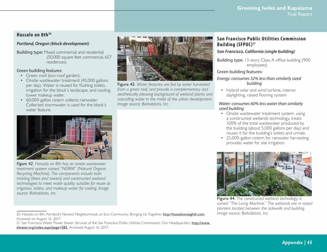
Greening Iwilei and KapalamaFinal Report
Appendix | 45
Hassalo on 8th20
Portland, Oregon (block development)
Building type: Mixed commercial and residential (50,000 square feet commercial, 657 residences)
Green building features:• Green roof (eco-roof garden).• Onsite wastewater treatment (45,000 gallons
per day). Water is reused for fl ushing toilets, irrigation for the block’s landscape, and cooling tower makeup water.
• 60,000-gallon cistern collects rainwater. Collected stormwater is used for the block’s water feature.
20. Hassalo on 8th. Portland’s Newest Neighborhood, an Eco-Community, Bringing Us Together, http://hassalooneighth.com.
Accessed on August 16, 2017.
Figure 43. Water features are fed by water harvested from a green roof, and provide a complementary and aesthetically pleasing background of wetland plants and cascading water in the midst of the urban development. Image source: Biohabitats, Inc.
Figure 42. Hassalo on 8th has an onsite wastewater treatment system coined “NORM” (Natural Organic Recycling Machine). The components include both trickling fi lters (red towers) and constructed wetland technologies to meet water quality suitable for reuse as irrigation, toilets, and makeup water for cooling. Image source: Biohabitats, Inc.
San Francisco Public Utilities Commission Building (SFPUC)21
San Francisco, California (single building)
Building type: 13-story Class A offi ce building (900 employees)
Green building features:Energy: consumes 32% less than similarly sized
building• Hybrid solar and wind turbine, interior
daylighting, raised fl ooring system
Water: consumes 60% less water than similarly sized building• Onsite wastewater treatment system, using
a constructed wetlands technology, treats 100% of the total wastewater produced by the building (about 5,000 gallons per day) and reuses it for the building’s toilets and urinals.
• 25,000-gallon cistern for rainwater harvesting provides water for site irrigation.
21. San Francisco Water Power Sewer, Services of the San Francisco Public Utilities Commission. Our Headquarters, http://www.sfwater.org/index.aspx?page=583. Accessed August 16, 2017.
Figure 44. The constructed wetland technology is coined “The Living Machine.” The wetlands are in raised planters located between the sidewalk and building. Image source: Biohabitats, Inc.