Embed Size (px)
Citation preview
Educational Series - 4
Guide to the Caves
of Minnesota
Minnesota Geological Survey

UNIVERSITY
OF
MINNESOTA
1967
Minnesota Geological Survey
Paul K. Sims, Director
Minneapolis, Minnesota· 55455
Guide to the Caves of Minnesota R. K. Hogberg* and T. N. Bayed
* Minnesota Geological Survey t Winona State College
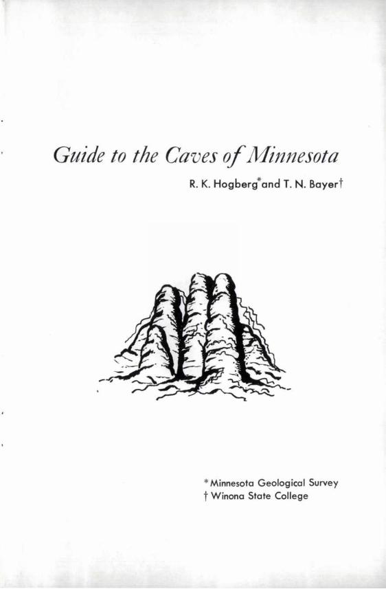
Spelunkers exploring one of Minnesota's 1 i me s ton e c a v e s .
ii
Guide to the Caves of Minnesota
CAVES have fascinated man since he first used them for shelter some hundreds of thousands of years ago. They have been the subject of many legends and stories that were carried down by word of mouth from generation to generation. The ogres and other cave monsters of European folklore are well known, as are the stories of caves having bottomless pits, disappearing streams, clouds of bats, and unusual rock formations that puzzled yet intrigued the early settlers of the United States.
Caves have been described in song and story. IIFingal ls Cave Overtur~'by Felix Mendelssohn portrays the waves washing into a famous cave on one of Scotland1s Hebrides Islands. Mark Twain in his popular "Adventures of Tom Sawyer" gave a vivid account of McDougalls cave in which Becky Thatcher and Tom were lost for three days.
In the history of our country, caves provided shelter for the aborigines, dens for Spanish treasure in the early exploration period, temporary family shelters in the colonial period, sources of chemi-cals for fertilizer and explosives in the Revolutionary War, hiding places for escaped slaves in the Civil War, places to hide loot from stage coach holdups in the western frontier, and shelters for people and storage for valuable documents in the nuclear age.
1

Many of the caves in the United States are well known because of their historical and legendary background. However, few people are aware that some of the Nation! s most interesting caves are found in Minnesota. Names such as DeviP s Den, Indian Treasure' and Horse Thief reflect the romance of these caves. Other fascinating names of Minnesota caves are listed in the Appendix.
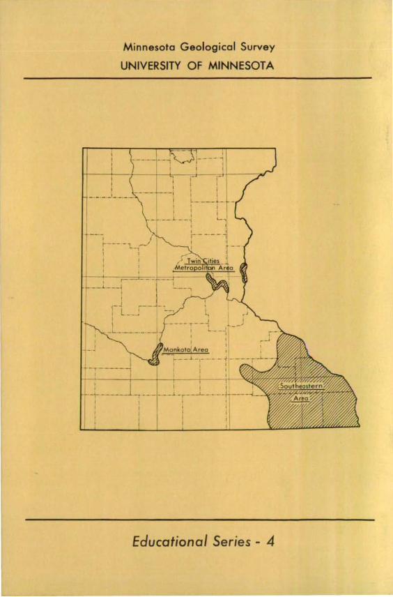
The majority of Minnesota! s caves occur in the southeastern part of the State - -mostly in Fillmore and Olmsted counties (see back outside cover). This area is reached from the north and south by U. S. Highways 52 and 63, and from the east and west via U. S. Highways 14 and 16. Caves also occur in Blue Earth, Dodge, Houston, LeSueur, Mower, Nicollet, Wabasha, and Winona counties and in the seven-county Twin Cities metropolitan area.
The Minnesota caves, as we find them today, are t result of some hundreds of millions of years of preparation by interacting earth proces s es. It is the purpose of this booklet to attempt to describe their natural history in the hope that the account will give the reader a richer and fuller understanding of these subterranean wonders.
SPELEOLOGY
What is a cave?
We define a cave as a natural cavity within the bedrock of the earth!s crust that has an opening to the land surface. A cave may range in size from that just large enough for a man to crawl through to an extensive system of long interconnected passageways and large chambers.
2
Why do people explore caves?
The question--why man explores--has been asked of mountain climbers, skin divers, hikers, and many others who investigate their natural environment. Cave exploration is a form of exciting recreation to a spelunkel~ or caver. To him it is a challenge and a thrill to explore the dark passages hidden beneath the earth's surface, to discover the hitherto unknown labyrinth of new passageways, to probe that huge chamber lined with stalagmites and stalactites, to find that waterpool of unknown depth. In addition to exploration, professional spelunkers carry out a variety of scientific studies within caves which in total are called spe leo logy from the two Greek words spelaion --meaning cave and logos --meaning study.
Techniques requiring considerable skill and strength must be used in moving from place to place during the investigation of most unexplored caves. Spelunkers must learn to negotiate extremely small passageways that may change abruptly in attitude. Equipment common to mountaineering such as climbing ropes, cable ladders, hammers, pitons, and karibiners generally is needed. Hard hats equipped with carbide or battery powered lamps are essential. Scuba gear is used for underwater exploration in flooded parts of caves. It should be mentioned here that few persons suffering from claustrophobia or vertigo ever become successful spelunkers!
A spelunker's first and most important task in cave exploration is to prepare an accurate map of the cave--a base for all the future scientific studies. Often it takes weeks or even months to complete a survey and prepare a map of an average size cave, especially when the work is mostly limited to weekends and holidays. Many large well-known caves
3
Caves lJZ Minnesota Rock Units
Era Period Formation Member
C E NO- Glacial Deposits ZOIC Quaternar) (Pleistocene)
~ES<?-ZOIC Cretaceous
Coleraine and
W indrow
Devonian Cedar Volley
Maquoketa
Galena
P 0
A
L d
0 Decorah E
0 v Platteville
Z -G1enwood
0 c
St. Peter I
C a
n
Oneoto
PRECAMBRIAN* red sandstone, basalt ic lava flows and plutonic rocks
Rock Type
~ro)'l-,,-f-dolomi'-;'7
* Traic""'" not proportional to I lrati;raphic IIttion above.
have such long passageway systeITls that cOITlpletion of a ITlap represents a long-terITl project.
After the three -diITlensional relationships of the cave are deterITlined and related to the land surface above, the caver can then begin to work on the scientific aspects, such as the descriptions of cave forITlations, geologic studies, biological studies, and archaeological investigations.
During the initial exploration period professional spelunkers ITlake careful notes and sketches and take photographs showing the type, shape, size, and extent of cave formations or spe leo thems _ - the staZagmites~ staZactites~ and other physical forITls that are cOITlposed of calciuITl carbonate precipitated froITl ground-water solutions. They are careful not to daITlage any of the cave I s delicate speleotheITls; cave etiquette deITlands that such structures be left to delight future cavers.
Cave walls provide the geologist with relatively large rock exposures for exaITlination and study-rocks that have been protected frOITl norITlal surface weathering. The geologist not only can observe how the cave was forITled but also can ITlake detailed studies of the physical features and fossil asseITlblages of the rock units.
The only true cave plants for the botanist to study are several species of aquatic fungi. These plants, which require no sunlight for growth, consist of fine white bristles or tufts. C OITlITlon green and rusty-r.ed algae can be seen on the walls of COITlITlercial caves where flood light beaITls illliITlinate the wet rock surface.
Many aniITlals use caves for shelter; few however
5
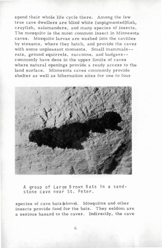
spend their whole life cycle there. Among the few true cave dwellers are blind white (unpigmented)fish, crayfish, salamanders, and many species of insects. The mosquito is the most common insect in Minnesota caves. Mosquito larvae are washed into the cavities by streams, where they hatch, and provide the caver with some unpleasant moments. Small mammals - rats, ground squirrels, raccoons, and badgers-commonly have dens in the upper limits of caves where natural openings provide a ready access to the land surface. Minnesota caves commonly provide shelter as well as hibernation sites for one to four
A group of Laroe Brown Bats in a sandstone cave near St. Peter.
species of cave bats (above). Mosquitos and other insects provide food for the bats. They seldom are a serious hazard to the caver. Indirectly, the cave
6
bats have been beneficial to man. For centuries deposits of bat guano and saltpeter were harvested from cave floors. The guano was used for fertilizing plant crops and the saltpeter or nitrocalcite was used in the manufacture of gun powder.
Archeologists study remains of prehistoric human life in caves to learn about manls early beginnings. Much of what is known about the early civilizations in the Middle East--such as the tools that were used and the diet and general cultural level of the people- -comes from cave diggings. Paintings on walls of caves in southwestern France and Spain depict the game animals of the past and, mOre importantly, indicate the high intellectual level of their early European inhabitants--the CrO-Magnon man--of some 40 to 50 thousand years ago. Archeological diggings in Minnesota caves and rock shelters have uncovered remains of the early Indian habitation from the period 500 B. C. to 1500 A. D.
GEOLOGIC SETTING
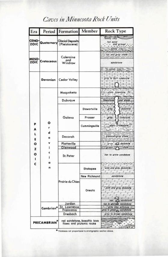
The natural history of all caves begins with their geologic setting. Minnesota I s caves are scattered through a 1500- to l600-foot thick sequence of Paleozoic rocks which crop out in the valley walls of the Mississippi River and its tributaries in southeastern Minnesota. The various units of this sequence are shown in a composite column on page 4. Gen-erally, the base of the sequence lies on igneous and metamorphic rocks of Precambrian age. The Precambrian basement rocks in Fillmore County, where most of the caves occur, probably are similar to the Duluth Gabbro Complex of northeastern Minnesota.
The Paleozoic sedimentary rocks of the State have been divided by geologists into three geologic
7
units, which in ascending order are the Cambrian, Ordovician, and Devonian periods. The caves are mostly in rocks of the Ordovician Period.
The rocks of Ordovician page consist of three principal sedimentary types - -shale, sandstone, and limestone. Shale is the consolidated equivalent of silt and clay; sandstone is the equivalent of sand; and limestone is the equivalent of lime muds and the accumulated hard parts of animals and plants. The hard parts, Or fossi Zs, are the preserved remains of ancient living animals and plants.
Sedimentary rocks are formed from particles and dissolved materials of pre-existing rocks. The process that causes rocks to be broken down into particles or taken into solution is called weathering. This is accomp'lished by mechanical and chemical means in combination with gravity. The particles of sediment are carried away from the site by streams and are commonly deposited in a sea or an inland lake. Subsequently, the sediments are changed into rock by compaction and cementation, as a result of being buried beneath a considerable weight of younger sediments. The vast inland sea in southeastern Minnesota in which the sedimentary rocks of Ordovician age accumulated can be dated at about 500 to 430 million years ago.
The caves of Minnesota are either in beds of limestone or sandstone. The most extensive and most difficult to locate are in limestone. Sandstone caves are small and generally easy to find.
DEVELOPMENT OF CAVES
With this brief background on the rocks within which the caves occur, let us now turn to the questions as to HOW, WHERE, and WHEN the Minnesota caves were formed.
8
How The Caves Were Formed
Limestone Caves
Four conditions are necessary for the development of a cavity in limestone beds: (1) fractures must be present to provide channelways for the movement of ground-water; (2) the rocks must be soluble in ground-water; (3) a favorable chemical and biochemical environment is required; and (4) lowering of the water -table must take place slowly over a long interval of time.
In the limestone caves of southeastern Minnesota the most important channelways for entry and movement of ground-water were a set of intersecting joints --nearly vertical fractures. One jOint set trends easterly and the other northeasterly. The straight passageways of the large limestone caves were formed along the two major joint sets, whereas less regular secondary passageways that intersect the major ones at large angles formed along other fractures. In mapping the pattern and extent of the cave systems in other states, scientists have found that the underground streams excavated the rocks adjacent to jOints forming a modified tree-like pattern--a drainage system with a rock roof.
Let us examine, briefly, the chemical processes by which the caves were developed. The caves occur within limestone beds composed dominantly of the mineral calcite. They are formed by the dissolution of the calcite and associated lesser minerals. It has been found in laboratory experiments that this mineral is very slightly soluble in pure water. However we know from laboratory experiments that calcite can be dissolved by mildly acidic ground-water charged with carbonic acid. Possible sources of carbon dioxide
9

to yield the carbonic acid are rainfall and surface waters that percolate through the humus layers of the soil. The mildly acidic solutions would seep randomly downward through the fractures in the limestone beds and dissolve the adjoining rock. The resulting solutions, saturated with calcium and bicarbonate ions, would then be carried downward to the water-table and enter subsurface streams that might issue as springs. Possibly such mildly acidic solutions accounted for the excavation of the very narrow upper parts of the cave passageways.
However, it is difficult to explain the development of large and extensive cave passageways by the above described chemical process. Scientists have suggested several other ways by which caves can be excavated. One hypothesis suggests that microorganisms, living at or near the top of the water-table, feed on the organic materials carried downward from the humus layers and produce complex organic compounds that generate mild acids in the ground-water solutions. In addition, sulphuric acid commonly is available as a result of the decomposition of sulphide minerals - -mostly pyrite -that occur in limestones, and contributes further to the acidity of the waters. Acidic solutions formed in this manner would probably be a mOre effective agent in dissolving limestone than would ground-water charged only with carbonic acid. The resulting mildly acidic waters could have formed the large passageways of the Minnesota caves. Subsurface streams carried large volumes of mildly acidic solutions that reacted with the carbonate minerals--mostly calcite--in the walls of the water courses and as the local water-table was lowered, the streams slowly cut downward into the limestone beds. The time required for this chemical excavation is estimated to be in the high tens to low hundreds of thousands of years.
10
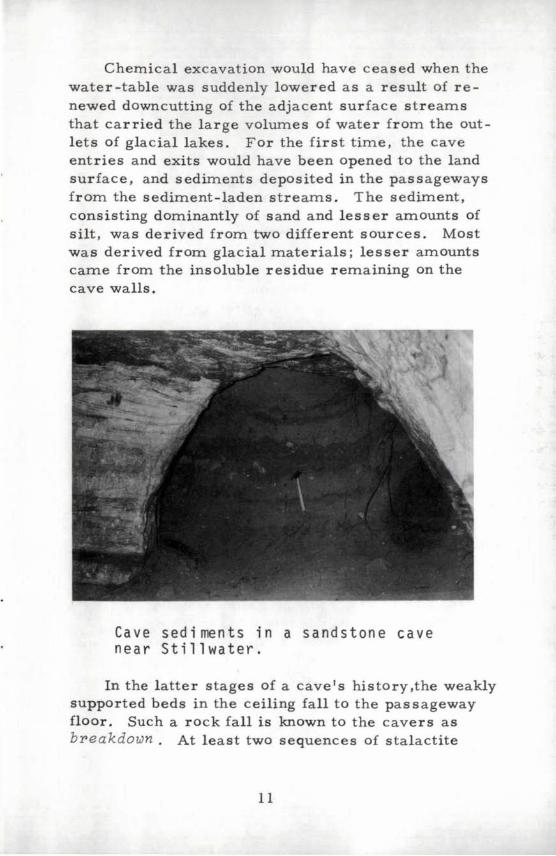
Chemical excavation would have ceased when the water-table was suddenly lowered as a result of renewed downcutting of the adjacent surface streams that carried the large volumes of water from the outlets of glacial lakes. For the first time, the cave entries and exits would have been opened to the land surface, and sediments deposited in the passageways from the sediment-laden streams. The sediment, consisting dominantly of sand and lesser amounts of silt, was derived from two different sources. Most was derived from glacial materials; lesser amounts carne from the insoluble residue remaining on the cave walls.
Cave sediments in a sandstone cave near Stillwater.
In the latter stages of a cave's history,the weakly supported beds in the ceiling fall to the passageway floor. Such a rock fall is known to the cavers as breakdown. At least two sequences of stalactite
11
formation and breakdown of the ceiling beds have been observed in the non-commercial passageways of Mystery Caves.
Sandstone Caves
Sandstone caves were developed by processes somewhat similar to those that formed limestone caves. However, the processes differed in two important respects. Although the sandstone caves probably also were formed at Or near the watertable surface, they were excavated in a much shorter period of time than the limestone caves and excavation was largely by hydraulic action rather than by chemical solution.
In the Twin Cities metropolitan area, as well as in Houston and Winona counties, sandstone caves occur adjacent to the wide deeply cut river valleys. Probably all of these caves were produced by piping ~ which is a type of internal erosion caused by groundwater seepage. The erosion begins at the exposed surface and migrates towards the source of the water. Although piping most commonly occurs in unconsolidated glacial sediments, it takes place in well-sorted sandstones when a moderately strong hydraulic gradient exists.
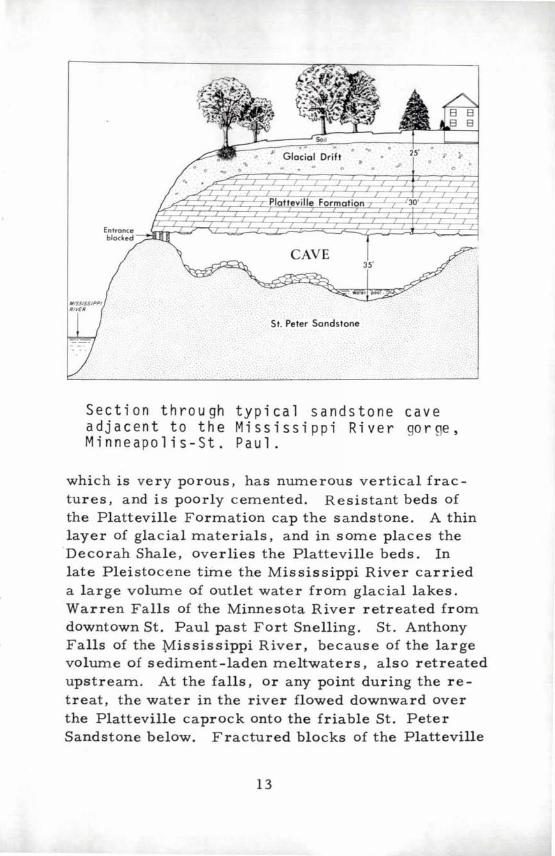
We will use the caves along the Mississippi "gorge" between st. Anthony Falls and Fort Snelling as an example of how the sandstone caves probably were formed. The caves in Minneapolis and St. Paul are near the Mississippi River and for the most part downstream from St. Anthony Falls. The exposed portion of the river gorge, below the falls, is about one-fourth to one-half mile wide and about 100 feet deep. Except for the upper 20 to 30 feet, the banks of the gorge are composed of the St. Peter Sandstone,
12
.. .
CAVE
St. Peter Sandstone
Section through typical sandstone cave a d j ace n t tot heM iss iss i p p i R i v ergo r ge , Minneapolis-St. Paul.
which is very porous, has numerous vertical fractures, and is poorly cemented. Resistant beds of the Platteville Formation cap the sandstone. A thin layer of glacial materials, and in some places the Decorah Shale, overlies the Platteville beds. In late Pleistocene time the Mississippi River carried a large volume of outlet water from glacial lakes. Warren Falls of the Minnesota River retreated from downtown St. Paul past Fort Snelling. St. Anthony Falls of the Mississippi River, because of the large volume of sediment-laden meltwaters, also retreated upstream. At the falls, or any pOint during the retreat, the water in the river flowed downward over the Platteville caprock onto the friable St. Peter Sandstone below. Fractured blocks of the Platteville
13
gradually were undermined and toppled into the river. As a result, the water-table was tilted abruptly towards the new level of the lowered river channel, and piping began within the vertical fractures of the St. Peter Sandstone adjacent to the river. The groundwater flowing downward along the fracture-controlled channelways eroded the sandstone beds and formed pipe-shaped cavities. With the passage of time, piping diminished and gradually ceased as the local over-steepened slope of the water-table was smoothed out. Later,the shape of the cavities was modified by ground-water erosion. Some caves were partially or completely filled with stream sediments. For the most part the dolomite beds of the cave ceilings have spalled and in some places the whole section has collapsed thus filling the caves.
Where The Caves Were Formed
Minnesota's limestone caves are found within the Galena and Dubuque Formations in southeastern Minnesota. The lowermost stratigraphic limit of these large caves is the top of the Decorah Shale that provided an impervious barrier to the downward s eepage of ground-water. The uppermost limit of cave development was controlled by the wfl.ter -table, the surface of which is normally below and generally parallel to the topography of the land. Another important factor favoring cave development was the thin cover of glacial drift in southeastern Minnesota. Because of the thin cover, the water-table was below the top of the solid rock. In fact, this part of the State was in the driftZess area from middle
Pleistocene time to the present. The thin COver of the glacial drift in southeastern Minnesota is in sharp contrast to the remainder of the State, which is blanketed by 50 to 300 feet, and rarely by as much as 400 to 500 feet of glacial materials.
14
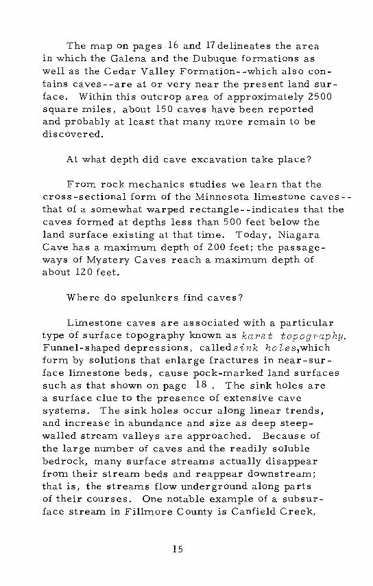
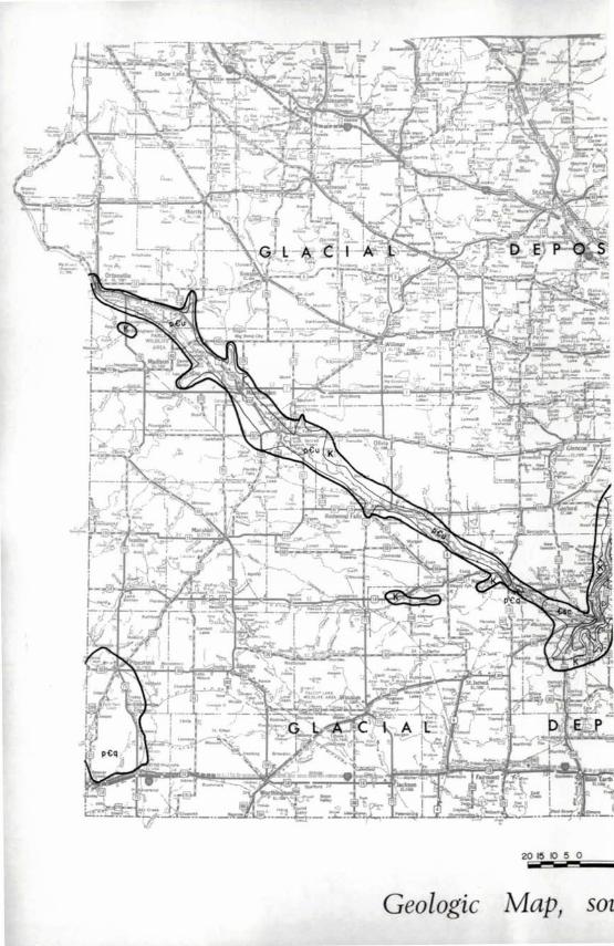
The map on pages 16 and 17 delineates the area in which the Galena and the Dubuque formations as well as the Cedar Valley Formation--which also contains caves--are at or very near the present land surface. Within this outcrop area of approximately 2500 square miles, about 150 caves have been reported and probably at least that many more remain to be discovered.
At what depth did cave excavation take place?
From rock mechanics studies we learn that the cross -sectional form of the Minnesota limestone caves -that of a somewhat warped rectangle- -indicates that the caves formed at depths less than 500 feet below the land surface existing at that time. Today, Niagara Cave has a maximum depth of 200 feet; the passageways of Mystery Caves reach a maximum depth of about 120 feet.
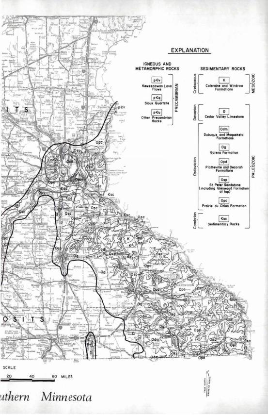
Where do spelunkers find caves?
Limestone caves are associated with a particular type of surface topography known as kars t topography. Funnel-shaped depressions, called sink ho les,which form by solutions that enlarge fractures in near-surface limestone beds, cause pock-marked land surfaces such as that shown on page 18. The sink holes are a surface clue to the presence of extensive cave systems. The sink holes occur along linear trends, and increase in abundance and size as deep steepwalled stream valleys are approached. Because of the large number of caves and the readily soluble bedrock, many surface streams actually disappear from their stream beds and reappear downstream; that is, the streams flow underground along parts of their courses. One notable example of a subsurface stream in Fillmore County is Canfield Creek,
15
2015 Kl50 --Geologic Map, SOt
SCALE
20 40 60 MILES
uthern Minnesota
EXPLANATION
IGNEOUS AND METAMORPHIC ROCKS
K.weenawan Lova ~ Flow. ir
I p~q I StoUl Quartz it.
I p~u I Other Precambrian
Rock,
m ~ « U w a: a.
SEDIMENTARY ROCKS
"C }U ~ ~ 2 .E CoI.roln. and Windrow g 5 Formation. ~
.~ 0 C[ ~ Cldar Volley Limtltont
C .2 .11 > o "E o
IOdm l Dubuque and Moqu.k.ta
Formo1ion.
~ Galeno Formation
IOpd I Plott,v ill. and Oecorah
Formotlono
~ Sf. P,t.r Sandston,
(includinQ Glenwood Formation at top)
i Ope I Prairie du Chl.n Formation
~ I ~Ie I C[ 3 Sedimentary Rocks
i ~ i
U 5 ~ W ...J
~
Vertical aerial photograph of an area of numerous sink holes near Fountain (scale 1:20,436).
Topographic rr.ap of the same area as above (about same scale).
18
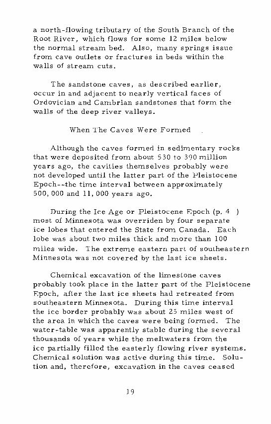
a north-flowing tributary of the South Branch of the Root River, which £lows for some 12 miles below the normal stream bed. Also, many springs issue from cave outlets or fractures in beds within the walls of stream cuts.
The sandstone caves, as described earlier, occur in and adjacent to nearly vertical faces of Ordovician and Cambrian sandstones that form the walls of the deep river valleys.
When The Caves Were Formed
Although the caves formed in sedimentary rocks that were deposited from about 530 to 390 million years ago, the cavities themselves probably were not developed until the latter part of the Pleistocene Epoch--the time interval between approximately 500, 000 and 11, 000 years ago.
During the Ice Age or Pleistocene Epoch (p. 4 ) most of Minnesota was overriden by four separate ice lobes that entered the State from Canada. Each lobe was about two miles thick and more than 100
miles wide. The extreme eastern part of southeastern Minnesota was not covered by the last ice sheets.
Chemical excavation of the limestone caves probably took place in the latter part of the Pleistocene Epoch, after the last ice sheets had retreated from southeastern Minnesota. During this time interval the ice border probably was about 25 miles west of the area in which the caves were being formed. The water-table was apparently stable during the several thousands of years while the meltwaters from the ice partially filled the easterly flowing river systems. Chemical solution was active during this time. Solution and, therefore, excavation in the caves ceased
19
when the water-table was abruptly lowered. This occurred as a result of greater volUllle of water as the ice lobes retreated more rapidly and because the streams began to erode the valley floors. This episode culminated when an outlet for glacial Lake Agassiz in northwestern Minnesota was breached, and the water poured into the Minnesota-Mississippi River system.
About 9200 years ago the outlet of Lake Agassiz was shifted to the northeast, and the volume of water entering the Mississippi River was abruptly curtailed. At this time the bed of the Mississippi River began filling with sediment, whereas earlier it had been a downcutting stream. The Mississippi River channel beneath the city of Winona, which is now underlain by about 150 to 175 feet of clays, silts, and sands, is an example of this channel filling. The tributary streams of the Mississippi system also deposited alluvium in their relatively wide lower valleys. These sediment-filled channels now comprise some of southeastern Minnesota I s finest agricultural land.
The sandstone caves were developed in very late Pleistocene or early post-Pleistocene time, when the lake-outlet waters deepened the river systems of southeastern Minnesota. As described earlier in this booklet, the hydraulic excavation of the sandstone caves in Minneapolis and St. Paul occurred shortly after the undermining of the Platteville caprock along the Mississippi River by the retreat of the waterfalls. The waterfalls retreated from downtown St. Paul to their present position at St. Anthony Falls during the interval of time from about 12,000 years ago to the year 1874 A. D., when the falls were stabilized by man. Caves in the Mankato area were excavated during the same general time, as were those of the St. Croix River valley. The caves along
20
the Mississippi River in Wabasha, Winona, and Houston counties are somewhat older than the other sandstone caves of Minnesota.
SPELEOTHEMS
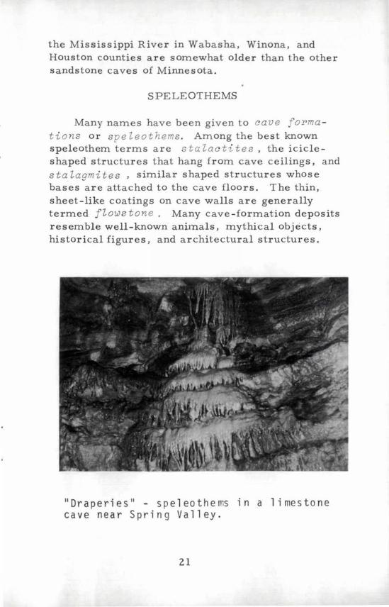
Many names have been given to cave orma tions Or speleothems . Among the best known speleothem terms are stalactites , the icicleshaped structures that hang from cave ceilings, and stalagmites , similar shaped structures whose bases are attached to the cave floors. The thin, sheet-like coatings on cave walls are generally termed flows tone . Many cave-formation deposits resemble well-known animals, mythical objects, historical figures, and architectural structures.
II Dr ape ri e s II - S pel eo the ms ina 1 i me s ton e cave near Spring Valley.
21
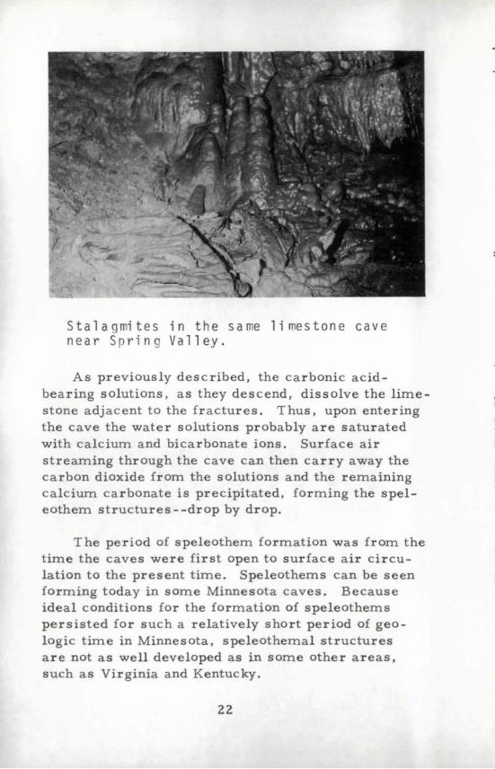
S tal a 9 mi t e sin the s a me 1 i me s ton e c a v e near Spring Valley.
As previously described, the carbonic acidbearing solutions, as they descend, dissolve the limestone adjacent to the fractures. Thus, upon entering the cave the water solutions probably are saturated with calcium and bicarbonate ions. Surface air streaming through the cave can then carry away the carbon dioxide from the solutions and the remaining calcium carbonate is precipitated, forming the speleothem structures - -drop by drop.
The period of speleothem formation was from the time the caves were first open to surface air circulation to the present time. Speleothems can be seen forming today in some Minnesota caves. Because ideal conditions for the formation of speleothems persisted for such a relatively short period of geologic time in Minnesota, speleothemal structures are not as well developed as in some other areas, such as Virginia and Kentucky.
22

MINNESOTA CAVES
In two respects - -a nearly constant temperature and a constant humidity of the cave air - -all large Minnesota caves are alike. The air temperatures within the caves are controlled mainly by the rock temperatures, which in Minnesota at depths of 50 to 150 feet range from 40 to 50 degrees Fahrenheit. The temperature of the air circulating through the caves varies only a few degrees from the rock temperatures the year around. The relative humidity in the limestone caves is greater than 90 percent at all times because of the constant "rain" of groundwater. As a consequence of the large volume of surface air exchange, the small sandstone caves are wanner and less humid than the limestone caves in the summer seas on.
The descriptions of individual Minnesota caves are grouped under geographic sections on the following pages. These sections are the Southeastern Area, the Twin Cities Metropolitan Area, and the Mankato Area (refer to back outside cover). Illustrated guides are provided for Mystery and Niagara caves, the two commercial liInestone caves in Minnesota- -in the Southeastern Area section. The section on the Twin Cities Metropolitan Area gives information on the St. Paul and Minneapolis sandstone caves and a tour guide for the historic Stillwater Caves. The sandstone caves near St. Peter are described in the Mankato Area section.
Caves in the Southeastern Area
The Southeastern Area contains the greatest number and most important caves in Minnesota. The larger caves are the limestone caves; of these, Mystery and Niagara have conducted tours. Smaller and less
23
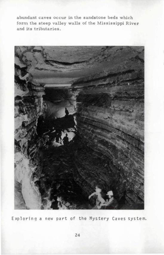
abundant caves occur in the sandstone beds which form the steep valley walls of the Mississippi River and its tributaries.
Exploring a new part of the Mystery Caves system.
24
Mystery Caves
Mystery Caves are about six miles southeast of Spring Valley in Fillmore County. In the winter of 1937 Mr. Joseph Petty observed that the snow was melting on a hillside adjacent to small crevices in the bedrock near the entryway to an underground stream. Also, water vapor was emanating from the crevices. Walter Blakeslee later joined Petty in an investigation of the area, and the two men dug into the hillside and discovered the passageway of a cave. They entered the system about five olclock in the afternoon that day, explored the many rooms and chambers, and finally arrived back at their entry at about two olclock the next morning--thus completing the first exploration of what is now known as Mys-tery Caves.
Lights were installed in the passageways and rooms and the cave--Tour No. l--was opened to the public in 1938. During World War II the cave was closed. Clarence Prohaska, the present owner and operator, purchased the property, made numerous improvements, and reopened the cave for guided tours in 1948. In 1958 a group of five cavers led by Michael McDonald found an extension of the cave system beyond the original commercial section. An opening was made to the surface, and the cave sediments and limestone breakdown were removed from the galleries. Guided tours were begun in--Tour No. 2--in July, 1960.
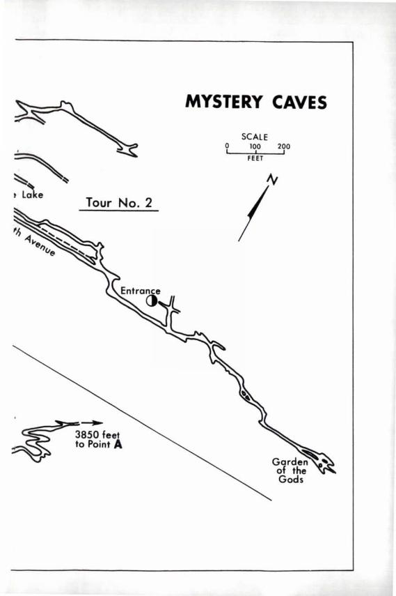
Mystery is the only extensive limestone cave in Minnesota that has been even partially explored and mapped. A small part of the passageways and rooms of this system is shown on the map on pages 26 and 27.
25
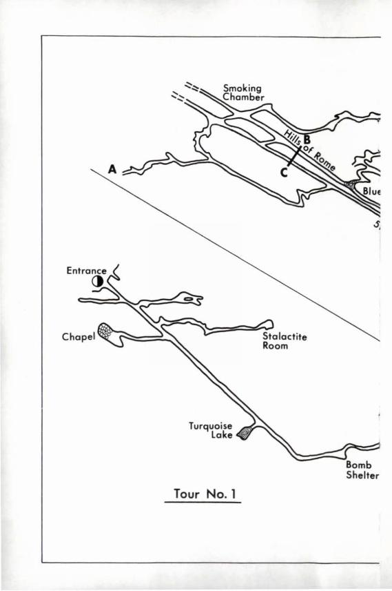
A
s ,
Tour No.1
MYSTERY CAVES
SCALE
~~ ~e Tour No.2
o 100 2~0 I
I --;-;FE:7ETT
At
I
~
. ~850. feeAt ~ to POint
As discussed in an earlier section of this booklet, formation of a cave system is similar to the development of a surface -stream drainage system. Both surface and subsurface streams form a treelike network of channels. In the Mystery system the lowermost limits of the solution- carved passageways slope in various directions, depending on the slope of the drainage system that excavated the openings.
Modern subsurface streams flow into and are deepening the ancient solution-enlarged channels in the Mystery system. One stream follows a rectangular "short cut" route across a meander bend of the South Branch of the Root River. It is seen a short distance to the north of Tour No.1, and enters the river downstream as a spring. Another subsurface stream flows to the northeast from the cross -cutting passageways that are to the north of the main passageway of Tour No.2. The outflow from this second stream is at Seven Springs, which is about one-half mile northeast of the entrance to Tour No.2. The sources of water for the subsurface streams are (1) the South Branch of the Root River, (2) leakage through fractures in the underground channel walls, and (3) local surface water.
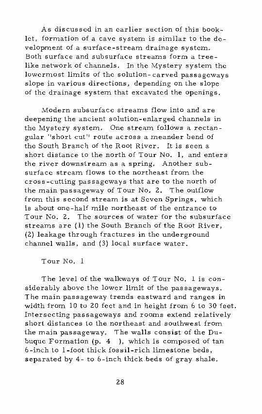
Tour No. 1
The level of the walkways of Tour No. 1 is considerably above the lower limit of the passageways. The main passageway trends eastward and ranges in width from 10 to 20 feet and in height from 6 to 30 feet. Intersecting passageways and rooms extend relatively short distances to the northeast and southwest from the main passageway. The walls consist of the Dubuque Formation (p. 4 ), which is composed of tan 6-inch to I-foot thick fossil-rich limestone beds, separated by 4- to 6 -inch thick beds of gray shale.
28
To observe the depth of the solution-widened passageway, look through the floor grating that is just beyond the steps from the Wishing Well. In the spring one can see and hear the water as it flows through the limestone-walled channel.
In the ceiling of the main passageway just beyond the floor grating you can observe the rOws of small soda-straw stalactites that follow micro-fractures in a bed of the Dubuque Formation (below). The
View in main passage\'Jay, Tour No.1, Mystery Caves.
29
trends of the microfractures are identical to the trends of the major f ractures along which the Mystery Caves system was developed.
As can be seen in the photo on page 29 , the walls of the main passageway have the appearance of a natural stone retaining wall. The limes tone beds are convex outward whereas in the thinner shale beds are c oncave inward.
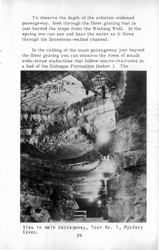
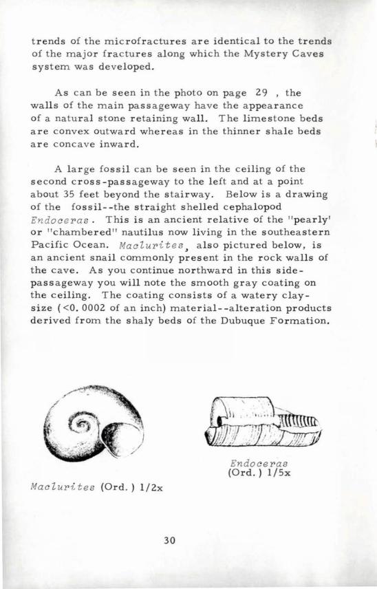
A large fo ssil can be seen in the ceiling of the second cross-passageway to the left and at a point about 35 feet beyond the stairway. Below is a drawing of the fossil- -the straight shelled cephalopod Endoc e r a s . This is an ancient relative of the " pearly ' Or "chambered" nautilus now living in the southeastern Pacific Ocean. Maclur i t e s " also pictured below, is an ancient snail commonly present in the rock walls of the cave. As you continue northward in this sidepassageway you will note the smooth gray coating on the ceiling. The coating consists of a watery claysize «0. 0002 of an inch) material- -alteration products derived from the shaly beds of the Dubuque Formation.
Ma c l ur 1: t es (Ord.) 1/2x
30
. ,
. II . ',,, ;. ; 7t~~ . J;~:;;;;; . ,I -j .. . , I ' .
,'II ! ;~ '~ .. , ~' , ""; . I, . ".i ' ...
Endoceras (Ord.) 1/5x
Near the end of the second cross-passageway, in the entrance to the Stalactite Room, is an accumulation of cave sediment- -the glacial materials carried into the cave by waters flowing from the land surface. The lower five to six feet of the cave sediment is tan, coarse-grained, sharp-edged sand. Overlying the sand is a 6- to l2-inch layer of orange-red sandy silt. By looking back towards the entrance from a position in the rear of the Stalactite Room, one can see the circular scallops or pot hole carved by the combination of abrasive rocks and the circular flow of a former stream.
The Chapel is a part of a very long 30- to 40-foot wide and 30- to 35-foot high passageway that parallels the main passageway. In addition to the retainingwall appearance of the Dubuque Formation, one can see in the ceiling the wave-ripple marked bedding planes of the lowermost beds of the overlying Maquoketa Formation.
Perhaps the most outstanding feature to observe in Tour No. 1 is Turquoise Lake, a 10- to l5-foot deep rectangular shaped pool. The very clear water of the pool is supported by a bottom layer of flowstone. Along the right side of the pond are rare popcornshaped botryoidal concretions. The concretions were most likely formed from silt and clay that floated on the water-coated rock surface as the pond level alternately rOse and fell. Also note the active area of speleothems in the back left corner of Turquoise Lake.
Tour No. 2
The passageways of Tour No. 2 are mostly in the Stewartville Member of the Galena Formation. Weathered surfaces of the Stewartville beds are characterized by a pock-marked or pitted surface, as can be seen in
31
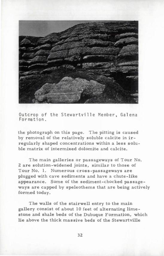
Outcrop of the Stewartville Member, Galena Fo r rna t i on .
the photograph on this page. The pitting is caused by removal of the relatively soluble calcite in irregularly shaped concentrations within a less soluble matrix of intermixed dolomite and calcite.
The main galleries or passageways of Tour No. 2 are solution-widened joints, similar to those of Tour No. 1. Numerous cross-passageways are plugged with cave sediments and have a chute-like appearance. Some of the sediment-chocked passageways are capped by speleothems that are being actively formed today.
The walls of the stairwell entry to the main gallery consist of about 10 feet of alternating limestone and shale beds of the Dubuque Formation, which lie above the thick massive beds of the Stewartville
32
Member. The walkways of Tour No. 2 are paved with silty sediments that were mined from the cave. These sediments make a smooth resilient mat upon which to walk.
T he main passageway to the left of the entryway, Or eastward toward the Garden of the Gods, has a cathedral-shaped cross-section formed by the paired alternating convex and concave erosion of the Stewartville Member, which narrows to a peak SOme 25 to 30 feet above the floor. The Garden of the Gods is a room in which speleothems hang from the ceiling and coat parts of the walls and floor.
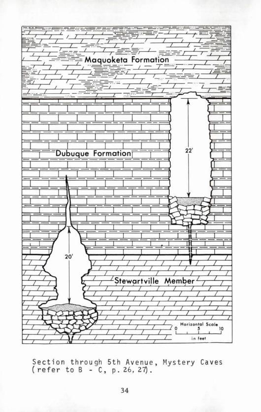
To the right of the entry there is an extremely straight passageway named 5th Avenue (p.26, 27). A vertical geologic section drawn through 5th Avenue, and an adjacent parallel passageway to the north,is shown on the following page. The marked difference in the cross -sectional shape of the cavities in the Dubuque Formation and in the Stewartville Member is graphically shown in the diagram. In an intersecting passageway to the left or south from 5th Avenue are twin speleothems --called the Carrot Sticks. The carrot color is caused by the small amount of hydrous iron oxide which is included within the calcium carbonate layers of the stalactites.
The Hills of Rome, the passageway 10-30 feet north of and parallel to 5th Avenue, has the best developed and most complete stratigraphic section in the commercial part of the Mystery system. Exposed here are beds extending upward from the basal 2 to 3 feet of the lower Stewartville Member through the Dubuque Formation to the basal beds of the Maquoketa Formation.
33
I I I I I I I J I I I I I I I I , I
I I I I I I I I
I I J I I I I
I I I I I I I 22'
I I Dubuque Formation l I 1 1
I I I I I I I I J J I I I I I I
I I I I I I I r I I I I I I I 1 I
I I I I I I I /{0~9i~l~ I J 1 J I 1 I I ~~~ I
I I I I I I I i. .J. J I J I f ~~ I I ]'
I I I I I I I I J f
I II 1 / / ,/ 20 ' l 1 1 1 1 1 1
1 J 11 1 1 / / / L 1 1 ~ .J / / / / / /
:1 I ........ A / / / / / 1 1
""" r / Stewartville Member /
1 1 I """
/ 1 1 / " r / / / 1 L / /
.L 1 \ ( 1 1 1 1 1 1 1 1 / ..J ..... /
/
1
~(:?\.?~;/D&'·"'.~ / / / / I L
J l 1 r oX~""""'" / / / / / J ~ I. .lor-" / I A ...l ')..... J) / / Horizontal Scal. ~ I 1 / /0 5 10 III 1 1 1 I I I
1 1 \ 1 1 1 1 1 1 i n feet I
Section through 5th Avenue, Mystery Caves (refer to B - C, p.26,27).
34
1
/
/
Blue Lake is another feature of interest in this part of the cave. The surface of this pool , which has a bottom composed of cave sediments, reflects --with a predictable lag- -seasonal ground-water seepage. The lake is fed by ground-water overflow from a series of pools beyond, Or to the north of , Blue Lake.
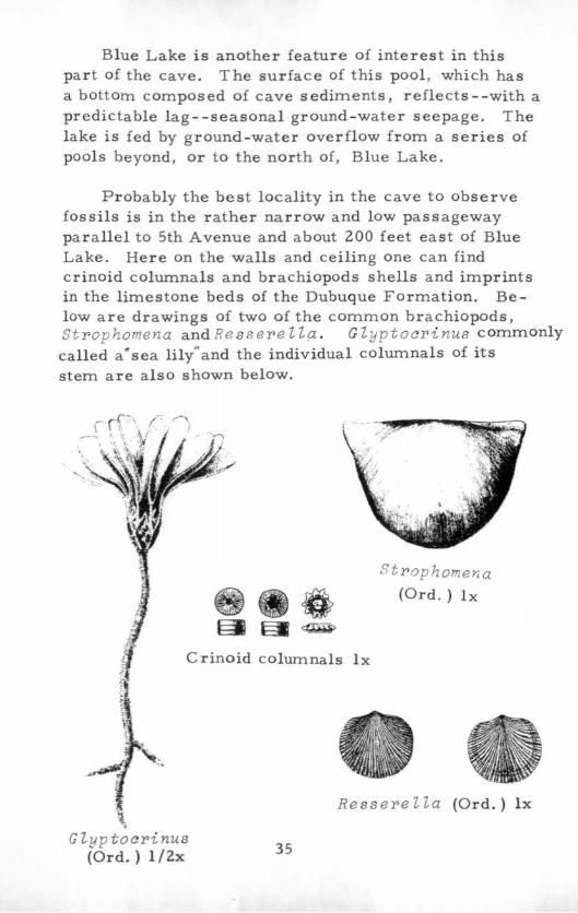
Probably the best locality in the cave to observe fossils is in the rather narrow and low passageway parallel to 5th Avenue and about 200 feet east of Blue Lake. Here on the walls and ceiling one can find crinoid columnals and brachiopods shells and imprints in the limestone beds of the Dubuque Formation. Below are drawings of two of the common brachiopods, st rophomena and Re ss ere ll.~ . G l yp tocri nus commonly called a"sea lily"and the individual columnals of its stem are also shown below.
St r ophomena
• (Ord.) Ix
~
Crinoid columnals Ix
, Glyptocrinu8
(Ord. ) 1/2x
Ressere lla (Ord.) Ix
35
In the same passageway, one also can see the alteration of aggregates of primary pyrite, Or "fools gold". The pyrite aggregates have a size and shape similar to a nickel or a quarter, are blackish-red to blood red in color, and form depressions in the walls. The mild acid formed by the action of groundwater on pyrite has reacted with the limestone and produced small white to glassy gypsum crystals, which coat the lower parts of the chamber. Selenite, a variety of gypsum, can be found as clear tabular crystals as much as one-quarter inch wide and oneinch long in the cave sediments at the base of the intersecting passageways.
Niagg.ra Cave
Niagara Cave is about five miles southwest of Harmony., in Fillmore County, and just a mile north of the Minnesota-Iowa border. The story of the discovery of this limestone cave is an interesting one, for three boys accidentally found it while searching for three lost pigs. According to reports, the boys tracked the pigs to the site of a sink hole at which point all traces of them were lost. In exploring the bottom of the sink hole they uncovered an entry about two feet wide to an enlarged fracture. After some effort and with some difficulty they squeezed through the opening and onto the top of a pile of limestone and shale blocks and descended to a subterranean chamber floor. They succeeded in finding the pigs in the passageway and returned them to their owner; more importantly, they discovered the large subterranean chambers of what is now named Niagara Cave.
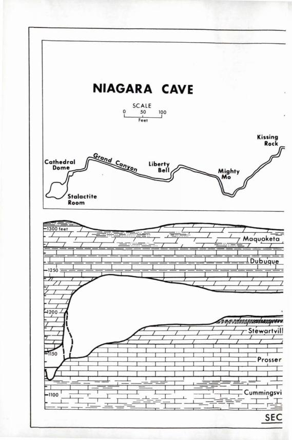
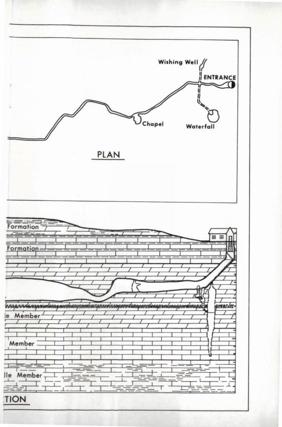
The most significant feature of Niagara Cave is that it has a vertical relief of approximately 150 feet-greater than that of any other known Minnesota cave. There is a plan and vertical section of the cave on
36
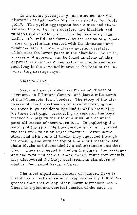
View of main passageway, Niagara Cave.
pages 38 and 39.
After chemical excavation of Niagara Cave, ephemeral surface streams carried sediments into the passageways and in places these sediments nearly completely filled the chambers. Still later, a sur-face stream began to flow downward through several sink holes and enlarged the fractures thus extending the cave system. Over a span of several hundreds of years, the stream removed the cave sediments through erosion and somewhat modified and enlarged the passageways. Stream waters charged with chert or jasper nodules cut deep scallops into the passageway walls and formed vaulted chambers. A modern subsurface stream begins at a sink hole near the bridge
37
NIAGARA CAVE
~ ... .=~ 1-1300 feel /-
/ / ... I f I
~1?5b J-'
/1 I7 t-I / ~ / I g
I I /I
I I F-l200 ..L~
I II I
\
[@' 15. J ./
~
f t:""""""7"
~ I
I-ll001~1 ~ ----L-1---.- ~
SCALE o 50 100 ..... 1 --;:F,.J-~e-:-I _......J1
7 ... .. .. . .. ... ... ......... "
J /. / " ... .. .... ....
./f ./ I
./ / /
I I I J
.. ./ I I ... / . ......
/ f / f
..............
~
I / I
/
I
/
. ... .
Kissing Rock
/ Maquoketa
J Dubu~1!f-
/ /
. •• OOffjoOtlJ'-
Stewartvill
/
Prosser J .1
I 1 ~- --'- ~ -L
T I. I.
-L ~I ~ -=-_=-C~g~ .1
- .L........- ---.-L., "I ---.l ~r= -
SEC
Waterfall
PLAN
_.-, .. . .. :-::: .:: . : .~
Formoti'on f .... ... ~ I .. .... ... 1"iBiB n Formation IS
"\..
~~ I I I I I I I
I I I I J , I - , (~
.. -- I , \ \ n..., \. I
~.JIIT ll.a1~ I , I
~-I
~.
Ie Member I I / 7 -/ / / I I I
I I / I I I / 7 /
I -Member
I I I I I I I ..! I
~ ~S -, I - !. ~ Member , : I ___ -1-_=_-=- IT-~ _-i~ -,-~ LTL __ I ~ ----r::;=r~ --1-:
c-_-...=- 1.1._ - - - -
:TION
on the main gravel road about 400 feet east of the entry roadway to Niagara Cave. This stream can be both observed and heard at three places in Niagara Cave (I) near the Wishing Well, (2) beneath the Waterfalls, and (3) in the Stalactite Room. From the Stalactite Room at the end of the tour, it continues for a distance of almost two miles underground before it emerges as a spring that flows into a tributary of the Upper Iowa River.
Cave Tour
From the base of the first entry stairway down to the level of the main passageway you descend through about 15 feet of the alternating limestone and shale beds of the Dubuque Formation and about 35 feet of the pitted beds of the Stewartville Member of the Galena Formation (p. 32). The main passageway is about 1750 feet long, averages 5 to 15 feet in width,and has ceiling heights ranging from 15 to 125 feet. It is paralleled by subsidiary passageways, none of which are shown on the plan of the cave. Enlarged fractures crOss the main passageway at angles ranging from 30 to 90 degrees; only one of these is shown on the map. The platform in the Stalactite Room, the lowest level of the commercial tour, is about 80 feet vertically be-low the base of the entry stairwell.
The Wishing Well, the first feature to be seen in Niagara Cave, is on a level about 15 feet below the main passageway. The small pool, which is about 10 feet deep, occupies a pothole scoured out of the limestone by chert nodules caught in a whirlpool of water. The modern subsurface stream is first seen and heard in the cross-passageway near the Wishing Well.
40
The Waterfalls, on the opposite side, also are below the level of the main passageway. This feature, a crudely cylindrical-shaped chamber in which the water from the underground stream now falls some 45 feet, was developed at the intersection of fractures that were enlarged by solutions. An abundance of chert nodules in the Stewartville Member of the Galena Formation provided the tools for the stream to abrade and form the well-developed pothole into which the water tumbles. The underground stream disappears into a narrOw passageway at the base of the Waterfalls chamber, and is next seen in the Stalactite Room.
The Chapel is the first feature to observe after returning to the main passageway. The changing shapes of the walls of this room, composed of the Stewartville Member, resulted from a complex history of solution and erosion. The Chapel was shaped by a series of pot holes; whereby one period of pothole development was superimposed on an earlier one, and so forth.
Along the main passageway near Flirtation Walk
scattered speleothems locally coat the ceiling and walls. Also, the scalloping effects of the underground stream that scoured the cave walls can be seen in the main passageway at such places as the Echo Chamber, Paul Bunyan's Bed, Kissing Rock, Liberty Bell, and Mighty Mo. Silty material, carried into the cave by slowly flowing streams, fills the lower part of the narrow cross -passageways in this segment of Niagara Cave.
The Grand Canyon, the narrowest and highest-up to 125 feet high--part of Niagara Cave, was fonned as a consequence of the mOre rapid downcutting of the
streams through the Pros ser Member of the Galena
Formation.
41
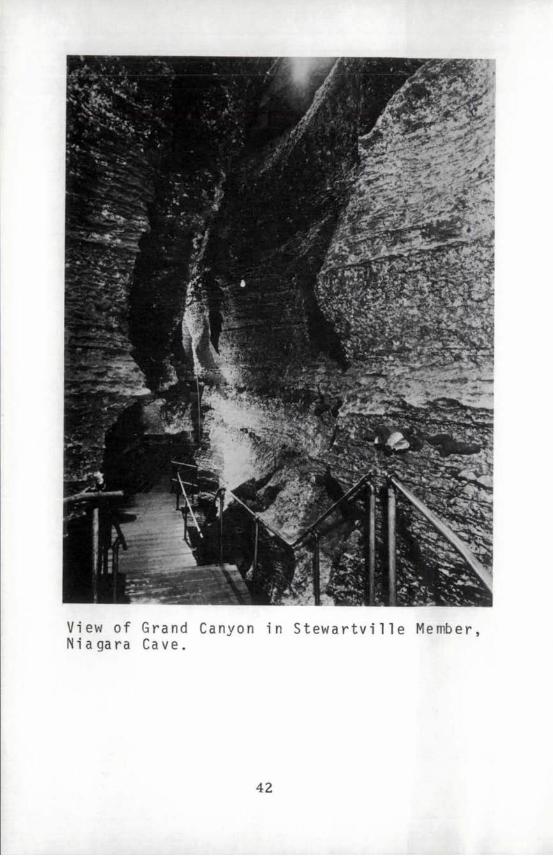
View of Grand Canyon in Stewartville Member, Niagara Cave.
42
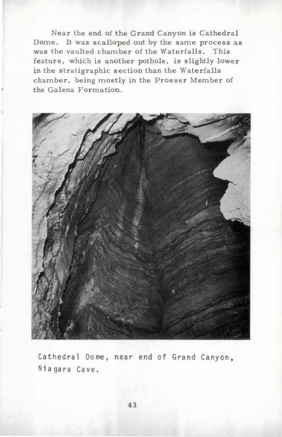
Near the end of the Grand Canyon is Cathedral Dome. It was scalloped out by the same process as was the vaulted chamber of the Waterfalls. This feature, which is another pothole, is slightly lower in the stratigraphic section than the Waterfalls chamber, being mostly in the Prosser Member of the Galena Formation.
Cat h e d r a 1 Dome, n ear end 0 f G ran d Can yon,
Niagara Cave.
43
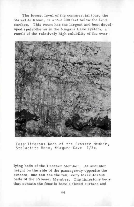
The lowest level of the commercial tour, the Stalactite Room, is about 200 feet below the land surface. This rOom has the largest and best developed speleothems in the Niagara Cave system, a result of the relatively high solubility of the over-
Fossiliferous beds of the Prosser Member, S tal act i t e Roo m, N i a ga rae a vel /3 x.
lying beds of the Prosser Member. At shoulder height on the side of the passageway opposite the stream, one can see the tan, very fossiliferous beds of the Prosser Member. The limestone beds that contain the fossils have a fluted surface and
44
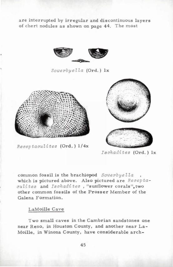
are interrupted by irregular and discontinuous layers of chert nodules as shown on page 44. The most
SoweY'bye Z Za (Ord.) Ix
Recep tacu Zi tes (Ord.) I /4x
Ischadites (Ord.) Ix
common fossil is the brachiopod SOlJeY'bye Z Za which is pictured above. Also pictured are Recep ta cu Zi tes and Ischadi tes , "sunflower corals ", two other common fossils of the Prosser Member of the Galena Formation.
LaMoille Cave
Two small caves in the Cambrian sandstones one near Reno, in Houston County, and another near LaMoille, in Winona County, have considerable arch-
45
eological interest. These two caves as well as several others in the southeastern corner of the State were produced by piping, which was described earlier in this booklet.
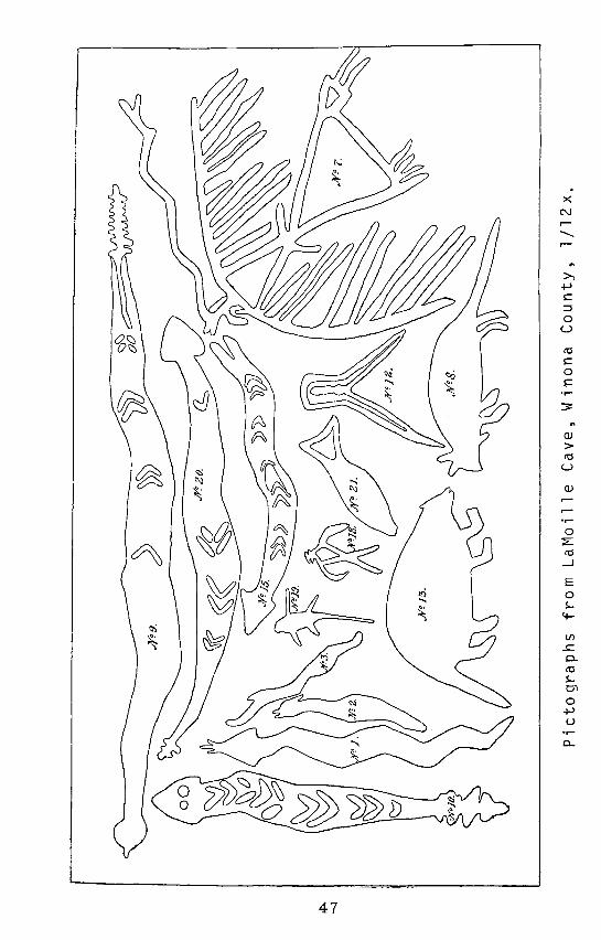
A reproduction of drawings made from pictographs scratched into the soft sandstone walls of the LaMoille Cave is shown on the opposite page. Similar pictographs have been found in the Reno Cave, in other nearby caves, and on the surfaces of scattered rock outcrops in southern Minnesota. The pictographs from the LaMoille Cave, reproduced from a plate in the volume, "Aborigines of Minnesota, " have not been dated so far as known. They depict the wild life that existed near the shelters. Especially notable are the sketches of the rattle snakes. Shortly after the drawings of the pictographs were made for the 1911 volume, slabs of the poorlycemented sandstone fell to the cave floor, destroying most of the pictographs. Archeological diggings in a rock shelter about half a mile from the LaMoille Cave revealed evidence of occupancy by early Indians of the Woodland Culture--from 500 B. C. to 1500 A.D. (oral communication, Elden Johnson). The LaMoille Cave was destroyed in recent years in the course of highway construction.
Other Caves
Several other caves have been reported in the Prairie du Chien Formation and in the Cambrian sandstones in Houston, Wabasha, and Winona counties. In addition, artificial caves have been dug or natural caves have been enlarged for mushroom culture and other uses in Wabasha County.
46
47
x N ...--...-
.,.....
OJ > ro u
OJ ...r.,.....
..... 0..
Caves in the Twin Cities Metropolitan Area
In the Twin Cities metropolitan area small sandstone caves occur adjacent to the Mississippi and St. Croix rivers. Several small natural caves and 28-man-made or enlarged caves are reported within the Twin Cities area.
Caves in St. Paul
Carver 1 S Cave is in the St. Peter Sandstone below Mounds Park in St. Paul, and is the most famous of the natural caves in the Twin Cities. It was first described by Johnathan Carver, an English Army captain who visited the site in 1767. The historic cave has. two levels; the larger and upper chamber was known to the local Indian tribes as Wakonteebe Or dwelling place of the "Great Spirit". On the walls were pictographs, similar in type and style to those described in the previous section. Carver1s Cave was partially destroyed and the remainder sealed in the early 1900 l s when the adjacent railroad right-of-way was widened.
Fountain Cave is farther upstream near what is now the intersection of Randolph and Sheppard Road in St. Paul. It is a small but well-known sandstone cave that was filled during the construction of Sheppard Road.
Several small caves occur along both sides of the Mississippi River between Fort Snelling and St. Anthony Falls. The diagrammatic cross -section on page 13 depicts the relationship of a typical uncollapsed St. Peter Sandstone cave with the present day surface features.
48
Alley
Brick or Cona.'. Pi.,..
s: s ell " >
~ <t
'" ~ ..; " c :> N a-
D
~
Stale ,": BO'
Sandstone cave beneath downtown Minneapolis.
49
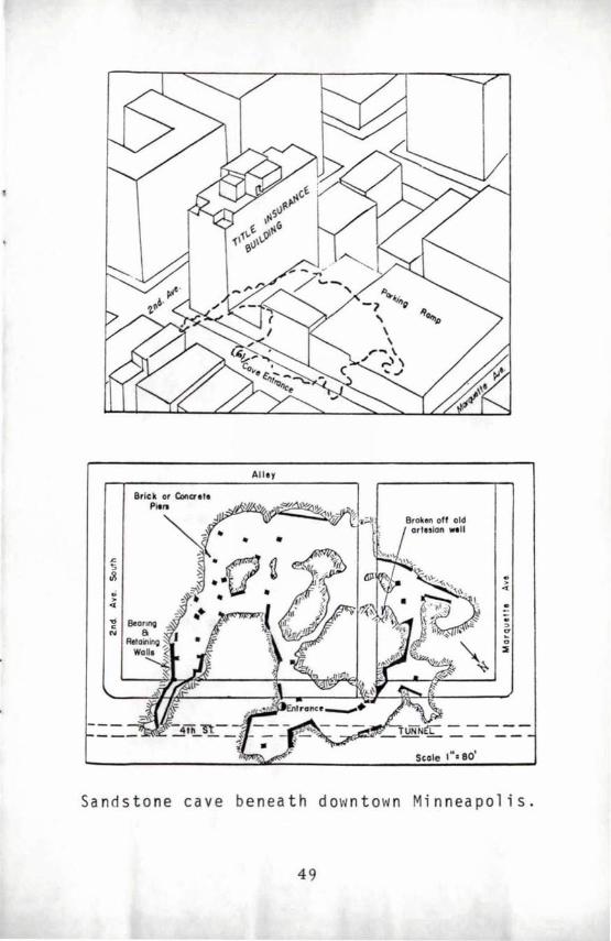
Caves in Minneapolis
A small cave beneath downtown Minneapolis was discovered in the early 1900 l s by tracing white sand carried by a sanitary sewer into the Mississippi River back to its source. This irregularly shaped cavity is 70 to 75 feet below street level. Its horizonta1limits, if projected to the surface, would extend nearly from Second Avenue to Marquette Avenue along and adjacent to Fourth Street. The heights of the rooms range from 3 to 6 feet; the ceiling is composed of the resistant beds of the Platteville Formation. A rusty well pipe reportedly found in the cave suggests that the cave initially was excavated by the hydraulic action of an artesian water well that flowed out of control. Later backflooding and excavations for sewer tunnels and building foundations have enlarged the cave. Concrete supports have prevented any subsidence into the cave.
Other man-made or enlarged caves, nowabandoned or collapsed, were dug into the St. Peter Sandstone along the Mississippi River and as far upstream as Hennepin Island.
Caves in the St. Croix Valley
A few small caves occur in the Cambrian sandstones in the valley walls of Lake St. Croix in and near Stillwater, in Washington County.
Stillwater Caves
These caves, at the south end of Main Street in Stillwater, are the only sandstone caves in Minnesota offering guided tours.
Stillwater Caves are the most historic of the
50
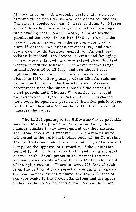
Minnesota caves. Undoubtedly early Indians in prehistoric times used the natural cha:rnbers for shelter. The first recorded use was in 1838 by Jules St. Pierre, a French trader, who enlarged the natural openings for a trading post. Martin Wolfe, a Swiss brewer, purchased the caves in the late 1880's. He used the cave's natural resources - -the spring water, con-stant 45 degree-Fahrenheit te:rnperature, and stor-age space - -in his brewing operation. As busines s volume increased, the several rOo:rns used for aging of beer were enlarged, and now extend about 300 feet westward into the hillside. The aging roo:rns range in width from 10 to 18 feet, and are about 7 feet high and 100 feet long. The Wolfe Brewery was closed in 1919, after passage of the 18th Amendment to the Constitution of the United States. Various enterprises used the outer rooms of the caves for short periods until Thomas W. Curtis, Jr. bought the properties in 1945. Shortly after he purchased the caves, he opened a portion of them for public tours. O. L. Stanislaw now leases the Stillwater Caves and manages the tours.
The initial opening of the Stillwater Caves probably was developed by piping in post-glacial time, in a manner similar to the develop:rnent of other natural sandstone caves in Minnesota. The chambers were excavated in the yellowish-white beds of the Cambrian Jordan Sandstone, which are cemented by dolomite and comprise the uppermost formation of the Cambrian Period (p. 4 ). Fractures that trend north and east controlled the development of the natural cavities, and were used as structural breaks for the alignment of the aging rooms. There is about 115 feet of rock from the ceiling of the deepest of the aging rooms to the land surface directly above; the lower 65 feet of the roof rocks is the Jordan Sandstone and the upper 50 feet is the dolomite beds of the Prairie du Chien
51

Formation.
The cave entry is at the base of the nearly vertical valley wall on the west side of Lake St. Croix. The tour takes the visitor through the historic bricklined and white-washed rooms of the early trading post as well as the rooms later utilized for housing t~e brewery operations. In the deeper aging rooms, which are much larger than those near the entry, one can observe natural walls and the carefully arched ceilings in the Jordan Sandstone. Although these large rooms were excavated in the latter decades of the 19th century and for the most part are not artificially supported, there has been little or no spalling or subsidence.
During the early history of Stillwater, many caves were hollowed out of the Jordan Sandstone. The rooms were used to store many items, most common of which were kerosene and lamp oil.
One of aging rooms in the Stillwater Caves.
52
A natural cave, at the mouth of "Boom Hollow ll ,
north of Stillwater, was enlarged and used as a storage room for a store during the lumbering era in the St. Croix Valley. Logging booms, located near the cave, pulled out and separated the logs floating on the St. Croix from upstream cutting operations. The several lumber mills were located downstream from Boom Hollow. The cave which is about 75 feet deep, 7 feet high, and 15 feet wide, is in calcitecemented sandstone beds of the Cambrian Franconia Formation (p. 4).
Another natural cave is reported upstream from Boom Hollow near Marine on the St. Croix.
Artificial C ave s
In the greater Minneapolis -St. Paul area many rooms have been excavated within the St. Peter Formation for use in mushroom culture, storage of various commodities, aging of beer, garages for motor vehicles, and even a night club, as well as for sources of abrasive sand and sand for manufacture of glass. In IIheavy ground", the rooms are lined with brick or other supports to prevent caving.
About 150 miles of sanitary and storm sewers and utility tunnels have been dug within the St. Peter Sandstone beneath Minneapolis and St. Paul. To prevent caving, the tunnel walls generally are supported by steel ring supports and are lined with concrete.
Caves near Mankato
The tributaries of the Minnesota River have exposed several small caves, now nearly all collapsed,
53
in the basal beds of the Oneota Member of the Prairie du Chien Formation in Blue Earth, Nicollet, and LeSueur counties (p. 4 ).
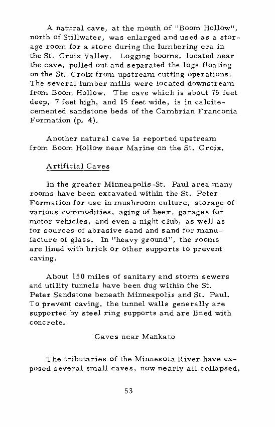
Caves near St. Peter
Near St. Peter, immediately below the resistant dolomite beds of the Oneota Member of the Prairie du Chien Formation, several sandstone caves are present in the uppermost beds of the Jordan Sandstone. The initial openings were excavated by piping under physical conditions similar to those responsible for the sandstone caves in the Minneapolis-St. Paul area. The natural caves were enlarged by man for rooms in which to age beer. After prohibition, mushroom culture was attempted in the same caves. In recent years the entryways and parts of the chambers were .destroyed during widening of U. S. Highway 169. A photograph of the natural opening to one of the caves taken before the highway was widened is shown on the following page.
Other Caves
Olmsted County has several large limestone caves that are similar in geology, size, and origin to those of F'illmore County. There is a small cave in the Platteville Formation near Fountain in Fillmore County. A cave in the Galena Formation is reported in Dodge County, near Pine Island. Manmade caves, near Jordan in Scott County, were used for aging beer. Rooms were excavated into the Jordan Sandstone for abrasive sands at the "Sand Mines II in Red Wing in Goodhue County.
54
Entrance to a sandstone cave near St. Peter.
55
SPELEOLOGICAL ORGANIZATIONS
Most cave explorers are members of the National Speleological Society, which is headquartered in Falls Church, Virginia. The spelunkers of our State are associated with the Minnesota Speleological Survey. At the present time the organization consists of about 20 members.
As you have noted in reading this booklet, the locations of caves other than the commercial ones have purposely been omitted. The reasons for this are several-fold. It is inadvisable for inexperienced persons to explore caves, because of the inherent risk involved in cave exploration. Also, it is possible for novices inadvertently to destroy some of the speleothems and other cave features that are important for future scientific study. Finally, property owners of lands underlain by caves might be held legally responsible for injury to a novice, even though permission was not granted to explore on his property.
However to aid the serious cavers, the Minnesota Speleological Survey has prepared a map for use by the Minnesota Geological Survey that shows the locations of all known caves in Minnesota. The locations are to be kept confidential, with limited selective access, and all priviliged inquiries into further use are to be cleared with the Minnesota Speleological Survey as well as the Minnesota Geological Survey. The Minnesota Speleological Survey's address is P. O. Box 233, Rochester.
56

ACKNOWLEDGMENTS
The writers wish to thank the many people who aided in the compilation of the data in this booklet. Thanks are especially due to the commercial cave operator s of the State for historical information, access to their caves, and use of their photographs. Mr. Douglas Nelson of the Minnesota Speleological Survey supplied information on recent explorations in the Mystery Caves system. Cave locations were supplied by the National Speleological SOciety.
Page
ii, 24
6, 55
18
18
26, 27 29
32
ILLUSTRATION CREDITS
David Planting, St. Paul DispatchPioneer Press Walter J. Breckenridge, Museum of Natural History, Univ. of Minn. U. S. Dept. of Agriculture, Commodity Stabilization Service (upper photo) U. S. Dept. of Interior, Geological Survey, Chatfield Quadrangle (lower photo) Minn. Speleological Survey, Rochester Clarence Prohaska, Mystery Caves, Spring Valley R. L. Bleifuss, Mines Exper. Sta., Univ. of Minn.
37,42,43 - Alfred P. Cremmer, Niagara Cave, Harmony
47 Minn. Historical Society, St. Paul 49 C. Marshall Payne, So. Pasadena, Calif.
57

FURTHER READING
Bretz, J. Harlen, 1938, Caves in the Galena Formation: Jour. Geology, v. 46, no. 6, p. 828 - 841.
Davies, William E., 1960, Origin of caves in folded limestone: Bull. of the Nat. Speleological Society, v. 22, part 1, p. 5 - 18.
FolsUITl, Franklin, 1962, Exploring American Caves: Collier Books, New York, New York, 319 p.
Hogberg, R. K., Sloan, R. E., and Tufford, Sarah, 1967, Guide to fossil collecting in Minnesota: Minn. Geo!. Survey Ed. Series 1 (revised), 40 p.
Moore, George W., 1960, Introduction to the origin of limestone caves: Bull. of the Nat. Speleological Society, v. 22, part 1, p. 3, 4.
Moore, George W. and Nicholas, Brother G., 1964, Speleology - the study of caves: D. C. Heath and Co., Boston, 120 p.
Rysgaard, George N., 1941, A study of cave bats of Minnesota--with special reference to the large brown bat Eptesicus fuscus fuscus (Beauvois): Unpublished M. S. Thesis, Michigan State University, East Lansing.
Winchell, N. H., 1911, The aborigines of Minnesota: Minn. Historical Society, The Pioneer Co., St. Paul, 761 p.
59


APPENDIX
Fascinating Names of Minnesota Caves
Bat Cave Indian Treasure
Chance Hollow LaMoille
Cold Air Mudwood
Cow's Downfall Mystery
Crawlway Niagara
Dance Hall Salamander
Deadman's Slippery Rock
Deep Lake Snowbound
Devil's Den Spider
Echo Chambers Suicide
Horse Thief Twister
Hurricane Well Weary Foot
Ice Woodchuck
61


Educational Series *
Price
ES-1 1967. Guide to Fossil Collecting
ES-2
ES-3
ES-4
in Minnesota (revised edition) -$0.50
1966. Guide to Mineral Collecting in Minnesota - - - - - - -
1966. Geologic Sketch of the Tower-Soudan State Park-
1967. Guide to Caves of Minnesota-
*Order from Minnesota Geological Survey, 220 Pillsbury Hall, University of Minnesota, I>1inneapolis, Minnesota, 55455
0.50
0.50
0.50
I
Minnesota Geological Survey
UNIVERSITY OF MINNESOTA
;--- -_.- . ..., . :"'-'1
I i
.. - j
I I
i L._._ ... I I
Educational Series - 4