Embed Size (px)
Citation preview
HawthorneArmy Depot
Installation Action Plan
MARCH 2001
INSTALLATION ACTION PLAN2001
HawthorneArmy Depot
The purpose of the Installation Action Plan (IAP) is to outline the total multi-yearrestoration program for an installation. The plan will define all Installation RestorationProgram (IRP) requirements and propose a comprehensive approach and associatedcosts to conduct future investigations and remedial actions at each Solid Waste Man-agement Unit (SWMU) at the installation and other areas of concern.
In an effort to coordinate planning information between the IRP manager, major armycommands (MACOMs), installations, executing agencies, regulatory agencies, andthe public, an IAP has been completed for Hawthorne Army Depot. The IAP is usedto track requirements, schedules and tentative budgets for all major Army installationrestoration programs.
All site specific funding and schedule information has been prepared according toprojected overall Army funding levels and is therefore subject to change during thedocument’s annual review. Under current project funding, all remedies will be inplace at Hawthorne Army Depot by the end of 2010.
PURPOSE
CONTRIBUTORS TO THIS YEAR’S IAP
Rebecca Jewell Benscoter Hawthorne Army DepotMary Jean Fischer IRP Support, Engineering & EnvironmentHerman Millsap Hawthorne Army DepotSophie Ngu U.S. Army Corps of Engineers, SacramentoEric Noack Nevada Division of Environmental ProtectionKevin Tiemeier HQ, Operations Support Command
NAME ORGANIZATION
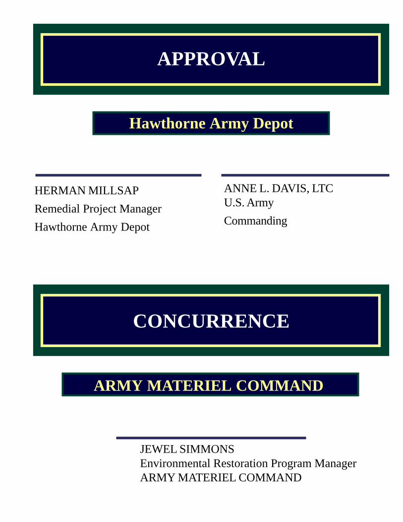
CONCURRENCE
JEWEL SIMMONSEnvironmental Restoration Program ManagerARMY MATERIEL COMMAND
ANNE L. DAVIS, LTCU.S. Army
Commanding
APPROVAL
Hawthorne Army Depot
ARMY MATERIEL COMMAND
HERMAN MILLSAP
Remedial Project Manager
Hawthorne Army Depot
KEVIN TIEMEIER
MSC Environmental RestorationProgram Manager, OSC
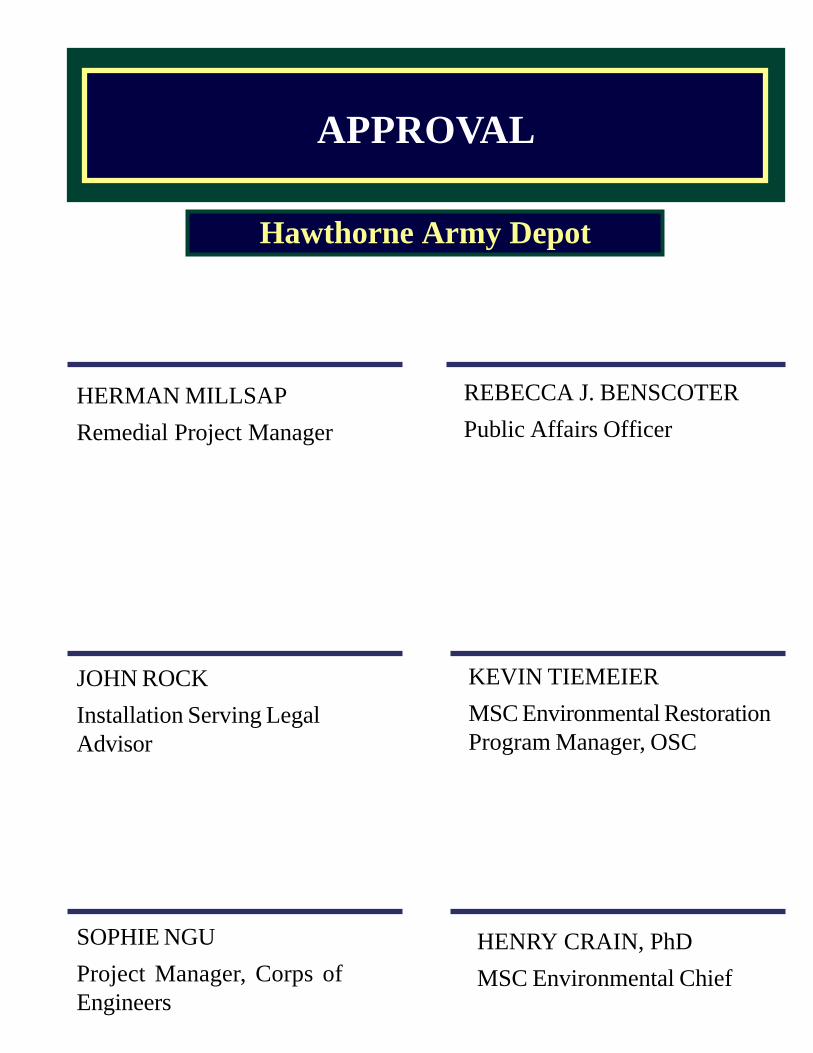
APPROVAL
HERMAN MILLSAP
Remedial Project Manager
JOHN ROCK
Installation Serving LegalAdvisor
Hawthorne Army Depot
SOPHIE NGU
Project Manager, Corps ofEngineers
HENRY CRAIN, PhD
MSC Environmental Chief
REBECCA J. BENSCOTER
Public Affairs Officer
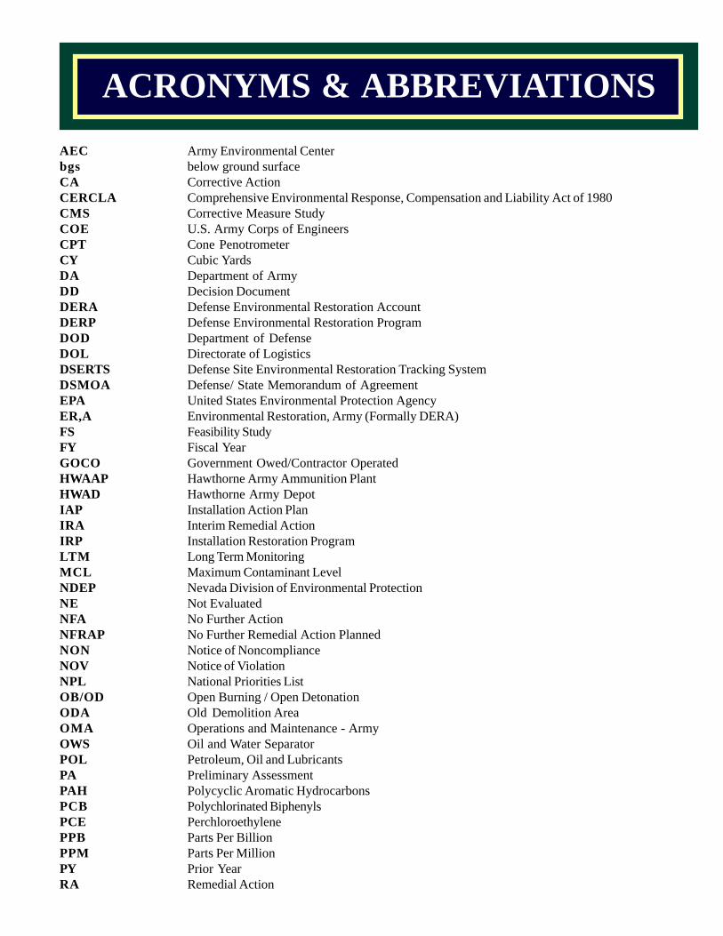
AEC Army Environmental Centerbgs below ground surfaceCA Corrective ActionCERCLA Comprehensive Environmental Response, Compensation and Liability Act of 1980CMS Corrective Measure StudyCOE U.S. Army Corps of EngineersCPT Cone PenotrometerCY Cubic YardsDA Department of ArmyDD Decision DocumentDERA Defense Environmental Restoration AccountDERP Defense Environmental Restoration ProgramDOD Department of DefenseDOL Directorate of LogisticsDSERTS Defense Site Environmental Restoration Tracking SystemDSMOA Defense/ State Memorandum of AgreementEPA United States Environmental Protection AgencyER,A Environmental Restoration, Army (Formally DERA)FS Feasibility StudyFY Fiscal YearGOCO Government Owed/Contractor OperatedHWAAP Hawthorne Army Ammunition PlantHWAD Hawthorne Army DepotIAP Installation Action PlanIRA Interim Remedial ActionIRP Installation Restoration ProgramLTM Long Term MonitoringMCL Maximum Contaminant LevelNDEP Nevada Division of Environmental ProtectionNE Not EvaluatedNFA No Further ActionNFRAP No Further Remedial Action PlannedNON Notice of NoncomplianceNOV Notice of ViolationNPL National Priorities ListOB/OD Open Burning / Open DetonationODA Old Demolition AreaOMA Operations and Maintenance - ArmyOWS Oil and Water SeparatorPOL Petroleum, Oil and LubricantsPA Preliminary AssessmentPAH Polycyclic Aromatic HydrocarbonsPCB Polychlorinated BiphenylsPCE PerchloroethylenePPB Parts Per BillionPPM Parts Per MillionPY Prior YearRA Remedial Action
ACRONYMS & ABBREVIATIONS
LIST OF ACRONYMS AND ABBREVIATIONS CONTINUED…
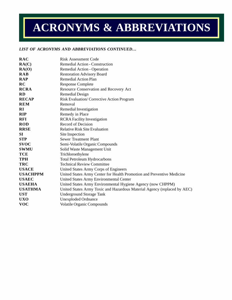
RAC Risk Assessment CodeRA(C) Remedial Action - ConstructionRA(O) Remedial Action - OperationRAB Restoration Advisory BoardRAP Remedial Action PlanRC Response CompleteRCRA Resource Conservation and Recovery ActRD Remedial DesignRECAP Risk Evaluation/ Corrective Action ProgramREM RemovalRI Remedial InvestigationRIP Remedy in PlaceRFI RCRA Facility InvestigationROD Record of DecisionRRSE Relative Risk Site EvaluationSI Site InspectionSTP Sewer Treatment PlantSVOC Semi-Volatile Organic CompoundsSWMU Solid Waste Management UnitTCE TrichloroethyleneTPH Total Petroleum HydrocarbonsTRC Technical Review CommitteeUSACE United States Army Corps of EngineersUSACHPPM United States Army Center for Health Promotion and Preventive MedicineUSAEC United States Army Environmental CenterUSAEHA United States Army Environmental Hygiene Agency (now CHPPM)USATHMA United States Army Toxic and Hazardous Material Agency (replaced by AEC)UST Underground Storage TankUXO Unexploded OrdnanceVOC Volatile Organic Compounds
ACRONYMS & ABBREVIATIONS
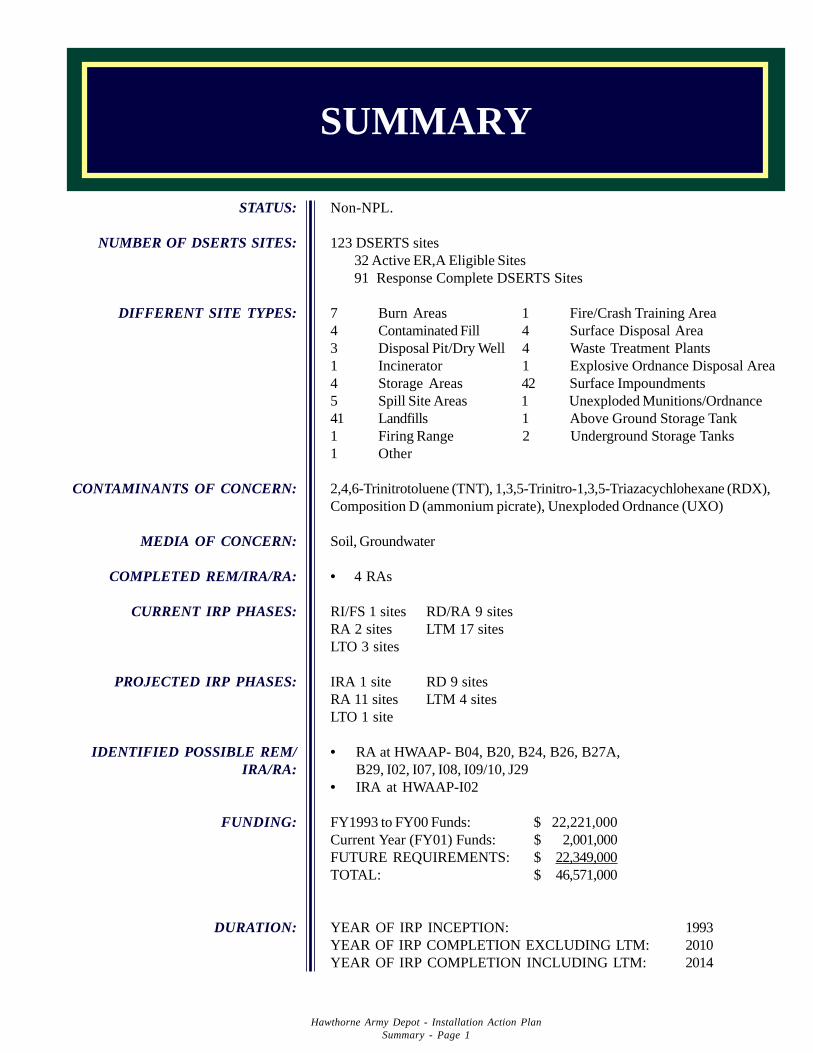
Non-NPL.
123 DSERTS sites32 Active ER,A Eligible Sites91 Response Complete DSERTS Sites
7 Burn Areas 1 Fire/Crash Training Area4 Contaminated Fill 4 Surface Disposal Area3 Disposal Pit/Dry Well 4 Waste Treatment Plants1 Incinerator 1 Explosive Ordnance Disposal Area4 Storage Areas 42 Surface Impoundments5 Spill Site Areas 1 Unexploded Munitions/Ordnance41 Landfills 1 Above Ground Storage Tank1 Firing Range 2 Underground Storage Tanks1 Other
2,4,6-Trinitrotoluene (TNT), 1,3,5-Trinitro-1,3,5-Triazacychlohexane (RDX),Composition D (ammonium picrate), Unexploded Ordnance (UXO)
Soil, Groundwater
• 4 RAs
RI/FS 1 sites RD/RA 9 sitesRA 2 sites LTM 17 sitesLTO 3 sites
IRA 1 site RD 9 sitesRA 11 sites LTM 4 sitesLTO 1 site
• RA at HWAAP- B04, B20, B24, B26, B27A,B29, I02, I07, I08, I09/10, J29
• IRA at HWAAP-I02
FY1993 to FY00 Funds: $ 22,221,000Current Year (FY01) Funds: $ 2,001,000FUTURE REQUIREMENTS: $ 22,349,000TOTAL: $ 46,571,000
YEAR OF IRP INCEPTION: 1993YEAR OF IRP COMPLETION EXCLUDING LTM: 2010YEAR OF IRP COMPLETION INCLUDING LTM: 2014
STATUS:
NUMBER OF DSERTS SITES:
DIFFERENT SITE TYPES:
CONTAMINANTS OF CONCERN:
MEDIA OF CONCERN:
COMPLETED REM/IRA/RA:
CURRENT IRP PHASES:
PROJECTED IRP PHASES:
IDENTIFIED POSSIBLE REM/IRA/RA:
FUNDING:
DURATION:
SUMMARY
Hawthorne Army Depot - Installation Action PlanSummary - Page 1
Hawthorne Army Depot - Installation Action PlanInstallation Information & Description - Page 2
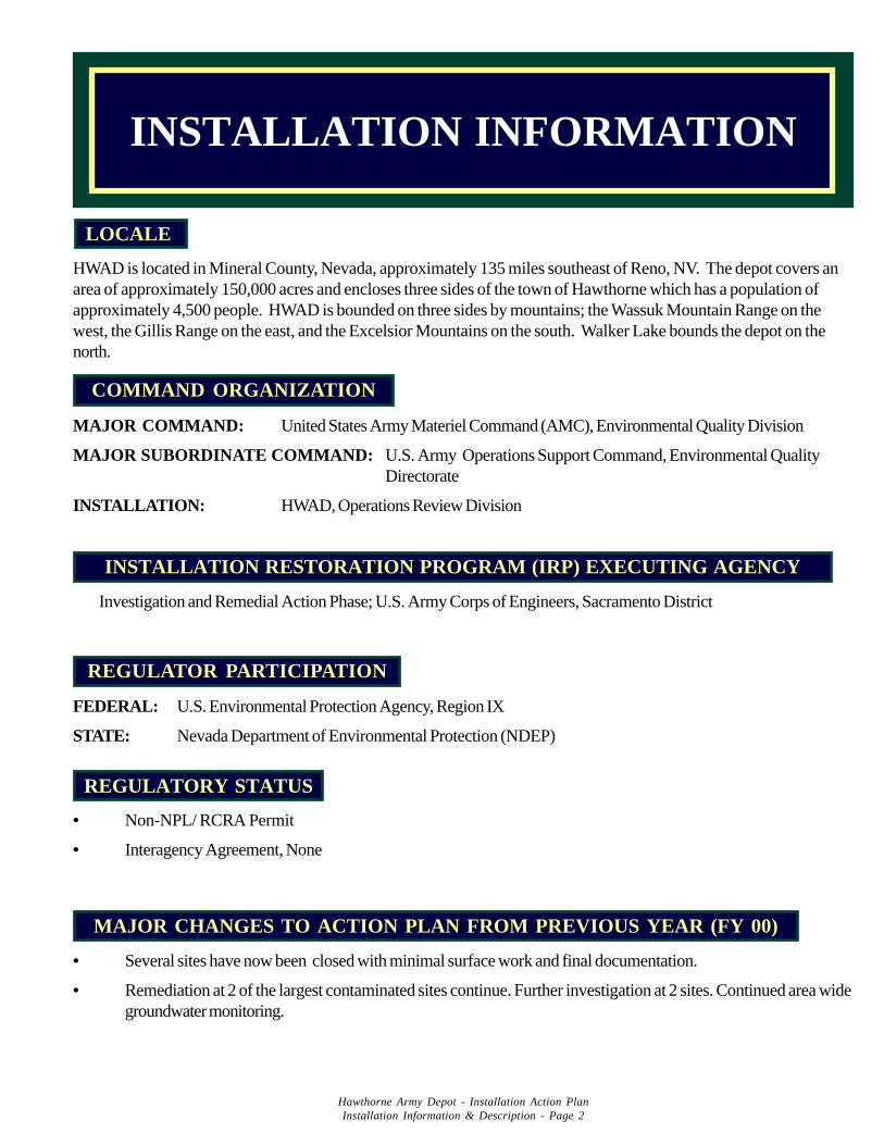
INSTALLATION INFORMATION
MAJOR CHANGES TO ACTION PLAN FROM PREVIOUS YEAR (FY 00)
• Several sites have now been closed with minimal surface work and final documentation.
• Remediation at 2 of the largest contaminated sites continue. Further investigation at 2 sites. Continued area widegroundwater monitoring.
• Non-NPL/ RCRA Permit
• Interagency Agreement, None
REGULATORY STATUS
REGULATOR PARTICIPATION
FEDERAL: U.S. Environmental Protection Agency, Region IX
STATE: Nevada Department of Environmental Protection (NDEP)
INSTALLATION RESTORATION PROGRAM (IRP) EXECUTING AGENCY
Investigation and Remedial Action Phase; U.S. Army Corps of Engineers, Sacramento District
COMMAND ORGANIZATION
MAJOR COMMAND: United States Army Materiel Command (AMC), Environmental Quality Division
MAJOR SUBORDINATE COMMAND: U.S. Army Operations Support Command, Environmental QualityDirectorate
INSTALLATION: HWAD, Operations Review Division
HWAD is located in Mineral County, Nevada, approximately 135 miles southeast of Reno, NV. The depot covers anarea of approximately 150,000 acres and encloses three sides of the town of Hawthorne which has a population ofapproximately 4,500 people. HWAD is bounded on three sides by mountains; the Wassuk Mountain Range on thewest, the Gillis Range on the east, and the Excelsior Mountains on the south. Walker Lake bounds the depot on thenorth.
LOCALE
HWAD is currently a Government owned/Contractor operated (GOCO) facility. Day & Zimmermann HawthorneCorporation [DZHC, Former Day and Zimmermann/Basil Corporation (DZB)] is the current operating contractor.The government and DZHC employ approximately 500 personnel. The current mission of HWAD is to receive, issue,store, renovate, inspect, demil, and dispose of conventional ammunition.
The installation was originally constructed in 1928 as a US Naval Ammunition Depot. The early mission of the depotwas to store, service, and issue ammunition to the Pacific Area. Following World War II, the Depot was activelyinvolved in the demolition of various types of allied and enemy ammunition. The role of the Depot was also expandedto include receiving, renovating, loading, maintaining, storing, and issuing ammunition, explosives, expendable ordnanceitems, and/or weapons and technical ordnance materials. The Depot was also used to test weapons and dispose ofunserviceable and/or dangerous ammunition and explosives. In 1977 the Depot was transferred to the U.S. Armyrenamed Hawthorne Army Ammunition Plant (HWAAP). After the transfer, HWAAP was redesignated as a GOCOPlant in 1980 and operating under the direction of DZB. Its mission in 1980-1994 was to
(1) receive, produce, assemble, load, issue, store, renovate, inspect, test demilitarize, anddispose of conventional ammunition;
(2) operate and/or maintain in operational readiness cast and fuel-air explosive loading plants,rocket assemble plants, and medium/major caliber assembly lines;
(3) provide special/experimental high explosive casting, extruding, and pressing; fuel air explo-sive loading and support services to designated research and development activities;
(4) provide storage facilities for war reserve ammunition, and maintain designated ammunitionin a state of readiness for mobilization, including assembling or otherwise providing base unit materials; and
(5) conduct testing of solid propelled munitions, high explosive warheads, mechanical andelectronic fuses, cartridge cases, primers, rocket motors, and other ballistic devices.
HWAAP was redesignated as Hawthorne Army Depot (HWAD) and its mission was revised on 1 October 1994.HWAD has continued to fulfill its revised mission (shipping, storage and recycling of munitions) and operating under thedirection of DZHC.
HWAD is not on the National Priority List (NPL). Studies and investigations have been conducted under the guidanceof State of Nevada Department of Environmental Protection Agency (NDEP). Releases of hazardous substances,pollutants, or contaminants have been located within the meaning of Comprehensive Environmental Response, Com-pensation and Liability Act (CERCLA), Resource Conservation and Recovery Act (RCRA) and applicable State Law.The regulatory process for the Installation Restoration Program is governed under RCRA.
In December 1995, to facilitate public involvement in HWAD’s Installation Restoration Program, HWAD publishedpublic notices in the Mineral County Independent Newspaper for establishment of a Restoration Advisory Board(RAB). Only one inquiry to public notices was received. Because of insufficient public response, a RAB will not beformed but information concerning the Installation Restoration Program will continuously be released to the publicthrough the media and display at the Mineral County Library.
INSTALLATION DESCRIPTION
Hawthorne Army Depot - Installation Action PlanInstallation Information & Description - Page 3
CONTAMINATION ASSESSMENT
Site investigations and groundwater monitoring have been conducted by the Army, US Army Environmental Hygiene Agency(USAEHA), US Army Toxic and Hazardous Materials Agency (USATHAMA), and US Geological Survey (USGS), Corps of Engineers,and numerous contractors in various areas throughout the installation since 1974. The primary contaminates of concern are explosives(2,4,6-Trinitrotoluene (TNT), 1,3,5-Trinitro-1,3,5-Triazacychlohexane (RDX), nitrate/nitrite) and Unexploded Ordnance (UXO).
Prior to the transfer of HWAAP to the Department of Army, USGS conducted a study in three phases under the direction of Departmentof Navy to assess the possibility of groundwater contamination in the vicinity of the disposal pits at facilities 103-41 (HWAAP-B29),103-16 (HWAAP-B27a). The disposal pits were constructed to receive explosive waste from the demilitarization operation. Theexplosive waste included composition D (ammonium picrate), amatol (TNT plus ammonium nitrate) and RDX.
In Phase I & III, November 1974 - November 1977, USGS installed a total of twenty six exploratory wells in immediate proximity andnorthwest of the disposal area adjacent to demilitarization facility 103-41 (HWAAP-B29). Analysis of water samples taken from thewells showed levels of nitrate/nitrite above background, and several of the wells were found to contain TNT. The highest concentra-tion of TNT (300 ppb and 430 ppb) was detected in two separate determinations in one of the wells. The compound dinitrotoluene(DNT) was also detected from one of the wells. Study indicated that a narrow plume of TNT contamination existed in a northwesterlydirection.
In Phase II, June 1976 - November 1977, USGS installed eight exploratory wells in the vicinity of disposal pits adjacent to the demilitari-zation facility 103-16 (HWAAP-B27a). Chemical analysis of the groundwater samples revealed nitrate/nitrite levels to be abovebackground in most cases and one sample from one of the wells showed TNT at a trace level.
After the transfer of HWAAP in 1977 to the Department of Army, US Army Armament Material Readiness Command (ARRCOM)requested USATHAMA, then known as Project Manager for Chemical Demilitarization and Installation Restoration (PMCDIR), toconduct assessments of HWAAP to determine if there was any contamination resulting from past waste disposal practices.
Installation assessment was conducted between 1977 and 1981 by USATHAMA. Over 25 pits were identified to have receivedexplosive wastes from loading and demilitarization operations in the production areas: 101, 102, 103, 104/49, and 108. The assessmentconcluded that TNT had migrated in a narrow plume to a distance of between 1,200 and 3,200 feet down gradient from 103-41 disposalpits. The migration rate of TNT was slower than the groundwater rate. The assessment also concluded that nitrogen compounds,primarily nitrate, were migrating in two plumes toward Walker Lake. Study was performed showing no impact from HWAD operationsto Walker Lake.
A disposal area for mustard and phosgene chemical munitions (HWAAP-A05) was located during the assessment. The area was firstused during World War II; it was last used in 1946 to decontaminate and bury an unspecified quantity of mustard munitions and theirtoxic agent contents. In 1991 an attempt was made to locate the munitions and to determine if any mustard agent remained either in thesoil or in the munitions. Several pits were located and excavated. M-15 chemical detectors gave positive readings for mustard at onlyone munition; however, laboratory analyses of samples taken from the munitions were negative. Testing of vapors from the pits wasnegative. Since the analyses were inconclusive, the area could still have chemical agent munitions buried beneath the surface.
Several test ranges were also identified in the assessment. Of particular concern is the range near Walker Lake where extensivemunition testing was conducted from World War II to the early seventies. Most of the rounds impacted in the lake and many remainthere as UXO. Live rounds are frequently found on the receding shoreline of Walker Lake.
Another area of concern is west of Walker Lake which was used for training. It was reported by Explosive Ordnance Division (EOD)personnel to be one of the most heavily UXO contaminated areas at HWAD.
The Rocket Test Area located near the southern boundary of HWAD also contains UXOs in the impact area. Adjacent to the RocketTest Area is also a site that was used for fuze and ordnance disposal from World War II through the Korean War. It was reported thatdemolition charges used to destroy the munitions were so large that live munitions were found as far as one mile from the detonationpit. The area is considered extremely hazardous and is fenced to discourage trespassing.
An evaluation of Solid Waste Management Units (SWMUs) was performed by USAEHA between May 1987 and August 1988. At thattime 82 SWMUs were identified. Site screening inspections were conducted from July ’92 through December ’92 to verify theSWMU’s, and data were gathered for the US EPA to revise the Hazard Ranking System (HRS2). As a result of the site screeninginspections, a total of 123 SWMUs were identified.
Hawthorne Army Depot - Installation Action PlanContamination Assessment - Page 4
CONTAMINATION ASSESSMENT
Hawthorne Army Depot - Installation Action PlanContamination Assessment - Page 5
Under the Installation Restoration Program - Defense Environmental Restoration Account, remedial investigation of Group A SolidWaste Management Units (33 SWMUs) since 1993; Group B (55 SWMUs), Old Bomb Disposal Sites (12 SWMUs (UXO and explosivedisposal and burned sites)), 7 Underground Storage Tank sites, 1 Above Ground Storage Tank site since 1994 have been conducted.
Group A SWMU’s consist of 29 catchment pits/ponds/ impoundments sites, 2 disposal pit site, 1 disposal pile site and 1 landfill. Workperformed includes surface geophysics survey, near surface soil and subsurface sampling and analyses, and groundwater sampling at 3existing wells. Baseline Risk Assessments for the 29 sites have completed. Groundwater sampling is included in the long-termgroundwater monitoring plan.
Group B SWMU’s consist of 23 landfills, 15 catchment/pits/ impoundments, 2 Deactivation Furnace areas, 7 disposal pits/ditches/trenches, 2 OB pits, 5 discharge/spill areas, and 1 mustard gas disposal area. Work performed includes aerial photography, GPSsurveying, Airborne Geophysics Survey, Surface Geophysics Survey, Subsurface Screening for Utilities and UXOs, Soil Gas Survey,Soil Sampling and analyses, Ground Water Measurements. Groundwater sampling at some of these sites are part of the ground watermonitoring program. Baseline Risk Assessments for most of the sites will be included in the RIFS.
A pilot study for windrow composting was performed during the summer of 1997. In this study, 2,500 cubic yards of soil containingTNT, HMX and DNT was treated at SWMU’s B20, B32 and I15. Remediation was completed at these sites and they are currently goingthrough the closure process. As part of the pilot study, regulatory requirements for the process as well as operating conditions wereestablished for the site. The involved regulatory agencies determined that the remediation process would not require a containmentbuilding or a solid surface pad. In addition, using treated wooden ammunition boxes as a wood source was deemed acceptable. Theoriginal study was expanded to include 300 cubic yards of ammonium picrate contaminated soil. Results indicate that this treatmentprocess will successfully remediate soil contaminated with ammonium picrate for which, prior to this test, there was no acceptedtreatment methodology.
Old Bomb Disposal Sites consists of 6 landfills, 4 open burn burial pit sites and 2 popping furnace sites. These sites were used fordisposal of ordnance. Airborne ground penetration radar (AGPR) survey was conducted to evaluate these sites. As a result of thesurvey and previous geophysical surveys, test pits are proposed to characterize geophysical anomalies, soil samplings are proposed todetermine if release of hazardous constituents has occurred.
7 UST sites are located at Bldg 13, 103-6, 101-25, 94, Camp Jumbo, Bldg 106-10, and 20-21. Tanks were removed between 1991 and 1993.Sampling results showed evidence of elevated levels of total petroleum hydrocarbons (TPH) ranging from about 6,000mg/kg to73,000mg/kg at depth ranging from 5 to 19 feet. Three sites, Camp Jumbo, Building 106-10 and Building 20-21, decision document forno further action have been signed by the regulatory agency. A pilot study bioventing system at Bldg 13 has been turned over to theCOE for long term monitoring. Installation of Bldg 103-6 and 101-25 is complete.
Above ground storage tank (AST) Site, HWAAP-J03 (Bldg 70 Diesel Leak), consists of two 100,000 gallon ASTs that were installed in1940s and had been leaking diesel fuel over a period of time. In 1991 the contaminated soils were removed by HWAD creating a largeexcavation pit. Remedial investigation conducted in 1994 indicated that soil contamination of TPH was at an elevated level of over40,000 mg/kg in the excavation pit, and TPH ground water was at 11 mg/l. The two AST tanks were removed in February 1997. Abioventing pilot study was completed at this site. Stockpiled soils contaminated with petroleum hydrocarbons from twelve sites wascollected at HWAAP-J03. This soil was used to fill the excavation pit. The enhanced bioventing test results indicate that bioventingmay be able to remediate the site within eight years.
Window composting of sites within the 101 production area is complete. Additional sites have been identified and based on futureevaluation, may be added to active sites for remediation. Composting is performed outside, on the bare ground.
This IAP includes only the IRP eligible sites and those listed in the Defense Site Environmental Restoration Tracking System (DSERTS)database.
Title Author DateA preliminary report on domestic water supply for Hawthorne Naval Ammunition Depot and City of Hawthorne Wilbert, H.E; U.S. Bureau of Reclamation 1947
A Brief Appraisal of the Water Resources of the Walker Lake Area, Mineral, Lyon, and Churchill Counties, NV. Reconnaissance Series Report No. 40, .
Everett, D.E. and F.E. Rush; NV DWR 1967
Hydrologic Regimen of Walker Lake, Mineral County, NV. WR Information Series, Report No. 21. Rush, F.E.; NV DWR and USGS 1974Ground Water Contamination by Percolating Explosives Wastes, Hawthorne Army Ammunition Plant, Mineral County, Nevada, Phase I, November 1974 .
US Department of the Interior, Geologic Survey Jun-75
Source of Nitrate in Water from Supply Well 8, Hawthorne Naval Ammunition Depot, Nevada. Van Denburgh, A.S., F.E. Rush; U.S. Geological Survey Administrative Progress Report
1975
Ground water contamination by percolating explosives wastes, Hawthorne Naval Ammunition Depot, Nevada, Phase I, Reconnaissance of the 103-41 Area
Van Denburgh, A.S., and R.R. Squires; U.S. Geological Survey Administrative Progress Report
1976
Preliminary Investigation of the Geothermal Resources near Hawthorne, NV. Project Report No. 50 Bohm, B.W. and R.L. Jacobsen; Water Resources Center, Desert Research Institute
1977
Ground Water Contamination by Percolating Explosives Wastes, Hawthorne Army Ammunition Plant, Mineral County, Nevada, Phase II, June 1976
USGS Nov-77
Ground Water Contamination by Percolating Explosives Wastes, Hawthorne Army Ammunition Plant, Mineral County, Nevada, Phase III, , August 1977 - November 1977.
USGS 1977
Installation Assessment of Naval Ammunition Depot, Hawthorne, NV. Records Evaluation Report No. 114. U.S. Army Toxic and Hazardous Materials Agency, Aberdeen Proving Ground, MD
Aug-77
Geothermal Potential of the Naval Ammunition Depot, Hawthorne, NV. Whelan, J. 1977Analysis of Surface Water and Sediment Samples from HWAAP for TNT, Picric Acid and RDX Energetic Materials Div, LCWSL, ARRADCOM,
Dover, NJ20-Nov-78
Aerial Photographs of HWAAP, with overlays showing site locations identified by Art Gravenstein, NDEP EMSL 1980
Ground Water Contamination by Percolating Explosives Wastes, HWAAP, Mineral County, NV, Phase IV, Reconnaissance Near Walker Lake
USGS 1980
Ground water contamination by percolating explosives wastes, Hawthorne Army Ammunition Plant, Mineral County, NV, Phase II, Reconnaissance of the 103-16 Area
Van Denburgh, A.S., R.R. Squires, and D.B. Wood; U.S. Geological Survey Administrative Progress Report
1980
Ground water contamination by percolating explosives wastes, Hawthorne Army Ammunition Plant, Mineral County, NV, Phase III, Reconnaissance of the 103-41 Area
Van Denburgh, A.S., D.G. Schaefer, and D.B. Wood; U.S. Geological Survey Administrative Progress Report
1980
Field Investigation of Uncontrolled Hazardous Waste Sites, FIT Project, Site Inspection Report on Hawthorne Army Ammunition Plant.
Ecology & Environment, Inc. 1981
Final Report, Survey and Assessment of Hawthorne Army Ammunition Plant, Hawthorne, Nevada USATHAMA, Aberdeen Proving Ground, Maryland Sep-81
PREVIOUS STUDIES
Hawthorne Army Depot Contamination Assessment Page 6
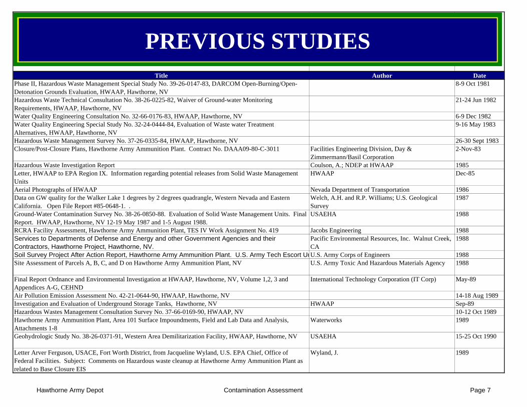
Title Author Date
PREVIOUS STUDIES
Phase II, Hazardous Waste Management Special Study No. 39-26-0147-83, DARCOM Open-Burning/Open-Detonation Grounds Evaluation, HWAAP, Hawthorne, NV
8-9 Oct 1981
Hazardous Waste Technical Consultation No. 38-26-0225-82, Waiver of Ground-water Monitoring Requirements, HWAAP, Hawthorne, NV
21-24 Jun 1982
Water Quality Engineering Consultation No. 32-66-0176-83, HWAAP, Hawthorne, NV 6-9 Dec 1982Water Quality Engineering Special Study No. 32-24-0444-84, Evaluation of Waste water Treatment Alternatives, HWAAP, Hawthorne, NV
9-16 May 1983
Hazardous Waste Management Survey No. 37-26-0335-84, HWAAP, Hawthorne, NV 26-30 Sept 1983Closure/Post-Closure Plans, Hawthorne Army Ammunition Plant. Contract No. DAAA09-80-C-3011 Facilities Engineering Division, Day &
Zimmermann/Basil Corporation2-Nov-83
Hazardous Waste Investigation Report Coulson, A.; NDEP at HWAAP 1985Letter, HWAAP to EPA Region IX. Information regarding potential releases from Solid Waste Management Units
HWAAP Dec-85
Aerial Photographs of HWAAP Nevada Department of Transportation 1986Data on GW quality for the Walker Lake 1 degrees by 2 degrees quadrangle, Western Nevada and Eastern California. Open File Report #85-0648-1. .
Welch, A.H. and R.P. Williams; U.S. Geological Survey
1987
Ground-Water Contamination Survey No. 38-26-0850-88. Evaluation of Solid Waste Management Units. Final Report. HWAAP, Hawthorne, NV 12-19 May 1987 and 1-5 August 1988.
USAEHA 1988
RCRA Facility Assessment, Hawthorne Army Ammunition Plant, TES IV Work Assignment No. 419 Jacobs Engineering 1988Services to Departments of Defense and Energy and other Government Agencies and their Contractors, Hawthorne Project, Hawthorne, NV.
Pacific Environmental Resources, Inc. Walnut Creek, CA
1988
Soil Survey Project After Action Report, Hawthorne Army Ammunition Plant. U.S. Army Tech Escort Unit U.S. Army Corps of Engineers 1988Site Assessment of Parcels A, B, C, and D on Hawthorne Army Ammunition Plant, NV U.S. Army Toxic And Hazardous Materials Agency 1988
Final Report Ordnance and Environmental Investigation at HWAAP, Hawthorne, NV, Volume 1,2, 3 and Appendices A-G, CEHND
International Technology Corporation (IT Corp) May-89
Air Pollution Emission Assessment No. 42-21-0644-90, HWAAP, Hawthorne, NV 14-18 Aug 1989Investigation and Evaluation of Underground Storage Tanks, Hawthorne, NV HWAAP Sep-89Hazardous Wastes Management Consultation Survey No. 37-66-0169-90, HWAAP, NV 10-12 Oct 1989Hawthorne Army Ammunition Plant, Area 101 Surface Impoundments, Field and Lab Data and Analysis, Attachments 1-8
Waterworks 1989
Geohydrologic Study No. 38-26-0371-91, Western Area Demilitarization Facility, HWAAP, Hawthorne, NV USAEHA 15-25 Oct 1990
Letter Arver Ferguson, USACE, Fort Worth District, from Jacqueline Wyland, U.S. EPA Chief, Office of Federal Facilities. Subject: Comments on Hazardous waste cleanup at Hawthorne Army Ammunition Plant as related to Base Closure EIS
Wyland, J. 1989
Hawthorne Army Depot Contamination Assessment Page 7
Title Author Date
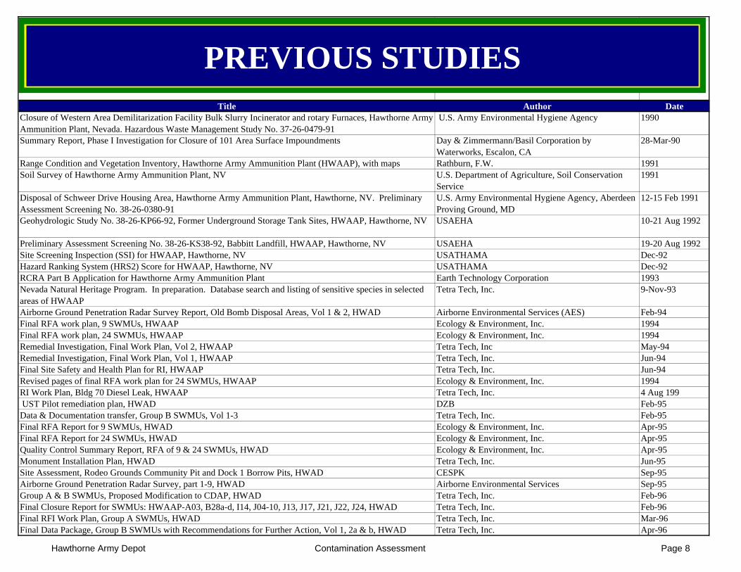
PREVIOUS STUDIES
Closure of Western Area Demilitarization Facility Bulk Slurry Incinerator and rotary Furnaces, Hawthorne Army Ammunition Plant, Nevada. Hazardous Waste Management Study No. 37-26-0479-91
U.S. Army Environmental Hygiene Agency 1990
Summary Report, Phase I Investigation for Closure of 101 Area Surface Impoundments Day & Zimmermann/Basil Corporation by Waterworks, Escalon, CA
28-Mar-90
Range Condition and Vegetation Inventory, Hawthorne Army Ammunition Plant (HWAAP), with maps Rathburn, F.W. 1991Soil Survey of Hawthorne Army Ammunition Plant, NV U.S. Department of Agriculture, Soil Conservation
Service1991
Disposal of Schweer Drive Housing Area, Hawthorne Army Ammunition Plant, Hawthorne, NV. Preliminary Assessment Screening No. 38-26-0380-91
U.S. Army Environmental Hygiene Agency, Aberdeen Proving Ground, MD
12-15 Feb 1991
Geohydrologic Study No. 38-26-KP66-92, Former Underground Storage Tank Sites, HWAAP, Hawthorne, NV USAEHA 10-21 Aug 1992
Preliminary Assessment Screening No. 38-26-KS38-92, Babbitt Landfill, HWAAP, Hawthorne, NV USAEHA 19-20 Aug 1992Site Screening Inspection (SSI) for HWAAP, Hawthorne, NV USATHAMA Dec-92Hazard Ranking System (HRS2) Score for HWAAP, Hawthorne, NV USATHAMA Dec-92RCRA Part B Application for Hawthorne Army Ammunition Plant Earth Technology Corporation 1993Nevada Natural Heritage Program. In preparation. Database search and listing of sensitive species in selected areas of HWAAP
Tetra Tech, Inc. 9-Nov-93
Airborne Ground Penetration Radar Survey Report, Old Bomb Disposal Areas, Vol 1 & 2, HWAD Airborne Environmental Services (AES) Feb-94Final RFA work plan, 9 SWMUs, HWAAP Ecology & Environment, Inc. 1994Final RFA work plan, 24 SWMUs, HWAAP Ecology & Environment, Inc. 1994Remedial Investigation, Final Work Plan, Vol 2, HWAAP Tetra Tech, Inc May-94Remedial Investigation, Final Work Plan, Vol 1, HWAAP Tetra Tech, Inc. Jun-94Final Site Safety and Health Plan for RI, HWAAP Tetra Tech, Inc. Jun-94Revised pages of final RFA work plan for 24 SWMUs, HWAAP Ecology & Environment, Inc. 1994RI Work Plan, Bldg 70 Diesel Leak, HWAAP Tetra Tech, Inc. 4 Aug 199 UST Pilot remediation plan, HWAD DZB Feb-95Data & Documentation transfer, Group B SWMUs, Vol 1-3 Tetra Tech, Inc. Feb-95Final RFA Report for 9 SWMUs, HWAD Ecology & Environment, Inc. Apr-95Final RFA Report for 24 SWMUs, HWAD Ecology & Environment, Inc. Apr-95Quality Control Summary Report, RFA of 9 & 24 SWMUs, HWAD Ecology & Environment, Inc. Apr-95Monument Installation Plan, HWAD Tetra Tech, Inc. Jun-95Site Assessment, Rodeo Grounds Community Pit and Dock 1 Borrow Pits, HWAD CESPK Sep-95Airborne Ground Penetration Radar Survey, part 1-9, HWAD Airborne Environmental Services Sep-95Group A & B SWMUs, Proposed Modification to CDAP, HWAD Tetra Tech, Inc. Feb-96Final Closure Report for SWMUs: HWAAP-A03, B28a-d, I14, J04-10, J13, J17, J21, J22, J24, HWAD Tetra Tech, Inc. Feb-96Final RFI Work Plan, Group A SWMUs, HWAD Tetra Tech, Inc. Mar-96Final Data Package, Group B SWMUs with Recommendations for Further Action, Vol 1, 2a & b, HWAD Tetra Tech, Inc. Apr-96
Hawthorne Army Depot Contamination Assessment Page 8
Title Author Date
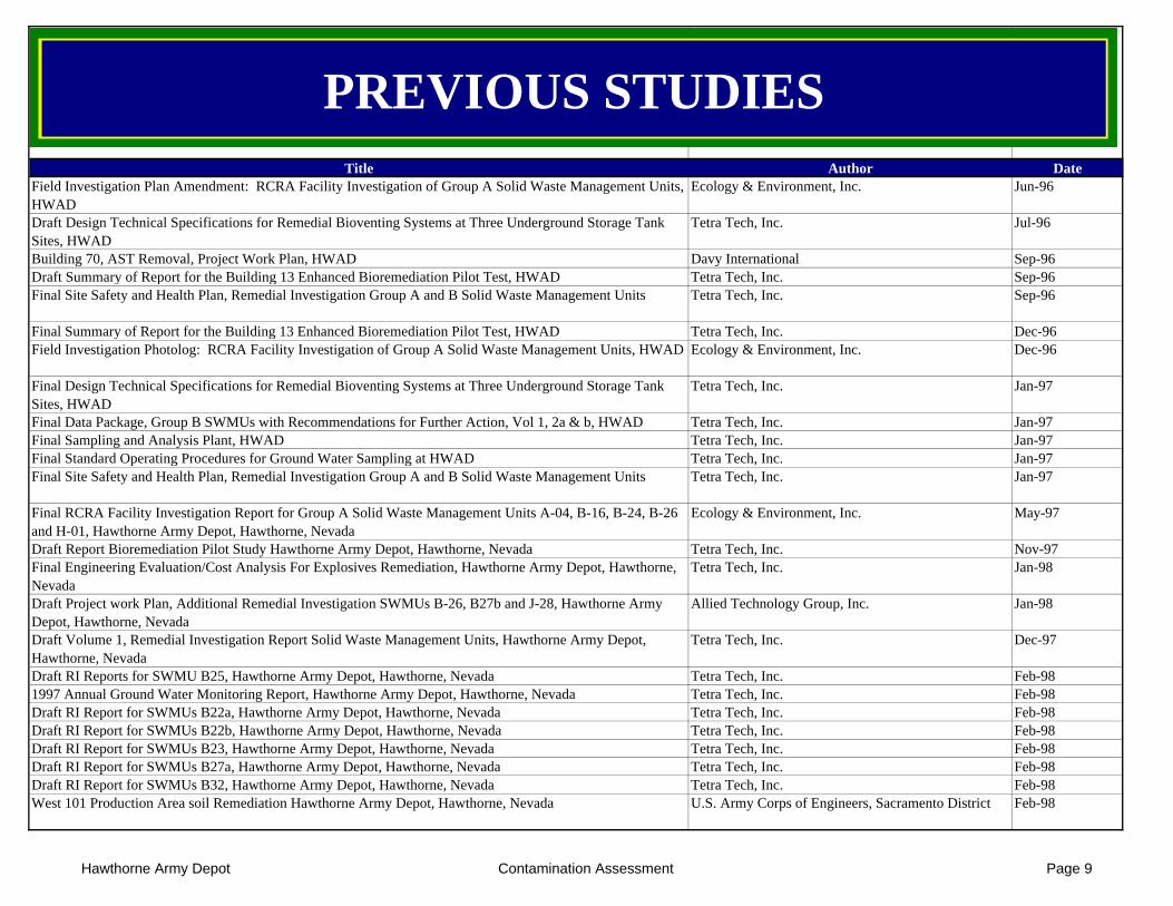
PREVIOUS STUDIES
Field Investigation Plan Amendment: RCRA Facility Investigation of Group A Solid Waste Management Units, HWAD
Ecology & Environment, Inc. Jun-96
Draft Design Technical Specifications for Remedial Bioventing Systems at Three Underground Storage Tank Sites, HWAD
Tetra Tech, Inc. Jul-96
Building 70, AST Removal, Project Work Plan, HWAD Davy International Sep-96Draft Summary of Report for the Building 13 Enhanced Bioremediation Pilot Test, HWAD Tetra Tech, Inc. Sep-96Final Site Safety and Health Plan, Remedial Investigation Group A and B Solid Waste Management Units Tetra Tech, Inc. Sep-96
Final Summary of Report for the Building 13 Enhanced Bioremediation Pilot Test, HWAD Tetra Tech, Inc. Dec-96Field Investigation Photolog: RCRA Facility Investigation of Group A Solid Waste Management Units, HWAD Ecology & Environment, Inc. Dec-96
Final Design Technical Specifications for Remedial Bioventing Systems at Three Underground Storage Tank Sites, HWAD
Tetra Tech, Inc. Jan-97
Final Data Package, Group B SWMUs with Recommendations for Further Action, Vol 1, 2a & b, HWAD Tetra Tech, Inc. Jan-97Final Sampling and Analysis Plant, HWAD Tetra Tech, Inc. Jan-97Final Standard Operating Procedures for Ground Water Sampling at HWAD Tetra Tech, Inc. Jan-97Final Site Safety and Health Plan, Remedial Investigation Group A and B Solid Waste Management Units Tetra Tech, Inc. Jan-97
Final RCRA Facility Investigation Report for Group A Solid Waste Management Units A-04, B-16, B-24, B-26 and H-01, Hawthorne Army Depot, Hawthorne, Nevada
Ecology & Environment, Inc. May-97
Draft Report Bioremediation Pilot Study Hawthorne Army Depot, Hawthorne, Nevada Tetra Tech, Inc. Nov-97Final Engineering Evaluation/Cost Analysis For Explosives Remediation, Hawthorne Army Depot, Hawthorne, Nevada
Tetra Tech, Inc. Jan-98
Draft Project work Plan, Additional Remedial Investigation SWMUs B-26, B27b and J-28, Hawthorne Army Depot, Hawthorne, Nevada
Allied Technology Group, Inc. Jan-98
Draft Volume 1, Remedial Investigation Report Solid Waste Management Units, Hawthorne Army Depot, Hawthorne, Nevada
Tetra Tech, Inc. Dec-97
Draft RI Reports for SWMU B25, Hawthorne Army Depot, Hawthorne, Nevada Tetra Tech, Inc. Feb-981997 Annual Ground Water Monitoring Report, Hawthorne Army Depot, Hawthorne, Nevada Tetra Tech, Inc. Feb-98Draft RI Report for SWMUs B22a, Hawthorne Army Depot, Hawthorne, Nevada Tetra Tech, Inc. Feb-98Draft RI Report for SWMUs B22b, Hawthorne Army Depot, Hawthorne, Nevada Tetra Tech, Inc. Feb-98Draft RI Report for SWMUs B23, Hawthorne Army Depot, Hawthorne, Nevada Tetra Tech, Inc. Feb-98Draft RI Report for SWMUs B27a, Hawthorne Army Depot, Hawthorne, Nevada Tetra Tech, Inc. Feb-98Draft RI Report for SWMUs B32, Hawthorne Army Depot, Hawthorne, Nevada Tetra Tech, Inc. Feb-98West 101 Production Area soil Remediation Hawthorne Army Depot, Hawthorne, Nevada U.S. Army Corps of Engineers, Sacramento District Feb-98
Hawthorne Army Depot Contamination Assessment Page 9
Title Author Date
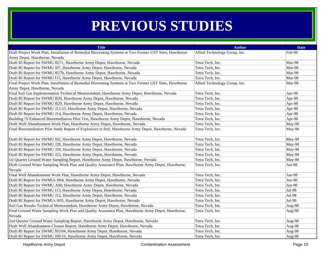
PREVIOUS STUDIES
Draft Project Work Plan, Installation of Remedial Bioventing Systems at Two Former UST Sites, Hawthorne Army Depot, Hawthorne, Nevada
Allied Technology Group, Inc. Feb-98
Draft RI Report for SWMU B27c, Hawthorne Army Depot, Hawthorne, Nevada Tetra Tech, Inc. Mar-98Draft RI Report for SWMU I07, Hawthorne Army Depot, Hawthorne, Nevada Tetra Tech, Inc. Mar-98Draft RI Report for SWMU B27b, Hawthorne Army Depot, Hawthorne, Nevada Tetra Tech, Inc. Mar-98Draft RI Report for SWMU I15, Hawthorne Army Depot, Hawthorne, Nevada Tetra Tech, Inc. Mar-98Final Project Work Plan, Installation of Remedial Bioventing Systems at Two Former UST Sites, Hawthorne Army Depot, Hawthorne, Nevada
Allied Technology Group, Inc. Mar-98
Final Soil Gas Implementation Technical Memorandum, Hawthorne Army Depot, Hawthorne, Nevada Tetra Tech, Inc. Apr-98Draft RI Report for SWMU B20, Hawthorne Army Depot, Hawthorne, Nevada Tetra Tech, Inc. Apr-98Draft RI Report for SWMU B29, Hawthorne Army Depot, Hawthorne, Nevada Tetra Tech, Inc. Apr-98Draft RI Report for SWMU J11/15, Hawthorne Army Depot, Hawthorne, Nevada Tetra Tech, Inc. Apr-98Draft RI Report for SWMU J14, Hawthorne Army Depot, Hawthorne, Nevada Tetra Tech, Inc. Apr-98Building 70 Enhanced Bioremediation Pilot Test, Hawthorne Army Depot, Hawthorne, Nevada Tetra Tech, Inc. Apr-98Draft Well Abandonment Work Plan, Hawthorne Army Depot, Hawthorne, Nevada Tetra Tech, Inc. May-98Final Bioremediation Pilot Study Report of Explosives in Soil, Hawthorne Army Depot, Hawthorne, Nevada Tetra Tech, Inc. May-98
Draft RI Report for SWMU I02, Hawthorne Army Depot, Hawthorne, Nevada Tetra Tech, Inc. May-98Draft RI Report for SWMU J28, Hawthorne Army Depot, Hawthorne, Nevada Tetra Tech, Inc. May-98Draft RI Report for SWMU J29, Hawthorne Army Depot, Hawthorne, Nevada Tetra Tech, Inc. May-98Draft RI Report for SWMU J23, Hawthorne Army Depot, Hawthorne, Nevada Tetra Tech, Inc. May-981st Quarter Ground Water Sampling Report, Hawthorne Army Depot, Hawthorne, Nevada Tetra Tech, Inc. May-98Draft Ground Water Sampling Work Plan and Quality Assurance Plan, Hawthorne Army Depot, Hawthorne, Nevada
Tetra Tech, Inc. Jun-98
Final Well Abandonment Work Plan, Hawthorne Army Depot, Hawthorne, Nevada Tetra Tech, Inc. Jun-98Draft RI Report for SWMUs H04, Hawthorne Army Depot, Hawthorne, Nevada Tetra Tech, Inc. Jun-98Draft RI Report for SWMU A08, Hawthorne Army Depot, Hawthorne, Nevada Tetra Tech, Inc. Jun-98Draft RI Report for SWMU I13, Hawthorne Army Depot, Hawthorne, Nevada Tetra Tech, Inc. Jul-98Draft RI Report for SWMU J12, Hawthorne Army Depot, Hawthorne, Nevada Tetra Tech, Inc. Jul-98Draft RI Report for SWMUs H05, Hawthorne Army Depot, Hawthorne, Nevada Tetra Tech, Inc. Jul-98Soil Gas Results Technical Memorandum, Hawthorne Army Depot, Hawthorne, Nevada Tetra Tech, Inc. Aug-98Final Ground Water Sampling Work Plan and Quality Assurance Plan, Hawthorne Army Depot, Hawthorne, Nevada
Tetra Tech, Inc. Aug-98
2nd Quarter Ground Water Sampling Report, Hawthorne Army Depot, Hawthorne, Nevada Tetra Tech, Inc. Aug-98Draft Well Abandonment Closure Report, Hawthorne Army Depot, Hawthorne, Nevada Tetra Tech, Inc. Aug-98Draft RI Report for SWMU I03/04, Hawthorne Army Depot, Hawthorne, Nevada Tetra Tech, Inc. Aug-98Draft RI Report for SWMU I09/10, Hawthorne Army Depot, Hawthorne, Nevada Tetra Tech, Inc. Aug-98
Hawthorne Army Depot Contamination Assessment Page 10
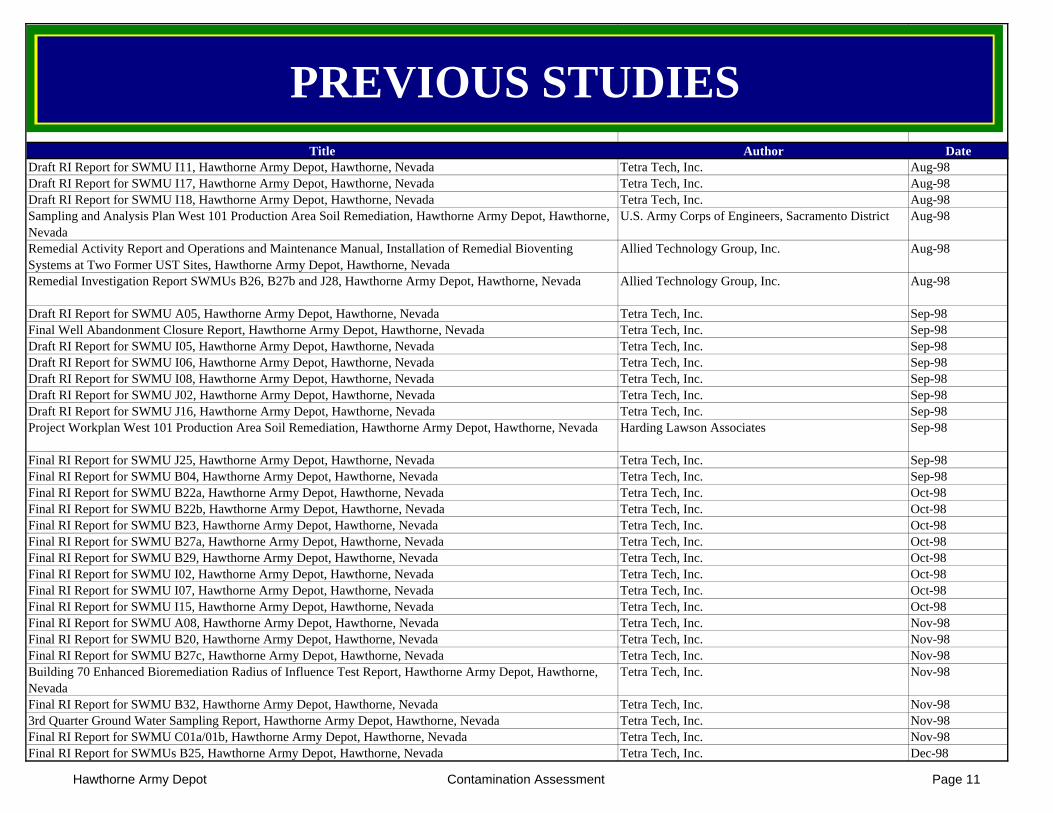
Title Author Date
PREVIOUS STUDIES
Draft RI Report for SWMU I11, Hawthorne Army Depot, Hawthorne, Nevada Tetra Tech, Inc. Aug-98Draft RI Report for SWMU I17, Hawthorne Army Depot, Hawthorne, Nevada Tetra Tech, Inc. Aug-98Draft RI Report for SWMU I18, Hawthorne Army Depot, Hawthorne, Nevada Tetra Tech, Inc. Aug-98Sampling and Analysis Plan West 101 Production Area Soil Remediation, Hawthorne Army Depot, Hawthorne, Nevada
U.S. Army Corps of Engineers, Sacramento District Aug-98
Remedial Activity Report and Operations and Maintenance Manual, Installation of Remedial Bioventing Systems at Two Former UST Sites, Hawthorne Army Depot, Hawthorne, Nevada
Allied Technology Group, Inc. Aug-98
Remedial Investigation Report SWMUs B26, B27b and J28, Hawthorne Army Depot, Hawthorne, Nevada Allied Technology Group, Inc. Aug-98
Draft RI Report for SWMU A05, Hawthorne Army Depot, Hawthorne, Nevada Tetra Tech, Inc. Sep-98Final Well Abandonment Closure Report, Hawthorne Army Depot, Hawthorne, Nevada Tetra Tech, Inc. Sep-98Draft RI Report for SWMU I05, Hawthorne Army Depot, Hawthorne, Nevada Tetra Tech, Inc. Sep-98Draft RI Report for SWMU I06, Hawthorne Army Depot, Hawthorne, Nevada Tetra Tech, Inc. Sep-98Draft RI Report for SWMU I08, Hawthorne Army Depot, Hawthorne, Nevada Tetra Tech, Inc. Sep-98Draft RI Report for SWMU J02, Hawthorne Army Depot, Hawthorne, Nevada Tetra Tech, Inc. Sep-98Draft RI Report for SWMU J16, Hawthorne Army Depot, Hawthorne, Nevada Tetra Tech, Inc. Sep-98Project Workplan West 101 Production Area Soil Remediation, Hawthorne Army Depot, Hawthorne, Nevada Harding Lawson Associates Sep-98
Final RI Report for SWMU J25, Hawthorne Army Depot, Hawthorne, Nevada Tetra Tech, Inc. Sep-98Final RI Report for SWMU B04, Hawthorne Army Depot, Hawthorne, Nevada Tetra Tech, Inc. Sep-98Final RI Report for SWMU B22a, Hawthorne Army Depot, Hawthorne, Nevada Tetra Tech, Inc. Oct-98Final RI Report for SWMU B22b, Hawthorne Army Depot, Hawthorne, Nevada Tetra Tech, Inc. Oct-98Final RI Report for SWMU B23, Hawthorne Army Depot, Hawthorne, Nevada Tetra Tech, Inc. Oct-98Final RI Report for SWMU B27a, Hawthorne Army Depot, Hawthorne, Nevada Tetra Tech, Inc. Oct-98Final RI Report for SWMU B29, Hawthorne Army Depot, Hawthorne, Nevada Tetra Tech, Inc. Oct-98Final RI Report for SWMU I02, Hawthorne Army Depot, Hawthorne, Nevada Tetra Tech, Inc. Oct-98Final RI Report for SWMU I07, Hawthorne Army Depot, Hawthorne, Nevada Tetra Tech, Inc. Oct-98Final RI Report for SWMU I15, Hawthorne Army Depot, Hawthorne, Nevada Tetra Tech, Inc. Oct-98Final RI Report for SWMU A08, Hawthorne Army Depot, Hawthorne, Nevada Tetra Tech, Inc. Nov-98Final RI Report for SWMU B20, Hawthorne Army Depot, Hawthorne, Nevada Tetra Tech, Inc. Nov-98Final RI Report for SWMU B27c, Hawthorne Army Depot, Hawthorne, Nevada Tetra Tech, Inc. Nov-98Building 70 Enhanced Bioremediation Radius of Influence Test Report, Hawthorne Army Depot, Hawthorne, Nevada
Tetra Tech, Inc. Nov-98
Final RI Report for SWMU B32, Hawthorne Army Depot, Hawthorne, Nevada Tetra Tech, Inc. Nov-983rd Quarter Ground Water Sampling Report, Hawthorne Army Depot, Hawthorne, Nevada Tetra Tech, Inc. Nov-98Final RI Report for SWMU C01a/01b, Hawthorne Army Depot, Hawthorne, Nevada Tetra Tech, Inc. Nov-98Final RI Report for SWMUs B25, Hawthorne Army Depot, Hawthorne, Nevada Tetra Tech, Inc. Dec-98
Hawthorne Army Depot Contamination Assessment Page 11
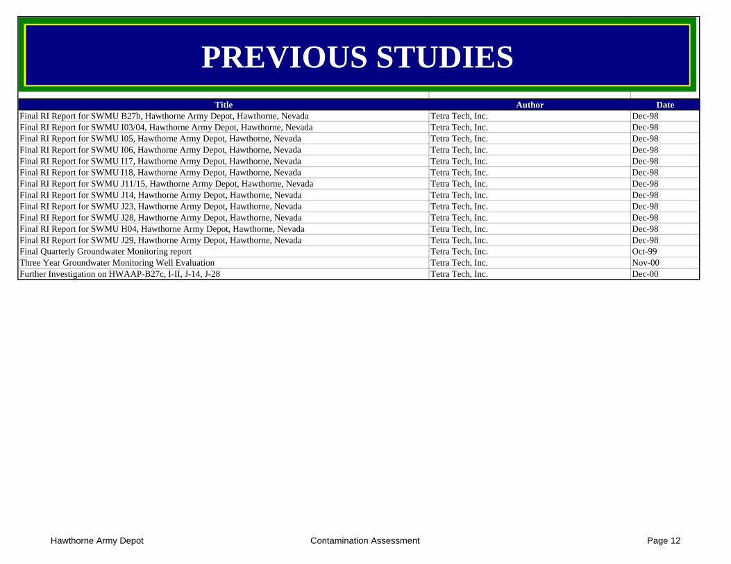
Title Author Date
PREVIOUS STUDIES
Final RI Report for SWMU B27b, Hawthorne Army Depot, Hawthorne, Nevada Tetra Tech, Inc. Dec-98Final RI Report for SWMU I03/04, Hawthorne Army Depot, Hawthorne, Nevada Tetra Tech, Inc. Dec-98Final RI Report for SWMU I05, Hawthorne Army Depot, Hawthorne, Nevada Tetra Tech, Inc. Dec-98Final RI Report for SWMU I06, Hawthorne Army Depot, Hawthorne, Nevada Tetra Tech, Inc. Dec-98Final RI Report for SWMU I17, Hawthorne Army Depot, Hawthorne, Nevada Tetra Tech, Inc. Dec-98Final RI Report for SWMU I18, Hawthorne Army Depot, Hawthorne, Nevada Tetra Tech, Inc. Dec-98Final RI Report for SWMU J11/15, Hawthorne Army Depot, Hawthorne, Nevada Tetra Tech, Inc. Dec-98Final RI Report for SWMU J14, Hawthorne Army Depot, Hawthorne, Nevada Tetra Tech, Inc. Dec-98Final RI Report for SWMU J23, Hawthorne Army Depot, Hawthorne, Nevada Tetra Tech, Inc. Dec-98Final RI Report for SWMU J28, Hawthorne Army Depot, Hawthorne, Nevada Tetra Tech, Inc. Dec-98Final RI Report for SWMU H04, Hawthorne Army Depot, Hawthorne, Nevada Tetra Tech, Inc. Dec-98Final RI Report for SWMU J29, Hawthorne Army Depot, Hawthorne, Nevada Tetra Tech, Inc. Dec-98Final Quarterly Groundwater Monitoring report Tetra Tech, Inc. Oct-99Three Year Groundwater Monitoring Well Evaluation Tetra Tech, Inc. Nov-00Further Investigation on HWAAP-B27c, I-II, J-14, J-28 Tetra Tech, Inc. Dec-00
Hawthorne Army Depot Contamination Assessment Page 12
Hawthorne Army Depot - Installation Action PlanSite Descriptions - Page 1
ER,A ELIGIBLEACTIVE DSERTS SITES
Hawthorne Army Depot - Installation Action PlanSite Descriptions - Page 2
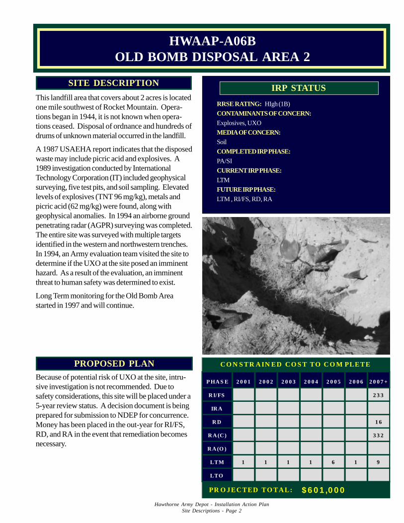
PROPOSED PLANBecause of potential risk of UXO at the site, intru-sive investigation is not recommended. Due tosafety considerations, this site will be placed under a5-year review status. A decision document is beingprepared for submission to NDEP for concurrence.Money has been placed in the out-year for RI/FS,RD, and RA in the event that remediation becomesnecessary.
RRSE RATING: HIgh (1B)
CONTAMINANTS OF CONCERN:Explosives, UXO
MEDIA OF CONCERN:Soil
COMPLETED IRP PHASE:PA/SI
CURRENT IRP PHASE:LTM
FUTURE IRP PHASE:LTM , RI/FS, RD, RA
IRP STATUSSITE DESCRIPTION
This landfill area that covers about 2 acres is locatedone mile southwest of Rocket Mountain. Opera-tions began in 1944, it is not known when opera-tions ceased. Disposal of ordnance and hundreds ofdrums of unknown material occurred in the landfill.
A 1987 USAEHA report indicates that the disposedwaste may include picric acid and explosives. A1989 investigation conducted by InternationalTechnology Corporation (IT) included geophysicalsurveying, five test pits, and soil sampling. Elevatedlevels of explosives (TNT 96 mg/kg), metals andpicric acid (62 mg/kg) were found, along withgeophysical anomalies. In 1994 an airborne groundpenetrating radar (AGPR) surveying was completed.The entire site was surveyed with multiple targetsidentified in the western and northwestern trenches.In 1994, an Army evaluation team visited the site todetermine if the UXO at the site posed an imminenthazard. As a result of the evaluation, an imminentthreat to human safety was determined to exist.
Long Term monitoring for the Old Bomb Areastarted in 1997 and will continue.
HWAAP-A06BOLD BOMB DISPOSAL AREA 2
P HA S E 2 0 0 1 2 0 0 2 2 0 0 3 2 0 0 4 2 0 0 5 2 0 0 6 2 0 0 7 +
R I/FS 2 3 3
IR A
R D 1 6
R A (C ) 3 3 2
R A (O )
LTM 1 1 1 1 6 1 9
LTO
C O N S TR A IN ED C O S T TO C O M PLETE
PR O JEC TED TO TA L: $ 6 0 1 ,0 0 0
Hawthorne Army Depot - Installation Action PlanSite Descriptions - Page 3
PROPOSED PLANBecause of potential risk of UXO at the site, intru-sive investigation is not recommended. Due tosafety considerations, this site will be placed under a5-year review status. A decision document is beingprepared for submission to NDEP for concurrence.Money has been placed in the out-year for RI/FS,RD, and RA in the event that remediation becomesnecessary.
RRSE RATING: Medium (2B)
CONTAMINANTS OF CONCERN:Explosives, Metals, UXO
MEDIA OF CONCERN:Soil
COMPLETED IRP PHASE:PA/SI
CURRENT IRP PHASE:LTM
FUTURE IRP PHASE:LTM , RI/FS, RD, RA
IRP STATUSSITE DESCRIPTION
This site is a landfill that measures 500' x 100' and islocated one mile south of Rocket Mountain. Opera-tions began in 1944; it is not known when opera-tions ceased. A 1987 USAEHA report indicatesthat disposal of many drums and possible ordnanceitems occurred in this landfill.
A 1989 investigation conducted by InternationalTechnology Corporation (IT) included geophysicalsurveying, excavating one test pit and soil sampling.Elevated levels of metals as well as the presence ofgeophysical anomalies were found. In 1994, anairborne GPR survey was completed, and an Armyevaluation team visited the site and determined thatUXO poses an imminent hazard.
Long term monitoring for the Old Bomb Areastarted in 1997.
HWAAP-A06COLD BOMB DISPOSAL AREA 3
P HAS E 2 0 0 1 2 0 0 2 2 0 0 3 2 0 0 4 2 0 0 5 2 0 0 6 2 0 0 7 +
RI/FS 2 3 3
IRA
RD 1 6
RA(C) 3 3 2
RA(O )
LTM 1 1 1 1 6 1 9
LTO
CO N STR AIN ED CO S T TO CO M PLETE
PR O JECTED TO TAL: $ 6 0 1 ,0 0 0
Hawthorne Army Depot - Installation Action PlanSite Descriptions - Page 4
PROPOSED PLANBecause of potential risk of UXO at the site, intrusiveinvestigation is not recommended. Due to safetyconsiderations, this site will be placed under a 5-yearreview status. A decision document is being pre-pared for submission to NDEP for concurrence.Money has been placed in the out-year for RI/FS,RD, and RA in the event that remediation becomesnecessary.
RRSE RATING: High (1B)
CONTAMINANTS OF CONCERN:Explosives, Metals, UXO
MEDIA OF CONCERN:Soil
COMPLETED IRP PHASE:PA/SI
CURRENT IRP PHASE:LTM
FUTURE IRP PHASE:LTM, RI/FS, RD, RA
IRP STATUSSITE DESCRIPTION
This landfill and waste treatment site is located onehalf mile southeast of Rocket Mountain and coversabout 300 square feet with two partially filledtrenches flanking the east and west sides. Operationsbegan in 1944; it is not known when operationsceased. A 1987 USAEHA report indicates thatdisposal of wastewater containing explosives oc-curred in addition to disposal and burning of PEP(pyrotechnic, explosives and propellants) and ord-nance. Explosives staining in trenches was alsoobserved.
A 1989 investigation conducted by InternationalTechnology Corporation (IT) included geophysicalsurveying, excavation of seven test pits, and soilsampling. Elevated levels of explosives (TNT130,000 mg/kg), metals, and picric acid (3,300 mg/kg), along with geophysical anomalies were found.In 1994, an airborne ground penetrating radar(AGPR) survey was completed over the entire site atseveral target locations. An Army evaluation teamvisited the site, and determined that UXO poses animminent hazard.
Long term monitoring for the Old Bomb Area startedin 1997 and will continue.
HWAAP-A06DOLD BOMB DISPOSAL AREA 4
1 1 11 1 6 10
P HA S E 2 0 0 1 2 0 0 2 2 0 0 3 2 0 0 4 2 0 0 5 2 0 0 6 2 0 0 7 +
R I/FS 2 3 3
IR A
R D 1 6
R A (C ) 3 3 2
R A (O )
LTM 1 1 1 1 6 1 9
LTO
C O N S TR A IN ED C O S T TO C O M PLETE
PR O JEC TED TO TA L: $ 6 0 1 ,0 0 0
Hawthorne Army Depot - Installation Action PlanSite Descriptions - Page 8
PROPOSED PLANBecause of potential risk of UXO at the site, intrusiveinvestigation is not recommended. Due to safetyconsiderations, this site will be placed under a 5-yearreview status. A decision document is being pre-pared for submission to NDEP for concurrence.Money has been placed in the out-year for RI/FS,RD, and RA in the event that remediation becomesnecessary.
RRSE RATING: High (1B)
CONTAMINANTS OF CONCERN:Explosives, Metals, TPH, UXO
MEDIA OF CONCERN:Soil
COMPLETED IRP PHASE:PA/SI
CURRENT IRP PHASE:LTM
FUTURE IRP PHASE:LTM, RI/FS, RD, RA
IRP STATUSSITE DESCRIPTION
This waste pile and treatment site measures about 850' x100' and is located immediately east of Old BombDisposal Area No. 4. Three 150’x30’x20' trenches arelocated in the center of this site. Operations began in1940; it is not known when operations ceased. A 1987USAEHA report indicates that many tons of ordnancewere burned and/or buried at this site. Explosive stainingand exposed ordnance have been observed.
A 1989 investigation conducted by International Technol-ogy Corporation (IT) included geophysical surveying,four test pits, and soil sampling. Elevated levels of metalsas well as geophysical anomalies were found. In 1994,airborne ground penetrating radar (AGPR) survey wascompleted over the entire site at several targets. AnArmy evaluation team visited the site, and determinedthat UXO at the site poses an imminent hazard.
Long term monitoring for the Old Bomb area started in1997 and will continue.
HWAAP-A06EOLD BOMB DISPOSAL AREA 5
1 1111 106
P HA S E 2 0 0 1 2 0 0 2 2 0 0 3 2 0 0 4 2 0 0 5 2 0 0 6 2 0 0 7 +
R I/FS 2 3 3
IR A
R D 1 6
R A (C ) 3 3 2
R A (O )
LTM 1 1 1 1 6 1 9
LTO
C O N S TR A IN ED C O S T TO C O M PLETE
PR O JEC TED TO TA L: $ 6 0 1 ,0 0 0
Hawthorne Army Depot - Installation Action PlanSite Descriptions - Page 9
HWAAP-A07NAVAL INSHORE OPS TNG CNTR FIRING RANGE
Any future action at this site is managed under theRange Rule. Because of potential risk of UXO at thesite, intrusive investigation is not recommended.Continue semiannual sweeps for UXO, fence areaoff.
PROPOSED PLAN
HWAAP-A07 are waste piles at the Naval InshoreOperations Training Center Firing Range (NIOTC)located west of Highway 95 between the MarineRifle Range and Police Pistol Range. The site coversapproximately 50 acres and has existing pits thatwere used as disposal sites. Only a small portion ofthe site remains active. The site was infrequentlyused for about 35 years, since the 1960’s. Thewaste piles consist of metal ammunition cans, inert3.5 inch rockets, fuse cans and similar debris result-ing from Navy training. The pile consists of approxi-mately 300 cubic yards of debris. Hazardous wastewas not buried at this location, however, reactiveUXO’s are present. Flash floods are common in thisarea during heavy rainfall events and gully erosionexposes the solid waste and UXO’s.
Reconnaissance surveys and sweeps have beenperformed at the site. In 1994, an Army evaluationteam visited the site to determine if the UXO at thesite pose an imminent hazard. As result of theevaluation, an imminent threat to human safety wasdetermined. Semiannual sweeps are conducted forUXO.
DSERTS lists this site as RC in August 1988.
SITE DESCRIPTION
100
RRSE RATING: NE
CONTAMINANTS OF CONCERN:Metals, Explosives,UXO
MEDIA OF CONCERN:Soil, Groundwater
COMPLETED IRP PHASE:PA/SI
CURRENT IRP PHASE: RI
FUTURE IRP PHASE: RC
IRP STATUS
P HA S E 2 0 0 1 2 0 0 2 2 0 0 3 2 0 0 4 2 0 0 5 2 0 0 6 2 0 0 7 +
R I/FS 1 0 0
IR A
R D
R A (C )
R A (O )
LTM
LTO
C O N S TR A IN ED C O S T TO C O M PLETE
PR O JEC TED TO TA L: $ 1 0 0 ,0 0 0
Hawthorne Army Depot - Installation Action PlanSite Descriptions - Page 10
PROPOSED PLANHWAD, COE and NDEP have tentatively agreed toclose this site and abandon two of the three monitor-ing wells. The remaining well will be kept open forbase wide monitoring.
RRSE RATING: Medium (2B)
CONTAMINANTS OF CONCERN:Metals, Solvents
MEDIA OF CONCERN:Soil, Groundwater
COMPLETED IRP PHASE:PA/SI, RI/FS
CURRENT IRP PHASE:LTM
FUTURE IRP PHASE:RC
IRP STATUSSITE DESCRIPTION
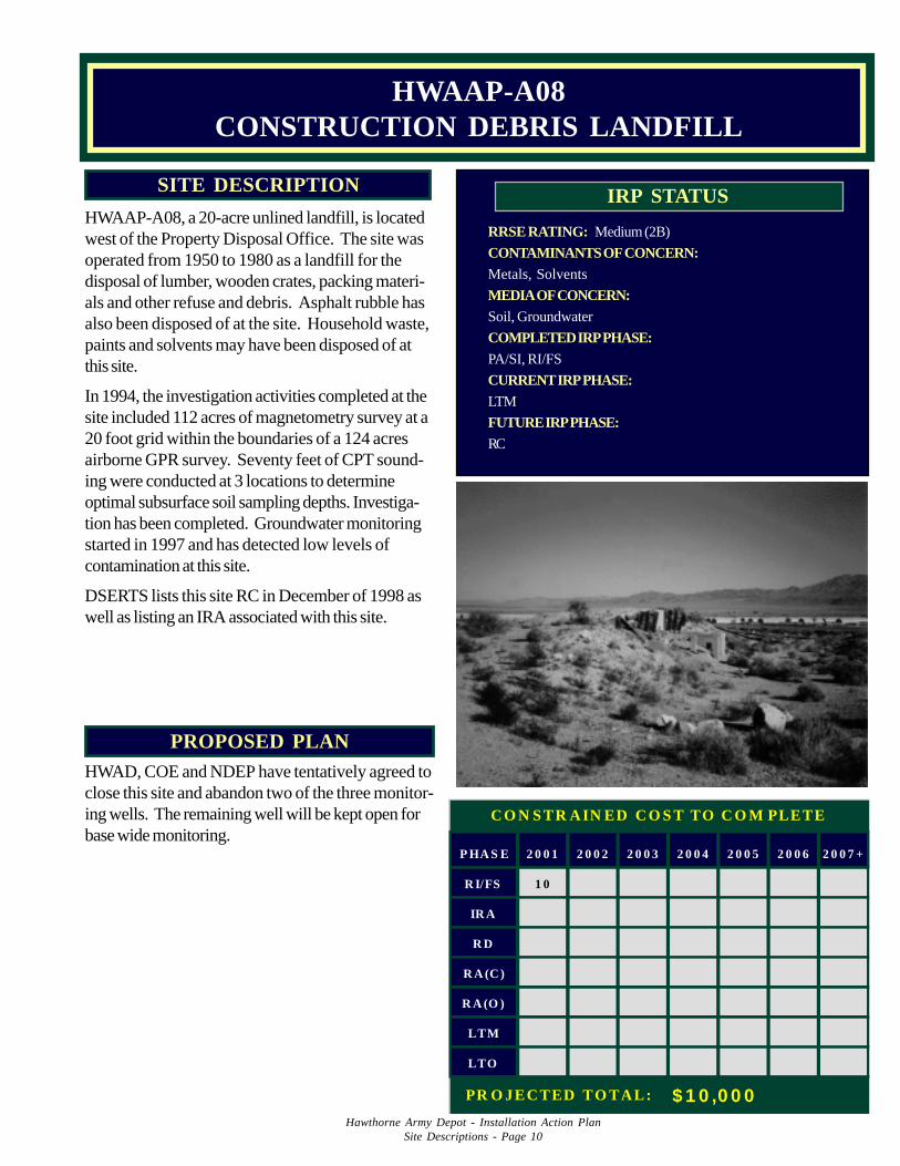
HWAAP-A08, a 20-acre unlined landfill, is locatedwest of the Property Disposal Office. The site wasoperated from 1950 to 1980 as a landfill for thedisposal of lumber, wooden crates, packing materi-als and other refuse and debris. Asphalt rubble hasalso been disposed of at the site. Household waste,paints and solvents may have been disposed of atthis site.
In 1994, the investigation activities completed at thesite included 112 acres of magnetometry survey at a20 foot grid within the boundaries of a 124 acresairborne GPR survey. Seventy feet of CPT sound-ing were conducted at 3 locations to determineoptimal subsurface soil sampling depths. Investiga-tion has been completed. Groundwater monitoringstarted in 1997 and has detected low levels ofcontamination at this site.
DSERTS lists this site RC in December of 1998 aswell as listing an IRA associated with this site.
HWAAP-A08CONSTRUCTION DEBRIS LANDFILL
109
P HA S E 2 0 0 1 2 0 0 2 2 0 0 3 2 0 0 4 2 0 0 5 2 0 0 6 2 0 0 7 +
R I/FS 1 0
IR A
R D
R A (C )
R A (O )
LTM
LTO
C O N S TR A IN ED C O S T TO C O M PLETE
PR O JEC TED TO TA L: $ 1 0 ,0 0 0
Hawthorne Army Depot - Installation Action PlanSite Descriptions - Page 11
PROPOSED PLANContinue monitoring of groundwater for explosives toinclude additional wells (2) for better delineation. RAwill include soil excavation and on site treatment withbioremediation.
RRSE RATING: Medium (2B)
CONTAMINANTS OF CONCERN:TNT, RDX, ammonium picrate
MEDIA OF CONCERN:Soil, Groundwater
COMPLETED IRP PHASE:PA/SI, RI, RD
CURRENT IRP PHASE:RA, LTM
FUTURE IRP PHASE:LTM
IRP STATUSSITE DESCRIPTION
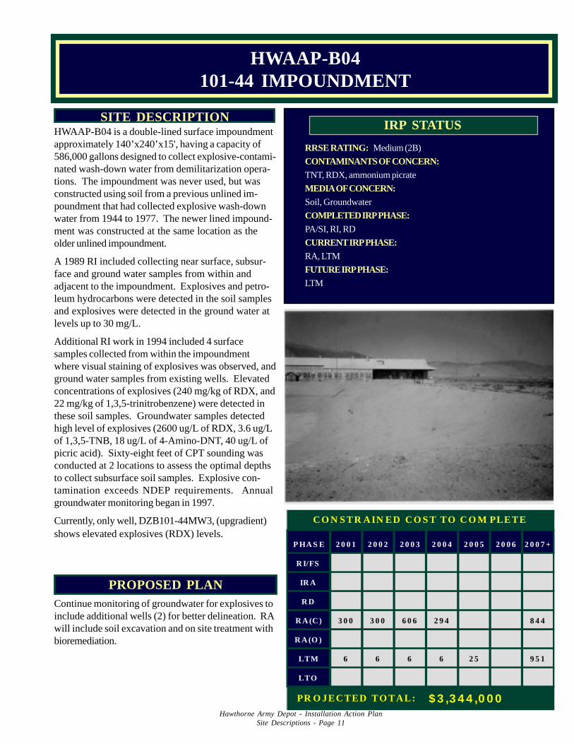
HWAAP-B04 is a double-lined surface impoundmentapproximately 140’x240’x15', having a capacity of586,000 gallons designed to collect explosive-contami-nated wash-down water from demilitarization opera-tions. The impoundment was never used, but wasconstructed using soil from a previous unlined im-poundment that had collected explosive wash-downwater from 1944 to 1977. The newer lined impound-ment was constructed at the same location as theolder unlined impoundment.
A 1989 RI included collecting near surface, subsur-face and ground water samples from within andadjacent to the impoundment. Explosives and petro-leum hydrocarbons were detected in the soil samplesand explosives were detected in the ground water atlevels up to 30 mg/L.
Additional RI work in 1994 included 4 surfacesamples collected from within the impoundmentwhere visual staining of explosives was observed, andground water samples from existing wells. Elevatedconcentrations of explosives (240 mg/kg of RDX, and22 mg/kg of 1,3,5-trinitrobenzene) were detected inthese soil samples. Groundwater samples detectedhigh level of explosives (2600 ug/L of RDX, 3.6 ug/Lof 1,3,5-TNB, 18 ug/L of 4-Amino-DNT, 40 ug/L ofpicric acid). Sixty-eight feet of CPT sounding wasconducted at 2 locations to assess the optimal depthsto collect subsurface soil samples. Explosive con-tamination exceeds NDEP requirements. Annualgroundwater monitoring began in 1997.
Currently, only well, DZB101-44MW3, (upgradient)shows elevated explosives (RDX) levels.
HWAAP-B04101-44 IMPOUNDMENT
P HA S E 2 0 0 1 2 0 0 2 2 0 0 3 2 0 0 4 2 0 0 5 2 0 0 6 2 0 0 7 +
R I/FS
IR A
R D
R A (C ) 3 0 0 3 0 0 6 0 6 2 9 4 8 4 4
R A (O )
LTM 6 6 6 6 2 5 9 5 1
LTO
C O N S TR A IN ED C O S T TO C O M PLETE
PR O JEC TED TO TA L: $ 3 ,3 4 4 ,0 0 0
Hawthorne Army Depot - Installation Action PlanSite Descriptions - Page 12
PROPOSED PLANLTM will continue; LTM for all of the 101 Area isfunded under this site.
RRSE RATING: Medium (2B)
CONTAMINANTS OF CONCERN:TNT, RDX, Metals
MEDIA OF CONCERN:Soil, Groundwater
COMPLETED IRP PHASE:PA/SI, RI/FS, RD, RA
CURRENT IRP PHASE:LTM
FUTURE IRP PHASE:LTM
IRP STATUSSITE DESCRIPTION
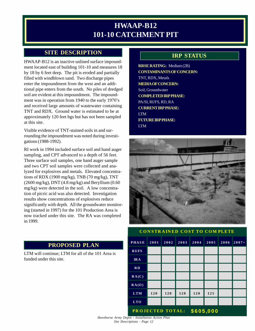
HWAAP-B12 is an inactive unlined surface impound-ment located east of building 101-10 and measures 18by 18 by 6 feet deep. The pit is eroded and partiallyfilled with windblown sand. Two discharge pipesenter the impoundment from the west and an addi-tional pipe enters from the south. No piles of dredgedsoil are evident at this impoundment. The impound-ment was in operation from 1940 to the early 1970’sand received large amounts of wastewater containingTNT and RDX. Ground water is estimated to be atapproximately 120 feet bgs but has not been sampledat this site.
Visible evidence of TNT-stained soils in and sur-rounding the impoundment was noted during investi-gations (1988-1992).
RI work in 1994 included surface soil and hand augersampling, and CPT advanced to a depth of 56 feet.Three surface soil samples, one hand auger sampleand two CPT soil samples were collected and ana-lyzed for explosives and metals. Elevated concentra-tions of RDX (1900 mg/kg), TNB (70 mg/kg), TNT(2600 mg/kg), DNT (4.8 mg/kg) and Beryllium (0.60mg/kg) were detected in the soil. A low concentra-tion of picric acid was also detected. Investigationresults show concentrations of explosives reducesignificantly with depth. All the groundwater monitor-ing (started in 1997) for the 101 Production Area isnow tracked under this site. The RA was completedin 1999.
HWAAP-B12101-10 CATCHMENT PIT
P HA S E 2 0 0 1 2 0 0 2 2 0 0 3 2 0 0 4 2 0 0 5 2 0 0 6 2 0 0 7 +
R I/FS
IR A
R D
R A (C )
R A (O )
LTM 1 2 0 1 2 0 1 2 0 1 2 0 1 2 5
LTO
C O N S TR A IN ED C O S T TO C O M PLETE
PR O JEC TED TO TA L: $ 6 0 5 ,0 0 0
Hawthorne Army Depot - Installation Action PlanSite Descriptions - Page 13
PROPOSED PLANContinue monitoring vapor extraction wells andgroundwater wells and further delineation of TCEcontamination in groundwater.
LTM is being funded under B12 also.
RRSE RATING: High (1B)
CONTAMINANTS OF CONCERN:TNT, RDX, TCE
MEDIA OF CONCERN:Soil, Groundwater
COMPLETED IRP PHASE:PA/SI, RI/FS, RA (soil)
CURRENT IRP PHASE:RI (groundwater)
FUTURE IRP PHASE:RC (soil), RD, RA (groundwater)
IRP STATUSSITE DESCRIPTION
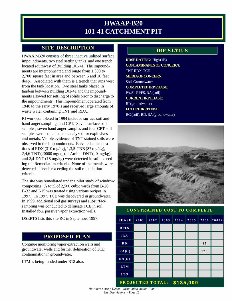
HWAAP-B20 consists of three inactive unlined surfaceimpoundments, two steel settling tanks, and one trenchlocated southwest of Building 101-41. The impound-ments are interconnected and range from 1,300 to2,700 square feet in area and between 6 and 10 feetdeep. Associated with them is a trench that runs westfrom the tank location. Two steel tanks placed intandem between Building 101-41 and the impound-ments allowed for settling of solids prior to discharge tothe impoundments. This impoundment operated from1940 to the early 1970’s and received large amounts ofwaste water containing TNT and RDX.
RI work completed in 1994 included surface soil andhand auger sampling, and CPT. Seven surface soilsamples, seven hand auger samples and four CPT soilsamples were collected and analyzed for explosivesand metals. Visible evidence of TNT stained soils wereobserved in the impoundments. Elevated concentra-tions of RDX (310 mg/kg), 1,3,5-TNB (87 mg/kg),2,4,6-TNT (20000 mg/kg), 2-Amino-DNT (20 mg/kg),and 2,4-DNT (18 mg/kg) were detected in soil exceed-ing the Remediation criteria. None of the metals weredetected at levels exceeding the soil remediationcriteria.
The site was remediated under a pilot study of windrowcomposting. A total of 2,500 cubic yards from B-20,B-32 and I-15 was treated using various recipes in1997. In 1997, TCE was discovered in groundwater.In 1999, additional soil gas surveys and subsurfacesampling was conducted to delineate TCE in soil.Installed four passive vapor extraction wells.
DSERTS lists this site RC in September 1997.
HWAAP-B20101-41 CATCHMENT PIT
P HA S E 2 0 0 1 2 0 0 2 2 0 0 3 2 0 0 4 2 0 0 5 2 0 0 6 2 0 0 7 +
R I/FS
IR A
R D 1 5
R A (C ) 1 2 0
R A (O )
LTM
LTO
C O N S TR A IN ED C O S T TO C O M PLETE
PR O JEC TED TO TA L: $ 1 3 5 ,0 0 0
Hawthorne Army Depot - Installation Action PlanSite Descriptions - Page 14
PROPOSED PLANA Closure Document presenting the RI/RA historywill be submitted for regulatory approval in FY2001.
Based upon concurrence of NDEP, LTM will bediscontinued.
RRSE RATING: High (1B)
CONTAMINANTS OF CONCERN:TNT, RDX, HMX
MEDIA OF CONCERN:Soil, Groundwater
COMPLETED IRP PHASE:PA/SI, RI/FS, RA
CURRENT IRP PHASE:LTM
FUTURE IRP PHASE:RC
IRP STATUSSITE DESCRIPTION
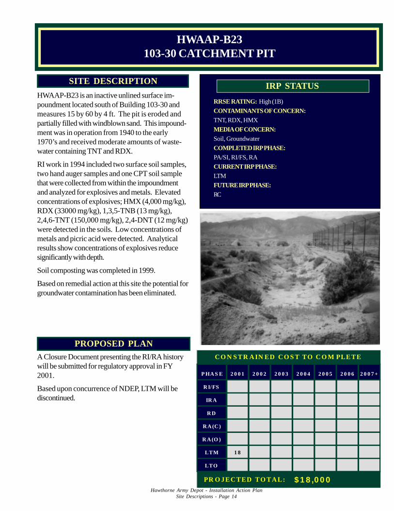
HWAAP-B23 is an inactive unlined surface im-poundment located south of Building 103-30 andmeasures 15 by 60 by 4 ft. The pit is eroded andpartially filled with windblown sand. This impound-ment was in operation from 1940 to the early1970’s and received moderate amounts of waste-water containing TNT and RDX.
RI work in 1994 included two surface soil samples,two hand auger samples and one CPT soil samplethat were collected from within the impoundmentand analyzed for explosives and metals. Elevatedconcentrations of explosives; HMX (4,000 mg/kg),RDX (33000 mg/kg), 1,3,5-TNB (13 mg/kg),2,4,6-TNT (150,000 mg/kg), 2,4-DNT (12 mg/kg)were detected in the soils. Low concentrations ofmetals and picric acid were detected. Analyticalresults show concentrations of explosives reducesignificantly with depth.
Soil composting was completed in 1999.
Based on remedial action at this site the potential forgroundwater contamination has been eliminated.
HWAAP-B23103-30 CATCHMENT PIT
P HA S E 2 0 0 1 2 0 0 2 2 0 0 3 2 0 0 4 2 0 0 5 2 0 0 6 2 0 0 7 +
R I/FS
IR A
R D
R A (C )
R A (O )
LTM 1 8
LTO
C O N S TR A IN ED C O S T TO C O M PLETE
PR O JEC TED TO TA L: $ 1 8 ,0 0 0

Hawthorne Army Depot - Installation Action PlanSite Descriptions - Page 15
PROPOSED PLANTo reduce risk to human health, RA is recom-mended to excavate and remediate (composting) thehigh levels of explosive compounds.
RRSE RATING: High (1B)
CONTAMINANTS OF CONCERN:Lead, Cadmium, PCB, Explosives, TPH
MEDIA OF CONCERN:Soil, Groundwater
COMPLETED IRP PHASE:PA/SI, RI/FS
CURRENT IRP PHASE:RD
FUTURE IRP PHASE:RA
IRP STATUSSITE DESCRIPTION
HWAAP-B24 is an open pit located adjacent toBuilding 102-52. The pit was used from 1950 to1980 for discharged battery electrolyte waste fluid,battery acid spills and wash down water from thebattery shop, Building 102-52. Acid and largequantities of water flowed from this building into thispit. Stained soil is evident in and around the subjectpit.
RI work in 1994 included two surface soil samples,two hand auger samples and two CPT soil samples.Samples were collected within the pit and analyzedfor explosives, metals, SVOCs, VOCs, PCBs, andTPH. Elevated lead (620 mg/kg), RDX (150 mg/kg), TPH (34000 mg/kg), and PCB-1260 (36 mg/kg) were detected. Low concentrations of SVOC,explosives except RDX, and TPH-gasoline werealso detected. Sampling results show contaminantconcentrations generally decreased with depth.
HWAAP-B24102-52 ACID PIT
P HA S E 2 0 0 1 2 0 0 2 2 0 0 3 2 0 0 4 2 0 0 5 2 0 0 6 2 0 0 7 +
R I/FS 6
IR A
R D
R A (C ) 7 7 6 8
R A (O )
LTM
LTO
C O N S TR A IN ED C O S T TO C O M PLETE
PR O JEC TED TO TA L: $ 1 5 1 ,0 0 0
Hawthorne Army Depot - Installation Action PlanSite Descriptions - Page 16
PROPOSED PLANA RA of excavation (soil and source) or landfarming may be needed.
RRSE RATING: Low (3B)
CONTAMINANTS OF CONCERN:TPH, Solvents, Metals
MEDIA OF CONCERN:Soil, Groundwater
COMPLETED IRP PHASE:PA/SI, RI/FS
CURRENT IRP PHASE:RD
FUTURE IRP PHASE:RA
IRP STATUSSITE DESCRIPTION
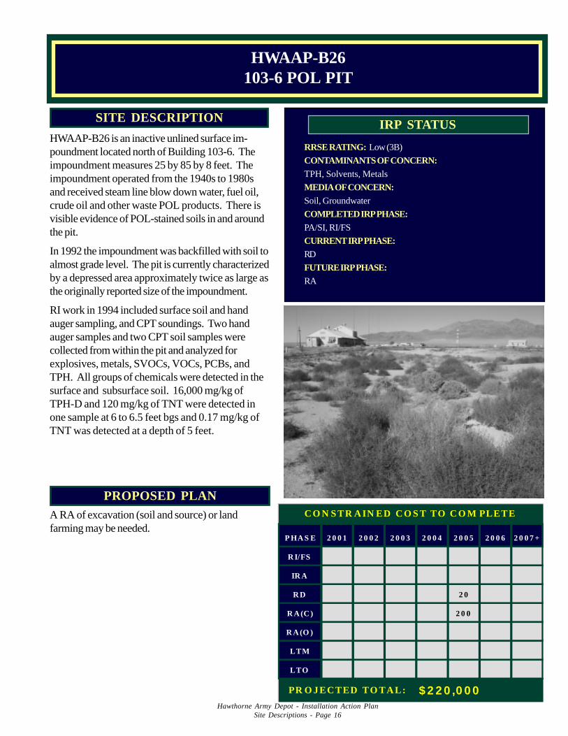
HWAAP-B26 is an inactive unlined surface im-poundment located north of Building 103-6. Theimpoundment measures 25 by 85 by 8 feet. Theimpoundment operated from the 1940s to 1980sand received steam line blow down water, fuel oil,crude oil and other waste POL products. There isvisible evidence of POL-stained soils in and aroundthe pit.
In 1992 the impoundment was backfilled with soil toalmost grade level. The pit is currently characterizedby a depressed area approximately twice as large asthe originally reported size of the impoundment.
RI work in 1994 included surface soil and handauger sampling, and CPT soundings. Two handauger samples and two CPT soil samples werecollected from within the pit and analyzed forexplosives, metals, SVOCs, VOCs, PCBs, andTPH. All groups of chemicals were detected in thesurface and subsurface soil. 16,000 mg/kg ofTPH-D and 120 mg/kg of TNT were detected inone sample at 6 to 6.5 feet bgs and 0.17 mg/kg ofTNT was detected at a depth of 5 feet.
HWAAP-B26103-6 POL PIT
P HA S E 2 0 0 1 2 0 0 2 2 0 0 3 2 0 0 4 2 0 0 5 2 0 0 6 2 0 0 7 +
R I/FS
IR A
R D 2 0
R A (C ) 2 0 0
R A (O )
LTM
LTO
C O N S TR A IN ED C O S T TO C O M PLETE
PR O JEC TED TO TA L: $ 2 2 0 ,0 0 0
Hawthorne Army Depot - Installation Action PlanSite Descriptions - Page 17
PROPOSED PLANTo reduce risk to human health, RA is recommendedto remove and remediate the high levels of explosiveand metal compounds. Excavations and treatment bybioremediation is suggested for RA.
RRSE RATING: Medium (2B)
CONTAMINANTS OF CONCERN:TNT, RDX, Yellow D, Nitric Acid, Metals
MEDIA OF CONCERN:Soil
COMPLETED IRP PHASE:PA/SI, RI/FS
CURRENT IRP PHASE:RD
FUTURE IRP PHASE:RA
IRP STATUSSITE DESCRIPTION
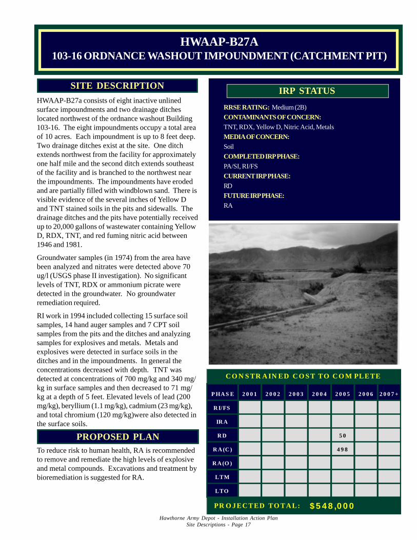
HWAAP-B27a consists of eight inactive unlinedsurface impoundments and two drainage ditcheslocated northwest of the ordnance washout Building103-16. The eight impoundments occupy a total areaof 10 acres. Each impoundment is up to 8 feet deep.Two drainage ditches exist at the site. One ditchextends northwest from the facility for approximatelyone half mile and the second ditch extends southeastof the facility and is branched to the northwest nearthe impoundments. The impoundments have erodedand are partially filled with windblown sand. There isvisible evidence of the several inches of Yellow Dand TNT stained soils in the pits and sidewalls. Thedrainage ditches and the pits have potentially receivedup to 20,000 gallons of wastewater containing YellowD, RDX, TNT, and red fuming nitric acid between1946 and 1981.
Groundwater samples (in 1974) from the area havebeen analyzed and nitrates were detected above 70ug/l (USGS phase II investigation). No significantlevels of TNT, RDX or ammonium picrate weredetected in the groundwater. No groundwaterremediation required.
RI work in 1994 included collecting 15 surface soilsamples, 14 hand auger samples and 7 CPT soilsamples from the pits and the ditches and analyzingsamples for explosives and metals. Metals andexplosives were detected in surface soils in theditches and in the impoundments. In general theconcentrations decreased with depth. TNT wasdetected at concentrations of 700 mg/kg and 340 mg/kg in surface samples and then decreased to 71 mg/kg at a depth of 5 feet. Elevated levels of lead (200mg/kg), beryllium (1.1 mg/kg), cadmium (23 mg/kg),and total chromium (120 mg/kg)were also detected inthe surface soils.
HWAAP-B27A103-16 ORDNANCE WASHOUT IMPOUNDMENT (CATCHMENT PIT)
P HA S E 2 0 0 1 2 0 0 2 2 0 0 3 2 0 0 4 2 0 0 5 2 0 0 6 2 0 0 7 +
R I/FS
IR A
R D 5 0
R A (C ) 4 9 8
R A (O )
LTM
LTO
C O N S TR A IN ED C O S T TO C O M PLETE
PR O JEC TED TO TA L: $ 5 4 8 ,0 0 0
Hawthorne Army Depot - Installation Action PlanSite Descriptions - Page 18
PROPOSED PLANTo reduce risk to human health, RA is recommendedto remove and remediate the high levels of explosivecompounds. Long term groundwater monitoring willbe required. Decision Document for this site will berevised to reflect increased soil and water contamina-tion in 2001.
RRSE RATING: High (1B)
CONTAMINANTS OF CONCERN:RDX, TNT, Amatol, Ammonium Picrate
MEDIA OF CONCERN:Soil, Groundwater
COMPLETED IRP PHASE:PA/SI, RI/FS, RD
CURRENT IRP PHASE:RA, LTM
FUTURE IRP PHASE:LTM
IRP STATUSSITE DESCRIPTION
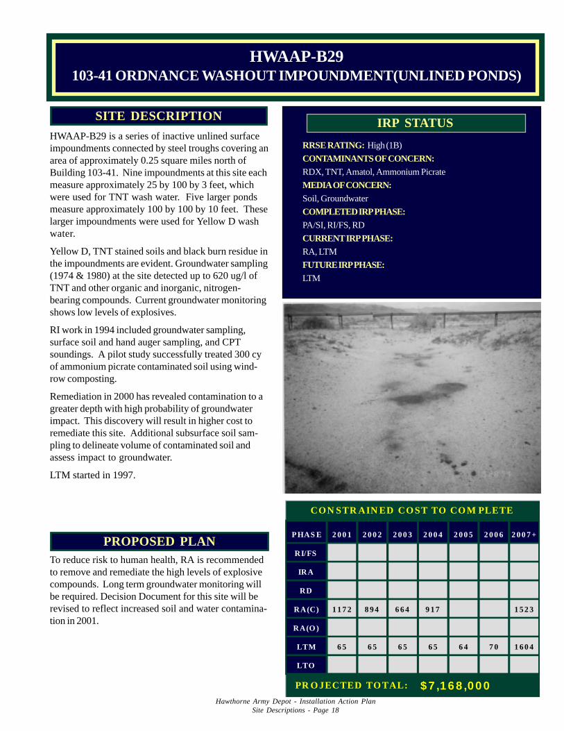
HWAAP-B29 is a series of inactive unlined surfaceimpoundments connected by steel troughs covering anarea of approximately 0.25 square miles north ofBuilding 103-41. Nine impoundments at this site eachmeasure approximately 25 by 100 by 3 feet, whichwere used for TNT wash water. Five larger pondsmeasure approximately 100 by 100 by 10 feet. Theselarger impoundments were used for Yellow D washwater.
Yellow D, TNT stained soils and black burn residue inthe impoundments are evident. Groundwater sampling(1974 & 1980) at the site detected up to 620 ug/l ofTNT and other organic and inorganic, nitrogen-bearing compounds. Current groundwater monitoringshows low levels of explosives.
RI work in 1994 included groundwater sampling,surface soil and hand auger sampling, and CPTsoundings. A pilot study successfully treated 300 cyof ammonium picrate contaminated soil using wind-row composting.
Remediation in 2000 has revealed contamination to agreater depth with high probability of groundwaterimpact. This discovery will result in higher cost toremediate this site. Additional subsurface soil sam-pling to delineate volume of contaminated soil andassess impact to groundwater.
LTM started in 1997.
HWAAP-B29103-41 ORDNANCE WASHOUT IMPOUNDMENT(UNLINED PONDS)
PHAS E 2 0 0 1 2 0 0 2 2 0 0 3 2 0 0 4 2 0 0 5 2 0 0 6 2 0 0 7 +
RI/FS
IRA
RD
RA(C) 1 1 7 2 8 9 4 6 6 4 9 1 7 1 5 2 3
RA(O )
LTM 6 5 6 5 6 5 6 5 6 4 7 0 1 6 0 4
LTO
CON STR AIN ED CO ST TO CO M PLETE
PR O JECTED TO TAL: $ 7 ,1 6 8 ,00 0
Hawthorne Army Depot - Installation Action PlanSite Descriptions - Page 19
PROPOSED PLANFinal Closure Document will be submitted to NDEPin 2001.
RRSE RATING: Medium (2B)
CONTAMINANTS OF CONCERN:Lead, Chronmium, Explosives
MEDIA OF CONCERN:Soil
COMPLETED IRP PHASE:PA/SI, RI/FS, RD
CURRENT IRP PHASE:RA
FUTURE IRP PHASE:RC
IRP STATUSSITE DESCRIPTION
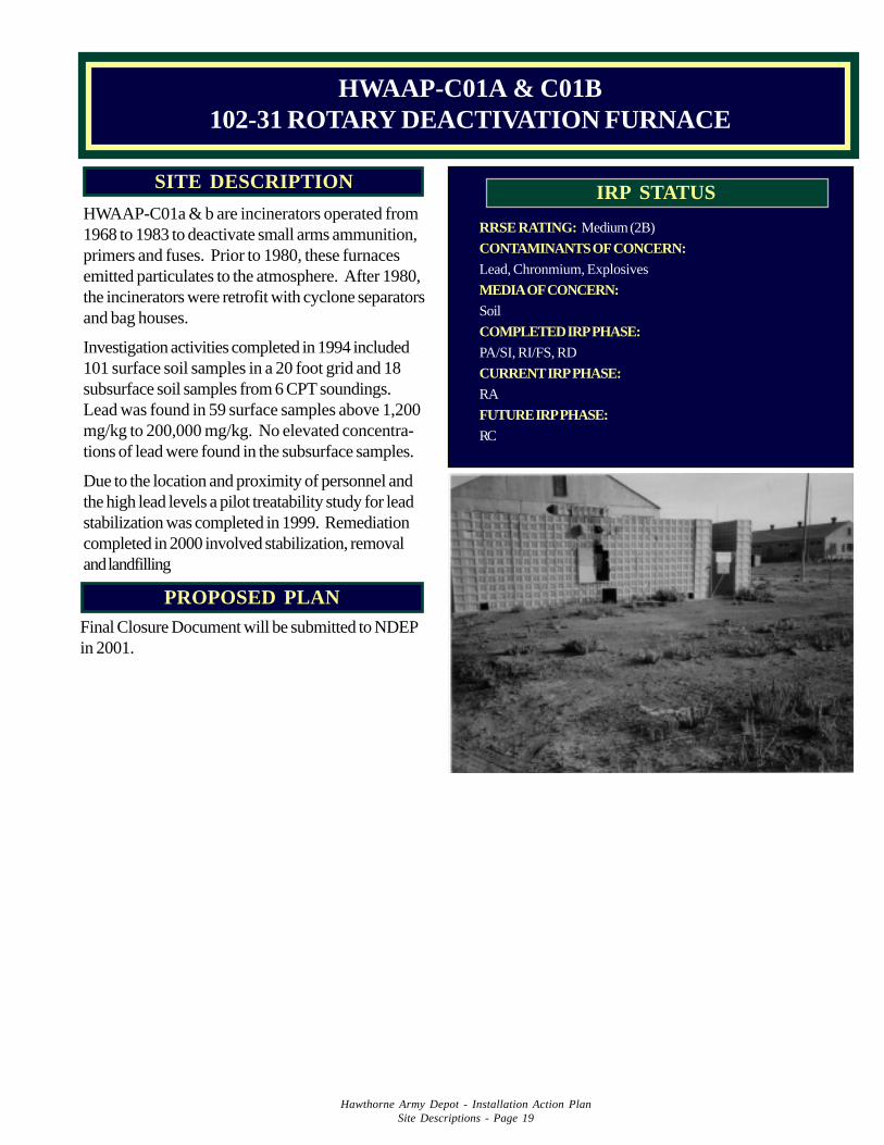
HWAAP-C01a & b are incinerators operated from1968 to 1983 to deactivate small arms ammunition,primers and fuses. Prior to 1980, these furnacesemitted particulates to the atmosphere. After 1980,the incinerators were retrofit with cyclone separatorsand bag houses.
Investigation activities completed in 1994 included101 surface soil samples in a 20 foot grid and 18subsurface soil samples from 6 CPT soundings.Lead was found in 59 surface samples above 1,200mg/kg to 200,000 mg/kg. No elevated concentra-tions of lead were found in the subsurface samples.
Due to the location and proximity of personnel andthe high lead levels a pilot treatability study for leadstabilization was completed in 1999. Remediationcompleted in 2000 involved stabilization, removaland landfilling
HWAAP-C01A & C01B102-31 ROTARY DEACTIVATION FURNACE
Hawthorne Army Depot - Installation Action PlanSite Descriptions - Page 20
PROPOSED PLANBecause of potential risk of UXO at the site, nointrusive activity will be conducted. Site will beplaced on a 5-year status. LTM will continue.Money has been placed in the out-year for RI/FS,in the event that remediation becomes necessary.
RRSE RATING: Low (3B)
CONTAMINANTS OF CONCERN:Explosives, Lead, UXO
MEDIA OF CONCERN:Soil
COMPLETED IRP PHASE:PA/SI
CURRENT IRP PHASE:LTM
FUTURE IRP PHASE:LTM, RI/FS
IRP STATUSSITE DESCRIPTION
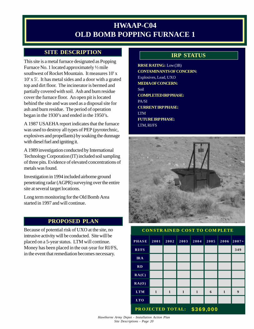
This site is a metal furnace designated as PoppingFurnace No. 1 located approximately ½ milesouthwest of Rocket Mountain. It measures 10' x10' x 5'. It has metal sides and a door with a gratedtop and dirt floor. The incinerator is bermed andpartially covered with soil. Ash and burn residuecover the furnace floor. An open pit is locatedbehind the site and was used as a disposal site forash and burn residue. The period of operationbegan in the 1930’s and ended in the 1950’s.
A 1987 USAEHA report indicates that the furnacewas used to destroy all types of PEP (pyrotechnic,explosives and propellants) by soaking the dunnagewith diesel fuel and igniting it.
A 1989 investigation conducted by InternationalTechnology Corporation (IT) included soil samplingof three pits. Evidence of elevated concentrations ofmetals was found.
Investigation in 1994 included airborne groundpenetrating radar (AGPR) surveying over the entiresite at several target locations.
Long term monitoring for the Old Bomb Areastarted in 1997 and will continue.
HWAAP-C04OLD BOMB POPPING FURNACE 1
1
PHAS E 2 0 0 1 2 0 0 2 2 0 0 3 2 0 0 4 2 0 0 5 2 0 0 6 2 0 0 7 +
RI/FS 3 4 9
IRA
RD
RA(C)
RA(O )
LTM 1 1 1 1 6 1 9
LTO
CON STR AIN ED CO ST TO CO M PLETE
PR O JECTED TO TAL: $ 3 6 9 ,0 0 0
Hawthorne Army Depot - Installation Action PlanSite Descriptions - Page 21
PROPOSED PLANBecause of potential risk of UXO at the site, nointrusive activity will be conducted. Site will beplaced on a 5-year status. LTM will continue.Money has been placed in the out-year for RI/FS inthe event that remediation becomes necessary.
RRSE RATING: Low (3B)
CONTAMINANTS OF CONCERN:Explosives, Metals, UXO
MEDIA OF CONCERN:Soil
COMPLETED IRP PHASE:PA/SI
CURRENT IRP PHASE:LTM
FUTURE IRP PHASE:LTM, RI/FS
IRP STATUSSITE DESCRIPTION
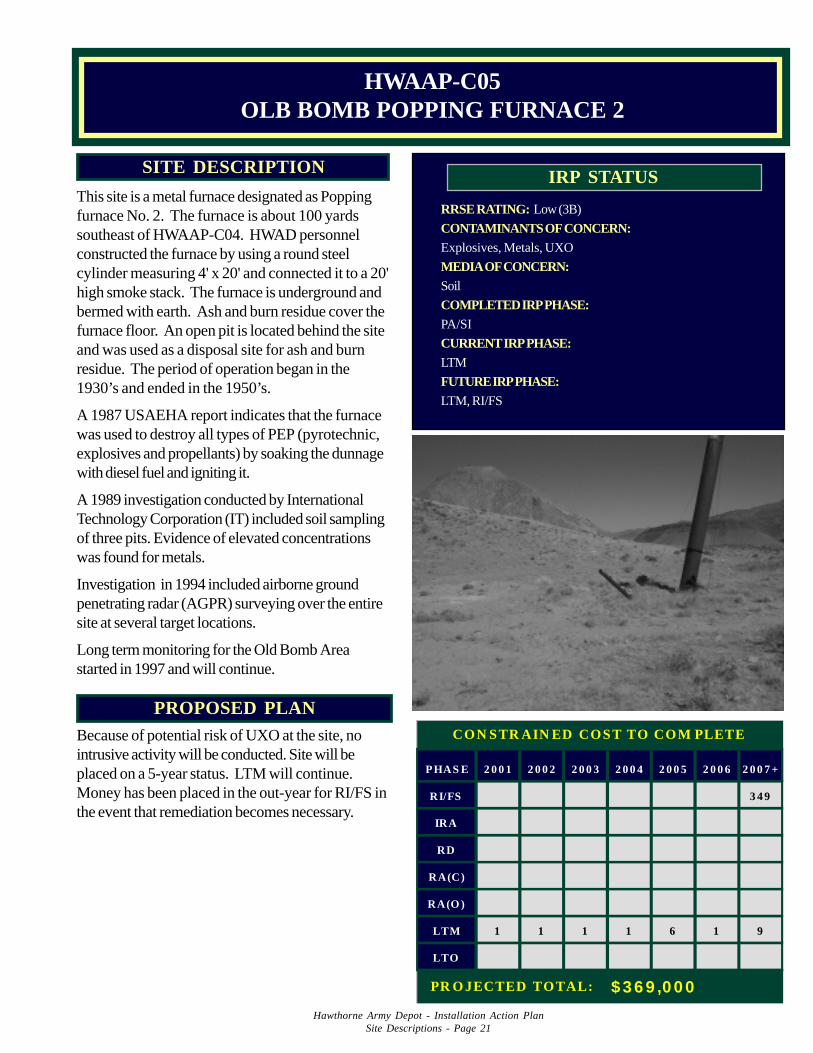
This site is a metal furnace designated as Poppingfurnace No. 2. The furnace is about 100 yardssoutheast of HWAAP-C04. HWAD personnelconstructed the furnace by using a round steelcylinder measuring 4' x 20' and connected it to a 20'high smoke stack. The furnace is underground andbermed with earth. Ash and burn residue cover thefurnace floor. An open pit is located behind the siteand was used as a disposal site for ash and burnresidue. The period of operation began in the1930’s and ended in the 1950’s.
A 1987 USAEHA report indicates that the furnacewas used to destroy all types of PEP (pyrotechnic,explosives and propellants) by soaking the dunnagewith diesel fuel and igniting it.
A 1989 investigation conducted by InternationalTechnology Corporation (IT) included soil samplingof three pits. Evidence of elevated concentrationswas found for metals.
Investigation in 1994 included airborne groundpenetrating radar (AGPR) surveying over the entiresite at several target locations.
Long term monitoring for the Old Bomb Areastarted in 1997 and will continue.
HWAAP-C05OLB BOMB POPPING FURNACE 2
1 111 1 6 10
PHAS E 2 0 0 1 2 0 0 2 2 0 0 3 2 0 0 4 2 0 0 5 2 0 0 6 2 0 0 7 +
RI/FS 3 4 9
IRA
RD
RA(C)
RA(O )
LTM 1 1 1 1 6 1 9
LTO
CON STR AIN ED COST TO COM PLETE
PR O JECTED TOTAL: $ 3 6 9 ,0 0 0
Hawthorne Army Depot - Installation Action PlanSite Descriptions - Page 22
PROPOSED PLANBecause of potential risk of UXO at the site, intru-sive investigation is not recommended. Defer 5-years (DD). Money has been placed in the out-yearfor RI/FS in the event that remediation becomesnecessary.
RRSE RATING: High (1B)
CONTAMINANTS OF CONCERN:Explosives, Metals, UXO
MEDIA OF CONCERN:Soil
COMPLETED IRP PHASE:PA/SI
CURRENT IRP PHASE:LTM
FUTURE IRP PHASE:LTM, RI/FS
IRP STATUSSITE DESCRIPTION
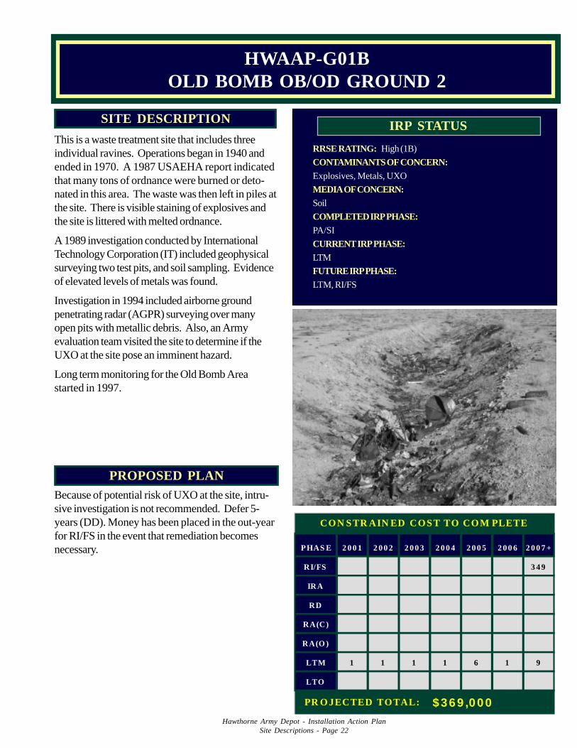
This is a waste treatment site that includes threeindividual ravines. Operations began in 1940 andended in 1970. A 1987 USAEHA report indicatedthat many tons of ordnance were burned or deto-nated in this area. The waste was then left in piles atthe site. There is visible staining of explosives andthe site is littered with melted ordnance.
A 1989 investigation conducted by InternationalTechnology Corporation (IT) included geophysicalsurveying two test pits, and soil sampling. Evidenceof elevated levels of metals was found.
Investigation in 1994 included airborne groundpenetrating radar (AGPR) surveying over manyopen pits with metallic debris. Also, an Armyevaluation team visited the site to determine if theUXO at the site pose an imminent hazard.
Long term monitoring for the Old Bomb Areastarted in 1997.
HWAAP-G01BOLD BOMB OB/OD GROUND 2
PHAS E 2 0 0 1 2 0 0 2 2 0 0 3 2 0 0 4 2 0 0 5 2 0 0 6 2 0 0 7 +
RI/FS 3 4 9
IRA
RD
RA(C)
RA(O )
LTM 1 1 1 1 6 1 9
LTO
CON STR AIN ED COST TO COM PLETE
PR O JECTED TOTAL: $369 ,000
Hawthorne Army Depot - Installation Action PlanSite Descriptions - Page 23
PROPOSED PLANBecause of potential risk of UXO at the site, intru-sive investigation is not recommended. Defer 5-years (DD). LTM will continue. Money has beenplaced in the out-year for RI/FS in the event thatremediation becomes necessary.
RRSE RATING: High (1B)
CONTAMINANTS OF CONCERN:Explosives, UXO, Metals
MEDIA OF CONCERN:Soil
COMPLETED IRP PHASE:PA/SI
CURRENT IRP PHASE:LTM
FUTURE IRP PHASE:LTM, RI/FS
IRP STATUSSITE DESCRIPTION
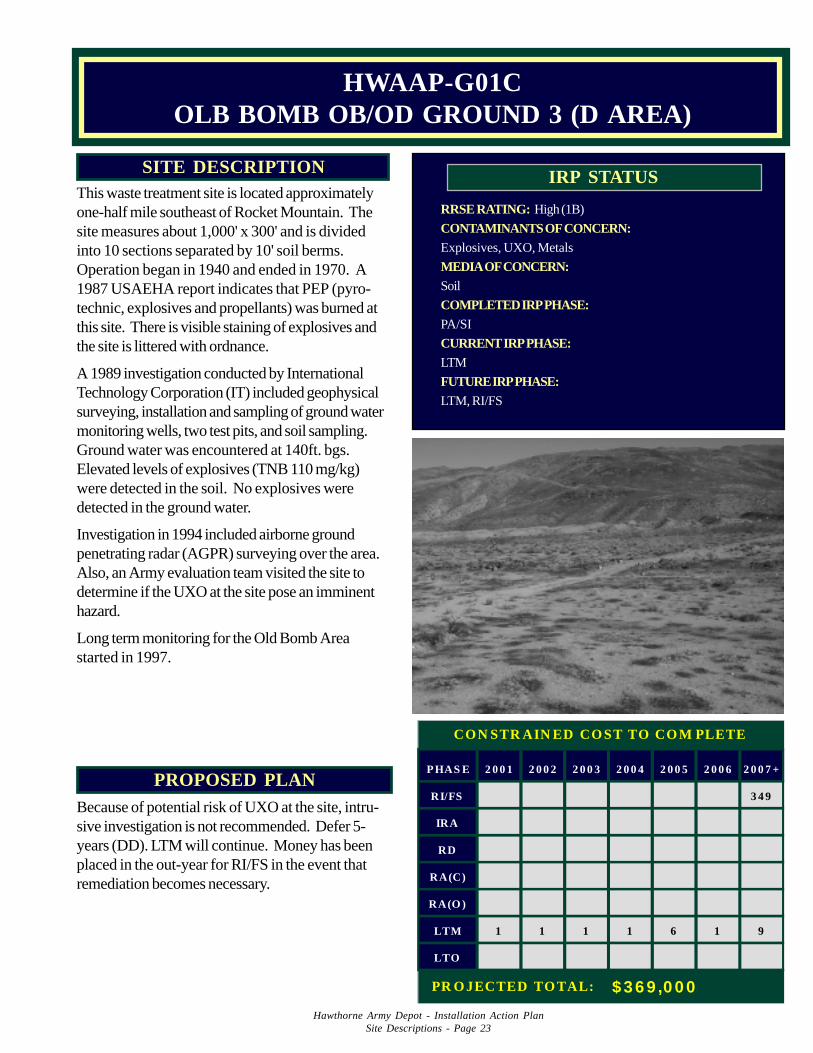
HWAAP-G01COLB BOMB OB/OD GROUND 3 (D AREA)
This waste treatment site is located approximatelyone-half mile southeast of Rocket Mountain. Thesite measures about 1,000' x 300' and is dividedinto 10 sections separated by 10' soil berms.Operation began in 1940 and ended in 1970. A1987 USAEHA report indicates that PEP (pyro-technic, explosives and propellants) was burned atthis site. There is visible staining of explosives andthe site is littered with ordnance.
A 1989 investigation conducted by InternationalTechnology Corporation (IT) included geophysicalsurveying, installation and sampling of ground watermonitoring wells, two test pits, and soil sampling.Ground water was encountered at 140ft. bgs.Elevated levels of explosives (TNB 110 mg/kg)were detected in the soil. No explosives weredetected in the ground water.
Investigation in 1994 included airborne groundpenetrating radar (AGPR) surveying over the area.Also, an Army evaluation team visited the site todetermine if the UXO at the site pose an imminenthazard.
Long term monitoring for the Old Bomb Areastarted in 1997.
1011 1 1 1 6
PHAS E 2 0 0 1 2 0 0 2 2 0 0 3 2 0 0 4 2 0 0 5 2 0 0 6 2 0 0 7 +
RI/FS 3 4 9
IRA
RD
RA(C)
RA(O )
LTM 1 1 1 1 6 1 9
LTO
CON STR AIN ED CO ST TO CO M PLETE
PR O JECTED TO TAL: $ 3 6 9 ,0 0 0
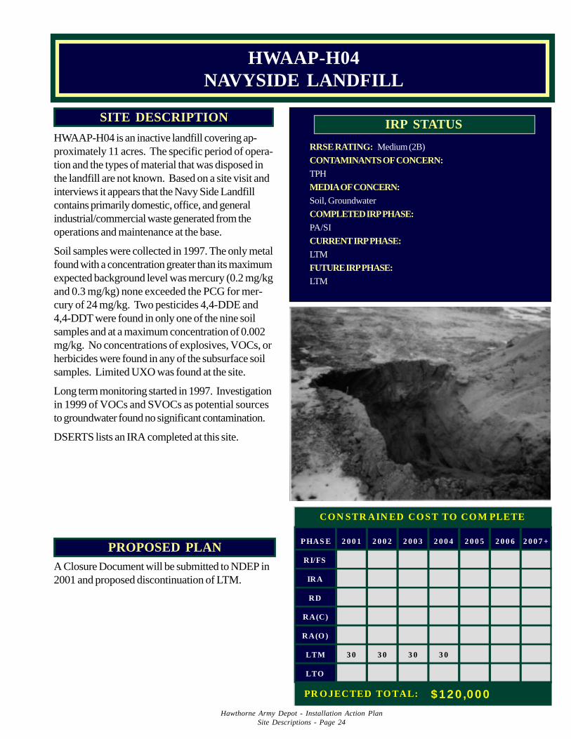
Hawthorne Army Depot - Installation Action PlanSite Descriptions - Page 24
PROPOSED PLANA Closure Document will be submitted to NDEP in2001 and proposed discontinuation of LTM.
RRSE RATING: Medium (2B)
CONTAMINANTS OF CONCERN:TPH
MEDIA OF CONCERN:Soil, Groundwater
COMPLETED IRP PHASE:PA/SI
CURRENT IRP PHASE:LTM
FUTURE IRP PHASE:LTM
IRP STATUSSITE DESCRIPTION
HWAAP-H04 is an inactive landfill covering ap-proximately 11 acres. The specific period of opera-tion and the types of material that was disposed inthe landfill are not known. Based on a site visit andinterviews it appears that the Navy Side Landfillcontains primarily domestic, office, and generalindustrial/commercial waste generated from theoperations and maintenance at the base.
Soil samples were collected in 1997. The only metalfound with a concentration greater than its maximumexpected background level was mercury (0.2 mg/kgand 0.3 mg/kg) none exceeded the PCG for mer-cury of 24 mg/kg. Two pesticides 4,4-DDE and4,4-DDT were found in only one of the nine soilsamples and at a maximum concentration of 0.002mg/kg. No concentrations of explosives, VOCs, orherbicides were found in any of the subsurface soilsamples. Limited UXO was found at the site.
Long term monitoring started in 1997. Investigationin 1999 of VOCs and SVOCs as potential sourcesto groundwater found no significant contamination.
DSERTS lists an IRA completed at this site.
HWAAP-H04NAVYSIDE LANDFILL
3035 30 30 30
PHAS E 2 0 0 1 2 0 0 2 2 0 0 3 2 0 0 4 2 0 0 5 2 0 0 6 2 0 0 7 +
RI/FS
IRA
RD
RA(C)
RA(O )
LTM 3 0 3 0 3 0 3 0
LTO
CON STR AIN ED CO ST TO CO M PLETE
PR O JECTED TO TAL: $120 ,000
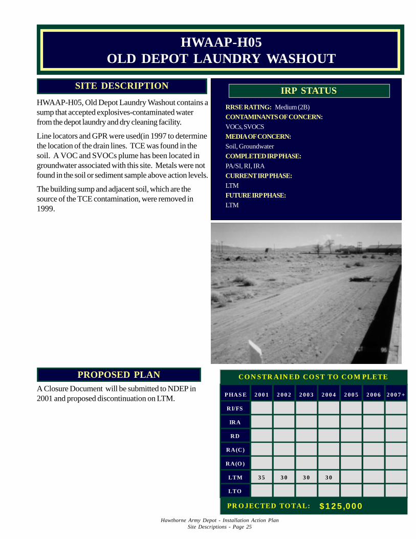
Hawthorne Army Depot - Installation Action PlanSite Descriptions - Page 25
PROPOSED PLANA Closure Document will be submitted to NDEP in2001 and proposed discontinuation on LTM.
RRSE RATING: Medium (2B)
CONTAMINANTS OF CONCERN:VOCs, SVOCS
MEDIA OF CONCERN:Soil, Groundwater
COMPLETED IRP PHASE:PA/SI, RI, IRA
CURRENT IRP PHASE:LTM
FUTURE IRP PHASE:LTM
IRP STATUSSITE DESCRIPTION
HWAAP-H05, Old Depot Laundry Washout contains asump that accepted explosives-contaminated waterfrom the depot laundry and dry cleaning facility.
Line locators and GPR were used(in 1997 to determinethe location of the drain lines. TCE was found in thesoil. A VOC and SVOCs plume has been located ingroundwater associated with this site. Metals were notfound in the soil or sediment sample above action levels.
The building sump and adjacent soil, which are thesource of the TCE contamination, were removed in1999.
HWAAP-H05OLD DEPOT LAUNDRY WASHOUT
PHAS E 2 0 0 1 2 0 0 2 2 0 0 3 2 0 0 4 2 0 0 5 2 0 0 6 2 0 0 7 +
RI/FS
IRA
RD
RA(C)
RA(O )
LTM 3 5 3 0 3 0 3 0
LTO
CON STR AIN ED CO ST TO CO M PLETE
PR O JECTED TO TAL: $ 1 2 5 ,0 0 0
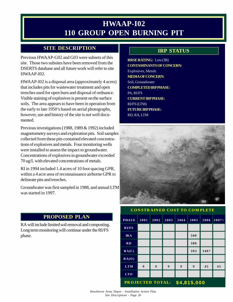
Hawthorne Army Depot - Installation Action PlanSite Descriptions - Page 26
PROPOSED PLANRA will include limited soil removal and composting.Long term monitoring will continue under the RI/FSphase.
RRSE RATING: Low (3B)
CONTAMINANTS OF CONCERN:Explosives, Metals
MEDIA OF CONCERN:Soil, Groundwater
COMPLETED IRP PHASE:PA, RI/FS
CURRENT IRP PHASE:RI/FS (LTM)
FUTURE IRP PHASE:RD, RA, LTM
IRP STATUSSITE DESCRIPTION
Previous HWAAP-G02 and G03 were subsets of thissite. Those two subsites have been removed from theDSERTS database and all future work will refer to siteHWAAP-I02.
HWAAP-I02 is a disposal area (approximately 4 acres)that includes pits for wastewater treatment and opentrenches used for open burn and disposal of ordnance.Visible staining of explosives is present on the surfacesoils. The area appears to have been in operation fromthe early to late 1950’s based on aerial photographs,however, use and history of the site is not well docu-mented.
Previous investigations (1988, 1989 & 1992) includedmagnetometry surveys and exploration pits. Soil samplescollected from these pits contained elevated concentra-tions of explosives and metals. Four monitoring wellswere installed to assess the impact to groundwater.Concentrations of explosives in groundwater exceeded70 ug/L with elevated concentrations of metals.
RI in 1994 included 1.4 acres of 10 foot spacing GPR,within a 4 acre area of reconnaissance airborne GPR todelineate pits and trenches.
Groundwater was first sampled in 1988, and annual LTMwas started in 1997.
HWAAP-I02110 GROUP OPEN BURNING PIT
PHAS E 2 0 0 1 2 0 0 2 2 0 0 3 2 0 0 4 2 0 0 5 2 0 0 6 2 0 0 7 +
RI/FS
IRA 5 0 0
RD 3 8 0
RA(C) 3 9 3 3 4 0 7
RA(O )
LTM 9 9 9 9 9 4 5 4 5
LTO
CON STR AIN ED CO ST TO CO M PLETE
PR O JECTED TO TAL: $4 ,815 ,000
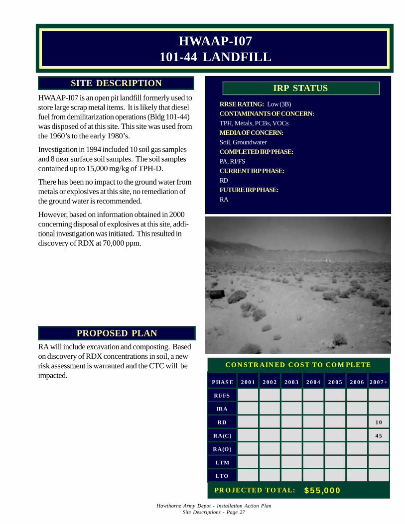
Hawthorne Army Depot - Installation Action PlanSite Descriptions - Page 27
PROPOSED PLANRA will include excavation and composting. Basedon discovery of RDX concentrations in soil, a newrisk assessment is warranted and the CTC will beimpacted.
RRSE RATING: Low (3B)
CONTAMINANTS OF CONCERN:TPH, Metals, PCBs, VOCs
MEDIA OF CONCERN:Soil, Groundwater
COMPLETED IRP PHASE:PA, RI/FS
CURRENT IRP PHASE:RD
FUTURE IRP PHASE:RA
IRP STATUSSITE DESCRIPTION
HWAAP-I07 is an open pit landfill formerly used tostore large scrap metal items. It is likely that dieselfuel from demilitarization operations (Bldg 101-44)was disposed of at this site. This site was used fromthe 1960’s to the early 1980’s.
Investigation in 1994 included 10 soil gas samplesand 8 near surface soil samples. The soil samplescontained up to 15,000 mg/kg of TPH-D.
There has been no impact to the ground water frommetals or explosives at this site, no remediation ofthe ground water is recommended.
However, based on information obtained in 2000concerning disposal of explosives at this site, addi-tional investigation was initiated. This resulted indiscovery of RDX at 70,000 ppm.
HWAAP-I07101-44 LANDFILL
PHAS E 2 0 0 1 2 0 0 2 2 0 0 3 2 0 0 4 2 0 0 5 2 0 0 6 2 0 0 7 +
RI/FS
IRA
RD 1 0
RA(C) 4 5
RA(O )
LTM
LTO
CON STR AIN ED CO ST TO CO M PLETE
PR O JECTED TO TAL: $ 5 5 ,0 0 0
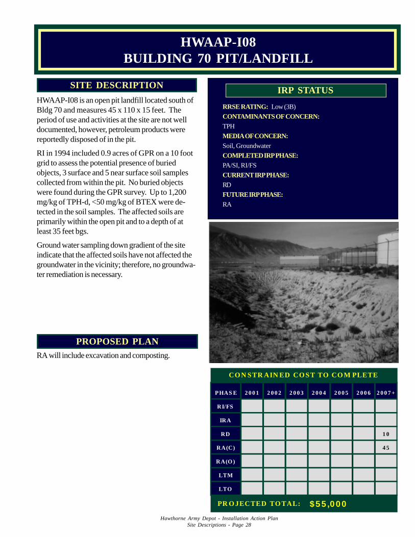
Hawthorne Army Depot - Installation Action PlanSite Descriptions - Page 28
PROPOSED PLANRA will include excavation and composting.
RRSE RATING: Low (3B)
CONTAMINANTS OF CONCERN:TPH
MEDIA OF CONCERN:Soil, Groundwater
COMPLETED IRP PHASE:PA/SI, RI/FS
CURRENT IRP PHASE:RD
FUTURE IRP PHASE:RA
IRP STATUSSITE DESCRIPTION
HWAAP-I08 is an open pit landfill located south ofBldg 70 and measures 45 x 110 x 15 feet. Theperiod of use and activities at the site are not welldocumented, however, petroleum products werereportedly disposed of in the pit.
RI in 1994 included 0.9 acres of GPR on a 10 footgrid to assess the potential presence of buriedobjects, 3 surface and 5 near surface soil samplescollected from within the pit. No buried objectswere found during the GPR survey. Up to 1,200mg/kg of TPH-d, <50 mg/kg of BTEX were de-tected in the soil samples. The affected soils areprimarily within the open pit and to a depth of atleast 35 feet bgs.
Ground water sampling down gradient of the siteindicate that the affected soils have not affected thegroundwater in the vicinity; therefore, no groundwa-ter remediation is necessary.
HWAAP-I08BUILDING 70 PIT/LANDFILL
PHAS E 2 0 0 1 2 0 0 2 2 0 0 3 2 0 0 4 2 0 0 5 2 0 0 6 2 0 0 7 +
RI/FS
IRA
RD 1 0
RA(C) 4 5
RA(O )
LTM
LTO
CON STR AIN ED CO ST TO CO M PLETE
PR O JECTED TO TAL: $55 ,000
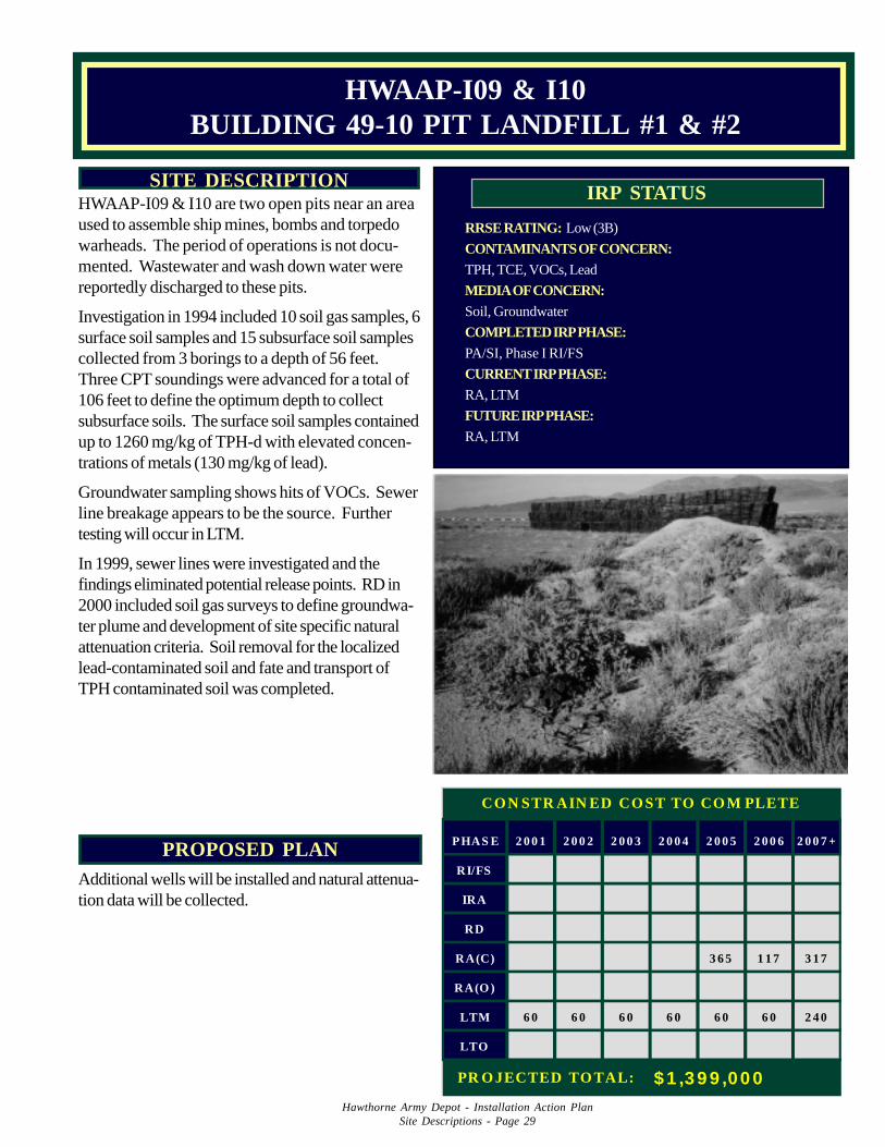
Hawthorne Army Depot - Installation Action PlanSite Descriptions - Page 29
PROPOSED PLANAdditional wells will be installed and natural attenua-tion data will be collected.
RRSE RATING: Low (3B)
CONTAMINANTS OF CONCERN:TPH, TCE, VOCs, Lead
MEDIA OF CONCERN:Soil, Groundwater
COMPLETED IRP PHASE:PA/SI, Phase I RI/FS
CURRENT IRP PHASE:RA, LTM
FUTURE IRP PHASE:RA, LTM
IRP STATUSSITE DESCRIPTION
HWAAP-I09 & I10 are two open pits near an areaused to assemble ship mines, bombs and torpedowarheads. The period of operations is not docu-mented. Wastewater and wash down water werereportedly discharged to these pits.
Investigation in 1994 included 10 soil gas samples, 6surface soil samples and 15 subsurface soil samplescollected from 3 borings to a depth of 56 feet.Three CPT soundings were advanced for a total of106 feet to define the optimum depth to collectsubsurface soils. The surface soil samples containedup to 1260 mg/kg of TPH-d with elevated concen-trations of metals (130 mg/kg of lead).
Groundwater sampling shows hits of VOCs. Sewerline breakage appears to be the source. Furthertesting will occur in LTM.
In 1999, sewer lines were investigated and thefindings eliminated potential release points. RD in2000 included soil gas surveys to define groundwa-ter plume and development of site specific naturalattenuation criteria. Soil removal for the localizedlead-contaminated soil and fate and transport ofTPH contaminated soil was completed.
HWAAP-I09 & I10BUILDING 49-10 PIT LANDFILL #1 & #2
PHAS E 2 0 0 1 2 0 0 2 2 0 0 3 2 0 0 4 2 0 0 5 2 0 0 6 2 0 0 7 +
RI/FS
IRA
RD
RA(C) 3 6 5 1 1 7 3 1 7
RA(O )
LTM 6 0 6 0 6 0 6 0 6 0 6 0 2 4 0
LTO
CON STR AIN ED CO ST TO CO M PLETE
PR O JECTED TO TAL: $ 1 ,3 9 9 ,00 0
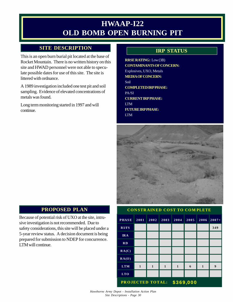
Hawthorne Army Depot - Installation Action PlanSite Descriptions - Page 30
PROPOSED PLANBecause of potential risk of UXO at the site, intru-sive investigation is not recommended. Due tosafety considerations, this site will be placed under a5-year review status. A decision document is beingprepared for submission to NDEP for concurrence.LTM will continue.
RRSE RATING: Low (3B)
CONTAMINANTS OF CONCERN:Explosives, UXO, Metals
MEDIA OF CONCERN:Soil
COMPLETED IRP PHASE:PA/SI
CURRENT IRP PHASE:LTM
FUTURE IRP PHASE:LTM
IRP STATUSSITE DESCRIPTION
This is an open burn burial pit located at the base ofRocket Mountain. There is no written history on thissite and HWAD personnel were not able to specu-late possible dates for use of this site. The site islittered with ordnance.
A 1989 investigation included one test pit and soilsampling. Evidence of elevated concentrations ofmetals was found.
Long term monitoring started in 1997 and willcontinue.
HWAAP-I22OLD BOMB OPEN BURNING PIT
PHAS E 2 0 0 1 2 0 0 2 2 0 0 3 2 0 0 4 2 0 0 5 2 0 0 6 2 0 0 7 +
RI/FS 3 4 9
IRA
RD
RA(C)
RA(O )
LTM 1 1 1 1 6 1 9
LTO
CON STR AIN ED CO ST TO CO M PLETE
PR O JECTED TO TAL: $ 3 6 9 ,0 0 0
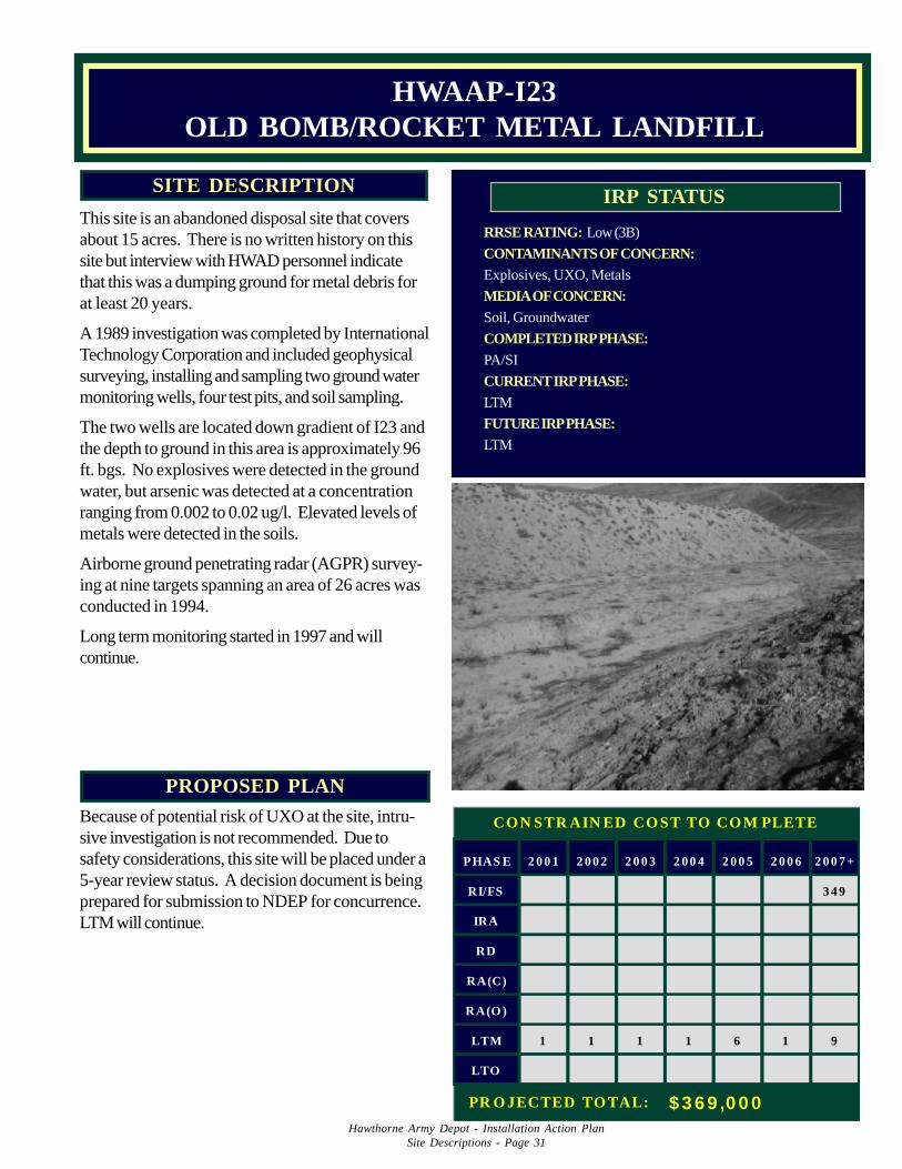
Hawthorne Army Depot - Installation Action PlanSite Descriptions - Page 31
PROPOSED PLANBecause of potential risk of UXO at the site, intru-sive investigation is not recommended. Due tosafety considerations, this site will be placed under a5-year review status. A decision document is beingprepared for submission to NDEP for concurrence.LTM will continue.
RRSE RATING: Low (3B)
CONTAMINANTS OF CONCERN:Explosives, UXO, Metals
MEDIA OF CONCERN:Soil, Groundwater
COMPLETED IRP PHASE:PA/SI
CURRENT IRP PHASE:LTM
FUTURE IRP PHASE:LTM
IRP STATUSSITE DESCRIPTION
This site is an abandoned disposal site that coversabout 15 acres. There is no written history on thissite but interview with HWAD personnel indicatethat this was a dumping ground for metal debris forat least 20 years.
A 1989 investigation was completed by InternationalTechnology Corporation and included geophysicalsurveying, installing and sampling two ground watermonitoring wells, four test pits, and soil sampling.
The two wells are located down gradient of I23 andthe depth to ground in this area is approximately 96ft. bgs. No explosives were detected in the groundwater, but arsenic was detected at a concentrationranging from 0.002 to 0.02 ug/l. Elevated levels ofmetals were detected in the soils.
Airborne ground penetrating radar (AGPR) survey-ing at nine targets spanning an area of 26 acres wasconducted in 1994.
Long term monitoring started in 1997 and willcontinue.
HWAAP-I23OLD BOMB/ROCKET METAL LANDFILL
PHAS E 2 0 0 1 2 0 0 2 2 0 0 3 2 0 0 4 2 0 0 5 2 0 0 6 2 0 0 7 +
RI/FS 3 4 9
IRA
RD
RA(C)
RA(O )
LTM 1 1 1 1 6 1 9
LTO
CON STR AIN ED CO ST TO CO M PLETE
PR O JECTED TO TAL: $ 3 6 9 ,0 0 0
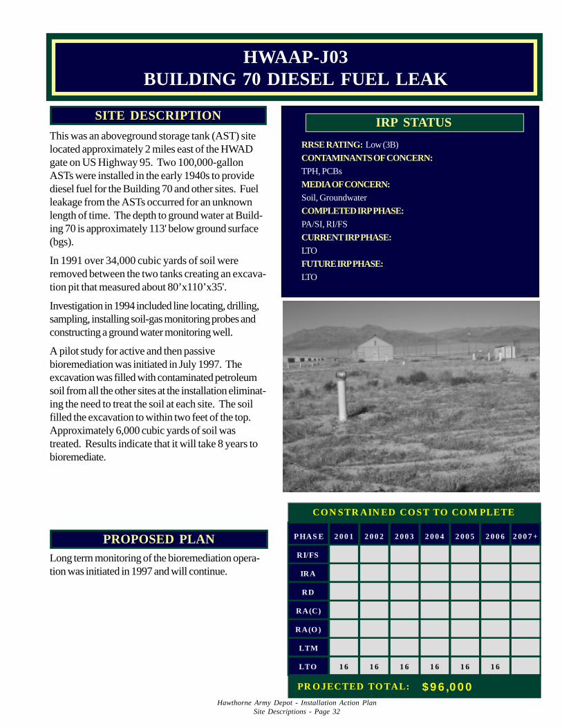
Hawthorne Army Depot - Installation Action PlanSite Descriptions - Page 32
PROPOSED PLANLong term monitoring of the bioremediation opera-tion was initiated in 1997 and will continue.
RRSE RATING: Low (3B)
CONTAMINANTS OF CONCERN:TPH, PCBs
MEDIA OF CONCERN:Soil, Groundwater
COMPLETED IRP PHASE:PA/SI, RI/FS
CURRENT IRP PHASE:LTO
FUTURE IRP PHASE:LTO
IRP STATUSSITE DESCRIPTION
This was an aboveground storage tank (AST) sitelocated approximately 2 miles east of the HWADgate on US Highway 95. Two 100,000-gallonASTs were installed in the early 1940s to providediesel fuel for the Building 70 and other sites. Fuelleakage from the ASTs occurred for an unknownlength of time. The depth to ground water at Build-ing 70 is approximately 113' below ground surface(bgs).
In 1991 over 34,000 cubic yards of soil wereremoved between the two tanks creating an excava-tion pit that measured about 80’x110’x35'.
Investigation in 1994 included line locating, drilling,sampling, installing soil-gas monitoring probes andconstructing a ground water monitoring well.
A pilot study for active and then passivebioremediation was initiated in July 1997. Theexcavation was filled with contaminated petroleumsoil from all the other sites at the installation eliminat-ing the need to treat the soil at each site. The soilfilled the excavation to within two feet of the top.Approximately 6,000 cubic yards of soil wastreated. Results indicate that it will take 8 years tobioremediate.
HWAAP-J03BUILDING 70 DIESEL FUEL LEAK
PHAS E 2 0 0 1 2 0 0 2 2 0 0 3 2 0 0 4 2 0 0 5 2 0 0 6 2 0 0 7 +
RI/FS
IRA
RD
RA(C)
RA(O )
LTM
LTO 1 6 1 6 1 6 1 6 1 6 1 6
CON STR AIN ED CO ST TO CO M PLETE
PR O JECTED TO TAL: $ 9 6 ,0 0 0
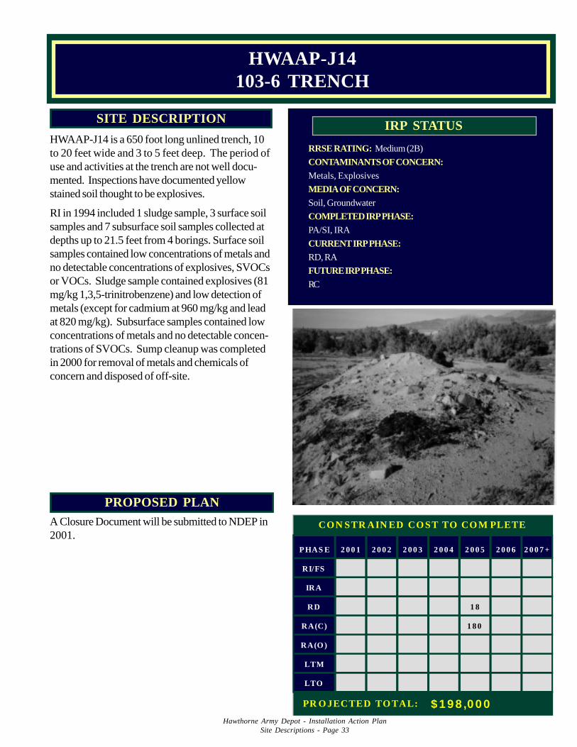
Hawthorne Army Depot - Installation Action PlanSite Descriptions - Page 33
PROPOSED PLANA Closure Document will be submitted to NDEP in2001.
RRSE RATING: Medium (2B)
CONTAMINANTS OF CONCERN:Metals, Explosives
MEDIA OF CONCERN:Soil, Groundwater
COMPLETED IRP PHASE:PA/SI, IRA
CURRENT IRP PHASE:RD, RA
FUTURE IRP PHASE:RC
IRP STATUSSITE DESCRIPTION
HWAAP-J14 is a 650 foot long unlined trench, 10to 20 feet wide and 3 to 5 feet deep. The period ofuse and activities at the trench are not well docu-mented. Inspections have documented yellowstained soil thought to be explosives.
RI in 1994 included 1 sludge sample, 3 surface soilsamples and 7 subsurface soil samples collected atdepths up to 21.5 feet from 4 borings. Surface soilsamples contained low concentrations of metals andno detectable concentrations of explosives, SVOCsor VOCs. Sludge sample contained explosives (81mg/kg 1,3,5-trinitrobenzene) and low detection ofmetals (except for cadmium at 960 mg/kg and leadat 820 mg/kg). Subsurface samples contained lowconcentrations of metals and no detectable concen-trations of SVOCs. Sump cleanup was completedin 2000 for removal of metals and chemicals ofconcern and disposed of off-site.
HWAAP-J14103-6 TRENCH
PHAS E 2 0 0 1 2 0 0 2 2 0 0 3 2 0 0 4 2 0 0 5 2 0 0 6 2 0 0 7 +
RI/FS
IRA
RD 1 8
RA(C) 1 8 0
RA(O )
LTM
LTO
CON STR AIN ED CO ST TO CO M PLETE
PR O JECTED TO TAL: $ 1 9 8 ,0 0 0
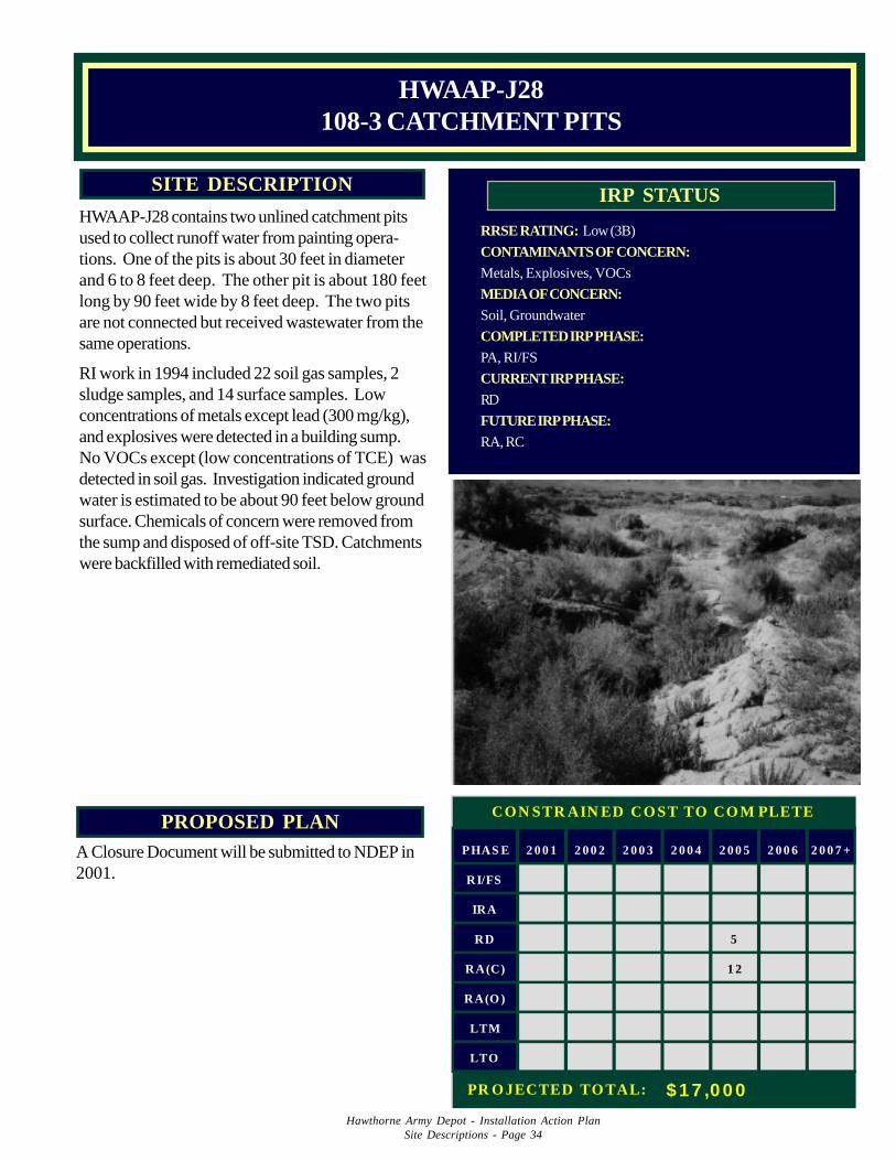
Hawthorne Army Depot - Installation Action PlanSite Descriptions - Page 34
PROPOSED PLANA Closure Document will be submitted to NDEP in2001.
RRSE RATING: Low (3B)
CONTAMINANTS OF CONCERN:Metals, Explosives, VOCs
MEDIA OF CONCERN:Soil, Groundwater
COMPLETED IRP PHASE:PA, RI/FS
CURRENT IRP PHASE:RD
FUTURE IRP PHASE:RA, RC
IRP STATUSSITE DESCRIPTION
HWAAP-J28 contains two unlined catchment pitsused to collect runoff water from painting opera-tions. One of the pits is about 30 feet in diameterand 6 to 8 feet deep. The other pit is about 180 feetlong by 90 feet wide by 8 feet deep. The two pitsare not connected but received wastewater from thesame operations.
RI work in 1994 included 22 soil gas samples, 2sludge samples, and 14 surface samples. Lowconcentrations of metals except lead (300 mg/kg),and explosives were detected in a building sump.No VOCs except (low concentrations of TCE) wasdetected in soil gas. Investigation indicated groundwater is estimated to be about 90 feet below groundsurface. Chemicals of concern were removed fromthe sump and disposed of off-site TSD. Catchmentswere backfilled with remediated soil.
HWAAP-J28108-3 CATCHMENT PITS
PHAS E 2 0 0 1 2 0 0 2 2 0 0 3 2 0 0 4 2 0 0 5 2 0 0 6 2 0 0 7 +
RI/FS
IRA
RD 5
RA(C) 1 2
RA(O )
LTM
LTO
CON STR AIN ED CO ST TO CO M PLETE
PR O JECTED TO TAL: $ 1 7 ,0 0 0
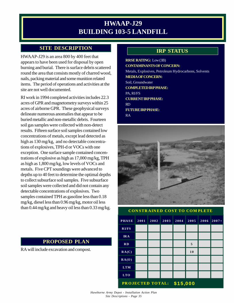
Hawthorne Army Depot - Installation Action PlanSite Descriptions - Page 35
PROPOSED PLANRA will include excavation and compost.
RRSE RATING: Low (3B)
CONTAMINANTS OF CONCERN:Metals, Explosives, Petroleum Hydrocarbons, Solvents
MEDIA OF CONCERN:Soil, Groundwater
COMPLETED IRP PHASE:PA, RI/FS
CURRENT IRP PHASE:RD
FUTURE IRP PHASE:RA
IRP STATUSSITE DESCRIPTION
HWAAP-J29 is an area 800 by 400 feet thatappears to have been used for disposal by openburning and burial. There is surface debris scatteredround the area that consists mostly of charred wood,nails, packing material and some munition relateditems. The period of operations and activities at thesite are not well documented.
RI work in 1994 completed activities includes 22.3acres of GPR and magnetometry surveys within 25acres of airborne GPR. These geophysical surveysdelineate numerous anomalies that appear to beburied metallic and non-metallic debris. Fourteensoil gas samples were collected with non-detectresults. Fifteen surface soil samples contained lowconcentrations of metals, except lead detected ashigh as 130 mg/kg, and no detectable concentra-tions of explosives, TPH-d or VOCs with oneexception. One surface sample contained concen-trations of explosive as high as 17,000 mg/kg, TPHas high as 1,800 mg/kg, low levels of VOCs andmetals. Five CPT soundings were advanced todepths up to 40 feet to determine the optimal depthsto collect subsurface soil samples. Five subsurfacesoil samples were collected and did not contain anydetectable concentrations of explosives. Twosamples contained TPH as gasoline less than 0.18mg/kg, diesel less than 0.96 mg/kg, motor oil lessthan 0.44 mg/kg and heavy oil less than 0.33 mg/kg.
HWAAP-J29BUILDING 103-5 LANDFILL
PHAS E 2 0 0 1 2 0 0 2 2 0 0 3 2 0 0 4 2 0 0 5 2 0 0 6 2 0 0 7 +
RI/FS
IRA
RD 5
RA(C) 1 0
RA(O )
LTM
LTO
CON STR AIN ED CO ST TO CO M PLETE
PR O JECTED TO TAL: $ 1 5 ,0 0 0
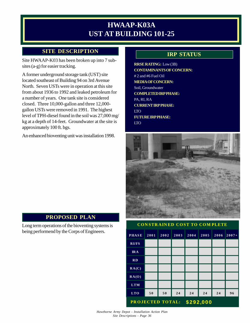
Hawthorne Army Depot - Installation Action PlanSite Descriptions - Page 36
PROPOSED PLANLong term operations of the bioventing systems isbeing performend by the Corps of Engineers.
RRSE RATING: Low (3B)
CONTAMINANTS OF CONCERN:# 2 and #6 Fuel Oil
MEDIA OF CONCERN:Soil, Groundwater
COMPLETED IRP PHASE:PA, RI, RA
CURRENT IRP PHASE:LTO
FUTURE IRP PHASE:LTO
IRP STATUSSITE DESCRIPTION
Site HWAAP-K03 has been broken up into 7 sub-sites (a-g) for easier tracking.
A former underground storage tank (UST) sitelocated southeast of Building 94 on 3rd AvenueNorth. Seven USTs were in operation at this sitefrom about 1936 to 1992 and leaked petroleum fora number of years. One tank site is consideredclosed. Three 10,000-gallon and three 12,000-gallon USTs were removed in 1991. The highestlevel of TPH-diesel found in the soil was 27,000 mg/kg at a depth of 14-feet. Groundwater at the site isapproximately 100 ft. bgs.
An enhanced bioventing unit was installation 1998.
HWAAP-K03AUST AT BUILDING 101-25
PHAS E 2 0 0 1 2 0 0 2 2 0 0 3 2 0 0 4 2 0 0 5 2 0 0 6 2 0 0 7 +
RI/FS
IRA
RD
RA(C)
RA(O )
LTM
LTO 5 0 5 0 2 4 2 4 2 4 2 4 9 6
CON STR AIN ED CO ST TO CO M PLETE
PR O JECTED TO TAL: $292 ,000
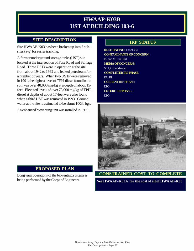
Hawthorne Army Depot - Installation Action PlanSite Descriptions - Page 37
PROPOSED PLANLong term operations of the bioventing systems isbeing performed by the Corps of Engineers.
RRSE RATING: Low (3B)
CONTAMINANTS OF CONCERN:#2 and #6 Fuel Oil
MEDIA OF CONCERN:Soil, Groundwater
COMPLETED IRP PHASE:PA, RI
CURRENT IRP PHASE:LTO
FUTURE IRP PHASE:LTO
IRP STATUSSITE DESCRIPTION
Site HWAAP-K03 has been broken up into 7 sub-sites (a-g) for easier tracking.
A former underground storage tanks (UST) sitelocated at the intersection of Fuse Road and SalvageRoad. Three USTs were in operation at the sitefrom about 1942 to 1992 and leaked petroleum fora number of years. When two USTs were removedin 1991, the highest level of TPH-diesel found in thesoil was over 48,000 mg/kg at a depth of about 15-feet. Elevated levels of over 73,000 mg/kg of TPH-diesel at depths of about 17-feet were also foundwhen a third UST was removed in 1993. Groundwater at the site is estimated to be about 100ft. bgs.
An enhanced bioventing unit was installed in 1998.
HWAAP-K03BUST AT BUILDING 103-6
CONSTRAINED COST TO COMPLETE
See HWAAP-K03A for the cost of all of HWAAP-K03.
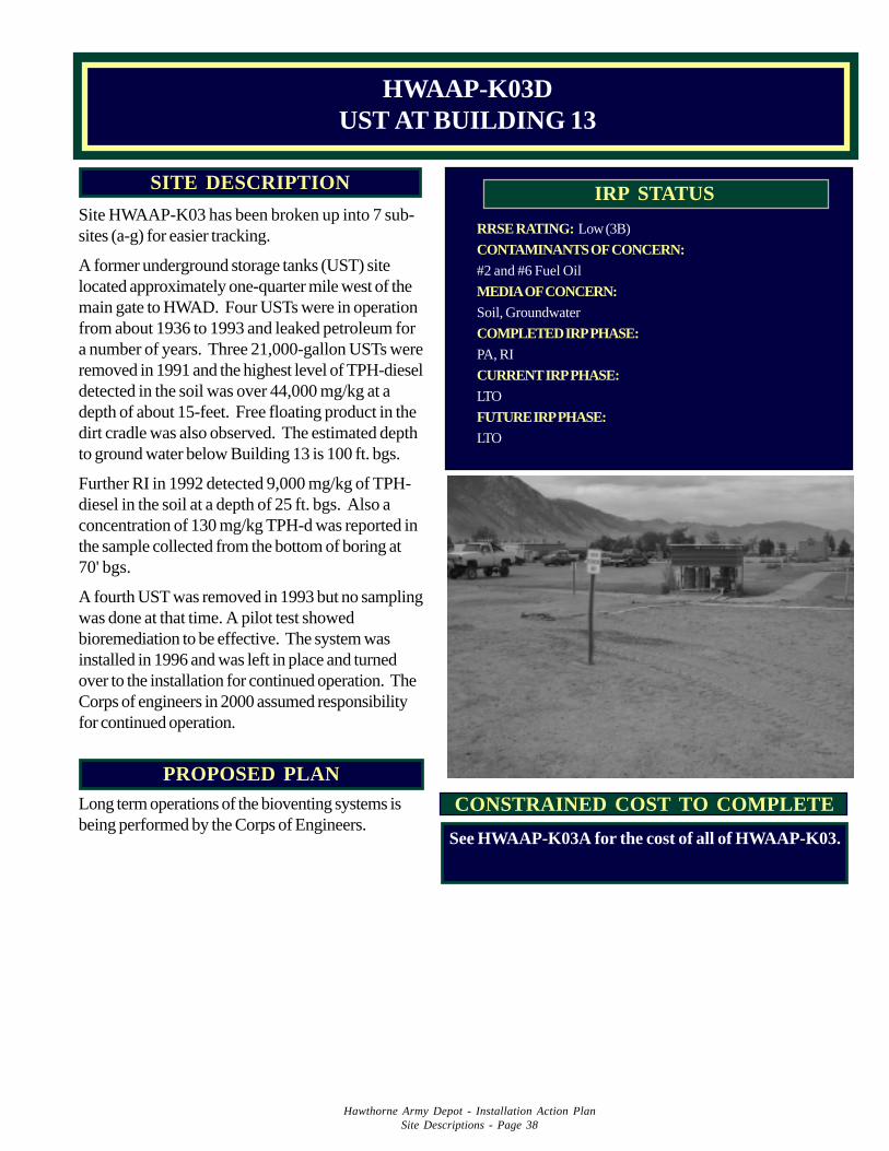
Hawthorne Army Depot - Installation Action PlanSite Descriptions - Page 38
PROPOSED PLANLong term operations of the bioventing systems isbeing performed by the Corps of Engineers.
RRSE RATING: Low (3B)
CONTAMINANTS OF CONCERN:#2 and #6 Fuel Oil
MEDIA OF CONCERN:Soil, Groundwater
COMPLETED IRP PHASE:PA, RI
CURRENT IRP PHASE:LTO
FUTURE IRP PHASE:LTO
IRP STATUSSITE DESCRIPTION
Site HWAAP-K03 has been broken up into 7 sub-sites (a-g) for easier tracking.
A former underground storage tanks (UST) sitelocated approximately one-quarter mile west of themain gate to HWAD. Four USTs were in operationfrom about 1936 to 1993 and leaked petroleum fora number of years. Three 21,000-gallon USTs wereremoved in 1991 and the highest level of TPH-dieseldetected in the soil was over 44,000 mg/kg at adepth of about 15-feet. Free floating product in thedirt cradle was also observed. The estimated depthto ground water below Building 13 is 100 ft. bgs.
Further RI in 1992 detected 9,000 mg/kg of TPH-diesel in the soil at a depth of 25 ft. bgs. Also aconcentration of 130 mg/kg TPH-d was reported inthe sample collected from the bottom of boring at70' bgs.
A fourth UST was removed in 1993 but no samplingwas done at that time. A pilot test showedbioremediation to be effective. The system wasinstalled in 1996 and was left in place and turnedover to the installation for continued operation. TheCorps of engineers in 2000 assumed responsibilityfor continued operation.
HWAAP-K03DUST AT BUILDING 13
CONSTRAINED COST TO COMPLETE
See HWAAP-K03A for the cost of all of HWAAP-K03.
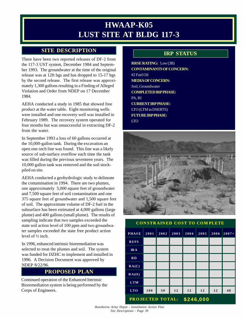
Hawthorne Army Depot - Installation Action PlanSite Descriptions - Page 39
PROPOSED PLANContinued operation of the Enhanced IntrinsicBioremediation system is being performed by theCorps of Engineers.
RRSE RATING: Low (3B)
CONTAMINANTS OF CONCERN:#2 Fuel Oil
MEDIA OF CONCERN:Soil, Groundwater
COMPLETED IRP PHASE:PA, RI
CURRENT IRP PHASE:LTO (LTM in DSERTS)
FUTURE IRP PHASE:LTO
IRP STATUSSITE DESCRIPTION
There have been two reported releases of DF-2 fromthe 117-3 UST system, December 1984 and Septem-ber 1993. The groundwater at the time of the originalrelease was at 12ft bgs and has dropped to 15-17 bgsby the second release. The first release was approxi-mately 1,300 gallons resulting in a Finding of AllegedViolation and Order from NDEP on 17 December1984.
AEHA conducted a study in 1985 that showed freeproduct at the water table. Eight monitoring wellswere installed and one recovery well was installed inFebruary 1989. The recovery system operated forfour months but was unsuccessful in extracting DF-2from the water.
In September 1993 a loss of 60 gallons occurred atthe 10,000-gallon tank. During the excavation anopen one-inch line was found. This line was a likelysource of sub-surface overflow each time the tankwas filled during the previous seventeen years. The10,000 gallon tank was removed and the soil stock-piled on site.
AEHA conducted a geohydrologic study to delineatethe contamination in 1994. There are two plumes,one approximately 5,000 square feet of groundwaterand 7,500 square feet of soil contamination and one375 square feet of groundwater and 1,500 square feetof soil. The approximate volume of DF-2 fuel in thesubsurface has been estimated at 4,000 gallons (largeplume) and 400 gallons (small plume). The results ofsampling indicate that two samples exceeded thestate soil action level of 100 ppm and two groundwa-ter samples exceeded the state free product actionlevel of ½ inch.
In 1996, enhanced intrinsic bioremediation wasselected to treat the plumes and soil. The systemwas funded for DZHC to implement and installed in1996. A Decision Document was approved byNDEP 8/22/96.
HWAAP-K05LUST SITE AT BLDG 117-3
PHAS E 2 0 0 1 2 0 0 2 2 0 0 3 2 0 0 4 2 0 0 5 2 0 0 6 2 0 0 7 +
RI/FS
IRA
RD
RA(C)
RA(O )
LTM
LTO 1 0 0 5 0 1 2 1 2 1 2 1 2 4 8
CON STR AIN ED CO ST TO CO M PLETE
PR O JECTED TO TAL: $ 2 4 6 ,0 0 0
Hawthorne Army Depot - Installation Action PlanSite Descriptions - Page 40
RESPONSE COMPLETEDSERTS SITES
Hawthorne Army Depot - Installation Action PlanSite Descriptions - Page 41
PROPOSED PLAN
HWAAP-A03 is an abandoned landfill located in the WADF area.The site has never been used for the disposal of coal ash though anoperational permit was issued. In 1994, the investigation activitiesincluded collection of two surface soil samples. During sampling lowbackground concentrations of metals were detected. No otherchemicals of concern were detected.
Response Complete. A Decision Document presenting the remedialinvestigation history for this site has received regulatory approval. Siteclosed.
SITE DESCRIPTION
HWAAP-A03COAL ASH LANDFILL (NOT OPEN)
CONTAMINANTS:NoneMEDIA OF CONCERN:NoneRRSE RATING:Low (3A)COMPLETED IRP PHASE:PA/SICURRENT IRP PHASE:RCFUTURE IRP PHASE:RC
IRP STATUS
PROPOSED PLANDocument presenting the RI/RA history will be submitted forregulatory approval in 2001.
SITE DESCRIPTION
HWAAP-A04 is a closed unlined landfill locatedsoutheast of the Former Babbitt Housing Area andapproximately 1 mile east of the base of the WassukMountain Range. The landfill covers 65 to 75 acres.The landfill was in operation from 1940 to 1975 andreceived office and domestic waste. The landfill wasoperated by the modified trench method, in whichoperators used sand and gravel to cover the solidwaste material. Refuse was routinely burned in thelandfill trenches.
A geophysical survey was completed in 1994 todefine the landfill area. The surveys identifiedanomalies which define the areas of the landfillwhere there appears to be buried material in lineartrenches, consistent with historical data of the site.Field investigation showed buried material to be drywaste and construction debris.
HWAAP-A04BABBITT CLOSED LANDFILL
RRSE RATING: High (1B)
CONTAMINANTS OF CONCERN: TPH, VOCs, Metals
MEDIA OF CONCERN: Soil
COMPLETED IRP PHASE: PA/SI, RI/FS, RD
CURRENT IRP PHASE: RC
FUTURE IRP PHASE: RC
IRP STATUS
Three wells were installed in 1996 to sample groundwater. Thegroundwater sampling program at this site has been under wayfor one year. Groundwater monitoring is no longer requiredbecause contamination was not found.
Hawthorne Army Depot - Installation Action PlanSite Descriptions - Page 42
PROPOSED PLANA Closure Document presenting the RI/RA history will besubmitted for regulatory aproval in 2001.
SITE DESCRIPTIONHWAAP-A05 is a site operated from 1940 to 1946 todispose of munitions containing mustard and otherchemical agents including phosgene and cyanogenchloride. The general procedure for disposal was to treatthe chemicals in an open trench and backfill the excavationto grade.
The site was investigated in 1981 and in 1988 by test pitsand geophysical surveys to identify disposal areas. Sixty-three soil samples collected from the test pits were ana-lyzed and found no detections of the chemicals of concern.RI activities completed in 1994 included airborne GPR over345 acres, 1350 feet of refraction seismic and 510 feet ofreflection seismic surveys to further delineate the formerdisposal trenches.
There is no evidence that the contaminants continue toexist at this site. At the direction of NDEP, a fence hasbeen constructed and signs posted to designate an off-limits area as a precaution.
HWAAP-A05MUSTARD GAS DISPOSAL AREA
RRSE RATING: Low (3B)
CONTAMINANTS OF CONCERN:Mustard Gas, Phosgene, Cyanogen Chloride, 1,1,2,2-tetrachlo-
roethane
MEDIA OF CONCERN: Soil
COMPLETED IRP PHASE: PA/SI
CURRENT IRP PHASE: RC
FUTURE IRP PHASE: RC
IRP STATUS
RRSE RATING: Medium (2B)
CONTAMINANTS OF CONCERN:Explosives, Metals, UXO
MEDIA OF CONCERN:Soil, Groundwater
COMPLETED IRP PHASE:PA
CURRENT IRP PHASE:RC
FUTURE IRP PHASE:RC
SITE DESCRIPTION
HWAAP-A06a, an unlined landfill (approximately 50 acres), is located approxi-mately one mile west and one mile northwest of Rocket Mountain. The landfill wasin operation from 1943 to 1946 for the disposal of, by means of burning anddetonation, approximately 10,000 tons of mines, warheads, bombs, incendiarydevices, and miscellaneous ordnance. The ground is stained by black ash andrusty-red oxidized TNT residue/ammonium picrate. Wind erosion and surfaceflash flooding may cause these contaminants to be dispersed.
In 1994, airborne ground penetrating radar (AGPR) surveying over bothHWAAP-A06a and G01a was completed. Forty-four targets were surveyed overa 63 acre area. In 1994, an Army evaluation team visited the site to determine ifthe UXO at the site pose an imminent hazard. As result of the evaluation, animminent threat to human safety was determined and a Risk Assessment Code(RAC) 2 was assigned.
HWAAP-A06AOLD BOMB DISPOSAL AREA 1
IRP STATUS
Because of potential risk of UXO at the site, intrusive investigation is not recommended.
This site is an active RCRA permitted site and therefore not eligible for IRP funds.
PROPOSED PLAN
Hawthorne Army Depot - Installation Action PlanSite Descriptions - Page 43
PROPOSED PLAN
HWAAP A09a is a storage area of 113 piles of empty, crushed ammunition cans and 12piles of soil/debris located west of the 100 production area and 2 miles south of thesouthern shore of Walker Lake. The waste piles are approximately 6 to 10 feet high and 12to 25 feet in diameter and are estimated to range from 15 to 65 cubic yards in volume. Theempty cans were dumped on open ground and then separated magnetically, crushed, andstacked into piles. The cans were not flashed to remove explosive residues and still maycontain reactive powder residues. Ground water at this site is reported to be between 70and 78 feet bgs with a northerly gradient.
Remedial investigations completed at the site in 1994 included visual characterization ofthe contents of the piles and collection of surface and hand auger soil sampling. Eighteensurface soil samples and eighteen hand auger samples were collected from around six ofthe piles for metals & explosives analyses. Low concentration of explosives and metals(lead of 230 mg/kg) were detected. The investigation indicated that a release of lowmagnitude had occurred. Although the lead concentration of 160 mg/kg is above theNDEP criteria of 100 mg/k, it is well below other accepted standards including the EPARegion IX PRG. The piles were inspected for ordnance and placed into a permitted landfill
A Closure Document was approvedby NDEP on 4 Aug 2000.
SITE DESCRIPTION
HWAAP-A09AAMMO CAN PILES
CONTAMINANTS:Explosives, Lead, CadmiumMEDIA OF CONCERN:SoilRRSE RATING:Low (3B)COMPLETED IRP PHASE:PA/SICURRENT IRP PHASE:RCFUTURE IRP PHASE:RC
IRP STATUS
HWAAP-A09b is an unlined earthen pit located 0.5 miles west of the 100 group area.The pit occupies approximately 1 acre and was used as an open dumping ground forall types of batteries, smokeless powder (propellant), and rocket packing material. Thepit was used from the 1950s to the 1960s. Ground water at this site is reported to bebetween 70 and 80 feet bgs.
Flooding in 1992 exposed a 10-foot thick wall of batteries and rocket packing corks,and washed the waste downstream. Following the flood the batteries were removedby HWAD in 1993 and placed in a permitted off-site landfill.
In 1994, remedial investigations completed included collection of surface and handauger samples and CPT soil samples. Three surface soil samples, three hand augersamples and two CPT samples were collected and analyzed for metals and explosives.No explosives were detected. Lead (160 mg/kg), barium (510 mg/kg) and beryllium(1.1mg/kg) were detected at moderate concentrations. The lead concentrationsdecrease significantly with depth. Site was re-graded in 1997.
SITE DESCRIPTION
HWAAP-A09BBATTERY DISPOSAL AREA
CONTAMINANTS:Lead, CadmiumMEDIA OF CONCERN:Soil, GroundwaterRRSE RATING:Low (3B)COMPLETED IRP PHASE:PA/SICURRENT IRP PHASE:RCFUTURE IRP PHASE:RC
A Closure Document was approvedby NDEP on 22 Mar 2000.
IRP STATUS
PROPOSED PLAN
Hawthorne Army Depot - Installation Action PlanSite Descriptions - Page 44
PROPOSED PLANA Closure Document presenting the RI/RA history will besubmitted for regulatory approval in 2001.
RRSE RATING: Low (3B)
CONTAMINANTS OF CONCERN:BTEX, Metals, Explosives
MEDIA OF CONCERN:Soil
COMPLETED IRP PHASE:PA/SI
CURRENT IRP PHASE:RC
FUTURE IRP PHASE:RC
IRP STATUSSITE DESCRIPTION
HWAAP-A11 is an open unlined pit approximately300’x100’x15', located next to Magazine 18AT5near the Mustard Gas Disposal Area (HWAAP-A05), used for the disposal of pyrotechnics, explo-sives, propellants, metal, ammunition boxes andother waste by open burning. The period of opera-tion is unknown.
The SI activities completed in 1994 includedground-penetrating radar and magnetometry surveyson a 10-foot grid and the collection and analyses of3 near surface soil samples. The soil samplescontained up to 10 mg/kg of BTEX based on fieldscreening analyses. In 2000, additional investigationand remedial action was completed by removing200 cubic yards of soil for treatment at C01a/b.This site has been backfilled with bioremediated soil.
HWAAP-A11MAG 18-5 DISPOSAL PIT
This site is not eligible for IRP funds.
HWAAP-B01, is a single-lined pit (approximately 250’x225’x15'). Ithas been in use since 1983. It was designed for a capacity of 1.2million gallons to receive waste water from demil processes duringemergency shut down of the waste water treatment facility or duringexcess accumulation of wastewater. One up gradient and three downgradient groundwater monitoring wells were installed. An interim PartB Permit was issued.
SITE DESCRIPTION
HWAAP-B01WADF IMPOUNDMENT #1
IRP STATUS
CONTAMINANTS:Ammonium PicrateMEDIA OF CONCERN:Soil, GroundwaterRRSE RATING:Not EvaluatedCOMPLETED IRP PHASE:PA/SICURRENT IRP PHASE:RCFUTURE IRP PHASE:RC
PROPOSED PLAN
This site is RC under the IRP, any future action will be handled underthe Part B Permit.
Hawthorne Army Depot - Installation Action PlanSite Descriptions - Page 45
PROPOSED PLAN
This site is not eligible for IRP funds.
HWAAP-B02 & B03, are lined surface impoundments, that havenever been used since they were opened in 1983. Each impoundment(approximately 250’x225’x15') is single-lined with hypalon. Each hasa design capacity of 1.3 million gallons and was designed for the samepurpose as HWAAP-B01. One up gradient and three down gradientwere also installed at each site. An interim Part B permit was issued.
This site is RC under the IRP, any future action will be handled underthe Part B Permit.
SITE DESCRIPTION
CONTAMINANTS:NoneMEDIA OF CONCERN:NoneRRSE RATING:Not EvaluatedCOMPLETED IRP PHASE:PA/SICURRENT IRP PHASE:RCFUTURE IRP PHASE:RC
IRP STATUS
HWAAP-B02 & B03WADF IMPOUNDMENT #2 & #3
RRSE RATING: Medium (2B)
CONTAMINANTS OF CONCERN:TNT, ammonium picrate
MEDIA OF CONCERN:Soil, Groundwater
COMPLETED IRP PHASE:PA/SI, RI/FS, RD, RA
CURRENT IRP PHASE: RC
FUTURE IRP PHASE: RC
IRP STATUSSITE DESCRIPTIONHWAAP-B05, a double-lined surface impoundment approximately 100’x115’x15', is locatedwithin the 101 Production Group, designed to collect explosive-contaminated wash downwater from demilitarization operations. The impoundment was never used, however, the soilused to construct the impoundment was from a previous unlined impoundment used tocollect explosive wash down water from 1944 to 1977. The newer lined impoundment wasconstructed at the same location as the older unlined impoundment.
A 1989 RI included collecting near surface, subsurface and ground water samples fromwithin and adjacent to the impoundment. Explosives and petroleum hydrocarbons weredetected in the soil samples and explosives were detected in the groundwater at levels up to2,000 ug/L.
Additional RI work in 1994 included 4 surface samples collected from within the impound-ment where visual staining of explosives was observed, and groundwater samples fromexisting wells. Concentrations of explosives were detected in these soil samples above 1200mg/kg. Ground water samples were analyzed for explosives and found RDX concentrationat 3.4 ug/L. Fifty-five feet of CPT sounding were conducted at 2 locations to assess theoptimal depths to collect subsurface soil samples.
The Baseline Risk Assessment was completed in 1997. The site was reevaluated in 1999 andno further action is required (an IRA to remove the liner for additional sampling wascompleted).
HWAAP-B05101-15 IMPOUNDMENT
PROPOSED PLANA Closure Document was approved byNDEP on 22 Nov 99.
LTM is being funded under B12.
Hawthorne Army Depot - Installation Action PlanSite Descriptions - Page 46
PROPOSED PLANA Closure Document presenting theRI/RA history will be submitted forregulatory approval in FY 2001.
RRSE RATING: Medium (2B)
CONTAMINANTS OF CONCERN:TNT, RDX, Yellow D
MEDIA OF CONCERN:Soil, Groundwater
COMPLETED IRP PHASE:PA/SI, RI/FS, RA
CURRENT IRP PHASE:RC
FUTURE IRP PHASE:RC
HWAAP-B06 is a double-lined surface impoundment approximately 85’x15’x15'designed to collect explosive-contaminated wash down water from demilitarizationoperations. The impoundment was never used, however, the soil used to constructthe impoundment was from a previous unlined impoundment used to collect explo-sive wash down water from 1944 to 1977. The newer lined impoundment wasconstructed at the same location as the older unlined impoundment.
A 1989 RI included collecting near surface, subsurface and ground water samplesfrom within and adjacent to the impoundment. High concentrations of explosiveswere detected in the soil samples and only ammonium picrate was detected in theground water at a concentration of 3,600 ug/L.
Additional RI work in 1994 included 5 surface samples collected. Concentrations ofexplosives and semi-volatile organic compounds were detected in these soil samplesabove 5 mg/kg and 70 mg/kg respectively. Visual staining from explosives wasobserved and at such high levels that samples could not be shipped for analyses.Ground water samples were found to contain low level of explosives. Twenty-fivefeet of CPT sounding was conducted at 1 location to assess the optimal depths tocollect subsurface soil samples. Contamination exceeds NDEP requirements.
RA by composting was commenced in 1998 and completed in 1999.
HWAAP-B06101-13 IMPOUNDMENT
SITE DESCRIPTION IRP STATUS
A Closure Document presenting theRI/RA history will be submitted forregulatory approval in FY 2001.
HWAAP-B07101-1 CATCHMENT PIT
HWAAP-B07 is an unlined surface impoundment located southeast of Building101-1 and measures approximately 15 feet by 12 feet. The pit is approximately 4feet deep. The impoundment was in operation from 1940 to the early 1970’s andreceived large amounts of wastewater containing TNT and RDX. Piles ofdredged soil were located on all sides of the impoundment.
Visible evidence of TNT stained soils in the impoundment was noted during siteinvestigations. Soil sampling has confirmed the contamination of the explosives inthe soil in 1988-1992. Ground water is estimated to be at approximately 120 feetbgs but has not been sampled at this site.
RI work in 1994 included surface soil and hand auger sampling, and CPT sound-ings to a depth of 40 feet bgs. One surface soil sample, one hand auger sampleand three CPT soundings were collected and analyzed for metals and explosives.Low concentrations of metals (except beryllium) and explosives contaminationwere detected in the soil. Beryllium was detected in two samples collected from31 and 40 feet below ground at 0.73 mg/kg and 0.67 mg/kg, respectively.
This site was backfilled, graded and closed in 1999.
SITE DESCRIPTION
PROPOSED PLAN
CONTAMINANTS:TNT, RDXMEDIA OF CONCERN:Soil, GroundwaterRRSE RATING:Low (3B)COMPLETED IRP PHASE:PA/SI, RI/FS, RACURRENT IRP PHASE:RCFUTURE IRP PHASE:RC
IRP STATUS
Hawthorne Army Depot - Installation Action PlanSite Descriptions - Page 47
HWAAP-B08 is an inactive unlined surface impoundment located southwest of Building 101-1 andmeasures approximately 45 by 72 by 6 feet. Two discharge pipes from Building 101-1 enter theimpoundment on the east side and one discharge pipe enters the impoundment at the southern cornernear a manhole. The impoundment was in operation from 1940 to the early 1970’s and received largeamounts of wastewater containing TNT and RDX.
Visible evidence of TNT stained soils in the impoundment was noted during site investigations (1988-1992). Soil sampling has confirmed the contamination of the soil with explosives. Groundwater isestimated to be at approximately 120 feet bgs but has not been sampled at this site.
RI work in 1994 included surface soil and hand auger sampling, and CPT soundings to a depth of 47feet bgs. Three surface soil samples, three hand auger samples and two CPT soil samples werecollected and analyzed for metals and explosives. Low concentrations of metals (except beryllium)and elevated concentration of RDX (up to 2500 mg/kg) were detected in soil. Investigation resultshows concentration of RDX reduces significantly with depth. Beryllium was detected up to 0.89mg/kg. Contamination exceeds NDEP requirements.
Based on the conclusion that the metals and explosives impacted soils have not impacted the groundwater, no remediation of the ground water is required. Groundwater monitoring has been transferredto HWAAP-B12.
A RA of bioremediation was completed in 1999.
HWAAP-B08101-1 SOUTH CATCHMENT PIT
SITE DESCRIPTION
CONTAMINANTS:TNT, RDXMEDIA OF CONCERN:Soil, GroundwaterRRSE RATING:Medium (2B)COMPLETED IRP PHASE:PA/SI, RI/FS, RD, RACURRENT IRP PHASE:RCFUTURE IRP PHASE:RC
IRP STATUS
A Closure Document was approvedby NDEP on 4 Aug 2000.
PROPOSED PLAN
CONTAMINANTS:TNT, RDXMEDIA OF CONCERN:Soil, GroundwaterRRSE RATING:Low (3B)COMPLETED IRP PHASE:PA/SI, RI/FS, RD, RACURRENT IRP PHASE:RCFUTURE IRP PHASE:RC
IRP STATUS
A Closure Document was approvedby NDEP on 4 Aug 2000.
PROPOSED PLAN
HWAAP-B09101-32 CATCHMENT PIT
HWAAP-B09 is an inactive unlined surface impoundment located east of Building 101-2 andmeasures approximately 100 by 155 by 8 feet. It consists of three interconnected ponds; one smallerpond containing a concrete settling tank and two large ponds used for overflow of liquids. Theimpoundment was in operation from 1940 to the early 1970’s and received large amounts of wastewa-ter containing TNT and RDX. Ground water is estimated to be at approximately 120 feet bgs but hasnot been sampled at this site. In December 1992 and May 1994 the concrete settling tank waspartially filled with water and sludge.
TNT stained soils are visible in the settling ponds and soil sampling confirmed (1988-1992) thecontamination of the soil with explosives and metals.
RI work in 1994 included sludge sampling, surface soil and hand auger sampling, and CPT soundingsto a depth of 59 feet bgs. One sludge sample, five surface soil samples, five hand auger samples andthree CPT soil samples were collected and analyzed for metals and explosives. Low levels of metals(except beryllium) and explosives (except RDX) were detected in the soil. However, the visiblystained soils that are present at the site contained explosives at such high levels that samples couldnot be shipped for analysis. Up to 230 mg/kg of RDX was detected in the shallow soil exceeding theremediation goal of 64 mg/kg. Up to 0.62 mg/kg of beryllium was detected in soil. Contaminationexceeds NDEP requirements.
A RA of bioremediation was completed in 1999.
SITE DESCRIPTION
Hawthorne Army Depot - Installation Action PlanSite Descriptions - Page 48
HWAAP-B10 consists of two inactive unlined surface impoundments locatednorth of Building 101-3. Each pit measures approximately 15 by 15 feet and is 2to 4 feet deep. The impoundments were in operation from 1940 to the early1970’s and received large amounts of wastewater containing TNT and RDX.Ground water is estimated to be at approximately 120 feet bgs but has not beensampled at this site.
Visible evidence of TNT stained soils in the impoundment was noted during siteinvestigations. Soil sampling in 1988-92 has confirmed the contamination of thesoil with explosives. RI work in 1994 included surface soil and hand augersampling, and CPT drilling. Two surface soil samples, two hand auger samplesand five CPT soil samples were collected and analyzed for metals and explosives.Metals (except beryllium) were detected at concentrations below the soilremediation criteria. Beryllium was detected at concentrations of 0.55 mg/kg and0.69 mg/kg in CPT samples from 8 and 18 feet bgs. Explosives (except 1,3,5-TNB at 4.9 mg/kg) were detected at concentrations below the soil remediationcriteria. The RA was completed in 1999.
HWAAP-B10101-3 CATCHMENT PIT
SITE DESCRIPTION
A Closure Document was approvedby NDEP on 4 Aug 2000.
PROPOSED PLAN
CONTAMINANTS:TNT, RDXMEDIA OF CONCERN:Soil, GroundwaterRRSE RATING:Low (3B)COMPLETED IRP PHASE:PA/SI, RI/FS, RD, RACURRENT IRP PHASE:RCFUTURE IRP PHASE:RC
IRP STATUS
HWAAP-B11a is an inactive unlined surface impoundment on the north side ofBuilding 101-31 and measures 45 by 20 by 3 feet. The impoundment is partiallyfilled with windblown sand and tumbleweeds and is partially eroded. Small pilesof dredged soil are located on the sides of the impoundment. The impoundmentwas in operation from 1940 to the early 1970’s and received large amounts ofwastewater containing TNT and RDX.
Visible evidence of TNT stained soils in the impoundment was noted during siteinvestigations. Soil sampling taken (1988-92) has confirmed the contamination ofthe soil with explosives. RI work in 1994 included surface soil and hand augersampling, and CPT soundings. One surface soil sample, one hand auger sampleand two CPT soil samples were collected and analyzed for metals and solvents.Solvents, metals (except beryllium and lead) and explosives were detected belowPCGs. Bioremediation was selected as the RA and was completed in 1999.
A Closure Document was approved by NDEP on 4 Aug 2000.
CONTAMINANTS:Solvents, Metals, ExplosivesMEDIA OF CONCERN:Soil, GroundwaterRRSE RATING:Low (3B)COMPLETED IRP PHASE:PA/SI, RI/FS, RD, RACURRENT IRP PHASE:RCFUTURE IRP PHASE:RC
IRP STATUS
HWAAP-B11A101-31 CATCHMENT PIT
PROPOSED PLAN
SITE DESCRIPTION
Hawthorne Army Depot - Installation Action PlanSite Descriptions - Page 49
HWAAP-B11b is an inactive unlined surface impoundment located 40 feet north ofBuilding 101-34 and measures 45 by 13 by 3 feet. The pit walls are partiallyeroded and the pit is partially filled with windblown sand. Piles of dredged soil arelocated on the sides of the impoundment. The impoundment was in operation from1940 to the early 1970’s and received large amounts of wastewater containingTNT, RDX and lead-based paint.
No visible evidence of TNT staining was noted during site investigations howeverdried paint is present in the impoundment. Soil sampling in 1997 confirmed thecontamination of the soil with solvents and metals. RI work in 1994 includedsurface soil and hand auger sampling, and CPT soundings. One surface soilsample, one hand auger sample and one CPT soil sample were collected andanalyzed for metals and solvents. Solvent, metals (except beryllium and lead) andexplosives were detected below PCGs.
RA was removal of explosive contaminated debris in 1997. The site was reas-sessed in 1999, no further action was required.
HWAAP-B11B101-34 CATCHMENT PIT
CONTAMINANTS:Solvents, Metals, ExplosivesMEDIA OF CONCERN:Soil, GroundwaterRRSE RATING:Low (3B)COMPLETED IRP PHASE:PA/SI, RI/FS, RD, RACURRENT IRP PHASE:RCFUTURE IRP PHASE:RC
IRP STATUS
A Closure Document was approvedby NDEP on 6 Dec 1999.
SITE DESCRIPTION
PROPOSED PLAN
HWAAP-B13 is an inactive unlined surface impoundment located between buildings 101-29and 101-36 and south of Building 101-56. The impoundment measures approximately 120 by45 by 7 feet. The pit is eroded and partially filled with windblown sand. Two dischargepipes enter the impoundment from the west and an additional pipe enters from the south. Aconcrete settling tank is located southeast of the impoundment with a discharge pipeleading from the west end of the tank into the east of the impoundment. Dredged soil islocated on the side of the impoundment. The impoundment was in operation from 1940 tothe early 1970’s and received large amounts of wastewater containing TNT and RDX.
RI in 1994 included water sampling from the settling tank, surface soil and hand augersampling, and CPT soundings. Three surface soil samples, three hand auger samples andone CPT soil sample were collected and analyzed for explosives and metals. Elevatedconcentrations of RDX, and TNT were detected in the soil. Visible evidence of TNT stainedsoils in and surrounding the impoundment were noted during investigations.
The site reassessed in 1999 using improved sampling and analytical techniques; no furtheraction was required.
CONTAMINANTS:TNT, RDXMEDIA OF CONCERN:Soil, GroundwaterRRSE RATING:High (1B)COMPLETED IRP PHASE:PA/SI, RI/FS, RDCURRENT IRP PHASE:RCFUTURE IRP PHASE:RC
HWAAP-B13101-29/36 CATCHMENT PIT
IRP STATUSSITE DESCRIPTION
A Closure Document was approved byNDEP on 6 Dec 1999.
PROPOSED PLAN
Hawthorne Army Depot - Installation Action PlanSite Descriptions - Page 50
PROPOSED PLANA Closure Document was approvedby NDEP on 22 March 2000.
RRSE RATING: Low (3B)
CONTAMINANTS OF CONCERN:TNT, RDX, Lead
MEDIA OF CONCERN:Soil, Groundwater
COMPLETED IRP PHASE:PA/SI, RI/FS, RD, RA
CURRENT IRP PHASE:RC
FUTURE IRP PHASE:RC
IRP STATUSSITE DESCRIPTION
HWAAP-B15 consists of two inactive unlined surface impoundments located nearBuildings 101-16 and 101-63. Impoundment HWAAP-B15a measures 75 by 15 feetby 8 feet deep with partially eroded sidewalls. The second smaller pit (HWAAP-B15b)is located adjacent to Building 101-16. Piles of dredged soil are located on the sides ofthe impoundments.
HWAAP-B15a was in operation from 1940 to the early 1970’s and received largeamounts of wastewater containing TNT, RDX and possibly lead based paint waste.
Visible evidence of TNT-stained soils in and surrounding the impoundments werenoted during site investigations (1998-1992).
RI work in 1994 included surface soil and hand auger sampling, and CPT soundings.Two surface soil samples, two hand auger samples and one CPT soil sample werecollected and analyzed for solvents, explosives and metals. Low levels of RDX, TNTand metals (Arsenic, barium, total chromium, and lead) were detected in the soil.Three surface soil samples, three hand auger samples and five CPT soil samples werecollected and analyzed for explosives and metals. Elevated concentrations of explo-sives (TNT, TNB, DNT), and metals (Beryllium) were detected in the soil.
RA by composting was completed in 1999.
HWAAP-B15101-16 CATCHMENT PIT
HWAAP-B16 is an inactive unlined surface impoundment located northwest of theconveyor ramp for Building 101-18 and measures 33 by 60 by 6 feet. The sidewallsof the pit are partially eroded and the pit is partially filled with windblown sand. Adischarge pipe enters the impoundment from the south side and a sump is located onthe southwest corner. The sump does not appear to be connected to this impound-ment. This site was in operation from 1940 to the early 1970’s and received largeamounts of wastewater containing TNT and RDX.
Visible evidence of TNT stained soils in and surrounding the impoundment were notedduring site investigations (1988-1992).
RI work in 1994 included surface soil and hand auger sampling, and CPT sounding.Two surface soil samples, two hand auger samples and two CPT soil samples werecollected and analyzed for explosives and metals. Laboratory analysis of surface andsubsurface soil detected RDX (1200 mg/kg), 2,4,6-TNT (5600 mg/kg), 1,3,5-TNB(210 mg/kg), 2-amino-DNT (29 mg/kg), and 2,4-DNT (4.0 mg/kg) that exceeded theremediation criteria.
RA by composting was completed in 1999.
HWAAP-B16101-18 CATCHMENT PIT
CONTAMINANTS:TNT, RDXMEDIA OF CONCERN:Soil, GroundwaterRRSE RATING:High (1A)COMPLETED IRP PHASE:PA/SI, RI/FS, RD, RACURRENT IRP PHASE:RCFUTURE IRP PHASE:RC
A Closure Document presenting theRI/RA history will be submitted forregulatory approval in FY 2001.
IRP STATUS
PROPOSED PLAN
SITE DESCRIPTION
Hawthorne Army Depot - Installation Action PlanSite Descriptions - Page 51
HWAAP-B17a is an inactive unlined surface impoundment connected with HWAAP-B17b and is located 5 feet south of Building 101-20. The pit measures 12 by 12 by 3feet. The sidewalls of the pit are partially eroded and the pit is partially filled withwindblown sand. No piles of dredged soil are visible at this site. This impoundmentwas in operation from 1940 to the early 1970’s and received large amounts of waste-water containing TNT and RDX.
Visible evidence of TNT stained soils in and surrounding the impoundment betweenB17a and B17b were noted during site investigations (1988-1992).
RI work in 1994 included surface soil and hand auger sampling and CPT sounding.Two surface soil samples, one hand auger samples and three CPT soil samples werecollected and analyzed for explosives and metals. Elevated concentration of 1,3,5-TNB (31 mg/kg), 2-Amino-DNT (1.3 mg/kg), lead (130 mg/kg) and total chromium(130 mg/kg) were detected in the soil.
RA by composting was completed in 1999. A Closure Document was approvedby NDEP on 24 April 2000.
CONTAMINANTS:TNT, RDXMEDIA OF CONCERN:Soil, GroundwaterRRSE RATING:High (1B)COMPLETED IRP PHASE:PA/SI, RI/FS, RD, RACURRENT IRP PHASE:RCFUTURE IRP PHASE:RC
HWAAP-B17A101-20 CATCHMENT PIT
IRP STATUSSITE DESCRIPTION
PROPOSED PLAN
A Closure Document was approvedby NDEP on 4 Aug 2000.
HWAAP-B17B101-20 CATCHMENT PIT
HWAAP-B17b is an inactive unlined surface impoundment connected with HWAAP-B17a and is located 100 feet south of Building 101-20 and measures 60 by 21 by 6feet. The sidewalls of the pit are partially eroded and the pit is partially filled withwindblown sand. A discharge pipe enters the impoundment from the north side. Apile of dredged soil is located at the east end of the impoundment. This impoundmentwas in operation from 1940 to the early 1970’s and received large amounts of waste-water containing TNT and RDX. There was no visible evidence of TNT stained soilswere observed on the surface between B17a and B17b.
RI work in 1994 included surface soil and hand auger sampling, and CPT soundings.Three surface soil samples, one hand auger sample and two CPT soil samples werecollected and analyzed for explosives and metals. Elevated concentrations of 1,3,5-TNB (60 mg/kg) were detected in soil.
RA by composting was completed in 1999.
RRSE RATING:High (1B)
CONTAMINANTS OF CONCERN:TNT, RDX
MEDIA OF CONCERN:Soil, Groundwater
COMPLETED IRP PHASE:PA/SI, RI/FS, RD, RA
CURRENT IRP PHASE: RC
FUTURE IRP PHASE: RC
IRP STATUS
PROPOSED PLAN
SITE DESCRIPTION
Hawthorne Army Depot - Installation Action PlanSite Descriptions - Page 52
HWAAP-B18101-62 CATCHMENT PIT
CONTAMINANTS:TNT, RDXMEDIA OF CONCERN:Soil, GroundwaterRRSE RATING:High (1B)COMPLETED IRP PHASE:PA/SI, RI/FS, RD, RACURRENT IRP PHASE: RCFUTURE IRP PHASE: RC
HWAAP-B18 is an inactive unlined surface impoundment located adjacent toBuilding 101-62 and located northeast of Building 101-62. The impoundmentmeasures 75 by 21 by 6 feet. The sidewalls of the pit are partially eroded. Nodischarge pipes were evident but a septic tank is located south of the impoundment.Piles of dredged soils are located on the sides of the impoundment. This impound-ment was in operation from 1940 to the early 1970’s and received large amounts ofwastewater containing TNT and RDX.
Visible evidence of TNT stained soils were seen in the impoundment during earlierinvestigation but no stained soils were observed during the 1994 investigations. RIwork in 1994 included surface soil and hand auger sampling, and CPT soundings.Two surface soil samples, two hand auger sample and nine CPT soil samples werecollected and analyzed for explosives and metals.
RA by composting was completed in 1999.
IRP STATUSSITE DESCRIPTION
A Closure Document presenting theRI/RA history will be submitted forregulatory approval in FY 2001.
PROPOSED PLAN
HWAAP-B19 is an inactive unlined surface impoundment located northeast ofBuilding 101-11 and measures 42 by 78 by 6 feet. The sidewalls of the pit arepartially eroded and two discharge pipes enter the impoundment. Piles of dredgedsoils are located on the sides of the impoundment. This impoundment was inoperation from 1940 to the early 1970’s and received large amounts of wastewatercontaining TNT and RDX.
Visible evidence of TNT stained soils was seen in the impoundments during earlierinvestigations but no stained soils were observed during the 1994 investigations. RIwork completed in 1994 included surface soil and hand auger sampling, and CPTsoundings. Five surface soil samples, three hand auger samples and six CPT soilsamples were collected and analyzed for explosives and metals. Lab resultsindicate explosive and metals were detected at low concentrations.
RA by composting was completed in 1999.
HWAAP-B19101-11 CATCHMENT PIT
SITE DESCRIPTION
CONTAMINANTS:TNT, RDXMEDIA OF CONCERN:Soil, GroundwaterRRSE RATING:High (1B)COMPLETED IRP PHASE:PA/SI, RI/FS, RD, RACURRENT IRP PHASE: RCFUTURE IRP PHASE: RC
IRP STATUS
A Closure Document presenting theRI/RA history will be submitted forregulatory approval in FY 2001.
PROPOSED PLAN
Hawthorne Army Depot - Installation Action PlanSite Descriptions - Page 53
HWAAP-B21 is inactive unlined surface impoundment pit located between Build-ings 101-41 and 101-44 and east of Building 101-41 and measures 150 by 140 by 8feet. The impoundment is partially eroded and partially filled with windblown sand.Piles of dredged soils are located on the sides of the impoundment. This impound-ment operated from 1940 to the early 1970’s and was reported to have receivedlarge amounts of wastewater containing TNT and RDX.
RI work in 1994 included surface soil and hand auger sampling, and CPT sound-ings. Two surface soil samples, two hand auger samples and four CPT soilsamples were collected and analyzed for explosives and metals. Elevated concen-trations of arsenic (3.10 mg/kg) and beryllium (0.67 mg/kg) were detected in theCPT soil samples. No visible evidence of TNT stained soils is in the impound-ments. Soil sampling indicated that the soil is not contaminated with explosives.
The arsenic hit was reevaluated. The reported concentration of 310mg/kg is atranscription error.
HWAAP-B21101-41/42 CATCHMENT PIT
CONTAMINANTS:TNT, RDX, MetalsMEDIA OF CONCERN:Soil, GroundwaterRRSE RATING:Low (3B)COMPLETED IRP PHASE:PA/SI, RI/FS, RACURRENT IRP PHASE: RCFUTURE IRP PHASE: RC
IRP STATUSSITE DESCRIPTION
A Closure Document presenting theRI/RA history will be submitted forregulatory approval in FY 2001.
PROPOSED PLAN
HWAAP-B22a is an inactive unlined surface impoundment pit located west ofBuilding 101-44 and northwest of HWAAP-B22b. The pit measures 54 by 42 by4 feet deep. The impoundment is partially eroded and partially filled with wind-blown sand. A large pile of dredged soil is located on the north side of theimpoundment. This impoundment operated from 1940 to the early 1970’s andreceived large amounts of wastewater containing TNT and RDX.
RI work in 1994 included surface soil and hand auger sampling, and CPT sound-ings. One surface soil sample, one hand auger sample and two CPT soil sampleswere collected and analyzed for explosives and metals. Stained soils wereobserved in the impoundments and soil samples collected from 0'-5' bgs werefield screened for explosives. Only low concentration of metals, and no explo-sives were detected in soil samples taken at greater depth.
There has been no impact to the groundwater from metals or explosives at thissite, no remediation of the ground water is recommended. Site reassessed in1999 using improved sampling and analytical techniques.
HWAAP-B22A101-44 CATCHMENT PIT
SITE DESCRIPTION
CONTAMINANTS:TNT, RDXMEDIA OF CONCERN:Soil, GroundwaterRRSE RATING:High (1B)COMPLETED IRP PHASE:PA/SI, RI/FSCURRENT IRP PHASE: RCFUTURE IRP PHASE: RC
IRP STATUS
A Closure Document presenting theRI/RA history will be submitted forregulatory approval in FY 2001.
PROPOSED PLAN
Hawthorne Army Depot - Installation Action PlanSite Descriptions - Page 54
HWAAP-B22b is an inactive unlined surface impoundment pit located northwest ofBuilding 101-44 and east of HWAAP-B22b. The pit measures 45 by 30 by 6 feet.The impoundment is partially eroded and partially filled with windblown sand. Alarge pile of dredged soil is located on the north side of the impoundment. Thisimpoundment operated from 1940 to the early 1970’s and received large amountsof wastewater containing TNT and RDX.
RI work in 1994 included surface soil and hand auger sampling, and CPT sound-ings. One surface soil sample, one hand auger sample and two CPT soil sampleswere collected and analyzed for explosives and metals. Only low concentrations ofexplosives and metals were detected in soil samples collected.
There has been no impact to the groundwater from metals or explosives at this site,no remediation of the groundwater is recommended. The site was reassessed in1999 with improved sampling and analytical techniques.
HWAAP-B22B101-44 CATCHMENT PIT
CONTAMINANTS:TNT, RDXMEDIA OF CONCERN:Soil, GroundwaterRRSE RATING:High (1B)COMPLETED IRP PHASE:PA/SI, RI/FSCURRENT IRP PHASE: RCFUTURE IRP PHASE: RC
IRP STATUS
A Closure Document presenting theRI/RA history will be submitted forregulatory approval in FY 2001.
PROPOSED PLAN
SITE DESCRIPTION
HWAAP-B25 is an open pit approximately 10’x20’x1', located adjacent toBuilding 103-7 that operated during the 1960’s and early 1970’s to receivewaste water containing packing plaster, cement and vermiculite from loadinginert bombs.
The RI/FS was completed in December 1998 and approval for NFA wasreceived. There was no evidence of a release of metals or explosives to thesoil.
HWAAP-B25103-7 INERT WASTE IMPOUNDMENT
SITE DESCRIPTION
CONTAMINANTS:Inert Materials, MetalsMEDIA OF CONCERN:Soil, GroundwaterRRSE RATING:Low (3B)COMPLETED IRP PHASE:PA/SI, RI/FSCURRENT IRP PHASE: RCFUTURE IRP PHASE: RC
IRP STATUS
A Closure Document was approved byNDEP on 29 Mar 2000.
PROPOSED PLAN
Hawthorne Army Depot - Installation Action PlanSite Descriptions - Page 55
SITE DESCRIPTION
HWAAP-B27b is an unlined ditch approximately 3,000 sq. ft. used from the1950’s to the 1970’s to contain discharged wastewater from the operations ofcleaning ammunition and charge cans. The wastewater was known to containcaustics, paint and sandblasting residues.
Investigation activities completed in 1994 include 2.9 acres of GPR to identifydischarge pipes that lead from the operation building to the ditch. Eleven surfaceand 16 near surface soil samples were collected. Elevated concentration ofmetals (560 mg/kg of lead, 330 mg/kg of chromium) that were detected in sumpsediment exceeded NDEP criteria, 20xTCLP. Sumps were cleaned out andsediment disposed of off-site. Six subsurface soil samples were collected from 5borings. These samples contained no elevated concentrations of metals and nodetected concentrations of explosives.
Mercury was lost in the building and may have been released into the trench.However, sampling in 1999 found no evidence of mercury in the soil samples,except for one isolated location. Mercury impacted soils were removed anddisposed of off-site and the oxidation trench was backfied.
There has been no impact to the ground water from metals or explosives at thissite, no remediation of the ground water is required.
HWAAP-B27B103-8/10 OXIDATION DITCH
A Closure Document was approvedby NDEP on 29 Mar 2000.
PROPOSED PLAN
CONTAMINANTS:Explosives, Lead, hromate, PCB MercuryMEDIA OF CONCERN:SoilRRSE RATING:Low (3B)COMPLETED IRP PHASE:PA/SI, Phase I&II RI/FS, RACURRENT IRP PHASE: RCFUTURE IRP PHASE: RC
IRP STATUS
PROPOSED PLAN
A Closure Document presenting RI/RA historywill be submitted to NDEP in 2001.
SITE DESCRIPTION
HWAAP-B27c is an unlined surface impoundment (approximately100’x10’x10') and ditch with associated underground piping locatedwest of Building 103-20 used for the discharge of wastewater from anearby operations of cleaning and sandblasting. The operations wereconducted from the 1959’s to the 1970’s.
Investigation activities completed in 1994 include 5 surface soilsamples and 13 subsurface soil samples collected from 5 borings.Elevated concentration of metals (3500 mg/kg of lead, 890 mg/kg ofchromium) were detected in soil exceeded NDEP criteria, 20xTCLP.Lead-contaminated soil was excavated, stabilized and placed in an on-site landfill in association with remediation at C01a/b.
There has been no impact to the groundwater from metals or explo-sives at this site. No remediation of the groundwater is recom-mended.
HWAAP-B27C103-20 SURFACE IMPOUNDMENT
RRSE RATING: Low (3B)
CONTAMINANTS OF CONCERN: Metals
MEDIA OF CONCERN: Soil
COMPLETED IRP PHASE: PA/SI, RI/FS, RA
CURRENT IRP PHASE: RC
FUTURE IRP PHASE: RC
IRP STATUS
Hawthorne Army Depot - Installation Action PlanSite Descriptions - Page 56
HWAAP-B28a is a lined surface impoundment approximately 200 feet squareand 8 feet deep that was designed to contain spills of propylene oxide. Theimpoundment was never used for its originally proposed purpose, however, itwas used for the disposal of ethylene oxide.
Investigation in 1994 included 7 subsurface soil samples from 5 locations forVOCs analyses. The chemicals of concern were detected at low concentra-tions.
HWAAP-B28A108-20 PO SPILL IMPOUNDMENT
CONTAMINANTS:Ethylene, Oxide, Propylene, VOCsMEDIA OF CONCERN:Soil, GroundwaterRRSE RATING:Low (3B)COMPLETED IRP PHASE:PA/SI, RICURRENT IRP PHASE: RCFUTURE IRP PHASE: RC
IRP STATUS
A Closure Document was approvedby NDEP on 22 Nov 1999.
PROPOSED PLAN
SITE DESCRIPTION
HWAAP-B28b is a lined surface impoundment approximately 40 feetsquare and 4 feet deep that was designed to contain spills of propyleneoxide. The impoundment was never used.
Investigation in 1994 included 10 soil-gas samples, 3 surface soil samplesand 8 subsurface soil samples from 2 borings for VOC & SVOCsanalyses. The chemicals of concern were not detected in any of thesamples.
CONTAMINANTS:NoneMEDIA OF CONCERN:NoneRRSE RATING:Low (3B)COMPLETED IRP PHASE:PA/SI, RICURRENT IRP PHASE: RCFUTURE IRP PHASE: RC
IRP STATUS
A Closure Document was approvedby NDEP on 22 Nov 1999.
PROPOSED PLAN
SITE DESCRIPTION
HWAAP-B28B108-20 PO SPILL IMPOUNDMENT
Hawthorne Army Depot - Installation Action PlanSite Descriptions - Page 57
HWAAP-B28c is an unlined impoundment approximately 150 by 100feet and is about 8 feet deep and was designed to contain spills ofethylene oxide. The impoundment was reportedly operational in 1988but has not been used since.
Investigation in 1994 included 10 soil-gas samples and 14 subsurfacesoil samples from 5 borings for VOC & SVOC analyses. Low concen-trations of the chemicals were detected in the subsurface samples.
HWAAP-B28C104-8 EO SPILL IMPOUNDMENT
CONTAMINANTS:Ethylene OxideMEDIA OF CONCERN:SoilRRSE RATING:Low (3B)COMPLETED IRP PHASE:PA/SI, RICURRENT IRP PHASE: RCFUTURE IRP PHASE: RC
IRP STATUS
A Closure Document was approvedon 22 Nov 1999.
PROPOSED PLAN
SITE DESCRIPTION
HWAAP-B28d is an open evaporation pond about 60 feet in diam-eter, designed to contain spills of ethylene oxide. The pond wasreportedly operational in 1979 but has not been used since.
Investigation in 1994 included 10 soil gas samples and 13 subsurfacesoil samples collected from 5 borings for VOC & SVOC analyses.Low concentrations of the chemicals of concern were detected in thesubsurface soil samples.
SITE DESCRIPTION
HWAAP-B28D104-10 EO SPILL IMPOUNDMENT (BASIN)
CONTAMINANTS:Ethylene OxideMEDIA OF CONCERN:SoilRRSE RATING:Low (3B)COMPLETED IRP PHASE:PA/SI, RICURRENT IRP PHASE: RCFUTURE IRP PHASE: RC
IRP STATUS
A Closure Document was approvedby NDEP on 22 Nov 1999.
PROPOSED PLAN
Hawthorne Army Depot - Installation Action PlanSite Descriptions - Page 58
HWAAP-B30 is an inactive unlined surface impoundment pit located northwest of Bldg101-16 and measures 78 by 30 by 6 feet. The impoundment is partially eroded at thesouth end. A settling tank is located approximately east of the impoundment at thewest side of Bldg 101-16 and appears to be connected to the impoundment by adischarge pipe entering the pit at the southeast corner. Small piles of dredged soilssurround the impoundment. This impoundment operated from 1940 to the early1970’s and received large amounts of wastewater containing TNT and RDX.
RI work in 1994 included water sampling from the settling tank, surface soil and handauger sampling, and CPT soundings. Three surface soil samples, three hand augersamples, seven CPT soil samples and one water sample from the settling tank werecollected and analyzed for explosives and metals. The sump water contained elevatedlevels of VOCs, RDX (240 ppb), 2-Amino-DNT (5.3 ppb), and 4-Amino-DNT (9.8ppb). Explosives and metals (except beryllium) were detected at low levels in the soilsamples taken from surface to a depth of 20' bgs. Stained soils were observed.
The site was reassessed in 1999 using improved sampling and analytical techniques;NFA was required.
HWAAP-B30101-16 CATCHMENT PIT (BASIN)
CONTAMINANTS:TNT, RDXMEDIA OF CONCERN:Soil, GroundwaterRRSE RATING:Medium (2B)COMPLETED IRP PHASE:PA/SI, RI/FS, RDCURRENT IRP PHASE: RCFUTURE IRP PHASE: RC
IRP STATUS
A Closure Document was approvedby NDEP on 22 Nov 1999.
PROPOSED PLAN
SITE DESCRIPTION
HWAAP-B31 is an inactive unlined surface impoundment pit located south ofBuilding 101-65 and measures 70 by 32 by 5 feet. The impoundment is heavilyeroded and partially filled with windblown sand. A discharge pipe enters the pitfrom the northeast corner. Small piles of dredged soils surround the impound-ment. This impoundment operated from 1940 to the early 1970’s and receivedlarge amounts of waste water containing TNT and RDX.
RI work in 1994 included surface soil and hand auger sampling, and CPT sound-ings. Two surface soil samples, two hand auger samples and three CPT soilsamples were collected and analyzed for explosives and metals. Low concentra-tions of explosives and metals were detected in the soil.
The site was reassessed in 1999 with improved sampling and analytical tech-niques. No further action is required.
CONTAMINANTS:TNT, RDXMEDIA OF CONCERN:Soil, GroundwaterRRSE RATING:High (1B)COMPLETED IRP PHASE:PA/SI, RI/ FS, RDCURRENT IRP PHASE: RCFUTURE IRP PHASE: RC
IRP STATUS
A Closure Document was approvedby NDEP on 24 Apr 2000.
PROPOSED PLAN
SITE DESCRIPTION
HWAAP-B31101-65 CATCHMENT PIT
Hawthorne Army Depot - Installation Action PlanSite Descriptions - Page 59
HWAAP-B32 is an inactive unlined surface impoundment pit located southeastof Building 101-41 and measures 57 by 45 by 3 feet. The impoundment isheavily eroded and partially filled with windblown sand. A discharge pipeenters the pit from the northwest side. Small piles of dredged soils surround theimpoundment. This impoundment operated from 1940 to the early 1970’s andreceived large amounts of wastewater containing TNT and RDX.
RI work in 1994 included surface soil and hand auger sampling, and CPTsoundings. One surface soil sample, one hand auger sample and three CPT soilsamples were collected and analyzed for explosives and metals. Low concen-trations of explosives and metals were detected in the soil.
Site soils were treated using a static bioremediation pile for evaluation oftechnology in 1997.
CONTAMINANTS:TNT, RDXMEDIA OF CONCERN:Soil, GroundwaterRRSE RATING:Low (3B)COMPLETED IRP PHASE:PA/SI, RI/FS, RACURRENT IRP PHASE: RCFUTURE IRP PHASE: RC
IRP STATUS
A Closure Document presenting theRI/RA history will be submitted forregulatory approval in FY 2001.
PROPOSED PLAN
HWAAP-B32101-41 CATCHMENT PIT
SITE DESCRIPTION
HWAAP-B33 is an inactive unlined surface impoundment located south ofBuilding 102-51 measuring 25 by 25 by 12 feet. The pit shows no signs of useor erosion. The use and operating practices for the pit are unknown.
RI work in 1994 consisted of collecting one surface soil sample, one hand augersample and one CPT soundings. Five metals were detected in the soil samplesbut at a low concentration. No explosives were detected in the soil.
HWAAP-B33102 PRODUCTION AREA(102-51 CATCHMENT PIT)
SITE DESCRIPTION
CONTAMINANTS:MetalsMEDIA OF CONCERN:Soil, GroundwaterRRSE RATING:Medium (2B)COMPLETED IRP PHASE:PA/SI, RICURRENT IRP PHASE: RCFUTURE IRP PHASE: RC
IRP STATUS
A Closure Document was ap-proved by NDEP on 29 Mar 2000.
PROPOSED PLAN
Hawthorne Army Depot - Installation Action PlanSite Descriptions - Page 60
HWAAP-B34, is an unlined surface impoundment (approx.100’x30’x5'), that is located east of Building 104-3. The pit has beenused since 1940s to collect steam blow down from Boiler Plant 104-2and wastewater containing explosives from 104-3. Groundwater isapprox. 160' below surface.
HWAAP-B34104-3 CATCHMENT PIT
CONTAMINANTS:ExplosivesMEDIA OF CONCERN:SoilRRSE RATING:Low (3B)COMPLETED IRP PHASE:PA/SICURRENT IRP PHASE: RCFUTURE IRP PHASE: RC
IRP STATUS
A Closure Document presenting theRI/RA history will be submitted forregulatory approval in FY 2001.
PROPOSED PLAN
SITE DESCRIPTION
This is an active site, and therefore is not eligible for IRP funds.
HWAAP-C02A is a modern rotary deactivation furnace located in Building117-3 in the WADF area. This unit was in operation until losing interim statuson November 9, 1989. During operations, this furnace received small armsammunition and detonation fuses.
The unit was closed in 1990 with the approval of the NDEP.
HWAAP-C02A117-3 WADF ROTARY DEACTIVATION FURNANCE
CONTAMINANTS:Lead, Explosives, UXOMEDIA OF CONCERN:SoilRRSE RATING:NECOMPLETED IRP PHASE:PA/SI, RICURRENT IRP PHASE: RCFUTURE IRP PHASE: RC
IRP STATUS
This site is RC under the IRP.
PROPOSED PLAN
SITE DESCRIPTION
Hawthorne Army Depot - Installation Action PlanSite Descriptions - Page 61
This is an active site, and therefore is not eligible for IRP funds.
HWAAP-C03, an active incinerator, is co-located with the sanitary landfill. Ithas been in operation since 1975 for burning paper products. The ash isdisposed of in the sanitary landfill. This unit will undergo closure under the AirPermit.
HWAAP-C03DOCUMENT INCINERATOR
CONTAMINANTS:NoneMEDIA OF CONCERN:NoneRRSE RATING:NECOMPLETED IRP PHASE:PA/SICURRENT IRP PHASE: RCFUTURE IRP PHASE: RC
IRP STATUS
This site is RC under the IRP.
PROPOSED PLAN
SITE DESCRIPTION
This is an active site, and therefore is not eligible for IRP funds.
HWAAP-D01 & D02, non-reactive and reactive/explosive hazardous wastestorage areas, have been active since 1982. Building 106-22 and 106-23 (Area 1)were used to store non-explosive hazardous wastes pending proper disposal bythe Defense Logistics Agency. Building 113-73A and 115-9 (Area 2) were usedto store reactive/explosive contaminated waste. These buildings were designatedas hazardous waste storage facilities on the installation’s RCRA Part B Permit.The Area 1 building is 50 by 200 ft and is in excess of 15 feet high. The Area 2building is 50 by 100 by 15 ft.
The wastes stored at Area 1 are deactivation furnace ash, empty cresylic aciddrums, trichlorofluoroethene, malathion, solvent rags, phosphoric acid, dry cleaningsolvent, sodium hydroxide, chromium trioxide, corrosion-preventive compound,paint sludge, empty cyclohexamine drums and PCP dust. The wastes stored atArea 2 are reactive waste.
HWAAP-D01 & D02CONTAINER STORAGE 1 & 2
SITE DESCRIPTION
CONTAMINANTS:Explosives, Metals, Cresylic Acid,TCEMEDIA OF CONCERN:SoilRRSE RATING:NECOMPLETED IRP PHASE: PA/SICURRENT IRP PHASE: RCFUTURE IRP PHASE: RC
IRP STATUS
This site is RC under the IRP, andcurrent/ future action will be managedunder the Part B Permit.
PROPOSED PLAN
Hawthorne Army Depot - Installation Action PlanSite Descriptions - Page 62
This is an active site and therefore is not eligible for IRP funds.
HWAAP-E01a, an active treatment unit, has been operated since 1979. It wasdesigned to treat wastewater from the explosives washout processes at theWADF.
HWAAP-E01AWADF WWTP
SITE DESCRIPTION
CONTAMINANTS:Explosive Compound ResidueMEDIA OF CONCERN:Soil, GroundwaterRRSE RATING:NECOMPLETED IRP PHASE:PA/SICURRENT IRP PHASE: RCFUTURE IRP PHASE: RC
IRP STATUS
This site is RC under the IRP, andcurrent/ future action will be man-aged under NPDES.
PROPOSED PLAN
This is an active site, and therefore is not eligible for IRP funds.
HWAAP-E01b, an active wastewater treatment unit, receives domes-tic sewage piped from the Western Area Demilitarization Facility(WADF) into six PVC-lined evaporative ponds. The WADF sewagereceives no mechanical treatment, and does not discharge to thegroundwater. Domestic sewage is held in each of these 0.6-acreponds. The largest of the six ponds is 250’x100'. The lagoons havebeen used for sewage disposal since 1977. This area also receivestreated effluent from the wastewater treatment plant which can dis-charge water with TNT up to 2 ppm under the NPDES permit.
HWAAP-E01BWADF SEWAGE EVAP PONDS
CONTAMINANTS:Domestic SewageMEDIA OF CONCERN:Soil, GroundwaterRRSE RATING:NECOMPLETED IRP PHASE:PA/SICURRENT IRP PHASE: RCFUTURE IRP PHASE: RC
IRP STATUS
This site is RC under the IRP, anycurrent/ future action will be man-aged under the NPDES permit.
PROPOSED PLAN
SITE DESCRIPTION
Hawthorne Army Depot - Installation Action PlanSite Descriptions - Page 63
This is an active site, and therefore is not eligible for IRP funds.
HWAAP-E02a, E02b, and E02c have been in operation since 1930. The STPwas designed to treat 0.4 million gallons per day (MGD) of sewage. The STPconsists of two parallel Imhoff tanks with bar screens, an open sludge holdingtank, an incomplete dosing siphon, 20 evaporation/percolation ponds, and twounlined sludge drying beds. The fluid flows from the sludge settling tank to theevaporation/percolation ponds, and the effluent percolates to the groundwater.
The USGS, during their Phase II investigation, confirmed that contaminantshave leaked from the ponds to the ground water. The groundwater is approxi-mately 90 feet below the surface. Groundwater monitoring wells were installeddown gradient of the site.
HWAAP-E02HWAAP STP EVAP/PERC PONDS
SITE DESCRIPTION
CONTAMINANTS:SludgeMEDIA OF CONCERN:Soil, GroundwaterRRSE RATING:NECOMPLETED IRP PHASE:PA/SICURRENT IRP PHASE: RCFUTURE IRP PHASE: RC
IRP STATUS
This site is RC under the IRP, anycurrent/ future action will be man-aged under the NPDES permit.
PROPOSED PLAN
This is an active site, and therefore is not eligible for IRP funds.
HWAAP-E03, an active STP, consists of three oxidation-percolation-evaporation lagoons located on the HWAAP southeast of the 112group. This STP is operated by the town of Hawthorne under aneasement issued by the U.S. Army.
The USGS, during their Phase II investigation, confirmed that con-taminants have leaked from the ponds to the groundwater. Thegroundwater is approximately 90 feet below the surface. Groundwatermonitoring wells were installed down gradient of the site.
HWAAP-E03HAWTHORNE SEWAGE EVAP PONDS
CONTAMINANTS:NitratesMEDIA OF CONCERN:Soil, GroundwaterRRSE RATING:NECOMPLETED IRP PHASE:PA/SICURRENT IRP PHASE: RCFUTURE IRP PHASE: RC
IRP STATUS
This site is RC under the IRP, anycurrent/ future action will be man-aged under the permit.
PROPOSED PLAN
SITE DESCRIPTION
Hawthorne Army Depot - Installation Action PlanSite Descriptions - Page 64
This is an active site, and therefore is not eligible for IRP funds.
HWAAP-F01, a Property Disposal Office Storage Facility, is located in the106 Group Area. It is currently active. Thousands of tons of recyclable wood,oil, metals, automobiles, equipment, and other items are returned to commerceor the public each year through this facility, which does not handle hazardouswaste.
HWAAP-F01TRANSFER STATION, PROP DISPOSAL OFC (PDO)
SITE DESCRIPTION
CONTAMINANTS:NoneMEDIA OF CONCERN:NoneRRSE RATING:NECOMPLETED IRP PHASE:PA/SICURRENT IRP PHASE: RCFUTURE IRP PHASE: RC
IRP STATUS
This site is RC under the IRP, and any future action will be non-IRP.
PROPOSED PLAN
RRSE RATING: Medium (2B)
CONTAMINANTS OF CONCERN:Explosives, UXO, Metals
MEDIA OF CONCERN:Soil
COMPLETED IRP PHASE:PA/SI
CURRENT IRP PHASE:RC
FUTURE IRP PHASE:RC
IRP STATUSSITE DESCRIPTIONHWAAP-G01a, a waste treatment site, is adjacent to HWAAP-A06a and is located approxi-mately eight miles southeast of the HWAD industrial facility and one mile northwest of TVHill. There is significant overlap with A06a and G01a. Together, both cover approximately50 acres. The site was used from 1940 to the late 1950’s to burn and detonate reactivehazardous waste such as mines, warheads, bombs, incendiary devices, miscellaneousordnance and PEP. The surface of the site had been physically rearranged, and there is onetrench measuring 300’x15’x15'. The ground and trench are stained with black ash and rusty-red oxidized TNT residue. Surface flooding could erode into closed cells and move solidwaste or leachates downstream to other areas on the alluvial plain surface.
The installation completed and submitted a closure plan for this site to the State of Nevadain March 1985. No physical closure activities have occurred. The State deferred action tohigher priority sites located in industrial area where workers are more likely to be exposedand groundwater has been impacted. This site is an isolated location and fenced with 24-hour security.
Soil sampling performed by USAEHA in 1981 identified explosives. Groundwater sampleswere reportedly clean in the 1981 Survey and Assessment of HWAD report prepared byUSATHAMA.
Investigation in 1994 included airborne ground penetrating radar (AGPR) surveying overboth A06a and G01a. Forty-four targets were surveyed over a 63 acre area. Also, an Armyevaluation team visited the site to determine if the OEW at the site pose an imminent hazard.As result of the evaluation, an imminent threat to human safety was determined and a RiskAssessment Code (RAC) 2 was assigned.
HWAAP-G01AOLD BOMB OB/OD GROUND 1
PROPOSED PLANThis site is an active RCRA permit-ted site and is not eligible for IRPfunds
Hawthorne Army Depot - Installation Action PlanSite Descriptions - Page 65
PROPOSED PLAN
Currently, the slab is acting as a cap. Repairsto the concrete slab will be needed to preventinfiltration. The concrete slab was repairedduring 2000. A Closure Document presentingthe RI/RA history will be submitted for regula-tory approval in 2001.
RRSE RATING: Low (3B)
CONTAMINANTS OF CONCERN:TPH, SVOCs, VOCs, PCBs
MEDIA OF CONCERN:Soil, Groundwater
COMPLETED IRP PHASE:PA/SI
CURRENT IRP PHASE:RC
FUTURE IRP PHASE:RC
IRP STATUSSITE DESCRIPTION
HWAAP-H01 is a concrete slab and foundation of the former movietheater located northwest of Thorne Road and north of the main gateof HWAD. The concrete slab measures 60 by 20 feet and slopeseast. It was used for fire training by igniting and extinguishing wastepetroleum, oil, and lubricants (POLs) on the slab. A 3ft high retain-ing wall and earthen berms were used to contain the fuel on the slab.This site was used for fire training for an undetermined period receiv-ing various fuels and crankcase oils. POL staining is evident on thesurrounding soils and fuel contamination is visible within the basin.The expansion joints of the slab are degraded, potentially allowingPOL to leak into the soils.
RI work in 1994 included surface soil and hand auger sampling, andCPT studies. Two surface soil samples, two hand auger samples andfour CPT soil samples were collected around the slab and analyzedfor SVOCs, VOCs, pesticides and PCBs, TPH, explosives andmetals. Metals, TPH diesel and SVOC and dioxin were detected inthe soil samples.
HWAAP-H01FIRE TRAINING PIT
This site is not in DSERTS.
HWAAP-H02 is two unlined v-shaped open trenches in the salvageyard next to PDO. One measures 250 by 30 feet and 20 feet deep.The installation burns unsaleable non-PCP treated wood, scrap wire,and other products in the trench. The fire department uses the burnsite for training. The wood scraps are ignited with fuel oil products.The site has been in service since 1970.
HWAAP-H02WASTE LUMBER OB PIT
CONTAMINANTS:TPHMEDIA OF CONCERN:SoilRRSE RATING:NACOMPLETED IRP PHASE:PA/SICURRENT IRP PHASE: RCFUTURE IRP PHASE: RC
IRP STATUS
Response Complete
PROPOSED PLAN
SITE DESCRIPTION
Hawthorne Army Depot - Installation Action PlanSite Descriptions - Page 66
HWAAP-H03 is an unlined pit located southeast of the HWADSewage Treatment Plant and measures 160 by 70 by 15 feet and theends are sloped toward the center. Brush and tree cuttings weredisposed of in the pit, soaked in waste fuel and burnt for fire controltraining. The pit was in operation from about 1975 to 1983 hadreceived varying amounts of fuels, wood products and rubbish.
The 1994 investigation included surface soil and hand auger sampling,and CPT soundings. Two surface soil samples, two hand augersamples and three CPT soil samples were collected in the pit andanalyzed for SVOCs, VOCs, pesticides and PCBs, TPH, explosivesand metals. Metals, TPH diesel, SVOC and dioxin were detected inthe soil samples. Visible evidence of ash and burn residue is on theground surface.
HWAAP-H03ROAD & GROUNDS WASTE OB PIT
CONTAMINANTS:TPBMEDIA OF CONCERN:Soil, GroundwaterRRSE RATING:Low (3B)COMPLETED IRP PHASE:PA/SICURRENT IRP PHASE: RCFUTURE IRP PHASE: RC
IRP STATUS
A Closure Document presenting theRI/RA history will be submitted forregulatory approval in FY 2001.
PROPOSED PLAN
SITE DESCRIPTION
The site is active and therefore not eligible for IRP funds.
HWAAP-I01 was identified by NDEP. UXO clearance is required prior tocharacterization of the site. This site will closed under the RCRA Permit.
HWAAP-I01NEW BOMB LANDFILL
SITE DESCRIPTION
CONTAMINANTS:Explosives, UXOMEDIA OF CONCERN:SoilRRSE RATING:NECOMPLETED IRP PHASE:PACURRENT IRP PHASE: RCFUTURE IRP PHASE: RC
IRP STATUS
Response Complete
PROPOSED PLAN
Hawthorne Army Depot - Installation Action PlanSite Descriptions - Page 67
HWAAP-I03 & I04 is a site with two former pits. The use of the pitsand the period of operations are not known. The adjacent building’soperation is handling explosives. No evidence of the pits remainsfollowing a flash flood in 1992.
RI in 1994 included 1.8 acres of GPR and magnetometry surveys, 19soil gas samples, 7 near surface soil samples, and 8 subsurface. Lowconcentrations of VOCs were detected in the soil gas and subsurfacesoil samples. Low level of explosives and diesel were detected innear surface soil samples.
HWAAP-I03 & I04104-7 PIT #1 & 104-7 PIT #2
CONTAMINANTS:Solvents, TPH, Metals, ExplosivesMEDIA OF CONCERN:Soil, GroundwaterRRSE RATING:Low (3B)COMPLETED IRP PHASE:PA, RI/FSCURRENT IRP PHASE: RCFUTURE IRP PHASE: RC
IRP STATUS
A Closure Document was approvedby NDEP on 22 Nov 1999.
PROPOSED PLAN
SITE DESCRIPTION
HWAAP-I05 is a covered landfill approximately 200 feet long by 50 feet wide.Use and period of operation of the landfill is not well documented.
Investigation activities in 1994 included 0.3 acres of magnetometry survey toidentify metallic anomalies in the landfill area. Five anomalies were detected andinvestigated in 1997. Since it appears that disposal activities did not occur atthis site, closure is recommended.
HWAAP-I0533-16 LANDFILL
SITE DESCRIPTION
CONTAMINANTS:TPH (oil/ diesel), AcidMEDIA OF CONCERN:SoilRRSE RATING:Medium (2B)COMPLETED IRP PHASE:PA/SI, RI/FSCURRENT IRP PHASE: RCFUTURE IRP PHASE: RC
IRP STATUS
A Closure Document was approvedby NDEP on 22 Nov 1999.
PROPOSED PLAN
Hawthorne Army Depot - Installation Action PlanSite Descriptions - Page 68
HWAAP-I06 is the site of a spill of FS Smoke and petroleum hydro-carbons in August 1988. The spill reportedly occurred when acontractor was processing materials containing FS Smoke. Thepetroleum hydrocarbons were reportedly spilled from a portablegenerator. Samples collected at the time of the spill defined foursuspected contaminated locations of hydrocarbons.
Investigation in 1994 included 12 surface and 6 near surface soilsamples. Low concentrations of TPH were found in the surface soilsamples but no TPH was detected in the near surface soil samples.
HWAAP-I06SPILL SITE 30-5
CONTAMINANTS:TPH, Acids, MetalsMEDIA OF CONCERN:SoilRRSE RATING:NECOMPLETED IRP PHASE:PA, RI/FSCURRENT IRP PHASE: RCFUTURE IRP PHASE: RC
IRP STATUS
A Closure Document was approvedby NDEP on 15 Sept 1999.
PROPOSED PLAN
SITE DESCRIPTION
PROPOSED PLANA Closure Document will be submitted to NDEP in2001.
RRSE RATING: High (1B)
CONTAMINANTS OF CONCERN:Lead, Solvents
MEDIA OF CONCERN:Soil, Groundwater
COMPLETED IRP PHASE:PA, RI, RD, RA
CURRENT IRP PHASE:RC
FUTURE IRP PHASE:RC
IRP STATUS
HWAAP-I11BUILDING 49-9 PIT/LANDFILL
SITE DESCRIPTION
HWAAP-I11 is an open pit landfill used to dispose of paint,paint solvents and their containers. The pit is approximately 40by 15 by 4 ft. The period of use of the pit is not well docu-mented.
RI work in 1994 included a 0.2 acre magnetometry survey toassess other buried containers; one 50 foot CPT sounding todefine the optimum depth for subsurface sampling; collection of10 soil gas samples, two surface soil samples and 8 subsurfacesoil samples from one boring drilled to a maximum depth of 30feet. No additional buried containers were identified from themagnetometry survey. One soil gas sample collected from withinthe pit contained a high concentration of VOCs. Both surfaceand subsurface soil samples contained concentrations of VOCswith elevated concentrations of lead (2500 mg/kg) in the surfacesoil samples. Excavation, stabilization and placement of treatedsoil in an on-site landfill were accomplished in conjunction withremediation of C01a/b in 2000.
Hawthorne Army Depot - Installation Action PlanSite Descriptions - Page 69
HWAAP-I13 is a former discharge pit where petroleum hydrocarbonsand paint residue were reportedly disposed from a sheet metal shop.The period of operations of the pit is not known. The site is presentlyfilled to grade. The chemicals of concern include petroleum hydrocar-bons, solvents, metals and PCBs from cutting oil.
RI in 1994 included 0.01 acres of GPR on a 2 foot grid identifying theformer pit boundaries. One CPT sounding was advanced to 60 feetto define the optimum depth for subsurface sampling. Five subsurfacesoil samples were collected from one boring to a maximum depth of60 feet for metals, VOCs, PCBs. Low concentrations of VOCs weredetected in the subsurface soil samples.
SITE DESCRIPTION
HWAAP-I13BUILDING 10 DISCHARGE/LANDFILL
CONTAMINANTS:Lead, TPH, PCBs, SolventsMEDIA OF CONCERN:SoilRRSE RATING:Low (3B)COMPLETED IRP PHASE:PA, RI/FSCURRENT IRP PHASE: RCFUTURE IRP PHASE: RC
IRP STATUS
A Closure Document was approvedby NDEP on 22 Nov 1999.
PROPOSED PLAN
HWAAP-I14 is a spill site of diesel fuel and oil contaminated waterreleased from a blow down incident in 1991 from a compressor.Based on visible staining, the spill appears to be limited to a 10 by 10-foot area.
RI in 1994 included collecting 9 near surface soil samples.
SITE DESCRIPTION
HWAAP-I14BUILDING 49 OIL SPILL SITE
CONTAMINANTS:Lead, TPH, PCBs, SolventsMEDIA OF CONCERN:SoilRRSE RATING:Low (3B)COMPLETED IRP PHASE:PA, RI/FSCURRENT IRP PHASE: RCFUTURE IRP PHASE: RC
IRP STATUS
A Closure Document presenting theRI/RA history will be submitted forregulatory approval in FY 2001.
PROPOSED PLAN
Hawthorne Army Depot - Installation Action PlanSite Descriptions - Page 70
PROPOSED PLANA closure document was signed by NDEP on 4 Aug2000.
RRSE RATING: Low (3B)
CONTAMINANTS OF CONCERN:Explosives, Solvents, Metals
MEDIA OF CONCERN:Soil
COMPLETED IRP PHASE:PA, RI/FS, RA (soil)
CURRENT IRP PHASE:RC
FUTURE IRP PHASE:RC
IRP STATUSSITE DESCRIPTION
HWAAP-I15 is a site with two catchment pits reportedly usedto contain explosive contaminated wastewater from Bldg 101-42. The two pits are connected by a pipe buried in a low weir.The upper and lower pits are 70 by 45 feet and 120 by 70 feetrespectively. The operating period of the building was from1940 to the early 1970’s.
RI in 1994 included line locating to determine the pathway ofthe contaminated wastewater from the building to the pits.Data collection included 20 soil gas samples, 12 surface soilsamples and 1 CPT sounding to assess the optimal depth tocollect subsurface soil samples. No subsurface soil sampleswere collected. The surface soil samples were found to containup to 1500 mg/kg of explosives.
The soil from this site was combined with the soil from B20 in apilot study of windrow composting. The soil was remediatedand the pits were backfilled with clean soil. The RA wascompleted in 1997.
HWAAP-I15101-42 CATCHMENT PIT
HWAAP-I17 is a landfill area about 90 by 30 feet. The area contains piles ofdebris that contain concrete, lumber, metal pipe, sheet metal and rebar. Theperiod of use and activities are not well documented.
RI in 1994 included soil gas survey of the adjacent HWAAP-B28d site. Nodetection of VOCs was found in the soil gas samples.
HWAAP-I17104-10 LANDFILL
SITE DESCRIPTION
CONTAMINANTS:ethylene oxideMEDIA OF CONCERN:SoilRRSE RATING:Low (3B)COMPLETED IRP PHASE:PA, RI/FSCURRENT IRP PHASE: RCFUTURE IRP PHASE: RC
IRP STATUS
A Closure Document was approvedby NDEP on 13 Oct 1999.
PROPOSED PLAN
Hawthorne Army Depot - Installation Action PlanSite Descriptions - Page 71
PROPOSED PLANA Closure Document presenting the RI/RA history will be submittedfor regulatory approval in 2001.
RRSE RATING: Low (3B)
CONTAMINANTS OF CONCERN:TPH
MEDIA OF CONCERN:Soil
COMPLETED IRP PHASE:PA, RI
CURRENT IRP PHASE:RC
FUTURE IRP PHASE:RC
IRP STATUSSITE DESCRIPTION
HWAAP-I18 is a hydrocarbon spill site first identified as stained soilduring a 1991 inspection. The date of the spill event is not known.The chemical of concern is TPH. The source of the TPH product isnot known.
RI in 1994 included 0.2 acres of GPR survey on 10 foot grid toassess the potential for underground storage tanks. Twenty-eightnear surface soil samples were collected and two CPT soundingborings were drilled to assess the optimal depth to collect subsurfacesamples. The near surface soil samples contained up to 1,600 mg/kgof TPH. No PCBs were detected.
HWAAP-I18104-2 HYDROCARBON SPILL
This site is currently not eligible for IRP funds.
HWAAP-I19 is a water impact area, located at the southern point ofWalker Lake, it was utilized in the 1950s by China Lake NavalWeapons Center personnel for testing large quantities of incendiaryweapons. This impact range is closely associated with A10, K01 andK02.
Safety is the primary risk as these sites. These sites will be addressedunder the Range Rule.
HWAAP-I19NAVY BEACH TEST RANGE
CONTAMINANTS:Explosives, UXOMEDIA OF CONCERN:Soil, GroundwaterRRSE RATING:NECOMPLETED IRP PHASE:PACURRENT IRP PHASE: RCFUTURE IRP PHASE: RC
IRP STATUS
Response Complete
PROPOSED PLAN
SITE DESCRIPTION
Hawthorne Army Depot - Installation Action PlanSite Descriptions - Page 72
HWAAP-J02 is both a burn area and landfill with a burial trench. The burnarea that is about 500 by 350 feet was apparently used to dispose of materialby open burning and then buried. The period of use and activities at the site isnot well documented. The chemicals of concern are petroleum hydrocarbonsand solvents that were probably used to ignite the material and explosives, inthat they may have been present in the material that was burned.
RI in 1994 included 4.4 acres of magnetometry survey to assess buried metallicdebris in the burn area. Several distinct anomalies were found. Seven soil-gassamples were collected but no detection of chemicals of concern was found inthese samples. Fifteen near surface soil samples were collected and 9 subsur-face soil samples from 3 borings drilled to a maximum depth of 23 feet werecollected by drilling. Based on the finding and evaluation, no significant concen-trations of the chemicals of concern were found in the near surface or subsur-face samples.
SITE DESCRIPTION
HWAAP-J02115 GROUP BURN AREA/LANDFILL
CONTAMINANTS:Possible SolventsMEDIA OF CONCERN:SoilRRSE RATING:Low (3B)COMPLETED IRP PHASE:PA, RI/FSCURRENT IRP PHASE: RCFUTURE IRP PHASE: RC
IRP STATUS
PROPOSED PLANA Closure Document was approvedby NDEP on 13 Oct 1999.
HWAAP-J04 is an open air drum storage area once used to store drums ofaluminum powder. The aluminum powder was used to manufacture explosives.The site is about 3,200 by 800 feet with clustered areas of 90 by 30 feet wheredrums were stored. The chemicals of concern are metals and explosives. Theperiod that drums were stored at the site is not known. No drums are presentlystored in the area.
RI in 1994 included 38 composite surface soil samples. Aluminum was detectedin one soil sample at 84,000 mg/kg, exceeding the closure goal of 80,000 mg/kg,and two samples detected arsenic at 31 mg/kg and 51 mg/kg, exceeding theclosure goad of 30 mg/kg for arsenic. All other metals were detected at concen-tration below their respective closure goals. Explosives were detected below thelaboratory limits.
SITE DESCRIPTION
HWAAP-J04107 AREA DRUM STORAGE/LANDFILL
CONTAMINANTS:Lead, CadmiumMEDIA OF CONCERN:Soil, GroundwaterRRSE RATING:Low (3B)COMPLETED IRP PHASE:PA/SICURRENT IRP PHASE: RCFUTURE IRP PHASE: RC
IRP STATUS
A Closure Document was ap-proved by NDEP on 22 Nov1999.
PROPOSED PLAN
Hawthorne Army Depot - Installation Action PlanSite Descriptions - Page 73
HWAAP-J05 is a suspected landfill about 1,500 by 250 feet with a maxi-mum 6 foot depth, adjacent to a loading dock. The landfill operations is notknown, however it is believed that it may have been used to dispose ofpacking material and other waste generated at the dock by open burning andburial. The period of operations of the landfill is also not known.
RI in 1994 included collection and analysis of 10 soil gas samples, 10surface soil samples and 10 subsurface soil samples collected from 3 boringsdrilled to a maximum depth of 30 feet each. No VOCs or BTEX concen-trations were detected in the soil gas survey. No TPH-d concentrationswere detected in the near surface and subsurface soil samples. Metalsexcept arsenic were detected in all of the soil samples collected at concen-trations below the proposed closure goals. Arsenic was detected in onesample at depth of 31 feet bgs at concentration of 87 mg/kg exceeding theclosure goal of 30 mg/kg.
SITE DESCRIPTION
HWAAP-J05DOCK 1 LANDFILL
CONTAMINANTS:Tear Gas, Metals, Solvents, PetrolumHydrocarbonsMEDIA OF CONCERN: SoilRRSE RATING:Low (3B)COMPLETED IRP PHASE:PA, RICURRENT IRP PHASE: RCFUTURE IRP PHASE: RC
IRP STATUS
PROPOSED PLANA Closure Document was approved byNDEP on 13 Oct 1999.
HWAAP-J06 is a suspected landfill about 1000 by 1000 feet, adja-cent to a loading dock. The landfill operations is not known, howeverit is believed that it may have been used to dispose of packing materialand other waste generated at the dock by open burning and burial.The period of operations of the landfill is also not known.
RI in 1994 included 10 soil gas samples, 10 surface soil samples and9 subsurface soil samples collected from 3 borings drilled to a maxi-mum depth of 21 feet each. Low concentrations of TPH and VOCswere detected in the subsurface samples.
SITE DESCRIPTION
HWAAP-J06DOCK 2 LANDFILL
CONTAMINANTS:Metals, Petroleum Hydrocarbons, SolventsMEDIA OF CONCERN: SoilRRSE RATING:Low (3B)COMPLETED IRP PHASE:PA, RICURRENT IRP PHASE: RCFUTURE IRP PHASE: RC
IRP STATUS
PROPOSED PLANA Closure Document was approved byNDEP on 13 Oct 1999.

Hawthorne Army Depot - Installation Action PlanSite Descriptions - Page 74
HWAAP-J07 is a former landfill that has been filled and covered. Its location isadjacent to Dock 3, north of the intersection of 1st Avenue and 2nd AvenueSouth, and east of Group 50. The site was identified from aerial photographsthat show bulldozer scarring and an old pit area. The site covers approximately12 acres. Several low mounds of soil are present in the south and centralportions of the area and scattered debris is seen throughout the area. Nodocumentation is available on the area’s use as a landfill. No evidence ofhazardous waste disposal was observed at the site. RI in 1994 included amagnetometry and electro magnetometry survey covering 24.6 acres on boththe east and west sides of HWAAP-J7, soil gas survey at 10 locations, collec-tion of 10 surface soil samples, subsurface sampling at 5 locations with 3-4samples per location for a total of 19 samples. No VOCs were detected in thesoil gas samples. Low levels of BTEX, metals and VOCs were detected in thesurface and subsurface soils. No TPH was detected.
SITE DESCRIPTION
HWAAP-J07DOCK 3 LANDFILL
CONTAMINANTS:Metals, Volatile & Petroleum Hydrocar-bonsMEDIA OF CONCERN: SoilRRSE RATING:Low (3B)COMPLETED IRP PHASE:PA, RICURRENT IRP PHASE: RCFUTURE IRP PHASE: RC
IRP STATUS
PROPOSED PLANA Closure Document was approved byNDEP on 13 Oct 1999.
HWAAP-J08 is a possible landfill adjacent to Dock 4 located north of theintersection of Pamlico Road and East Road, west of Group 9. The sitewas identified by NDEP as a possible landfill due to the standard practiceof waste disposal at all docks. No documentation is available on the area’suse as a landfill. No evidence of hazardous waste disposal was observedat the site. Potential contaminants at the site are metals, volatile andpetroleum hydrocarbons.
RI in 1994 included a soil gas survey at 10 locations, collection of 10surface soil samples, and CPT subsurface samples at 3 locations at maxi-mum depths of 26 feet with 2-3 samples per location. No VOCs weredetected in the soil gas samples. Low levels of metals and 1.2 mg/kgTPH-diesel were detected in the surface and subsurface soils.
SITE DESCRIPTION
HWAAP-J08DOCK 4 LANDFILL
CONTAMINANTS:Metals, Volatile & Petroluem HydrocarbonsMEDIA OF CONCERN:SoilRRSE RATING:Low (3B)COMPLETED IRP PHASE:PA, RICURRENT IRP PHASE: RCFUTURE IRP PHASE: RC
IRP STATUS
PROPOSED PLANA Closure Document was approved byNDEP on 13 Oct 1999.
Hawthorne Army Depot - Installation Action PlanSite Descriptions - Page 75
HWAAP-J09DOCK 5 LANDFILL
HWAAP-J09 is a possible landfill adjacent to Dock 5, north ofHWAAP-A5. The site was identified by NDEP as a possible landfill dueto the standard practice of waste disposal at all docks. No documenta-tion is available on the area’s use as a landfill. At Dock 5 there is noevidence of open burning or waste disposal. The area west of the dockshowed evidence of bulldozer scarring and a small pile of soil wasobserved. No evidence of hazardous waste disposal was observed atthe site.
RI work in 1994 included a soil gas survey at 10 locations, collection of11 surface soil samples, and 3 subsurface soil samples to maximumdepths of 14 feet at 2 locations. No VOCs or BTEX were detected inthe soil samples. Low levels of metals and TPH diesel were detected inthe surface and subsurface soils.
SITE DESCRIPTION
RRSE RATING: Low (3B)
CONTAMINANTS OF CONCERN:Metals, Volatile & Petroleum Hydrocarbons
MEDIA OF CONCERN: Soil
COMPLETED IRP PHASE:PA, RI
CURRENT IRP PHASE: RC
FUTURE IRP PHASE: RC
IRP STATUS
PROPOSED PLANA Closure Document was approved byNDEP on 13 Oct 1999.
HWAAP-J10DOCK 6 LANDFILL
HWAAP J10 is a possible landfill adjacent to Dock 6, south of Group21. The site was identified by NDEP as a possible landfill due to thestandard practice of waste disposal at all docks. No documentation isavailable on the area’s use as a landfill. At Dock 6 there is evidence ofopen burning of dunnage materials in the form of nails, charred woodfragments and metal strapping. No debris or evidence of hazardouswaste disposal was observed at the site.
RI in 1994 included a soil gas survey at 16 locations, collection of 10surface soil samples, and 12 subsurface soil samples to maximumdepths of 25 feet at 3 locations. No TPH-d detected in near surface &subsurface samples. Low levels of VOCs were detected in the soil gassamples and the subsurface soils. Low levels of metals were detectedin the surface and subsurface soils.
CONTAMINANTS:Metals, Volatile & Petroleum HydrocarbonsMEDIA OF CONCERN:Soil, GroundwaterRRSE RATING:Low (3B)COMPLETED IRP PHASE:PA/SI, RI/FS, RACURRENT IRP PHASE: RCFUTURE IRP PHASE: RC
IRP STATUS
A Closure Document was approved byNDEP on 13 Oct 1999.
PROPOSED PLAN
SITE DESCRIPTION
Hawthorne Army Depot - Installation Action PlanSite Descriptions - Page 76
SITE DESCRIPTION
HWAAP-J11 is a 12-acre landfill. The period of use and activities at the siteare not documented.
HWAAP-J11 and J15 is the same site.
RI in 1994 a survey of 15.4 acres with magnetometry and GPR on a 20 footgrid. The initial survey of the 500 square landfill showed magnetic anomaliesalong the perimeter of the survey. The survey was therefore expanded toclearly identify the anomalies. Based on this data, it appears that the siteincludes 17 geophysical anomalies over a 12-acre area. Twenty-one nearsurface soil samples were collected in areas of VOC soil gas concentrations andgeophysical anomalies. Low concentrations of metals and VOCs were de-tected in these surface soil samples. CPT soundings were conducted in 4borings to maximum depths of 25 feet each, to assess the optimal depth tocollect subsurface soil samples. No subsurface soil samples were collected.
Depth to ground water is expected at about 100 feet. No explosives weredetected.
HWAAP-J11103-16 LANDFILL/PILE
RRSE RATING: Low (3B)
CONTAMINANTS OF CONCERN:Metals, VOCs
MEDIA OF CONCERN:Soil, Groundwater
COMPLETED IRP PHASE:PA/SI, RI/FS
CURRENT IRP PHASE: RC
FUTURE IRP PHASE: RC
IRP STATUS
PROPOSED PLANA Closure Document was approvedby NDEP on 4 Aug 2000.
PROPOSED PLANA Closure Document presenting the RI/RA history will be submittedfor regulatory approval in 2001.
RRSE RATING: Low (3B)
CONTAMINANTS OF CONCERN:Metals
MEDIA OF CONCERN:Soil
COMPLETED IRP PHASE:PA/SI, RI/FS
CURRENT IRP PHASE:RC
FUTURE IRP PHASE:RC
IRP STATUSSITE DESCRIPTION
HWAAP-J12 is an inactive landfill used to dispose of landscapedebris such as branches, brush and trees. Landfill was in use fromthe 1940’s to the 1970’s. Activities at the site include burning andburial of the debris.
RI in 1994 completed activities included a survey of 45 acres withMagnetometry and GPR on a 20-foot grid within a 17.4 acre area ofairborne GPR survey. Preliminary interpretations of these surveysindicate numerous anomalies of buried metallic objects and disturbedexcavations over 37 acres. No VOCs were detected in any of the10 soil gas samples collected. Four CPT soundings to a depth of 25feet each were advanced to determine the optimum depth to collectsubsurface soil samples. Depth to groundwater is 102 ft bgs.
HWAAP-J12LANDSCAPE LANDFILL
Hawthorne Army Depot - Installation Action PlanSite Descriptions - Page 77
HWAAP J13 is a landfill dump located south of WADF and covers an areaof 7500 square feet. It was identified from aerial photographs. It servedas a borrow area for surrounding building construction as well as a tempo-rary storage site for materials used during construction of Building 117-10.The site contains one 55 gallon drum, several soil piles and scatteredblocks and fragments of concrete and rubble. No evidence of hazardouswaste disposal except for the drum was noted.
RI in 1994 included soil gas surveying at 9 locations, hand auger samplingat 5 locations at 2 or 5 foot intervals, and collecting 7 subsurface samplesfrom 3 borings at maximum depths of 29 feet. The soil gas survey de-tected no contaminants. Low concentration of VOCs, TPH-d, BTEX, andmetals were detected in the subsurface soil samples. No PCB was de-tected.
HWAAP-J13WADF SOUTH DUMP
SITE DESCRIPTION
CONTAMINANTS:Metals, Volatile & PetromeumHydrocarbonsMEDIA OF CONCERN:SoilRRSE RATING:Low (3B)COMPLETED IRP PHASE:PA, RICURRENT IRP PHASE: RCFUTURE IRP PHASE: RC
IRP STATUS
A Closure Document was approved byNDEP on 22 Nov 1999.
PROPOSED PLAN
PROPOSED PLANA decision document was approved by NDEP 4August 2000.
RRSE RATING: Low (3B)
CONTAMINANTS OF CONCERN:Explosives, Metals
MEDIA OF CONCERN:Soil, Groundwater
COMPLETED IRP PHASE:PA/SI
CURRENT IRP PHASE:RC
FUTURE IRP PHASE:RC
IRP STATUSSITE DESCRIPTION
HWAAP-J11 is a 12-acre landfill. The period of use and activi-ties at the site are not documented.
HWAAP-J11 and J15 is the same site.
RI in 1994 a survey of 15.4 acres with magnetometry and GPRon a 20 foot grid. The initial survey of the 500 square landfillshowed magnetic anomalies along the perimeter of the survey.The survey was therefore expanded to clearly identify the anoma-lies. Based on this data, it appears that the site includes 17geophysical anomalies over a 12-acre area. Twenty-one nearsurface soil samples were collected in areas of VOC soil gasconcentrations and geophysical anomalies. Low concentrationsof metals and VOCs were detected in these surface soil samples.CPT soundings were conducted in 4 borings to maximum depthsof 25 feet each, to assess the optimal depth to collect subsurfacesoil samples. No subsurface soil samples were collected.
Depth to ground water is expected at about 100 feet. Noexplosives were detected.
HWAAP-J15103-16 LANDFILL
Hawthorne Army Depot - Installation Action PlanSite Descriptions - Page 78
CONTAMINANTS:Metals, Explosives, PetroleumHydrocarbonsMEDIA OF CONCERN:SoilRRSE RATING:Low (3B)COMPLETED IRP PHASE:PA, RI/FSCURRENT IRP PHASE: RCFUTURE IRP PHASE: RC
IRP STATUS
A Closure Document was approvedby NDEP on 13 Oct 1999.
PROPOSED PLAN
HWAAP-J16111-113 GROUP BURN AREA/LANDFILL
HWAAP-J16 is an open burn/landfill area. The surface contained banding steeland other scrap. The period of operations and activities at the site are notknown, however, inspections have documented dark burned areas and disturbedground.
RI work in 1994 completed activities included 6.1 acres of magnetometry surveyon a 20 foot grid. This survey delineated several buried metallic objects. Four-teen soil gas samples and 20 near surface soil samples were collected near theanomalies. Preliminary data evaluation indicates no elevated chemicals of con-cern in the near surface. Five subsurface soil samples were collected from 5borings at depths up to 13.5 feet based on 2 CPT soundings to a depth of 30feet each. Evaluation of the sample data do not show elevated concentrations ofthe chemicals of concern, except for one lead concentration, which was at adepth of two feet bgs that does not pose a threat to human health or the environ-ment; therefore, no remediation of soils is necessary.
SITE DESCRIPTION
HWAAP-J17 a former open air drum area, was located from aerial photo-graphs located 5000 feet north of the HWAD installation boundary on landmaintained by the U.S. Bureau of Land Management. The site covers an areaof about 13 acres and contains a shallow excavated trench about 60 feet longand a loading ramp constructed of earth. The site was a former temporaryhabitation site but the nature of the activities area not precisely known. It wasinhabited for several years and then abandoned in the early 1970’s. The trenchis thought to be a sewage disposal trench. The debris at the site includes avariety of material unrelated to HWAD and other debris including cardboardtubes for packing rockets, decomposing fiber drums originally used to holdaluminum powder and metal collars. Other unknown debris are present. Thedepth to groundwater is approximately 100 feet bgs.
RI in 1994 included collection of 8 surface soil samples. Low levels of metalswere detected. BTEX and TPH-d were not detected.
HWAAP-J17THORNE DRUM AREA
SITE DESCRIPTION
CONTAMINANTS:Metals, Petroleum HydrocarbonsMEDIA OF CONCERN:SoilRRSE RATING:Low (3B)COMPLETED IRP PHASE:PA/SICURRENT IRP PHASE: RCFUTURE IRP PHASE: RC
IRP STATUS
A Closure Document was approvedby NDEP on 22 Apr 2000.
PROPOSED PLAN

Hawthorne Army Depot - Installation Action PlanSite Descriptions - Page 79
HWAAP J21 consists of a 600-foot long trench and a round unlined pit about30 feet in diameter. The site is located parallel to West Road south of theGroup 50 magazine. The trench is oriented east-west and is about 50 feet wideand 6 to 8 feet deep and interior vegetated with brush. A paved wooden-shored ramp rises to a concrete “dock” near the center of the south shoulder ofthe trench which suggests that the trench was excavated to allow vehicles to beloaded or unloaded at the dock. The type and duration of operations at thetrench are unknown. Some transite sheeting is present. The pit is locatedsouthwest of the trench and a thick concrete slab with a 6 foot deep pit resem-bling a vehicle maintenance “grease pit” is located north of the pit.
RI in 1994 consisted of collecting 8 surface soil samples. TPH-diesel wasdetected in 2 samples up to 2.4 mg/kg. SVOCs were below laboratory detec-tion limit. BTEX screening levels were less than 50 mg/kg. The only metalfound in excess of PRG was lead detected at 690 mg/kg in one surface soilsample.
CONTAMINANTS:Metals, Asbestos, Petroleum Hydro-carbonsMEDIA OF CONCERN: SoilRRSE RATING:Low (3B)COMPLETED IRP PHASE:PA/SICURRENT IRP PHASE: RCFUTURE IRP PHASE: RC
IRP STATUS
HWAAP-J21BLDG 97 OLD DOCK AREA
SITE DESCRIPTION
A Closure Document was approvedby NDEP on 22 Nov 1999.
PROPOSED PLAN
HWAAP J22 consists of a large open area that contains numerous small pits withfive or six of the pits being larger and deeper up to 15 and 20 feet in diameter.The site is located southwest of Group 50 and may have been used as a camp orsettlement prior to or during construction of HWAAP in 1928. The duration andtype of operation performed in this area is unknown. The pits are littered withfragments of pottery, rusted metal parts, glass bottles, household debris andtransite roofing material. An empty, corroded 55-gallon drum was located in thelargest pits.
RI in 1994 included 10 hand auger samples at five locations with samples col-lected at 2 and 5 foot depths except one location was at 2 foot depths. Nocontamination of BTEX, VOCs or TPH-diesel was detected in the soil samples.
This area has been determined to be a site of historical interest by the NevadaState Historical Preservation Office, with the concurrence of the Federal Facili-ties Bureau of NDEP.
HWAAP-J2250 GROUP PITS
CONTAMINANTS:Asbestos, Metals, PetroleumHydrocarbonsMEDIA OF CONCERN:SoilRRSE RATING:Low (3B)COMPLETED IRP PHASE:PA/SICURRENT IRP PHASE: RCFUTURE IRP PHASE: RC
IRP STATUSSITE DESCRIPTION
A Closure Document was approvedby NDEP on 22 Nov 1999.
PROPOSED PLAN
Hawthorne Army Depot - Installation Action PlanSite Descriptions - Page 80
HWAAP-J23 is a backfilled former trench area used for disposal of railroadmaintenance debris, tires, oil cans iron and asphalt. The period of operations isnot documented, however the trenches appear on aerial photographs from themid-1950’s until the early 1980’s. The boundaries of the trenches were notdefined.
RI in 1994 completed activities includes 11.5 acres of GPR and magnetometrysurveys on a 20 foot grid. These surveys delineate the former trench, and atleast one other anomaly of possible buried debris. Ten soil gas samples and 9near surface soil samples were collected with no-detect results. In addition, 6subsurface soil samples in 2 borings up to depths of 19.5 feet were collected inthe areas of the geophysical anomalies. Final evaluation shows no concentra-tions of the chemicals of concern in these samples.
CONTAMINANTS:Metals, Volatile & Petroleum Hydro-carbonsMEDIA OF CONCERN:SoilRRSE RATING:Low (3B)COMPLETED IRP PHASE:PA, RI/FSCURRENT IRP PHASE: RCFUTURE IRP PHASE: RC
HWAAP-J23TRENCH AT DUSTY ACRES AREA
IRP STATUSSITE DESCRIPTION
A Closure Document was approvedby NDEP on 23 Mar 2000.
PROPOSED PLAN
HWAAP-J24 is a 450-foot long trench located adjacent to an old loadingdock, south of Highway 95 near 2nd Avenue South. The trench area forms awide depression covering about 600 feet square and has a concrete loadingdock structure built along the west side of the depression and the foundation ofa former wooden building located adjacent to the dock. This site served as astaging area during the early construction of the depot. Concrete aggregate isscattered on the ground. No evidence of hazardous waste disposal wasobserved.
RI work in 1994 included collection of five surface soil samples. Low levels ofmetals were detected. Lead was detected at concentrations ranging from 8.8 to20 mg/kg.
HWAAP-J24TRENCH NEAR 50-60
CONTAMINANTS:Possible Metals, AsbestosMEDIA OF CONCERN:SoilRRSE RATING:Low (3B)COMPLETED IRP PHASE:PA/SICURRENT IRP PHASE:RCFUTURE IRP PHASE:RC
A Closure Document was approvedby NDEP on 22 Nov 1999.
IRP STATUS
PROPOSED PLAN
SITE DESCRIPTION
Hawthorne Army Depot - Installation Action PlanSite Descriptions - Page 81
HWAAP-J25 is former landfill that contains drums, mines, bombshells andother debris. The period of operations and the boundaries of the landfill arenot known.
RI in 1994 included 17.5 acres GPR and magnetometry surveys on a 20 footgrid. These surveys defined an area 500 by 150 feet believed to be theboundaries of the landfill. Soil samples had no concentrations of explosives orVOCs and none appear to have been released.
CONTAMINANTS:Asbestos, Possible UXO, Explosives,MetalsMEDIA OF CONCERN:SoilRRSE RATING:High (3B)COMPLETED IRP PHASE:PA/SI, RI/FSCURRENT IRP PHASE: RCFUTURE IRP PHASE: RC
HWAAP-J25THORNE AREA LANDFILL
IRP STATUSSITE DESCRIPTION
A Closure Document was approvedby NDEP on 24 Apr 2000.
PROPOSED PLAN
HWAAP-J26LANDFILL-TURN TABLE AREA
SITE DESCRIPTION
HWAAP-J26 is described as the building foundations in the Camp Jumboarea. Camp Jumbo was reportedly a housing area for civilian employees ofHWAD during WWII and had been a CCC Camp before the war. Thematerials of concern are dispersed fragments of white, fibrous pipe insulationmaterial that is suspected to contain asbestos material. The asbestos wasremoved in 1997.
RRSE RATING: NE
CONTAMINANTS OF CONCERN:Asbestos
MEDIA OF CONCERN:Soil
COMPLETED IRP PHASE:PA
CURRENT IRP PHASE: RC
FUTURE IRP PHASE: RC
IRP STATUS
A Closure Document was approvedby NDEP on 4 Aug 2000.
PROPOSED PLAN
Hawthorne Army Depot - Installation Action PlanSite Descriptions - Page 82
HWAAP-J27LANDFILL CAMP JUMBO AREA
CONTAMINANTS:AsbestosMEDIA OF CONCERN:SoilRRSE RATING:NECOMPLETED IRP PHASE:PACURRENT IRP PHASE: RCFUTURE IRP PHASE: RC
HWAAP J27 is located north of the Schweer Housing area. Informationdescribing the boundaries and activities is not well documented. Camp Jumbowas reported to be a civilian housing area during World War II and had beena CCC Camp before the war. Reportedly four underground storage tanksexisted at the site but have been removed. Building foundations are present inthe area but no evidence of disposal of hazardous materials was observed.No investigations have been performed at the site, none are required by theNDEP.
IRP STATUSSITE DESCRIPTION
A Closure Document was approvedby NDEP on 4 Aug 2000.
PROPOSED PLAN
A firing range on the southeastern portion of Walker Lake used for the testing rockets,depth charges, and other unidentified munitions. There were five impact areas. Period ofoperations began during World War II and ended in the 1970s. The receding lake waterscontinuously expose UXO and fragments. The source includes the Walker Lake Test RangeDisposal Pits (HWAAP-K02). UXOs have been located outside the installation propertyboundary and Walker Lake. The amount of material fired into the lake or buried in the pits isunknown.
The base makes quarterly sweeps for UXOs as ordered by NDEP. In 1994, an Armyevaluation team visited the site to determine if the UXO at the site pose an imminent hazard.As result of the evaluation, an imminent threat to human safety was determined to exist. ARisk Assessment Code (RAC) 1 was assigned. In 1995, USACHPPM performed a study todetermine if past ordnance testing activities at Walker Lake have adversely impacted thesurface water, sediments, and fish of Walker Lake. The study indicated that no explosive ormetals associated with munitions were detected in any of media sampled.
This impact range is closely associated with I19, A10, and K02.
Safety is the primary risk as these sites. These sites will be addressed under the RangeRule.
HWAAP-K01WALKER LAKE TEST RANGE
SITE DESCRIPTION
CONTAMINANTS:Explosives, UXO, MetalsMEDIA OF CONCERN:Soil, groundwaterRRSE RATING:NECOMPLETED IRP PHASE:PACURRENT IRP PHASE: RCFUTURE IRP PHASE: RC
IRP STATUS
Response Complete
PROPOSED PLAN
Hawthorne Army Depot - Installation Action PlanSite Descriptions - Page 83
HWAAP-K02 and HWAAP-A10 are one and the same. A closed firing range on thesoutheastern portion of Walker Lake was used for the testing or mortars, rockets, and depthcharges. There were five impact areas. Period of operations began during World War II andended in the 1970s. The receding lake waters continuously expose UXO and fragments.The source includes the Walker Lake Test Range (HWAAP-K01). UXOs have been locatedoutside the installation property boundary and Walker Lake. The amount of material firedinto the lake is unknown. The base makes quarterly sweeps for UXOs as ordered by NDEP.In 1994, an Army evaluation team visited the site to determine if the UXO at the site pose animminent hazard. As result of the evaluation, an imminent threat to human safety wasdetermined to exist. A Risk Assessment Code (RAC) 1 was assigned. In 1995, USACHPPMperformed a study to determine if past ordnance testing activities at Walker Lake haveadversely impacted the surface water, sediments, and fish of Walker Lake. The studyindicated that no explosive or metals associated with munitions were detected in any ofmedia sampled.
This impact range is closely associated with I19, and K01.
Safety is the primary risk as these sites. These sites will be addressed under the RangeRule.
HWAAP-K02 & A10WALKER LAKE TEST RANGE
CONTAMINANTS:Explosives, UXO, MetalsMEDIA OF CONCERN:Soil, groundwaterRRSE RATING:NECOMPLETED IRP PHASE:PACURRENT IRP PHASE: RCFUTURE IRP PHASE: RC
IRP STATUSSITE DESCRIPTION
Response Complete
PROPOSED PLAN
Site HWAAP-K03 has been broken up into 7 sub-sites (a-g) for easier track-ing.
A former underground storage tank (UST) site located about 1 mile northeastof the HWAD main gate, north of Fuse Road. A 75-gallon UST containingdiesel fuel #2 was in operation from about 1946 to 1991 when it was removed.
A sample was taken in the center of the excavation and detected TPH-dieselcontamination in the soil during the tank removal at 2,600 mg/kg at a depth of5-feet. A subsequent investigation of the backfilled tank pit detected no con-centrations of TPH-diesel below the tank. The estimated depth to groundwater at this site is 21 ft. bgs. A Decision Document for closure was approvedby NDEP October 1996.
HWAAP-K03CUST AT BUILDING 106-10
SITE DESCRIPTION
CONTAMINANTS:#2 Fuel OilMEDIA OF CONCERN:Soil, GroundwaterRRSE RATING:Low (3B)COMPLETED IRP PHASE:PA/SICURRENT IRP PHASE: RCFUTURE IRP PHASE: RC
IRP STATUS
No further action is required by theIRP.
PROPOSED PLAN
Hawthorne Army Depot - Installation Action PlanSite Descriptions - Page 84
SITE DESCRIPTIONSite HWAAP-K03 has been broken up into 7 sub-sites (a-g) for easier track-ing.
A former underground storage tanks (UST) site located approximately 10 milessoutheast of Hawthorne on Pamlico Road. The two tanks located at Building20-21 have been removed. Ground water is estimated to be at a depth of 300-ft. bgs.
The first tank at this site is considered closed.
The second, a 275-gallon UST, contained diesel fuel #2 from about 1946 to1991 when it was removed. The highest level of TPH-diesel detected in the soilwas over 13,000 mg/kg at a depth of 7 feet.
A Decision document for site closure was approved by NDEP in October1996.
HWAAP-K03EUST AT BUILDING 20-21
CONTAMINANTS:#2 Fuel OilMEDIA OF CONCERN:Soil, GroundwaterRRSE RATING:Low (3B)COMPLETED IRP PHASE:PA, RICURRENT IRP PHASE: RCFUTURE IRP PHASE: RC
IRP STATUS
No further action is required by theIRP.
PROPOSED PLAN
SITE DESCRIPTION
Site HWAAP-K03 has been broken up into 7 sub-sites (a-g) for easier track-ing.
These 3 USTs site were located at Building 94, between Sand Road and SageRoad along 3rd Avenue. Ground water at one site is estimated to be about 100ft. bgs.
Tanks were removed and all contaminated soil relocated to Building 70 USTsite in 1997 and is currently undergoing long-term bioventing.
The third tank, a 300-gallon steel tank contained diesel fuel from about 1942 to1992, when it was removed. 3,000 mg/kg TPH-diesel was detected in the soilsof the tank pit. Subsequent investigation detected 260 mg/kg TPH-diesel at 15ft. bgs but non-detect at 30 ft. bgs.
HWAAP-K03FUST AT BUILDING 94
CONTAMINANTS:#2 Fuel OilMEDIA OF CONCERN:Soil, GroundwaterRRSE RATING:Low (3B)COMPLETED IRP PHASE:PA, RICURRENT IRP PHASE: RCFUTURE IRP PHASE: RC
IRP STATUS
A Closure Document will be submit-ted in FY2001.
PROPOSED PLAN
SITE DESCRIPTION
Hawthorne Army Depot - Installation Action PlanSite Descriptions - Page 85
Site HWAAP-K03 has been broken up into 7 sub-sites (a-g) for easiertracking.
A former underground storage tanks (UST) site located approximately 1 milewest of the HWAD main gate on U.S. Highway 95. Five USTs were inoperation from about 1931 to 1991 and leaked petroleum for a number ofyears. Ground water at this site is estimated to be about 300 ft. bgs.
All USTs were removed and are considered closed. Closure was accom-plished in 1996.. The highest level of TPH-diesel found in the soil during thetank removal was over 6,000 mg/kg at a depth of 8-feet. Additional soilborings and sampling to 30 feet did not detect any TPH-diesel.
A Decision document for site closure was approved by NDEP in October1996.
HWAAP-K03GUST AT CAMP JUMBO
CONTAMINANTS:#2 Fuel OilMEDIA OF CONCERN:Soil, GroundwaterRRSE RATING:Low (3B)COMPLETED IRP PHASE:PA, RICURRENT IRP PHASE: RCFUTURE IRP PHASE: RC
IRP STATUS
No further action is required by theIRP.
PROPOSED PLAN
SITE DESCRIPTION
This DSERTS site was set up for the removal of the above groundstorage tanks from HWAAP-J03 at Bldg 70. The two tanks were metalwith a concrete base and had lead based paint on the outside and two-three feet of concrete on the inside of the tanks. The tanks containeddiesel fuel and were known to have leaked.
The tanks were removed in April 1997. All future actions will be handledunder HWAAP-J03.
CONTAMINANTS:Diesel FuelMEDIA OF CONCERN:Soil, GroundwaterRRSE RATING:NECOMPLETED IRP PHASE:PA, RI, RACURRENT IRP PHASE: RCFUTURE IRP PHASE: RC
IRP STATUS
No further action is required by theIRP.
PROPOSED PLAN
SITE DESCRIPTION
HWAAP-K04ABOVEGROUND STORAGE TANKS AT BLDG 70
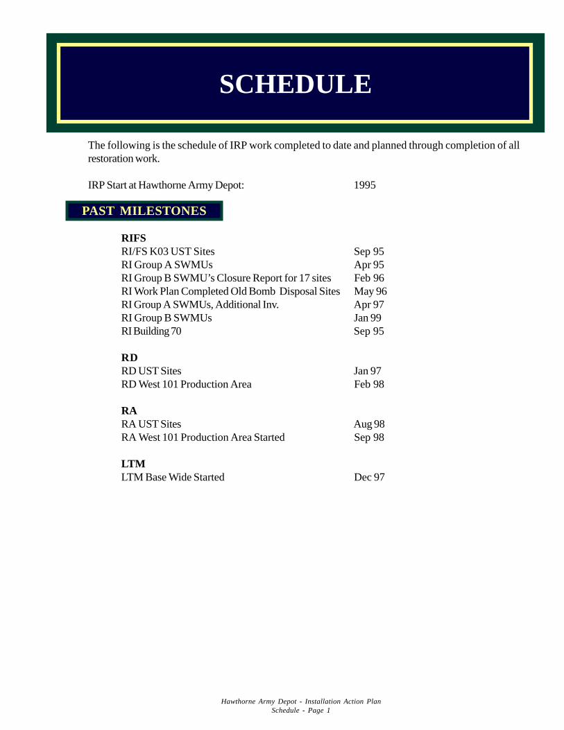
The following is the schedule of IRP work completed to date and planned through completion of allrestoration work.
IRP Start at Hawthorne Army Depot: 1995
RIFSRI/FS K03 UST Sites Sep 95RI Group A SWMUs Apr 95RI Group B SWMU’s Closure Report for 17 sites Feb 96RI Work Plan Completed Old Bomb Disposal Sites May 96RI Group A SWMUs, Additional Inv. Apr 97RI Group B SWMUs Jan 99RI Building 70 Sep 95
RDRD UST Sites Jan 97RD West 101 Production Area Feb 98
RARA UST Sites Aug 98RA West 101 Production Area Started Sep 98
LTMLTM Base Wide Started Dec 97
SCHEDULE
PAST MILESTONES
Hawthorne Army Depot - Installation Action PlanSchedule - Page 1
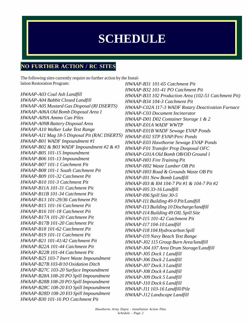
The following sites currently require no further action by the Instal-lation Restoration Program:
HWAAP-A03 Coal Ash LandfillHWAAP-A04 Babbit Closed LandfillHWAAP-A05 Mustard Gas Disposal (RI DSERTS)HWAAP-A06A Old Bomb Disposal Area 1HWAAP-A09A Ammo Can PilesHWAAP-A09B Battery Disposal AreaHWAAP-A10 Walker Lake Test RangeHWAAP-A11 Mag 18-5 Disposal Pit (RAC DSERTS)HWAAP-B01 WADF Impoundment #1HWAAP-B02 & B03 WADF Impoundment #2 & #3HWAAP-B05 101-15 ImpoundmentHWAAP-B06 101-13 ImpoundmentHWAAP-B07 101-1 Catchment PitHWAAP-B08 101-1 South Catchment PitHWAAP-B09 101-32 Catchment PitHWAAP-B10 101-3 Catchment PitHWAAP-B11A 101-31 Catchment PitHWAAP-B11B 101-34 Catchment PitHWAAP-B13 101-29/36 Catchment PitHWAAP-B15 101-16 Catchment PitHWAAP-B16 101-18 Catchment PitHWAAP-B17A 101-20 Catchment PitHWAAP-B17B 101-20 Catchment PitHWAAP-B18 101-62 Catchment PitHWAAP-B19 101-11 Catchment PitHWAAP-B21 101-41/42 Catchment PitHWAAP-B22A 101-44 Catchment PitHWAAP-B22B 101-44 Catchment PitHWAAP-B25 103-7 Inert Waste ImpoundmentHWAAP-B27B 103-8/10 Oxidation DitchHWAAP-B27C 103-20 Surface ImpoundmentHWAAP-B28A 108-20 PO Spill ImpoundmentHWAAP-B28B 108-20 PO Spill ImpoundmentHWAAP-B28C 108-20 EO Spill ImpoundmentHWAAP-B28D 108-20 EO Spill ImpoundmentHWAAP-B30 101-16 PO Catchment Pit
Hawthorne Army Depot - Installation Action PlanSchedule - Page 2
NO FURTHER ACTION / RC SITES
HWAAP-B31 101-65 Catchment PitHWAAP-B32 101-41 PO Catchment PitHWAAP-B33 102 Production Area (102-51 Catchment Pit)HWAAP-B34 104-3 Catchment PitHWAAP-C02A 117-3 WADF Rotary Deactivation FurnaceHWAAP-C03 Document IncineratorHWAAP-D01 D02 Container Storage 1 & 2HWAAP-E01A WADF WWTPHWAAP-E01B WADF Sewage EVAP PondsHWAAP-E02 STP EVAP/Perc PondsHWAAP-E03 Hawthorne Sewage EVAP PondsHWAAP-F01 Transfer Prop Dosposal OFCHWAAP-G01A Old Bomb OB/OD Ground 1HWAAP-H01 Fire Training PitHWAAP-H02 Waste Lumber OB PitHWAAP-H03 Road & Grounds Waste OB PitHWAAP-I01 New Bomb LandfillHWAAP-I03 & I04 104-7 Pit #1 & 104-7 Pit #2HWAAP-I05 33-16 LandfillHWAAP-I06 Spill Site 30-5HWAAP-I11 Building 49-9 Pit/LandfillHWAAP-I13 Building 10 Discharge/landfillHWAAP-I14 Building 49 OIL Spill SiteHWAAP-I15 101-42 Catchment PitHWAAP-I17 104-10 LandfillHWAAP-I18 104 Hydrocarbon SpillHWAAP-I19 Navy Beach Test RangeHWAAP-J02 115 Group Burn Area/landfillHWAAP-J04 107 Area Drum Storage/LandfillHWAAP-J05 Dock 1 LandfillHWAAP-J06 Dock 2 LandfillHWAAP-J07 Dock 3 LandfillHWAAP-J08 Dock 4 LandfillHWAAP-J09 Dock 5 LandfillHWAAP-J10 Dock 6 LandfillHWAAP-J11 103-16 Landfill/PileHWAAP-J12 Landscape Landfill
SCHEDULE
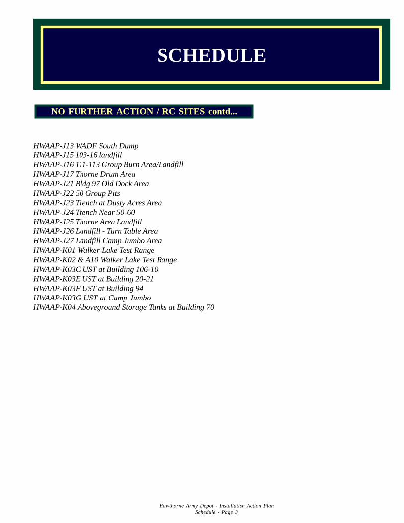
SCHEDULE
HWAAP-J13 WADF South DumpHWAAP-J15 103-16 landfillHWAAP-J16 111-113 Group Burn Area/LandfillHWAAP-J17 Thorne Drum AreaHWAAP-J21 Bldg 97 Old Dock AreaHWAAP-J22 50 Group PitsHWAAP-J23 Trench at Dusty Acres AreaHWAAP-J24 Trench Near 50-60HWAAP-J25 Thorne Area LandfillHWAAP-J26 Landfill - Turn Table AreaHWAAP-J27 Landfill Camp Jumbo AreaHWAAP-K01 Walker Lake Test RangeHWAAP-K02 & A10 Walker Lake Test RangeHWAAP-K03C UST at Building 106-10HWAAP-K03E UST at Building 20-21HWAAP-K03F UST at Building 94HWAAP-K03G UST at Camp JumboHWAAP-K04 Aboveground Storage Tanks at Building 70
Hawthorne Army Depot - Installation Action PlanSchedule - Page 3
NO FURTHER ACTION / RC SITES contd...
DSERTS # PHASE FY01 FY02 FY03 FY04 FY05 FY06 FY07+
HWAAP-A06B RI/FSRDRALTM
HWAAP-A06C RI/FSRDRALTM
HWAAP-A06D RI/FSRDRALTM
HWAAP-A06E RI/FSRDRALTM
HWAAP-A07 RI/FS
HWAAP-A08 LTM
HWAAP-B04 RALTM
HWAAP-B12 LTM
HWAAP-B20 RI/FSRDRA
HWAAP-B23 LTM
HWAAP-B24 RDRA
HWAAP-B26 RDRA
HWAAP-B27A RDRA
HWAAP-B29 RALTM
HWAAP-C04 RI/FSLTM
Hawthorne Army Depot IRP Schedule(Based on current funding constraints)
Current Phase Future Phase
Schedule 4
DSERTS # PHASE FY01 FY02 FY03 FY04 FY05 FY06 FY07+
HWAAP-C05 RI/FSLTM
HWAAP-G01B RI/FSLTM
HWAAP-G01C RI/FSLTM
HWAAP-H04 LTM
HWAAP-H05 LTM
HWAAP-I02 IRARDRALTM
HWAAP-I07 RDRA
HWAAP-I08 RDRA
HWAAP-I09/10 RALTM
HWAAP-I22 LTM
HWAAP-I23 LTM
HWAAP-J03 LTM
HWAAP-J14 RDRA
HWAAP-J28 RDRA
HWAAP-J29 RDRA
HWAAP-K03 LTO
HWAAP-K05 LTO
Schedule 5
DEFENSE SITE ENVIRONMENTAL RESTORATION TRACKING SYSTEMSite, 4. Installation Phase Summary Report 11/27/00
Installation: HAWTHORNE ADPrograms: BRAC I, BRAC II, BRAC III, BRAC IV, IRP
Subprograms: Compliance, Restoration, UXOInstallation count for Programs: 1
NPL Options: Delisted, No, Proposed, Yes
Installations count for Programs and NPL: 1Site count for Programs and NPL: 123
Phase / Status / Sites
PA SI
C U F RC C U F RC
123 0 0 3 117 0 0 27RI / FS RD
C U F RC C U F
88 2 0 24 33 2 9RA(C) RA(O)
C U F RC C U F RC52 5 11 48 3 1 0 3
LTMC U F N
1 18 4 92Remedy / Status / Sites (Actions)
IRA
C U F
9 ( 9 ) 1 ( 1 ) 1 ( 1 )
FRA
C U F
51 ( 51 ) 4 ( 4 ) 12 ( 12 )
RIP Total: 1
RC Total: 105
Reporting Period End Date: 09/30/2000
Schedule 6
DEFENSE SITE ENVIRONMENTAL RESTORATION TRACKING SYSTEM
Site, 9. RISK INSTALLATION ACTION PLAN REPORT 11/27/2000
Installation: HAWTHORNE ADMajor Command:AMC
SubCommand:OSCProgram Options:IRP, BRAC I, BRAC II, BRAC III, BRAC IV
Subprogram Options:Compliance, Restoration, UXOMedia Phase (s) Phase (s) Phase (s) #IRA #IRA #IRA LTM RIP RC
Site RRSE Evaluated Completed Underway Future Completed Underway Future Status Date Date
HWAAP-A03 3B SL PA N 199810RACRISI
HWAAP-A04 1B GW PA N 200009SL RAC
RDRISI
HWAAP-A05 3B GW PA RI 200506SI
HWAAP-A06A 2B GW PA 1 199209SL SI
HWAAP-A06B 1B SL PA U 199310SI
HWAAP-A06C 2B SL PA U 198808SI
HWAAP-A06D 1B SL PA U 199410SI
HWAAP-A06E 1B SL PA U 198809SI
HWAAP-A07 NE PA N 198808SI
HWAAP-A08 2B GW PA 1 U 199812SL RI
SIHWAAP-A09A 3B SL PA N 199810
RACRISI
HWAAP-A09B 3B SL PA N 199803RAC
SIHWAAP-A10 NE PA N 199709
SIHWAAP-A11 3B SL PA RAC N 200103
RDSI
HWAAP-B01 NE PA N 198808SI
HWAAP-B02 NE PA N 198808SI
HWAAP-B03 NE PA N 198808SI
HWAAP-B04 2B GW PA RAC F 200509SL RD
RISI
HWAAP-B05 2B GW PA N 199911SL RAC
RDRISI
HWAAP-B06 2B GW PA N 199909SL RAC
RDRISI
HWAAP-B07 3B SL PA N 199909RAC
SIHWAAP-B08 2B SL PA N 199909
RACRDRISI
HWAAP-B09 3B GW PA N 199909SL RAC
RDRISI
HWAAP-B10 3B SL PA N 199909RACRDRISI
Schedule 7
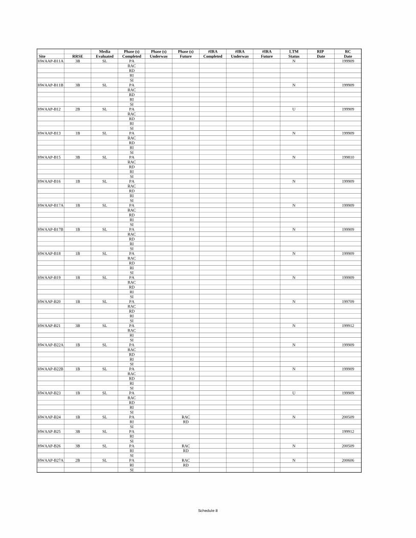
Media Phase (s) Phase (s) Phase (s) #IRA #IRA #IRA LTM RIP RC Site RRSE Evaluated Completed Underway Future Completed Underway Future Status Date DateHWAAP-B11A 3B SL PA N 199909
RACRDRISI
HWAAP-B11B 3B SL PA N 199909RACRDRISI
HWAAP-B12 2B SL PA U 199909RACRDRISI
HWAAP-B13 1B SL PA N 199909RACRDRISI
HWAAP-B15 3B SL PA N 199810RACRDRISI
HWAAP-B16 1B SL PA N 199909RACRDRISI
HWAAP-B17A 1B SL PA N 199909RACRDRISI
HWAAP-B17B 1B SL PA N 199909RACRDRISI
HWAAP-B18 1B SL PA N 199909RACRDRISI
HWAAP-B19 1B SL PA N 199909RACRDRISI
HWAAP-B20 1B SL PA N 199709RACRDRISI
HWAAP-B21 3B SL PA N 199912RACRISI
HWAAP-B22A 1B SL PA N 199909RACRDRISI
HWAAP-B22B 1B SL PA N 199909RACRDRISI
HWAAP-B23 1B SL PA U 199909RACRDRISI
HWAAP-B24 1B SL PA RAC N 200509RI RDSI
HWAAP-B25 3B SL PA 199912RISI
HWAAP-B26 3B SL PA RAC N 200509RI RDSI
HWAAP-B27A 2B SL PA RAC N 200606RI RDSI
Schedule 8
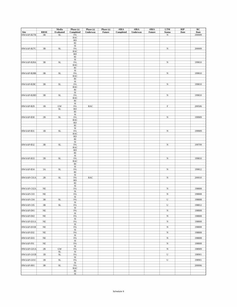
Media Phase (s) Phase (s) Phase (s) #IRA #IRA #IRA LTM RIP RC Site RRSE Evaluated Completed Underway Future Completed Underway Future Status Date DateHWAAP-B27B 3B SL PA N 200009
RACRDRISI
HWAAP-B27C 3B SL PA N 200009RACRDRISI
HWAAP-B28A 3B SL PA N 199810RACRISI
HWAAP-B28B 3B SL PA N 199810RACRISI
HWAAP-B28C 3B SL PA N 199810RACRISI
HWAAP-B28D 3B SL PA N 199810RACRISI
HWAAP-B29 1B GW PA RAC F 200506SL RD
RISI
HWAAP-B30 2B SL PA N 199909RACRDRISI
HWAAP-B31 1B SL PA N 199909RACRDRISI
HWAAP-B32 3B SL PA N 199709RACRDRISI
HWAAP-B33 2B SL PA N 199810RACRISI
HWAAP-B34 3A SL PA N 199812RISI
HWAAP-C01A 2B SL PA RAC N 200010RDRISI
HWAAP-C02A NE PA N 198808SI
HWAAP-C03 NE PA N 198808SI
HWAAP-C04 3B SL PA U 198808SI
HWAAP-C05 3B SL PA U 198812SI
HWAAP-D01 NE PA N 198808SI
HWAAP-D02 NE PA N 198808SI
HWAAP-E01A NE PA N 198808SI
HWAAP-E01B NE PA N 198808SI
HWAAP-E02 NE PA N 198808SI
HWAAP-E03 NE PA N 198808SI
HWAAP-F01 NE PA N 198808SI
HWAAP-G01A 2B GW PA N 198909SL SI
HWAAP-G01B 1B SL PA U 198901SI
HWAAP-G01C 1B SL PA U 198901SI
HWAAP-H01 3B SL PA 200006RACRISI
Schedule 9
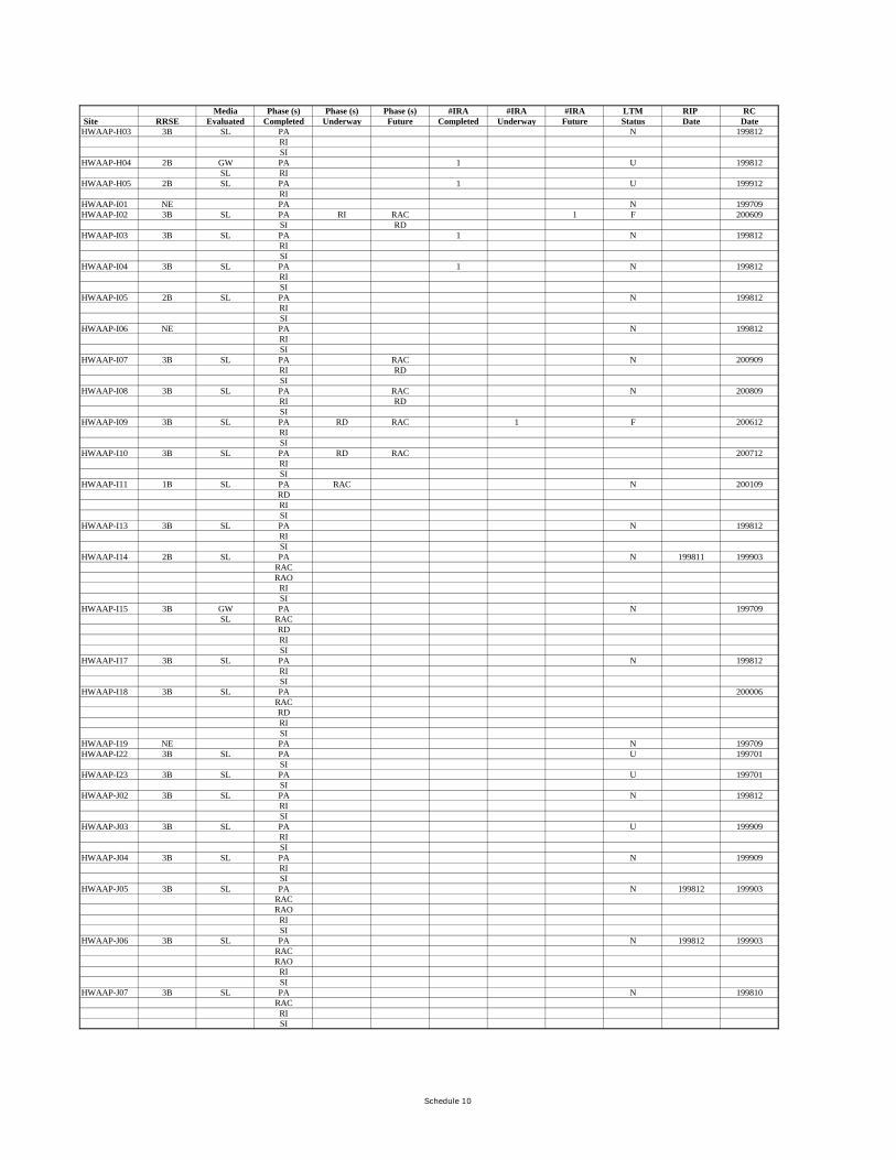
Media Phase (s) Phase (s) Phase (s) #IRA #IRA #IRA LTM RIP RC Site RRSE Evaluated Completed Underway Future Completed Underway Future Status Date DateHWAAP-H03 3B SL PA N 199812
RISI
HWAAP-H04 2B GW PA 1 U 199812SL RI
HWAAP-H05 2B SL PA 1 U 199912RI
HWAAP-I01 NE PA N 199709HWAAP-I02 3B SL PA RI RAC 1 F 200609
SI RDHWAAP-I03 3B SL PA 1 N 199812
RISI
HWAAP-I04 3B SL PA 1 N 199812RISI
HWAAP-I05 2B SL PA N 199812RISI
HWAAP-I06 NE PA N 199812RISI
HWAAP-I07 3B SL PA RAC N 200909RI RDSI
HWAAP-I08 3B SL PA RAC N 200809RI RDSI
HWAAP-I09 3B SL PA RD RAC 1 F 200612RISI
HWAAP-I10 3B SL PA RD RAC 200712RISI
HWAAP-I11 1B SL PA RAC N 200109RDRISI
HWAAP-I13 3B SL PA N 199812RISI
HWAAP-I14 2B SL PA N 199811 199903RACRAO
RISI
HWAAP-I15 3B GW PA N 199709SL RAC
RDRISI
HWAAP-I17 3B SL PA N 199812RISI
HWAAP-I18 3B SL PA 200006RACRDRISI
HWAAP-I19 NE PA N 199709HWAAP-I22 3B SL PA U 199701
SIHWAAP-I23 3B SL PA U 199701
SIHWAAP-J02 3B SL PA N 199812
RISI
HWAAP-J03 3B SL PA U 199909RISI
HWAAP-J04 3B SL PA N 199909RISI
HWAAP-J05 3B SL PA N 199812 199903RACRAO
RISI
HWAAP-J06 3B SL PA N 199812 199903RACRAO
RISI
HWAAP-J07 3B SL PA N 199810RACRISI
Schedule 10
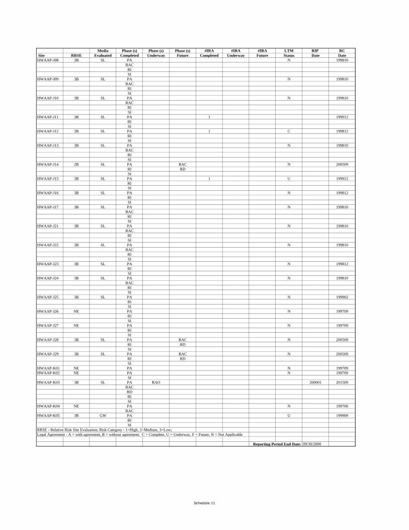
Media Phase (s) Phase (s) Phase (s) #IRA #IRA #IRA LTM RIP RC Site RRSE Evaluated Completed Underway Future Completed Underway Future Status Date DateHWAAP-J08 3B SL PA N 199810
RACRISI
HWAAP-J09 3B SL PA N 199810RACRISI
HWAAP-J10 3B SL PA N 199810RACRISI
HWAAP-J11 3B SL PA 1 199912RISI
HWAAP-J12 3B SL PA 1 C 199812RISI
HWAAP-J13 3B SL PA N 199810RACRISI
HWAAP-J14 2B SL PA RAC N 200509RI RDSI
HWAAP-J15 3B SL PA 1 U 199912RISI
HWAAP-J16 3B SL PA N 199812RISI
HWAAP-J17 3B SL PA N 199810RACRISI
HWAAP-J21 3B SL PA N 199810RACRISI
HWAAP-J22 3B SL PA N 199810RACRISI
HWAAP-J23 3B SL PA N 199812RISI
HWAAP-J24 3B SL PA N 199810RACRISI
HWAAP-J25 3B SL PA N 199902RISI
HWAAP-J26 NE PA N 199709RISI
HWAAP-J27 NE PA N 199709RISI
HWAAP-J28 3B SL PA RAC N 200509RI RDSI
HWAAP-J29 3B SL PA RAC N 200509RI RDSI
HWAAP-K01 NE PA N 199709HWAAP-K02 NE PA N 199709
SIHWAAP-K03 3B SL PA RAO 200001 201509
RACRDRISI
HWAAP-K04 NE PA N 199706RAC
HWAAP-K05 3B GW PA U 199909RISI
RRSE - Relative Risk Site Evaluation; Risk Category - 1=High, 2=Medium, 3=Low; Legal Agreement - A = with agreement, B = without agreement; C = Complete, U = Underway, F = Future, N = Not Applicable
Reporting Period End Date: 09/30/2000
Schedule 11
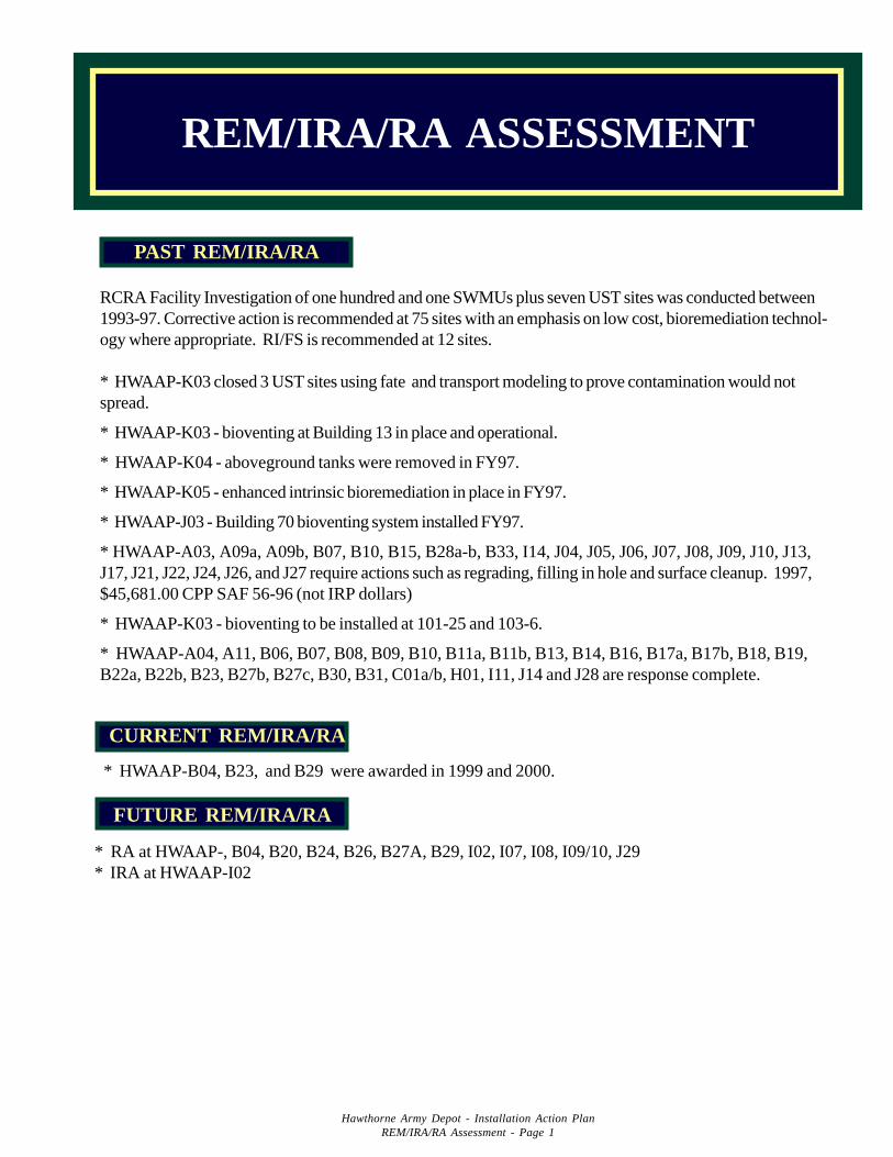
REM/IRA/RA ASSESSMENT
Hawthorne Army Depot - Installation Action PlanREM/IRA/RA Assessment - Page 1
RCRA Facility Investigation of one hundred and one SWMUs plus seven UST sites was conducted between1993-97. Corrective action is recommended at 75 sites with an emphasis on low cost, bioremediation technol-ogy where appropriate. RI/FS is recommended at 12 sites.
* HWAAP-K03 closed 3 UST sites using fate and transport modeling to prove contamination would notspread.
* HWAAP-K03 - bioventing at Building 13 in place and operational.
* HWAAP-K04 - aboveground tanks were removed in FY97.
* HWAAP-K05 - enhanced intrinsic bioremediation in place in FY97.
* HWAAP-J03 - Building 70 bioventing system installed FY97.
* HWAAP-A03, A09a, A09b, B07, B10, B15, B28a-b, B33, I14, J04, J05, J06, J07, J08, J09, J10, J13,J17, J21, J22, J24, J26, and J27 require actions such as regrading, filling in hole and surface cleanup. 1997,$45,681.00 CPP SAF 56-96 (not IRP dollars)
* HWAAP-K03 - bioventing to be installed at 101-25 and 103-6.
* HWAAP-A04, A11, B06, B07, B08, B09, B10, B11a, B11b, B13, B14, B16, B17a, B17b, B18, B19,B22a, B22b, B23, B27b, B27c, B30, B31, C01a/b, H01, I11, J14 and J28 are response complete.
PAST REM/IRA/RA
* HWAAP-B04, B23, and B29 were awarded in 1999 and 2000.
CURRENT REM/IRA/RA
* RA at HWAAP-, B04, B20, B24, B26, B27A, B29, I02, I07, I08, I09/10, J29* IRA at HWAAP-I02
FUTURE REM/IRA/RA
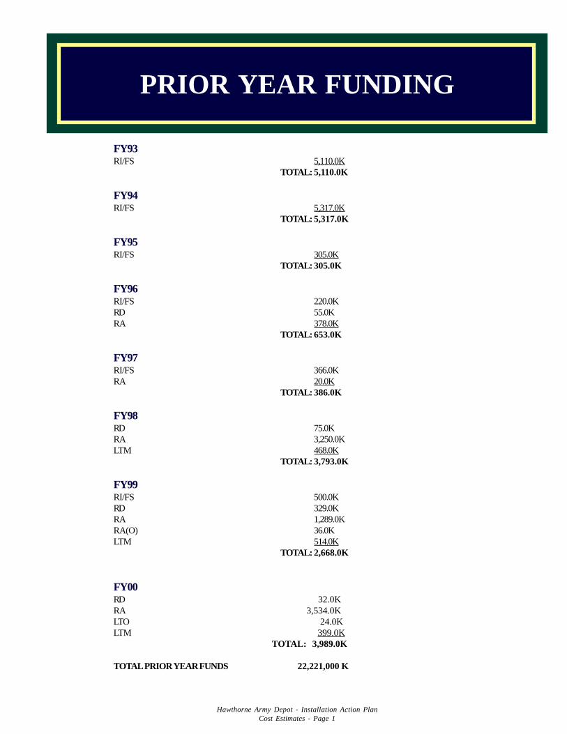
FY93RI/FS 5,110.0K
TOTAL: 5,110.0K
FY94RI/FS 5,317.0K
TOTAL: 5,317.0K
FY95RI/FS 305.0K
TOTAL: 305.0K
FY96RI/FS 220.0KRD 55.0KRA 378.0K
TOTAL: 653.0K
FY97RI/FS 366.0KRA 20.0K
TOTAL: 386.0K
FY98RD 75.0KRA 3,250.0KLTM 468.0K
TOTAL: 3,793.0K
FY99RI/FS 500.0KRD 329.0KRA 1,289.0KRA(O) 36.0KLTM 514.0K
TOTAL: 2,668.0K
FY00RD 32.0KRA 3,534.0KLTO 24.0KLTM 399.0K
TOTAL: 3,989.0K
TOTAL PRIOR YEAR FUNDS 22,221,000 K
Hawthorne Army Depot - Installation Action PlanCost Estimates - Page 1
PRIOR YEAR FUNDING
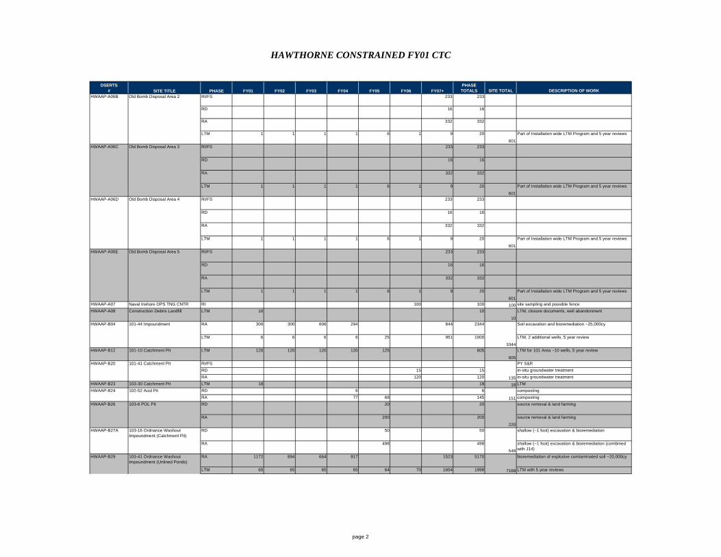
HAWTHORNE CONSTRAINED FY01 CTC
DSERTS# SITE TITLE PHASE FY01 FY02 FY03 FY04 FY05 FY06 FY07+
PHASE TOTALS SITE TOTAL DESCRIPTION OF WORK
HWAAP-A06B Old Bomb Disposal Area 2 RI/FS 233 233
RD 16 16
RA 332 332
LTM 1 1 1 1 6 1 9 20
601
Part of Installation wide LTM Program and 5 year reviews
HWAAP-A06C Old Bomb Disposal Area 3 RI/FS 233 233
RD 16 16
RA 332 332
LTM 1 1 1 1 6 1 9 20
601
Part of Installation wide LTM Program and 5 year reviews
HWAAP-A06D Old Bomb Disposal Area 4 RI/FS 233 233
RD 16 16
RA 332 332
LTM 1 1 1 1 6 1 9 20
601
Part of Installation wide LTM Program and 5 year reviews
HWAAP-A06E Old Bomb Disposal Area 5 RI/FS 233 233
RD 16 16
RA 332 332
LTM 1 1 1 1 6 1 9 20
601
Part of Installation wide LTM Program and 5 year reviews
HWAAP-A07 Naval Inshore OPS TNG CNTR Firing Range
RI 100 100 100 site sampling and possible fence
HWAAP-A08 Construction Debris Landfill LTM 10 10
10
LTM, closure documents, well abandonment
HWAAP-B04 101-44 Impoundment RA 300 300 606 294 844 2344 Soil excavation and bioremediation ~25,000cy
LTM 6 6 6 6 25 951 1000
3344
LTM, 2 additional wells, 5 year review
HWAAP-B12 101-10 Catchment Pit LTM 120 120 120 120 125 605
605
LTM for 101 Area ~10 wells, 5 year review
HWAAP-B20 101-41 Catchment Pit RI/FS PY S&R
RD 15 15 in-situ groundwater treatment
RA 120 120 135 in-situ groundwater treatment
HWAAP-B23 103-30 Catchment Pit LTM 18 18 18 LTM
HWAAP-B24 102-52 Acid Pit RD 6 6 composting
RA 77 68 145 151 composting
HWAAP-B26 103-6 POL Pit RD 20 20 source removal & land farming
RA 200 200
220
source removal & land farming
HWAAP-B27A RD 50 50 shallow (~1 foot) excavation & bioremediation
RA 498 498
548
shallow (~1 foot) excavation & bioremediation (combined with J14)
HWAAP-B29 RA 1172 894 664 917 1523 5170 bioremediation of explosive comtaminated soil ~20,000cy
LTM 65 65 65 65 64 70 1604 1998 7168 LTM with 5 year reviews
103-16 Ordnance Washout Impoundment (Catchment Pit)
103-41 Ordnance Washout Impoundment (Unlined Ponds)
page 2
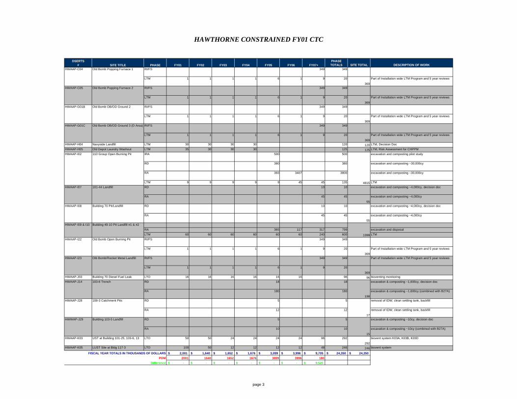
HAWTHORNE CONSTRAINED FY01 CTC
DSERTS# SITE TITLE PHASE FY01 FY02 FY03 FY04 FY05 FY06 FY07+
PHASE TOTALS SITE TOTAL DESCRIPTION OF WORK
HWAAP-C04 Old Bomb Popping Furnace 1 RI/FS 349 349
LTM 1 1 1 1 6 1 9 20
369
Part of Installation wide LTM Program and 5 year reviews
HWAAP-C05 Old Bomb Popping Furnace 2 RI/FS 349 349
LTM 1 1 1 1 6 1 9 20
369
Part of Installation wide LTM Program and 5 year reviews
HWAAP-G01B Old Bomb OB/OD Ground 2 RI/FS 349 349
LTM 1 1 1 1 6 1 9 20
369
Part of Installation wide LTM Program and 5 year reviews
HWAAP-G01C Old Bomb OB/OD Ground 3 (D Area) RI/FS 349 349
LTM 1 1 1 1 6 1 9 20
369
Part of Installation wide LTM Program and 5 year reviews
HWAAP-H04 Navyside Landfill LTM 30 30 30 30 120 120 LTM, Decision Doc
HWAAP-H05 Old Depot Laundry Washout LTM 35 30 30 30 125 125 LTM, Risk Assessment for CHPPM
HWAAP-I02 110 Group Open Burning Pit IRA 500 500 excavation and composting pilot study
RD 380 380 excavation and composting ~30,000cy
RA 393 3407 3800 excavation and composting ~30,000cy
LTM 9 9 9 9 9 45 45 135 4815 LTM
HWAAP-I07 101-44 Landfill RD 10 10 excavation and composting ~4,000cy, decision doc
RA 45 45
55
excavation and composting ~4,000cy
HWAAP-I08 Building 70 Pit/Landfill RD 10 10 excavation and composting ~4,000cy, decision doc
RA 45 45
55
excavation and composting ~4,000cy
Building 49-10 Pit Landfill #1 & #2
RA 365 117 317 799 excavation and disposal
LTM 60 60 60 60 60 60 240 600 1399 LTM
HWAAP-I22 Old Bomb Open Burning Pit RI/FS 349 349
LTM 1 1 1 1 6 1 9 20
369
Part of Installation wide LTM Program and 5 year reviews
HWAAP-I23 Olb Bomb/Rocket Metal Landfill RI/FS 349 349 Part of Installation wide LTM Program and 5 year reviews
LTM 1 1 1 1 6 1 9 20
369HWAAP-J03 Building 70 Diesel Fuel Leak LTO 16 16 16 16 16 16 96 96 bioventing monitoring
HWAAP-J14 103-6 Trench RD 18 18 excavation & composting ~1,600cy, decision doc
RA 180 180
198
excavation & composting ~1,600cy (combined with B27A)
HWAAP-J28 108-3 Catchment Pits RD 5 5 removal of IDW, clean settling tank, backfill
RA 12 12
17
removal of IDW, clean settling tank, backfill
HWWAP-J29 Building 103-5 Landfill RD 5 5 excavation & composting ~10cy, decision doc
RA 10 10
15
excavation & composting ~10cy (combined with B27A)
HWAAP-K03 UST at Building 101-25, 103-6, 13 LTO 50 50 24 24 24 24 96 292
292
biovent system K03A, K03B, K03D
HWAAP-K05 LUST Site at Bldg 117-3 LTO 100 50 12 12 12 12 48 246 246 biovent system
FISCAL YEAR TOTALS IN THOUSANDS OF DOLLARS 2,001$ 1,640$ 1,652$ 1,676$ 3,099$ 3,996$ 9,705$ 24,350$ 24,350$
POM 2001 1640 1652 1676 3099 3996 180
Difference -$ -$ -$ -$ -$ -$ 9,525$
HWAAP-I09 & I10
page 3
COMMUNITY INVOLVEMENT
There is no RAB established at Hawthorne Army Depot. HWAD has solicited community participation in estab-lishment of the restoration advisory board (RAB). This has included; open house for the general public, statewideTV coverage of HWAD’s IRP, public notices in the local newspapers, presentations to community clubs and highschools, and a public out reach through the local library. HWAD will continue to solicit community involvement.The Nevada Division of Environmental Protection is a full partner in HWAD’s IRP and is supportive of our effortsto form a RAB for the Depot. They also recognize the difficulties of recruiting RAB members in a rural locationsuch as Hawthorne.
Hawthorne Army Depot - Installation Action PlanCommunity Involvement - Page 1
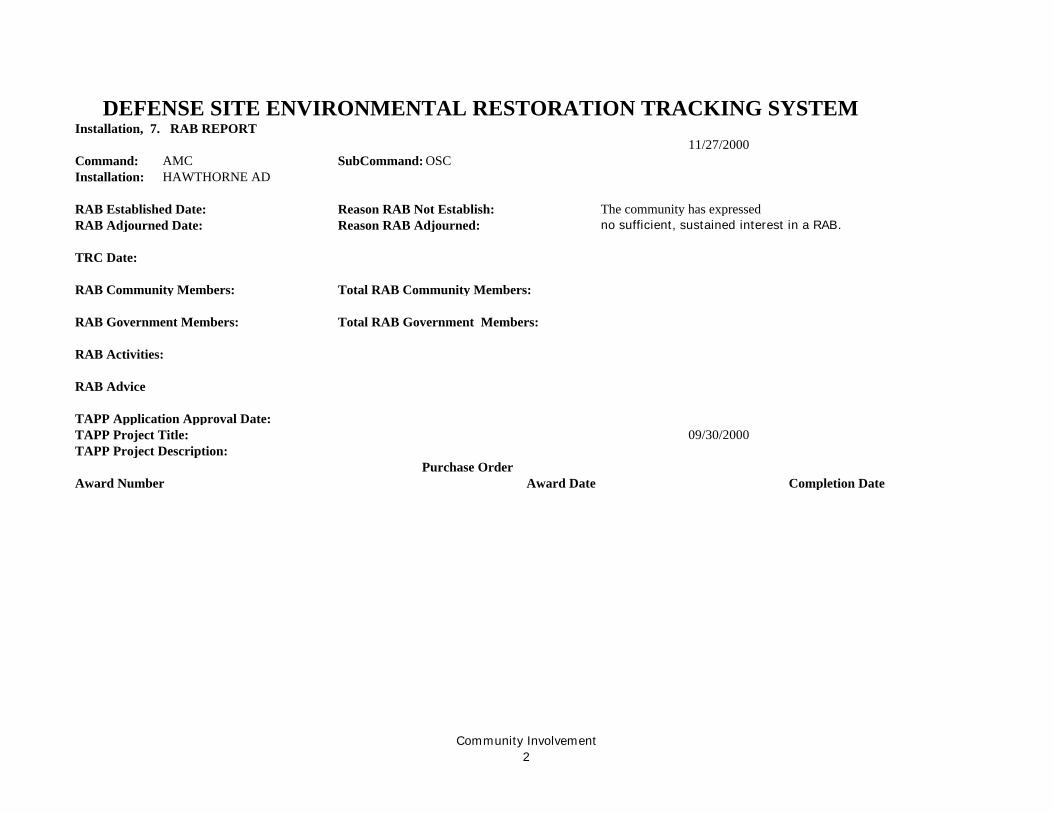
Installation, 7. RAB REPORT11/27/2000
Command: AMC SubCommand: OSCInstallation: HAWTHORNE AD
RAB Established Date: Reason RAB Not Establish: The community has expressed RAB Adjourned Date: Reason RAB Adjourned: no sufficient, sustained interest in a RAB.
TRC Date:
RAB Community Members: Total RAB Community Members:
RAB Government Members: Total RAB Government Members:
RAB Activities:
RAB Advice
TAPP Application Approval Date: TAPP Project Title: 09/30/2000TAPP Project Description:
Purchase OrderAward Number Award Date Completion Date
DEFENSE SITE ENVIRONMENTAL RESTORATION TRACKING SYSTEM
Community Involvement2