Embed Size (px)
Citation preview
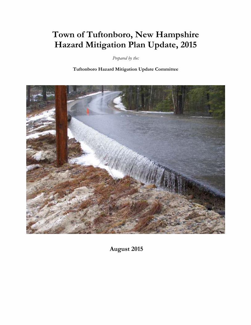
Town of Tuftonboro, New Hampshire Hazard Mitigation Plan Update, 2015
Prepared by the:
Tuftonboro Hazard Mitigation Update Committee
August 2015

Intentionally left blank.
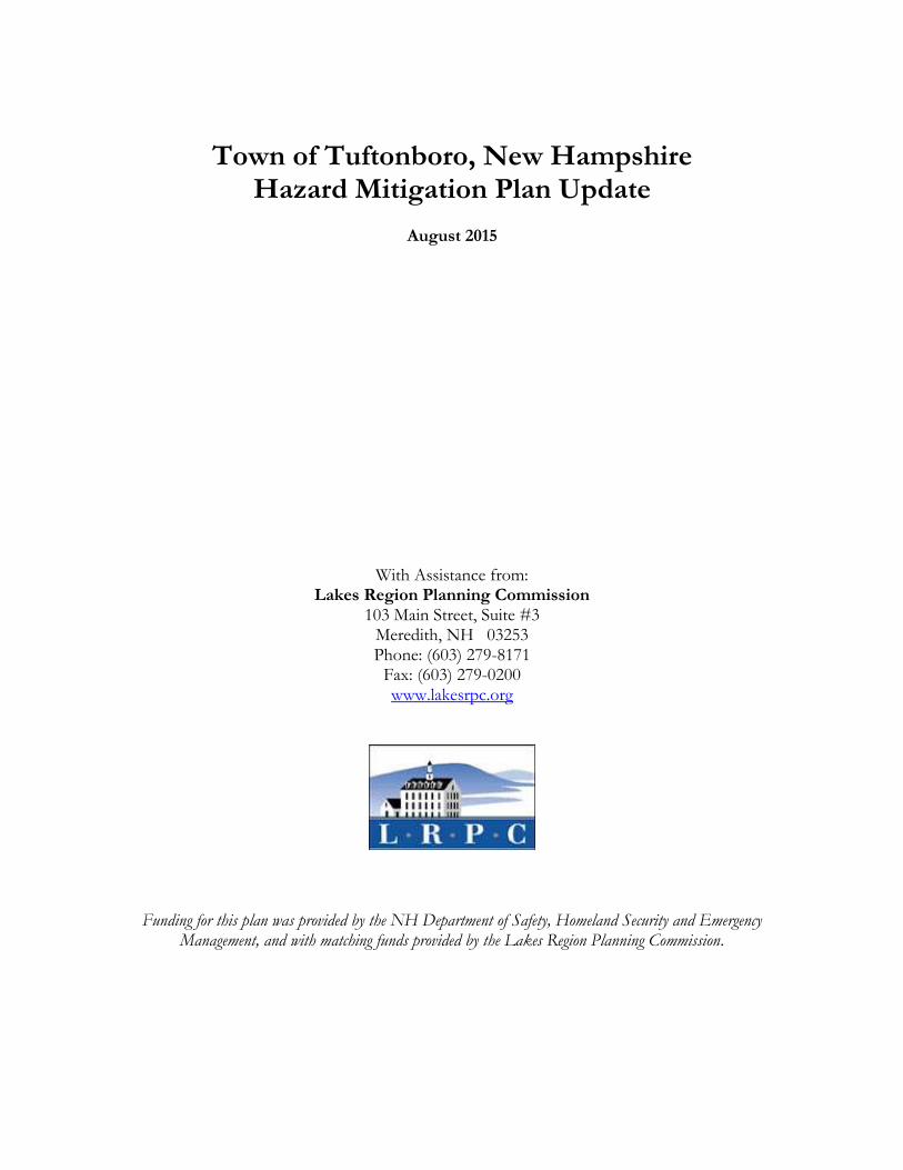
Town of Tuftonboro, New Hampshire
Hazard Mitigation Plan Update
August 2015
With Assistance from: Lakes Region Planning Commission
103 Main Street, Suite #3 Meredith, NH 03253 Phone: (603) 279-8171
Fax: (603) 279-0200 www.lakesrpc.org
Funding for this plan was provided by the NH Department of Safety, Homeland Security and Emergency Management, and with matching funds provided by the Lakes Region Planning Commission.
Tuftonboro, NH Hazard Mitigation Plan Update, 2015
i
TABLE OF CONTENTS
CHAPTER I: PLANNING PROCESS ................................................................................... 4
A. BACKGROUND ................................................................................................................................................ 4 B. AUTHORITY ...................................................................................................................................................... 4 C. FUNDING SOURCE ........................................................................................................................................ 4 D. PURPOSE ............................................................................................................................................................ 4 E. SCOPE OF PLAN .............................................................................................................................................. 4 F. METHODOLOGY ............................................................................................................................................ 5 G. ACKNOWLEDGMENTS ................................................................................................................................ 6
CHAPTER II: COMMUNITY PROFILE .............................................................................. 7 A. GEOGRAPHY .................................................................................................................................................... 7 B. WEATHER CONDITIONS ............................................................................................................................ 7 C. PUBLIC SERVICES ........................................................................................................................................... 7 D. DEVELOPMENT TRENDS ........................................................................................................................... 7
CHAPTER III: RISK ASSESSMENT ................................................................................... 10 A. IDENTIFYING HAZARDS .......................................................................................................................... 10 B. PROFILING HAZARD EVENTS ............................................................................................................... 11
CHAPTER IV: VULNERABILITY ASSESSMENT ............................................................. 22 A. INVENTORY ASSETS ................................................................................................................................... 22 B. IMPACT OF HAZARDS ................................................................................................................................ 23 C. SUMMARY OF RISK ...................................................................................................................................... 26
CHAPTER V: MITIGATION STRATEGIES ...................................................................... 28 A. CURRENT PLANS, POLICIES, AND REGULATIONS ....................................................................... 28 B. STATUS OF 2009 ACTIONS ......................................................................................................................... 32 C. MITIGATION GOALS AND TYPES OF ACTIONS ............................................................................. 35 D. POTENTIAL ACTIONS ................................................................................................................................ 36 E. PRIORITIZATION OF ACTIONS ............................................................................................................. 41 F. IMPLEMENTATION OF MITIGATION ACTIONS ............................................................................ 42
CHAPTER VI: PLAN ADOPTION AND MONITORING ................................................ 45 A. IMPLEMENTATION ..................................................................................................................................... 45 B. PLAN MAINTENANCE & PUBLIC INVOLVEMENT ........................................................................ 45 C. SIGNED CERTIFICATE OF ADOPTION............................................................................................... 47
APPENDIX A: TECHNICAL RESOURCES ....................................................................... 48 APPENDIX B: MITIGATION FUNDING RESOURCES ................................................. 51 APPENDIX C: PUBLICITY AND INFORMATION ......................................................... 56 APPENDIX D: MEETING AGENDAS and PARTICIPATION ........................................ 64 APPENDIX E: HAZARD EVENTS PRIOR TO 2009 ......................................................... 68 APPENDIX F: CRITICAL FACILITIES & POTENTIAL HAZARDS MAP .................... 71 APPENDIX G: HAZARDS – SUPPLEMENTARY HAZARD INFORMATION ............. 72 APPENDIX H: PRIORITIZATION DETAILS .................................................................. 82 APPENDIX I: EXISTING PLANS, STUDIES, REPORTS, AND TECHNICAL
INFORMATION ................................................................................................... 84 APPENDIX J: MONITOR, EVALUATE, & UPDATE ....................................................... 85 APPENDIX K: FEMA WEBLIOGRAPHY .......................................................................... 88
Tuftonboro, NH Hazard Mitigation Plan Update, 2015
ii
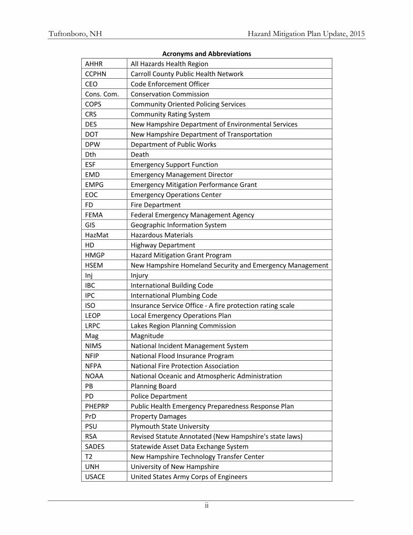
Acronyms and Abbreviations
AHHR All Hazards Health Region
CCPHN Carroll County Public Health Network
CEO Code Enforcement Officer
Cons. Com. Conservation Commission
COPS Community Oriented Policing Services
CRS Community Rating System
DES New Hampshire Department of Environmental Services
DOT New Hampshire Department of Transportation
DPW Department of Public Works
Dth Death
ESF Emergency Support Function
EMD Emergency Management Director
EMPG Emergency Mitigation Performance Grant
EOC Emergency Operations Center
FD Fire Department
FEMA Federal Emergency Management Agency
GIS Geographic Information System
HazMat Hazardous Materials
HD Highway Department
HMGP Hazard Mitigation Grant Program
HSEM New Hampshire Homeland Security and Emergency Management
Inj Injury
IBC International Building Code
IPC International Plumbing Code
ISO Insurance Service Office - A fire protection rating scale
LEOP Local Emergency Operations Plan
LRPC Lakes Region Planning Commission
Mag Magnitude
NIMS National Incident Management System
NFIP National Flood Insurance Program
NFPA National Fire Protection Association
NOAA National Oceanic and Atmospheric Administration
PB Planning Board
PD Police Department
PHEPRP Public Health Emergency Preparedness Response Plan
PrD Property Damages
PSU Plymouth State University
RSA Revised Statute Annotated (New Hampshire's state laws)
SADES Statewide Asset Data Exchange System
T2 New Hampshire Technology Transfer Center
UNH University of New Hampshire
USACE United States Army Corps of Engineers
Tuftonboro, NH Hazard Mitigation Plan Update, 2015
iii
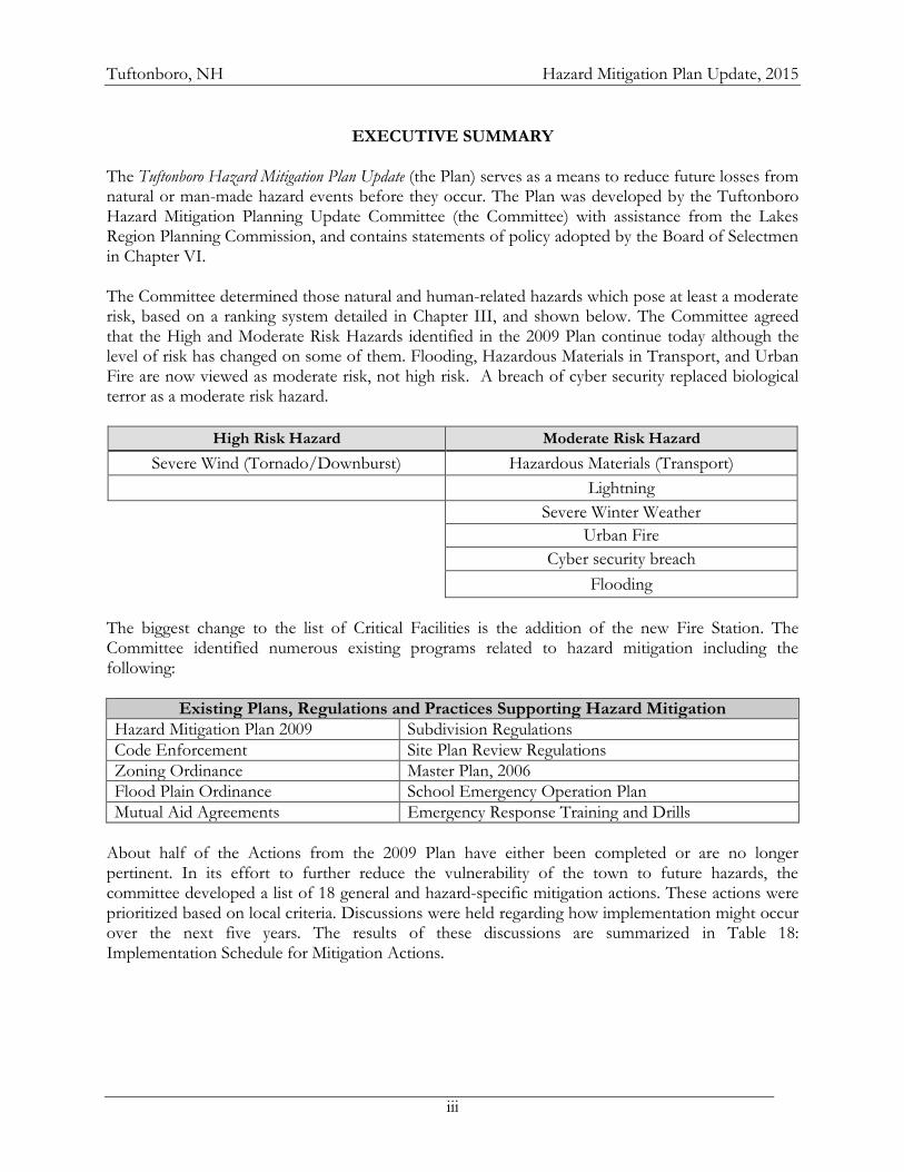
EXECUTIVE SUMMARY
The Tuftonboro Hazard Mitigation Plan Update (the Plan) serves as a means to reduce future losses from natural or man-made hazard events before they occur. The Plan was developed by the Tuftonboro Hazard Mitigation Planning Update Committee (the Committee) with assistance from the Lakes Region Planning Commission, and contains statements of policy adopted by the Board of Selectmen in Chapter VI. The Committee determined those natural and human-related hazards which pose at least a moderate risk, based on a ranking system detailed in Chapter III, and shown below. The Committee agreed that the High and Moderate Risk Hazards identified in the 2009 Plan continue today although the level of risk has changed on some of them. Flooding, Hazardous Materials in Transport, and Urban Fire are now viewed as moderate risk, not high risk. A breach of cyber security replaced biological terror as a moderate risk hazard.
High Risk Hazard Moderate Risk Hazard
Severe Wind (Tornado/Downburst) Hazardous Materials (Transport)
Lightning
Severe Winter Weather
Urban Fire
Cyber security breach
Flooding
The biggest change to the list of Critical Facilities is the addition of the new Fire Station. The Committee identified numerous existing programs related to hazard mitigation including the following:
Existing Plans, Regulations and Practices Supporting Hazard Mitigation
Hazard Mitigation Plan 2009 Subdivision Regulations
Code Enforcement Site Plan Review Regulations
Zoning Ordinance Master Plan, 2006
Flood Plain Ordinance School Emergency Operation Plan
Mutual Aid Agreements Emergency Response Training and Drills
About half of the Actions from the 2009 Plan have either been completed or are no longer pertinent. In its effort to further reduce the vulnerability of the town to future hazards, the committee developed a list of 18 general and hazard-specific mitigation actions. These actions were prioritized based on local criteria. Discussions were held regarding how implementation might occur over the next five years. The results of these discussions are summarized in Table 18: Implementation Schedule for Mitigation Actions.
Tuftonboro, NH Hazard Mitigation Plan Update, 2015
4
CHAPTER I: PLANNING PROCESS
A. BACKGROUND A community must have an approved hazard mitigation plan in order to apply for Federal Emergency Management Agency (FEMA) Hazard Mitigation Funding. These grant funds are to be used for hazard mitigation projects and actions that will ultimately reduce and mitigate future losses from natural or human hazard events. In response to this requirement, the NH Department of Safety’s Division of Homeland Security and Emergency Management (HSEM) and the nine regional planning commissions in the state entered into agreements to aid communities with plan development and update. The plan development process generally followed the steps outlined in FEMA’s Local Mitigation Planning Handbook (2013). B. AUTHORITY The town of Tuftonboro Hazard Mitigation Plan was prepared pursuant to Section 322, Mitigation Planning of the Robert T. Stafford Disaster Relief and Emergency Assistance Act and Section 104 of the Disaster Mitigation Act (DMA) of 2000. Section 322 of DMA 2000 emphasizes the need for State, local and tribal entities to closely coordinate mitigation planning and implementation efforts. C. FUNDING SOURCE The New Hampshire Department of Safety’s Homeland Security and Emergency Management (NH HSEM) funded the Plan with matching funds from the Lakes Region Planning Commission. D. PURPOSE The Tuftonboro Hazard Mitigation Plan is a planning tool to be used by the town of Tuftonboro, as well as other local, state, and federal government entities, in their efforts to reduce the negative effects from natural and human-related hazards. The Plan contains statements of policy as outlined in the Implementation Schedule for Mitigation Actions and in Chapter VI: Plan Adoption and Monitoring. All other sections of this plan are support and documentation for informational purposes only and are not included as a statement of policy. E. SCOPE OF PLAN The scope of this Plan includes the identification of natural and human-related hazards affecting the town of Tuftonboro, as identified by the Committee. Chapter III discusses the identification and review of these hazards. The plan also describes the process through which actions intended to mitigate these hazards were developed and prioritized.
Tuftonboro, NH Hazard Mitigation Plan Update, 2015
5
F. METHODOLOGY The Lakes Region Planning Commission (LRPC) corresponded with the Tuftonboro Emergency Management Director (EMD) in the fall of 2013 to initiate the hazard mitigation update process in the town of Tuftonboro and was followed by a meeting with the Selectmen to discuss the process. The EMD established the Tuftonboro Hazard Mitigation Planning Update Committee in for the purpose of updating a long-range plan for hazard mitigation. The Committee consisted of representatives from the Police and Fire Departments, the Road Agent, the Code Enforcement Officer, a school employee, a local business owner, and one of the town’s Board of Selectmen. All meetings were open to the public and a few did attend. Using FEMA’s Local Mitigation Plan Review Guide (2011), Mitigation Planning Workshop (2012) materials, and the Local Mitigation Planning Handbook (2013) as guidance, the Committee reviewed and updated various elements of the town’s 2009 Hazard Mitigation Plan. The planner and the committee reviewed and referenced a variety of plans, studies, reports, and technical information during the development of this Plan Update; a list of these resources can be found in Appendix I. Data on property valuation was provided by the town. The Committee held meetings from January 2014 through March 2014, with committee and public review and comment on the draft in December 2014. The following timeline shows the dates and corresponding Committee actions. The committee reviewed each section of the plan and LRPC staff provided updated information on hazards in New Hampshire. Each section of the existing plan was revised and reformatted in order to develop a more comprehensive document. Meeting agendas were posted in Town Hall and at the LRPC web page and are included in Appendix D. October 28, 2013 Tuftonboro Board of Selectmen Meeting: Tuftonboro Town Offices Review of the purpose and key elements of the Hazard Mitigation Plan
Overview of the update process and the role of the Board of Selectmen Discussion of outreach to potential committee members Committee Meetings January 28, 2014: Introductory Committee Meeting: Tuftonboro Central Fire Station Overview of update process and objectives Discussion of Development Trends since 2009 Locate critical facilities and hazards on map
Identify Hazard Events since 2009
February 10, 2014: Committee Meeting: Tuftonboro Central Fire Station Probability of Hazard Occurrence Status of 2009 Recommendations Risk Assessment
February 24, 2014: Committee Meeting: Tuftonboro Central Fire Station
Status of 2009 Recommendations Goals
Mitigation Actions
Tuftonboro, NH Hazard Mitigation Plan Update, 2015
6
March 10, 2014: Committee Meeting: Tuftonboro Central Fire Station Prioritization of Actions
Implementation
Public Involvement The Tuftonboro EMD invited a variety of Hazard Mitigation Planning stakeholders to join the Hazard Mitigation Planning Committee. The Committee was well represented by municipal officials, including members of the Board of Selectmen. Specific opportunities for public input occurred at each meeting. Local businesses, neighboring communities, and members of the public were encouraged to attend all meetings through press releases and postings on the town and LRPC websites (Appendix C). Additionally, the Board of Selectmen meeting and one of the committee meetings was videotaped by a resident and broadcast on the local Community Access TV. Members of the public did engage in discussions regarding hazards and potential impacts and posed questions about funding of the planning process and potential funding assistance to town for mitigation projects (Potential resources are identified in both Table 18 and Appendix B). No additional public comments were received during the review period. G. ACKNOWLEDGMENTS Special thanks to those that assisted in the development of this Plan: Adam Thompson Tuftonboro Fire Department, Chief/EMD Carolyn Sundquist Tuftonboro Board of Selectmen, Selectman Andrew Shagoury Tuftonboro Police Department, Chief Caleb Pike Tuftonboro Fire Department, Lieutenant Jack Parson Tuftonboro Planning Board, Vice-Chair and Tuftonboro Health and Code Enforcement Officer Jim Bean Tuftonboro Highway Department, Road Agent Frank Tranchita, Jr. Tuftonboro Citizen and Business Owner Arthur Grupp Tuftonboro Central School, Facilities Manager
Heidi Lawton NH Homeland Security and Emergency Management, Carroll County Field
Representative David Jeffers Lakes Region Planning Commission, Regional Planner Additional assistance was provided by: Jennifer Gilbert NH Office of Energy and Planning, Floodplain Management Coordinator, Joe Kowalski Tuftonboro Citizen and Videographer Diane Falcey Tuftonboro Administrative Assistant, Assessing Parker Moore NH Homeland Security and Emergency Management, Hazard Mitigation Planner
Tuftonboro, NH Hazard Mitigation Plan Update, 2015
7
CHAPTER II: COMMUNITY PROFILE
A. GEOGRAPHY
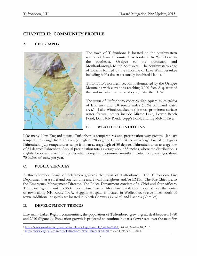
The town of Tuftonboro is located on the southwestern section of Carroll County. It is bordered by Wolfeboro to the southeast, Ossipee to the northeast, and Moultonborough to the northwest. The southwestern edge of town is formed by the shoreline of Lake Winnipesaukee including half a dozen seasonally inhabited islands. Tuftonboro’s northern section is dominated by the Ossipee Mountains with elevations reaching 3,000 feet. A quarter of the land in Tuftonboro has slopes greater than 15%. The town of Tuftonboro contains 40.6 square miles (82%) of land area and 8.8 square miles (18%) of inland water area.3 Lake Winnipesaukee is the most prominent surface water feature, others include Mirror Lake, Lqwer Beech Pond, Dan Hole Pond, Copp’s Pond, and the Melvin River. B. WEATHER CONDITIONS
Like many New England towns, Tuftonboro’s temperatures and precipitation vary greatly. January temperatures range from an average high of 28 degrees Fahrenheit to an average low of 5 degrees Fahrenheit. July temperatures range from an average high of 80 degrees Fahrenheit to an average low of 53 degrees Fahrenheit. Annual precipitation totals average about 53 inches, where the distribution is slightly lower in the winter months when compared to summer months.1 Tuftonboro averages about 70 inches of snow per year.2 C. PUBLIC SERVICES A three-member Board of Selectmen governs the town of Tuftonboro. The Tuftonboro Fire Department has a chief and one full-time and 29 call firefighters and/or EMTs. The Fire Chief is also the Emergency Management Director. The Police Department consists of a Chief and four officers. The Road Agent maintains 35.4 miles of town roads. Most town facilities are located near the center of town along NH Route 109A. Huggins Hospital is located in Wolfeboro, twelve miles south of town. Additional hospitals are located in North Conway (33 miles) and Laconia (39 miles). D. DEVELOPMENT TRENDS Like many Lakes Region communities, the population of Tuftonboro grew a great deal between 1980 and 2010 (Figure 1). Population growth is projected to continue but at a slower rate over the next few
1 http://www.weather.com/weather/wxclimatology/monthly/graph/03816, visited October 10, 2013. 2 http://www.city-data.com/city/Tuftonboro-New-Hampshire.html, visited October 10, 2013.
Tuftonboro, NH Hazard Mitigation Plan Update, 2015
8
decades (Figure 2). The median age of residents in 2010 was 50.8 years, up from 47.7 on 2000. The population density of Tuftonboro is 58.3 persons per square mile of land area.3 Table 1: Tuftonboro, NH Year-Round Population, 1980-2010
Year 1980 1990 2000 2010
Population 1,500 1,842 2,148 2,387
% Changed --- 23% 17% 11%
Table 2: Tuftonboro, NH Projected Year-Round Population, 2020-20404
Year 2010 2020 2030 2040
Population 2,387 2,547 2,719 2,796
% Change --- 7% 7% 3%
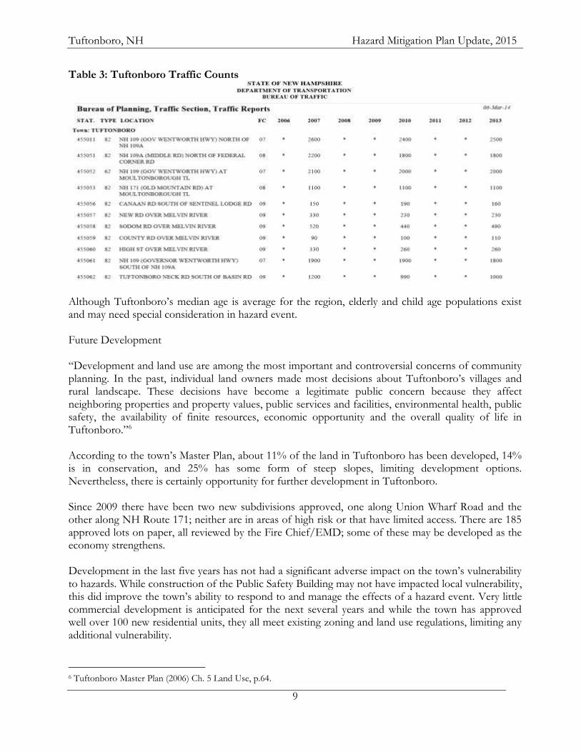
Between 2009 and 2012 a total of 19 Single Family Housing Permits were issued in Tuftonboro, down from the 108 that had been granted in the previous four years. There was one Manufactured Housing Unit permit issued during this time period; zero in the prior four years. There have been no Commercial or Industrial permits issued in this time period. Of Tuftonboro’s 2,435 housing units in 2010, the Census reported that 1,293 or 53% were seasonal, slightly higher than in 2000. This is nearly twice the seasonal housing rate of the Lakes Region (29%). The 2006 Master Plan estimated that the seasonal population was likely more than 6,100 not including transient visitors and guests.5 Three state routes run through Tuftonboro, generally parallel to each other. NH Route 109 and 109A run from Wolfeboro to Moultonborough with Route 109 running along the lakeshore and Route 109A going through the center of town, serving most of the town’s critical facilities. NH Route 171 runs across the northern section of town connecting Moultonborough with Ossipee. Table 3 indicates the Average Annual Daily Traffic counts, measured in vehicles per day. As this is a projected average over the entire year, there are certainly many summer days when the volume of traffic on any one of these roads far exceeds these figures. These records from the NH Department of Transportation indicate little change in traffic volumes since 2007 along the major roadways in Tuftonboro.
3 New Hampshire Community Profiles, NH Employment and Security Office, http://www.nhes.state.nh.us/elmi/htmlprofiles/Tuftonboro.html, visited October 9, 2013. 4 New Hampshire Office of Energy and Planning, March 2013 http://www.nh.gov/oep/data-center/documents/2013-projections-municipalities.pdf. 5 Tuftonboro Master Plan (2012) http://www.tuftonboro.org/pages/TuftonboroNH_Boards/Planning/toc, Chapter 2, p.11.
Tuftonboro, NH Hazard Mitigation Plan Update, 2015
9
Table 3: Tuftonboro Traffic Counts
Although Tuftonboro’s median age is average for the region, elderly and child age populations exist and may need special consideration in hazard event. Future Development “Development and land use are among the most important and controversial concerns of community planning. In the past, individual land owners made most decisions about Tuftonboro’s villages and rural landscape. These decisions have become a legitimate public concern because they affect neighboring properties and property values, public services and facilities, environmental health, public safety, the availability of finite resources, economic opportunity and the overall quality of life in Tuftonboro.”6 According to the town’s Master Plan, about 11% of the land in Tuftonboro has been developed, 14% is in conservation, and 25% has some form of steep slopes, limiting development options. Nevertheless, there is certainly opportunity for further development in Tuftonboro. Since 2009 there have been two new subdivisions approved, one along Union Wharf Road and the other along NH Route 171; neither are in areas of high risk or that have limited access. There are 185 approved lots on paper, all reviewed by the Fire Chief/EMD; some of these may be developed as the economy strengthens. Development in the last five years has not had a significant adverse impact on the town’s vulnerability to hazards. While construction of the Public Safety Building may not have impacted local vulnerability, this did improve the town’s ability to respond to and manage the effects of a hazard event. Very little commercial development is anticipated for the next several years and while the town has approved well over 100 new residential units, they all meet existing zoning and land use regulations, limiting any additional vulnerability.
6 Tuftonboro Master Plan (2006) Ch. 5 Land Use, p.64.
Tuftonboro, NH Hazard Mitigation Plan Update, 2015
10
CHAPTER III: RISK ASSESSMENT
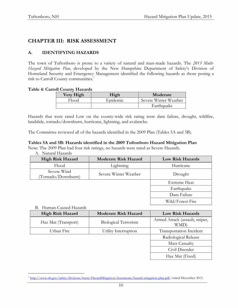
A. IDENTIFYING HAZARDS The town of Tuftonboro is prone to a variety of natural and man-made hazards. The 2013 Multi-Hazard Mitigation Plan, developed by the New Hampshire Department of Safety’s Division of Homeland Security and Emergency Management identified the following hazards as those posing a risk to Carroll County communities.7 Table 4: Carroll County Hazards
Very High High Moderate
Flood Epidemic Severe Winter Weather
Earthquake
Hazards that were rated Low on the county-wide risk rating were dam failure, drought, wildfire, landslide, tornado/downburst, hurricane, lightning, and avalanche. The Committee reviewed all of the hazards identified in the 2009 Plan (Tables 5A and 5B). Tables 5A and 5B: Hazards identified in the 2009 Tuftonboro Hazard Mitigation Plan Note: The 2009 Plan had four risk ratings, no hazards were rated as Severe Hazards.
A. Natural Hazards
High Risk Hazard Moderate Risk Hazard Low Risk Hazards
Flood Lightning Hurricane
Severe Wind (Tornado/Downburst)
Severe Winter Weather Drought
Extreme Heat
Earthquake
Dam Failure
Wild/Forest Fire
B. Human-Caused Hazards
High Risk Hazard Moderate Risk Hazard Low Risk Hazards
Haz Mat (Transport) Biological Terrorism Armed Attack (assault, sniper,
WMD)
Urban Fire Utility Interruption Transportation Incident
Radiological Release
Mass Casualty
Civil Disorder
Haz Mat (Fixed)
7 http://www.nh.gov/safety/divisions/hsem/HazardMitigation/documents/hazard-mitigation-plan.pdf, visited December 2013.
Tuftonboro, NH Hazard Mitigation Plan Update, 2015
11
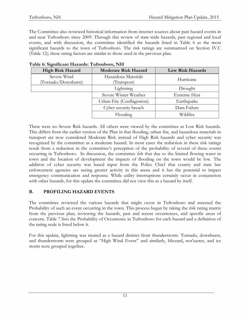
The Committee also reviewed historical information from internet sources about past hazard events in and near Tuftonboro since 2009. Through this review of state-wide hazards, past regional and local events, and with discussion, the committee identified the hazards listed in Table 6 as the most significant hazards to the town of Tuftonboro. The risk ratings are summarized on Section IV.C (Table 12); these rating factors are similar to those used in the previous plan. Table 6: Significant Hazards: Tuftonboro, NH
High Risk Hazard Moderate Risk Hazard Low Risk Hazards
Severe Wind (Tornado/Downburst)
Hazardous Materials (Transport)
Hurricane
Lightning Drought
Severe Winter Weather Extreme Heat
Urban Fire (Conflagration) Earthquake
Cyber security breach Dam Failure
Flooding Wildfire
There were no Severe Risk hazards. All others were viewed by the committee as Low Risk hazards. This differs from the earlier version of the Plan in that flooding, urban fire, and hazardous materials in transport are now considered Moderate Risk instead of High Risk hazards and cyber security was recognized by the committee as a moderate hazard. In most cases the reduction in these risk ratings result from a reduction in the committee’s perception of the probability of several of these events occurring in Tuftonboro. In discussion, the committee felt that due to the limited flowing water in town and the location of development the impacts of flooding on the town would be low. The addition of cyber security was based input from the Police Chief that county and state law enforcement agencies are seeing greater activity in this arena and it has the potential to impact emergency communication and response. While utility interruptions certainly occur in conjunction with other hazards, for this update the committee did not view this as a hazard by itself. B. PROFILING HAZARD EVENTS The committee reviewed the various hazards that might occur in Tuftonboro and assessed the Probability of such an event occurring in the town. This process began by taking the risk rating matrix from the previous plan, reviewing the hazards, past and recent occurrences, and specific areas of concern. Table 7 lists the Probability of Occurrence in Tuftonboro for each hazard and a definition of the rating scale is listed below it. For this update, lightning was treated as a hazard distinct from thunderstorm. Tornado, downburst, and thunderstorm were grouped as “High Wind Event” and similarly, blizzard, nor’easter, and ice storm were grouped together.
Tuftonboro, NH Hazard Mitigation Plan Update, 2015
12
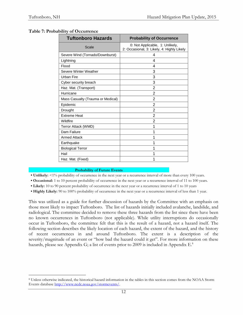
Table 7: Probability of Occurrence
Tuftonboro Hazards Probability of Occurrence
Scale 0: Not Applicable, 1: Unlikely,
2: Occasional, 3: Likely, 4: Highly Likely
Severe Wind (Tornado/Downburst) 4
Lightning 4
Flood 4
Severe Winter Weather 3
Urban Fire 3
Cyber security breach 3
Haz. Mat. (Transport) 2
Hurricane 2
Mass Casualty (Trauma or Medical) 2
Epidemic 2
Drought 2
Extreme Heat 2
Wildfire 2
Terror Attack (WMD) 1
Dam Failure 1
Armed Attack 1
Earthquake 1
Biological Terror 1
Hail 1
Haz. Mat. (Fixed) 1
Probability of Future Events
• Unlikely: <1% probability of occurrence in the next year or a recurrence interval of more than every 100 years.
• Occasional: 1 to 10 percent probability of occurrence in the next year or a recurrence interval of 11 to 100 years.
• Likely: 10 to 90 percent probability of occurrence in the next year or a recurrence interval of 1 to 10 years
• Highly Likely: 90 to 100% probability of occurrence in the next year or a recurrence interval of less than 1 year.
This was utilized as a guide for further discussion of hazards by the Committee with an emphasis on those most likely to impact Tuftonboro. The list of hazards initially included avalanche, landslide, and radiological. The committee decided to remove these three hazards from the list since there have been no known occurrences in Tuftonboro (not applicable). While utility interruptions do occasionally occur in Tuftonboro, the committee felt that this is the result of a hazard, not a hazard itself. The following section describes the likely location of each hazard, the extent of the hazard, and the history of recent occurrences in and around Tuftonboro. The extent is a description of the severity/magnitude of an event or “how bad the hazard could it get”. For more information on these hazards, please see Appendix G; a list of events prior to 2009 is included in Appendix E.8
8 Unless otherwise indicated, the historical hazard information in the tables in this section comes from the NOAA Storm Events database http://www.ncdc.noaa.gov/stormevents/.
Tuftonboro, NH Hazard Mitigation Plan Update, 2015
13
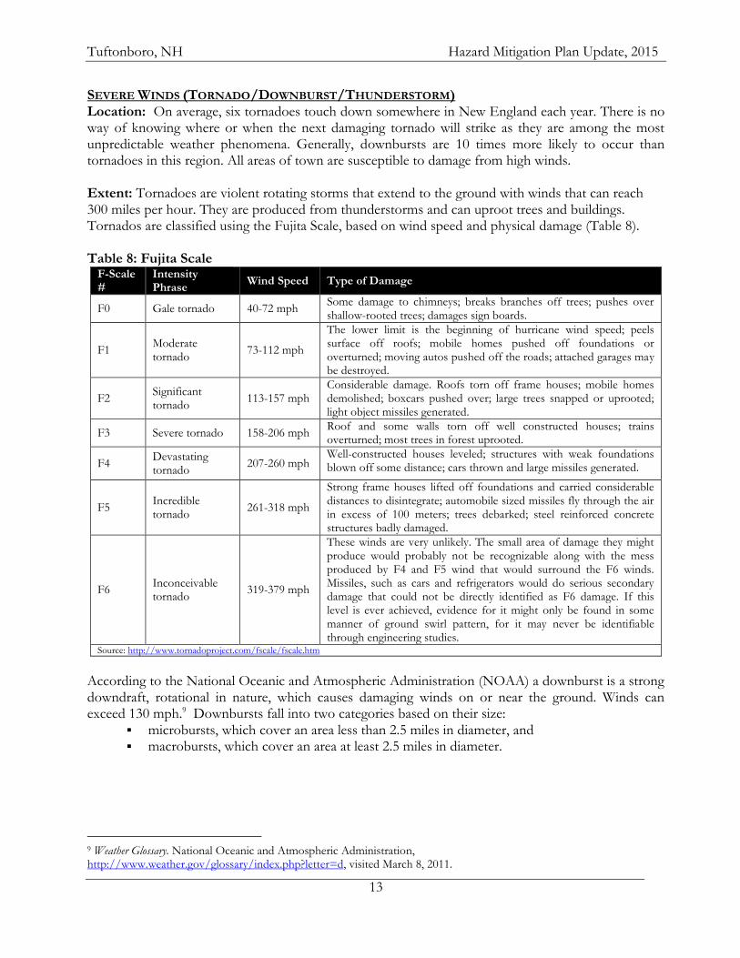
SEVERE WINDS (TORNADO/DOWNBURST/THUNDERSTORM) Location: On average, six tornadoes touch down somewhere in New England each year. There is no way of knowing where or when the next damaging tornado will strike as they are among the most unpredictable weather phenomena. Generally, downbursts are 10 times more likely to occur than tornadoes in this region. All areas of town are susceptible to damage from high winds. Extent: Tornadoes are violent rotating storms that extend to the ground with winds that can reach 300 miles per hour. They are produced from thunderstorms and can uproot trees and buildings. Tornados are classified using the Fujita Scale, based on wind speed and physical damage (Table 8). Table 8: Fujita Scale
F-Scale #
Intensity Phrase
Wind Speed Type of Damage
F0 Gale tornado 40-72 mph Some damage to chimneys; breaks branches off trees; pushes over shallow-rooted trees; damages sign boards.
F1 Moderate tornado
73-112 mph
The lower limit is the beginning of hurricane wind speed; peels surface off roofs; mobile homes pushed off foundations or overturned; moving autos pushed off the roads; attached garages may be destroyed.
F2 Significant tornado
113-157 mph Considerable damage. Roofs torn off frame houses; mobile homes demolished; boxcars pushed over; large trees snapped or uprooted; light object missiles generated.
F3 Severe tornado 158-206 mph Roof and some walls torn off well constructed houses; trains overturned; most trees in forest uprooted.
F4 Devastating tornado
207-260 mph Well-constructed houses leveled; structures with weak foundations blown off some distance; cars thrown and large missiles generated.
F5 Incredible tornado
261-318 mph
Strong frame houses lifted off foundations and carried considerable distances to disintegrate; automobile sized missiles fly through the air in excess of 100 meters; trees debarked; steel reinforced concrete structures badly damaged.
F6 Inconceivable tornado
319-379 mph
These winds are very unlikely. The small area of damage they might produce would probably not be recognizable along with the mess produced by F4 and F5 wind that would surround the F6 winds. Missiles, such as cars and refrigerators would do serious secondary damage that could not be directly identified as F6 damage. If this level is ever achieved, evidence for it might only be found in some manner of ground swirl pattern, for it may never be identifiable through engineering studies.
Source: http://www.tornadoproject.com/fscale/fscale.htm
According to the National Oceanic and Atmospheric Administration (NOAA) a downburst is a strong downdraft, rotational in nature, which causes damaging winds on or near the ground. Winds can exceed 130 mph.9 Downbursts fall into two categories based on their size:
microbursts, which cover an area less than 2.5 miles in diameter, and macrobursts, which cover an area at least 2.5 miles in diameter.
9 Weather Glossary. National Oceanic and Atmospheric Administration, http://www.weather.gov/glossary/index.php?letter=d, visited March 8, 2011.
Tuftonboro, NH Hazard Mitigation Plan Update, 2015
14
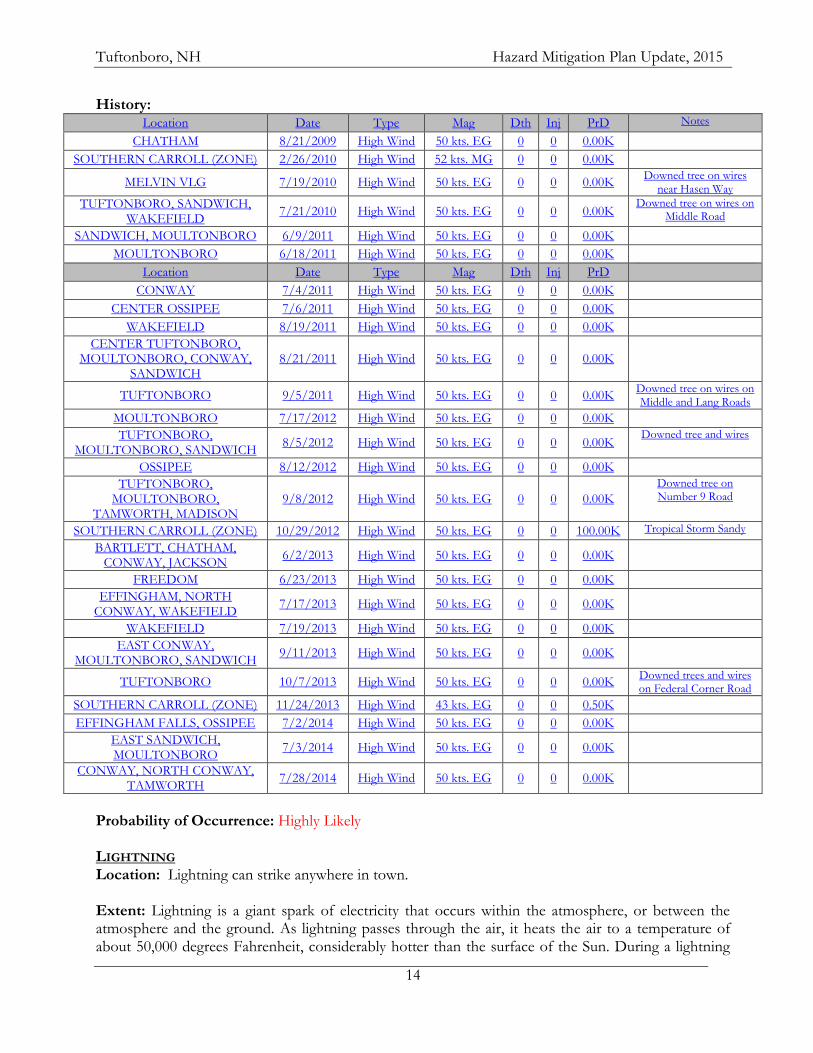
History: Location Date Type Mag Dth Inj PrD
Notes
CHATHAM 8/21/2009 High Wind 50 kts. EG 0 0 0.00K
SOUTHERN CARROLL (ZONE) 2/26/2010 High Wind 52 kts. MG 0 0 0.00K
MELVIN VLG 7/19/2010 High Wind 50 kts. EG 0 0 0.00K Downed tree on wires
near Hasen Way
TUFTONBORO, SANDWICH, WAKEFIELD
7/21/2010 High Wind 50 kts. EG 0 0 0.00K Downed tree on wires on
Middle Road
SANDWICH, MOULTONBORO 6/9/2011 High Wind 50 kts. EG 0 0 0.00K
MOULTONBORO 6/18/2011 High Wind 50 kts. EG 0 0 0.00K
Location Date Type Mag Dth Inj PrD
CONWAY 7/4/2011 High Wind 50 kts. EG 0 0 0.00K
CENTER OSSIPEE 7/6/2011 High Wind 50 kts. EG 0 0 0.00K
WAKEFIELD 8/19/2011 High Wind 50 kts. EG 0 0 0.00K
CENTER TUFTONBORO, MOULTONBORO, CONWAY,
SANDWICH 8/21/2011 High Wind 50 kts. EG 0 0 0.00K
TUFTONBORO 9/5/2011 High Wind 50 kts. EG 0 0 0.00K Downed tree on wires on Middle and Lang Roads
MOULTONBORO 7/17/2012 High Wind 50 kts. EG 0 0 0.00K
TUFTONBORO, MOULTONBORO, SANDWICH
8/5/2012 High Wind 50 kts. EG 0 0 0.00K Downed tree and wires
OSSIPEE 8/12/2012 High Wind 50 kts. EG 0 0 0.00K
TUFTONBORO, MOULTONBORO,
TAMWORTH, MADISON 9/8/2012 High Wind 50 kts. EG 0 0 0.00K
Downed tree on Number 9 Road
SOUTHERN CARROLL (ZONE) 10/29/2012 High Wind 50 kts. EG 0 0 100.00K Tropical Storm Sandy
BARTLETT, CHATHAM, CONWAY, JACKSON
6/2/2013 High Wind 50 kts. EG 0 0 0.00K
FREEDOM 6/23/2013 High Wind 50 kts. EG 0 0 0.00K
EFFINGHAM, NORTH CONWAY, WAKEFIELD
7/17/2013 High Wind 50 kts. EG 0 0 0.00K
WAKEFIELD 7/19/2013 High Wind 50 kts. EG 0 0 0.00K
EAST CONWAY, MOULTONBORO, SANDWICH
9/11/2013 High Wind 50 kts. EG 0 0 0.00K
TUFTONBORO 10/7/2013 High Wind 50 kts. EG 0 0 0.00K Downed trees and wires on Federal Corner Road
SOUTHERN CARROLL (ZONE) 11/24/2013 High Wind 43 kts. EG 0 0 0.50K
EFFINGHAM FALLS, OSSIPEE 7/2/2014 High Wind 50 kts. EG 0 0 0.00K
EAST SANDWICH, MOULTONBORO
7/3/2014 High Wind 50 kts. EG 0 0 0.00K
CONWAY, NORTH CONWAY, TAMWORTH
7/28/2014 High Wind 50 kts. EG 0 0 0.00K
Probability of Occurrence: Highly Likely LIGHTNING Location: Lightning can strike anywhere in town. Extent: Lightning is a giant spark of electricity that occurs within the atmosphere, or between the atmosphere and the ground. As lightning passes through the air, it heats the air to a temperature of about 50,000 degrees Fahrenheit, considerably hotter than the surface of the Sun. During a lightning
Tuftonboro, NH Hazard Mitigation Plan Update, 2015
15
discharge, the sudden heating of the air causes it to expand rapidly, resulting in thunder.10 Thunderstorms occur mainly in the summertime; some can be anticipated and detected well in advance while others are “pop-up” storms that are limited in size and duration. Exactly where and when lightning will strike is unknown. Most thunderstorms do not last long in any one location but move through fairly quickly. These giant sparks of electricity can result in fire or electrical damage to property or electrocution of people. The National Weather Service does utilize a six-point scale for characterizing lightning activity called the Lightning Activity Level (LAL) based on frequency of ground strikes along with rainfall and ground conditions.11 Table 9: Lightning Activity Level scale
LAL 1 No thunderstorms
LAL 2 Isolated thunderstorms. Light rain will occasionally reach the ground. Lightning is very infrequent, 1 to 5 cloud to ground strikes in a five minute period.
LAL 3 Widely scattered thunderstorms. Light to moderate rain will reach the ground. Lightning is infrequent, 6 to 10 cloud to ground strikes in a 5 minute period.
LAL 4 Scattered thunderstorms. Moderate rain is commonly produced Lightning is frequent, 11 to 15 cloud to ground strikes in a 5 minute period.
LAL 5 Numerous thunderstorms. Rainfall is moderate to heavy. Lightning is frequent and intense, greater than 15 cloud to ground strikes in a 5 minute period.
LAL 6 Dry lightning (same as LAL 3 but without rain). This type of lightning has the potential for extreme fire activity and is normally highlighted in fire weather forecasts with a Red Flag Warning.
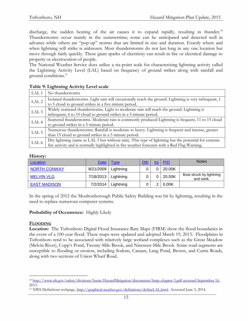
History:
Location Date Type Dth Inj PrD
Notes
NORTH CONWAY 8/21/2009 Lightning 0 0 20.00K
MELVIN VLG 7/18/2013 Lightning 0 0 20.00K Boat struck by lightning
and sank.
EAST MADISON 7/2/2014 Lightning 0 2 0.00K
In the spring of 2012 the Moultonborough Public Safety Building was hit by lightning, resulting in the need to replace numerous computer systems. Probability of Occurrence: Highly Likely FLOODING Location: The Tuftonboro Digital Flood Insurance Rate Maps (FIRM) show the flood boundaries in the event of a 100-year flood. These maps were updated and adopted March 19, 2013. Floodplains in Tuftonboro tend to be associated with relatively large wetland complexes such as the Great Meadow (Melvin River), Copp’s Pond, Twenty-Mile Brook, and Nineteen-Mile Brook. Some road segments are susceptible to flooding or erosion, including Sodom, Canaan, Lang Pond, Brown, and Curtis Roads, along with two sections of Union Wharf Road.
10 http://www.nh.gov/safety/divisions/hsem/HazardMitigation/documents/hmp-chapter-3.pdf accessed September 16, 2013. 11 NWS Definitions webpage, http://graphical.weather.gov/definitions/defineLAL.html. Accessed June 3, 2014.
Tuftonboro, NH Hazard Mitigation Plan Update, 2015
16
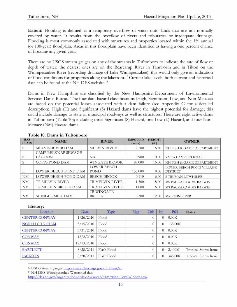
Extent: Flooding is defined as a temporary overflow of water onto lands that are not normally covered by water. It results from the overflow of rivers and tributaries or inadequate drainage. Flooding is most commonly associated with structures and properties located within the 1% annual (or 100-year) floodplain. Areas in this floodplain have been identified as having a one percent chance of flooding any given year. There are no USGS stream gauges on any of the streams in Tuftonboro to indicate the rate of flow or depth of water; the nearest ones are on the Bearcamp River in Tamworth and in Tilton on the Winnipesaukee River (recording drainage of Lake Winnipesaukee); this would only give an indication of flood conditions for properties along the lakefront.12 Current lake levels, both current and historical data can be found at the NH DES website.13 Dams in New Hampshire are classified by the New Hampshire Department of Environmental Services Dams Bureau. The four dam hazard classifications (High, Significant, Low, and Non-Menace) are based on the potential losses associated with a dam failure (see Appendix G for a detailed description). High (H) and Significant (S) Hazard dams have the highest potential for damage; this could include damage to state or municipal roadways as well as structures. There are eight active dams in Tuftonboro (Table 10); including three Significant (S) Hazard, one Low (L) Hazard, and four Non-Menace (NM) Hazard dams. Table 10: Dams in Tuftonboro
HAZ CLASS NAME RIVER
IMPOUND (acres)
HEIGHT (ft.)
OWNER
S MELVIN RIVER DAM MELVIN RIVER 2.500 16.50 NH FISH & GAME DEPARTMENT
S CAMP BELKNAP SEWAGE LAGOON NA 0.900 10.00 YMCA CAMP BELKNAP
S COPPS POND DAM WINGATE BROOK 89.000 16.00 NH FISH & GAME DEPARTMENT
L LOWER BEECH POND DAM LOWER BEECH POND 155.000 8.00
LOWER BEECH POND VILLAGE DISTRICT
NM LOWER BEECH POND DAM BEECH BROOK 0.110 6.00 S TRUMAN LITWHILER
NM TR MELVIN RIVER TR MELVIN RIVER 1.300 8.00 MS PACKARD & MS BARWIS
NM TR MELVIN BROOK DAM TR MELVIN RIVER 1.000 6.00 MS PACKARD & MS BARWIS
NM SHINGLE MILL DAM TR WINGATE BROOK 0.300 12.00 MR JOHN PIPER
History:
Location Date Type Mag Dth Inj PrD Notes
CENTER CONWAY 1/26/2010 Flood 0 0 0.00K
NORTH CHATHAM 3/15/2010 Flood 0 0 135.00K
CENTER CONWAY 3/31/2010 Flood 0 0 0.00K
CONWAY 12/2/2010 Flood 0 0 0.00K
CONWAY 12/13/2010 Flood 0 0 0.00K
BARTLETT 8/28/2011 Flash Flood 0 0 2.400M Tropical Storm Irene
JACKSON 8/28/2011 Flash Flood 0 0 345.00K Tropical Storm Irene
12 USGS stream gauges http://waterdata.usgs.gov/nh/nwis/rt. 13 NH DES Winnipesaukee Watershed data http://des.nh.gov/organization/divisions/water/dam/winni_levels/index.htm.
Tuftonboro, NH Hazard Mitigation Plan Update, 2015
17
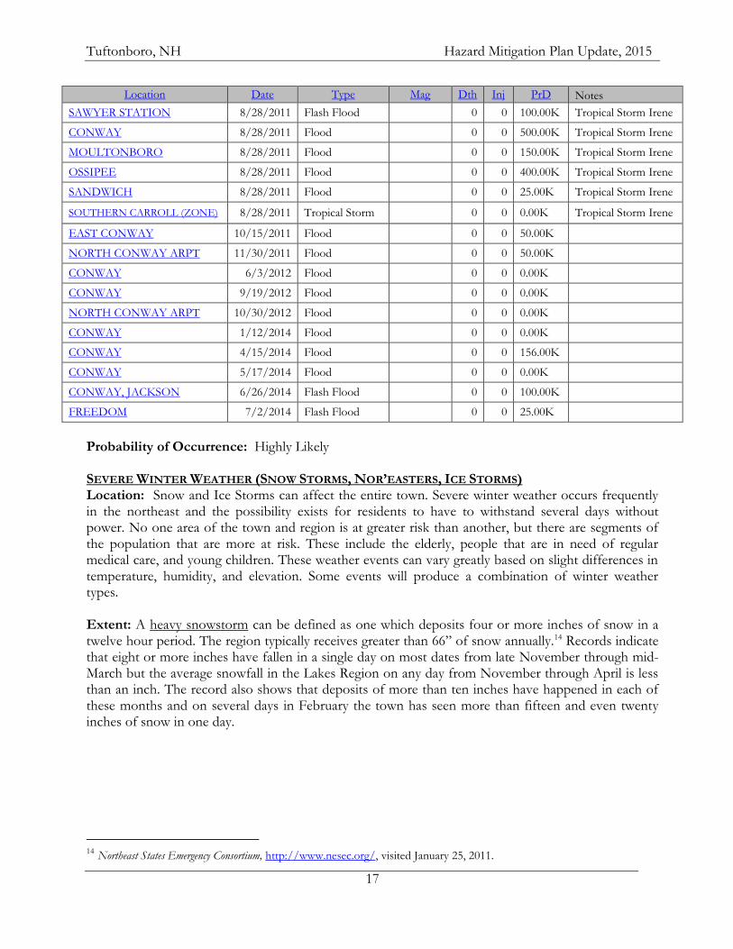
Location Date Type Mag Dth Inj PrD Notes
SAWYER STATION 8/28/2011 Flash Flood 0 0 100.00K Tropical Storm Irene
CONWAY 8/28/2011 Flood 0 0 500.00K Tropical Storm Irene
MOULTONBORO 8/28/2011 Flood 0 0 150.00K Tropical Storm Irene
OSSIPEE 8/28/2011 Flood 0 0 400.00K Tropical Storm Irene
SANDWICH 8/28/2011 Flood 0 0 25.00K Tropical Storm Irene
SOUTHERN CARROLL (ZONE) 8/28/2011 Tropical Storm 0 0 0.00K Tropical Storm Irene
EAST CONWAY 10/15/2011 Flood 0 0 50.00K
NORTH CONWAY ARPT 11/30/2011 Flood 0 0 50.00K
CONWAY 6/3/2012 Flood 0 0 0.00K
CONWAY 9/19/2012 Flood 0 0 0.00K
NORTH CONWAY ARPT 10/30/2012 Flood 0 0 0.00K
CONWAY 1/12/2014 Flood 0 0 0.00K
CONWAY 4/15/2014 Flood 0 0 156.00K
CONWAY 5/17/2014 Flood 0 0 0.00K
CONWAY, JACKSON 6/26/2014 Flash Flood 0 0 100.00K
FREEDOM 7/2/2014 Flash Flood 0 0 25.00K
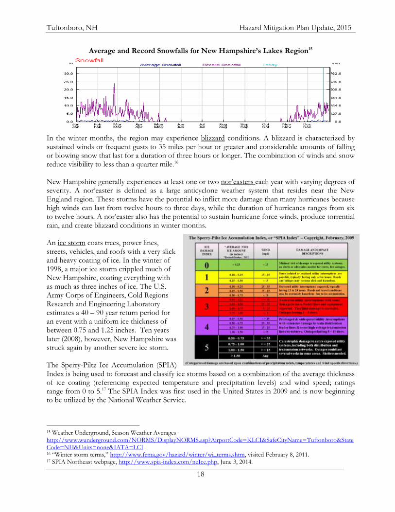
Probability of Occurrence: Highly Likely SEVERE WINTER WEATHER (SNOW STORMS, NOR’EASTERS, ICE STORMS) Location: Snow and Ice Storms can affect the entire town. Severe winter weather occurs frequently in the northeast and the possibility exists for residents to have to withstand several days without power. No one area of the town and region is at greater risk than another, but there are segments of the population that are more at risk. These include the elderly, people that are in need of regular medical care, and young children. These weather events can vary greatly based on slight differences in temperature, humidity, and elevation. Some events will produce a combination of winter weather types. Extent: A heavy snowstorm can be defined as one which deposits four or more inches of snow in a twelve hour period. The region typically receives greater than 66” of snow annually.14 Records indicate that eight or more inches have fallen in a single day on most dates from late November through mid-March but the average snowfall in the Lakes Region on any day from November through April is less than an inch. The record also shows that deposits of more than ten inches have happened in each of these months and on several days in February the town has seen more than fifteen and even twenty inches of snow in one day.
14 Northeast States Emergency Consortium, http://www.nesec.org/, visited January 25, 2011.
Tuftonboro, NH Hazard Mitigation Plan Update, 2015
18
Average and Record Snowfalls for New Hampshire’s Lakes Region15
In the winter months, the region may experience blizzard conditions. A blizzard is characterized by sustained winds or frequent gusts to 35 miles per hour or greater and considerable amounts of falling or blowing snow that last for a duration of three hours or longer. The combination of winds and snow reduce visibility to less than a quarter mile.16 New Hampshire generally experiences at least one or two nor’easters each year with varying degrees of severity. A nor’easter is defined as a large anticyclone weather system that resides near the New England region. These storms have the potential to inflict more damage than many hurricanes because high winds can last from twelve hours to three days, while the duration of hurricanes ranges from six to twelve hours. A nor’easter also has the potential to sustain hurricane force winds, produce torrential rain, and create blizzard conditions in winter months. An ice storm coats trees, power lines, streets, vehicles, and roofs with a very slick and heavy coating of ice. In the winter of 1998, a major ice storm crippled much of New Hampshire, coating everything with as much as three inches of ice. The U.S. Army Corps of Engineers, Cold Regions Research and Engineering Laboratory estimates a 40 – 90 year return period for an event with a uniform ice thickness of between 0.75 and 1.25 inches. Ten years later (2008), however, New Hampshire was struck again by another severe ice storm. The Sperry-Piltz Ice Accumulation (SPIA) Index is being used to forecast and classify ice storms based on a combination of the average thickness of ice coating (referencing expected temperature and precipitation levels) and wind speed; ratings range from 0 to 5.17 The SPIA Index was first used in the United States in 2009 and is now beginning to be utilized by the National Weather Service.
15 Weather Underground, Season Weather Averages http://www.wunderground.com/NORMS/DisplayNORMS.asp?AirportCode=KLCI&SafeCityName=Tuftonboro&StateCode=NH&Units=none&IATA=LCI. 16 “Winter storm terms,” http://www.fema.gov/hazard/winter/wi_terms.shtm, visited February 8, 2011. 17 SPIA Northeast webpage, http://www.spia-index.com/neIce.php, June 3, 2014.
Tuftonboro, NH Hazard Mitigation Plan Update, 2015
19
History: Type Date
Location Magnitude
Winter Storm 12/9/2009 SOUTHERN CARROLL (ZONE) 6-10 inches
Heavy Snow 1/17/2010 SOUTHERN CARROLL (ZONE) 6-10 inches
Heavy Snow 2/23/2010 Statewide
Nor'easter 12-24 inches. Winds over 45 mph. Statewide - Snow and ice; 330,000 without power $2 million; Presidential Disaster
Heavy Snow 12/26/2010 SOUTHERN CARROLL (ZONE) 6-16 inches
Heavy Snow 1/12/2011 SOUTHERN CARROLL (ZONE) 10-19 inches
Heavy Snow 1/18/2011 SOUTHERN CARROLL (ZONE) 4-8 inches
Heavy Snow 2/2/2011 SOUTHERN CARROLL (ZONE) 8-12 inches
Heavy Snow 2/25/2011 SOUTHERN CARROLL (ZONE) 8-12 inches
Heavy Snow 4/1/2011 SOUTHERN CARROLL (ZONE) 6-12 inches
Heavy Snow 10/29/2011 SOUTHERN CARROLL (ZONE) 16-18 inches
Heavy Snow 11/22/2011 SOUTHERN CARROLL (ZONE) 6-12 inches
Heavy Snow 1/12/2012 SOUTHERN CARROLL (ZONE) 6-8 inches
Heavy Snow 1/19/2012 SOUTHERN CARROLL (ZONE) 6-8 inches
Heavy Snow 3/1/2012 SOUTHERN CARROLL (ZONE) 8-14 inches
Winter Storm 12/26/2012 SOUTHERN CARROLL (ZONE) 6-14 inches
Heavy Snow 2/8/2013 SOUTHERN CARROLL (ZONE) Blizzard conditions, 18 inches
Heavy Snow 2/23/2013 SOUTHERN CARROLL (ZONE) 6-14 inches
Heavy Snow 2/27/2013 SOUTHERN CARROLL (ZONE) 6-10 inches
Heavy Snow 3/19/2013 SOUTHERN CARROLL (ZONE) 10-12 inches
Heavy Snow 12/14/2013 SOUTHERN CARROLL (ZONE) 8-14 inches
Heavy Snow 12/29/2013 SOUTHERN CARROLL (ZONE) 5-10 inches
Heavy Snow 1/2/2014 SOUTHERN CARROLL (ZONE) 6-14 inches
Heavy Snow 2/5/2014 SOUTHERN CARROLL (ZONE) 6-12 inches
Heavy Snow 2/13/2014 SOUTHERN CARROLL (ZONE) 6-14 inches
Heavy Snow 2/18/2014 SOUTHERN CARROLL (ZONE) 6-14 inches
Heavy Snow 3/19/2014 SOUTHERN CARROLL (ZONE) 6-18 inches
Probability of Occurrence: Likely FIRE (WILDFIRE/CONFLAGRATION) Location: Much of Tuftonboro is wooded and the northern section is characterized by steep slopes. Tuftonboro does not have any urban areas; however, the mobile home park of North Country Village and some waterfront homes are close together and some are difficult to access, especially those on islands. Extent: A wildfire is defined as a fire in wooded, potentially remote areas that may endanger lives. New Hampshire has about 500 wild land fires each year; most of these burn less than half an
Alton Bay Christian Conference Center, 2009
Tuftonboro, NH Hazard Mitigation Plan Update, 2015
20
acre. Much of the Lakes Region is forested and susceptible to fire. The National Wildfire Coordinating Group (NWCG) has defined seven classes of wildfire based on size:
Class A - one-fourth acre or less;
Class B - more than one-fourth acre, but less than 10 acres;
Class C - 10 acres or more, but less than 100 acres;
Class D - 100 acres or more, but less than 300 acres;
Class E - 300 acres or more, but less than 1,000 acres;
Class F - 1,000 acres or more, but less than 5,000 acres;
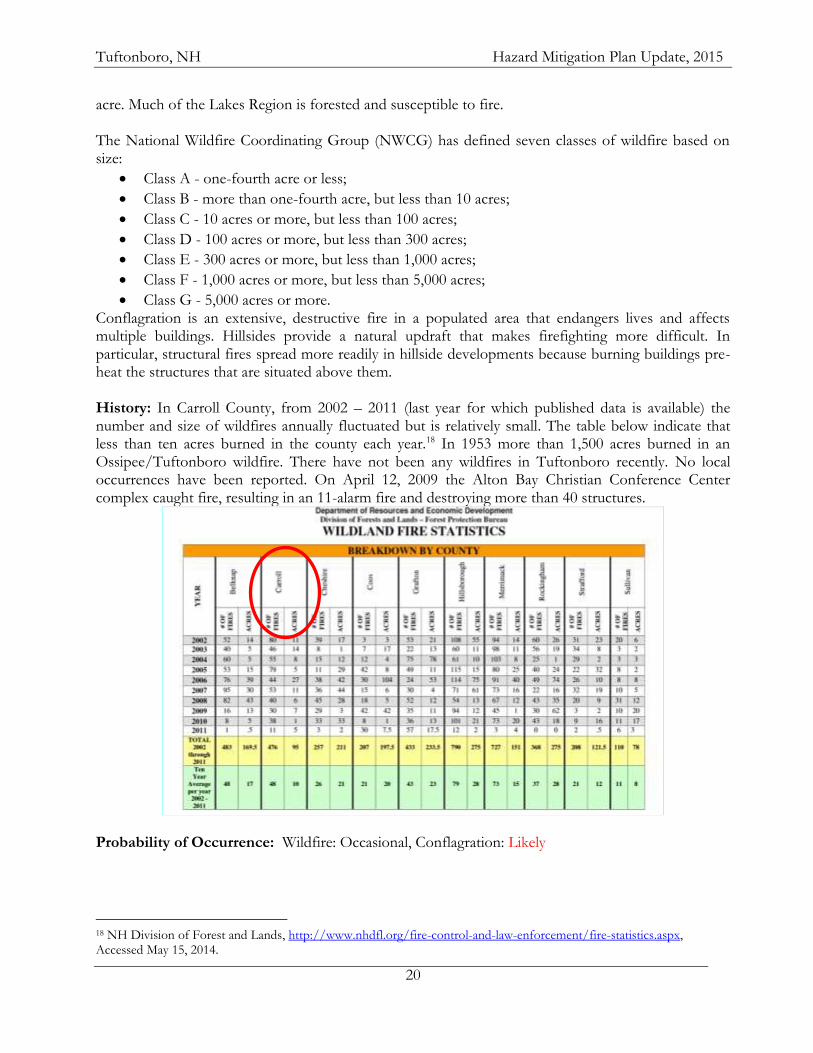
Class G - 5,000 acres or more. Conflagration is an extensive, destructive fire in a populated area that endangers lives and affects multiple buildings. Hillsides provide a natural updraft that makes firefighting more difficult. In particular, structural fires spread more readily in hillside developments because burning buildings pre-heat the structures that are situated above them. History: In Carroll County, from 2002 – 2011 (last year for which published data is available) the number and size of wildfires annually fluctuated but is relatively small. The table below indicate that less than ten acres burned in the county each year.18 In 1953 more than 1,500 acres burned in an Ossipee/Tuftonboro wildfire. There have not been any wildfires in Tuftonboro recently. No local occurrences have been reported. On April 12, 2009 the Alton Bay Christian Conference Center complex caught fire, resulting in an 11-alarm fire and destroying more than 40 structures.
Probability of Occurrence: Wildfire: Occasional, Conflagration: Likely
18 NH Division of Forest and Lands, http://www.nhdfl.org/fire-control-and-law-enforcement/fire-statistics.aspx, Accessed May 15, 2014.
Tuftonboro, NH Hazard Mitigation Plan Update, 2015
21
HAZARDOUS MATERIALS IN TRANSPORT Location: Major roadways, especially in populated areas or near water bodies are areas of concern. A spill along NH Route 109 as it hugs the Lake Winnipesaukee shoreline could impact the water and shoreline. Extent: Oil or chemical spills along the routes noted above could result in the contamination of wells or waterbodies in the watershed. NH Route 109 runs along both Lake Winnipesaukee and Mirror Lake while substantial portions of NH Routes 109A and 171 run over top of aquifers.19 In addition to distributing fuel to central locations in the region, tankers travel throughout the area daily to deliver home heating fuel. Many oil tankers have the capacity to carry 10,000 gallons of home heating oil. History: No local incidents were identified; however the proximity of state highways to vulnerable water bodies led the Committee to consider a spill of hazardous materials while in transport a concern. Probability of Occurrence: Occasional TERRORISM/CYBER SECURITY BREACH Location: There are multiple types of terrorist activity. The nature of the action will determine the location of vulnerability. Public safety and municipal computers and communications equipment may be vulnerable to cyber-terrorism, while the Tuftonboro Central School would be a likely focus of some sort of armed attack. Extent: While the Lakes Region is known as a vacation destination, it does nevertheless have the potential to be the site of some incidents of terrorism. A determined individual intent on inflicting harm or terror might gain access to a site where they could do harm to individuals or large groups of people. The primary target site is the school where several hundred children learn and play. Cyber-terrorists could disrupt, damage, or destroy local or regional communications and computer equipment, limiting the ability of emergency responders to provide services. History: No local incidents were identified. Probability of Occurrence: Cyber Security Breach – Likely, Armed Attack, Biological - Unlikely Summary It is cost prohibitive to make the built environment resistant to the most devastating natural hazards that could occur, though reasonable measures can be taken to minimize loss of life and property damage. Tuftonboro may be affected by an unavoidable extraordinary circumstance such as a violent earthquake, but historically, events of this magnitude have been infrequent. Those natural events that are common to the northeast also have common elements of concern for public safety. These include the potential for long-term power outages, the potential need for short-term sheltering facilities, and the availability of equipment and trained personnel. Key to loss prevention in these relatively common event scenarios is pre-event planning that critically assesses communications within the community, mutual aid resources regionally, public awareness and education, and emergency response training.
19 Tuftonboro Master Plan (2006) Map 3-1
Tuftonboro, NH Hazard Mitigation Plan Update, 2015
22
CHAPTER IV: VULNERABILITY ASSESSMENT
A. INVENTORY ASSETS The list of critical infrastructure for the town of Tuftonboro (Table 11) was updated by the Committee and the values updated by the town’s Assessing (2013). The critical infrastructure list has five facility classifications, 1) Essential Services; 2) Emergency Shelter; 3) Structures and Services; 4) Populations to Protect, and 5) Other. The first category contains facilities essential in a hazard event, including the Emergency Operation Center. The second contains the emergency shelters. The third category is a list of facilities that have been identified by the Committee as facilities to protect in order to minimize additional risk to hazards. The fourth category contains special populations that may require additional attention in the event of a disaster and the final category includes town recreation areas and some of the town’s historic resources. In some cases a facility may fall into multiple classifications because, as in many small communities, it serves multiple functions. Table 11: Critical Facilities
TYPE NAME ADDRESS Owner Structural
Value Notes
Ess Serv Town Office and Police Station 240 Middle Road Municipality $436,600 Town Office, Secondary EOC
Ess Serv Central Fire Station 189 Middle Road Municipality $1,318,900 Primary EOC
Ess Serv Mirror Lake Fire Station 11 Tuftonboro Neck Road Municipality $38,100 Vehicle storage
Ess Serv Melvin Village Fire Station 451 Gov. Wentworth Hghwy Municipality $56,000 Vehicle storage
Shelter Tuftonboro Elementary School 205 Middle Road GWRSD $1,638,100 Primary Shelter
StructServ Town House 247 Middle Road Municipality $197,100 Secondary Shelter
Ess Serv Town Highway Garage 69 Sodom Road Municipality $26,400
Ess Serv Transfer Sration 20 Sargent's Crossing Municipality $148,500
Ess Serv State Highway Garage 328 Middle Road NH DOT $176,700
StructServ NH Electric Co-Op Substation 71 Ledge Hill Road NHECoOp $9,804,400
StructServ PSNH Transformer site Mountain Road PSNH $2,754,100
StructServ Tuftonboro Free Library 221 Middle Road Municipality $367,300
PopProt Camp Northwoods 144 Gov. Wentworth Hghwy Boston YMCA $2,396,900
PopProt Camp Merrow Vista 147 Canaan Road American Youth Foundation $3,415,400
PopProt Camp Belknap 172 Gov. Wentworth Hghwy YMCA $371,500
PopProt Camp Sentinal 26 Sentinel Lodge Road NH Youth $892,500
PopProt William Lawrence Camp 139 Federal Corners Road William Lawrence Camp $935,700
PopProt Sandy Island Lake Winnipesaukee Boston YMCA $1,986,400
PopProt Apple Gate Garden 141 Mountain Road Private $272,900
Other Historical Society 449 Gov. Wentworth Hghwy Historic Society $189,800 Historic
Other Union Wharf 19 Mile Bay Municipality $19,100 Recreation Area - Boat dock
Other Melvin Wharf Melvin Wharf Road Municipality $7,400 Recreation Area - Boat dock
Other Town Beach 19 Mile Bay Municipality $1,104,800 Recreation Area - Structure & land
Other Lake Road Pier Lake Road Municipality $554,400 Recreation Area - Land
Other Davis Field 205 Middle Road GWRSD $137,400 Recreation Area - Land
Other Lang Pond Beach (Mirror Lake) Lang Pond Road Municipality $40,900 Recreation Area - Land
Tuftonboro, NH Hazard Mitigation Plan Update, 2015
23
Tuftonboro, September 2008
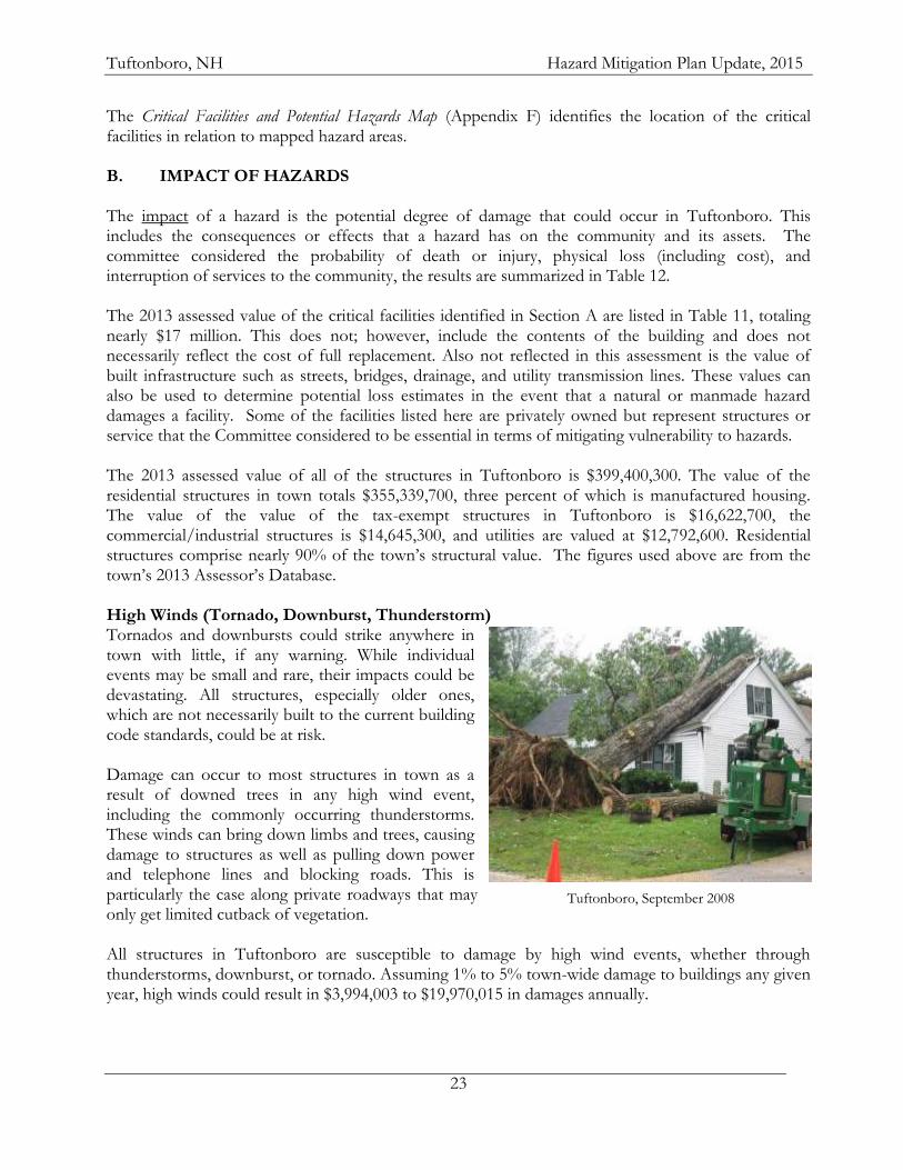
The Critical Facilities and Potential Hazards Map (Appendix F) identifies the location of the critical facilities in relation to mapped hazard areas. B. IMPACT OF HAZARDS The impact of a hazard is the potential degree of damage that could occur in Tuftonboro. This includes the consequences or effects that a hazard has on the community and its assets. The committee considered the probability of death or injury, physical loss (including cost), and interruption of services to the community, the results are summarized in Table 12. The 2013 assessed value of the critical facilities identified in Section A are listed in Table 11, totaling nearly $17 million. This does not; however, include the contents of the building and does not necessarily reflect the cost of full replacement. Also not reflected in this assessment is the value of built infrastructure such as streets, bridges, drainage, and utility transmission lines. These values can also be used to determine potential loss estimates in the event that a natural or manmade hazard damages a facility. Some of the facilities listed here are privately owned but represent structures or service that the Committee considered to be essential in terms of mitigating vulnerability to hazards. The 2013 assessed value of all of the structures in Tuftonboro is $399,400,300. The value of the residential structures in town totals $355,339,700, three percent of which is manufactured housing. The value of the value of the tax-exempt structures in Tuftonboro is $16,622,700, the commercial/industrial structures is $14,645,300, and utilities are valued at $12,792,600. Residential structures comprise nearly 90% of the town’s structural value. The figures used above are from the town’s 2013 Assessor’s Database. High Winds (Tornado, Downburst, Thunderstorm) Tornados and downbursts could strike anywhere in town with little, if any warning. While individual events may be small and rare, their impacts could be devastating. All structures, especially older ones, which are not necessarily built to the current building code standards, could be at risk. Damage can occur to most structures in town as a result of downed trees in any high wind event, including the commonly occurring thunderstorms. These winds can bring down limbs and trees, causing damage to structures as well as pulling down power and telephone lines and blocking roads. This is particularly the case along private roadways that may only get limited cutback of vegetation. All structures in Tuftonboro are susceptible to damage by high wind events, whether through thunderstorms, downburst, or tornado. Assuming 1% to 5% town-wide damage to buildings any given year, high winds could result in $3,994,003 to $19,970,015 in damages annually.
Tuftonboro, NH Hazard Mitigation Plan Update, 2015
24
Lightning Although the numbers have trended downward in recent decades, during the last half of the twentieth century more people were killed in the United States each year by lightning than by any other weather event. It can also wreak havoc with electrical and communications systems. Power outages, whether associated with natural or man-made hazards have the potential to cause great disruption to residents and the functioning of the town. There is back-up power for most municipal facilities. All structures in Tuftonboro are susceptible to damage by lightning and resulting fires. The town’s computer and communication systems could also be impacted by lightning. Assuming 1% town-wide damage to buildings annually, then each year lightning could result in $3,994,003 in damages. Flooding The town of Tuftonboro actively participates in the National Flood Insurance Program (NFIP) through the administration of its floodplain ordinance by the Selectmen and Code Enforcement Officer. This includes correspondence with the NH Floodplain Manager regarding specific issues and periodically updating the town’s floodplain ordinance. By actively participating in the NFIP property owners are able to purchase flood insurance through the FEMA program. The town joined the program on June 15, 1976 through emergency entry, regular entry occurred on May 4, 1989. The original Flood Insurance Rate Maps (FIRM) were published by FEMA on May 4, 1989; these were recently updated (adopted March 19, 2013) and are available in digital form (DFIRM) at http://msc.fema.gov/portal. The Flood Insurance Study (FIS) for Carroll County was also adopted by the town on March 19, 2013. The town’s Level C Floodplain Ordinance was last amended on March 19, 2013. The Code Enforcement Officer is responsible for maintaining floodproofing and elevation certificates. Information regarding floodplains, floodproofing, and flood insurance are provided with all building permit applications. The NH Floodplain Coordinator considers the town officials to be knowledgeable regarding floodplains and the town compliant with floodplain administration. There are currently 16 structures with flood insurance policies in force through the NFIP with a total insurance value of $4,780,000 (average of $298,750 per structure). Five of the NFIP-insured structures are in “A” (High Risk) Zones, while eleven are in the B, C, or X (Low Risk) Zones. Since 1976 there have been zero losses paid out in Tuftonboro.20 Over the past several decades, the Planning Board, Land Use staff, and Code Enforcement Officer have sought and received assistance from the NH Floodplain Manager, in the form of Community Assistance Calls and Visits and General Technical Assistance from the NH Floodplain Manager. Several road segments are prone to flooding or washout. No critical facilities are susceptible to flooding.
20 NFIP State Coordinator, NH Office of Energy and Planning, July, 2013.
Tuftonboro, NH Hazard Mitigation Plan Update, 2015
25
Winter Weather (Snow storms/Ice Storms) Almost all facilities in town can be impacted by heavy snow or ice. Flat-roofed buildings are all susceptible to damage from snow and ice loads. Downed limbs and wires and unplowed or untreated roads can severely limit emergency access to many residences. The potential for very cold temperatures and loss of power can quickly compound the issue. A severe ice storm struck central and southern New Hampshire and New England on December 11, 2008. Over 400,000 people were without power, some for over two weeks, and overall damages exceeded $15 million. All structures in Tuftonboro are susceptible to damage by winter weather events, whether through ice storms, blizzards, or the heavy, wet snow often associated with a nor’easter. Assuming 1% to 5% town-wide damage to buildings, winter weather could result in $3,994,003 to $19,970,015 in damages annually. Fire (Wildfire & Conflagration) While all properties in Tuftonboro have the potential to be impacted by fire, no facilities were noted as being particularly impacted by wildfire. Areas that might be impacted are a few sparsely developed areas in the northern section of town. Those susceptible to conflagration are those in close proximity to each other or with limited access, such as North Country Village or island homes. The impact of a fire would vary greatly depending upon its location and any structures involved. Assuming 1% town-wide damage to buildings, each year wildfire could result in $3,994,003 in damages.
Tuftonboro, NH Hazard Mitigation Plan Update, 2015
26
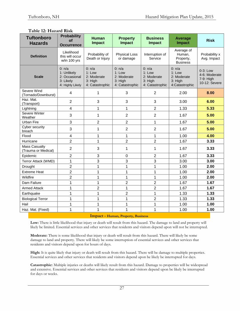
Hazardous Materials The release of hazardous materials along the various roadways in town has the potential to cause damage. There are many variables that could affect the degree of impact, including the nature of the material, the location of the accident and its proximity to surface and groundwater, as well as structures. A hazardous materials accident would not likely impact structures; rather the impact would be environmental. A 2007 report from NH Department of Environmental Services found that a reduction in water quality could lead to $25 million of lost income to the Lakes Region (30 communities).21 Terrorism/Cyber Security Breach Actions taken to harm or terrorize individuals or segments of the population may injure, scar, or result in fatalities. Damage to structures is not a likelihood. A breach in cyber security would compromise the ability to communicate and respond effectively. C. SUMMARY OF RISK The committee used the matrix below (Table 12) to put some simple numerical ratings to the various impacts that a hazard might have on the town of Tuftonboro and to ensure that they considered the three major impacts (Human, Business, and Property) in addition to those on the critical facilities. It should be noted that the ranking of individual hazards for the purposes of planning discussion should not in any way diminish the potential severity of the impacts of a given hazard event. Further, hazards ranked as low risk may have the impact of increasing the risk of other hazards when they occur. For example, in the event of a drought, the risk of woodland fire may be greater. In combination, hazard events may have the impact of overwhelming existing emergency response systems.
21 http://des.nh.gov/organization///commissioner/pip/publications/wd/documents/whats_our_water_worth.pdf.
Tuftonboro, NH Hazard Mitigation Plan Update, 2015
27
Table 12: Hazard Risk
Tuftonboro Hazards
Probability of
Occurrence
Human Impact
Property Impact
Business Impact
Average Impact
Risk
Definition Likelihood
this will occur w/in 100 yrs
Probability of Death or Injury
Physical Loss or damage
Interruption of Service
Average of Human,
Property, Business
Probability x Avg. Impact
Scale
0: n/a 1: Unlikely 2: Occasional 3: Likely 4: Highly Likely
0: n/a 1: Low 2: Moderate 3: High 4: Catastrophic
0: n/a 1: Low 2: Moderate 3: High 4: Catastrophic
0: n/a 1: Low 2: Moderate 3: High 4: Catastrophic
0: n/a 1: Low 2: Moderate 3: High 4:Catastrophic
0-3: Low 4-6: Moderate 7-9: High 10-12: Severe
Severe Wind (Tornado/Downburst)
4 1 3 2 2.00 8.00
Haz. Mat. (Transport)
2 3 3 3 3.00 6.00
Lightning 4 1 1 2 1.33 5.33
Severe Winter Weather
3 1 2 2 1.67 5.00
Urban Fire 3 2 2 1 1.67 5.00
Cyber security breach
3 1 2 2 1.67 5.00
Flood 4 1 1 1 1.00 4.00
Hurricane 2 1 2 2 1.67 3.33
Mass Casualty (Trauma or Medical)
2 3 1 1 1.67 3.33
Epidemic 2 3 0 2 1.67 3.33
Terror Attack (WMD) 1 3 3 3 3.00 3.00
Drought 2 1 1 1 1.00 2.00
Extreme Heat 2 1 1 1 1.00 2.00
Wildfire 2 1 1 1 1.00 2.00
Dam Failure 1 1 2 2 1.67 1.67
Armed Attack 1 2 1 2 1.67 1.67
Earthquake 1 1 2 1 1.33 1.33
Biological Terror 1 1 1 2 1.33 1.33
Hail 1 1 1 1 1.00 1.00
Haz. Mat. (Fixed) 1 1 1 1 1.00 1.00
Impact - Human, Property, Business
Low: There is little likelihood that injury or death will result from this hazard. The damage to land and property will likely be limited. Essential services and other services that residents and visitors depend upon will not be interrupted.
Moderate: There is some likelihood that injury or death will result from this hazard. There will likely be some damage to land and property. There will likely be some interruption of essential services and other services that residents and visitors depend upon for hours of days.
High: It is quite likely that injury or death will result from this hazard. There will be damage to multiple properties. Essential services and other services that residents and visitors depend upon be likely be interrupted for days.
Catastrophic: Multiple injuries or deaths will likely result from this hazard. Damage to properties will be widespread and extensive. Essential services and other services that residents and visitors depend upon be likely be interrupted for days or weeks.
Tuftonboro, NH Hazard Mitigation Plan Update, 2015
28
CHAPTER V: MITIGATION STRATEGIES
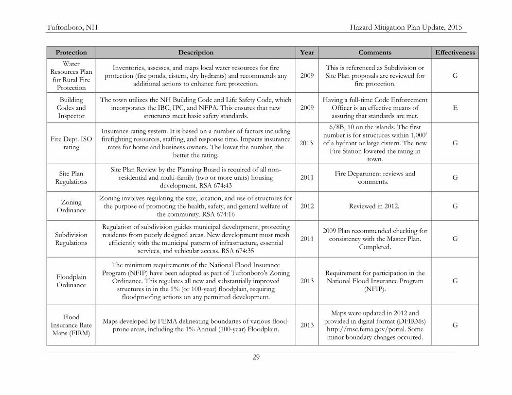
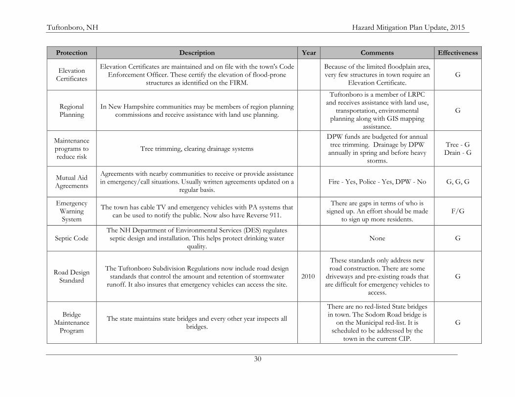
A. CURRENT PLANS, POLICIES, AND REGULATIONS The planning decisions that affect community growth patterns have evolved over the years as Tuftonboro has developed. Many local programs have the effect of mitigating disasters; some of these have been in effect for years, others have been updated since the development of the 2009 Hazard Mitigation Plan. A review of existing mitigation strategies was conducted and included review of pertinent documents including the zoning ordinance, subdivision regulations, emergency management plan, site plan regulations, and discussion with Committee members. The following strategies (Table 13) detail existing plans and regulations related to hazard mitigation. The review of existing capabilities (Table 13) and the status of the 2009 Actions (Table 14) utilized these categorizations: Poor (P)............ The policy, plan or mutual aid system does not work as well as it should and often falls short of meeting its goals. Fair (F)...............The policy, plan or mutual aid system does not work as well as it should and sometimes falls short of meeting its goals. Good (G)............The policy, plan or mutual aid system works well and is achieving its goals. Excellent (E).......The policy, plan or mutual aid system works very well and often exceeds its goals. Untested (U)…...The policy, plan or mutual aid system has not yet been utilized or tested. Table 13: Existing Protections and Policies
Protection Description Year Comments Effectiveness
Master Plan
Guiding document for land use planning. It serves to guide the overall character, physical form, growth, and development of the
community. It is the foundation upon which the town's zoning and regulations are based. RSA 674:2
2006 This is developed by the Planning
Board with public input and is referred to by the Board frequently.
G/E
Capital Improvement
Plan
The Tuftonboro CIP is an outline of anticipated expenditures for capital projects over at least six years. It links local infrastructure
investments with master plan goals, land use ordinances, and economic development. RSA 674:5
2013 The town's first CIP was developed in
2007. Threshold - $10,000 and lifespan of at least two years.
G/E
Local Emergency Operations
Plan
The town maintains an LEOP in ESF format. This plan identifies the capabilities and response procedures of the town in response to an
emergency. 2011 Due for an update in 2015. E
Tuftonboro, NH Hazard Mitigation Plan Update, 2015
29
Protection Description Year Comments Effectiveness
Water Resources Plan for Rural Fire
Protection
Inventories, assesses, and maps local water resources for fire protection (fire ponds, cistern, dry hydrants) and recommends any
additional actions to enhance fore protection. 2009
This is referenced as Subdivision or Site Plan proposals are reviewed for
fire protection. G
Building Codes and Inspector
The town utilizes the NH Building Code and Life Safety Code, which incorporates the IBC, IPC, and NFPA. This ensures that new
structures meet basic safety standards. 2009
Having a full-time Code Enforcement Officer is an effective means of assuring that standards are met.
E
Fire Dept. ISO rating
Insurance rating system. It is based on a number of factors including firefighting resources, staffing, and response time. Impacts insurance
rates for home and business owners. The lower the number, the better the rating.
2013
6/8B, 10 on the islands. The first number is for structures within 1,000' of a hydrant or large cistern. The new
Fire Station lowered the rating in town.
G
Site Plan Regulations
Site Plan Review by the Planning Board is required of all non-residential and multi-family (two or more units) housing
development. RSA 674:43 2011
Fire Department reviews and comments.
G
Zoning Ordinance
Zoning involves regulating the size, location, and use of structures for the purpose of promoting the health, safety, and general welfare of
the community. RSA 674:16 2012 Reviewed in 2012. G
Subdivision Regulations
Regulation of subdivision guides municipal development, protecting residents from poorly designed areas. New development must mesh
efficiently with the municipal pattern of infrastructure, essential services, and vehicular access. RSA 674:35
2011 2009 Plan recommended checking for
consistency with the Master Plan. Completed.
G
Floodplain Ordinance
The minimum requirements of the National Flood Insurance Program (NFIP) have been adopted as part of Tuftonboro's Zoning
Ordinance. This regulates all new and substantially improved structures in in the 1% (or 100-year) floodplain, requiring
floodproofing actions on any permitted development.
2013 Requirement for participation in the National Flood Insurance Program
(NFIP). G
Flood Insurance Rate Maps (FIRM)
Maps developed by FEMA delineating boundaries of various flood-prone areas, including the 1% Annual (100-year) Floodplain.
2013
Maps were updated in 2012 and provided in digital format (DFIRMs) http://msc.fema.gov/portal. Some minor boundary changes occurred.
G
Tuftonboro, NH Hazard Mitigation Plan Update, 2015
30
Protection Description Year Comments Effectiveness
Elevation Certificates
Elevation Certificates are maintained and on file with the town's Code Enforcement Officer. These certify the elevation of flood-prone
structures as identified on the FIRM.
Because of the limited floodplain area, very few structures in town require an
Elevation Certificate. G
Regional Planning
In New Hampshire communities may be members of region planning commissions and receive assistance with land use planning.
Tuftonboro is a member of LRPC and receives assistance with land use,
transportation, environmental planning along with GIS mapping
assistance.
G
Maintenance programs to reduce risk
Tree trimming, clearing drainage systems
DPW funds are budgeted for annual tree trimming. Drainage by DPW
annually in spring and before heavy storms.
Tree - G Drain - G
Mutual Aid Agreements
Agreements with nearby communities to receive or provide assistance in emergency/call situations. Usually written agreements updated on a
regular basis. Fire - Yes, Police - Yes, DPW - No G, G, G
Emergency Warning System
The town has cable TV and emergency vehicles with PA systems that can be used to notify the public. Now also have Reverse 911.
There are gaps in terms of who is
signed up. An effort should be made to sign up more residents.
F/G
Septic Code The NH Department of Environmental Services (DES) regulates septic design and installation. This helps protect drinking water
quality. None G
Road Design Standard
The Tuftonboro Subdivision Regulations now include road design standards that control the amount and retention of stormwater
runoff. It also insures that emergency vehicles can access the site. 2010
These standards only address new road construction. There are some
driveways and pre-existing roads that are difficult for emergency vehicles to
access.
G
Bridge Maintenance
Program
The state maintains state bridges and every other year inspects all bridges.
There are no red-listed State bridges in town. The Sodom Road bridge is
on the Municipal red-list. It is scheduled to be addressed by the
town in the current CIP.
G
Tuftonboro, NH Hazard Mitigation Plan Update, 2015
31
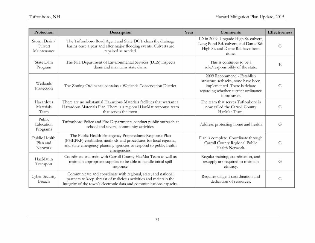
Protection Description Year Comments Effectiveness
Storm Drain/ Culvert
Maintenance
The Tuftonboro Road Agent and State DOT clean the drainage basins once a year and after major flooding events. Culverts are
repaired as needed.
ID in 2009: Upgrade High St. culvert, Lang Pond Rd. culvert, and Dame Rd.
High St. and Dame Rd. have been done.
G
State Dam Program
The NH Department of Environmental Services (DES) inspects dams and maintains state dams.
This is continues to be a
role/responsibility of the state. E
Wetlands Protection
The Zoning Ordinance contains a Wetlands Conservation District.
2009 Recommend - Establish structure setbacks, none have been
implemented. There is debate regarding whether current ordinance
is too strict.
G
Hazardous Materials
Team
There are no substantial Hazardous Materials facilities that warrant a Hazardous Materials Plan. There is a regional HazMat response team
that serves the town.
The team that serves Tuftonboro is now called the Carroll County
HazMat Team. G
Public Education Programs
Tuftonboro Police and Fire Departments conduct public outreach at school and several community activities.
Address protecting home and health. G
Public Health Plan and Network
The Public Health Emergency Preparedness Response Plan (PHEPRP) establishes methods and procedures for local regional, and state emergency planning agencies to respond to public health
emergencies.
Plan is complete. Coordinate through
Carroll County Regional Public Health Network.
G
HazMat in Transport
Coordinate and train with Carroll County HazMat Team as well as maintain appropriate supplies to be able to handle initial spill
response.
Regular training, coordination, and resupply are required to maintain
efficacy. G
Cyber Security Breach
Communicate and coordinate with regional, state, and national partners to keep abreast of malicious activities and maintain the
integrity of the town’s electronic data and communications capacity.
Requires diligent coordination and dedication of resources.
G
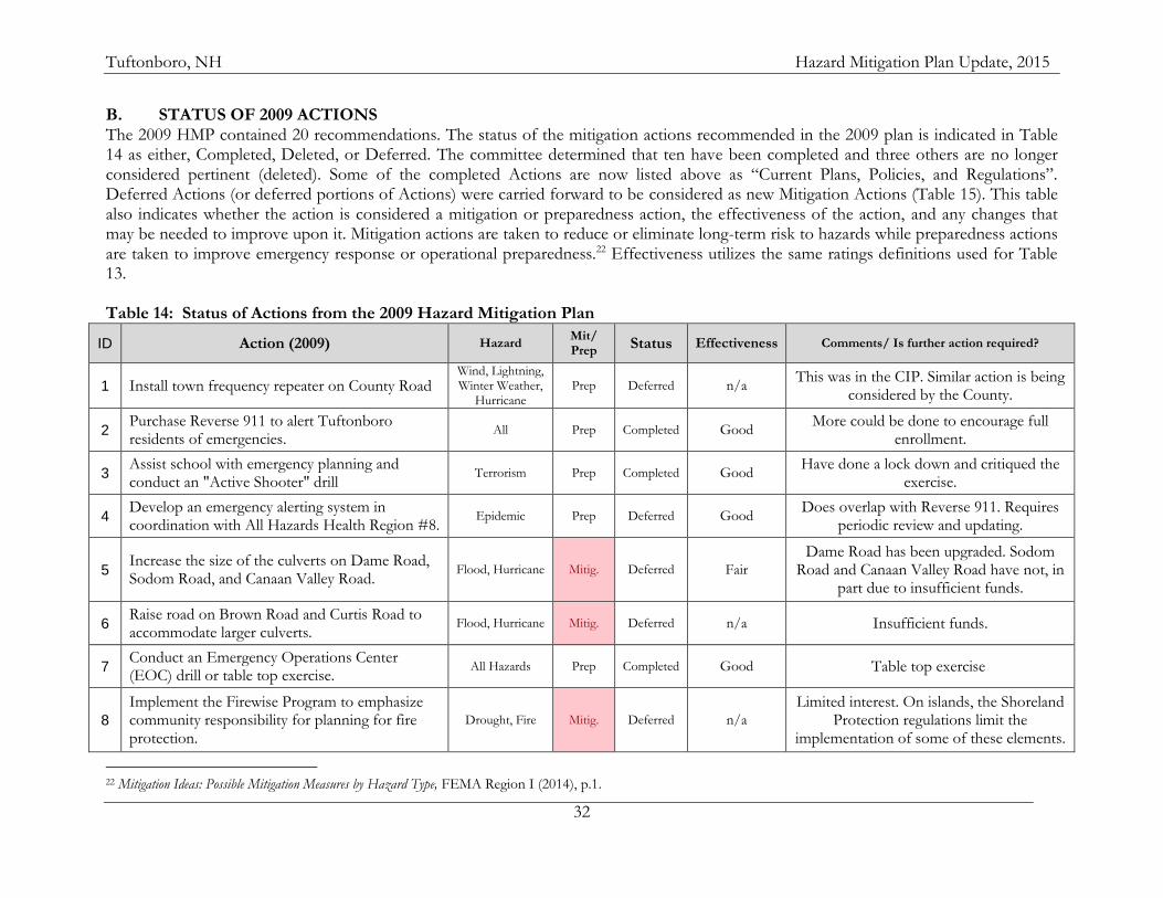
Tuftonboro, NH Hazard Mitigation Plan Update, 2015
32
B. STATUS OF 2009 ACTIONS The 2009 HMP contained 20 recommendations. The status of the mitigation actions recommended in the 2009 plan is indicated in Table 14 as either, Completed, Deleted, or Deferred. The committee determined that ten have been completed and three others are no longer considered pertinent (deleted). Some of the completed Actions are now listed above as “Current Plans, Policies, and Regulations”. Deferred Actions (or deferred portions of Actions) were carried forward to be considered as new Mitigation Actions (Table 15). This table also indicates whether the action is considered a mitigation or preparedness action, the effectiveness of the action, and any changes that may be needed to improve upon it. Mitigation actions are taken to reduce or eliminate long-term risk to hazards while preparedness actions are taken to improve emergency response or operational preparedness.22 Effectiveness utilizes the same ratings definitions used for Table 13. Table 14: Status of Actions from the 2009 Hazard Mitigation Plan
ID Action (2009) Hazard Mit/ Prep
Status Effectiveness Comments/ Is further action required?
1 Install town frequency repeater on County Road Wind, Lightning, Winter Weather,
Hurricane Prep Deferred n/a
This was in the CIP. Similar action is being considered by the County.
2 Purchase Reverse 911 to alert Tuftonboro residents of emergencies.
All Prep Completed Good More could be done to encourage full
enrollment.
3 Assist school with emergency planning and conduct an "Active Shooter" drill
Terrorism Prep Completed Good Have done a lock down and critiqued the
exercise.
4 Develop an emergency alerting system in coordination with All Hazards Health Region #8.
Epidemic Prep Deferred Good Does overlap with Reverse 911. Requires
periodic review and updating.
5 Increase the size of the culverts on Dame Road, Sodom Road, and Canaan Valley Road.
Flood, Hurricane Mitig. Deferred Fair
Dame Road has been upgraded. Sodom Road and Canaan Valley Road have not, in
part due to insufficient funds.
6 Raise road on Brown Road and Curtis Road to accommodate larger culverts.
Flood, Hurricane Mitig. Deferred n/a Insufficient funds.
7 Conduct an Emergency Operations Center (EOC) drill or table top exercise.
All Hazards Prep Completed Good Table top exercise
8
Implement the Firewise Program to emphasize community responsibility for planning for fire protection.
Drought, Fire Mitig. Deferred n/a
Limited interest. On islands, the Shoreland Protection regulations limit the
implementation of some of these elements.
22 Mitigation Ideas: Possible Mitigation Measures by Hazard Type, FEMA Region I (2014), p.1.
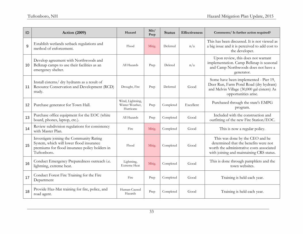
Tuftonboro, NH Hazard Mitigation Plan Update, 2015
33
ID Action (2009) Hazard Mit/ Prep
Status Effectiveness Comments/ Is further action required?
9 Establish wetlands setback regulations and method of enforcement.
Flood Mitig. Deferred n/a
This has been discussed. It is not viewed as a big issue and it is perceived to add cost to
the developer.
10
Develop agreement with Northwoods and Belknap camps to use their facilities as an emergency shelter.
All Hazards Prep Deleted n/a
Upon review, this does not warrant implementation. Camp Belknap is seasonal
and Camp Northwoods does not have a generator.
11
Install cisterns/ dry hydrants as a result of Resource Conservation and Development (RCD) study.
Drought, Fire Prep Deferred Good
Some have been implemented - Pier 19, Deer Run, Farm Pond Road (dry hydrant) and Melvin Village (30,000 gal cistern) As
opportunities arise.
12 Purchase generator for Town Hall. Wind, Lightning, Winter Weather,
Hurricane Prep Completed Excellent
Purchased through the state's EMPG program.
13 Purchase office equipment for the EOC (white board, phones, laptop, etc.).
All Hazards Prep Completed Good Included with the construction and
outfitting of the new Fire Station/EOC.
14 Review subdivision regulations for consistency with Master Plan.
Fire Mitig. Completed Good This is now a regular policy.
15
Investigate joining the Community Rating System, which will lower flood insurance premiums for flood insurance policy holders in Tuftonboro.
Flood Mitig. Completed Good
This was done by the CEO and he determined that the benefits were not
worth the administrative costs associated with joining and maintaining CRS status.
16 Conduct Emergency Preparedness outreach i.e. lightning, extreme heat.
Lightning, Extreme Heat
Mitig. Completed Good This is done through pamphlets and the
town websites.
17 Conduct Forest Fire Training for the Fire Department
Fire Prep Completed Good Training is held each year.
18 Provide Haz-Mat training for fire, police, and road agent.
Human-Caused Hazards
Prep Completed Good Training is held each year.
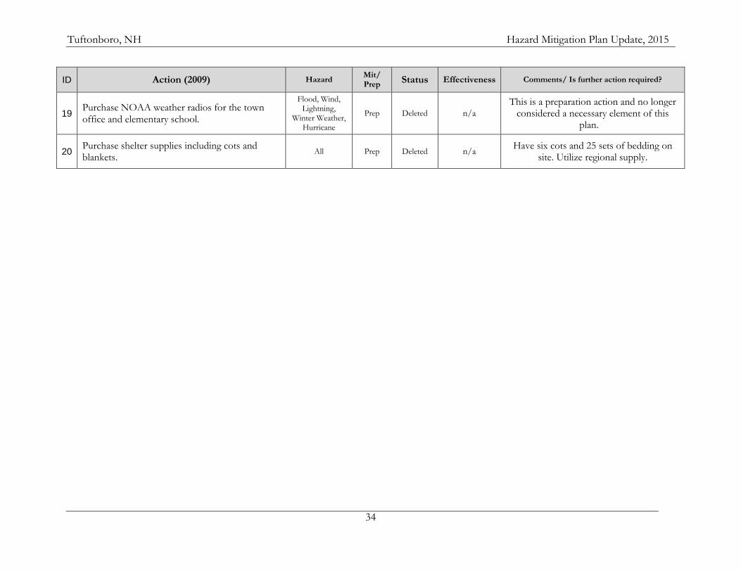
Tuftonboro, NH Hazard Mitigation Plan Update, 2015
34
ID Action (2009) Hazard Mit/ Prep
Status Effectiveness Comments/ Is further action required?
19 Purchase NOAA weather radios for the town office and elementary school.
Flood, Wind, Lightning,
Winter Weather, Hurricane
Prep Deleted n/a
This is a preparation action and no longer considered a necessary element of this
plan.
20 Purchase shelter supplies including cots and blankets.
All Prep Deleted n/a Have six cots and 25 sets of bedding on
site. Utilize regional supply.

Tuftonboro, NH Hazard Mitigation Plan Update, 2015
35
C. MITIGATION GOALS AND TYPES OF ACTIONS In the 2009 Plan, the committee affirmed its support for the goals stated in the State HMP at the time. While the overall goals of the town of Tuftonboro have not changed substantially since then, the form in which they are stated has. The general goals below are similar to the goals in the earlier plan while the hazard-specific goals address specific local concerns and were not included in the last plan. General Goals:
1. Improve upon the protection of the residents of Tuftonboro and its visitors from all hazards, raise general awareness, and reduce the liability to the town from hazard events.
2. Reduce the potential impact of hazard events on Tuftonboro’s critical support services, facilities, and infrastructure. 3. Improve emergency preparedness. 4. Improve the response and recovery capability of Tuftonboro to hazard events. 5. Reduce the potential impact of hazard events on private and public property, the natural environment, and economic resources. 6. Work in cooperation with surrounding communities and in support of New Hampshire’s Hazard Mitigation goals.
Hazard Specific Severe Wind
7. Reduce the likelihood of damage or loss of life due to high wind events. Winter Weather
8. Minimize the impact of severe winter weather on people living in or visiting Tuftonboro along with structures and infrastructure. Flooding
9. Minimize the impact that flooding would have on life, property, and infrastructure in Tuftonboro. Fire
10. Reduce the risk of loss of life, and damage to property and infrastructure due to structural or wildfires. 11. Minimize the impact to life, property, and the environment during a hazardous materials spill. 12. Reduce the impact on life, structures, and infrastructure (especially communications infrastructure) as a result of a lightning strike.
Epidemic 13. Minimize the impact that an epidemic or other health hazard may have on the people in the town of Tuftonboro
There are a number of types of actions that communities may take to reduce the likelihood that a hazard might impact the community. These include:
Local Plans and Regulations
Structure and Infrastructure Projects
Natural Systems Protection
Education and Awareness Programs
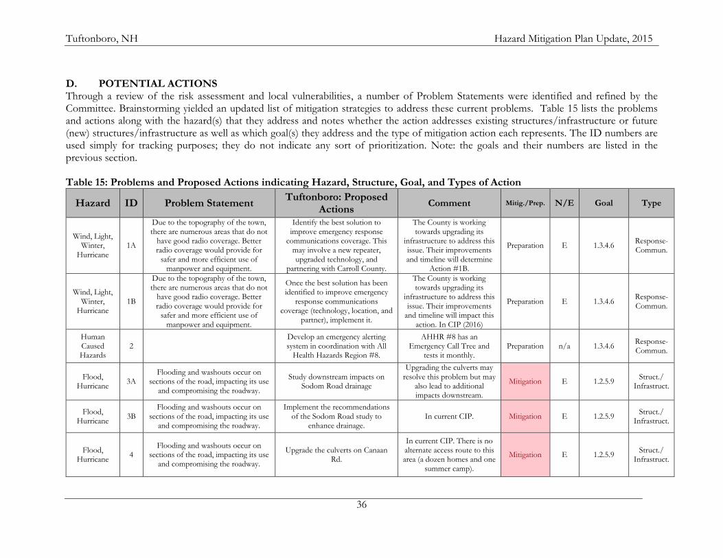
Tuftonboro, NH Hazard Mitigation Plan Update, 2015
36
D. POTENTIAL ACTIONS Through a review of the risk assessment and local vulnerabilities, a number of Problem Statements were identified and refined by the Committee. Brainstorming yielded an updated list of mitigation strategies to address these current problems. Table 15 lists the problems and actions along with the hazard(s) that they address and notes whether the action addresses existing structures/infrastructure or future (new) structures/infrastructure as well as which goal(s) they address and the type of mitigation action each represents. The ID numbers are used simply for tracking purposes; they do not indicate any sort of prioritization. Note: the goals and their numbers are listed in the previous section. Table 15: Problems and Proposed Actions indicating Hazard, Structure, Goal, and Types of Action
Hazard ID Problem Statement Tuftonboro: Proposed
Actions Comment Mitig./Prep. N/E Goal Type
Wind, Light, Winter,
Hurricane 1A
Due to the topography of the town, there are numerous areas that do not
have good radio coverage. Better radio coverage would provide for
safer and more efficient use of manpower and equipment.
Identify the best solution to improve emergency response
communications coverage. This may involve a new repeater, upgraded technology, and
partnering with Carroll County.
The County is working towards upgrading its
infrastructure to address this issue. Their improvements and timeline will determine
Action #1B.
Preparation E 1.3.4.6 Response- Commun.
Wind, Light, Winter,
Hurricane 1B
Due to the topography of the town, there are numerous areas that do not
have good radio coverage. Better radio coverage would provide for
safer and more efficient use of manpower and equipment.
Once the best solution has been identified to improve emergency
response communications coverage (technology, location, and
partner), implement it.
The County is working towards upgrading its
infrastructure to address this issue. Their improvements
and timeline will impact this action. In CIP (2016)
Preparation E 1.3.4.6 Response- Commun.
Human Caused Hazards
2 Develop an emergency alerting system in coordination with All
Health Hazards Region #8.
AHHR #8 has an Emergency Call Tree and
tests it monthly. Preparation n/a 1.3.4.6
Response- Commun.
Flood, Hurricane
3A Flooding and washouts occur on
sections of the road, impacting its use and compromising the roadway.
Study downstream impacts on Sodom Road drainage
Upgrading the culverts may resolve this problem but may
also lead to additional impacts downstream.
Mitigation E 1.2.5.9 Struct./
Infrastruct.
Flood, Hurricane
3B Flooding and washouts occur on
sections of the road, impacting its use and compromising the roadway.
Implement the recommendations of the Sodom Road study to
enhance drainage. In current CIP. Mitigation E 1.2.5.9
Struct./ Infrastruct.
Flood, Hurricane
4 Flooding and washouts occur on
sections of the road, impacting its use and compromising the roadway.
Upgrade the culverts on Canaan Rd.
In current CIP. There is no alternate access route to this area (a dozen homes and one
summer camp).
Mitigation E 1.2.5.9 Struct./
Infrastruct.
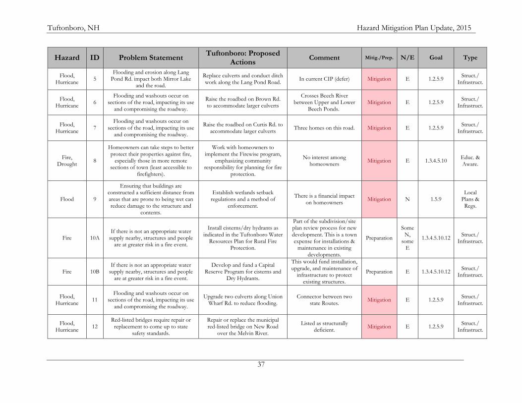
Tuftonboro, NH Hazard Mitigation Plan Update, 2015
37
Hazard ID Problem Statement Tuftonboro: Proposed
Actions Comment Mitig./Prep. N/E Goal Type
Flood, Hurricane
5 Flooding and erosion along Lang
Pond Rd. impact both Mirror Lake and the road.
Replace culverts and conduct ditch work along the Lang Pond Road.
In current CIP (defer) Mitigation E 1.2.5.9 Struct./
Infrastruct.
Flood, Hurricane
6 Flooding and washouts occur on
sections of the road, impacting its use and compromising the roadway.
Raise the roadbed on Brown Rd. to accommodate larger culverts
Crosses Beech River between Upper and Lower
Beech Ponds. Mitigation E 1.2.5.9
Struct./ Infrastruct.
Flood, Hurricane
7 Flooding and washouts occur on
sections of the road, impacting its use and compromising the roadway.
Raise the roadbed on Curtis Rd. to accommodate larger culverts
Three homes on this road. Mitigation E 1.2.5.9 Struct./
Infrastruct.
Fire, Drought
8
Homeowners can take steps to better protect their properties against fire,
especially those in more remote sections of town (least accessible to
firefighters).
Work with homeowners to implement the Firewise program,
emphasizing community responsibility for planning for fire
protection.
No interest among homeowners
Mitigation E 1.3.4.5.10 Educ. & Aware.
Flood 9
Ensuring that buildings are constructed a sufficient distance from areas that are prone to being wet can reduce damage to the structure and
contents.
Establish wetlands setback regulations and a method of
enforcement.
There is a financial impact on homeowners
Mitigation N 1.5.9 Local
Plans & Regs.
Fire 10A If there is not an appropriate water
supply nearby, structures and people are at greater risk in a fire event.
Install cisterns/dry hydrants as indicated in the Tuftonboro Water
Resources Plan for Rural Fire Protection.
Part of the subdivision/site plan review process for new development. This is a town expense for installations &
maintenance in existing developments.
Preparation
Some N,
some E
1.3.4.5.10.12 Struct./
Infrastruct.
Fire 10B If there is not an appropriate water
supply nearby, structures and people are at greater risk in a fire event.
Develop and fund a Capital Reserve Program for cisterns and
Dry Hydrants.
This would fund installation, upgrade, and maintenance of
infrastructure to protect existing structures.
Preparation E 1.3.4.5.10.12 Struct./
Infrastruct.
Flood, Hurricane
11 Flooding and washouts occur on
sections of the road, impacting its use and compromising the roadway.
Upgrade two culverts along Union Wharf Rd. to reduce flooding.
Connector between two state Routes.
Mitigation E 1.2.5.9 Struct./
Infrastruct.
Flood, Hurricane
12 Red-listed bridges require repair or
replacement to come up to state safety standards.
Repair or replace the municipal red-listed bridge on New Road
over the Melvin River.
Listed as structurally deficient.
Mitigation E 1.2.5.9 Struct./
Infrastruct.
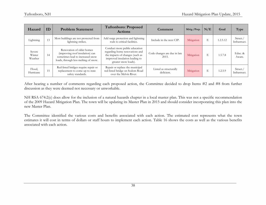
Tuftonboro, NH Hazard Mitigation Plan Update, 2015
38
Hazard ID Problem Statement Tuftonboro: Proposed
Actions Comment Mitig./Prep. N/E Goal Type
Lightning 13 Most buildings are not protected from
lightning strikes. Add surge protection and lightning
rods to critical facilities. Include in the next CIP. Mitigation E 1.2.5.12
Struct./ Infrastruct.
Severe Winter
Weather 14
Renovation of older homes (improving roof insulation) can
sometimes lead to increased snow loads, through less melting of snow.
Conduct more public education regarding home renovations and the impacts of changes (such as improved insulation leading to
greater snow loads).
Code changes are due in late 2015.
Mitigation E 1.5.7.8 Educ. & Aware.
Flood, Hurricane
15 Red-listed bridges require repair or
replacement to come up to state safety standards.
Repair or replace the municipal red-listed bridge on Sodom Road
over the Melvin River.
Listed as structurally deficient.
Mitigation E 1.2.5.9 Struct./
Infrastruct.
After hearing a number of comments regarding each proposed action, the Committee decided to drop Items #2 and #8 from further discussion as they were deemed not necessary or unworkable. NH RSA 674:2(e) does allow for the inclusion of a natural hazards chapter in a local master plan. This was not a specific recommendation of the 2009 Hazard Mitigation Plan. The town will be updating its Master Plan in 2015 and should consider incorporating this plan into the new Master Plan. The Committee identified the various costs and benefits associated with each action. The estimated cost represents what the town estimates it will cost in terms of dollars or staff hours to implement each action. Table 16 shows the costs as well as the various benefits associated with each action.
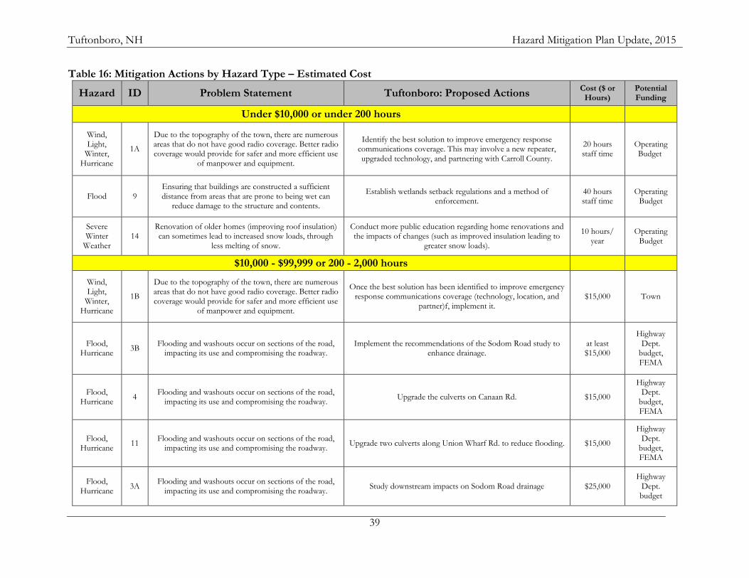
Tuftonboro, NH Hazard Mitigation Plan Update, 2015
39
Table 16: Mitigation Actions by Hazard Type – Estimated Cost
Hazard ID Problem Statement Tuftonboro: Proposed Actions Cost ($ or
Hours) Potential Funding
Under $10,000 or under 200 hours
Wind, Light,
Winter, Hurricane
1A
Due to the topography of the town, there are numerous areas that do not have good radio coverage. Better radio coverage would provide for safer and more efficient use
of manpower and equipment.
Identify the best solution to improve emergency response communications coverage. This may involve a new repeater, upgraded technology, and partnering with Carroll County.
20 hours staff time
Operating Budget
Flood 9 Ensuring that buildings are constructed a sufficient distance from areas that are prone to being wet can
reduce damage to the structure and contents.
Establish wetlands setback regulations and a method of enforcement.
40 hours staff time
Operating Budget
Severe Winter
Weather 14
Renovation of older homes (improving roof insulation) can sometimes lead to increased snow loads, through
less melting of snow.
Conduct more public education regarding home renovations and the impacts of changes (such as improved insulation leading to
greater snow loads).
10 hours/ year
Operating Budget
$10,000 - $99,999 or 200 - 2,000 hours
Wind, Light,
Winter, Hurricane
1B
Due to the topography of the town, there are numerous areas that do not have good radio coverage. Better radio coverage would provide for safer and more efficient use
of manpower and equipment.
Once the best solution has been identified to improve emergency response communications coverage (technology, location, and
partner)f, implement it. $15,000 Town
Flood, Hurricane
3B Flooding and washouts occur on sections of the road,
impacting its use and compromising the roadway. Implement the recommendations of the Sodom Road study to
enhance drainage. at least $15,000
Highway Dept.
budget, FEMA
Flood, Hurricane
4 Flooding and washouts occur on sections of the road,
impacting its use and compromising the roadway. Upgrade the culverts on Canaan Rd. $15,000
Highway Dept.
budget, FEMA
Flood, Hurricane
11 Flooding and washouts occur on sections of the road,
impacting its use and compromising the roadway. Upgrade two culverts along Union Wharf Rd. to reduce flooding. $15,000
Highway Dept.
budget, FEMA
Flood, Hurricane
3A Flooding and washouts occur on sections of the road,
impacting its use and compromising the roadway. Study downstream impacts on Sodom Road drainage $25,000
Highway Dept. budget
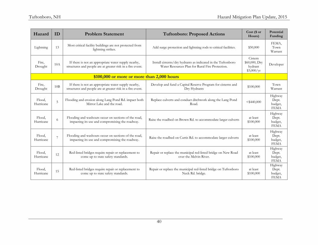
Tuftonboro, NH Hazard Mitigation Plan Update, 2015
40
Hazard ID Problem Statement Tuftonboro: Proposed Actions Cost ($ or
Hours) Potential Funding
Lightning 13 Most critical facility buildings are not protected from
lightning strikes. Add surge protection and lightning rods to critical facilities. $50,000
FEMA, Town
Warrant
Fire, Drought
10A If there is not an appropriate water supply nearby,
structures and people are at greater risk in a fire event. Install cisterns/dry hydrants as indicated in the Tuftonboro
Water Resources Plan for Rural Fire Protection.
Cistern $60,000, Dry
hydrant $3,000/yr
Developer
$100,000 or more or more than 2,000 hours
Fire, Drought
10B If there is not an appropriate water supply nearby,
structures and people are at greater risk in a fire event. Develop and fund a Capital Reserve Program for cisterns and
Dry Hydrants $100,000
Town Warrant
Flood, Hurricane
5 Flooding and erosion along Lang Pond Rd. impact both
Mirror Lake and the road. Replace culverts and conduct ditchwork along the Lang Pond
Road. <$440,000
Highway Dept.
budget, FEMA
Flood, Hurricane
6 Flooding and washouts occur on sections of the road,
impacting its use and compromising the roadway. Raise the roadbed on Brown Rd. to accommodate larger culverts
at least $100,000
Highway Dept.
budget, FEMA
Flood, Hurricane
7 Flooding and washouts occur on sections of the road,
impacting its use and compromising the roadway. Raise the roadbed on Curtis Rd. to accommodate larger culverts
at least $100,000
Highway Dept.
budget, FEMA
Flood, Hurricane
12 Red-listed bridges require repair or replacement to
come up to state safety standards. Repair or replace the municipal red-listed bridge on New Road
over the Melvin River. at least
$100,000
Highway Dept.
budget, FEMA
Flood, Hurricane
15 Red-listed bridges require repair or replacement to
come up to state safety standards. Repair or replace the municipal red-listed bridge on Tuftonboro
Neck Rd. bridge. at least
$100,000
Highway Dept.
budget, FEMA
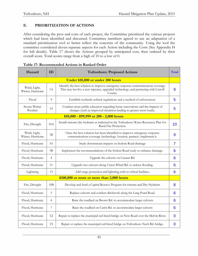
Tuftonboro, NH Hazard Mitigation Plan Update, 2015
41
E. PRIORITIZATION OF ACTIONS After considering the pros and cons of each project, the Committee prioritized the various projects which had been identified and discussed. Committee members agreed to use an adaptation of a standard prioritization tool to better reflect the concerns of the community. Using the tool the committee considered eleven separate aspects for each Action including the Costs (See Appendix H for full details). Table 17 shows the Actions grouped by anticipated cost, then ordered by their overall score. Total scores range from a high of 10 to a low of 0. Table 17: Recommended Actions in Ranked Order
Hazard ID Tuftonboro: Proposed Actions Total
Under $10,000 or under 200 hours
Wind, Light, Winter, Hurricane
1A Identify the best solution to improve emergency response communications coverage. This may involve a new repeater, upgraded technology, and partnering with Carroll
County. 9
Flood 9 Establish wetlands setback regulations and a method of enforcement. 5
Severe Winter Weather
14 Conduct more public education regarding home renovations and the impacts of
changes (such as improved insulation leading to greater snow loads). 5
$10,000 - $99,999 or 200 - 2,000 hours
Fire, Drought 10A Install cisterns/dry hydrants as indicated in the Tuftonboro Water Resources Plan for
Rural Fire Protection. 10
Wind, Light, Winter, Hurricane
1B Once the best solution has been identified to improve emergency response
communications coverage (technology, location, partner), implement it. 9
Flood, Hurricane 3A Study downstream impacts on Sodom Road drainage 7
Flood, Hurricane 3B Implement the recommendations of the Sodom Road study to enhance drainage. 6
Flood, Hurricane 4 Upgrade the culverts on Canaan Rd. 6
Flood, Hurricane 11 Upgrade two culverts along Union Wharf Rd. to reduce flooding. 6
Lightning 13 Add surge protection and lightning rods to critical facilities. 6
$100,000 or more or more than 2,000 hours
Fire, Drought 10B Develop and fund a Capital Reserve Program for cisterns and Dry Hydrants 8
Flood, Hurricane 5 Replace culverts and conduct ditchwork along the Lang Pond Road. 6
Flood, Hurricane 6 Raise the roadbed on Brown Rd. to accommodate larger culverts 6
Flood, Hurricane 7 Raise the roadbed on Curtis Rd. to accommodate larger culverts 6
Flood, Hurricane 12 Repair or replace the municipal red-listed bridge on New Road over the Melvin River. 0
Flood, Hurricane 15 Repair or replace the municipal red-listed bridge on Tuftonboro Neck Rd. bridge. 0
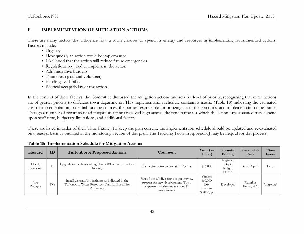
Tuftonboro, NH Hazard Mitigation Plan Update, 2015
42
F. IMPLEMENTATION OF MITIGATION ACTIONS There are many factors that influence how a town chooses to spend its energy and resources in implementing recommended actions. Factors include:
Urgency How quickly an action could be implemented Likelihood that the action will reduce future emergencies Regulations required to implement the action Administrative burdens Time (both paid and volunteer) Funding availability Political acceptability of the action.
In the context of these factors, the Committee discussed the mitigation actions and relative level of priority, recognizing that some actions are of greater priority to different town departments. This implementation schedule contains a matrix (Table 18) indicating the estimated cost of implementation, potential funding sources, the parties responsible for bringing about these actions, and implementation time frame. Though a number of recommended mitigation actions received high scores, the time frame for which the actions are executed may depend upon staff time, budgetary limitations, and additional factors. These are listed in order of their Time Frame. To keep the plan current, the implementation schedule should be updated and re-evaluated on a regular basis as outlined in the monitoring section of this plan. The Tracking Tools in Appendix J may be helpful for this process. Table 18: Implementation Schedule for Mitigation Actions
Hazard ID Tuftonboro: Proposed Actions Comment Cost ($ or
Hours) Potential Funding
Responsible Party
Time Frame
Flood, Hurricane
11 Upgrade two culverts along Union Wharf Rd. to reduce
flooding. Connector between two state Routes. $15,000
Highway Dept.
budget, FEMA
Road Agent 1 year
Fire, Drought
10A Install cisterns/dry hydrants as indicated in the
Tuftonboro Water Resources Plan for Rural Fire Protection.
Part of the subdivision/site plan review process for new development. Town
expense for other installations & maintenance.
Cistern $60,000,
Dry hydrant
$3,000/yr
Developer Planning
Board, FD Ongoing*
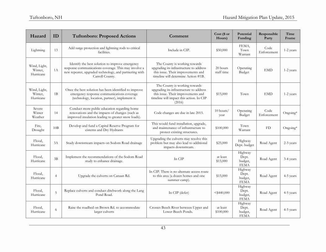
Tuftonboro, NH Hazard Mitigation Plan Update, 2015
43
Hazard ID Tuftonboro: Proposed Actions Comment Cost ($ or
Hours) Potential Funding
Responsible Party
Time Frame
Lightning 13 Add surge protection and lightning rods to critical
facilities. Include in CIP. $50,000
FEMA, Town
Warrant
Code Enforcement
1-2 years
Wind, Light, Winter,
Hurricane 1A
Identify the best solution to improve emergency response communications coverage. This may involve a new repeater, upgraded technology, and partnering with
Carroll County.
The County is working towards upgrading its infrastructure to address
this issue. Their improvements and timeline will determine Action #1B.
20 hours staff time
Operating Budget
EMD 1-2 years
Wind, Light, Winter,
Hurricane 1B
Once the best solution has been identified to improve emergency response communications coverage (technology, location, partner), implement it.
The County is working towards upgrading its infrastructure to address
this issue. Their improvements and timeline will impact this action. In CIP
(2016)
$15,000 Town EMD 1-2 years
Severe Winter
Weather 14
Conduct more public education regarding home renovations and the impacts of changes (such as
improved insulation leading to greater snow loads). Code changes are due in late 2015.
10 hours/ year
Operating Budget
Code Enforcement
Ongoing*
Fire, Drought
10B Develop and fund a Capital Reserve Program for
cisterns and Dry Hydrants
This would fund installation, upgrade, and maintenance of infrastructure to
protect existing structures. $100,000
Town Warrant
FD Ongoing*
Flood, Hurricane
3A Study downstream impacts on Sodom Road drainage Upgrading the culverts may resolve this problem but may also lead to additional
impacts downstream. $25,000
Highway Dept. budget
Road Agent 2-3 years
Flood, Hurricane
3B Implement the recommendations of the Sodom Road
study to enhance drainage. In CIP
at least $15,000
Highway Dept.
budget, FEMA
Road Agent 3-4 years
Flood, Hurricane
4 Upgrade the culverts on Canaan Rd. In CIP. There is no alternate access route
to this area (a dozen homes and one summer camp).
$15,000
Highway Dept.
budget, FEMA
Road Agent 4-5 years
Flood, Hurricane
5 Replace culverts and conduct ditchwork along the Lang
Pond Road. In CIP (defer) <$440,000
Highway Dept.
budget, FEMA
Road Agent 4-5 years
Flood, Hurricane
6 Raise the roadbed on Brown Rd. to accommodate
larger culverts Crosses Beech River between Upper and
Lower Beech Ponds. at least
$100,000
Highway Dept.
budget, FEMA
Road Agent 4-5 years
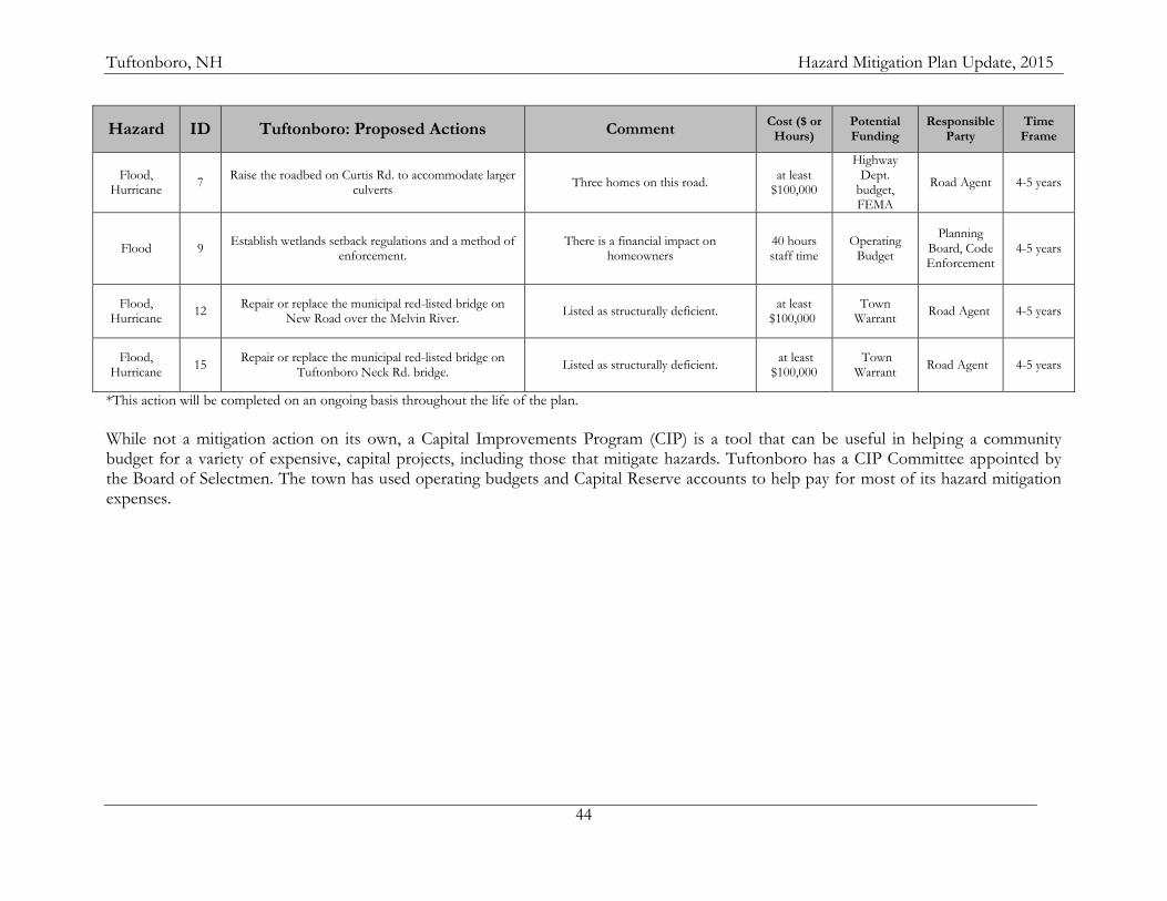
Tuftonboro, NH Hazard Mitigation Plan Update, 2015
44
Hazard ID Tuftonboro: Proposed Actions Comment Cost ($ or
Hours) Potential Funding
Responsible Party
Time Frame
Flood, Hurricane
7 Raise the roadbed on Curtis Rd. to accommodate larger
culverts Three homes on this road.
at least $100,000
Highway Dept.
budget, FEMA
Road Agent 4-5 years
Flood 9 Establish wetlands setback regulations and a method of
enforcement. There is a financial impact on
homeowners 40 hours staff time
Operating Budget
Planning Board, Code Enforcement
4-5 years
Flood, Hurricane
12 Repair or replace the municipal red-listed bridge on
New Road over the Melvin River. Listed as structurally deficient.
at least $100,000
Town Warrant
Road Agent 4-5 years
Flood, Hurricane
15 Repair or replace the municipal red-listed bridge on
Tuftonboro Neck Rd. bridge. Listed as structurally deficient.
at least $100,000
Town Warrant
Road Agent 4-5 years
*This action will be completed on an ongoing basis throughout the life of the plan.
While not a mitigation action on its own, a Capital Improvements Program (CIP) is a tool that can be useful in helping a community budget for a variety of expensive, capital projects, including those that mitigate hazards. Tuftonboro has a CIP Committee appointed by the Board of Selectmen. The town has used operating budgets and Capital Reserve accounts to help pay for most of its hazard mitigation expenses.
Tuftonboro, NH Hazard Mitigation Plan Update, 2015
45
CHAPTER VI: PLAN ADOPTION AND MONITORING
A. IMPLEMENTATION The Tuftonboro Hazard Mitigation Plan Update Committee, established by the EMD and Board of Selectmen, will meet annually to review the Plan and provide a mechanism for ensuring that an attempt is made to incorporate the actions identified in the plan into ongoing town planning activities. Essential elements of implementation require that all responsible parties for the various recommendations understand what is expected of them, and that they are willing to fulfill their role in implementation. It is therefore important to have the responsible parties clearly identified when the town adopts the final plan. Where appropriate it would be helpful to have any hazard mitigation activities identified in job descriptions. Some of the actions in this plan rely on the town’s operating budget along with grant funds available through FEMA and other sources such as those listed in Appendix B. The Emergency Management Director will coordinate with the department heads, Budget Committee, and Selectmen to ensure that funds and staff time for these projects are available. The EMD and Hazard Mitigation Committee will work with the Selectmen and Capital Improvements Plan (CIP) Committee to incorporate the various projects into subsequent budgets. The EMD will also coordinate with the NH HSEM Field Representative to ensure that the town applies for appropriate grant funds. For those mitigation actions which involve either revisions to the Subdivision or Site Plan Review Regulations or the Zoning Ordinance or incorporation into the Master Plan, members of the Hazard Mitigation Committee will work with the Planning Board to develop appropriate language. When appropriate, an effort will be made to incorporate this plan into the Emergency Operations Plan. Within a year after the town officially adopts the 2015 update to the Hazard Mitigation Plan, an attempt will be made to have hazard mitigation strategies integrated into these existing mechanisms and into all other ongoing town planning activities. B. PLAN MAINTENANCE & PUBLIC INVOLVEMENT The Tuftonboro Hazard Mitigation Planning Committee and the Selectboard, in order to track progress and update the mitigation strategies identified in Chapter V, Section F will review the Tuftonboro Hazard Mitigation Plan every year or after a hazard event. Town of Tuftonboro Emergency Management Director is responsible for initiating this review and needs to consult with members of the Tuftonboro Committee identified in this Plan. Changes will be made to the Plan to accommodate projects that have failed, are no longer consistent with the timeframe identified, are no longer consistent with the community's priorities, or lack funding resources. Priorities that were not ranked high, but identified as potential mitigation strategies, will be reviewed during the monitoring and update of this Plan to determine feasibility of future implementation. In keeping with the process of adopting the Plan, a public hearing will be held to receive public comment on the Plan. Maintenance and updating will be held during the annual review period and the final product adopted by the Selectboard. The Committee will meet annually as part of this plan maintenance.
Tuftonboro, NH Hazard Mitigation Plan Update, 2015
46
The Emergency Management Director is also responsible for updating and resubmitting the plan to FEMA to be re-approved every five years. The EMD will convene a plan update committee in early 2019 to begin updating this plan before it expires. On behalf of the Hazard Mitigation Committee, the Emergency Management Director, under direction of the Selectboard, will be responsible for ensuring that town’s departments and the public have adequate opportunity to participate in the planning process during the Plan’s annual review and during any Hazard Mitigation Committee meetings. Administrative staff may be utilized to assist with the public involvement process. For each committee meeting, and the annual update process, techniques that will be utilized for public involvement include:
Provide invitations to Budget Committee members;
Provide invitations to municipal department heads;
Post notices of meetings at the Town Hall, Fire Station, Library, and on the town website;
Submit press releases for publication in the Granite State News, Tuftonboro Times, and Conway Daily Sun, and other appropriate newspapers or media outlets.
Entities to invite to future Hazard Mitigation plan updates include the Emergency Management Directors of the neighboring communities of Wolfeboro, Moultonborough, and Ossipee.
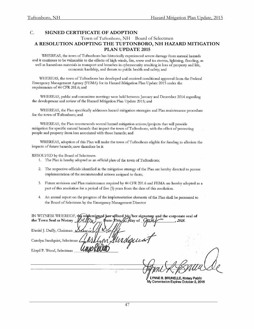
Tuftonboro, NH Hazard Mitigation Plan Update, 2015
47
C. SIGNED CERTIFICATE OF ADOPTION Town of Tuftonboro, NH Board of Selectmen
A RESOLUTION ADOPTING THE TUFTONBORO, NH HAZARD MITIGATION PLAN UPDATE 2015
Tuftonboro, NH Hazard Mitigation Plan Update, 2015
48
APPENDIX A: TECHNICAL RESOURCES
NH Homeland Security and Emergency Management ........................................................................ 271-2231 http://www.nh.gov/safety/divisions/HSEM/
Hazard Mitigation Section ................................................................................................................................... 271-2231 http://www.nh.gov/safety/divisions/hsem/HazardMitigation/index.html
Federal Emergency Management Agency ....................................................................................... (617) 223-4175 http://www.fema.gov/
FEMA, National Flood Insurance Program, Community Status Book http://www.fema.gov/national-flood-insurance-program/national-flood-insurance-program-community-status-book
NH Regional Planning Commissions: Central NH Regional Planning Commission ................................................................................................... 796-2129 http://www.cnhrpc.org/
Lakes Region Regional Planning Commission ................................................................................................. 279-8171 http://www.lakesrpc.org/
Nashua Regional Planning Commission ........................................................................................................... 883-0366 http://www.nashuarpc.org/
North Country Council ........................................................................................................................................ 444-6303 http://www.nccouncil.org/
Rockingham Regional Planning Commission .................................................................................................. 778-0885 http://www.rpc-nh.org/
Southern New Hampshire Regional Planning Commission .......................................................................... 669-4664 http://www.snhpc.org/
Southwest Regional Planning Commission ...................................................................................................... 357-0557 http://www.swrpc.org/
Strafford Regional Planning Commission......................................................................................................... 742-2523 http://www.strafford.org/
Upper Valley Lake Sunapee Regional Planning Commission........................................................................ 448-1680 http://www.uvlsrpc.org/
NH Governor’s Office of Energy and Planning ....................................................................................... 271-2155 http://www.nh.gov/oep/index.htm
New Hampshire Floodplain Management Program http://www.nh.gov/oep/programs/floodplainmanagement/index.htm
NH Department of Transportation .............................................................................................................. 271-3734 http://www.nh.gov/dot/index.htm
NH Department of Cultural Affairs ............................................................................................................. 271-2540 http://www.nh.gov/nhculture/
Division of Historical Resources ........................................................................................................................ 271-3483 http://www.nh.gov/nhdhr/
NH Department of Environmental Services ............................................................................................. 271-3503 http://www.des.state.nh.us/
Dam Bureau ......................................................................................................................................................... 271-63406 http://www.des.state.nh.us/organization/divisions/water/dam/index.htm
NH Municipal Association ............................................................................................................................. 224-7447 http://www.nhmunicipal.org/LGCWebsite/index.asp
Tuftonboro, NH Hazard Mitigation Plan Update, 2015
49
NH Fish and Game Department .................................................................................................................. 271-3421 http://www.wildlife.state.nh.us/
NH Department of Resources and Economic Development .............................................................. 271-2411 http://www.dred.state.nh.us/
Division of Forests and Lands ............................................................................................................................ 271-2214 http://www.nhdfl.org/
Natural Heritage Inventory ................................................................................................................................. 271-2215 http://www.nhdfl.org/about-forests-and-lands/bureaus/natural-heritage-bureau/
Division of Parks and Recreation ....................................................................................................................... 271-3255 http://www.nhstateparks.org/
NH Department of Health and Human Services .................................................................................... 271-9389 http://www.dhhs.state.nh.us/
Northeast States Emergency Consortium, Inc. (NESEC) .......................................................... (781) 224-9876 http://www.nesec.org/
US Department of Commerce .............................................................................................................. (202) 482-2000 http://www.commerce.gov/
National Oceanic and Atmospheric Administration ............................................................................. (202) 482-6090 http://www.noaa.gov/
National Weather Service, Eastern Region Headquarters http://www.erh.noaa.gov/
National Weather Service, Tauton, Massachusetts ................................................................................ (508) 824-5116 http://www.erh.noaa.gov/er/box/
National Weather Service, Gray, Maine .................................................................................................. (207) 688-3216 http://www.erh.noaa.gov/er/gyx/
US Department of the Interior http://www.doi.gov/
US Fish and Wildlife Service ............................................................................................................................... 225-1411 http://www.fws.gov/
US Geological Survey ........................................................................................................................................... 225-4681 http://www.usgs.gov/
US Geological Survey Real Time Hydrologic Data http://waterdata.usgs.gov/nwis/rt
US Army Corps of Engineers ................................................................................................................... (978) 318-8087 http://www.usace.army.mil/
US Department of Agriculture http://www.usda.gov/wps/portal/usdahome
US Forest Service ....................................................................................................................................... (202) 205-8333 http://www.fs.fed.us/
New Hampshire Electrical Cooperative ........................................................................................... (800) 698-2007 http://www.nhec.com/
Cold Region Research Laboratory ................................................................................................................ 646-4187 http://www.crrel.usace.army.mil/
National Emergency Management Association ............................................................................ (859) 244-8000 http://nemaweb.org
Tuftonboro, NH Hazard Mitigation Plan Update, 2015
50
National Aeronautics and Space Administration http://www.nasa.gov/
NASA Optical Transient Detector – Lightning and Atmospheric Research http://thunder.msfc.nasa.gov/
National Lightning Safety Institute
http://lightningsafety.com/
The Tornado Project Online http://www.tornadoproject.com/
National Severe Storms Laboratory http://www.nssl.noaa.gov/
Plymouth State University Weather Center http://vortex.plymouth.edu/
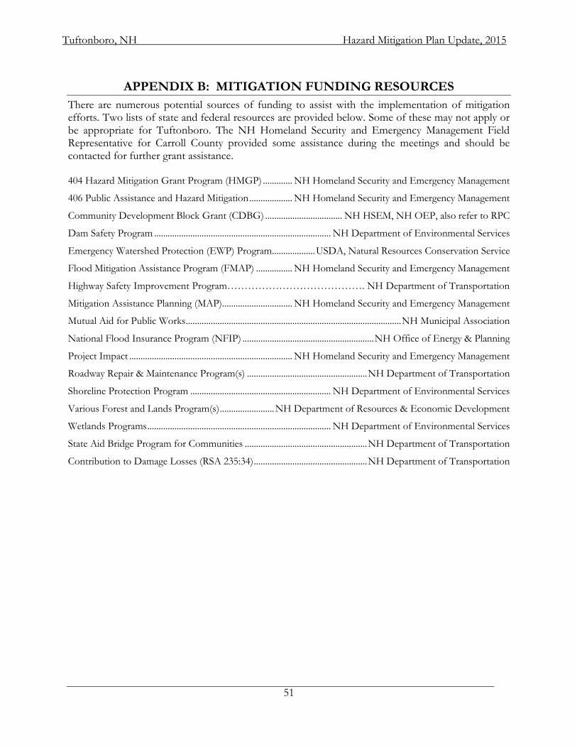
Tuftonboro, NH Hazard Mitigation Plan Update, 2015
51
APPENDIX B: MITIGATION FUNDING RESOURCES
There are numerous potential sources of funding to assist with the implementation of mitigation efforts. Two lists of state and federal resources are provided below. Some of these may not apply or be appropriate for Tuftonboro. The NH Homeland Security and Emergency Management Field Representative for Carroll County provided some assistance during the meetings and should be contacted for further grant assistance. 404 Hazard Mitigation Grant Program (HMGP) ............. NH Homeland Security and Emergency Management
406 Public Assistance and Hazard Mitigation ................... NH Homeland Security and Emergency Management
Community Development Block Grant (CDBG) .................................. NH HSEM, NH OEP, also refer to RPC
Dam Safety Program .............................................................................. NH Department of Environmental Services
Emergency Watershed Protection (EWP) Program................... USDA, Natural Resources Conservation Service
Flood Mitigation Assistance Program (FMAP) ................ NH Homeland Security and Emergency Management
Highway Safety Improvement Program…………………………………. NH Department of Transportation
Mitigation Assistance Planning (MAP) ............................... NH Homeland Security and Emergency Management
Mutual Aid for Public Works ............................................................................................... NH Municipal Association
National Flood Insurance Program (NFIP) .......................................................... NH Office of Energy & Planning
Project Impact ........................................................................ NH Homeland Security and Emergency Management
Roadway Repair & Maintenance Program(s) ..................................................... NH Department of Transportation
Shoreline Protection Program .............................................................. NH Department of Environmental Services
Various Forest and Lands Program(s) ........................ NH Department of Resources & Economic Development
Wetlands Programs ................................................................................. NH Department of Environmental Services
State Aid Bridge Program for Communities ...................................................... NH Department of Transportation
Contribution to Damage Losses (RSA 235:34) .................................................. NH Department of Transportation
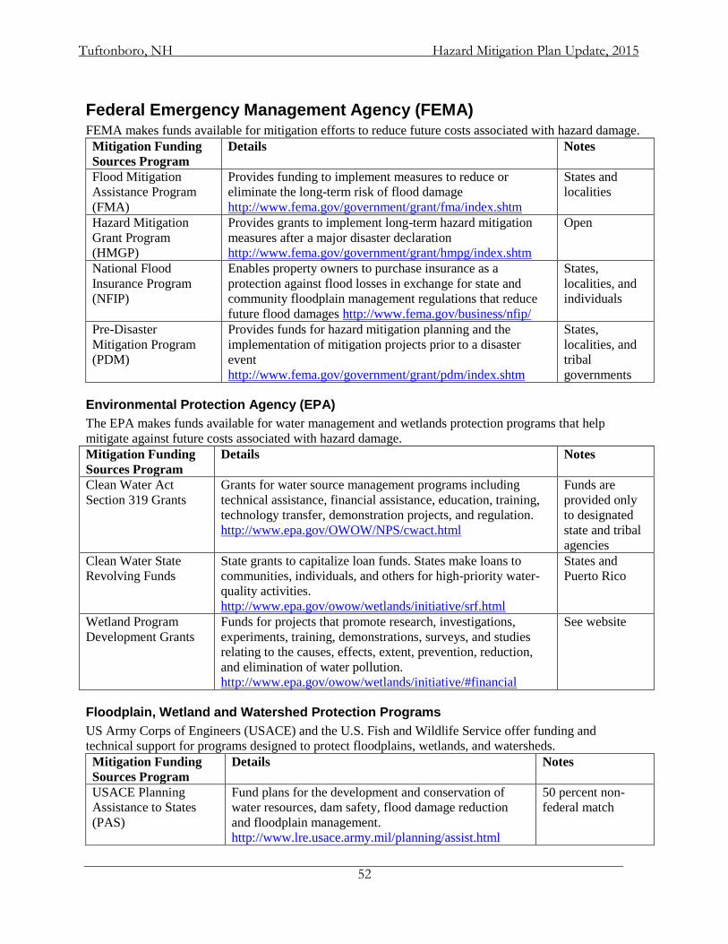
Tuftonboro, NH Hazard Mitigation Plan Update, 2015
52
Federal Emergency Management Agency (FEMA) FEMA makes funds available for mitigation efforts to reduce future costs associated with hazard damage.
Mitigation Funding
Sources Program
Details Notes
Flood Mitigation
Assistance Program
(FMA)
Provides funding to implement measures to reduce or
eliminate the long-term risk of flood damage
http://www.fema.gov/government/grant/fma/index.shtm
States and
localities
Hazard Mitigation
Grant Program
(HMGP)
Provides grants to implement long-term hazard mitigation
measures after a major disaster declaration
http://www.fema.gov/government/grant/hmpg/index.shtm
Open
National Flood
Insurance Program
(NFIP)
Enables property owners to purchase insurance as a
protection against flood losses in exchange for state and
community floodplain management regulations that reduce
future flood damages http://www.fema.gov/business/nfip/
States,
localities, and
individuals
Pre-Disaster
Mitigation Program
(PDM)
Provides funds for hazard mitigation planning and the
implementation of mitigation projects prior to a disaster
event
http://www.fema.gov/government/grant/pdm/index.shtm
States,
localities, and
tribal
governments
Environmental Protection Agency (EPA)
The EPA makes funds available for water management and wetlands protection programs that help
mitigate against future costs associated with hazard damage.
Mitigation Funding
Sources Program
Details Notes
Clean Water Act
Section 319 Grants
Grants for water source management programs including
technical assistance, financial assistance, education, training,
technology transfer, demonstration projects, and regulation.
http://www.epa.gov/OWOW/NPS/cwact.html
Funds are
provided only
to designated
state and tribal
agencies
Clean Water State
Revolving Funds
State grants to capitalize loan funds. States make loans to
communities, individuals, and others for high-priority water-
quality activities.
http://www.epa.gov/owow/wetlands/initiative/srf.html
States and
Puerto Rico
Wetland Program
Development Grants
Funds for projects that promote research, investigations,
experiments, training, demonstrations, surveys, and studies
relating to the causes, effects, extent, prevention, reduction,
and elimination of water pollution.
http://www.epa.gov/owow/wetlands/initiative/#financial
See website
Floodplain, Wetland and Watershed Protection Programs
US Army Corps of Engineers (USACE) and the U.S. Fish and Wildlife Service offer funding and
technical support for programs designed to protect floodplains, wetlands, and watersheds.
Mitigation Funding
Sources Program
Details Notes
USACE Planning
Assistance to States
(PAS)
Fund plans for the development and conservation of
water resources, dam safety, flood damage reduction
and floodplain management.
http://www.lre.usace.army.mil/planning/assist.html
50 percent non-
federal match
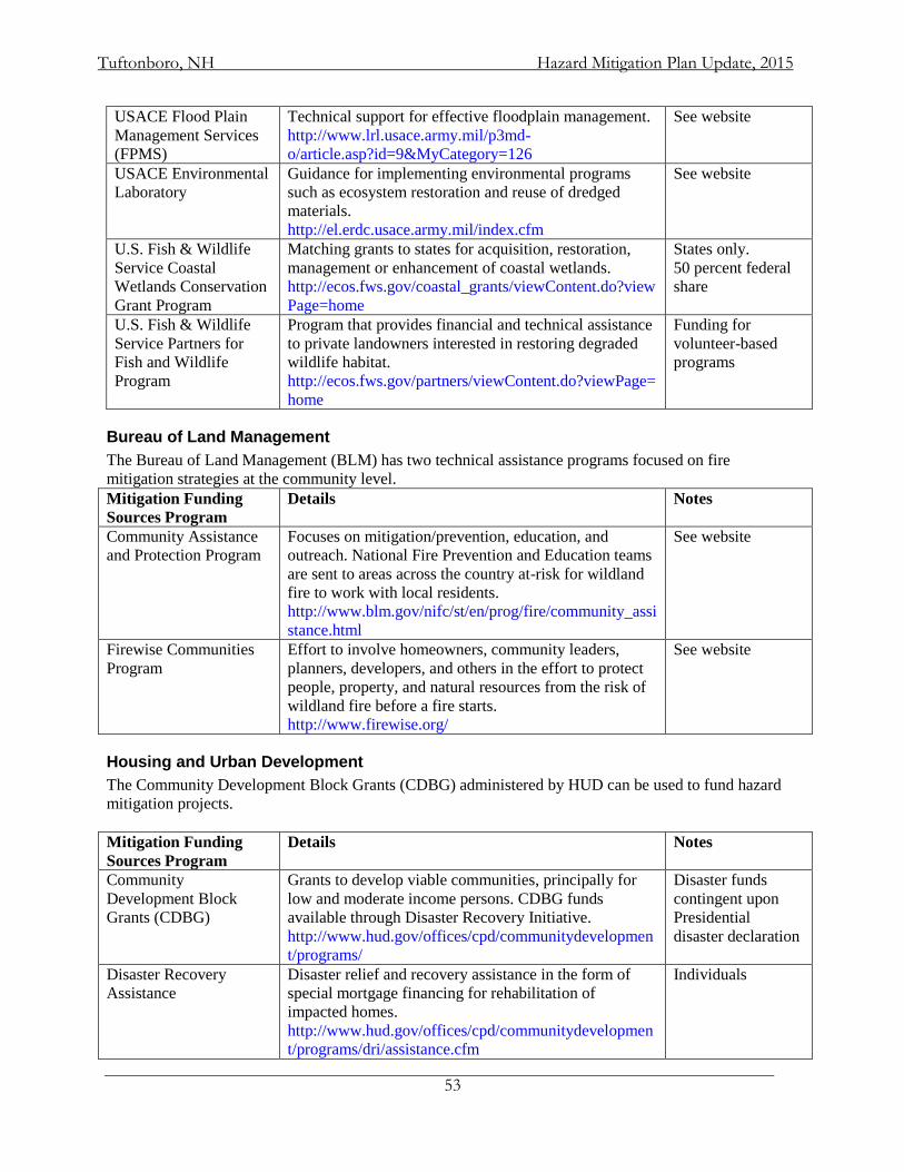
Tuftonboro, NH Hazard Mitigation Plan Update, 2015
53
USACE Flood Plain
Management Services
(FPMS)
Technical support for effective floodplain management.
http://www.lrl.usace.army.mil/p3md-
o/article.asp?id=9&MyCategory=126
See website
USACE Environmental
Laboratory
Guidance for implementing environmental programs
such as ecosystem restoration and reuse of dredged
materials.
http://el.erdc.usace.army.mil/index.cfm
See website
U.S. Fish & Wildlife
Service Coastal
Wetlands Conservation
Grant Program
Matching grants to states for acquisition, restoration,
management or enhancement of coastal wetlands.
http://ecos.fws.gov/coastal_grants/viewContent.do?view
Page=home
States only.
50 percent federal
share
U.S. Fish & Wildlife
Service Partners for
Fish and Wildlife
Program
Program that provides financial and technical assistance
to private landowners interested in restoring degraded
wildlife habitat.
http://ecos.fws.gov/partners/viewContent.do?viewPage=
home
Funding for
volunteer-based
programs
Bureau of Land Management
The Bureau of Land Management (BLM) has two technical assistance programs focused on fire
mitigation strategies at the community level.
Mitigation Funding
Sources Program
Details Notes
Community Assistance
and Protection Program
Focuses on mitigation/prevention, education, and
outreach. National Fire Prevention and Education teams
are sent to areas across the country at-risk for wildland
fire to work with local residents.
http://www.blm.gov/nifc/st/en/prog/fire/community_assi
stance.html
See website
Firewise Communities
Program
Effort to involve homeowners, community leaders,
planners, developers, and others in the effort to protect
people, property, and natural resources from the risk of
wildland fire before a fire starts.
http://www.firewise.org/
See website
Housing and Urban Development
The Community Development Block Grants (CDBG) administered by HUD can be used to fund hazard
mitigation projects.
Mitigation Funding
Sources Program
Details Notes
Community
Development Block
Grants (CDBG)
Grants to develop viable communities, principally for
low and moderate income persons. CDBG funds
available through Disaster Recovery Initiative.
http://www.hud.gov/offices/cpd/communitydevelopmen
t/programs/
Disaster funds
contingent upon
Presidential
disaster declaration
Disaster Recovery
Assistance
Disaster relief and recovery assistance in the form of
special mortgage financing for rehabilitation of
impacted homes.
http://www.hud.gov/offices/cpd/communitydevelopmen
t/programs/dri/assistance.cfm
Individuals
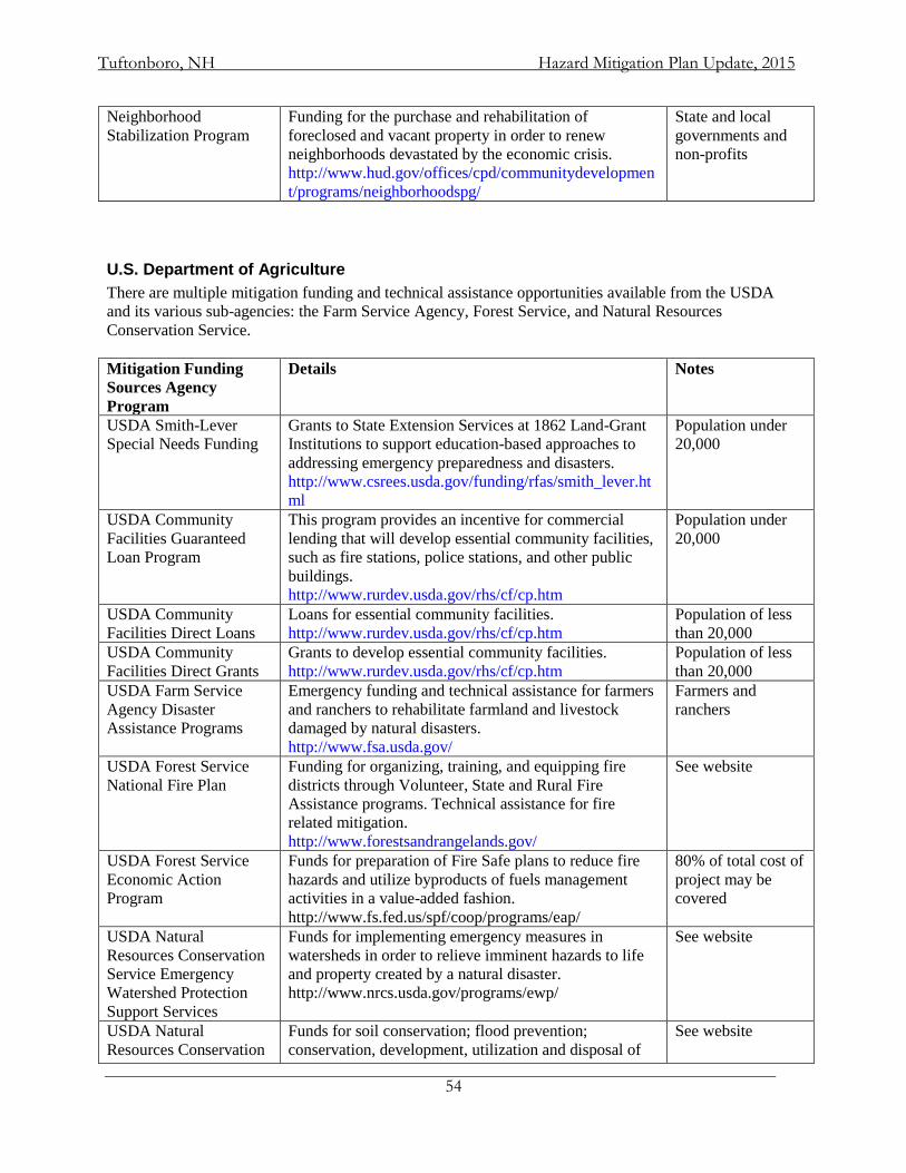
Tuftonboro, NH Hazard Mitigation Plan Update, 2015
54
Neighborhood
Stabilization Program
Funding for the purchase and rehabilitation of
foreclosed and vacant property in order to renew
neighborhoods devastated by the economic crisis.
http://www.hud.gov/offices/cpd/communitydevelopmen
t/programs/neighborhoodspg/
State and local
governments and
non-profits
U.S. Department of Agriculture
There are multiple mitigation funding and technical assistance opportunities available from the USDA
and its various sub-agencies: the Farm Service Agency, Forest Service, and Natural Resources
Conservation Service.
Mitigation Funding
Sources Agency
Program
Details Notes
USDA Smith-Lever
Special Needs Funding
Grants to State Extension Services at 1862 Land-Grant
Institutions to support education-based approaches to
addressing emergency preparedness and disasters.
http://www.csrees.usda.gov/funding/rfas/smith_lever.ht
ml
Population under
20,000
USDA Community
Facilities Guaranteed
Loan Program
This program provides an incentive for commercial
lending that will develop essential community facilities,
such as fire stations, police stations, and other public
buildings.
http://www.rurdev.usda.gov/rhs/cf/cp.htm
Population under
20,000
USDA Community
Facilities Direct Loans
Loans for essential community facilities.
http://www.rurdev.usda.gov/rhs/cf/cp.htm
Population of less
than 20,000
USDA Community
Facilities Direct Grants
Grants to develop essential community facilities.
http://www.rurdev.usda.gov/rhs/cf/cp.htm
Population of less
than 20,000
USDA Farm Service
Agency Disaster
Assistance Programs
Emergency funding and technical assistance for farmers
and ranchers to rehabilitate farmland and livestock
damaged by natural disasters.
http://www.fsa.usda.gov/
Farmers and
ranchers
USDA Forest Service
National Fire Plan
Funding for organizing, training, and equipping fire
districts through Volunteer, State and Rural Fire
Assistance programs. Technical assistance for fire
related mitigation.
http://www.forestsandrangelands.gov/
See website
USDA Forest Service
Economic Action
Program
Funds for preparation of Fire Safe plans to reduce fire
hazards and utilize byproducts of fuels management
activities in a value-added fashion.
http://www.fs.fed.us/spf/coop/programs/eap/
80% of total cost of
project may be
covered
USDA Natural
Resources Conservation
Service Emergency
Watershed Protection
Support Services
Funds for implementing emergency measures in
watersheds in order to relieve imminent hazards to life
and property created by a natural disaster.
http://www.nrcs.usda.gov/programs/ewp/
See website
USDA Natural
Resources Conservation
Funds for soil conservation; flood prevention;
conservation, development, utilization and disposal of
See website
Tuftonboro, NH Hazard Mitigation Plan Update, 2015
55
Service Watershed
Protection and Flood
Prevention
water; and conservation and proper utilization of land.
http://www.nrcs.usda.gov/programs/watershed/index.ht
ml
Health and Economic Agencies
Alternative mitigation programs can be found through health and economic agencies that provide loans
and grants aimed primarily at disaster relief.
Federal Loans and
Grants for Disaster
Relief Agency Program
Details Notes
Department of Health &
Human Services Disaster
Assistance for State
Units on Aging (SUAs)
Provide disaster relief funds to those SUAs and tribal
organizations who are currently receiving a grant under
Title VI of the Older Americans Act.
http://www.aoa.gov/doingbus/fundopp/fundopp.asp
Areas designated in
a Disaster
Declaration issued
by the President
Economic Development
Administration (EDA)
Economic Development
Administration
Investment Programs
Grants that support public works, economic adjustment
assistance, and planning. Certain funds allocated for
locations recently hit by major disasters.
http://www.eda.gov/AboutEDA/Programs.xml
The maximum
investment rate
shall not exceed 50
percent of the
project cost
U.S. Small Business
Administration Small
Business Administration
Loan Program
Low-interest, fixed rate loans to small businesses for the
purpose of implementing mitigation measures. Also
available for disaster damaged property.
http://www.sba.gov/services/financialassistance/index.ht
ml
Must meet SBA
approved credit
rating
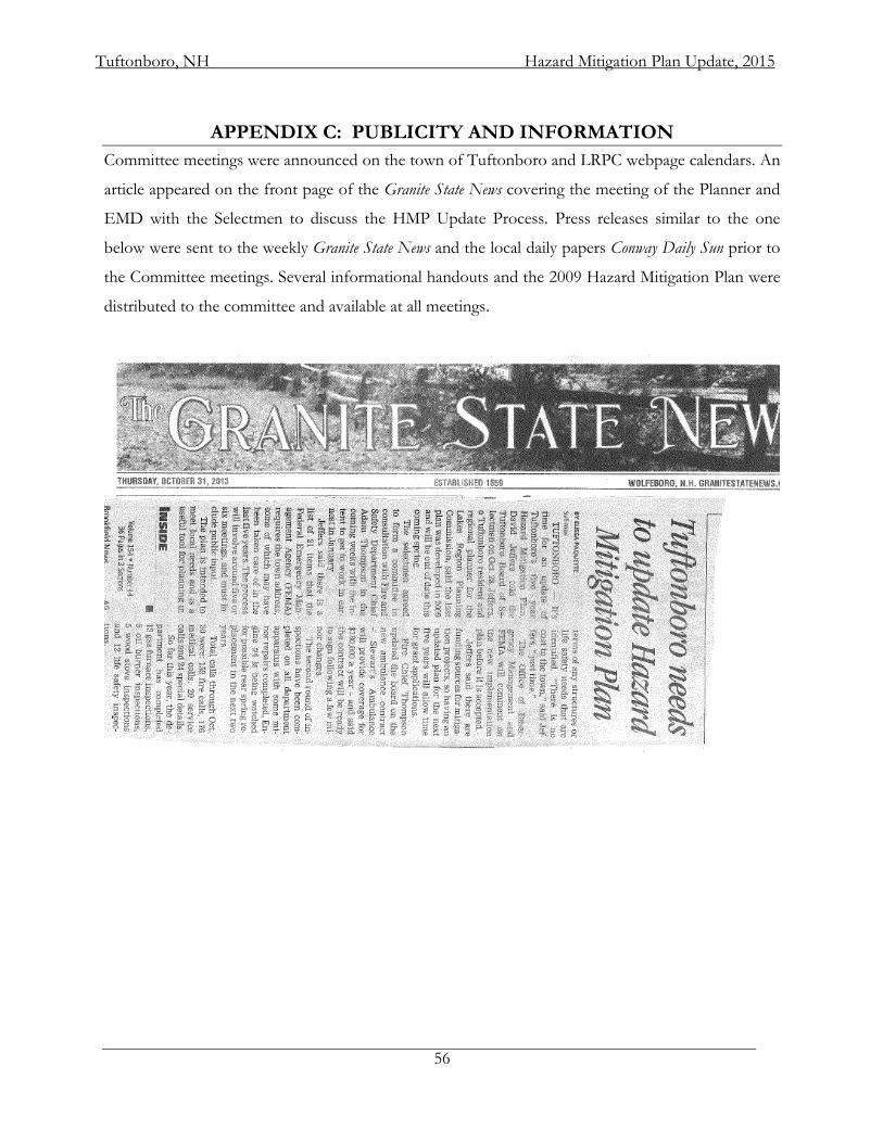
Tuftonboro, NH Hazard Mitigation Plan Update, 2015
56
APPENDIX C: PUBLICITY AND INFORMATION
Committee meetings were announced on the town of Tuftonboro and LRPC webpage calendars. An
article appeared on the front page of the Granite State News covering the meeting of the Planner and
EMD with the Selectmen to discuss the HMP Update Process. Press releases similar to the one
below were sent to the weekly Granite State News and the local daily papers Conway Daily Sun prior to
the Committee meetings. Several informational handouts and the 2009 Hazard Mitigation Plan were
distributed to the committee and available at all meetings.
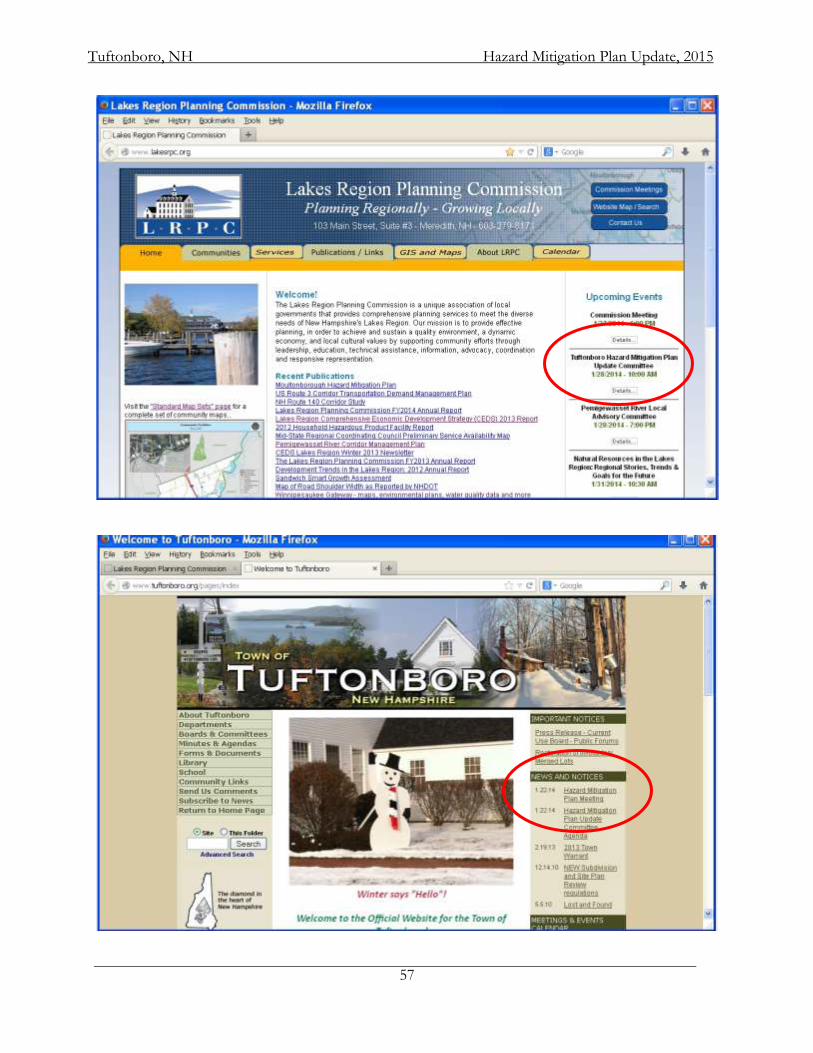
Tuftonboro, NH Hazard Mitigation Plan Update, 2015
57
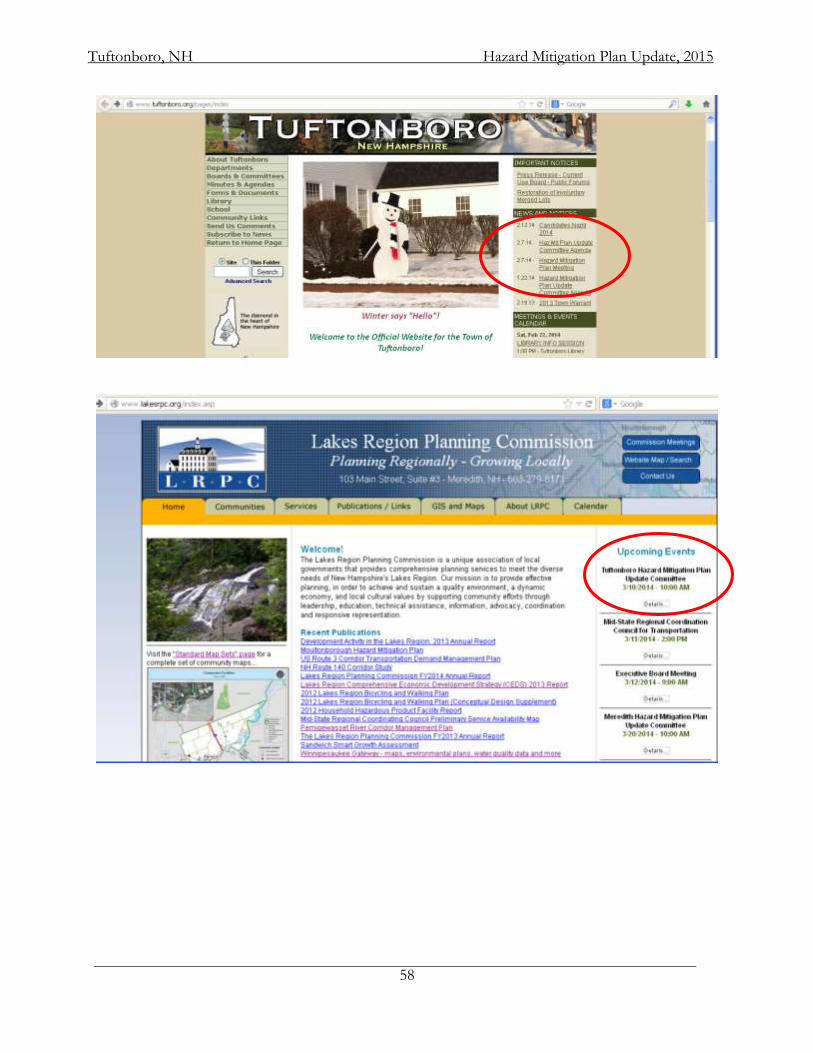
Tuftonboro, NH Hazard Mitigation Plan Update, 2015
58
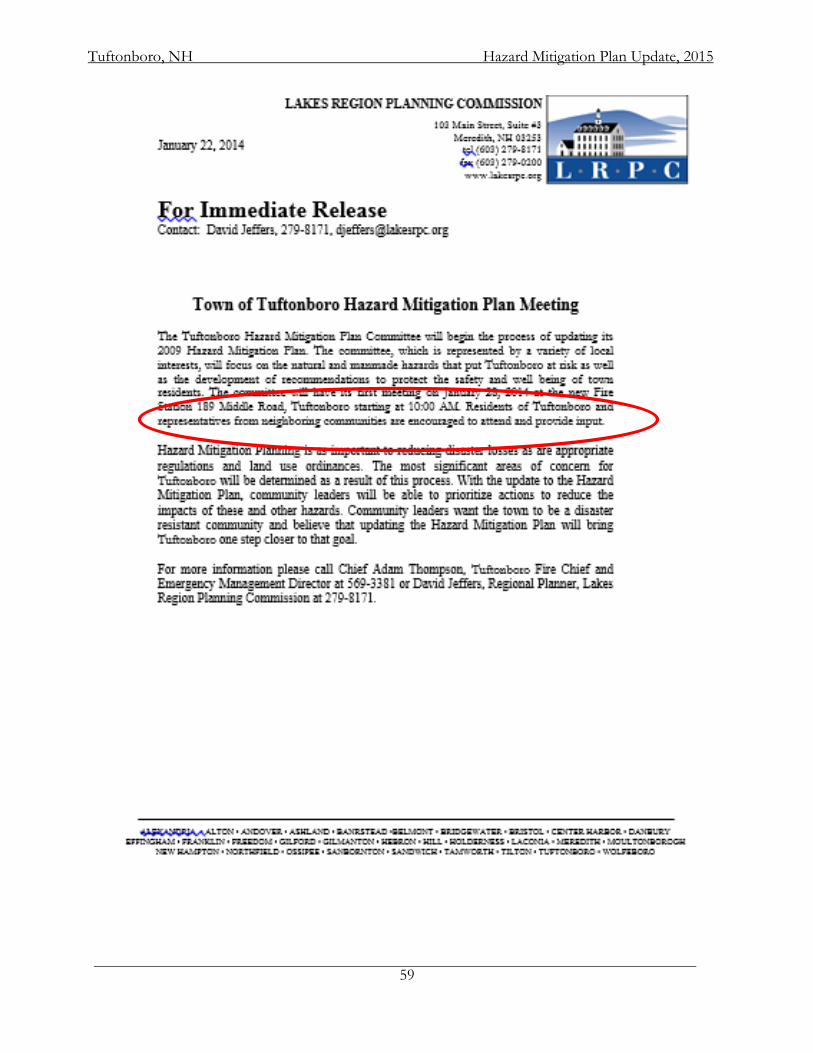
Tuftonboro, NH Hazard Mitigation Plan Update, 2015
59
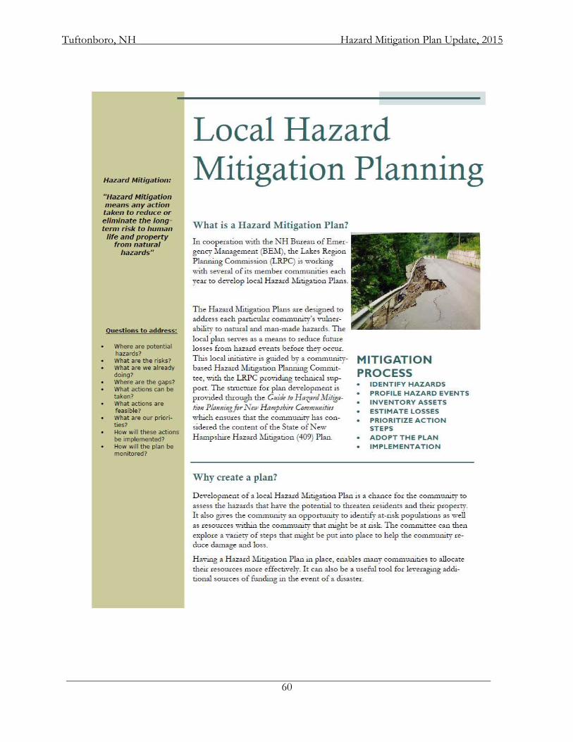
Tuftonboro, NH Hazard Mitigation Plan Update, 2015
60
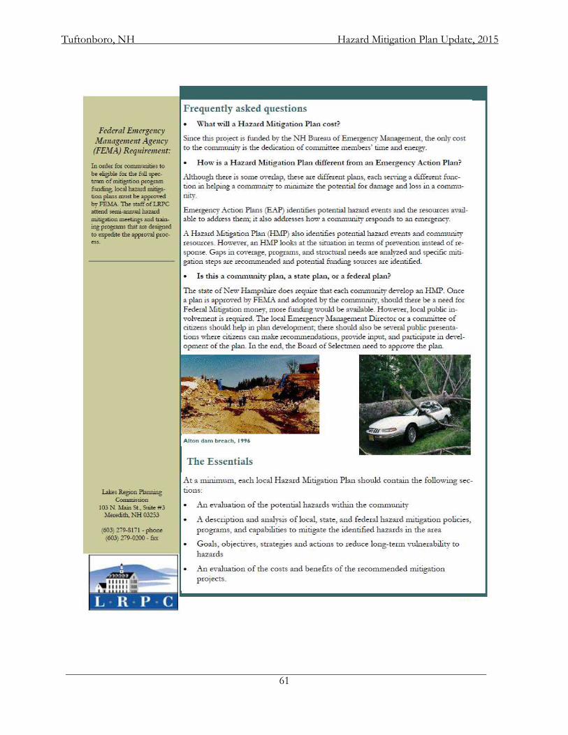
Tuftonboro, NH Hazard Mitigation Plan Update, 2015
61
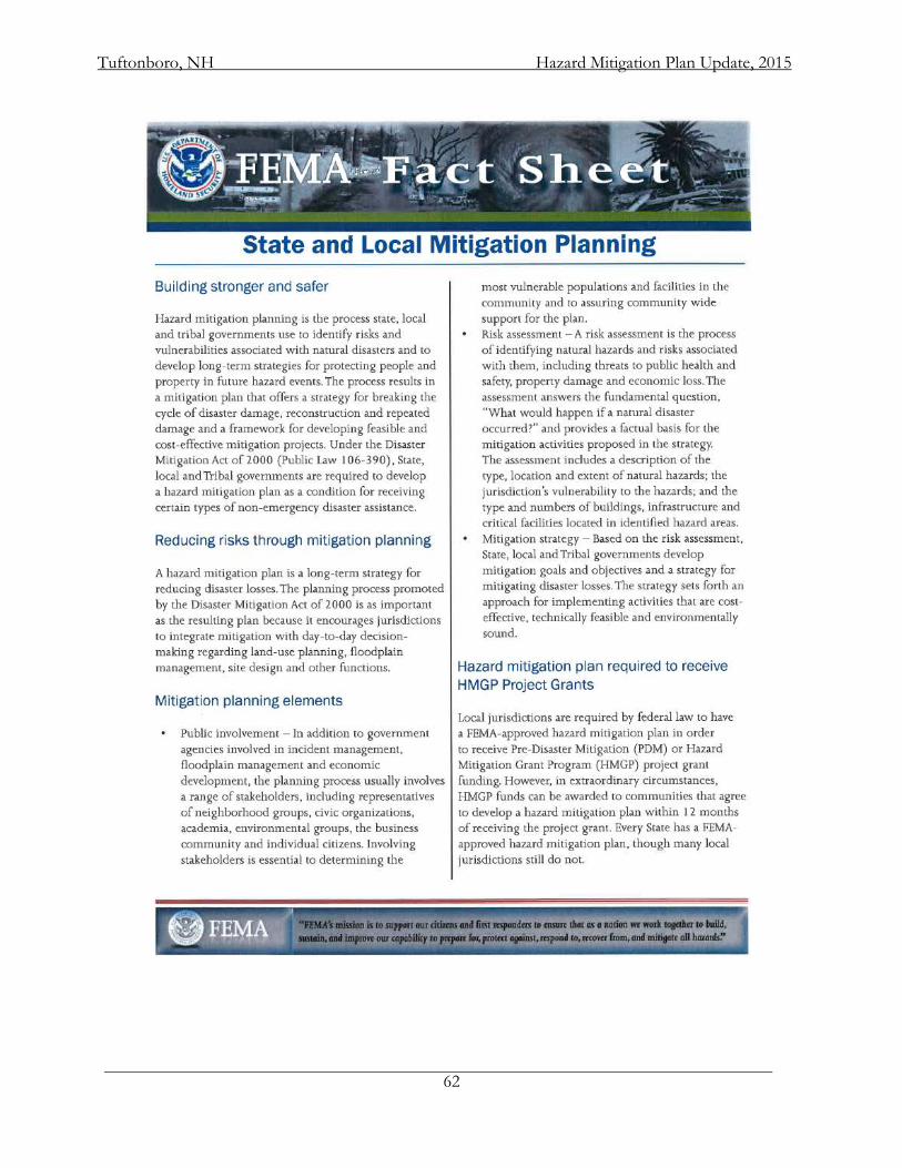
Tuftonboro, NH Hazard Mitigation Plan Update, 2015
62
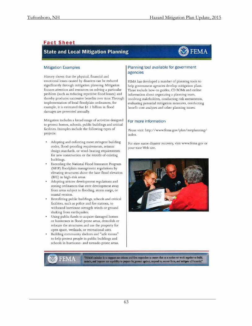
Tuftonboro, NH Hazard Mitigation Plan Update, 2015
63
Tuftonboro, NH Hazard Mitigation Plan Update, 2015
64
APPENDIX D: MEETING AGENDAS and PARTICIPATION
This section contains copies of the Committee meeting agendas and a summary of participation. Meetings were held at the Tuftonboro Central Fire Station. Agendas were developed by the LRPC planner and meetings were chaired by the Emergency Management Director. At each meeting there was opportunity for public input.
Tuftonboro Hazard Mitigation Plan Update Committee
January 28, 2014 – 10:00 AM Fire Station
189 Middle Road, Tuftonboro, NH
AGENDA
1. Introductions
2. What is Hazard Mitigation Planning? a. Mitigation planning vs. emergency response planning
3. Purpose of Committee 4. Review Community Capabilities
a. Planning & Regulatory b. Administrative and Technical c. Financial d. Education & Outreach e. National Flood Insurance Program (NFIP)
5. Discussion of Development Trends
6. Identify Critical Facilities on base map
7. Identify all hazards (past – especially since 2009 & potential) in Tuftonboro and mark on
map
8. Set schedule for future meetings 9. Public Input
Goals for next meeting:
a. Risk Assessment, including data collection b. Town Goals
Tuftonboro, NH Hazard Mitigation Plan Update, 2015
65
Tuftonboro Hazard Mitigation Plan Update Committee
February 10, 2014 – 10:00 AM Fire Station
189 Middle Road, Tuftonboro, NH
AGENDA
1. Introductions 2. Status of 2009 Mitigation Projects
3. Risk Assessment
a. Hazards
i. location ii. extent iii. frequency
b. Assets i. people ii. economy iii. built environment
1. existing structures 2. infrastructure 3. critical facilities 4. cultural resources 5. future development
c. Impacts
4. Schedule next meeting 5. Public Input
Goals for next meeting:
a. Goals b. Mitigation Actions
Tuftonboro, NH Hazard Mitigation Plan Update, 2015
66
Tuftonboro Hazard Mitigation Plan Update Committee
February 24, 2014 – 10:00 AM Fire Station
189 Middle Road, Tuftonboro, NH
AGENDA
1. Introductions 2. Review of Hazard Significance
3. Goals
4. Mitigation Actions
5. Schedule next meeting 6. Public Input
Goals for next meeting:
a. Costs of Actions b. Prioritization of Actions
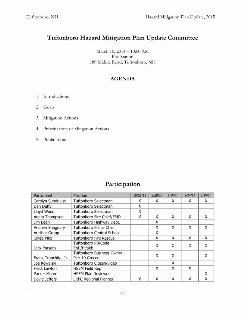
Tuftonboro, NH Hazard Mitigation Plan Update, 2015
67
Tuftonboro Hazard Mitigation Plan Update Committee
March 10, 2014 – 10:00 AM Fire Station
189 Middle Road, Tuftonboro, NH
AGENDA
1. Introductions
2. Goals
3. Mitigation Actions
4. Prioritization of Mitigation Actions 5. Public Input
Participation
Participant Position 10/28/13 1/28/14 2/10/14 2/24/14 3/10/14
Carolyn Sundquist Tuftonboro Selectman X X X X X
Dan Duffy Tuftonboro Selectman X
Lloyd Wood Tuftonboro Selectman X
Adam Thompson Tuftonboro Fire Chief/EMD X X X X X
Jim Bean Tuftonboro Highway Dept. X
Andrew Shagoury Tuftonboro Police Chief X X X X
Aurthur Grupp Tuftonboro Central School X
Caleb Pike Tuftonboro Fire Rescue X X X X
Jack Parsons
Tuftonboro PB/Code
Enf./Health X X X X
Frank Tranchita, Jr. Tuftonboro Business Owner - Pier 19 Grocer
X X
X
Joe Kowalski Tuftonboro Citizen/video X
Heidi Lawton HSEM Field Rep X X X
Parker Moore HSEM Plan Reviewer X
David Jeffers LRPC Regional Planner X X X X X
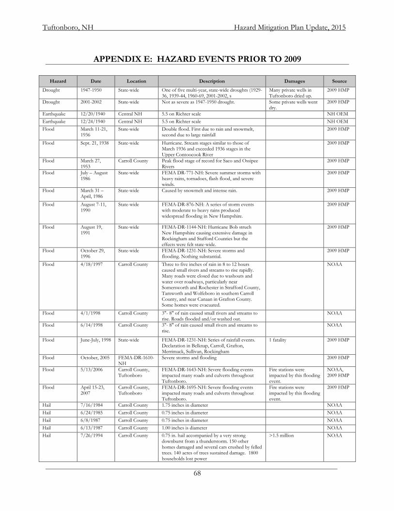
Tuftonboro, NH Hazard Mitigation Plan Update, 2015
68
APPENDIX E: HAZARD EVENTS PRIOR TO 2009
Hazard Date Location Description Damages Source
Drought 1947-1950 State-wide One of five multi-year, state-wide droughts (1929-36, 1939-44, 1960-69, 2001-2002, s
Many private wells in Tuftonboro dried up.
2009 HMP
Drought 2001-2002 State-wide Not as severe as 1947-1950 drought. Some private wells went dry.
2009 HMP
Earthquake 12/20/1940 Central NH 5.5 on Richter scale NH OEM
Earthquake 12/24/1940 Central NH 5.5 on Richter scale NH OEM
Flood March 11-21, 1936
State-wide Double flood. First due to rain and snowmelt, second due to large rainfall
2009 HMP
Flood Sept. 21, 1938 State-wide Hurricane. Stream stages similar to those of March 1936 and exceeded 1936 stages in the Upper Contoocook River
2009 HMP
Flood March 27, 1953
Carroll County Peak flood stage of record for Saco and Ossipee Rivers
2009 HMP
Flood July – August 1986
State-wide FEMA DR-771-NH: Severe summer storms with heavy rains, tornadoes, flash flood, and severe winds.
2009 HMP
Flood March 31 – April, 1986
State-wide Caused by snowmelt and intense rain. 2009 HMP
Flood August 7-11, 1990
State-wide FEMA-DR-876-NH: A series of storm events with moderate to heavy rains produced widespread flooding in New Hampshire.
2009 HMP
Flood August 19, 1991
State-wide FEMA-DR-1144-NH: Hurricane Bob struch New Hampshire causing extensive damage in Rockingham and Stafford Counties but the effects were felt state-wide.
2009 HMP
Flood October 29, 1996
State-wide FEMA-DR-1231-NH: Severe storms and flooding. Nothing substantial.
2009 HMP
Flood 4/18/1997 Carroll County Three to five inches of rain in 8 to 12 hours caused small rivers and streams to rise rapidly. Many roads were closed due to washouts and water over roadways, particularly near Somersworth and Rochester in Strafford County, Tamworth and Wolfeboro in southern Carroll County, and near Canaan in Grafton County. Some homes were evacuated.
NOAA
Flood 4/1/1998 Carroll County 3"- 8" of rain caused small rivers and streams to rise. Roads flooded and/or washed out.
NOAA
Flood 6/14/1998 Carroll County 3"- 8" of rain caused small rivers and streams to rise.
NOAA
Flood June-July, 1998 State-wide FEMA-DR-1231-NH: Series of rainfall events. Declaration in Belknap, Carroll, Grafton, Merrimack, Sullivan, Rockingham
1 fatality 2009 HMP
Flood October, 2005 FEMA-DR-1610-NH
Severe storms and flooding 2009 HMP
Flood 5/13/2006 Carroll County, Tuftonboro
FEMA-DR-1643-NH: Severe flooding events impacted many roads and culverts throughout Tuftonboro.
Fire stations were impacted by this flooding event.
NOAA, 2009 HMP
Flood April 15-23, 2007
Carroll County, Tuftonboro
FEMA-DR-1695-NH: Severe flooding events impacted many roads and culverts throughout Tuftonboro.
Fire stations were impacted by this flooding event.
2009 HMP
Hail 7/16/1984 Carroll County 1.75 inches in diameter NOAA
Hail 6/24/1985 Carroll County 0.75 inches in diameter NOAA
Hail 6/8/1987 Carroll County 0.75 inches in diameter NOAA
Hail 6/13/1987 Carroll County 1.00 inches is diameter NOAA
Hail 7/26/1994 Carroll County 0.75 in. hail accompanied by a very strong downburst from a thunderstorm. 150 other homes damaged and several cars crushed by felled trees. 140 acres of trees sustained damage. 1800 households lost power
>1.5 million NOAA
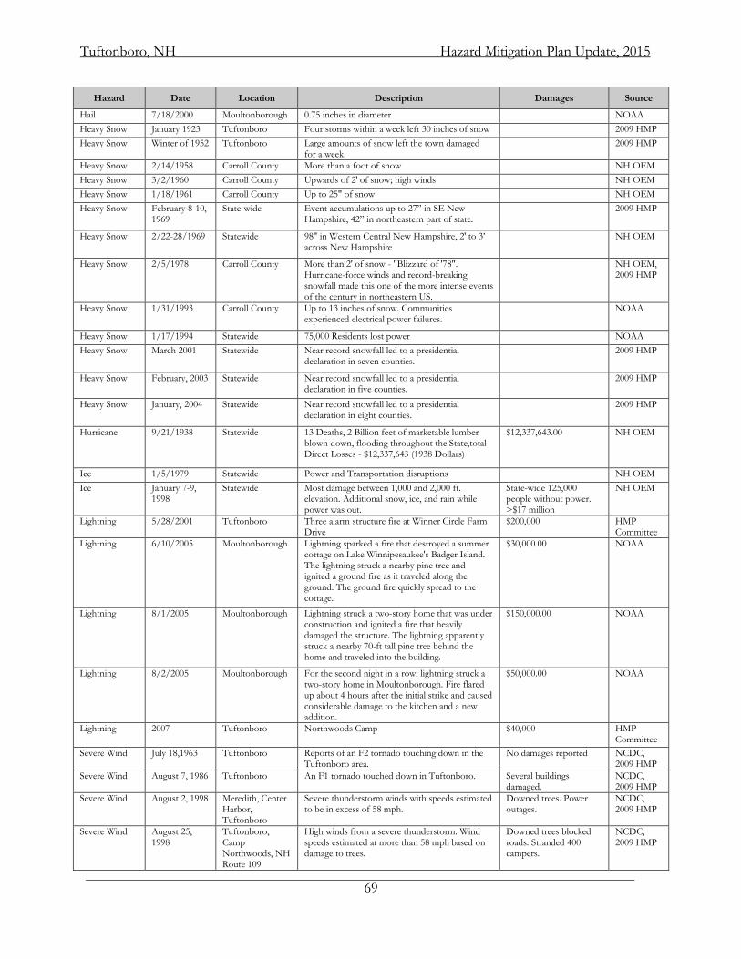
Tuftonboro, NH Hazard Mitigation Plan Update, 2015
69
Hazard Date Location Description Damages Source
Hail 7/18/2000 Moultonborough 0.75 inches in diameter NOAA
Heavy Snow January 1923 Tuftonboro Four storms within a week left 30 inches of snow 2009 HMP
Heavy Snow Winter of 1952 Tuftonboro Large amounts of snow left the town damaged for a week.
2009 HMP
Heavy Snow 2/14/1958 Carroll County More than a foot of snow NH OEM
Heavy Snow 3/2/1960 Carroll County Upwards of 2' of snow; high winds NH OEM
Heavy Snow 1/18/1961 Carroll County Up to 25" of snow NH OEM
Heavy Snow February 8-10, 1969
State-wide Event accumulations up to 27” in SE New Hampshire, 42” in northeastern part of state.
2009 HMP
Heavy Snow 2/22-28/1969 Statewide 98" in Western Central New Hampshire, 2' to 3’ across New Hampshire
NH OEM
Heavy Snow 2/5/1978 Carroll County More than 2' of snow - "Blizzard of '78". Hurricane-force winds and record-breaking snowfall made this one of the more intense events of the century in northeastern US.
NH OEM, 2009 HMP
Heavy Snow 1/31/1993 Carroll County Up to 13 inches of snow. Communities experienced electrical power failures.
NOAA
Heavy Snow 1/17/1994 Statewide 75,000 Residents lost power NOAA
Heavy Snow March 2001 Statewide Near record snowfall led to a presidential declaration in seven counties.
2009 HMP
Heavy Snow February, 2003 Statewide Near record snowfall led to a presidential declaration in five counties.
2009 HMP
Heavy Snow January, 2004 Statewide Near record snowfall led to a presidential declaration in eight counties.
2009 HMP
Hurricane 9/21/1938 Statewide 13 Deaths, 2 Billion feet of marketable lumber blown down, flooding throughout the State,total Direct Losses - $12,337,643 (1938 Dollars)
$12,337,643.00 NH OEM
Ice 1/5/1979 Statewide Power and Transportation disruptions NH OEM
Ice January 7-9, 1998
Statewide Most damage between 1,000 and 2,000 ft. elevation. Additional snow, ice, and rain while power was out.
State-wide 125,000 people without power. >$17 million
NH OEM
Lightning 5/28/2001 Tuftonboro Three alarm structure fire at Winner Circle Farm Drive
$200,000 HMP Committee
Lightning 6/10/2005 Moultonborough Lightning sparked a fire that destroyed a summer cottage on Lake Winnipesaukee's Badger Island. The lightning struck a nearby pine tree and ignited a ground fire as it traveled along the ground. The ground fire quickly spread to the cottage.
$30,000.00 NOAA
Lightning 8/1/2005 Moultonborough Lightning struck a two-story home that was under construction and ignited a fire that heavily damaged the structure. The lightning apparently struck a nearby 70-ft tall pine tree behind the home and traveled into the building.
$150,000.00 NOAA
Lightning 8/2/2005 Moultonborough For the second night in a row, lightning struck a two-story home in Moultonborough. Fire flared up about 4 hours after the initial strike and caused considerable damage to the kitchen and a new addition.
$50,000.00 NOAA
Lightning 2007 Tuftonboro Northwoods Camp $40,000 HMP Committee
Severe Wind July 18,1963 Tuftonboro Reports of an F2 tornado touching down in the Tuftonboro area.
No damages reported NCDC, 2009 HMP
Severe Wind August 7, 1986 Tuftonboro An F1 tornado touched down in Tuftonboro. Several buildings damaged.
NCDC, 2009 HMP
Severe Wind August 2, 1998 Meredith, Center Harbor, Tuftonboro
Severe thunderstorm winds with speeds estimated to be in excess of 58 mph.
Downed trees. Power outages.
NCDC, 2009 HMP
Severe Wind August 25, 1998
Tuftonboro, Camp Northwoods, NH Route 109
High winds from a severe thunderstorm. Wind speeds estimated at more than 58 mph based on damage to trees.
Downed trees blocked roads. Stranded 400 campers.
NCDC, 2009 HMP
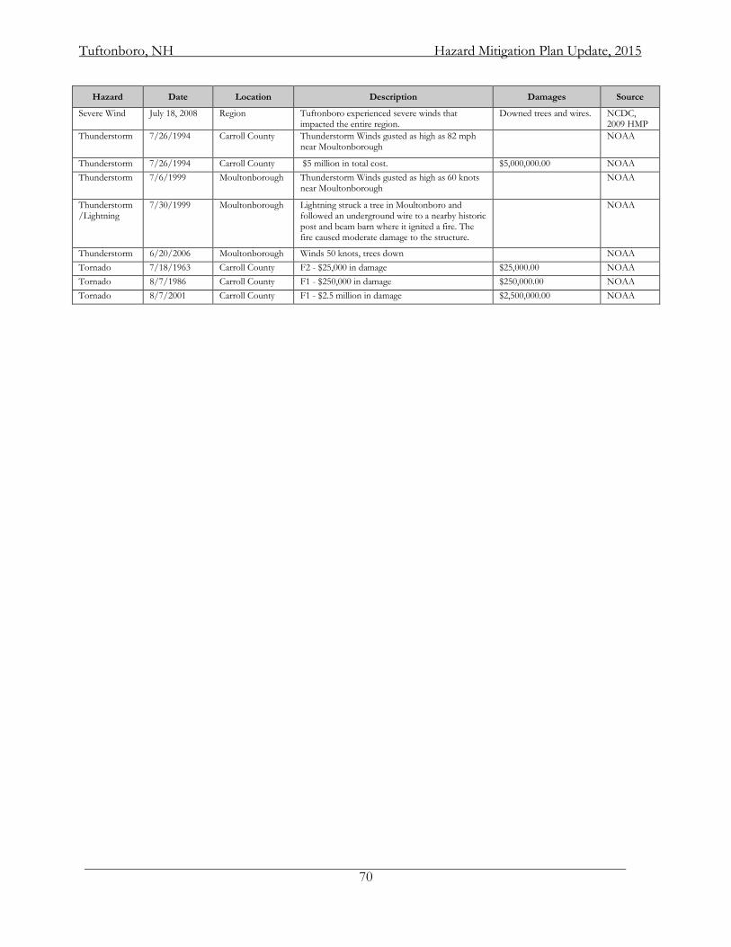
Tuftonboro, NH Hazard Mitigation Plan Update, 2015
70
Hazard Date Location Description Damages Source
Severe Wind July 18, 2008 Region Tuftonboro experienced severe winds that impacted the entire region.
Downed trees and wires. NCDC, 2009 HMP
Thunderstorm 7/26/1994 Carroll County Thunderstorm Winds gusted as high as 82 mph near Moultonborough
NOAA
Thunderstorm 7/26/1994 Carroll County $5 million in total cost. $5,000,000.00 NOAA
Thunderstorm 7/6/1999 Moultonborough Thunderstorm Winds gusted as high as 60 knots near Moultonborough
NOAA
Thunderstorm/Lightning
7/30/1999 Moultonborough Lightning struck a tree in Moultonboro and followed an underground wire to a nearby historic post and beam barn where it ignited a fire. The fire caused moderate damage to the structure.
NOAA
Thunderstorm 6/20/2006 Moultonborough Winds 50 knots, trees down NOAA
Tornado 7/18/1963 Carroll County F2 - $25,000 in damage $25,000.00 NOAA
Tornado 8/7/1986 Carroll County F1 - $250,000 in damage $250,000.00 NOAA
Tornado 8/7/2001 Carroll County F1 - $2.5 million in damage $2,500,000.00 NOAA
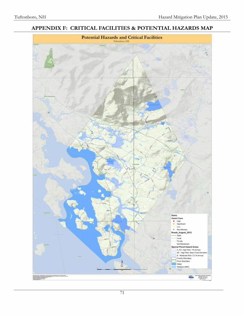
Tuftonboro, NH Hazard Mitigation Plan Update, 2015
71
APPENDIX F: CRITICAL FACILITIES & POTENTIAL HAZARDS MAP
Tuftonboro, NH Hazard Mitigation Plan Update, 2015
72
APPENDIX G: HAZARDS – SUPPLEMENTARY HAZARD INFORMATION
This section provides statewide or regional information regarding hazards. Some information is about hazards mentioned in the NH Hazard Mitigation Plan. Other information either provides context or extra detail which supplements the locally important information addressed in Chapter III. Flooding Historically, the state’s two largest floods occurred in 1936 and 1938. The 1936 flood was associated with snow melt and heavy precipitation. The 1938 flooding was caused by the Great New England Hurricane of 1938. Those floods prompted the construction of a series of flood control dams throughout New England, built in the 1950s and ‘60s. They continue to be operated by the US Army Corps of Engineers.23 A series of floods in New Hampshire began in October 2005 with a flood that primarily affected the southwest corner of the state and devastated the town of Alstead. The flood killed seven people. It was followed by floods in May 2006 and April 2007 and a series of floods during the late summer and early fall of 2008. Recent flooding in the region was associated with Tropical Storm Irene in September 2011 and Tropical Storm Sandy in October 2012. Flooding in the Lakes Region is most commonly associated with structures and properties located within a floodplain. There are numerous rivers and streams within the region and significant changes in elevation, leading to some fast-moving water. The region also has a great deal of shoreline, making it exposed to rising water levels as well. Although historically, there have not been many instances of shoreline flooding, the potential always exists for a major flood event to occur. Recent rain events have proven this is becoming an increasing concern as additional development is contributing to flood hazards. As areas are covered with impervious surfaces, less water is allowed to infiltrate, evaporate, or be transpired by vegetative growth and more of it runs off directly into surface drainages and water bodies. This increases the likelihood of flash floods and substantial overland flow. Of greatest concern are the waterfront properties on the lakes, ponds, and associated tributaries. Culvert improvements and roadwork have been conducted throughout the region as a result of localized flooding events. Of particular concern in the region are areas of steep slopes and soils with limited capacity to accept rapid volumes of rainwater. Roads and culverts in close proximity to these conditions are most at risk of localized flooding. Flooding due to Dam Failure Dam failure results in rapid loss of water that is normally held back by a dam. These types of floods can be extremely dangerous and pose a threat to both life and property. Dam classifications in New Hampshire are based on the degree of potential damages that a failure or disoperation of the dam is expected to cause. The classifications are designated as non-menace, low hazard, significant hazard, and high hazard and are summarized in greater detail in Table G-1.
23 http://www.nh.gov/safety/divisions/hsem/NaturalHazards/index.html date visited: January 18, 2011
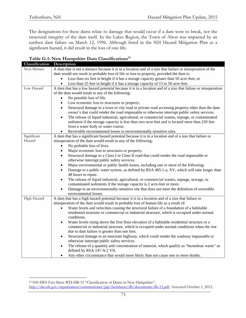
Tuftonboro, NH Hazard Mitigation Plan Update, 2015
73
The designations for these dams relate to damage that would occur if a dam were to break, not the structural integrity of the dam itself. In the Lakes Region, the Town of Alton was impacted by an earthen dam failure on March 12, 1996. Although listed in the NH Hazard Mitigation Plan as a significant hazard, it did result in the loss of one life.
Table G-1: New Hampshire Dam Classifications24
Classification Description Non-Menace A dam that is not a menace because it is in a location and of a size that failure or misoperation of the
dam would not result in probable loss of life or loss to property, provided the dam is:
Less than six feet in height if it has a storage capacity greater than 50 acre-feet; or
Less than 25 feet in height if it has a storage capacity of 15 to 50 acre-feet.
Low Hazard A dam that has a low hazard potential because it is in a location and of a size that failure or misoperation
of the dam would result in any of the following:
No possible loss of life.
Low economic loss to structures or property.
Structural damage to a town or city road or private road accessing property other than the dam
owner’s that could render the road impassable or otherwise interrupt public safety services.
The release of liquid industrial, agricultural, or commercial wastes, septage, or contaminated
sediment if the storage capacity is less than two-acre-feet and is located more than 250 feet
from a water body or water course.
Reversible environmental losses to environmentally-sensitive sites.
Significant Hazard
A dam that has a significant hazard potential because it is in a location and of a size that failure or
misoperation of the dam would result in any of the following:
No probable loss of lives.
Major economic loss to structures or property.
Structural damage to a Class I or Class II road that could render the road impassable or
otherwise interrupt public safety services.
Major environmental or public health losses, including one or more of the following:
Damage to a public water system, as defined by RSA 485:1-a, XV, which will take longer than
48 hours to repair.
The release of liquid industrial, agricultural, or commercial wastes, septage, sewage, or
contaminated sediments if the storage capacity is 2 acre-feet or more.
Damage to an environmentally-sensitive site that does not meet the definition of reversible
environmental losses.
High Hazard A dam that has a high hazard potential because it is in a location and of a size that failure or
misoperation of the dam would result in probable loss of human life as a result of:
Water levels and velocities causing the structural failure of a foundation of a habitable
residential structure or commercial or industrial structure, which is occupied under normal
conditions.
Water levels rising above the first floor elevation of a habitable residential structure or a
commercial or industrial structure, which is occupied under normal conditions when the rise
due to dam failure is greater than one foot.
Structural damage to an interstate highway, which could render the roadway impassable or
otherwise interrupt public safety services.
The release of a quantity and concentration of material, which qualify as “hazardous waste” as
defined by RSA 147-A:2 VII.
Any other circumstance that would more likely than not cause one or more deaths.
24 NH DES Fact Sheet WD-DB-15 “Classification of Dams in New Hampshire”, http://des.nh.gov/organization/commissioner/pip/factsheets/db/documents/db-15.pdf. Accessed October 1, 2012.
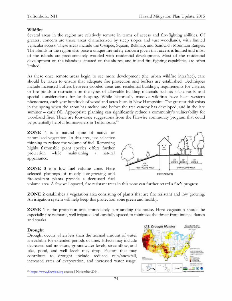
Tuftonboro, NH Hazard Mitigation Plan Update, 2015
74
Wildfire Several areas in the region are relatively remote in terms of access and fire-fighting abilities. Of greatest concern are those areas characterized by steep slopes and vast woodlands, with limited vehicular access. These areas include the Ossipee, Squam, Belknap, and Sandwich Mountain Ranges. The islands in the region also pose a unique fire safety concern given that access is limited and most of the islands are predominately wooded with residential development. Most of the residential development on the islands is situated on the shores, and inland fire-fighting capabilities are often limited. As these once remote areas begin to see more development (the urban wildfire interface), care should be taken to ensure that adequate fire protection and buffers are established. Techniques include increased buffers between wooded areas and residential buildings, requirements for cisterns or fire ponds, a restriction on the types of allowable building materials such as shake roofs, and special considerations for landscaping. While historically massive wildfires have been western phenomena, each year hundreds of woodland acres burn in New Hampshire. The greatest risk exists in the spring when the snow has melted and before the tree canopy has developed, and in the late summer – early fall. Appropriate planning can significantly reduce a community’s vulnerability for woodland fires. There are four-zone suggestions from the Firewise community program that could be potentially helpful homeowners in Tuftonboro.25 ZONE 4 is a natural zone of native or naturalized vegetation. In this area, use selective thinning to reduce the volume of fuel. Removing highly flammable plant species offers further protection while maintaining a natural appearance. ZONE 3 is a low fuel volume zone. Here selected plantings of mostly low-growing and fire-resistant plants provide a decreased fuel volume area. A few well-spaced, fire resistant trees in this zone can further retard a fire's progress. ZONE 2 establishes a vegetation area consisting of plants that are fire resistant and low growing. An irrigation system will help keep this protection zone green and healthy. ZONE 1 is the protection area immediately surrounding the house. Here vegetation should be especially fire resistant, well irrigated and carefully spaced to minimize the threat from intense flames and sparks. Drought Drought occurs when less than the normal amount of water is available for extended periods of time. Effects may include decreased soil moisture, groundwater levels, streamflow, and lake, pond, and well levels may drop. Factors that may contribute to drought include reduced rain/snowfall, increased rates of evaporation, and increased water usage.
25 http://www.firewise.org accessed November 2014.
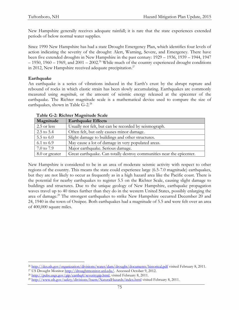
Tuftonboro, NH Hazard Mitigation Plan Update, 2015
75
New Hampshire generally receives adequate rainfall; it is rare that the state experiences extended periods of below normal water supplies. Since 1990 New Hampshire has had a state Drought Emergency Plan, which identifies four levels of action indicating the severity of the drought: Alert, Warning, Severe, and Emergency. There have been five extended droughts in New Hampshire in the past century: 1929 – 1936, 1939 – 1944, 1947 – 1950, 1960 – 1969, and 2001 – 2002.26 While much of the country experienced drought conditions in 2012, New Hampshire received adequate precipitation.27 Earthquake An earthquake is a series of vibrations induced in the Earth’s crust by the abrupt rupture and rebound of rocks in which elastic strain has been slowly accumulating. Earthquakes are commonly measured using magnitude, or the amount of seismic energy released at the epicenter of the earthquake. The Richter magnitude scale is a mathematical device used to compare the size of earthquakes, shown in Table G-2.28 Table G-2: Richter Magnitude Scale
Magnitude Earthquake Effects
2.5 or less Usually not felt, but can be recorded by seismograph.
2.5 to 5.4 Often felt, but only causes minor damage.
5.5 to 6.0 Slight damage to buildings and other structures.
6.1 to 6.9 May cause a lot of damage in very populated areas.
7.0 to 7.9 Major earthquake. Serious damage.
8.0 or greater Great earthquake. Can totally destroy communities near the epicenter.
New Hampshire is considered to be in an area of moderate seismic activity with respect to other regions of the country. This means the state could experience large (6.5-7.0 magnitude) earthquakes, but they are not likely to occur as frequently as in a high hazard area like the Pacific coast. There is the potential for nearby earthquakes to register 5.5 on the Richter Scale, causing slight damage to buildings and structures. Due to the unique geology of New Hampshire, earthquake propagation waves travel up to 40 times further than they do in the western United States, possibly enlarging the area of damage.29 The strongest earthquakes to strike New Hampshire occurred December 20 and 24, 1940 in the town of Ossipee. Both earthquakes had a magnitude of 5.5 and were felt over an area of 400,000 square miles.
26 http://des.nh.gov/organization/divisions/water/dam/drought/documents/historical.pdf visited February 8, 2011. 27 US Drought Monitor http://droughtmonitor.unl.edu/. Accessed October 9, 2012. 28 http://pubs.usgs.gov/gip/earthq4/severitygip.html, visited February 8, 2011. 29 http://www.nh.gov/safety/divisions/hsem/NaturalHazards/index.html visited February 8, 2011.
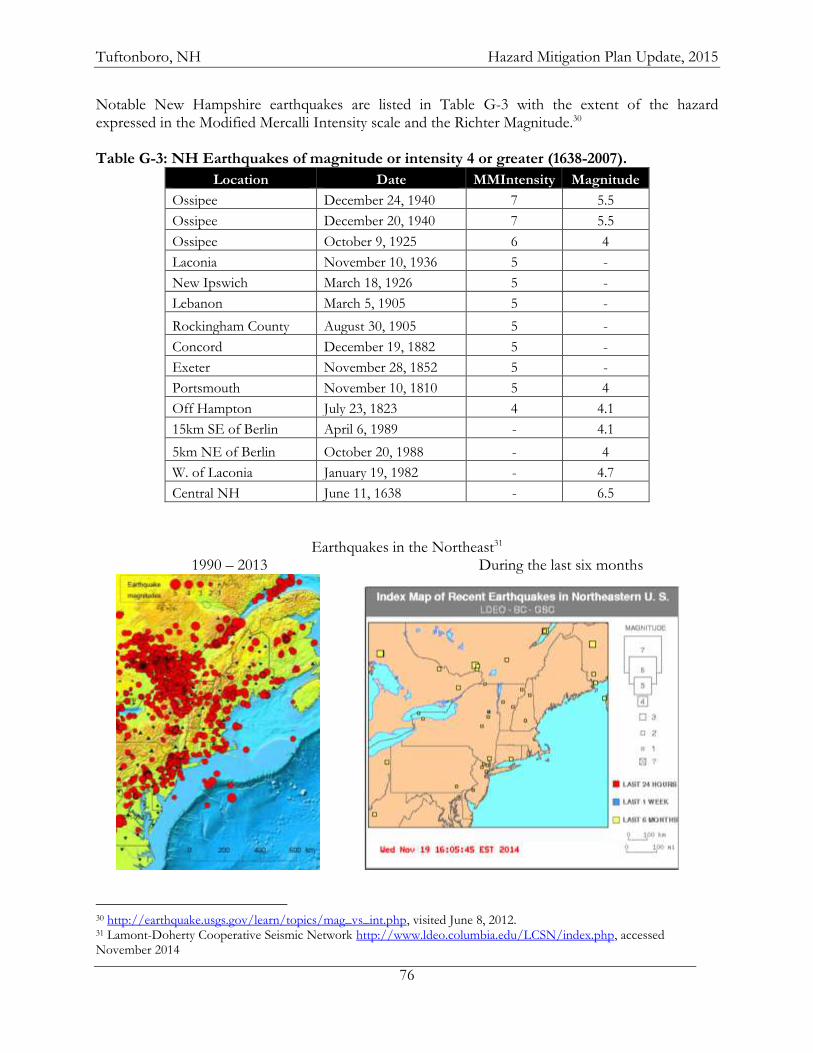
Tuftonboro, NH Hazard Mitigation Plan Update, 2015
76
Notable New Hampshire earthquakes are listed in Table G-3 with the extent of the hazard expressed in the Modified Mercalli Intensity scale and the Richter Magnitude.30 Table G-3: NH Earthquakes of magnitude or intensity 4 or greater (1638-2007).
Location Date MMIntensity Magnitude
Ossipee December 24, 1940 7 5.5
Ossipee December 20, 1940 7 5.5
Ossipee October 9, 1925 6 4
Laconia November 10, 1936 5 -
New Ipswich March 18, 1926 5 -
Lebanon March 5, 1905 5 -
Rockingham County August 30, 1905 5 -
Concord December 19, 1882 5 -
Exeter November 28, 1852 5 -
Portsmouth November 10, 1810 5 4
Off Hampton July 23, 1823 4 4.1
15km SE of Berlin April 6, 1989 - 4.1
5km NE of Berlin October 20, 1988 - 4
W. of Laconia January 19, 1982 - 4.7
Central NH June 11, 1638 - 6.5
Earthquakes in the Northeast31 1990 – 2013 During the last six months
30 http://earthquake.usgs.gov/learn/topics/mag_vs_int.php, visited June 8, 2012. 31 Lamont-Doherty Cooperative Seismic Network http://www.ldeo.columbia.edu/LCSN/index.php, accessed November 2014
Tuftonboro, NH Hazard Mitigation Plan Update, 2015
77
Damage from an earthquake generally falls into two types; Structural and Nonstructural. Structural Damage is considered any damage to the load bearing components of a building
or other structure. Nonstructural Damage is considered any portion not connected to the superstructure. This
includes anything added after the frame is complete.
According to the NH Division of Homeland Security and Emergency Management, some of the issues likely to be encountered after a damaging earthquake could be:
Total or partial collapse of buildings, especially un-reinforced masonry structures and those not built to seismic codes.
Damage to roads and bridges from ground settlement and structural damage. Mass Causalities. Loss of electric power. Loss of telecommunication systems. Fires from gas line ruptures and chimney failures. Total or partial loss of potable and fire-fighting water systems from pipe ruptures. Hazardous Material incidences. Loss of critical capabilities from structural and nonstructural damages. Lack of mutual aid support.
The NH HSEM also notes that a “cascade of disasters” typically occurs after a damaging earthquake. For example:
Damage to gas lines and chimneys result in fires that are difficult to extinguish due to damage to the road, water systems, fire and police stations.
Structural and Nonstructural damage cause many injuries, but because of damage to health care facilities and emergency response facilities, there is a slow or nonexistent response.
Responders are slowed in their response because of Hazardous Material incidents. Flooding due to dam failures.
Damage from the 1940 earthquakes in Ossipee included some damage to most of the chimneys in the epicenter region of Ossipee, ranging from cosmetic cracks to total collapse. Sections of several foundations collapsed and at least one house rotated on its foundation. In the town of Conway, 15 miles from the epicenter, one house was lost by fire when sparks in a cracked chimney started the blaze. Splits found in the rafters and trusses temporarily closed Ossipee High School. No damages were associated with the October 2012 earthquake in Maine but the potential does exist for some damages to occur.32 On average, every other year the Lakes Region experiences an earthquake, though these earthquakes are mild and go mostly undetected by people. Sanbornton (Gaza) and Tamworth are identified as a major epicenters in the region.33 A search of the USGS National Earthquake Information Center database shows that since 2006 there have been two earthquakes with a magnitude of at least 3.0 within a 100 km (62 mi.) radius of Tuftonboro; a 3.4 event in 2010 centered in Penacook, NH and a 4.0 quake in southern Maine shook the region on October 16, 2012.
32 USGS http://earthquake.usgs.gov/earthquakes/eventpage/usb000d75b#pager, accessed October 17, 2012. 33 http://des.nh.gov/organization/commissioner/pip/factsheets/geo/documents/geo-3.pdf , pg. 3, visited January 25, 2011.
Tuftonboro, NH Hazard Mitigation Plan Update, 2015
78
Landslide A landslide is the downward or outward movement of slope-forming materials reacting to the force of gravity, including mudflows, mudslides, debris flows, rockslides, debris avalanches, debris slides and earth flows. Landslides may be formed when a layer of soil atop a slope becomes saturated by significant precipitation and slides along a more cohesive layer of soil or rock. Seismic activity may play a role in the mass movement of landforms also. Although New Hampshire is mountainous, it consists largely of relatively old geologic formations that have been worn by the forces of nature for eons. Consequently, much of the landscape is relatively stable and the exposure to this hazard type is generally limited to areas in the north and north central portion of the state. Formations of sedimentary deposits and along the Connecticut and Merrimack Rivers also create potential landslide conditions. Although the overall vulnerability for landslides in the state is low, there is considerable terrain susceptible to landslide action. This was exemplified in May of 2003 when the Old Man of the Mountain collapsed. The continuous action of freezing and thawing of moisture in rock fissures causes it to split and separate. This action occurs frequently on the steeply sloped areas of the state, increasing the risk of landslides. In addition to being susceptible to this freeze/thaw process, the Ossipee Mountain Range, Squam Range, and other mountains throughout the Lakes Region are also close to seismic faults and at risk to increased pressure to development. Consideration must be given to the vulnerability of man-made structures in these areas due to seismic- and/or soils saturation-induced landslide activity. Landslide activities are also often attributed to other hazard events. For example, during a recent flood event, a death occurred when a mass of saturated soil collapsed. This death was attributed to the declared flood event.34 Also, during the 2007 Nor’easter a landslide occurred in Milton, NH resulting in the temporary closure of NH Route 101. Tornado/Downburst/Hurricane The Lakes Region is at risk of several types of natural events associated with high winds, including nor’easters, downbursts, hurricanes and tornadoes. The northeast is located in a zone that should be built to withstand 160 mile an hour wind gusts. A large portion of the northeast, including the Lakes Region, is in a designated hurricane susceptible region. An F2 tornado ripped through a 50-mile section of central NH in July of 2008 from Epsom to Ossipee leading to requests for federal disaster declarations in several counties.35
The major damage from downbursts come from falling trees, which may take down power lines, block roads, or damage structures and vehicles. New Hampshire experienced three such events in the 1990s. One event occurred in Moultonborough on July 26, 1994 and was classified as a macroburst. It affected an area one-half mile wide by 4-6 miles in length. The tornado/downburst risk for an individual community in New Hampshire is relatively low compared to many other parts of the country. Though the danger that these storms present may be high, the frequency of these storms is relatively low to moderate.
Hurricanes are severe tropical storms that have winds at least 74 miles per hour. In the Lakes Region they could produce heavy rain and strong winds that could cause flooding or damage buildings,
34 http://www.nh.gov/safety/divisions/hsem/NaturalHazards/index.html visited February 8, 2011. 35 http://www.fema.gov/news/newsrelease.fema?id=45525 visited March 8, 2011.
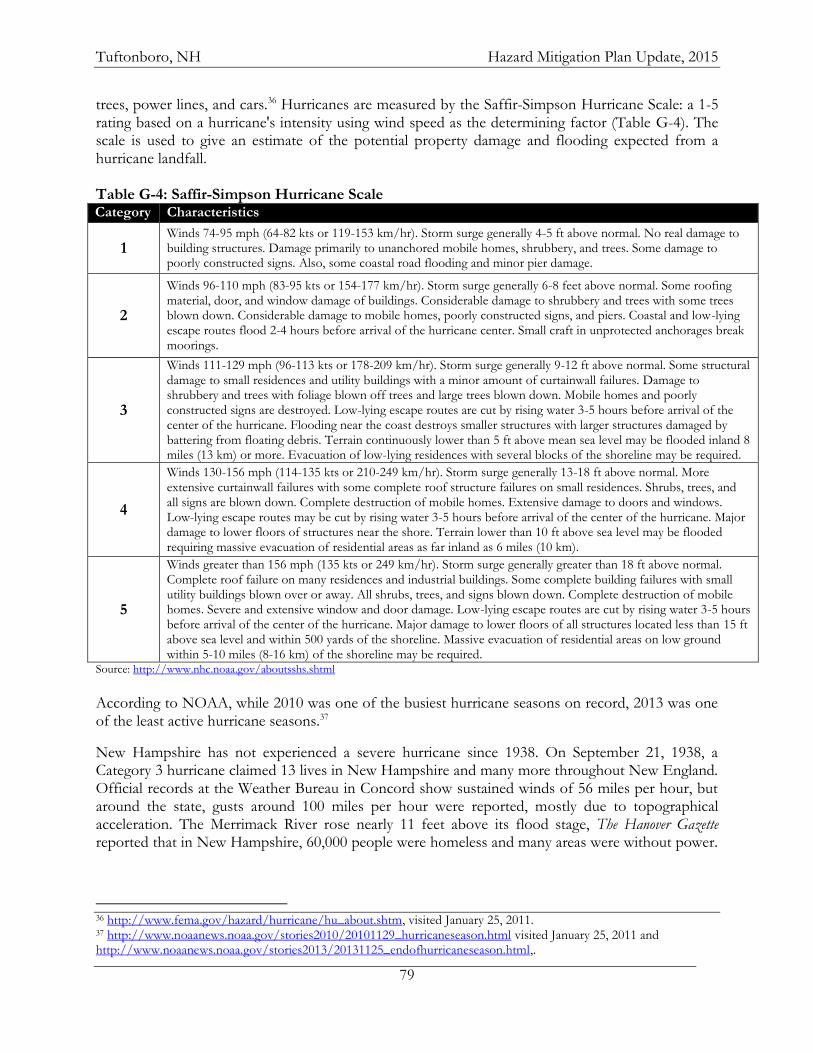
Tuftonboro, NH Hazard Mitigation Plan Update, 2015
79
trees, power lines, and cars.36 Hurricanes are measured by the Saffir-Simpson Hurricane Scale: a 1-5 rating based on a hurricane's intensity using wind speed as the determining factor (Table G-4). The scale is used to give an estimate of the potential property damage and flooding expected from a hurricane landfall. Table G-4: Saffir-Simpson Hurricane Scale Category Characteristics
1 Winds 74-95 mph (64-82 kts or 119-153 km/hr). Storm surge generally 4-5 ft above normal. No real damage to building structures. Damage primarily to unanchored mobile homes, shrubbery, and trees. Some damage to poorly constructed signs. Also, some coastal road flooding and minor pier damage.
2
Winds 96-110 mph (83-95 kts or 154-177 km/hr). Storm surge generally 6-8 feet above normal. Some roofing material, door, and window damage of buildings. Considerable damage to shrubbery and trees with some trees blown down. Considerable damage to mobile homes, poorly constructed signs, and piers. Coastal and low-lying escape routes flood 2-4 hours before arrival of the hurricane center. Small craft in unprotected anchorages break moorings.
3
Winds 111-129 mph (96-113 kts or 178-209 km/hr). Storm surge generally 9-12 ft above normal. Some structural damage to small residences and utility buildings with a minor amount of curtainwall failures. Damage to shrubbery and trees with foliage blown off trees and large trees blown down. Mobile homes and poorly constructed signs are destroyed. Low-lying escape routes are cut by rising water 3-5 hours before arrival of the center of the hurricane. Flooding near the coast destroys smaller structures with larger structures damaged by battering from floating debris. Terrain continuously lower than 5 ft above mean sea level may be flooded inland 8 miles (13 km) or more. Evacuation of low-lying residences with several blocks of the shoreline may be required.
4
Winds 130-156 mph (114-135 kts or 210-249 km/hr). Storm surge generally 13-18 ft above normal. More extensive curtainwall failures with some complete roof structure failures on small residences. Shrubs, trees, and all signs are blown down. Complete destruction of mobile homes. Extensive damage to doors and windows. Low-lying escape routes may be cut by rising water 3-5 hours before arrival of the center of the hurricane. Major damage to lower floors of structures near the shore. Terrain lower than 10 ft above sea level may be flooded requiring massive evacuation of residential areas as far inland as 6 miles (10 km).
5
Winds greater than 156 mph (135 kts or 249 km/hr). Storm surge generally greater than 18 ft above normal. Complete roof failure on many residences and industrial buildings. Some complete building failures with small utility buildings blown over or away. All shrubs, trees, and signs blown down. Complete destruction of mobile homes. Severe and extensive window and door damage. Low-lying escape routes are cut by rising water 3-5 hours before arrival of the center of the hurricane. Major damage to lower floors of all structures located less than 15 ft above sea level and within 500 yards of the shoreline. Massive evacuation of residential areas on low ground within 5-10 miles (8-16 km) of the shoreline may be required.
Source: http://www.nhc.noaa.gov/aboutsshs.shtml
According to NOAA, while 2010 was one of the busiest hurricane seasons on record, 2013 was one of the least active hurricane seasons.37
New Hampshire has not experienced a severe hurricane since 1938. On September 21, 1938, a Category 3 hurricane claimed 13 lives in New Hampshire and many more throughout New England. Official records at the Weather Bureau in Concord show sustained winds of 56 miles per hour, but around the state, gusts around 100 miles per hour were reported, mostly due to topographical acceleration. The Merrimack River rose nearly 11 feet above its flood stage, The Hanover Gazette reported that in New Hampshire, 60,000 people were homeless and many areas were without power.
36 http://www.fema.gov/hazard/hurricane/hu_about.shtm, visited January 25, 2011. 37 http://www.noaanews.noaa.gov/stories2010/20101129_hurricaneseason.html visited January 25, 2011 and http://www.noaanews.noaa.gov/stories2013/20131125_endofhurricaneseason.html,.
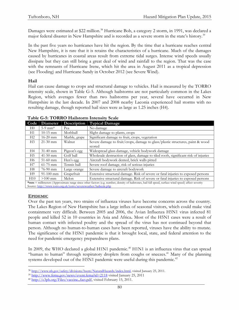
Tuftonboro, NH Hazard Mitigation Plan Update, 2015
80
Damages were estimated at $22 million.38 Hurricane Bob, a category 2 storm, in 1991, was declared a major federal disaster in New Hampshire and is recorded as a severe storm in the state’s history.39
In the past five years no hurricanes have hit the region. By the time that a hurricane reaches central New Hampshire, it is rare that it is retains the characteristics of a hurricane. Much of the damages caused by hurricanes in coastal areas result from extreme tidal surges. Intense wind speeds usually dissipate but they can still bring a great deal of wind and rainfall to the region. That was the case with the remnants of Hurricane Irene, which hit the area in August 2011 as a tropical depression (see Flooding) and Hurricane Sandy in October 2012 (see Severe Wind).
Hail Hail can cause damage to crops and structural damage to vehicles. Hail is measured by the TORRO intensity scale, shown in Table G-5. Although hailstorms are not particularly common in the Lakes Region, which averages fewer than two hailstorms per year, several have occurred in New Hampshire in the last decade. In 2007 and 2008 nearby Laconia experienced hail storms with no resulting damage, though reported hail sizes were as large as 1.25 inches (H4). Table G-5: TORRO Hailstorm Intensity Scale Code Diameter Description Typical Damage
H0 5-9 mm* Pea No damage
H1 10-15 mm Mothball Slight damage to plants, crops
H2 16-20 mm Marble, grape Significant damage to fruit, crops, vegetation
H3 21-30 mm Walnut Severe damage to fruit/crops, damage to glass/plastic structures, paint & wood scored
H4 31-40 mm Pigeon's egg Widespread glass damage, vehicle bodywork damage
H5 41-50 mm Golf ball Wholesale destruction of glass, damage to tiled roofs, significant risk of injuries
H6 51-60 mm Hen’s egg Aircraft bodywork dented, brick walls pitted
H7 61-75 mm Tennis ball Severe roof damage, risk of serious injuries
H8 76-90 mm Large orange Severe damage to aircraft bodywork
H9 91-100 mm Grapefruit Extensive structural damage. Risk of severe or fatal injuries to exposed persons
H10 >100 mm Melon Extensive structural damage. Risk of severe or fatal injuries to exposed persons *mm = millimeters (Approximate range since other factors (e.g. number, density of hailstones, hail fall speed, surface wind speed) affect severity Source: http://www.torro.org.uk/torro/severeweather/hailscale.php
EPIDEMIC Over the past ten years, two strains of influenza viruses have become concerns across the country. The Lakes Region of New Hampshire has a large influx of seasonal visitors, which could make viral containment very difficult. Between 2005 and 2006, the Avian Influenza H5N1 virus infected 81 people and killed 52 in 10 countries in Asia and Africa. Most of the H5N1 cases were a result of human contact with infected poultry and the spread of the virus has not continued beyond that person. Although no human-to-human cases have been reported, viruses have the ability to mutate. The significance of the H5N1 pandemic is that it brought local, state, and federal attention to the need for pandemic emergency preparedness plans. In 2009, the WHO declared a global H1N1 pandemic.40 H1N1 is an influenza virus that can spread “human to human” through respiratory droplets from coughs or sneezes.41 Many of the planning systems developed out of the H5N1 pandemic were useful during this pandemic.42
38 http://www.nh.gov/safety/divisions/hsem/NaturalHazards/index.html, visited January 25, 2011. 39 http://www.fema.gov/news/event.fema?id=2118 visited January 25, 2011 40 http://c3ph.org/Files/vaccine_fact.pdf, visited February 15, 2011.
Tuftonboro, NH Hazard Mitigation Plan Update, 2015
81
The 2012-13 flu season was much more severe in New Hampshire than any of the previous decade; 35 deaths occurred statewide, the most since 1997.43 The community does partner with Carroll County Coalition for Public Health (http://www.c3ph.org/) for resources and training.
41 http://c3ph.org/Files/H1N1FAQ.pdf, visited February 15, 2011. 42 http://www.cdc.gov/h1n1flu/cdcresponse.htm, visited February 8, 2011. 43 NH Department of Health and Human Services http://www.dhhs.nh.gov/media/pr/2013/01-jan/01112013flu.htm, visited
January 17, 2013.
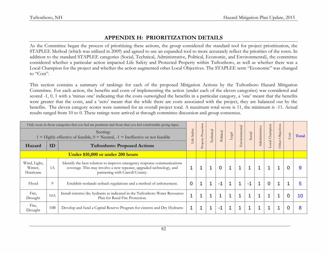
Tuftonboro, NH Hazard Mitigation Plan Update, 2015
82
APPENDIX H: PRIORITIZATION DETAILS
As the Committee began the process of prioritizing these actions, the group considered the standard tool for project prioritization, the STAPLEE Method (which was utilized in 2009) and agreed to use an expanded tool to more accurately reflect the priorities of the town. In addition to the standard STAPLEE categories (Social, Technical, Administrative, Political, Economic, and Environmental), the committee considered whether a particular action impacted Life Safety and Protected Property within Tuftonboro, as well as whether there was a Local Champion for the project and whether the action augmented other Local Objectives. The STAPLEE term “Economic” was changed to “Cost”. This section contains a summary of rankings for each of the proposed Mitigation Actions by the Tuftonboro Hazard Mitigation Committee. For each action, the benefits and costs of implementing the action (under each of the eleven categories) was considered and scored -1, 0, 1 with a ‘minus one’ indicating that the costs outweighed the benefits in a particular category, a ‘one’ meant that the benefits were greater that the costs, and a ‘zero’ meant that the while there are costs associated with the project, they are balanced out by the benefits. The eleven category scores were summed for an overall project total. A maximum total score is 11, the minimum is -11. Actual results ranged from 10 to 0. These ratings were arrived at through committee discussion and group consensus.
Only score in those categories that you feel are pertinent and those that you feel comfortable giving input.
Lif
e Saf
ety
Pro
per
ty P
rote
ctio
n
Tec
hn
ical
Po
litic
al
Leg
al
En
vir
on
men
tal
So
cial
Ad
min
istr
ativ
e
Lo
cal C
ham
pio
n
Oth
er O
bje
ctiv
es
Co
st
Total Scoring:
1 = Highly effective of feasible, 0 = Neutral, -1 = Ineffective or not feasible
Hazard ID Tuftonboro: Proposed Actions
Under $10,000 or under 200 hours
Wind, Light, Winter,
Hurricane 1A
Identify the best solution to improve emergency response communications coverage. This may involve a new repeater, upgraded technology, and
partnering with Carroll County. 1 1 1 0 1 1 1 1 1 1 0 9
Flood 9 Establish wetlands setback regulations and a method of enforcement. 0 1 1 -1 1 1 -1 1 0 1 1 5
Fire, Drought
10A Install cisterns/dry hydrants as indicated in the Tuftonboro Water Resources
Plan for Rural Fire Protection. 1 1 1 1 1 1 1 1 1 1 0 10
Fire, Drought
10B Develop and fund a Capital Reserve Program for cisterns and Dry Hydrants 1 1 1 -1 1 1 1 1 1 1 0 8
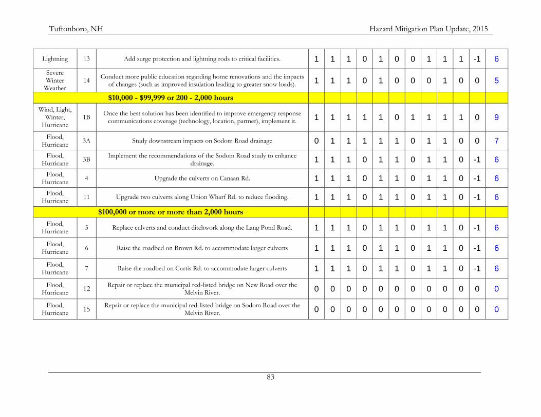
Tuftonboro, NH Hazard Mitigation Plan Update, 2015
83
Lightning 13 Add surge protection and lightning rods to critical facilities. 1 1 1 0 1 0 0 1 1 1 -1 6
Severe Winter
Weather 14
Conduct more public education regarding home renovations and the impacts of changes (such as improved insulation leading to greater snow loads). 1 1 1 0 1 0 0 0 1 0 0 5
$10,000 - $99,999 or 200 - 2,000 hours
Wind, Light, Winter,
Hurricane 1B
Once the best solution has been identified to improve emergency response communications coverage (technology, location, partner), implement it. 1 1 1 1 1 0 1 1 1 1 0 9
Flood, Hurricane
3A Study downstream impacts on Sodom Road drainage 0 1 1 1 1 1 0 1 1 0 0 7
Flood, Hurricane
3B Implement the recommendations of the Sodom Road study to enhance
drainage. 1 1 1 0 1 1 0 1 1 0 -1 6
Flood, Hurricane
4 Upgrade the culverts on Canaan Rd. 1 1 1 0 1 1 0 1 1 0 -1 6
Flood, Hurricane
11 Upgrade two culverts along Union Wharf Rd. to reduce flooding. 1 1 1 0 1 1 0 1 1 0 -1 6
$100,000 or more or more than 2,000 hours
Flood, Hurricane
5 Replace culverts and conduct ditchwork along the Lang Pond Road. 1 1 1 0 1 1 0 1 1 0 -1 6
Flood, Hurricane
6 Raise the roadbed on Brown Rd. to accommodate larger culverts 1 1 1 0 1 1 0 1 1 0 -1 6
Flood, Hurricane
7 Raise the roadbed on Curtis Rd. to accommodate larger culverts 1 1 1 0 1 1 0 1 1 0 -1 6
Flood, Hurricane
12 Repair or replace the municipal red-listed bridge on New Road over the
Melvin River. 0 0 0 0 0 0 0 0 0 0 0 0
Flood, Hurricane
15 Repair or replace the municipal red-listed bridge on Sodom Road over the
Melvin River. 0 0 0 0 0 0 0 0 0 0 0 0
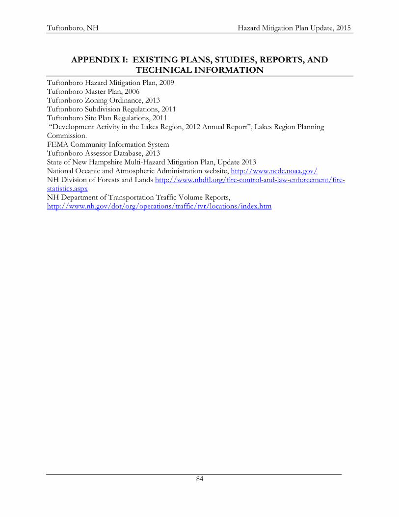
Tuftonboro, NH Hazard Mitigation Plan Update, 2015
84
APPENDIX I: EXISTING PLANS, STUDIES, REPORTS, AND TECHNICAL INFORMATION
Tuftonboro Hazard Mitigation Plan, 2009 Tuftonboro Master Plan, 2006 Tuftonboro Zoning Ordinance, 2013 Tuftonboro Subdivision Regulations, 2011 Tuftonboro Site Plan Regulations, 2011 “Development Activity in the Lakes Region, 2012 Annual Report”, Lakes Region Planning Commission. FEMA Community Information System Tuftonboro Assessor Database, 2013 State of New Hampshire Multi-Hazard Mitigation Plan, Update 2013 National Oceanic and Atmospheric Administration website, http://www.ncdc.noaa.gov/ NH Division of Forests and Lands http://www.nhdfl.org/fire-control-and-law-enforcement/fire-statistics.aspx NH Department of Transportation Traffic Volume Reports, http://www.nh.gov/dot/org/operations/traffic/tvr/locations/index.htm
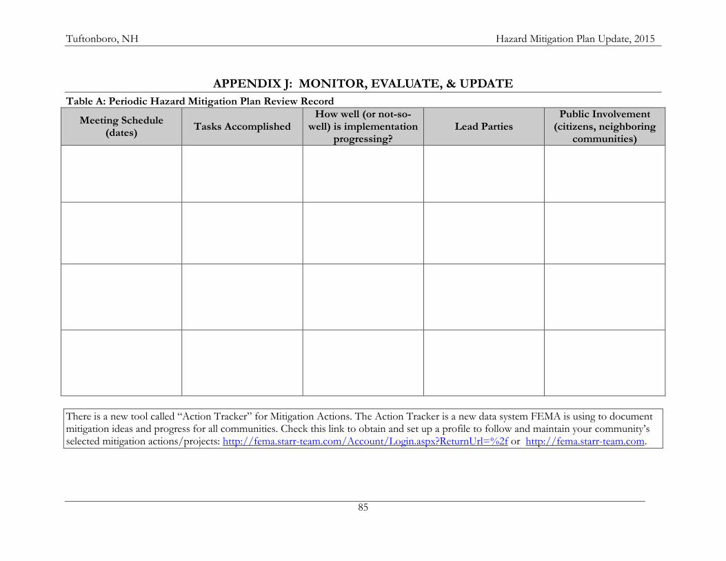
Tuftonboro, NH Hazard Mitigation Plan Update, 2015
85
APPENDIX J: MONITOR, EVALUATE, & UPDATE
Table A: Periodic Hazard Mitigation Plan Review Record
Meeting Schedule (dates)
Tasks Accomplished How well (or not-so-
well) is implementation progressing?
Lead Parties Public Involvement
(citizens, neighboring communities)
There is a new tool called “Action Tracker” for Mitigation Actions. The Action Tracker is a new data system FEMA is using to document mitigation ideas and progress for all communities. Check this link to obtain and set up a profile to follow and maintain your community’s selected mitigation actions/projects: http://fema.starr-team.com/Account/Login.aspx?ReturnUrl=%2f or http://fema.starr-team.com.
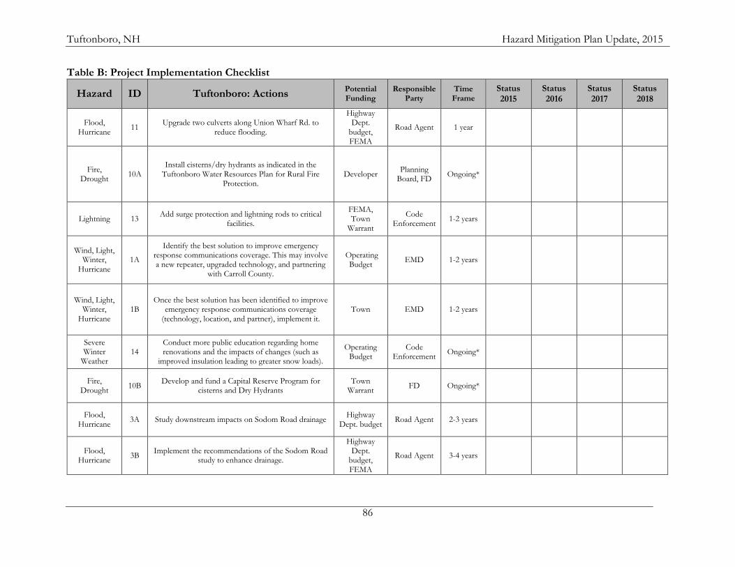
Tuftonboro, NH Hazard Mitigation Plan Update, 2015
86
Table B: Project Implementation Checklist
Hazard ID Tuftonboro: Actions Potential Funding
Responsible Party
Time Frame
Status 2015
Status 2016
Status 2017
Status 2018
Flood, Hurricane
11 Upgrade two culverts along Union Wharf Rd. to
reduce flooding.
Highway Dept.
budget, FEMA
Road Agent 1 year
Fire, Drought
10A Install cisterns/dry hydrants as indicated in the
Tuftonboro Water Resources Plan for Rural Fire Protection.
Developer Planning
Board, FD Ongoing*
Lightning 13 Add surge protection and lightning rods to critical
facilities.
FEMA, Town
Warrant
Code Enforcement
1-2 years
Wind, Light, Winter,
Hurricane 1A
Identify the best solution to improve emergency response communications coverage. This may involve a new repeater, upgraded technology, and partnering
with Carroll County.
Operating Budget
EMD 1-2 years
Wind, Light, Winter,
Hurricane 1B
Once the best solution has been identified to improve emergency response communications coverage
(technology, location, and partner), implement it. Town EMD 1-2 years
Severe Winter
Weather 14
Conduct more public education regarding home renovations and the impacts of changes (such as
improved insulation leading to greater snow loads).
Operating Budget
Code Enforcement
Ongoing*
Fire, Drought
10B Develop and fund a Capital Reserve Program for
cisterns and Dry Hydrants Town
Warrant FD Ongoing*
Flood, Hurricane
3A Study downstream impacts on Sodom Road drainage Highway
Dept. budget Road Agent 2-3 years
Flood, Hurricane
3B Implement the recommendations of the Sodom Road
study to enhance drainage.
Highway Dept.
budget, FEMA
Road Agent 3-4 years
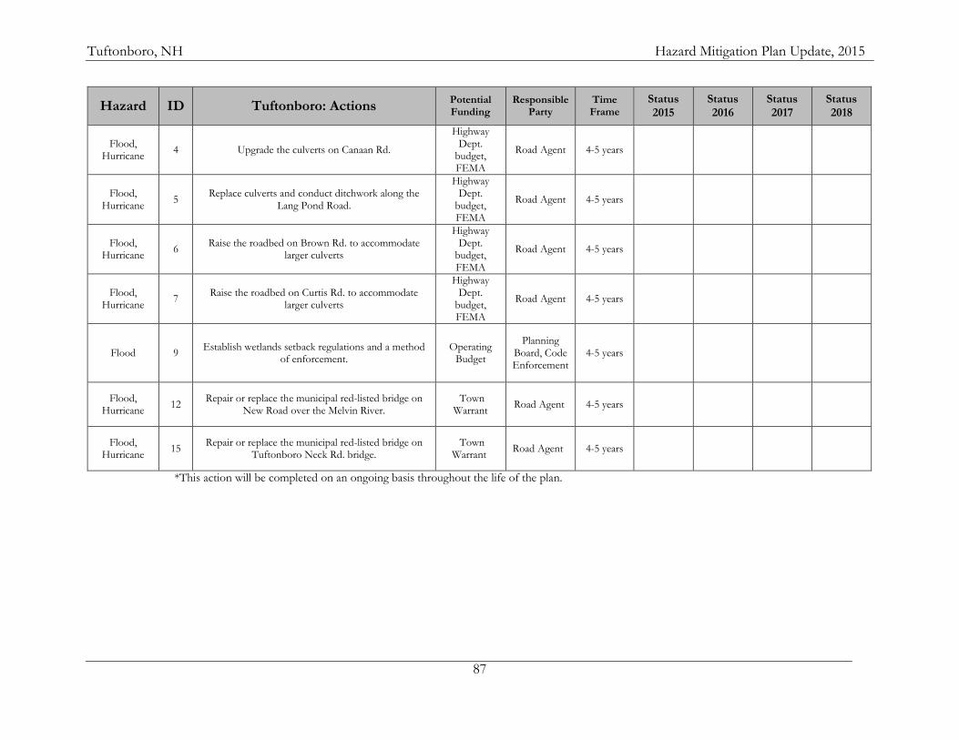
Tuftonboro, NH Hazard Mitigation Plan Update, 2015
87
Hazard ID Tuftonboro: Actions Potential Funding
Responsible Party
Time Frame
Status 2015
Status 2016
Status 2017
Status 2018
Flood, Hurricane
4 Upgrade the culverts on Canaan Rd.
Highway Dept.
budget, FEMA
Road Agent 4-5 years
Flood, Hurricane
5 Replace culverts and conduct ditchwork along the
Lang Pond Road.
Highway Dept.
budget, FEMA
Road Agent 4-5 years
Flood, Hurricane
6 Raise the roadbed on Brown Rd. to accommodate
larger culverts
Highway Dept.
budget, FEMA
Road Agent 4-5 years
Flood, Hurricane
7 Raise the roadbed on Curtis Rd. to accommodate
larger culverts
Highway Dept.
budget, FEMA
Road Agent 4-5 years
Flood 9 Establish wetlands setback regulations and a method
of enforcement. Operating
Budget
Planning Board, Code Enforcement
4-5 years
Flood, Hurricane
12 Repair or replace the municipal red-listed bridge on
New Road over the Melvin River. Town
Warrant Road Agent 4-5 years
Flood, Hurricane
15 Repair or replace the municipal red-listed bridge on
Tuftonboro Neck Rd. bridge. Town
Warrant Road Agent 4-5 years
*This action will be completed on an ongoing basis throughout the life of the plan.
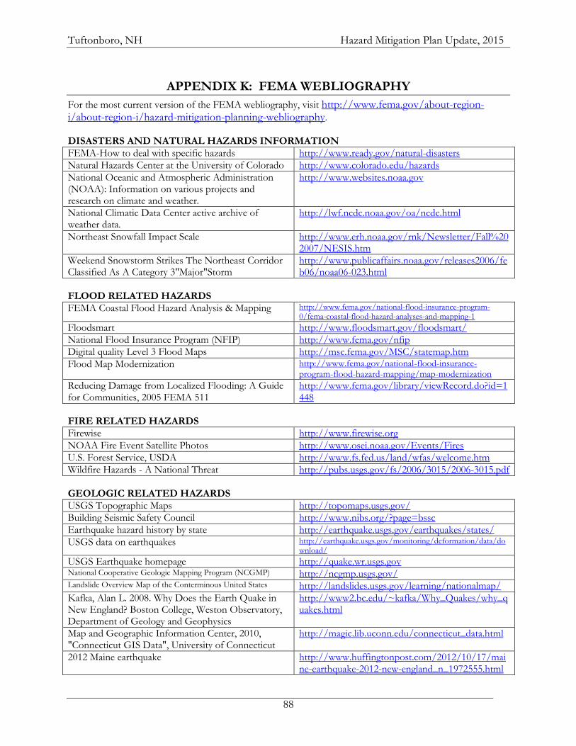
Tuftonboro, NH Hazard Mitigation Plan Update, 2015
88
APPENDIX K: FEMA WEBLIOGRAPHY
For the most current version of the FEMA webliography, visit http://www.fema.gov/about-region-i/about-region-i/hazard-mitigation-planning-webliography. DISASTERS AND NATURAL HAZARDS INFORMATION
FEMA-How to deal with specific hazards http://www.ready.gov/natural-disasters
Natural Hazards Center at the University of Colorado http://www.colorado.edu/hazards
National Oceanic and Atmospheric Administration (NOAA): Information on various projects and research on climate and weather.
http://www.websites.noaa.gov
National Climatic Data Center active archive of weather data.
http://lwf.ncdc.noaa.gov/oa/ncdc.html
Northeast Snowfall Impact Scale http://www.erh.noaa.gov/rnk/Newsletter/Fall%202007/NESIS.htm
Weekend Snowstorm Strikes The Northeast Corridor Classified As A Category 3"Major"Storm
http://www.publicaffairs.noaa.gov/releases2006/feb06/noaa06-023.html
FLOOD RELATED HAZARDS
FEMA Coastal Flood Hazard Analysis & Mapping http://www.fema.gov/national-flood-insurance-program-0/fema-coastal-flood-hazard-analyses-and-mapping-1
Floodsmart http://www.floodsmart.gov/floodsmart/
National Flood Insurance Program (NFIP) http://www.fema.gov/nfip
Digital quality Level 3 Flood Maps http://msc.fema.gov/MSC/statemap.htm
Flood Map Modernization http://www.fema.gov/national-flood-insurance-program-flood-hazard-mapping/map-modernization
Reducing Damage from Localized Flooding: A Guide for Communities, 2005 FEMA 511
http://www.fema.gov/library/viewRecord.do?id=1448
FIRE RELATED HAZARDS
Firewise http://www.firewise.org
NOAA Fire Event Satellite Photos http://www.osei.noaa.gov/Events/Fires
U.S. Forest Service, USDA http://www.fs.fed.us/land/wfas/welcome.htm
Wildfire Hazards - A National Threat http://pubs.usgs.gov/fs/2006/3015/2006-3015.pdf
GEOLOGIC RELATED HAZARDS
USGS Topographic Maps http://topomaps.usgs.gov/
Building Seismic Safety Council http://www.nibs.org/?page=bssc
Earthquake hazard history by state http://earthquake.usgs.gov/earthquakes/states/
USGS data on earthquakes http://earthquake.usgs.gov/monitoring/deformation/data/download/
USGS Earthquake homepage http://quake.wr.usgs.gov National Cooperative Geologic Mapping Program (NCGMP) http://ncgmp.usgs.gov/ Landslide Overview Map of the Conterminous United States http://landslides.usgs.gov/learning/nationalmap/
Kafka, Alan L. 2008. Why Does the Earth Quake in New England? Boston College, Weston Observatory, Department of Geology and Geophysics
http://www2.bc.edu/~kafka/Why_Quakes/why_quakes.html
Map and Geographic Information Center, 2010, "Connecticut GIS Data", University of Connecticut
http://magic.lib.uconn.edu/connecticut_data.html
2012 Maine earthquake http://www.huffingtonpost.com/2012/10/17/maine-earthquake-2012-new-england_n_1972555.html
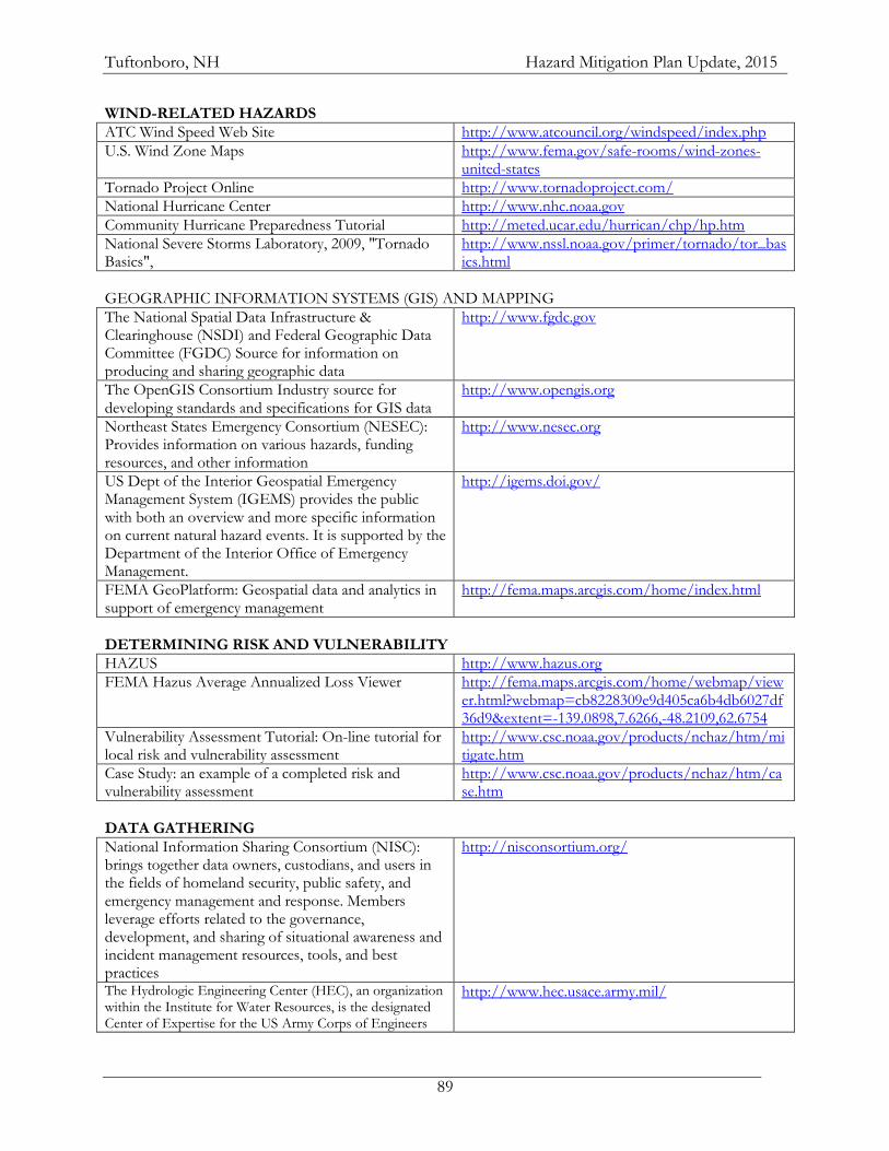
Tuftonboro, NH Hazard Mitigation Plan Update, 2015
89
WIND-RELATED HAZARDS
ATC Wind Speed Web Site http://www.atcouncil.org/windspeed/index.php
U.S. Wind Zone Maps http://www.fema.gov/safe-rooms/wind-zones-united-states
Tornado Project Online http://www.tornadoproject.com/
National Hurricane Center http://www.nhc.noaa.gov
Community Hurricane Preparedness Tutorial http://meted.ucar.edu/hurrican/chp/hp.htm
National Severe Storms Laboratory, 2009, "Tornado Basics",
http://www.nssl.noaa.gov/primer/tornado/tor_basics.html
GEOGRAPHIC INFORMATION SYSTEMS (GIS) AND MAPPING
The National Spatial Data Infrastructure & Clearinghouse (NSDI) and Federal Geographic Data Committee (FGDC) Source for information on producing and sharing geographic data
http://www.fgdc.gov
The OpenGIS Consortium Industry source for developing standards and specifications for GIS data
http://www.opengis.org
Northeast States Emergency Consortium (NESEC): Provides information on various hazards, funding resources, and other information
http://www.nesec.org
US Dept of the Interior Geospatial Emergency Management System (IGEMS) provides the public with both an overview and more specific information on current natural hazard events. It is supported by the Department of the Interior Office of Emergency Management.
http://igems.doi.gov/
FEMA GeoPlatform: Geospatial data and analytics in support of emergency management
http://fema.maps.arcgis.com/home/index.html
DETERMINING RISK AND VULNERABILITY
HAZUS http://www.hazus.org
FEMA Hazus Average Annualized Loss Viewer http://fema.maps.arcgis.com/home/webmap/viewer.html?webmap=cb8228309e9d405ca6b4db6027df36d9&extent=-139.0898,7.6266,-48.2109,62.6754
Vulnerability Assessment Tutorial: On-line tutorial for local risk and vulnerability assessment
http://www.csc.noaa.gov/products/nchaz/htm/mitigate.htm
Case Study: an example of a completed risk and vulnerability assessment
http://www.csc.noaa.gov/products/nchaz/htm/case.htm
DATA GATHERING
National Information Sharing Consortium (NISC): brings together data owners, custodians, and users in the fields of homeland security, public safety, and emergency management and response. Members leverage efforts related to the governance, development, and sharing of situational awareness and incident management resources, tools, and best practices
http://nisconsortium.org/
The Hydrologic Engineering Center (HEC), an organization within the Institute for Water Resources, is the designated Center of Expertise for the US Army Corps of Engineers
http://www.hec.usace.army.mil/
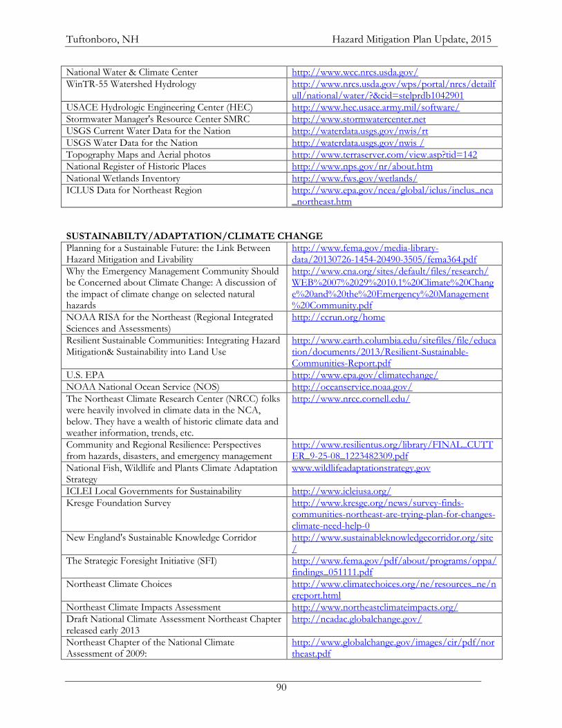
Tuftonboro, NH Hazard Mitigation Plan Update, 2015
90
National Water & Climate Center http://www.wcc.nrcs.usda.gov/
WinTR-55 Watershed Hydrology http://www.nrcs.usda.gov/wps/portal/nrcs/detailfull/national/water/?&cid=stelprdb1042901
USACE Hydrologic Engineering Center (HEC) http://www.hec.usace.army.mil/software/
Stormwater Manager's Resource Center SMRC http://www.stormwatercenter.net
USGS Current Water Data for the Nation http://waterdata.usgs.gov/nwis/rt
USGS Water Data for the Nation http://waterdata.usgs.gov/nwis /
Topography Maps and Aerial photos http://www.terraserver.com/view.asp?tid=142
National Register of Historic Places http://www.nps.gov/nr/about.htm
National Wetlands Inventory http://www.fws.gov/wetlands/
ICLUS Data for Northeast Region http://www.epa.gov/ncea/global/iclus/inclus_nca_northeast.htm
SUSTAINABILTY/ADAPTATION/CLIMATE CHANGE
Planning for a Sustainable Future: the Link Between Hazard Mitigation and Livability
http://www.fema.gov/media-library-data/20130726-1454-20490-3505/fema364.pdf
Why the Emergency Management Community Should be Concerned about Climate Change: A discussion of the impact of climate change on selected natural hazards
http://www.cna.org/sites/default/files/research/WEB%2007%2029%2010.1%20Climate%20Change%20and%20the%20Emergency%20Management%20Community.pdf
NOAA RISA for the Northeast (Regional Integrated Sciences and Assessments)
http://ccrun.org/home
Resilient Sustainable Communities: Integrating Hazard Mitigation& Sustainability into Land Use
http://www.earth.columbia.edu/sitefiles/file/education/documents/2013/Resilient-Sustainable-Communities-Report.pdf
U.S. EPA http://www.epa.gov/climatechange/
NOAA National Ocean Service (NOS) http://oceanservice.noaa.gov/
The Northeast Climate Research Center (NRCC) folks were heavily involved in climate data in the NCA, below. They have a wealth of historic climate data and weather information, trends, etc.
http://www.nrcc.cornell.edu/
Community and Regional Resilience: Perspectives from hazards, disasters, and emergency management
http://www.resilientus.org/library/FINAL_CUTTER_9-25-08_1223482309.pdf
National Fish, Wildlife and Plants Climate Adaptation Strategy
www.wildlifeadaptationstrategy.gov
ICLEI Local Governments for Sustainability http://www.icleiusa.org/
Kresge Foundation Survey http://www.kresge.org/news/survey-finds-communities-northeast-are-trying-plan-for-changes-climate-need-help-0
New England's Sustainable Knowledge Corridor http://www.sustainableknowledgecorridor.org/site/
The Strategic Foresight Initiative (SFI) http://www.fema.gov/pdf/about/programs/oppa/findings_051111.pdf
Northeast Climate Choices http://www.climatechoices.org/ne/resources_ne/nereport.html
Northeast Climate Impacts Assessment http://www.northeastclimateimpacts.org/
Draft National Climate Assessment Northeast Chapter released early 2013
http://ncadac.globalchange.gov/
Northeast Chapter of the National Climate Assessment of 2009:
http://www.globalchange.gov/images/cir/pdf/northeast.pdf
Tuftonboro, NH Hazard Mitigation Plan Update, 2015
91
NEclimateUS.org http://www.neclimateus.org
ClimateNE www.climatenortheast.com
Scenarios for Climate Assessment and Adaptation http://scenarios.globalchange.gov/
Northeast Climate Science Center http://necsc.umass.edu/
FEMA Climate Change Adaptation and Emergency Management
https://www.llis.dhs.gov/content/climate-change-adaptation-and-emergency-management-0
Climate Central http://www.climatecentral.org
EPA State and Local Climate and Energy Program http://www.epa.gov/statelocalclimate/index.html
PLANNING
American Planning Association http://www.planning.org
PlannersWeb - Provides city and regional planning resources http://www.plannersweb.com
OTHER FEDERAL RESOURCES
U.S. Army Corps of Engineers: Provides funding for floodplain management planning and technical assistance and other water resources issues.
www.nae.usace.army.mil
Natural Resources Conservation Service: Technical assistance to individual land owners, groups of landowners, communities, and soil and water conservation districts.
www.nrcs.usda.gov
NOAA Coastal Services Center http://www.csc.noaa.gov/
Rural Economic and Community Development: Technical assistance to rural areas and smaller communities in rural areas on financing public works projects.
www.rurdev.usda.gov
Farm Service Agency: Manages the Wetlands Reserve Program (useful in open space or acquisition projects by purchasing easements on wetlands properties) and farmland set aside programs
www.fsa.usda.gov
National Weather Service: Prepares and issues flood, severe weather and coastal storm warnings. Staff hydrologists can work with communities on flood warning issues; can give technical assistance in preparing flood-warning plans.
www.weather.gov
Economic Development Administration (EDA): Assists communities with technical assistance for economic development planning
www.osec.doc.gov/eda/default.htm
National Park Service: Technical assistance with open space preservation planning; can help facilitate meetings and identify non-structural options for floodplain redevelopment.
www.nps.gov
Fish and Wildlife Services: Can provide technical and
financial assistance to restore wetlands and riparian habitats. www.fws.gov
Department of Housing & Urban Development www.hud.gov
Small Business Administration: SBA can provide additional low-interest funds (up to 20% above what an eligible applicant would qualify for) to install mitigation measures. They can also loan the cost of bringing a damaged property up to state or local code requirements.
www.sba.gov/disaster
Environmental Protection Agency www.epa.gov
Tuftonboro, NH Hazard Mitigation Plan Update, 2015
92
OTHER RESOURCES
New England States Emergency Consortium (NESEC): NESEC conducts public awareness and education programs on natural disaster and emergency management activities throughout New England. Resources are available on earthquake preparedness, mitigation, and hurricane safety.
www.nesec.org
Association of State Floodplain Managers (ASFPM): ASFPM has developed a series of technical and topical research papers, and a series of Proceedings from their annual conferences.
www.floods.org
National Voluntary Organizations Active in Disaster (VOAD) is a non-profit, nonpartisan membership organization that serves as the forum where organizations share knowledge and resources throughout the disaster cycle—preparation, response, recovery and mitigation.
http://www.nvoad.org
FEMA RESOURCES
Federal Emergency Management Agency (FEMA) www.fema.gov
National Mitigation Framework http://www.fema.gov/national-mitigation-framework
Federal Insurance and Mitigation Administration (FIMA)
http://www.fema.gov/fima
Community Rating System (CRS) http://www.fema.gov/national-flood-insurance-program/national-flood-insurance-program-community-rating-system
FEMA Building Science http://www.fema.gov/building-science
National Flood Insurance Program (NFIP) http://www.fema.gov/national-flood-insurance-program
Floodplain Management & Community Assistance Program
http://www.fema.gov/floodplain-management
Increased Cost of Compliance (ICC): ICC coverage provides up to $30,000 for elevation and design requirements to repeatedly or substantially damaged property.
http://www.fema.gov/national-flood-insurance-program-2/increased-cost-compliance-coverage
National Disaster Recovery Framework http://www.fema.gov/national-disaster-recovery-framework
Computer Sciences Corporation: contracted by FIMA as the NFIP Statistical Agent, CSC provides information and assistance on flood insurance to lenders, insurance agents and communities
www.csc.com
Integrating the Local Natural Hazard Mitigation Plan into a Community’s Comprehensive Plan: A Guidebook for Local Governments
https://www.fema.gov/ar/media-library/assets/documents/89725
Integrating Historic Property and Cultural Resource Considerations into Hazard Mitigation Planning
http://www.fema.gov/media-library/assets/documents/4317
Mitigation Best Practices Portfolio http://www.fema.gov/mitigation-best-practices-portfolio
FEMA Multi-Hazard Mitigation Planning Website http://www.fema.gov/multi-hazard-mitigation-planning
Tuftonboro, NH Hazard Mitigation Plan Update, 2015
93
FEMA Resources Page http://www.fema.gov/plan/mitplanning/resources.shtm
Local Mitigation Plan Review Guide http://www.fema.gov/library/viewRecord.do?id=4859
Local Mitigation Planning Handbook complements and liberally references the Local Mitigation Plan Review Guide above
http://www.fema.gov/library/viewRecord.do?id=7209
HAZUS http://www.fema.gov/protecting-our-communities/hazus
Mitigation Ideas: A Resource for Reducing Risk to Natural Hazards
http://www.fema.gov/library/viewRecord.do?id=6938
Integrating Hazard Mitigation Into Local Planning: Case Studies and Tools for Community Officials
http://www.fema.gov/library/viewRecord.do?id=7130
IS-318 Mitigation Planning for Local and Tribal Communities Independent Study Course
http://training.fema.gov/EMIWeb/IS/is318.asp
FEMA REGION I MITIGATION PLANNING CONTACTS Marilyn Hilliard Senior Planner Phone: (617) 956-7536 Email: [email protected] Brigitte Ndikum-Nyada Community Planner Phone: 617-956-7614 Email: [email protected] Connecticut; Maine; New Hampshire