Embed Size (px)
DESCRIPTION
History of Urban FormUniversity of CincinnatiFall 2011
Citation preview

Christian Huelsman
Hennepin AvenueThe original historic urban street in Minneapolis
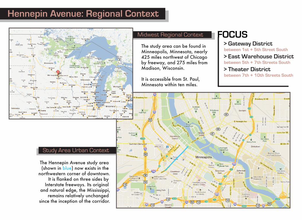
Midwest Regional Context
Study Area Urban Context
1903 Plat Map
The Hennepin Avenue study area (shown in blue) now exists in the
northwestern corner of downtown.It is flanked on three sides by
Interstate freeways. Its original and natural edge, the Mississippi,
remains relatively unchanged since the inception of the corridor.
The study area can be found in Minneapolis, Minnesota, nearly 425 miles northwest of Chicago by freeway, and 275 miles from Madison, Wisconsin.
It is accessible from St. Paul, Minnesota within ten miles.
FOCUS> Gateway Districtbetween 1st + 5th Street South
> East Warehouse Districtbetween 5th + 7th Streets South
> Theater Districtbetween 7th + 10th Streets South
Hennepin Avenue: Regional Context
Gateway District
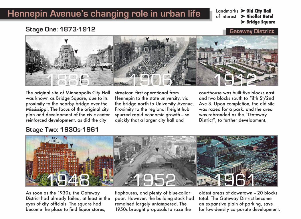
Old City HallNicollet HotelBridge Square
Landmarksof interest
nnn
n
The original site of Minneapolis City Hallwas known as Bridge Square, due to itsproximity to the nearby bridge over the Mississippi. The focus of the original city plan and development of the civic center reinforced development, as did the city
streetcar, first operational from Hennepin to the state university, via the bridge north to University Avenue. Proximity to the regional freight hub spurred rapid economic growth -- so quickly that a larger city hall and
courthouse was built five blocks east and two blocks south to Fifth St/2ndAve S. Upon completion, the old site was razed for a park. and the area was rebranded as the “Gateway District”, to further development.
Hennepin Avenue’s changing role in urban life
Stage One: 1873-1912
1886 1906 1912
Stage Two: 1930s-1961
As soon as the 1930s, the GatewayDistrict had already failed, at least in theeyes of city officials. The square hadbecome the place to find liquor stores,
flophouses, and plenty of blue-collarpoor. However, the building stock hadremained largely untampered. The 1950s brought proposals to raze the
oldest areas of downtown -- 20 blockstotal. The Gateway District becamean expansive plain of parking, savefor low-density corporate development.
1952 1961
n n
nn
n
n
n
n
n
n
n
1948
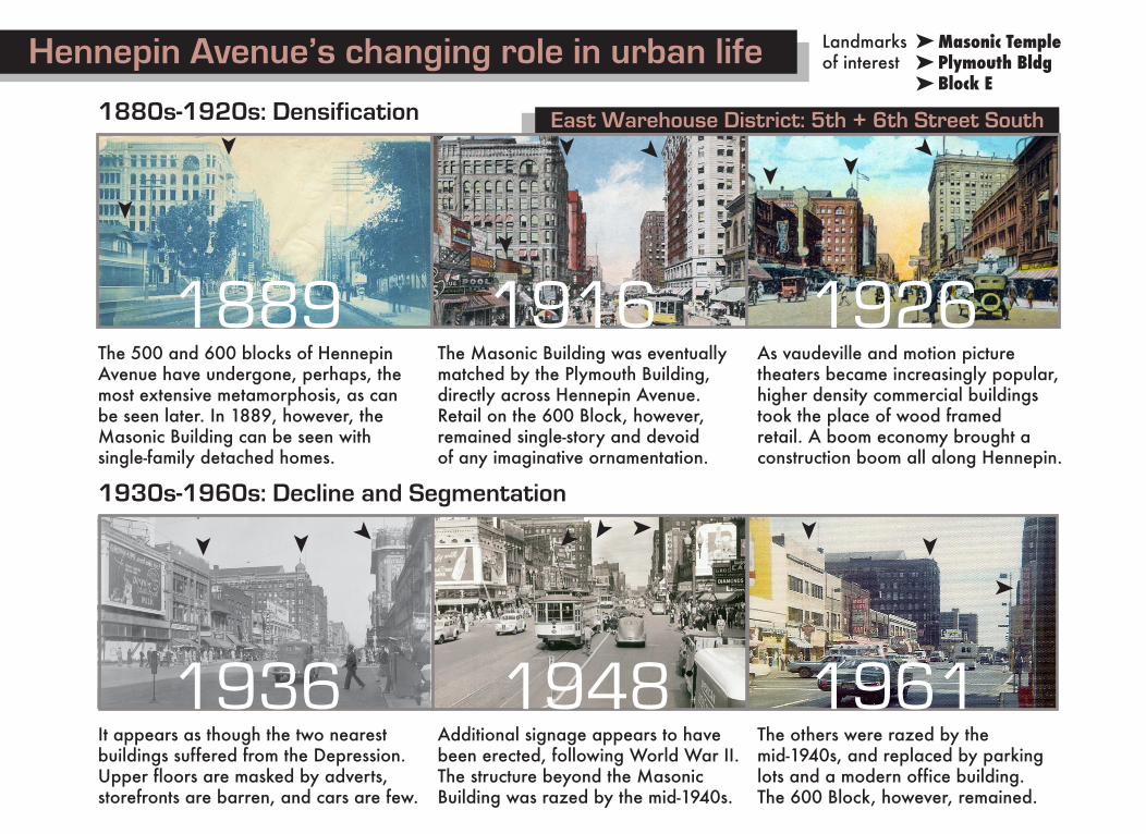
East Warehouse District: 5th + 6th Street South
The 500 and 600 blocks of HennepinAvenue have undergone, perhaps, themost extensive metamorphosis, as canbe seen later. In 1889, however, theMasonic Building can be seen withsingle-family detached homes.
The Masonic Building was eventuallymatched by the Plymouth Building,directly across Hennepin Avenue.Retail on the 600 Block, however,remained single-story and devoidof any imaginative ornamentation.
As vaudeville and motion picturetheaters became increasingly popular,higher density commercial buildingstook the place of wood framedretail. A boom economy brought aconstruction boom all along Hennepin.
Hennepin Avenue’s changing role in urban life
1880s-1920s: Densification
1930s-1960s: Decline and Segmentation
1889 1916
It appears as though the two nearestbuildings suffered from the Depression.Upper floors are masked by adverts,storefronts are barren, and cars are few.
Additional signage appears to havebeen erected, following World War II.The structure beyond the MasonicBuilding was razed by the mid-1940s.
The others were razed by the mid-1940s, and replaced by parking lots and a modern office building.The 600 Block, however, remained.
1936 1948
Masonic TemplePlymouth BldgBlock E
Landmarksof interest
1961
1926
n nnn
n
n
nnn
n
n n
nn
n
n
n n
n
n
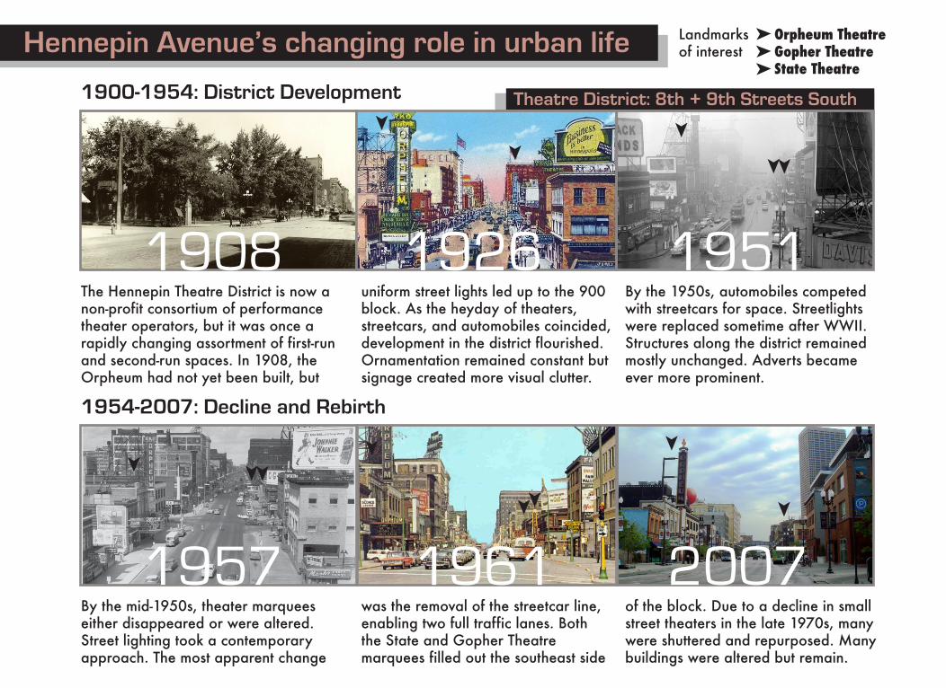
Theatre District: 8th + 9th Streets South
Orpheum TheatreGopher TheatreState Theatre
nn
n
Landmarksof interest
The Hennepin Theatre District is now anon-profit consortium of performancetheater operators, but it was once arapidly changing assortment of first-runand second-run spaces. In 1908, theOrpheum had not yet been built, but
uniform street lights led up to the 900 block. As the heyday of theaters,streetcars, and automobiles coincided,development in the district flourished.Ornamentation remained constant butsignage created more visual clutter.
By the 1950s, automobiles competedwith streetcars for space. Streetlightswere replaced sometime after WWII.Structures along the district remainedmostly unchanged. Adverts becameever more prominent.
Hennepin Avenue’s changing role in urban life
1954-2007: Decline and Rebirth
1908 1926
By the mid-1950s, theater marqueeseither disappeared or were altered.Street lighting took a contemporaryapproach. The most apparent change
was the removal of the streetcar line,enabling two full traffic lanes. Boththe State and Gopher Theatremarquees filled out the southeast side
of the block. Due to a decline in smallstreet theaters in the late 1970s, manywere shuttered and repurposed. Manybuildings were altered but remain.
1957 1961 2007
1951
1900-1954: District Developmentn
n
n
nnn
n
n
nn
n
nn
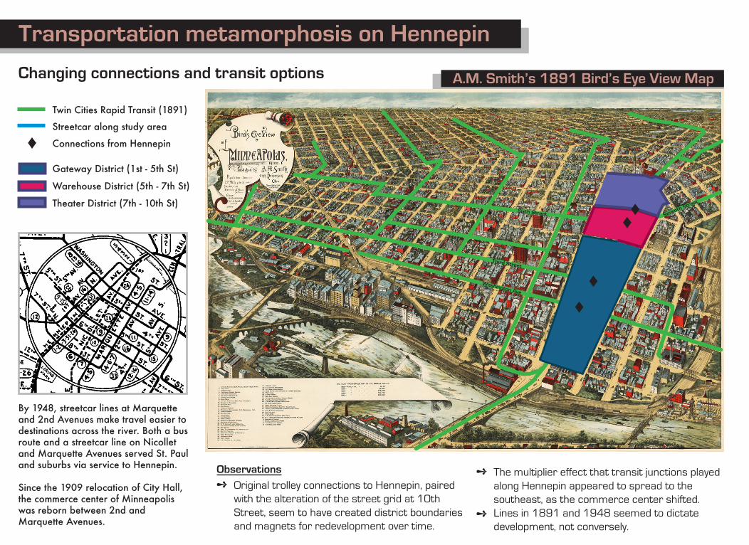
A.M. Smith’s 1891 Bird’s Eye View MapChanging connections and transit options
Twin Cities Rapid Transit (1891)
Streetcar along study area
Connections from Hennepin
Gateway District (1st - 5th St)
Warehouse District (5th - 7th St)
Theater District (7th - 10th St)
L
L
LL
L
By 1948, streetcar lines at Marquette and 2nd Avenues make travel easier todestinations across the river. Both a busroute and a streetcar line on Nicollet and Marquette Avenues served St. Paul and suburbs via service to Hennepin.
Since the 1909 relocation of City Hall,the commerce center of Minneapolis was reborn between 2nd and Marquette Avenues.
Observations
+ Original trolley connections to Hennepin, paired with the alteration of the street grid at 10th Street, seem to have created district boundaries and magnets for redevelopment over time.
+
+
The multiplier effect that transit junctions played along Hennepin appeared to spread to thesoutheast, as the commerce center shifted.Lines in 1891 and 1948 seemed to dictatedevelopment, not conversely.
Washington Ave
Third Street
Sixth Street Seventh Street
Transportation metamorphosis on Hennepin
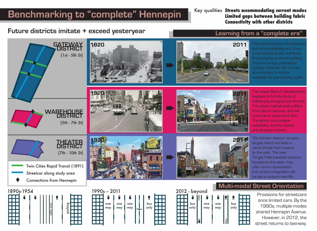
Learning from a “complete era”Future districts imitate + exceed yesteryear
(1st - 5th St)
(5th - 7th St)
(7th - 10th St)
L
L
GATEWAYDISTRICT
DISTRICT
DISTRICT
WAREHOUSE
THEATER
#
#
#
L
L
; ; ;
;
oneway
oneway
oneway
busonlybikes
; ;
;
park
ing
safe
ty z
one
1990s -- 20111890s-1954Multi-modal Street Orientation
Twin Cities Rapid Transit (1891)
Streetcar along study area
Connections from HennepinL
Provisions for streetcarsonce limited cars. By the1990s, multiple modes
shared Hennepin Avenue.However, in 2012, the
street returns to two-way.
; ; ;
;;
busonly
oneway
oneway
busonly
bike
s;bikes
2012 - beyond
1920
1920
1920
Streets accommodating current modesLimited gaps between building fabricConnectivity with other districts
Key qualities
The city reinvented the Gatewaybut lacks walkability and, thus,a connection to the riverfront.Encouraging on-street parkingmay encourage pedestrianactivity. However, the currentenvironment is neitherwalkable nor perceviably public.
The newer Block E developmentreplaced a full city block ofindividually wrapped storefronts.The urban mall already suffersfrom store closures, and willcontinue to experience this.The street encourageswalkability, but the storesare shielded indoors.
The theater district remainslargely intact but feels avisual threat from towersto the east. The newTarget Field baseball stadium,located to the west, mayoffer some rejuvenation, but careful integration willbe key to ensure new life.
2011
2011
2011
Benchmarking to “complete” Hennepin