Embed Size (px)
Citation preview
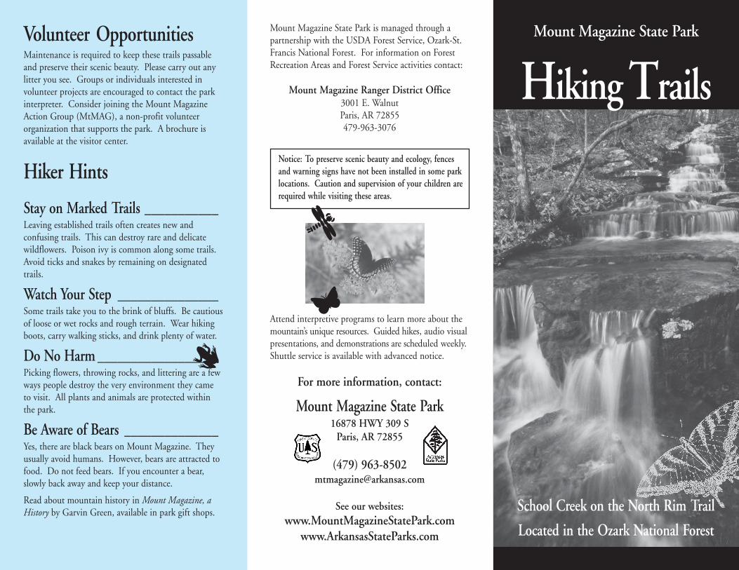
Mount Magazine State Park
Hiking Trails
School Creek on the North Rim Trail
Located in the Ozark National Forest
Mount Magazine State Park is managed through apartnership with the USDA Forest Service, Ozark-St.Francis National Forest. For information on ForestRecreation Areas and Forest Service activities contact:
Mount Magazine Ranger District Office3001 E. WalnutParis, AR 72855479-963-3076
Notice: To preserve scenic beauty and ecology, fencesand warning signs have not been installed in some parklocations. Caution and supervision of your children arerequired while visiting these areas.
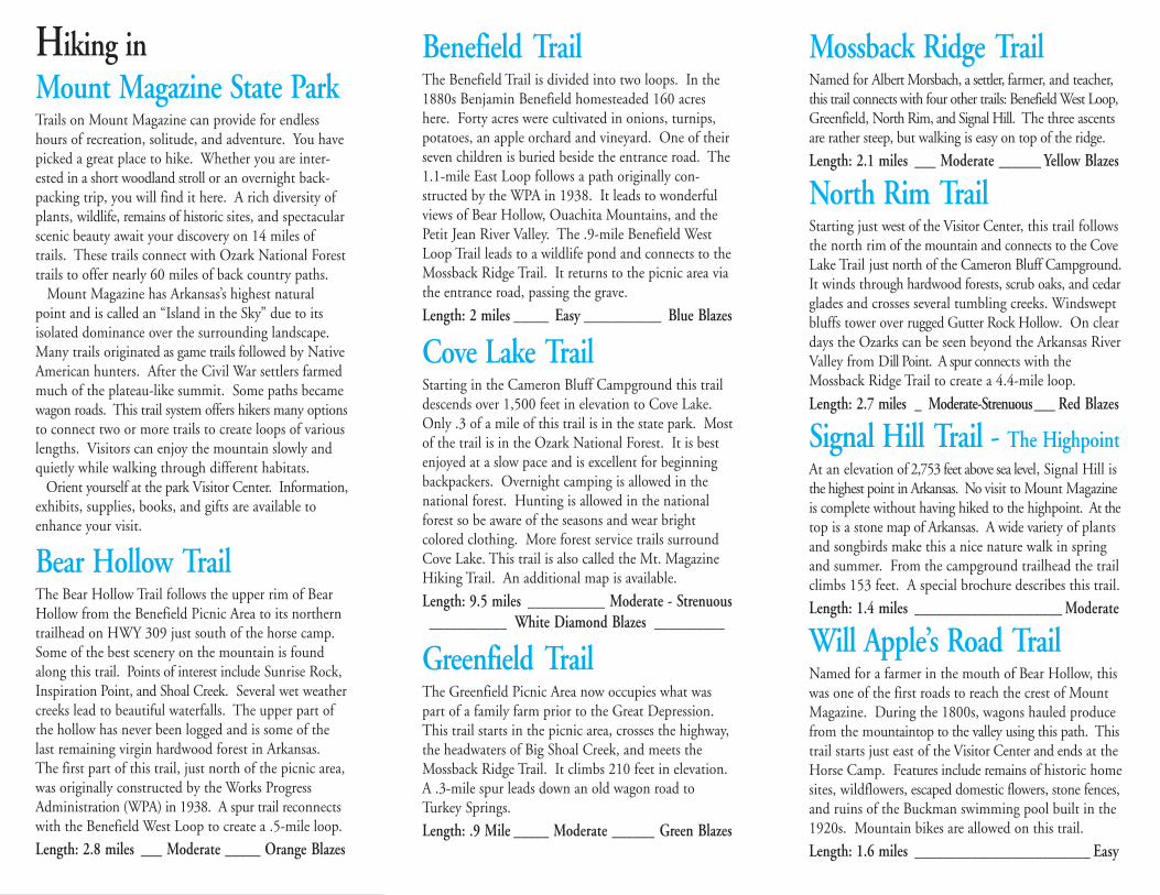
Attend interpretive programs to learn more about themountain’s unique resources. Guided hikes, audio visualpresentations, and demonstrations are scheduled weekly.Shuttle service is available with advanced notice.
For more information, contact:
Mount Magazine State Park16878 HWY 309 S
Paris, AR 72855
(479) [email protected]
See our websites:www.MountMagazineStatePark.com
www.ArkansasStateParks.com
Volunteer OpportunitiesMaintenance is required to keep these trails passableand preserve their scenic beauty. Please carry out anylitter you see. Groups or individuals interested involunteer projects are encouraged to contact the parkinterpreter. Consider joining the Mount MagazineAction Group (MtMAG), a non-profit volunteerorganization that supports the park. A brochure isavailable at the visitor center.
Hiker Hints
Stay on Marked Trails ___________Leaving established trails often creates new andconfusing trails. This can destroy rare and delicatewildflowers. Poison ivy is common along some trails.Avoid ticks and snakes by remaining on designatedtrails.
Watch Your Step _______________Some trails take you to the brink of bluffs. Be cautiousof loose or wet rocks and rough terrain. Wear hikingboots, carry walking sticks, and drink plenty of water.
Do No Harm __________________Picking flowers, throwing rocks, and littering are a fewways people destroy the very environment they cameto visit. All plants and animals are protected withinthe park.
Be Aware of Bears ______________Yes, there are black bears on Mount Magazine. Theyusually avoid humans. However, bears are attracted tofood. Do not feed bears. If you encounter a bear,slowly back away and keep your distance.
Read about mountain history in Mount Magazine, aHistory by Garvin Green, available in park gift shops.
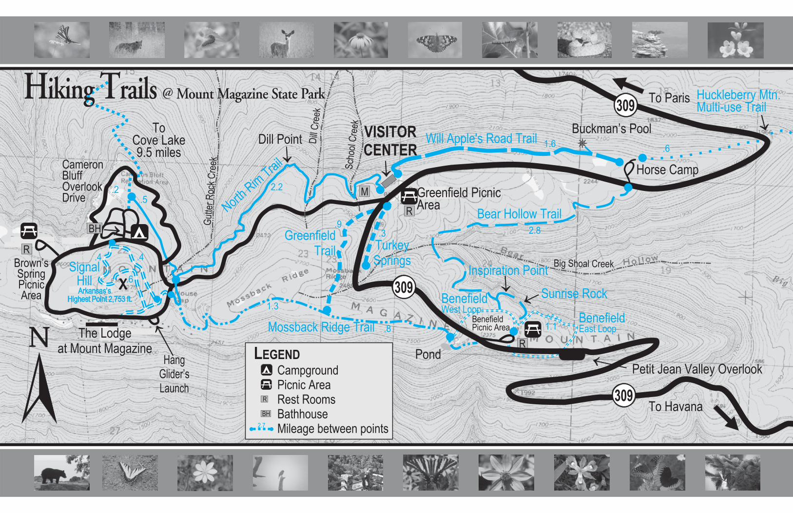
Hiking inMount Magazine State ParkTrails on Mount Magazine can provide for endlesshours of recreation, solitude, and adventure. You havepicked a great place to hike. Whether you are inter-ested in a short woodland stroll or an overnight back-packing trip, you will find it here. A rich diversity ofplants, wildlife, remains of historic sites, and spectacularscenic beauty await your discovery on 14 miles oftrails. These trails connect with Ozark National Foresttrails to offer nearly 60 miles of back country paths. Mount Magazine has Arkansas’s highest naturalpoint and is called an “Island in the Sky” due to itsisolated dominance over the surrounding landscape.Many trails originated as game trails followed by NativeAmerican hunters. After the Civil War settlers farmedmuch of the plateau-like summit. Some paths becamewagon roads. This trail system offers hikers many optionsto connect two or more trails to create loops of variouslengths. Visitors can enjoy the mountain slowly andquietly while walking through different habitats. Orient yourself at the park Visitor Center. Information,exhibits, supplies, books, and gifts are available toenhance your visit.
Bear Hollow TrailThe Bear Hollow Trail follows the upper rim of BearHollow from the Benefield Picnic Area to its northerntrailhead on HWY 309 just south of the horse camp.Some of the best scenery on the mountain is foundalong this trail. Points of interest include Sunrise Rock,Inspiration Point, and Shoal Creek. Several wet weathercreeks lead to beautiful waterfalls. The upper part ofthe hollow has never been logged and is some of thelast remaining virgin hardwood forest in Arkansas.The first part of this trail, just north of the picnic area,was originally constructed by the Works ProgressAdministration (WPA) in 1938. A spur trail reconnectswith the Benefield West Loop to create a .5-mile loop.
Length: 2.8 miles___Moderate_____Orange Blazes
Benefield TrailThe Benefield Trail is divided into two loops. In the1880s Benjamin Benefield homesteaded 160 acreshere. Forty acres were cultivated in onions, turnips,potatoes, an apple orchard and vineyard. One of theirseven children is buried beside the entrance road. The1.1-mile East Loop follows a path originally con-structed by the WPA in 1938. It leads to wonderfulviews of Bear Hollow, Ouachita Mountains, and thePetit Jean River Valley. The .9-mile Benefield WestLoop Trail leads to a wildlife pond and connects to theMossback Ridge Trail. It returns to the picnic area viathe entrance road, passing the grave.
Length: 2 miles_____Easy___________Blue Blazes
Cove Lake TrailStarting in the Cameron Bluff Campground this traildescends over 1,500 feet in elevation to Cove Lake.Only .3 of a mile of this trail is in the state park. Mostof the trail is in the Ozark National Forest. It is bestenjoyed at a slow pace and is excellent for beginningbackpackers. Overnight camping is allowed in thenational forest. Hunting is allowed in the nationalforest so be aware of the seasons and wear brightcolored clothing. More forest service trails surroundCove Lake. This trail is also called the Mt. MagazineHiking Trail. An additional map is available.
Length: 9.5 miles___________Moderate - Strenuous___________White Diamond Blazes__________
Greenfield TrailThe Greenfield Picnic Area now occupies what waspart of a family farm prior to the Great Depression.This trail starts in the picnic area, crosses the highway,the headwaters of Big Shoal Creek, and meets theMossback Ridge Trail. It climbs 210 feet in elevation.A .3-mile spur leads down an old wagon road toTurkey Springs.
Length: .9 Mile_____Moderate______Green Blazes
Mossback Ridge TrailNamed for Albert Morsbach, a settler, farmer, and teacher,this trail connects with four other trails: Benefield West Loop,Greenfield, North Rim, and Signal Hill. The three ascentsare rather steep, but walking is easy on top of the ridge.
Length: 2.1 miles___Moderate______Yellow Blazes
North Rim TrailStarting just west of the Visitor Center, this trail followsthe north rim of the mountain and connects to the CoveLake Trail just north of the Cameron Bluff Campground.It winds through hardwood forests, scrub oaks, and cedarglades and crosses several tumbling creeks. Windsweptbluffs tower over rugged Gutter Rock Hollow. On cleardays the Ozarks can be seen beyond the Arkansas RiverValley from Dill Point. A spur connects with theMossback Ridge Trail to create a 4.4-mile loop.
Length: 2.7 miles_Moderate-Strenuous___Red Blazes
Signal Hill Trail - The HighpointAt an elevation of 2,753 feet above sea level, Signal Hill isthe highest point in Arkansas. No visit to Mount Magazineis complete without having hiked to the highpoint. At thetop is a stone map of Arkansas. A wide variety of plantsand songbirds make this a nice nature walk in springand summer. From the campground trailhead the trailclimbs 153 feet. A special brochure describes this trail.
Length: 1.4 miles_____________________Moderate
Will Apple’s Road TrailNamed for a farmer in the mouth of Bear Hollow, thiswas one of the first roads to reach the crest of MountMagazine. During the 1800s, wagons hauled producefrom the mountaintop to the valley using this path. Thistrail starts just east of the Visitor Center and ends at theHorse Camp. Features include remains of historic homesites, wildflowers, escaped domestic flowers, stone fences,and ruins of the Buckman swimming pool built in the1920s. Mountain bikes are allowed on this trail.
Length: 1.6 miles_________________________Easy
Mount Magazine State Park
Hiking Trails
School Creek on the North Rim Trail
Located in the Ozark National Forest
Mount Magazine State Park is managed through apartnership with the USDA Forest Service, Ozark-St.Francis National Forest. For information on ForestRecreation Areas and Forest Service activities contact:
Mount Magazine Ranger District Office3001 E. WalnutParis, AR 72855479-963-3076
Notice: To preserve scenic beauty and ecology, fencesand warning signs have not been installed in some parklocations. Caution and supervision of your children arerequired while visiting these areas.
Attend interpretive programs to learn more about themountain’s unique resources. Guided hikes, audio visualpresentations, and demonstrations are scheduled weekly.Shuttle service is available with advanced notice.
For more information, contact:
Mount Magazine State Park16878 HWY 309 S
Paris, AR 72855
(479) [email protected]
See our websites:www.MountMagazineStatePark.com
www.ArkansasStateParks.com
Volunteer OpportunitiesMaintenance is required to keep these trails passableand preserve their scenic beauty. Please carry out anylitter you see. Groups or individuals interested involunteer projects are encouraged to contact the parkinterpreter. Consider joining the Mount MagazineAction Group (MtMAG), a non-profit volunteerorganization that supports the park. A brochure isavailable at the visitor center.
Hiker Hints
Stay on Marked Trails___________Leaving established trails often creates new andconfusing trails. This can destroy rare and delicatewildflowers. Poison ivy is common along some trails.Avoid ticks and snakes by remaining on designatedtrails.
Watch Your Step_______________Some trails take you to the brink of bluffs. Be cautiousof loose or wet rocks and rough terrain. Wear hikingboots, carry walking sticks, and drink plenty of water.
Do No Harm__________________Picking flowers, throwing rocks, and littering are a fewways people destroy the very environment they cameto visit. All plants and animals are protected withinthe park.
Be Aware of Bears______________Yes, there are black bears on Mount Magazine. Theyusually avoid humans. However, bears are attracted tofood. Do not feed bears. If you encounter a bear,slowly back away and keep your distance.
Read about mountain history in Mount Magazine, aHistory by Garvin Green, available in park gift shops.
Hiking inMount Magazine State ParkTrails on Mount Magazine can provide for endlesshours of recreation, solitude, and adventure. You havepicked a great place to hike. Whether you are inter-ested in a short woodland stroll or an overnight back-packing trip, you will find it here. A rich diversity ofplants, wildlife, remains of historic sites, and spectacularscenic beauty await your discovery on 14 miles oftrails. These trails connect with Ozark National Foresttrails to offer nearly 60 miles of back country paths. Mount Magazine has Arkansas’s highest naturalpoint and is called an “Island in the Sky” due to itsisolated dominance over the surrounding landscape.Many trails originated as game trails followed by NativeAmerican hunters. After the Civil War settlers farmedmuch of the plateau-like summit. Some paths becamewagon roads. This trail system offers hikers many optionsto connect two or more trails to create loops of variouslengths. Visitors can enjoy the mountain slowly andquietly while walking through different habitats. Orient yourself at the park Visitor Center. Information,exhibits, supplies, books, and gifts are available toenhance your visit.
Bear Hollow TrailThe Bear Hollow Trail follows the upper rim of BearHollow from the Benefield Picnic Area to its northerntrailhead on HWY 309 just south of the horse camp.Some of the best scenery on the mountain is foundalong this trail. Points of interest include Sunrise Rock,Inspiration Point, and Shoal Creek. Several wet weathercreeks lead to beautiful waterfalls. The upper part ofthe hollow has never been logged and is some of thelast remaining virgin hardwood forest in Arkansas.The first part of this trail, just north of the picnic area,was originally constructed by the Works ProgressAdministration (WPA) in 1938. A spur trail reconnectswith the Benefield West Loop to create a .5-mile loop.
Length: 2.8 miles ___ Moderate _____ Orange Blazes
Benefield TrailThe Benefield Trail is divided into two loops. In the1880s Benjamin Benefield homesteaded 160 acreshere. Forty acres were cultivated in onions, turnips,potatoes, an apple orchard and vineyard. One of theirseven children is buried beside the entrance road. The1.1-mile East Loop follows a path originally con-structed by the WPA in 1938. It leads to wonderfulviews of Bear Hollow, Ouachita Mountains, and thePetit Jean River Valley. The .9-mile Benefield WestLoop Trail leads to a wildlife pond and connects to theMossback Ridge Trail. It returns to the picnic area viathe entrance road, passing the grave.
Length: 2 miles _____ Easy ___________ Blue Blazes
Cove Lake TrailStarting in the Cameron Bluff Campground this traildescends over 1,500 feet in elevation to Cove Lake.Only .3 of a mile of this trail is in the state park. Mostof the trail is in the Ozark National Forest. It is bestenjoyed at a slow pace and is excellent for beginningbackpackers. Overnight camping is allowed in thenational forest. Hunting is allowed in the nationalforest so be aware of the seasons and wear brightcolored clothing. More forest service trails surroundCove Lake. This trail is also called the Mt. MagazineHiking Trail. An additional map is available.
Length: 9.5 miles ___________ Moderate - Strenuous___________ White Diamond Blazes __________
Greenfield TrailThe Greenfield Picnic Area now occupies what waspart of a family farm prior to the Great Depression.This trail starts in the picnic area, crosses the highway,the headwaters of Big Shoal Creek, and meets theMossback Ridge Trail. It climbs 210 feet in elevation.A .3-mile spur leads down an old wagon road toTurkey Springs.
Length: .9 Mile _____ Moderate ______ Green Blazes
Mossback Ridge TrailNamed for Albert Morsbach, a settler, farmer, and teacher,this trail connects with four other trails: Benefield West Loop,Greenfield, North Rim, and Signal Hill. The three ascentsare rather steep, but walking is easy on top of the ridge.
Length: 2.1 miles ___ Moderate ______ Yellow Blazes
North Rim TrailStarting just west of the Visitor Center, this trail followsthe north rim of the mountain and connects to the CoveLake Trail just north of the Cameron Bluff Campground.It winds through hardwood forests, scrub oaks, and cedarglades and crosses several tumbling creeks. Windsweptbluffs tower over rugged Gutter Rock Hollow. On cleardays the Ozarks can be seen beyond the Arkansas RiverValley from Dill Point. A spur connects with theMossback Ridge Trail to create a 4.4-mile loop.
Length: 2.7 miles _ Moderate-Strenuous___ Red Blazes
Signal Hill Trail - The HighpointAt an elevation of 2,753 feet above sea level, Signal Hill isthe highest point in Arkansas. No visit to Mount Magazineis complete without having hiked to the highpoint. At thetop is a stone map of Arkansas. A wide variety of plantsand songbirds make this a nice nature walk in springand summer. From the campground trailhead the trailclimbs 153 feet. A special brochure describes this trail.
Length: 1.4 miles _____________________ Moderate
Will Apple’s Road TrailNamed for a farmer in the mouth of Bear Hollow, thiswas one of the first roads to reach the crest of MountMagazine. During the 1800s, wagons hauled producefrom the mountaintop to the valley using this path. Thistrail starts just east of the Visitor Center and ends at theHorse Camp. Features include remains of historic homesites, wildflowers, escaped domestic flowers, stone fences,and ruins of the Buckman swimming pool built in the1920s. Mountain bikes are allowed on this trail.
Length: 1.6 miles _________________________ Easy
Hiking Trails @ Mount Magazine State Park