Embed Size (px)
Citation preview
Emma Hancox and Adam Mindykowski
6th July 2010
Revised final report
© Historic Environment and Archaeology Service,
Worcestershire County Council
Historic Environment and Archaeology Service, Worcestershire County Council, Woodbury, University of Worcester, Henwick Grove, Worcester WR2 6AJ
Historic Environment Assessment
for
Redditch Borough Council
Report 1754

Contents 1. Background......................................................................................................................... 3 1.1 Reasons for the project ..................................................................................................... 3
1.1.1 Project policy and wider framework links .................................................................. 3 1.2 Project parameters ........................................................................................................... 3 1.3 Previous historic environment assessments in Worcestershire ....................................... 3
1.3.1 Outline assessment of RSS areas, 2006 .................................................................. 3 1.3.2 Worcester Growth Point scoping report, 2007 .......................................................... 4
2. 2010 Redditch Borough Council study ............................................................................ 4 2.1 Aims .................................................................................................................................. 4 3. Methods ............................................................................................................................... 5 3.1 Methodological background .............................................................................................. 5 3.2 Preparation of Historic Environment Record data ............................................................ 6
3.2.1 Introduction to the HER ............................................................................................. 6 3.2.2 Preparation and selection of records ......................................................................... 6
3.3 Preparation of Landscape Description Units (LDUs) ........................................................ 8 3.4 Definition of Historic Environment Character Zones (HECZ) ........................................... 8 3.5 Production of character statements and HECZ assessment criteria ................................ 9
3.5.1 Summary of assessment themes and scoring criteria .............................................. 9 3.5.2 Issues affecting scoring ........................................................................................... 11
4. Summary and consideration of the assessment results ............................................. 13 4.1 Key outcomes of the assessment ................................................................................... 13
4.1.1 Grouping of assessment themes ............................................................................. 13 4.2 Issues of survival, potential and sensitivity to change .................................................... 16
4.2.1 Historic Environment Survival and Potential maps: ................................................ 17 4.2.2 Historic Environment Sensitivity to Change map: ................................................... 19
4.3 Assessment of coherence and diversity ......................................................................... 20 4.3.1 Historic Environment Coherence map: .................................................................... 21 4.3.2 Historic Environment Diversity map: ....................................................................... 21
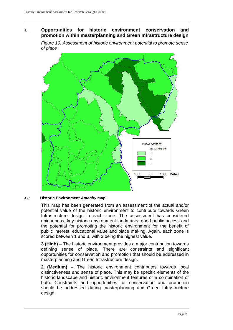
4.4 Opportunities for historic environment conservation and promotion within masterplanning and Green Infrastructure design ...................................................................... 23
4.4.1 Historic Environment Amenity map: ........................................................................ 23 4.4.2 Deficiencies, needs and opportunities..................................................................... 24
5. Publication summary ....................................................................................................... 25 6. Summary of sources for masterplanning ...................................................................... 26 7. The archive........................................................................................................................ 26 8. Acknowledgements .......................................................................................................... 27 9. Personnel .......................................................................................................................... 27 10. Bibliography .................................................................................................................. 27 11. Abbreviations and Glossary of Terms ........................................................................ 27 WCC: Worcestershire County Council ...................................................................................... 28 12. General periods for the historic environment ........................................................... 28 Appendix 1: .............................................................................................................................. 29 Historic Environment Character Statements Redditch Borough Council ......................... 29 13. Historic Environment Character Zones (HECZ)......................................................... 30
Historic Environment Assessment for Redditch Borough Council
Page 2
Historic Environment Assessment for Redditch Borough Council
Part 1 Project summary
An Historic Environment Assessment was carried out on behalf of Redditch Borough Council (RBC). The project was funded by RBC and English Heritage and was designed to provide an integrated historic environment evidence base to support policy and Green Infrastructure documents aimed at shaping future development strategy. The project combined county landscape character mapping with Historic Environment Record data and an outline Historic Landscape Character assessment. The results have produced 20 distinctive Historic Environment Character Zones, which are supported by character statements assessing historic environment survival, potential, documentation, diversity, group value, sensitivity and amenity potential for each zone. The project has provided an immediate assessment of the historic environment, however the methodology also provides the capacity for re-evaluation at key future stages. Archaeological survival and potential vary significantly across RBC from excellent to poor. The reasons for this are dependant on the type of archaeology and the 20
th century management of the landscape. Some
areas of high survival are well known, others perhaps less so. All areas have some amenity value and there is a need to develop networks that may enhance the amenity value of moderate and low scoring zones through the provision of enhanced access, conservation and promotion of the historic environment. These opportunities will become clear through an integrated approach to Green Infrastructure study, and the subsequent development of a strategy, that should identify and develop areas where valued historic environment features, habitats, landscape, blue infrastructure and access coexist. A detailed study set in the context of the existing evidence base will ensure that Green Infrastructure design can both enhance the historic environment and develop an appropriate mitigation strategy where different environmental themes conflict in terms of their conservation requirements.
Historic Environment Assessment for Redditch Borough Council
Page 3
Part 2 Detailed report
1. Background
1.1 Reasons for the project
The project was commissioned by Redditch Borough Council (RBC). The project was only possible as a result of funding support provided by both the Borough Council and English Heritage. The brief was to carry out an Historic Environment Assessment (HEA) in order to form part of the evidence base for Green Infrastructure study core strategy/local development framework.
1.1.1 Project policy and wider framework links
In November 2008, Worcestershire County Council produced a draft technical working paper for Planning and Green Infrastructure aimed at providing the first iteration of an integrated environmental framework (WCC November 2008). The document is part of a multi-stage process that aims to provide an over-arching Green Infrastructure framework that will link district strategies and provide a strategic guide for all types of environmental and developmental planning. The results of the RBC HEA will be integrated with a similar study being produced for Bromsgrove District during 2010 and a previous study produced in 2009 for the South Worcestershire Joint Core Strategy Area (SWJCS). The SWJCS area covers Wychavon District Council, Malvern Hills District Council and Worcester City Council.
The combined results from the three studies will then inform version 2 of the technical working paper, which is being drafted for publication in spring 2010.
1.2 Project parameters
The project conforms to the Standard and Guidance for Archaeological Desk-Based Assessments (IfA 2008) and to a project proposal of January 2010, prepared by Worcestershire Historic Environment and Archaeology Service.
1.3 Previous historic environment assessments in Worcestershire
1.3.1 Outline assessment of RSS areas, 2006
A brief outline of Historic Environment Character for the RSS assessment areas around Kidderminster, Bromsgrove, Redditch, Evesham, Pershore, Droitwich Spa and Malvern was produced in 2006 (WHEAS, November 2006). The study centred on quantifying the diverse range of historic assets recorded on the County Council HER at that time. By including County designated assets the study deliberately avoided the shortcomings of landscape scale assessments that only consider nationally designated assets (Scheduled Monuments, Listed Buildings, Registered Parks and Gardens and Registered Battlefields) although these assets were included within the overall assessment. A series of maps illustrating the locations of different classifications of assets were produced for a 1 kilometre buffer zone around each town. The aims were
Historic Environment Assessment for Redditch Borough Council
Page 4
to highlight diversity and show gaps in the record due to a lack of investigations. In addition, a short descriptive statement was produced for each buffer zone that aimed at capturing the essential HLC attributes within each zone. The Worcestershire HLC project had not commenced at the time of the study. HLC statements were therefore drawn from a rapid map-based assessment of each buffer zone using broad type HLC character descriptions.
1.3.2 Worcester Growth Point scoping report, 2007
In May 2007 the historic environment and archaeological services of Worcestershire County Council and Worcester City Council prepared a scoping report as a first stage study to inform the Green Infrastructure Strategy process for the Worcester new growth point project.
Through this work, and following discussion with Worcestershire County Council Planning Officers, it became clear that, in order to ensure consistency and to avoid duplication of effort in serving the needs of the emerging pattern of strategic planning documents, it would be an advantage to have a consistent, countywide historic environment assessment that could be easily fed into wider strategic documents. This is particularly important within the context of the Worcestershire two-tier system and the multiplicity of sub-county core strategies. It was concluded that a countywide Historic Environment Assessment would generate a more informed understanding of the capacity of the county to accommodate potential new development, and to explore development of a Green Infrastructure strategy to both conserve and enhance historic environment landscapes and assets.
2. 2010 Redditch Borough Council study
2.1 Aims
In January 2010, it was agreed between Worcestershire Historic Environment and Archaeology Service, English Heritage and the Officers of RBC that the historic environment assessment for the area would follow an adapted methodology based on the Shropshire County Council ‘Shrewsbury New Growth Point Historic Environment Assessment’ project design. This would effectively complete the second stage of the desired countywide coverage. In order to address external short-term deadlines, this study would proceed in a number of stages. This reflects that, whilst there is an urgent need for a base level of information to inform the current strategic planning process, a full analysis will only be possible with the completion of the Historic Landscape Characterisation (HLC). A project proposal was submitted to the RBC Officers and English Heritage. The proposal was accepted and commenced immediately with funding support from both organisations.
Historic Environment Assessment for Redditch Borough Council
Page 5
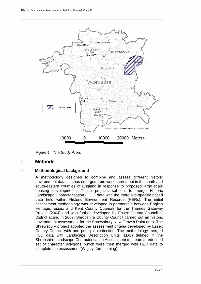
Figure 1. The Study Area.
3. Methods
3.1 Methodological background
A methodology designed to combine and assess different historic environment datasets has emerged from work carried out in the south and south-eastern counties of England in response to proposed large scale housing developments. These projects set out to merge Historic Landscape Characterisation (HLC) data with the more site-specific based data held within Historic Environment Records (HERs). The initial assessment methodology was developed in partnership between English Heritage, Essex and Kent County Councils for the Thames Gateway Project (2004) and was further developed by Essex County Council at District scale. In 2007, Shropshire County Council carried out an historic environment assessment for the Shrewsbury New Growth Point area. The Shrewsbury project adopted the assessment criteria developed by Essex County Council with one principle distinction. The methodology merged HLC data with Landscape Description Units (LDU) defined in the Shropshire Landscape Characterisation Assessment to create a redefined set of character polygons, which were then merged with HER data to complete the assessment (Wigley, forthcoming).
Historic Environment Assessment for Redditch Borough Council
Page 6
3.2 Preparation of Historic Environment Record data
3.2.1 Introduction to the HER
The Historic Environment Record maintained by Worcestershire Historic Environment and Archaeology Service is the principal record of historic environment assets in Worcestershire. The HER embraces all known assets drawn from a diverse range of sources. In addition to holding records of above and below ground historic environment features, the HER also holds data relating to nationally designated assets (SM, RB, RPG and LB). The evolution from a Sites and Monuments Record (SMR) to an Historic Environment Record in 2004 marked a shift towards development of a more holistic record that now includes data on ancient trees, palaeoenvironmental data, selected geological records, historic town deposit modelling and the definition of historic landscape components. There are also links to related sources such as reports on research and investigation projects and historic documentation. The HER records spatially the location of archaeological investigations both fieldwork and desk-based. The record is underpinned by a suite of historic and modern map sources, aerial photographs and character maps, all managed within a GIS package.
3.2.2 Preparation and selection of records
In line with similar characterisation studies, selected HER data was abstracted from the record to show the distribution of assets and key landscape features and areas.
Selected HER layers were converted to point data to enable assessment based on the distribution of assets, the type of evidence and broad period. These datasets are:
Monuments
Historic Buildings
Listed Buildings
Historic Farmsteads
Scheduled Monuments
Ancient Trees
Selected landscape component layers were not converted to point data given their value as a context for individual and grouped historic assets. They also contributed to the definition of character zones based on their influence on landscape character. These datasets are:
Parks and Gardens
Ancient semi-natural and ancient replanted woodland
Conservation areas
Registered Common Land
The Documentation assessment theme (see section 3.4) was largely informed by information and sources drawn from the Activities layer in the HER.
Historic Environment Assessment for Redditch Borough Council
Page 7
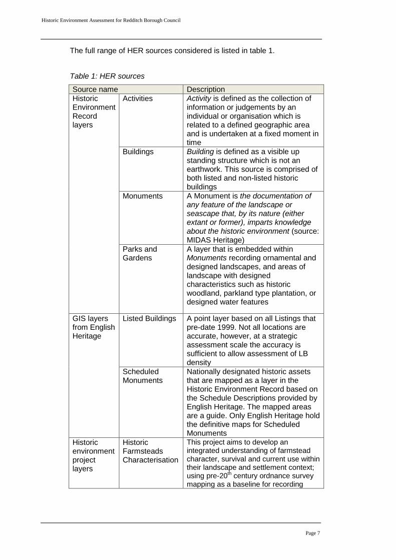
The full range of HER sources considered is listed in table 1.
Table 1: HER sources
Source name Description
Historic Environment Record layers
Activities Activity is defined as the collection of information or judgements by an individual or organisation which is related to a defined geographic area and is undertaken at a fixed moment in time
Buildings Building is defined as a visible up standing structure which is not an earthwork. This source is comprised of both listed and non-listed historic buildings
Monuments A Monument is the documentation of any feature of the landscape or seascape that, by its nature (either extant or former), imparts knowledge about the historic environment (source: MIDAS Heritage)
Parks and Gardens
A layer that is embedded within Monuments recording ornamental and designed landscapes, and areas of landscape with designed characteristics such as historic woodland, parkland type plantation, or designed water features
GIS layers from English Heritage
Listed Buildings A point layer based on all Listings that pre-date 1999. Not all locations are accurate, however, at a strategic assessment scale the accuracy is sufficient to allow assessment of LB density
Scheduled Monuments
Nationally designated historic assets that are mapped as a layer in the Historic Environment Record based on the Schedule Descriptions provided by English Heritage. The mapped areas are a guide. Only English Heritage hold the definitive maps for Scheduled Monuments
Historic environment project layers
Historic Farmsteads Characterisation
This project aims to develop an integrated understanding of farmstead character, survival and current use within their landscape and settlement context; using pre-20th century ordnance survey mapping as a baseline for recording
Historic Environment Assessment for Redditch Borough Council
Page 8
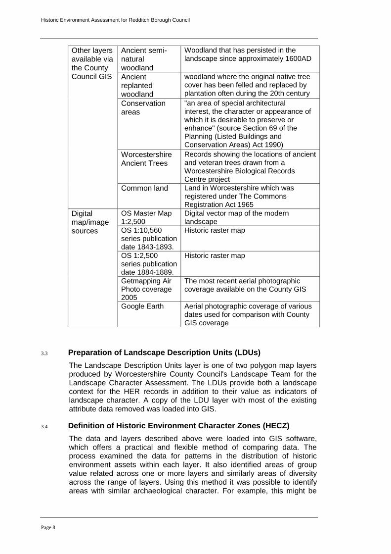
Other layers available via the County Council GIS
Ancient semi-natural woodland
Woodland that has persisted in the landscape since approximately 1600AD
Ancient replanted woodland
woodland where the original native tree cover has been felled and replaced by plantation often during the 20th century
Conservation areas
"an area of special architectural interest, the character or appearance of which it is desirable to preserve or enhance" (source Section 69 of the Planning (Listed Buildings and Conservation Areas) Act 1990)
Worcestershire Ancient Trees
Records showing the locations of ancient and veteran trees drawn from a Worcestershire Biological Records Centre project
Common land Land in Worcestershire which was registered under The Commons Registration Act 1965
Digital map/image sources
OS Master Map 1:2,500
Digital vector map of the modern landscape
OS 1:10,560 series publication date 1843-1893.
Historic raster map
OS 1:2,500 series publication date 1884-1889.
Historic raster map
Getmapping Air Photo coverage 2005
The most recent aerial photographic coverage available on the County GIS
Google Earth Aerial photographic coverage of various dates used for comparison with County GIS coverage
3.3 Preparation of Landscape Description Units (LDUs)
The Landscape Description Units layer is one of two polygon map layers produced by Worcestershire County Council's Landscape Team for the Landscape Character Assessment. The LDUs provide both a landscape context for the HER records in addition to their value as indicators of landscape character. A copy of the LDU layer with most of the existing attribute data removed was loaded into GIS.
3.4 Definition of Historic Environment Character Zones (HECZ)
The data and layers described above were loaded into GIS software, which offers a practical and flexible method of comparing data. The process examined the data for patterns in the distribution of historic environment assets within each layer. It also identified areas of group value related across one or more layers and similarly areas of diversity across the range of layers. Using this method it was possible to identify areas with similar archaeological character. For example, this might be
Historic Environment Assessment for Redditch Borough Council
Page 9
areas defined by surviving extensive below ground archaeology or where features are broadly of a similar period.
The historic buildings, Listed Buildings and historic farmsteads layers were compared to assess the distribution and relationship between historic buildings and their setting in the landscape.
This assessment was carried out in relation to the existing LDU mapping, selected historic Ordnance Survey mapping and aerial photographic coverage. It was therefore possible to make an assessment of the historic landscape character in any given area.
By combining the above, it was possible to define areas of distinctive or related historic environment character to create an integrated evidence base; the Historic Environment Character Zone. A total of 20 HECZ were defined entirely or partially within the area of Redditch Borough. The next stage involved preparation of a character statement, and thematic assessment of, each character zone. It is important to stress that this study is the first iteration of a strategic assessment. Once the county Historic Landscape Character project is complete, this data should be used to deepen the assessment of landscape character and sensitivity.
3.5 Production of character statements and HECZ assessment criteria
Each HECZ is supported by three short statements, an introductory summary to set the context followed by summaries of historic landscape and archaeological character attributes for the zone.
This is followed by an assessment of the zone based on seven themes:
Survival
Potential
Documentation
Diversity
Group value
Amenity
Sensitivity to change
Each theme has been scored between 1 and 3, with 3 being the highest value. The definition of assessment themes and scoring methodology is based on the method employed by Shropshire Council for the Shrewsbury New Growth Point Assessment (Wigley forthcoming). This method is rooted in the approach developed for the Rochford District Historic Environment Characterisation Project (Brown, Clarke and Havis, 2006). It must be understood that at this strategic assessment level the numerical assessment is indicative. The scores must therefore be taken in relation to the overall character description statements.
3.5.1 Summary of assessment themes and scoring criteria
Survival – based on current Historic Environment Record assets, land-use and the impact of previous development
Historic Environment Assessment for Redditch Borough Council
Page 10
3 – High preservation of many known assets
2 – Moderate preservation of many assets or few recorded assets, but little disturbance within the zone
1 – Low or unknown preservation due to heavy impact or low density of Historic Environment Records
Potential – assessment of likelihood for the presence of additional historic environment features
3 – A range of high quality assets probably survive in the zone due to a lack of heavy impact
2 – Some existing impact from development, long-term arable land-use or limited known historic assets due to a lack of investigation
1 – Existing widespread impact from development, or quarrying, or potential is unknown due to a low density of records
Documentation – an assessment of previous, investigation, field survey (including: field walking, field evaluation, excavation, salvage recording, building recording and landscape survey), research, archive and historic documentation
3 – A wide range of the above
2 – Some of the above
1 – Few or none of the above
Diversity – an assessment of the range of assets present in each zone based on date/period (e.g. Iron Age, medieval), or evidence type (e.g. structural, below ground, environmental, earthworks or landscape)
3 – A wide range of assets in date and evidence
2 – A moderate range of assets in date and evidence
1 – Few know assets or many assets of a limited date range or evidence type
Group value – an assessment of coherence in the historic environment by period, evidence type or both
3 – Contains a wide range of assets related in either date, type or both
2 – Contains a moderate range of assets related in either date, type or both
1 – Contains few assets of similar date or type
Amenity value – identifies historic environment attributes within the zone with a potential to be promoted as part of Green Infrastructure provision or enhanced public access
Historic Environment Assessment for Redditch Borough Council
Page 11
3 – The historic environment provides a major contribution towards defining sense of place. There are constraints and significant opportunities for conservation and promotion that should be addressed in masterplanning and Green Infrastructure design.
2 – The historic environment contributes towards local distinctiveness and sense of place. This may be specific elements of the historic landscape or historic environment features or a combination of both. Constraints and opportunities for conservation and promotion should be addressed during masterplanning and Green Infrastructure design.
1 – The historic environment does not appear to contribute strongly towards defining sense of place. However, the full potential may be unknown and there is, therefore, scope for further investigations. These should be carried out as part of masterplanning and Green Infrastructure design to identify constraints and opportunities.
Sensitivity to change – identifies sensitivity based on the impact of medium to large-scale development
3 – Medium to large-scale development will have a significant impact on the historic environment.
2 – Medium to large-scale development will have a considerable impact on the historic environment.
1 – The historic environment could accommodate medium to large-scale development although specific assets may suffer adverse effects.
The integrated assessment is then expressed through an overall score, which is the sum total of scores from the seven criteria.
3.5.2 Issues affecting scoring
Where a score of 1 has been applied this does not in every case indicate a low historic environment value. The assessment of historic environment data has been reliant on existing information and sources held in the Worcestershire HER. In common with all other local authorities, the HER is largely populated with records drawn from the following activities:
Archaeological investigations carried out as part of development control conditions of assessment and mitigation
Archaeological assessments and investigations carried out in conjunction with aggregates extraction
Archaeological investigations carried out in conjunction with large infrastructure installation and upgrade projects, such as utilities and road building
Previous landscape-scale or urban historic environment assessments
Private and academic survey and research
Historic Environment Assessment for Redditch Borough Council
Page 12
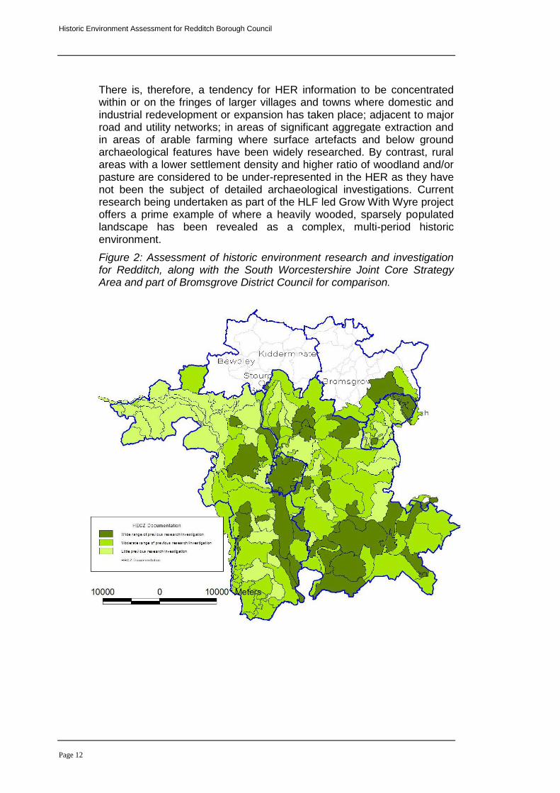
There is, therefore, a tendency for HER information to be concentrated within or on the fringes of larger villages and towns where domestic and industrial redevelopment or expansion has taken place; adjacent to major road and utility networks; in areas of significant aggregate extraction and in areas of arable farming where surface artefacts and below ground archaeological features have been widely researched. By contrast, rural areas with a lower settlement density and higher ratio of woodland and/or pasture are considered to be under-represented in the HER as they have not been the subject of detailed archaeological investigations. Current research being undertaken as part of the HLF led Grow With Wyre project offers a prime example of where a heavily wooded, sparsely populated landscape has been revealed as a complex, multi-period historic environment.
Figure 2: Assessment of historic environment research and investigation for Redditch, along with the South Worcestershire Joint Core Strategy Area and part of Bromsgrove District Council for comparison.
Historic Environment Assessment for Redditch Borough Council
Page 13
4. Summary and consideration of the assessment results
4.1 Key outcomes of the assessment
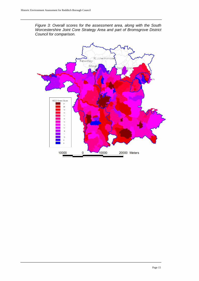
The project has identified and characterised 20 HECZ partially or completely within the RBC area (Appendix A includes all 20 statements, plus three others that are entirely outside RBC but border the boundary; HECZ104, 105 and 133). These are strategic level indicative character assessments. In the majority of cases, the base Landscape Description Units were either altered or merged to reflect clear patterns in the association between the historic environment and landscape. Decision processes developed for the county Historic Landscape Character Project were used, particularly, to assess historic field patterns in their chronological framework. In retrospect, had HLC mapping been available for this assessment the final results may have varied to some degree. Nonetheless, by applying HLC assessment techniques as part of the HEA assessment process, the essential HLC attributes and trends have been successfully captured. It has been possible to validate this by respective comparison of selected HECZ in those areas where the HLC has been completed.
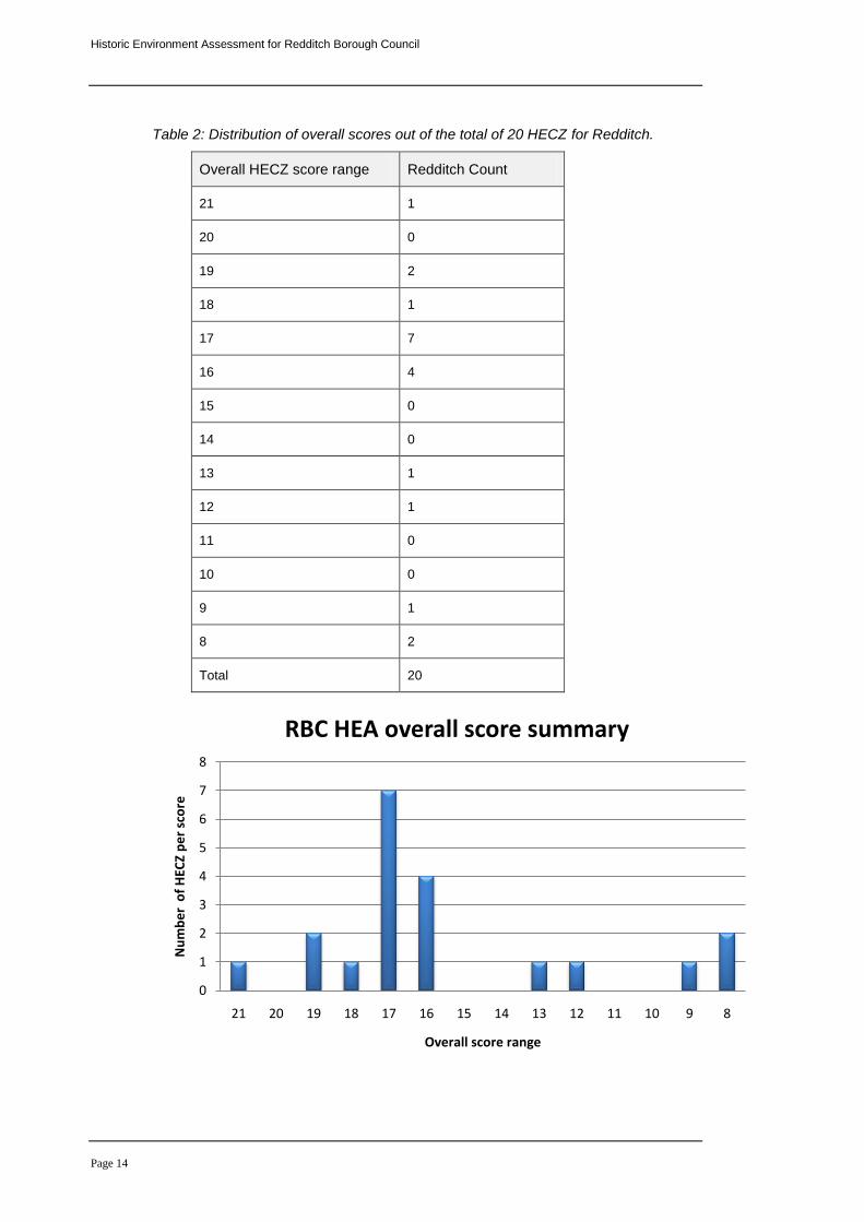
The individual scores for each of the seven assessment themes, discussed in section 3.5, were combined to provide an overall score for each HECZ. The score range spans from 8 to 21 with the majority of HECZ in Redditch Borough scoring 16 or above. The mean average across the entire County (excluding Wyre Forest District) is 15.50, the mean average for Redditch Borough is 17.75, showing that overall RBC is slightly higher than average. Redditch, however, has much greater diversity of scores over a small area. The area around Feckenham and to the west of Redditch New Town is high scoring, whereas parts of the urban area are very low.
4.1.1 Grouping of assessment themes
In the following section the seven assessment themes have been grouped together to reflect their conceptual relationships, for example, there is a direct link between the survival of historic environment features and the potential for additional features and sites being present in the same zone. It must be stressed that all seven themes interact and therefore contribute towards assessments of sensitivity, opportunity (amenity) and the overall score in each zone.
Historic Environment Assessment for Redditch Borough Council
Page 14
Table 2: Distribution of overall scores out of the total of 20 HECZ for Redditch.
Overall HECZ score range Redditch Count
21 1
20 0
19 2
18 1
17 7
16 4
15 0
14 0
13 1
12 1
11 0
10 0
9 1
8 2
Total 20
0
1
2
3
4
5
6
7
8
21 20 19 18 17 16 15 14 13 12 11 10 9 8
Nu
mb
er
of
HEC
Z p
er
sco
re
Overall score range
RBC HEA overall score summary
Historic Environment Assessment for Redditch Borough Council
Page 15
Figure 3: Overall scores for the assessment area, along with the South Worcestershire Joint Core Strategy Area and part of Bromsgrove District Council for comparison.
Historic Environment Assessment for Redditch Borough Council
Page 16
4.2 Issues of survival, potential and sensitivity to change
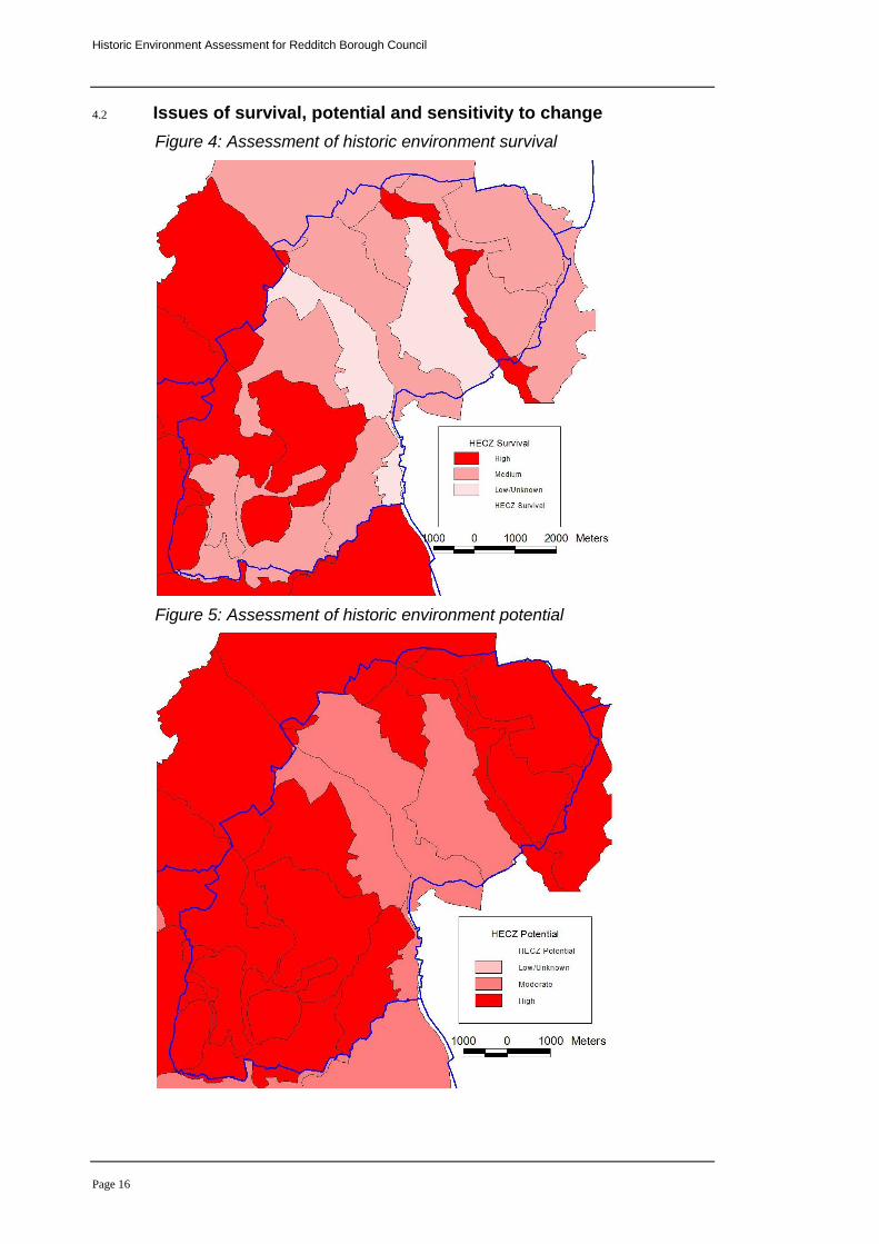
Figure 4: Assessment of historic environment survival
Figure 5: Assessment of historic environment potential
Historic Environment Assessment for Redditch Borough Council
Page 17
4.2.1 Historic Environment Survival and Potential maps:
These maps have been generated to show the known survival in each zone and the potential for unknown archaeology to be discovered, or for known archaeology to provide further information through research and study. Survival varies significantly across Redditch Borough from excellent to poor. The reasons for this are dependant on the type of archaeology and the 20
th century management of the landscape. Some
areas of high survival are well known, others perhaps less so.
Below-ground and earthwork survival varies considerably from one HECZ to another. In the Southern Arrow Valley (HECZ130, page 33), for example, extensive earthworks and buildings are a visible part of the landscape and below-ground archaeology has been found to survive to a great depth. Elsewhere modern development has had a significant impact on survival, such as in HECZ138 Lakeside to Green Lane (page 41).
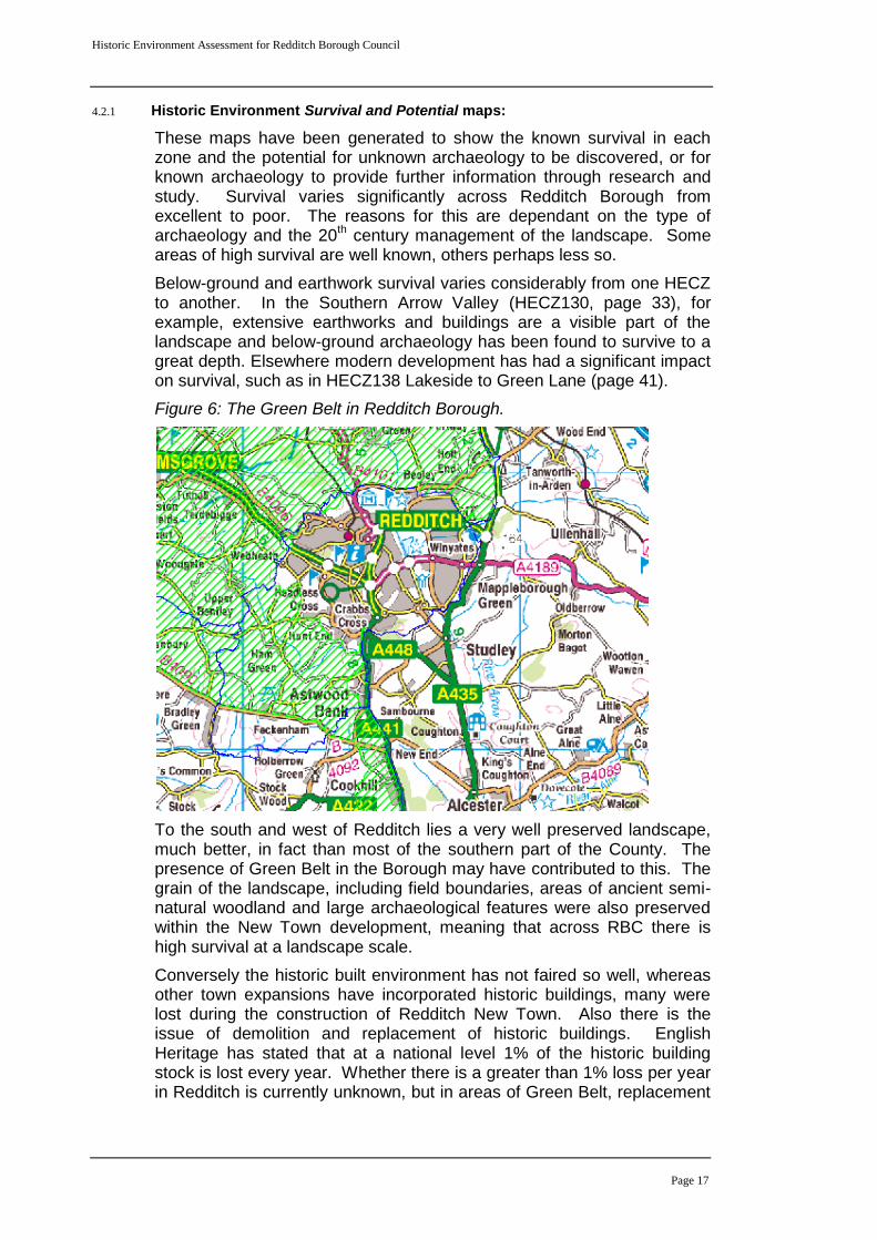
Figure 6: The Green Belt in Redditch Borough.
To the south and west of Redditch lies a very well preserved landscape, much better, in fact than most of the southern part of the County. The presence of Green Belt in the Borough may have contributed to this. The grain of the landscape, including field boundaries, areas of ancient semi-natural woodland and large archaeological features were also preserved within the New Town development, meaning that across RBC there is high survival at a landscape scale.
Conversely the historic built environment has not faired so well, whereas other town expansions have incorporated historic buildings, many were lost during the construction of Redditch New Town. Also there is the issue of demolition and replacement of historic buildings. English Heritage has stated that at a national level 1% of the historic building stock is lost every year. Whether there is a greater than 1% loss per year in Redditch is currently unknown, but in areas of Green Belt, replacement
Historic Environment Assessment for Redditch Borough Council
Page 18
is often the only option, rather than including the retention of historic buildings within new development.
Research is on-going, but various projects are showing the extreme vulnerability of historic buildings in this area of the County. The Historic Farmsteads Characterisation project, for example, has highlighted the high loss and conversion of traditional farm buildings in northeast Worcestershire. In Redditch Borough, 40% of farmsteads that existed at the start of the 20
th century have been completely lost, in comparison with
just 8% across the County as a whole (compared to 10% regionally). A very large proportion of those surviving buildings have been substantially altered or converted, as they are an attractive prospect for wealthy commuters. The conversion of traditional farm buildings to domestic use can be very positive as it protects and maintains them, however, it is only positive if that conversion is sensitive to the character of the buildings.
This study has also picked up the rapidly disappearing evidence of the needle industry that characterised the area. Where this survives, it forms a key characteristic of the landscape.
The assessment of potential is logically linked with survival; where there is good survival then the presence of additional features can be forecast with reasonable confidence. However, high potential can also be estimated in zones where the impact on landscape from development and intensification of farming is less evident.
Historic environment potential has to be understood in the abstract. Zones that have an intact historic field pattern can not produce more boundaries and hedgerows. However, by contrast, the deep alluvial deposits associated with river corridors and palaeochannels preserve ancient environmental materials, organic artefacts and structures, and multi-period features sealed beneath the upper alluvial layers. These are not visible on the surface, but are highly susceptible to impact from the deep excavations imposed by development.
Historic Environment Assessment for Redditch Borough Council
Page 19
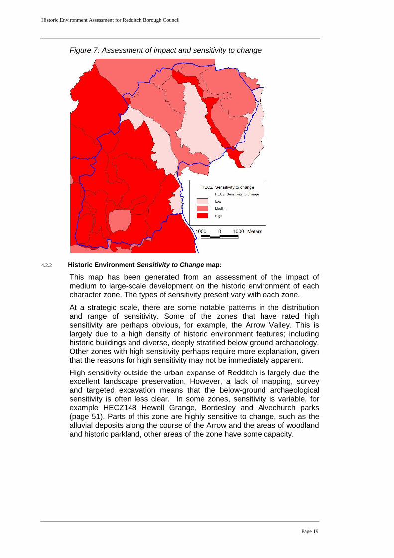
Figure 7: Assessment of impact and sensitivity to change
4.2.2 Historic Environment Sensitivity to Change map:
This map has been generated from an assessment of the impact of medium to large-scale development on the historic environment of each character zone. The types of sensitivity present vary with each zone.
At a strategic scale, there are some notable patterns in the distribution and range of sensitivity. Some of the zones that have rated high sensitivity are perhaps obvious, for example, the Arrow Valley. This is largely due to a high density of historic environment features; including historic buildings and diverse, deeply stratified below ground archaeology. Other zones with high sensitivity perhaps require more explanation, given that the reasons for high sensitivity may not be immediately apparent.
High sensitivity outside the urban expanse of Redditch is largely due the excellent landscape preservation. However, a lack of mapping, survey and targeted excavation means that the below-ground archaeological sensitivity is often less clear. In some zones, sensitivity is variable, for example HECZ148 Hewell Grange, Bordesley and Alvechurch parks (page 51). Parts of this zone are highly sensitive to change, such as the alluvial deposits along the course of the Arrow and the areas of woodland and historic parkland, other areas of the zone have some capacity.
Historic Environment Assessment for Redditch Borough Council
Page 20
4.3 Assessment of coherence and diversity
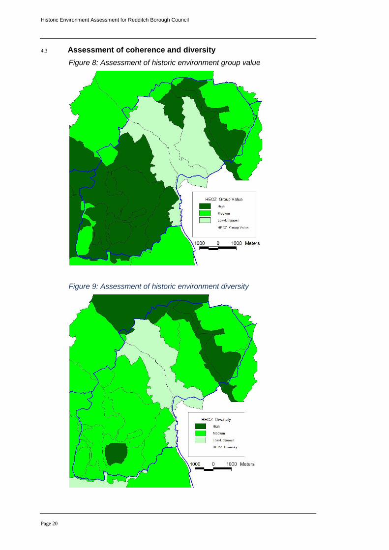
Figure 8: Assessment of historic environment group value
Figure 9: Assessment of historic environment diversity
Historic Environment Assessment for Redditch Borough Council
Page 21
4.3.1 Historic Environment Coherence map:
The assessment of coherence, or 'group value', has particular relevance to aid an understanding of setting and the definition of sense of place. This may be a visual experience, for example: dispersed settlement along sinuous lanes, areas of well-preserved medieval earthworks, historic hedgerows, relic parkland or commons. By contrast, a group value might be defined by features that are not visible, yet they contribute strongly towards the historic environment of an area, for example: areas with alluvial soils that preserve a wide assemblage of palaeoenvironmental materials.
The group value assessment also provides a specific indicator of sensitivity. Any loss or weakening of coherence identified in character zones with a high group value will weaken the overall historic environment character of the zone and potentially impact on the setting of related historic assets.
This theme also provides an indicator of opportunities that should inform Green Infrastructure design. For example, zones that may have a relatively intact historic field pattern, ancient woodland, medieval moated sites or areas of relic parkland offer particular opportunities for integration into Green Infrastructure networks and open space. Equally, the protection of high value below ground archaeology might be achieved through the allocation of open space that limits ground disturbance within a development area. The group value theme does not identify those specific areas of sensitivity at a site level, but is does aim to define areas where these constraints and opportunities are likely to be encountered.
The zones around Feckenham form a coherent medieval and post medieval landscape. This coherence extends right across to Droitwich and is distinctive, and therefore, a significant area within the County.
The modern New Town is not referred to in the individual character statements, but this is a coherent 20
th century landscape. The New Town
movement developed from the garden city movement, launched around 1900 by Ebenezer Howard and Sir Patrick Geddes. Following World War II, the 1946 New Towns Act was introduced, partly to replace homes and infrastructure damaged during the War. All the new towns feature certain characteristics, for example large areas of open space, segregated industrial estates and a car-oriented layout with many roundabouts. The third generation towns, of which Redditch is one of five designated between 1961 and 1966, devoted substantial resources to cycle routes, public transport and community facilities. Many argue that one of the key failings in New Town design is a lack of sense of place (Downie, 1972). Green Infrastructure planning should seek opportunities to enhance the existing Redditch landscape and protect and enhance the historic environment in new development areas. Archaeology and history can engage the public and give them a sense of ownership and belonging within their landscape.
4.3.2 Historic Environment Diversity map:
At a strategic scale of assessment, diversity is a key attribute of the historic environment and it is possible to identify and classify distinctive
Historic Environment Assessment for Redditch Borough Council
Page 22
areas where multi-period historic assets are present. Equally, some zones contain a wide range of assets of different types. It might seem predictable that zones with a lower group value will have a higher diversity score and vice-versa. This is, however, not necessarily the case as comparison between figures 8 and 9 demonstrates.
For example, HECZ 130 (The Southern Arrow Valley) has both a high group value, due to the well-preserved medieval and post-medieval landscape, and a high diversity value, due to the presence of below-ground remains from Romano-British times onwards and significant palaeoenvironmental remains.
Historic environment diversity, perhaps, presents extra challenges, but also opportunities for planning and Green Infrastructure design. The range of constraints and opportunities for protection and enhancement will be greater given that buildings, earthworks, paleoenvironmental remains, below ground archaeology and relic landscapes each demand very different responses within an integrated strategy to deliver effective solutions.
The area east of Droitwich up to the borders of Redditch has a high group value due to its coherent well preserved medieval and post-medieval landscape character. This requires an approach to planning design that respects the grain and scale of the historic field and settlement patterns. However, there are areas of diversity within this landscape where below ground archaeology is concentrated, and therefore, particularly sensitive to change. Undoubtedly, where these factors combine complex constraints arise that may affect development opportunities, but equally require further investigation to identify detailed constraints and opportunities.
Historic Environment Assessment for Redditch Borough Council
Page 23
4.4 Opportunities for historic environment conservation and promotion within masterplanning and Green Infrastructure design
Figure 10: Assessment of historic environment potential to promote sense of place
4.4.1 Historic Environment Amenity map:
This map has been generated from an assessment of the actual and/or potential value of the historic environment to contribute towards Green Infrastructure design in each zone. The assessment has considered uniqueness, key historic environment landmarks, good public access and the potential for promoting the historic environment for the benefit of public interest, educational value and place making. Again, each zone is scored between 1 and 3, with 3 being the highest value.
3 (High) – The historic environment provides a major contribution towards defining sense of place. There are constraints and significant opportunities for conservation and promotion that should be addressed in masterplanning and Green Infrastructure design.
2 (Medium) – The historic environment contributes towards local distinctiveness and sense of place. This may be specific elements of the historic landscape and historic environment features or a combination of both. Constraints and opportunities for conservation and promotion should be addressed during masterplanning and Green Infrastructure design.
Historic Environment Assessment for Redditch Borough Council
Page 24
1 (Low/Unknown) – The historic environment does not appear to contribute strongly towards defining sense of place. However, the full potential may be unknown and there is, therefore, scope for further investigations. These should be carried out as part of masterplanning and Green Infrastructure design to identify constraints and opportunities.
The map clearly demonstrates that some potential for promotion and conservation exists across the entire assessment area. Individual zones and zone groups that have a high amenity value score are reasonably dispersed throughout the assessment area. In some cases, such as the Southern Arrow Valley, this is a result of the coexistence between high value, high density historic assets and equally high value landscapes. However, in other zones, such as parts of the former Feckenham Forest area in the east of Worcestershire, the high score reflects a perhaps less obvious value, which is the result of greater diversity in the range of historic environment assets and landscape types.
It is important to note that zones with a low score are not necessarily devoid of historic environment interest, nor are they degraded landscapes without other environmental potential, although areas of degraded landscape will, of course, influence scoring. In some cases these are zones where the historic environment is not well recorded. In others they reflect the impact of 20
th century development.
4.4.2 Deficiencies, needs and opportunities
The most obvious area of weakness in the Historic Environment Assessment is the effect of 'weighting' in the scoring cased by a bias in the density of records held in the Historic Environment Record (see Figure 2). The primary source of data in the Historic Environment Record is drawn from investigations linked to planning conditions that follow guidelines set out in PPS5 (formerly PPGs15/16); the upgrade, or installation of major utility services and other major infrastructure developments, such as road building, and aggregates extraction. This results in higher densities of records in urban centres and areas of suburban expansion, along major infrastructure routes and in areas of quarrying; for example, the lower Severn Valley in Worcestershire.
There are pockets, or areas of high record density elsewhere, however, they tend to be isolated and often the result of independent research and field investigation. The opposite situation of a low density in records often occurs in areas of the County that are more remote, less densely populated that have not historically been effected by major developmental impacts.
The bias in record density is a factor that affects all Historic Environment Records across the country. The direct affect on the HEA is clearly demonstrated at both ends of the density scale; for example, urban areas and places where quarrying is taking place all score high. The high score may not accurately represent the level of survival. Equally, were the score is low this can be the result of a lack of previous investigations and does not necessarily indicate a lack of historic environment features. This underpins the need for site masterplanning to ensure detailed investigations are undertaken in order to establish fully the intricate variables that will be present on any site, to measure loss, survival and
Historic Environment Assessment for Redditch Borough Council
Page 25
identify potential and therefore opportunities for conservation and enhancement.
Across all zones, diverse types of historic environment features and landscape attributes are subject to the same level of impact from development. By contrast, the opportunities for mitigation and conservation are more intricate requiring detailed assessment and understanding during site masterplanning.
The development of opportunities to conserve historic environment features and landscapes and promote their contribution towards defining identity and a sense of place should be a key objective in Green Infrastructure provision. Specific groups of historic environment features, and their relationship with Green Infrastructure themes, can be defined as follows:
Green Infrastructure historic environment networks: hedgerows, green lanes, canals, disused railway lines;
Green Infrastructure historic environment open space/green space: orchards, designed landscape (e.g. parkland), permanent pasture with earthworks (e.g. ridge and furrow), land with extensive below ground archaeology, ancient semi-natural and ancient replanted woodlands;
Green Infrastructure historic environment water features: ponds, water filled quarries and clay pits, canals, bogs, palaeochannels and alluvial soils.
The amenity map provides a basis with which to explore how areas of high value can be linked through the development and enhancement of Green Infrastructure networks. There is also a need to develop networks that may enhance the amenity value of moderate and low scoring zones through the provision of enhanced access, conservation and promotion of the historic environment. These opportunities will become clear through an integrated approach to Green Infrastructure study, and the subsequent development of a strategy, that should identify and develop areas where valued historic environment features, habitats, landscape, blue infrastructure and access coexist. A detailed study set in the context of the existing evidence base will ensure that Green Infrastructure design can both enhance the historic environment and develop an appropriate mitigation strategy where different environmental themes conflict in terms of their conservation requirements.
5. Publication summary
The Service has a professional obligation to publish the results of archaeological projects within a reasonable period of time. To this end, the Service intends to use this summary as the basis for publication through local or regional journals. The client is requested to consider the content of this section as being acceptable for such publication.
An Historic Environment Assessment was carried out on behalf of Redditch Borough Council. The project was designed to provide an integrated historic environment evidence base to support policy and Green Infrastructure documents aimed at shaping future development
Historic Environment Assessment for Redditch Borough Council
Page 26
strategy. The project combined county landscape character mapping with Historic Environment Record data and an outline Historic Landscape Character assessment. The results have produced 20 distinctive Historic Environment Character Zones, which are supported by character statements assessing historic environment survival, potential, documentation, diversity, group value, sensitivity and amenity potential for each zone. The project has provided an immediate assessment of the historic environment, however the methodology also provides the capacity for re-evaluation at key future stages.
6. Summary of sources for masterplanning
Specialist advice:
Worcestershire County Council Historic Environment and Archaeology Service
Borough Conservation Officers
English Heritage Documents:
Historic Environment Assessment for Redditch Borough Council
Planning for Landscape, Biodiversity and the Historic Environment in the development of Green Infrastructure Strategies in Worcestershire, Technical Research Paper: Version 2, Worcestershire County Council
Revised historic environment content for the Worcester Green Infrastructure Study
Planning Policy Statement 5: Planning for the Historic Environment Sources:
Sites or monuments registered on the County Historic Environment Record
Borough Listed Buildings records
English Heritage record of Scheduled Monuments, Registered Battlefields and Registered Parks and Gardens
Worcestershire (and West Midlands) Historic Farmsteads Characterisation Project (English Heritage and Regional Local Authorities)
Historic Landscape Characterisation Project for Worcestershire (Worcestershire Historic Environment and Archaeology Service)
7. The archive
The archive consists of:
GIS based map coverage for the RBC area and supporting digital documentation.
The project archive is intended to be placed at:
Worcestershire Historic Environment and Archaeology Service Woodbury University of Worcester Henwick Grove Worcester WR2 6AJ
Historic Environment Assessment for Redditch Borough Council
Page 27
Tel: 01905 855455 Fax: 01905 855035
8. Acknowledgements
The Service would like to thank Vanessa Clarke (BBC) and Andy Wigley (SC) for their guidance during the development of the HEA methodology and to Alexa Williams (RBC) and Emma Baker (RBC) for their kind assistance in the successful conclusion of this project.
9. Personnel
The report preparation was undertaken by Emma Hancox. The project manager responsible for the quality of the project was Adam Mindykowski.
10. Bibliography
Downie, L. 1972. The Disappointing New Towns of Great Britain. The Alicia Patterson Foundation, New York.
IFA, 1999 Standard and guidance for archaeological desk-based assessment, Institute of Field Archaeologists.
WCC 2008, Planning for Landscape, Biodiversity and the Historic Environment in the development of Green Infrastructure Strategies in Worcestershire, Technical Research Paper: version 1, WCC unpublished document.
Worcestershire Landscape Character Assessment http://gis.worcestershire.gov.uk/website/lca/viewer.htm
11. Abbreviations and Glossary of Terms
BBC: Bedford Borough Council
Cropmarks: The visible effect on the development of arable crops caused by the presence of below ground historic environment features
HEA: Historic Environment Assessment
HER: Historic Environment Record.
HECZ: Historic Environment Character Zones
HLF: Heritage Lottery Fund
PPG15 Planning Policy Guidance 15 (PPG15): provides a full statement of Government policies for the identification and protection of historic buildings, conservation areas and other elements of the historic environment. Now superseded by PPS5.
Planning Policy Guidance 16 (PPG16): sets out the Secretary of State's policy on archaeological remains on land, and how they should be preserved or recorded both in an urban setting and in the countryside (source: www.communities.gov.uk). Now superseded by PPS5.
Planning Policy Statement 5 (PPS5): provides a full statement of Government policies for the identification and protection of historic
Historic Environment Assessment for Redditch Borough Council
Page 28
buildings, conservation areas, archaeological remains and other elements of the historic environment.
Palaeochannels: ancient silted up river channels, or other watercourses that are often associated with well-preserved organic remains and historic environment features.
Palaeoenvironmental: Organic remains associated with past landscapes. Such deposits can reveal information about climate, the types of fauna and flora in a landscape and past human activity.
RBC Redditch Borough Council
Ridge and furrow: large-scale earthworks associated with former medieval and post-medieval open-field communal farming that appear as a distinctive corrugated surface
SC: Shropshire Council
WHEAS: Worcestershire Historic Environment and Archaeology Service
WCC: Worcestershire County Council
12. General periods for the historic environment
Palaeolithic -500000 BC to -10001 BC
Mesolithic -10000 BC to -4001 BC
Neolithic -4000 BC to -2351 BC
Bronze Age -2350 BC to -701 BC
Iron Age -800 BC to 42 AD
Romano-British 43 AD to 409 AD
Post-roman (Early medieval) 410 AD to 1065 AD
Medieval 1066 AD to 1539 AD
Post- medieval 1540 AD to 1900 AD
Modern 1901 AD to 2050 AD
Historic Environment Assessment for Redditch Borough Council
Page 29
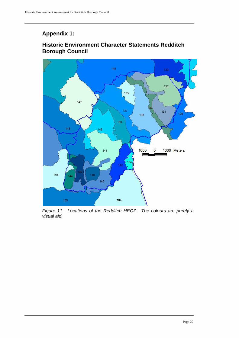
Appendix 1:
Historic Environment Character Statements Redditch Borough Council
Figure 11. Locations of the Redditch HECZ. The colours are purely a visual aid.
Historic Environment Assessment for Redditch Borough Council
Page 30
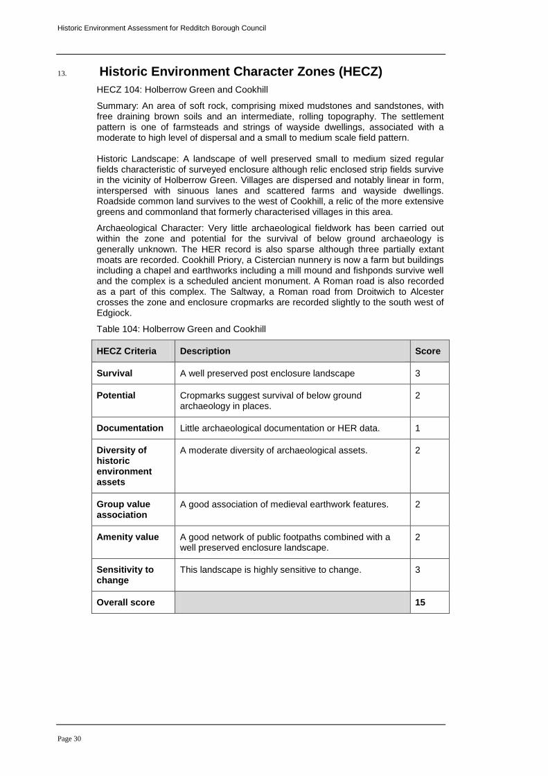
13. Historic Environment Character Zones (HECZ)
HECZ 104: Holberrow Green and Cookhill
Summary: An area of soft rock, comprising mixed mudstones and sandstones, with free draining brown soils and an intermediate, rolling topography. The settlement pattern is one of farmsteads and strings of wayside dwellings, associated with a moderate to high level of dispersal and a small to medium scale field pattern. Historic Landscape: A landscape of well preserved small to medium sized regular fields characteristic of surveyed enclosure although relic enclosed strip fields survive in the vicinity of Holberrow Green. Villages are dispersed and notably linear in form, interspersed with sinuous lanes and scattered farms and wayside dwellings. Roadside common land survives to the west of Cookhill, a relic of the more extensive greens and commonland that formerly characterised villages in this area.
Archaeological Character: Very little archaeological fieldwork has been carried out within the zone and potential for the survival of below ground archaeology is generally unknown. The HER record is also sparse although three partially extant moats are recorded. Cookhill Priory, a Cistercian nunnery is now a farm but buildings including a chapel and earthworks including a mill mound and fishponds survive well and the complex is a scheduled ancient monument. A Roman road is also recorded as a part of this complex. The Saltway, a Roman road from Droitwich to Alcester crosses the zone and enclosure cropmarks are recorded slightly to the south west of Edgiock.
Table 104: Holberrow Green and Cookhill
HECZ Criteria Description Score
Survival A well preserved post enclosure landscape 3
Potential Cropmarks suggest survival of below ground archaeology in places.
2
Documentation Little archaeological documentation or HER data. 1
Diversity of historic environment assets
A moderate diversity of archaeological assets. 2
Group value association
A good association of medieval earthwork features. 2
Amenity value A good network of public footpaths combined with a well preserved enclosure landscape.
2
Sensitivity to change
This landscape is highly sensitive to change. 3
Overall score 15
Historic Environment Assessment for Redditch Borough Council
Page 31
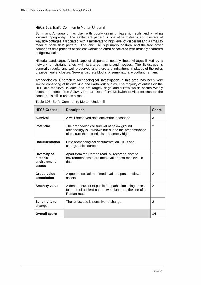
HECZ 105: Earl's Common to Morton Underhill
Summary: An area of lias clay, with poorly draining, base rich soils and a rolling lowland topography. The settlement pattern is one of farmsteads and clusters of wayside cottages associated with a moderate to high level of dispersal and a small to medium scale field pattern. The land use is primarily pastoral and the tree cover comprises relic patches of ancient woodland often associated with densely scattered hedgerow oaks. Historic Landscape: A landscape of dispersed, notably linear villages linked by a network of straight lanes with scattered farms and houses. The fieldscape is generally regular and well preserved and there are indications in places of the relics of piecemeal enclosure. Several discrete blocks of semi-natural woodland remain. Archaeological Character: Archaeological investigation in this area has been very limited consisting of fieldwalking and earthwork survey. The majority of entries on the HER are medieval in date and are largely ridge and furrow which occurs widely across the zone. The Saltway Roman Road from Droitwich to Alcester crosses the zone and is still in use as a road.
Table 105: Earl's Common to Morton Underhill
HECZ Criteria Description Score
Survival A well preserved post enclosure landscape 3
Potential The archaeological survival of below ground archaeology is unknown but due to the predominance of pasture the potential is reasonably high.
2
Documentation Little archaeological documentation. HER and cartographic sources.
1
Diversity of historic environment assets
Apart from the Roman road, all recorded historic environment assts are medieval or post medieval in date.
1
Group value association
A good association of medieval and post medieval assets
2
Amenity value A dense network of public footpaths, including access to areas of ancient-natural woodland and the line of a Roman road.
2
Sensitivity to change
The landscape is sensitive to change. 2
Overall score 14
Historic Environment Assessment for Redditch Borough Council
Page 32
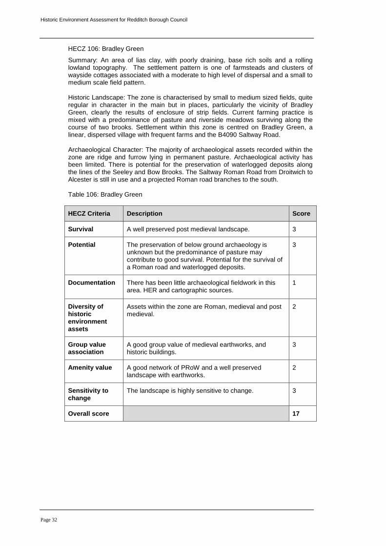
HECZ 106: Bradley Green
Summary: An area of lias clay, with poorly draining, base rich soils and a rolling lowland topography. The settlement pattern is one of farmsteads and clusters of wayside cottages associated with a moderate to high level of dispersal and a small to medium scale field pattern. Historic Landscape: The zone is characterised by small to medium sized fields, quite regular in character in the main but in places, particularly the vicinity of Bradley Green, clearly the results of enclosure of strip fields. Current farming practice is mixed with a predominance of pasture and riverside meadows surviving along the course of two brooks. Settlement within this zone is centred on Bradley Green, a linear, dispersed village with frequent farms and the B4090 Saltway Road. Archaeological Character: The majority of archaeological assets recorded within the zone are ridge and furrow lying in permanent pasture. Archaeological activity has been limited. There is potential for the preservation of waterlogged deposits along the lines of the Seeley and Bow Brooks. The Saltway Roman Road from Droitwich to Alcester is still in use and a projected Roman road branches to the south. Table 106: Bradley Green
HECZ Criteria Description Score
Survival A well preserved post medieval landscape. 3
Potential The preservation of below ground archaeology is unknown but the predominance of pasture may contribute to good survival. Potential for the survival of a Roman road and waterlogged deposits.
3
Documentation There has been little archaeological fieldwork in this area. HER and cartographic sources.
1
Diversity of historic environment assets
Assets within the zone are Roman, medieval and post medieval.
2
Group value association
A good group value of medieval earthworks, and historic buildings.
3
Amenity value A good network of PRoW and a well preserved landscape with earthworks.
2
Sensitivity to change
The landscape is highly sensitive to change. 3
Overall score 17
Historic Environment Assessment for Redditch Borough Council
Page 33
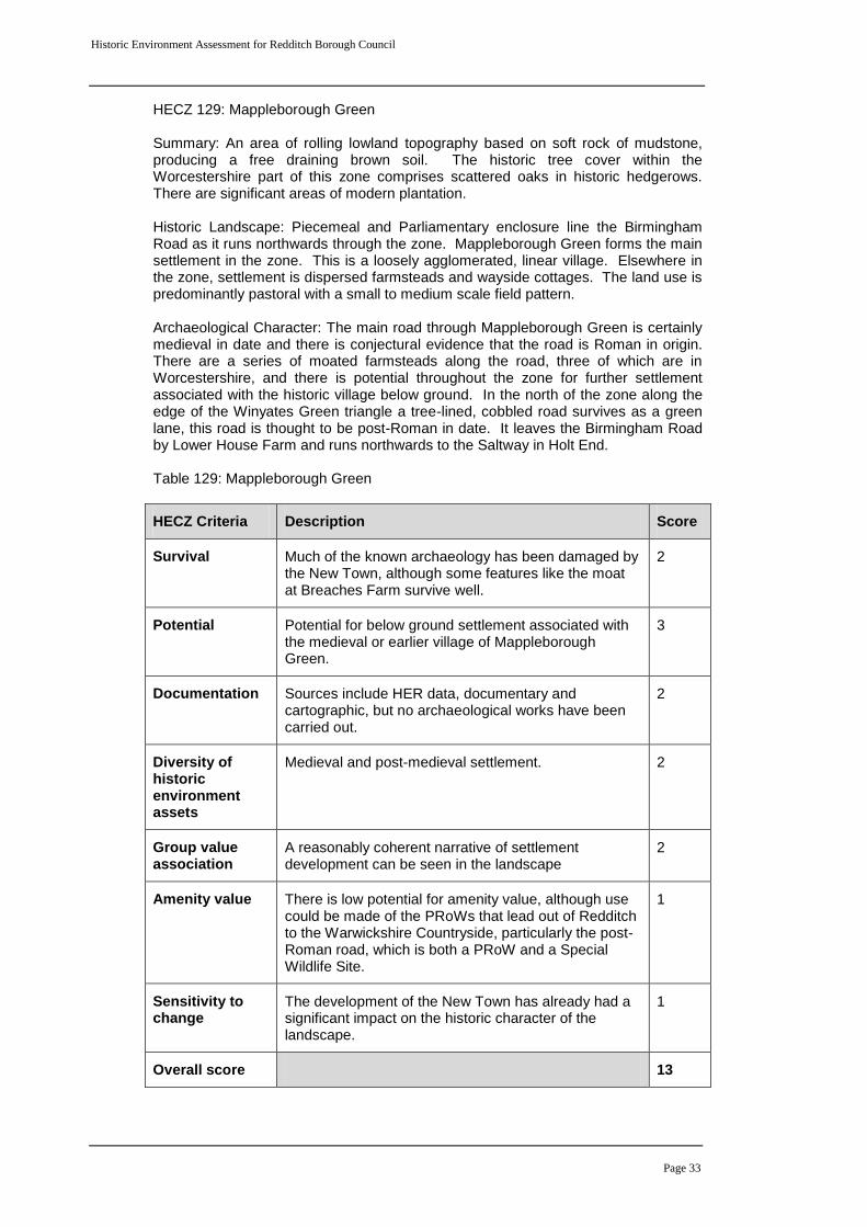
HECZ 129: Mappleborough Green Summary: An area of rolling lowland topography based on soft rock of mudstone, producing a free draining brown soil. The historic tree cover within the Worcestershire part of this zone comprises scattered oaks in historic hedgerows. There are significant areas of modern plantation. Historic Landscape: Piecemeal and Parliamentary enclosure line the Birmingham Road as it runs northwards through the zone. Mappleborough Green forms the main settlement in the zone. This is a loosely agglomerated, linear village. Elsewhere in the zone, settlement is dispersed farmsteads and wayside cottages. The land use is predominantly pastoral with a small to medium scale field pattern. Archaeological Character: The main road through Mappleborough Green is certainly medieval in date and there is conjectural evidence that the road is Roman in origin. There are a series of moated farmsteads along the road, three of which are in Worcestershire, and there is potential throughout the zone for further settlement associated with the historic village below ground. In the north of the zone along the edge of the Winyates Green triangle a tree-lined, cobbled road survives as a green lane, this road is thought to be post-Roman in date. It leaves the Birmingham Road by Lower House Farm and runs northwards to the Saltway in Holt End. Table 129: Mappleborough Green
HECZ Criteria Description Score
Survival Much of the known archaeology has been damaged by the New Town, although some features like the moat at Breaches Farm survive well.
2
Potential Potential for below ground settlement associated with the medieval or earlier village of Mappleborough Green.
3
Documentation Sources include HER data, documentary and cartographic, but no archaeological works have been carried out.
2
Diversity of historic environment assets
Medieval and post-medieval settlement. 2
Group value association
A reasonably coherent narrative of settlement development can be seen in the landscape
2
Amenity value There is low potential for amenity value, although use could be made of the PRoWs that lead out of Redditch to the Warwickshire Countryside, particularly the post-Roman road, which is both a PRoW and a Special Wildlife Site.
1
Sensitivity to change
The development of the New Town has already had a significant impact on the historic character of the landscape.
1
Overall score 13
Historic Environment Assessment for Redditch Borough Council
Page 34
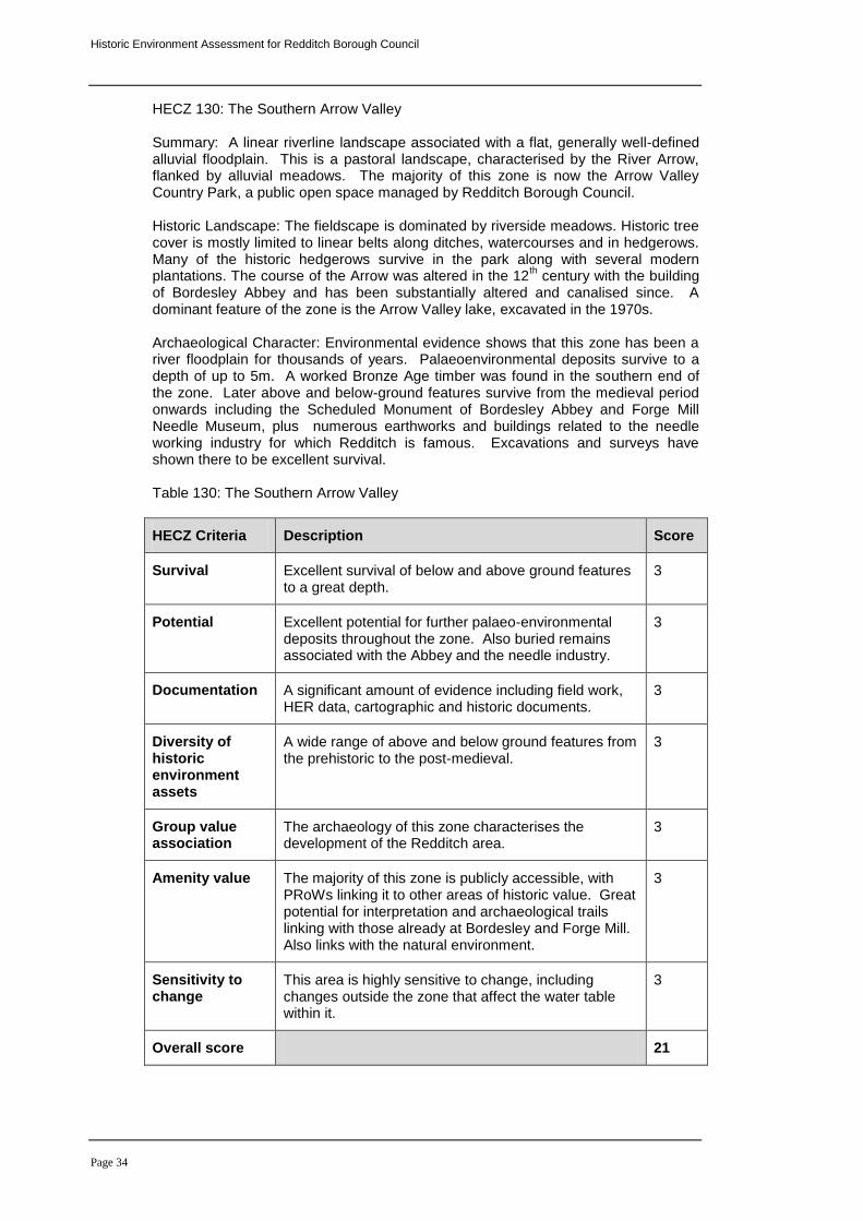
HECZ 130: The Southern Arrow Valley Summary: A linear riverline landscape associated with a flat, generally well-defined alluvial floodplain. This is a pastoral landscape, characterised by the River Arrow, flanked by alluvial meadows. The majority of this zone is now the Arrow Valley Country Park, a public open space managed by Redditch Borough Council.
Historic Landscape: The fieldscape is dominated by riverside meadows. Historic tree cover is mostly limited to linear belts along ditches, watercourses and in hedgerows. Many of the historic hedgerows survive in the park along with several modern plantations. The course of the Arrow was altered in the 12
th century with the building
of Bordesley Abbey and has been substantially altered and canalised since. A dominant feature of the zone is the Arrow Valley lake, excavated in the 1970s. Archaeological Character: Environmental evidence shows that this zone has been a river floodplain for thousands of years. Palaeoenvironmental deposits survive to a depth of up to 5m. A worked Bronze Age timber was found in the southern end of the zone. Later above and below-ground features survive from the medieval period onwards including the Scheduled Monument of Bordesley Abbey and Forge Mill Needle Museum, plus numerous earthworks and buildings related to the needle working industry for which Redditch is famous. Excavations and surveys have shown there to be excellent survival. Table 130: The Southern Arrow Valley
HECZ Criteria Description Score
Survival Excellent survival of below and above ground features to a great depth.
3
Potential Excellent potential for further palaeo-environmental deposits throughout the zone. Also buried remains associated with the Abbey and the needle industry.
3
Documentation A significant amount of evidence including field work, HER data, cartographic and historic documents.
3
Diversity of historic environment assets
A wide range of above and below ground features from the prehistoric to the post-medieval.
3
Group value association
The archaeology of this zone characterises the development of the Redditch area.
3
Amenity value The majority of this zone is publicly accessible, with PRoWs linking it to other areas of historic value. Great potential for interpretation and archaeological trails linking with those already at Bordesley and Forge Mill. Also links with the natural environment.
3
Sensitivity to change
This area is highly sensitive to change, including changes outside the zone that affect the water table within it.
3
Overall score 21
Historic Environment Assessment for Redditch Borough Council
Page 35
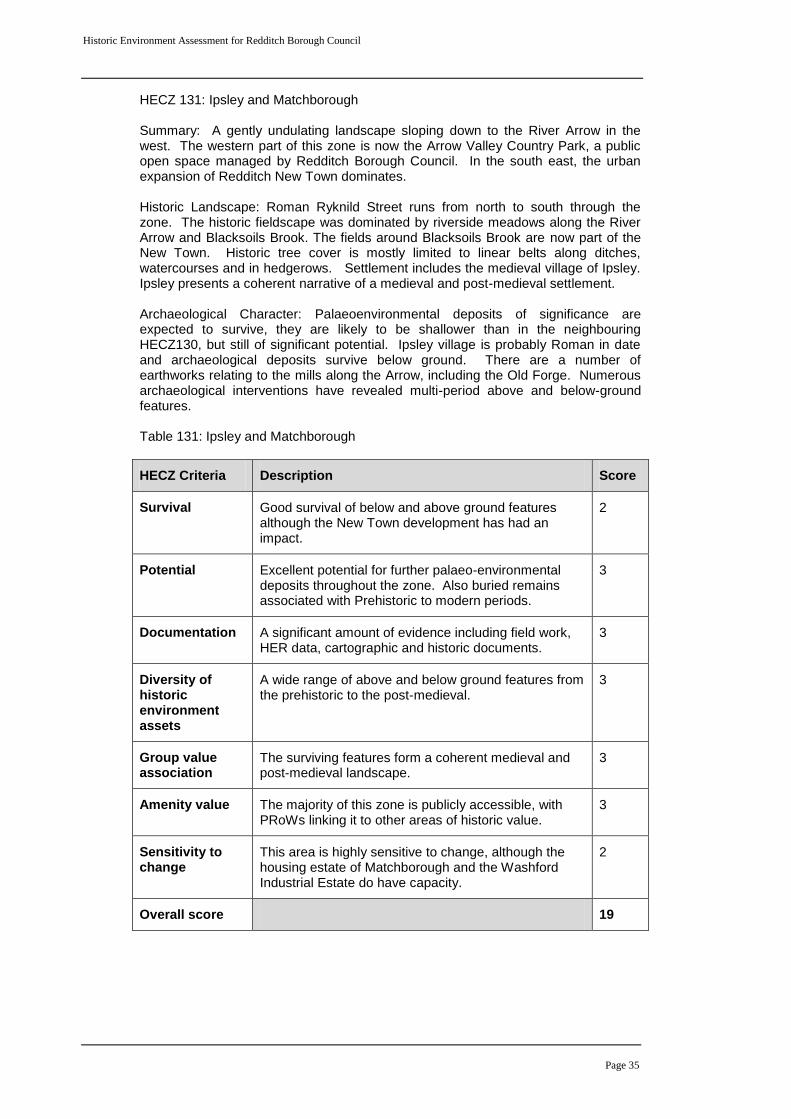
HECZ 131: Ipsley and Matchborough Summary: A gently undulating landscape sloping down to the River Arrow in the west. The western part of this zone is now the Arrow Valley Country Park, a public open space managed by Redditch Borough Council. In the south east, the urban expansion of Redditch New Town dominates.
Historic Landscape: Roman Ryknild Street runs from north to south through the zone. The historic fieldscape was dominated by riverside meadows along the River Arrow and Blacksoils Brook. The fields around Blacksoils Brook are now part of the New Town. Historic tree cover is mostly limited to linear belts along ditches, watercourses and in hedgerows. Settlement includes the medieval village of Ipsley. Ipsley presents a coherent narrative of a medieval and post-medieval settlement. Archaeological Character: Palaeoenvironmental deposits of significance are expected to survive, they are likely to be shallower than in the neighbouring HECZ130, but still of significant potential. Ipsley village is probably Roman in date and archaeological deposits survive below ground. There are a number of earthworks relating to the mills along the Arrow, including the Old Forge. Numerous archaeological interventions have revealed multi-period above and below-ground features. Table 131: Ipsley and Matchborough
HECZ Criteria Description Score
Survival Good survival of below and above ground features although the New Town development has had an impact.
2
Potential Excellent potential for further palaeo-environmental deposits throughout the zone. Also buried remains associated with Prehistoric to modern periods.
3
Documentation A significant amount of evidence including field work, HER data, cartographic and historic documents.
3
Diversity of historic environment assets
A wide range of above and below ground features from the prehistoric to the post-medieval.
3
Group value association
The surviving features form a coherent medieval and post-medieval landscape.
3
Amenity value The majority of this zone is publicly accessible, with PRoWs linking it to other areas of historic value.
3
Sensitivity to change
This area is highly sensitive to change, although the housing estate of Matchborough and the Washford Industrial Estate do have capacity.
2
Overall score 19
Historic Environment Assessment for Redditch Borough Council
Page 36
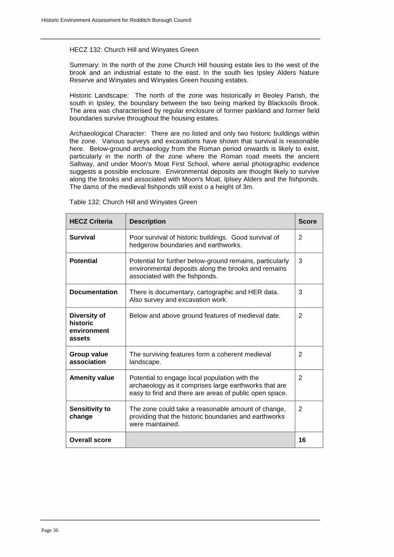
HECZ 132: Church Hill and Winyates Green Summary: In the north of the zone Church Hill housing estate lies to the west of the brook and an industrial estate to the east. In the south lies Ipsley Alders Nature Reserve and Winyates and Winyates Green housing estates. Historic Landscape: The north of the zone was historically in Beoley Parish, the south in Ipsley, the boundary between the two being marked by Blacksoils Brook. The area was characterised by regular enclosure of former parkland and former field boundaries survive throughout the housing estates. Archaeological Character: There are no listed and only two historic buildings within the zone. Various surveys and excavations have shown that survival is reasonable here. Below-ground archaeology from the Roman period onwards is likely to exist, particularly in the north of the zone where the Roman road meets the ancient Saltway, and under Moon's Moat First School, where aerial photographic evidence suggests a possible enclosure. Environmental deposits are thought likely to survive along the brooks and associated with Moon's Moat, Iplsey Alders and the fishponds. The dams of the medieval fishponds still exist o a height of 3m. Table 132: Church Hill and Winyates Green
HECZ Criteria Description Score
Survival Poor survival of historic buildings. Good survival of hedgerow boundaries and earthworks.
2
Potential Potential for further below-ground remains, particularly environmental deposits along the brooks and remains associated with the fishponds.
3
Documentation There is documentary, cartographic and HER data. Also survey and excavation work.
3
Diversity of historic environment assets
Below and above ground features of medieval date. 2
Group value association
The surviving features form a coherent medieval landscape.
2
Amenity value Potential to engage local population with the archaeology as it comprises large earthworks that are easy to find and there are areas of public open space.
2
Sensitivity to change
The zone could take a reasonable amount of change, providing that the historic boundaries and earthworks were maintained.
2
Overall score 16
Historic Environment Assessment for Redditch Borough Council
Page 37
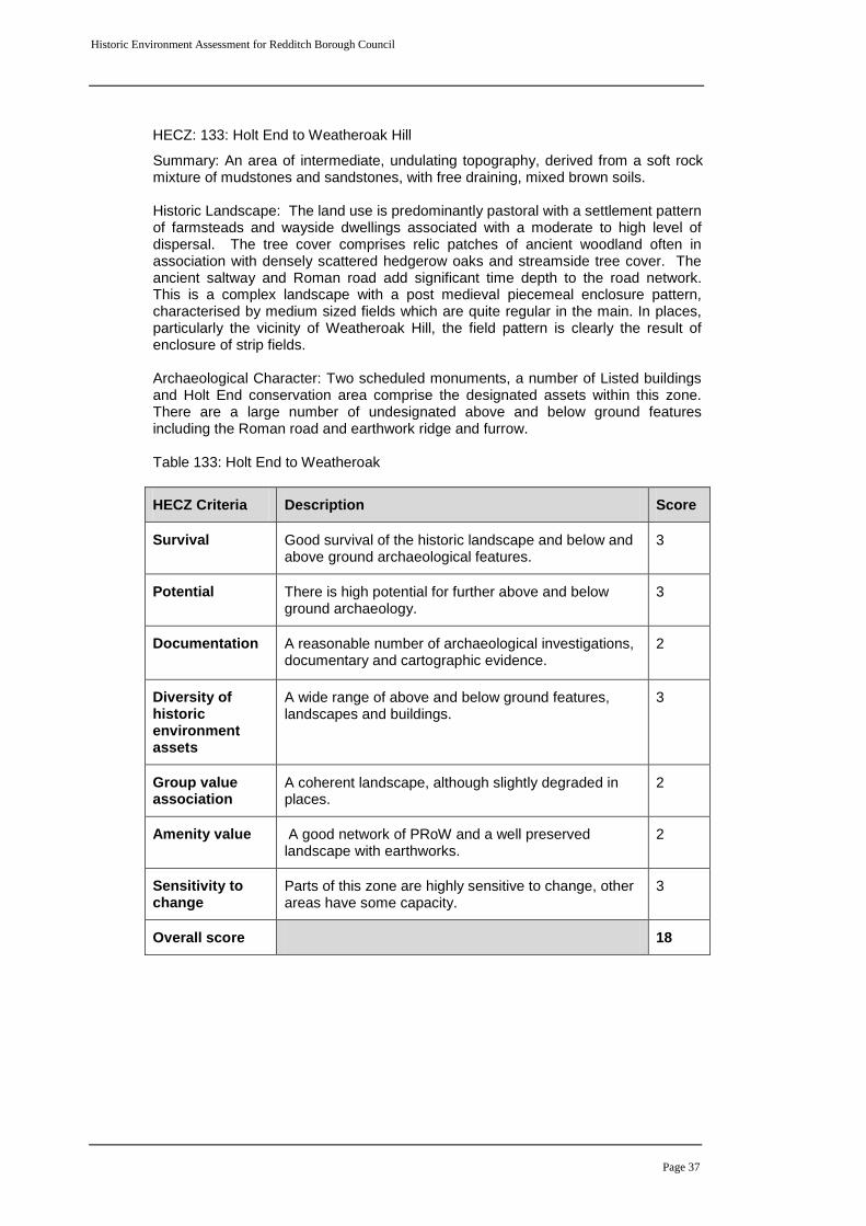
HECZ: 133: Holt End to Weatheroak Hill
Summary: An area of intermediate, undulating topography, derived from a soft rock mixture of mudstones and sandstones, with free draining, mixed brown soils.
Historic Landscape: The land use is predominantly pastoral with a settlement pattern of farmsteads and wayside dwellings associated with a moderate to high level of dispersal. The tree cover comprises relic patches of ancient woodland often in association with densely scattered hedgerow oaks and streamside tree cover. The ancient saltway and Roman road add significant time depth to the road network. This is a complex landscape with a post medieval piecemeal enclosure pattern, characterised by medium sized fields which are quite regular in the main. In places, particularly the vicinity of Weatheroak Hill, the field pattern is clearly the result of enclosure of strip fields.
Archaeological Character: Two scheduled monuments, a number of Listed buildings and Holt End conservation area comprise the designated assets within this zone. There are a large number of undesignated above and below ground features including the Roman road and earthwork ridge and furrow. Table 133: Holt End to Weatheroak
HECZ Criteria Description Score
Survival Good survival of the historic landscape and below and above ground archaeological features.
3
Potential There is high potential for further above and below ground archaeology.
3
Documentation A reasonable number of archaeological investigations, documentary and cartographic evidence.
2
Diversity of historic environment assets
A wide range of above and below ground features, landscapes and buildings.
3
Group value association
A coherent landscape, although slightly degraded in places.
2
Amenity value A good network of PRoW and a well preserved landscape with earthworks.
2
Sensitivity to change
Parts of this zone are highly sensitive to change, other areas have some capacity.
3
Overall score 18
Historic Environment Assessment for Redditch Borough Council
Page 38
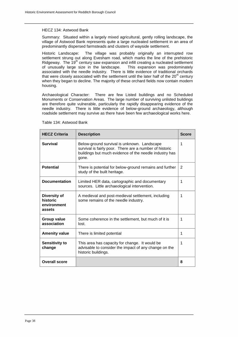
HECZ 134: Astwood Bank
Summary: Situated within a largely mixed agricultural, gently rolling landscape, the village of Astwood Bank represents quite a large nucleated settlement in an area of predominantly dispersed farmsteads and clusters of wayside settlement.
Historic Landscape: The village was probably originally an interrupted row settlement strung out along Evesham road, which marks the line of the prehistoric Ridgeway. The 19
th century saw expansion and infill creating a nucleated settlement
of unusually large size in the landscape. This expansion was predominately associated with the needle industry. There is little evidence of traditional orchards that were closely associated with the settlement until the later half of the 20
th century
when they began to decline. The majority of these orchard fields now contain modern housing. Archaeological Character: There are few Listed buildings and no Scheduled Monuments or Conservation Areas. The large number of surviving unlisted buildings are therefore quite vulnerable, particularly the rapidly disappearing evidence of the needle industry. There is little evidence of below-ground archaeology, although roadside settlement may survive as there have been few archaeological works here. Table 134: Astwood Bank
HECZ Criteria Description Score
Survival Below-ground survival is unknown. Landscape survival is fairly poor. There are a number of historic buildings but much evidence of the needle industry has gone.
1
Potential There is potential for below-ground remains and further study of the built heritage.
2
Documentation Limited HER data, cartographic and documentary sources. Little archaeological intervention.
1
Diversity of historic environment assets
A medieval and post-medieval settlement, including some remains of the needle industry.
1
Group value association
Some coherence in the settlement, but much of it is lost.
1
Amenity value There is limited potential 1
Sensitivity to change
This area has capacity for change. It would be advisable to consider the impact of any change on the historic buildings.
1
Overall score 8
Historic Environment Assessment for Redditch Borough Council
Page 39
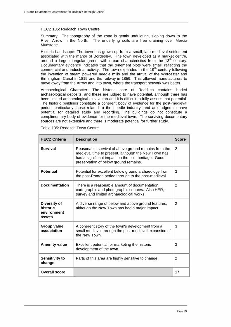
HECZ 135: Redditch Town Centre
Summary: The topography of the zone is gently undulating, sloping down to the River Arrow in the North. The underlying soils are free draining over Mercia Mudstone.
Historic Landscape: The town has grown up from a small, late medieval settlement associated with the manor of Bordesley. The town developed as a market centre, around a large triangular green, with urban characteristics from the 13
th century.
Documentary evidence indicates that the tenement plots were small, reflecting the commercial and industrial activity. The town expanded in the 19
th century following
the invention of steam powered needle mills and the arrival of the Worcester and Birmingham Canal in 1815 and the railway in 1859. This allowed manufacturers to move away from the Arrow and into town, where the transport network was better.
Archaeological Character: The historic core of Redditch contains buried archaeological deposits, and these are judged to have potential, although there has been limited archaeological excavation and it is difficult to fully assess that potential. The historic buildings constitute a coherent body of evidence for the post-medieval period, particularly those related to the needle industry, and are judged to have potential for detailed study and recording. The buildings do not constitute a complimentary body of evidence for the medieval town. The surviving documentary sources are not extensive and there is moderate potential for further study.
Table 135: Redditch Town Centre
HECZ Criteria Description Score
Survival Reasonable survival of above ground remains from the medieval time to present, although the New Town has had a significant impact on the built heritage. Good preservation of below ground remains.
2
Potential Potential for excellent below ground archaeology from the post-Roman period through to the post-medieval
3
Documentation There is a reasonable amount of documentation, cartographic and photographic sources. Also HER, survey and limited archaeological works.
2
Diversity of historic environment assets
A diverse range of below and above ground features, although the New Town has had a major impact.
2
Group value association
A coherent story of the town's development from a small medieval through the post-medieval expansion of the New Town.
3
Amenity value Excellent potential for marketing the historic development of the town.
3
Sensitivity to change
Parts of this area are highly sensitive to change. 2
Overall score 17
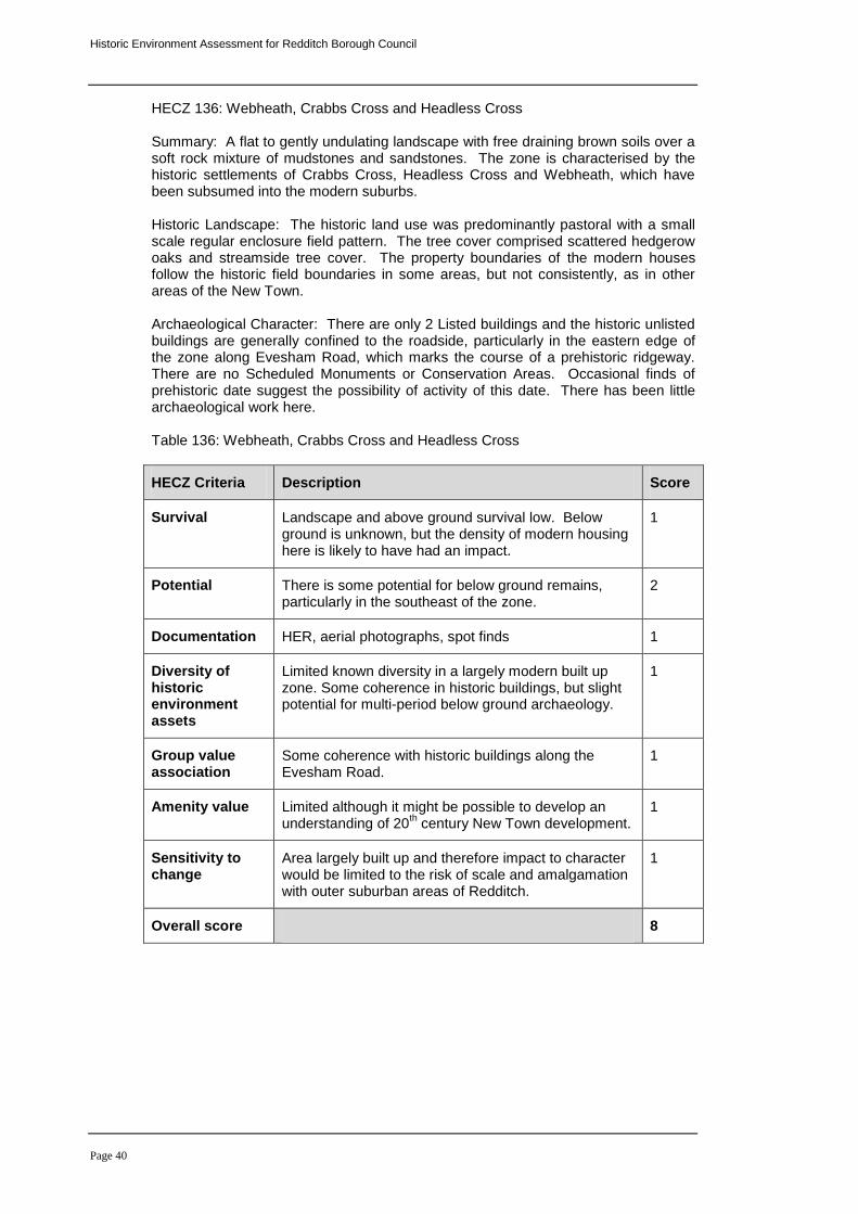
Historic Environment Assessment for Redditch Borough Council
Page 40
HECZ 136: Webheath, Crabbs Cross and Headless Cross Summary: A flat to gently undulating landscape with free draining brown soils over a soft rock mixture of mudstones and sandstones. The zone is characterised by the historic settlements of Crabbs Cross, Headless Cross and Webheath, which have been subsumed into the modern suburbs. Historic Landscape: The historic land use was predominantly pastoral with a small scale regular enclosure field pattern. The tree cover comprised scattered hedgerow oaks and streamside tree cover. The property boundaries of the modern houses follow the historic field boundaries in some areas, but not consistently, as in other areas of the New Town. Archaeological Character: There are only 2 Listed buildings and the historic unlisted buildings are generally confined to the roadside, particularly in the eastern edge of the zone along Evesham Road, which marks the course of a prehistoric ridgeway. There are no Scheduled Monuments or Conservation Areas. Occasional finds of prehistoric date suggest the possibility of activity of this date. There has been little archaeological work here. Table 136: Webheath, Crabbs Cross and Headless Cross
HECZ Criteria Description Score
Survival Landscape and above ground survival low. Below ground is unknown, but the density of modern housing here is likely to have had an impact.
1
Potential There is some potential for below ground remains, particularly in the southeast of the zone.
2
Documentation HER, aerial photographs, spot finds 1
Diversity of historic environment assets
Limited known diversity in a largely modern built up zone. Some coherence in historic buildings, but slight potential for multi-period below ground archaeology.
1
Group value association
Some coherence with historic buildings along the Evesham Road.
1
Amenity value Limited although it might be possible to develop an understanding of 20
th century New Town development.
1
Sensitivity to change
Area largely built up and therefore impact to character would be limited to the risk of scale and amalgamation with outer suburban areas of Redditch.
1
Overall score 8
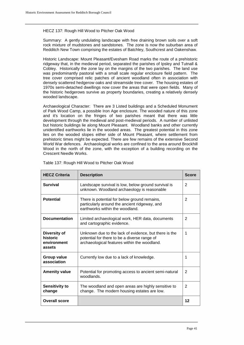
Historic Environment Assessment for Redditch Borough Council
Page 41
HECZ 137: Rough Hill Wood to Pitcher Oak Wood Summary: A gently undulating landscape with free draining brown soils over a soft rock mixture of mudstones and sandstones. The zone is now the suburban area of Redditch New Town comprising the estates of Batchley, Southcrest and Oakenshaw. Historic Landscape: Mount Pleasant/Evesham Road marks the route of a prehistoric ridgeway that, in the medieval period, separated the parishes of Ipsley and Tutnall & Cobley. Historically the zone lay on the margins of the two parishes. The land use was predominantly pastoral with a small scale regular enclosure field pattern. The tree cover comprised relic patches of ancient woodland often in association with densely scattered hedgerow oaks and streamside tree cover. The housing estates of 1970s semi-detached dwellings now cover the areas that were open fields. Many of the historic hedgerows survive as property boundaries, creating a relatively densely wooded landscape. Archaeological Character: There are 3 Listed buildings and a Scheduled Monument of Park Wood Camp, a possible Iron Age enclosure. The wooded nature of this zone and it's location on the fringes of two parishes meant that there was little development through the medieval and post-medieval periods. A number of unlisted but historic buildings lie along Mount Pleasant. Woodland banks and other currently unidentified earthworks lie in the wooded areas. The greatest potential in this zone lies on the wooded slopes either side of Mount Pleasant, where settlement from prehistoric times might be expected. There are few remains of the extensive Second World War defences. Archaeological works are confined to the area around Brockhill Wood in the north of the zone, with the exception of a building recording on the Crescent Needle Works. Table 137: Rough Hill Wood to Pitcher Oak Wood
HECZ Criteria Description Score
Survival Landscape survival is low, below ground survival is unknown. Woodland archaeology is reasonable
2
Potential There is potential for below ground remains, particularly around the ancient ridgeway, and earthworks within the woodland.
2
Documentation Limited archaeological work, HER data, documents and cartographic evidence.
2
Diversity of historic environment assets
Unknown due to the lack of evidence, but there is the potential for there to be a diverse range of archaeological features within the woodland.
1
Group value association
Currently low due to a lack of knowledge. 1
Amenity value Potential for promoting access to ancient semi-natural woodlands.
2
Sensitivity to change
The woodland and open areas are highly sensitive to change. The modern housing estates are low.
2
Overall score 12
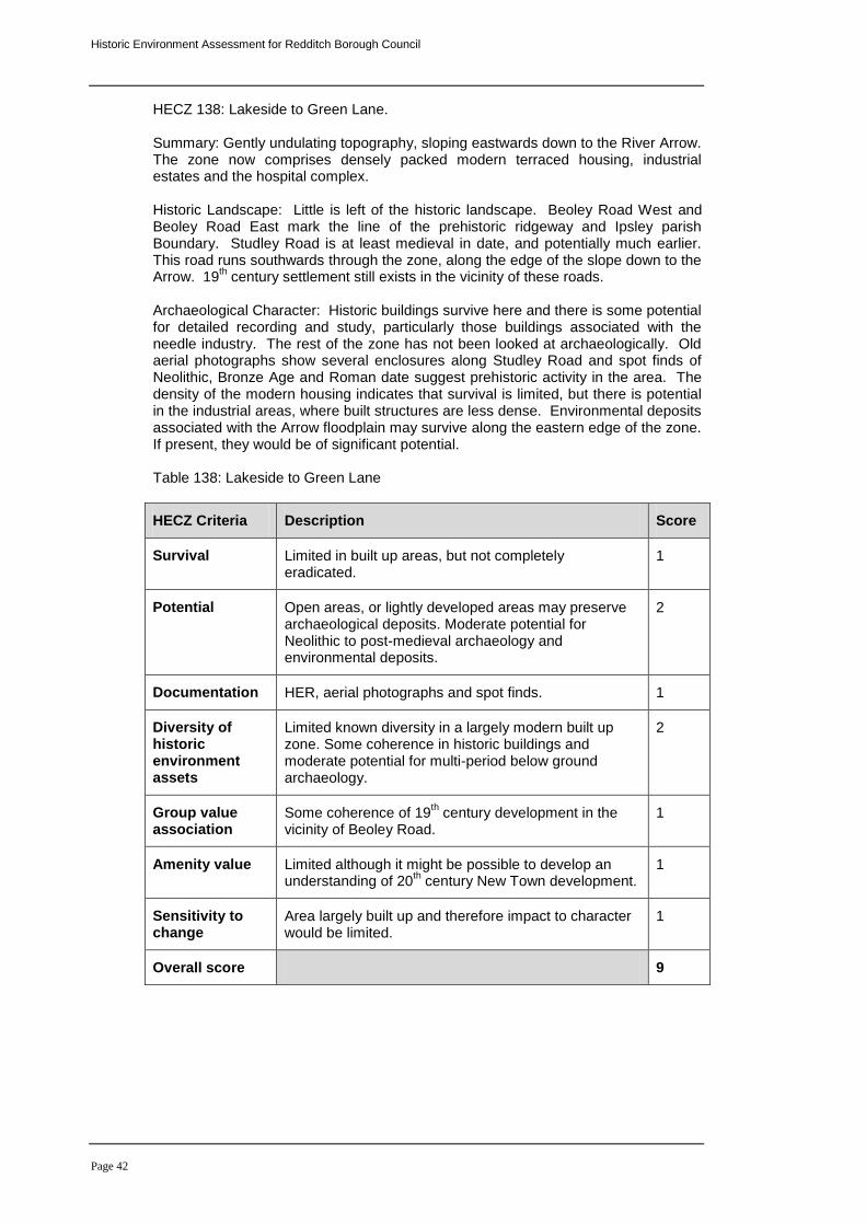
Historic Environment Assessment for Redditch Borough Council
Page 42
HECZ 138: Lakeside to Green Lane. Summary: Gently undulating topography, sloping eastwards down to the River Arrow. The zone now comprises densely packed modern terraced housing, industrial estates and the hospital complex. Historic Landscape: Little is left of the historic landscape. Beoley Road West and Beoley Road East mark the line of the prehistoric ridgeway and Ipsley parish Boundary. Studley Road is at least medieval in date, and potentially much earlier. This road runs southwards through the zone, along the edge of the slope down to the Arrow. 19
th century settlement still exists in the vicinity of these roads.
Archaeological Character: Historic buildings survive here and there is some potential for detailed recording and study, particularly those buildings associated with the needle industry. The rest of the zone has not been looked at archaeologically. Old aerial photographs show several enclosures along Studley Road and spot finds of Neolithic, Bronze Age and Roman date suggest prehistoric activity in the area. The density of the modern housing indicates that survival is limited, but there is potential in the industrial areas, where built structures are less dense. Environmental deposits associated with the Arrow floodplain may survive along the eastern edge of the zone. If present, they would be of significant potential. Table 138: Lakeside to Green Lane
HECZ Criteria Description Score
Survival Limited in built up areas, but not completely eradicated.
1
Potential Open areas, or lightly developed areas may preserve archaeological deposits. Moderate potential for Neolithic to post-medieval archaeology and environmental deposits.
2
Documentation HER, aerial photographs and spot finds. 1
Diversity of historic environment assets
Limited known diversity in a largely modern built up zone. Some coherence in historic buildings and moderate potential for multi-period below ground archaeology.
2
Group value association
Some coherence of 19th century development in the
vicinity of Beoley Road. 1
Amenity value Limited although it might be possible to develop an understanding of 20
th century New Town development.
1
Sensitivity to change
Area largely built up and therefore impact to character would be limited.
1
Overall score 9
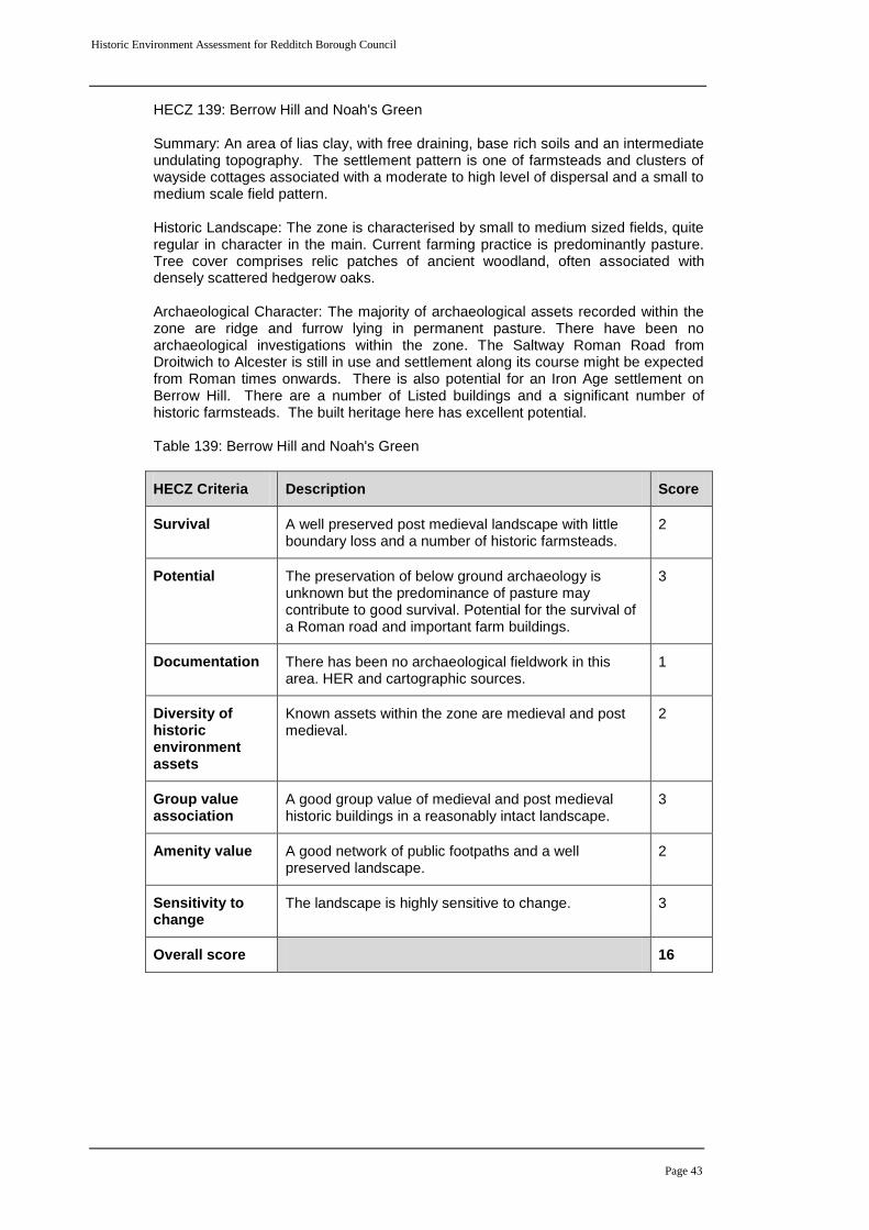
Historic Environment Assessment for Redditch Borough Council
Page 43
HECZ 139: Berrow Hill and Noah's Green Summary: An area of lias clay, with free draining, base rich soils and an intermediate undulating topography. The settlement pattern is one of farmsteads and clusters of wayside cottages associated with a moderate to high level of dispersal and a small to medium scale field pattern. Historic Landscape: The zone is characterised by small to medium sized fields, quite regular in character in the main. Current farming practice is predominantly pasture. Tree cover comprises relic patches of ancient woodland, often associated with densely scattered hedgerow oaks. Archaeological Character: The majority of archaeological assets recorded within the zone are ridge and furrow lying in permanent pasture. There have been no archaeological investigations within the zone. The Saltway Roman Road from Droitwich to Alcester is still in use and settlement along its course might be expected from Roman times onwards. There is also potential for an Iron Age settlement on Berrow Hill. There are a number of Listed buildings and a significant number of historic farmsteads. The built heritage here has excellent potential. Table 139: Berrow Hill and Noah's Green
HECZ Criteria Description Score
Survival A well preserved post medieval landscape with little boundary loss and a number of historic farmsteads.
2
Potential The preservation of below ground archaeology is unknown but the predominance of pasture may contribute to good survival. Potential for the survival of a Roman road and important farm buildings.
3
Documentation There has been no archaeological fieldwork in this area. HER and cartographic sources.
1
Diversity of historic environment assets
Known assets within the zone are medieval and post medieval.
2
Group value association
A good group value of medieval and post medieval historic buildings in a reasonably intact landscape.
3
Amenity value A good network of public footpaths and a well preserved landscape.
2
Sensitivity to change
The landscape is highly sensitive to change. 3
Overall score 16
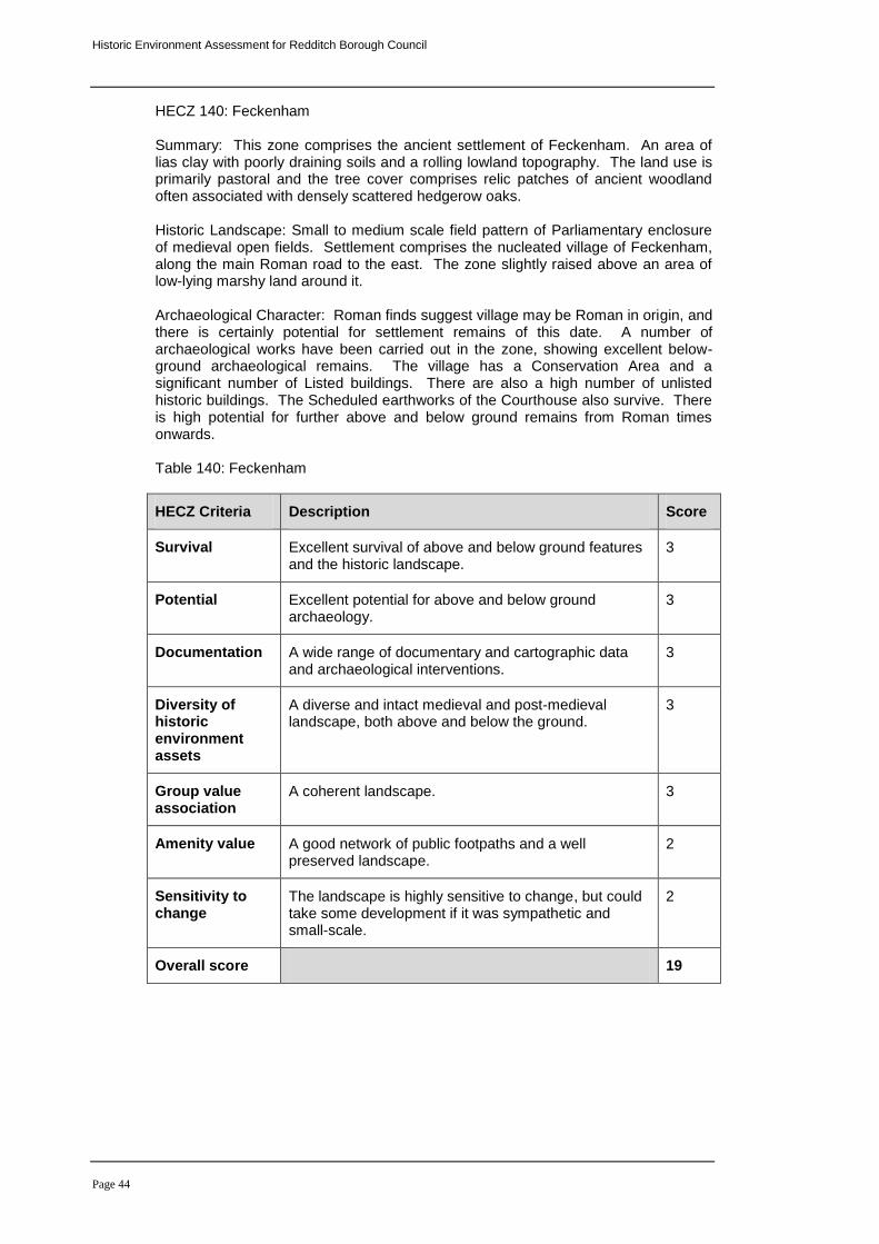
Historic Environment Assessment for Redditch Borough Council
Page 44
HECZ 140: Feckenham Summary: This zone comprises the ancient settlement of Feckenham. An area of lias clay with poorly draining soils and a rolling lowland topography. The land use is primarily pastoral and the tree cover comprises relic patches of ancient woodland often associated with densely scattered hedgerow oaks. Historic Landscape: Small to medium scale field pattern of Parliamentary enclosure of medieval open fields. Settlement comprises the nucleated village of Feckenham, along the main Roman road to the east. The zone slightly raised above an area of low-lying marshy land around it. Archaeological Character: Roman finds suggest village may be Roman in origin, and there is certainly potential for settlement remains of this date. A number of archaeological works have been carried out in the zone, showing excellent below-ground archaeological remains. The village has a Conservation Area and a significant number of Listed buildings. There are also a high number of unlisted historic buildings. The Scheduled earthworks of the Courthouse also survive. There is high potential for further above and below ground remains from Roman times onwards. Table 140: Feckenham
HECZ Criteria Description Score
Survival Excellent survival of above and below ground features and the historic landscape.
3
Potential Excellent potential for above and below ground archaeology.
3
Documentation A wide range of documentary and cartographic data and archaeological interventions.
3
Diversity of historic environment assets
A diverse and intact medieval and post-medieval landscape, both above and below the ground.
3
Group value association
A coherent landscape. 3
Amenity value A good network of public footpaths and a well preserved landscape.
2
Sensitivity to change
The landscape is highly sensitive to change, but could take some development if it was sympathetic and small-scale.
2
Overall score 19
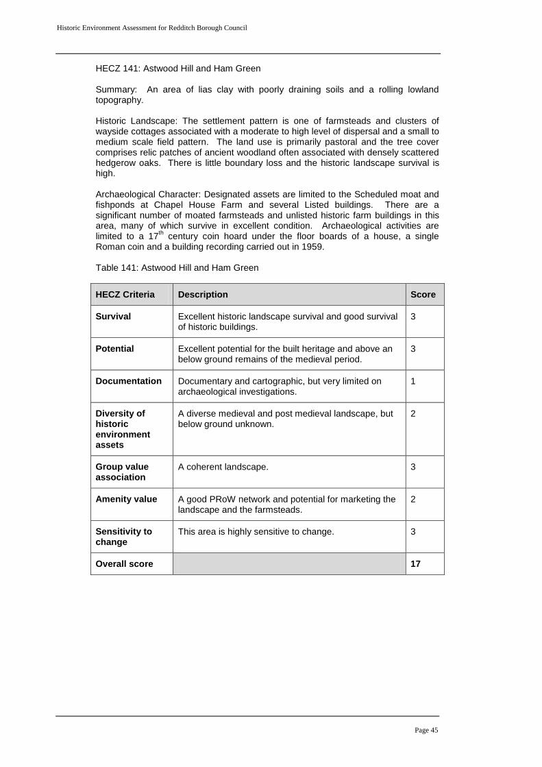
Historic Environment Assessment for Redditch Borough Council
Page 45
HECZ 141: Astwood Hill and Ham Green Summary: An area of lias clay with poorly draining soils and a rolling lowland topography. Historic Landscape: The settlement pattern is one of farmsteads and clusters of wayside cottages associated with a moderate to high level of dispersal and a small to medium scale field pattern. The land use is primarily pastoral and the tree cover comprises relic patches of ancient woodland often associated with densely scattered hedgerow oaks. There is little boundary loss and the historic landscape survival is high. Archaeological Character: Designated assets are limited to the Scheduled moat and fishponds at Chapel House Farm and several Listed buildings. There are a significant number of moated farmsteads and unlisted historic farm buildings in this area, many of which survive in excellent condition. Archaeological activities are limited to a 17
th century coin hoard under the floor boards of a house, a single
Roman coin and a building recording carried out in 1959. Table 141: Astwood Hill and Ham Green
HECZ Criteria Description Score
Survival Excellent historic landscape survival and good survival of historic buildings.
3
Potential Excellent potential for the built heritage and above an below ground remains of the medieval period.
3
Documentation Documentary and cartographic, but very limited on archaeological investigations.
1
Diversity of historic environment assets
A diverse medieval and post medieval landscape, but below ground unknown.
2
Group value association
A coherent landscape. 3
Amenity value A good PRoW network and potential for marketing the landscape and the farmsteads.
2
Sensitivity to change
This area is highly sensitive to change. 3
Overall score 17
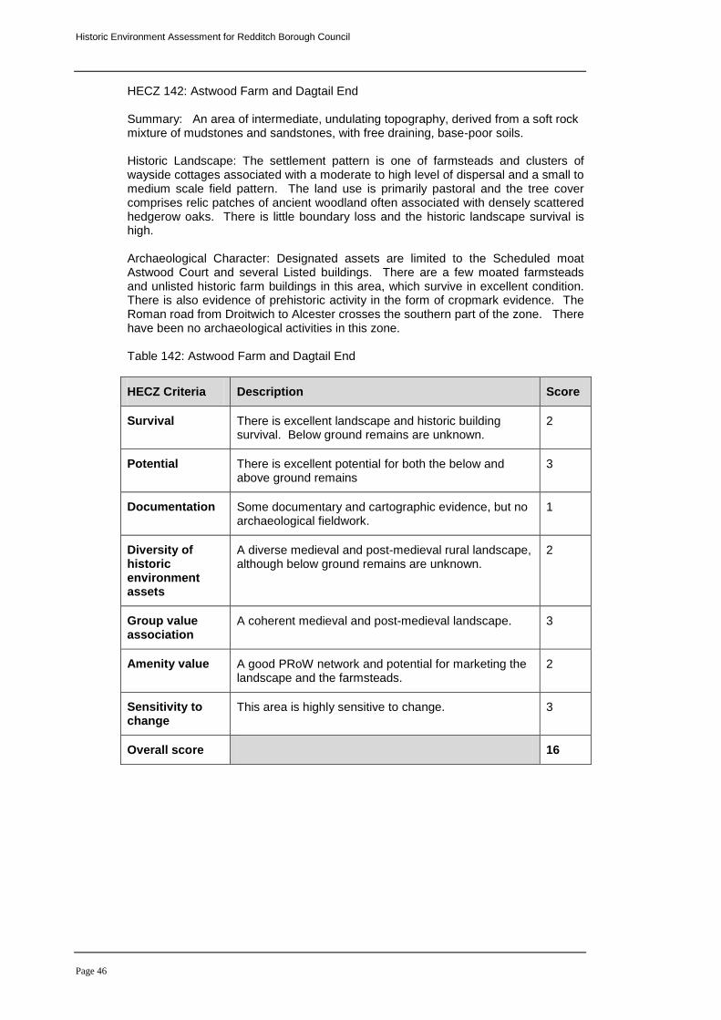
Historic Environment Assessment for Redditch Borough Council
Page 46
HECZ 142: Astwood Farm and Dagtail End Summary: An area of intermediate, undulating topography, derived from a soft rock mixture of mudstones and sandstones, with free draining, base-poor soils. Historic Landscape: The settlement pattern is one of farmsteads and clusters of wayside cottages associated with a moderate to high level of dispersal and a small to medium scale field pattern. The land use is primarily pastoral and the tree cover comprises relic patches of ancient woodland often associated with densely scattered hedgerow oaks. There is little boundary loss and the historic landscape survival is high. Archaeological Character: Designated assets are limited to the Scheduled moat Astwood Court and several Listed buildings. There are a few moated farmsteads and unlisted historic farm buildings in this area, which survive in excellent condition. There is also evidence of prehistoric activity in the form of cropmark evidence. The Roman road from Droitwich to Alcester crosses the southern part of the zone. There have been no archaeological activities in this zone. Table 142: Astwood Farm and Dagtail End
HECZ Criteria Description Score
Survival There is excellent landscape and historic building survival. Below ground remains are unknown.
2
Potential There is excellent potential for both the below and above ground remains
3
Documentation Some documentary and cartographic evidence, but no archaeological fieldwork.
1
Diversity of historic environment assets
A diverse medieval and post-medieval rural landscape, although below ground remains are unknown.
2
Group value association
A coherent medieval and post-medieval landscape. 3
Amenity value A good PRoW network and potential for marketing the landscape and the farmsteads.
2
Sensitivity to change
This area is highly sensitive to change. 3
Overall score 16
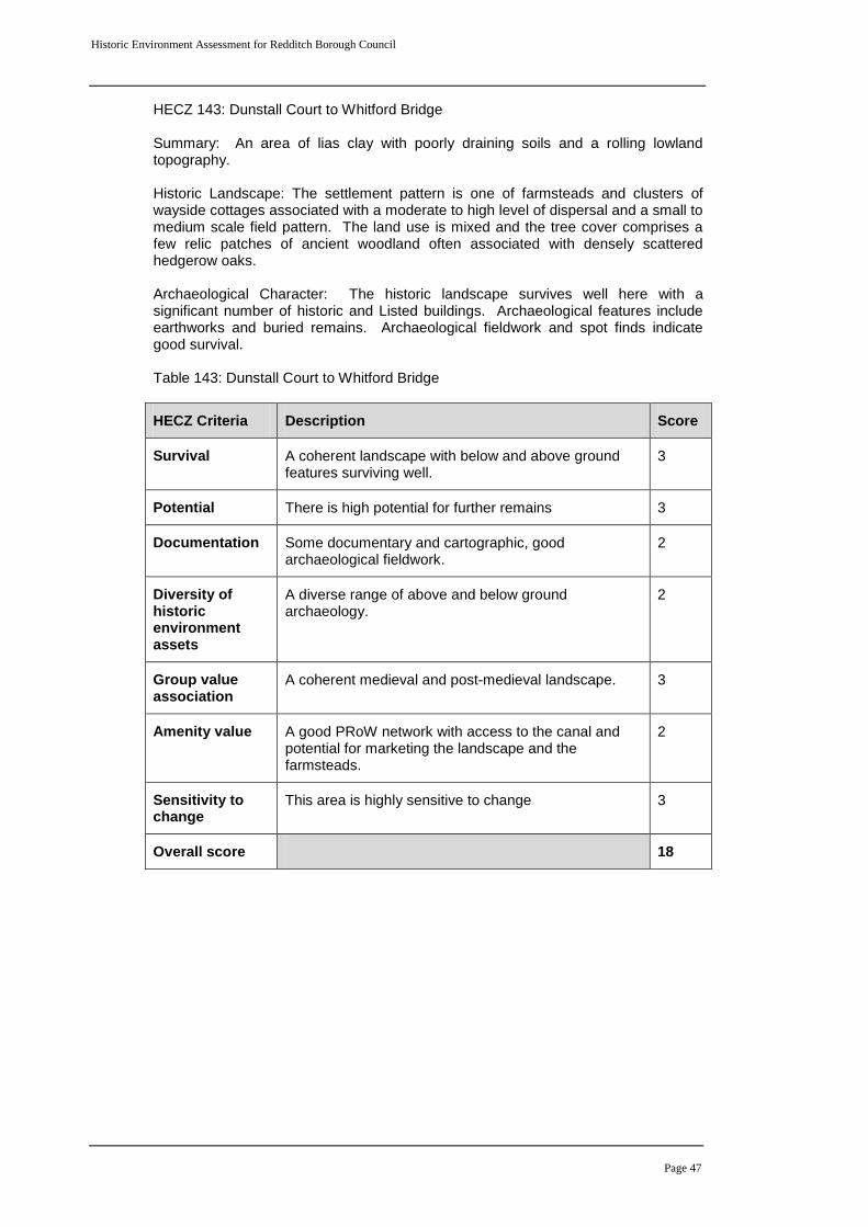
Historic Environment Assessment for Redditch Borough Council
Page 47
HECZ 143: Dunstall Court to Whitford Bridge Summary: An area of lias clay with poorly draining soils and a rolling lowland topography. Historic Landscape: The settlement pattern is one of farmsteads and clusters of wayside cottages associated with a moderate to high level of dispersal and a small to medium scale field pattern. The land use is mixed and the tree cover comprises a few relic patches of ancient woodland often associated with densely scattered hedgerow oaks. Archaeological Character: The historic landscape survives well here with a significant number of historic and Listed buildings. Archaeological features include earthworks and buried remains. Archaeological fieldwork and spot finds indicate good survival. Table 143: Dunstall Court to Whitford Bridge
HECZ Criteria Description Score
Survival A coherent landscape with below and above ground features surviving well.
3
Potential There is high potential for further remains 3
Documentation Some documentary and cartographic, good archaeological fieldwork.
2
Diversity of historic environment assets
A diverse range of above and below ground archaeology.
2
Group value association
A coherent medieval and post-medieval landscape. 3
Amenity value A good PRoW network with access to the canal and potential for marketing the landscape and the farmsteads.
2
Sensitivity to change
This area is highly sensitive to change 3
Overall score 18
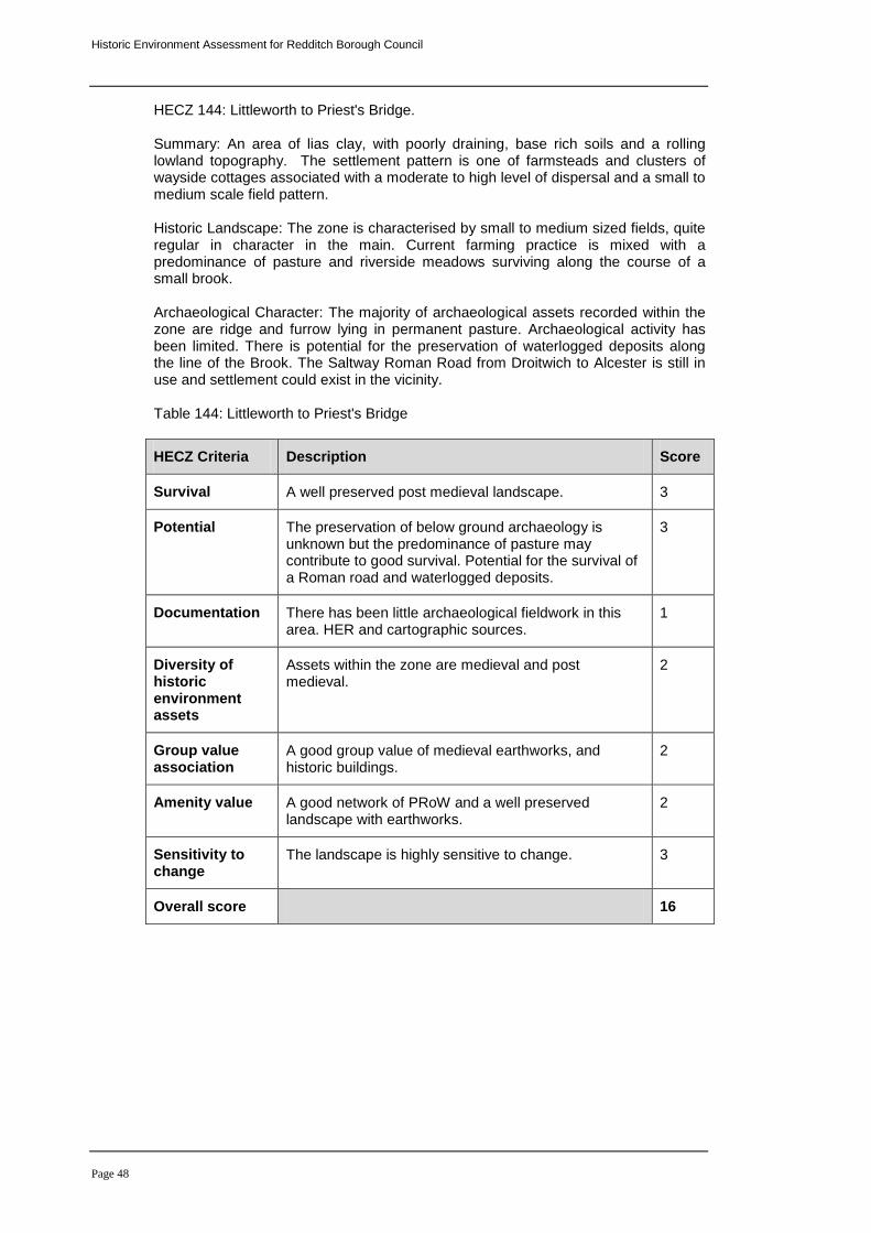
Historic Environment Assessment for Redditch Borough Council
Page 48
HECZ 144: Littleworth to Priest's Bridge. Summary: An area of lias clay, with poorly draining, base rich soils and a rolling lowland topography. The settlement pattern is one of farmsteads and clusters of wayside cottages associated with a moderate to high level of dispersal and a small to medium scale field pattern. Historic Landscape: The zone is characterised by small to medium sized fields, quite regular in character in the main. Current farming practice is mixed with a predominance of pasture and riverside meadows surviving along the course of a small brook. Archaeological Character: The majority of archaeological assets recorded within the zone are ridge and furrow lying in permanent pasture. Archaeological activity has been limited. There is potential for the preservation of waterlogged deposits along the line of the Brook. The Saltway Roman Road from Droitwich to Alcester is still in use and settlement could exist in the vicinity. Table 144: Littleworth to Priest's Bridge
HECZ Criteria Description Score
Survival A well preserved post medieval landscape. 3
Potential The preservation of below ground archaeology is unknown but the predominance of pasture may contribute to good survival. Potential for the survival of a Roman road and waterlogged deposits.
3
Documentation There has been little archaeological fieldwork in this area. HER and cartographic sources.
1
Diversity of historic environment assets
Assets within the zone are medieval and post medieval.
2
Group value association
A good group value of medieval earthworks, and historic buildings.
2
Amenity value A good network of PRoW and a well preserved landscape with earthworks.
2
Sensitivity to change
The landscape is highly sensitive to change. 3
Overall score 16
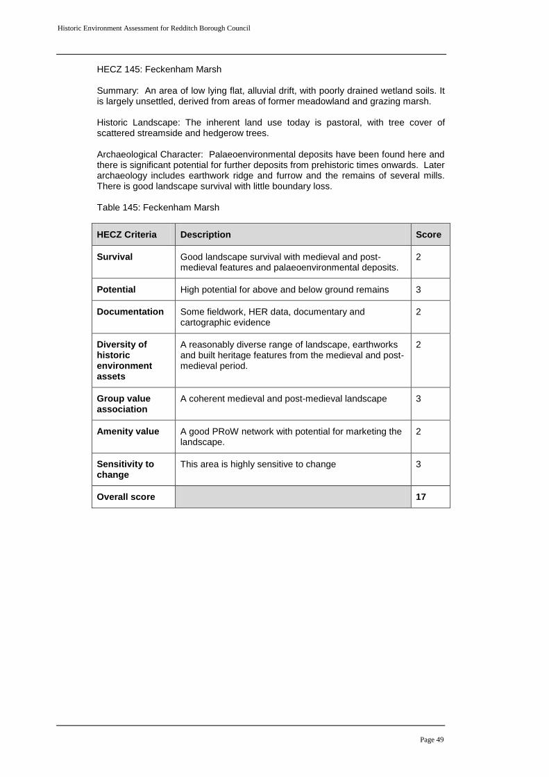
Historic Environment Assessment for Redditch Borough Council
Page 49
HECZ 145: Feckenham Marsh Summary: An area of low lying flat, alluvial drift, with poorly drained wetland soils. It is largely unsettled, derived from areas of former meadowland and grazing marsh. Historic Landscape: The inherent land use today is pastoral, with tree cover of scattered streamside and hedgerow trees. Archaeological Character: Palaeoenvironmental deposits have been found here and there is significant potential for further deposits from prehistoric times onwards. Later archaeology includes earthwork ridge and furrow and the remains of several mills. There is good landscape survival with little boundary loss. Table 145: Feckenham Marsh
HECZ Criteria Description Score
Survival Good landscape survival with medieval and post-medieval features and palaeoenvironmental deposits.
2
Potential High potential for above and below ground remains 3
Documentation Some fieldwork, HER data, documentary and cartographic evidence
2
Diversity of historic environment assets
A reasonably diverse range of landscape, earthworks and built heritage features from the medieval and post-medieval period.
2
Group value association
A coherent medieval and post-medieval landscape 3
Amenity value A good PRoW network with potential for marketing the landscape.
2
Sensitivity to change
This area is highly sensitive to change 3
Overall score 17
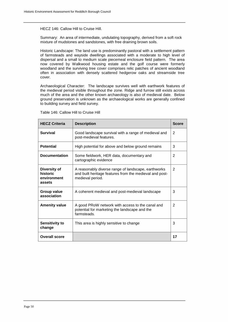
Historic Environment Assessment for Redditch Borough Council
Page 50
HECZ 146: Callow Hill to Cruise Hill. Summary: An area of intermediate, undulating topography, derived from a soft rock mixture of mudstones and sandstones, with free draining brown soils. Historic Landscape: The land use is predominantly pastoral with a settlement pattern of farmsteads and wayside dwellings associated with a moderate to high level of dispersal and a small to medium scale piecemeal enclosure field pattern. The area now covered by Walkwood housing estate and the golf course were formerly woodland and the surviving tree cover comprises relic patches of ancient woodland often in association with densely scattered hedgerow oaks and streamside tree cover. Archaeological Character: The landscape survives well with earthwork features of the medieval period visible throughout the zone. Ridge and furrow still exists across much of the area and the other known archaeology is also of medieval date. Below ground preservation is unknown as the archaeological works are generally confined to building survey and field survey. Table 146: Callow Hill to Cruise Hill
HECZ Criteria Description Score
Survival Good landscape survival with a range of medieval and post-medieval features.
2
Potential High potential for above and below ground remains 3
Documentation Some fieldwork, HER data, documentary and cartographic evidence
2
Diversity of historic environment assets
A reasonably diverse range of landscape, earthworks and built heritage features from the medieval and post-medieval period.
2
Group value association
A coherent medieval and post-medieval landscape 3
Amenity value A good PRoW network with access to the canal and potential for marketing the landscape and the farmsteads.
2
Sensitivity to change
This area is highly sensitive to change 3
Overall score 17
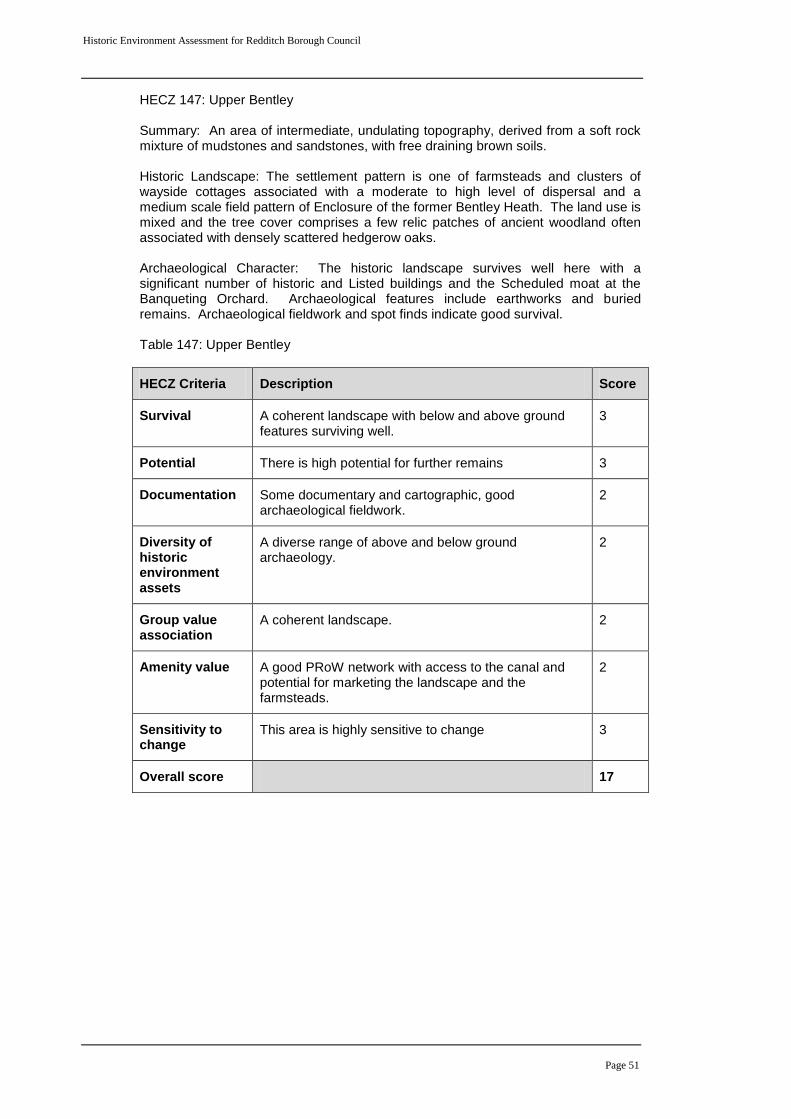
Historic Environment Assessment for Redditch Borough Council
Page 51
HECZ 147: Upper Bentley Summary: An area of intermediate, undulating topography, derived from a soft rock mixture of mudstones and sandstones, with free draining brown soils. Historic Landscape: The settlement pattern is one of farmsteads and clusters of wayside cottages associated with a moderate to high level of dispersal and a medium scale field pattern of Enclosure of the former Bentley Heath. The land use is mixed and the tree cover comprises a few relic patches of ancient woodland often associated with densely scattered hedgerow oaks. Archaeological Character: The historic landscape survives well here with a significant number of historic and Listed buildings and the Scheduled moat at the Banqueting Orchard. Archaeological features include earthworks and buried remains. Archaeological fieldwork and spot finds indicate good survival. Table 147: Upper Bentley
HECZ Criteria Description Score
Survival A coherent landscape with below and above ground features surviving well.
3
Potential There is high potential for further remains 3
Documentation Some documentary and cartographic, good archaeological fieldwork.
2
Diversity of historic environment assets
A diverse range of above and below ground archaeology.
2
Group value association
A coherent landscape. 2
Amenity value A good PRoW network with access to the canal and potential for marketing the landscape and the farmsteads.
2
Sensitivity to change
This area is highly sensitive to change 3
Overall score 17
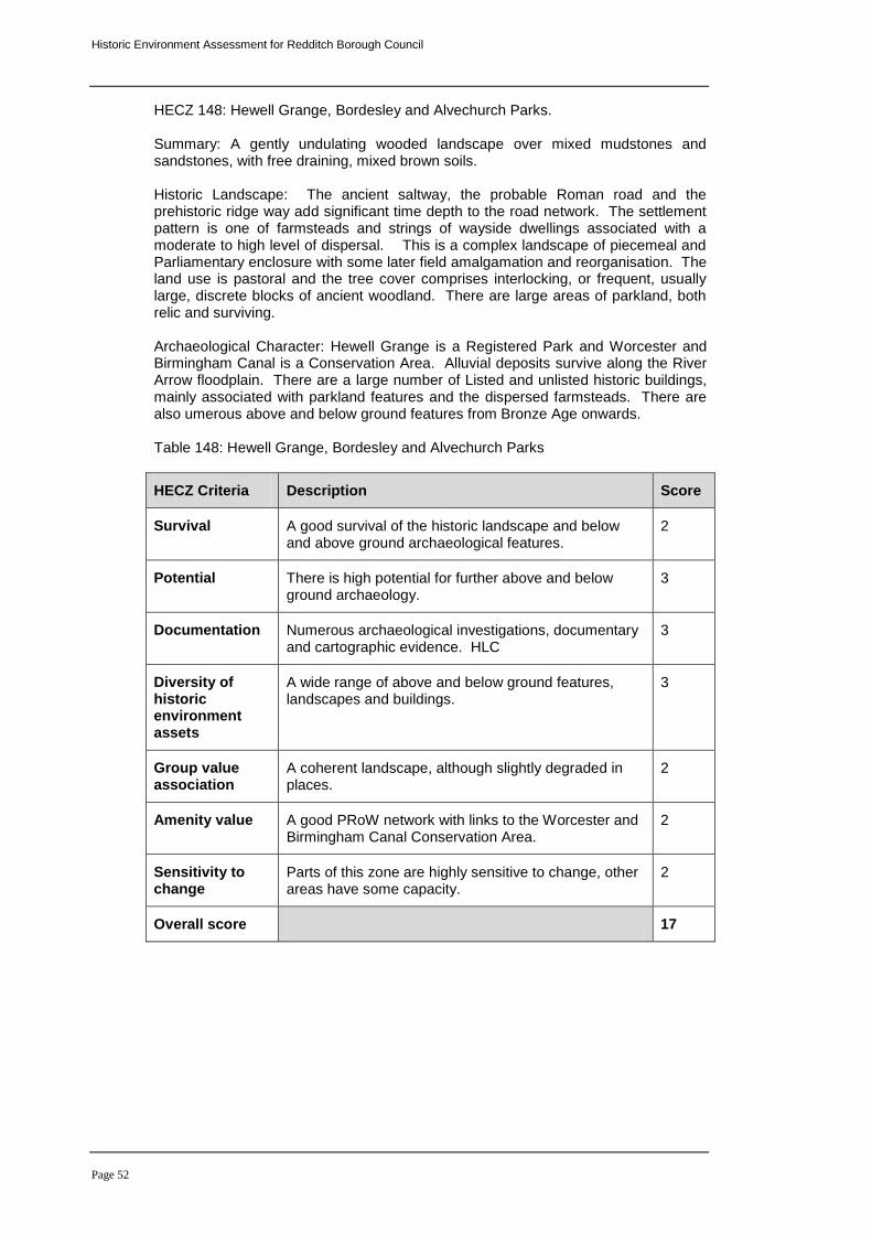
Historic Environment Assessment for Redditch Borough Council
Page 52
HECZ 148: Hewell Grange, Bordesley and Alvechurch Parks. Summary: A gently undulating wooded landscape over mixed mudstones and sandstones, with free draining, mixed brown soils.
Historic Landscape: The ancient saltway, the probable Roman road and the prehistoric ridge way add significant time depth to the road network. The settlement pattern is one of farmsteads and strings of wayside dwellings associated with a moderate to high level of dispersal. This is a complex landscape of piecemeal and Parliamentary enclosure with some later field amalgamation and reorganisation. The land use is pastoral and the tree cover comprises interlocking, or frequent, usually large, discrete blocks of ancient woodland. There are large areas of parkland, both relic and surviving.
Archaeological Character: Hewell Grange is a Registered Park and Worcester and Birmingham Canal is a Conservation Area. Alluvial deposits survive along the River Arrow floodplain. There are a large number of Listed and unlisted historic buildings, mainly associated with parkland features and the dispersed farmsteads. There are also umerous above and below ground features from Bronze Age onwards. Table 148: Hewell Grange, Bordesley and Alvechurch Parks
HECZ Criteria Description Score
Survival A good survival of the historic landscape and below and above ground archaeological features.
2
Potential There is high potential for further above and below ground archaeology.
3
Documentation Numerous archaeological investigations, documentary and cartographic evidence. HLC
3
Diversity of historic environment assets
A wide range of above and below ground features, landscapes and buildings.
3
Group value association
A coherent landscape, although slightly degraded in places.
2
Amenity value A good PRoW network with links to the Worcester and Birmingham Canal Conservation Area.
2
Sensitivity to change
Parts of this zone are highly sensitive to change, other areas have some capacity.
2
Overall score 17