Embed Size (px)
Citation preview
HUME CITY COUNCIL SUNBURY HIGAP SPAtIAL StRAtEGYJULY 2012www.hume.vic.gov.au
1
1079 Pascoe Vale Road Broadmeadows PO Box 119 Dallas 3047 www.hume.vic.gov.au Tel: 9205 2200
2
Contents
1. Introduction ............................................................................................3
1.1. Growth in Sunbury ............................................................................3 1.2. This Spatial Strategy .........................................................................3 1.3. Consultation ......................................................................................4 1.4. The Status of this Strategy ................................................................4 1.5. Structure of this Strategy ...................................................................5
2. A Spatial Portrait of Sunbury ................................................................7
3. Vision & Objectives ............................................................................ 10
4. The Spatial Structure of Sunbury...................................................... 11
4.1. Separate, Self Contained but Connected ...................................... 11 4.2. Changes within Sunbury ................................................................ 14
5. Sunbury’s Precincts ........................................................................... 23
5.1. Sunbury West ................................................................................. 24 5.2. Sunbury South ................................................................................ 29 5.3. Sunbury South East ....................................................................... 36 5.4. Sunbury North East ........................................................................ 43 5.5. Sunbury North ................................................................................ 49 5.6. Central Sunbury Precinct ............................................................... 52 5.7. Diggers Rest ................................................................................... 54
6. Monitoring and Review ...................................................................... 56
3
1. Introduction
In 2011, Sunbury celebrated 175 years of being a township and has been the subject of numerous growth strategies that have taken it to its current size of over 35,000 people. It is now set for a very significant period of growth in the coming 30 years following the changes to the Urban Growth Boundary (UGB) by State Government in August 2010 that could see the town grow to a population of 80,000 people by 2040 and ultimately over 100,000 people. The implications of this change for Sunbury are significant. Ensuring that the opportunities presented by this change benefit communities in Sunbury and deliver new development which is sustainable long into the future requires a new and comprehensive planning approach for the township. This Spatial Strategy and the accompanying Draft Delivery and Infrastructure Strategy are the culmination of a comprehensive review of planning for Sunbury by Hume City Council and when adopted will be Council’s plan for the township. It will inform Council’s planning for Sunbury and be the basis for its advocacy work with State Government and developers.
1.1. Growth in Sunbury
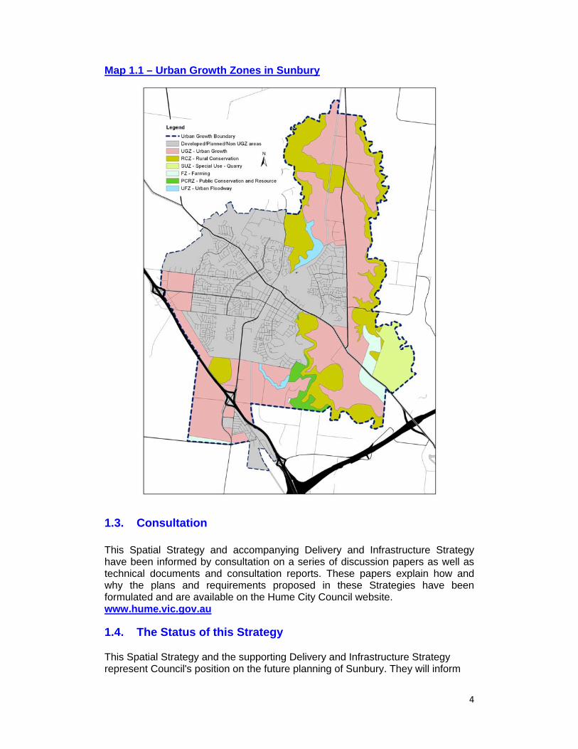
Most of the development will occur on the edge of the existing township in areas zoned Urban Growth Zone (UGZ) in Map 1.1 with some changes in the existing area, particularly in and around the Sunbury Town Centre. Whilst the UGB is intended to provide long term certainty around the limit of the future expansion of Melbourne and Sunbury, it is constantly under review. For this reason, this Spatial Strategy identifies future locations for development beyond the 2010 UGB that are considered logical and provide a potential ultimate boundary to Sunbury’s development.
1.2. This Spatial Strategy
Previous plans for Sunbury dating from 1970’s have sought to keep Sunbury separate from Melbourne and to make it a self contained township. This Spatial Strategy holds true to these principles of separation and self containment, particularly for employment and services. At the same time it acknowledges that to absorb the scale of growth proposed by State Government sustainably and appropriately, there needs to be significantly improved transport connectivity to Melbourne to provide access to a fuller range of jobs and services. At its core is a desire to make Sunbury a liveable, affordable and attractive place to live which retains its character as it grows whilst minimising the future Sunbury community’s contribution to climate change and vulnerability to peak oil. Reflecting this, the Spatial Strategy sets realistic but ambitious employment targets and calls upon State Government to commit to providing significant improvements to the road and public transport network as well as additional large scale health and education facilities in the township.
4
Map 1.1 – Urban Growth Zones in Sunbury
1.3. Consultation This Spatial Strategy and accompanying Delivery and Infrastructure Strategy have been informed by consultation on a series of discussion papers as well as technical documents and consultation reports. These papers explain how and why the plans and requirements proposed in these Strategies have been formulated and are available on the Hume City Council website. www.hume.vic.gov.au
1.4. The Status of this Strategy
This Spatial Strategy and the supporting Delivery and Infrastructure Strategy represent Council's position on the future planning of Sunbury. They will inform
5
the future planning and investment decisions of Council and it's submissions to State and Federal Government, particularly forthcoming Precinct Structure Plans (PSP) and infrastructure funding bids. Elements of this Strategy will be incorporated in the Hume Planning Scheme. Importantly, while the contents of this document will be used to inform consideration of planning proposals, the Hume Planning will form the statutory planning framework for Sunbury and be used to determine future planning permits. For the Diggers Rest area, the Melton Planning Scheme will be used. The Growth Corridor Plans In June 2012, State Government approved the Growth Corridor Plans which outlines at a broad level their view on how the Sunbury and Diggers Rest Area should change, focusing principally on the urban growth areas (shown in pink on Map 1.1). It also approved a Precinct Structure Plan for Diggers Rest. These are incorporated and form part of the Hume and Melton Planning Schemes. This Spatial Strategy and the Growth Corridor Plan align very closely and changes to the Draft Spatial Strategy have been made to increase this alignment. However, this Spatial Strategy shows the following differences: A bulky goods centre with adjoining business and residential development;
on Vineyard Road adjoining the Calder Freeway and An additional second train station in the North East of Sunbury. For more information on the Planning Process please visit www.dpcd.vic.gov.au and for more information on the Growth Corridor Plans please visit www.gaa.vic.gov.au.
1.5. Structure of this Strategy Following this introduction, the Spatial Strategy adopts the following structure: Section 2 – Spatial Portrait This Section describes what Sunbury is currently like including the qualities that should be retained and the challenges that should be addressed. This portrait forms the basis for the changes for Sunbury proposed in the Spatial Strategy and is the context for action and intervention. Section 3 – Vision & Objectives Section 3 includes the Vision for Sunbury in 2040 and describes the place that Sunbury should be in the future. It also includes a series of high level objectives required to achieve this vision which are the basis of the directions and strategies contained within the remainder of the Spatial Strategy. Section 4 – Spatial Structure Section 4 outlines the high level changes to the structure of Sunbury necessary to achieve the vision and objectives. It includes strategies that direct at a broad level
6
the location of future employment areas, activity centres, open space, road infrastructure and public transport. Section 5 – Sunbury’s Precincts This section describes and directs the future changes and development within different precinct areas of Sunbury. It includes detailed strategies to guide the future scale, location and form of different land uses and development outcomes, and the form of the future infrastructure required. Section 6 – Monitoring & Review This section outlines the approach to monitoring and reviewing the Spatial Strategy.
7
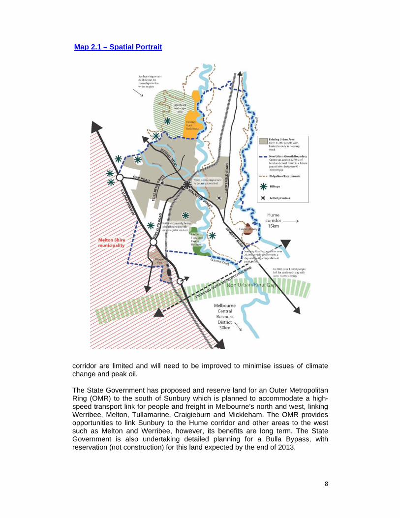
2. A Spatial Portrait of Sunbury Sunbury is located within the municipality of Hume, approximately 30km north-west of Melbourne’s CBD and 15km west of Broadmeadows and the Hume corridor. It is bound by the Calder Freeway to the south-west, Deep Creek to the east, and Macedon Ranges Shire to the north and west. Diggers Rest, within the Melton Shire municipality, adjoins Sunbury to the south with the Diggers Rest township separated from Sunbury by the Calder Freeway. The majority of the existing urban area of Sunbury is confined to the Jacksons Creek valley and is surrounded by rural land, with rural uses such as wineries and vineyards in or on the edge of the town. The urban area is separated from Melbourne and the Hume corridor by land zoned Green Wedge and the Melbourne Airport which provides a non-urban/rural separation between Sunbury and the rest of Melbourne. This physical separation, together with its rural setting and historic town centre assist in creating the sense that Sunbury is different and more like a country town than a suburb of Melbourne. Sunbury achieves a relative low level of self containment at present with residents leaving the township to access employment opportunities and large scale services like hospitals, major retail and education services. In 2006, over 11,000 people were leaving the township everyday for work, with over 10,000 residents driving, notably to the Melbourne Airport and to the Hume corridor. If current out commuting trends were to continue for Sunbury, the amount of residents leaving the township for work would more than triple with the majority of these residents travelling by car. While there is a good diversity in the employment opportunities present in Sunbury, most jobs are to be found in sectors which serve the population of Sunbury and surrounding areas. This includes retail (22%), education (14%) and healthcare (11%)1. In comparison, large numbers of people are leaving the township to access work in the manufacturing, transport/warehousing and public administration sectors. The forecast imbalance between the number of residents and the number and type of jobs in Sunbury has significant implications for the existing transport network, the environment and the affordability and desirability of living in Sunbury. A key challenge will be providing an appropriate amount and location of employment land, including industrial, commercial and retail provision to maximise jobs growth and limit commuting. Main vehicular access to Sunbury is made from Sunbury-Bulla Road, the Calder Freeway, Lancefield Road and Riddell Road. Sunbury-Bulla Road experiences heavy congestion particularly where the road uses the historic Deep Creek bluestone bridge to travel through the Bulla township. The Melbourne to Bendigo train line provides public transport access from Sunbury to Melbourne with the line currently being electrified to provide more regular services. However public transport opportunities to the Melbourne Airport, the Hume corridor, and Melton
1 Census Data (2006)
8
corridor are limited and will need to be improved to minimise issues of climate change and peak oil. The State Government has proposed and reserve land for an Outer Metropolitan Ring (OMR) to the south of Sunbury which is planned to accommodate a high-speed transport link for people and freight in Melbourne’s north and west, linking Werribee, Melton, Tullamarine, Craigieburn and Mickleham. The OMR provides opportunities to link Sunbury to the Hume corridor and other areas to the west such as Melton and Werribee, however, its benefits are long term. The State Government is also undertaking detailed planning for a Bulla Bypass, with reservation (not construction) for this land expected by the end of 2013.
Map 2.1 – Spatial Portrait
9
Main internal roads within Sunbury include Macedon Street, Gap Road, Vineyard Road/Horne Street, and Elizabeth Drive. Many roads within the town are at capacity or close to capacity due to incomplete orbital routes and limited rail crossings resulting in a significant proportion of traffic travelling through the town centre. Ensuring convenient access to the town centre while allowing for cross-town movement, presents a key challenge for Sunbury as it grows. A key challenge will be ensuring that transport infrastructure improvements are made in step with development to minimise congestion, climate change and the Sunbury community’s vulnerability to peak oil. The existing town centre currently provides a vibrant focal point for retail, health, education, office and some community services for both residents in Sunbury and in townships in the wider region. The town centre and surrounding older area of Sunbury boast wide streets and a generous informal public realm which assist in creating the country town feel of Sunbury. The scale of growth in Sunbury will generate significant additional demand for uses traditionally situated in or adjoining the town centre, including high street and bulky goods retailers as well as large scale regional community facilities. Due to limited space and car parking issues, it is anticipated that the existing town centre will not be able to accommodate all of this growth. Furthermore, to provide new communities with convenient access to everyday services, new centres within new development areas will be required. It will therefore be important to balance the need to reinforce the prominence of the existing town centre while at the same time enabling additional centres to develop to provide retail, health, education, office and community uses in step with new development. Sunbury is currently lacking in regional health and education facilities and population growth will increase the need for these facilities. While the increased demand for these facilities creates an opportunity to address this, the State Government Agencies responsible for providing them have no current plans for future provision. The challenge for Council therefore is to ensure that the opportunities remain for providing such facilities into the future. Currently the range of housing stock in Sunbury is limited, with the majority of housing targeted at families. The composition of households in Sunbury is expected to reflect changes elsewhere in Australia, with the proportion of new households without dependents and lone person households increasing and households with dependents falling. That said, family sized housing will continue to remain the largest source of demand. A key challenge will be in ensuring housing demand is met and providing this in the most appropriate locations. Sunbury has significant landscape, natural and cultural heritage features. It includes a number of significant hill tops, creeks, escarpments and areas of native vegetation and biodiversity. Significant aboriginal cultural features are located in Sunbury, including five ceremonial Aboriginal Earth Rings. Sunbury also boasts a rich post-European cultural history, with attractions such as Emu Bottom Homestead, Rupertswood mansion, “The Birthplace of the Ashes” and the Sunbury Rock Festival site. This rural outlook and range of significant features assist in creating a country town feel for Sunbury and is a key point of difference that should be protected and celebrated.
10
3. Vision & Objectives The Spatial Portrait described what Sunbury is like now, the qualities it has and the challenges it faces. The Vision below describes what Sunbury should be like in 2040 and seeks to ensure that Sunbury retains its qualities whilst responding to the challenges it faces. The Objectives that follow are the key ‘tasks’ or requirements that need to be met to achieve the place described in the Vision and form the basis for more detailed strategies and measures in Section 4 and 5.
Box 3.1: A Vision for Sunbury in 2040 In 2040 Sunbury is a unique township with a sense of community and familiarity which is physically separate but well connected to Melbourne by good transport links. Its rural setting, parks and accessible countryside are renowned and highly valued by the community. The vibrant town centre and new neighbourhood centres are the hubs of activity throughout the day and evening. These centres and adjoining residential and employment areas are connected by public transport, walking and cycling routes. Large and local scale health, education and leisure facilities as well as diverse housing and employment opportunities enable people to live and work in Sunbury throughout their lives.
Box 3.2: Strategic Objectives SO1 Ensure Sunbury is different and separate to Melbourne but well
connected by high quality transport and technology networks; SO2 Retain Sunbury’s rural outlook and increase public access to its high
quality heritage and natural environment; SO3 Encourage use and development in the surrounding non urban areas
that is supportive and complimentary to the urban area; SO4 Increase the number and diversity of jobs within Sunbury; SO5 Prioiritise and intensify activity in the town centre and create new
supporting smaller activity centres; SO6 Develop places of activity and walkable neighbourhoods linked by well
designed and efficient transport connections; SO7 Increase the potential for the Sunbury and wider community to access
its housing, health, leisure, cultural and education needs in the township;
SO8 Increase the provision of sustainable energy, waste and water services; and
SO9 Deliver logically sequenced development supported by appropriately funded and timely infrastructure.
11
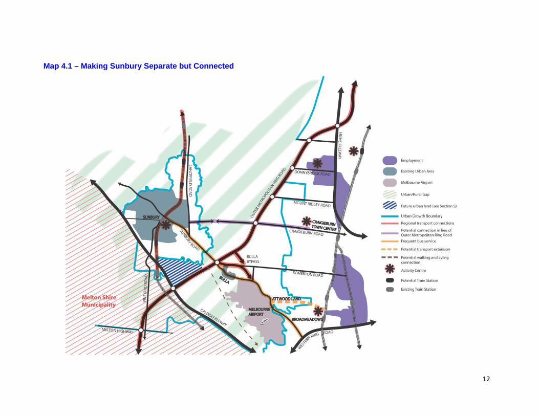
4. The Spatial Structure of Sunbury This section outlines the future spatial structure for Sunbury required to address the issues and challenges described in Section 2 and to deliver the Vision and Objectives outlined in Section 3. Principally this section describes Maps 4.1 and 4.2. Map 4.1 shows the proposed long term boundary of Sunbury and its major transport connections to Melbourne whilst Map 4.2 shows the location of the principal areas of change within Sunbury, and how Sunbury is to function into the future. Strategies are included that will guide development outcomes in accordance with these changes.
4.1. Separate, Self Contained but Connected A Long Term Limit to Sunbury’ Growth Map 4.1 shows the preferred long term boundary to the expansion of Sunbury identified by Council. It contains the expansion of Sunbury within the alignment of the proposed OMR and Calder Freeway in the south and the west, the escarpment of Emu Creek in the east and the current UGB alignment in the north. To reinforce this boundary, a green wedge of non urban development is shown between Sunbury/Diggers Rest and Melbourne to restrict the expansion of Melbourne further north. This boundary and green wedge will ensure that Sunbury’s physical separateness and sense of difference from Melbourne is retained. It will also ensure that the characteristic and unique rural outlook from the township and the roads leading to the township is retained. Two areas of land are shown beyond the current UGB as suitable for future development and need to be considered in the future planning of Sunbury at all stages to avoid costly solutions in the future. The first, and the largest, is to the South of the township between Watsons Road, Jacksons Creek and the alignment of the OMR. This area is suitable for urban development in the long term and is discussed more in Section 5.2. The second is a smaller area of land to the west of the township and is discussed more in Section 5.1. For either of these areas to be developed for urban purposes, the UGB would need to be amended and appropriate structure plans prepared. A Level of Self Containment If all the land were developed within the UGB, Sunbury could reach a future population of approximately 100,000. If the additional land identified in Map 4.1 were also developed, this could result in a population closer to 120,000.
12
Map 4.1 – Making Sunbury Separate but Connected
13
This Strategy adopts an ambitious but realistic target of 30,000 jobs for a future population of 100,000 which, if achieved, will help minimise the future level of out commuting for work and in turn increase spending in the town and help make community services viable. The Strategy also plans for large scale increases in retail and commercial floorspace in the Town Centre and new activity centres, large new community and sports facilities, and identifies land for a University/TAFE and a hospital (or future equivalents) to help minimise the need for the community to leave Sunbury for shopping, education and leisure activities. The Strategy also seeks to provide for a broader range of housing opportunities, including town houses and apartments in addition to traditional family housing. This is discussed more in Section 4.2 and Section 5. Connected to Melbourne Notwithstanding the efforts to increase the self containment of Sunbury, it is never going to be able to provide and meet the full range of demands of a community of 100,000+ people, particularly in the short to medium term. As a result, it is critical that Sunbury is well connected to Melbourne by a range of suitable modes of transport. The principal connections planned are shown on Map 4.1 and include:
An extension to the smart bus service to connect Sunbury to Melbourne Airport and Broadmeadows by a high frequency bus service;
Provision of new train stations to increase accessibility to frequent train services to the inner areas of Melbourne and its CBD;
Construction of the Bulla Bypass and the upgrade to Sunbury Bulla Road to improve vehicular, public transport and cycle access to Melbourne Airport, Broadmeadows, Epping and the northern employment corridor;
Construction of the OMR to provide links to the western and northern parts of Melbourne;
Construction of a road link from Sunbury to Craigieburn Road as an alternative to the OMR if the OMR is not pursued due to funding constraints;
Provision of a high frequency bus service into the new employment areas of Toolern and western Melton; and
Construction of a metropolitan cycle link between Sunbury and Melbourne. Delivering these connections in step with demand will be critical to ensuring that Sunbury remains an attractive and liveable township into the future. The delivery, funding and timing of these significant State infrastructure items are discussed in the Delivery and Infrastructure Strategy that supports this Spatial Strategy. Strategies Advocate for the 2010 UGB to be amended to align with the boundary shown
on Map 4.1 Ensure that the Green Wedge between Melbourne and Sunbury/Diggers Rest
is retained Advocate for a hospital or equivalent health facility and a university/TAFE
14
Advocate for the timely provision of the following infrastructure items in accordance with the Delivery and Infrastructure Strategy: o An extension to the smart bus service to Sunbury o Provision of new train stations south of Jacksons Hill and two to the north
east of Sunbury o Construction of the Bulla Bypass and the upgrade to Sunbury Bulla Road o Construction of the OMR and a connection from Sunbury to the Hume
Northern Growth Corridor if the OMR is not delivered or delayed o Provision of a high frequency bus service into the new employment areas of
Toolern and western Melton o Construction of a metropolitan cycle link between Sunbury and Melbourne
Link the rate of development to the delivery of major transport infrastructure.
4.2. Changes within Sunbury
To achieve the vision, retain the liveability and increase the sustainability of Sunbury will require changes within the Sunbury township. As shown conceptually in Figure 4.1 and in more detail in Map 4.2, the future structure of Sunbury will retain a focus on the town centre but include a large number of new areas for activity that are well connected to new and existing residents by new orbital transport links. This includes a number of new activity centres of varying sizes that will be the preferred location for a range of retail, commercial, leisure and community facilities and be the focus for community interaction. This Spatial Strategy seeks to guide the ultimate outcome in these centres as well as their staging over time to ensure that the viability of each centre is first enabled and then maintained. The other substantive changes include:
New employment areas at competitive and accessible locations; Protection of hilltops through open space and conservation areas; and Creation of new Regional Parks to protect important environmental, heritage and
landscape features, and at the same time increase community access to them. A large number of additional facilities and infrastructure are proposed to provide for a range of community needs. State Government are still developing strategies for the provision of large scale health, tertiary and higher education services to support the Sunbury area. State Government is considering if such facilities should be provided in the form of a hospital and university/TAFE or whether these same services should be provided in an equivalent way. This Spatial Strategy seeks to provide the opportunity for both options and identifies the Sunbury Town Centre as the preferred location for a potential hospital (or equivalent) and the current VU site as the preferred location for a university/TAFE (or equivalent). To ensure flexibility, land is also safeguarded in Sunbury Town Centre for a university/TAFE (or equivalent) with land adjoining one of the proposed train stations in the North East of Sunbury also identified as an alternative location for these two important potential facilities. These changes are discussed more below and in Section 5. Strategies Advocate and implement the future Spatial Structure of Sunbury based on Map
4.2.

15
Figure 4.1 – Current & Future Sunbury
Current Sunbury
Future Sunbury
16
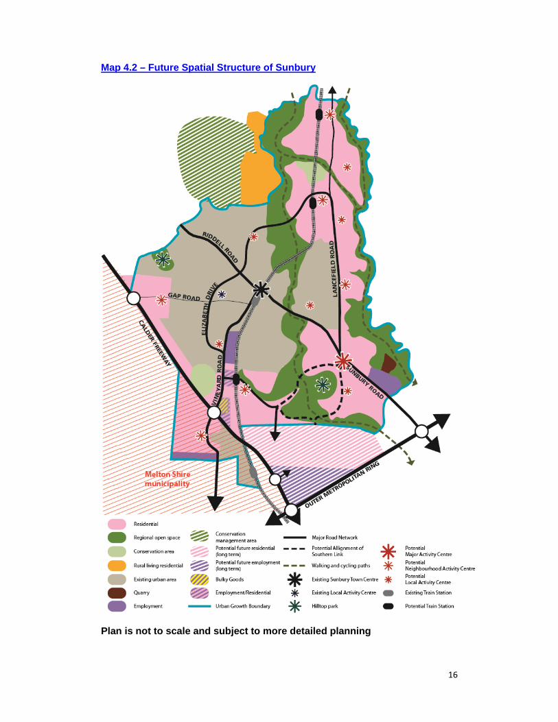
Map 4.2 – Future Spatial Structure of Sunbury
Plan is not to scale and subject to more detailed planning
17
Activity Centres Sunbury Town Centre will remain the primary activity centre in Sunbury and be classified as a Principal Activity Centre (PAC). Whilst it will continue to provide for the everyday needs of the Sunbury community, it will be the prime and preferred location for meeting the higher order requirements of Sunbury and the wider region, particularly for high street fashion retail and more specialised service needs. To meet this demand it will need to be expanded and intensified with land safeguarded into the future for a potential new hospital (or equivalent) and a potential TAFE/university facility (or equivalent). The Town Centre is discussed more in Section 5. The second largest activity centre in Sunbury will be a new Major Activity Centre (MAC) located on Sunbury Road. This will be developed over time to enable and provide appropriate investment opportunity for development and change in Sunbury Town Centre to occur prior to significant new space being made available outside of the Towne Centre. Initially, it will be planned to meet the local demands of the existing and new community in south east part of Sunbury. Its ultimate scale of retail and commercial floorspace will depend on the extent of change in Sunbury Town Centre and demand generated by development throughout the entire eastern side of Sunbury but will always be a secondary retail and commercial location. A series of new Neighbourhood Activity Centres (NACs) and Local Activity Centres (LACs) will also be developed, primarily in the new development areas. These supporting centres will provide an alternative location for local scale retail and services helping to free up capacity in the town centre. NACs will be based around a large supermarket with a small range of uses like cafes, restaurants, speciality food shops, real estate agents and small scale office and medical facilities. A multi purpose community centre, a primary school and active sporting facilities will also generally be located within or adjoining the NACs and where the demand is sufficient a secondary school will be provided. Medium and higher density housing will also be developed in and on the edge of the NACs especially those which adjoin a train station to increase the diversity of housing in Sunbury. The LACs will be far smaller and be primarily about providing local access to a small supermarket with a small range of convenience shops and cafe/restaurants and maybe some community and active sport facilities. The largest of these NACs will be the located in the north east of Sunbury adjacent to one of the future train stations and be the preferred locations for new large scale community infrastructure needed to service the eastern side of Sunbury in the long term like a potential future indoor sports centre, a potential regional sports facility, and potential additional library facilities. It will also be a favoured secondary location for a potential future hospital (or equivalent) and university/TAFE (or equivalent) if sites in the Sunbury Town Centre and former VU site prove unachievable. Finally a bulky goods centre of approximately 50,000 sqm will be provided on the eastern side of Vineyard Road near to the Calder Freeway. This will be the focus for bulky goods development in the township and reduce the need for such uses
18
to be located in multiple locations, particularly industrial areas. It will also help to minimise such high traffic generating uses from entering the heart of Sunbury. Strategies Advocate and plan for hierarchy of centres based on Map 4.2 with:
o Sunbury Town Centre classified as a Principal Activity Centre o A new Major Activity Centre on Sunbury Road o A series of new Neighbourhood and Local Activity Centres o A new bulky goods centre on Vineyard Road
Ensure that Sunbury Town Centre remains the primary activity centre and prevent other activity centres adversely impacting upon its vitality and viability
Safeguard land in Sunbury Town Centre and at the large Neighbourhood Activity Centre off Lancefield Road for a hospital (or equivalent) and a university/TAFE facility (or equivalent) until they are developed or it is determined that they are not required.
Support the delivery of these activity centres in accordance with the approach and the timeframes identified in the Delivery and Infrastructure Strategy.
Employment A significant driver of employment growth will be increased demand for goods and services associated with growth in the Sunbury population like retail, health, education, and professional services. Most of this demand will be met in existing and new facilities and developments ideally located in the Sunbury Town Centre and new supporting centres. A future hospital hospital (or equivalent) and a university/TAFE (or equivalent) are also important potential employers. Whilst potential investment from outside Sunbury is likely to be limited especially in the short term, land will be provided in strategic locations to attract businesses in sectors like manufacturing and transport and logistics which are strong sources of jobs in the wider region and a potential source of jobs in Sunbury. Three new principal employment locations have been identified, primarily for industrial type development but with the potential for office development. These are shown on Map 4.2 and include: The remaining industrial zoned land at the northern end of Vineyard Road to
the alignment of Harpers Creek; 27 ha of land at Diggers Rest in Shire of Melton (see Section 5.7); and 100 ha of land on Sunbury Bulla Road. In addition, land is shown for a mixture of residential and employment development on Vineyard Road both adjacent to the proposed new train station and adjoining the Calder Freeway. These areas will provide alternative locations to the activity centres and the industrial areas for a range of business uses that are compatible with residential development. Approximately 130-150 ha of land outside the UGB to the south of Sunbury is also shown as long term employment land. This represents a highly suitable location for large scale light industrial and transport and logistics companies looking to locate proximate to the OMR and Calder Freeway. Should this land not
19
be included within the UGB in the future there will be few opportunities for such development in the Sunbury area. Strategies Support the development of existing industrial zoned land at the northern end
of Vineyard Road for light industrial uses and 27ha of land at Diggers Rest for a range of light industrial and transport and logistics uses.
Advocate and plan for a flexible zoning and approach to enable the development of100 ha of employment land on Sunbury Bulla Road adjacent to the quarry, principally for light industrial and business uses.
Advocate for the inclusion of approximately 130 to 150ha land to the south of Sunbury within the UGB for large scale industrial and transport and logistics users.
Promote the land off Vineyard Road adjacent to the new train station and adjacent to the Calder Freeway for a range of business uses that are compatible with residential development.
Support the delivery of these sites in accordance with the approach and timescales in the Delivery and Infrastructure Strategy.
Safeguard land in Sunbury Town Centre and at the large Neighbourhood Activity Centre (NAC) for a hospital (or equivalent) and a university/TAFE (or equivalent) until they are developed or it is determined that they are not required.
Transport An orbital loop will be developed within Sunbury through the extension of Elizabeth Drive to Vineyard Road and Racecourse Road, the upgrade of Lancefield Road and the construction of a Northern and Southern Link. A high frequency bus service should operate along it providing a 15 minute frequency of service. Further investigation of the potential alignment of the Southern and Northern Links is required and so ‘potential’ alignments are currently shown on Map 4.2. Other alignments maybe considered in the investigation. This orbital loop will be supported by a network of off and on road walking and cycling opportunities and additional rail crossings for road, public transport and walking and cycling. Connections from Jacksons Hill to Vineyard Road and the Calder Freeway will also be provided to better connect this residential area to the major road network. As a combination, these will enable people to access different parts of Sunbury and enable through traffic to bypass the town centre. It will particularly enable people on the eastern side of Sunbury to access the Jacksons Hill Train Station, the Calder Freeway and large scale facilities in the west. Likewise, it will allow people on the southern and western side of Sunbury to access the employment area on Sunbury Road and the potential large scale regional facilities at the NAC on Lancefield Road in the longer term. Further Work Investigate and identify the optimal alignment for the Southern and Northern
Link taking account of:

20
o The feasibility and cost of construction; o The impact on the environmental, cultural heritage and visual qualities of
the area; and o The contribution to the required transport network in Sunbury in the short
and longer term. Facilitate a transport connection to connect Jacksons Hill estate with Vineyard
Road (Viaduct Way) and land to the south. Investigate the need, feasibility and cost of extending Shield Street across the
railway line. Strategies Plan and advocate for the provision of an Orbital Loop with high frequency
bus services (15 minute frequency) around Sunbury comprising of: o An extended Elizabeth Drive o A Northern and Southern Link o An upgraded Lancefield Road in the timeframe outlined in the Delivery and Infrastructure Strategy.
Deliver improved transport connections from Jacksons Hill to Vineyard Road and/or the Calder Freeway.
Deliver a network of walking and cycling opportunities based on the Hume Walking and Cycling Strategy and the Concept Plans in Section 5.
Open Space Sunbury’s topography, landscape and rural qualities present significant unique opportunities to provide an open space network that is the envy of many and that creates a real point of difference between Sunbury and other areas. Regional parks will be planned along both Jacksons Creek and Emu Creek and their associated escarpments. These Regional Parks will be based on linear trails for walking and cycling along the escarpments and the creeks with larger open space areas located along them for a range of formal and informal activity. Two regional hill top parks at Mount Holden and at Redstone Hill will also be planned providing elevated spaces to enjoy the expansive views across and around Sunbury. In combination these parks and hill tops will provide a highly valued open space area for the Sunbury community to undertake a range of activities and enable them to access and enjoy Sunbury’s unique landscape. To ensure a more complete and continuous open space network, a range of smaller links will be planned within new precincts to connect people to these regional spaces as well as to neighbourhood parks, sporting reserves and activity centres. Where possible these will follow creek and drainage lines to help safeguard and enhance their landscape and biodiversity qualities. The scale, nature and ownership of open space will be determined through more detailed planning (see further work). Further Work
21
Prepare a Masterplan for Jacksons Creek and Emu Creek Regional Parks showing the location of: o Areas of water management, nature conservation and informal activity o Access points, car parks, paths and trails o Any community or visitor buildings o Publically and privately owned land in these areas.
Work with State Government to attract funding and deliver these Regional Parks.
Prepare a Masterplan for Redstone Hilltop Park (see Section 5.3)
Strategies Plan and advocate for the provision of Regional Parks along Jacksons Creek
and Emu Creek and their associated escarpment. Plan for and deliver active sports, neighbourhood parks and linear parks in
accordance with the Precinct Concept Plans in Section 5. Advocate and deliver all open space in accordance with the approach and
timeframe outlined in the Delivery and Infrastructure Strategy. Environmental Protection The most significant areas of native vegetation and biodiversity are located in the areas zoned Rural Conservation Zone (RCZ) along Jacksons Creek and Emu Creek. Likewise, the areas of greatest landscape sensitivity are also covered by RCZ. To ensure their long term protection and management these areas, and to ensure the greatest community benefit of these areas and the resources required to achieve this protection, these will form part of the future Regional Parks. There will be other areas of native vegetation and biodiversity that need to be protected through development. Where possible these areas will be conserved and form part of local open space parks or linkages. Strategies To protect areas of environmental significance the following strategies will be pursued: Continue to implement the three step approach to native vegetation
management as detailed at Clause 12.01-2 of the Hume Planning Scheme. As far as practicable, require conservation reserves containing important
habitat to be linked by habitat corridors. Ensure that the masterplans prepared for the Jacksons Creek and Emu Creek
Regional Parks protect and provide public access to the significant environmental and landscape assets, and the natural and visual qualities of the Jacksons Creek and Emu Creek corridors.
Promote the protection and long term management of other significant environmental and landscape features such as hilltops, creeks, escarpments and significant native vegetation but where possible encourage public access through incorporation into open space.
Require such areas to be appropriately managed and if transferred to public ownership require appropriate management plans and funding as agreed with the applicable management authority.
22
Work with DSE and others to ensure that the buffer from the creeks to new development accounts for: o Flooding, erosion and water quality o Any passive open space and walking and cycling opportunities o Roads, bridges and access arrangements o Appropriate habitat protection
Resource Efficiency Using natural resources efficiently and producing sustainable energy is critical to minimising climate change and achieving a secure energy future for Australia. There are a number of significant Federal and State Government programs aimed at achieving these outcomes, notably the Carbon Tax and the Energy Efficiency Target. Over the next 30 years, and as innovative technology being trialled around the world become more proven, there will be potential to achieve more localised measures and strategies to produce more sustainable energy and minimise resource use. The scale of growth and the scale of new developments in Sunbury offer the potential for a range of technologies and measures to be utilised. Further Work Explore through future Waste Strategies the potential to generate energy from waste. Strategies Work with Western Water to enable use of Class A recycled water in new
developments. Work with Western Water to deliver necessary water tanks on key hilltops
whilst minimising any visual intrusion. Work with State Government to pursue use of more sustainable and localised
energy production in new development. Support proposals for cleaner energy production where they do not adversely
impact on the landscape and visual qualities of Sunbury and the amenity of the Sunbury community.
23
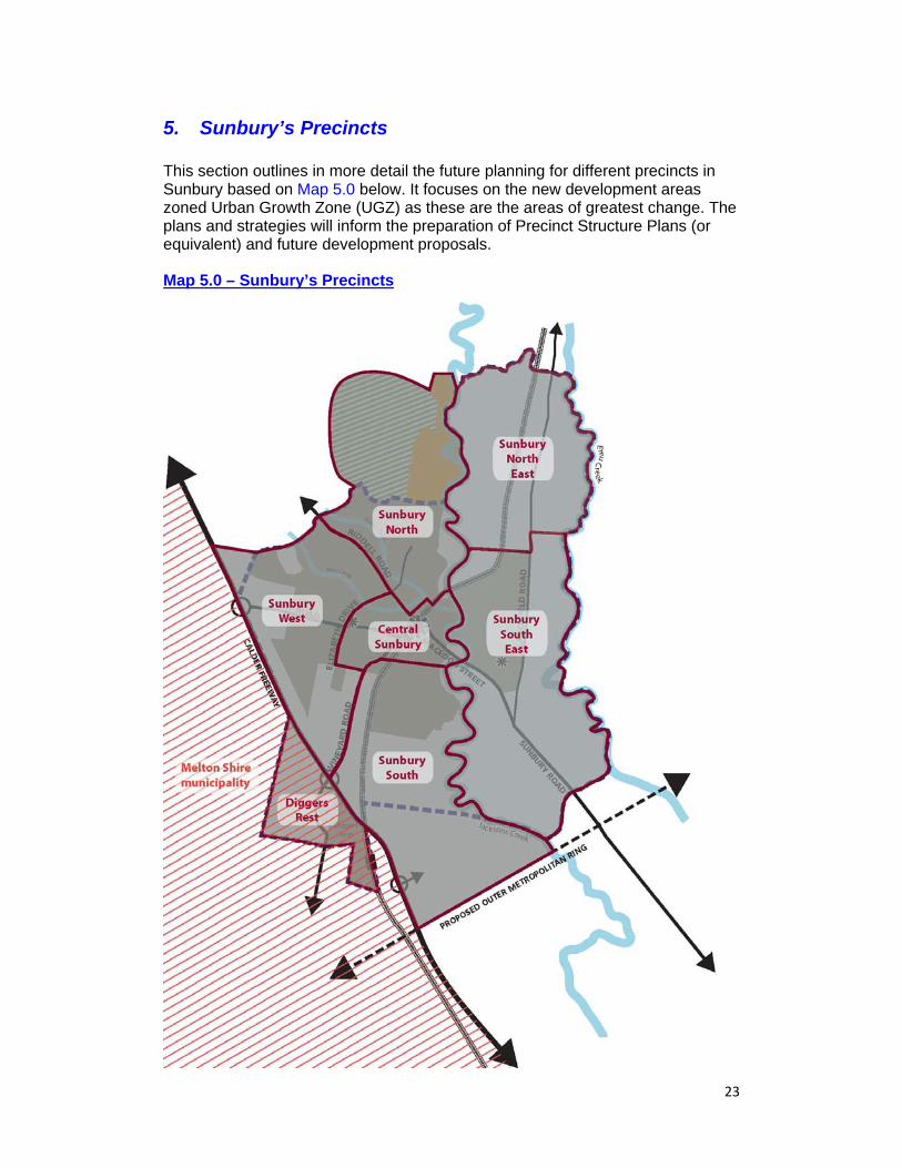
5. Sunbury’s Precincts This section outlines in more detail the future planning for different precincts in Sunbury based on Map 5.0 below. It focuses on the new development areas zoned Urban Growth Zone (UGZ) as these are the areas of greatest change. The plans and strategies will inform the preparation of Precinct Structure Plans (or equivalent) and future development proposals. Map 5.0 – Sunbury’s Precincts
24
5.1. Sunbury West The Current Sunbury West Precinct Sunbury’s western precinct comprises land principally from Vineyard Road and Elizabeth Drive to the Calder Freeway. The precinct is bounded by Elizabeth Drive and Vineyard Road to the east, Riddell Road to the north east, the Urban Growth Boundary (UGB) to the north west, and the Calder Freeway to the south west. The precinct is mostly developed or being developed. However, there are some large areas that require further planning including an area zoned Residential 1 Zone off Vineyard Road and Mitchells Lane, an area to the west zoned Low Density Residential, and areas in the west zoned Urban Growth Zone (UGZ). There are a number of prominent topographical and natural features within and adjoining the precinct, including Bald Hill to the south, Mt Holden Hilltop Reserve to the north and Kororoit Creek extending through a large portion of the precinct. A triangular portion of the precinct located in the north western corner currently outside the UGB is included as it represents a logical area for urban development in the future. The Future Sunbury West Precinct The Sunbury West Precinct will be further developed with the land to the west of the existing urban area providing a community of approximately 3,200 to 3,700 dwellings along with a Neighbourhood Activity Centre (NAC) on Gap Road. The NAC will be the focus for this community and much of the community in the Philips Drive and Mitchell Lane areas. It will comprise a full range supermarket and additional floorspace for a range of retail and commercial uses. The NAC will be developed either side of Gap Road and include a primary school, community hub, and district sports reserve, and potentially a public square or park. High and medium density housing, principally in the form of town houses and apartments, will be provided in and around the activity centre to signal the presence of more intense activity and maximise proximity to such uses. The remainder of the residential land in this new development area will be more conventional density housing. The existing community facilities located in Sunbury West will be consolidated and upgraded. This includes the existing sporting facilities at Langama Park which is to be upgraded to a regional soccer facility to service the new and existing areas of Sunbury. A Local Activity Centre (LAC) is proposed on the intersection of the extended Elizabeth Drive and Vineyard Road and will comprise a supermarket with minimal other shops to reflect its more convenience role. This centre will provide easy access for the existing and future community located in the Ashifield Estate and new residential area around the centre as well as future employees in this area adjoining Vineyard Road. Elizabeth Drive will be extended to connect to Vineyard Road and form an important part of the road and public transport Orbital Link within Sunbury. Road upgrades will also be made to Gap Road to allow for a dedicated cycle lane and
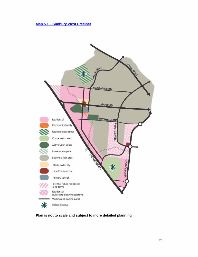
25
Map 5.1 – Sunbury West Precinct
Plan is not to scale and subject to more detailed planning
26
The operation of bus services to link this western area of Sunbury with the Sunbury Town Centre. A hilltop park will be developed on Mount Holden and provide a high quality location for the community to enjoy the ranging views from this location. A series of linear parks and neighbourhood parks will also be developed to connect the new development areas with the existing area, including new walking and cycling paths along the Kororoit Creek and Harpers Creek. Whilst Bald Hill will not be developed for open space, it will be protected from increased development and conserved as an important landscape feature. Strategies To develop precincts that accord with the Vision and Objectives and the Spatial Structure for Sunbury, the following strategies are required in Sunbury West: Require that the Precinct Structure Plans (or equivalent) and development
proposals for this Precinct are generally in accordance with this Spatial Strategy and Map 5.1.
Advocate and deliver the infrastructure required for the precinct in accordance with the Delivery & Infrastructure Strategy.
Transport To achieve connected and walkable neighbourhoods with well-designed and efficient public transport, walking and cycling in this precinct the following strategies are required in Sunbury West:
Promote the upgrade of Gap Road to include:
o A dedicated cycle lane and bus services to link the future residential areas with the town centre; and
o Ensure the design maintains the characteristic landscape treatments that exist along it.
Require the activity centre, open space reserves, community facilities, schools and public transport nodes to be linked by convenient, safe and direct walking and cycling infrastructure.
Plan for and promote a hierarchy of pedestrian and cyclist friendly non arterial roads comprising: o Bus ready connector streets with off road walking and cycling paths to link
residents directly to activity centres, schools and active open space; and o Safe local access streets with shared spaces where appropriate.
Activity Centres
To maintain the primacy of Sunbury Town Centre whilst enabling vibrant, popular and well designed centres near to where people live the following strategies are required in Sunbury West: Plan for new activity centres, schools, community facilities and active sports
reserves generally in the locations shown in Map 5.1. Plan for the following floorspace requirements in activity centres:
27
o A Neighbourhood Activity Centre – 9,000 sq.m comprising a large supermarket and a mix of specialty shops, food and drink premises and offices; and
o A Local Activity Centre (LAC) – approximately 2,500 sq.m comprising a small supermarket, specialty shops and offices
Require any proposal for retail floor space above these limits to be accompanied by a retail impact assessment that addresses the following: o The impact the increased development will have on the Sunbury Town
Centre and other existing or proposed centres; and o The impact that development will have on the provision of services and
amenities within a walkable catchment for surrounding neighbourhoods. Require residential development within the 400m surrounding the
neighbourhood activity centre to be a mix of housing types, including town houses and apartments, and achieve a minimum overall density of 25 d.p.h unless this is shown to be unviable.
Require Urban Design Framework Plans (or equivalent guidance) for each activity centre showing: o A street based centre with active frontages; o The location and scale of retail, commercial, community, residential and
other uses; o The potential scale and height of building in different locations and how
this helps provide legibility to the centre and the precinct; o The road and public transport network and the parking approach and how
this encourages walkable, pedestrian and cyclist friendly activity centres; and
o How residential development is integrated into the built form. Open Space To maximise community access and enjoyment of Sunbury’s unique landscape and to provide good access to a range of open space, the following strategies are required in Sunbury West:
Require a public open space and walking and cycling link along Kororoit
Creek. Require the district sports reserve to be 10.25ha and be accompanied by a
sports pavilion. Require neighbourhood parks of 0.75ha to be located throughout the new
residential areas to ensure the majority of the new community is within 500m of open space.
Design To minimise the visual intrusion of new development on Sunbury’s landscape and to protect the rural qualities of the hilltops and rural entries to Sunbury, the following strategies are required: Require a specific urban design and landscape strategy for Gap Road
showing how the existing rural feel will be retained and how it will complement the existing landscape treatments.
28
Require a landscape and urban design strategy to design an appropriate interface between the residential development and the Calder Freeway to ensure noise issues are appropriately dealt with.
Require a landscape and urban design strategy adjoining Bald Hill to show how the hill will be maintained as a prominent landscape feature.
29
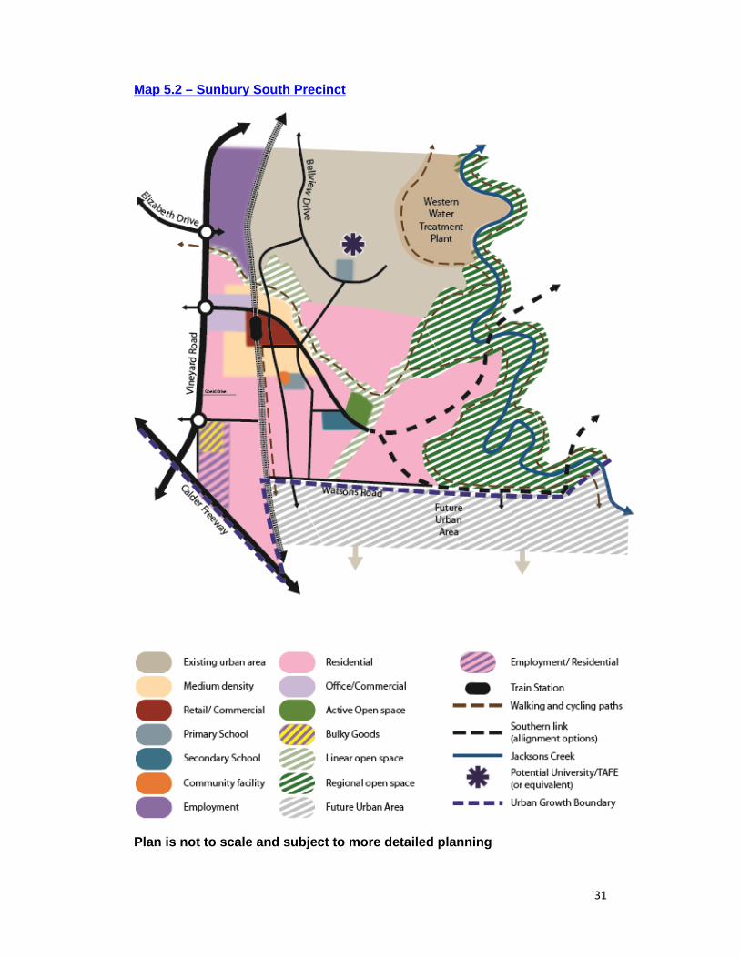
5.2. Sunbury South The Current Sunbury South Precinct Sunbury’s southern precinct includes the existing Jacksons Hill residential area and the land to the south between Jacksons Creek and Vineyard Road. The precinct is bounded by Jacksons Creek to the east, the Calder Freeway and the proposed Outer Metropolitan Ring (OMR) to the south, the Calder Freeway and Vineyard Road to the west and the Shields Street to the north. Jacksons Hill is largely developed and has sweeping views from its southern side towards the escarpments/ tributaries of Jacksons Creek, Bald Hill, Redstone Hill and Melbourne CBD. The remainder of the precinct is largely undeveloped except for some larger rural properties and some industrial development between Vineyard Road and the railway line. A large portion of the precinct is currently outside the Urban Growth Boundary (UGB). This land, located in the southern section of the precinct, has been included in this Strategy as it is a logical area for future urban development. The Melbourne-Bendigo rail line runs north-south through the western portion of the precinct adjacent to Vineyard Road and provides a barrier to movement east west, particularly from the land around Jacksons Hill. Jacksons Creek and Harpers Creek meet at the Holden Flora and Fauna Reserve and provide an impressive natural landscape and topography but are again barriers for movement between future communities. The other significant feature is the former Caloola facility on the top of Jacksons Hill. Whilst many of the buildings are currently vacant, a number are used by schools, and community groups and organisations. The Future Sunbury South Precinct The Jacksons Hill residential area will be completed and include a small Local Activity Centre (LAC) comprising a small food store of approximately 820 sq.m with 120 sq.m of other shops and services. This centre will provide the Jacksons Hill community with basic convenience needs and may also include community facilities and medium density housing. The former Caloola facility on the hilltop surrounded by the Jacksons Hill estate (currently owned by Victoria University) will remain a highly important feature and would be suitable for a dedicated higher education facility or in part for the provision of university or TAFE programs. Part of the site could also be used for wider community and active sports uses. Any development of this site should preserve the historic buildings and maintain some community access.to the site and buildings where possible. The undeveloped UGZ land to the south of Jacksons Hill will provide a community of approximately 3,200 to 3,700 dwellings either side of the train line and be developed based on transit orientated development principles. A Neighbourhood Activity Centre (NAC) will be developed primarily to the east of the proposed Jacksons Hill Train Station and meet the everyday needs of the communities in this new residential area and Jacksons Hill. An area of mixed office, commercial and higher density housing development will be promoted adjoining the station and Vineyard Road.
30
The NAC will comprise a full line supermarket and supporting specialty retail and complimentary commercial floorspace. High and medium density housing, principally in the form of town houses and apartments, will be provided in and around the activity centre and train station to maximize its proximity to the train station and provide a strong local catchment to the NAC. The NAC will designed to enable good and quick connectivity to the train station and the majority of residential development further south. A primary school, multi purpose community facility, district sports reserve and a secondary school will be located to the south of this NAC and in the heart of the precinct with good walking and cycling access to maximise access from the surrounding residential areas whilst retaining strong connectivity to the NAC. The balance of the residential housing will consist principally of conventional density dwellings with higher density development around neighbourhood parks and other areas of open space and high amenity. Development fronting Jacksons Creek and Harpers Creek will be set back from the edge of the escarpment and creek to protect these as prominent landscape features, to mitigate flooding and surface run off issues, address fire risk, and to enable open space linkages to be developed. In the north of the precinct land adjoining Vineyard Road will be developed for industrial development to Harpers Creek to further expand the Sunbury Business Park mix of light industrial uses. Further south adjoining the Calder Freeway, a bulky goods centre will be located with the surrounding area developed for a mixture of business and residential uses. To ensure the rural entrance to Sunbury along Vineyard Road is maintained, the visual intrusion of potential large scale buildings will be mitigated through landscape and vegetation buffers along the Vineyard Road, height restrictions and appropriate use of materials to all new buildings. Measures to address noise and vehicle movements associated with the bulky goods centre and businesses will also be controlled to minimise impact. The Southern Link will traverse through this precinct from Vineyard Road across Jacksons Creek to the Sunbury Bulla Road. The Southern Link will provide strong vehicular, public transport, walking and cycling connections from the new residential areas to the train station, the NAC and Vineyard Road via a grade separated crossing. Regular bus services will utilise the Southern Link and connect Sunbury South with the Town Centre and other centres. Additional local services will provide access to local facilities by public transport. Further work (see Section 4.2) will be undertaken to determine the optimal alignment for the Southern Link and the most appropriate location for the crossing of Jacksons Creek. A transport link under the viaduct will also be provided and the potential for additional pedestrian and cycle crossings further south will be explored to provide access to the employment area and bulky goods centre. A Regional Park with associated walking and cycling routes will be planned along Jacksons Creek and its escarpment. Together with neighbourhood parks, other passive parks along the Harpers Creek tributary and the district sports reserve, the community in Sunbury South will have access to a significant scale and range of open space.
31
Map 5.2 – Sunbury South Precinct
Plan is not to scale and subject to more detailed planning

32
The land outside of the UGB to the south will be planned for future residential and be connected via good road connections back to Sunbury and further south to the Calder Freeway. Approximately 130 to 150 hectares of predominantly industrial development will be planned in the area immediately adjoining the Calder Freeway and the OMR with immediate access onto the Calder Freeway. Further Work Prepare a precinct concept plan to guide the future development of the land
currently outside the Urban Growth Boundary (UGB). Work with State Government to prepare an education blueprint for Sunbury
including the potential for higher education use at the former VU site. Explore the potential for additional walking and cycling crossings of the rail
line to improve connectivity. See Further Work in Section 4 for further work on Southern Link and
Jacksons Creek Regional Park. Strategies To develop precincts that accord with the Vision and Objectives and the Spatial Structure for Sunbury, the following strategies will be pursued in Sunbury South: Require that the Precinct Structure Plans (or equivalent) and development
proposals for this Precinct are generally in accordance with this Spatial Strategy and Map 5.2.
Advocate and deliver the infrastructure required for the precinct in accordance with the Delivery and Infrastructure Strategy.
Advocate that the Growth Areas Infrastructure Contribution (GAIC) levied as part of development of this precinct be utilised in accordance with the Delivery and Infrastructure Strategy.
Transport To ensure that Vineyard Road and the Southern Link enable appropriate vehicular flows through this precinct whilst enabling integrated and walkable neighbourhoods with well-designed and efficient public transport, walking and cycling, the following strategies will be pursued in Sunbury South: Promote Vineyard Road to:
o Be no more than 4 lanes with off road pedestrian and cycling lanes and no service lanes unless traffic analysis shows this to be unsuitable; and
o Have intersections at no more than 500m and signalised pedestrian crossings that enable safe access to activity centres and employment areas.
Promote the Southern Link to: o Be no more than 4 lanes with off road pedestrian and cycling lanes and
no service lanes unless traffic analysis shows this to be unsuitable. o Have intersections at no more than 200m and signalised pedestrian
crossings that enable safe access to the activity centre, schools and community facilities; and
o Provide a strong connection to the Jacksons Hill Train Station and the main street of the Neighbourhood Activity Centre.
33
Require the train station, activity centre, employment land, open space reserves, community facilities, schools and public transport nodes to be linked by convenient, safe and direct walking and cycling infrastructure.
Plan for and promote a hierarchy of pedestrian and cyclist friendly non arterial roads comprising: o Bus ready connector streets with off road cycling provision to link
residents directly to activity centres, schools and active open space; o Safe local access streets with shared spaces where appropriate; and o Plan for a bus interchange at the Neighbourhood Activity Centre (NAC)
off the Southern Link and adjacent to the Jacksons Hill Train Station to enable efficient transfer on to different modes of transport.
Work with VicTrack in designing walking and cycling links along the rail line, linking residential areas of Sunbury and Diggers Rest with the train station, the NAC and other facilities within this precinct.
Ensure that appropriate access into the land to the south of Watsons Road is achieved to enable the future development of this land.
Activity Centres To maintain the primacy of Sunbury Town Centre whilst enabling vibrant, popular and well designed centres near to where people live, the following strategies are required in Sunbury South: Plan for the new activity centres, schools, community facilities and active
sports reserves generally in the locations shown in Map 5.2. Plan for a Neighbourhood Activity Centre (NAC) of approximately 10,000
sqm comprising a full line supermarket and a mix of specialty shops, food and drink premises and offices.
Plan for a bulky goods centre of approximately 50,000 sqm off Vineyard Road.
Require any proposal for retail floor space above this limit to be accompanied by a retail impact assessment that addresses the following: o The impact the increased development will have on the Sunbury Town
Centre and other existing or proposed centres; and o The impact that development will have on the provision of services and
amenities within a walkable catchment for surrounding neighbourhoods. Require residential development within and 400m surrounding the
neighbourhood Activity Centre NAC to be a mix of housing types, including town houses and apartments, and achieve a minimum overall density of 25 d.p.h unless this is shown to be unviable.
Require the Neighbourhood Activity Centre (NAC) to be designed and developed in coordination with the Jacksons Hill Train Station and adjoining office development to facilitate a transit orientated development.
Require an Urban Design Framework Plan (or equivalent guidance) for the Neighbourhood Activity Centre (NAC) showing: o A street based centre with active frontages; o The location and scale of retail, commercial, community, residential and
other uses; o The potential scale and height of buildings in different locations and how
this helps provide legibility to the centre and the precinct;
34
o The road and public transport network and the parking approach and how this integrates the centre with the train station and encourages a walkable, pedestrian and cyclist friendly activity centre;
o How residential development is integrated into the built form; and o How development will be integrated with the grade separated rail
crossing. Open Space To maximise the community access and enjoyment of Sunbury’s unique landscape and to provide good access to a range of open space, the following strategies are required in Sunbury South: Require public open space and walking and cycling links along Harpers
Creek to connect to the Jacksons Creek Regional Park. Utilise other drainage lines and creeks as areas of open space with walking
and cycling facilities Require walking and cycling paths within the setback from the escarpment of
Jacksons Creek. Require the district sports reserve to be 10.25ha and be accompanied by a
sports pavilion. Require neighbourhood parks of 0.75ha to be located throughout the
residential areas to ensure the majority of the precinct is within 500m of open space.
Design To minimise the visual intrusion of new development on Sunbury’s landscape and to protect the rural qualities of the entries into Sunbury, the following strategies are required: Require a specific urban design, traffic and landscape strategy for the bulky
goods centre and any business development adjoining the Calder Freeway and fronting Vineyard Road showing: o How the rural feel and high quality gateway treatment along Vineyard
Road will be retained; o How the access for delivery vehicles and other vehicles onto Vineyard
Road will be achieved and any noise impacts mitigated; o How the visual impact of the development from the surrounding
residential areas and views to Bald Hill will be mitigated. Require that development fronts all roads and public open space. Require that new buildings:
o Be limited to 2 storeys for development fronting Jacksons Creek escarpment: and
o Have a minimum setback of 100m from the edge of Jacksons Creek escarpment unless a smaller distance can be shown to have no visual impact on the views from the creek valleys and accommodate needs for fire protection, passive open space and and walking and cycling opportunities.
35
Employment To meet the quantum and diversity of jobs sought in Sunbury, the following strategies are required in Sunbury South: Require development proposals for the employment land north of Harpers
Creek to enable a range of employment uses for both local and regional businesses across a range of industrial and business uses.
Require development proposals for the mixed office, commercial and residential area adjacent to the future Jacksons Hill Train station to provide a range of floorspace options to cater for a range of local and regional businesses, including demands that cannot be met in the Sunbury Town Centre.
Promote the land adjoining the Calder Freeway for business development and uses that are compatible with residential development.
36
5.3. Sunbury South East The Current Sunbury South East Precinct The Sunbury South East precinct is bound by Jacksons Creek in the east and the escarpment of Emu Creek in the west. The Goonawarra Estate comprises approximately 1,900 dwellings and a Local Activity Centre with community facilities, limited retail and a primary school. The Goonawarra Recreation Reserve is a large area of active open space which adjoins Lancefield Road and is currently being developed. The remainder of the precinct contains large rural properties, two vineyards and an olive farm in the valley of Jacksons Creek and the Hi Quality quarry located in the south eastern corner. This quarry is likely to remain active for approximately 30 years with a section of the site being developed for a green waste recycling facility as part of the rehabilitation of the quarry. Jacksons Creek and its escarpment provide an impressive, unique and high quality landscape but act as a barrier to connectivity between this area and the rest of Sunbury. Emu Creek and its escarpment is equally impressive and contains a number of steep gullys that need to be carefully managed. Whilst one of the least steep hilltops in Sunbury, Redstone Hill is an attractive visual feature particularly when viewed from Jacksons Creek, Jacksons Hill and Sunbury Road. The Sunbury Bulla Road and Lancefield Road are the primary road connections through the precinct and carry high volumes of through traffic. The Future Sunbury South East Precinct The Sunbury South East Precinct will be the largest precinct in Sunbury and contain approximately 10,000 to 12,000 dwellings in the future and around 100 hectares of light industrial land with an additional. The focus for the precinct will be the Regional Parks along the creeks and the escarpments, a hilltop park on Redstone Hill and a Major Activity Centre (MAC) off Sunbury Road. This MAC will initially comprise potentially two supermarkets and a range of other retail and commercial uses aimed at servicing this precinct. In the longer term when development in the north east of Sunbury is realised it will grow to cater for a broader range of needs but should not detract from the primacy of Sunbury Town Centre. A NAC in the north of the precinct off Lancefield Road together with an expanded Goonawarra Local Activity Centre and a second Local Activity Centre (LAC) in the south of the precinct will ensure convenient walkable access to convenience retail and services throughout the precinct. These activity centres will be a place of high activity and social interaction with pleasant pedestrian orientated spaces and roads. High and medium density housing, principally in the form of town houses and apartments, will be provided in and around these activity centres, particularly the large NAC to signal the presence of more intense activity. Schools, community and active sports reserves will be provided immediately adjoining the smaller centres to generate strong community hubs of activity. They will be located further from the MAC to maximise residential development close to the centre and its facilities.
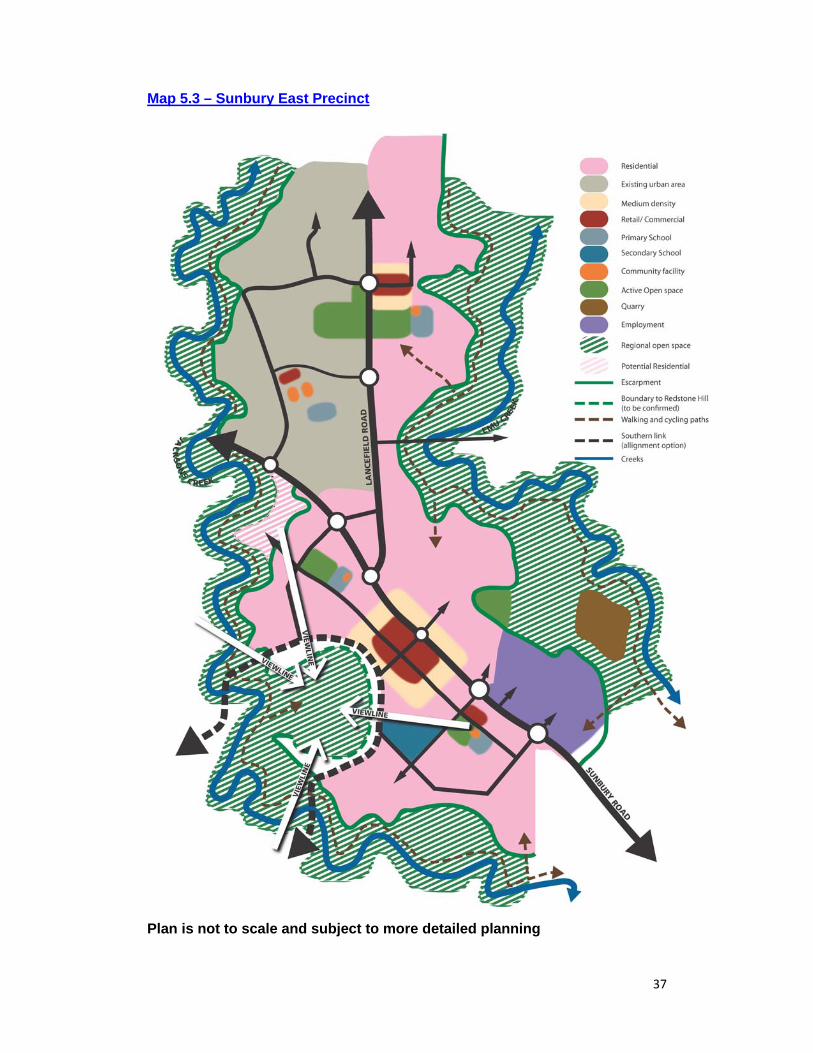
37
Map 5.3 – Sunbury East Precinct
Plan is not to scale and subject to more detailed planning
38
Sunbury Road and Lancefield Road will be upgraded to support the additional traffic but will be controlled to reduce any sense of division between communities and be designed to enable safe and easy pedestrian and cycle movements across them, particularly near to the activity centres. High frequency bus services will run along these streets and connect this precinct with the Sunbury Town Centre, and train stations further north, and Melbourne Airport and Northern Melbourne to the south. Additional local services will run on connector streets within the residential areas and provide more local access to schools and the activity centres. The new Southern Link road will connect this precinct with Sunbury South and provide a direct vehicular, public transport and cycling connection to the Jackson’s Hill Train Station as well as connection to the Calder Freeway. It too will be designed to minimise any physical or psychological barrier to connectivity between communities and to provide safe and easy movement across it by pedestrians. The final alignment of the Southern Link through this precinct will be determined through the further work outlined above in Section 4.2 and in the Delivery and Infrastructure Strategy. Regional Parks along Jacksons Creek and Emu Creek will provide high quality accessible open space and conservation areas in this precinct with walking and cycling trails along the top of the escarpments and along the creeks. The Redstone Hilltop Park will be connected to the Jacksons Hill Regional Park and will provide a large high quality passive open space area that allows the local community and wider Sunbury to enjoy wide ranging views across Sunbury and the wider area. As the quarry is rehabilitated this area could form part of the Regional Park network in Sunbury. Smaller neighbourhood parks and active sporting reserves will provide more local and active open space opportunities and be spaced to ensure the majority of the new community have good access to open space. Roads will be aligned to enable the visual connections to Redstone Hill from the Sunbury Bulla Road and from the areas to the north. Land between Jacksons Creek and Redstone Hill on the west will remain undeveloped to retain views from Jacksons Creek and Jacksons Hill and retain the landscape connection between Redstone Hill and Jacksons Creek. Building heights, landscaping and the extent of development on the slopes of Redstone Hill will be controlled to protect the dominance and visual qualities of Redstone Hill. Development interfacing the escarpment of both Jacksons Creek and Emu Creek will be set back and be restricted in height to minimise the visual impact, particularly when viewed from these creeks. Further Work Develop a Redstone Hilltop Park Master Plan to determine and guide:
o The scale and nature of conservation, passive and active open space and the associated management arrangements;
o The suitability of a community facility(s) or sports facility(s) within the park; o The suitability of development on the eastern slopes of the hill; o How the park is accessed and connected to the Jacksons Creek Regional
Park and surrounding residential areas; and o The appropriate landscaping, road and path network.
See Further Work in Section 4.2 on Regional Parks and Southern Link. Strategies
39
To develop this precinct in accordance with the Vision, Objectives and Spatial Structure for Sunbury, the following strategies will be pursued in Sunbury South East: Require that the Precinct Structure Plans (or equivalent) and development
proposals for this Precinct are generally in accordance with this Spatial Strategy and Map 5.3.
Advocate and deliver the infrastructure and development required for the precinct in accordance with the Delivery and Infrastructure Strategy.
Advocate that the Growth Areas Infrastructure Contribution (GAIC) levied as part of development of this precinct be utilised in accordance with the Delivery and Infrastructure Strategy.
Transport To ensure that Sunbury Bulla Road, Lancefield Road and the Southern Link enable appropriate vehicular flows through this precinct whilst enabling connected and walkable neighbourhoods with well designed and efficient public transport, walking and cycling, the following strategies will be pursued in Sunbury South East: Promote the design of Sunbury Bulla Road and Lancefield Road:
o To be no more than 4 lanes with dedicated off road pedestrian and cycling lanes;
o With intersections no more than 500m apart unless traffic analysis shows this to be unsuitable;
o With signalised pedestrian crossings that enable appropriate pedestrian and cycling connectivity to employment area and activity centres, schools and community facilities;.
o To be suitable for high frequency bus services with bus priority measures at intersections where appropriate;
o With landscaping treatments that reflect the existing rural character of Sunbury’s primary roads and provide an appropriate main street experience; and
o With service roads only where necessary.
Promote the Southern Link to: o Be no more than 4 lanes with off road pedestrian and cycling lanes and no
service lanes unless traffic analysis shows this to be unsuitable; o Have intersections at no more than 200m and signalised pedestrian
crossings that enable safe access to activity centres, schools and community facilities; and
o Form the main street of the Major Activity (MAC) unless traffic volumes require it to be bypass the centre.
Plan for a bus interchange at the MAC off the Sunbury Bulla Road to enable good connectivity between the local and principal bus services.
Plan for and promote a hierarchy of pedestrian and cyclist friendly non arterial roads comprising: o Bus ready connector streets with off road walking and cycling paths to link
residents directly to the MAC and the other smaller centres, schools and active open space; and
o Safe local access streets with shared spaces where appropriate.
40
Require a strong pedestrian connection between the Local Activity Centre (LAC) in the south and the employment land..
Require that destination areas such as activity centres, open space reserves, community facilities, schools and public transport nodes are linked by convenient, safe and direct walking and cycling infrastructure. Provide these links within areas of public open space where appropriate.
Activity Centres
To maintain the primacy of Sunbury Town Centre whilst enabling a vibrant, popular and well designed MAC and convenient, viable and busy smaller centres, the following strategies will be pursued in Sunbury South East: Plan for new activity centres, schools, community facilities and active sports
reserves generally in the locations shown in Map 5.3 to ensure good connectivity between activity centres and community facilities.
Plan for the MAC to be planned and developed: o initially to meet the local needs of this precinct only and be no larger than
15,000 sqm comprising up to 2 supermarkets (one or both full line), speciality shops, food and drink premises and 5,000 sqm of office.
o in the longer term to meet a broader range of needs of the entire eastern side of Sunbury and to be no larger than 25,000 sq.m with limited large format retail uses.
Plan for the following floorspace limits in the other activity centres: o Small NAC – 7,000 sqm comprising a medium sized supermarket,
speciality shops, food and drink premises and office o Goonawarra Activity Centre and southern LAC – 2,500 sqm comprising a
small supermarket, speciality shops, food and drink premises and office Require any proposal for retail floor space above these limits to be
accompanied by a retail impact assessment that addresses the following: o The impact the increased development will have on the Sunbury Town
Centre and other existing or proposed centres; and o The impact that development will have on the provision of services and
amenities within a walkable catchment for surrounding neighbourhoods. Require residential development within and in the 400m surrounding the
MAC to be a mix of housing types, including town houses and apartments, and achieve a minimum overall density of 25 d.p.h unless this is shown to be unviable.
Require the Main Street of the MAC to be orientated toward Redstone Hill to maximise the physical and visual connectivity to Redstone Hill.
Require Urban Design Framework Plans (or equivalent guidance) for each activity centre showing: o A street based centre with active street frontages; o The location and scale of retail, office, community, residential and other
uses; o The potential scale and height of building in different locations and how
this helps provide legibility to the centre and the precinct; o The road and public transport network and the parking approach and how
this encourages pedestrian and cyclist friendly activity centres; and o How residential development is integrated into the built form..
41
Open Space To maximise the community access and enjoyment of Sunbury’s unique landscape and to provide good access to a high quality range of open space, the following strategies will be pursued in Sunbury South East: Require development to accord with the future Redstone Hill Masterplan. Require walking and cycling paths within the setback from the escarpment of
Jacksons Creek and Emu Creek as part of new developments. Plan for drainage lines and creeks as open space corridors to connect
residents with the Emu Creek and Jacksons Creek Regional Parks. Require a public open space and walking and cycling link between Jacksons
Creek and Emu Creek along the southern boundary of the precinct. Require all district sports reserves to be 10.25ha and be accompanied by a
sports pavilion. Require neighbourhood parks of 0.75ha to be located throughout the
residential areas to ensure the majority of the precinct is within 500m of open space.
Design
To minimise the visual intrusion of new development on Sunbury’s landscape and to protect the rural qualities of the Sunbury Bulla Road and Lancefield Road entry into Sunbury, the following strategies will be pursued: Require that no development be permitted on the western side of Redstone
Hill to maintain the visual connection to Redstone Hill from Jacksons Hill and maintain the landscape connectivity between Redstone Hill and Jacksons Creek.
Require new buildings to be: o No more than 2 stories when fronting the escarpment or Redstone Hill; o No more than 4 stories throughout the remainder of the precinct; o Set back a minimum of 100m from the edge of the Jacksons Creek and
Emu Creek escarpment unless a smaller distance can be shown to have no visual impact on the views from the creek valleys and accommodate needs for fire protection, passive open space and walking and cycling opportunities; and
o Below the contour(s) identified in the Redstone Hill Masterplan. Promote a cross section for Sunbury Bulla Road and Lancefield Road that
allows for a rural landscaping outcome to be achieved Require a specific urban design and landscape strategy for the employment
area showing: o How the rural feel along Sunbury Bulla Road will be retained; and o How the visual impact of the development from the surrounding rural
areas will been mitigated. Promote streets that provide direct views to Redstone Hill and enable visual
connectivity with Redstone Hill from Sunbury Bulla Road and elsewhere within the precinct.
Require that development fronts all roads and public open space.
42
Employment To meet the quantum and diversity of jobs sought in Sunbury and build upon the recycling opportunities presented by the Green Waste facility, the following strategies are required in Sunbury South East: Require proposals in the employment area to enable a range of office
industrial, and transport and logistics uses for a range of local businesses and larger regional businesses with the emphasis on local businesses prior to the construction of the Outer Metropolitan Ring.
Support proposals for recycling facilities that complement the Green Waste Facility subject to appropriate measures to address traffic, amenity and other concerns.
Explore the opportunity to develop an industrial ecology precinct in the area that builds upon the quarry and green waste activities.
43
5.4. Sunbury North East The Current Sunbury North East Precinct Sunbury’s North East Precinct is bounded by Jacksons Creek to the east, Emu Creek to the west, the future Sunbury East precinct to the south and rural areas to the north. Lancefield Road and the Melbourne-Bendigo rail line run north-south and divide the precinct into three linear sections. The precinct’s access to the rest of Sunbury is via Lancefield Road with Jacksons Creek and its escarpment currently limiting more direct access. The precinct is relatively remote from the existing Sunbury urban area with rural uses predominating and providing sweeping views towards the hilltops of Sunbury and surrounding distant mountain ranges. There is an area of large lots north of Rolling Meadows that would suitable for further planned subdivision as part of a wider development area. Jacksons Creek, Emu Creek, along with their associated escarpments and tributaries provide significant landscape and environmental features. Jacksons Creek escarpment is a particularly prominent feature when viewed from Emu Bottom Wetlands and Racecourse Road. A large area of land in the middle of the precinct is of environmental and landscape significance and is zoned Rural Conservation Zone (RCZ) and offers the potential to achieve a well defined east-west landscape and biodiversity corridor between the two creeks. The Future Sunbury North East Precinct The Sunbury North East Precinct will be Sunbury’s last residential development front and provide a community of approximately 8,500 to 9,500 dwellings. An upgraded Lancefield Road and a new Northern Link will provide the main vehicular access to and from the precinct, providing access to the Sunbury Town Centre. As in the Sunbury South East precinct, these roads will be of a scale to reduce the creation of a barrier between communities and designed to enable convenient pedestrian and cycle movement across these roads, particularly near activity centres. The final alignment of the Northern Link through this precinct will be determined through the detailed work outlined in Section 4.2 and the Delivery and Infrastructure Strategy. Two train stations will enable residents to travel by public transport to the Sunbury Town Centre and inner Melbourne, with an orbital bus route providing high frequency bus services and further transport options to the town centre and other parts of Sunbury. Additional local services will run on connector streets within the residential areas and provide more local access to schools and the activity centres. Residents will enjoy convenient access to retail, leisure, community, education, and health services via a range of activity centres situated throughout the precinct to provide a walkable distance for residents to these uses. A large Neighbourhood Activity Centre (NAC) located in the south of the precinct adjoining one of the new stations will provide for the focus for the community in this precinct and their local retail and community needs. Adjoining it will be large scale regional facilities for the Sunbury and wider area that cannot be
44
accommodated within the Sunbury Town Centre and are not needed until the longer term. This may include a hospital (or equivalent) and a university/TAFE (or equivalent) if more preferred locations are not pursued. This large NAC will be co-located with the new train station and orbital bus route to support this transport hub and to allow the wider Sunbury area to benefit from public transport access to the regional facilities adjoining this centre. A Neighbourhood Activity Centre (NAC) will be co-located with the northern train station and two Local Activity Centres (LAC) will be located on the eastern side of the precinct to provide residents with walkable access to convenience retail and services. High and medium density housing, principally in the form of town houses and apartments, will be provided in and around these activity centres, particularly the large NAC to signal the presence of more intense activity and to maximise the benefit of proximate retail and services at these centres. Regional Parks along Jacksons Creek and Emu Creek with associated walking and cycling routes along the creeks and escarpments will provide residents with an accessible and attractive place to enjoy and experience Sunbury’s significant landscape, while at the same time protecting these significant landscape and environmental features. An east-west reserve in the middle of this precinct will protect significant environmental features while also providing an open space linkage to the Jacksons and Emu Creek Regional Parks. Other open space links and walking and cycling routes will connect people to these areas and activity centre, providing an integrated network of open space. Smaller neighbourhood parks and active sporting reserves will provide more local and active open space opportunities and be spaced to ensure the majority of the new community are within a walkable distance to open space. Roads and open spaces will be designed to enable views through the precinct to the surrounding hilltops and mountain ranges. Development will be setback from escarpments and buildings near escarpments will be of a lower height to ensure the Jacksons and Emu Creek escarpments remain dominant features in the landscape, particularly when viewed from the creek corridors and vantage points such as Emu Bottom Wetlands and Racecourse Road. Further Work See Further Work in Section 4.2 on Regional Parks and the Northern Link. Develop a more detailed plan for the large open space and conservation
reserve in the heart of this precinct to confirm: o The scale and nature of conservation, passive and active open space
and the associated management arrangements; o How it integrates with a potential future regional sports facility; o How the park is accessed and connected to the Jacksons Creek and
Emu Creek Regional Park and surrounding residential areas; and o The appropriate landscaping, road and path network.
Strategies To develop this precinct in accordance with the Vision, Objectives and the Spatial Structure for Sunbury, the following strategies will be pursued in Sunbury North East:
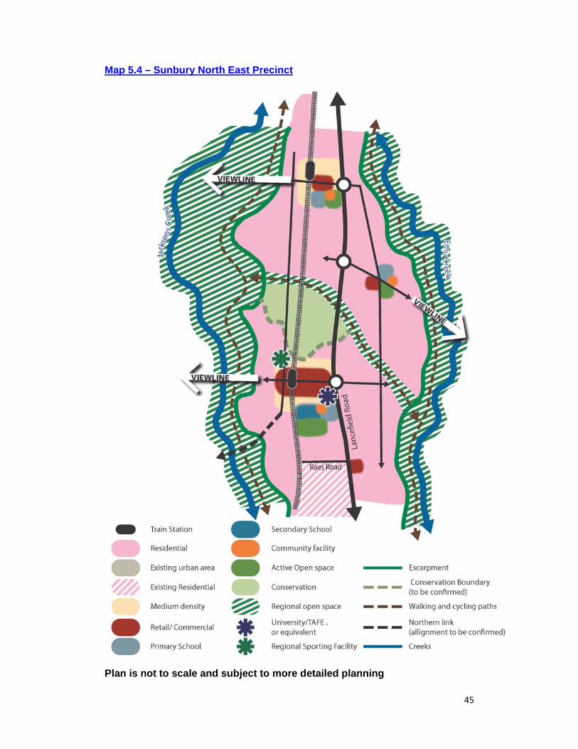
45
Map 5.4 – Sunbury North East Precinct
Plan is not to scale and subject to more detailed planning
46
Transport To achieve efficient vehicular movement through the precinct while also enabling connected and walkable neighbourhoods with well designed public transport, walking and cycling, the following strategies will be pursued in Sunbury North East: Promote the design of Lancefield Road to:
Be no more than 4 lanes with off road pedestrian and cycling lanes. This can be reduced to 2 lanes in the north of the precinct;
Provide intersections no more than 500m apart unless traffic analysis shows this to be unsuitable;.
Provide signalised pedestrian crossings that enable appropriate pedestrian and cycling connectivity to activity centres, schools and community facilities;
Be suitable for high frequency bus services with bus priority measures at intersections where appropriate;
Include landscaping treatments and development setbacks that reflect the existing rural character of Sunbury’s primary roads; and
Have service roads only where necessary. Promote the design of the Northern Link to:
Be no more than 4 lanes with off road pedestrian and cycling lanes and no service lanes;
Provide intersections at no more than 200m and signalised pedestrian crossings that enable safe access to activity centres, schools and community facilities; and
Have a grade separated rail crossing. Advocate for the provision of two new train stations and a high frequency
public transport service linking this precinct to Sunbury Road and the Town Centre.
Plan for a bus interchange at the large Neighbourhood Activity Centre (NAC) that provides connectivity between the local and principal bus services.
Plan for and promote a hierarchy of pedestrian and cyclist friendly non arterial roads comprising: o Bus ready connector streets with off road walking and cycling paths to link
residents directly to activity centres, schools and active open space; and o Safe local access streets with shared spaces where appropriate
Require that destination areas such as activity centres, open space reserves, community facilities, schools and public transport nodes are linked by convenient, safe and direct walking and cycling infrastructure. Provide these links within areas of public open space where appropriate.
Work with VicTrack in designing walking and cycling links along the rail line, linking urban areas of Sunbury in the south with new activity centres within this precinct.
Activity Centres To maintain the primacy of Sunbury Town Centre whilst enabling vibrant, popular and well designed centres near to where people live the following strategies are required:
47
Plan for new activity centres, schools, community facilities and active sports reserves generally in the locations shown at Map 5.4.
Plan for the following floor space requirements in activity centres: o Large Neighbourhood Activity Centre (NAC)– 15,000 sqm comprising 2
supermarkets (one or both full line), speciality retail, food and drink premises, office, and community uses
o Small Neighbourhood Activity Centre (NAC) – 7,000 sqm comprising a full line supermarket, speciality retail, food and drink and office.
o Local Activity Centre (LAC) – 2,500 sqm comprising a small supermarket, speciality retail, food and drink and office.
Require any proposal for retail floor space above these limits must be accompanied by a retail capacity and economic impact assessment that addresses the following:
o The impact the increased development will have on the Sunbury Town Centre and other existing or proposed centres.
o The impact that development will have on the provision of services and amenities within a walkable catchment for surrounding neighbourhoods.
Require that land within or proximate to the large NAC be reserved for a hospital, (or equivalent) university/TAFE (or equivalent) until preferred sites are developed.
Require that land within or proximate to the Large NAC be reserved for a regional scale outdoor sporting complex and a large scale indoor sports facility, subject to a further needs analysis for these facilities and alternative sites being developed.
Require that residential development located on land within and in the 400m surrounding the NACs include a range of dwelling types and achieve a minimum density of 25 dwellings per hectare.
Require the NACs be designed and developed in coordination with the Northern Train Stations to facilitate transit orientated development
Require Urban Design Framework Plans (or equivalent guidance) for each activity centre showing: o A street based centre with active street frontages; o The location and scale of retail, commercial, community, residential,
education and other uses; o The potential scale and height of buildings in different locations and how
this helps provide legibility to the centre and the precinct; o The road, public transport and walking cycling network and the parking
approach and how this integrates with the train stations and encourages walkable, pedestrian and cycle friendly activity;
o How residential development is integrated into the centre; and o How development will be integrated with the grade separated rail crossing
(where appropriate). Open Space To maximise the community access and enjoyment of Sunbury’s unique landscape and to provide good access to a range of open space, the following strategies are required: Require walking and cycling paths within the setback from the escarpment of
Jacksons Creek and Emu Creek as part of new developments;
48
Plan for drainage lines, creeks and areas of conservation as open space corridors to connect residents with the Emu Creek and Jacksons Creek Regional Parks;
Plan for an open space walking and cycling link along the rail line linking the existing rail reserve to the south with new activity centres in the north.
Plan for an open space link that provides an east-west walking and cycling connection between the Jacksons and Emu Creek Regional Parks.
Plan for public open space links that connect residents to key destination areas. Unencumbered open space where appropriate must be provided to complete this network.
Require all district sports reserves to be 10.25ha and sub district sports open space to be 5ha and both be accompanied by a sports pavilion
Require neighbourhood parks of 0.75ha to be located throughout the residential areas to ensure the majority of the precinct is within 500m of open space;
Design To minimise the visual intrusion of new development on Sunbury’s landscape, particularly the dominance of the creek escarpments from vantage points along the creek corridor, Emu Bottom Wetlands and Racecourse Road and to protect the rural qualities of the entries into Sunbury, the following strategies are required: Require the design of roads and open space to be aligned to create viewing
corridors towards Mount Holden, Mount Macedon and the distant hilltops and mountain ranges.
Require that the design of escarpment reserves does not restrict views towards Mt Holden and distant mountain ranges and landscape features.
Require that new buildings: o Be limited to 2 storeys for development fronting escarpments; and \ o Have a minimum setback of 100m from the edge of the Jacksons Creek
and Emu Creek escarpments unless a smaller distance can be shown to have no visual impact on the views from the creek valleys and accommodate needs for fire protection, passive open space and and walking and cycling opportunities.
Require that development fronts all roads and public open space

49
5.5. Sunbury North The Current Sunbury North Precinct The Sunbury North Precinct is bounded by Riddell Road to the south, Jacksons Creek to the east and rural areas to the north and west. Existing conventional, low density and rural residential development predominate, with limited retail or local services in the area. The area is largely developed with residential development planned for remaining land at the Canterbury Hills estate and the Council land at Racecourse Road. The northern part of this precinct contains rolling topography with numerous hilltops and ridgelines that are critical in defining the northern edge of Sunbury and the rural outlook from existing developed areas, particularly from the Sunbury Town Centre and from land to the south and east of Sunbury. Some dwellings within the Canterbury Hills estate have been developed on steep slopes creating a poor visual outcome in this precinct. The hilltops, ridgeline and the land beyond comprise areas susceptible to significant erosion and areas of native vegetation significance and currently have significant land management problems. Council adopted a Master Plan for 275 Racecourse Road at its Council meeting on 22 February 2010. To implement the Master Plan, a planning scheme amendment will be required to rezone the land which is expected in 2012. The Future Sunbury North Precinct The Sunbury North Precinct will remain a predominantly residential area comprising a mixture of rural, semi-rural, sub urban and urban housing. The visually prominent ridgeline in this precinct will provide a strong landscape and rural northern edge to Sunbury. Limited rural living will be permitted beyond this ridgeline where this enables the preservation of native vegetation, the prevention of erosion, public access to this area, and does not impact on the visual qualities of the area. A new Local Activity Centre (LAC) off Elizabeth Drive and upgraded community facilities will ensure that residents also have convenient access to day-to-day needs including a medium sized supermarket. Elizabeth Drive and the Northern Link will provide vehicle and public transport access to higher order facilities and services in the Sunbury Town Centre and a Major Activity Centre (MAC) in Sunbury’s north-east. Land in the east of the precinct is currently zoned Rural Conservation Zone (RCZ) but maybe partially developed to enable the delivery of the Northern Link. Further Work Undertake further investigations on land zoned Rural Conservation Zone
(shown as Conservation Area on Map 5.5) to determine: o The extent of environmental constraints; o The required mechanisms to ensure the provision of the Northern Link;
and o The mechanisms to ensure the provision of an open space link from
Sunbury Town Centre to Emu Bottom Wetland.
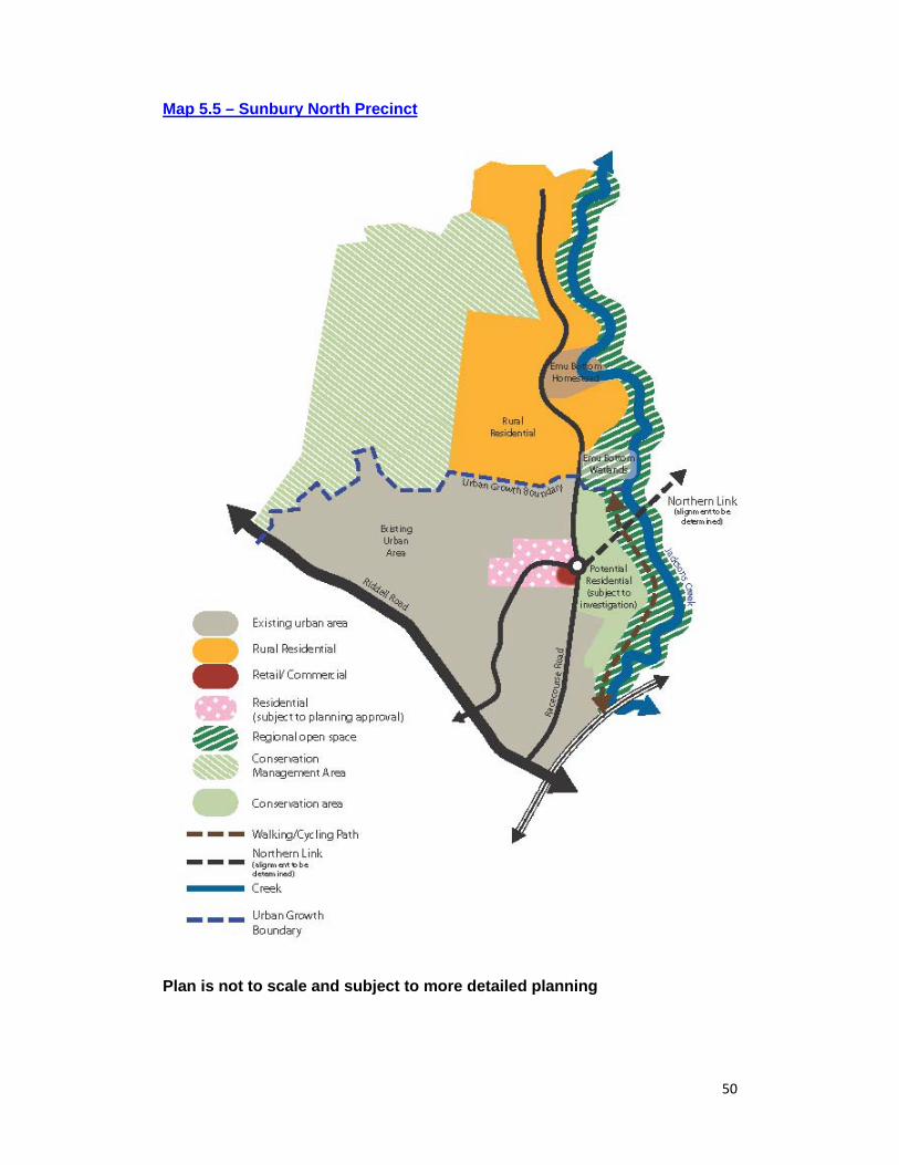
50
Map 5.5 – Sunbury North Precinct
Plan is not to scale and subject to more detailed planning
51
Strategies To develop this precinct in accordance with the Vision, Objectives and Spatial Structure for Sunbury, the following strategies will be pursued in Sunbury North: Require that any development proposals for this Precinct are generally in
accordance with this Spatial Strategy and Map 5.5. Rezone 275 Racecourse Road to implement the masterplan for Racecourse
Road. Plan for a Local Activity Centre (LAC) generally in the location shown on Map
5.5 with a retail floorspace limit of 5,000 sqm for a medium sized supermarket and additional space for specialty retail, restaurant and café uses.
Require any proposal for retail floor space above these limits must be accompanied by a retail capacity and economic impact assessment that addresses the following:
The impact the increased development will have on the Sunbury Town Centre and other existing or proposed centres.
The impact that development will have on the provision of services and amenities within a walkable catchment for surrounding neighbourhoods.
To extend Elizabeth Drive through to Racecourse Road and to connect with the Northern Link through the development of the Council land at Racecourse Road To maintain the strong visual, landscape and rural northern edge to Sunbury and to enable improved protection and public access to the areas of landscape, native vegetation and erosion beyond, the following strategies will be pursued: Limit urban development to the current Urban Growth Boundary. Support development proposals on land shown as Conservation
Management Area on Map 5.5 currently zoned Green Wedge A (GWAZ), that provide the following key components: o Development located beyond the hilltops and ridgeline. o No adverse impact on the visual significance of the area from key vantage
points. This should be supported by a visual and landscape impact assessment.
o A minimum average lot size of 1 hectare and a minimum lot size of 0.8 hectares.
o An assessment of erosion issues and how these issues will be addressed. o A high quality conservation and land management outcome. o An extension to the Sunbury public open space network.
52
5.6. Central Sunbury Precinct The Current Central Sunbury Precinct The Central Sunbury Precinct is bounded by Shields Street/Mitchells Lane to the south, Elizabeth Drive to the west, Jacksons Creek to the east and Riddell Road/Racecourse Road to the north. Gap Road, Riddell Road, Vineyard Road, and Macedon Street provide the main vehicular access to this precinct, with the Melbourne-Bendigo train line running north-south through the precinct. This precinct is the primary focus for activity in Sunbury with the traditional and vibrant Town Centre providing shops, schools, employment opportunities, restaurants, cafes, community facilities, leisure and transport facilities all located within approximately 400m of the Sunbury train station. The remainder the precinct comprises predominately residential development with a mix of attractive older dwellings and newer unit development close to the Town Centre and more conventional dwellings in the outer area. There is also an area of industrial land in Horne Street which comprises a mix of uses. It is the oldest part of Sunbury and has many historic and rich townscape qualities such as wide streetscapes, generous footpaths with continuous verandahs in the retail core, mature tree plantings, pedestrian laneways, historic buildings and glimpses of the surrounding hilltops. These all contribute to what is described as Sunbury’s country town character. The traditional main streets of Evans Street, Brook Street and O’Shanassy Street with their collection of fine grain buildings, active frontages, generous public realm and strong connection to the railway station are the core of the Town Centre. This highly attractive, walkable and pedestrian friendly core is surrounded by developments on Horne Street and Station Street that are less well defined and include a range of large format retail, service stations and light industrial. The area to the west of the railway line is particularly disconnected from the central walkable core by the rail line with poor pedestrian connectivity. Macedon Street contains a number of civic uses and is a highly attractive boulevard type entrance into the heart of Sunbury. Vehicle movement through the centre is currently problematic, due to the wider Sunbury area having to utilise the two rail crossings in the Town Centre for cross town movement. This coupled with poorly located car parking, a limited amount of commuter parking at the station and limited pedestrian connectivity across the rail line results in queuing traffic in the centre at peak times. The Future Central Sunbury Precinct The Central Sunbury Precinct will remain the primary centre of activity in Sunbury and offer higher order retail, community, leisure and office facilities and over time some housing. This may include a university/TAFE (or equivalent), a hospital (or equivalent), a library and learning centre and a performing arts centre. New developments, particularly on the western side of the railway line will increase the scale and range of development in the Sunbury Town Centre and
53
help to better define its boundaries. The core of the centre will retain its character whilst intensifying through additional above ground floor uses. Over time the Sunbury Town Centre will become the focus for more high street fashion uses and be a place where people will predominantly walk or cycle. Additional parking will be provided on the perimeter of this core with people encouraged to utilize these car parks and walk to their destination. The current Sunbury Town Centre Plan guides the future development of the town centre, including a number of actions for streetscape improvements which are underway. The principles and actions developed in the Sunbury Town Centre Plan remain relevant and will be updated to enable a larger scale of development. Further Work Review and update the Sunbury Town Centre Plan in consultation with the
Sunbury community. Develop design guidelines to ensure that future development protects and
respects views to significant landscape features. Explore further possible locations for a potential university/TAFE (or
equivalent) and hospital (or equivalent). Strategies To maintain the primacy of Sunbury Town Centre and enable development which meets many of the higher order shopping, community, leisure, entertainment and employment needs of the Sunbury community, the following strategies will be pursued: Plan for the following within the Sunbury Town Centre:
o A minimum of 90,000 sqm of retail floor space; o A minimum of 40,000 sqm of office and commercial floorspace; o Additional leisure, eating and drinking opportunities; and o Additional and enlarged community facilities including: a library and
learning centre, enlarged youth centre, enlarged community health facilities.
Safeguard land for a hospital (or equivalent) and university/TAFE (or equivalent).
Prepare and implement a Parking Precinct Plan for the Sunbury Town Centre.
Continue implementation of the (updated) Sunbury Town Centre Plan. Work with the Department of Transport to investigate a better design solution
for the station pedestrian overpass and the potential for a bus interchange on the western side of the train station.
To enable a better use of land in the immediate proximity to Sunbury Town Centre and the Sunbury Train Station the following strategy will be pursued: Support the rezoning of industrial land on Horne Street and Station Street for
uses appropriate in an edge of town centre location where this does not result in an unacceptable displacement of existing businesses.

54
5.7. Diggers Rest The Current Diggers Rest Precinct The Diggers Rest Precinct is located within the Shire of Melton and is bordered by the Calder Freeway to the north, the Melbourne-Bendigo Railway line to the east, Diggers Rest-Coimadai Road to the south and rural land to the east. The Melbourne Airport Environs Overlay applies to the southern boundary of the precinct. The Diggers Rest township is situated to the east of the precinct along the western boundary of the rail line adjacent to the Diggers Rest station. The township is small in size with a population of approximately 1,800 people, with limited retail and community facilities which include a government primary school, a maternal and child health centre, a pre-school facility, a community hall, a recreation reserve and some lower order retail stores such as a small grocery store. The township’s limited size has resulted in an insufficient population to support extensive retail opportunities and a range of Council services, which has resulted in residents of Diggers Rest being reliant on Sunbury and to a lesser extent Melton for many of its goods and services. The remainder of the precinct consists of relatively flat rural land, interspersed with a few dwellings and copses of vegetation, providing views to Bald Hill in Sunbury and long ranging views to distant mountain ranges. A tributary of Kororoit Creek runs north-east through this rural area. While the Diggers Rest Precinct is outside the jurisdiction of Hume City Council, it has a significant relationship with Sunbury, most importantly its physical connection via Vineyard Road and its reliance on Sunbury for services. The Future Diggers Rest Precinct The Diggers Rest Precinct Structure Plan was approved in June 2012 sets the future direction for the planning of the Diggers Rest Precinct and seeks to expand the community and provide a new local town centre and some local employment. The local centre will offer local level retail and community opportunities, including a full-line supermarket previously lacking in Digger Rest. Business and employment opportunities will be provided to the south along Diggers Rest–Coimadai Road. Hume City Council supports the vision for the Diggers Rest Precinct, in particular the expansion of the township to provide the community with vital retail and community services. Hume City Council believes that the land immediately adjoining the Calder Freeway should have been developed for employment uses with a focus on transport and logistics and light industrial development to broaden the employment offer for the future of both the Diggers Rest and Sunbury communities. It would therefore support such amendments to the Diggers Rest PSP.
55
Strategies Work with Melton Shire Council to promote the employment area at Diggers
Rest for a range of local and regional industrial, business and transport and logistics companies
Promote the ultimate design of Vineyard Road to be a maximum of 4 lanes with good walking and cycling provision unless traffic analysis shows 6 lanes are required.
56
6. Monitoring and Review This Spatial Strategy includes strategies and further work required to meet the Vision and Objectives that have been developed to guide the development of Sunbury over the coming 30 years. By monitoring the Strategy over time it will be possible to determine whether these strategies and the further work are achieving the Vision and Objectives, and whether the strategies need to be amended or new strategies developed. Table 6.1 below contains the monitoring indicators that will be used and the frequency of the monitoring for each indicator. Many of the indicators relate to the timely provision of infrastructure and refer to the Delivery and Infrastructure Strategy that outlines in more detail the proposed timing and delivery of development and infrastructure. As outlined in that Strategy, should critical infrastructure such as the Bulla Bypass or Southern Link not be delivered the Strategy will need to be revised. A Monitoring Report will be prepared every 2 years based on these indicators and report any minor amendments to the Spatial Strategy. A more comprehensive review of the Spatial Strategy will be undertaken every 10 years or sooner if required.
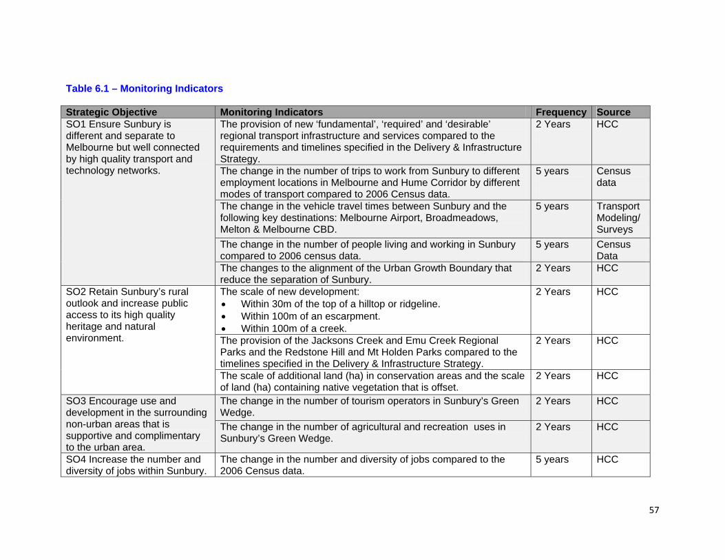
57
Table 6.1 – Monitoring Indicators Strategic Objective Monitoring Indicators Frequency Source SO1 Ensure Sunbury is different and separate to Melbourne but well connected by high quality transport and technology networks.
The provision of new ‘fundamental’, ‘required’ and ‘desirable’ regional transport infrastructure and services compared to the requirements and timelines specified in the Delivery & Infrastructure Strategy.
2 Years
HCC
The change in the number of trips to work from Sunbury to different employment locations in Melbourne and Hume Corridor by different modes of transport compared to 2006 Census data.
5 years
Census data
The change in the vehicle travel times between Sunbury and the following key destinations: Melbourne Airport, Broadmeadows, Melton & Melbourne CBD.
5 years Transport Modeling/ Surveys
The change in the number of people living and working in Sunbury compared to 2006 census data.
5 years Census Data
The changes to the alignment of the Urban Growth Boundary that reduce the separation of Sunbury.
2 Years
HCC
SO2 Retain Sunbury’s rural outlook and increase public access to its high quality heritage and natural environment.
The scale of new development: Within 30m of the top of a hilltop or ridgeline. Within 100m of an escarpment. Within 100m of a creek.
2 Years
HCC
The provision of the Jacksons Creek and Emu Creek Regional Parks and the Redstone Hill and Mt Holden Parks compared to the timelines specified in the Delivery & Infrastructure Strategy.
2 Years
HCC
The scale of additional land (ha) in conservation areas and the scale of land (ha) containing native vegetation that is offset.
2 Years
HCC
SO3 Encourage use and development in the surrounding non-urban areas that is supportive and complimentary to the urban area.
The change in the number of tourism operators in Sunbury’s Green Wedge.
2 Years
HCC
The change in the number of agricultural and recreation uses in Sunbury’s Green Wedge.
2 Years
HCC
SO4 Increase the number and diversity of jobs within Sunbury.
The change in the number and diversity of jobs compared to the 2006 Census data.
5 years HCC
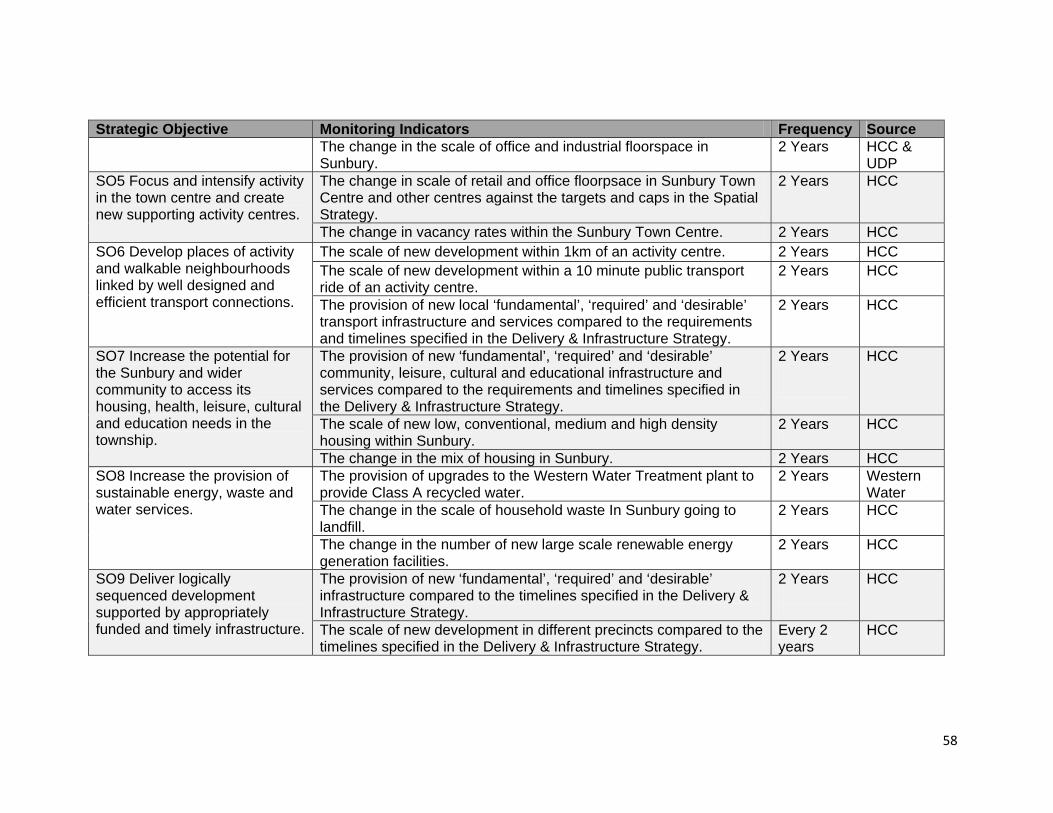
58
Strategic Objective Monitoring Indicators Frequency Source The change in the scale of office and industrial floorspace in Sunbury.
2 Years
HCC & UDP
SO5 Focus and intensify activity in the town centre and create new supporting activity centres.
The change in scale of retail and office floorpsace in Sunbury Town Centre and other centres against the targets and caps in the Spatial Strategy.
2 Years HCC
The change in vacancy rates within the Sunbury Town Centre. 2 Years HCC SO6 Develop places of activity and walkable neighbourhoods linked by well designed and efficient transport connections.
The scale of new development within 1km of an activity centre. 2 Years HCC The scale of new development within a 10 minute public transport ride of an activity centre.
2 Years HCC
The provision of new local ‘fundamental’, ‘required’ and ‘desirable’ transport infrastructure and services compared to the requirements and timelines specified in the Delivery & Infrastructure Strategy.
2 Years
HCC
SO7 Increase the potential for the Sunbury and wider community to access its housing, health, leisure, cultural and education needs in the township.
The provision of new ‘fundamental’, ‘required’ and ‘desirable’ community, leisure, cultural and educational infrastructure and services compared to the requirements and timelines specified in the Delivery & Infrastructure Strategy.
2 Years
HCC
The scale of new low, conventional, medium and high density housing within Sunbury.
2 Years
HCC
The change in the mix of housing in Sunbury. 2 Years HCC SO8 Increase the provision of sustainable energy, waste and water services.
The provision of upgrades to the Western Water Treatment plant to provide Class A recycled water.
2 Years
Western Water
The change in the scale of household waste In Sunbury going to landfill.
2 Years
HCC
The change in the number of new large scale renewable energy generation facilities.
2 Years
HCC
SO9 Deliver logically sequenced development supported by appropriately funded and timely infrastructure.
The provision of new ‘fundamental’, ‘required’ and ‘desirable’ infrastructure compared to the timelines specified in the Delivery & Infrastructure Strategy.
2 Years
HCC
The scale of new development in different precincts compared to the timelines specified in the Delivery & Infrastructure Strategy.
Every 2 years
HCC