Embed Size (px)
Citation preview
HURRICANE ANDREW AND LOUISIANA’S COAST
WRITTEN BY
National Biological ServiceSouthern Science Center
Lafayette, Louisiana
‘Current AddressNational Biological Service
Northern Prairie Science CenterJamestown, North Dakota
PRODUCED BY
II
Louisiana State UniversityBaton Rouge, Louisiana
and162
National Biological Service{afayette, Louisiana
National Sea Grant DepositoryPell Library Building - GSOUniversity of Rhode Island
Narragansett, RI 02882-1197USA
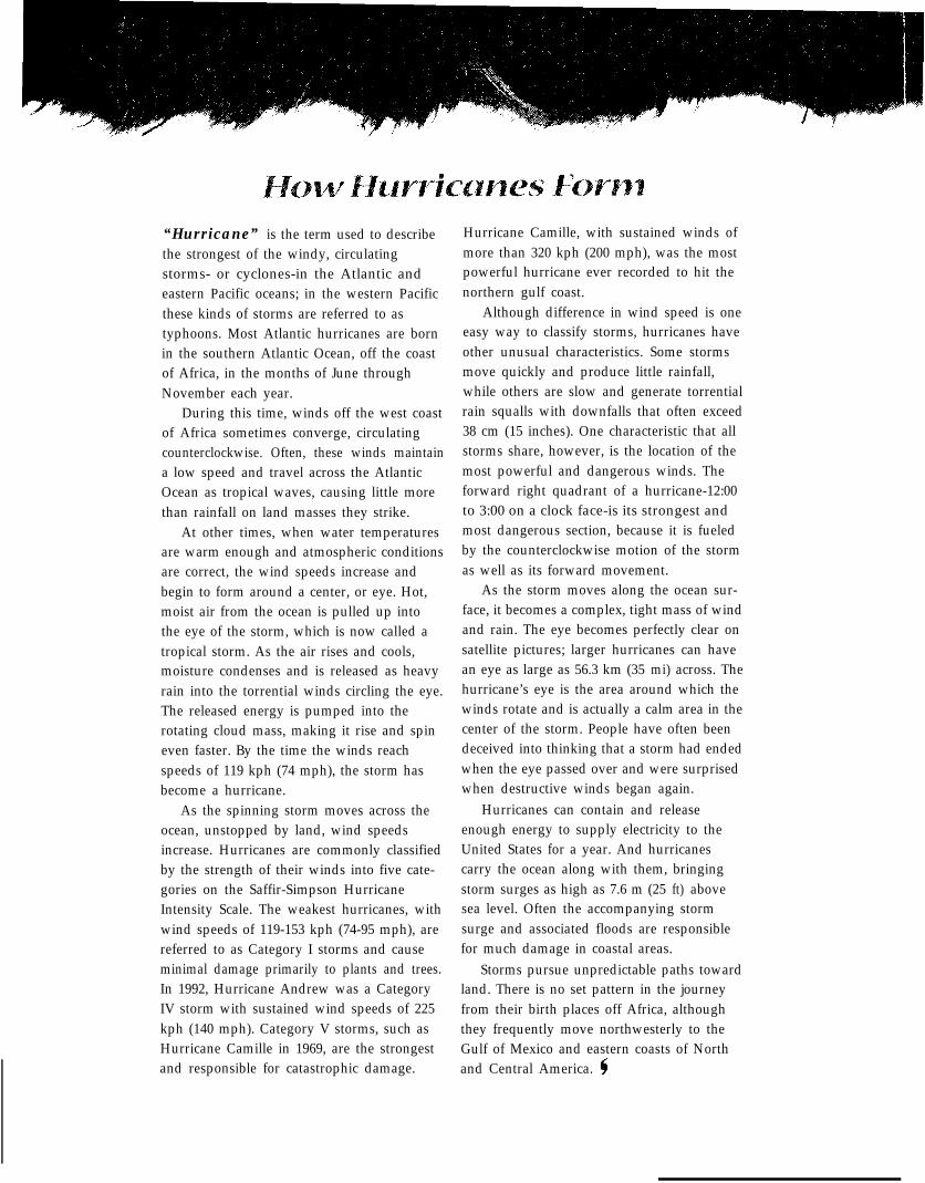
“Hurricane” is the term used to describethe strongest of the windy, circulatingstorms- or cyclones-in the Atlantic andeastern Pacific oceans; in the western Pacificthese kinds of storms are referred to astyphoons. Most Atlantic hurricanes are bornin the southern Atlantic Ocean, off the coastof Africa, in the months of June throughNovember each year.
During this time, winds off the west coastof Africa sometimes converge, circulatingcounterclockwise. Often, these winds maintaina low speed and travel across the AtlanticOcean as tropical waves, causing little morethan rainfall on land masses they strike.
At other times, when water temperaturesare warm enough and atmospheric conditionsare correct, the wind speeds increase andbegin to form around a center, or eye. Hot,moist air from the ocean is pulled up intothe eye of the storm, which is now called atropical storm. As the air rises and cools,moisture condenses and is released as heavyrain into the torrential winds circling the eye.The released energy is pumped into therotating cloud mass, making it rise and spineven faster. By the time the winds reachspeeds of 119 kph (74 mph), the storm hasbecome a hurricane.
As the spinning storm moves across theocean, unstopped by land, wind speedsincrease. Hurricanes are commonly classifiedby the strength of their winds into five cate-gories on the Saffir-Simpson HurricaneIntensity Scale. The weakest hurricanes, withwind speeds of 119-153 kph (74-95 mph), arereferred to as Category I storms and causeminimal damage primarily to plants and trees.In 1992, Hurricane Andrew was a CategoryIV storm with sustained wind speeds of 225kph (140 mph). Category V storms, such asHurricane Camille in 1969, are the strongestand responsible for catastrophic damage.
Hurricane Camille, with sustained winds ofmore than 320 kph (200 mph), was the mostpowerful hurricane ever recorded to hit thenorthern gulf coast.
Although difference in wind speed is oneeasy way to classify storms, hurricanes haveother unusual characteristics. Some stormsmove quickly and produce little rainfall,while others are slow and generate torrentialrain squalls with downfalls that often exceed38 cm (15 inches). One characteristic that allstorms share, however, is the location of themost powerful and dangerous winds. Theforward right quadrant of a hurricane-12:00to 3:00 on a clock face-is its strongest andmost dangerous section, because it is fueledby the counterclockwise motion of the stormas well as its forward movement.
As the storm moves along the ocean sur-face, it becomes a complex, tight mass of windand rain. The eye becomes perfectly clear onsatellite pictures; larger hurricanes can havean eye as large as 56.3 km (35 mi) across. Thehurricane’s eye is the area around which thewinds rotate and is actually a calm area in thecenter of the storm. People have often beendeceived into thinking that a storm had endedwhen the eye passed over and were surprisedwhen destructive winds began again.
Hurricanes can contain and releaseenough energy to supply electricity to theUnited States for a year. And hurricanescarry the ocean along with them, bringingstorm surges as high as 7.6 m (25 ft) abovesea level. Often the accompanying stormsurge and associated floods are responsiblefor much damage in coastal areas.
Storms pursue unpredictable paths towardland. There is no set pattern in the journeyfrom their birth places off Africa, althoughthey frequently move northwesterly to theGulf of Mexico and eastern coasts of Northand Central America.
A Fierce Storm
n mid-August 1992, television andradio audiences were alerted to apotentially damaging hurricane
that had formed in the Atlantic Ocean.Satellite imagery showed a largeswirling mass of clouds rotating aroundan area of low pressure and headingtoward the continental United States.
On August 24, this hurricane struckthe eastern coast of Florida, passedover the Florida peninsula, entered theGulf of Mexico, and moved north-westerly until it slammed into theLouisiana coast on August 26.Hurricane Andrew, as it was namedby the National Weather Service,caused over $27 billion worth of dam-age in Florida and Louisiana. It wasnot only the costliest storm to strike
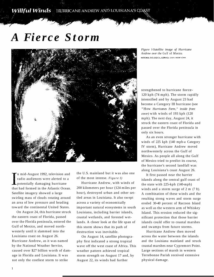
the U.S. mainland but it was also oneof the most intense. Figure 1)
Hurricane Andrew, with winds of200 kilometers per hour (124 miles perhour), destroyed urban and other set-tled areas in Louisiana. It also sweptacross a variety of economicallyimportant natural ecosystems in southLouisiana, including barrier islands,coastal wetlands, and forested wet-lands. A closer look at the life span ofthis storm shows that its path ofdestruction was inevitable.
On August 14, satellite photogra-phy first indicated a strong tropicalwave off the west coast of Africa. Thisweather pattern achieved tropicalstorm strength on August 17 and, byAugust 22, its winds had further
Figure l-Satellite image of HurricaneAndrew over the Gulf of Mexico.
strengthened to hurricane force-120 kph (74 mph). The storm rapidlyintensified and by August 23 hadbecome a Category III hurricane (see“How Hurricanes Form,” inside frontcover) with winds of 193 kph (120mph). The next day, August 24, itstruck the eastern coast of Florida andpassed over the Florida peninsula inonly six hours.
As an even stronger hurricane withwinds of 225 kph (140 mph-a CategoryIV storm), Hurricane Andrew movednorthwesterly across the Gulf ofMexico. As people all along the Gulfof Mexico tried to predict its course,the hurricane’s second landfall wasalong Louisiana’s coast August 26.
It first passed near the barrierislands along the central gulf coast ofthe state with 225-kph (140-mph)winds and a storm surge of 2 m (7 ft).A combination of these winds and theresulting strong waves and storm surgeeroded 30-40 percent of Raccoon Islandas well as the western arm of WhiskeyIsland. This erosion reduced the sig-nificant protection that those barrierislands could offer to coastal marshesand swamps from future storms.
Hurricane Andrew then movedacross the water between the islandsand the Louisiana mainland and struckcoastal marshes near Cypremort Point.Large sections of marsh in westernTerrebonne Parish received extensivephysical damage.
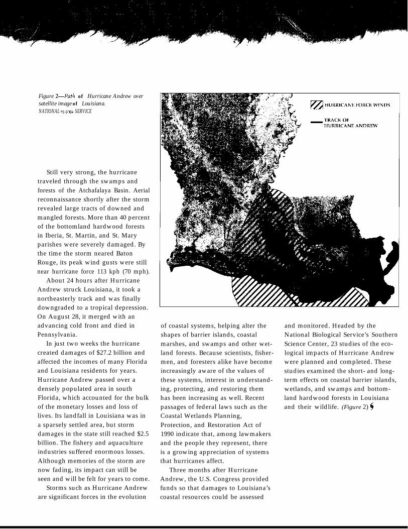
Figure Z-Path of Hurricane Andrew oversatellite image of Louisiana.NATIONAL l3lOLOGlCAL SERVICE
Still very strong, the hurricanetraveled through the swamps andforests of the Atchafalaya Basin. Aerialreconnaissance shortly after the stormrevealed large tracts of downed andmangled forests. More than 40 percentof the bottomland hardwood forestsin Iberia, St. Martin, and St. Maryparishes were severely damaged. Bythe time the storm neared BatonRouge, its peak wind gusts were stillnear hurricane force 113 kph (70 mph).
About 24 hours after HurricaneAndrew struck Louisiana, it took anortheasterly track and was finallydowngraded to a tropical depression.On August 28, it merged with anadvancing cold front and died inPennsylvania.
In just two weeks the hurricanecreated damages of $27.2 billion andaffected the incomes of many Floridaand Louisiana residents for years.Hurricane Andrew passed over adensely populated area in southFlorida, which accounted for the bulkof the monetary losses and loss oflives. Its landfall in Louisiana was ina sparsely settled area, but stormdamages in the state still reached $2.5billion. The fishery and aquacultureindustries suffered enormous losses.Although memories of the storm arenow fading, its impact can still beseen and will be felt for years to come.
Storms such as Hurricane Andreware significant forces in the evolution
of coastal systems, helping alter the and monitored. Headed by theNational Biological Service’s SouthernScience Center, 23 studies of the eco-logical impacts of Hurricane Andrewwere planned and completed. Thesestudies examined the short- and long-term effects on coastal barrier islands,wetlands, and swamps and bottom-land hardwood forests in Louisianaand their wildlife. (Figure 2) (
shapes of barrier islands, coastalmarshes, and swamps and other wet-land forests. Because scientists, fisher-men, and foresters alike have becomeincreasingly aware of the values ofthese systems, interest in understand-ing, protecting, and restoring themhas been increasing as well. Recentpassages of federal laws such as theCoastal Wetlands Planning,Protection, and Restoration Act of1990 indicate that, among lawmakersand the people they represent, thereis a growing appreciation of systemsthat hurricanes affect.
Three months after HurricaneAndrew, the U.S. Congress providedfunds so that damages to Louisiana’scoastal resources could be assessed
Barrier Islands
the outermost land exposed tohurricanes, barrier islands often
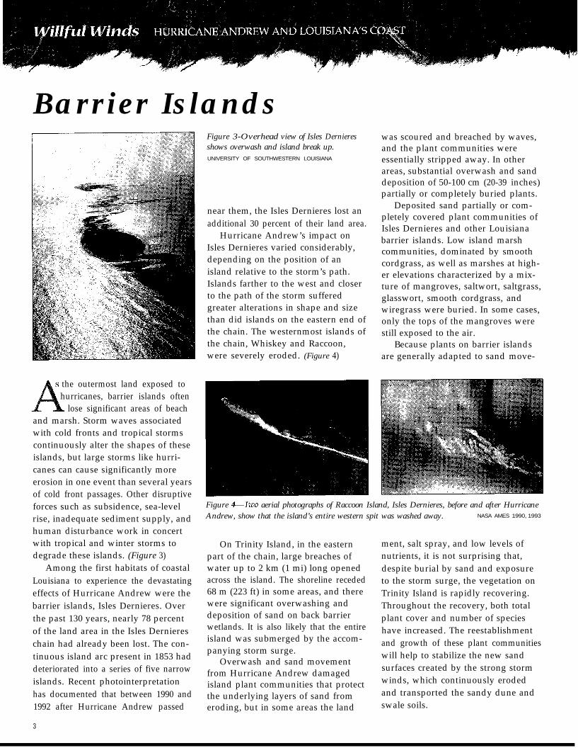
lose significant areas of beachand marsh. Storm waves associatedwith cold fronts and tropical stormscontinuously alter the shapes of theseislands, but large storms like hurri-canes can cause significantly moreerosion in one event than several yearsof cold front passages. Other disruptiveforces such as subsidence, sea-levelrise, inadequate sediment supply, andhuman disturbance work in concertwith tropical and winter storms todegrade these islands. (Figure 3)
Among the first habitats of coastalLouisiana to experience the devastatingeffects of Hurricane Andrew were thebarrier islands, Isles Dernieres. Overthe past 130 years, nearly 78 percentof the land area in the Isles Derniereschain had already been lost. The con-tinuous island arc present in 1853 haddeteriorated into a series of five narrowislands. Recent photointerpretationhas documented that between 1990 and1992 after Hurricane Andrew passed
3
Figure 3-Overhead view of Isles Dernieresshows overwash and island break up.UNIVERSITY OF SOUTHWESTERN LOUISIANA
near them, the Isles Dernieres lost anadditional 30 percent of their land area.
Hurricane Andrew’s impact onIsles Dernieres varied considerably,depending on the position of anisland relative to the storm’s path.Islands farther to the west and closerto the path of the storm sufferedgreater alterations in shape and sizethan did islands on the eastern end ofthe chain. The westernmost islands ofthe chain, Whiskey and Raccoon,were severely eroded. (Figure 4)
was scoured and breached by waves,and the plant communities wereessentially stripped away. In otherareas, substantial overwash and sanddeposition of 50-100 cm (20-39 inches)partially or completely buried plants.
Deposited sand partially or com-pletely covered plant communities ofIsles Dernieres and other Louisianabarrier islands. Low island marshcommunities, dominated by smoothcordgrass, as well as marshes at high-er elevations characterized by a mix-ture of mangroves, saltwort, saltgrass,glasswort, smooth cordgrass, andwiregrass were buried. In some cases,only the tops of the mangroves werestill exposed to the air.
Because plants on barrier islandsare generally adapted to sand move-
Figure &Two aerial photographs of Raccoon Island, Isles Dernieres, before and after HurricaneAndrew, show that the island’s entire western spit was washed away. NASA AMES 1990, 1993
On Trinity Island, in the easternpart of the chain, large breaches ofwater up to 2 km (1 mi) long openedacross the island. The shoreline receded68 m (223 ft) in some areas, and therewere significant overwashing anddeposition of sand on back barrierwetlands. It is also likely that the entireisland was submerged by the accom-panying storm surge.
Overwash and sand movementfrom Hurricane Andrew damagedisland plant communities that protectthe underlying layers of sand fromeroding, but in some areas the land
ment, salt spray, and low levels ofnutrients, it is not surprising that,despite burial by sand and exposureto the storm surge, the vegetation onTrinity Island is rapidly recovering.Throughout the recovery, both totalplant cover and number of specieshave increased. The reestablishmentand growth of these plant communitieswill help to stabilize the new sandsurfaces created by the strong stormwinds, which continuously erodedand transported the sandy dune andswale soils.
When Hurricane Andrew carriedbeach sand across Trinity Island anddeposited it on the back barrier wet-land plant communities, it createdhabitats with environmental conditionsdifferent from those present before thestorm. Changes in salinity and eleva-tion resulted in a redistribution ofplant species. For instance, increasedelevation from sand depositioncaused a shift in species dominancefrom smooth cordgrass to wiregrass.Mangroves disappeared from highersites but became established in thesaltier lower sites.
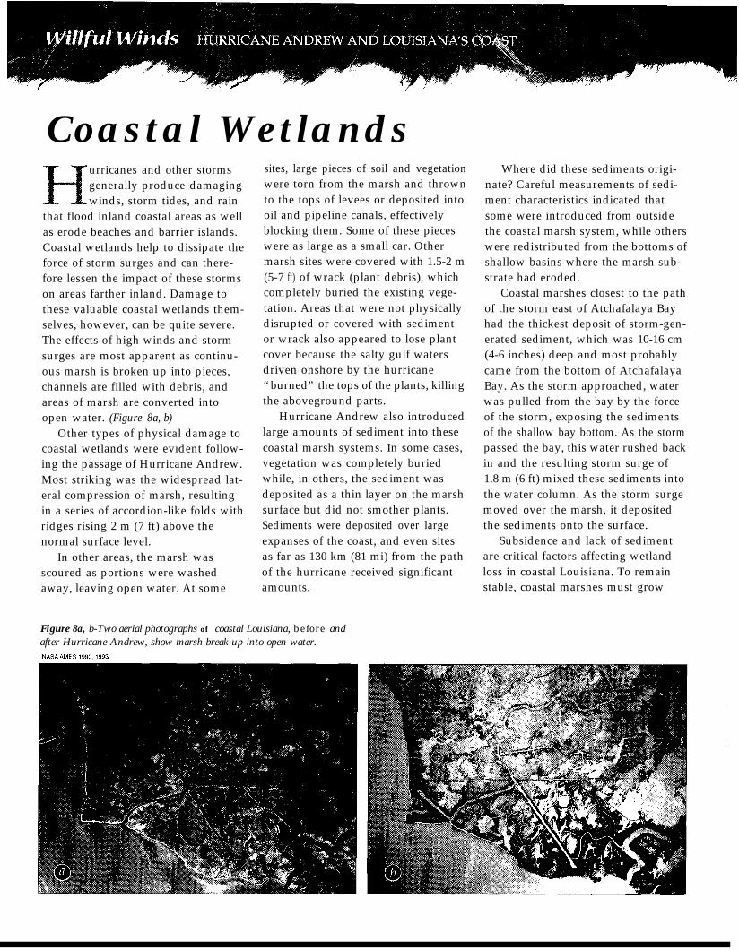
Many barren areas had still notrecovered from the hurricane threeyears later. Most recovery occurredwhen new shoots grew from the run-ners of adult plants that had survivedthe storm. Because runners have togrow from adult plants, barren areas
Figure 5-Revegetation of barrier islandsthrough runner growth of plants that survivedthe storm. NATIONAL BIOLOGICAL SERVICE
distant from surviving vegetation willtake a long time to regain plant cover.In addition, damage to new growthby nutria has been noted. This herbi-vore can damage new shoots and mayplay a major role in the future estab-lishment of vegetation. (Figure 5)
Dispersal and germination byseeds on Trinity Island were minimal,
NOVEMBER 1993
MARCH 1994
NOVEMBER 1994
CLASS Nov. ‘93
n Bare Dunes 3 .58 4 7R 3.69Beach 24.33 68.39 54.50Flat/Beach Bar 4.20 5.70 6.77
n Salt Marsh 59.75 57.55 61.59
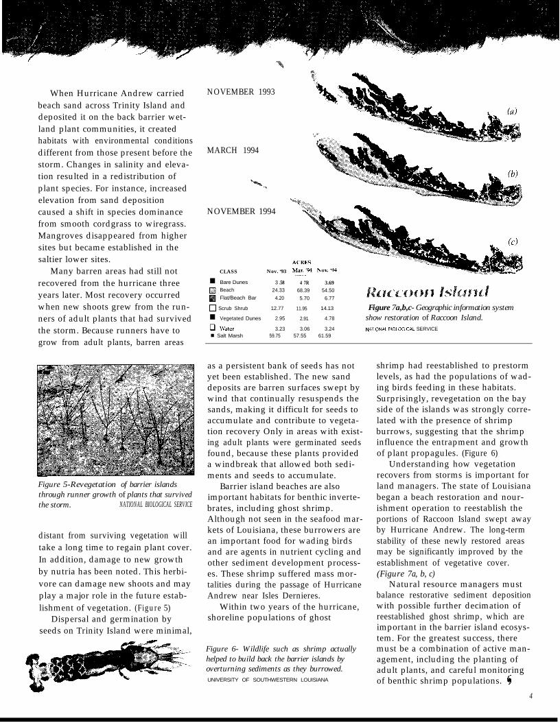
0 sScrub Shrub 12.77 11.95 14.13 Figure 7a,b,c- Geographic information systemn Vegetated Dunes 2.95 2.91 4.78 show restoration of Raccoon Island.q Water 3.23 3.06 3.24 NATlONAL BlOLOGlCAL SERVICE
as a persistent bank of seeds has notyet been established. The new sanddeposits are barren surfaces swept bywind that continually resuspends thesands, making it difficult for seeds toaccumulate and contribute to vegeta-tion recovery Only in areas with exist-ing adult plants were germinated seedsfound, because these plants provideda windbreak that allowed both sedi-ments and seeds to accumulate.
Barrier island beaches are alsoimportant habitats for benthic inverte-brates, including ghost shrimp.Although not seen in the seafood mar-kets of Louisiana, these burrowers arean important food for wading birdsand are agents in nutrient cycling andother sediment development process-es. These shrimp suffered mass mor-talities during the passage of HurricaneAndrew near Isles Dernieres.
Within two years of the hurricane,shoreline populations of ghost
Figure 6- Wildlife such as shrimp actuallyhelped to build back the barrier islands byoverturning sediments as they burrowed.UNIVERSITY OF SOUTHWESTERN LOUISIANA
shrimp had reestablished to prestormlevels, as had the populations of wad-ing birds feeding in these habitats.Surprisingly, revegetation on the bayside of the islands was strongly corre-lated with the presence of shrimpburrows, suggesting that the shrimpinfluence the entrapment and growthof plant propagules. (Figure 6)
Understanding how vegetationrecovers from storms is important forland managers. The state of Louisianabegan a beach restoration and nour-ishment operation to reestablish theportions of Raccoon Island swept awayby Hurricane Andrew. The long-termstability of these newly restored areasmay be significantly improved by theestablishment of vegetative cover.(Figure 7a, b, c)
Natural resource managers mustbalance restorative sediment depositionwith possible further decimation ofreestablished ghost shrimp, which areimportant in the barrier island ecosys-tem. For the greatest success, theremust be a combination of active man-agement, including the planting ofadult plants, and careful monitoringof benthic shrimp populations.
4
Coastal Wetlandsurricanes and other stormsgenerally produce damagingwinds, storm tides, and rain
that flood inland coastal areas as wellas erode beaches and barrier islands.Coastal wetlands help to dissipate theforce of storm surges and can there-fore lessen the impact of these stormson areas farther inland. Damage tothese valuable coastal wetlands them-selves, however, can be quite severe.The effects of high winds and stormsurges are most apparent as continu-ous marsh is broken up into pieces,channels are filled with debris, andareas of marsh are converted intoopen water. (Figure 8a, b)
Other types of physical damage tocoastal wetlands were evident follow-ing the passage of Hurricane Andrew.Most striking was the widespread lat-eral compression of marsh, resultingin a series of accordion-like folds withridges rising 2 m (7 ft) above thenormal surface level.
In other areas, the marsh wasscoured as portions were washedaway, leaving open water. At some
sites, large pieces of soil and vegetationwere torn from the marsh and thrownto the tops of levees or deposited intooil and pipeline canals, effectivelyblocking them. Some of these pieceswere as large as a small car. Othermarsh sites were covered with 1.5-2 m(5-7 ft) of wrack (plant debris), whichcompletely buried the existing vege-tation. Areas that were not physicallydisrupted or covered with sedimentor wrack also appeared to lose plantcover because the salty gulf watersdriven onshore by the hurricane“burned” the tops of the plants, killingthe aboveground parts.
Hurricane Andrew also introducedlarge amounts of sediment into thesecoastal marsh systems. In some cases,vegetation was completely buriedwhile, in others, the sediment wasdeposited as a thin layer on the marshsurface but did not smother plants.Sediments were deposited over largeexpanses of the coast, and even sitesas far as 130 km (81 mi) from the pathof the hurricane received significantamounts.
Where did these sediments origi-nate? Careful measurements of sedi-ment characteristics indicated thatsome were introduced from outsidethe coastal marsh system, while otherswere redistributed from the bottoms ofshallow basins where the marsh sub-strate had eroded.
Coastal marshes closest to the pathof the storm east of Atchafalaya Bayhad the thickest deposit of storm-gen-erated sediment, which was 10-16 cm(4-6 inches) deep and most probablycame from the bottom of AtchafalayaBay. As the storm approached, waterwas pulled from the bay by the forceof the storm, exposing the sedimentsof the shallow bay bottom. As the stormpassed the bay, this water rushed backin and the resulting storm surge of1.8 m (6 ft) mixed these sediments intothe water column. As the storm surgemoved over the marsh, it depositedthe sediments onto the surface.
Subsidence and lack of sedimentare critical factors affecting wetlandloss in coastal Louisiana. To remainstable, coastal marshes must grow
Figure 8a, b-Two aerial photographs of coastal Louisiana, before andafter Hurricane Andrew, show marsh break-up into open water.
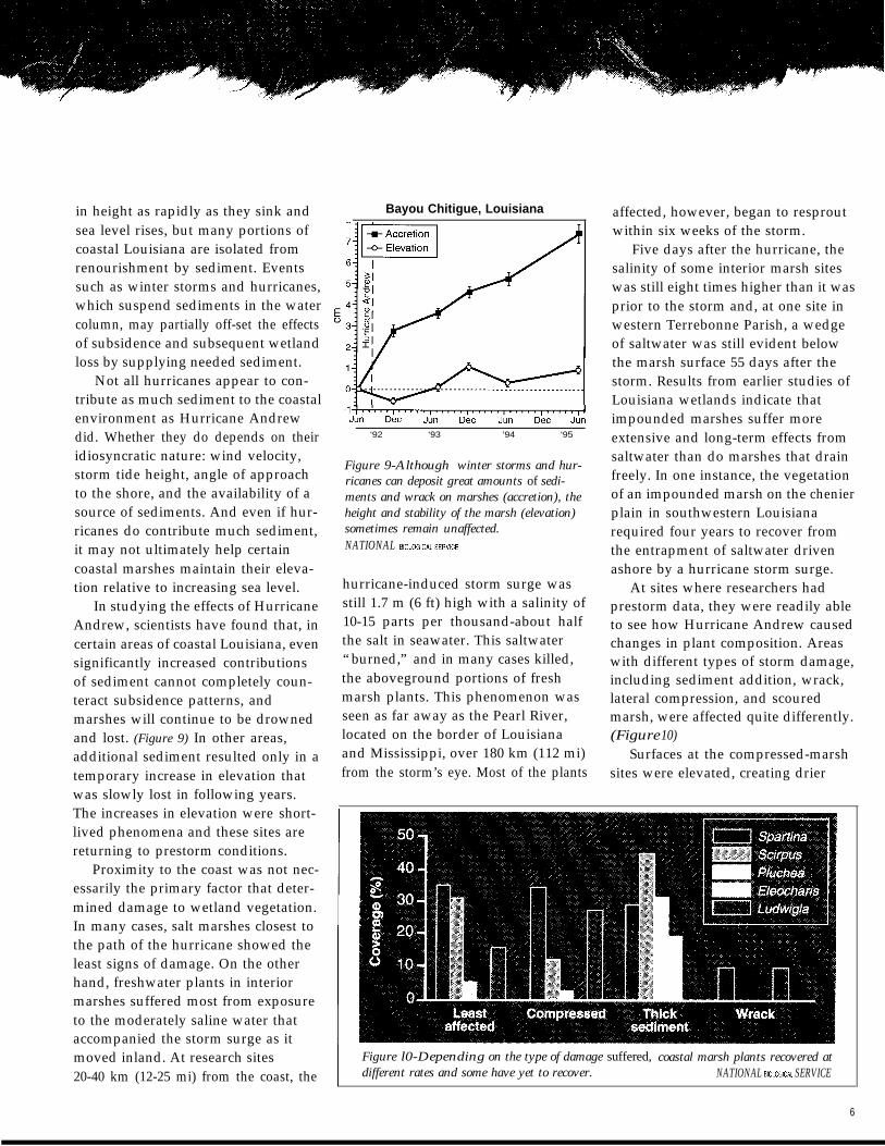
in height as rapidly as they sink andsea level rises, but many portions ofcoastal Louisiana are isolated fromrenourishment by sediment. Eventssuch as winter storms and hurricanes,which suspend sediments in the watercolumn, may partially off-set the effectsof subsidence and subsequent wetlandloss by supplying needed sediment.
Not all hurricanes appear to con-tribute as much sediment to the coastalenvironment as Hurricane Andrewdid. Whether they do depends on theiridiosyncratic nature: wind velocity,storm tide height, angle of approachto the shore, and the availability of asource of sediments. And even if hur-ricanes do contribute much sediment,it may not ultimately help certaincoastal marshes maintain their eleva-tion relative to increasing sea level.
In studying the effects of HurricaneAndrew, scientists have found that, incertain areas of coastal Louisiana, evensignificantly increased contributionsof sediment cannot completely coun-teract subsidence patterns, andmarshes will continue to be drownedand lost. (Figure 9) In other areas,additional sediment resulted only in atemporary increase in elevation thatwas slowly lost in following years.The increases in elevation were short-lived phenomena and these sites arereturning to prestorm conditions.
Proximity to the coast was not nec-essarily the primary factor that deter-mined damage to wetland vegetation.In many cases, salt marshes closest tothe path of the hurricane showed theleast signs of damage. On the otherhand, freshwater plants in interiormarshes suffered most from exposureto the moderately saline water thataccompanied the storm surge as itmoved inland. At research sites20-40 km (12-25 mi) from the coast, the
Bayou Chitigue, Louisiana
-l:..~...,.....,.....,.....,.....,.....,rJUll DW JW DlX JLln DW JLNl
‘92 ‘93 ‘94 ‘95
Figure 9-Although winter storms and hur-ricanes can deposit great amounts of sedi-ments and wrack on marshes (accretion), theheight and stability of the marsh (elevation)sometimes remain unaffected.NATIONAL BKXOGICAL SER”,CE
hurricane-induced storm surge wasstill 1.7 m (6 ft) high with a salinity of10-15 parts per thousand-about halfthe salt in seawater. This saltwater“burned,” and in many cases killed,the aboveground portions of freshmarsh plants. This phenomenon wasseen as far away as the Pearl River,located on the border of Louisianaand Mississippi, over 180 km (112 mi)from the storm’s eye. Most of the plants
affected, however, began to resproutwithin six weeks of the storm.
Five days after the hurricane, thesalinity of some interior marsh siteswas still eight times higher than it wasprior to the storm and, at one site inwestern Terrebonne Parish, a wedgeof saltwater was still evident belowthe marsh surface 55 days after thestorm. Results from earlier studies ofLouisiana wetlands indicate thatimpounded marshes suffer moreextensive and long-term effects fromsaltwater than do marshes that drainfreely. In one instance, the vegetationof an impounded marsh on the chenierplain in southwestern Louisianarequired four years to recover fromthe entrapment of saltwater drivenashore by a hurricane storm surge.
At sites where researchers hadprestorm data, they were readily ableto see how Hurricane Andrew causedchanges in plant composition. Areaswith different types of storm damage,including sediment addition, wrack,lateral compression, and scouredmarsh, were affected quite differently.(Figure 10)
Surfaces at the compressed-marshsites were elevated, creating drier
Figure l0-Depending on the type of damage suffered, coastal marsh plants recovered atdifferent rates and some have yet to recover. NATIONAL BlOLOGlCAL SERVICE
6
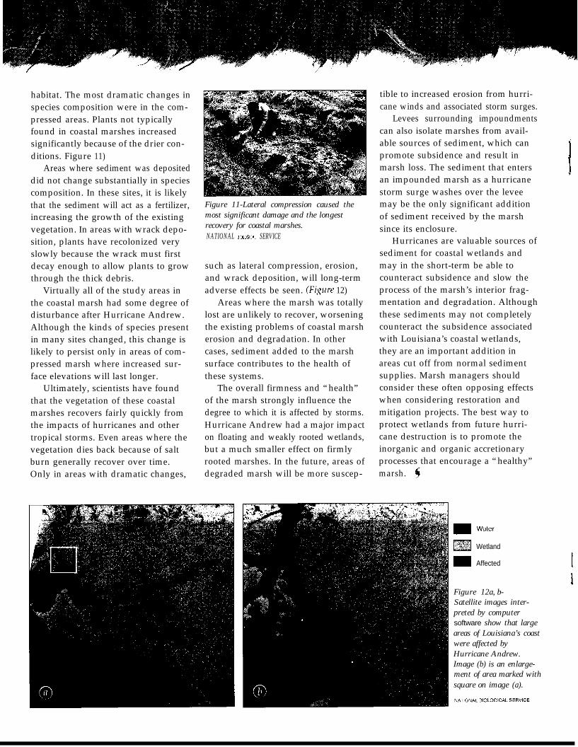
habitat. The most dramatic changes inspecies composition were in the com-pressed areas. Plants not typicallyfound in coastal marshes increasedsignificantly because of the drier con-ditions. Figure 11)
Areas where sediment was depositeddid not change substantially in speciescomposition. In these sites, it is likelythat the sediment will act as a fertilizer,increasing the growth of the existingvegetation. In areas with wrack depo-sition, plants have recolonized veryslowly because the wrack must firstdecay enough to allow plants to growthrough the thick debris.
Ultimately, scientists have foundthat the vegetation of these coastalmarshes recovers fairly quickly fromthe impacts of hurricanes and othertropical storms. Even areas where thevegetation dies back because of saltburn generally recover over time.Only in areas with dramatic changes,
Virtually all of the study areas inthe coastal marsh had some degree ofdisturbance after Hurricane Andrew.Although the kinds of species presentin many sites changed, this change islikely to persist only in areas of com-pressed marsh where increased sur-face elevations will last longer.
Figure 11-Lateral compression caused themost significant damage and the longestrecovery for coastal marshes.NATIONAL BlOLOGlCAL SERVICE
such as lateral compression, erosion,and wrack deposition, will long-termadverse effects be seen. 03pre 12)
The overall firmness and “health”of the marsh strongly influence the
Areas where the marsh was totallylost are unlikely to recover, worseningthe existing problems of coastal marsh
degree to which it is affected by storms.
erosion and degradation. In othercases, sediment added to the marsh
Hurricane Andrew had a major impact
surface contributes to the health ofthese systems.
on floating and weakly rooted wetlands,but a much smaller effect on firmlyrooted marshes. In the future, areas ofdegraded marsh will be more suscep-
tible to increased erosion from hurri-cane winds and associated storm surges.
Levees surrounding impoundmentscan also isolate marshes from avail-able sources of sediment, which canpromote subsidence and result inmarsh loss. The sediment that entersan impounded marsh as a hurricanestorm surge washes over the leveemay be the only significant additionof sediment received by the marshsince its enclosure.
Hurricanes are valuable sources ofsediment for coastal wetlands andmay in the short-term be able tocounteract subsidence and slow theprocess of the marsh’s interior frag-mentation and degradation. Althoughthese sediments may not completelycounteract the subsidence associatedwith Louisiana’s coastal wetlands,they are an important addition inareas cut off from normal sedimentsupplies. Marsh managers shouldconsider these often opposing effectswhen considering restoration andmitigation projects. The best way toprotect wetlands from future hurri-cane destruction is to promote theinorganic and organic accretionaryprocesses that encourage a “healthy”marsh.
Wetland
Affected
Figure 12a, b-Satellite images inter-preted by computersoftware show that largeareas of Louisiana’s coastwere affected byHurricane Andrew.Image (b) is an enlarge-ment of area marked withsquare on image (a).
-
Forested Wetlandsurricane Andrew diminishedin strength after it madelandfall east of Cypremort
Point. The storm turned to the north-northeast, passing over the AtchafalayaBasin where more than 450 km2 (174 mi’) of cypress-tupelo and bot-tomland hardwood forests were at risk.The storm stayed within the leveeboundaries with wind speeds graduallyweakening, but wind gusts of 112 kph(70 mph) were still recorded when thestorm was 48 km (30 mi) west ofBaton Rouge.
The Atchafalaya Basin contains 35percent of the remaining bottomlandhardwood forest and swamp forestsof the lower Mississippi floodplain.The two dominant forest-cover typesinclude cypress-tupelo swamps, pri-marily in the southeast part of thebasin, and mixed bottomland hard-wood forests. The southwest portionof the basin has been subjected to highrates of sedimentation since the con-struction of levees after the flood of1927 and the diversion of sediment-laden Mississippi River water. Theareas of new sediment are now domi-nated by black and sandbar willow,swamp cottonwood, and the exoticChinese tallow.
The impact of Hurricane Andrewvaried greatly with forest type, thespecies mixture, canopy (tree top)
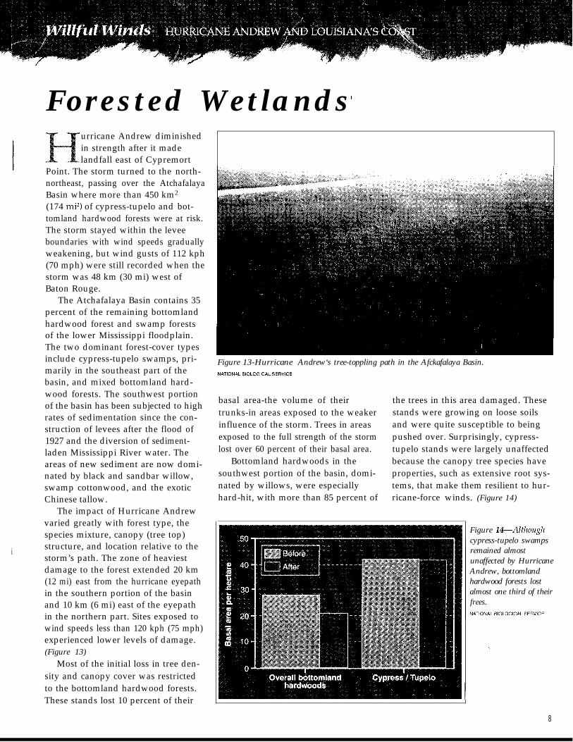
i structure, and location relative to thestorm’s path. The zone of heaviestdamage to the forest extended 20 km(12 mi) east from the hurricane eyepathin the southern portion of the basinand 10 km (6 mi) east of the eyepathin the northern part. Sites exposed towind speeds less than 120 kph (75 mph)experienced lower levels of damage.(Figure 13)
Most of the initial loss in tree den-sity and canopy cover was restrictedto the bottomland hardwood forests.These stands lost 10 percent of their
Figure 13-Hurricane Andrew‘s tree-toppling path in the Afckafalaya Basin.
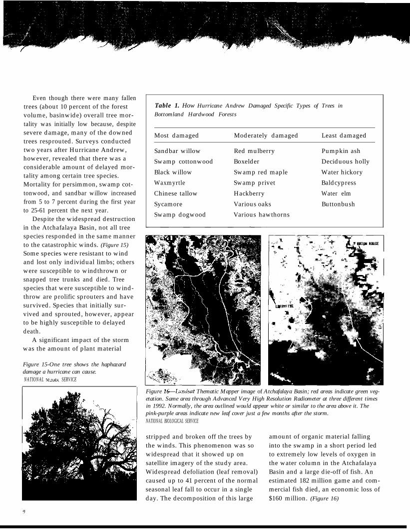
basal area-the volume of theirtrunks-in areas exposed to the weakerinfluence of the storm. Trees in areasexposed to the full strength of the stormlost over 60 percent of their basal area.
Bottomland hardwoods in thesouthwest portion of the basin, domi-nated by willows, were especiallyhard-hit, with more than 85 percent of
the trees in this area damaged. Thesestands were growing on loose soilsand were quite susceptible to beingpushed over. Surprisingly, cypress-tupelo stands were largely unaffectedbecause the canopy tree species haveproperties, such as extensive root sys-tems, that make them resilient to hur-ricane-force winds. (Figure 14)
Figure IPAlfkougkcypress-tupelo swampsremained almostunaffected by HurricaneAndrew, bottomlandhardwood forests lostalmost one third of theirfrees.
8
Even though there were many fallentrees (about 10 percent of the forestvolume, basinwide) overall tree mor-tality was initially low because, despitesevere damage, many of the downedtrees resprouted. Surveys conductedtwo years after Hurricane Andrew,however, revealed that there was aconsiderable amount of delayed mor-tality among certain tree species.Mortality for persimmon, swamp cot-tonwood, and sandbar willow increasedfrom 5 to 7 percent during the first yearto 25-61 percent the next year.
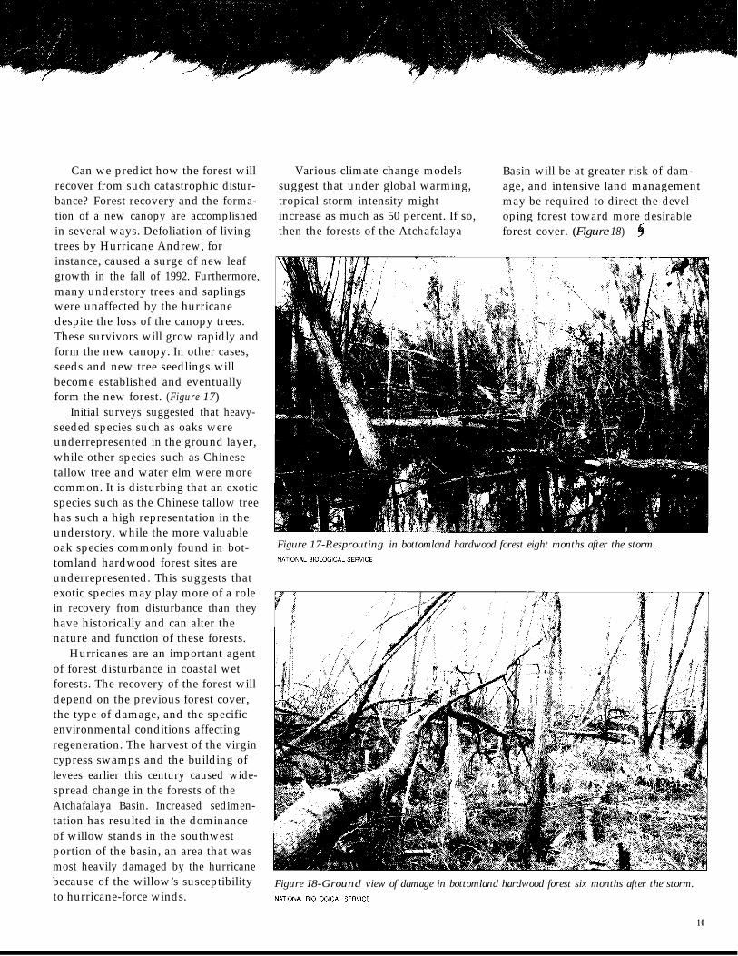
Despite the widespread destructionin the Atchafalaya Basin, not all treespecies responded in the same mannerto the catastrophic winds. (Figure 15)Some species were resistant to windand lost only individual limbs; otherswere susceptible to windthrown orsnapped tree trunks and died. Treespecies that were susceptible to wind-throw are prolific sprouters and havesurvived. Species that initially sur-vived and sprouted, however, appearto be highly susceptible to delayeddeath.
A significant impact of the stormwas the amount of plant material
Figure 15-One tree shows the haphazarddamage a hurricane can cause.NATIONAL BIOLCIGICAL SERVICE
Table 1. How Hurricane Andrew Damaged Specific Types of Trees inBottomland Hardwood Forests
Most damaged Moderately damaged Least damaged
Sandbar willowSwamp cottonwoodBlack willowWaxmyrtleChinese tallowSycamoreSwamp dogwood
Red mulberryBoxelderSwamp red mapleSwamp privetHackberryVarious oaksVarious hawthorns
Pumpkin ashDeciduous hollyWater hickoryBaldcypressWater elmButtonbush
Figure l&Landsat Thematic Mapper image of Atchafalaya Basin; red areas indicate green veg-etation. Same area through Advanced Very High Resolution Radiometer at three different timesin 1992. Normally, the area outlined would appear white or similar to the area above it. Thepink-purple areas indicate new leaf cover just a few months after the storm.NATIONAL BIOLOGICAL SERVICE
stripped and broken off the trees bythe winds. This phenomenon was sowidespread that it showed up onsatellite imagery of the study area.Widespread defoliation (leaf removal)caused up to 41 percent of the normalseasonal leaf fall to occur in a singleday. The decomposition of this large
amount of organic material fallinginto the swamp in a short period ledto extremely low levels of oxygen inthe water column in the AtchafalayaBasin and a large die-off of fish. Anestimated 182 million game and com-mercial fish died, an economic loss of$160 million. (Figure 16)
Can we predict how the forest will Various climate change models Basin will be at greater risk of dam-recover from such catastrophic distur- suggest that under global warming, age, and intensive land managementbance? Forest recovery and the forma- tropical storm intensity might may be required to direct the devel-tion of a new canopy are accomplished increase as much as 50 percent. If so, oping forest toward more desirablein several ways. Defoliation of living then the forests of the Atchafalaya forest cover. (Figure 18)trees by Hurricane Andrew, forinstance, caused a surge of new leafgrowth in the fall of 1992. Furthermore,many understory trees and saplingswere unaffected by the hurricanedespite the loss of the canopy trees.These survivors will grow rapidly andform the new canopy. In other cases,seeds and new tree seedlings willbecome established and eventuallyform the new forest. (Figure 17)
Initial surveys suggested that heavy-seeded species such as oaks wereunderrepresented in the ground layer,while other species such as Chinesetallow tree and water elm were morecommon. It is disturbing that an exoticspecies such as the Chinese tallow treehas such a high representation in theunderstory, while the more valuableoak species commonly found in bot- Figure 17-Resprouting in bottomland hardwood forest eight months after the storm.
tomland hardwood forest sites are NATlONAL BlOLOGlCAL SER”lCEunderrepresented. This suggests thatexotic species may play more of a rolein recovery from disturbance than theyhave historically and can alter thenature and function of these forests.
Hurricanes are an important agentof forest disturbance in coastal wetforests. The recovery of the forest willdepend on the previous forest cover,the type of damage, and the specificenvironmental conditions affectingregeneration. The harvest of the virgincypress swamps and the building oflevees earlier this century caused wide-spread change in the forests of theAtchafalaya Basin. Increased sedimen-tation has resulted in the dominanceof willow stands in the southwestportion of the basin, an area that wasmost heavily damaged by the hurricanebecause of the willow’s susceptibility Figure I8-Ground view of damage in bottomland hardwood forest six months after the storm.to hurricane-force winds. NATlONAL BlOLclGlCAL SER”lCE
10
x
Wildlife
t is certain that a storm with cypress-tupelo swamps, providedwinds of 225 kph (140 mph) will more forage opportunities for deerimmediately kill some fish, birds, after the hurricane. Over time, how-
and other animals as it passes through ever, this increased forage will decreasetheir habitat. Surprisingly, however, as mature canopy trees becomestudies have shown that the passing reestablished and shade out the under-of Hurricane Andrew actually provided story. Further research will show if
benefits to some wildlife species while alternative management, such as
barely affecting others. Sweeping clearing debris in these forests after a
through the Atchafalaya Basin, the hurricane, would enhance the habitat
winds of the storm cleared much of of white-tailed deer in years following
the canopy in the bottomland hard-storms. (Figure 19)
wood forest. This disturbance allowedBirds in the Atchafalaya Basin
more sunlight and other nutrients forwere affected more significantly byHurricane Andrew. Numbers of resi-
a greater variety and number of plants dent birds-those that live in an areato grow and, ultimately, provided year-round- dropped immediatelysmall mammals like white-footed deer after the hurricane, as individuals,mice, and amphibians, and reptiles their nesting places, and habitat werewith more food. battered by the high winds. But studies
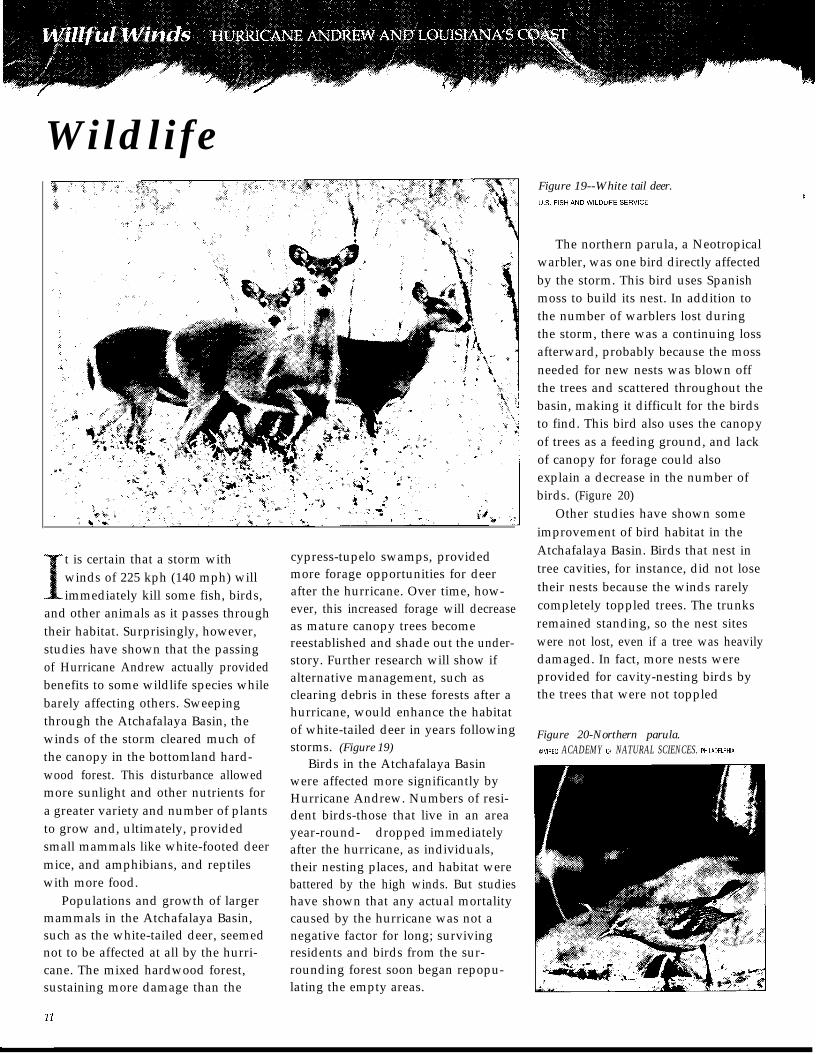
Populations and growth of larger have shown that any actual mortalitymammals in the Atchafalaya Basin, caused by the hurricane was not asuch as the white-tailed deer, seemed negative factor for long; survivingnot to be affected at all by the hurri- residents and birds from the sur-cane. The mixed hardwood forest,sustaining more damage than the
rounding forest soon began repopu-lating the empty areas.
Figure 19--White tail deer.
The northern parula, a Neotropicalwarbler, was one bird directly affectedby the storm. This bird uses Spanishmoss to build its nest. In addition tothe number of warblers lost duringthe storm, there was a continuing lossafterward, probably because the mossneeded for new nests was blown offthe trees and scattered throughout thebasin, making it difficult for the birdsto find. This bird also uses the canopyof trees as a feeding ground, and lackof canopy for forage could alsoexplain a decrease in the number ofbirds. (Figure 20)
Other studies have shown someimprovement of bird habitat in theAtchafalaya Basin. Birds that nest intree cavities, for instance, did not losetheir nests because the winds rarelycompletely toppled trees. The trunksremained standing, so the nest siteswere not lost, even if a tree was heavilydamaged. In fact, more nests wereprovided for cavity-nesting birds bythe trees that were not toppled
Figure 20-Northern parula.0”IREO. ACADEMY OF NATURAL SCIENCES. PHlLADELPHlA
because new cavities were made whenbranches broke off.
While the number of resident birdsdropped immediately after the storm,the broken forests provided someattraction for migrating birds likeNeotropical warblers. These travelingsongbirds visit the Louisiana forestson their migration through NorthAmerica, but their new attraction tosites they usually ignored increasedbird diversity in the basin right afterthe storm.
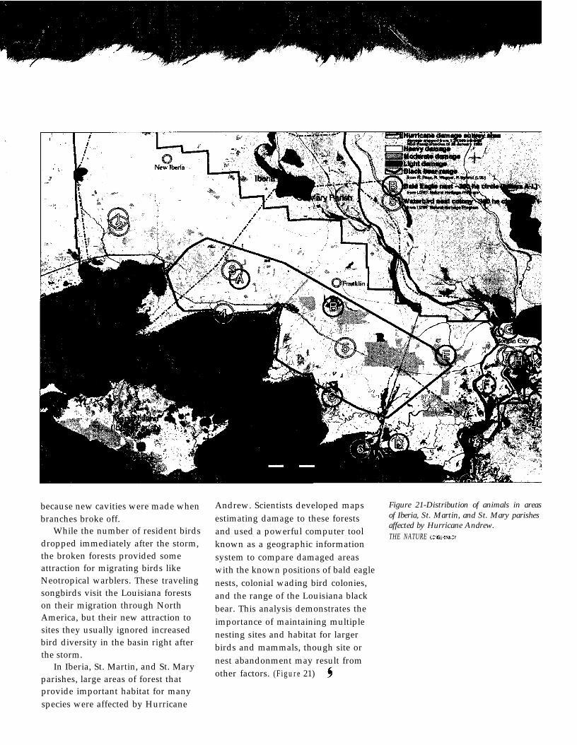
In Iberia, St. Martin, and St. Maryparishes, large areas of forest thatprovide important habitat for manyspecies were affected by Hurricane
Andrew. Scientists developed mapsestimating damage to these forestsand used a powerful computer tool
Figure 21-Distribution of animals in areasof Iberia, St. Martin, and St. Mary parishesaffected by Hurricane Andrew.THE NATURE CONSER”ANCY
known as a geographic informationsystem to compare damaged areaswith the known positions of bald eaglenests, colonial wading bird colonies,and the range of the Louisiana blackbear. This analysis demonstrates theimportance of maintaining multiplenesting sites and habitat for largerbirds and mammals, though site ornest abandonment may result fromother factors. (Figure 21)
/
Hurricanes Are Inevitable
e are only just beginning toappreciate the significance of
hurricane effects on our biologicalresources. As we learn more from sci-entists about the frequency withwhich hurricanes can occur, the sys-tems they affect, and how they inter-act with the evolution of our coastalecosystems, we can better prepareourselves and our environment fortheir onslaught.
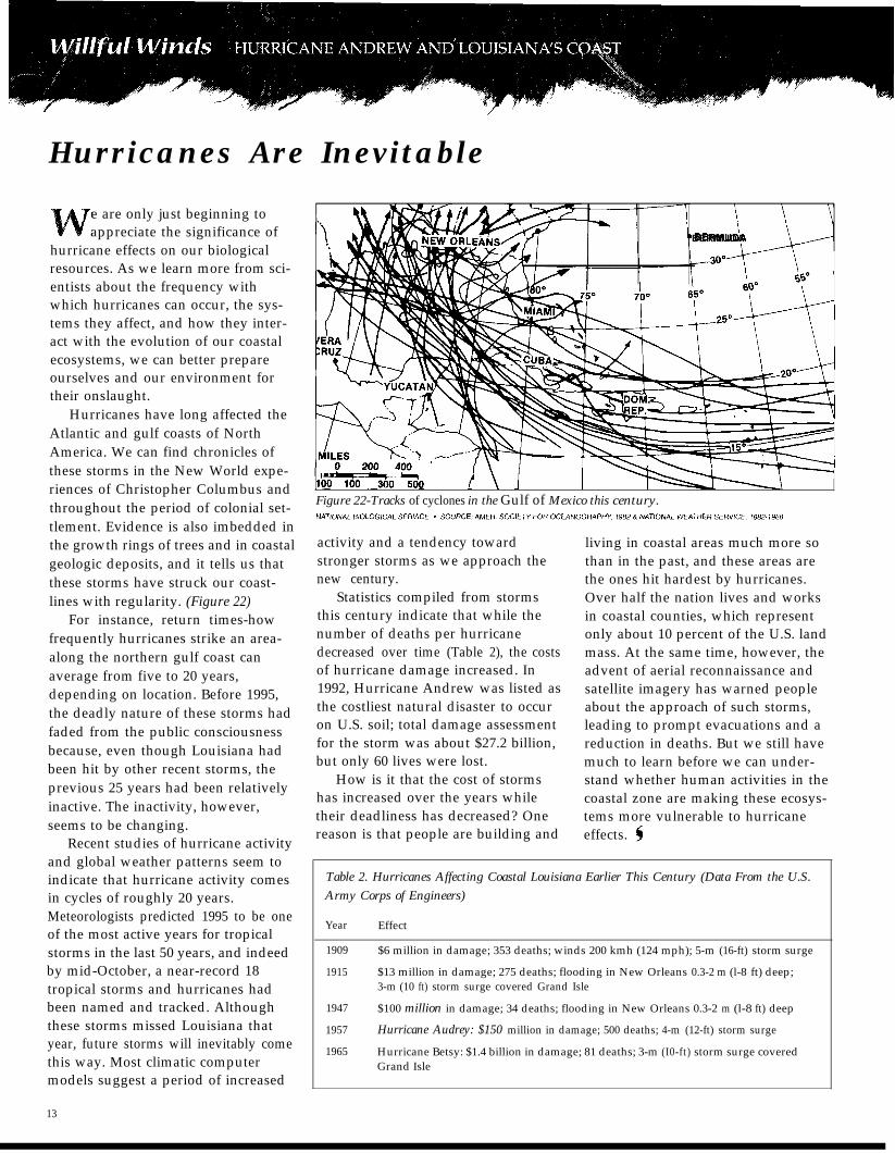
Hurricanes have long affected theAtlantic and gulf coasts of NorthAmerica. We can find chronicles ofthese storms in the New World expe-riences of Christopher Columbus andthroughout the period of colonial set-tlement. Evidence is also imbedded inthe growth rings of trees and in coastalgeologic deposits, and it tells us thatthese storms have struck our coast-lines with regularity. (Figure 22)
For instance, return times-howfrequently hurricanes strike an area-along the northern gulf coast canaverage from five to 20 years,depending on location. Before 1995,the deadly nature of these storms hadfaded from the public consciousnessbecause, even though Louisiana hadbeen hit by other recent storms, theprevious 25 years had been relativelyinactive. The inactivity, however,seems to be changing.
Recent studies of hurricane activityand global weather patterns seem toindicate that hurricane activity comesin cycles of roughly 20 years.Meteorologists predicted 1995 to be oneof the most active years for tropicalstorms in the last 50 years, and indeedby mid-October, a near-record 18tropical storms and hurricanes hadbeen named and tracked. Althoughthese storms missed Louisiana thatyear, future storms will inevitably comethis way. Most climatic computermodels suggest a period of increased
13
‘BERMUDA
Figure 22-Tracks of cyclones in the Gulf of Mexico this century.
activity and a tendency towardstronger storms as we approach thenew century.
Statistics compiled from stormsthis century indicate that while thenumber of deaths per hurricanedecreased over time (Table 2), the costsof hurricane damage increased. In1992, Hurricane Andrew was listed asthe costliest natural disaster to occuron U.S. soil; total damage assessmentfor the storm was about $27.2 billion,but only 60 lives were lost.
How is it that the cost of stormshas increased over the years whiletheir deadliness has decreased? Onereason is that people are building and
living in coastal areas much more sothan in the past, and these areas arethe ones hit hardest by hurricanes.Over half the nation lives and worksin coastal counties, which representonly about 10 percent of the U.S. landmass. At the same time, however, theadvent of aerial reconnaissance andsatellite imagery has warned peopleabout the approach of such storms,leading to prompt evacuations and areduction in deaths. But we still havemuch to learn before we can under-stand whether human activities in thecoastal zone are making these ecosys-tems more vulnerable to hurricaneeffects. $
Table 2. Hurricanes Affecting Coastal Louisiana Earlier This Century (Data From the U.S.Army Corps of Engineers)
Year
1909
1915
1947
1957
1965
Effect
$6 million in damage; 353 deaths; winds 200 kmh (124 mph); 5-m (16-ft) storm surge
$13 million in damage; 275 deaths; flooding in New Orleans 0.3-2 m (l-8 ft) deep;3-m (10 ft) storm surge covered Grand Isle
$100 million in damage; 34 deaths; flooding in New Orleans 0.3-2 m (l-8 ft) deep
Hurricane Audrey: $150 million in damage; 500 deaths; 4-m (12-ft) storm surge
Hurricane Betsy: $1.4 billion in damage; 81 deaths; 3-m (I0-ft) storm surge coveredGrand Isle
“*““./” --- - ,*
Value of Louisiana’s Coastal Barrier Islands
and Wetland Systemst is estimated that every 1 km(0.6 mi) of barrier island shoreline
protects 30 km* (12 mi’) of wetland-estuarine habitat. The islands thatfringe the coastal wetlands can limitthe height of hurricane storm surges,reduce wave energy, reduce thepotential for erosion of landwardwetlands, and retard saltwater intru-sion. The continued degradation ofthese islands, however, has dimin-ished their ability to protect the wet-lands, bays, and estuaries that sup-port Louisiana’s coastal fisheries.
Coastal wetlands offer an impor-tant buffer from flooding and salinityintrusion associated with the hurricane’sstorm surge. However, Louisiana’s
coastal wetlands are also at risk. Thecurrent rate of wetland loss inLouisiana averages some 65.6 km2(25 mi’) each year. Since the 1930s, anestimated 3,950 km2 (1,525 mi’) ofcoastal wetlands and barrier islandshave been lost. Subsidence, humanimpacts, and erosion caused by stormshave all been implicated in these highrates of loss. A hurricane such asHurricane Andrew can result in ayear’s worth of loss in a single day.
Besides offering great protection tocities and upland areas, Louisiana’scoastal and forested wetlands alsohave an important impact on thestate’s economy. The state’s coastalecosystems provide the natural
resources for a $1-billion-per-year fishand shellfish industry. The fisheriesindustry in southern Louisiana relieson coastal marshes for crucial nurseryhabitat. A powerful hurricane damagesthe livelihoods of people who rely onfisheries. After Hurricane Andrew, forexample, $15 million was granted tothe gulf commercial fishing industryto help recover from those losses.Farther inland, forested wetlands pro-vide crucial habitat for wildlife and arenewable resource for the timber andpaper industries. The AtchafalayaBasin holds the largest single parcelof forested wetland left in the UnitedStates, about 1.5 million acres. (
Monitoring, Protecting, andCoastal Louisiana
Restoring
hough many natural habitatswere devastated by the hurri-
cane, research is showing that most ofthese systems will recover in time.Physical destruction was limited to anarea near the path of the storm, butthe secondary effects of HurricaneAndrew were noticed at sites quitedistant from its path. Some of thebarrier islands were severely eroded.Hurricanes such as Andrew can onlyaccelerate a trend towards theirdisappearance, although efforts torestore those islands are already see-ing some success.
Vegetation has recovered inLouisiana’s coastal wetlands, but incertain areas wetland loss was accel-erated and distinct physical changes-such as the compression of coastalmarshes-resulted. The forested
wetlands of the Atchafalaya Basinwill probably be as resilient as thecoastal wetlands despite damage andloss to the canopy trees. Despite initiallosses, wildlife populations have gen-erally recovered.
Our conclusions must be temperedwith the realization that these coastalecosystems are increasingly at riskfrom various natural and human-caused factors. The forested wetlandsare being rapidly reduced in area andare experiencing changes in the com-position of their woody species. Overtime, Louisiana has lost nearly 60 per-cent of its forested wetlands. Barrierislands are eroding at alarming rates,and Louisiana leads the nation inwetland loss.
We must continue to monitor thelong-term effects of hurricanes and
make note of which species are presentas well as establish permanent studyplots that can be followed over time.Without continued research into howboth nature and humans affectLouisiana’s coast, we may one dayarrive at a point where we find thatwillful winds are agents of totaldestruction. Hurricane Andrew‘sdamage was tempered by its part inthe continued evolution of the coast,but that may change with future,fiercer storms and continued degra-dation of our coastal resources. (
14
Pieces of trees and sediment, care-fully extracted and preserved, providea historical view of the environment.Analytical techniques carry nameslike dendrochronological (dendro=tree,chrono=time) and cryogenic (cryo=frost,genic=generation) core sampling. Treesamples reveal the impacts of pasthurricanes on tree growth, as do sedi-ment samples of the life of a marsh,both offering valuable informationabout the present environment.
Wetland scientists have made useof these technological advances todevelop tools that assist their researchefforts and offer more detailed infor-mation about the resources to bemanaged. In the studies undertakenafter Hurricane Andrew, these toolswere used to assess the damage to thecoastal environment and predict thelong-term effects on valuable coastalresources.
For instance, data loggers for thecontinuous recording of water eleva-tion, wind speed, and other informa-tion had been placed at variousmarsh sites prior to the hurricane toevaluate marsh management methods.These computers recorded the hurri-cane as it passed over the sites. Theyshowed that, on August 26, Jug Lake,Louisiana, received wind gusts of162 kph (101 mph) that were respon-sible for the extensive tearing of thebrackish marsh and its conversion toopen water, which is specific, on-the-spot information scientists would nothave had otherwise.
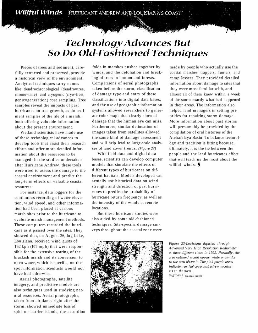
Aerial photographs, satelliteimagery, and predictive models arealso techniques used in studying nat-ural resources. Aerial photographs,taken from airplanes right after thestorm, showed immediate loss ofspits on barrier islands, the accordion
folds in marshes pushed together bywinds, and the defoliation and break-ing of trees in bottomland forests.Comparisons of aerial photographstaken before the storm, classificationof damage type and entry of theseclassifications into digital data bases,and the use of geographic informationsystems allowed researchers to gener-ate color maps that clearly showeddamage that the human eye can miss.Furthermore, similar delineation ofimages taken from satellites allowedthe same kind of damage assessmentand will help lead to large-scale analy-ses of land cover trends. (Figure 23)
With field data and digital databases, scientists can develop computermodels that simulate the effects ofdifferent types of hurricanes on dif-ferent habitats. Models developed canactually use historical data on windstrength and direction of past hurri-canes to predict the probability ofhurricane return frequency, as well asthe intensity of the winds at remotelocations.
But these hurricane studies werealso aided by some old-fashionedtechniques. Site-specific damage sur-veys throughout the coastal zone were
made by people who actually use thecoastal marshes: trappers, hunters, andcamp lessees. They provided detailedinformation about damage to sites thatthey were most familiar with, andalmost all of them knew within a weekof the storm exactly what had happenedin their areas. The information alsohelped land managers in setting pri-orities for repairing storm damage.More information about past stormswill presumably be provided by thecompilation of oral histories of theAtchafalaya Basin. To balance technol-ogy and tradition is fitting because,ultimately, it is the tie between thepeople and the land hurricanes affectthat will teach us the most about thewillful winds. 5
Figure 23-Louisiana depicted throughAdvanced Very High Resolution Radiometerat three different times in 1992. Normally, thearea outlined would appear white or similarto the area above it. The pink-purple areasindicate new leaf cover just a few monthsafter the storm.NATIONAL BIOLOGICAL SERVICE
Atlantic Hurricanes. G.E Dunn and B.I.Miller. 1960. Louisiana State UniversityPress, Baton Rouge, LA. 326 pp.
Early American Hurricanes 1492-1870.D.M. Ludlum. 1963. AmericanMeteorological Society. Boston, MA.191 pp.
Florida Hurricanes and Tropical Storms,1871-1993, An Historical Survey.F. Doehring, I.W. Duedall, and J.M.Williams. 1994. Florida Sea GrantCollege Program, Gainesville, FL. 118 pp.
The Fragile Fringe: Coastal Wetlands ofthe Continental United States. 1992.Louisiana Sea Grant College Program,U.S. Fish and Wildlife Service, andNational Oceanic and AtmosphericAdministration. 16 pp.
History of Hurricane Occurrences AlongCoastal Louisiana. 1972. U.S. Army Corpof Engineers, New Orleans, LA. 43 pp.
Hurricane Force: A Coastal Perspective.1994. Department of the Interior, U.S.Geological Survey. 28-minute video.
Hurricanes, Their Nature and History.1959. I.R. Tannehill. 1959. PrincetonUniversity Press, Princeton, NJ. 308 pp.
Journal of Coastal Research, SpecialIssue 21. Impacts of Hurricane Andrewon the Coastal Zones of Florida andLouisiana: 22-26 August 1992.
Restless Ribbons of Sand: Atlantic andGulf Coast Barriers. J.T. Wells and C.H.Peterson. 1986. U.S. Fish and WildlifeService and Louisiana Sea Grant CollegeProgram, Baton Rouge, LA. 20 pp.
Tropical Cyclones of the North AtlanticOcean, 1871-1992. C.J. Neumann, B.R.Jarvinen, C.J. McAdie, J.D. Elms.1993. National Climatic Data Center,Asheville, NC, 193 pp.
World Wide Web homepage for theUSA National Hurricane Center.Http://www.nhc.noaa.gov/
Dal Chappell, Bill Jones, Steve Laine, Sue Lauritzen, and Jim Lynch preparedfigures for this publication. Gaye Farris, Lee Foote, Lori Huckaby, Janet Keough,Bob Stewart, and Kristie Weeks reviewed the entire manuscript; Don Cahoon,Tom Doyle, and Clint Jeske provided technical reviews. Elizabeth Coleman editedthe text. Karen Short designed the publication.
We are especially grateful to the individuals who led the projects reported here:
Darryl Felder, Debbie Fuller, James Grace, Glenn Guntenspergen, LarryBob Keeland, Paul Leberg, Greg Linscomb, Ted Leininger, Graeme Lock;Irv Mendelssohn, Elijah Ramsey, Mark Swan, and Joe Truett.
Wylie Barrow, Pete Bourgeois, Don Cahoon, Robert Chabreck, Tom Doyle,
16