Embed Size (px)
Citation preview
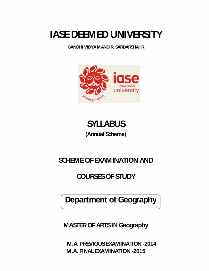
IASE DEEMED UNIVERSITY GANDHI VIDYA MANDIR, SARDARSHAHR
SYLLABUS (Annual Scheme)
SCHEME OF EXAMINATION AND
COURSES OF STUDY
MASTER OF ARTS IN Geography
M.A. PREVIOUS EXAMINATION -2014 M.A. FINAL EXAMINATION -2015
Department of Geography
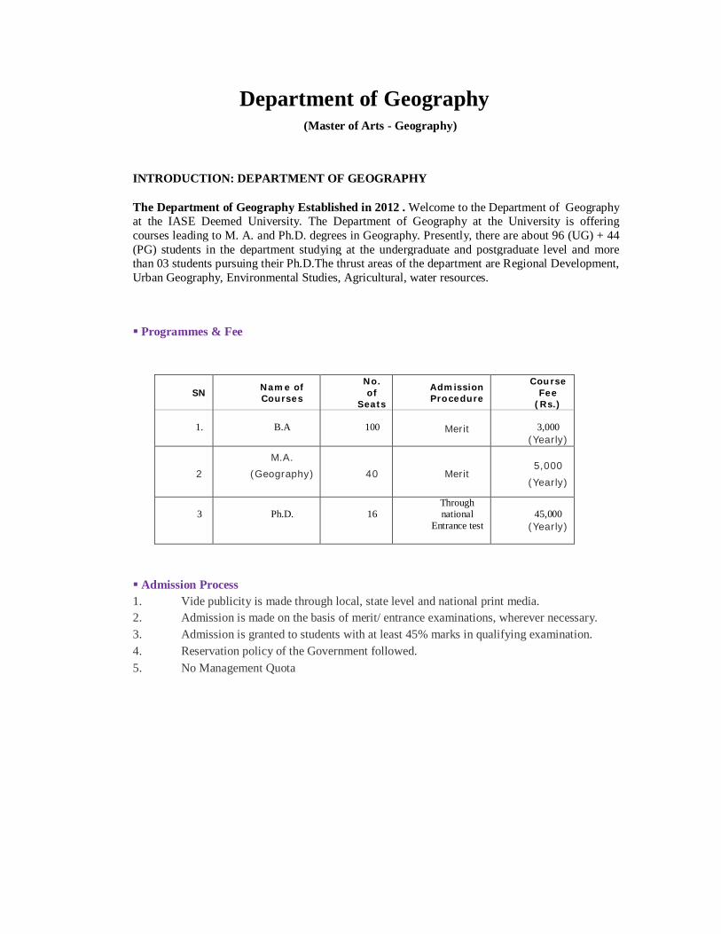
Department of Geography
(Master of Arts - Geography)
INTRODUCTION: DEPARTMENT OF GEOGRAPHY
The Department of Geography Established in 2012 . Welcome to the Department of Geography at the IASE Deemed University. The Department of Geography at the University is offering courses leading to M. A. and Ph.D. degrees in Geography. Presently, there are about 96 (UG) + 44 (PG) students in the department studying at the undergraduate and postgraduate level and more than 03 students pursuing their Ph.D.The thrust areas of the department are Regional Development, Urban Geography, Environmental Studies, Agricultural, water resources.
Programmes & Fee
Admission Process 1. Vide publicity is made through local, state level and national print media. 2. Admission is made on the basis of merit/ entrance examinations, wherever necessary. 3. Admission is granted to students with at least 45% marks in qualifying examination. 4. Reservation policy of the Government followed. 5. No Management Quota
SN Name of Courses
No. of
Seats
Admission Procedure
Course Fee
(Rs.)
1.
B.A
100
Merit
3,000
(Yearly)
2
M.A.
(Geography)
40 Merit 5,000
(Yearly)
3
Ph.D.
16
Through national
Entrance test
45,000
(Yearly)

Master of Arts – Geography
M.A. Final Geography Examination – 2014-15 Paper I : Advanced Geography of India
3 hours duration Max. Max : 100
Note : This paper will contain ten questions having two questions from each unit. Candidates are required to attempt five questions in all selecting at least one question from each unit.
Unit – I
Physiography and drainage systems, soils, vegetation. Climate and its regional variations; Origin and mechanism of India monsoon; Schemes of natural, physiography and climatic classifications. Identification of drought and flood prone areas.
Unit – II
Resources : Conservation and utilization of land, mineral, water, biotic and marine resources. Agriculture, Agroclimatic regions; landuse pattern, green revolution and its impact on Indian agriculture. Agriculture infrastructure irrigation fertilizers and seeds. Dry zone agriculture.
Unit – III
Mineral- Iron ore, copper, coal, Aluminum, Bauxite, Jink and Power- Petroleum, hydropower, nuclear resources, Factors of Industrial localization, classification of industries, Major industries – iron and steel, cotton, textile, cement, fertilizer, paper and pulp and sugar industries.
Unit – IV
Tribal areas and their problems. Population distribution, density and growth, population problems and policies. Study of the network of roadways, railways, airways and waterways. Regional disparities in social and economic development in India.
Unit – V
Geographical study of Rajasthan under the following heads – Relief, climate, vegetation, soils, agriculture development, irrigation, mineral and power resources industrial development, Physiographic division & Rajasthan State (1) Marusthali (2) Aravalli (3) Hadoti Plateau (4) Bangar
Books Recommended : 1. Chatterji, S.B.: Climatology of India, Calcutta University, Calcutta. 2. Choudhary, M.R.: Indian Industries – Development and Location. 3. Dreze, Jean and Amartya Sen (ed.) : India : Economic Development and Social Opportunity, Oxford University Press, New Delhi . 4. Galyan and Sengupta : Economic Regions and Regionalization in India. 5. Govt. of India : Five Year Plans of India. 6. Govt. of India : National Atlas of India, NATMO Publication, Calcutta. 7. Govt. of India : The Gazetteer of India, Vol.I&III, Publication Division, New Delhi. 8. India Year Book (Lates Edition) : Publication Division, Delhi. 9. Irrigation Atlas of India. 10. Khular, D.R. : Geography of India. 11. Kumar, L.S.S. and Others : Agriculture in India Vol. I&II, Asia Publishing House, Bombay. 12. Kundu, A. Raza Moonis : Indian Economy – The Regional Dimension, Spectrum Publishers, New Delhi. 13. Misra, V.C.: Geography of Rajasthan, National Book Trust, New Delhi. 14. Puri, G.S.: Indian Forest Ecology, Oxford Book Stationery Co. 15. S.P. Roy Choudhary : Land and Soil, National Book Trust, New Delhi. 16. Sharma, T.C. and Coutino, O.: Economic and Commercial Geography of India, Vikas Publishing House, New Delhi. 17. Singh, R.L.: India – A Regional Geography, N.G.S.I., Varanasi. 18. Spate, O.H.K. and Learmonth, A.T.A.: India and Pakistan – Land, People and Economy, Methuen & Co., London. 19. Tiwari, R.C.: Geography of Inida. 20. Ekeksfj;k] prqHkZt % Hkkjr dk o`gr Hkwxksy] lkfgR; Hkou] ifCy'klZ ,.M fMLVªhC;wVlZ izk- fy-] vkxjkA 21. clay] ,l-lh- % Hkkjr dk o`gr Hkwxksy] ehuk{kh izdk'ku] esjB 22. 'kekZ] ,p-,l- ,oa 'kekZ] ,e-,y- % jktLFkku dk Hkwxksy] iap'khy izdk'ku] t;iqjA 23. 'kekZ Jhdey] fgUnh xzaFk vdkneh] Hkksiky] e/; izns'k
Paper II : Any One of the Following
Paper II (a) : Urban Geography
3 hours duration Max. Max : 100
Note : This paper will contain ten questions having two questions from each unit. Candidates are required to attempt five questions in all selecting at least one question from each unit.
Unit – I
Aims and scope of urban geography. Factors affecting the growth of towns during Neolithic period, Greek and Roman Period, Dark Ages, Medieval period, Renaissance period, Industrial Revolution and Modern times. Chief characteristics of the towns of each period.
Unit – II
Trends of urbanization in the world. Urbanization in India since 1901 and its problems. Census of India, Definitions of urban centres. Chief characteristics of modern town, City Conurbation, Metropolis and Megalopolis. Spatial pattern and distribution of urban centres : types of cities, central places, transport foci and centre of specialized services.
Unit – III
Classification of cities based on functions, Urban Rank-size relationship, Primate city, The Basic and Non-Basic concept of urban economic functions and its application. Urban hierarchy based on functions, Christaller’s central place theory, August Losch’s theory of market centres.
Unit – VI
Urban Morphology, Unplanned and planned growth of town : Urban plans, Morphology of Indian cities. Functional Structure of towns, Chief characteristics of C.B.D., Residential areas, Manufacturing areas and other functional areas. Theories and Models of urban structure.
Unit – V
Centrifugal and centripetal forces in urban geography. Development of suburbs, rural-urban fringe, satellite town, ring towns. Sphere of urban influence (Umland) and its delimitation.
Principles of Town Planning – Preparation of a Master Plan, Study of Master Plans of Jaipur, Bikaner, Sriganganager and Churu, Principles of regional planning.
Books Recommended : 1. Alam, S.M.: Hyderabad and Secunderabad. Twin City, Asia Publishing House, Bombay. 2. Carter : The Study of Urban Geography, Edward Amold, London. 3. Chorley, R.J.O., Haggett, P. (ed.) : Models in Geography, Methuen, London. 4. Dickinson, R.E.: City Region and Regionalism, Routeledge and Kegon Paul, London. 5. Gibbs, J.P.: Urban Research Methods, Van Nostrand Co. Inc., Princetion, New Jersey. 6. Govt. of Rjasthani : Master Plan of Jaipur, Bikaner, Sriganganagar and Churu. 7. Johnson, R.H. : Urban Geography. 8. Mandal, R.B.: Urban Geography – A Textbook, Concept Publishing Co., New Delhi. 9. Meyor, H.M., Kohn, C.F.: Readings in Urban Geography, University of Chicago Press, Chicago. 10. Mumford, L.: Culture of Cities, McMillan & Co., Landon. 11. N.V. Sovani : Urbanization and Urban India, Asia Publishing House, Bombay. 12. Northan. R.C.: Urban Geography, John Wiley and Sons, New York. 13. Singh, R.L.: Bangalore – An Urban Servey, National Geographical Society of India, B.H.U. Varanasi. 14. Singh, K. and Steinberg, F. (ed.) : Urban Indian in Crisis, New Age Interns, New Delhi. 15. Singh. R.L.: Banaras – A Study in Urban Geography, Students Friends, Allahbad. 16. Smailes, A.E.: The Geography of Towns, Huchinson, London. 17. Taylor, G.: Urban Geography, Mathuen and Co., London. 18. Tewari, Vinod K. Jay A., Weinstein, V.L.S. Prakasa Rao : Indian Cities : Ecological Perspective. 19. tks'kh] vkj-,y- % uxjh; Hkwxksy] jkt- fgUnh xzaFk vdkneh] t;iqj 20. vkseizdk'k flag % uxjh; Hkwxksy 21. caly % uxjh; Hkwxksy] ehuk{kh izdk'ku] esjB 22. jko] ch-ih- % uxjh; Hkwxksy] olqU/kjk izdk'ku] xksj[kiqj
Paper III : Agricultural Geography (Elements & Applied)
3 hours duration Max. Max : 100
Note : This paper will contain ten questions having two questions from each unit. Candidates are required to attempt five questions in all selecting at least one question from each unit.
Unit – I
Elements of Agricultural Geography : Concept of agricultural origin and dispersal. Development of agriculture through the ages in important agricultural areas of the world. Trends and practices.
Factors affecting agriculture : Physical – Relief, climate, soil, water, storage etc. Social-land ownership and size of holdings.
Economic input of human and animal power, irrigation, and fertilizers, mechanizations etc. Others : Financial Management, market system, transport, trade etc.
Unit – II
Water : Water resources, quality of water for irrigation, water quality criteria, various methods of irrigation and their comparative advantages. Soil and water balance. Types of agriculture – Whittlesey’s classification of agricultural regions and special study of shifting cultivation, plantation agriculture, Mediterranean, Collective and state farming, extensive and intensive agriculture, dry farming and their characteristics.
Unit – III
Applied Agricultural Geography : Agricultural Land use : Concept, history of agricultural land use surveys, principles, objectives, policies and planning and landuse surveys. Land classification: need and basis of land classification. British Pattern, American pattern, Indian pattern, Irish pattern, Land use data: Sources, types of mapping and problems.
Unit – IV
Models in agricultural land use : concept, need and principles. Von Thunen’s Agricultural Location Theory and its recent modifications, Coleman’s model, Preparation and planning of a detailed proforma for landuse surveys.
Unit – V
Measurements of the level of agricultural development : Concept and methodology – Agricultural regionalization – Concept, methods of delimitation (including statistical methods).
Crop-ranking, crop-combination regions – meaning and methodology. (Detailed study of Kendal, Weaver, Doi and S.M. Rafiullah), Corpping Intensity, Crop-diversification – methods and deductions.
Agricultural efficiency – concept methods of measurement. Nutrition and balance sheet. Crop land use and deficiency diseases.
Note : the candidates are expected to make field studies. A field trip be organized for landuse survey of a village. A question be asked in examination.
Books Recommended : 1. Ali Mohammed : Dynamics of Agriculture Development in India, Concept Publication Co., Delhi. 2. Ali Mohammed : Situation of agriculture, Food and Nutrition in Rural India, Concept Publishing Co., Delhi. 3. Gregor, H.P. Geography of Agriculture, Prentice Hall, New York 4. Grigg, D.B.: The Agricultural Systems of the World, Cambridge University Press, New York 5. Hartshorn, T.A. and Alexander, J.W. : Economic Geography, Prentice Hall, New Delhi 6. I.C.A.R. : Soil and Water Conservation Research 7. I.C.A.R. : Soil Conservation in India. 8. Kostrowicki, J.: World Types of Agriculture, Polish Academy, Warsaw. 9. Morgan, W.B. and Norton. R.J.C. : Agricultural Geography, Mathuen, London. 10. Noor Mohammed : Agriculture Land use in India, Inter-India Public, Delhi. 11. Noor Mohammed : New Dimension in Agricultural, Concept, New Delhi. 12. Sachchidananda : Social Dimensions of Agricultural Development, National Publishing House, Delhi. 13. Shafi M.: Agriculture Geography. 14. Singh, J. and Dhillon, S.S. : Agricultural Geography, Tata McGraw Hill Pub., New Delhi 15. Stamps, L.D. : The Land of Britain, Its Use and Misuse, Longman, London
16. Symon Leslie : Agricultural Geography, G. Bell and Sons Ltd., London 17. Tarrant, J.R. Agricultural Geography, Wiley, New York 18. izfeyk dqekj % d`f"k Hkwxksy] e/;izns'k fgUnh xzaFk vdkneh 19. cztHkw"k.k flag & d`f"k Hkwxksy] xksj[kiqj 20. ekftn gqlSu % d`f"k Hkwxksy
Paper IV : Remote sensing and G.I.S.
3 hours duration Max. Max : 100
Note : This paper will contain ten questions having two questions from each unit. Candidates are required to attempt five questions in all selecting at least one question from each unit.
Unit – I
Historical development of remote sensing as a technology – Relevance of remote sensing in geography – concepts and basics : Energy source, energy and radiation principles, energy interactions in the atmosphere and earth surface features. Remote sensing systems : Platforms, Sensors and radiation records.
Unit – II
Air photos and photogrammetry : Elements of photographic system : Type, scales and ground coverage, resolution, radiometric characteristics, films, filters, aerial, cameras, film exposures, geometric fundamentals of photogrammetry : elements of vertical photographs, relief displacement, image parallax, stereoscopic, orthophotos airphoto interpretation : shape, size, pattern, tone, texture, shadows, site advantage and limitation.
Unit – III
Satellite Remote Sensing : History and development of various types of satellite and space programme. Image processing : types of imagery, techniques of visual interpretation, ground verification, transfer of interpreted thematic information of base maps-digital processing : rectification and resolution, Image enhancement contrast manipulation, classification supervised and unsupervised, Post classification analysis. Remote sensing and its comparison with map.
Unit – IV
Applications : Air Photo and image interpretations and mapping forest and wild life, mines & Geology, Geomorphoto.
Landuse and land cover soil, land evaluation, weather studies, water resources, hazard management and environmental management.
Unit – V
GIS – Introduction, definition & scope, its application in various field & planning.
Suggested Readings: 1. American Society of Photogrammetry : Manual of Remote Sensing, ASP, Falls Church, V.A., 1983, Vol.I,II. 2. Barrett, E.C. and L.E. Curtis : Fundamentals of Remote Sensing and Air Photo Interpretation, Mcmillan, New York. 3. Burrough P.A. : Principles of Geographic Information Systems for Land Resource Assessment, Oxford University Press, New York. 4. Compbell, J.: Introduction to Remote Sensing, Guilford, New Your. 5. Curran, Paul J.: Principles of Remote Sensing, Longman, London. 6. Gautam, N.C. : SPGU. Technology of Geography, N.R.S.A., Hyderabad. 7. Hord, R.M.: Digital image processing of remotely sensed data, Academic, New York. 8. Luder, D.: Aerial Photography Interpretation : Principles and Application, McGraw Hill, New York. 9. Mark, S. Monmonier : Computer Assisted Cartography, Prentice Hall, Englewood Cliff, New Jersey. 10. Pratt, W.K. Digital image processing, wiley, New York. 11. Rao, D.P. (eds.) : Remote Sensing for Earth Resources, Association of Exploration geophysicist, Hyderabad. 12. Singh, S. : Remote Sensing Technology, AS Publication, Jodhpur. 13. Star, J. and Estes, J.: Geographic Information Systems : An Introduction, Prentice Hall, Englewood Cliff, New
Jersey.
14. Thomas M. Lillesand and Ralph W. Kefer : Remote Sensing and Image interpretation, John wiley & sons, New York.
15. Wolf Paul, K.: Elements of Photogrammetry, McGraw Hill Book Co.
Dissertation on Geographical Problem (In lieu of paper Vi,VII,VIII)
N.B. : The candidates offering this paper will be required to submit dissertation at least three weeks before the commencement of the theory examination. It will be examined by a board of two examiners. Three copies of dissertation must be submitted to the university, out of which one copy will be returned to the department/college and one to the supervisor. The dissertation should exclusively be based on field work and statistical analysis as far as possible and be prepared under the guidance of a postgraduate teacher of five years standing. The volume of dissertation should not exceed 100 papers.
PRACTICALS
Surveying and Laboratory work (Total 10 hours per batch of 15 candidates spread over tow days).
1. Laboratory work 4 hrs duration 40 marks
2. Record work and viva voce (10+10) (2 hrs.) 20 marks 3. Field surveying & viva voce (15+10) 4 hours duration 25 marks 4. Survey camp & viva voce (10+5) 15 marks
Total 100 marks
Note : 12 hours of teaching practical be provided per batch of 15 students per week.
The art of surveying, history of surveying, scope, utility, and problems. Classification of surveying.
Methods and techniques of representation of relief:
(a) Methods and techniques of depicting relief. (b) Profile, gradients and calculation of slopes. (c) Contours and indivisibility. (d) Block diagrams, field sketching, serial profile, hypsographic curves, altimetric frequency graphs.
Interpretation of topographical Maps :
A brief history of topographical maps of the world with special reference to India and their interpretation. Detailed study of such topo sheets.
Air photo interpretation and exercise on the determination of height of plan, parallax, number of runs and number of photographs, knowledge of stereoscopic vision, mosaics, types of camera, emulsions and stereoscopes, interpretation and identification of cultural and physical features on aerial photography. Photo interpretation of land use and settlement in the field surveying.
Remote sensing and computer application in mapping; Distal mapping; Geographic information system (GIS): Thematic maps.
Field Survey Camp :
Theodolite : Its parts and their functions, use of theodolite – traverse computation, independent co-ordinates.
Use and application of planetable and clinometers in small area survey, traverse, reuniting – two and three point problems. Practical contouring by Clinometers.
Leveling : Terms, types and principles of leveling. Classification of leveling, profiles and other leveling. Use of Dumpy level, practical contouring, cross uniting, use and application of abeny level.
Survey Camp – A topographical survey of settlement will be done by organizing a camp at least for a week duration and maps and reports of the camp will be prepared. Students will stay in camp. The report shall be prepared separately and independently.
Reference Books: 1. Breed, C.B. and Hommer, G.L.: The principles of surveying. Vol. I and II, New York. 2. Davis, R.E. and Foot, F.S. : Survyeing Theory and Practice, Hohn Willey and Sons Inc., New York. 3. Deshpande, T.S. : A textbook of surveying and leveling, United book Corporation, Puna.
4. Gautam, N.C.: Urban Landuse Studies Through Air photo Interpretation Techniques, Pink Publishing House, Mathura. 5. Kanetkar, T.P. and Kulkarni, S.V.: Sruveying and leveling, A.V. Gria Prakash, Puna. 6. Punamia, B.C.: Surveying and field work Vol.I, Standard Books Depot., Delhi. 7. Roorkee Engineering College : Manual of surveying. 8. Sharma, Jawahar Lal : A Text Book of Surveying, CBS publishers Delhi, 1988. 9. Singh, R.L. and Dutt. P.K. : Elements of Practical Geography, Students Friends, Allahabad. 10. Tracy, T.R. : Surveying Theory and Practice, McGraw Hill book co., New York. 11. Williamson : Surveying and Field Work Constable. 12. ts-ih- 'kekZ % izk;ksfxd Hkwxksy
Paper – V : Any One of the following :
Paper – V : (a) Population Geography :
3 hours duration Max. Max : 100
Note : This paper will contain ten questions having two questions from each unit. Candidates are required to attempt five questions in all selecting at least one question from each unit.
Unit - I
Definition and scope of Population Geography, Theory in Population Geography-Malthusian, Neo Malthusian and optimum Population theory and Biological Population Theory. Types of Data and Population census with special reference to the Indian census.
Unit - II
Density and Distribution factors affecting population distribution in the world in the world. Measures of population density, Measures of dispersal and concentration of population and population potential. Demographic transition.
Unit - III
The Growth of population, world patterns of fertility and mortality. Age and Sex composition, Marital status, Families and households, Language and literacy, Religious composition of population, Economic composition of population.
Unit - IV
Primary occupations, manufacturing industry, Transport, Trade and service etc. Rural and urban population and urbanization. Internal and international migration behavioral migration studies.
Unit - V
The Growth of India’s Population, The death rate and birth rate in India, density and distribution of population in India, Is India over populated? Age and sex composition in India’s population, Urbanization in India. Occupational composition and internal Migrations.
Economic composition of Inida’s population, Internal migration in India. The Population policy of Govt. of India.
Books Recommended :
1. Clarks : Population Geography. 2. Johnes : A Population Geography. 3. Trewarth : A Geography of Population. 4. Woods- Population Analysis in Geography. 5. Woods- Theoretical Population Geography. 6. Beanijen Garnier – Geography of Population. 7. Zelinsky : A prologue to population Geography. 8. Wilson- Population Geography. 9. Chandra- Population Georgaphy. 10. Davis- The Population of India and Pakistan. 11. Clarks (ed.) : Geography of Population. 12. Schnell & Monmonier : The study of population – Elements Patterns and Processes.
13. Dyson and Crook : India’s Demography. 14. Rees and Wilson : Spatial Population Analysis. 15. Pacione : Population Geography – Problems and prospects. 16. ,l-Mh- ekW;Z % tula[;k Hkwxksy
Paper – VI : CLIMATOLOGY
3 hours duration Max. Max : 100
Note : This paper will contain ten questions having two questions from each unit. Candidates are required to attempt five questions in all selecting at least one question from each unit.
Unit - I
Nature and scope of climatology and its relationship with meteorology. Composition, mass and structure of the atmosphere. Isolation, Heat balance of the earth, green house effect, vertical and horizontal distribution of temperature.
Unit - II
Atmospheric motion : forces controlling motion of air vertical motion and vorticty, local wind, jet stream, general circulation in the atmosphere, Atmospheric moisture: Humidity, evaporation, condensation, precipitation : types, acid rain, world pattern of precipation.
Unit - III
Tropical, temperature and high latitude weather systems – concept of air masses and atmospheric disturbances, ocean atmospheric interation – EL Nino, Southern oscillation (ENSO) and La Nina. Monsoon winds, norwesters and cyclones tropical and temperate phenomena, climate of India and its controls; Western disturbances.
Unit - IV
Climatic Classification of Koppen, and Thorntwaite, Major climates of the world – tropical, temperate desert and mountain climate.
Climatic changes Evidences, possible causes; global warming, environmental impacts and society’s response.
Unit - V
Applied climatology : Data collection, archiving, accessing, interpretation and generation of climatic information specially for water balance studies, soils, agriculture activities, house types and health.
Suggested Readings
1. Barry, R.G. and Chorley P.J. : Atmosphere, Whether and Climate, Routledge, London and New York. 2. Critchifield, J.H.: General Climatology. Prentice Hall, India, New Delhi. 3. Lydolph, P.E. : The climate of the Earth, Rowman. 4. Fein, J.S. and stephens, P.N. Monsoons. Wiley Interscience. 5. India Met. Deptt. : Climatological Tables of Observatories in India, Govt. of India. 6. Mh-,l- yky % tyok;q foKku
Paper – VII : Geography of Water Resources
3 hours duration Max. Max : 100
Note : This paper will contain ten questions having two questions from each unit. Candidates are required to attempt five questions in all selecting at least one question from each unit.
Unit - I
Water as a focus of geographical interest, inventory and distribution of world’s water resources (surface and subsurface); world hydrological cycle : quantitative estimates, water storages. Glaciers, river channels, lakes and reservoirs, soil moisture, ground water.
The basic hydrologic cycle : precipitation, potential, evapotranspiration and interception losses : runoff.
Water demand and use : methods of estimation – agricultural, industrial and municipal uses of water.
Unit - II
Agricultural use of water : estimation of crop – water requirement; soil-water-crop relationships; water balance and drought; major and minor irrigation : methods of distribution of water to farms; water harvesting techniques, soil water conservation.
Irrigation-water logging, salinity and alkalinity of soil over exploitation of ground water, land subsidence, aline water intrusion inter the olostal aquifers. Water quality parameters, water pollution over and ground water-fluoride and arsenic.
Unit - III
Industrial use of water : methods of estimation; demand for water in the industrial sector of India.
Municipal use of water : General trends in water supply to the urban and rural communities in India. Internal navigation, hydel power and recreation.
Unit - IV
Problems of water resource management Floods-magnitude/frequency, structural and non structural adjustment of flood hazards; embankments, reservoirs, channel improvement, soil conservation, afforestation, flood forecasting, evacuation, floodplains, landuse regulation and insurance. Case studies of major floods.
Droughts-occurrence, major drought management with reference of Rajasthan.
Unit - V
Conservation and planning for the development of water resources-social and institutional considerations; integrated basin planning conjunctive use of surface and ground water resources; watershed management; international and interstate river water disputes and ties, some case studies.
Suggested Readings
1. Agarwal, Anil and Sunita Narain : Dying wisdom : Rise, Fall and Potential of India’s Traditional Water Harvesting System. Centre for science and environment, New Delhi, 1997.
2. Economic and social Commission for Asia and the pacific united nations : Guidelines for the preparation of National Master water Plan.
3. Gulhatim N.D. : Development of Inter-state rivers : Law and Practice in India. Allied pub., Bombay. 4. International Water Resource Association and Central Board of Irrigation & power, water of human needs, Vols. I to V
Proceedings of the Second world congress on weather resources, 12-16 December, New Delhi. 5. Jones, J.A.: Global hydrology : processes, resources and environmental Management, Longman. 6. Krutilla, John V. and Eckstein, O.: Multiple purpose river development : studies in applied economic analysis, john hopkin’s
press, boston. 7. Law. B.C. (ed.) Mounains and rivers of India IGU national committee for Geography, Calcutta. 8. Michaelm A.M. : Irrigation : Theory and Practices, Vikas publishing House Pvt. Ltd., New Delhi. 9. Matter, J.R., Water Resources Distribution, use and Management, John Wiley, Marylance. 10. Newson, M.Land, water and Development River Basin systems and their sustainable management, routledge, London. 11. Pareira, H.D. : Landuse and water resources, Cambridge University Press, Cambridge. 12. Rao, K.L.: India’s Water Wealth, Orient Longman, New Delhi. 13. Kates R.W. and Burtgon, I. (ed.) : Geography, Resources and environment, Ottowa 14. Singh, R.A. and Singh, S.R. : Water Management; Principles and Practices, Tara Publication, Varanasim. 15. Smith, K. : Water in Britain : A study in Applied hydrology and resource Geography, McMillan, London. 16. Tebbutt, T.H.Y. (ed.) : Advances in Water engineering Elsevier applied science Pub., London. 17. Tideman, E.M. watershed Management : Guidelines for Indian Conditions, Omega, New Delhi. 18. Todd, D.K. : Ground water hydrology, John Wiley, New York. 19. U.S.D.A.: The Year Book of Agriculture : Water, Oxford and I.B.H. Publishing Co., New Delhi.

20. Verghese, B.G. : Water of Hope : Integrated water resource development and Regional Co-operation within the Himalayan-Ganga-Brahmaputra-Barak Basin, Oxford IBH, New Delhi.
21. White, G.F.L. : Environmental effects of Complex River Development. Westriver Press, Boulder, Colorado.