Embed Size (px)
Citation preview
Stinson Municipal Airport Master Plan UpdateImplementation Plan
6-1 May 2013
IMPLEMENTATION PLANSECTION 6 -INTRODUCTION6.1
This section presents a proposed sequence and schedule for the development identified in the ADPdescribed in the previous section. The recommended projects in the ADP have been categorized intodistinct projects with estimates of probable cost and duration. The individual project cost estimates andanticipated funding sources are detailed in Section 7, Financial Plan. This section is organized aroundthe following topics:
· Factors Affecting Implementation and Phasing – Discussion of general criteria upon whichphasing and facility development will be based.
· Post-Master Planning Process Activities – Recap of the activities of the master planning processthat should be continued after the conclusion of the study.
· Phased Implementation Plan – Potential phasing of airport development projects, according tothe type of project and category of airport development.
· Airport Activity Monitoring and Project Triggers
· Summary
FACTORS AFFECTING IMPLEMENTATION AND PHASING6.2
The ADP and Implementation plans are developed using the Aviation Activity Forecast from Section 3and the Facility Requirements from Section 4. The actual amount of airport activity should determine thetiming of development throughout the planning horizon, with the use of planning activity levels instead ofyears. It should be recognized that airport activity and growth may not occur precisely as forecasted;therefore it is important to continuously monitor airport activity as it actually occurs.
Factors which may affect the type and volume of growth could include, a drastic change in aircraft fleetmix, the closing or addition of a flight training facility, and economic growth resulting in increasedcorporate aviation activity. Significantly greater demand for hangar space by corporate operators thananticipated may influence the timing of hangar construction.
POST-MASTER PLANNING PROCESS ACTIVITIES6.3
During the course of the master planning process for the Airport, several activities occurred whichinfluenced the recommended airport development scenarios. One of these activities was a BusinessDevelopment Workshop (BDW). The BDW was a two-hour workshop consisting of a group ofstakeholders and representatives from various businesses, organizations, Bexar County, the San AntonioRiver Authority, National Park Service, universities, and airport business tenants.
The session had no formal agenda; instead, it was intended to spark discussion among the participantsabout how the Airport could benefit their respective organizations. The BDW resulted in highly beneficialinformation, and proved there is significant interest in the development of the Airport, not only for potentialbusiness growth around the Stinson environs, but also for the aesthetic improvement of the Airport itself.There was significant discussion about how the Airport could integrate with the nearby Mission Reachproject, which is a major improvement of the San Antonio River, given the Airport is historic.
Stinson Municipal Airport Master Plan UpdateImplementation Plan
6-2 May 2013
With the overall success of the BDW, the ideas that were generated as a result of it, and the diverserepresentation of stakeholders, it is highly recommended that this panel continue to meet past theconclusion of the study, possibly as an organized committee. Active communication among business andprofessional representatives with a sincere interest in the development of Stinson Municipal Airport wouldserve to benefit the Airport’s future development and economic impact.
A project that has recently been completed near the Airport is the Mission Trails project. This projectinvolved the improvement of Mission Road with new sidewalks, streetlights, and new road pavement. Atthis time, however, the project does not extend all the way to the portion of Mission Road in which theAirport is located. Based on discussions with the River Oversight Committee, the project is planned forexpansion into the Airport vicinity as funding becomes available. It is recommended that the Airport staffcollaborate with the City of San Antonio and representatives of the Mission Trails to help facilitate theprocess of extending the improvements into the Airport vicinity.
PHASED IMPLEMENTATION PLAN6.4
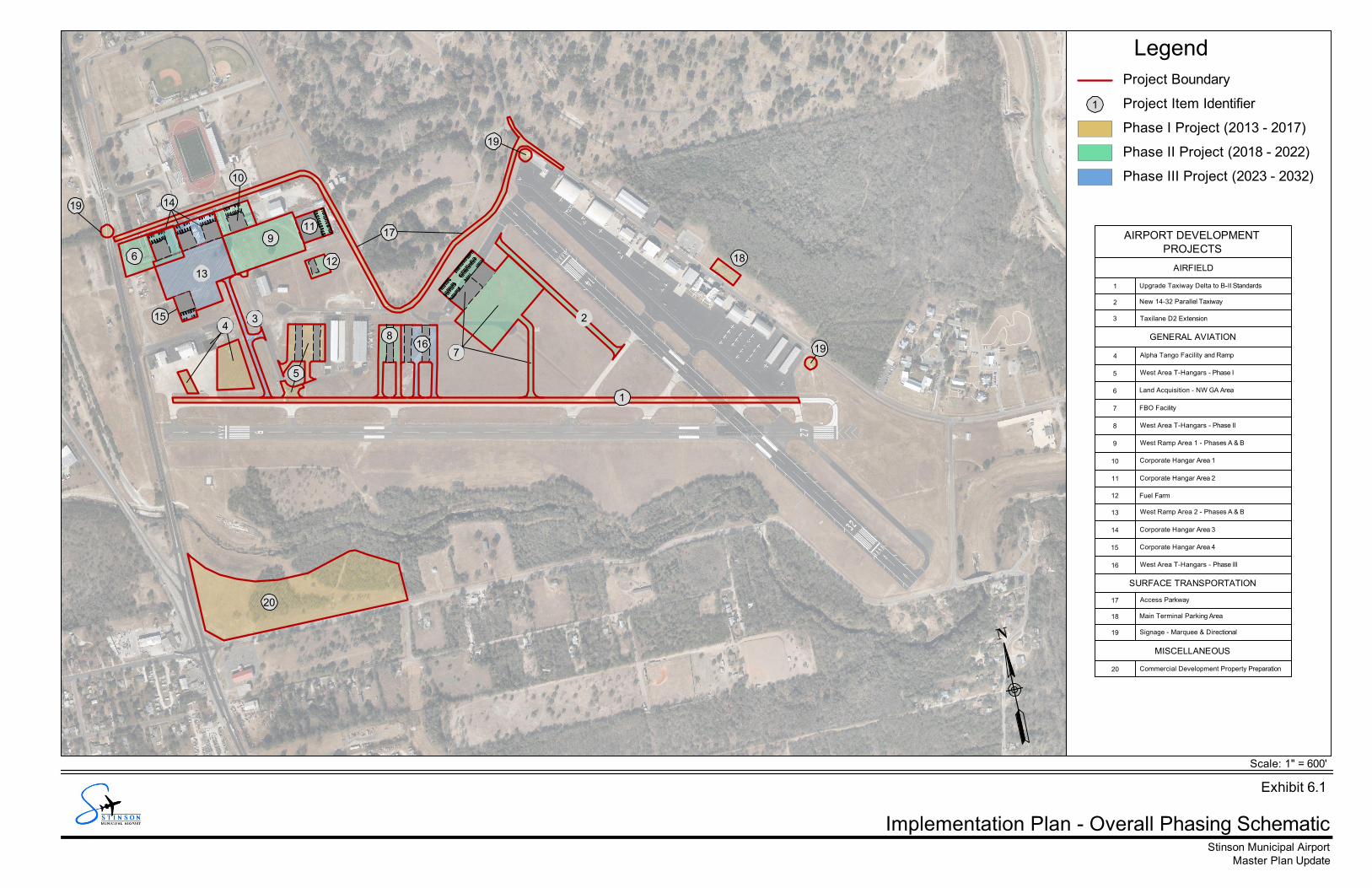
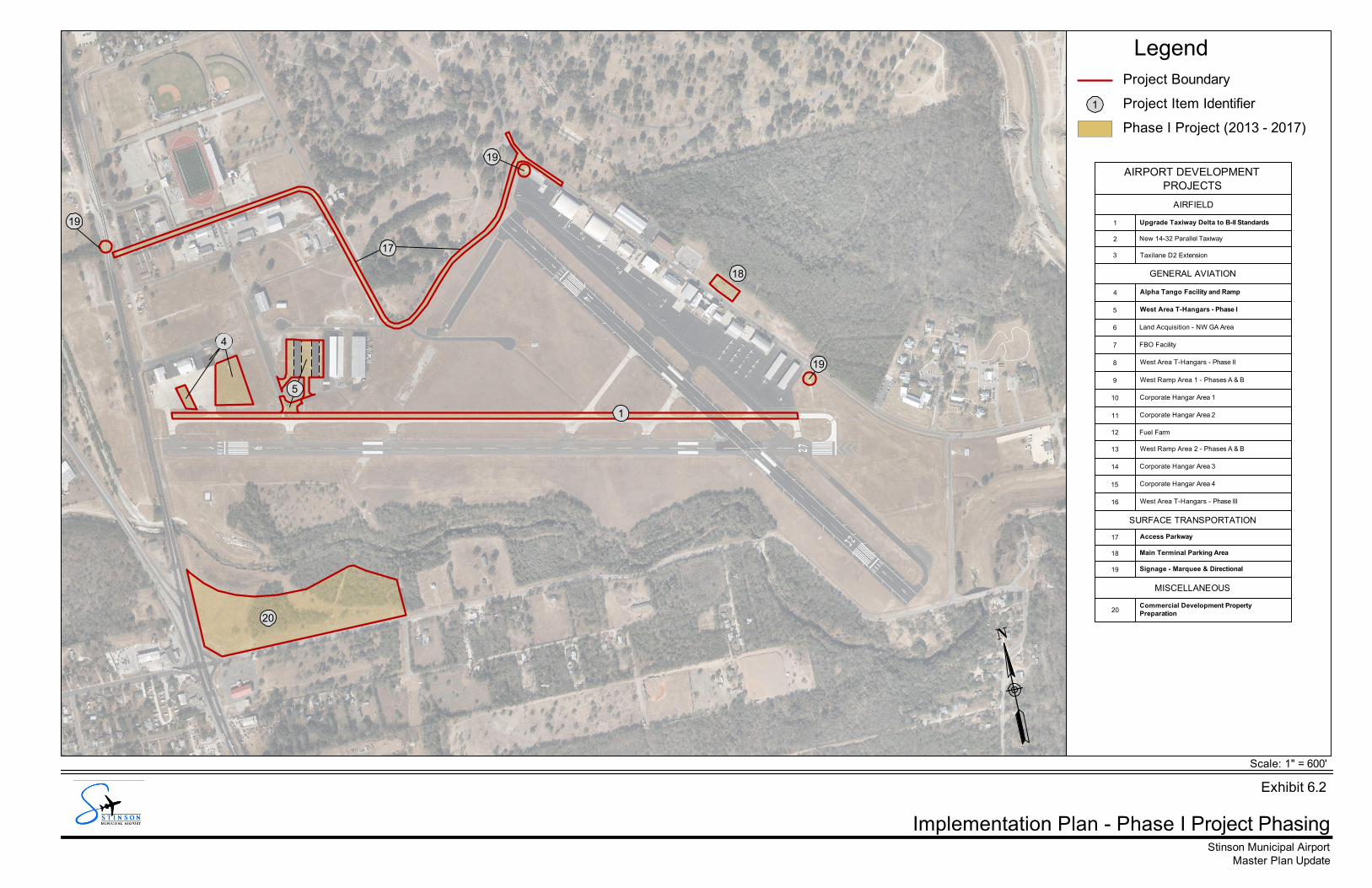
The phasing of the projects identified in the ADP is based on demand levels that will trigger the need forimplementation. An overall project phasing plan is provided in Exhibit 6.1, which is based on theprojected need for Airport improvements.
PHASE I PROJECTS (2013-2017)6.4.1
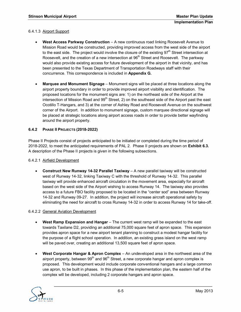
Phase I Projects consist of projects that will be initiated or completed during the time period of 2013-2017,to meet the anticipated requirements of PAL 1. Phase I projects are shown on Exhibit 6.2.
6.4.1.1 Airfield Development
· Taxiway D Upgrade to ARC B-II Separation Standards – As identified during the masterplanning process, the centerline-to-centerline separation between Runway 09-27 and Taxiway Dwill be increased to 240 feet in order to bring Runway 09-27 in compliance with ARC B-IIstandards. This project will involve construction of new pavement, removal of existing pavement,and modification of the existing connector taxiways along Runway 09-27 to properly align with therelocated Taxiway D pavement. In addition, this project will require fence line relocation and theuse of declared distances.
6.4.1.2 General Aviation Development
· West Area T-Hangars (Phase I) – This project involves the construction of two nested T-hangarbuildings to the west of the existing Ocotillo T-hangar building, east of the existing Taxilane D2.Each building will contain 12 units, for a total of 24 T-hangar units. In addition to the buildings,associated necessary aircraft taxiway access will be constructed from Taxiway D andTaxilane D2.
20
15
5
1
14
18
19
19
10
19
17
7
34
12
119
613
2
168
Implementation Plan - Overall Phasing Schematic
Master Plan UpdateStinson Municipal Airport
Legend
Scale: 1" = 600'
Project Item Identifier1
Phase I Project (2013 - 2017)
Project Boundary
Phase II Project (2018 - 2022)
Phase III Project (2023 - 2032)
AIRPORT DEVELOPMENTPROJECTS
AIRFIELD
1 Upgrade Taxiway Delta to B-II Standards
2 New 14-32 Parallel Taxiway
3 Taxilane D2 Extension
GENERAL AVIATION
4 Alpha Tango Facility and Ramp
5 West Area T-Hangars - Phase I
6 Land Acquisition - NW GA Area
7 FBO Facility
8 West Area T-Hangars - Phase II
9 West Ramp Area 1 - Phases A & B
10 Corporate Hangar Area 1
11 Corporate Hangar Area 2
12 Fuel Farm
13 West Ramp Area 2 - Phases A & B
14 Corporate Hangar Area 3
15 Corporate Hangar Area 4
16 West Area T-Hangars - Phase III
SURFACE TRANSPORTATION
17 Access Parkway
18 Main Terminal Parking Area
19 Signage - Marquee & Directional
MISCELLANEOUS
20 Commercial Development Property Preparation
Exhibit 6.1
20
5
1
18
19
19
19
17
4
Implementation Plan - Phase I Project Phasing
Master Plan UpdateStinson Municipal Airport
Legend
Scale: 1" = 600'
Project Item Identifier1
Phase I Project (2013 - 2017)
Project Boundary
AIRPORT DEVELOPMENTPROJECTS
AIRFIELD
1 Upgrade Taxiway Delta to B-II Standards
2 New 14-32 Parallel Taxiway
3 Taxilane D2 Extension
GENERAL AVIATION
4 Alpha Tango Facility and Ramp
5 West Area T-Hangars - Phase I
6 Land Acquisition - NW GA Area
7 FBO Facility
8 West Area T-Hangars - Phase II
9 West Ramp Area 1 - Phases A & B
10 Corporate Hangar Area 1
11 Corporate Hangar Area 2
12 Fuel Farm
13 West Ramp Area 2 - Phases A & B
14 Corporate Hangar Area 3
15 Corporate Hangar Area 4
16 West Area T-Hangars - Phase III
SURFACE TRANSPORTATION
17 Access Parkway
18 Main Terminal Parking Area
19 Signage - Marquee & Directional
MISCELLANEOUS
20Commercial Development PropertyPreparation
Exhibit 6.2
Stinson Municipal Airport Master Plan UpdateImplementation Plan
6-5 May 2013
6.4.1.3 Airport Support
· West Access Parkway Construction – A new continuous road linking Roosevelt Avenue toMission Road would be constructed, providing improved access from the west side of the airportto the east side. The project would involve the closure of the existing 97th Street intersection atRoosevelt, and the creation of a new intersection at 96th Street and Roosevelt. The parkwaywould also provide existing access for future development of the airport in that vicinity, and hasbeen presented to the Texas Department of Transportation Roadways staff with theirconcurrence. This correspondence is included in Appendix G.
· Marquee and Monument Signage – Monument signs will be placed at three locations along theairport property boundary in order to provide improved airport visibility and identification. Theproposed locations for the monument signs are: 1) on the northeast side of the Airport at theintersection of Mission Road and 99th Street, 2) on the southeast side of the Airport past the eastOcotillo T-Hangars, and 3) at the corner of Ashley Road and Roosevelt Avenue on the southwestcorner of the Airport. In addition to monument signage, custom marquee directional signage willbe placed at strategic locations along airport access roads in order to provide better wayfindingaround the airport property.
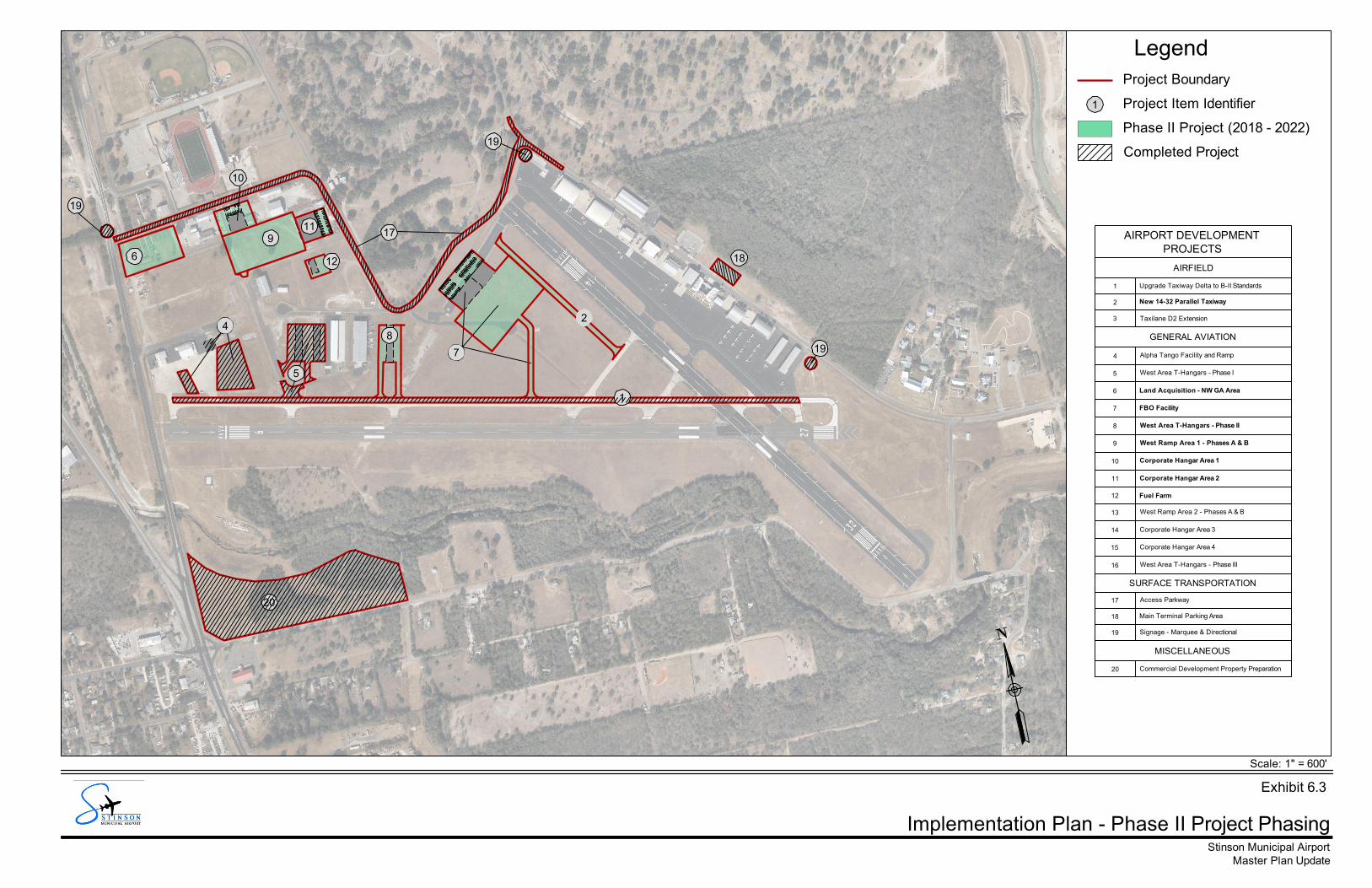
PHASE II PROJECTS (2018-2022)6.4.2
Phase II Projects consist of projects anticipated to be initiated or completed during the time period of2018-2022, to meet the anticipated requirements of PAL 2. Phase II projects are shown on Exhibit 6.3.A description of the Phase II projects is given in the following subsections.
6.4.2.1 Airfield Development
· Construct New Runway 14-32 Parallel Taxiway – A new parallel taxiway will be constructedwest of Runway 14-32, linking Taxiway C with the threshold of Runway 14-32. This paralleltaxiway will provide enhanced aircraft circulation in the movement area, especially for aircraftbased on the west side of the Airport wishing to access Runway 14. The taxiway also providesaccess to a future FBO facility proposed to be located in the “center sod” area between Runway14-32 and Runway 09-27. In addition, the project will increase aircraft operational safety byeliminating the need for aircraft to cross Runway 14-32 in order to access Runway 14 for take-off.
6.4.2.2 General Aviation Development
· West Ramp Expansion and Hangar – The current west ramp will be expanded to the easttowards Taxilane D2, providing an additional 75,000 square feet of apron space. This expansionprovides apron space for a new airport tenant planning to construct a modest hangar facility forthe purpose of a flight school operation. In addition, an existing grass island on the west rampwill be paved over, creating an additional 13,500 square feet of apron space.
· West Corporate Hangar & Apron Complex – An undeveloped area in the northwest area of theairport property, between 99th and 96th Street, a new corporate hangar and apron complex isproposed. This development would include corporate conventional hangars and a large commonuse apron, to be built in phases. In this phase of the implementation plan, the eastern half of thecomplex will be developed, including 2 corporate hangars and apron space.
Stinson Municipal Airport Master Plan UpdateImplementation Plan
6-6 May 2013
· West T-Hangars (Phase II) – Additional T-hangars are planned to be constructed directly off ofthe existing Taxilane D2 to the east. This project consists of two 6-unit T-hangar buildings,providing 12 T-hangar units.
6.4.2.3 Airport Support
· Construct Fuel Farm – An airport fuel farm is proposed west of the new access parkway. Thisfacility will be approximately 20,000 square feet in size, and will provide fuel storage tanks for useby an FBO.
20
5
1
18
19
19
10
19
17
7
4
12
119
6
28
Implementation Plan - Phase II Project Phasing
Master Plan UpdateStinson Municipal Airport
Legend
Scale: 1" = 600'
Project Item Identifier1
Phase II Project (2018 - 2022)
Project Boundary
Completed Project
AIRPORT DEVELOPMENTPROJECTS
AIRFIELD
1 Upgrade Taxiway Delta to B-II Standards
2 New 14-32 Parallel Taxiway
3 Taxilane D2 Extension
GENERAL AVIATION
4 Alpha Tango Facility and Ramp
5 West Area T-Hangars - Phase I
6 Land Acquisition - NW GA Area
7 FBO Facility
8 West Area T-Hangars - Phase II
9 West Ramp Area 1 - Phases A & B
10 Corporate Hangar Area 1
11 Corporate Hangar Area 2
12 Fuel Farm
13 West Ramp Area 2 - Phases A & B
14 Corporate Hangar Area 3
15 Corporate Hangar Area 4
16 West Area T-Hangars - Phase III
SURFACE TRANSPORTATION
17 Access Parkway
18 Main Terminal Parking Area
19 Signage - Marquee & Directional
MISCELLANEOUS
20 Commercial Development Property Preparation
Exhibit 6.3
Stinson Municipal Airport Master Plan UpdateImplementation Plan
6-8 May 2013
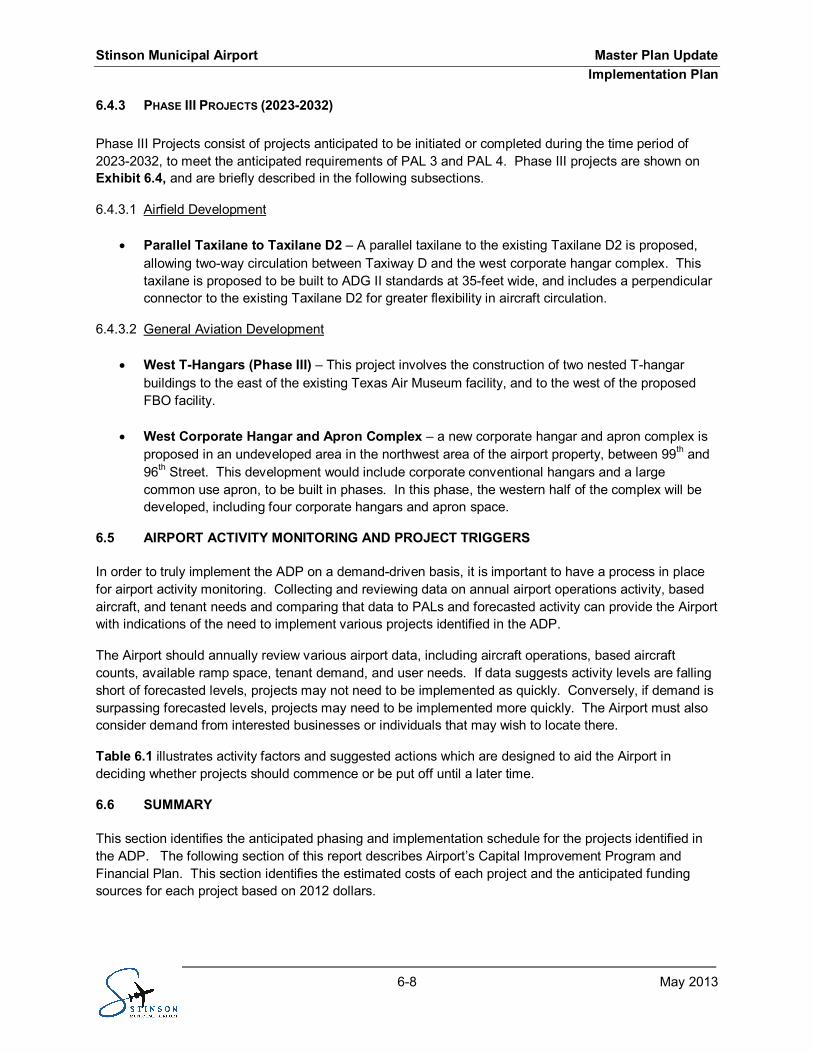
PHASE III PROJECTS (2023-2032)6.4.3
Phase III Projects consist of projects anticipated to be initiated or completed during the time period of2023-2032, to meet the anticipated requirements of PAL 3 and PAL 4. Phase III projects are shown onExhibit 6.4, and are briefly described in the following subsections.
6.4.3.1 Airfield Development
· Parallel Taxilane to Taxilane D2 – A parallel taxilane to the existing Taxilane D2 is proposed,allowing two-way circulation between Taxiway D and the west corporate hangar complex. Thistaxilane is proposed to be built to ADG II standards at 35-feet wide, and includes a perpendicularconnector to the existing Taxilane D2 for greater flexibility in aircraft circulation.
6.4.3.2 General Aviation Development
· West T-Hangars (Phase III) – This project involves the construction of two nested T-hangarbuildings to the east of the existing Texas Air Museum facility, and to the west of the proposedFBO facility.
· West Corporate Hangar and Apron Complex – a new corporate hangar and apron complex isproposed in an undeveloped area in the northwest area of the airport property, between 99th and96th Street. This development would include corporate conventional hangars and a largecommon use apron, to be built in phases. In this phase, the western half of the complex will bedeveloped, including four corporate hangars and apron space.
AIRPORT ACTIVITY MONITORING AND PROJECT TRIGGERS6.5
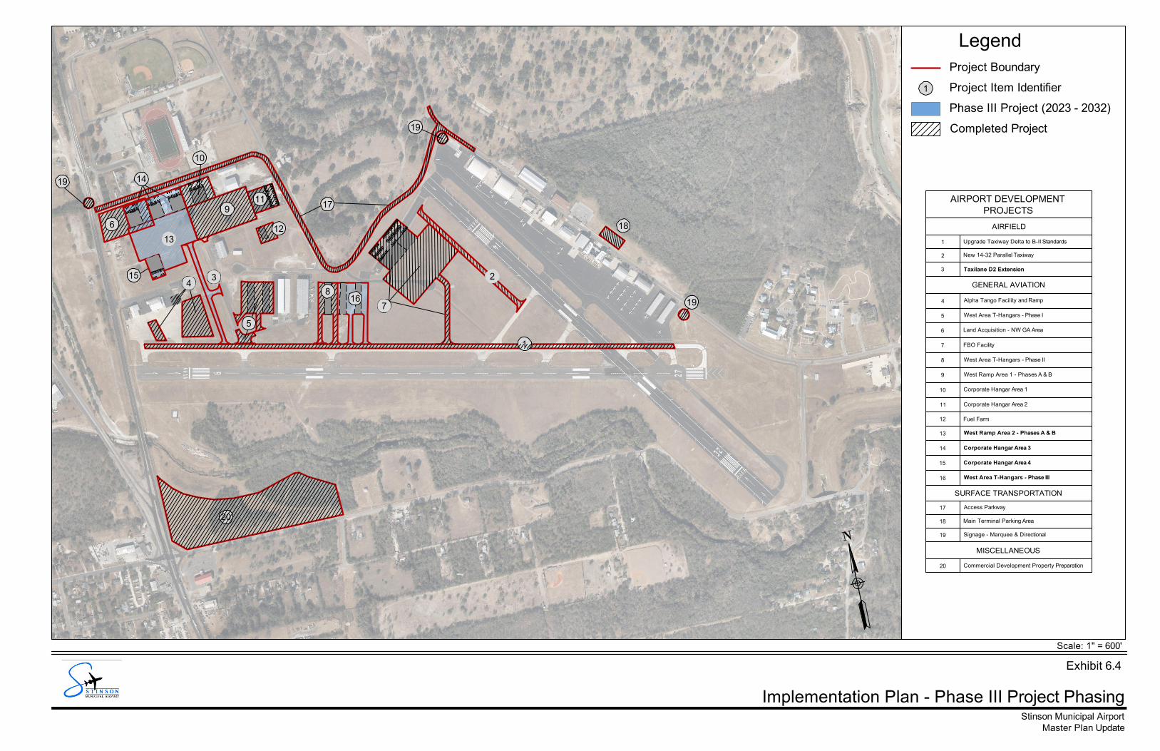
In order to truly implement the ADP on a demand-driven basis, it is important to have a process in placefor airport activity monitoring. Collecting and reviewing data on annual airport operations activity, basedaircraft, and tenant needs and comparing that data to PALs and forecasted activity can provide the Airportwith indications of the need to implement various projects identified in the ADP.
The Airport should annually review various airport data, including aircraft operations, based aircraftcounts, available ramp space, tenant demand, and user needs. If data suggests activity levels are fallingshort of forecasted levels, projects may not need to be implemented as quickly. Conversely, if demand issurpassing forecasted levels, projects may need to be implemented more quickly. The Airport must alsoconsider demand from interested businesses or individuals that may wish to locate there.
Table 6.1 illustrates activity factors and suggested actions which are designed to aid the Airport indeciding whether projects should commence or be put off until a later time.
SUMMARY6.6
This section identifies the anticipated phasing and implementation schedule for the projects identified inthe ADP. The following section of this report describes Airport’s Capital Improvement Program andFinancial Plan. This section identifies the estimated costs of each project and the anticipated fundingsources for each project based on 2012 dollars.
20
15
5
1
14
18
19
19
10
19
17
7
34
12
119
613
2
168
Implementation Plan - Phase III Project Phasing
Master Plan UpdateStinson Municipal Airport
Legend
Scale: 1" = 600'
Project Item Identifier1
Phase III Project (2023 - 2032)
Project Boundary
Completed Project
AIRPORT DEVELOPMENTPROJECTS
AIRFIELD
1 Upgrade Taxiway Delta to B-II Standards
2 New 14-32 Parallel Taxiway
3 Taxilane D2 Extension
GENERAL AVIATION
4 Alpha Tango Facility and Ramp
5 West Area T-Hangars - Phase I
6 Land Acquisition - NW GA Area
7 FBO Facility
8 West Area T-Hangars - Phase II
9 West Ramp Area 1 - Phases A & B
10 Corporate Hangar Area 1
11 Corporate Hangar Area 2
12 Fuel Farm
13 West Ramp Area 2 - Phases A & B
14 Corporate Hangar Area 3
15 Corporate Hangar Area 4
16 West Area T-Hangars - Phase III
SURFACE TRANSPORTATION
17 Access Parkway
18 Main Terminal Parking Area
19 Signage - Marquee & Directional
MISCELLANEOUS
20 Commercial Development Property Preparation
Exhibit 6.4
Stinson Municipal Airport Master Plan UpdateImplementation Plan
6-10 May 2013
Airport Activity Factors and ActionsTable 6.1 -
Activity Type Activity Information Trigger Action
AnnualOperations
Indicates the annual operational demand onthe Airport
Demand is >60%of ASV
Monitor for increasing growth trends. Begindiscussion of capacity enhancements if there issustained demand above 60% of ASV.
Based AircraftDemand
Indicates the need for additional space forbased aircraft with respect to existing capacity
Demand is >90%of existingstorage capacity
Monitor based aircraft activity for increasing ordecreasing trends. Provide additional apron orhangar storage space when there is a sustainedincrease in based aircraft demand.
Tenant / UserNeeds
Indicates utilization of existing facilities andpotential need for improvements None Monitor tenant needs and discuss potential projects
on the ADP that may fit their needs.
BusinessDemand
Indicates interest from businesses seeking tooperate at the Airport
Business InterestWork with interested businesses to identify theirneeds and determine if a proposed project on theADP meets those needs.
Stinson Municipal Airport Master Plan UpdateFinancial Plan
7-1 May 2013
FINANCIAL PLANSECTION 7 -INTRODUCTION7.1
This section addresses the financial viability of implementing the recommended Airport Master Plan. Forpurposes of this analysis, a specific implementation schedule is presented herein. The financialstrategies to be utilized will be determined at the time of actual implementation, and will reflect the policyof the City of San Antonio, its entire Airport System, and overall economic conditions nationwide.
This section also provides a financial plan for the Master Plan recommendations for the Short-Term (2013through 2017), the Mid-Term (2018 through 2022), and the Long-Term (2023 through 2032), and isorganized as follows:
· Introduction· Historical Funding· Available Funding Sources· Capital Development Program Spending· Summary
HISTORICAL FUNDING7.2
A review of historical funding for the Airport indicates capital funding has traditionally been received fromAirport Improvement Program (AIP) Grants, the Airport’s General Operating Fund, the Stinson RevolvingFund, and the State of Texas Routine Airport Maintenance Program (RAMP) fund.
AVAILABLE FUNDING SOURCES7.3
This section identifies available funding sources to implement the recommended Capital ImprovementProgram at the Airport, which include: AIP Grants; RAMP Funds; the Stinson Revolving Fund; otherAirport Funds; COSA Participation; and Third Party funding, as discussed in the following paragraphs.
AIRPORT IMPROVEMENT PROGRAM GRANTS7.3.1
The Airport Improvement Program is the Federal Aviation Administration’s grant program for civil airportsincluded in the National Plan of Integrated Airport System. It is administered by TxDOT under a BlockGrant from the FAA to TxDOT. Grants are made to the State’s General Aviation Airports based oneligibility and national priority. Current legislation provides eligible General Aviation Airports with anannual Non-Primary Entitlement of up to $150,000/year. The amount of funding available to an airport isbased on the level of traffic, project type and justification, and how it compares to other projects proposedacross the nation.
Above and beyond this element of the AIP, is discretionary funding, which is awarded based on projectjustification and demand. Generally, these funds can be used for airside, terminal, and relatedinfrastructure development. This includes airfield pavement construction and rehabilitation; terminalconstruction; roadway and access projects; safety and security projects; land acquisition; planning,environmental, and noise mitigation programs. There are exceptions to these eligibility categories, thislist simply captures the majority of eligible items.
Stinson Municipal Airport Master Plan UpdateFinancial Plan
7-2 May 2013
STATE OF TEXAS ROUTINE AIRPORT MAINTENANCE PROGRAM FUND7.3.2
TxDOT administers the RAMP, which matches local government grants up to $50,000. The grant isavailable to cover 50 percent of the costs of many annual airport maintenance requirements such asairfield pavement repair and rehabilitation, drainage maintenance, sweeping and repair and maintenanceof lighting and approach aids. It also can be utilized for certain low-cost capital improvements such asairport public parking lots, installation of security fencing, replacement of rotating beacons, etc.33
STINSON REVOLVING FUND7.3.3
The Stinson Revolving Fund was established for the Airport as part of the City of San Antonio’s AirportEconomic Development Program. The Revolving Fund was established in 1992 with an initialcontribution of $2.0 million from the Aviation Department’s Capital Improvement Fund, with additionalannual contributions of $500,000 until the balance reached its cap limit of $5.0 million. The RevolvingFund was initially established to develop a pool of funds to finance the construction of City-ownedfacilities to be leased to qualifying tenants on a cost-recovery basis. In order to facilitate thedevelopment of a first-class general aviation airport, the ordinance governing the Revolving Fund wasrevised in 1999 to permit fund balances in excess of $2.5 million for capital improvement projects at theAirport, including those for public and/or common use. Facility financing of new construction at theAirport is limited to $2.0 million or less per project from the Revolving Fund.
OTHER AIRPORT FUNDING7.3.4
Other Airport Funding includes any other revenue sources the Airport has at its discretion for use oncapital projects. This could include the Aviation Department’s Capital Improvement Fund, AirportDiscretionary Funds, and other Aviation Department Revenues generated from both Aviation and Non-Aviation Rates and Charges.
OTHER CITY OF SAN ANTONIO PARTICIPATION7.3.5
The Airport typically requires an annual subsidy from the City’s Aviation Department to break evenfinancially after accounting for its annual operating revenues, operating expenses, and capital outlay.The majority of general aviation facilities in the nation operate at a deficit; however, the value of thesefacilities to their local aviation systems and communities warrants the fiscal aid of other sponsors to meettheir financial requirements. Beyond day-to-day financial responsibilities, there are certain capitalprojects, such as public roadways, infrastructure, and other projects that meet the City’s long-term goalfor the Airport and its environs, that may warrant provision of additional funds by the City. Fundingsources could include: the City of San Antonio Public Works Department; San Antonio Water System;and the Aviation Department’s Capital Improvement Fund.
33 Texas Department of Transportation – 2012 Routine Airport Maintenance Program (RAMP) Grants ProgramDescription
Stinson Municipal Airport Master Plan UpdateFinancial Plan
7-3 May 2013
THIRD PARTY FUNDING7.3.6
Third-party financing can provide additional sources of funding for capital improvement projects. Typicalairport projects that feature third-party financing include general aviation hangar development, corporatehangars, and cargo facilities. Although third-party financing may take many different shapes, a typicalscenario occurs when a third-party developer finances a construction project with expected strongpositive cash flows. Under such an arrangement, the third-party pays ground rent to the Airport whileleasing the structure or facility to one or more tenants. Depending on the terms of the agreement, theAirport typically receives ownership of the structure or facility after a fixed amount of time has passed.This period affords the third-party the opportunity to amortize its investment.
CAPITAL DEVELOPMENT PROGRAM SPENDING7.4
The timing of the various capital improvement projects has been developed and reviewed by theConsultant Team in conjunction with Airport officials and staff. The planned capital improvements arebased on the needs of the Airport given current infrastructure conditions and estimated future growth. Asignificant amount of advanced planning should occur to document the purpose, need and justification,and to examine other capacity enhancing alternatives prior to the implementation of capital improvementprojects. The financial capabilities of the Airport have also been taken into account.
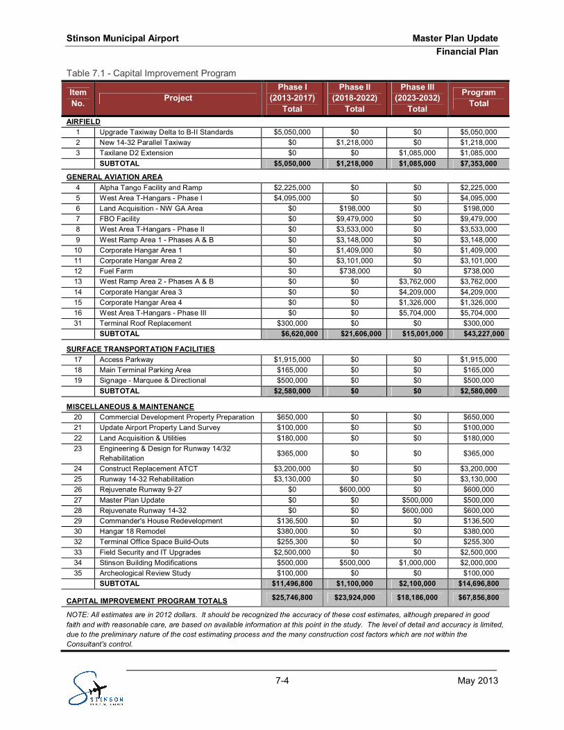
The total annual funding requirement for the 20-year Capital Improvement Program (CIP) is estimated atapproximately $67.9 million in 2012 dollars (see Table 7.1, Capital Improvement Program). The CIPwas developed as a cooperative effort among the Airport and its consultants, and provides informationbased upon current financial data and the goals of the Airport. Because actual activity levels are likely tovary from the projected forecast, the implementation schedule should be closely monitored and adjustedbased on the actual activity levels. Furthermore, there are certain projects or operating maintenanceinitiatives (item numbers 21 through 35) included in the CIP that are not shown on the ADP. They werenot assessed under this master planning process, but it is important to recognize the implication offunding them holistically in this financial plan. Detailed tables of the CIP can be found in Appendix F.
Stinson Municipal Airport Master Plan UpdateFinancial Plan
7-4 May 2013
Capital Improvement ProgramTable 7.1 -
ItemNo. Project
Phase I(2013-2017)
Total
Phase II(2018-2022)
Total
Phase III(2023-2032)
Total
ProgramTotal
AIRFIELD1 Upgrade Taxiway Delta to B-II Standards $5,050,000 $0 $0 $5,050,0002 New 14-32 Parallel Taxiway $0 $1,218,000 $0 $1,218,0003 Taxilane D2 Extension $0 $0 $1,085,000 $1,085,000
SUBTOTAL $5,050,000 $1,218,000 $1,085,000 $7,353,000
GENERAL AVIATION AREA4 Alpha Tango Facility and Ramp $2,225,000 $0 $0 $2,225,0005 West Area T-Hangars - Phase I $4,095,000 $0 $0 $4,095,0006 Land Acquisition - NW GA Area $0 $198,000 $0 $198,0007 FBO Facility $0 $9,479,000 $0 $9,479,0008 West Area T-Hangars - Phase II $0 $3,533,000 $0 $3,533,0009 West Ramp Area 1 - Phases A & B $0 $3,148,000 $0 $3,148,00010 Corporate Hangar Area 1 $0 $1,409,000 $0 $1,409,00011 Corporate Hangar Area 2 $0 $3,101,000 $0 $3,101,00012 Fuel Farm $0 $738,000 $0 $738,00013 West Ramp Area 2 - Phases A & B $0 $0 $3,762,000 $3,762,00014 Corporate Hangar Area 3 $0 $0 $4,209,000 $4,209,00015 Corporate Hangar Area 4 $0 $0 $1,326,000 $1,326,00016 West Area T-Hangars - Phase III $0 $0 $5,704,000 $5,704,00031 Terminal Roof Replacement $300,000 $0 $0 $300,000
SUBTOTAL $6,620,000 $21,606,000 $15,001,000 $43,227,000
SURFACE TRANSPORTATION FACILITIES17 Access Parkway $1,915,000 $0 $0 $1,915,00018 Main Terminal Parking Area $165,000 $0 $0 $165,00019 Signage - Marquee & Directional $500,000 $0 $0 $500,000
SUBTOTAL $2,580,000 $0 $0 $2,580,000
MISCELLANEOUS & MAINTENANCE20 Commercial Development Property Preparation $650,000 $0 $0 $650,00021 Update Airport Property Land Survey $100,000 $0 $0 $100,00022 Land Acquisition & Utilities $180,000 $0 $0 $180,00023 Engineering & Design for Runway 14/32
Rehabilitation$365,000 $0 $0 $365,000
24 Construct Replacement ATCT $3,200,000 $0 $0 $3,200,00025 Runway 14-32 Rehabilitation $3,130,000 $0 $0 $3,130,00026 Rejuvenate Runway 9-27 $0 $600,000 $0 $600,00027 Master Plan Update $0 $0 $500,000 $500,00028 Rejuvenate Runway 14-32 $0 $0 $600,000 $600,00029 Commander's House Redevelopment $136,500 $0 $0 $136,50030 Hangar 18 Remodel $380,000 $0 $0 $380,00032 Terminal Office Space Build-Outs $255,300 $0 $0 $255,30033 Field Security and IT Upgrades $2,500,000 $0 $0 $2,500,00034 Stinson Building Modifications $500,000 $500,000 $1,000,000 $2,000,00035 Archeological Review Study $100,000 $0 $0 $100,000
SUBTOTAL $11,496,800 $1,100,000 $2,100,000 $14,696,800
CAPITAL IMPROVEMENT PROGRAM TOTALS $25,746,800 $23,924,000 $18,186,000 $67,856,800
NOTE: All estimates are in 2012 dollars. It should be recognized the accuracy of these cost estimates, although prepared in goodfaith and with reasonable care, are based on available information at this point in the study. The level of detail and accuracy is limited,due to the preliminary nature of the cost estimating process and the many construction cost factors which are not within theConsultant's control.
Stinson Municipal Airport Master Plan UpdateFinancial Plan
7-5 May 2013
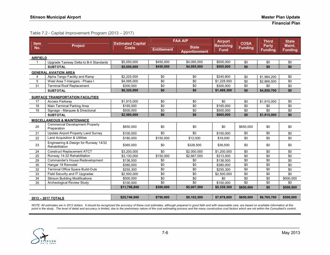
SHORT-TERM PLANNING HORIZON PROJECTS (2013-2017)7.4.1
The total annual funding requirement for the Short-Term Planning Horizon projects is approximately $25.7million. Table 7.2 shows the Capital Improvement Program (2013 – 2017), and provides detailedinformation regarding each recommended project, its timing and the specific funding sources. The itemnumbers correspond to the projects shown on Exhibit 6.2. The projects to be implemented in this initialplanning period include:
· Land Acquisition
· Replacement Air Traffic Control Tower
· Runway and Taxiway Rehabilitation
· Taxiway Construction & Design Standard Improvements
· Hangar Facilities and
· Access & Signage Improvements.
It should be noted the land acquisition and replacement of the ATCT were not projects included in theADP because these were separate initiatives underway prior to the Master Plan Update. The anticipatedfunding sources for these Short-Term capital projects are:
· FAA AIP (Non-Primary Entitlement) Funding: $750,000
· Other FAA AIP Funding (State Apportionment & Discretionary): $9,102,500
· State RAMP Funding: $250,000
· Airport Revolving Fund (Local Match to AIP Grants): $1,094,722
· Airport Revolving Fund (Airport Funding): $7,133,878
· Other Airport Funding: $0
· City of San Antonio Funding: $2,565,000
· Third Party Funding: $4,850,700
Stinson Municipal Airport Master Plan UpdateFinancial Plan
7-6 May 2013
Capital Improvement Program (2013 – 2017)Table 7.2 -
ItemNo. Project Estimated Capital
Costs
FAA AIP AirportRevolving
FundCOSA
FundingThirdParty
Funding
StateMaint.
FundingEntitlement StateApportionment
AIRFIELD1 Upgrade Taxiway Delta to B-II Standards $5,050,000 $450,000 $4,095,000 $505,000 $0 $0 $0
SUBTOTAL $5,050,000 $450,000 $4,095,000 $505,000 $0 $0 $0
GENERAL AVIATION AREA4 Alpha Tango Facility and Ramp $2,225,000 $0 $0 $240,800 $0 $1,984,200 $05 West Area T-Hangars - Phase I $4,095,000 $0 $0 $1,228,500 $0 $2,866,500 $031 Terminal Roof Replacement $300,000 $0 $0 $300,000 $0 $0 $0
SUBTOTAL $6,320,000 $0 $0 $1,469,300 $0 $4,850,700 $0
SURFACE TRANSPORTATION FACILITIES17 Access Parkway $1,915,000 $0 $0 $0 $0 $1,915,000 $018 Main Terminal Parking Area $165,000 $0 $0 $165,000 $0 $0 $019 Signage - Marquee & Directional $500,000 $0 $0 $500,000 $0 $0 $0
SUBTOTAL $2,580,000 $0 $0 $665,000 $0 $1,915,000 $0MISCELLANEOUS & MAINTENANCE
20Commercial Development PropertyPreparation $650,000 $0 $0 $0 $650,000 $0 $0
21 Update Airport Property Land Survey $100,000 $0 $0 $100,000 $0 $0 $022 Land Acquisition & Utilities $180,000 $150,000 $12,000 $18,000 $0 $0 $0
23Engineering & Design for Runway 14/32Rehabilitation $365,000 $0 $328,500 $36,500 $0 $0 $0
24 Construct Replacement ATCT $3,200,000 $0 $2,000,000 $1,200,000 $0 $0 $025 Runway 14-32 Rehabilitation $3,130,000 $150,000 $2,667,000 $313,000 $0 $0 $029 Commander's House Redevelopment $136,500 $0 $0 $136,500 $0 $0 $030 Hangar 18 Remodel $380,000 $0 $0 $380,000 $0 $0 $032 Terminal Office Space Build-Outs $255,300 $0 $0 $255,300 $0 $0 $033 Field Security and IT Upgrades $2,500,000 $0 $0 $2,500,000 $0 $0 $034 Stinson Building Modifications $500,000 $0 $0 $0 $0 $0 $500,00035 Archeological Review Study $100,000 $0 $0 $100,000 $0 $0 $0
$11,796,800 $300,000 $5,007,500 $5,339,300 $650,000 $0 $500,000
2013 – 2017 TOTALS $25,746,800 $750,000 $9,102,500 $7,978,600 $650,000 $6,765,700 $500,000
NOTE: All estimates are in 2012 dollars. It should be recognized the accuracy of these cost estimates, although prepared in good faith and with reasonable care, are based on available information at thispoint in the study. The level of detail and accuracy is limited, due to the preliminary nature of the cost estimating process and the many construction cost factors which are not within the Consultant's control.
Stinson Municipal Airport Master Plan UpdateFinancial Plan
7-7 May 2013
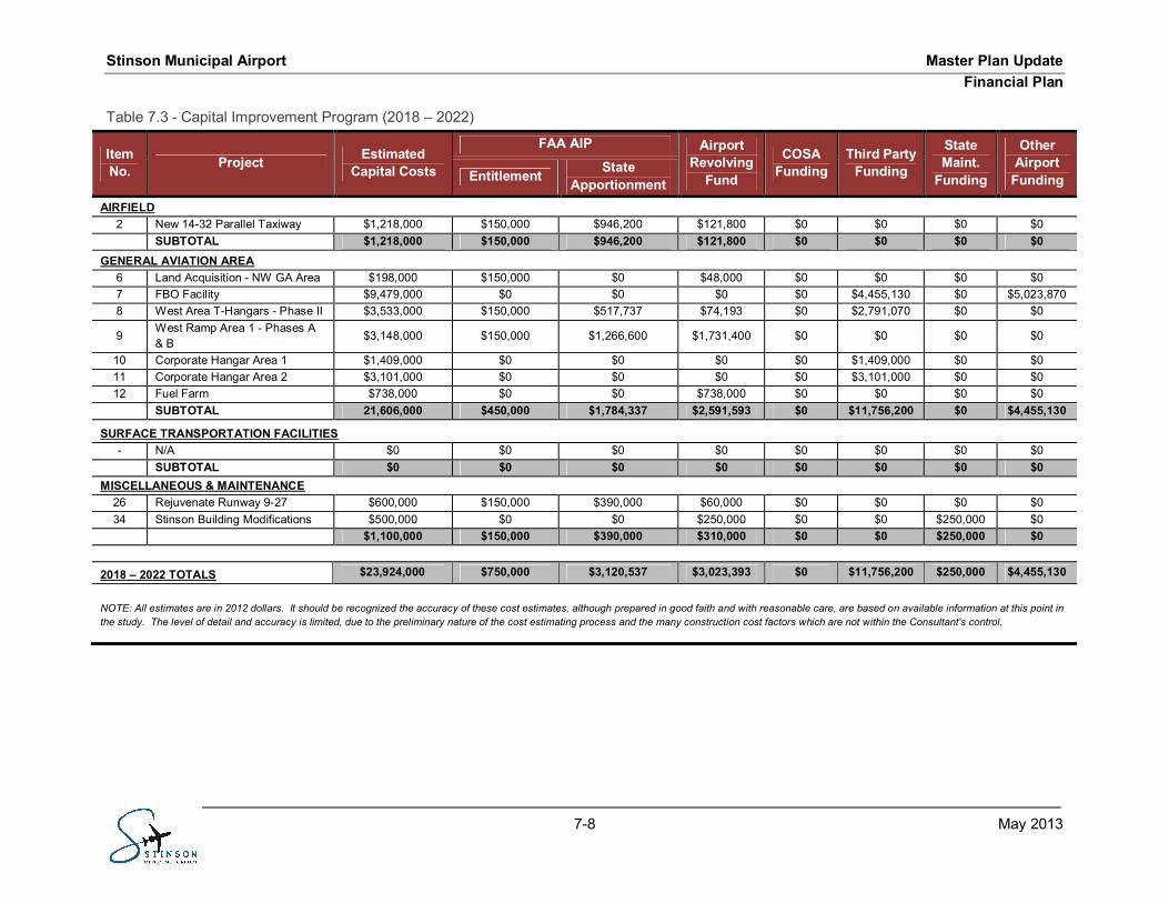
MID-TERM PLANNING HORIZON PROJECTS (2018-2022)7.4.2
The total annual funding requirement for the Mid-Term Planning Horizon projects is approximately $23.9million. Table 7.3 shows the Capital Improvement Program (2018 – 2022) and provides detailedinformation regarding each recommended project, its timing and the specific funding sources. The itemnumbers correspond to the projects shown on Exhibit 6.3. The projects scheduled for implementationduring this planning period include:
· Land Acquisition
· Taxiway & Ramp Construction
· Hangar & Fixed Base Operator Facilities
· Fuel Farm and
· Runway Rejuvenation.
The anticipated funding sources for these Mid-Term capital projects are:
· FAA AIP (Non-Primary Entitlement) Funding: $750,000
· Other FAA AIP (State Apportionment & Discretionary) Funding: $3,120,537
· State RAMP Funding: $250,000
· Airport Revolving Fund (Local Match to AIP Grants): $430,060
· Airport Revolving Fund (Airport Funding): $2,593,333
· Other Airport Funding: $5,023,870
· City of San Antonio Funding: $0
· Third Party Funding: $11,756,200
Stinson Municipal Airport Master Plan UpdateFinancial Plan
7-8 May 2013
Capital Improvement Program (2018 – 2022)Table 7.3 -
ItemNo. Project Estimated
Capital Costs
FAA AIP AirportRevolving
Fund
COSAFunding
Third PartyFunding
StateMaint.
Funding
OtherAirport
FundingEntitlement StateApportionment
AIRFIELD2 New 14-32 Parallel Taxiway $1,218,000 $150,000 $946,200 $121,800 $0 $0 $0 $0
SUBTOTAL $1,218,000 $150,000 $946,200 $121,800 $0 $0 $0 $0GENERAL AVIATION AREA
6 Land Acquisition - NW GA Area $198,000 $150,000 $0 $48,000 $0 $0 $0 $07 FBO Facility $9,479,000 $0 $0 $0 $0 $4,455,130 $0 $5,023,8708 West Area T-Hangars - Phase II $3,533,000 $150,000 $517,737 $74,193 $0 $2,791,070 $0 $0
9West Ramp Area 1 - Phases A& B
$3,148,000 $150,000 $1,266,600 $1,731,400 $0 $0 $0 $0
10 Corporate Hangar Area 1 $1,409,000 $0 $0 $0 $0 $1,409,000 $0 $011 Corporate Hangar Area 2 $3,101,000 $0 $0 $0 $0 $3,101,000 $0 $012 Fuel Farm $738,000 $0 $0 $738,000 $0 $0 $0 $0
SUBTOTAL 21,606,000 $450,000 $1,784,337 $2,591,593 $0 $11,756,200 $0 $4,455,130
SURFACE TRANSPORTATION FACILITIES- N/A $0 $0 $0 $0 $0 $0 $0 $0
SUBTOTAL $0 $0 $0 $0 $0 $0 $0 $0MISCELLANEOUS & MAINTENANCE
26 Rejuvenate Runway 9-27 $600,000 $150,000 $390,000 $60,000 $0 $0 $0 $034 Stinson Building Modifications $500,000 $0 $0 $250,000 $0 $0 $250,000 $0
$1,100,000 $150,000 $390,000 $310,000 $0 $0 $250,000 $0
2018 – 2022 TOTALS $23,924,000 $750,000 $3,120,537 $3,023,393 $0 $11,756,200 $250,000 $4,455,130
NOTE: All estimates are in 2012 dollars. It should be recognized the accuracy of these cost estimates, although prepared in good faith and with reasonable care, are based on available information at this point inthe study. The level of detail and accuracy is limited, due to the preliminary nature of the cost estimating process and the many construction cost factors which are not within the Consultant's control.
Stinson Municipal Airport Master Plan UpdateFinancial Plan
7-9 May 2013
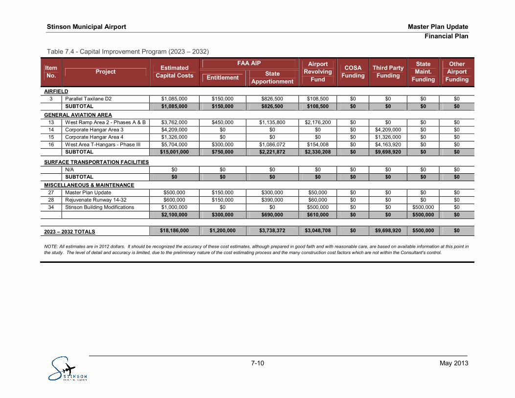
LONG-TERM PLANNING HORIZON PROJECTS (2023-2032)7.4.3
The total annual funding requirement for the Long-Term Planning Horizon projects is approximately $18.2million. Table 7.4 shows the Capital Improvement Program (2023 – 2032) and provides detailedinformation regarding each recommended project, its timing and the specific funding sources. The itemnumbers correspond to the projects shown on Exhibit 6.4. The projects to be implemented in thisplanning period include:
· Taxilane Extension
· Ramp Construction
· Hangar Facilities and
· Runway Rejuvenation.
The anticipated funding sources for these Long-Term capital projects are:
· FAA AIP (Non-Primary Entitlement) Funding: $1,200,000
· Other FAA AIP (State Apportionment & Discretionary) Funding: $3,738,372
· State RAMP Funding: $500,000
· Airport Revolving Fund (Local Match to AIP Grants): $548,708
· Airport Revolving Fund (Airport Funding): $2,500,000
· Other Airport Funding: $0
· City of San Antonio Funding: $0
· Third Party Funding: $9,698,920
Stinson Municipal Airport Master Plan UpdateFinancial Plan
7-10 May 2013
Capital Improvement Program (2023 – 2032)Table 7.4 -
ItemNo. Project Estimated
Capital Costs
FAA AIP AirportRevolving
Fund
COSAFunding
Third PartyFunding
StateMaint.
Funding
OtherAirport
FundingEntitlement StateApportionment
AIRFIELD3 Parallel Taxilane D2 $1,085,000 $150,000 $826,500 $108,500 $0 $0 $0 $0
SUBTOTAL $1,085,000 $150,000 $826,500 $108,500 $0 $0 $0 $0GENERAL AVIATION AREA
13 West Ramp Area 2 - Phases A & B $3,762,000 $450,000 $1,135,800 $2,176,200 $0 $0 $0 $014 Corporate Hangar Area 3 $4,209,000 $0 $0 $0 $0 $4,209,000 $0 $015 Corporate Hangar Area 4 $1,326,000 $0 $0 $0 $0 $1,326,000 $0 $016 West Area T-Hangars - Phase III $5,704,000 $300,000 $1,086,072 $154,008 $0 $4,163,920 $0 $0
SUBTOTAL $15,001,000 $750,000 $2,221,872 $2,330,208 $0 $9,698,920 $0 $0
SURFACE TRANSPORTATION FACILITIESN/A $0 $0 $0 $0 $0 $0 $0 $0SUBTOTAL $0 $0 $0 $0 $0 $0 $0 $0
MISCELLANEOUS & MAINTENANCE27 Master Plan Update $500,000 $150,000 $300,000 $50,000 $0 $0 $0 $028 Rejuvenate Runway 14-32 $600,000 $150,000 $390,000 $60,000 $0 $0 $0 $034 Stinson Building Modifications $1,000,000 $0 $0 $500,000 $0 $0 $500,000 $0
$2,100,000 $300,000 $690,000 $610,000 $0 $0 $500,000 $0
2023 – 2032 TOTALS $18,186,000 $1,200,000 $3,738,372 $3,048,708 $0 $9,698,920 $500,000 $0
NOTE: All estimates are in 2012 dollars. It should be recognized the accuracy of these cost estimates, although prepared in good faith and with reasonable care, are based on available information at this point inthe study. The level of detail and accuracy is limited, due to the preliminary nature of the cost estimating process and the many construction cost factors which are not within the Consultant's control.
Stinson Municipal Airport Master Plan UpdateFinancial Plan
7-11 May 2013
SUMMARY7.5
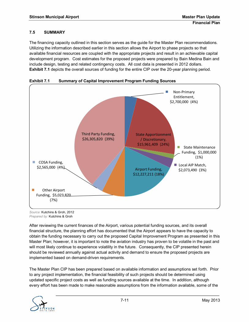
The financing capacity outlined in this section serves as the guide for the Master Plan recommendations.Utilizing the information described earlier in this section allows the Airport to phase projects so thatavailable financial resources are coupled with the appropriate projects and result in an achievable capitaldevelopment program. Cost estimates for the proposed projects were prepared by Bain Medina Bain andinclude design, testing and related contingency costs. All cost data is presented in 2012 dollars.Exhibit 7.1 depicts the overall sources of funding for the entire CIP over the 20-year planning period.
Exhibit 7.1 Summary of Capital Improvement Program Funding Sources
Source: Kutchins & Groh, 2012Prepared by: Kutchins & Groh
After reviewing the current finances of the Airport, various potential funding sources, and its overallfinancial structure, the planning effort has documented that the Airport appears to have the capacity toobtain the funding necessary to carry out the proposed Capital Improvement Program as presented in thisMaster Plan; however, it is important to note the aviation industry has proven to be volatile in the past andwill most likely continue to experience volatility in the future. Consequently, the CIP presented hereinshould be reviewed annually against actual activity and demand to ensure the proposed projects areimplemented based on demand-driven requirements.
The Master Plan CIP has been prepared based on available information and assumptions set forth. Priorto any project implementation, the financial feasibility of such projects should be determined usingupdated specific project costs as well as funding sources available at the time. In addition, althoughevery effort has been made to make reasonable assumptions from the information available, some of the
Non-PrimaryEntitlement,
$2,700,000 (4%)
State Apportionment/ Discretionary,
$15,961,409 (24%)State Maintenance
Funding, $1,000,000(1%)
Local AIP Match,$2,073,490 (3%)Airport Funding,
$12,227,211 (18%)
Other AirportFunding, $5,023,870
(7%)
COSA Funding,$2,565,000 (4%)
Third Party Funding,$26,305,820 (39%)
Stinson Municipal Airport Master Plan UpdateFinancial Plan
7-12 May 2013
assumptions used to develop the Master Plan CIP may not be realized, and other unanticipatedcircumstances may arise. Therefore, actual results may be materially different from those projected. Assuch, the Master Plan CIP is not intended to be used to support the sale of bonds or to obtain other formsof financing.
Stinson Municipal Airport Master Plan UpdateEnvironmental Overview
8-1 May 2013
ENVIRONMENTAL OVERVIEWSECTION 8 -INTRODUCTION8.1
From an environmental standpoint, federal actions are important so planners and scientists may assessimpacts on the existing and surrounding environments. Title I of the National Environmental Policy Act(NEPA) contains a Declaration that requires federal government to use practicable means to create andmaintain conditions under which man and nature can exist in productive harmony. Section 102 requiresfederal agencies to incorporate environmental considerations in their planning and decision-making byusing a systematic interdisciplinary approach. Specifically, federal agencies are to prepare detailedstatements assessing the environmental impact when federal actions significantly affect the environment.
Planned development at the Airport is shown on Exhibit 5.17. The Airport Development Plan iscomprised of three phases, which contain prioritized construction of the following facilities (or otherwisespecified):
Phase I:
· Upgrade parallel taxiway to runway 9-27 to ARC B-II Standards· Alpha Tango Facility and Ramp· West Area T-Hangars – Phase I· Access Parkway· Main Terminal Parking Area· Signage – Marquee & Directional and Monument· Commercial/Retail Development Property Preparation
Phase II:
· Parallel taxiway to runway 14-32· Land acquisition on northwest GA Area· Fixed Base Operator Facility· West Area T-Hangars – Phase II· West Ramp Area 1 – Phases A & B· Corporate Hangar Area 1· Corporate Hangar Area 2· Fuel Farm
Phase III:
· Parallel Taxiway to Taxilane D2· West Ramp Area 2 – Phases A & B· Corporate Hangar Area 3· Corporate Hangar Area 4· West Area T-Hangars – Phase III·
The Airport is owned by the City of San Antonio and is operated by the San Antonio Aviation Department,which also operates San Antonio International Airport. The Airport is comprised of 310 acres. It islocated approximately six miles south of downtown San Antonio in Bexar County, Texas.
Stinson Municipal Airport Master Plan UpdateEnvironmental Overview
8-2 May 2013
PURPOSE8.1.1
This Environmental Overview identifies the existing environmental conditions of the Airport property, aswell as potential environmental impacts from the planned development at the Airport. It provides federal,state and local government officials and the general public with an understanding of the environmentalresources and constraints within Airport property.
The Council on Environmental Quality regulation 1501.2 states that, “Agencies shall integrate theNational Environmental Policy Act (NEPA) process with other planning at the earliest possible time toensure planning and decisions reflect environmental values, emphasize cooperative consultation amongagencies before the environmental assessment is prepared; and identify significant environmental issuesdeserving of further study. As outlined in Federal Aviation Administration Order 1050.1E, the followingenvironmental factors and resources are considered in this environmental overview:
1. Air Quality2. Coastal Resources3. Compatible Land Use4. Construction Impacts5. Section 4(f) and Section 6(f)6. Prime Farmlands7. Biotic Communities - Fish, Wildlife, Birds and Vegetation8. Floodplains9. Hazardous Materials, Pollution Prevention, and Solid Waste10. Wetlands/Waters of the U.S.11. Light Emissions and Visual Impacts12. Natural Resources, Energy Supply, and Sustainable Design13. Noise14. Socioeconomic Impacts, Environmental Justice, and Safety Risks15. Water Quality16. Cultural Resources17. Wild and Scenic Rivers18. Secondary (Induced) Impacts
This overview is not intended to be a formal NEPA assessment. Its purpose is to ensure thatenvironmental factors are considered and to point out those areas that may be potentially affected by theplanned development at the Airport.
ENVIRONMENTAL PROCESS8.1.2
Actions or projects that are considered “Federal actions” or receive Federal funding must be assessedfrom an environmental standpoint in order to comply with NEPA of 1969. The planned Airportdevelopment would be considered a Federal action; and would require compliance with the FAAenvironmental process. The process consists of a determination of the appropriate review for theproposed action(s). Federal regulations outline three categories of environmental action relevant toairport development: categorical exclusion, environmental assessment and environmental impactstatement (EIS).
A Categorical Exclusion applies to those actions that have been found (under normal circumstances) tohave no potential for significant environmental impacts. An environmental assessment is prepared in
Stinson Municipal Airport Master Plan UpdateEnvironmental Overview
8-3 May 2013
order to determine whether a proposed action has the potential to significantly affect the environment. Ifan environmental assessment indicates that a proposed action will not result in significant impacts, aFinding of No Significant Impact would be prepared.
An Environmental Impact Statement is prepared for major federal actions and allow federal agencies tomake in-depth examinations of the existing environment resources, environmental impacts from proposedaction and environmental management and mitigation that would minimize assessed impacts. It alsodiscloses information needed for the public to understand the proposed action and its environmentaleffects. Major airport actions at a commercial service airport within a metropolitan statistical areanormally require an EIS.
ENVIRONMENTAL FACTORS AND RESOURCES8.2
This section presents outcomes from a preliminary environmental constraints review for the Airportproperty and surrounds. An in-depth NEPA assessment and further study would be required toadequately evaluate environmental impacts from the planned improvements at the Airport. However,potential environmental impacts and issues will be identified in this section; as well as relevant regulationsand government agencies for each environmental factor.
AIR QUALITY8.2.1
The United States Environmental Protection Agency (USEPA) is the federal agency that has jurisdictionover air quality issues and regulations. The Texas Commission on Environmental Quality (TCEQ)oversees air permitting activities and implements plans to protect and restore air quality in cooperationwith local, regional, state and federal stakeholders.
The Federal Clean Air Act (CAA) (42 U.S.C. §§ 7401-7671q) has established National Ambient AirQuality Standards (NAAQS) for six criteria air pollutants. These six pollutants are: carbon monoxide(CO), lead (Pb), nitrogen dioxide (NO2), ozone (O3), particulate matter (PM10 and PM2.5) and sulfur dioxide(SO2). Geographic areas where these standards are not met for the preceding criteria pollutants aredesignated as “nonattainment areas.” A nonattainment area is defined by the CAA as a locality where airpollution levels persistently exceed NAAQS or contributes to ambient air quality in a nearby area that failsto meet standards. The CAA Amendments of 1990 require Federal agencies to ensure their actionsconform to the appropriate State Implementation Plan (SIP).
The SIP provides for the implementation, maintenance, and enforcement of the NAAQS, and includesemission limitations and control measures to attain and maintain the NAAQS. Conformity is defined asdemonstrating that a project conforms to the SIP’s purpose of eliminating or reducing the severity andnumber of violations of the ambient air quality standards and achieving expeditious attainment of suchstandards. Individual states containing nonattainment areas must prepare a SIP to meet or exceedNAAQS for the pollutants within the timeframe established by the CAA.
Texas contains six nonattainment areas, which are located outside of the San Antonio area (EPA, 2012).A temporary increase in emissions from construction activities for the proposed action may occur as aresult of planned airport development. However, these activities are not anticipated to result in significantimpacts on air quality.
Stinson Municipal Airport Master Plan UpdateEnvironmental Overview
8-4 May 2013
COASTAL RESOURCES8.2.2
The National Oceanic and Atmospheric Administration’s (NOAA) Office of Ocean and Coastal ResourceManagement (OCRM) administers the Coastal Zone Management Act (CZMA). The United StatesDepartment of the Interior, through the United States Fish and Wildlife Service (Service), has primaryauthority in the implementation of Coastal Barriers Resources Act (CBRA). The CZMA and the CBRAgovern federal activities involving or affecting coastal resources.
The Airport is located in San Antonio, Texas, which is not located within the vicinity of a coastal zone orbarrier. Therefore, these requirements do not apply to the Airport.
COMPATIBLE LAND USE8.2.3
In accordance with FAA Order 1050.1E, the compatibility of existing and planned land uses in the vicinityof an airport is usually associated with the extent of related noise impacts. The FAA requires airports andairport sponsors seek compatible uses for the land surrounding an airport through appropriate zoning andmunicipal planning efforts.
As shown in Exhibit 2.10, the Airport and its surroundings consist of various land uses. Large tracts of taxexempt lands (i.e. Harlandale Independent School District and cemeteries) are located north of StinsonAirport; while to the south and west are undeveloped, industrial, residential and commercial uses.Undeveloped and tax exempt properties lie to the east of the airport. Several parks and burial parks aresituated west, north and east of the Airport property.
A portion of the San Antonio Missions National Historical Park (approximately 3.8 acres) would beexposed to aircraft noise of DNL 65 dB and higher. This area of the National Historical Park is notaccessible to the public and consists of agricultural fields. In general, agricultural uses are consideredcompatible with aircraft noise of DNL 65 dB and higher; and since this portion of the park is not publicallyaccessible, it is considered a compatible land use.
A small portion of Stinson Park (less than an acre in size) would be exposed to aircraft noise of DNL 65dB. This portion of the park is located adjacent to Roosevelt Avenue, north of the intersection with SouthFlores Street. It is a grassy area with no recreational facilities. Although this area of the park is containedwithin the park boundary, its uses are limited to open spaces. Since the park is used for residential sportsactivities, in accordance with FAA guidelines, it is considered compatible with predicted aircraft noise.
Areas identified for future development are located within Airport property boundaries and will beconsidered compatible land uses.
CONSTRUCTION IMPACTS8.2.4
On-site construction activities will be conducted in accordance with FAA Advisory Circular 150/5370-10,Standards for Specifying Construction of Airports, and FAA Advisory Circular 150/5370-10A, Standardsfor Specifying Construction of Airports, Item P-156, Temporary Air and Water Pollution, Soil Erosion, andSiltation Control and incorporate best management practices into project plans.
Construction Impacts are commonly temporary in nature and cease once construction is complete.Typical impacts resulting from airport construction projects include: increased vehicular traffic onroadways, noise from construction equipment, noise and dust from delivery of material through local
Stinson Municipal Airport Master Plan UpdateEnvironmental Overview
8-5 May 2013
streets, air pollution from construction equipment exhaust and dust, and erosion that may have effects onsurrounding water bodies.
During construction of the planned development, there would be an increase in traffic associated withconstruction-related activities, particularly along Mission Road and Roosevelt Avenue. The majority ofthe traffic would be associated with delivery of construction materials and removal of unwanted materials.Temporary detours may be required to facilitate construction. The effects on traffic would be temporary innature, and would not be significant when compared with total traffic volumes in the area.
The residential area nearest to the construction site for the taxiway upgrade is over 1,200 feet to the west.It is anticipated the majority of the construction activity would take place during daylight hours. Although itis possible construction activities could occur during nighttime hours, the activity would be temporary innature and practices to minimize potential nighttime noise impacts would be considered. Constructionnoise may be heard at nearby residences; however, these residences are located at a distance fromconstruction activities.
While the soil, which is a Frio Clay Loam, is not expected to present an erosion problem, a silt retentionprogram in conjunction with a Storm Water Pollution Prevention Plan (SWPPP) and other bestmanagement practices could be used during construction to minimize erosion during heavy storm events.Additionally, the contractor could seed and mulch disturbed areas at the completion of each constructionproject. Dust and particulate matter resulting from construction activities will be reduced through theapplication of procedures set forth in the FAA Advisory Circular 150/5370-10A. These procedures areanticipated to reduce construction effects to air quality to below significant levels. As applicable, otherbest management practices will be put into place before or during construction activities to minimizeeffects on environmental factors within and adjacent to Airport property.
SECTIONS 4(F) AND 6(F) RESOURCES8.2.5
Section 4(f) of the Department of Transportation Act of 1966 [Title 49, USC Section 1653 (f); amended andrecodified in 49 USC Section 303] provides that the Secretary of Transportation will not approve anyprogram or project that requires the use of publicly owned land from a park, recreation area, or wildlifeand waterfowl refuge of national, State or local significance or land from an historic site of national, Stateor local significance.
Section 6(f) of the Land and Water Conservation Fund Act (L&WCFA) [16 USC, Section 4601 et. seq.);36 Code of Federal Regulations (CFR) Part 59] prohibits the taking of lands purchased with land andwater conservation funds. The Secretary of the Department of Transportation has jurisdiction overSection 4(f) lands. The Department of the Interior and National Park Service has jurisdiction over Section6(f).
There are Section 4(f) properties located east and west of the Airport. Stinson Park, San Jose BurialPark, San Jose Burial Park Cemetery, and Espada Park are located near the Airport, while portions ofSan Antonio Missions National Historical Park are located within a quarter mile east of the Airport. Theplanned Airport improvements are not expected to impact nearby Section 4(f) resources.
PRIME FARMLANDS8.2.6
The USDA has jurisdiction over farmlands in Texas. The Farmland Protection Policy Act (FPPA) of 1981authorizes the U.S. Department of Agriculture (USDA) to minimize federal programs’ contribution tounnecessary and irreversible conversion of farmland to nonagricultural uses. Prime farmland, as defined
Stinson Municipal Airport Master Plan UpdateEnvironmental Overview
8-6 May 2013
by the USDA, is land that has the best combination of physical and chemical characteristics for producingfood, feed, fiber, forage, oilseed, and other agricultural crops with minimum inputs of fuel, fertilizer,pesticides, and labor, and without intolerable soil erosion.
According to the U.S. Department of Agriculture Web Soil Survey, two soils are identified in the area ofthe Airport development—Lewisville silty clay and Pits and Quarries. According to the FarmlandProtection Policy Act (PL 90-542), lands already committed to urban development, such as the Airport, donot meet the definition of prime or unique farmland.
BIOTIC COMMUNITIES—FISH, WILDLIFE, BIRDS AND VEGETATION8.2.7
The U.S. Fish and Wildlife Service (USFWS) have jurisdiction over federally endangered and threatenedspecies in Texas. Moreover, the Texas Parks and Wildlife Department (TPWD) has jurisdiction overTexas state threatened and endangered species; as well as other protected terrestrial, aquatic, plant andanimal species.
Several statutes protect the fish, wildlife, and plant resources of the U.S., including the Fish and WildlifeCoordination Act of 1958, the Fish and Wildlife Conservation Act of 1980, and the Migratory Bird TreatyAct (MBTA) of 1918. Under the MBTA it is unlawful to take, import, export, possess, buy, sell, purchaseor barter any migratory bird. An impact to plant communities would be considered significant ifimplementation of a particular action would result in a loss of the native plant community as identified bythe TPWD in Plant Communities of Texas (Series Level). Impacts on animals would be consideredsignificant if implementing an action would result in a taking of wildlife protected by the MBTA, Lacey Act,Bald or Golden Eagle Protection Act, and Title 31, Part 2, Chapter 65 of the Texas Administrative Code.
The Endangered Species Act (ESA) of 1973, as amended, was enacted to provide a program for thepreservation of endangered and threatened species and the ecosystems upon which they depend forsurvival. The ESA requires federal agencies to implement protection programs for listed species and touse their authorities to further the purposes of the Act. The significance criteria for endangered orthreatened flora and fauna are based of state and federal regulations.
According to the USFWS and the TPWD’s Natural Diversity Database (NDD), there are no protected plantspecies and no habitat for listed or endangered species present within the affected environment. It issuggested that vegetation clearing is minimized during the planned development to preserve habitat forsinging birds, squirrels and other urban animals. The project is located in Karst Zone 5, which is an areathat does not contain karst endangered species. The planned Airport development would not result insignificant impacts to fish, wildlife, or plants.
FLOODPLAINS8.2.8
The COSA is the Federal Emergency Management Agency (FEMA) Floodplain Administrator for the area.Executive Order 11988 directs Federal agencies to “take action to reduce the risk of flood loss, minimizethe impact of floods on human safety, health and welfare, and restore and preserve the natural andbeneficial values served by floodplains”. Department of Transportation (DOT) Order 5650.2, FloodplainManagement and Protection, contains DOT’s policies and procedures for implementing the ExecutiveOrder. The Executive Order and the DOT order establish a policy to avoid taking action within a 100-yearfloodplain, where practicable. The FEMA published Flood Insurance Rate Maps (FIRM) in support of theNational Flood Insurance Program for the U.S.
Stinson Municipal Airport Master Plan UpdateEnvironmental Overview
8-7 May 2013
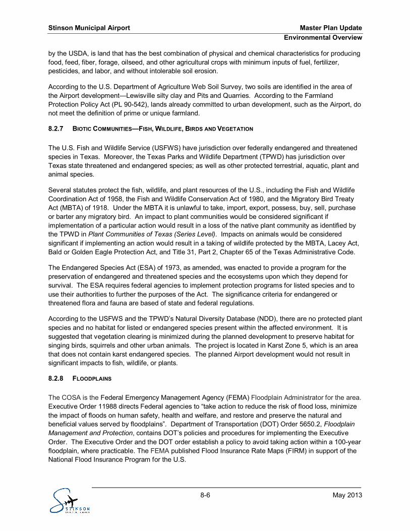
The majority of the Airport, including runway and taxiway safety areas, is situated outside the 500-yearfloodplain. However, approximately 22 acres of the Airport falls within the 100-year floodplain. Accordingto floodplain information (FEMA 2010), a 100-year floodplain exists along Six Mile Creek, which is locatedat the southern and southeastern borders of the airport, as shown in Exhibit 8.1.
A small portion (approximately 0.1 acres) of the non-aeronautical development area located on thenortheast quadrant of the Roosevelt Avenue and Ashley Road intersection is located within the 100-yearfloodplain of Six Mile Creek. Any development within the 100-year floodplain would require a floodplaindevelopment permit, and would need further evaluation to verify any floodplain buffer requirements.Sediment and erosion best management practices should be planned for this area to minimize or avoidimpacts on the 100-year floodplain of Six-mile Creek.
HAZARDOUS MATERIALS, SOLID WASTE, AND POLLUTION PREVENTION8.2.9
FAA Order 1050.1E states that hazardous material and solid waste impacts must be considered in NEPAdocumentation. Pollution prevention is reducing or eliminating waste at the source by modifyingproduction processes; promoting the use of non-toxic or less-toxic substances; implementingconservation techniques; and re-using materials rather than putting them into the waste stream. Pollutionprevention is a key policy in environmental protection activities; therefore, EPA has developed a 2010-2014 Pollution Prevention Program Strategic Plan.
A review of the EPA and TCEQ regulatory databases revealed the following on or within 0.5 miles of theAirport property:
· One facility that generates or transports hazardous wastes (i.e. Resource Conservation andRecovery Act Generator(RCRA GEN));
· One State/Tribal Institutional Control has been placed on the property;· One Voluntary Cleanup Program (VCP) facility; and· Two State/Tribal Hazardous Waste (HW) facilities.
The RCRA GEN facility identified on the Airport property is California Helicopter International, Inc. It. iscategorized as a conditionally exempt small quantity generator, generating less than 100kg of hazardouswaste per month. A comprehensive Phase 1 environmental site assessment is suggested as duediligence; as well as a subsequent Phase 2 site assessment (involves possible sampling).
The institutional control and VCP facility identified on Airport property is Schneck Aviation, Inc. It hadformerly engaged in the business of dismantling aircraft engines; chrome plating engine components, andreassembling the engines for re-installation in the airplanes. During the 1980’s, Schneck Aviation ceasedoperations and the release of chromic acid and solvents was discovered.
The site was cleaned and a ‘Completion Certificate’ was issued by TCEQ on October 05, 2007.Additionally, a TCEQ letter (July 12, 2006), states that site cleanup has been attained as long asappropriate post closure care is performed. Construction activities conducted on Airport property must beconducted in accordance with the Response Action Plan (March 7, 2006) for the site, subsequentlyapproved reports or other TCEQ written correspondence. The TCEQ issued a Conditional Certificate ofCompletion on November 20, 2006 under Texas Risk Reduction Program Remedy Standard B Tier 2commercial/industrial standards, in accordance with 30 Texas Administrative Code (TAC) 350.33.
£¤281
Six-mile Creek
San Antonio River
UT536
UT122
Mission
Flores
Loop 410
State Loop 13
Ashley
Ashley
Mission
Rilling
Harding
Espada
Echo
99th
Ware
98th
Sams
March
97th
Apoll
o
Braubach
96th
Ely
93rd
Curtis
Troy
Deely
91st
Bernard
Genevieve
Cadmus
Barranca
Flores
Jernig
an
DodicKopplow
Fourni
erLuc
inda
Dan
Petaluma
95th
Herbst
Saipan
Amber
Buto
Damon
92nd
Stinson Municipal AirportMaster Plan Report
Exhibit 8.1100-YEAR FLOODPLAIN
Scale: 1" = 0.25 miles
Source: 1) 2011 Aerial Photograph Provided by The City of San Antonio (COSA) 2) Floodplain Data Provided by FEMA Panel No. 48029C0580G, Dated September 29, 2010
Prepared by: RABA KISTNER Environmental, Inc.
LegendSTREAMAPPROXIMATE SITE BOUNDARY100-YEAR FLOODPLAIN
Stinson Municipal Airport Master Plan UpdateEnvironmental Overview
8-9 May 2013
One of the hazardous waste facilities identified on the Airport property is Tobin Surveys, which is currentlylisted as inactive. The other hazardous waste facility is Schneck Aviation, Inc., which is also listed asinactive. It is not anticipated that there will be significant impacts from these facilities; however, furtherinvestigation may be required to determine if residual hazardous waste occurs near these inactivefacilities.
Solid waste and hazardous material currently generated and disposed of by the Airport include thoseassociated with aircraft operations, those generated with FBO tenants, and those associated withconstruction activities. Solid waste generally includes construction materials, paper, plastic, wood, andmetal products. Specific definitions are contained within RCRA for hazardous materials, special wasteand universal waste. The planned Airport development is not anticipated to create significant impactsfrom solid waste or hazardous materials. However, construction activities may generate waste on atemporary basis during the project duration and can be accommodated at existing landfills. Additionally,environmental specialist will assess planned development to identify waste generators that may add tothe waste currently generated by California Helicopter International. This would increase the generatedquantity and possibly change requirements.
WETLANDS/WATERS OF THE U.S.8.2.10
Agencies that regulate impacts on water resources within Texas include the U.S. Army Corps ofEngineers (USACE), the USEPA, the USFWS and the TCEQ. The USACE is the primary regulatoryauthority enforcing Section 404 requirements for wetlands and “Waters of the U.S.” Wetlands and thejurisdictional “Waters of the U.S.” are protected under Sections 401 and 404 of the CWA, EO 11990,Protection of Wetlands, and by the review process of TCEQ.
A portion of Six Mile Creek flows through Airport property, which is unaltered and varies in depth from 15to 20 feet. The Creek serves as a major drainage for the San Antonio’s south side.
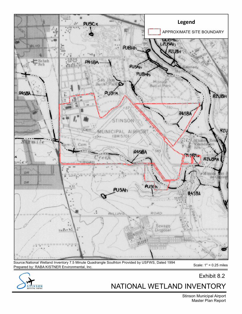
As shown in Exhibit 8.2, the USFWS National Wetlands Inventory Mapping identifies Six Mile Creek as aR4SBA wetland, which means it is a riverine and intermittent stream that is temporarily flooded. No otherwetlands are located within Airport property. Proposed taxi lane improvements north of Taxiway D2would require the disturbance and relocation of an upland drainage swale. It is anticipated this swale isnot a wetland; however delineating potential unidentified wetlands may be required to identify potentialwetlands in the area of the swale and areas within the floodplain of Six Mile Creek where development isplanned. If no wetlands are identified during a wetland delineation or investigation of these areas, noimpacts to wetlands or “Waters of the U.S.” would be expected from the planned Airport development.
LIGHT EMISSIONS AND VISUAL IMPACTS8.2.11
The FAA Order 1050.1E states the project sponsor shall consider the extent that lighting associated withan airport action will create an annoyance or interfere with normal activities among people in the vicinityof the installation.
No impacts from the relatively low levels of light intensity from planned Airport development areanticipated, when compared to background levels associated with existing air navigation facilities.Planned commercial and retail developments may require indirect lighting or other mitigation to reduceglare on adjacent residents in proximity to the southwest corner of the Airport.
Stinson Municipal AirportMaster Plan Report
Exhibit 8.2NATIONAL WETLAND INVENTORY
Scale: 1" = 0.25 milesSource:National Wetland Inventory 7.5 Minute Quadrangle Southton Provided by USFWS, Dated 1994Prepared by: RABA KISTNER Environmental, Inc.
LegendAPPROXIMATE SITE BOUNDARY
Stinson Municipal Airport Master Plan UpdateEnvironmental Overview
8-11 May 2013
Visual impacts of the planned development will be assessed in the NEPA documentation. Visual amenitywill need to be analyzed before and during the design of building and other structures. Specific federal,state or local guidelines may apply. Additionally, the Mission Parkway Historic District may have somerequirements or design guidelines that would be required for incorporation into the applicable design.
NATURAL RESOURCES, ENERGY SUPPLY, AND SUSTAINABLE DESIGN8.2.12
The FAA Order 1050.1E states that a significant environmental impact on energy and natural resourceconsumption occurs when airport actions result in demand exceeding supplies. This is in relation to theuse of energy by new structures and facilities; as well as changes in ground vehicles and/or aircraft.
CPS Energy (CPS), the city-owned gas and electrical company, provides the Airport with electrical powerand natural gas. Aircraft fuel is another category of energy utilized at the Airport. The fuel is trucked intothe Airport for storage prior to distribution. No underground fuel pipelines to the Airport have beenidentified; and Airport improvements would not cause an increase in natural gas. There would be anincrease in electricity for the additional airfield lighting and other planned development. It is expected thisminor increase in demand can be met with local supply.
It is anticipated that demands for rock, sand, aggregate, or other materials required for runwayconstruction would be sufficiently met by nearby suppliers of the local community without creatingsubstantial shortages and reducing transportation cost and fuel requirements.
NOISE8.2.13
Guidance in FAA Orders 5050.4B and 1050.1E provide the methodology for preparing aircraft noiseexposure maps. The FAA requires analyses of subsonic aircraft noise exposure and compatible landuses around civilian airports be accomplished using a computer-based program—Integrated NoiseModel.
The noise model incorporates the number of annual average daily daytime (7:00 a.m. to 10:00 p.m.) andnighttime (10:00 p.m. to 7:00 a.m.) flight events; as well as the flight paths and profiles, and noise andperformance information. Model outputs provide the overall daily sound level at many points on theground around an airport. From a plotted grid of points, contours of the forecasted daily sound levels areplotted for overlay onto land use maps.
Nearby residences, schools, and other noise-sensitive land uses are considered non-compatible withday-night average sound level of 65dBA or greater. In 2003, the area exposed to aircraft noise of 65dBand higher consisted of commercial, residential, tax exempt, and vacant land uses. The mostpredominant land uses exposed to aircraft noise of 65dB and higher are tax exempt and commercial landuses. These areas include a large portion of the San Antonio Missions National Historical Park, which islocated southeast of the Airport and along the San Antonio River.
It is anticipated that approximately 16 residents in five dwelling units would be exposed to aircraft noise of65 dB and higher in 2013. No schools or religious facilities would be exposed to this threshold of aircraftnoise. A small portion of the San Antonio Missions National Historical Park that is not publicallyaccessible (approximately 3.8 acres) would be exposed to aircraft noise exceeding the threshold. A smallportion of Stinson Park (located west of the Airport) would be exposed to aircraft noise of DNL 65 dB andhigher. An increase of 3.0 dB in one grid cell is predicted. Because the grid is located entirely on airportproperty and no other significant increases in noise exposure occur in the affected environment, thechange in noise exposure would not be significant.
Stinson Municipal Airport Master Plan UpdateEnvironmental Overview
8-12 May 2013
Due to the proposed modifications to the taxiway system and the potential for increased airplane traffic,additional noise analysis may be required.
SOCIOECONOMIC, ENVIRONMENTAL JUSTICE, AND SAFETY RISKS8.2.14
According to FAA Order 1050.1E, primary social impacts to be considered are those associated with therelocation or community disruption transportation, planned development, and employment. ExecutiveOrder (EO) 12898 (U.S., 1994) requires federal agencies to identify and address, as appropriate,disproportionately high and adverse human health or environmental effects of their programs, policies,and activities on minority and low-income populations.
A Presidential memorandum that accompanied EO 12898 and provides guidance for assessing andaddressing environmental justice issues associated with transportation projects. Similarly, EO 13045directs federal agencies to identify and assess environmental health risks and safety risks of their actionsthat may disproportionately affect children. Property Code, §21.046 provides for relocation payments andadvisory assistance to people who are displaced for projects undertaken by a State agency or politicalsubdivision of the State. Acquisitions will be conducted in accordance with the Uniform RelocationAssistance and Real Property Acquisition Policies Act of 1970, amended, and relocation resources areavailable to residential and business relocates without discrimination.
Airport development actions can potentially have socioeconomic impacts on surrounding areas.According to FAA Order 1050.1E, factors to be considered in determining socioeconomic impacts include:
· Extensive relocation of residents without sufficient replacement housing.· Extensive relocation of community businesses, creating severe economic hardship for the
affected communities.· Disruptions of traffic patterns on roads serving the Airport and surrounding communities that
substantially reduce the levels of service (a measure to determine the effectiveness oftransportation infrastructure).
· A substantial loss in community tax base.
Much of the land surrounding the Airport is undeveloped. No extensive resident or businessdisplacements are anticipated as a result of the Airport Development Plan. Road closures are notexpected to create significant impact on traffic patterns. Since there would not be tax-based businessesor residential displacements, the community tax base should not be adversely affected.
The Council on Environmental Quality’s environmental justice guidance under NEPA identifies that aminority population should be identified when the minority population exceeds 50%; or when the minoritypopulation is meaningfully greater than the minority population of the general population.
A general review of 2010 population data reveals that the area around the Airport property comprises aminority population of more than 50%. Environmental justice and socioeconomic analyses would berequired during the NEPA assessment.
WATER QUALITY8.2.15
The TCEQ has jurisdiction over water quality guidelines and practices in San Antonio, Texas. Waterquality guidelines are set forth in Section 401 of the Clean Water Act (CWA). Industrial plant operations,including airports, are required to obtain stormwater permits under the 1987 amendments to the CWA.The National Pollutant Discharge Elimination System (NPDES) permit requires: (1) submission of
Stinson Municipal Airport Master Plan UpdateEnvironmental Overview
8-13 May 2013
information regarding existing programs to control pollutants; and (2) field screening of major outfalls todetect improper drainage discharges. Discharges of stormwater runoff must be identified andcharacterized, including those containing deicing fluids, liquid fuels, and chemicals used for maintenance.
The planned Airport development will create new impervious surfaces that result in increased stormwaterrunoff. The additional runoff would be split between two drainage outfalls. Prior to construction ofimpervious cover, proper permitting and compliance with state and local environmental agencies shouldbe sought to minimize potential water quality impacts.
Surface water runoff from Airport property flows into Six Mile Creek, and then eventually to the SanAntonio River. Effects to water quality, if any, are expected to be temporary and minor. The EPAregulates the discharge of stormwater from construction sites that disturb five or more acres. The TCEQbegan administering this regulatory program on behalf of the EPA in 2003.
Pursuant to Section 402 of the CWA, potential stormwater discharge from the Airport property duringconstruction must be authorized by TCEQ. As such, the planned development would require a TexasPollution Discharge Elimination System (TPDES) water quality permit for construction activities.
The planned development is located within the boundaries of a regulated Municipal Separate StormSewer System (MS4). The COSA, San Antonio Water Systems and TxDOT are co-permittees for theMS4 permit. The permit authorizes each of the MS4 operators (TxDOT and San Antonio) to dischargestormwater runoff from the MS4 to waters of the US. A Notice of Intent (NOI) will be required for TPDEScompliance. The NOI will be posted alongside the SWPPP at the construction site.
CULTURAL RESOURCES8.2.16
The Texas Historical Commission (THC) has jurisdiction over historical, architectural, and archeologicalresources in Texas. The National Historic Preservation Act (NHPA), as amended, provides for thepreservation of cultural resources eligible for inclusion in the National Register of Historic Places (NRHP).Section 106 of the NHPA directs heads of Federal or independent agencies, that have direct or indirectjurisdiction over a Federal or federally assisted undertaking, to “take into account the effect on anydistrict, site, building, structure, or object that is included in or eligible for the inclusion in the NationalRegister”.
The Texas Historic Site Atlas (THC, 2012) indicates there are no historic properties included in the NRHPwithin Airport boundaries. As shown in Exhibit 8.3, the Airport is located within the Mission ParkwayNational Historic District—National Register District designated by the COSA. The Mission ParkwayHistoric District covers the Airport property and extends to the north and east. The District also extendssoutheast along the San Antonio River.
Terminal and tenant facilities along Mission Road have been identified as having historical significance.As such, the COSA’s Historic Design and Review Commission (HDRC) must approve improvements tothese facilities. A “Pauper’s Cemetery” (41BX789) is located on Airport property. It contains knownhuman burial sites dating back to the 1930s. Previous studies had identified this site and the Airport hasimplemented, with concurrence from the THC, best management practices in this area. Archeologicalsites are confidential; and therefore not depicted on Exhibit 8.3.
ESPADA AQUEDUCT
MISSION SAN JUANCAPISTRANO
BERGS MILLRUINS
ACEQUIA PARK
ESPADA DAM
MISSION PARKBURIAL PARK
SAN JOSEBURIAL PARK
PAUPER'SCEMETERY
UT536
UT122
Mission
Flores
State Loop 13
Ashley
Presa
Ashley
Mission
Rilling
Harding
Espada
Echo
99th
98th
March
97th
Apoll
o
Braubach
96th
Ware
Curtis
Ely
Lorita
93rd
Sams
Troy
91st
Jernigan
Old Corpus Christi
Deely
Cadmus
Barranca
Bernard
Genevieve
Flores
Dan
95th
Herbst
DodicPetaluma
Buto
Damon
Henderson92nd
Mission
Lorita
Stinson Municipal AirportMaster Plan Report
Exhibit 8.3CULTURAL RESOURCES
Scale: 1" = 0.25 miles
Source:1) National Register District Data Provided by The Texas Historical Commission (THC) 2) Historial Landmark Data Provided by The City of San Antonio (COSA) 3) 2011 Aerial Photograph Provided by The City of San Antonio (COSA)
Prepared by: RABA KISTNER Environmental, Inc.
LegendAPPROXIMATE SITE BOUNDARYHISTORICAL LANDMARK AREACEMETERYMISSION PARKWAY HISTORIC DISTRICT (NATIONAL REGISTER DISTRICT)
Stinson Municipal Airport Master Plan UpdateEnvironmental Overview
8-15 May 2013
WILD AND SCENIC RIVERS8.2.17
The U.S. Department of the Interior has jurisdiction over rivers on the National Inventory. The Wild andScenic Rivers Act, as amended, protects rivers listed on the National Inventory of Wild and Scenic Rivers.According to a review of the inventory, there are no wild or scenic rivers located within the Airport vicinityor planned development, resulting in no impacts on these natural features.
SECONDARY (INDUCED) IMPACTS8.2.18
Major development proposals often involve the potential for induced or secondary impacts on surroundingcommunities. Induced impacts include shifts in patterns of population growth and movement; publicservice demands; and changes in business and economic activity to the extent influenced by airportdevelopment.
The planned improvements at the Airport are not anticipated to cause significant shifts in populationgrowth and movement, impacts on public services or economic activity in the area.
SUMMARY8.3
This environmental overview for the Stinson Airport Development Plan constitutes a general evaluation ofenvironmental factors and resources located within and adjacent to the Airport property. Additionalresearch and investigation will be necessary to adequately identify and define existing environmentalfactors; and impacts from the planned development. Additionally, mitigation and management measureswill be identified to avoid, reduce and/or minimize foreseeable impacts.
Impacts on water quality and quantity can be avoided by the use of construction silt fences, rock checkdams, stormwater detention ponds and other best management practices. Environmental factors havingthe most potential of being affected by the planned Airport development would be: cultural resources(historical and archeological), floodplains, and environmental justice.
Commercial and retail development planned for the southwest corner of the Airport property couldpotentially encroach into the 100-year floodplain of Six Mile Creek. A floodplain development permitwould be required for developments constructed within a 100-year floodplain (see Exhibit 8.1).
Before or during planned Airport development, planting of trees and other native vegetation would beencouraged to offset anticipated vegetation clearing during construction. Native wetland plantings(pecan, water oak, bald cypress) could be planted within the floodplain of Six Mile Creek, especially areasthat have minimal trees.
Table 8.1 provides a summary of the overview for the 18 environmental impact categories with respect tothe proposed Airport improvements. While some of the categories indicate a potential impact, they are allbelow the threshold levels that would require further analysis.
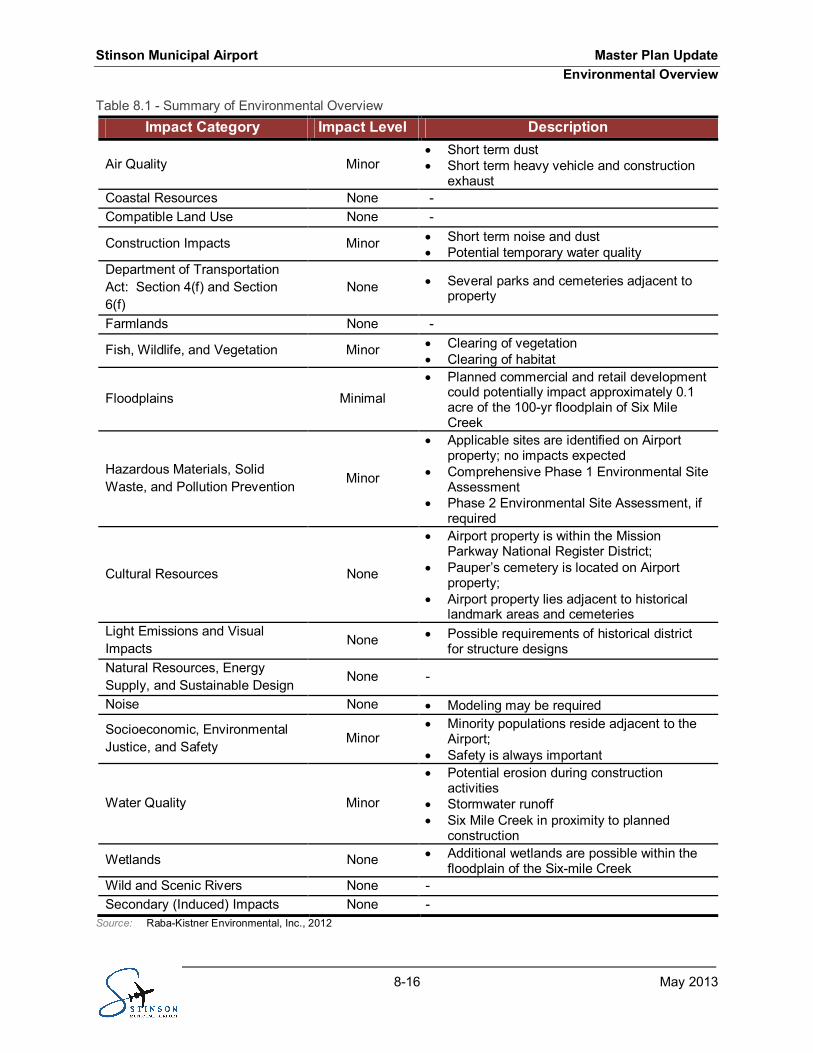
Stinson Municipal Airport Master Plan UpdateEnvironmental Overview
8-16 May 2013
Summary of Environmental OverviewTable 8.1 -Impact Category Impact Level Description
Air Quality Minor· Short term dust· Short term heavy vehicle and construction
exhaustCoastal Resources None -Compatible Land Use None -
Construction Impacts Minor · Short term noise and dust· Potential temporary water quality
Department of TransportationAct: Section 4(f) and Section6(f)
None · Several parks and cemeteries adjacent toproperty
Farmlands None -
Fish, Wildlife, and Vegetation Minor · Clearing of vegetation· Clearing of habitat
Floodplains Minimal· Planned commercial and retail development
could potentially impact approximately 0.1acre of the 100-yr floodplain of Six MileCreek
Hazardous Materials, SolidWaste, and Pollution Prevention Minor
· Applicable sites are identified on Airportproperty; no impacts expected
· Comprehensive Phase 1 Environmental SiteAssessment
· Phase 2 Environmental Site Assessment, ifrequired
Cultural Resources None
· Airport property is within the MissionParkway National Register District;
· Pauper’s cemetery is located on Airportproperty;
· Airport property lies adjacent to historicallandmark areas and cemeteries
Light Emissions and VisualImpacts None · Possible requirements of historical district
for structure designsNatural Resources, EnergySupply, and Sustainable Design
None -
Noise None · Modeling may be required
Socioeconomic, EnvironmentalJustice, and Safety
Minor· Minority populations reside adjacent to the
Airport;· Safety is always important
Water Quality Minor
· Potential erosion during constructionactivities
· Stormwater runoff· Six Mile Creek in proximity to planned
construction
Wetlands None · Additional wetlands are possible within thefloodplain of the Six-mile Creek
Wild and Scenic Rivers None -Secondary (Induced) Impacts None -
Source: Raba-Kistner Environmental, Inc., 2012