Embed Size (px)
Citation preview
Improvement Dredging for Lamma Power Station
Navigation Channel
Executive Summary
May 2017
The Hongkong Electric Company Limited
356263 ENL 06 05 B
P:\Hong Kong\ENL\PROJECTS\356263 Lamma Dredging EIA\06 Deliverables\05 EIA ES\ES_Eng revF.docx
September 2016
Improvement Dredging for Lamma Power Station Navigation Chan Executive Summary
Improvement Dredging for Lamma Power Station Navigation Channel
Executive Summary
May 2017
The Hongkong Electric Company Limited
Mott MacDonald, 20/F AIA Kowloon Tower, Landmark East, 100 How Ming Street, Kwun Tong, Kowloon, Hong Kong
T +852 2828 5757 F +852 2827 1823 w W www.mottmac.com
356263/ENL/06/05/F May 2017 P:\Hong Kong\ENL\PROJECTS\356263 Lamma Dredging EIA\06 Deliverables\05 EIA ES\ES_Eng revF.docx
Improvement Dredging for Lamma Power Station Navigation Channel Executive Summary
Chapter Title Page
1 Introduction 1
2 Project Description 2
2.1 Scope and Location of the Project ______________________________________________________ 2 2.2 The Need for the Project _____________________________________________________________ 2 2.3 Consideration of Alternatives and Selection of Preferred Option _______________________________ 2 2.4 Works Programme and Interface with Concurrent Projects ___________________________________ 4
3 Summary of Environmental Impact Assessment 6
3.1 Water Pollution _____________________________________________________________________ 6 3.1.1 Construction Phase _________________________________________________________________ 6 3.1.2 Operation Phase ___________________________________________________________________ 6 3.2 Marine Ecological Impact _____________________________________________________________ 7 3.3 Fisheries Impact ____________________________________________________________________ 8 3.4 Hazard to Life ______________________________________________________________________ 8 3.5 Noise Impact ______________________________________________________________________ 9 3.5.1 Construction Phase _________________________________________________________________ 9 3.5.2 Operation Phase ___________________________________________________________________ 9 3.6 Waste Management Implications _______________________________________________________ 9 3.6.1 Construction Phase _________________________________________________________________ 9 3.6.2 Operation Phase __________________________________________________________________ 10 3.7 Impact Summary __________________________________________________________________ 10
Tables
Table 2-1: Summary of Options Evaluation and the Preferred Option ____________________________________ 3 Table 3-1: Recommended Maximum Allowable Dredging Rates________________________________________ 6 Table 3-2: Summary of Environmental Impacts ____________________________________________________ 11
Figures
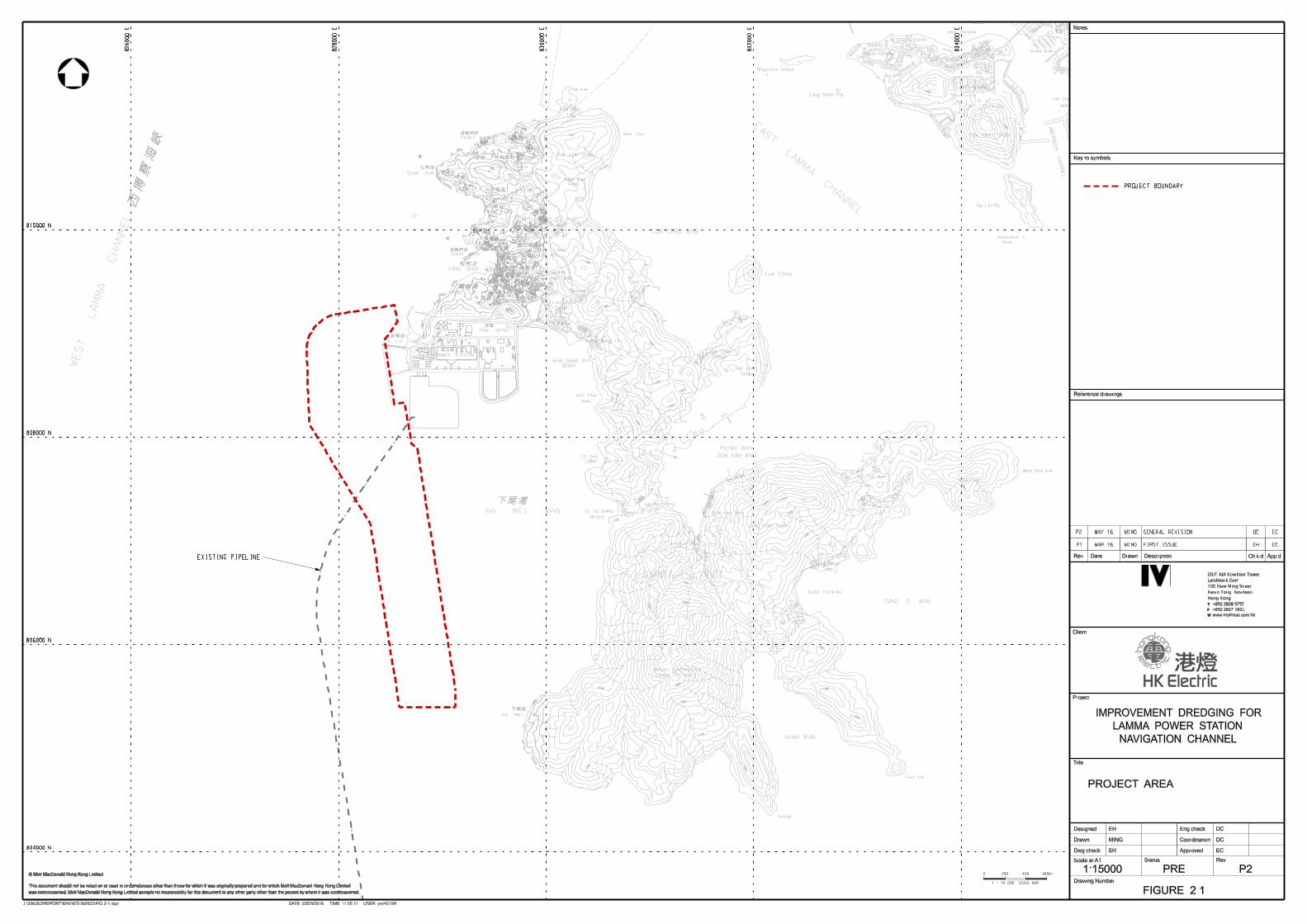
Figure 2.1: Project Area
Contents
Improvement Dredging for Lamma Power Station Navigation Channel Executive Summary
356263/ENL/06/05/F May 2017 P:\Hong Kong\ENL\PROJECTS\356263 Lamma Dredging EIA\06 Deliverables\05 EIA ES\ES_Eng revF.docx
1
This Executive Summary summarises the results of the Environmental Impact Assessment (EIA) for the
Improvement Dredging for Lamma Power Station Navigation Channel (the “Channel”). The EIA
accompanies an application for an Environmental Permit (EP) and has been prepared in accordance with
the requirements of the Environmental Impact Assessment Ordinance (EIAO).
The existing Channel was originally formed in 1981 to facilitate the delivery of coal to the existing Lamma
Power Station (LPS) by ocean going vessels. As a mainly coal-fired power station that relies on coal-fired
units for base load operations, access for ocean going vessels carrying coal to LPS is essential for
ensuring the continuity of electricity supply to Lamma and Hong Kong Islands. In order to maintain safe
clearance of these vessels through the Channel, dredging of naturally accumulating sediment in the
Channel is required.
The project proponent, The Hongkong Electric Company Limited (HK Electric), has commissioned Mott
MacDonald Hong Kong Limited to carry out an environmental impact assessment (EIA) to confirm the
environmental acceptability of the Improvement Dredging for Lamma Power Station Navigation Channel
(hereafter referred to as “the Project”).
The Project is classified as a Designated Project under C.12 of Part I Schedule 2 of the EIAO, a dredging
operation exceeding 500,000 m3, and a project profile for an EIA Study Brief was submitted to the
Environmental Protection Department (EPD) on 15 December 2014 under Section 5(1)(a) of the EIAO. On
27 January 2015, EPD issued an EIA Study Brief for the Project (ESB-282/2014). The EIA report has been
prepared according to the study brief requirements, which identified six key environmental assessment
aspects to be addressed, including water quality, marine ecology, fisheries, hazard to life, noise and waste
management implications arising from the construction and future operation of the Project.
This Executive Summary provides the key findings of these assessments and recommendations for future
mitigation measures to ensure compliance with environmental legislation and guidelines.
1 Introduction
Improvement Dredging for Lamma Power Station Navigation Channel Executive Summary
356263/ENL/06/05/F May 2017 P:\Hong Kong\ENL\PROJECTS\356263 Lamma Dredging EIA\06 Deliverables\05 EIA ES\ES_Eng revF.docx
2
2.1 Scope and Location of the Project
The Project will provide and maintain safe clearance for ocean going marine vessels delivering coal
shipments to LPS via the Channel, through the dredging of naturally accumulating sediment from the
seabed. Hong Kong Marine Department stipulates the current minimum channel depth for safe marine
passage to be no less than 15.5 metres below Chart Datum (-15.5 mCD) (approximately 15.65 metres
below Profile Datum (-15.65 mPD)). In order to ensure this minimum depth is met, the Channel must be
dredged and maintained at a level below this depth.
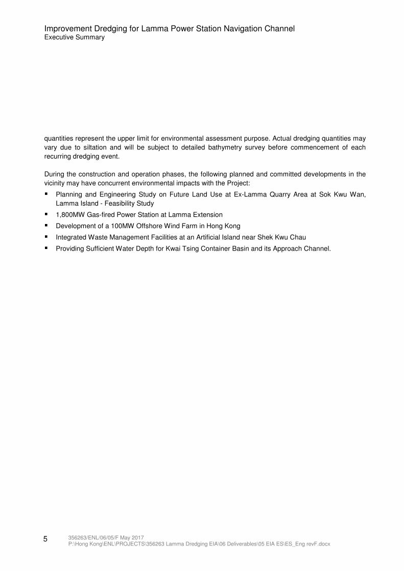
The Project area is approx. 262 ha and covers the main part of the Channel as well as the immediate area
surrounding the Channel. The project area is indicated in Figure 2.1.
2.2 The Need for the Project
LPS is the only power station supplying Hong Kong and Lamma Islands with electricity. As coal forms part
of the fuel mix and is delivered to LPS via the marine route, there is a need to maintain the Channel to
ensure safe passage for ocean going vessels delivering coal supplies to LPS.
Historically, natural siltation varies across the Channel with an average annual rate ranging from 0.07 m to
0.19 m per year. To ensure that the natural siltation does not raise the seabed level to above -15.65 mPD
(which is the minimum seabed level required to maintain safe passage for the vessels used to deliver coal
to LPS), periodic improvement dredging of the Channel has historically, and will continue to be required as
long as the Channel remains in use.
2.3 Consideration of Alternatives and Selection of Preferred Option
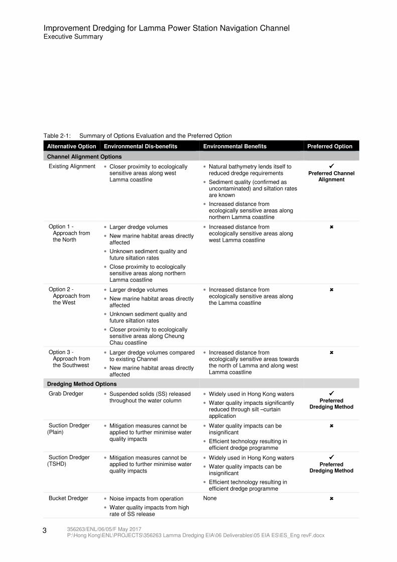
Alternative options were considered in the determination of the preferred Project option, including Channel
alignments, dredging methods and the need for operation dredging (the target channel depth and
associated dredging quantity and frequency). The environmental benefits and dis-benefits of these
alternatives and the identified preferred options are presented in Table 2-1.
2 Project Description
Improvement Dredging for Lamma Power Station Navigation Channel Executive Summary
356263/ENL/06/05/F May 2017 P:\Hong Kong\ENL\PROJECTS\356263 Lamma Dredging EIA\06 Deliverables\05 EIA ES\ES_Eng revF.docx
3
Table 2-1: Summary of Options Evaluation and the Preferred Option
Alternative Option Environmental Dis-benefits Environmental Benefits Preferred Option
Channel Alignment Options
Existing Alignment • Closer proximity to ecologically sensitive areas along west Lamma coastline
• Natural bathymetry lends itself to reduced dredge requirements
• Sediment quality (confirmed as uncontaminated) and siltation rates are known
• Increased distance from ecologically sensitive areas along northern Lamma coastline
���� Preferred Channel
Alignment
Option 1 - Approach from the North
• Larger dredge volumes
• New marine habitat areas directly affected
• Unknown sediment quality and future siltation rates
• Close proximity to ecologically sensitive areas along northern Lamma coastline
• Increased distance from ecologically sensitive areas along west Lamma coastline
����
Option 2 - Approach from the West
• Larger dredge volumes
• New marine habitat areas directly affected
• Unknown sediment quality and future siltation rates
• Closer proximity to ecologically sensitive areas along Cheung Chau coastline
• Increased distance from ecologically sensitive areas along the Lamma coastline
����
Option 3 - Approach from the Southwest
• Larger dredge volumes compared to existing Channel
• New marine habitat areas directly affected
• Increased distance from ecologically sensitive areas towards the north of Lamma and along west Lamma coastline
����
Dredging Method Options
Grab Dredger • Suspended solids (SS) released throughout the water column
• Widely used in Hong Kong waters
• Water quality impacts significantly reduced through silt –curtain application
���� Preferred
Dredging Method
Suction Dredger (Plain)
• Mitigation measures cannot be applied to further minimise water quality impacts
• Water quality impacts can be insignificant
• Efficient technology resulting in efficient dredge programme
����
Suction Dredger (TSHD)
• Mitigation measures cannot be applied to further minimise water quality impacts
• Widely used in Hong Kong waters
• Water quality impacts can be insignificant
• Efficient technology resulting in efficient dredge programme
���� Preferred
Dredging Method
Bucket Dredger • Noise impacts from operation
• Water quality impacts from high rate of SS release
None ����
Improvement Dredging for Lamma Power Station Navigation Channel Executive Summary
356263/ENL/06/05/F May 2017 P:\Hong Kong\ENL\PROJECTS\356263 Lamma Dredging EIA\06 Deliverables\05 EIA ES\ES_Eng revF.docx
4
Alternative Option Environmental Dis-benefits Environmental Benefits Preferred Option
Backhoe Dredger • Water quality impacts from high rate of SS release
None ����
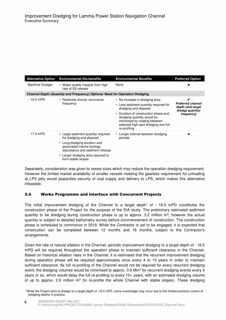
Channel Depth (Quantity and Frequency) Options/ Need for Operation Dredging
- 16.5 mPD • Relatively shorter recurrence frequency
• No increase in dredging area
• Less sediment quantity required for dredging and disposal
• Duration of construction phase and dredging quantity would be minimised by rotating between selected high spot dredging and full re-profiling
���� Preferred channel depth (and target dredge quantity/
frequency)
- 17.0 mPD • Large sediment quantity required for dredging and disposal
• Long dredging duration and associated marine ecology disturbance and sediment release
• Larger dredging area required to form stable slopes
• Longer interval between dredging periods
����
Separately, consideration was given to vessel sizes which may reduce the operation dredging requirement.
However the limited market availability of smaller vessels meeting the gearless requirement for unloading
at LPS jetty would jeopardise security of coal supply and delivery to LPS, which makes this alternative
infeasible.
2.4 Works Programme and Interface with Concurrent Projects
The initial improvement dredging of the Channel to a target depth1 of - 16.5 mPD constitutes the
construction phase of the Project for the purpose of the EIA study. The preliminary estimated sediment
quantity to be dredging during construction phase is up to approx. 3.2 million m3, however the actual
quantity is subject to detailed bathymetry survey before commencement of construction. The construction
phase is scheduled to commence in 2019. While the Contractor is yet to be engaged, it is expected that
construction can be completed between 12 months and 18 months, subject to the Contractor’s
arrangements.
Given the rate of natural siltation in the Channel, periodic improvement dredging to a target depth of - 16.5
mPD will be required throughout the operation phase to maintain sufficient clearance in the Channel.
Based on historical siltation rates in the Channel, it is estimated that the recurrent improvement dredging
during operation phase will be required approximately once every 4 to 10 years in order to maintain
sufficient clearance. As full re-profiling of the Channel would not be required for every recurrent dredging
event, the dredging volumes would be minimised to approx. 0.9 Mm3 for recurrent dredging events every 4
years or so, which would delay the full re-profiling to every 10+ years, with an estimated dredging volume
of up to approx. 2.9 million m3 (to re-profile the whole Channel with stable slopes). These dredging
1 While the Project aims to dredge to a target depth of -16.5 mPD, some overdredge may occur due to the limited precision control of dredging depths in practice.
Improvement Dredging for Lamma Power Station Navigation Channel Executive Summary
356263/ENL/06/05/F May 2017 P:\Hong Kong\ENL\PROJECTS\356263 Lamma Dredging EIA\06 Deliverables\05 EIA ES\ES_Eng revF.docx
5
quantities represent the upper limit for environmental assessment purpose. Actual dredging quantities may
vary due to siltation and will be subject to detailed bathymetry survey before commencement of each
recurring dredging event.
During the construction and operation phases, the following planned and committed developments in the
vicinity may have concurrent environmental impacts with the Project:
� Planning and Engineering Study on Future Land Use at Ex-Lamma Quarry Area at Sok Kwu Wan,
Lamma Island - Feasibility Study
� 1,800MW Gas-fired Power Station at Lamma Extension
� Development of a 100MW Offshore Wind Farm in Hong Kong
� Integrated Waste Management Facilities at an Artificial Island near Shek Kwu Chau
� Providing Sufficient Water Depth for Kwai Tsing Container Basin and its Approach Channel.
Improvement Dredging for Lamma Power Station Navigation Channel Executive Summary
356263/ENL/06/05/F May 2017 P:\Hong Kong\ENL\PROJECTS\356263 Lamma Dredging EIA\06 Deliverables\05 EIA ES\ES_Eng revF.docx
6
3.1 Water Pollution
The water quality impact assessment has been conducted in accordance with Annexes 6 and 14 of EIAO-
TM as well as the technical requirements stipulated in Clause 3.4.2 and Appendix B of the EIA Study Brief
No. ESB-282/2014. The study area covers the Western Buffer and Southern Water Control Zones (WCZs).
Water sensitive receivers (WSRs) were identified in within this study area, including seawater intakes,
beaches, corals, fish culture zones and ecologically sensitive areas / areas of conservation importance.
Sediment sampling was conducted to ascertain the elutriation potential of various contaminants in the
sediment and to determine the sediment oxygen demand. Water quality criteria were identified for
assessment of water quality impacts due to Project activities
3.1.1 Construction Phase
The key potential water quality impacts arising from construction activities of the Project include release of
SS and turbidity due to dredging activities and release of contaminants and/or impact on dissolved oxygen
due to disturbance of sediment. To assess the key potential water quality impacts due to the project,
hydrodynamic modelling was undertaken to quantify SS and contaminant release. The Project area was
divided into four working zones and a ‘backwards’ modelling approach was adopted to determine the
maximum allowable dredging rates at each zone that would maintain compliance at all WSRs. Based on
the results and taking into account the potential activities of concurrent projects in the vicinity,
recommendations were made on the maximum allowable dredging rates for the Project, which is
summarised in Table 3-1.
Table 3-1: Recommended Maximum Allowable Dredging Rates
Maximum allowable dredging rate* (m3/day)
Dry Season Wet Season
A B C D A B C D
Grab Dredger
49,800
90,400
89,600
57,800
72,100
73,700
63,500
38,500
TSHD
78,900
137,600
171,900
63,300
132,500
78,800
65,100
22,200
*Values are rounded to the nearest hundred
With these recommended maximum allowable dredging rates, all WSRs would comply with the water
quality criteria. No adverse water quality impacts due to sedimentation, release of contaminants from
sediment and dissolved oxygen depletion were identified from the modelled and calculated results based
on the recommended maximum allowable dredging rates. Nevertheless, controls to safeguard water
quality during construction phase are specified in the Environmental Monitoring and Audit Manual and
would be implemented as part of the environmental monitoring and audit programme for the Project.
3.1.2 Operation Phase
For this Project, the marine activities (improvement dredging) to be conducted during construction phase
and the recurring improvement dredging to be conducted during operation phase are the same, though
3 Summary of Environmental Impact Assessment
Improvement Dredging for Lamma Power Station Navigation Channel Executive Summary
356263/ENL/06/05/F May 2017 P:\Hong Kong\ENL\PROJECTS\356263 Lamma Dredging EIA\06 Deliverables\05 EIA ES\ES_Eng revF.docx
7
there may be differences in the dredgers and quantity of dredged sediment each time. The ‘backwards’
modelling approach adopted provides the recommended maximum allowable dredging rates which are
applicable to all recurring improvement dredging operations. These recommended maximum allowable
dredging rates are considered to be robust as they have taken into account the following:
� The long term baseline marine water quality in Southern and Western Buffer WCZs (1986 to 2015).
� The hydrodynamics for the whole of Hong Kong waters (which is covered by the water quality model).
� Incorporated a 10% reduction in the maximum allowable dredging rates as contingency to cater for
changes in the status of concurrent projects over time.
In addition, the Project area has been periodically dredged since 1990 and the approach adopted for this
assessment is consistent with, and has been successfully adopted in the preceding EIA for dredging at this
Project location (refer to the approved EIA report No. AEIAR-069/2003), which has demonstrated no
adverse water quality impacts. With the application of the recommended maximum allowable dredging
rates and mitigation measures, no adverse water quality impacts are anticipated during operation phase
recurrent dredging. Further controls to safeguard water quality during operation phase recurrent
improvement dredging are specified in the Environmental Monitoring and Audit Manual and would be
implemented as part of the environmental monitoring and audit programme for the Project.
3.2 Marine Ecological Impact
The Marine Ecological Impact Assessment has been conducted in accordance with the requirements
stipulated under Section 3.4.3 and Appendix C of the EIA Study Brief No. ESB-282/2014 as well as
Annexes 8 and 16 of the EIAO-TM. The Study Area of the Project for ecological impact assessment will
cover the Southern Water Control Zone (WCZ) and Western Buffer WCZ as designated under the Water
Pollution Control Ordinance.
Based on literature review and field survey findings, the key habitats and recognised sites of conservation
interest identifies within the Study Area are Sham Wan SSSI and Restricted Area, hard shore habitat
including artificial and rocky shores, soft shore habitat (sandy shores), sub-tidal habitats including soft
bottom substrates (benthos) and hard bottom substrate (with and without corals), and marine waters
(potential marine park at South Lamma, Green Turtle and Finless Porpoise habitat). From the evaluation
of the potential ecological impacts, the direct impact of the loss of subtidal soft bottom habitat and benthic
communities is considered to be minor. Similarly, the indirect disturbance impact on benthic communities
and coral communities are expected to be minor, while the indirect disturbance impact on intertidal
communities is anticipated to be negligible. The potential impact on the Green Turtle and its nesting site at
south-eastern Lamma is also expected to be minor. For the disturbance impact on cetaceans, dredging
activities for both construction and operation phases of this Project are unlikely to cause any long-term
damage to cetaceans and the potential disturbance or collision impacts of proposed dredging works on
finless porpoise are considered as minor since the past dredging works had no significant effect on finless
porpoise. Therefore, it is concluded that the overall marine ecological impact is expected to be minor.
Mitigation/precautionary measure is only considered to be necessary to further avoid and minimize the
potential impacts on the cetacean Finless Porpoise for both construction and operation (operation
Improvement Dredging for Lamma Power Station Navigation Channel Executive Summary
356263/ENL/06/05/F May 2017 P:\Hong Kong\ENL\PROJECTS\356263 Lamma Dredging EIA\06 Deliverables\05 EIA ES\ES_Eng revF.docx
8
dredging) phases. It is recommended to avoid dredging Zone 4 of the navigation channel (except for
necessary hotspot / localised dredging) during the calving season from February to April to avoid
disturbance impacts. To minimise the disturbance to Finless Porpoise habitat outside the Project Area, it is
recommended that vessel movements to disposal grounds to bypass the Finless Porpoise habitat area in
southwest and east Lamma, and to implement a maximum speed limit of 10 knots in south and east
Lamma waters. All vessel operators working on the Project should be thoroughly briefed on the possible
occurrence of Finless Porpoise within and in the vicinity of the Project Area and along routes to the Project
Area, as well as rules for safe vessel operation around cetaceans and slowing down to 10 knots in the
presence of cetaceans in south and east Lamma waters. With the implementation of the abovementioned
mitigation measures and water quality mitigation measures, no residual impact on the marine environment
is expected.
3.3 Fisheries Impact
A fisheries impact assessment has been conducted in accordance with Clause 3.4.4 and Appendix D of
the EIA Study Brief No. ESB-282/2014 as well as Annexes 9 and 17 of the EIAO-TM, to include an
assessment of the following:
� Size of affected area
� Loss of fisheries resources / production
� Destruction and disturbance of nursery and spawning grounds
� Impact on fishing activity
� Impact on aquaculture activity.
The potential fisheries impacts including loss of fishing ground, loss of spawning / nursery grounds for
commercial fisheries resources, loss of fisheries resources and impact on fisheries operation are
considered to be minor for the improvement dredging works during construction phase and operation
period due to the short-term and small-scale nature of the works. A ‘backwards’ modelling approach has
been adopted, which estimates the maximum dredging rates which would ensure no unacceptable
environmental impacts. The results were then verified with a ‘forwards’ model taking into account
concurrent projects. The modelling result demonstrated that there would be no significant adverse indirect
fisheries impact caused by the deterioration of water quality. With the implementation of water quality
control measures, no fisheries specific measure is considered necessary.
3.4 Hazard to Life
A Hazard Identification workshop has been organized with various stakeholders including HK Electric to
identify the hazards associated with the dredging works using the Grab Dredging method and TSHD
method near the existing natural gas submarine pipeline. For each of the identified hazards, both existing
and potential mitigation measures have been explored. The findings have been properly recorded in the
worksheets.
Improvement Dredging for Lamma Power Station Navigation Channel Executive Summary
356263/ENL/06/05/F May 2017 P:\Hong Kong\ENL\PROJECTS\356263 Lamma Dredging EIA\06 Deliverables\05 EIA ES\ES_Eng revF.docx
9
The Hazard Analysis has evaluated the risk based on the risk acceptability defined in the ETWB Risk
Management User Manual and has considered all the existing engineering measures and procedural
controls in order to reduce the risks to acceptable level. Where the level of risk is initially assessed as high,
additional safeguards have been recommended by the attendees of the workshop that will be effective in
controlling the risk to an acceptable level. All the risk items will be subject to ongoing review and
monitoring to ensure the level of risk will not increase throughout the dredging operation of the project.
3.5 Noise Impact
Potential noise impacts associated with the construction and operation phases of the Project have been
assessed in accordance with the technical requirements stipulated in Clause 3.4.6 and Appendix E of the
EIA Study Brief (ESB-282/2014), as well as Annexes 5 and 13 of the EIAO-TM.
3.5.1 Construction Phase
Quantitative assessment of the potential construction noise impact has been carried out in accordance with
the EIA study brief requirements. With the optimum quantity of construction plants, the construction noise
levels at all noise sensitive receivers (NSRs) are predicted to comply with the relevant noise criteria.
Adverse construction noise impacts are therefore not anticipated in this project.
The proposed construction has been assessed on a 24 hours per day basis. As the construction noise
impact levels at the representative NSR are predicted to comply with the noise criteria during restricted
hours, it is considered feasible for the construction works to be undertaken during restricted hours. In case
of any construction activities during restricted hours, it will be the Contractor’s responsibility to ensure
compliance with the Noise Control Ordinance and the relevant TMs. The Contractor will be required to
submit a Construction Noise Permit (CNP) application and obtain a CNP from the Noise Control Authority.
3.5.2 Operation Phase
Some operation dredging for the improvement work to maintain the required depth within the navigation
channel will be required. The noise criteria for the construction phase are also applicable to the future
operation dredging during operational phase of this Project.
Same plant inventory has been assumed for the operation dredging as that for the construction dredging in
this Project, the noise levels at the representative NSR during operation dredging are expected to be no
worse than during the construction phase and will comply with the construction noise criteria.
3.6 Waste Management Implications
3.6.1 Construction Phase
The major waste types generated by the construction activities will be marine sediment. Based on the
review of the sediment quality data from the approved EIA report No. AEIAR-069/2003, previous marine
Improvement Dredging for Lamma Power Station Navigation Channel Executive Summary
356263/ENL/06/05/F May 2017 P:\Hong Kong\ENL\PROJECTS\356263 Lamma Dredging EIA\06 Deliverables\05 EIA ES\ES_Eng revF.docx
10
site investigation studies and Sediment Quality Report (SQR), the marine sediment to be dredged is
classified as Category L (for Type 1, Open Sea Disposal). The total volume of dredged sediment requiring
marine disposal is estimated to be up to 3.2 million m3. Subject to the result of future bathymetric surveys,
sediment sampling will be carried out at the actual dredging area prior to dredging activity in the future to
confirm the classification of sediment, and to comply with the DASO permitting requirements and Marine
Fill Committee’s (MFC) approval on disposal allocation. With implementation of the recommended
mitigation measures and management procedures in accordance with the requirements of PNAP ADV-21,
no environmental impact is anticipated.
Chemical waste will be generated from maintenance and servicing of dredging plant and equipment as well
as general refuse to be generated from the workforce. Provided that all these identified wastes are
handled, transported and disposed of in strict accordance with the relevant legislative and recommended
requirements and that the recommended mitigation measures are properly implemented, no adverse
environmental impact is expected during the construction phase.
3.6.2 Operation Phase
During the operation phase, it is anticipated that with recurrent dredging of localised high spots once every
4 years or so (with estimated dredging quantity up to 0.9 million m3 each time), full re-profiling of the
Channel with a dredging quantity of up to 2.9 million m3 can be delayed to approx. once every 10+ years.
The extent of dredging area within the project boundary will be subjected to the result of the future
bathymetric surveys. Based on the previous site investigation studies, the marine sediment to be dredged
is expected to be classified as Category L (for Type 1, Open Sea Disposal). In any case, recurring
improvement dredging would require sediment sampling and testing in accordance with the requirements
of the PNAP ADV-21 for proper disposal of the dredged sediment. MFC would determine the most
appropriate marine disposal site on the basis of the testing results and formally allocate marine disposal
space in accordance with the PNAP ADV-21. With implementation of the recommended mitigation
measures and management procedures in accordance with the requirements of PNAP ADV-21, no
environmental impact is anticipated.
Chemical waste will be generated from maintenance and servicing of dredging plant and equipment as well
as general refuse to be generated from the workforce. Provided that all these identified wastes are
handled, transported and disposed of in strict accordance with the relevant legislative and recommended
requirements and that the recommended mitigation measures are properly implemented, no adverse
environmental impact is expected during the operation phase.
3.7 Impact Summary
A summary of the environmental impacts for individual aspects in the EIA report is presented in Table 3-2.
11 356263/ENL/06/05/F May 2017 P:\Hong Kong\ENL\PROJECTS\356263 Lamma Dredging EIA\06 Deliverables\05 EIA ES\ES_Eng revF.docx
Improvement Dredging for Lamma Power Station Navigation Channel Executive Summary
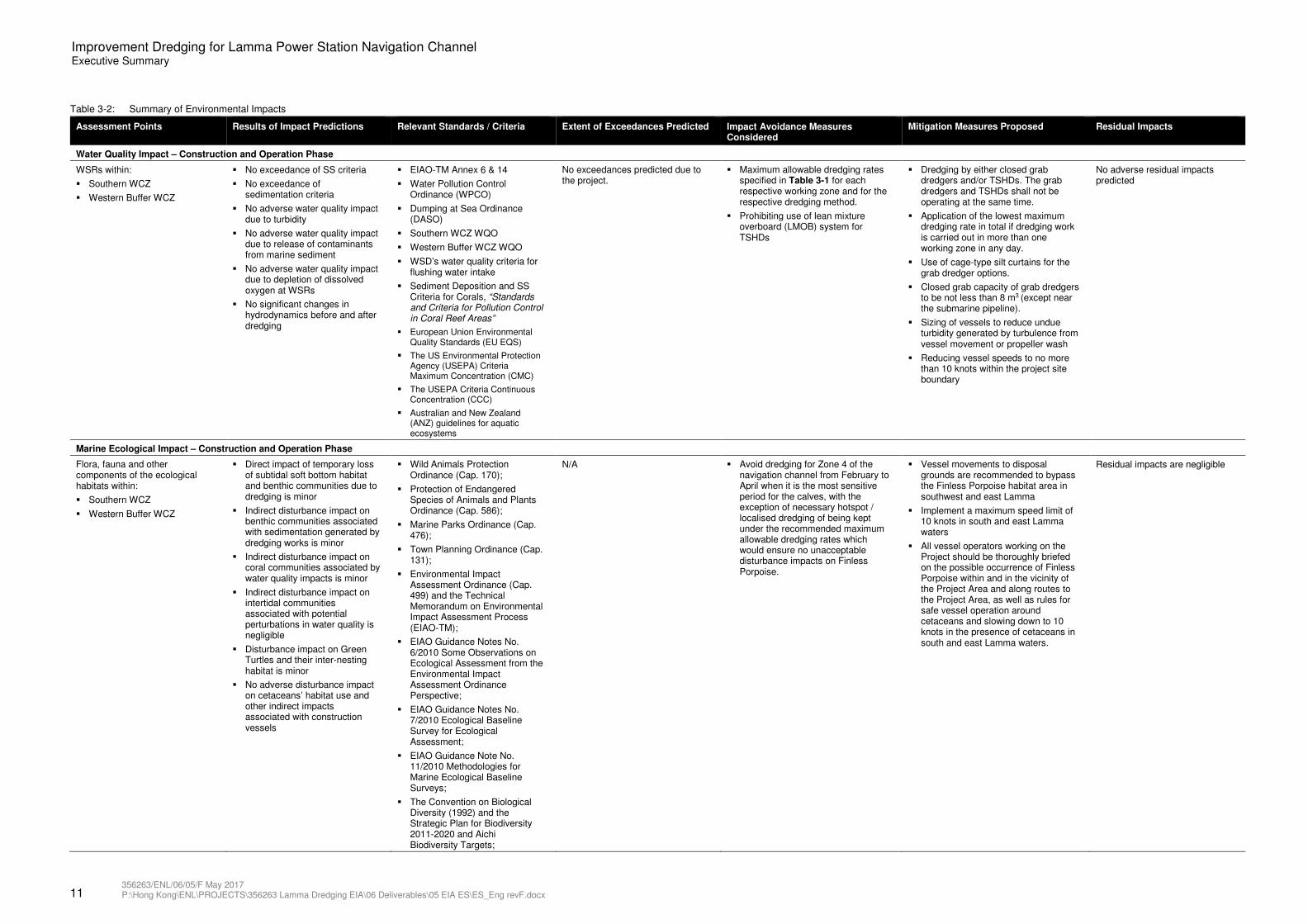
Table 3-2: Summary of Environmental Impacts
Assessment Points Results of Impact Predictions Relevant Standards / Criteria Extent of Exceedances Predicted Impact Avoidance Measures Considered
Mitigation Measures Proposed Residual Impacts
Water Quality Impact – Construction and Operation Phase
WSRs within:
� Southern WCZ
� Western Buffer WCZ
� No exceedance of SS criteria
� No exceedance of sedimentation criteria
� No adverse water quality impact due to turbidity
� No adverse water quality impact due to release of contaminants from marine sediment
� No adverse water quality impact due to depletion of dissolved oxygen at WSRs
� No significant changes in hydrodynamics before and after dredging
� EIAO-TM Annex 6 & 14
� Water Pollution Control Ordinance (WPCO)
� Dumping at Sea Ordinance (DASO)
� Southern WCZ WQO
� Western Buffer WCZ WQO
� WSD’s water quality criteria for flushing water intake
� Sediment Deposition and SS Criteria for Corals, “Standards and Criteria for Pollution Control in Coral Reef Areas”
� European Union Environmental Quality Standards (EU EQS)
� The US Environmental Protection Agency (USEPA) Criteria Maximum Concentration (CMC)
� The USEPA Criteria Continuous Concentration (CCC)
� Australian and New Zealand (ANZ) guidelines for aquatic ecosystems
No exceedances predicted due to the project.
� Maximum allowable dredging rates specified in Table 3-1 for each respective working zone and for the respective dredging method.
� Prohibiting use of lean mixture overboard (LMOB) system for TSHDs
� Dredging by either closed grab dredgers and/or TSHDs. The grab dredgers and TSHDs shall not be operating at the same time.
� Application of the lowest maximum dredging rate in total if dredging work is carried out in more than one working zone in any day.
� Use of cage-type silt curtains for the grab dredger options.
� Closed grab capacity of grab dredgers to be not less than 8 m3 (except near the submarine pipeline).
� Sizing of vessels to reduce undue turbidity generated by turbulence from vessel movement or propeller wash
� Reducing vessel speeds to no more than 10 knots within the project site boundary
No adverse residual impacts predicted
Marine Ecological Impact – Construction and Operation Phase
Flora, fauna and other components of the ecological habitats within:
� Southern WCZ
� Western Buffer WCZ
� Direct impact of temporary loss of subtidal soft bottom habitat and benthic communities due to dredging is minor
� Indirect disturbance impact on benthic communities associated with sedimentation generated by dredging works is minor
� Indirect disturbance impact on coral communities associated by water quality impacts is minor
� Indirect disturbance impact on intertidal communities associated with potential perturbations in water quality is negligible
� Disturbance impact on Green Turtles and their inter-nesting habitat is minor
� No adverse disturbance impact on cetaceans’ habitat use and other indirect impacts associated with construction vessels
� Wild Animals Protection Ordinance (Cap. 170);
� Protection of Endangered Species of Animals and Plants Ordinance (Cap. 586);
� Marine Parks Ordinance (Cap. 476);
� Town Planning Ordinance (Cap. 131);
� Environmental Impact Assessment Ordinance (Cap. 499) and the Technical Memorandum on Environmental Impact Assessment Process (EIAO-TM);
� EIAO Guidance Notes No. 6/2010 Some Observations on Ecological Assessment from the Environmental Impact Assessment Ordinance Perspective;
� EIAO Guidance Notes No. 7/2010 Ecological Baseline Survey for Ecological Assessment;
� EIAO Guidance Note No. 11/2010 Methodologies for Marine Ecological Baseline Surveys;
� The Convention on Biological Diversity (1992) and the Strategic Plan for Biodiversity 2011-2020 and Aichi Biodiversity Targets;
N/A � Avoid dredging for Zone 4 of the navigation channel from February to April when it is the most sensitive period for the calves, with the exception of necessary hotspot / localised dredging of being kept under the recommended maximum allowable dredging rates which would ensure no unacceptable disturbance impacts on Finless Porpoise.
� Vessel movements to disposal grounds are recommended to bypass the Finless Porpoise habitat area in southwest and east Lamma
� Implement a maximum speed limit of 10 knots in south and east Lamma waters
� All vessel operators working on the Project should be thoroughly briefed on the possible occurrence of Finless Porpoise within and in the vicinity of the Project Area and along routes to the Project Area, as well as rules for safe vessel operation around cetaceans and slowing down to 10 knots in the presence of cetaceans in south and east Lamma waters.
Residual impacts are negligible

12 356263/ENL/06/05/F May 2017 P:\Hong Kong\ENL\PROJECTS\356263 Lamma Dredging EIA\06 Deliverables\05 EIA ES\ES_Eng revF.docx
Improvement Dredging for Lamma Power Station Navigation Channel Executive Summary
Assessment Points Results of Impact Predictions Relevant Standards / Criteria Extent of Exceedances Predicted Impact Avoidance Measures Considered
Mitigation Measures Proposed Residual Impacts
� Convention on International Trade in Endangered Species of Wild Flora and Fauna (CITES);
� The IUCN Red List of Threatened Species; and
� Wild Animal Protection Law of the Peoples’ Republic of China (PRC).
Fisheries Impact – Construction and Operation Phase
� Lo Tik Wan FCZ and associated artificial reefs
� Sok Kwu Wan FCZ
� Cheung Sha Wan FCZ
� Nursery and spawning ground for fisheries
� Capture fisheries activities around Lamma waters
� Low impact on loss of fishing ground, fisheries resources and fishing operation
� EIAO-TM Annexes 9 and 17
� Fisheries Protection Ordinance (Cap.171)
� Marine Fish Culture Ordinance (Cap. 353)
� Water Pollution Control Ordinance (Cap. 358)
No exceedances predicted due to the project.
� Maximum allowable dredging rates specified in Section 3.7.1.3 for each respective working zone and for the respective dredging method.
� Prohibiting use of lean mixture overboard (LMOB) system for TSHDs
� Dredging by either closed grab dredgers and/or TSHDs. The grab dredgers and TSHDs shall not be operating at the same time.
� Application of the lowest maximum dredging rate if dredging work is carried out in more than one working zone in any day.
� Use of cage-type silt curtains for the grab dredger options.
� Closed grab capacity of grab dredgers to be not less than 8 m3 (except near the submarine pipeline).
� Sizing of vessels to reduce undue turbidity generated by turbulence from vessel movement or propeller wash
� Reducing vessel speeds to no more than 10 knots within the project site boundary
No adverse residual impacts predicted
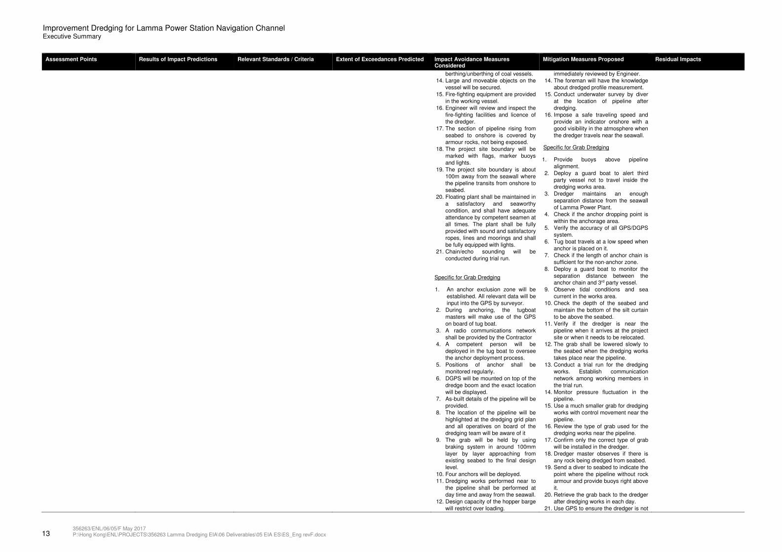
Hazard to Human Life – Construction and Operation Phase
Grab Dredging Method and Trailing Suction Hopper Dredging Method (TSHD) near the existing natural gas submarine pipeline
For Grab Dredging method
A total of 30 hazards have been identified, with 13 of them being ranked in High risk level while the rest are in Medium risk level.
For TSHD method
A total of 23 hazards have been identified, with 15 of them being ranked in High risk level while the rest are in Medium risk level
Risk Management User Manual published by the Environment Transport and Works Bureau 2005
N/A General
1. Rock armour with 730 long is
provided along the pipeline inside
the Channel.
2. Shut down the pipeline in case of a
large gas release.
3. Non anchor zone will be applied.
4. Navigation lights and markers on
will be provided on working vessel.
5. When the visibility is low,
navigational warnings will be
broadcast to advise vessels to
proceed with a safe speed.
6. Typhoon moorings for all marine
plant shall be arranged.
7. Marine operations terminated and
marine plant sent to the designated
typhoon moorings when No.3 or
above typhoon signal is hoisted.
8. Mariner Notice will be sent out to
notify the dredging works area.
9. Coordinate marine traffic
arrangement .
10. The Contractor will be requested to
comply with all local requirement for
safe traveling inside Hong Kong.
11. The Engineer evaluates the marine
traffic arrangement.
12. Advance notice will be sent to
Contractor about the berthing and
unberthing of coal vessel.
13. Any vessel occupying the navigation
channel shall be removed before
General
1. Confirm all anchors are secured in
position.
2. Avoid the working vessel traveling
during berthing and unberthing of coal
vessel or after sunset/low visibility.
3. Check the weather information from
Marine Department.
4. Consider the preliminary coal vessel
shipping plan provided by HK Electric.
5. Confirm that all large and moveable
objects are secured on the dredger.
6. Use electrical appliance for cooking
and smoking onboard not allowed.
7. Store dangerous goods in an
explosion proof cabinet according to
local requirements.
8. Check any loosen anchoring system
on board regularly to avoid drifting of
the working vessel.
9. Prepare a plan to cater for drifting of
working vessel.
10. Provide maintenance records of the
working vessel and lifting appliance
and gears for dredger.
11. Request working vessel not to stay
right above the pipeline unless
necessary.
12. Prepare a method statement for
dredging works and ensure it is
followed during the operation.
13. Conduct the dredged profile
measurement and the results will be
Adverse residual impact is not anticipated.
13 356263/ENL/06/05/F May 2017 P:\Hong Kong\ENL\PROJECTS\356263 Lamma Dredging EIA\06 Deliverables\05 EIA ES\ES_Eng revF.docx
Improvement Dredging for Lamma Power Station Navigation Channel Executive Summary
Assessment Points Results of Impact Predictions Relevant Standards / Criteria Extent of Exceedances Predicted Impact Avoidance Measures Considered
Mitigation Measures Proposed Residual Impacts
berthing/unberthing of coal vessels.
14. Large and moveable objects on the
vessel will be secured.
15. Fire-fighting equipment are provided
in the working vessel.
16. Engineer will review and inspect the
fire-fighting facilities and licence of
the dredger.
17. The section of pipeline rising from
seabed to onshore is covered by
armour rocks, not being exposed.
18. The project site boundary will be
marked with flags, marker buoys
and lights.
19. The project site boundary is about
100m away from the seawall where
the pipeline transits from onshore to
seabed.
20. Floating plant shall be maintained in
a satisfactory and seaworthy
condition, and shall have adequate
attendance by competent seamen at
all times. The plant shall be fully
provided with sound and satisfactory
ropes, lines and moorings and shall
be fully equipped with lights.
21. Chain/echo sounding will be
conducted during trial run.
Specific for Grab Dredging
1. An anchor exclusion zone will be
established. All relevant data will be
input into the GPS by surveyor.
2. During anchoring, the tugboat
masters will make use of the GPS
on board of tug boat.
3. A radio communications network
shall be provided by the Contractor
4. A competent person will be
deployed in the tug boat to oversee
the anchor deployment process.
5. Positions of anchor shall be
monitored regularly.
6. DGPS will be mounted on top of the
dredge boom and the exact location
will be displayed.
7. As-built details of the pipeline will be
provided.
8. The location of the pipeline will be
highlighted at the dredging grid plan
and all operatives on board of the
dredging team will be aware of it
9. The grab will be held by using
braking system in around 100mm
layer by layer approaching from
existing seabed to the final design
level.
10. Four anchors will be deployed.
11. Dredging works performed near to
the pipeline shall be performed at
day time and away from the seawall.
12. Design capacity of the hopper barge
will restrict over loading.
immediately reviewed by Engineer.
14. The foreman will have the knowledge
about dredged profile measurement.
15. Conduct underwater survey by diver
at the location of pipeline after
dredging.
16. Impose a safe traveling speed and
provide an indicator onshore with a
good visibility in the atmosphere when
the dredger travels near the seawall.
Specific for Grab Dredging
1. Provide buoys above pipeline
alignment.
2. Deploy a guard boat to alert third
party vessel not to travel inside the
dredging works area.
3. Dredger maintains an enough
separation distance from the seawall
of Lamma Power Plant.
4. Check if the anchor dropping point is
within the anchorage area.
5. Verify the accuracy of all GPS/DGPS
system.
6. Tug boat travels at a low speed when
anchor is placed on it.
7. Check if the length of anchor chain is
sufficient for the non-anchor zone.
8. Deploy a guard boat to monitor the
separation distance between the
anchor chain and 3rd party vessel.
9. Observe tidal conditions and sea
current in the works area.
10. Check the depth of the seabed and
maintain the bottom of the silt curtain
to be above the seabed.
11. Verify if the dredger is near the
pipeline when it arrives at the project
site or when it needs to be relocated.
12. The grab shall be lowered slowly to
the seabed when the dredging works
takes place near the pipeline.
13. Conduct a trial run for the dredging
works. Establish communication
network among working members in
the trial run.
14. Monitor pressure fluctuation in the
pipeline.
15. Use a much smaller grab for dredging
works with control movement near the
pipeline.
16. Review the type of grab used for the
dredging works near the pipeline.
17. Confirm only the correct type of grab
will be installed in the dredger.
18. Dredger master observes if there is
any rock being dredged from seabed.
19. Send a diver to seabed to indicate the
point where the pipeline without rock
armour and provide buoys right above
it.
20. Retrieve the grab back to the dredger
after dredging works in each day.
21. Use GPS to ensure the dredger is not
14 356263/ENL/06/05/F May 2017 P:\Hong Kong\ENL\PROJECTS\356263 Lamma Dredging EIA\06 Deliverables\05 EIA ES\ES_Eng revF.docx
Improvement Dredging for Lamma Power Station Navigation Channel Executive Summary
Assessment Points Results of Impact Predictions Relevant Standards / Criteria Extent of Exceedances Predicted Impact Avoidance Measures Considered
Mitigation Measures Proposed Residual Impacts
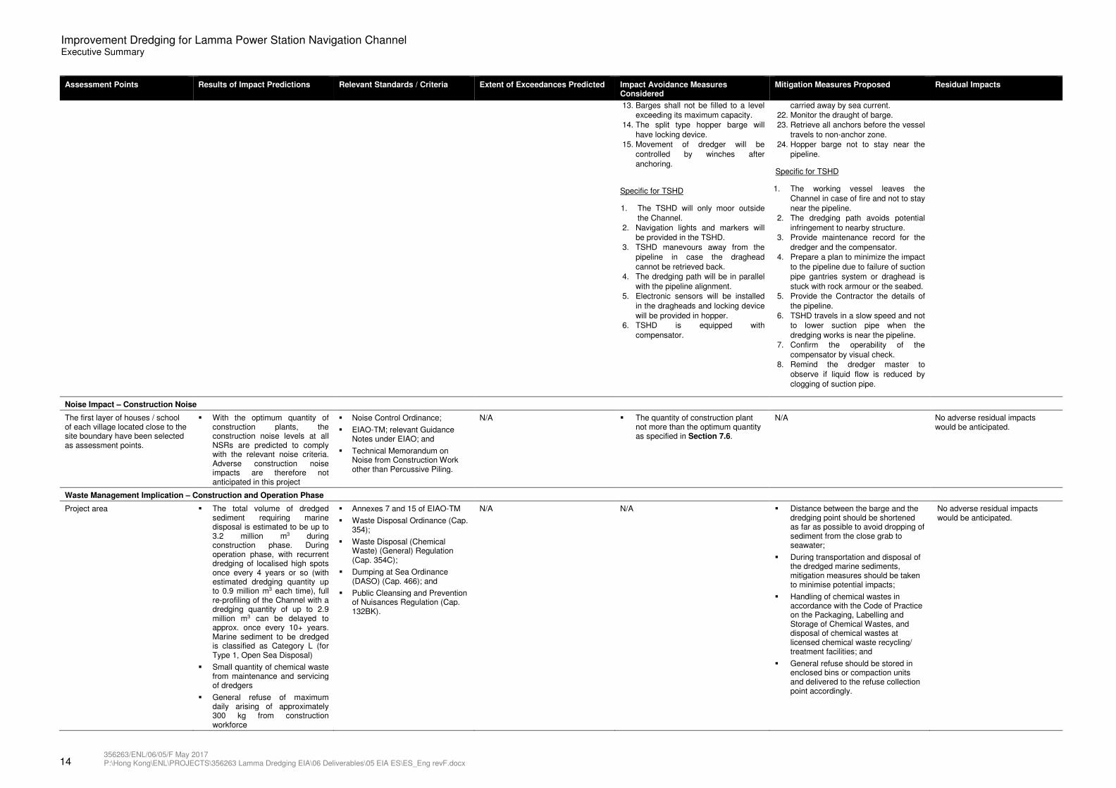
13. Barges shall not be filled to a level
exceeding its maximum capacity.
14. The split type hopper barge will
have locking device.
15. Movement of dredger will be
controlled by winches after
anchoring.
Specific for TSHD
1. The TSHD will only moor outside
the Channel.
2. Navigation lights and markers will
be provided in the TSHD.
3. TSHD manevours away from the
pipeline in case the draghead
cannot be retrieved back.
4. The dredging path will be in parallel
with the pipeline alignment.
5. Electronic sensors will be installed
in the dragheads and locking device
will be provided in hopper.
6. TSHD is equipped with
compensator.
carried away by sea current.
22. Monitor the draught of barge.
23. Retrieve all anchors before the vessel
travels to non-anchor zone.
24. Hopper barge not to stay near the
pipeline.
Specific for TSHD
1. The working vessel leaves the
Channel in case of fire and not to stay
near the pipeline.
2. The dredging path avoids potential
infringement to nearby structure.
3. Provide maintenance record for the
dredger and the compensator.
4. Prepare a plan to minimize the impact
to the pipeline due to failure of suction
pipe gantries system or draghead is
stuck with rock armour or the seabed.
5. Provide the Contractor the details of
the pipeline.
6. TSHD travels in a slow speed and not
to lower suction pipe when the
dredging works is near the pipeline.
7. Confirm the operability of the
compensator by visual check.
8. Remind the dredger master to
observe if liquid flow is reduced by
clogging of suction pipe.
Noise Impact – Construction Noise
The first layer of houses / school of each village located close to the site boundary have been selected as assessment points.
� With the optimum quantity of construction plants, the construction noise levels at all NSRs are predicted to comply with the relevant noise criteria. Adverse construction noise impacts are therefore not anticipated in this project
� Noise Control Ordinance;
� EIAO-TM; relevant Guidance Notes under EIAO; and
� Technical Memorandum on Noise from Construction Work other than Percussive Piling.
N/A � The quantity of construction plant not more than the optimum quantity as specified in Section 7.6.
N/A No adverse residual impacts would be anticipated.
Waste Management Implication – Construction and Operation Phase
Project area � The total volume of dredged sediment requiring marine disposal is estimated to be up to 3.2 million m3 during construction phase. During operation phase, with recurrent dredging of localised high spots once every 4 years or so (with estimated dredging quantity up to 0.9 million m3 each time), full re-profiling of the Channel with a dredging quantity of up to 2.9 million m3 can be delayed to approx. once every 10+ years. Marine sediment to be dredged is classified as Category L (for Type 1, Open Sea Disposal)
� Small quantity of chemical waste from maintenance and servicing of dredgers
� General refuse of maximum daily arising of approximately 300 kg from construction workforce
� Annexes 7 and 15 of EIAO-TM
� Waste Disposal Ordinance (Cap. 354);
� Waste Disposal (Chemical Waste) (General) Regulation (Cap. 354C);
� Dumping at Sea Ordinance (DASO) (Cap. 466); and
� Public Cleansing and Prevention of Nuisances Regulation (Cap. 132BK).
N/A N/A � Distance between the barge and the dredging point should be shortened as far as possible to avoid dropping of sediment from the close grab to seawater;
� During transportation and disposal of the dredged marine sediments, mitigation measures should be taken to minimise potential impacts;
� Handling of chemical wastes in accordance with the Code of Practice on the Packaging, Labelling and Storage of Chemical Wastes, and disposal of chemical wastes at licensed chemical waste recycling/ treatment facilities; and
� General refuse should be stored in enclosed bins or compaction units and delivered to the refuse collection point accordingly.
No adverse residual impacts would be anticipated.
96
86
96
86
A`æLookout
ç·ü‰Ferry Pier
ç·ü‰Ferry Pier
µ˜Police Post
HA MEI WAN
KAM LO HOM
“°Ko Long
œ⁄ßNga Kau
Wan
D¿O Tsai
_¥⁄¤Pak Kok
Kau Tsuen
_¥⁄¤Pak Kok
San Tsuen
i“„Po Lo Tsui
_˜ØPo Wah
Yuen
F¤HfiSha Po
Old Village
Û¥Shek Li
Û¥ø–Shek Li
Ka Nam
j⁄W˘Tai Wan
San Tsuen
jگTai Yuen
Village
î¾Wang Long
_”ð¾æYung Shue Long
New Village
_”ð¾æYung Shue Long
Old Village_”ðYung Shue
Wan
j⁄Tai Peng
q„OPower Station
Ñ•Coal Depot
U⁄ÀHa Mei Tsui
YUNG SHUE WAN
Û¥⁄Shek Kok Tsui
MOUNT STENHOUSE
(SHAN TEI TONG)
LING KOK SHAN
PAK KOK SHAN
NGAI TAU
Ap Lei Chau Estate
South Horizons
Lei Tung Estate
Pak Kok
Tsui
PAAK KAP
HANG
Tai Wan
Kau Tsuen
Tai Ling Lo TikTsuen Wan
Long Tsai
Tsuen
Tai Wan
To
Hung Shing Ye
Luk Chau
Village
Mo Tat Wan
Lo So Shing
Mo TatSok Kwu Wan
Yung Shue
Ha
Tung O
SHEK PAI WAN
SHAM WAN
Magazine Island
Pak Kok
Lung Shan Pai
PO CHONG
WANAP LEI CHAU
Nam Tsui
Ap Lei Pai
LUK CHAU WANAssistance
Rock
Luk Chau
HUNG SHING YEH
BEACH
KAT TSAI
WAN
PICNIC BAY
(SOK KWU WAN)TIT SHA
LONG
Wong Chuk Kok
LO SO SHING
BEACH
LAMMA ISLAND
SHEK PAI WAN
TUNG O WAN
SHAM WAN
Yuen Kok
Tai Kok
808000 N
806000 N
PROJECT AREA
1:15000 P2PRE
EC
DC
DC
EH
EH
MING
ECEHFIRST ISSUEP1 MAR 16 MING
810000 N
PROJECT BOUNDARY
804000 N
0
1 : 15 000 SCALE BAR
200 400 600m
EXISTING PIPELINE
FIGURE 2.1
MINGMAY 16P2 DC ECGENERAL REVISION
Key to symbols
App�dCh�k�dDescriptionDrawnDateRev
RevStatus
Drawing Number
Scale at A1
Eng check
Approved
Coordination
Dwg check
Drawn
Designed
Title
Notes
Client
Reference drawings
J:\356263\REPORT\ENV\ES\160523\FIG 2-1.dgn DATE:23/05/2016TIME:11:05:11USER:yim42169
Project
IMPROVEMENT DREDGING FOR
LAMMA POWER STATION
NAVIGATION CHANNEL
Hong Kong
Kwun Tong, Kowloon
100 How Ming Street
Landmark East
20/F AIA Kowloon Tower