Embed Size (px)
Citation preview
This article was downloaded by: [University of Illinois Chicago]On: 19 August 2013, At: 11:12Publisher: RoutledgeInforma Ltd Registered in England and Wales Registered Number: 1072954 Registered office: Mortimer House, 37-41 MortimerStreet, London W1T 3JH, UK
Journal of the American Planning AssociationPublication details, including instructions for authors and subscription information:http://www.tandfonline.com/loi/rjpa20
Information Into Action: Biodiversity Data Outreach andMunicipal Land ConservationJack D. Kartez a & Molly P. Casto ba University of Southern Maine (USM)b Urban Planner, City of PortlandPublished online: 15 Oct 2008.
To cite this article: Jack D. Kartez & Molly P. Casto (2008) Information Into Action: Biodiversity Data Outreach and Municipal LandConservation, Journal of the American Planning Association, 74:4, 467-480, DOI: 10.1080/01944360802378096
To link to this article: http://dx.doi.org/10.1080/01944360802378096
PLEASE SCROLL DOWN FOR ARTICLE
Taylor & Francis makes every effort to ensure the accuracy of all the information (the “Content”) contained in the publicationson our platform. However, Taylor & Francis, our agents, and our licensors make no representations or warranties whatsoeveras to the accuracy, completeness, or suitability for any purpose of the Content. Any opinions and views expressed in thispublication are the opinions and views of the authors, and are not the views of or endorsed by Taylor & Francis. The accuracyof the Content should not be relied upon and should be independently verified with primary sources of information. Taylorand Francis shall not be liable for any losses, actions, claims, proceedings, demands, costs, expenses, damages, and otherliabilities whatsoever or howsoever caused arising directly or indirectly in connection with, in relation to or arising out of theuse of the Content.
This article may be used for research, teaching, and private study purposes. Any substantial or systematic reproduction,redistribution, reselling, loan, sub-licensing, systematic supply, or distribution in any form to anyone is expressly forbidden.Terms & Conditions of access and use can be found at http://www.tandfonline.com/page/terms-and-conditions
467
Problem: Technical specialists in environ-mental planning rely on science to suggesteffective conservation strategies. Theassumption that rational technical infor-mation will be readily turned into action,however, is often not accomplished inpractice.
Purpose: In this article, we present a studyof Maine’s Beginning with Habitat (BwH)program, a statewide collaborative multi-agency effort that distributes customizedecological information directly to localgovernments who must develop state-mandated comprehensive plans. The goalis to spur the implementation of land usepolicies that more effectively protectbiodiversity. We first review the changingconception of how technical informationfrom experts comes to influence decisionson science-intensive green planning issues.We then test that recent thinking with anempirical study examining what conditionshave encouraged local governments to usethe BwH ecological information to enactnew land conservation tools.
Methods: We collected data on the localgovernment planning and implementationresponse to the BwH program in a 2004survey of all participating Maine towns andcities.
Results and conclusions: The inves-tigation supports conceptual arguments byInnes and others that getting stakeholdersto use planning and environmental manage-ment information is critical to overcomingthe limitations of the conventional rationalplanning model. The likelihood that acommunity will act on the new science-based information depends on its wealth
Information Into Action
Biodiversity Data Outreach and MunicipalLand Conservation
Jack D. Kartez and Molly P. Casto
Does putting better bioscience information on habitat into the hands ofsmall town officials and conservation advocates help to stimulate landuse planning actions to protect biodiversity? We examine this question
using data from an assessment we conducted of Maine’s innovative Beginningwith Habitat program in 2004 at the request of the program’s collaborativesteering committee, which involves both governments and nongovernmentalorganizations. We conducted a survey to examine the extent to which the localgovernments involved in this program have actually used the new informationto implement conservation actions, and why such action may be more likelyunder certain conditions. We use this analysis to reflect on the changing view
and urbanization pressures, but even moresignificantly on the extent to which differentinterests are engaged in using the informa-tion. We were surprised to find less imple-mentation when local planning staff led theuse of the technical information, absentwider public engagement.
Takeaway for practice: When addressinglocal ecological land use planning issueseffectively depends on using technicalinformation, scientists, specialists, andadvocates should encourage stakeholderaccess to such information and supportthem in using it to make decisions. Researchon the planning process itself should aim toprovide technical specialists evidence-basedmodels of effective public engagementprocesses that make information usable.
Keywords: environmental planning,communicative planning, stakeholderengagement, habitat, biodiversity
Research support: This work waspartially supported by the Maine CoastalProgram in the Maine State PlanningOffice, Executive Department.
About the authors: Jack D. Kartez ([email protected]) isassociate vice president for research, scholar-ship, and creative activity at the Universityof Southern Maine (USM), professor ofcommunity planning and development inUSM’s Muskie School of Public Service,and associate director of the U.S. Environ-mental Protection Agency-funded Region IEnvironmental Finance Center. Molly P.Casto ([email protected]) is anurban planner with the City of Portland,and has worked as an environmental andcommunity development professional inMaine, northern California, East Africa, andSouth America. She earned a Master’s ofCommunity Planning and Developmentat USM.
Journal of the American Planning Association,
Vol. 74, No. 4, Autumn 2008
DOI 10.1080/01944360802378096
© American Planning Association, Chicago, IL.
74-4 08 337976 Kartez QC3 9/18/08 11:39 AM Page 467D
ownl
oade
d by
[U
nive
rsity
of
Illin
ois
Chi
cago
] at
11:
12 1
9 A
ugus
t 201
3
of how technical information is used in the planningprocess, from the expert-judgment role to an emergingconsensus-building or communicative role. This evolutionof communicative ethics in planning is not as familiar toother scientific professions involved in environmental issues,yet the concepts may be crucial to engaging lay publics andachieving a sustainable future.
This is an exploratory study, opportunistically conductedand focused on a few measures of the planning process.Nonetheless, it provides new empirical information thatrigorously tests ideas about the emerging communicativeconception of planning, previously based largely onparticipant-observation case studies.
Landscape Ecology Information inLocal Decisions
Scientists and resource management experts haveseveral decades of accumulated insight into the need forlandscape-level (large-area or system-scale) land conservationplanning to protect biodiversity. Experts, however, oftenhope or even assume that the act of delivering good infor-mation inevitably translates into utilization and action. Thisis not necessarily the case, as professional planners concernedwith the inherent difficulties of linking knowledge to actionknow (Friedmann, 1973).
On one level, our research is a quantitative examinationin one setting of whether ecological land conservationinformation intended to influence local comprehensiveplanning has had an influence on local implementationactions to protect habitat. Such actions might includedirect controls like zoning, incentives for better design, usingtools like subdivision regulation, direct public investmentslike land acquisition, and education. On a second level,this study also examines a planning theory issue about theeffectiveness and the role of rational (technical, scientific)information and analysis in local planning.
The opportunistic laboratory for this study is the manysmall towns and cities in Maine that are the object of asingle, multiorganizational and statewide informationprogram called Beginning with Habitat (BwH). BecauseMaine, like other New England states, does not give coun-ties land use police powers, most localities have jurisdictionover their rural and undeveloped hinterlands. These townsoften make balkanized and uncoordinated developmentmanagement decisions. This severely undermines thepossibility of achieving the landscape-scale continuoushabitat blocks and corridors that ecologists now argue areessential to preserving the integrity and resilience of entirepopulations and communities of organisms.
Thus, applied ecologists and biologists from Maine’sstate, federal, and environmental organizations see anurgent need to provide common scientific guidance acrosspolitical boundaries. BwH incorporates into a single datasetthe habitat characterizations that were formerly separatelyprepared and incompatible. These data came from threedifferent biological domains (avian, plant, and animal)governed by several different state and federal statutes(e.g., not only state and federal laws governing endangeredspecies, but also the U.S. Fish and Wildlife Service’s TrustSpecies authority which extends much further to all mi-gratory birds, and additional Maine state-administeredenvironmental statutes governing disturbance of naturalareas). Historically, this fragmented approach createdobstacles to localities using these data.
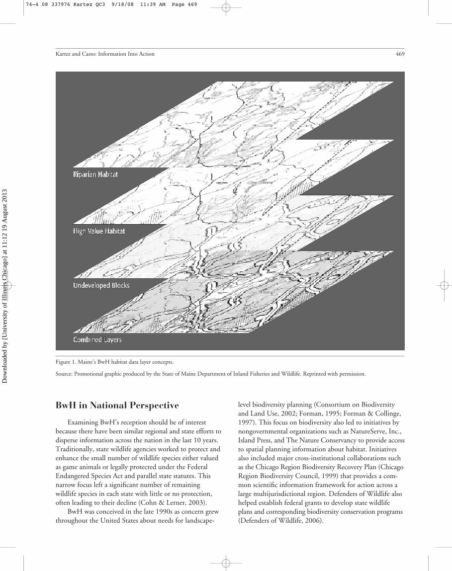
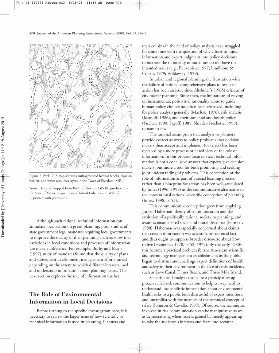
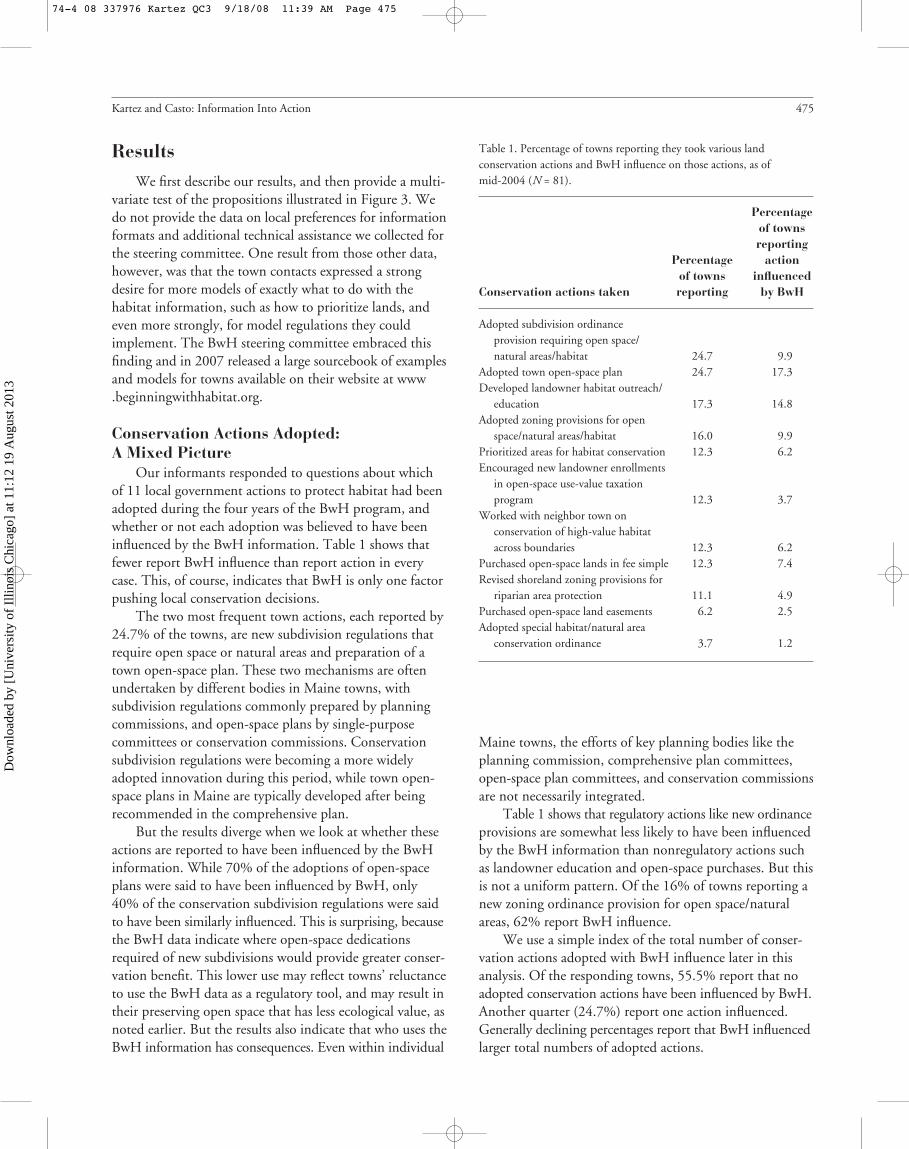
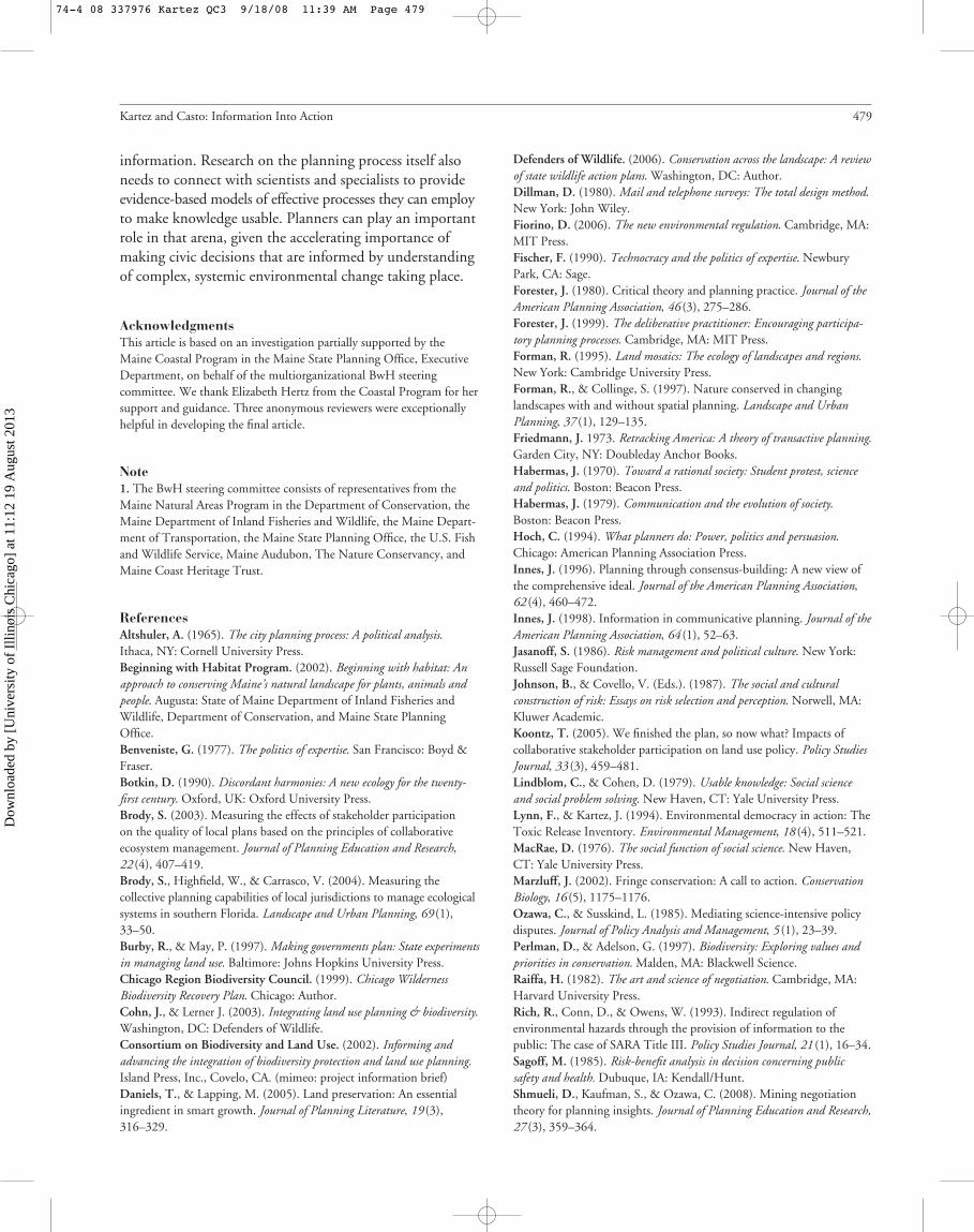
Figure 1 illustrates the three main layers of the now-integrated BwH data, which include (1) water resourcesand riparian habitats, (2) high value plant and animalhabitats, and (3) undeveloped habitat blocks. BwH alsoincludes information on public and conservation lands,functionally characterized wetlands, and a regional map.Figure 2 is an excerpt from a production map that com-bines several layers. BwH is available to towns either as anelectronic GIS file or as a set of mylar overlays.
These science-based agencies’ voluntary cooperation tointegrate this database in order to improve accessibility tononspecialists is itself an organizational innovation. Theagencies have historically been reluctant to make data onecologically sensitive locations available because of fears ofhuman disturbance. But it is even more significant thatthey have attempted to make these data more intelligibleto nonscientist decision makers.
This instance of many towns receiving the same levelof environmental planning information aimed at influencingcomprehensive plans and intended to spur implementationprovides an opportunity to examine the degree to whichinformation actually influences action. Although thisinvestigation is confined to a single state, which may raisethe usual questions about generalization of study results, ithas the virtue of controlling for many factors that have tobe accounted for in studies of multiple states and programs,such as differences in state legal frameworks, political andplanning cultures, and differences in ecological informa-tion outreach content and methods. Here, it is possible tofocus on what happens to the same information when it isdelivered to a range of localities that have similar contexts,but exhibit local differences in size, growth pressures,planning capacity, and other factors.
468 Journal of the American Planning Association, Autumn 2008, Vol. 74, No. 4
74-4 08 337976 Kartez QC3 9/18/08 11:39 AM Page 468D
ownl
oade
d by
[U
nive
rsity
of
Illin
ois
Chi
cago
] at
11:
12 1
9 A
ugus
t 201
3
BwH in National Perspective
Examining BwH’s reception should be of interestbecause there have been similar regional and state efforts todisperse information across the nation in the last 10 years.Traditionally, state wildlife agencies worked to protect andenhance the small number of wildlife species either valuedas game animals or legally protected under the FederalEndangered Species Act and parallel state statutes. Thisnarrow focus left a significant number of remainingwildlife species in each state with little or no protection,often leading to their decline (Cohn & Lerner, 2003).
BwH was conceived in the late 1990s as concern grewthroughout the United States about needs for landscape-
level biodiversity planning (Consortium on Biodiversityand Land Use, 2002; Forman, 1995; Forman & Collinge,1997). This focus on biodiversity also led to initiatives bynongovernmental organizations such as NatureServe, Inc.,Island Press, and The Nature Conservancy to provide accessto spatial planning information about habitat. Initiativesalso included major cross-institutional collaborations suchas the Chicago Region Biodiversity Recovery Plan (ChicagoRegion Biodiversity Council, 1999) that provides a com-mon scientific information framework for action across alarge multijurisdictional region. Defenders of Wildlife alsohelped establish federal grants to develop state wildlifeplans and corresponding biodiversity conservation programs(Defenders of Wildlife, 2006).
Kartez and Casto: Information Into Action 469
Figure 1. Maine’s BwH habitat data layer concepts.
Source: Promotional graphic produced by the State of Maine Department of Inland Fisheries and Wildlife. Reprinted with permission.
74-4 08 337976 Kartez QC3 9/18/08 11:39 AM Page 469D
ownl
oade
d by
[U
nive
rsity
of
Illin
ois
Chi
cago
] at
11:
12 1
9 A
ugus
t 201
3
Although such rational technical information canstimulate local action on green planning, prior studies ofstate government legal mandates requiring local governmentsto improve the quality of their planning analysis show thatvariations in local conditions and processes of informationuse make a difference. For example, Burby and May’s(1997) study of mandates found that the quality of plansand subsequent development management efforts varieddepending on the extent to which different interests usedand understood information about planning issues. Thenext section explores the role of information further.
The Role of EnvironmentalInformation in Local Decisions
Before turning to the specific investigation here, it isnecessary to review the larger issue of how scientific ortechnical information is used in planning. Planners and
their cousins in the field of policy analysis have struggledfor some time with the question of why efforts to injectinformation and expert judgment into policy decisionsto increase the rationality of outcomes do not have theintended result (e.g., Benveniste, 1977; Lindblom &Cohen, 1979; Wildavsky, 1979).
In urban and regional planning, the frustration withthe failure of rational comprehensive plans to result inaction has been an issue since Altshuler’s (1965) critique ofcity master planning. Since then, the limitations of relyingon instrumental, positivistic rationality alone to guidehuman policy choices has often been criticized, includingfor policy analysis generally (MacRae, 1976), risk analysis(Jasanoff, 1986), and environmental and health policy(Fischer, 1990; Sagoff, 1985; Shrader-Frechette, 1995),to name a few.
The rational assumption that analysts or plannersprovide correct answers to policy problems that decisionmakers then accept and implement (or reject) has beenreplaced by a more process-oriented view of the role ofinformation. In this process-focused view, technical infor-mation is not a conclusive answer that experts give decisionmakers, but more a tool for both promoting and seekingjoint understanding of problems. This conception of therole of information as part of a social learning processrather than a blueprint for action has been well-articulatedby Innes (1996, 1998) as the communicative alternative tothe conventional rational-scientific conception of planning(Innes, 1998, p. 53).
This communicative conception grew from applyingJurgen Habermas’ theory of communication and theevolution of a politically rational society to planning, andassumes emancipated social and moral discourse (Forester,1980). Habermas was especially concerned about claimsthat certain information was scientific or technical fact,and thus ought to suppress broader discourse about howto live (Habermas 1970, p. 52; 1979). By the early 1980s,this became a practical problem for the American scientificand technology management establishment, as the publicbegan to distrust and challenge expert definitions of healthand safety in their environment in the face of crisis incidentssuch as Love Canal, Times Beach, and Three Mile Island.
Scientists and analysts turned to a participatory ap-proach called risk communication to help convey hard tounderstand, probabilistic information about environmentalhealth risks to a public both distrustful of expert intentionsand unfamiliar with the nuances of the technical concept ofsafety (Johnson & Covello, 1987). Of course, the techniquesinvolved in risk communication can be manipulative as wellas democratizing when trust is gained by merely appearingto take the audience’s interests and fears into account.
470 Journal of the American Planning Association, Autumn 2008, Vol. 74, No. 4
Figure 2. BwH GIS map showing unfragmented habitat blocks, riparianhabitat, and water resources layers in the Town of Freedom, ME.
Source: Excerpt cropped from BwH production GIS file produced bythe State of Maine Department of Inland Fisheries and Wildlife.Reprinted with permission.
74-4 08 337976 Kartez QC3 9/18/08 11:39 AM Page 470D
ownl
oade
d by
[U
nive
rsity
of
Illin
ois
Chi
cago
] at
11:
12 1
9 A
ugus
t 201
3
We hope we are correct in finding planning theorists’conceptions of communicative planning and the role ofinformation more faithfully aimed at Habermas’ originalemancipatory desire to remove distortions from societaldiscourse, while aiming for a fuller rationality that takessocial and political dimensions into account along withinstrumental facts. Innes (1998) has described this alter-native approach as one that promotes joint understandingas a basis for action: “. . . only if there is plenty of talkabout the meaning of the information, its accuracy and itsimplications. Information does not influence unless itrepresents a socially constructed and shared understandingcreated in the community of policy actors” (p. 56).
In a related argument, Innes (1996) proposes thatprocesses that use alternative dispute resolution (ADR)concepts to build consensus offer a new conception ofcomprehensive planning. In such processes multiple interestsseek a shared commitment for how to carry out future-oriented decisions, not a master blueprint created by calcu-lation alone. One of the powerful techniques that draws ondispute resolution is the concept of joint fact finding orjoint model building (Raiffa, 1982). Such a process usesinformation not only to seek instrumental answers abouthow things work, but allows the stakeholders to learn towork together and to negotiate common understandingsof what makes sense within shared assumptions. Ozawaand Susskind (1985) note this as especially important onscientific issues. More recently, Shmueli, Kaufman, andOzawa (2008) posit that understanding how information isused is one of three fundamental lessons for planning fromnegotiation theory (p. 362).
Innes (1998, p. 56) cites mandated environmentalimpact statement (EIS) processes as examples of this. Suchan EIS process requires only public disclosure and consider-ation of information about impacts, not a specific decisionresult. Yet, EIS processes have led to many projects beingmodified to mitigate impacts, not just because of litigationthreats, but because they created common information andforums for wrestling with contentious technical issues. Thelaws that protect the public’s right to know about chemicalhazards, such as originally enacted in Philadelphia andthen federally mandated by Title III of the SuperfundAmendments and Reauthorization Act of 1986, are alsoexamples of information disclosure processes aimed atspurring voluntary environmental protection. Such lawshave been called “information as regulation” (Rich, Conn,& Owens, 1993) because the disclosed data can instigatenegotiation between stakeholders on action without apredetermined regulatory standard (Lynn & Kartez, 1994).Such information-driven approaches have been called “thenew environmental regulation” (Fiorino, 2006).
The key argument throughout this evolution of thinkingis the rejection of the old Cartesian assumption that theproduction of information for decisions can be totallyseparated from the process of agreeing on what the infor-mation means for practical action in collective decisions.In addition to the perspectives from planning theory,negotiation theory, and the emergent communicative view,a similar argument is made from the environmental policystudies tradition by Koontz (2005), who aptly poses theproblem: “We finished the plan, so now what?” (p. 459).These conceptual issues and the integration of thesestreams of thinking can be reviewed only briefly here.
Communicative Planning forLandscape Biodiversity
What has been called a communicative process ofinformation use is especially crucial to dealing with achallenging problem affecting many environmental orgreen planning issues. The challenge is that the specialist,such as an ecologist, for example, wants to see the bestscience-based information taken into account by lay decisionmakers, but that information is probabilistic, it changes asnew evidence accumulates, and it incorporates implicitvalue judgments. (See Botkin, 1990, for a discussion.) Inthe environmental health arena, for example, regulatorsmay choose a maximum allowable threshold for a toxicsubstance as a societally acceptable way to manage uncer-tainty, given the state of knowledge about that substance andits hazards. But such decisions have often been vigorouslyand successfully challenged by a public that questions thevalues they reflect, such as the hidden assumption thatsome small chance of loss of life to an abstract statisticalperson is tolerable (see Jasanoff, 1986; Shrader-Frechette,1995).
Protecting biodiversity through land conservation mayseem more benign, as it is simply saving nature. That,however, would be a superficial understanding of both thescience and the practical problem (Perlman & Adelson,1997). Decisions to protect certain lands remaining intheir existing state from conversion to alternate use involvenot only judgments about utility, equity, and other values,but judgments about the very concept of what is natural.Landscape ecologists and conservation biologists have inrecent years expressed grave concerns over what they seeas misplaced public priorities for protection of lands forhabitat based on perceptions of nature that are not tied to theactual needs of populations and communities of organisms(Marzluff, 2002).
Kartez and Casto: Information Into Action 471
74-4 08 337976 Kartez QC3 9/18/08 11:39 AM Page 471D
ownl
oade
d by
[U
nive
rsity
of
Illin
ois
Chi
cago
] at
11:
12 1
9 A
ugus
t 201
3
An example of this (drawn from our practice; see alsoWhittaker, 1999) is the town government or land trustthat acquires at great cost a scenic farm in an effort to savenature, though this may be of very little importance topreserving biodiversity in the area. A different example iswhen the public perceives wilderness land as the highestpriority for species preservation when the fragmentationof habitat around human-settled regions is an equal threat(Marzluff, 2002). Even within a scientific valuation frame-work, deciding which lands to save will require judgment.Providing some guidance that is both understandable andscientifically rational on what landscape characteristics areimportant to protect is the aim of programs like BwH. Butthis still requires local action.
Study Context
BwH’s ultimate goal is to maintain sufficient habitatto support all native plant and animal species in Maine.The purposes and program assumptions discussed hereare drawn from the knowledge we gained in conductinga program evaluation for the collaborative BwH steeringcommittee.1 BwH compiles the habitat characterizationdata from multiple agencies, scientific protocols, andspecies domains into a single integrated series of visuallyarresting GIS datasets customized for each municipality,along with an interpretive handbook (BwH, 2002). Aboutone third (134) of Maine’s municipalities had participatedat the time of our 2004 investigation. Previous to BwH,each of the five public agencies involved communicatedtheir habitat information to local users in different formats,at different times, governed by different update schedules,and with varying levels of interpretive explanation. Thisdid not help users comprehend or use this ecologicalinformation. The BwH (2002) package is arranged aroundthree fundamental categories of lands derived from principlesof landscape ecology (see Figure 1) and two more generalprinciples:
1. Riparian habitat: Riparian areas underpin all habitat-based planning in Maine because they are critical tomany populations and communities;
2. High value habitats: Planners should pay specialattention to the plant and animal habitats that hostrare plants, animals and natural communities;
3. Connectivity: Habitat connectivity is crucial tomaintaining functional ecosystems and viable plantand animal populations. It is important to maintainsome large habitat blocks and the connectionsamong these blocks.
4. Good planning avoids loss of biodiversity throughwell-planned development, and;
5. Planners must take a landscape-based approachbecause identifying and protecting individual featuresor species is not enough to achieve meaningfulconservation.
The program also uses additional landscape ecologyconcepts such as edge, fragmentation and interior effects,the importance of communities, and the support of migra-tion and other population dynamics. The name “Beginningwith Habitat” comes from the program’s fundamental aimto promote comprehensive and anticipatory efforts to pro-tect habitat across a larger landscape rather than piecemealefforts focused in single sites or projects or even within theboundaries of individual local governments.
Maine’s approach is thus a process-oriented informationstrategy rather than a conventional blueprint approach.Because of this, a recent national assessment by Defendersof Wildlife of State Wildlife Action Plans does not rankMaine in the top tier of 12 states it identifies as “conser-vation leaders.” Maine is identified, however, as one of 18states with “excellent actions” to address “developmentthreats” through “conservation actions” (Defenders ofWildlife, 2006, pp. 20–21). This is in spite of trendsdiscussed earlier toward using process-oriented rather thanblueprint-oriented strategies to promote green planning.
Despite its emphasis on process, the BwH steeringcommittee made a conventional assumption about howthe information would be employed at the local level. Theprogram has targeted delivery of the habitat informationpackage to towns updating their comprehensive land useplans. These plans are required under the Maine GrowthManagement Act, and must address 10 statewide goalsincluding natural resource protection.
From the standpoint of conventional technical ration-ality, the steering committee’s working hypothesis that thehabitat information can improve plans, and that this willresult in increased land conservation, is not an unreasonableassumption. However, as discussed earlier, much evidencesuggests that moving from plan to action is not so simple.The communicative view of planning suggests that someprocess for involving multiple interests in using the infor-mation may be necessary for the link to action to occur.
After one or more of the biologists of the BwH steeringcommittee make a live presentation to town stakeholdersand decision makers, the data package is put into thehands of one local contact in each town. The committeeassumes that the local contact will attempt to link theinformation to the comprehensive planning process. TheBwH steering committee also assumes that the meaning
472 Journal of the American Planning Association, Autumn 2008, Vol. 74, No. 4
74-4 08 337976 Kartez QC3 9/18/08 11:39 AM Page 472D
ownl
oade
d by
[U
nive
rsity
of
Illin
ois
Chi
cago
] at
11:
12 1
9 A
ugus
t 201
3
and implications of the information will be accepted by themultiple interests necessary to support local action, whoextend well beyond the local contact alone. We decidedthat knowing more about how far the information pene-trates those local interests should be important, and weincorporated this question into our investigation.
In some cases, the local contact is a town staff planner(where such exists). We might assume that this professionalis able to broker the information to the users with influenceover land use policy, given the persistent claims our field ofplanning makes to such expertise. But the local contacts,we learned, also include citizen appointees from townbodies such as comprehensive plan update committees andplanning commissions, conservation commissions, andopen-space planning committees, as well as nonplannertown staff and even elected selectmen or councilors. Thesebodies, which may all coexist in Maine local government,often do not agree on priorities and appropriate tools forlocal land conservation and for regulating development.Therefore, it is possible that conservation action requiresengaging a wider network of local actors. Burby and May(1997), for example, cite evidence of this in examiningother types of information-dependent planning initiatives.Delivery of the habitat information to a town then becomesonly a starting point in the linking of that knowledge toaction.
Study Design and Methodology
In 2004, the BwH steering committee asked us toinvestigate the impact of the first few years of the program.Their initial aims were to find out if and how the informa-tion delivered to the contact was being further disseminatedlocally, what data formats users found most accessible (e.g.,paper maps vs. GIS datasets), and what enhancements totechnical assistance products or services might be desired(such as more data, guidance on its use, or face-to-facehelp). We suggested to the committee that it would beuseful to know if the information was influencing theadoption of specific conservation actions as well as beingused in comprehensive plan updates. This was somewhatcontroversial.
Although these applied scientists are all vigorouslycommitted to conservation, they are reluctant to dictate tolocal decision makers exactly what actions to take, given ahome rule political and legal culture of local autonomy. Asensitive aspect of the information is that it may appear tothe layman to be a kind of biodiversity zoning by stategovernment. Yet the scientific content is much moreprobabilistic and requires judgment, as is characteristic of
much environmental information, as discussed earlier. Forexample, the Trust Species high value habitat layer producedby the U.S. Fish and Wildlife Service (USFWS) is simplythe top 30% of their ranking system for the entire Gulf ofMaine ecosystem. USFWS adopted this threshold to makethese data more usable. The steering committee was eagerto see such information used, but reluctant to appear to beintervening too directly, and aware of the complexity ofthe information.
We also recognized that multiple towns participatingunder the same program provided an opportunity tosystematically investigate factors influencing use of theinformation. Such examinations have revealed insightsabout the conditions for success of general statewide plan-ning mandates (Burby & May, 1997) and specific statewideconservation programs (e.g., Brody, Highfield, & Carrasco,2004). Innes (1998, p. 60) argues that more investigationis needed of communicative planning processes. BwHprovided an opportunity for investigation in a mode otherthan the single interpretive case study relying on participantobservation.
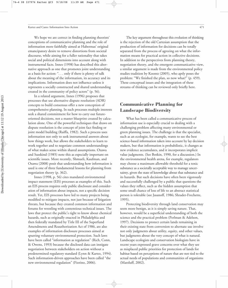
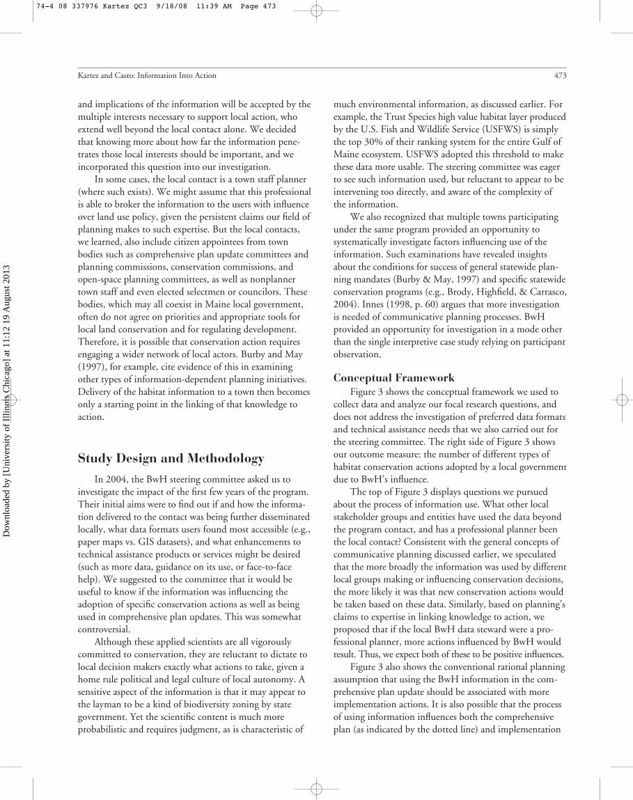
Conceptual FrameworkFigure 3 shows the conceptual framework we used to
collect data and analyze our focal research questions, anddoes not address the investigation of preferred data formatsand technical assistance needs that we also carried out forthe steering committee. The right side of Figure 3 showsour outcome measure: the number of different types ofhabitat conservation actions adopted by a local governmentdue to BwH’s influence.
The top of Figure 3 displays questions we pursuedabout the process of information use. What other localstakeholder groups and entities have used the data beyondthe program contact, and has a professional planner beenthe local contact? Consistent with the general concepts ofcommunicative planning discussed earlier, we speculatedthat the more broadly the information was used by differentlocal groups making or influencing conservation decisions,the more likely it was that new conservation actions wouldbe taken based on these data. Similarly, based on planning’sclaims to expertise in linking knowledge to action, weproposed that if the local BwH data steward were a pro-fessional planner, more actions influenced by BwH wouldresult. Thus, we expect both of these to be positive influences.
Figure 3 also shows the conventional rational planningassumption that using the BwH information in the com-prehensive plan update should be associated with moreimplementation actions. It is also possible that the processof using information influences both the comprehensiveplan (as indicated by the dotted line) and implementation
Kartez and Casto: Information Into Action 473
74-4 08 337976 Kartez QC3 9/18/08 11:39 AM Page 473D
ownl
oade
d by
[U
nive
rsity
of
Illin
ois
Chi
cago
] at
11:
12 1
9 A
ugus
t 201
3
actions. This is called a common cause in the analysis, ora test of a rival explanation.
Finally, the items on the left in Figure 3 are character-istics of the fixed local context in which BwH and localgovernments operate, which are conditions outside theircontrol. These factors may also be common causes of boththe character of the planning effort (such as more engage-ment of stakeholders or more professional help) and theadoption of implementation actions (due to more capacityor political pressure to adopt, regardless of the process oreven the plan’s quality). For example, factors such as a highgrowth rate and high incomes or high educational attain-ment among the electorate have been found to be associatedwith increased local government planning commitmentsfor conservation (Brody et al., 2004). The literature suggeststhat all the local context factors on the left in Figure 3 wouldhave positive effects, with higher levels associated withhigher levels of process, plan content, and implementationmeasures.
Data Collection MethodsWe collected data on all questions except the com-
munity characteristics with a mailed questionnaire sent to
the official local BwH contact in mid-2004. We drew dataon municipal characteristics from the 2000 Census ofPopulation and Housing. The mail survey was limited to 16closed-ended questions to promote response by the mixedgroup of professionals and citizen officials. A number ofquestions were extensive multi-item inventories, listing, forexample, local actions or local planning participants. Weadministered the survey using Dillman’s (1980) proceduresfor encouraging response. We solicited the local contactsfrom all 134 towns that received the BwH package by June,2004 as key informants reporting on their towns, and thetown is the unit of analysis.
The 61% response rate we achieved was somewhatbelow the 75% level we have typically achieved with directlocal government studies using these methods. That is inpart due to a lower response rate from the smallest towns,which have few or no staff resources, and where the primarycontact was a volunteer appointed citizen official. Consistentwith that, nonresponding towns had a mean populationin 2000 of 3,084 versus the larger average population of4,757 for the 81 responding towns (p < .05 for differencein means). This indicates a slight response bias towardslarger towns.
474 Journal of the American Planning Association, Autumn 2008, Vol. 74, No. 4
Figure 3. Conceptual framework for predicting local government action.
Planning process• Number of stakeholder
groups using BwH data• Local BwH contact is a
professional planner
Local context• Population size• Growth rate• Income levels• Density
Comprehensive planupdate uses BwH data
Conservation actionsinfluenced by BwH• Revised regulations• Land acquisitions• Functional plans
(e.g., open space)• Outreach /education
74-4 08 337976 Kartez QC3 9/18/08 11:39 AM Page 474D
ownl
oade
d by
[U
nive
rsity
of
Illin
ois
Chi
cago
] at
11:
12 1
9 A
ugus
t 201
3
Results
We first describe our results, and then provide a multi-variate test of the propositions illustrated in Figure 3. Wedo not provide the data on local preferences for informationformats and additional technical assistance we collected forthe steering committee. One result from those other data,however, was that the town contacts expressed a strongdesire for more models of exactly what to do with thehabitat information, such as how to prioritize lands, andeven more strongly, for model regulations they couldimplement. The BwH steering committee embraced thisfinding and in 2007 released a large sourcebook of examplesand models for towns available on their website at www.beginningwithhabitat.org.
Conservation Actions Adopted:A Mixed Picture
Our informants responded to questions about whichof 11 local government actions to protect habitat had beenadopted during the four years of the BwH program, andwhether or not each adoption was believed to have beeninfluenced by the BwH information. Table 1 shows thatfewer report BwH influence than report action in everycase. This, of course, indicates that BwH is only one factorpushing local conservation decisions.
The two most frequent town actions, each reported by24.7% of the towns, are new subdivision regulations thatrequire open space or natural areas and preparation of atown open-space plan. These two mechanisms are oftenundertaken by different bodies in Maine towns, withsubdivision regulations commonly prepared by planningcommissions, and open-space plans by single-purposecommittees or conservation commissions. Conservationsubdivision regulations were becoming a more widelyadopted innovation during this period, while town open-space plans in Maine are typically developed after beingrecommended in the comprehensive plan.
But the results diverge when we look at whether theseactions are reported to have been influenced by the BwHinformation. While 70% of the adoptions of open-spaceplans were said to have been influenced by BwH, only40% of the conservation subdivision regulations were saidto have been similarly influenced. This is surprising, becausethe BwH data indicate where open-space dedicationsrequired of new subdivisions would provide greater conser-vation benefit. This lower use may reflect towns’ reluctanceto use the BwH data as a regulatory tool, and may result intheir preserving open space that has less ecological value, asnoted earlier. But the results also indicate that who uses theBwH information has consequences. Even within individual
Maine towns, the efforts of key planning bodies like theplanning commission, comprehensive plan committees,open-space plan committees, and conservation commissionsare not necessarily integrated.
Table 1 shows that regulatory actions like new ordinanceprovisions are somewhat less likely to have been influencedby the BwH information than nonregulatory actions suchas landowner education and open-space purchases. But thisis not a uniform pattern. Of the 16% of towns reporting anew zoning ordinance provision for open space/naturalareas, 62% report BwH influence.
We use a simple index of the total number of conser-vation actions adopted with BwH influence later in thisanalysis. Of the responding towns, 55.5% report that noadopted conservation actions have been influenced by BwH.Another quarter (24.7%) report one action influenced.Generally declining percentages report that BwH influencedlarger total numbers of adopted actions.
Kartez and Casto: Information Into Action 475
Table 1. Percentage of towns reporting they took various landconservation actions and BwH influence on those actions, as of mid-2004 (N = 81).
Percentageof townsreporting
Percentage actionof towns influenced
Conservation actions taken reporting by BwH
Adopted subdivision ordinance provision requiring open space/natural areas/habitat 24.7 9.9
Adopted town open-space plan 24.7 17.3Developed landowner habitat outreach/
education 17.3 14.8Adopted zoning provisions for open
space/natural areas/habitat 16.0 9.9Prioritized areas for habitat conservation 12.3 6.2Encouraged new landowner enrollments
in open-space use-value taxation program 12.3 3.7
Worked with neighbor town on conservation of high-value habitat across boundaries 12.3 6.2
Purchased open-space lands in fee simple 12.3 7.4Revised shoreland zoning provisions for
riparian area protection 11.1 4.9Purchased open-space land easements 6.2 2.5Adopted special habitat/natural area
conservation ordinance 3.7 1.2
74-4 08 337976 Kartez QC3 9/18/08 11:39 AM Page 475D
ownl
oade
d by
[U
nive
rsity
of
Illin
ois
Chi
cago
] at
11:
12 1
9 A
ugus
t 201
3
Testing the ComprehensivePlanning Assumption
The BwH steering committee assumed that providingtheir science-based information to localities for use incomprehensive plans gave them a key opportunity toinfluence local decisions. The survey found that 86% ofthe responding towns had adopted new or updated com-prehensive plans in the previous four years. Three quartersof these reported that the BwH information influenced theplan’s content. At least on the planning level, the committee’sstrategy was operating as envisioned: just under two thirdsof the responding towns had new plans influenced byBwH.
A simple test of differences between the mean numberof conservation actions adopted with and without a com-prehensive plan reported as influenced by the informationshows a statistically nonzero but small difference in theexpected direction. With a BwH-influenced plan, theaverage number of adopted actions index is 0.72. Withoutan influenced plan the average is near zero (0.12). Thisresult is different from chance at the 95% confidenceinterval. We further test this role of plans in the multivariateanalysis of our conceptual framework.
The Role of Process: Users ofHabitat Information
The two aspects of the information use process that weexamine in this exploratory study are the role of the planneras the local contact versus other stewards of the information,and the number of different types of users of the informa-tion among local stakeholder groups. The most likely BwHlocal contact is the local planning professional (at 26% ofthe local BwH contacts responding to a question abouttheir defined role in town affairs). Another 20% of contactsindicated they were citizen members of the comprehensiveplan preparation committee. This high proportion of BwHcontacts who were planners or plan committee members isconsistent with the program’s aim to inject BwH data intothe comprehensive plan. But about equal numbers oftowns report other roles for the contact: member of thecitizen planning commission (11%) or conservation com-mission (10%), town manager (10%), or elected official(10%). The remaining 13% of towns report a variety ofstaff, some in nonplanning roles, as the contact.
We wanted to test the notion that planning has specialexpertise in providing information to decision makers.This would perhaps be true if a professional town plannerrather than a citizen official or other nonplanner were toreceive and communicate the contents of the BwH package.A simple test of difference in the average number of BwH-influenced conservation actions in towns in which a planner
was and was not the lead contact did show a slightly higheraverage number of actions for towns with a planner in thelead than for the other towns. But the difference of 0.9versus 0.6 actions on average, respectively, is not statisticallydifferent from no difference (p > .20) nor is the smalldifference practically significant.
The second measure of information use in the planningprocess is based on asking the local contact which of 11local stakeholder groups in conservation decisions haveactually made some use of the BwH data. Table 2 showsthat the three most frequent user groups are those citizenofficials and staff most involved in comprehensive planning.That is consistent with BwH’s delivery strategy. However,as just discussed, having a planning staff person as the leadcontact, and hence also a user, does not seem to affectaction. Thus other users may also be important in devel-oping support for implementation actions. A critical massof interests sharing knowledge may be needed (Brody,2003); for example, one fifth (21%) of the towns reporta local land trust as a BwH information user. Land trustshave indeed grown rapidly to play important political andfinancial roles in assisting local government efforts at landconservation (Daniels & Lapping, 2005; Whittaker,1999).
Table 3 shows the possible importance of this criticalmass aspect of engaging multiple relevant interests inshared information use. This concept was discussed earlieras one drawn from both the science-intensive disputeresolution framework and from ideas about applyingcommunicative ethics theory. Table 3 shows the percentages
476 Journal of the American Planning Association, Autumn 2008, Vol. 74, No. 4
Table 2. Percentage of towns reporting various users of BwHinformation (N = 81).
Percentageof towns
reporting group User groups used BwH
Comprehensive plan committee 60.5Planning board 43.2Planning staff or consultant 39.5Conservation commission 29.6Individual citizens 22.2Local land trusts 21.0Elected officials (selectmen/council) 11.1Landowners 9.9Open-space committee 7.4School teachers/students 7.4Engineers or other public works employees 3.7
74-4 08 337976 Kartez QC3 9/18/08 11:39 AM Page 476D
ownl
oade
d by
[U
nive
rsity
of
Illin
ois
Chi
cago
] at
11:
12 1
9 A
ugus
t 201
3
of the towns reporting various numbers of user groups forthe BwH information, together with the average numberof conservation actions reported to be influenced by BwHfor the same categories.
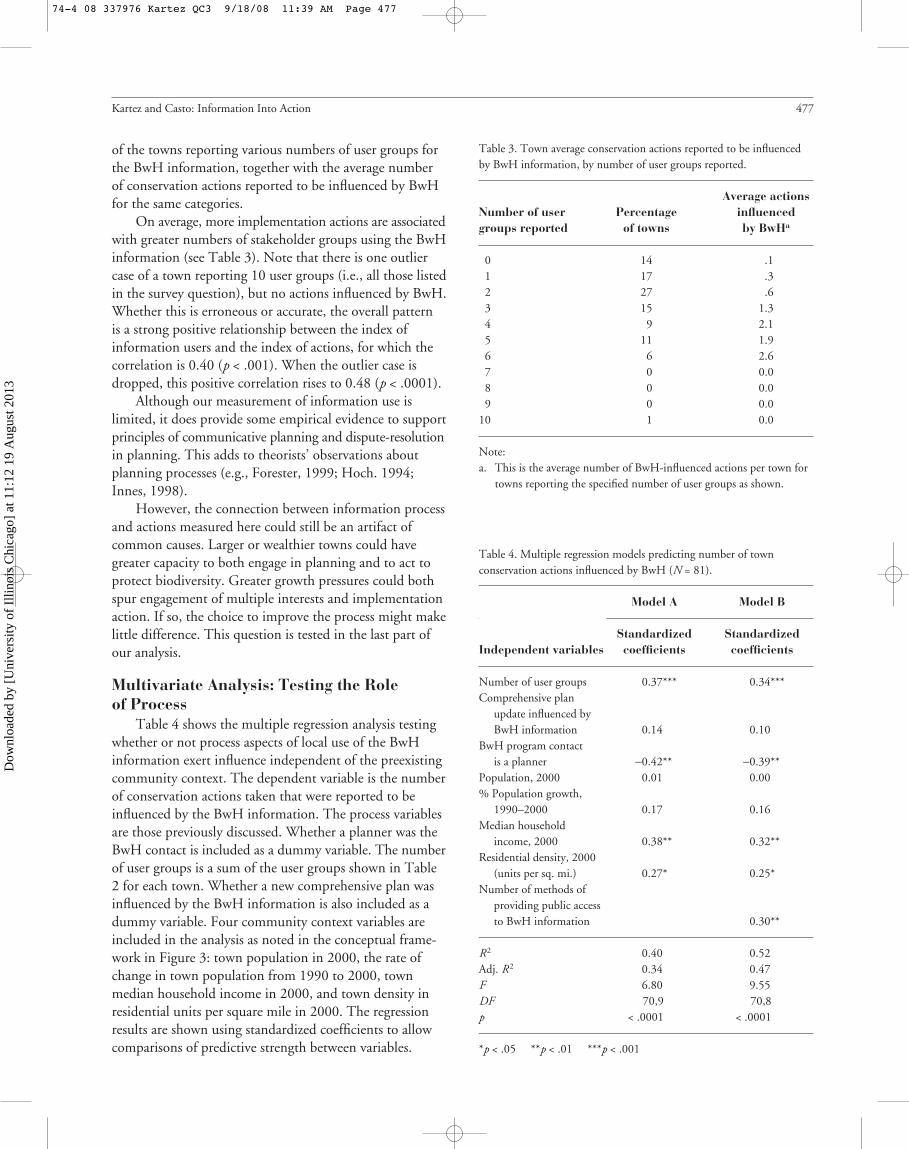
On average, more implementation actions are associatedwith greater numbers of stakeholder groups using the BwHinformation (see Table 3). Note that there is one outliercase of a town reporting 10 user groups (i.e., all those listedin the survey question), but no actions influenced by BwH.Whether this is erroneous or accurate, the overall patternis a strong positive relationship between the index ofinformation users and the index of actions, for which thecorrelation is 0.40 (p < .001). When the outlier case isdropped, this positive correlation rises to 0.48 (p < .0001).
Although our measurement of information use islimited, it does provide some empirical evidence to supportprinciples of communicative planning and dispute-resolutionin planning. This adds to theorists’ observations aboutplanning processes (e.g., Forester, 1999; Hoch. 1994;Innes, 1998).
However, the connection between information processand actions measured here could still be an artifact ofcommon causes. Larger or wealthier towns could havegreater capacity to both engage in planning and to act toprotect biodiversity. Greater growth pressures could bothspur engagement of multiple interests and implementationaction. If so, the choice to improve the process might makelittle difference. This question is tested in the last part ofour analysis.
Multivariate Analysis: Testing the Roleof Process
Table 4 shows the multiple regression analysis testingwhether or not process aspects of local use of the BwHinformation exert influence independent of the preexistingcommunity context. The dependent variable is the numberof conservation actions taken that were reported to beinfluenced by the BwH information. The process variablesare those previously discussed. Whether a planner was theBwH contact is included as a dummy variable. The numberof user groups is a sum of the user groups shown in Table2 for each town. Whether a new comprehensive plan wasinfluenced by the BwH information is also included as adummy variable. Four community context variables areincluded in the analysis as noted in the conceptual frame-work in Figure 3: town population in 2000, the rate ofchange in town population from 1990 to 2000, townmedian household income in 2000, and town density inresidential units per square mile in 2000. The regressionresults are shown using standardized coefficients to allowcomparisons of predictive strength between variables.
Kartez and Casto: Information Into Action 477
Table 3. Town average conservation actions reported to be influencedby BwH information, by number of user groups reported.
Average actionsNumber of user Percentage influencedgroups reported of towns by BwHa
0 14 .11 17 .32 27 .63 15 1.34 9 2.15 11 1.96 6 2.67 0 0.08 0 0.09 0 0.0
10 1 0.0
Note:a. This is the average number of BwH-influenced actions per town for
towns reporting the specified number of user groups as shown.
Table 4. Multiple regression models predicting number of townconservation actions influenced by BwH (N = 81).
Model A Model B
Standardized StandardizedIndependent variables coefficients coefficients
Number of user groups 0.37*** 0.34***Comprehensive plan
update influenced by BwH information 0.14 0.10
BwH program contactis a planner −0.42** −0.39**
Population, 2000 0.01 0.00% Population growth,
1990–2000 0.17 0.16Median household
income, 2000 0.38** 0.32**Residential density, 2000
(units per sq. mi.) 0.27* 0.25*Number of methods of
providing public access to BwH information 0.30**
R2 0.40 0.52Adj. R2 0.34 0.47F 6.80 9.55DF 70,9 70,8p < .0001 < .0001
*p < .05 **p < .01 ***p < .001
74-4 08 337976 Kartez QC3 9/18/08 11:39 AM Page 477D
ownl
oade
d by
[U
nive
rsity
of
Illin
ois
Chi
cago
] at
11:
12 1
9 A
ugus
t 201
3
The results in Table 4 show that the outcome measure,total conservation actions adopted and influenced by theBwH program, is in part predicted by some fixed commu-nity characteristics, other factors held constant. Wealthiertowns and more developed towns (as indicated by higheraverage residential density) are significantly more likely tohave adopted more conservation tools on average. Popula-tion size has no unique effect. Towns with higher growthrates in the preceding decade are also slightly more likely tobe higher adopters, but this is not a statistically significantresult (p < .15).
Even after taking into account consideration thattowns that are more urbanized and have greater wealthmay be more prepared to act on the biodiversity infor-mation, there are significant effects for two of the planningprocess-related predictors. The greater the number ofinterests engaged in using the information, the greater thenumber of actions on average, with a standardized coefficientof 0.37 that is significantly nonzero at the .001 probabilitylevel (Model A). However, a surprising result is that havinga professional planner as the lead for making the BwHinformation available in the planning effort is negativelyassociated with a higher number of implementation actions,with a significantly nonzero coefficient of −0.42 (p < .01).
We further tested the robustness of this analysis byadding a measure of how accessible the information was tothe local stakeholders (Model B). This was done to exam-ine whether or not the effect of the number of user groupswas an artifact of more people having access to the infor-mation simply because of better dissemination, and notbecause of the breadth and diversity of political interestsengaged (Burby & May, 1997). This accessibility variablewas a count of the number of different methods used byeach town to make BwH available (e.g., paper maps, townwebsite, town library, etc.). The results for Model B showthat the accessibility factor was a significant predictor ofmore conservation action, but did not diminish the confi-dence levels for the other key predictors, including numberof user groups. The coefficient of determination (R2) forthis second model increased to an impressive 0.52 (0.47adjusted).
This indicates that, with all other factors held constant,including whether stakeholders engage in what Innes (1998)calls “talk” about the information (proxied here by howmany groups used the information), a professional planner’sinvolvement alone may be insufficient to promote localaction. More problematic to interpret is the result thatrather than having no effect, the planner-as-lead-contactvariable has a significantly negative effect. This suggeststhat planners may even impede local policy action thatrequires information sharing and communication among
diverse stakeholders. The estimated negative effect of theplanner as lead contact only results after removing all theeffects of the other measures indicating that informationwas shared with and used by stakeholders. This mightimply the case where planners may have created (or failedto improve) situations with poor or no communicationamong stakeholders. Unfortunately, these data do notpermit a conclusive explanation for the negative plannereffect.
Nonetheless, quite consistent with this interpretation,the use of the BwH data in a new comprehensive plan isin itself not a positive predictor of implementation actionafter the other process factors are accounted for. The BwHsteering committee’s strategy of targeting information toplan updates is only a starting point of a process of engage-ment needed to bridge the old divide between technicaland political rationality (Shmueli et al., 2008). The scopeof this study is modest. The results do suggest that inquiryinto how planners can facilitate wider engagement in usingscience-based information in green planning by a range ofinterests continues to be a vital direction for improvingpractice.
Conclusions
This has been an empirical inquiry into the impactof one innovative statewide effort to inject science-basedinformation into the local process of land conservation anddevelopment management. The evidence collected here,though limited, is conceptually consistent with long-standing critiques of the rational model of planning. It isconsistent as well with the emerging ideas about recoveringrationality by widening the circle of those engaged in usingand legitimizing expert information (Shrader-Frechette,1995). As discussed earlier, evidence in environmentalplanning over the past 25 years has indicated that suchprocesses of democratizing the use and application ofinformation are unavoidable if support for action is to bedeveloped at the community level (Lynn & Kartez, 1994).This study also adds to the evidence for the theoretical andpractical arguments being made in both planning theoryand negotiation theory about the need for a communicativeapproach to deliberation and decision.
Green community planning is increasingly driven byscience and is information intensive. Effectively addressinglocal environment and energy planning issues depends onusing scientific information. As a consequence, scientists,specialists, and advocates must give sustained attention tothe process that provides stakeholders the opportunity andthe support to access and make judgments about relevant
478 Journal of the American Planning Association, Autumn 2008, Vol. 74, No. 4
74-4 08 337976 Kartez QC3 9/18/08 11:39 AM Page 478D
ownl
oade
d by
[U
nive
rsity
of
Illin
ois
Chi
cago
] at
11:
12 1
9 A
ugus
t 201
3
information. Research on the planning process itself alsoneeds to connect with scientists and specialists to provideevidence-based models of effective processes they can employto make knowledge usable. Planners can play an importantrole in that arena, given the accelerating importance ofmaking civic decisions that are informed by understandingof complex, systemic environmental change taking place.
AcknowledgmentsThis article is based on an investigation partially supported by theMaine Coastal Program in the Maine State Planning Office, ExecutiveDepartment, on behalf of the multiorganizational BwH steeringcommittee. We thank Elizabeth Hertz from the Coastal Program for hersupport and guidance. Three anonymous reviewers were exceptionallyhelpful in developing the final article.
Note1. The BwH steering committee consists of representatives from theMaine Natural Areas Program in the Department of Conservation, theMaine Department of Inland Fisheries and Wildlife, the Maine Depart-ment of Transportation, the Maine State Planning Office, the U.S. Fishand Wildlife Service, Maine Audubon, The Nature Conservancy, andMaine Coast Heritage Trust.
ReferencesAltshuler, A. (1965). The city planning process: A political analysis.Ithaca, NY: Cornell University Press.Beginning with Habitat Program. (2002). Beginning with habitat: Anapproach to conserving Maine’s natural landscape for plants, animals andpeople. Augusta: State of Maine Department of Inland Fisheries andWildlife, Department of Conservation, and Maine State PlanningOffice.Benveniste, G. (1977). The politics of expertise. San Francisco: Boyd &Fraser.Botkin, D. (1990). Discordant harmonies: A new ecology for the twenty-first century. Oxford, UK: Oxford University Press.Brody, S. (2003). Measuring the effects of stakeholder participationon the quality of local plans based on the principles of collaborativeecosystem management. Journal of Planning Education and Research,22 (4), 407–419.Brody, S., Highfield, W., & Carrasco, V. (2004). Measuring thecollective planning capabilities of local jurisdictions to manage ecologicalsystems in southern Florida. Landscape and Urban Planning, 69 (1),33–50.Burby, R., & May, P. (1997). Making governments plan: State experimentsin managing land use. Baltimore: Johns Hopkins University Press.Chicago Region Biodiversity Council. (1999). Chicago WildernessBiodiversity Recovery Plan. Chicago: Author.Cohn, J., & Lerner J. (2003). Integrating land use planning & biodiversity.Washington, DC: Defenders of Wildlife.Consortium on Biodiversity and Land Use. (2002). Informing andadvancing the integration of biodiversity protection and land use planning.Island Press, Inc., Covelo, CA. (mimeo: project information brief)Daniels, T., & Lapping, M. (2005). Land preservation: An essentialingredient in smart growth. Journal of Planning Literature, 19 (3),316–329.
Defenders of Wildlife. (2006). Conservation across the landscape: A reviewof state wildlife action plans. Washington, DC: Author.Dillman, D. (1980). Mail and telephone surveys: The total design method.New York: John Wiley.Fiorino, D. (2006). The new environmental regulation. Cambridge, MA:MIT Press.Fischer, F. (1990). Technocracy and the politics of expertise. NewburyPark, CA: Sage.Forester, J. (1980). Critical theory and planning practice. Journal of theAmerican Planning Association, 46 (3), 275–286.Forester, J. (1999). The deliberative practitioner: Encouraging participa-tory planning processes. Cambridge, MA: MIT Press.Forman, R. (1995). Land mosaics: The ecology of landscapes and regions.New York: Cambridge University Press.Forman, R., & Collinge, S. (1997). Nature conserved in changinglandscapes with and without spatial planning. Landscape and UrbanPlanning, 37 (1), 129–135.Friedmann, J. 1973. Retracking America: A theory of transactive planning.Garden City, NY: Doubleday Anchor Books.Habermas, J. (1970). Toward a rational society: Student protest, scienceand politics. Boston: Beacon Press.Habermas, J. (1979). Communication and the evolution of society.Boston: Beacon Press.Hoch, C. (1994). What planners do: Power, politics and persuasion.Chicago: American Planning Association Press.Innes, J. (1996). Planning through consensus-building: A new view ofthe comprehensive ideal. Journal of the American Planning Association,62 (4), 460–472.Innes, J. (1998). Information in communicative planning. Journal of theAmerican Planning Association, 64 (1), 52–63.Jasanoff, S. (1986). Risk management and political culture. New York:Russell Sage Foundation.Johnson, B., & Covello, V. (Eds.). (1987). The social and culturalconstruction of risk: Essays on risk selection and perception. Norwell, MA:Kluwer Academic.Koontz, T. (2005). We finished the plan, so now what? Impacts ofcollaborative stakeholder participation on land use policy. Policy StudiesJournal, 33 (3), 459–481.Lindblom, C., & Cohen, D. (1979). Usable knowledge: Social scienceand social problem solving. New Haven, CT: Yale University Press.Lynn, F., & Kartez, J. (1994). Environmental democracy in action: TheToxic Release Inventory. Environmental Management, 18 (4), 511–521.MacRae, D. (1976). The social function of social science. New Haven,CT: Yale University Press.Marzluff, J. (2002). Fringe conservation: A call to action. ConservationBiology, 16 (5), 1175–1176.Ozawa, C., & Susskind, L. (1985). Mediating science-intensive policydisputes. Journal of Policy Analysis and Management, 5 (1), 23–39.Perlman, D., & Adelson, G. (1997). Biodiversity: Exploring values andpriorities in conservation. Malden, MA: Blackwell Science.Raiffa, H. (1982). The art and science of negotiation. Cambridge, MA:Harvard University Press.Rich, R., Conn, D., & Owens, W. (1993). Indirect regulation ofenvironmental hazards through the provision of information to thepublic: The case of SARA Title III. Policy Studies Journal, 21 (1), 16–34.Sagoff, M. (1985). Risk-benefit analysis in decision concerning publicsafety and health. Dubuque, IA: Kendall/Hunt.Shmueli, D., Kaufman, S., & Ozawa, C. (2008). Mining negotiationtheory for planning insights. Journal of Planning Education and Research,27 (3), 359–364.
Kartez and Casto: Information Into Action 479
74-4 08 337976 Kartez QC3 9/18/08 11:39 AM Page 479D
ownl
oade
d by
[U
nive
rsity
of
Illin
ois
Chi
cago
] at
11:
12 1
9 A
ugus
t 201
3
Shrader-Frechette, K. (1995). Evaluating the expertise of experts. Risk:Health, Safety and Environment, 6, 115–126.Whittaker, M. (1999). Preserving open space on the rural urban fringe:The role of land trusts. In O. Fursureth & M. Lapping (Eds.), Contestedcountryside: The rural urban fringe in North America (pp. 263–287).Aldershot, UK: Ashgate.
Wildavsky, A. (1979). Speaking truth to power: The art and craft of policyanalysis. Boston: Little, Brown.
480 Journal of the American Planning Association, Autumn 2008, Vol. 74, No. 4
University Pressof KansasPhone (785) 864-4155Fax (785) 864-4586www.kansaspress.ku.edu
The Zoning of AmericaEuclid v. AmblerMichael Allan Wolf
“Wonderful andcompelling, Wolf’sbook tells the storyof Euclid v. Amblerin detail for the firsttime.”—Daniel R.Mandelker, authorof Planning andControl of LandDevelopment
“After 80 years,Euclid v. Ambler isstill the case thatdefines American land use jurisprudence. Itsupplied the rules that permitted us to becomea suburban nation. Wolf tells a great story,brilliantly showing the intersection of law,politics, and culture.”—Lance Liebman,William S. Beinecke Professor of Law,Columbia University
Landmark Law Cases and American Society208 pages, Cloth $35.00, Paper $16.95
74-4 08 337976 Kartez QC3 9/18/08 11:39 AM Page 480D
ownl
oade
d by
[U
nive
rsity
of
Illin
ois
Chi
cago
] at
11:
12 1
9 A
ugus
t 201
3