Embed Size (px)
DESCRIPTION
INMAP 2005 Elevation Datasets. Anna Radue University Information Technology Services (UITS) Indiana University. INMAP05 Elevation Data. Created from 2005 Indiana orthophotography imagery collected in March & April, 2005 65,670 DEM ERDAS *.img files (~200 GB) 34,161 stple images - PowerPoint PPT Presentation
Citation preview
3/14/20073/14/2007 http://gis.iu.edu [email protected]://gis.iu.edu [email protected]
11
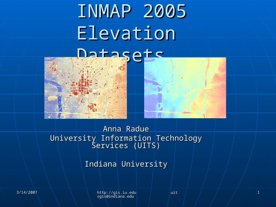
INMAP 2005 INMAP 2005 Elevation Datasets Elevation Datasets
Anna RadueAnna RadueUniversity Information Technology Services University Information Technology Services
(UITS)(UITS)
Indiana UniversityIndiana University
3/14/20073/14/2007 http://gis.iu.edu [email protected]://gis.iu.edu [email protected]
22
INMAP05 Elevation DataINMAP05 Elevation Data Created from 2005 Indiana Created from 2005 Indiana
orthophotography imagery collected orthophotography imagery collected in March & April, 2005in March & April, 2005
65,670 DEM ERDAS *.img files (~200 65,670 DEM ERDAS *.img files (~200 GB)GB)• 34,161 stple images34,161 stple images• 31,509 stplw images31,509 stplw images
800 x 800 pixel *.img images800 x 800 pixel *.img images 2.78 MB *.img file and 0.3 MB *.rrd2.78 MB *.img file and 0.3 MB *.rrd
3/14/20073/14/2007 http://gis.iu.edu [email protected]://gis.iu.edu [email protected]
33
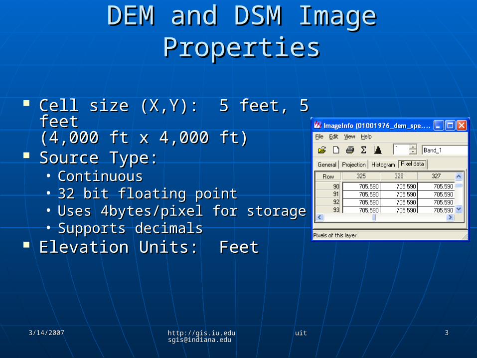
DEM and DSM Image PropertiesDEM and DSM Image Properties
Cell size (X,Y): 5 feet, 5 feetCell size (X,Y): 5 feet, 5 feet(4,000 ft x 4,000 ft)(4,000 ft x 4,000 ft)
Source Type: Source Type: • ContinuousContinuous• 32 bit floating point32 bit floating point• Uses 4bytes/pixel for storageUses 4bytes/pixel for storage• Supports decimalsSupports decimals
Elevation Units: FeetElevation Units: Feet
3/14/20073/14/2007 http://gis.iu.edu [email protected]://gis.iu.edu [email protected]
44
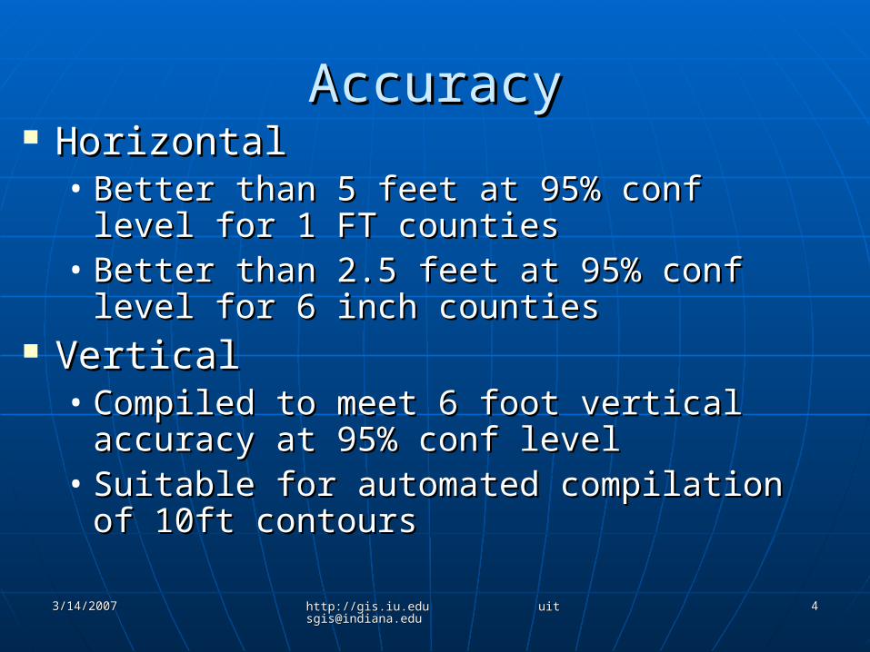
AccuracyAccuracy HorizontalHorizontal
• Better than 5 feet at 95% conf level for Better than 5 feet at 95% conf level for 1 FT counties1 FT counties
• Better than 2.5 feet at 95% conf level Better than 2.5 feet at 95% conf level for 6 inch countiesfor 6 inch counties
VerticalVertical• Compiled to meet 6 foot vertical Compiled to meet 6 foot vertical
accuracy at 95% conf levelaccuracy at 95% conf level• Suitable for automated compilation of Suitable for automated compilation of
10ft contours10ft contours
3/14/20073/14/2007 http://gis.iu.edu [email protected]://gis.iu.edu [email protected]
55
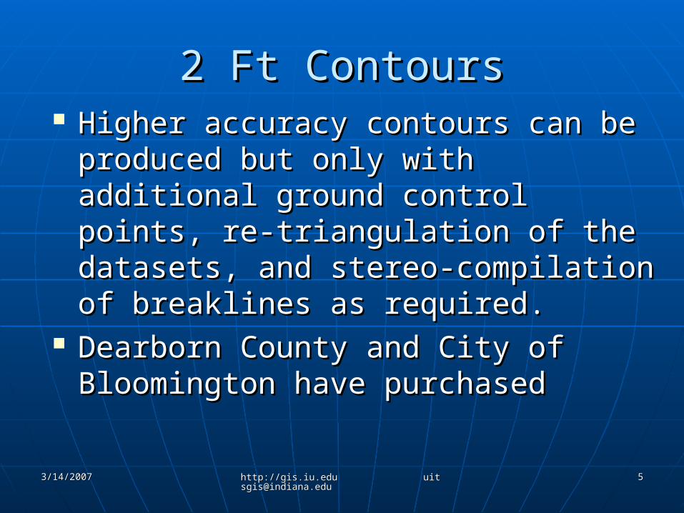
2 Ft Contours2 Ft Contours Higher accuracy contours can be Higher accuracy contours can be
produced but only with additional produced but only with additional ground control points, re-ground control points, re-triangulation of the datasets, and triangulation of the datasets, and stereo-compilation of breaklines as stereo-compilation of breaklines as required.required.
Dearborn County and City of Dearborn County and City of Bloomington have purchasedBloomington have purchased
3/14/20073/14/2007 http://gis.iu.edu [email protected]://gis.iu.edu [email protected]
66
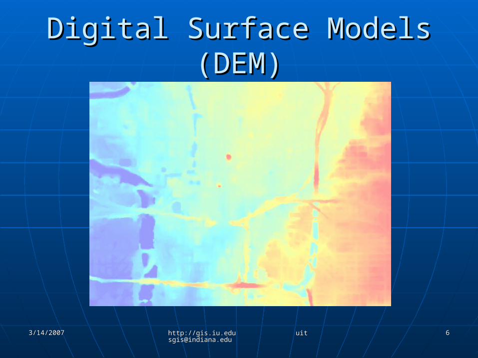
Digital Surface Models (DEM)Digital Surface Models (DEM)
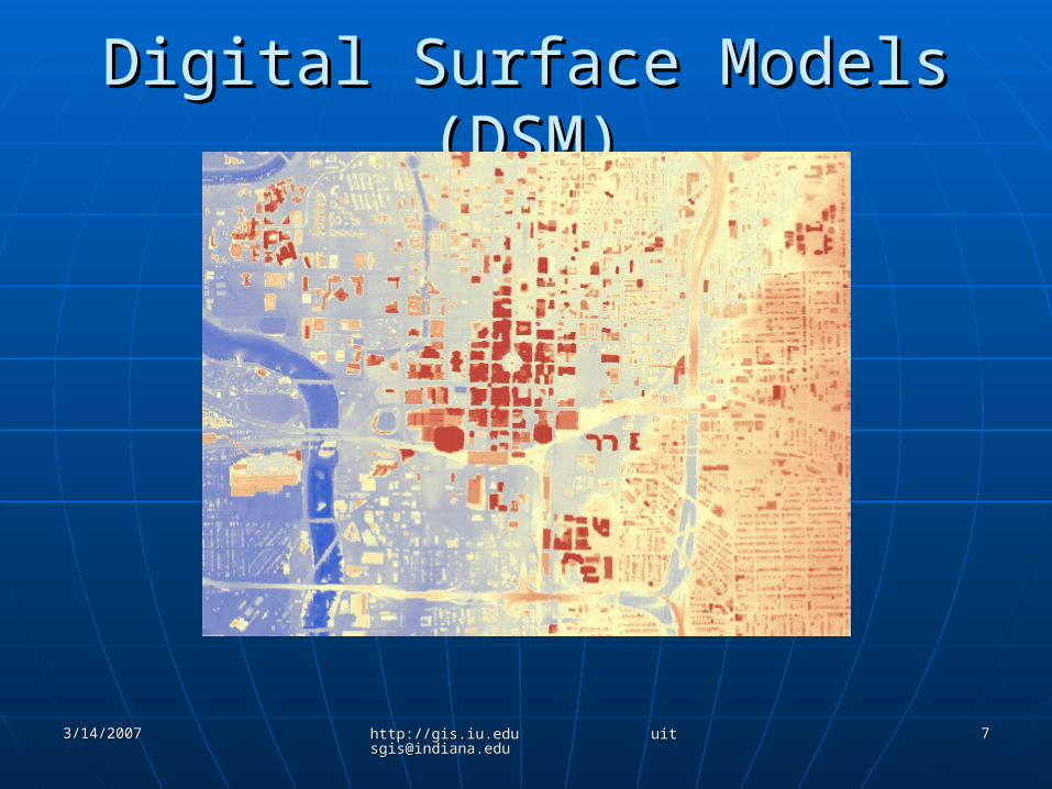
3/14/20073/14/2007 http://gis.iu.edu [email protected]://gis.iu.edu [email protected]
77
Digital Surface Models (DSM)Digital Surface Models (DSM)
3/14/20073/14/2007 http://gis.iu.edu [email protected]://gis.iu.edu [email protected]
88
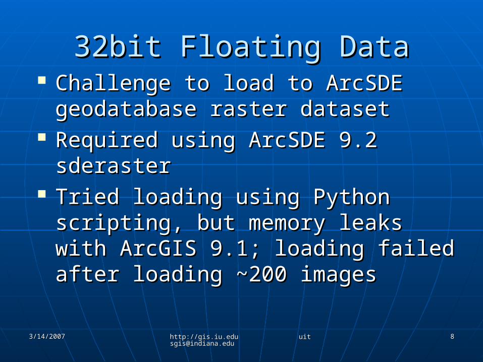
32bit Floating Data32bit Floating Data Challenge to load to ArcSDE Challenge to load to ArcSDE
geodatabase raster datasetgeodatabase raster dataset Required using ArcSDE 9.2 sderasterRequired using ArcSDE 9.2 sderaster Tried loading using Python scripting, Tried loading using Python scripting,
but memory leaks with ArcGIS 9.1; but memory leaks with ArcGIS 9.1; loading failed after loading ~200 loading failed after loading ~200 imagesimages
3/14/20073/14/2007 http://gis.iu.edu [email protected]://gis.iu.edu [email protected]
99
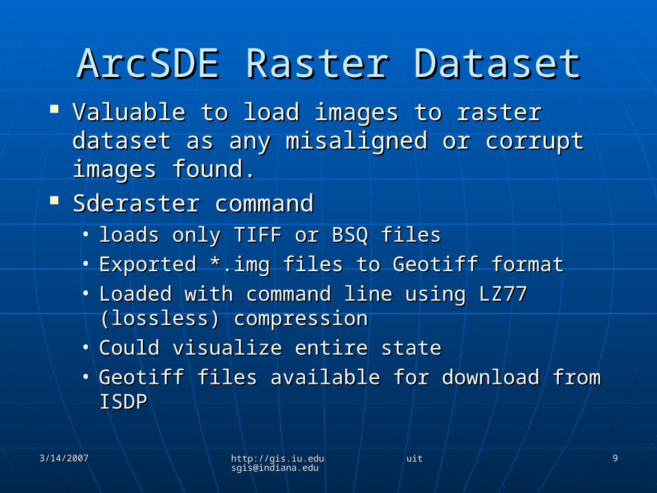
ArcSDE Raster DatasetArcSDE Raster Dataset Valuable to load images to raster dataset Valuable to load images to raster dataset
as any misaligned or corrupt images as any misaligned or corrupt images found.found.
Sderaster command Sderaster command • loads only TIFF or BSQ filesloads only TIFF or BSQ files• Exported *.img files to Geotiff formatExported *.img files to Geotiff format• Loaded with command line using LZ77 Loaded with command line using LZ77
(lossless) compression(lossless) compression• Could visualize entire state Could visualize entire state • Geotiff files available for download from ISDPGeotiff files available for download from ISDP
3/14/20073/14/2007 http://gis.iu.edu [email protected]://gis.iu.edu [email protected]
1010
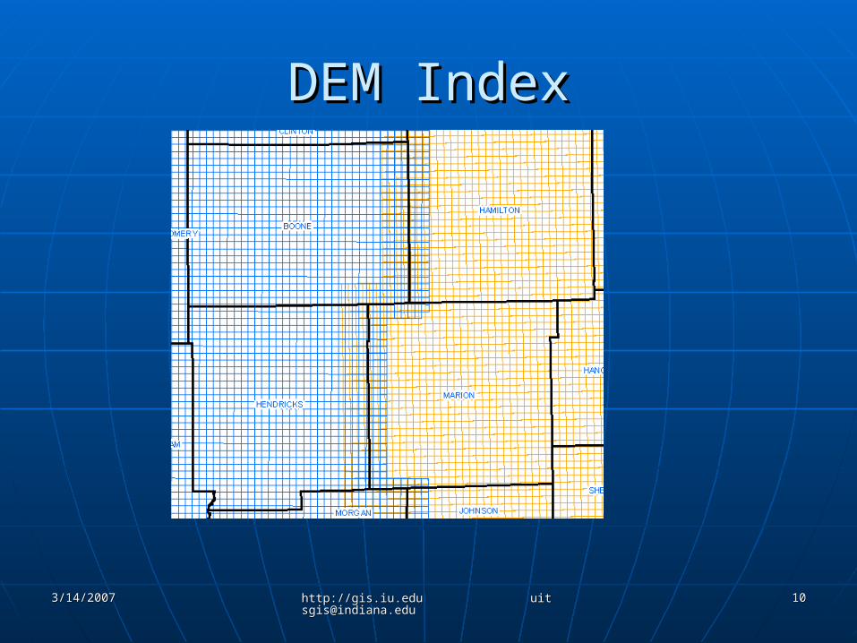
DEM IndexDEM Index
3/14/20073/14/2007 http://gis.iu.edu [email protected]://gis.iu.edu [email protected]
1111
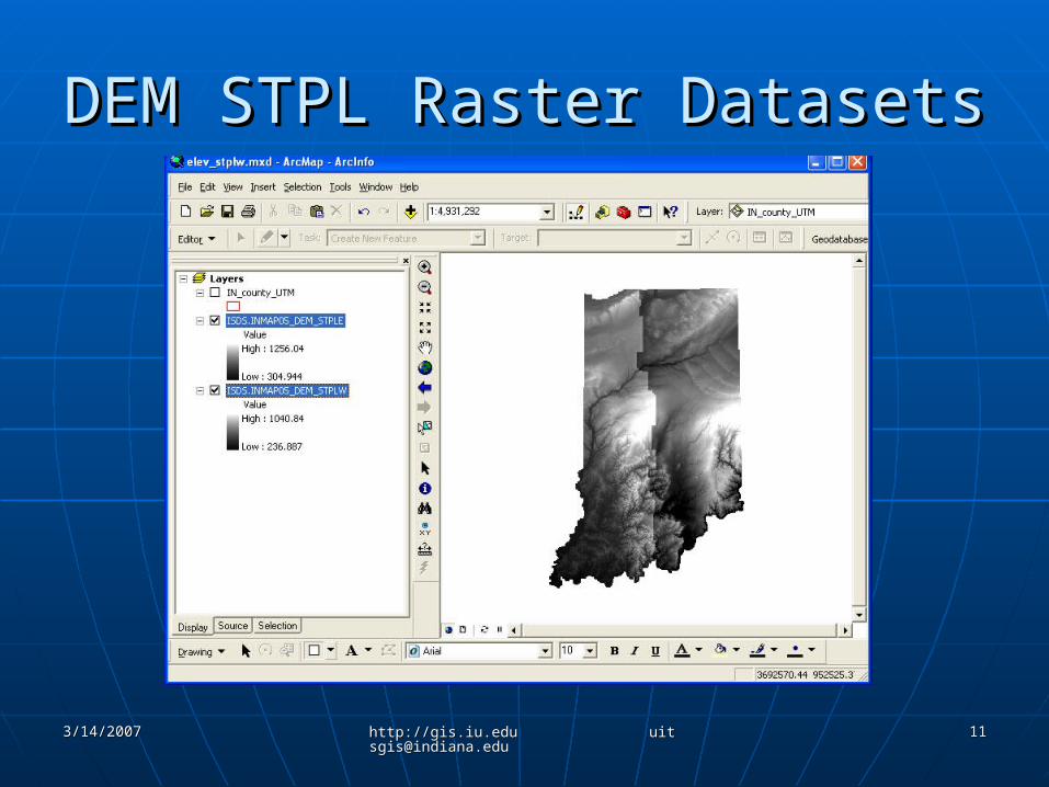
DEM STPL Raster DatasetsDEM STPL Raster Datasets
3/14/20073/14/2007 http://gis.iu.edu [email protected]://gis.iu.edu [email protected]
1212
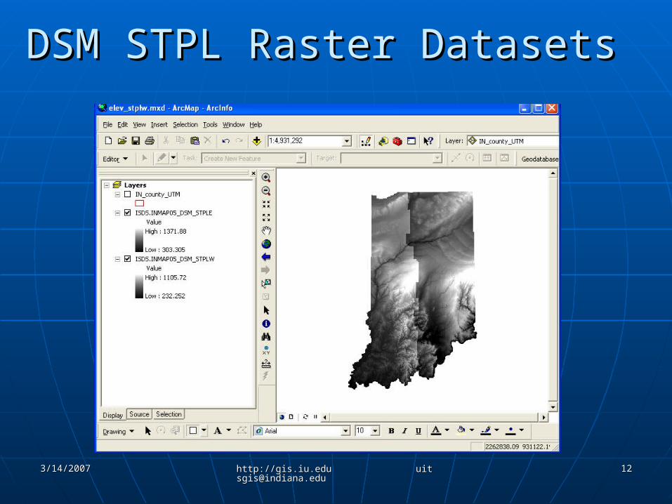
DSM STPL Raster DatasetsDSM STPL Raster Datasets
3/14/20073/14/2007 http://gis.iu.edu [email protected]://gis.iu.edu [email protected]
1313
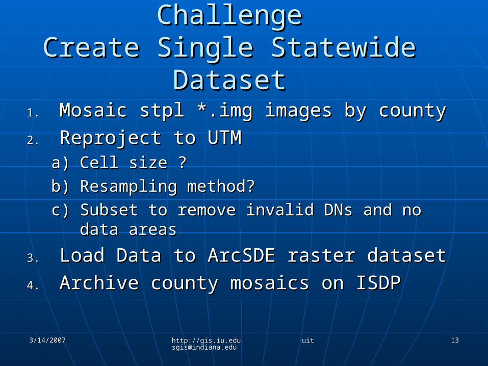
ChallengeChallengeCreate Single Statewide DatasetCreate Single Statewide Dataset
1.1. Mosaic stpl *.img images by countyMosaic stpl *.img images by county
2.2. Reproject to UTMReproject to UTMa)a) Cell size ?Cell size ?
b)b) Resampling method?Resampling method?
c)c) Subset to remove invalid DNs and no data Subset to remove invalid DNs and no data areasareas
3.3. Load Data to ArcSDE raster datasetLoad Data to ArcSDE raster dataset
4.4. Archive county mosaics on ISDPArchive county mosaics on ISDP
3/14/20073/14/2007 http://gis.iu.edu [email protected]://gis.iu.edu [email protected]
1414
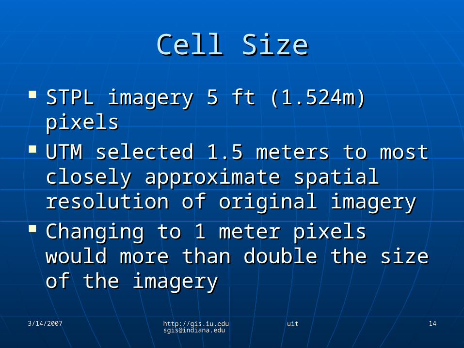
Cell SizeCell Size
STPL imagery 5 ft (1.524m) pixelsSTPL imagery 5 ft (1.524m) pixels UTM selected 1.5 meters to most UTM selected 1.5 meters to most
closely approximate spatial closely approximate spatial resolution of original imageryresolution of original imagery
Changing to 1 meter pixels would Changing to 1 meter pixels would more than double the size of the more than double the size of the imageryimagery
3/14/20073/14/2007 http://gis.iu.edu [email protected]://gis.iu.edu [email protected]
1515
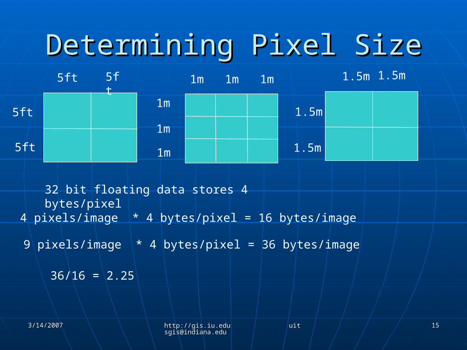
Determining Pixel SizeDetermining Pixel Size5ft 5ft
5ft
5ft
1m 1m 1m
1m
1m
1m
32 bit floating data stores 4 bytes/pixel
4 pixels/image * 4 bytes/pixel = 16 bytes/image
9 pixels/image * 4 bytes/pixel = 36 bytes/image
36/16 = 2.25
1.5m 1.5m
1.5m
1.5m
3/14/20073/14/2007 http://gis.iu.edu [email protected]://gis.iu.edu [email protected]
1616
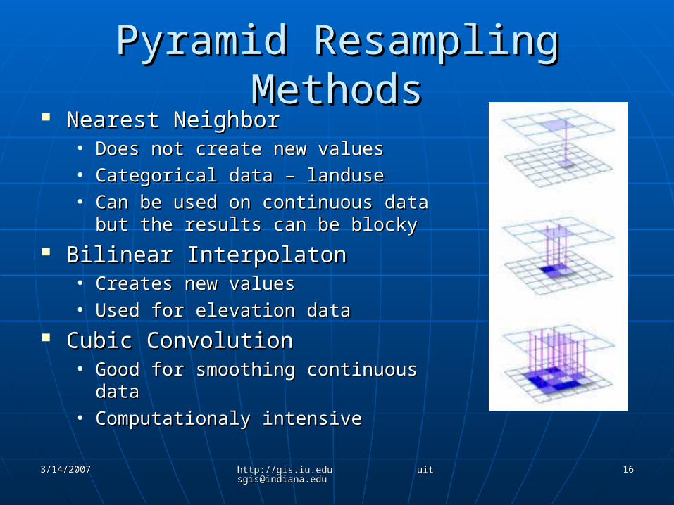
Pyramid Resampling MethodsPyramid Resampling Methods Nearest NeighborNearest Neighbor
• Does not create new valuesDoes not create new values• Categorical data – landuseCategorical data – landuse• Can be used on continuous data but Can be used on continuous data but
the results can be blockythe results can be blocky Bilinear InterpolatonBilinear Interpolaton
• Creates new valuesCreates new values• Used for elevation dataUsed for elevation data
Cubic ConvolutionCubic Convolution• Good for smoothing continuous dataGood for smoothing continuous data• Computationaly intensiveComputationaly intensive
3/14/20073/14/2007 http://gis.iu.edu [email protected]://gis.iu.edu [email protected]
1717
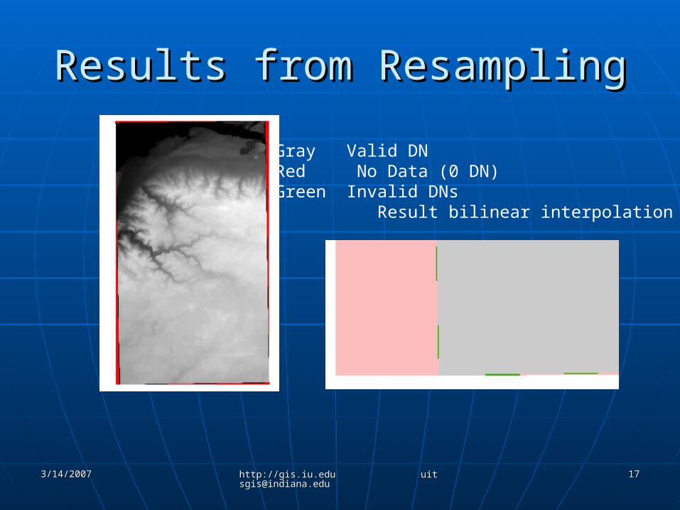
Results from ResamplingResults from Resampling
Gray Valid DNRed No Data (0 DN)Green Invalid DNs Result bilinear interpolation
3/14/20073/14/2007 http://gis.iu.edu [email protected]://gis.iu.edu [email protected]
1818
SubsettingSubsetting
Difficult for border counties, required Difficult for border counties, required multiple subsetsmultiple subsets
Important to subset to create images Important to subset to create images which align with raster dataset gridwhich align with raster dataset grid
Use coordinates for whole pixel Use coordinates for whole pixel valuesvalues
3/14/20073/14/2007 http://gis.iu.edu [email protected]://gis.iu.edu [email protected]
1919
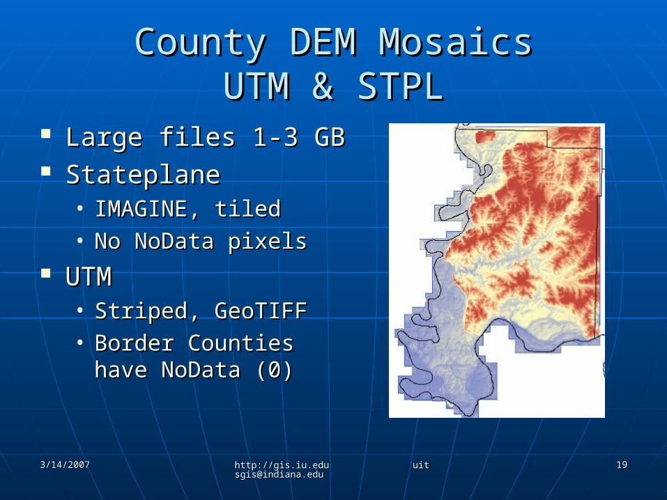
County DEM MosaicsCounty DEM MosaicsUTM & STPLUTM & STPL
Large files 1-3 GBLarge files 1-3 GB StateplaneStateplane
• IMAGINE, tiledIMAGINE, tiled• No NoData pixelsNo NoData pixels
UTMUTM• Striped, GeoTIFFStriped, GeoTIFF• Border Counties have Border Counties have
NoData (0)NoData (0)
3/14/20073/14/2007 http://gis.iu.edu [email protected]://gis.iu.edu [email protected]
2020
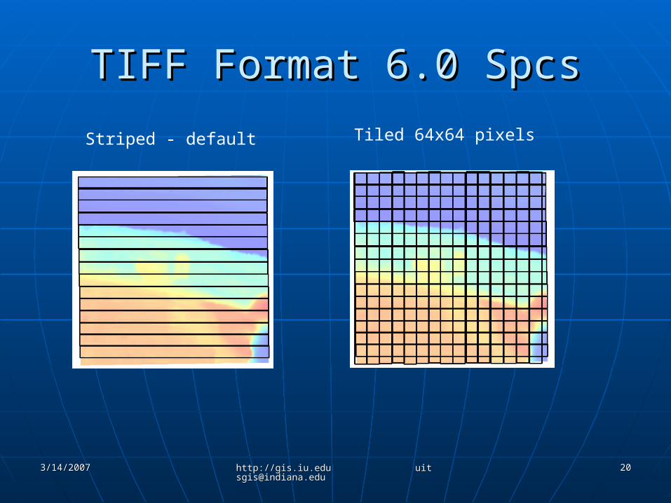
TIFF Format 6.0 SpcsTIFF Format 6.0 Spcs
Striped - default Tiled 64x64 pixels
3/14/20073/14/2007 http://gis.iu.edu [email protected]://gis.iu.edu [email protected]
2121
TIFF Tile FormatTIFF Tile Format
Image is broken in square tiles (64x64 pixel), each tile is Image is broken in square tiles (64x64 pixel), each tile is loaded separately into memory and can be accessed loaded separately into memory and can be accessed independently of other tiles independently of other tiles
All tiles in an image are the same size (4096 pixels/tile)All tiles in an image are the same size (4096 pixels/tile) Border tiles are padded to the tile boundariesBorder tiles are padded to the tile boundaries If image is 800 pixels wide, then the image is stored as 13 If image is 800 pixels wide, then the image is stored as 13
tiles wide - 32 pixels are added for padding to fill rightmost tiles wide - 32 pixels are added for padding to fill rightmost column of tiles 800/64 = 12.5 832/64 = 13column of tiles 800/64 = 12.5 832/64 = 13
Good viewers do not display pixels used for paddingGood viewers do not display pixels used for padding Method used by ERDAS IMAGINE for .img filesMethod used by ERDAS IMAGINE for .img files Good for high-resolution, large imagesGood for high-resolution, large images Applications can access imagery more efficientlyApplications can access imagery more efficiently Better compression with this formatBetter compression with this format ArcGIS 9.1 & 9.2 support, earlier versions do notArcGIS 9.1 & 9.2 support, earlier versions do not Other software may not support?Other software may not support?
3/14/20073/14/2007 http://gis.iu.edu [email protected]://gis.iu.edu [email protected]
2222
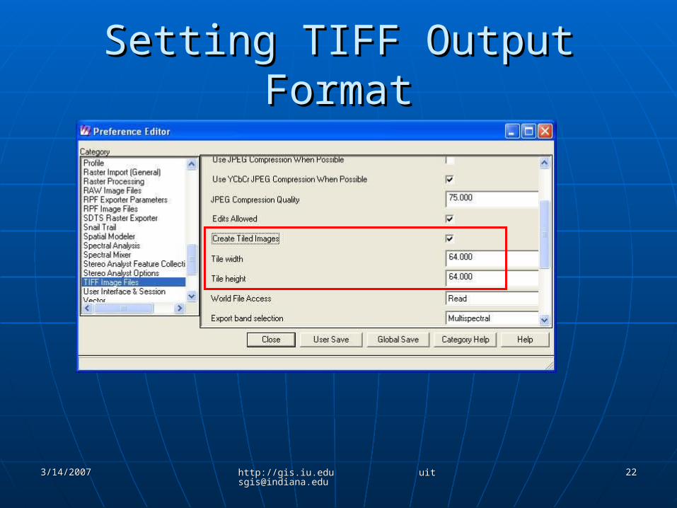
Setting TIFF Output FormatSetting TIFF Output Format
3/14/20073/14/2007 http://gis.iu.edu [email protected]://gis.iu.edu [email protected]
2323
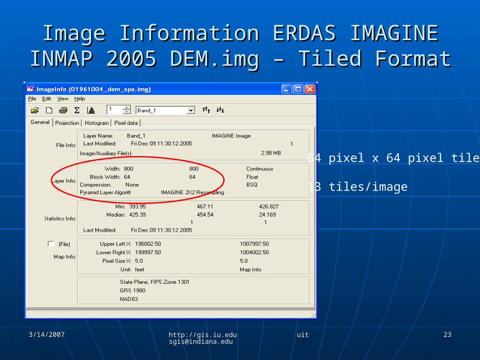
Image Information ERDAS IMAGINEImage Information ERDAS IMAGINEINMAP 2005 DEM.img – Tiled FormatINMAP 2005 DEM.img – Tiled Format
64 pixel x 64 pixel tiles
13 tiles/image
3/14/20073/14/2007 http://gis.iu.edu [email protected]://gis.iu.edu [email protected]
2424
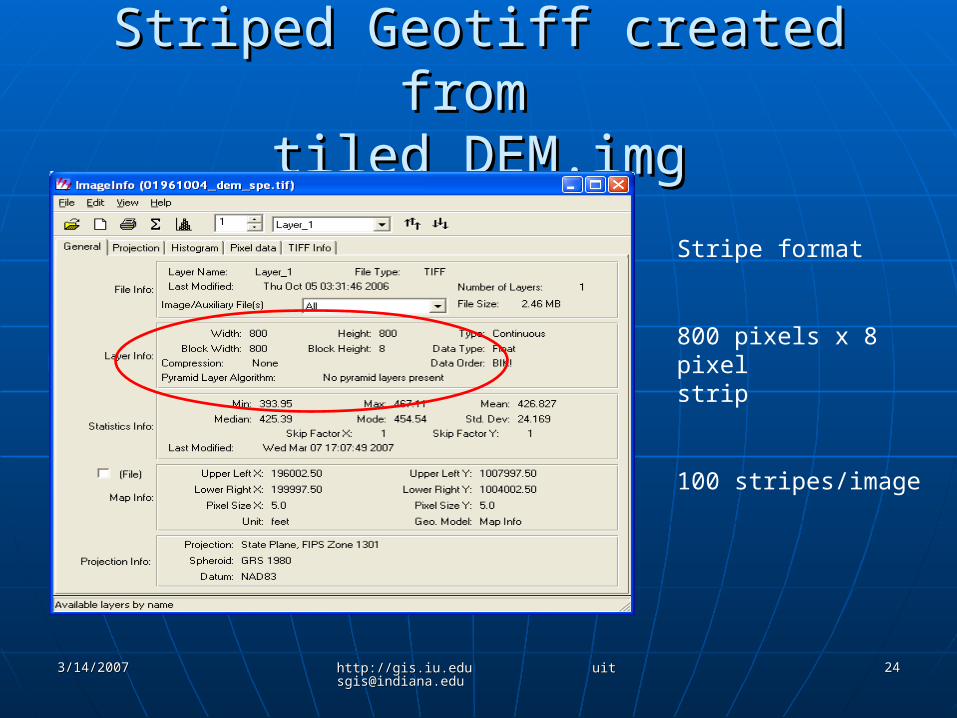
Striped Geotiff created from Striped Geotiff created from tiled DEM.imgtiled DEM.img
Stripe format
800 pixels x 8 pixelstrip
100 stripes/image
3/14/20073/14/2007 http://gis.iu.edu [email protected]://gis.iu.edu [email protected]
2525
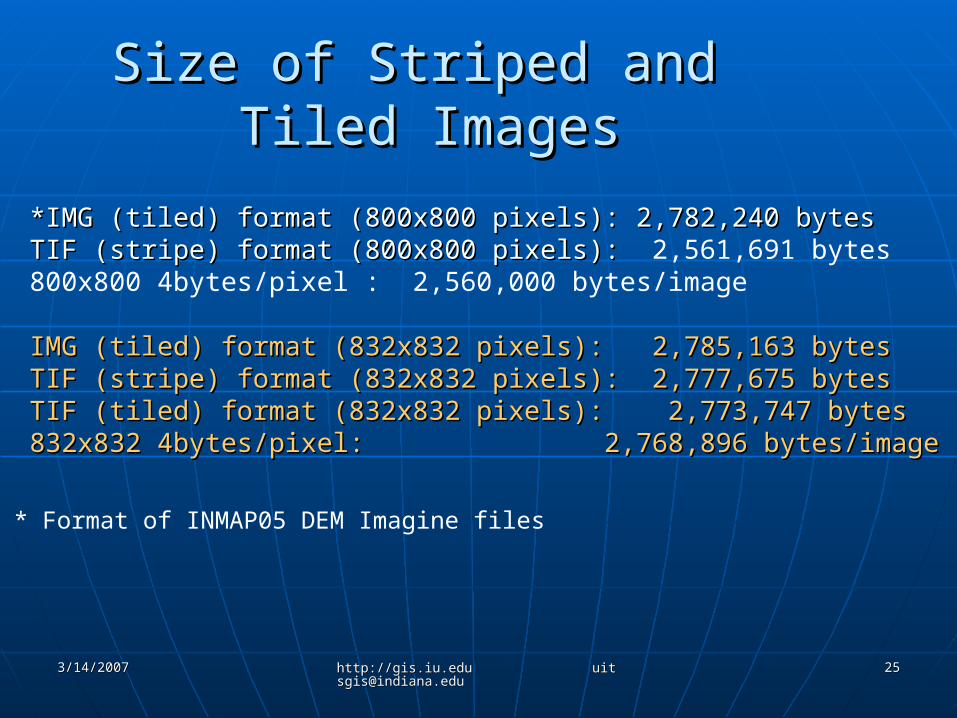
Size of Striped and Size of Striped and Tiled ImagesTiled Images
*IMG (tiled) format (800x800 pixels): 2,782,240 bytes*IMG (tiled) format (800x800 pixels): 2,782,240 bytesTIF (stripe) format (800x800 pixels): TIF (stripe) format (800x800 pixels): 2,561,691 bytes800x800 4bytes/pixel : 2,560,000 bytes/image
IMG (tiled) format (832x832 pixels): 2,785,163 bytesIMG (tiled) format (832x832 pixels): 2,785,163 bytesTIF (stripe) format (832x832 pixels): 2,777,675 bytesTIF (stripe) format (832x832 pixels): 2,777,675 bytesTIF (tiled) format (832x832 pixels): 2,773,747 bytesTIF (tiled) format (832x832 pixels): 2,773,747 bytes832x832 4bytes/pixel: 2,768,896 bytes/image832x832 4bytes/pixel: 2,768,896 bytes/image
* Format of INMAP05 DEM Imagine files
3/14/20073/14/2007 http://gis.iu.edu [email protected]://gis.iu.edu [email protected]
2626
TIFF Format - SummaryTIFF Format - Summary IMAGINE file format is tiledIMAGINE file format is tiled Default output TIFF format for ERDAS Default output TIFF format for ERDAS
IMAGINE is striped unless preferences IMAGINE is striped unless preferences changedchanged
Tiled image has padding if rows and Tiled image has padding if rows and columns not divisible by 64 – increases columns not divisible by 64 – increases image size without adding informationimage size without adding information
Tiled Tiff – compresses better with Winzip Tiled Tiff – compresses better with Winzip than striped imagethan striped image• Clark County DEM Clark County DEM
Striped: 2.007 GBStriped: 2.007 GB Tiled: 1.759 GBTiled: 1.759 GB

3/14/20073/14/2007 http://gis.iu.edu [email protected]://gis.iu.edu [email protected]
2727
AcknowledgementsAcknowledgements
ArcSDE/Oracle ConsultantArcSDE/Oracle ConsultantMannion Geosystems, LLCMannion Geosystems, LLC
Data Management Support, UITSData Management Support, UITS• Michael Halla, ManagerMichael Halla, Manager• Stephanie SniderStephanie Snider
Research and Technical Services, UITSResearch and Technical Services, UITS Digital Storage Services Group, UITSDigital Storage Services Group, UITS