Embed Size (px)
Citation preview
1
Lewes District Local Plan - Part 1
Inspector’s Report - Appendix
Main Modifications
2
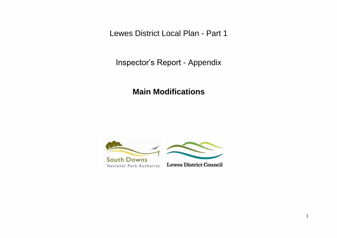
Main Modification Reference Number
Joint Core Strategy
Submission Document Reference /
Location
Proposed Change
MM01 Section 6 (Spatial Strategy) Spatial Policy 1, p.41
Amend Spatial Policy 1 by deleting the first sentence and replacing it with new text to read: In the period between 2010 and 2030, a minimum of 6,900 net additional dwellings will be provided in the plan area (this is the equivalent of approximately 345 net additional dwellings per annum).
MM02 Section 6 (Spatial Strategy) Spatial Policy 2, p.45
Amend Spatial Policy 2 as follows: Spatial Policy 2 – Distribution of Housing During the period between 2010 and 2030, a minimum of 6,900 net additional dwellings will be delivered in the district. Part of this total will be met as follows;
1,020 completions in the period between April 2010 and April 2015
The delivery of 1,558 commitments across the plan area.
An allowance for 600 dwellings to be permitted on unidentified small-scale windfall sites during the plan period and subsequently delivered.
An allowance for 125 dwellings to be permitted on rural exception sites during the plan period and subsequently delivered
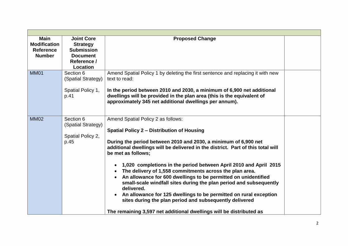
The remaining 3,597 net additional dwellings will be distributed as
3
follows: (1) Housing to be delivered on the following strategic site allocations;
o Land at North Street, Lewes – 415 net additional units. o Land at Old Malling Farm, Lewes – 240 net additional units o Land to the north of Bishops Lane, Ringmer – 110 net
additional units. o Land at Greenhill Way, Haywards Heath (within Wivelsfield
Parish) – 113 net additional units (this is in addition to the 62 units already granted permission at this site).
o Land at Harbour Heights, Newhaven – 400 net additional units.
o Land at Lower Hoddern Farm, Peacehaven – 450 net additional units.
(2) Planned housing growth at the following settlements; o Lewes – a minimum of 220 net additional units o Newhaven – a minimum of 425 net additional units o Peacehaven & Telscombe – a minimum of 255 net additional
units which will all be contingent upon developers identifying and demonstrating to the satisfaction of the local highway authority, and delivering, a co-ordinated package of multi-modal transport measures required to mitigate the impacts of development on the A259.
o Seaford – a minimum of 185 net additional units o Burgess Hill (within Wivelsfield Parish) – a minimum of 100
net additional units o Barcombe Cross – a minimum of 30 net additional units o North Chailey – a minimum of 30 net additional units o South Chailey – a minimum of 10 net additional units o Cooksbridge – a minimum of 30 net additional units o Ditchling – a minimum of 15 net additional units o Newick – a minimum of 100 net additional units
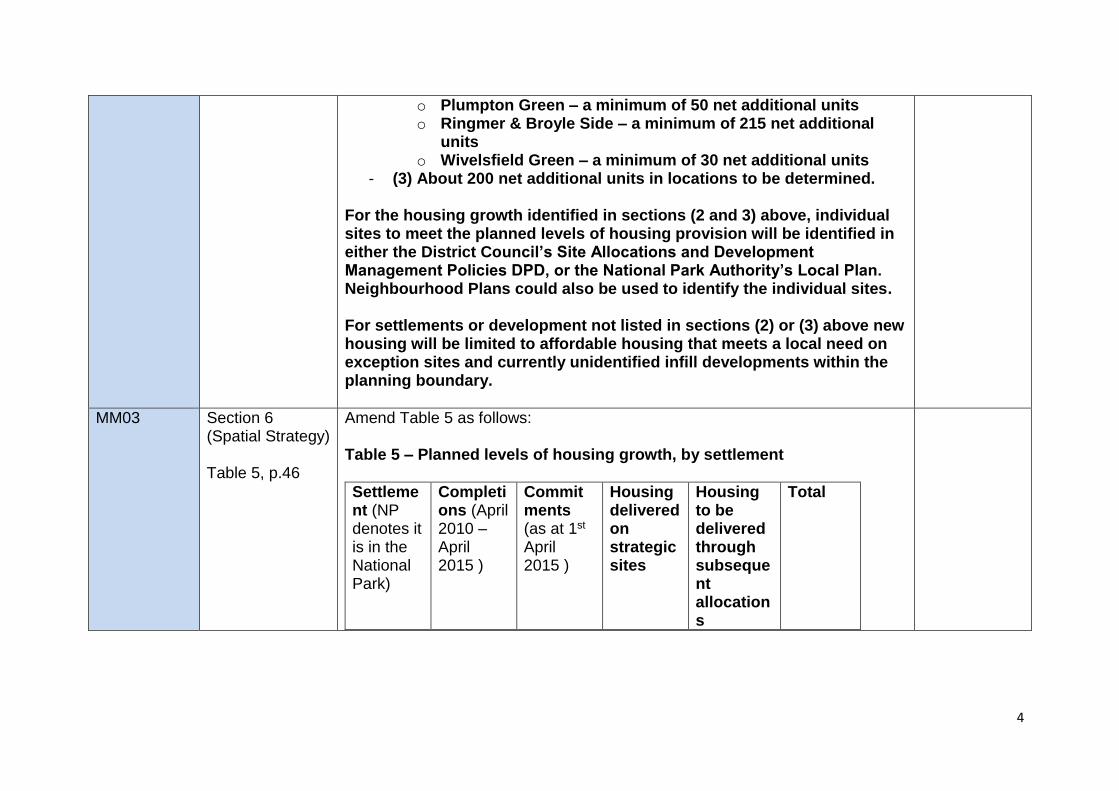
4
o Plumpton Green – a minimum of 50 net additional units o Ringmer & Broyle Side – a minimum of 215 net additional
units o Wivelsfield Green – a minimum of 30 net additional units
- (3) About 200 net additional units in locations to be determined. For the housing growth identified in sections (2 and 3) above, individual sites to meet the planned levels of housing provision will be identified in either the District Council’s Site Allocations and Development Management Policies DPD, or the National Park Authority’s Local Plan. Neighbourhood Plans could also be used to identify the individual sites. For settlements or development not listed in sections (2) or (3) above new housing will be limited to affordable housing that meets a local need on exception sites and currently unidentified infill developments within the planning boundary.
MM03 Section 6 (Spatial Strategy) Table 5, p.46
Amend Table 5 as follows: Table 5 – Planned levels of housing growth, by settlement
Settlement (NP denotes it is in the National Park)
Completions (April 2010 – April 2015 )
Commitments (as at 1st April 2015 )
Housing delivered on strategic sites
Housing to be delivered through subsequent allocations
Total
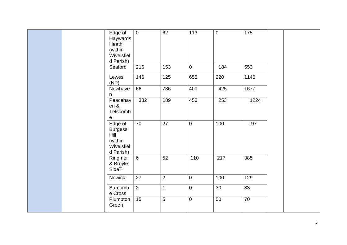
5
Edge of Haywards Heath (within Wivelsfield Parish)
0 62 113 0 175
Seaford 216 153 0 184 553
Lewes (NP)
146 125 655 220 1146
Newhaven
66 786 400 425 1677
Peacehaven & Telscombe
332 189 450 253 1224
Edge of Burgess Hill (within Wivelsfield Parish)
70 27 0 100 197
Ringmer & Broyle Side21
6 52 110 217 385
Newick 27 2 0 100 129
Barcombe Cross
2 1 0 30 33
Plumpton Green
15 5 0 50 70
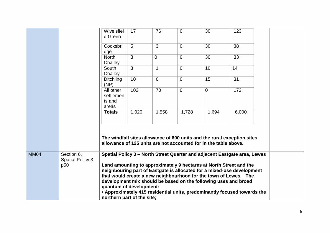
6
Wivelsfield Green
17 76 0 30 123
Cooksbridge
5 3 0 30 38
North Chailey
3 0 0 30 33
South Chailey
3 1 0 10 14
Ditchling (NP)
10 6 0 15 31
All other settlements and areas
102 70 0 0 172
Totals 1,020 1,558 1,728 1,694 6,000
The windfall sites allowance of 600 units and the rural exception sites allowance of 125 units are not accounted for in the table above.
MM04 Section 6, Spatial Policy 3 p50
Spatial Policy 3 – North Street Quarter and adjacent Eastgate area, Lewes Land amounting to approximately 9 hectares at North Street and the neighbouring part of Eastgate is allocated for a mixed-use development that would create a new neighbourhood for the town of Lewes. The development mix should be based on the following uses and broad quantum of development: • Approximately 415 residential units, predominantly focused towards the northern part of the site;
7
• At least 5,000 sq metres of B1a office floorspace and/or B1c light industrial floorspace, subject to market needs and general viability; • The redevelopment or relocation of the existing A1 food supermarket; • Other uses that are deemed to aid in the successful delivery of a new neighbourhood, whilst not undermining the wider function of the town (this could include A1 Shops, A2 Financial and Professional Services, A3 Restaurants and Cafes, A4 Drinking Establishments, A5 Hot Food Takeaways, C1 hotel, D2 Assembly and Leisure uses and community floorspace).
C2/C3 Nursing/ Care Home (self-contained units will be counted as residential within the above figure)
• D1 Non-residential institutions such as medical and health services, creches, exhibition and training space. Development of this site will be delivered between 2016 and 2021. The redevelopment of the North Street Quarter and the neighbouring part of Eastgate will be permitted subject to compliance with the Core Delivery Policies of this plan and the following criteria:
i) It incorporates the early provision of flood defences to an appropriate standard as advised by the Environment Agency;
ii) It facilitates improved linkages across Phoenix Causeway and Eastgate Street to enable the improved integration of the area to the north of Phoenix Causeway with the wider town centre;
iii) It delivers enhancements to vehicular access and off-site highway improvements, arising from and related to the development and its phasing;
iv) It respects and enhances the character of the town and achieves a high standard of design, recognising the high quality built environment, on and within the vicinity of the site, and the site’s setting within the South Downs National Park and adjacent to a Conservation Area;
8
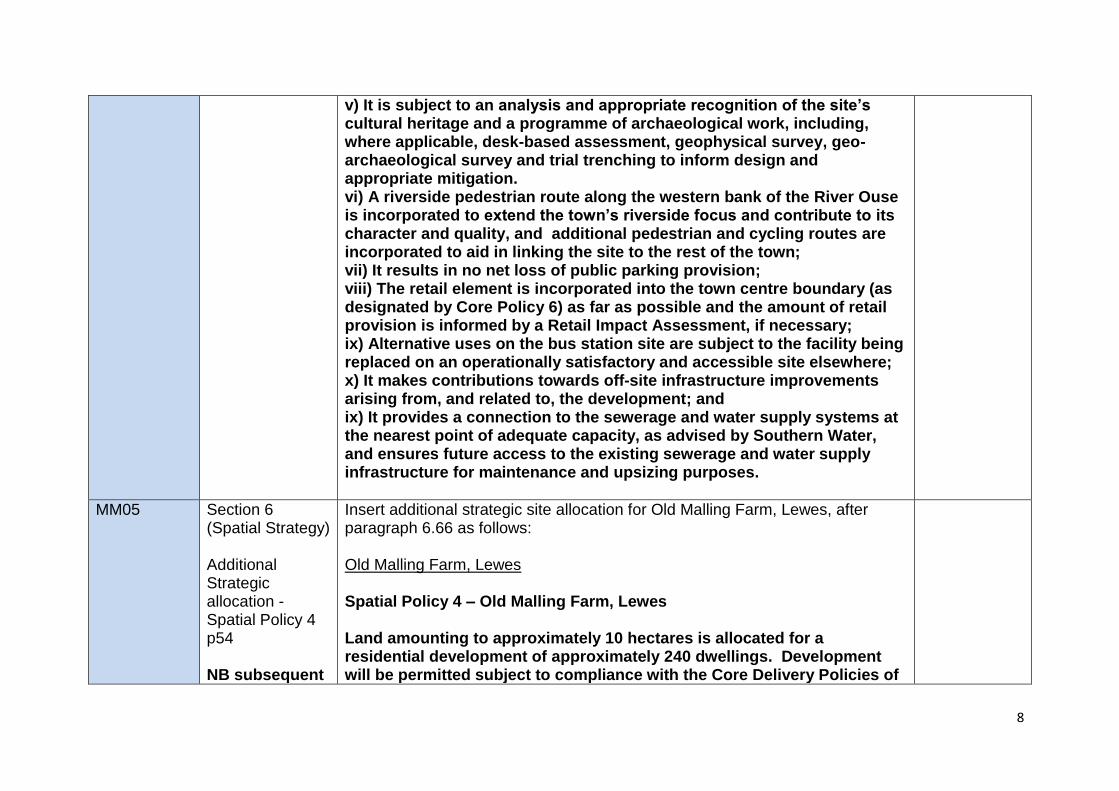
v) It is subject to an analysis and appropriate recognition of the site’s cultural heritage and a programme of archaeological work, including, where applicable, desk-based assessment, geophysical survey, geo-archaeological survey and trial trenching to inform design and appropriate mitigation. vi) A riverside pedestrian route along the western bank of the River Ouse is incorporated to extend the town’s riverside focus and contribute to its character and quality, and additional pedestrian and cycling routes are incorporated to aid in linking the site to the rest of the town; vii) It results in no net loss of public parking provision; viii) The retail element is incorporated into the town centre boundary (as designated by Core Policy 6) as far as possible and the amount of retail provision is informed by a Retail Impact Assessment, if necessary; ix) Alternative uses on the bus station site are subject to the facility being replaced on an operationally satisfactory and accessible site elsewhere; x) It makes contributions towards off-site infrastructure improvements arising from, and related to, the development; and ix) It provides a connection to the sewerage and water supply systems at the nearest point of adequate capacity, as advised by Southern Water, and ensures future access to the existing sewerage and water supply infrastructure for maintenance and upsizing purposes.
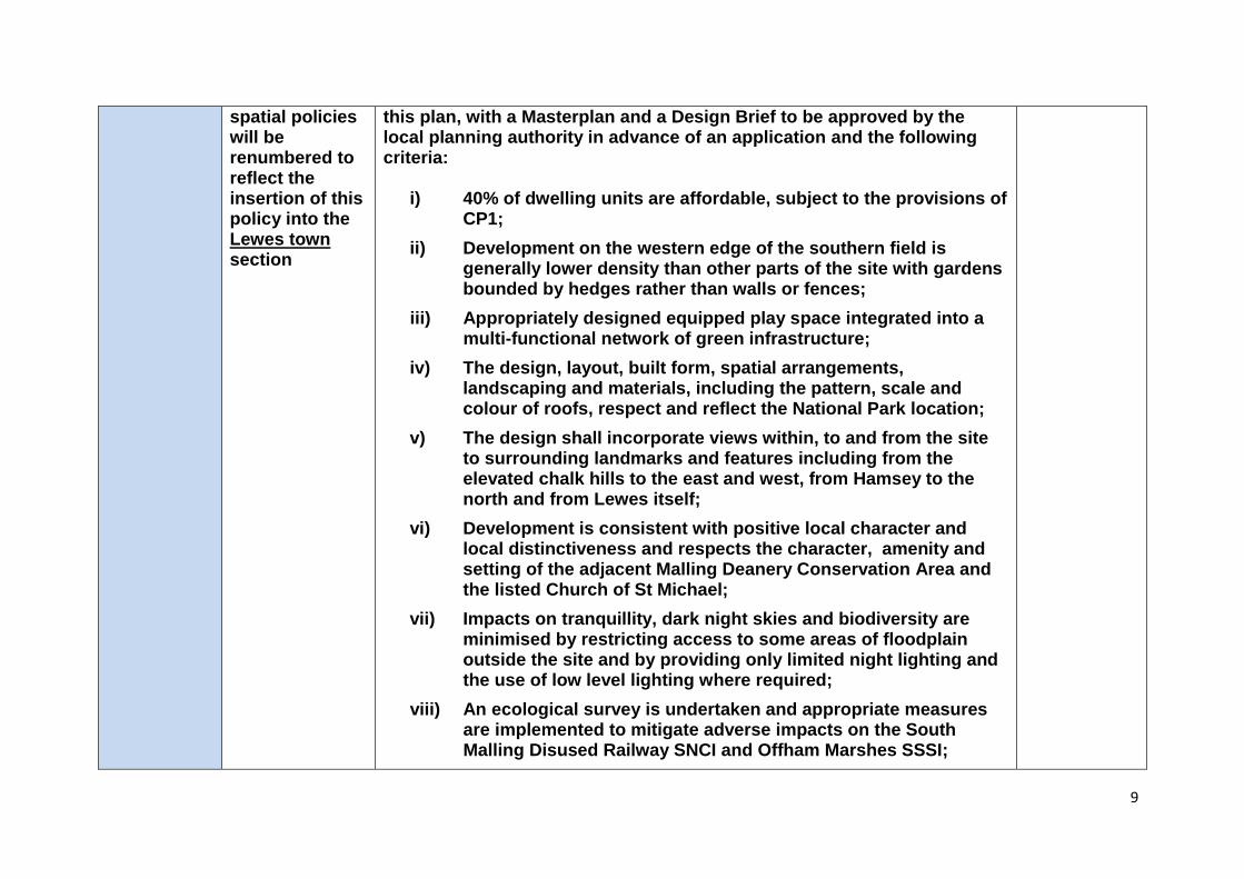
MM05 Section 6 (Spatial Strategy) Additional Strategic allocation - Spatial Policy 4 p54 NB subsequent
Insert additional strategic site allocation for Old Malling Farm, Lewes, after paragraph 6.66 as follows: Old Malling Farm, Lewes Spatial Policy 4 – Old Malling Farm, Lewes Land amounting to approximately 10 hectares is allocated for a residential development of approximately 240 dwellings. Development will be permitted subject to compliance with the Core Delivery Policies of
9
spatial policies will be renumbered to reflect the insertion of this policy into the Lewes town section
this plan, with a Masterplan and a Design Brief to be approved by the local planning authority in advance of an application and the following criteria:
i) 40% of dwelling units are affordable, subject to the provisions of CP1;
ii) Development on the western edge of the southern field is generally lower density than other parts of the site with gardens bounded by hedges rather than walls or fences;
iii) Appropriately designed equipped play space integrated into a multi-functional network of green infrastructure;
iv) The design, layout, built form, spatial arrangements, landscaping and materials, including the pattern, scale and colour of roofs, respect and reflect the National Park location;
v) The design shall incorporate views within, to and from the site to surrounding landmarks and features including from the elevated chalk hills to the east and west, from Hamsey to the north and from Lewes itself;
vi) Development is consistent with positive local character and local distinctiveness and respects the character, amenity and setting of the adjacent Malling Deanery Conservation Area and the listed Church of St Michael;
vii) Impacts on tranquillity, dark night skies and biodiversity are minimised by restricting access to some areas of floodplain outside the site and by providing only limited night lighting and the use of low level lighting where required;
viii) An ecological survey is undertaken and appropriate measures are implemented to mitigate adverse impacts on the South Malling Disused Railway SNCI and Offham Marshes SSSI;
10
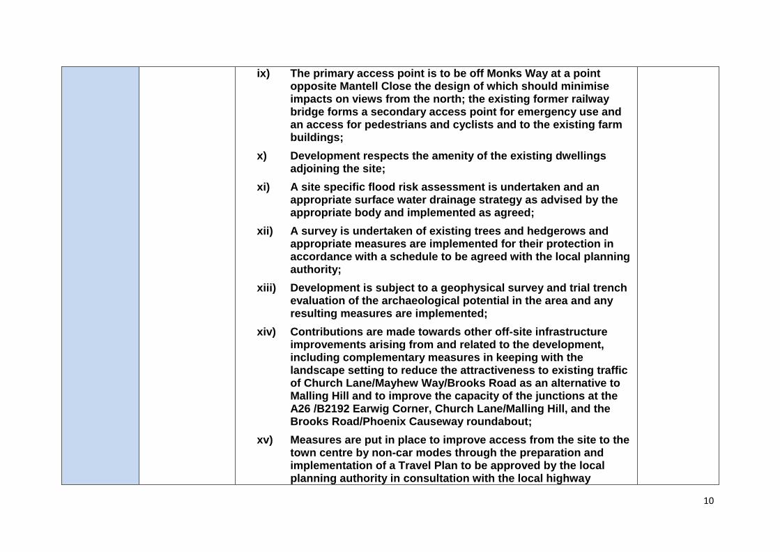
ix) The primary access point is to be off Monks Way at a point opposite Mantell Close the design of which should minimise impacts on views from the north; the existing former railway bridge forms a secondary access point for emergency use and an access for pedestrians and cyclists and to the existing farm buildings;
x) Development respects the amenity of the existing dwellings adjoining the site;
xi) A site specific flood risk assessment is undertaken and an appropriate surface water drainage strategy as advised by the appropriate body and implemented as agreed;
xii) A survey is undertaken of existing trees and hedgerows and appropriate measures are implemented for their protection in accordance with a schedule to be agreed with the local planning authority;
xiii) Development is subject to a geophysical survey and trial trench evaluation of the archaeological potential in the area and any resulting measures are implemented;
xiv) Contributions are made towards other off-site infrastructure improvements arising from and related to the development, including complementary measures in keeping with the landscape setting to reduce the attractiveness to existing traffic of Church Lane/Mayhew Way/Brooks Road as an alternative to Malling Hill and to improve the capacity of the junctions at the A26 /B2192 Earwig Corner, Church Lane/Malling Hill, and the Brooks Road/Phoenix Causeway roundabout;
xv) Measures are put in place to improve access from the site to the town centre by non-car modes through the preparation and implementation of a Travel Plan to be approved by the local planning authority in consultation with the local highway
11
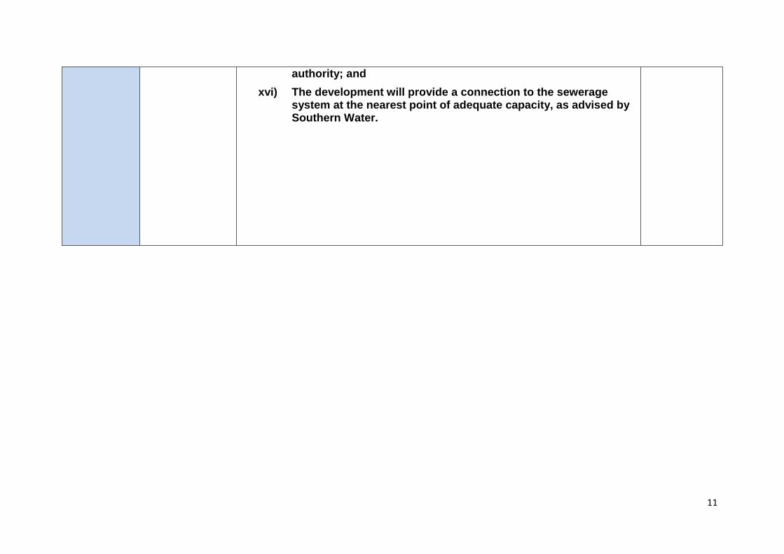
authority; and
xvi) The development will provide a connection to the sewerage system at the nearest point of adequate capacity, as advised by Southern Water.
12
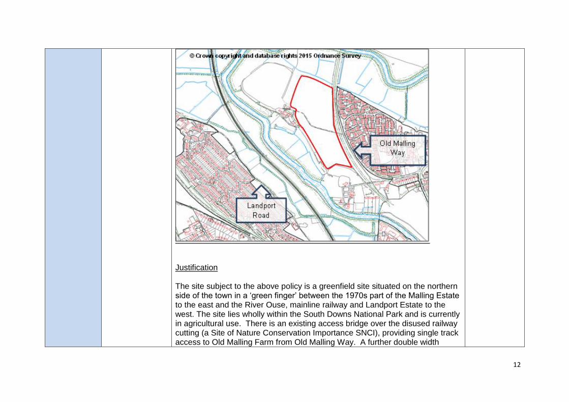
Justification The site subject to the above policy is a greenfield site situated on the northern side of the town in a ‘green finger’ between the 1970s part of the Malling Estate to the east and the River Ouse, mainline railway and Landport Estate to the west. The site lies wholly within the South Downs National Park and is currently in agricultural use. There is an existing access bridge over the disused railway cutting (a Site of Nature Conservation Importance SNCI), providing single track access to Old Malling Farm from Old Malling Way. A further double width
13
access point onto Monks Way, which is at grade and currently used for agricultural vehicles, is situated at the northern end of the site. Monks Way would form the principal access to the site, with the railway bridge providing secondary access for pedestrians, cyclists and emergency use, as well as access to the former farm buildings. To the south of the site lies the Malling Deanery Conservation Area, including the Grade II* St Michaels Church. Much of the site is Agricultural Land Classification Grade 2, with some Sub-grade 3a, and therefore constitutes best and most versatile agricultural land. There is also ecological interest in the area, including the Offham Marshes SSSI on the opposite side of the River Ouse and the SNCI along the adjacent disused railway cutting on the east of the site. The site also lies within an area of high archaeological potential being in the vicinity of a medieval settlement and the ruins of a college of Benedictine Canons. While current information would suggest that these interests do not override the principle of development on the site, further survey work will be required and appropriate mitigation measures implemented. The loss of best and most versatile land is to be avoided where possible. However in this case the few alternative options for strategic level residential development around Lewes town have been ruled out for other reasons, such as being of even greater great landscape sensitivity within the National Park. Development of the site could adversely impact the Special Qualities of the National Park, for instance on landscape and views, on recreational activities (the Ouse Valley Way), on tranquillity (including dark night skies), on historical features and cultural heritage (including the Conservation Area, Listed Building and archaeological remains), and on nearby wildlife and habitats. Nevertheless a sensitively designed scheme could be accommodated at Old Malling Farm, which takes into account the range of significant constraints and impacts on the SDNP and its Special Qualities and incorporates an appropriate range of mitigation measures.
14
Landscape mitigation measures should address the following sensitivities (as identified by the SDNPA’s landscape consultant1):
• Views from the site to local landmark features including chalk hills, church towers and Lewes Castle give this site a strong sense of place.
• The rural, tranquil and natural character of the Ouse Valley with no development apparent on its eastern banks, save for historic settlement associated with Old Malling Farm and Lewes Malling Deanery.
• The visually sensitive western edge of the site above the Ouse Valley floor where development would intrude into the valley.
• The site is seen in the context of the wider Ouse Valley floodplain when viewed from elevated locations to the east and west.
• From elevated locations to the west the site visually separates the historic settlement of Old Malling Farm and Lewes Malling Deanery.
• From elevated locations to the east the northern field of the site is visually prominent and is seen as part of the wider Ouse Valley corridor.
• The Ouse corridor to the north of Lewes was included in the South Downs National Park as providing a high quality setting to Lewes town for reasons of its intrinsic scenic attraction, cultural heritage and nature conservation.
Various measures were suggested to address these, including development on parts of the site only and at a lower density, and pulling development back and away from the western, southern and northern parts of the site. Other suggestions include: providing only limited night lighting on the site and the use of low level lighting where required, ensuring the use of dark colours for roofs,
1 Landscape and Visual Assessment: Old Malling Farm, Lewes, Allison Farmer Associates, May 2012
15
retaining views out of the site to surrounding landmarks, retaining some areas of floodplain with no access, and ensuring that any improved access to the floodplain does not unduly extend urbanising influences, including that signage and surfaces, gates and fencing are low key.
These various measures will be reviewed and considered for inclusion in a Design Brief be undertaken for the site either by the SDNPA or by the applicant and subject to the SDNPA’s approval. This will be informed by a detailed site appraisal, which shall include as 3D computer modelling of the site and its context; appropriate Verified Photomontages; and Zone of Theoretical Visibility plots from appropriate locations within the site. Transport evidence shows that significant development of this site should be contingent on highway improvement works at the Earwig corner junction of the A26 with the B2192 on the edge of the town to the east of the site. This is a junction that already experiences congestion, particularly at peak times, and therefore the further strain from new development (including from other development in Lewes town and at Ringmer) will need to be mitigated. Development consistent with this policy, as well as other development in the area will enable this mitigation to occur, possibly through a traffic light system to improve the flow of traffic through the junction. In addition, mitigation measures associated with the impact of development at Old Malling Farm will be required at the critical junction of Church Lane/Malling Hill and at the Brooks Road/Phoenix Causeway roundabout, in agreement with the local highway authority. Traffic calming measures are also required to reduce the amount of existing traffic using the access roads to the site so that they can accommodate the additional traffic movements that will be generated by the development. Contributions to infrastructure, including green infrastructure and equipped play
16
space, will be sought initially through a Section 106 agreement and would be specified further as part of that agreement. However, depending on the date of permission being granted, some of these contributions would be made through the Community Infrastructure Levy, once introduced. Core Policy 1 seeks to achieve a district-wide target of 40% affordable housing. This district-wide target is supported by robust viability evidence, as well as evidence of a significant need for affordable housing. As evidenced through the District Council’s Housing Needs Register, this need is particularly high in Lewes town, which has a particular shortage of affordable housing provision. Due to the high number of affordable houses that will be delivered on this site it will be important to consider the mix of these houses, particularly in terms of type and tenure. With this being the case, the National Park Authority and District Council (as the Housing Authority) may seek/accept a tenure split for the affordable housing that delivers a greater proportion of intermediate housing than the 25% guideline in Core Policy 1.
MM06 Section 6 (Spatial Strategy) Spatial Policy 5 paragraphs 6.80 – 6.83 p58-59
6.80 Through the evidence collected for the Core Strategy, a case can be made for the delivery of a strategic housing allocation at Ringmer during the early part of the plan period. The identification of such an allocation will help maintain a sufficient supply of deliverable housing sites during this period and up until the point further allocations are made in subsequent plans.
MM07
Section 6 (Spatial Strategy) Spatial Policy 5, p.55
Amend the first sentence of Spatial Policy 4: Land amounting to 8.5 hectares is allocated for residential development of approximately 175 dwellings (of which 62 net units already have planning permission on this strategic site). Development will be
17
permitted subject to compliance with the Core Delivery Policies of this plan and the following criteria:
MM08
Section 6 (Spatial Strategy) Spatial Policy 5, criterion(i), p.55
Replace the words ‘Primary and secondary accesses’ with ‘Access’ and add the word ‘/or’ to read:
i) Access including provision for pedestrians and cyclists to be provided from Ridge Way and/or Greenhill Way;
MM09
Section 6 (Spatial Strategy) Spatial Policy 5: New criterion (viii) p.55
Add new criterion (viii) to read as follows: The development will provide a connection to the sewerage and water supply systems at the nearest point of adequate capacity, as advised by Southern Water, and ensure future access to the existing sewerage and water supply infrastructure for maintenance and upsizing purposes.
MM10 Section 6 (Spatial Strategy) Spatial Policy 6 p59 Additional criterion iii)
Insert additional criterion after existing criterion ii) and renumber subsequent criteria accordingly: iii) The development will wherever possible allow for the retention and enhancement of important existing hedgerows. Mitigation will be required in the event that the removal of a hedgerow, or parts, is needed to facilitate development.
MM11 Section 6 (Spatial Strategy) Spatial Policy 6 p59
Amend criterion vii) to remove reference to the cycle route as follows: vii) Contributions towards off-site infrastructure improvements arising from and related to the development. This will include off-site highway improvements being made to the Earwig Corner junction as well as in the immediate vicinity of the site, particularly along Bishops Lane and its junction with the B2192; and
MM12
Section 6 (Spatial Strategy)
Add new criterion (ix) to read as follows:
18
Spatial Policy 6: New criterion (ix) p.59
The development will provide a connection to the sewerage system at the nearest point of adequate capacity, as advised by Southern Water. Delete final sentence.
MM13 Section 6 (Spatial Strategy) Spatial Policy 7 paragraphs 6.90 – 6.101 p61-65
Delete paragraphs 6.90 to 6.101 and SP6 policy wording. Replace with new text and policy wording relating to a full allocation: Newhaven 6.90 Newhaven is the smallest of the four towns in the district (parish
population: 12,232), despite being located in a strategically important position on the south coast at the mouth of the River Ouse. Newhaven is a port town which still has an active industrial and commercial river frontage. This includes a harbour with a cross-channel ferry service to Dieppe.
6.91 Regeneration of the district’s coastal towns is a key objective of this
plan. Key to this will be regeneration at Newhaven and growth will have a significant role to play in achieving this transformation. In this regard, the District Council supports the Port Authority’s plans for the continued use of the port for freight and passengers, which includes plans for expansion and modernisation. The District Council is also seeking to make better use of the current employment sites in the town and Core Policy 4 will be key to achieving this.
6.92 Housing growth is considered pivotal in helping to achieve regeneration
at Newhaven. As well as supplying much needed housing within an area of need, additional housing in Newhaven will also bring about significant investment into the town, including improvements to infrastructure and the creation of jobs, and a larger population base to support the existing businesses, including town centre retailers, which
19
operate in the town. 6.93 Spatial Policy 2 has identified Newhaven as the town to have the highest
level of housing growth during the plan period. The Strategic Housing Land Availability Assessment has identified significant potential for housing growth during the plan period, both through redevelopment opportunities within the existing town and some outward expansion. It will be for the District Council’s Site Allocations and Development Management Policies DPD, or a Neighbourhood Plan, to specifically allocate the majority of sites for housing. However, it is already clear that redevelopment opportunities within the existing town alone will not meet the overall housing target. In order for this target to be met, a strategic site that involves the outward expansion of the town will need to come forward.
6.94 The allocation of Harbour Heights will be considered by the local
planning authority as a single development. In the event that the site comes forward through multiple applications it is important that these are guided by and accord with a masterplan, infrastructure delivery strategy and phasing strategy. This will help ensure a comprehensive approach for the delivery of the allocated site as a whole as well as ensure that any proposals for part of the site help deliver a cohesive development that meets the Core Strategy’s policy objectives and do not prejudice the delivery of the remainder of the site or infrastructure provision.
Spatial Policy 7 – Land at Harbour Heights, Newhaven Land amounting to 20 hectares is allocated for a mixed-use development including employment units and approximately 400 dwellings. Development will be permitted subject to compliance with the Core Delivery Policies of this plan and the following criteria;
20
i) Progress in accordance with a detailed Masterplan,
infrastructure delivery strategy and phasing strategy to be agreed with the local planning authority;
ii) Primary and secondary accesses including provision for pedestrians and cyclists to be provided from Court Farm Road and Quarry Road.
iii) Development delivers at least 30% affordable housing in accordance with the relevant criteria of Core Policy 1.
iv) The development maintains the undeveloped nature of the cliff top coastline, and avoids exposing new development to coastal erosion risk, by ensuring a sufficient undeveloped area from the cliff edge to the most southerly point of development. This area will be utilised for informal open space and will respect the Beachy Head to Selsey Bill Shoreline Management Plan.
v) Development respects the amenity of the existing dwellings adjoining the site.
vi) Contributions towards off-site infrastructure improvements arising from and related to the development. This will include off site highway improvements being made to the South Road/ South Way junction.
vii) Subject to a proven need and viability considerations, any loss of employment units will be compensated for by the provision of modern business units that are appropriate for a predominantly residential area.
viii) Robust landscaping, which is appropriate to a coastal location, is provided within and around the site to mitigate the impacts of this edge of town site on the surrounding landscape, having particular regards to views from and into the National Park.
viii) The development incorporates and/or makes contribution towards the provision of equipped play space and sports pitches.
ix) Development is subject to an appropriate assessment and
21
evaluation of the archaeological potential and historic interest of the site.
x) Development is subject to an ecological impact assessment and appropriate measures are undertaken to mitigate adverse impacts on biodiversity. Development will also allow for the protection and enhancement of biodiversity, where possible.
xi) The development will provide a connection to the sewerage system at the nearest point of adequate capacity, as advised by Southern Water.
Should any planning application be submitted that only relates to part of the site it must be accompanied by:
A Masterplan and Infrastructure Delivery Statement that sets out: a) Site specific infrastructure requirements and how these
relate to the full allocation Infrastructure Delivery Strategy; b) Details of proposed development phasing, proposed
triggers for the delivery of associated infrastructure and how these relate to the full allocation Phasing Strategy; and
c) Details of how proposed publicly accessible space and facilities would be managed and maintained and related to the wider site and surroundings.
A Financial Appraisal in a format to be agreed in advance with the local planning authority, reporting on financial viability issues and justifying the form and content of the proposals. This will include the amount and type of affordable housing and amount and phasing of employment provision and details of how this relates to the delivery of the wider site.
22
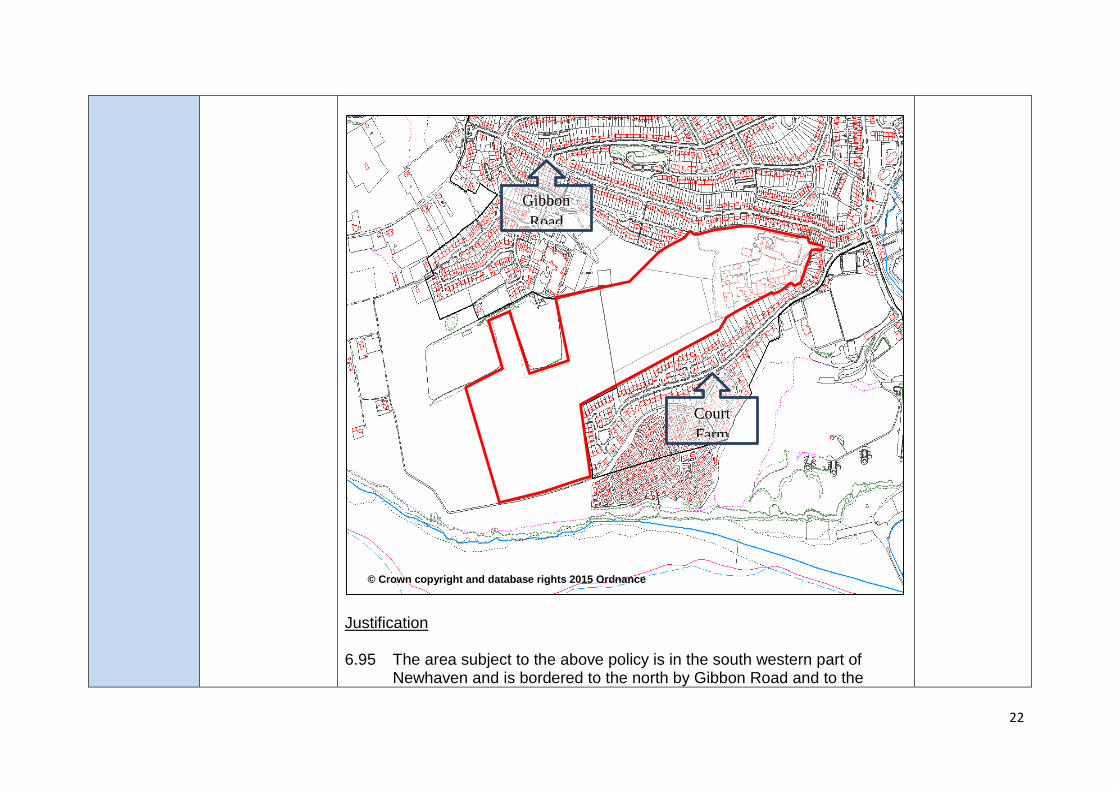
Justification 6.95 The area subject to the above policy is in the south western part of
Newhaven and is bordered to the north by Gibbon Road and to the
© Crown copyright and database rights 2015 Ordnance
Survey
Court
Farm
Gibbon
Road
23
south by Court Farm Road. The area extends from the Meeching Quarry Industrial Estate site in the east to land known as Harbour Heights in the west.
6.96 The majority of the area subject to this policy is in agricultural use. The
land is considered low grade agricultural land. Meeching Quarry Industrial Estate, covering approximately 3 hectares of the eastern part of the policy area, currently contains a mix of B2, B8 and Sui Generis uses. The Economic and Employment Land Assessment (EELA) scores the site low with regards to market attractiveness due to the poor quality and age of units, a number of which are currently vacant (including the Artex unit that covers a significant proportion of the site). The EELA identifies a need for the provision of smaller, high quality premises within Newhaven, particularly move-on office units, including to accommodate businesses seeking to move-on from the Enterprise Centre. The redevelopment of the Industrial Estate offers a good opportunity to meet this need and help off-set the loss of the existing employment floorspace.
6.97 A site specific affordable housing requirement has been included for this
strategic site in recognition of known and potential site constraints, including local topography, potential land contamination and infrastructure mitigation. An initial viability assessment indicates that affordable housing delivery at 40% (as sought by Core Policy 1) is unlikely be deliverable. Therefore, the level of affordable housing has been reduced to at least 30%, with the final level of affordable housing to be provided on site being informed by further detailed viability work. The development would be expected to be consistent with all other relevant aspects of CP1.
6.98 There are two potential access points, from Court Farm Road (between
128 and 138) and Quarry Road. Opportunities to create linkages
24
between the development and surrounding area should be explored, particularly linking the development to the primary and secondary schools to the north.
6.100 Previous consideration of development in this part of Newhaven, as well
as the findings from the evidence base (particularly the Landscape Capacity Study) identifies that parts of this area are quite prominent in landscape terms, particularly with the site being visible from a number of locations in and around Newhaven. However, existing and planned (the 2003 Local Plan land west of Meeching Quarry allocation) development in this part of the town has provided an urban feel to this area, which would not be exacerbated by development in accordance with this policy. To ensure that this is the case, careful consideration will still need to be given to the development’s layout, design and landscaping. This will need to ensure that visual impacts on the landscape, including views of the site from vantage points such as the cliff top and Newhaven Fort/ Castle Hill, are not compromised and that a suitable gap is maintained between Newhaven and Peacehaven (in this regard the development should not be located any further west than the western end of Hill Top Way and should provide a soft landscape interface between the town and countryside).
6.101 In considering the impact of development on the landscape, special
regard will need to be given to the undeveloped nature of the coastline, which needs to be retained. This should ensure that no development is located within the indicative cliff top erosion zone where no active intervention, to prevent erosion, is planned within the Shoreline Management Plan.
6.102 The policy makes reference to highway mitigation measures and
improvements to sustainable transport options. The justification for this
25
is that the transport evidence indicates that an increase in traffic from development in this part of Newhaven will have an adverse impact on southern access junctions of the Newhaven Ring Road (A259) in that they would be at or above their operating capacity. The additional strain from the development of this site will need to be mitigated. These mitigation measures will be in the form of junction improvements at South Road and South Way and by substantially improving sustainable transport options in this part of the town, especially a good quality and high frequency bus service, which will reduce the need to utilise the private car. As such, a sustainable travel plan will be required, which will need to be agreed by the local planning authority, in consultation with the local highway authority, and implemented accordingly.
6.103 Newhaven is currently recognised as having a shortfall in equipped
children’s play space and sports pitches. Although it is unreasonable to expect this development to make up the entire shortfall, it is proposed that the provision of, or contribution towards, open space and sports and recreation provision should be focussed on providing the facilities that are currently under-supplied in the area.
6.104 The site lies in an area of archaeological potential and as a result an
appropriate assessment and evaluation of the site’s archaeological and historic interest through desk-based assessment, geophysical survey, geo-archaeological survey and trial trenching will be expected to inform appropriate mitigation by design and recording.
6.105 The site is adjacent to the Brighton to Newhaven Cliffs SSSI and there
are SNCIs to the east and west. There are also multiple records of protected and notable species from the local area. As a result a ecological impact assessment will be required together with appropriate mitigation informed by the ecological impact assessment.
26
MM14 Section 6 (Spatial Strategy) New policy SP8 and text p.65
Insert new text to read: Peacehaven and Telscombe Peacehaven and Telscombe (combined parish population: 21,544) are located on the coast between Newhaven and the city of Brighton & Hove. The combined areas are classified as a district centre in the settlement hierarchy and offer a range of shops and services, together with a leisure centre, health facilities, library, and secondary school. Peacehaven and Telscombe offer only limited employment opportunities and there is significant out-commuting to work, particularly to the adjacent city of Brighton & Hove. The proximity of the city is also reflected in a fairly buoyant local housing market, which is supported by significant levels of in-migration from Brighton & Hove. The A259 coast road is the only vehicular route in and out of the urban area and ESCC, as the local transport authority, has concerns about the ability of this road to accommodate further increases in demand. Accordingly, the County Council’s transport policies and strategy for district’s coastal towns focus on improvements to, and increasing usage of, public transport to meet future demands along the A259 corridor. Peacehaven and Telscombe benefit from an extensive network of green spaces, including the cliff top and Telscombe Tye, which offers important recreational opportunities for residents. The Peacehaven Centenary Park, a 12 hectare site incorporating both formal and informal recreational facilities, was opened in 2015, funded primarily by recent housing development and the adjacent Waste Water Treatment Plant. Opportunities for expansion of the built-up area are limited by the sea to the south and the boundary of the South Downs National Park to the north.
27
However, a strategic housing development opportunity exists on agricultural land at Lower Hoddern Farm, located north-west of the new Peacehaven Centenary Park, as detailed in the following policy. Spatial Policy 8 - Land at Lower Hoddern Farm, Peacehaven Land amounting to 11 hectares is allocated for residential development of approximately 450 dwellings. Development will be permitted subject to compliance with the Core Delivery Policies of this plan and the following criteria:
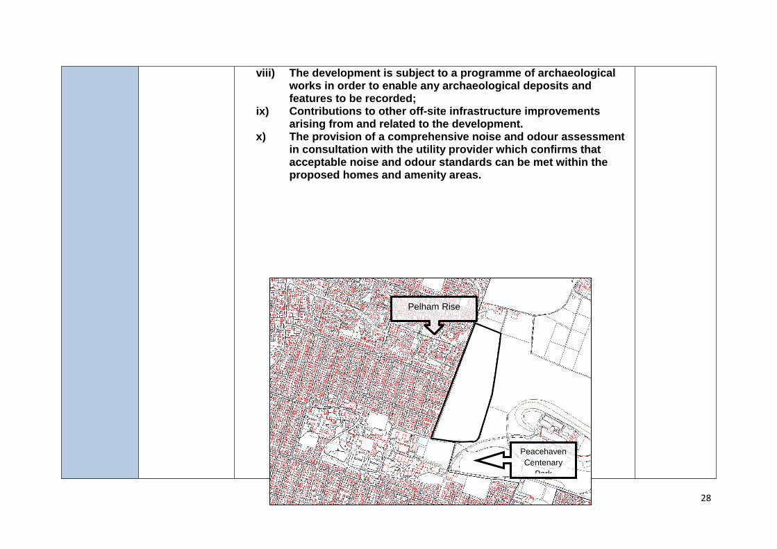
i) The primary vehicular access point shall be taken from Pelham Rise;
ii) The provision of safe and convenient pedestrian and cycle access to Southview Road, Firle Road and the Peacehaven Centenary Park;
iii) The provision of equipped children’s play spaces throughout the development;
iv) The provision of 2 hectares of public amenity space at the south east corner of the site, allowing for the potential expansion of the Peacehaven Centenary Park;
v) The provision of a comprehensive landscaping scheme, incorporating a significant new tree belt along the eastern boundary of the site;
vi) The identification, delivery and funding of a co-ordinated package of multi-modal transport measures to mitigate the impacts of development on the A259 coast road to the satisfaction of the local planning authority, in consultation with the local highway authority and adjacent highway authority;
vii) The development will provide a connection to the sewerage system at the nearest point of adequate capacity, as advised by Southern Water;
28
viii) The development is subject to a programme of archaeological works in order to enable any archaeological deposits and features to be recorded;
ix) Contributions to other off-site infrastructure improvements arising from and related to the development.
x) The provision of a comprehensive noise and odour assessment in consultation with the utility provider which confirms that acceptable noise and odour standards can be met within the proposed homes and amenity areas.
Pelham Rise
Peacehaven
Centenary
Park
29
Justification This housing allocation comprises a tract of open, relatively flat agricultural land which abuts the existing built-up area of Peacehaven on its western boundary. Peacehaven Community School and Centenary Park are located on the southern boundary, with Peacehaven Waste Water Treatment Works to the south east. A small group of residential properties and industrial units are located to the north, whilst elsewhere open countryside extends eastwards from the boundary of the allocated site towards the National Park. The site is in single ownership and is currently classified as Grade 2 agricultural land (i.e. the best and most versatile agricultural land). However, the site is within easy walking distance of the Meridian Centre, Peacehaven Leisure Centre, Peacehaven Community School, primary schools, and local employment opportunities. It is therefore considered that the economic and social benefits of housing development in this location outweigh the loss of valuable agricultural land. The development of the site also provides an opportunity to improve the urban edge of Peacehaven in this location, which is currently highly visible in views from the adjacent countryside of the National Park. This will be achieved through the requirement for a significant tree belt along the eastern edge of the allocation in order to help assimilate the development into the surrounding downland landscape. Approximately 2 hectares of the southern section of the site was allocated for public open space in the adopted Lewes District Local Plan 2003. This was part of a wider allocation to help address the significant shortfall of outdoor
© Crown copyright and database rights 2015 Ordnance Survey
30
playing space in Peacehaven and Telscombe. Notwithstanding the recent completion of the Centenary Park, a shortfall in outdoor playing space still exists in the towns and it is therefore considered appropriate for the housing allocation to include at least 2 hectares of public amenity space to meet the needs of the new residents. Provision should also be made for equipped and informal children’s play spaces in accordance with the Councils’ adopted standards. Due to local highway capacity constraints, an essential requirement of the development will be the identification and delivery of a co-ordinated package of multi-modal transport measures to mitigate the impacts on the A259 coast road. This will include effective enhancements to the existing bus service levels and infrastructure in the A259 corridor, thereby increasing the share of total person demands by bus for the whole area, not just arising from the new development itself. The development would also be contingent on the delivery of a number of transport infrastructure improvements, including improvements to the operation of the A259/Telscombe Cliffs Way junction, the Sutton Avenue roundabout, and the Newhaven Ring Road. The development should also demonstrate overall sustainable accessibility, including good connections to the adjacent street network in order to encourage walking and cycling. The allocated site is located within an Archaeological Notification Area, defining an area of prehistoric activity and settlement. The developer will therefore be required to record and advance understanding of the significance of any archaeological deposits and features within the site and should make this evidence publicly accessible.
MM15
Section 7 (Core Delivery Policies
MM15 is deleted.
31
Core Policy 1, p70
MM16 Core Policy 2 p73
Amend Criterion 2 to read: 2. Provide flexible, socially inclusive and adaptable accommodation to
help meet the diverse needs of the community and the changing needs of occupants over time. This need will include accommodation appropriate for the ageing population and disabled residents.
MM17
Section 7 (Core Delivery Policies) Core Policy 3, criterion 1, p.76
Amend criterion 1 by inserting the words ‘and wastewater facilities’ to read: Avoid locating sites in areas at high risk of flooding or significantly contaminated land, or adjacent to existing uses incompatible with residential uses, such as waste tips and wastewater facilities;
MM18 Core Policy 3 p76
Amend the first paragraph of the policy wording to read: Provision will be made for a net total of 13 additional permanent pitches for Gypsies and Travellers to serve the needs for the period 2014 to 2030. Of these 5 pitches will serve the needs of the area outside the National Park and 8 will serve the needs within the National Park area of the district. The local planning authority will allocate specific, deliverable sites through the Local Plan Part 2 and the SDNPA Local Plan, unless allocated through Neighbourhood Plans. These allocations will be informed by appropriate Site Assessment work and take into account any planning permissions granted for permanent use in the interim.
MM19 Core Policy 4 p81
Amend and add to criterion 2 to read: Safeguard existing employment sites from other competing uses unless there are demonstrable economic viability or environmental amenity reasons for not doing so. This will include:
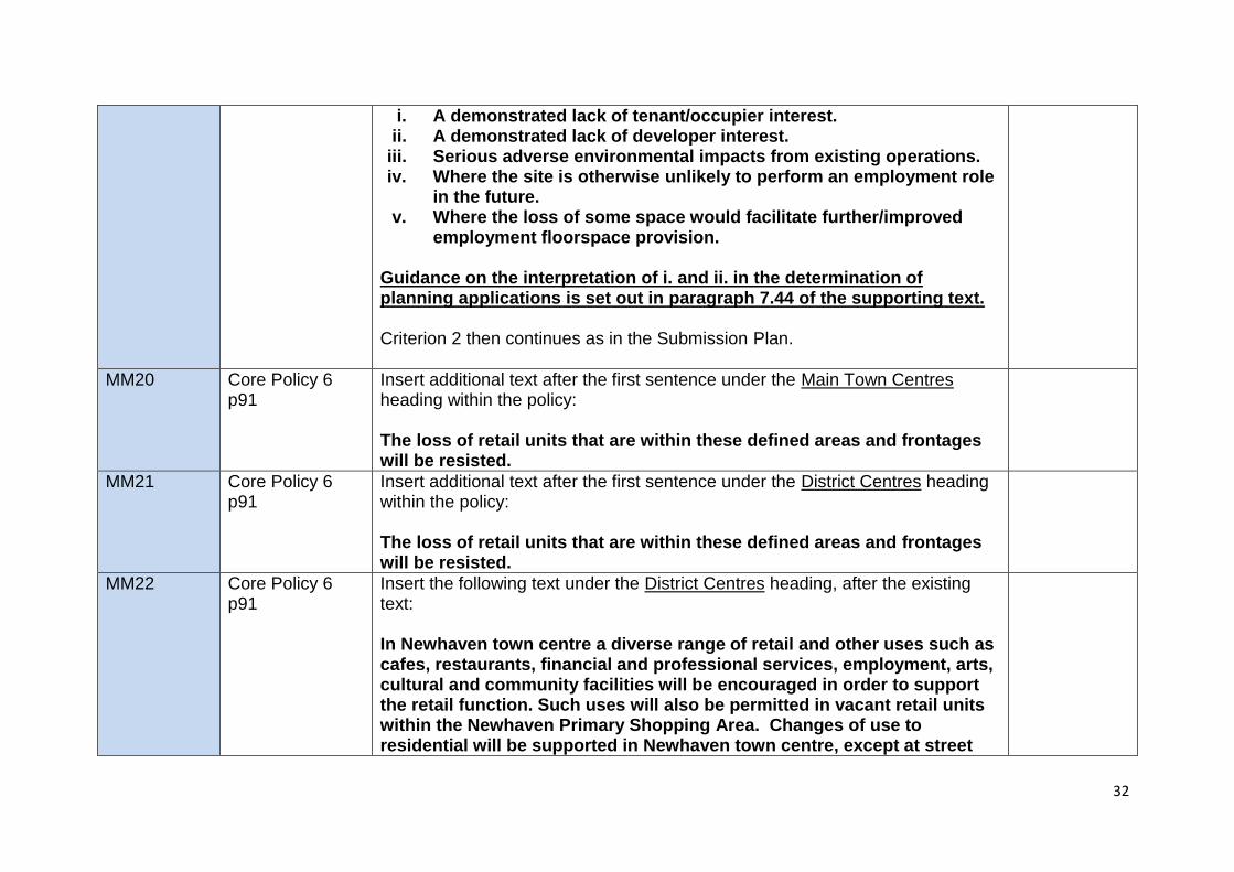
32
i. A demonstrated lack of tenant/occupier interest. ii. A demonstrated lack of developer interest.
iii. Serious adverse environmental impacts from existing operations. iv. Where the site is otherwise unlikely to perform an employment role
in the future. v. Where the loss of some space would facilitate further/improved
employment floorspace provision. Guidance on the interpretation of i. and ii. in the determination of planning applications is set out in paragraph 7.44 of the supporting text. Criterion 2 then continues as in the Submission Plan.
MM20 Core Policy 6 p91
Insert additional text after the first sentence under the Main Town Centres heading within the policy: The loss of retail units that are within these defined areas and frontages will be resisted.
MM21 Core Policy 6 p91
Insert additional text after the first sentence under the District Centres heading within the policy: The loss of retail units that are within these defined areas and frontages will be resisted.
MM22 Core Policy 6 p91
Insert the following text under the District Centres heading, after the existing text: In Newhaven town centre a diverse range of retail and other uses such as cafes, restaurants, financial and professional services, employment, arts, cultural and community facilities will be encouraged in order to support the retail function. Such uses will also be permitted in vacant retail units within the Newhaven Primary Shopping Area. Changes of use to residential will be supported in Newhaven town centre, except at street
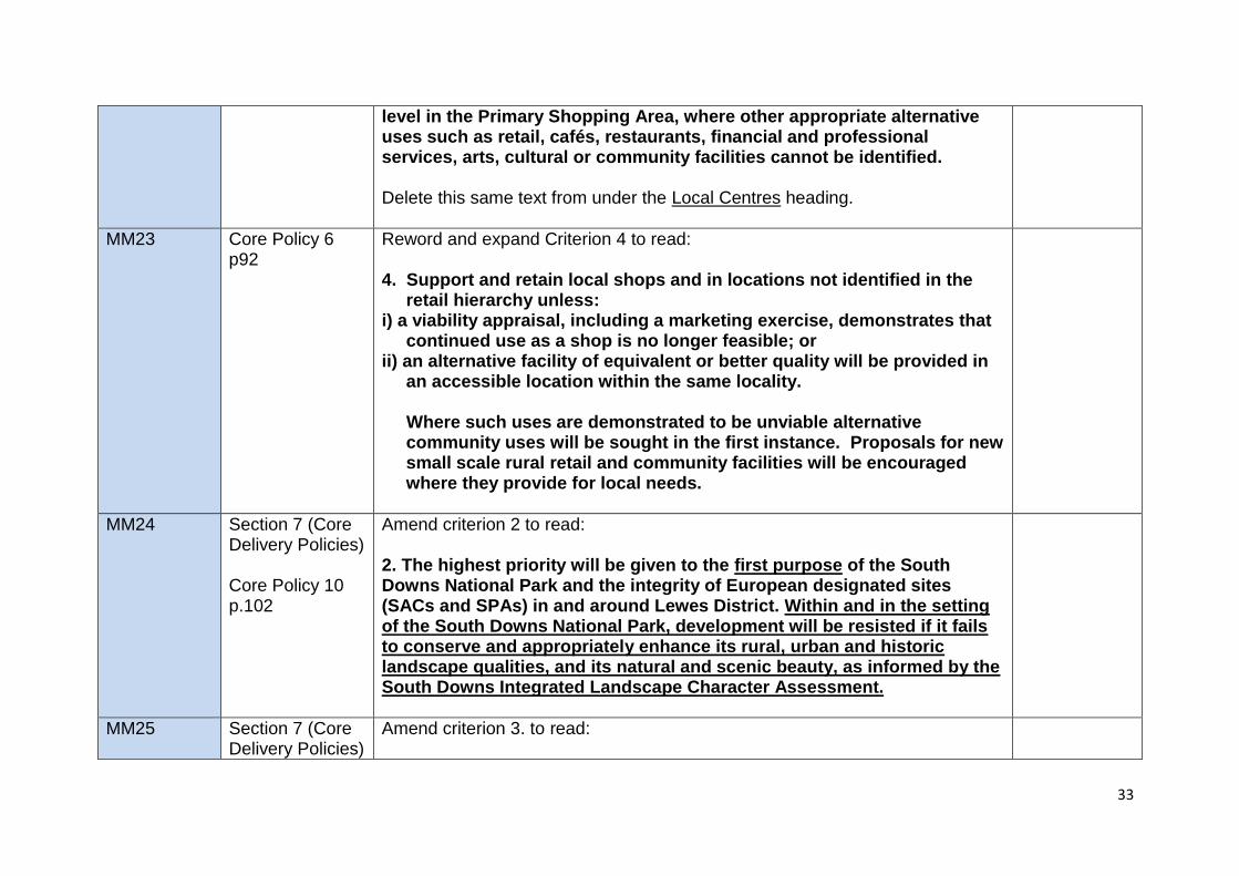
33
level in the Primary Shopping Area, where other appropriate alternative uses such as retail, cafés, restaurants, financial and professional services, arts, cultural or community facilities cannot be identified. Delete this same text from under the Local Centres heading.
MM23 Core Policy 6 p92
Reword and expand Criterion 4 to read: 4. Support and retain local shops and in locations not identified in the
retail hierarchy unless: i) a viability appraisal, including a marketing exercise, demonstrates that
continued use as a shop is no longer feasible; or ii) an alternative facility of equivalent or better quality will be provided in
an accessible location within the same locality. Where such uses are demonstrated to be unviable alternative
community uses will be sought in the first instance. Proposals for new small scale rural retail and community facilities will be encouraged where they provide for local needs.
MM24 Section 7 (Core Delivery Policies) Core Policy 10 p.102
Amend criterion 2 to read: 2. The highest priority will be given to the first purpose of the South Downs National Park and the integrity of European designated sites (SACs and SPAs) in and around Lewes District. Within and in the setting of the South Downs National Park, development will be resisted if it fails to conserve and appropriately enhance its rural, urban and historic landscape qualities, and its natural and scenic beauty, as informed by the South Downs Integrated Landscape Character Assessment.
MM25 Section 7 (Core Delivery Policies)
Amend criterion 3. to read:
34
Core Policy 10 p.102
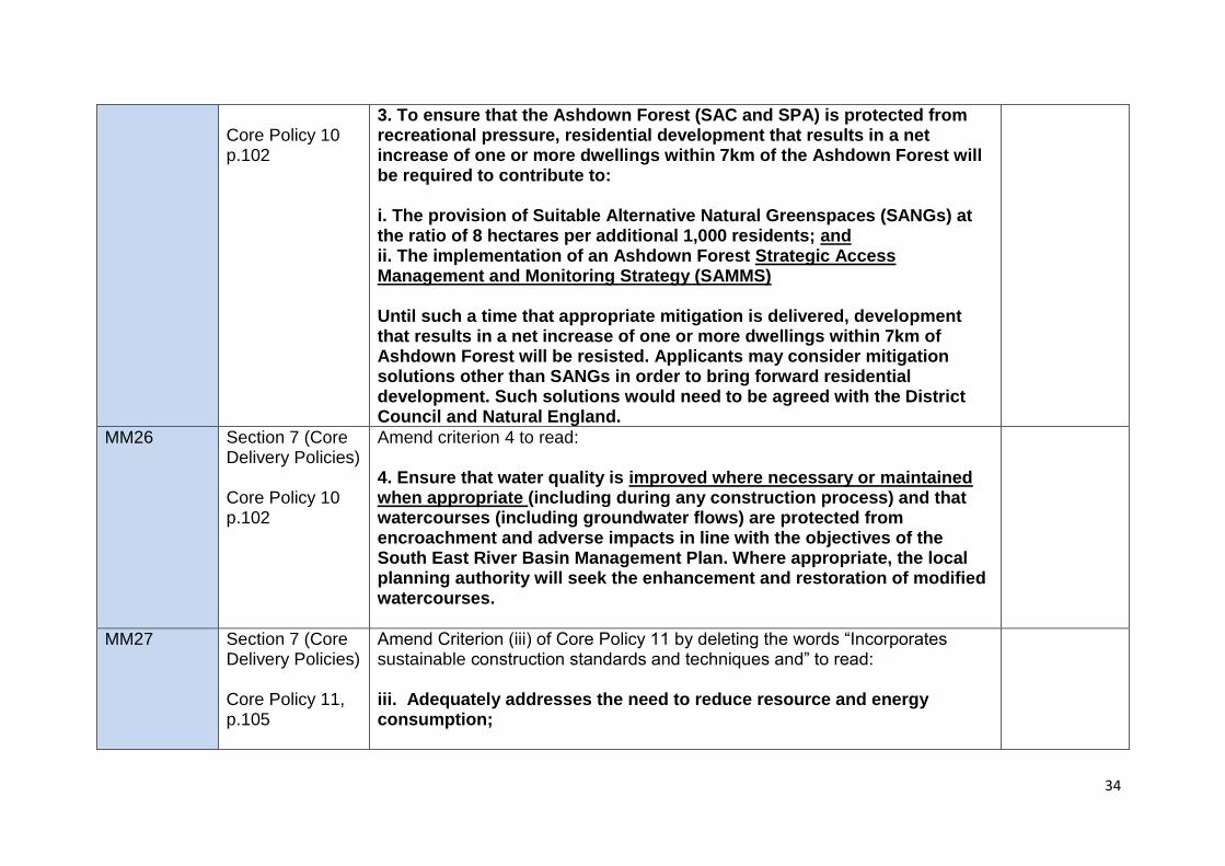
3. To ensure that the Ashdown Forest (SAC and SPA) is protected from recreational pressure, residential development that results in a net increase of one or more dwellings within 7km of the Ashdown Forest will be required to contribute to: i. The provision of Suitable Alternative Natural Greenspaces (SANGs) at the ratio of 8 hectares per additional 1,000 residents; and ii. The implementation of an Ashdown Forest Strategic Access Management and Monitoring Strategy (SAMMS) Until such a time that appropriate mitigation is delivered, development that results in a net increase of one or more dwellings within 7km of Ashdown Forest will be resisted. Applicants may consider mitigation solutions other than SANGs in order to bring forward residential development. Such solutions would need to be agreed with the District Council and Natural England.
MM26 Section 7 (Core Delivery Policies) Core Policy 10 p.102
Amend criterion 4 to read: 4. Ensure that water quality is improved where necessary or maintained when appropriate (including during any construction process) and that watercourses (including groundwater flows) are protected from encroachment and adverse impacts in line with the objectives of the South East River Basin Management Plan. Where appropriate, the local planning authority will seek the enhancement and restoration of modified watercourses.
MM27 Section 7 (Core Delivery Policies) Core Policy 11, p.105
Amend Criterion (iii) of Core Policy 11 by deleting the words “Incorporates sustainable construction standards and techniques and” to read: iii. Adequately addresses the need to reduce resource and energy consumption;
35
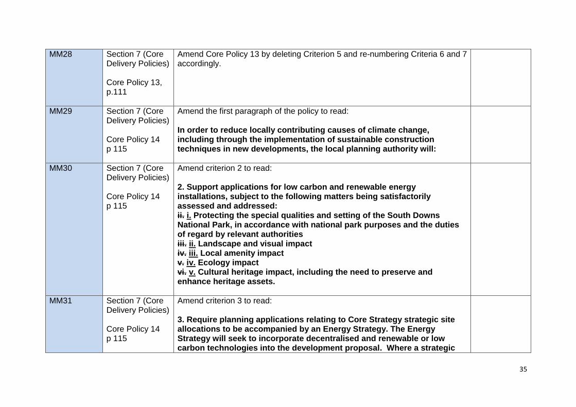
MM28 Section 7 (Core Delivery Policies) Core Policy 13, p.111
Amend Core Policy 13 by deleting Criterion 5 and re-numbering Criteria 6 and 7 accordingly.
MM29 Section 7 (Core Delivery Policies) Core Policy 14 p 115
Amend the first paragraph of the policy to read: In order to reduce locally contributing causes of climate change, including through the implementation of sustainable construction techniques in new developments, the local planning authority will:
MM30 Section 7 (Core Delivery Policies) Core Policy 14 p 115
Amend criterion 2 to read: 2. Support applications for low carbon and renewable energy installations, subject to the following matters being satisfactorily assessed and addressed: ii. i. Protecting the special qualities and setting of the South Downs National Park, in accordance with national park purposes and the duties of regard by relevant authorities iii. ii. Landscape and visual impact iv. iii. Local amenity impact v. iv. Ecology impact vi. v. Cultural heritage impact, including the need to preserve and enhance heritage assets.
MM31 Section 7 (Core Delivery Policies) Core Policy 14 p 115
Amend criterion 3 to read: 3. Require planning applications relating to Core Strategy strategic site allocations to be accompanied by an Energy Strategy. The Energy Strategy will seek to incorporate decentralised and renewable or low carbon technologies into the development proposal. Where a strategic

36
site is developed in phases, the Energy Strategy will guide the development of infrastructure for renewable and/or low carbon technologies in a coordinated way.
MM32
Section 7 (Core Delivery Policies) Core Policy 14 p 115
Amend criterion 4 to read: 4 Require all new dwellings to achieve water consumption of no more than 110 litres per person per day, unless it can be demonstrated that it would not be technically feasible or financially viable. All new non-residential developments over 1,000 square metres (gross floorspace) will be expected to achieve the BREEAM ‘Very Good’ standard and developers will be expected to provide certification evidence of the levels achieved in the relevant requirements/standards at the planning application stage.
MM33 Key Diagram Retitle “Portrait of the District” as “Key Diagram” and annotate accordingly.
MM34 Appendix 3 Monitoring and Delivery Framework Update in accord with all other Main Modifications.
MM35 Appendix 4 Replace with new Housing Trajectory as at October 2015.