Embed Size (px)
Citation preview
INTEGRATED COASTAL MANAGEMENT FRAMEWORK
OF THE RUPUBLIC OF FIJI
2011 Opportunities and issues for managing our coastal resources sustainably
Department of Environment
Ministry of Local Government, Urban Development, Housing and Environment
The Integrated Coastal Management Framework of the Republic of Fiji was prepared for the National Integrated Coastal Management Committee (ICMC) and the Department of Environment by Ms Patrina Dumaru. © 2011 Department of Environment, Republic of Fiji. Reproduction of this publication for educational and non− commercial purposes is authorized without prior written permission from the copyright holder, provided that the source is fully acknowledged. Reproduction of any part of this publication for resale or other commercial purposes is prohibited without prior written consent from the copyright owner Photographic credits: Ms Neema Nand
IInntteeggrraatteedd CCooaassttaall MMaannaaggeemmeenntt FFrraammeewwoorrkk ooff tthhee RReeppuubblliicc ooff FFiijjii 22001111
11
LIST OF ACRONYMS CBD Convention on Biodiversity CCCT Climate Change Country Team CCA Climate Change Adaptation CITES Convention on International Trade of Endangered Species of Wild Fauna and Flora DLS Department of Lands and Survey DoE Department of Environment DRM Disaster Reduction Management DTCP Department of Town and Country Planning EEZ Exclusive economic zone EIA Environmental Impact Assessment EMA Environment Management Act FAO Food and Agricultural Organisation FLMMA Fiji Locally Managed Marine Areas FNBSAP Fiji National Biodiversity Strategy Action Plan FNBSAPSC Fiji National Biodiversity Strategy Action Plan Steering Committee ICM Integrated Coastal Management ICMC Integrated Coastal Management Committee (Fiji) IUCN International Union for Conservation of Nature JICA Japan International Cooperation Agency LAC Limits of accessible change MESCAL Mangrove Ecosystems for Climate Adaptation Livelihood Project NEP National Environment Plan NEC National Environment Council NES National Environment Strategy NFC Native Fisheries Commission NGOs Non-Governmental Organisations NLTB Native Land Trust Board NRI National Resource Inventory NSER National State of the Environment Report PAC Protected Area Committee PCDF Partners in Community Development POPs Persistent Organic Pollutants PoWPA Programme of Work on Protected Areas REDD Reducing emission from deforestation and forest degradation UNFCCC United Nations Framework Convention on Climate Change USP University of the South Pacific WWF World Wildlife Fund
IInntteeggrraatteedd CCooaassttaall MMaannaaggeemmeenntt FFrraammeewwoorrkk ooff tthhee RReeppuubblliicc ooff FFiijjii 22001111
22
Table of Contents 1.0 Executive summary 4
2.0 Introduction 6
3.0 Status of coastal management in Fiji 7
3.1 Status of the Environment Management Act 7
3.1.1 Key decision-making bodies 7 3.1.2 Key legislative provisions 9
3.2 Other legislation relevant to coastal resource management 11
3.3 Key international arrangements related to ICM 13 3.3.1 Convention on Biological Diversity (CBD) 13 3.3.2 Convention on Wetlands (Ramsar Convention) 13
3.3.3 Convention on International Trade in Endangered Species of Wild Fauna and Flora (CITES) 14
3.3.4 Cartegena Protocol on Biosafety 14 3.3.5 Stockholm Convention on Persistent Organic Pollutants (POPs) 14
3.3.6 United Nations Framework Convention on Climate Change (UNFCCC) 14
3.4 Customary Resource Management Regime 15
3.4.1 Land tenure 15 3.4.2 Marine tenure 15 3.4.3 Provincial Councils 16 3.4.4 Village and Tikina based resource management 16 3.5 Resource management zones 17 3.5.1 Formalised zones 17 3.5.2 Protected Areas 18 3.5.3 Important archeological sites 20 3.5.4 Zoning for ICM 20
3.6 Legal and institutional arrangements for ICM 21
4.0 Current coastal conditions 23
4.1 Coastal stability 23
4.2 Water quality 23
4.3 Coastal quality 24
4.4 Coral reef health 24
4.5 Mangrove health 25
4.6 Coastal littoral (strand) vegetation 26
4.7 Seagrass 27
IInntteeggrraatteedd CCooaassttaall MMaannaaggeemmeenntt FFrraammeewwoorrkk ooff tthhee RReeppuubblliicc ooff FFiijjii 22001111
33
4.8 Human vulnerability 27
5.0 Coastal activities and users 29
5.1 Coastal development 30 5.1.1 Residential and commercial construction 30 5.1.2 Landfills and reclamation 31 5.1.3 Coastal Protection 31 5.1.4 Dredging 32 5.1.5 Coastal sand extraction 33
5.2 Tourism development 33 5.2.1 Reclamation and construction 34 5.2.2 Tourism waste management 34 5.2.3 Ecotourism and conservation initiatives 35 5.3 Living coastal resource utilization 36 5.3.1 Inshore fisheries 36 5.3.2 Aquaculture 36 5.3.3 Marine invasive species 37 5.4 Land-based activities 37 5.4.1 Wastewater 37 5.4.2 Solid waste 39 5.4.3 Land-use activities 40 5.4.4 Agricultural and bush/forest burning 40 5.5 Marine activities 40 5.5.1 Disposal of vessel generated waste 41 5.5.2 Oil Spills 41 5.5.3 Shipwrecks and abandoned vessels 41 5.6 Natural threats/disasters 41 5.6.1 Tropical cyclones, severe storms and floods 42 5.6.2 Tsunami 42 5.6.3 Sea level rise 42
6.0 Coastal data collection systems 43
7.0 Current coastal management initiatives 48
8.0 Funding possibilities 52
9.0 Conclusion 52
REFERENCE 53
IInntteeggrraatteedd CCooaassttaall MMaannaaggeemmeenntt FFrraammeewwoorrkk ooff tthhee RReeppuubblliicc ooff FFiijjii 22001111
44
1.0 Executive summary Collectively, the group of Fiji islands comprises 1,130 km of coastline covering 31,000 sq. km of coastal and inshore waters of which most is still in pristine condition. Fiji’s coastal environmental quality, however, is being threatened by the ever increasing urbanisation trends and demand for cash and modern goods and services as the local economy integrates further with the global. All of Fiji’s urban centres and an estimated 690,000 of Fiji’s 900,000 people live within 30 km of the country’s surrounding reefs (Burke et al. 2011). About half of Fiji’s population is now urbanised and this figure is expected to increase to 70 per cent by 2050 according to global projections. A significant proportion of Fiji’s urban areas are poorly planned and serviced. This means that the increasing rural-urban drift only leads to the expansion of informal settlements, particularly in low-lying and coastal areas, where sub-standard housing and sanitation practices are among the main threats to the health of Fiji’s coast. The expanding tourism, agricultural, forestry and fisheries industries coupled with increasing rates of urbanisation operating within a legal and institutional framework with limited environmental considerations suggests that serious steps need to be taken at the national level to safeguard the country’s coastal ecological system.
The 2005 Environment Management Act (EMA) stipulates the development of a coastal management plan under Section 3(8). The EMA defines the coastal zone as “the area within 30 metres inland from the high water mark and includes areas from the high water mark up to the fringing reef or if there is no fringing reef within a reasonable distance from the high water mark”. This Integrated Coastal Management (ICM) Framework begets the coastal management plan (to be called the National ICM Plan) by delineating the plan’s scope and structure. This framework has been produced by the Fiji Department of Environment to review current coastal conditions in the context of tourism development, coral reef degradation, siltation and erosion, harvesting of marine resources, waste management, coastal reclamation and construction and natural disasters among others as well as assess the current legal and institutional governing framework so as to recommend proposals for action and policy towards sustainable coastal resource management for Fiji. Important recommendations include:
RECOMMENDATION 1: Extend the jurisdiction of the ICM Plan inland within a clearly defined watershed when appropriate (instead of merely 30m).
RECOMMENDATION 2: Develop ICM plans at the provincial levels which when considered together will suggest the make-up of the National ICM Plan. It is assumed that the ICM plans at the provincial level would include a mangrove management plan as well as a coastal sensitivity atlas for disaster response planning and management.
RECOMMENDATION 3: Determine a relevant legal and institutional framework to effectively support Fiji’s ICM vision. Part of this includes determining which regulations under which Acts take precedence when in conflict.
IInntteeggrraatteedd CCooaassttaall MMaannaaggeemmeenntt FFrraammeewwoorrkk ooff tthhee RReeppuubblliicc ooff FFiijjii 22001111
55
RECOMMENDATION 4: To achieve multi-sectoral integration, a coastal commission (perhaps the NEC sub-committee) will need to play a greater role in decision-making. Its exact powers will need to be determined and formalised.
RECOMMENDATION 5: Key data and information requirements for sound coastal management decision-making be identified and an appropriate system of gathering, collation, use and management for ICM purposes be developed. These include knowledge of:
coastal areas especially prone to erosion changes taking place in mangrove areas definition of special coastal areas which need consideration limits of acceptable change (LAC) in major current and planned tourism areas marine invasive species coral reef health wetland circulation, soil and vegetation types appropriate and effective pollution control measures for Fiji coastal zone evacuation plans marine-based pollution from vessels and shipwrecks
RECOMMENDATION 6: Funding be sought under the next GEF funding cycle to support development of a full ICM Plan.
IInntteeggrraatteedd CCooaassttaall MMaannaaggeemmeenntt FFrraammeewwoorrkk ooff tthhee RReeppuubblliicc ooff FFiijjii 22001111
66
2.0 Introduction Section 8(3) of the 2005 Fiji Environment Management Act (EMA) calls for the establishment of a committee by the National Environmental Council to develop a coastal management plan. An ad hoc ICM committee was formally established in September 2009, although many ICM-related initiatives and activities at the national, provincial and community level over the past 15 years precede this. In seeking advice on the development of an ICM plan, the consensus was that this should be done over some years and a first step would be to develop an ICM Framework. With this in mind, an ICM Framework Workshop was held in Suva in April 2010 in which about 40 stakeholders representing government, the private sector, communal resource owners, non-governmental organisations and research institutions met and identified the guiding vision of the Fiji ICM Framework as well as the chapters, institutional arrangements and procedural approach. Based on this, the Fiji ICM framework is guided by the vision for the coastal zone to:
• Maintain ecological processes and services • Preserve, enhance and rehabilitate natural resources • Improve health and wellbeing of the people in Fiji.
ICM is universally defined as “a continuous and dynamic process by which decisions are taken for the sustainable use, development, and protection of coastal and marine areas and resources” (Cincin-Sain and Knetch, 1998). The term “integrated” implies the integration between sectors (e.g. tourism, agriculture, national planning, fisheries), stakeholders (government, private sector and NGOs), scales (national and local), discipline (physical science and social science) and space (land and sea) (Cincin-Sain and Knetch 1998).
Two key issues arise from this definition as Fiji embarks on a coastal planning process. First, ICM is essentially about decision-making processes and approaches for the sustainable management of Fiji’s coastal resources. Therefore, an ICM framework should be an assessment of existing institutional and regulatory systems governing Fiji’s coastal resources and the interest of various stakeholders within current coastal environment conditions and threats. Such an assessment is a necessary basis upon which more effective coastal management processes and approaches can be identified and recommended.
Second, the EMA defines Fiji’s coastal zone as “the area within 30 metres inland from the high water mark and includes areas from the high water mark up to the fringing reef or is there is no fringing within a reasonable distance from the high water mark”. Hence, a national ICM plan based on the EMA defined jurisdiction would significantly be limited if it does not encompass upstream activities beyond the 30 metre mark inland. The greatest impacts to Fiji’s inshore environment flow from the myriad of land-based activities occurring in her relatively extensive watershed and riverine system. Therefore, it would be imperative that the National ICM Plan covers the “ridge to reef” area if it is to effectively protect and sustainably manage Fiji’s valuable coastal environment. For governance purposes, “ridge to reef” may refer to boundaries of all Tikinas or districts whose land areas include parts or entireties of coastal watersheds. RECOMMENDATION 1: Extend the jurisdiction of the ICM Plan inland within a clearly defined watershed when appropriate (instead of merely 30m).
IInntteeggrraatteedd CCooaassttaall MMaannaaggeemmeenntt FFrraammeewwoorrkk ooff tthhee RReeppuubblliicc ooff FFiijjii 22001111
77
3.0 Status of coastal management in Fiji 3.1 Status of the Environment Management Act The 2005 EMA is the most relevant legislative framework encompassing ICM, in which the development of a coastal management plan is among several actions called for. The EMA jurisdiction covers the land, coastal zone, foreshore and seabed and extends to the outer limits of Fiji’s Exclusive Economic Zone (EEZ). Its two key purposes are to:
i. apply the principles of sustainable use and development of natural resources; and ii. identify matters of national importance in relation to the environment.
The EMA has two supporting regulations. The EIA Process Regulation 2007 outlines screening, processing and reviewing of EIA pertaining to the EMA. The Waste Disposal and Recycling Regulation 2007 outlines the process and requirements for disposing various waste types.
This section reviews the status of other obligations under the EMA that are concurrently being dealt with by the Fiji Department of Environment and that may be relevant to pursuing ICM in Fiji.
3.1.1 Key decision-making bodies
3.1.1a National Environment Council (NEC)
The NEC is a broadly represented multi-sectoral body established under Section 7 of the EMA to advise and coordinate the decision-making and initiatives pertaining to national environmental issues. Among their key tasks is overseeing the preparation and implementation of the National State of the Environment Report (NSER) and the National Environment Strategy (NES). The NEC may also appoint technical committees to deal with specific environmental issues and, more specifically, establish a coastal zone management committee and a resource owners committee. To date, the following committees have been established.
Fiji National Biodiversity Strategy and Action Plan Steering Committee (FNBSAPSC) advises and assists the Department of Environment on the implementation of the Fiji National Biodiversity Strategy Action Plan. The NBSAP Committee’s work is guided by the Implementation Framework for 2010-2014 which has seven thematic areas including: forest conservation; invasive species; inshore fisheries; coastal development; species conservation; protected areas; and inland waters.
Protected Areas Committee (PAC) was established in 2008 to carry out Fiji’s commitment under the Convention on Biological Diversity (CBD)’s Programme of Work on Protected Areas (PoWPA). The key functions of the PAC is to advise the NEC on protected area policies and priorities; assist with the establishment of an adequate and representative national protected area system; facilitate consensus on national priority areas for conservation; identify actions for the establishment and effective management of protected areas; and identify options for resource protected area management (PAC 2009). The PAC facilitated a workshop in September 2010 with representatives from Fiji’s 14 provinces to identify possible sites from each province for national protection and
IInntteeggrraatteedd CCooaassttaall MMaannaaggeemmeenntt FFrraammeewwoorrkk ooff tthhee RReeppuubblliicc ooff FFiijjii 22001111
88
management. A report detailing identified candidate sites and implementation strategies was recently released (Jupiter et al. 2011).
Integrated Coastal Management Committee (ICMC) is responsible for the preparation of the coastal zone management plan of which the development of this framework is a part. The need for ICM is one of the key tenets of the CBD. The development of the ICM Plan may also incorporated the development of a “coastal sensitivity atlas for disaster response planning and management” referred to in section 13 (3) of the EMA. A Mangrove Management Committee is a sub-group of the ICMC that deals specifically with sustainable mangrove management. A key task of the Mangrove Sub-committee is to bring together bodies that have legislative influence on mangrove management – mangrove management regulations are currently divided between departments of Forestry, Lands, Fisheries and Environment. Currently, the Departments of Fisheries, Forests and Lands are working on strengthening the conditions for licenses to cut mangrove (NEC Meeting Report, 8th July 2010). These new conditions may become part of the ICM Plan when it is developed as it will include the sustainable management of Fiji’s mangrove areas.
The Mangrove Management Committee also is the official steering committee for the recently established IUCN Mangrove Ecosystems for Climate Change Adaptation Livelihood (MESCAL) Project which could do a nation-wide baseline study of Fiji’s mangroves and promote its sustainable management (NEC Meeting Report, 14 May, 2009), as well as identifying mangrove areas to be declared as a protected areas (NEC Meeting Report, 31 March, 2010).
The Climate Change Country Team (CCCT) was set up to link and coordinate national climate change initiatives. They are currently focused on developing the National Climate Change Policy and joint national plan of action for Climate Change Adaptation (CCA) and Disaster Risk Management (DRM). Additionally the CCCT is conducting a climate change vulnerability and adaptation assessment of Fiji to identify vulnerable hotspots to climate change which is part of the Second National Communication Project to be completed in December 2011. This vulnerability assessment may also be linked to the coastal sensitivity atlas and ICM Plan.
Committees in the process of being set up include the Resource Owners Committee, Invasive Species and Species Conservation Committee, Forest Conservation Committee, Inshore Fisheries Committee and the National Wetlands Steering Committee.
3.1.1b Department for Environment (DoE)
As the implementing arm of the NEC, the DoE coordinates the compilation of the National Resource Inventory (NRI) and the formulation, review and implementation of the National State of the Environment Report (NSER), the National Environment Strategy (NES), the National Resource Management Plan (NRMP) and the National Biodiversity Strategy and Action Plan (NBSAP). The DoE is also responsible for carrying out EIA processes, waste management policies and programmes, environmental standard formulation and enforcement, environmental sustainability mainstreaming, and international treaty implementation of Multilateral Environmental Agreements (MEAs) of which
IInntteeggrraatteedd CCooaassttaall MMaannaaggeemmeenntt FFrraammeewwoorrkk ooff tthhee RReeppuubblliicc ooff FFiijjii 22001111
99
Fiji is party. In addition, the DoE conducts evaluations and audits of national resource management related projects and programmes. These tasks are carried out through the following units:
Environment impacts assessment (EIA) unit: responsible for the administration of EIAs.
Resource management unit: responsible for the development of the Natural Resource Inventory; the formulation, implementation and monitoring the National Resource Management Plan; and the co-ordination and maintenance of natural resource management activities and information databases.
Waste management and control unit: responsible for the formulation, implementation, monitoring and reviewing of the various waste management plans and activities, including solid waste, liquid waste, chemical waste and sanitary landfill management.
Environment management unit: responsible for reviewing and making recommendations to EIA reports as well as enforcing environmental management conditions of an approved EIA report.
Environment inspectors: responsible for inspecting facilities that may have contravened the EMA.
3.1.2 Key legislative provisions 3.1.2a Environment impacts assessment process
Section 4 of the EMA requires that any proposed development activity that is likely to cause significant impact on the environment is required to undergo an EIA process which includes screening, scoping, preparation, reviewing and decision-making. Section 32 of the EMA states that a condition of any approved EIA is that proponents are required prepare and implement an environmental management plan, monitoring programme, protection plan or mitigation measure which may be subject to inspection by the EIA administrator or an approving authority.
The EIA process is particularly relevant to ICM because it provides a check on activities that threaten the coastal environment such as reclamation and construction, pollution of marine waters, and coastal erosion as well as investigates on impacts of upstream activities such as logging, agriculture and mining.
3.1.2b Permits to discharge waste or pollutants
The EMA covers the control of pollution via a permit system under Section 5. Permits are required when: producing and discharging waste or pollutants into the environment; handling, storing, processing, or controlling of hazardous material; and engaging in any other activity that may adversely impact human or environmental health.
3.1.2c National reports and plans
Several important reports and plans have yet to be completed under the EMA. The last National State of the Environment Report (NSER) was published in 1992 and under the EMA, this should be done every 5 year followed by the development of the National Environment Strategy (NES) 12
IInntteeggrraatteedd CCooaassttaall MMaannaaggeemmeenntt FFrraammeewwoorrkk ooff tthhee RReeppuubblliicc ooff FFiijjii 22001111
1100
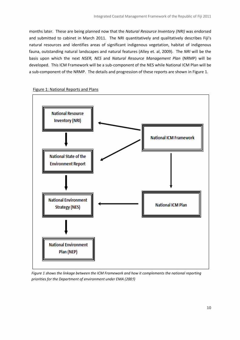
months later. These are being planned now that the Natural Resource Inventory (NRI) was endorsed and submitted to cabinet in March 2011. The NRI quantitatively and qualitatively describes Fiji’s natural resources and identifies areas of significant indigenous vegetation, habitat of indigenous fauna, outstanding natural landscapes and natural features (Alley et. al, 2009). The NRI will be the basis upon which the next NSER, NES and Natural Resource Management Plan (NRMP) will be developed. This ICM Framework will be a sub-component of the NES while National ICM Plan will be a sub-component of the NRMP. The details and progression of these reports are shown in Figure 1.
Figure 1: National Reports and Plans
Figure 1 shows the linkage between the ICM Framework and how it complements the national reporting priorities for the Department of environment under EMA (2005)
IInntteeggrraatteedd CCooaassttaall MMaannaaggeemmeenntt FFrraammeewwoorrkk ooff tthhee RReeppuubblliicc ooff FFiijjii 22001111
1111
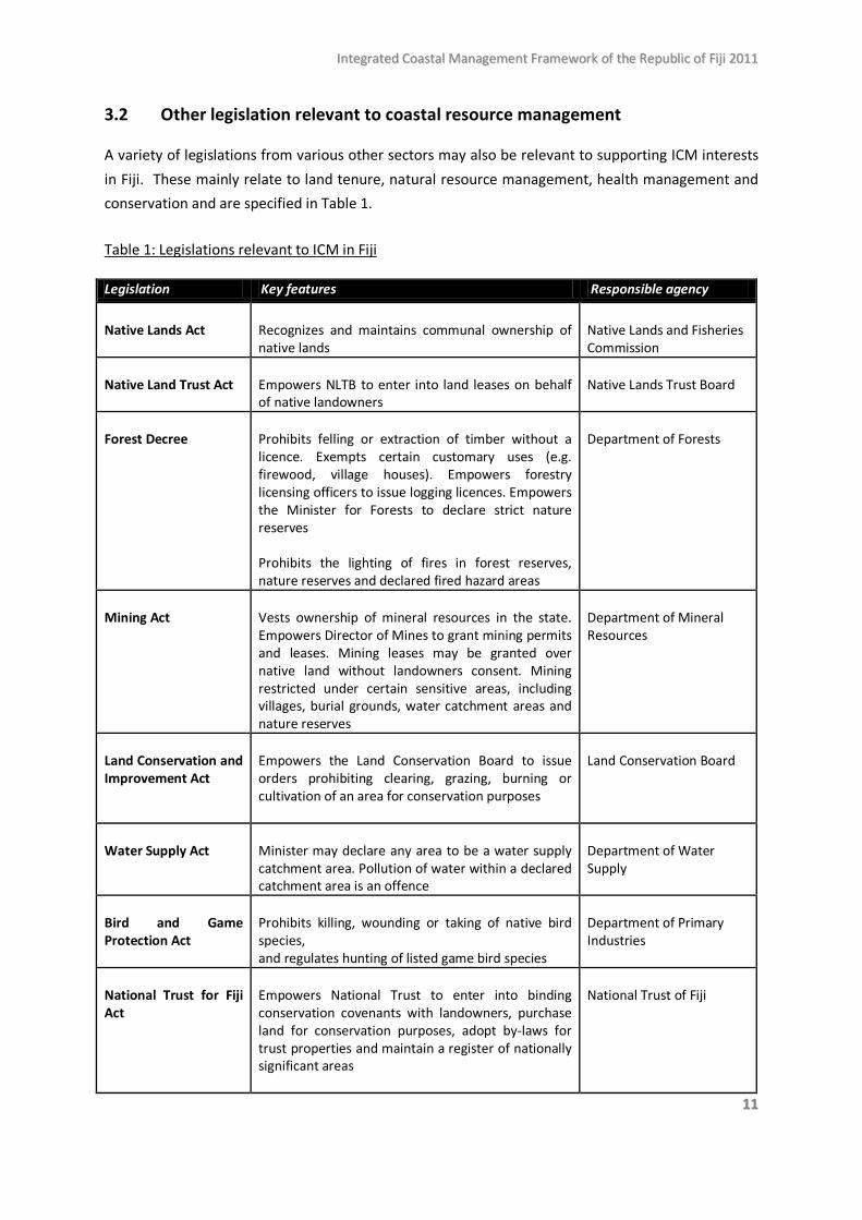
3.2 Other legislation relevant to coastal resource management A variety of legislations from various other sectors may also be relevant to supporting ICM interests in Fiji. These mainly relate to land tenure, natural resource management, health management and conservation and are specified in Table 1.
Table 1: Legislations relevant to ICM in Fiji
Legislation Key features Responsible agency
Native Lands Act
Recognizes and maintains communal ownership of native lands
Native Lands and Fisheries Commission
Native Land Trust Act
Empowers NLTB to enter into land leases on behalf of native landowners
Native Lands Trust Board
Forest Decree
Prohibits felling or extraction of timber without a licence. Exempts certain customary uses (e.g. firewood, village houses). Empowers forestry licensing officers to issue logging licences. Empowers the Minister for Forests to declare strict nature reserves Prohibits the lighting of fires in forest reserves, nature reserves and declared fired hazard areas
Department of Forests
Mining Act
Vests ownership of mineral resources in the state. Empowers Director of Mines to grant mining permits and leases. Mining leases may be granted over native land without landowners consent. Mining restricted under certain sensitive areas, including villages, burial grounds, water catchment areas and nature reserves
Department of Mineral Resources
Land Conservation and Improvement Act
Empowers the Land Conservation Board to issue orders prohibiting clearing, grazing, burning or cultivation of an area for conservation purposes
Land Conservation Board
Water Supply Act
Minister may declare any area to be a water supply catchment area. Pollution of water within a declared catchment area is an offence
Department of Water Supply
Bird and Game Protection Act
Prohibits killing, wounding or taking of native bird species, and regulates hunting of listed game bird species
Department of Primary Industries
National Trust for Fiji Act
Empowers National Trust to enter into binding conservation covenants with landowners, purchase land for conservation purposes, adopt by-laws for trust properties and maintain a register of nationally significant areas
National Trust of Fiji
IInntteeggrraatteedd CCooaassttaall MMaannaaggeemmeenntt FFrraammeewwoorrkk ooff tthhee RReeppuubblliicc ooff FFiijjii 22001111
1122
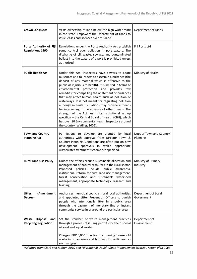
Crown Lands Act
Vests ownership of land below the high water mark in the state. Empowers the Department of Lands to issue leases and licences over this land
Department of Lands
Ports Authority of Fiji Regulations 1990
Regulations under the Ports Authority Act establish some control over pollution in port waters. The discharge of oil, waste, sewage, and contaminated ballast into the waters of a port is prohibited unless authorised.
Fiji Ports Ltd
Public Health Act
Under this Act, inspectors have powers to abate nuisances and to inspect to ascertain a nuisance (the deposit of any material which is offensive to the public or injurious to health). It is limited in terms of environmental protection and provides few remedies for compelling the abatement of nuisances that may affect human health such as pollution of waterways. It is not meant for regulating pollution although in limited situations may provide a means for intervening in the absence of other means. The strength of the Act lies in its institutional set up specifically the Central Board of Health (CBH), which has over 80 Environmental Health Inspectors around the country (Watling, 2005).
Ministry of Health
Town and Country Planning Act
Permissions to develop are granted by local authorities with approval from Director Town & Country Planning. Conditions are often put on new development approvals in which appropriate wastewater treatment systems are specified.
Dept of Town and Country Planning
Rural Land Use Policy
Guides the efforts around sustainable allocation and management of natural resources in the rural sector. Proposed policies include public awareness, institutional reform for rural land use management, forest conservation and sustainable watershed management, appropriate technology, research and training
Ministry of Primary Industry
Litter (Amendment Decree)
Authorises municipal councils, rural local authorities and appointed Litter Prevention Officers to punish people who intentionally litter in a public area through the payment of monetary fine or instant community service in or around the particular area.
Department of Local Government
Waste Disposal and Recycling Regulation
Set the standard of waste management practices through a process of issuing permits for the disposal of solid and liquid waste. Charges FJD10,000 fine for the burning household waste in urban areas and burning of specific wastes such as tyres.
Department of Environment
(Adapted from Clark and Jupiter, 2010 and Fiji National Liquid Waste Management Strategy Action Plan 2006)
IInntteeggrraatteedd CCooaassttaall MMaannaaggeemmeenntt FFrraammeewwoorrkk ooff tthhee RReeppuubblliicc ooff FFiijjii 22001111
1133
3.3 Key international arrangements related to ICM 3.3.1 Convention on Biological Diversity (CBD) Fiji has been party to the CBD since 1992. The CBD largely concerns the conservation and sustainable use of bio-diversity as well as the “fair and equitable sharing of the benefits arising out of the utilisation of genetic resources”. It also suggests ICM as a best practice approach to managing coastal resources. A National Biodiversity Strategy Action Plan (NBSAP) was completed and endorsed by Cabinet in 2003 as required under Article 6 of the CBD. The NBSAP was compiled by a steering committee comprised of the Departments of Environment (Chair), Forestry, Agriculture, Fisheries, National Trust of Fiji, the Fijian Affairs Board, NLTB, USP and various Fiji-based NGOs. Objective 1.4 of the NBSAP is concerned with minimising the loss of marine resources of importance to local communities of which specified actions include:
• Documentation of `tabu’ and other traditional conservation and protection measures of marine resources;
• Raise community awareness on the destructive influences of land-based activities such as unsustainable harvesting on aquatic biodiversity;
• Enact regulations to provide for consultation and majority agreement of traditional fishing rights communities prior to the issue of an IDA (Inside Demarcated Area) resource use licence;
• Encourage and assist traditional fishing rights communities to actively manage their qoliqoli and to establish or reinforce protected areas, through appropriate traditional conservation methods.
3.3.2 Convention on Wetlands (Ramsar Convention) More commonly known as the Ramsar (where the Convention was signed), the Convention on Wetlands entered into force in Fiji in 2006. Ramsar parties are also called upon to recognise the key ecological functions of wetlands including flood control, nutrient recycling, and habitat for migratory wildlife and fisheries. The general aim of the Ramsar Convention is to develop national policies to decrease wetland losses and recognise the ecological importance of migratory and seasonal movements of waterfowl. Fiji’s only official Wetland of International Importance (or Ramsar site) is 615 hectares of the Upper Navua Gorge.
IInntteeggrraatteedd CCooaassttaall MMaannaaggeemmeenntt FFrraammeewwoorrkk ooff tthhee RReeppuubblliicc ooff FFiijjii 22001111
1144
A substantial part of the coastal zone falls within the Ramsar Convention’s definition of wetlands, so carrying out commitments to the convention would be in line with the national ICM vision.
3.3.3 Convention on International Trade in Endangered Species of Wild Fauna and Flora
(CITES)
CITES came into force in Fiji in 1997 and it aims to monitor and control the trade of wild flora and fauna that are in danger of extinction. Article 8 of the convention requires parties to submit reports containing the details of traded species, permits granted and quantities and types of species traded, as well as reports on policy measures taken to enforce the convention. Fiji has submitted several of these reports between 2000 and 2006 (Kailola et al. 2008). 3.3.4 Cartegena Protocol on Biosafety
Fiji became a party to the Cartegena Protocol in May 2001. The protocol aims to protect Fiji’s biodiversity by setting up controlled measures in the transfer and handling of living modified organisms (LMOs) resulting from modern biotechnology. The national biosafety sub-committee includes the Ministries of Justice, Agriculture (Biosecurity Authority of Fiji Islands) and Health as well as the Customs Authority and Consumer Council of Fiji. As an outcome of this convention, Fiji now has its first Biosafety Clearing House
Fiji became a party to the Cartegena Protocol in May 2001. The protocol aims to protect Fiji’s biodiversity by setting up controlled measures in the transfer and handling of living modified organisms (LMOs) resulting from modern biotechnology. The national biosafety sub-committee includes the Ministries of Justice, Agriculture (Biosecurity Authority of Fiji Islands) and Health as well as the Customs Authority and Consumer Council of Fiji. As an outcome of this convention, Fiji now has its first Biosafety Clearing House.
3.3.5 Stockholm Convention on Persistent Organic Pollutants (POPs)
Fiji ratified the POPs convention in 2004. The convention aims to protect human health and the environment from the effects of POPs by reducing and eliminating POPs release from emissions (dioxins) and properly managing stockpiles of POPs waste. Fiji submitted a report for this convention in 2006.
3.3.6 United Nations Framework Convention on Climate Change (UNFCCC)
Fiji ratified the UNFCCC in 1997. Article 4 of the UNFCCC states parties are required to “develop plans for coastal zone management”.
IInntteeggrraatteedd CCooaassttaall MMaannaaggeemmeenntt FFrraammeewwoorrkk ooff tthhee RReeppuubblliicc ooff FFiijjii 22001111
1155
3.4 Customary Resource Management Regime The concept of Vanua (literally land) is a pre-colonial and well-established indigenous development model based on the interdependence between the natural environment, social and cultural systems “and the various other institutions established for the sake of achieving harmony, solidarity and prosperity within a particular social context” (Ravuvu 1983:70).
3.4.1 Land tenure
Fiji’s resource owners (i Taukei communities) are central to any pursuit to achieve ICM in Fiji. The i Taukei customary laws and practices are founded on the concept of vanua. The importance of the i Taukei local communities to ICM is seen in the highly decentralised nature of natural resource governance in Fiji. Over 80 per cent of land in Fiji is communally owned by the i Taukei under the Native Lands Act and almost all fishing grounds or i qoliqoli have been “registered and demarcated to reflect user rights” under the Fisheries Act (Fa’asili et al., 2002). The administration of natural resource use, however, is carried out by the Native Land Trust Board (NLTB) and the Native Fisheries Commission (NFC) (Evans 2006). Hence, apart from the resource owners themselves, the NLTB and the NFC are also key stakeholders in coastal resource governance. While the NLTB land use approach is largely development oriented, landowner consent to land-use is essential and leases and licenses granted are subject to the EMA and EIA process (Alley et al., 2009). NLTB’s role in granting leases and licences also makes it a key institution in managing coastal activities. It has the power to determine which coastal developments can occur (especially for tourism), who gets approval to log and the condition of agricultural leases on native land. NLTB’s leasing conditions for agricultural purposes explicitly states that “the tenant shall farm and manage the land in such a manner as to preserve the fertility and keep it in good condition”. A recent Land Use Decree established a “Land Use Bank” to facilitate the efficient leasing of lands which are currently idle and under-utilized. Terms and conditions under this decree are intended to supplement NLTB’s role as third party between landowners and potential tenants, although the benefits of this new system to landowners are yet to be seen. 3.4.2 Marine tenure
A traditional system of marine tenure consisting of i qoliqoli (traditional fishing grounds) belonging to adjacent communities is long-established and has some legal recognition officially referred to as “customary fishing rights” under the current Fisheries Act (Aalbersberg et al. 2005). The Native Fisheries Commission maintains a record of the mapped and delineated boundary lines of the 385 marine and 25 freshwater i qoliqoli areas of which about 300,000 Taukei villagers rely on for their livelihood (Aalbersberg et al 2005; Clarke and Jupiter 2010). While the existing Fisheries Act does not recognise the right of customary owners to enforce restrictions on subsistence fishing marine management areas such as tabu areas (Clark and Jupiter 2010) it is possible that this provision will
IInntteeggrraatteedd CCooaassttaall MMaannaaggeemmeenntt FFrraammeewwoorrkk ooff tthhee RReeppuubblliicc ooff FFiijjii 22001111
1166
be made in the current review of the Act (Comely pers. com. 2011). Customary practices of i qoliqoli management include temporary closures of certain fishery zones, limitations on the number of fishers licenses issued, limitations and the amount of fish to be harvested, restrictions on fishing practices, harvesting of certain species, and moratoria on fishing to observe significant events such as the passing of a high chief (Aalbersberg et al. 2005). While there has been a revival of traditional fisheries management systems and significant numbers of “tabu” areas established by adjacent i Taukei communities, effectively managing these have been constrained by their informal status. 3.4.3 Provincial Councils
The Fijian Affairs Act “regulates Fijian affairs by way of establishing institutions and their powers and jurisdictions” (Alley et al). I Taukei communities or villages in Fiji’s 14 provinces are governed by the Fijian Affairs Act and this means that the Local Government Act that sets standards on environmental and health practices do not apply. Nevertheless, Provincial Councils, established under the Fijian Affairs Act, may develop by-laws for the health, welfare and good government of their province which can be utilised for implementing ICM in Fiji. 3.4.4 Village and Tikina based resource management Over the past two decades, many Fijian villages have, to varying levels, developed their own sustainable resource management plans that are in line with ICM principles with the help of various external agents. Much of this effort has been effectively driven at the Tikina (district) level. The Fiji Locally Managed Marine Areas (FLMMA) Network is a prime example of bottom-up approach to managing coastal resources sustainably through partnership and co-learning between village communities and external governmental, non-government and research institutions (Aalbersberg et al 2005; Aalbersberg and Thaman 2004). Today about 250 of Fiji’s 410 qoliqoli (traditional fishing grounds) are established locally managed marine areas making up 10,745 sq. km (about a third) of the national inshore waters (LMMA Network, 2010). Further studies have found that coastal communities tend to observe customary marine management practices more than national fisheries regulation (Teh at el. 2009). Such community-based resource management approaches are also extending inland where an ICM pilot project and several “Ridge to Reef” projects are being effectively carried in the provinces of Nadroga, Kadavu, Bua, Macuata and Ra. The development of local management plans that reflect ICM principles indicates that local villages, in partnership with NGOs and various government ministries, are already establishing ICM practices at the local level. The next step would be to upscale these resource management approaches to the national level as exemplified by the adaptation of the Fisheries Act whereby community management plans may soon be recognised as part of the national fisheries management plan in a new Inshore Fisheries Decree. The progress in local or village level efforts towards sustainably managing their coastal resources and the historical and structural factors that support this system of natural resource governance presents opportunities that clearly should be fully utilised and further developed for the purpose of ICM planning in Fiji.
IInntteeggrraatteedd CCooaassttaall MMaannaaggeemmeenntt FFrraammeewwoorrkk ooff tthhee RReeppuubblliicc ooff FFiijjii 22001111
1177
3.5 Resource management zones
The Fiji ICM Plan is expected to develop policies and standards that will establish conditions or restrictions on various parts of the coastal zone, as well as facilitate development in other parts. The demarcation of zones based on the national ICM vision and its effective administration should facilitate coastal management decision-making and processes. Therefore, the current zoning structure that governs development and natural resource extraction activities will first be assessed in order to identify gaps, opportunities and resources necessary for nation-wide zoning that is consistent with ICM goals.
3.5.1 Formalised zones
Fiji has a National Landuse Policy and a National Integrated Landuse Plan is currently in the process of being formulated through the National Landuse Policy Steering Committee coordinated by the National Planning Office. The national landuse plan is expected to contain the following elements:
• information and ‘tools’ for efficient approaches to the generation, collation and interpretation of land resources data for land use planning purposes.
• the overdue landuse zoning of the agricultural sector which is a critical requirement given that various industrial, commercial, residential and other developments are occupying large tracts of valuable agricultural land
• Collation and standardisation of landuse related information held and to be gathered by various agencies.
However, in the absence of a national landuse plan, the Department of Town and Country Planning (DTCP) administers development proposals in coastal zones above the HWM, while a foreshore lease regulated by the Department of Lands is required for seaward development.
Above HWM: DTCP planning comprises two key aspects. Forward planning entails goal-setting, allocating land according to best possible use and developing guidelines that ensures land-use activities are in line with the established goals. Development control is the management of the magnitude and type of expansion that occurs in planning areas. Most development is controlled by locally-based zoning and development provisions, such as Town Planning Schemes, and various other master plans developed by urban municipal councils, NLTB and other authorities. The schemes and master plans determine the type of development appropriate for each zone and the standards and guidelines to be complied with. Only a very small portion of Fiji’s land area is currently covered by an authorised planning scheme or master plan. All of Fiji’s ten towns and two cities are located on the coast and have a town planning scheme – except for the recently declared towns of Nasinu and Rakiraki which are still in the process of drawing up plans. Some growth areas outside the town boundaries are
IInntteeggrraatteedd CCooaassttaall MMaannaaggeemmeenntt FFrraammeewwoorrkk ooff tthhee RReeppuubblliicc ooff FFiijjii 22001111
1188
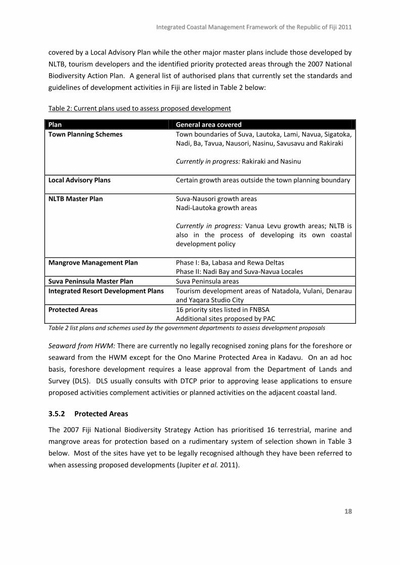
covered by a Local Advisory Plan while the other major master plans include those developed by NLTB, tourism developers and the identified priority protected areas through the 2007 National Biodiversity Action Plan. A general list of authorised plans that currently set the standards and guidelines of development activities in Fiji are listed in Table 2 below:
Table 2: Current plans used to assess proposed development
Plan General area covered Town Planning Schemes Town boundaries of Suva, Lautoka, Lami, Navua, Sigatoka,
Nadi, Ba, Tavua, Nausori, Nasinu, Savusavu and Rakiraki Currently in progress: Rakiraki and Nasinu
Local Advisory Plans
Certain growth areas outside the town planning boundary
NLTB Master Plan Suva-Nausori growth areas Nadi-Lautoka growth areas Currently in progress: Vanua Levu growth areas; NLTB is also in the process of developing its own coastal development policy
Mangrove Management Plan Phase I: Ba, Labasa and Rewa Deltas Phase II: Nadi Bay and Suva-Navua Locales
Suva Peninsula Master Plan Suva Peninsula areas Integrated Resort Development Plans Tourism development areas of Natadola, Vulani, Denarau
and Yaqara Studio City Protected Areas 16 priority sites listed in FNBSA
Additional sites proposed by PAC Table 2 list plans and schemes used by the government departments to assess development proposals Seaward from HWM: There are currently no legally recognised zoning plans for the foreshore or seaward from the HWM except for the Ono Marine Protected Area in Kadavu. On an ad hoc basis, foreshore development requires a lease approval from the Department of Lands and Survey (DLS). DLS usually consults with DTCP prior to approving lease applications to ensure proposed activities complement activities or planned activities on the adjacent coastal land. 3.5.2 Protected Areas
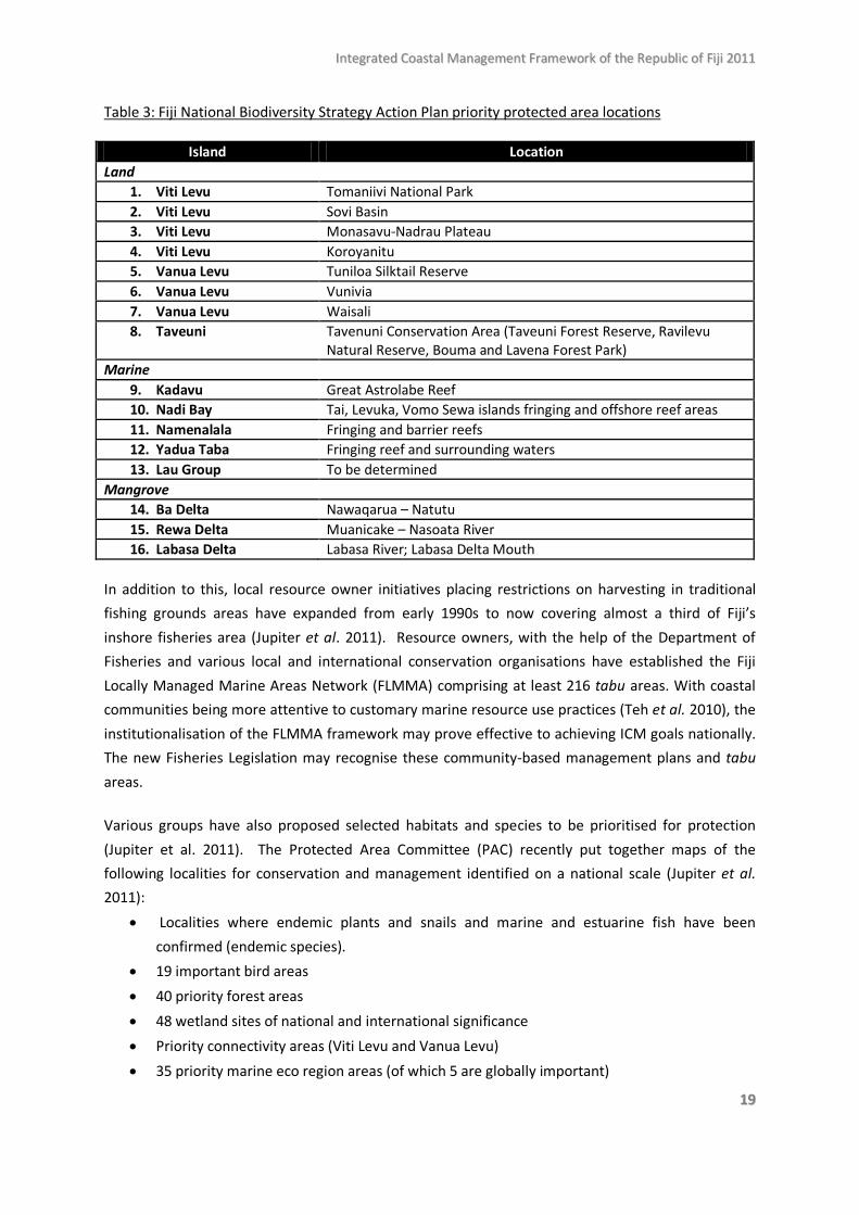
The 2007 Fiji National Biodiversity Strategy Action has prioritised 16 terrestrial, marine and mangrove areas for protection based on a rudimentary system of selection shown in Table 3 below. Most of the sites have yet to be legally recognised although they have been referred to when assessing proposed developments (Jupiter et al. 2011).
IInntteeggrraatteedd CCooaassttaall MMaannaaggeemmeenntt FFrraammeewwoorrkk ooff tthhee RReeppuubblliicc ooff FFiijjii 22001111
1199
Table 3: Fiji National Biodiversity Strategy Action Plan priority protected area locations
Island Location Land
1. Viti Levu Tomaniivi National Park 2. Viti Levu Sovi Basin 3. Viti Levu Monasavu-Nadrau Plateau 4. Viti Levu Koroyanitu 5. Vanua Levu Tuniloa Silktail Reserve 6. Vanua Levu Vunivia 7. Vanua Levu Waisali 8. Taveuni Tavenuni Conservation Area (Taveuni Forest Reserve, Ravilevu
Natural Reserve, Bouma and Lavena Forest Park) Marine
9. Kadavu Great Astrolabe Reef 10. Nadi Bay Tai, Levuka, Vomo Sewa islands fringing and offshore reef areas 11. Namenalala Fringing and barrier reefs 12. Yadua Taba Fringing reef and surrounding waters 13. Lau Group To be determined
Mangrove 14. Ba Delta Nawaqarua – Natutu 15. Rewa Delta Muanicake – Nasoata River 16. Labasa Delta Labasa River; Labasa Delta Mouth
In addition to this, local resource owner initiatives placing restrictions on harvesting in traditional fishing grounds areas have expanded from early 1990s to now covering almost a third of Fiji’s inshore fisheries area (Jupiter et al. 2011). Resource owners, with the help of the Department of Fisheries and various local and international conservation organisations have established the Fiji Locally Managed Marine Areas Network (FLMMA) comprising at least 216 tabu areas. With coastal communities being more attentive to customary marine resource use practices (Teh et al. 2010), the institutionalisation of the FLMMA framework may prove effective to achieving ICM goals nationally. The new Fisheries Legislation may recognise these community-based management plans and tabu areas. Various groups have also proposed selected habitats and species to be prioritised for protection (Jupiter et al. 2011). The Protected Area Committee (PAC) recently put together maps of the following localities for conservation and management identified on a national scale (Jupiter et al. 2011):
• Localities where endemic plants and snails and marine and estuarine fish have been confirmed (endemic species).
• 19 important bird areas • 40 priority forest areas • 48 wetland sites of national and international significance • Priority connectivity areas (Viti Levu and Vanua Levu) • 35 priority marine eco region areas (of which 5 are globally important)
IInntteeggrraatteedd CCooaassttaall MMaannaaggeemmeenntt FFrraammeewwoorrkk ooff tthhee RReeppuubblliicc ooff FFiijjii 22001111
2200
Through a facilitated workshop, provincial administrators further identified sites of significance for conservation and management for each of Fiji’s 14 provinces. The PAC is currently working towards facilitating the effective management of the above sites through collaboration with resource owning communities, government and other local and overseas agencies (Jupiter et al., 2010). The identified sites may be useful for initiating dialogue with stakeholders in developing ICM plans at the provincial level. 3.5.3 Important archeological sites Fiji has an interesting history that is worth preserving for future generations as well as to increase its value as a tourist destination. Recently, several villages on the Coral Coast have restored areas of archeological importance and integrated an archeological visit into their eco-tourism programme. Such initiatives have had a positive impact on both the communities and tourists and more villages around the country have expressed interest in restoring areas of historical importance to them. This work is currently being carried out by the Fiji Museum and the I Taukei Affairs Ministry. Although at its early stages, the recognition of important archeological sites should certainly be included in national ICM planning. The National Trust of Fiji also has a list of important cultural and historical sites of which the main ones include: Borron House in Suva City; Momi Gun Battery in the the Nadroga Province; Morris Hedstrom Store on Levuka Island; and the Laucala Ring in Laucala Beach Estate, Suva. 3.5.4 Zoning for ICM The above mentioned plans, schemes and areas of interest are linked to distinct groups of stakeholders with various interests and intentions and an essential component of ICM planning would be to consolidate these “mapped” interests and intentions. Indeed, such a process would have to be linked to the national landuse planning process given the importance of sustainable watershed management to the health of coastal ecosystems. A sustainable and relevant ICM plan will be one for which most if not all stakeholders share a sense of ownership. Given the competing stakeholder interest and scientific uncertainties that are likely to affect such a process, it may be more effective to approach the ICM planning process on a provincial basis.
RECOMMENDATION 2: Develop ICM plans at the provincial levels which when considered together will suggest the make-up of the National ICM Plan. It is assumed that the ICM plans at the provincial level would include a mangrove management plan as well as a coastal sensitivity atlas for disaster response planning and management.
IInntteeggrraatteedd CCooaassttaall MMaannaaggeemmeenntt FFrraammeewwoorrkk ooff tthhee RReeppuubblliicc ooff FFiijjii 22001111
2211
3.7 Legal and institutional arrangements for ICM While the development of an ICM plan is clearly stipulated in the 2005 EMA, the current legal and institutional framework remains limited in terms of fully implementing ICM nationally. Policy fragmentation has been identified as a major barrier to achieving ICM in Fiji (Thaman and Aalbersberg 2004; Alley et al., 2009) and is evident through the following:
No central body responsible for coordinating inter-sectoral development and resource management planning.
Resource management related legislation that is out of date and does not make reference to the 2005 EMA or to ICM issues (Forestry, Lands, Fisheries, Rivers and Streams Acts).
Mangroves are referred to in several pieces legislation (Fisheries and Land Acts and Forest Decree), although none of the departments are responsible for their sustainable management.
Pollution is covered by several acts (Public Health Act, EMA Waste, Disposal and Recycling Regulations and the Marine Pollution Regulation), which are inconsistent with each other
Such policy fragmentation implies the inability of government departments to manage resources in a way that maximises benefits of collaborating with other government departments, as well as the wider ecological and social network (Lane 2006).
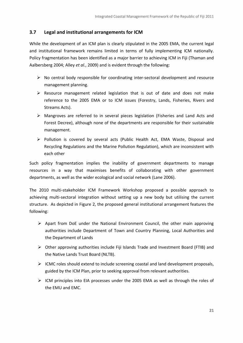
The 2010 multi-stakeholder ICM Framework Workshop proposed a possible approach to achieving multi-sectoral integration without setting up a new body but utilising the current structure. As depicted in Figure 2, the proposed general institutional arrangement features the following:
Apart from DoE under the National Environment Council, the other main approving authorities include Department of Town and Country Planning, Local Authorities and the Department of Lands
Other approving authorities include Fiji Islands Trade and Investment Board (FTIB) and the Native Lands Trust Board (NLTB).
ICMC roles should extend to include screening coastal and land development proposals, guided by the ICM Plan, prior to seeking approval from relevant authorities.
ICM principles into EIA processes under the 2005 EMA as well as through the roles of the EMU and EMC.
IInntteeggrraatteedd CCooaassttaall MMaannaaggeemmeenntt FFrraammeewwoorrkk ooff tthhee RReeppuubblliicc ooff FFiijjii 22001111
2222
Figure 2: Proposed institutional arrangement for ICM
RECOMMENDATION 3: Determine a relevant legal and institutional framework to effectively support Fiji’s ICM vision. Part of this includes determining which regulations under which Acts take precedence when in conflict.
RECOMMENDATION 4: To achieve multi-sectoral integration, a coastal commission (perhaps the NEC sub-committee) will need to play a greater role in decision-making. Its exact powers will need to be determined.
Application – Fiji Island Trade & Investment Bureau/Native Lands Trust Board(Seek all approving agencies advise: Advisory & Facilitation/Prior to issuance of FIRC and leases)
Department of Lands – (Foreshore
lease)
Local Authority –Outside town(Development
approval)
Department of Town Planning – Town
areas(Development
Approval)
National Environment Council – Environment Management Act 2005
Integrated Coastal
management Committee
(legal status)
ICM PlanMangrove
Management Plan
DoFi, DoFo, DoE, MRD, Health, NGOs, Institutions
EIA
(EMA 2005)EMU/EMC
(EMA 2005)
IInntteeggrraatteedd CCooaassttaall MMaannaaggeemmeenntt FFrraammeewwoorrkk ooff tthhee RReeppuubblliicc ooff FFiijjii 22001111
2233
4.0 Current coastal conditions 4.1 Coastal stability Coastal erosion has become significantly more evident in Fiji in the past 50 years (Mimura and Nunn 1998), and very little is known about the rates of erosion and the effectiveness of activities attempting to stabilise shoreline and beaches although a 1998 study quoted an annual loss of 21 million tons in the four major watersheds of Viti Levu – Rewa (9.3 million ton/year), Ba (6.4), Sigatoka (1.1) and Nadi (4.2) (JICA 1998). Nevertheless, several reports have documented the problem at a localised level, which is caused by natural processes as well as human activities (Mimura and Nunn 1998; Thaman et al. 2005; Tokalauvere 2007; Webb 2007; Vanualailai 2004). The southern coasts of most parts of Fiji would be considered less stable due to dominant wind direction enhancing wave and storm impact (Tawake 2010 pers. com.). The clearing of mangroves and coastal vegetation exacerbates coastal erosion as they play a key role in protecting the coast (Mimura and Nunn 1998). Another common problem is that people build their home and villages too close to the shore or coastal bank making them more vulnerable to the coastal changes that occur be it natural or human induced. The continuation of large-scale tourism development and urban expansion is also concerning, particularly when landscapes are changed substantially such as when mangroves are cut down at a large scale and reclaimed (Fiji Ministry of Tourism, 2006). Rising sea levels due to climate change is expected to further increase the difficulty of dealing with this problem and so it is even more pressing that domestic activities are managed so as to reduce the human-induced damage to Fiji’s coastal areas.
4.2 Water quality
Coastal waters such as those adjacent to the main urban centres of Suva, Nadi, Lautoka and Labasa are significantly more polluted than other parts of Fiji due to poor wastewater management systems in Fiji. Sources of wastewater deposits to coastal waters include toilets, industrial facilities, shipping related activities and urban storm water. Sewage waste yielding high concentrations of nutrients and micro-organisms in populated coastal areas appears to be the main concern both in urban and rural areas. Nitrate concentrations in nearshore waters around Fiji’s capital, Suva, have been recorded to be significantly enriched over the past 25 years (Fiji Department of Environment 2006). Fiji’s expanding tourism industry is also a main coastal pollution source given the generally low standards of effluent treatment facilities in existence (IAS 2004). Algal growth and the degradation of the coral reef environment has been linked to high nutrient levels from household and piggery sewage waste in rural coastal areas where wastewater is often directly released to nearby waters without any form of treatment (Mosley and Aalbersberg 2003). Squatter settlements in urban areas are rapidly increasing in urban centres developing in flood plains and mangrove areas (Lal et al. 2009), with limited access to basic facilities so waste is often deposited directly to adjacent waters. Several other forms of land-based pollution continue to compromise the quality of coastal waters. Metal contamination is also of concern, although these are isolated to “hot spots” near industrial
IInntteeggrraatteedd CCooaassttaall MMaannaaggeemmeenntt FFrraammeewwoorrkk ooff tthhee RReeppuubblliicc ooff FFiijjii 22001111
2244
facilities (Fiji Department of Environment 2006) and downstream from mining sites. The previously unregulated use of tributyl tin (TBT) and uncontrolled activities in shipyards are also linked to the extremely high levels of TBT concentrations in sediments and mangrove oysters in marine areas near slipways and boatyards (Fiji Department of Environment 2006). Significant changes in upstream land use trends over the past four decades in which forests have been cleared to accommodate agricultural, forestry and residential development has led to increasing rates of erosion and siltation and, in particular, high turbidity during heavy rains at coastal water close to river mouths. With the expanding urban population and industrial development as well changing land-use patterns upstream, it is obvious that water quality in coastal areas will continue to be compromised in the future unless adequate legislative, technological and educational measures are put in place.
4.3 Coastal quality
Beach pollution from carelessly dumped rubbish, makeshift garbage sea walls and human and animal waste, especially in urban centres, seriously compromises the quality of coastal areas. The serious lack of civic and corporate responsibility, coupled with limited garbage collection services, has contributed to litter covering beaches and coasts. Approximately half of the country’s population is serviced by municipal garbage collection services, with those excluded comprising of most rural, peri-urban and squatter settlements (Fiji Department of Environment 2005). Hence a significant amount of waste is dumped in rivers, streams and mangrove areas eventually to be carried and deposited on beaches. The many community initiated ‘clean-up’ activities and newly introduced litter legislation have not been able to reduce the problem and are limited in promoting waste separation and recycling which are more sustainable solutions to the current problem (Fiji Department of Environment 2005). There is clearly a need for stronger enforcement of currently relevant legislations such as the Litter Decree and the Waste Disposal and Recycling Regulation as well the development of more comprehensive legislation includes provisions for separation and recycling, minimisations and landfill site selection and management. 4.4 Coral reef health
Fiji’s reefs, combined, covers a total area of 6,704km² or three per cent of the of the world’s reefs (Burke et al., 2011). Coral reefs are the main source of protein diet and income for much of Fiji’s rural population and so their good health and ability to sustain marine resource dependent communities is of key concern. Fiji has around a thousand coral reefs that are less than 10,000 years old covering of which there are four types (Fiji Department of Environment 2007). Fringing reefs encircle most all high islands; barrier reefs form at the edge of island shelves; platform reefs lie in shallow island shelves; and several atolls and near atolls can be found in the eastern part of the Fiji (Fiji Department of Environment 2007).
The health of coral reefs in Fiji varies according to depth and location. The World Resources Institute recently categorised Fiji among the world’s nine countries most vulnerable to the effects of reef degradation given its high exposure to threats and dependence as a livelihood source (Burke et al.
IInntteeggrraatteedd CCooaassttaall MMaannaaggeemmeenntt FFrraammeewwoorrkk ooff tthhee RReeppuubblliicc ooff FFiijjii 22001111
2255
2011). A 2007 study showed that coral cover in Savusavu, Suva Harbour, Namena, South Kadavu, the Vatu-i-Ra passage, and Rotuma were relatively high (ranging from over 50 per cent cover) while the lowest was recorded in the Coral Coast of Viti Levu and Gau island (Sykes 2007). Fiji’s coral reefs have also generally shown relatively high levels of resilience by recovering from the 2000 and 2002 coral bleaching events caused by sustained periods of elevated sea surface temperatures. By 2007, coral cover was generally back to pre-2000 levels and in some areas higher (Sykes and Lovell 2008). Algae presence and isolation from unaffected areas (up-current and deeper reefs) appeared to hinder the recovery process (Sykes and Lovell 2008). While these studies indicate a level of confidence in the future health of Fiji’s coral reefs, further action is required to ensure such resilience in the face of further projected warming events and the continued release of land-based nutrients that can foster algal growth and increased survivorship of the larvae of crown-of-thorns (COTS) seastars (coral predators). Severe COTS outbreaks are periodically observed across Fiji and more recently threaten coral health in the Lomaiviti and Savusavu bay areas, as well as on Suva Reef (S. Jupiter, pers. comm.).
4.5 Mangrove health
Fiji’s mangrove cover was officially estimated at 45,288 hectares about three decades ago (Watling 1985) and no further systematic study has been carried to update this approximation. In light of the significant levels of activities since, in particular the clearing of mangrove areas to cater for urban expansion and tourism developments, there is an urgent need for research on the current status of Fiji’s mangroves. However, unofficial estimates of mangrove area losses are as high as 30 percent (Agrawal et al. 2003). Most of Fiji’s mangrove cover is found on the two main islands of Viti Levu and Vanua Levu with the three larger systems – Rewa, Ba and Labasa deltas – representing about 40 per cent of Fiji’s mangrove cover (Maharaj 2002). There are eight mangrove species in Fiji and a unique hybrid found only in Fiji, Tonga and New Caledonia (Watling 1985).
Mangroves play several key functions both ecologically and economically. The estimated value of ‘mangrove associated’ fisheries in 1983 was F$ 21.8 million - $F566/ha (Watling, 1985). Mangroves perform a coastal stabilisation role by trapping sediments which both controls the erosive action of waves and current as well as reduces silt loads that can potentially reach and kill coral reefs (Watling 1985). Mangroves also reduce the impact of waste water released into coastal waters by efficiently absorbing excess nutrients from treated sewage effluents (Fiji Department of Environment 2007). Mangroves also play a vital carbon sequestration role which contributes to climate change mitigation. These functions are particularly vital to the protection and sustainable management of coastal areas from the projected impacts of climate change and sea level rise.
However, Fiji’s mangroves are not sufficiently protected by law. Current mangrove management regulations are relatively weak and fragmented - divided between departments of Forestry, Lands, Fisheries and Environment. Mangroves are threatened by clearing for reclamation works, harvesting for firewood and building materials and excessive sediment discharge from unsustainable logging and agricultural practices upstream (Agrawal et al. 2003). A National Mangrove Plan was developed
IInntteeggrraatteedd CCooaassttaall MMaannaaggeemmeenntt FFrraammeewwoorrkk ooff tthhee RReeppuubblliicc ooff FFiijjii 22001111
2266
in 1986 but was not formalised by cabinet although it is often utilised by DTCP and other relevant government departments to assess development proposals. Nevertheless, the National Mangrove Sub-committee has pointed to the need for more immediate action to ensure:
• stricter licensing conditions for mangrove harvesting • control of mangrove harvesting • improved coordination between regulatory authorities • identification of sensitive areas for protection • design of buildings and structures that accommodates the natural processes of coastal
areas • a structure to retain the tie along the Nadi Bay is carried out given the diminishing areas of
entire mangrove forests in that region • EIA processes values the long-term economic and ecologic benefits of protecting mangroves
(how EIA fits in the approval process of cutting mangroves) (Fiji Department of Environment, 2010).
In recognition of the importance of and threats to Fiji’s mangroves, various organisations such as JICA, OISCA, WWF, USP, PCDF, FLMMA, Live and Learn Environment have initiated mangrove replanting projects as well as community-based mangrove protection plans over the past 20 years.
Addressing the above threats and opportunities along with the need to update the current status of mangroves from 30 years ago is indicative of the need for the development of a more recent mangrove management plan. Such a plan will essentially be a key component of the National ICM Plan. Further to this, given the role of mangroves in carbon sequestration, it should be incorporated into various initiatives and projects related to reducing emissions from deforestation and forest degradation (REDD) in Fiji.
4.6 Coastal littoral (strand) vegetation
Coastal littoral vegetation refers to vegetation growing on well-drained areas along the seashore above the high water mark (Thaman 2006). Littoral vegetation and mangroves together play a key ecological role in as the interface between the sea and land to stabilise the coastline, support terrestrial and marine plants and animals, and protect inland areas from the effects of saltwater (Thaman 2006). Most coastal vegetation also holds significant cultural value expressed in its use for medicines, garlands and traditional crafts (Thaman 1992). The clearing of coastal areas for development poses serious threats coastal vegetation. A study of Suva Lagoon found that coastal vegetation is almost absent in the area due to a relatively long history of urbanisation and expansion (Thaman 2006). The depletion of coastal littoral plants is even concerning for more isolated islands such as Rotuma where coastal forests have been cleared for housing and agriculture (Rigamoto and Tyagi 2005). Key threats to coastal vegetation nationally include:

IInntteeggrraatteedd CCooaassttaall MMaannaaggeemmeenntt FFrraammeewwoorrkk ooff tthhee RReeppuubblliicc ooff FFiijjii 22001111
2277
• Coastal clearing and reclamation • Unsustainable felling or plant removal • Invasive species
• Limited knowledge of coastal and littoral species (Thaman 2006).
The lack of knowledge and value of coastal littoral plants by people in general and coastal developers has lead to the poor and threatened state of this key part of Fiji’s coast and the incorporation of this issue into Fiji’s coastal planning process is vital.
4.7 Seagrass
Fiji’s seagrass meadows are located in intertidal and shallow sub-tidal parts of protected and soft shores (McKenzie and Yoshida 2007; NBSAP 2007). Of the five sea grass species present in Fiji, one is endemic to Fiji, Tonga and Samoa (McKenzie and Yoshida 2007). Seagrass is important to Fiji’s coast because they are highly productive biologically, efficiently recycle nutrients and supports a variety of marine life, for example, it has been estimate that 400 sq. metre of seagrass can support 2000 tonnes of fish annually (McKenzie and Yoshida 2007). Seagrass also play a very important carbon sequestration role and can be considered for Blue Carbon PES (payment for ecosystem services) initiatives (S. Jupiter, pers. comm.). It has also been suggested that Fiji’s extensive seagrass pasture may be used as foraging habitat for more than half of the adult green turtles in the central South Pacific (McKenzie and Yoshida 2007). The health and extent of Fiji’s seagrasses can be affected by the presence of sewage and other land-based wastewater pollutants, fisheries depletion, coral extraction, river siltation, coastal erosion, storm surges, floods and other natural disasters (McKenzie and Yoshida 2007). For example, previous studies by Vuki in 1994 linked seagrass meadow regressions in Suva’s back reef area to high turbidity and silt from land reclamation in the locality (McKenzie and Yoshida 2007).
4.8 Human vulnerability
Human vulnerability, in a socio-ecological context, refers to the potential for people and/or coastal communities to be negatively affected by social and environmental changes in the absence of adaptive capacity (McCarthy et al., 2001). Potential for loss is determined by exposure and sensitivity to perturbations and capacity to recover and adapt (Nelson et al. 2007; Barnett 2001). A person or a group of people’s adaptive capacity refers to their ability to act to reduce their vulnerability to social and environmental change and is usually dependent on access to income, knowledge, skills, technology, infrastructure and social networks (Barnett 2008). This implies that those at the margins of social and economic power are the most vulnerable because they often live in hazardous conditions and have less money and minimal political influence to cope with the impacts of environmental and social changes.
IInntteeggrraatteedd CCooaassttaall MMaannaaggeemmeenntt FFrraammeewwoorrkk ooff tthhee RReeppuubblliicc ooff FFiijjii 22001111
2288
While Fiji has achieved most of the Millennium Development Goals (MDG) targets with very high literacy rates (92.6%), attained universal primary education for boys and girls with declining and low child mortality rates (ADB 2003), about a third of the population continues to live below the basic needs poverty line of approximately $6,000 - $8,000 annually per household of four adults-equivalents. About 60 per cent of the poor are resource dependent for their income engaging in agriculture, fisheries and forestry (Lal 2008).
Due to their direct dependence on natural resources and limited access to basic services, the vulnerability of the rural population clearly contrasts that of the urban. About half of Fiji’s population is rural dwellers and 40 per cent of them live below the basic needs poverty line compared to 29 per cent of the urban population (Lal 2009). Only about 12 per cent have access to proper sanitation compared to 75 per cent in urban centres (ADB 2003). Rural peoples’ resource dependent economy makes them particularly exposed to the impacts of climate change and natural disasters such as cyclones, floods and storms and their limited income makes it difficult for them to recover from such events. The poverty cycle is further re-enforced with lower education quality and retention rates particularly in the outer islands (ADB 2003).
The significant increase of urban squatter settlements has emerged due to issues related to land tenure, poor access to services and low rural wages. The expiration of rural indo-Fijian agricultural leases has significantly contributed to this trend. With an annual 10 per cent increase is squatter population, today more than a tenth of Fiji’s people live in squatter or informal settlements and this figure continues to rise (Lal, 2008).
The impacts of such migration places significant pressure on coastal ecosystems as squatter communities are mainly located on flood plains or cleared mangrove areas which are vulnerable to floods and other hazards. The absence of basic services, in particular the adequate management of waste, means that large quantities of solid and liquid waste is continuously released into the coast on a regular basis. Inadequate water and sanitation standards and poor environmental quality means that both the poor are more exposed to various health hazards with limited resources to pay for medical care.
However, these generalized issues occur within a society that continues to demonstrate a high level of social resilience. Largely evident in the i Taukei culture, the sharing of resources and social influence between people of the same kin is evident in levels of financial remittance received from overseas to Fiji as well as from urban to rural. Such social resilience is also evident in the other cultures that exist in Fiji which is expressed in its own special way. Given the pressure posed by environmental, economic and social change, it is important to acknowledge the strengths of these social relationships and to build further on them.
IInntteeggrraatteedd CCooaassttaall MMaannaaggeemmeenntt FFrraammeewwoorrkk ooff tthhee RReeppuubblliicc ooff FFiijjii 22001111
2299
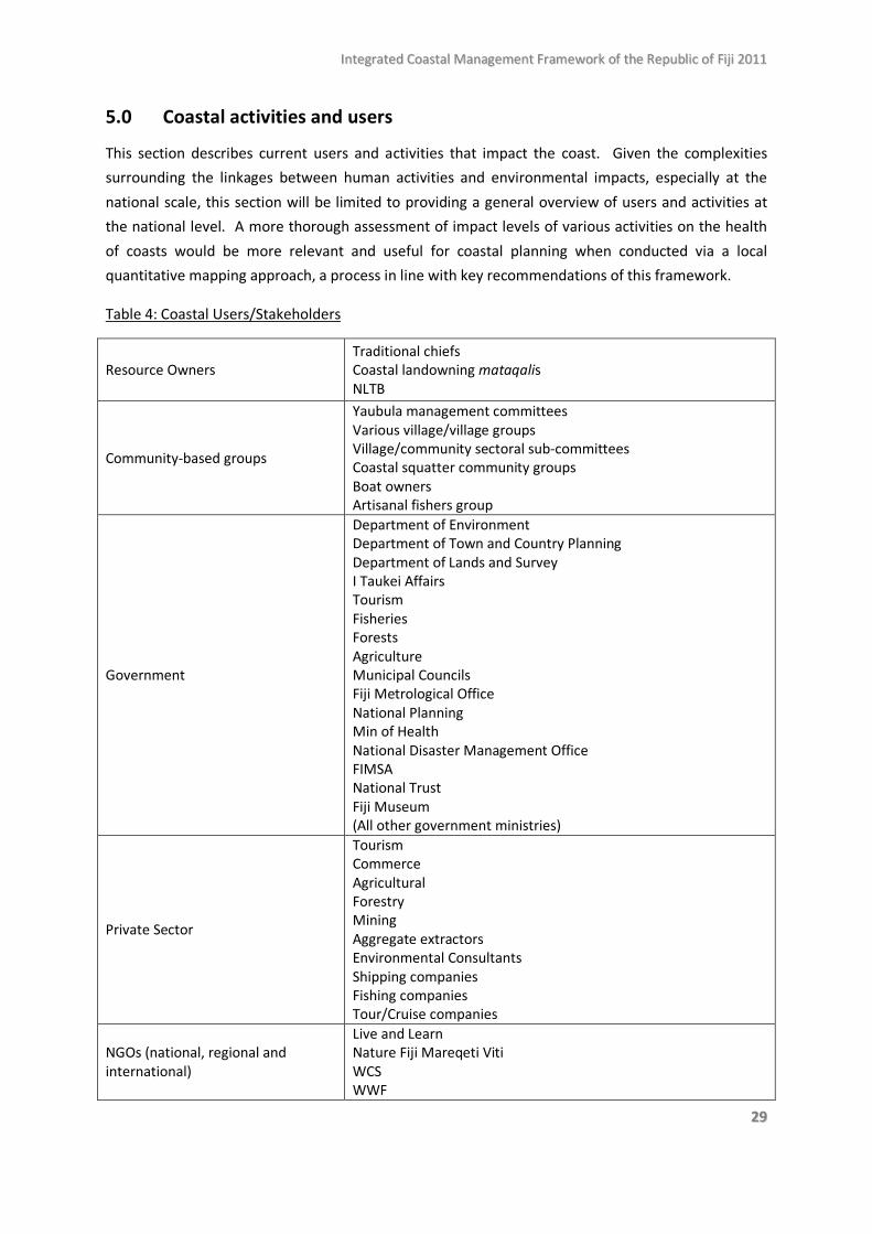
5.0 Coastal activities and users
This section describes current users and activities that impact the coast. Given the complexities surrounding the linkages between human activities and environmental impacts, especially at the national scale, this section will be limited to providing a general overview of users and activities at the national level. A more thorough assessment of impact levels of various activities on the health of coasts would be more relevant and useful for coastal planning when conducted via a local quantitative mapping approach, a process in line with key recommendations of this framework.
Table 4: Coastal Users/Stakeholders
Resource Owners Traditional chiefs Coastal landowning mataqalis NLTB
Community-based groups
Yaubula management committees Various village/village groups Village/community sectoral sub-committees Coastal squatter community groups Boat owners Artisanal fishers group
Government
Department of Environment Department of Town and Country Planning Department of Lands and Survey I Taukei Affairs Tourism Fisheries Forests Agriculture Municipal Councils Fiji Metrological Office National Planning Min of Health National Disaster Management Office FIMSA National Trust Fiji Museum (All other government ministries)
Private Sector
Tourism Commerce Agricultural Forestry Mining Aggregate extractors Environmental Consultants Shipping companies Fishing companies Tour/Cruise companies
NGOs (national, regional and international)
Live and Learn Nature Fiji Mareqeti Viti WCS WWF
IInntteeggrraatteedd CCooaassttaall MMaannaaggeemmeenntt FFrraammeewwoorrkk ooff tthhee RReeppuubblliicc ooff FFiijjii 22001111
3300
IAS IUCN Partners in Community Development FSPI Greenpeace Mamanuca Environment Society ECREA Save the Children
Other institutions
USP FNU FSM SOPAC SPREP UNDP SPC WHO World Banks ADB Overseas institutions
5.1 Coastal development
Pursuing ICM nationally is challenged by the complexities of ensuring that natural resource management decisions encompass a balance between development and conservation – a dilemma for policy makers due to the need to exploit natural resources for economic development (Fiji Department of Environment 2010). The health of Fiji’s coastal environment is impacted by a wide array of human activities on the coast as well as upstream. Well over 80 percent of the country’s population and nearly all its major income earning industries (tourism, sugar, and manufacturing) are located around coastal areas. Most coastal development initiatives in Fiji include tourism resort development, reclamation of mangrove areas and mudflats to accommodate urban expansion plans and tourism construction, river mouth dredging to reduce flood risks, beach mining and direct construction. These activities destroy mangrove and other sensitive coastal habitats, while run-off and sedimentation impacts threaten the health of seagrass and coral reefs which are critical to in-shore fisheries. Further, the expansion of agricultural activities, forest harvesting and mining industries also increases siltation and sedimentation that affect mangrove, seagrass and reef habitats. It is therefore evident that pursuing ICM effectively in Fiji will require building on innovative processes currently being implemented at various ridge-to-reef project sites that engage a wide cross section of stakeholders to support the implementation of existing relevant policies, as well as to committing to new initiatives required to balance development and conservation pursuits.
5.1.1 Residential and commercial construction
Construction in coastal areas is jointly governed by the Department of Land and Survey (DLS) who manages reclamation proposals and building in marine foreshore, and the Department of Town and Country (DTC), who manages development initiatives from the foreshore inland. However, DLS refers decisions back to DTC to ensure foreshore developments complement activities on adjacent coastal land. While the DoE is able to check on major environmental concerns through the EMA and
IInntteeggrraatteedd CCooaassttaall MMaannaaggeemmeenntt FFrraammeewwoorrkk ooff tthhee RReeppuubblliicc ooff FFiijjii 22001111
3311
EIA regulations, an improved system of governing coastal construction and development is required to ensure procedural efficiency and environmental sustainability. Additionally, with the growing rate of urbanisation experienced in Fiji in recent years, demand for land and housing has far exceeded the capacity of towns and cities, leading to the expansion of squatter settlements in marginal lands such as flood plains and illegally cleared mangrove areas (Lal 2009; Gravelle and Mimura 2008). The construction of roads, bridges, ports and major buildings in coastal areas has a tendency to modify nearshore bathymetry and water depth increasing the size of waves hitting the coastline (Maharaj 2002). This often results in the substantial erosion of shorelines and beaches as well as increases the vulnerability of human settlements and infrastructure (Maharaj 2002). The projected rising sea-levels of 20-100cm over the next century make people and infrastructure even more vulnerable to overtopping, erosion and technical malfunction during storms and cyclones (Maharaj 2002). Clearly, more foresight is required in the design, implementation and monitoring of coastal construction activities to reduce the vulnerability of coastal populations and valuable infrastructure.
5.1.2 Landfills and reclamation
Fiji’s land tenure system, mostly native owned, has contributed to the increase in reclamation, fill and development by the private sector development as a feasible means of acquiring land (Maharaj 2002). By 1984, up to 6 percent (2,500 ha) of Fiji’s mangrove cover had been cleared and reclaimed for sugar cultivation and construction (Watling 1985). The Lands Department is currently putting together a map showing foreshore developments. Illegal reclamation also occurs at local levels for house building (Watling 1985) and, recently, the issue has become more serious with high rural-urban migration resulting in the significant rise of squatter populations as the demand for affordable land and housing exceeds that which is available in urban centres (Lal 2009). Also, although not illegal, a substantial number of villages have been built on reclaimed land (Mimura and Nunn 1998). Reclaiming the coast for various economic activities may contribute to the short term economic development of Fiji, although the long-term ecological and economic costs could far outweigh its immediate benefits. Clearing large areas of mangrove for reclamation facilitates coastal erosion and the degradation of seagrass and reefs as mangroves play a key stabilising and sediment trapping function in the coastal environment. Also, fish populations the provide food and income for many resource dependent communities in Fiji rely on healthy mangrove and reef systems. Recognising the complexities of balancing development and conservation goals, it is imperative the Fiji ICM Plan sets clear guidelines for coastal reclamation given it serious implications on mangrove and other coastal ecosystems.
5.1.3 Coastal Protection Fiji’s natural coastal protection structures are mainly in the form of coral reefs, mangroves and coastal vegetation (Vanualailai 2004). A variety of artificial structures can also be found in Fiji today, ranging from more expensive and sophisticated structures used to protect major resorts and city boundaries, such as coastal protection units, causeways, groins, and gabion baskets, to those that are cheaper and locally constructed to protect local communities and newly reclaimed areas such village-scale vertical seawalls made from concrete and makeshift seawalls made from piling rocks,
IInntteeggrraatteedd CCooaassttaall MMaannaaggeemmeenntt FFrraammeewwoorrkk ooff tthhee RReeppuubblliicc ooff FFiijjii 22001111
3322
sticks, old tyres and garbage (Vanualailai 2004; Mimura and Nunn 1998; Fiji Department of Environment 2006). Coastal villages built on reclaimed land commonly use seawalls and other local scale coastal protection structures (Mimura and Nunn 1998). Most of the artificial coastal protection structures in Fiji have been poorly designed and short-lived due to structural failure from toe erosion, leaning and loss of backfill (Vanualailai 2004; Mimura and Nunn 1998). Moreso, artificial coastal protection structures also have affect sediment transport dynamics that is consequential to shoreline changes (Runyan and Griggs 2003; Mimura and Nunn 1998; Kraus and Mc Dougal 1996) Analyses of various coastal protection structures in Fiji commonly proposed the following three options as vital to addressing coastal erosion in Fiji:
Preservation of natural coastal protection structures such as mangroves, coral reefs and sandy beaches as they appear to be the most effective in stabilising coastal areas
Design coastal protection structures that combine the natural and artificial elements on the basis of holistically considering the natural coastal processes, environmental impacts, social acceptability as well as ensuring the that structures are functional, durable and flexible. This option will require the further capacity development of locally available resources given Fiji’s limited experience and expertise in coastal engineering
Relocation or retreat of coastal populations and infrastructure to higher ground, particularly given future projections of sea level rise due to global warming.
Recently, several community-based climate change adaptation initiatives have assisted villages to design more sustainable and cost effective coastal protection structures. In these instances natural coastal protection measures are favoured and initially trialled - such as coastal re-vegetation - followed by artificial options that take into consideration natural coastal processes at work as well as long term environmental implications (Limalevu et al. 2010). Evidently more trialling and analysis is still required in this area which the National ICM Plan could potentially support and upscale into national policies, guidelines on developing coastal protection structures.
5.1.4 Dredging
The dredging of river mouth areas has become commonly applied flood mitigation strategy that further threatens the health of coastal ecosystems, in particular mangroves. Some flood mitigating dredging projects in Fiji involve the cutting of channels through virgin mangrove areas as well as the destruction of other mangrove areas due to large deposits of mangrove silt (Nature Fiji Mareqeti Viti 2010). This may mean that the total cost of severe flooding on an annual basis would far exceed the “gravel rental” leases paid by the extractors (Nature Fiji Mareqeti Viti 2008). The costs typically reach several millions of dollars paid for by Fiji’s tax payers. Clearly, proper controls of river and beach material extraction is urgently required and flood mitigation strategies reconsidered to be reconciled with the national ICM long term vision of sustainable development.
IInntteeggrraatteedd CCooaassttaall MMaannaaggeemmeenntt FFrraammeewwoorrkk ooff tthhee RReeppuubblliicc ooff FFiijjii 22001111
3333
5.1.5 Coastal sand extraction
Over the past fifty years sand has been extracted from Fiji’s coast to meet domestic construction and infrastructural development demands. The estimated volume extracted from the Laucala Lagoon alone averages between 70,000 to 120,000 tons annually since 1962 (Maharaj 2002). Some special heritage sites such as the Sigatoka Sand Dunes in the south western coast of Viti Levu are more accessible and, therefore have become more preferred locations for extraction (R. Yarrow, pers. comm.). The protection of such sites should be paramount given its special archaeological, ecological and unique landform attributes (only such site in the Pacific islands). Sand is already extracted by mini-dredge in the Rewa River and such method should be promoted for the Sigatoka River (even if it costs a bit more) instead of mining the dunes. Over-extraction of upstream river material is particularly concerning as it transforms Fiji’s natural river systems into a smooth culvert-like course with a lower river base (Nature Fiji Mareqeti Viti 2008). These river system changes result in: loss of habitat for a variety of Fijian aquatic fauna; larger and more frequent flooding at river mouths which is now evident in Nadi and Labasa in recent years; and the breakdown of infrastructure such as bridges, Irish crossings, culverts and irrigation off-takes due to inability to withstand the impacts of the lowered base course of rivers (Nature Fiji Mareqeti Viti, 2008). 5.2 Tourism development
Tourism development is an essential part of Fiji’s coastal management endeavours with tourism accommodation and recreational activities focused on the coast. Fiji’s tourism industry is the main foreign exchange earner drawing more than 500,000 visitors annually who come to experience Fiji’s white sandy beaches, warm climate and spectacular coral reefs and friendly culture. However, the quality of Fiji’s coastal environment is constantly threatened by the economic objectives of the tourism industry. In 2006 there were 347 tourism properties with 9,070 rooms and Fiji’s Tourism Development Plan 2007-2016 aims to expand this to 16,000 rooms by 2016 to cater for the expected 1.1 million annual visitor arrivals (Department of Tourism 2007). Tourism development in has already made significant changes on Fiji’s coastline over the past three to four decades and plans for its further expansion requires environmental precaution for the long term sustainability of Fiji’s coast as well as the tourism industry itself.
Over 70 per cent of tourists are centred around the Coral Coast, Nadi and the outer islands of the Mamanucas due to the availability of relatively better infrastructure and presence of larger hotel chains (Patterson and Hughes, 2006). The other parts of Fiji can either be classified as developing tourism areas such as Yasawa Islands, Kadavu, Savusavu and Taveuni which are expensive to get to but luring to more adventurous tourists, or the emerging or “off-the-beaten-track” areas of the interior and east coast of Viti Levu (Patterson and Hughes, 2006).
The main indirect impacts of tourism on the health of Fiji’s coast include the effects of land clearing, infrastructural and building construction and pollution from wastewater as solid waste (Hall 2001). As such, efforts to address impacts of tourism on the coast may require putting in place adequate
IInntteeggrraatteedd CCooaassttaall MMaannaaggeemmeenntt FFrraammeewwoorrkk ooff tthhee RReeppuubblliicc ooff FFiijjii 22001111
3344
controls for these activities. A 2003 strategic environmental assessment stated that the ‘carrying capacity’ of the ‘tourism developed’ areas of Coral Coast and Mamanucas have likely been exceeded (Levett and McNally 2003). Carrying capacity refers to the “maximum number of visitor use an area can sustain without deteriorating the quality of the natural environment, local community and visitor experience” (Department of Tourism 2007:123). However, given the complexities surrounding the application of the carrying capacity approach, the Fiji Tourism Development Plan 2007-2016 has suggested the use of the Limits of Acceptable Change (LAC) approach instead so that the focus is more on tourism behavior and management practices rather than on visitor numbers alone. Such an approach would ideally indicate the type and nature of tourist accommodation in various areas and how the spatial layout should be determined so as to minimize the destructive impacts of tourism on Fiji’s coast. Indeed, the LAC studies should be done on major current and planned tourism areas and the LAC approach be incorporated into the broader Fiji ICM Plan.
5.2.1 Reclamation and construction
Tourism construction in Fiji has lead to the significant loss of ecological habitats such as mangrove and seagrasses while disrupting coastal processes to make way for resorts, roads and other tourism development facilities (Watling and Chape 1992). Among more significant examples is the clearing and reclamation of 130 ha of mangrove forest for the Denarau Island resort development (Hall 2001). Such activities detrimentally affect the health of coral reefs due to sediment stirred up during the reclamation process and the loss mangroves playing a sediment trapping role. The movement of heavy machinery in the clearing process, as evidenced in construction works in Treasure Island Resort, shows how scarring and soil disturbance can loosen sand deposits and facilitate erosion (Hall, 2001). Additionally, land tenure, topographical factors and institutional factors continue to shape the overall development and construction trends of tourism in Fiji’s coastline. For example, the steep topography and district governance boundaries have resulted in the patchiness of tourism development along the Coral Coast (Ministry of Tourism 2005). The preference of developers for freehold land has also contributed to the scattered nature of tourism development in Fiji as well as the desire to reclaim and convert mangrove areas into freehold land (Ministry of Tourism 2005). While the EMA stipulates that the construction of buildings be set back 30 metres from the HWM, anecdotal reports show that such as policy has not been consistently applied to all developments (Department of Tourism 2007). Overall, clearing, reclamation and construction in Fiji’s coast have significant implications on the natural functions of coastal ecosystems and processes and clear and effective policy guidelines need to be put in place and enforced to avoid such disturbance as far as possible.
5.2.2 Tourism waste management
The tourism industry is a major generator of waste in Fiji with a relatively higher proportion of plastics, packaging and cans (Fiji Department of Environment 2005). Due to the industry’s coastal orientation, much wastewater from hotel sewage systems as well as cruise ships are released into coastal waters (Fiji Department of Environment 2006). Sustainable waste management is particularly problematic for resorts and backpacker accommodation in the outer islands where
IInntteeggrraatteedd CCooaassttaall MMaannaaggeemmeenntt FFrraammeewwoorrkk ooff tthhee RReeppuubblliicc ooff FFiijjii 22001111
3355
dumping space is limited and costs of carting rubbish to a proper landfills uneconomical (Ministry of Tourism 2006). More concerning, however, is that waste water treatment standards of resorts are poor, so effluent runoff to coastal waters has resulted in high nutrient concentrations and incidences of algae growth (Mosley and Aalbersberg 2003; IAS 2004). A study of the quality of wastewater effluents from 18 resorts in the tourist developed areas of Suva, Coral Coast, Nadi and Mamanuca showed that none of them fully complied with internationally acceptable standards (IAS 2004).
While regulatory and institutional controls to minimise and monitor coastal pollution from effluents are inadequate, several resorts have voluntarily made efforts to improve their waste management systems as it enhances their reputation as being environmentally friendly. Several initiatives have emerged, some examples of which include: an artificial wetland demonstration constructed at the Fijian Resort in partnership with Partners in Community Development Fiji, a local non-governmental organisation; the upgrade of sewage treatment plants at Naviti and Hideaway Resorts; and a joint initiative between Robinson Crusoe Island Resort and Resort Support, a consulting firm in demonstrating how a small resort can monitor the health own coastal environment to check on pollution levels (Fiji Department of Environment 2006). To facilitate such initiatives, the Fiji Ministry of Tourism is developing the ‘Fiji Green Globe’ tourism certification and accreditation that will grade tourism facilities based on their level of environmental management practices which also includes waste management.
5.2.3 Ecotourism and conservation initiatives
The tourism sector also has had a positive impact on conservation through the operations of ecotourism ventures as well as though conservation activities carried out by resorts and tourism operators who recognise importance of maintaining and enhancing the quality of Fiji’s natural environment for future tourism as well as to attract tourists who share that value. The Fiji government has facilitated the establishment of several significant ecotourism initiatives such as the Colo-i-Suva Forest Park, Sigatoka Sand Dunes, Bouma National Heritage Park and Taveuni Hill Fort while privately initiated ecotourism ventures are emerging such as Rivers Fiji who leased “buffer zones” around the Navua River Canyon for conservation with the intention of protecting the quality of their scenic tours and rafting activities. While the Rivers Fiji approach was an effective means of restricting terrestrial resource harvesting through tourism, such an approach cannot be replicated in marine areas due to legislative limitations in leasing marine areas. However, there are very successful ventures such as Shark Reef, where Beqa Adventure Divers has encouraged the communities to voluntarily self-restrict access in exchange for incentive payments coming from fees paid by divers. Other positive impacts environmental impacts from tourism can be linked to individually initiated projects such as the turtle breeding programme on Turtle Island Resort as well as conservation projects collectively supported by groups of resort owners such as the Mamanuca Environment Society. Acknowledging the importance of conservation to the tourism industry, the Fiji Tourism Development Plan 2007-2006 promotes the development of ecotourism and suggests that Fiji develops formalised “National Park system for conservation lands and a Marine Park system for larger marine conservation areas”.
IInntteeggrraatteedd CCooaassttaall MMaannaaggeemmeenntt FFrraammeewwoorrkk ooff tthhee RReeppuubblliicc ooff FFiijjii 22001111
3366
5.3 Living coastal resource utilization
5.3.1 Inshore fisheries
The most recent national fisheries assessment suggests that of the 410 i qoliqolis in Fiji, 70 have been over-exploited, 250 are being fully utilised and the remaining and 90 have yet to encounter fishing pressure due to distance from markets (Hand et al. 2005). Fiji’s inshore fishery area is mainly used by for subsistence and artisanal purposes (Teh et al. 2009) contributing approximately $48million and $28million respectively according to 2003 figures (Minter 2008). Many of Fiji’s coastal communities rely almost exclusively on fishing for food and income, with about half of rural households engaging in subsistence fisheries (FAO 2009). According to more recent estimates, Fiji has about 43,000 subsistence fishers (Teh et al. 2009) although this is likely vastly underestimated. The main threats to Fiji’s inshore fisheries are over-harvesting, use of destructive and illegal fishing methods and land-based pollution. Over-harvesting is largely driven by the increasing demand for cash by a growing population to pay for basic services such as education, health, cultural and religious levies, basic food items from shops and other consumables. Of particular concern is the rate of harvesting of sea turtles which, although allowed for traditional events, is now being fished for general consumption. Localised depletion of beche-de-mer is due to its intensive harvest for income by coastal populations exclusively for export (Teh et al. 2009). Although illegal, dynamite fishing and the poisoning using a local plant called duva, is still reported to be used (Teh et al. 2009).
The overharvesting and pollution of freshwater marine life also has an impact on Fiji’s inshore fisheries. About 10-12 per cent of Fiji’s coral reef fish utilise freshwater ecosystems at a certain stage of their life cycle whilst nearly 97 per cent of Fiji’s freshwater fish use marine and estuarine waters during their lifetime indicative of the importance of protecting the quality of marine and freshwater ecosystems for both types of fisheries (Prasad and Jupiter 2007). Of particular concern is the healthy supply of freshwater prawn (ura) and freshwater clams (kai) that are a main source of protein and income for many villages along Fiji’s major rivers.
5.3.2 Aquaculture
Aquaculture initiatives in Fiji have not progressed significantly despite large government and donor investments. Intended to improve the nutrition and livelihood of rural populations, the main types of aquaculture programme include tilapia, carps, brackish water shrimps, prawns, fancy carps, gold fish, pearl oysters and seaweed (FAO 2009). Aquaculture could become a much larger industry in the future as the catch from natural fisheries flattens out, in order to meet the expanding demand for fish and related products (particularly in the tourism sector) as has happened in many parts of the world (R. Yarrow, pers. comm.). The contribution of aquaculture to global marine food supply has sustained steady increase over the past decades from 15 per cent in 1988 to 38 per cent in 2009 (FAO 2010; De Silva 2000). This trend is
IInntteeggrraatteedd CCooaassttaall MMaannaaggeemmeenntt FFrraammeewwoorrkk ooff tthhee RReeppuubblliicc ooff FFiijjii 22001111
3377
expected to increase further as aquaculture is expected to make up for future shortfall in aquatic food products as a result of declining natural fisheries and increasing population (De Silva 2000). However, the significant developments in global aquaculture have also incurred significant costs to the environment including eutrophication of recipient waters, large-scale conversion of mangrove forests and wetlands for shrimp farming and local anoxia of bottom sediments and siltation due to mollusc culture (FAO 2011). While aquaculture development in Fiji is still very limited care should be taken that impacts assessments of future development in the area be carried out in accordance with the regulations of the forthcoming Aquaculture Decree.
5.3.3 Marine invasive species
No studies have been carried out on marine invasive species in Fiji, although the black striped mussel has been found in national waters (Floerl et al., 2011). This discovery is of concern due to its close relation to the zebra mussel reported to have choked waterways and pipes and a threat to native biota habitats (Floerl et al., 2011). Bilge water of foreign vessels is a major source of invasive species. The increased arrivals of vessel originating from Asian countries that have similar climates and conditions to Fiji only enhance the risks associated with marine invasive species. While knowledge of marine invasive species in Fiji is minimal, studies in nearby countries have found a significant presence of them. A 1999 tally of invasive species in the marine and brackish waters of Hawaii added up to 343 – 287 invertebrate, 24 algae, 20 fish and 12 flowering plants (Eldredge and Smith 2001). The limited knowledge of this subject in Fiji is a constraint to properly managing our coastal resources, and there is an obvious need to conduct baseline surveys in all the major ports, namely Suva, Lautoka, Savusavu and Labasa (P. Skelton, pers. comm.).
5.4 Land-based activities
In addition, residential and commercial development has also increased nutrient and pathogen deposits into the environment from wastewater.
5.4.1 Wastewater
The continuous discharge of untreated or insufficiently treated wastewater from sewers, houses, industries and animal farms is fast having a deteriorating impact on Fiji’s coastal resources and general public health. Often wastewater including human excrement, bathroom and kitchen water, and effluents from industries and stormwater are deposited directly into nearby rivers and beaches without treatment to remove pathogens and reduce nutrient levels, heavy metals, oil and grease. A 2003 study along the Coral Coast of Fiji found high levels of nutrients from household wastewater and nearby piggeries significantly contributed to the poor health of coral and marine life in the region (Mosley and Aalbersberg 2003). Significant levels of algal growth have been found in many Fiji reefs indicating growing nutrient levels (Fiji Department of Environment 2006). Metal
IInntteeggrraatteedd CCooaassttaall MMaannaaggeemmeenntt FFrraammeewwoorrkk ooff tthhee RReeppuubblliicc ooff FFiijjii 22001111
3388
contamination in Suva Harbour is also relatively high (Morrison et al. 2006). These studies point to the urgent need to improve systems of managing waste water in Fiji.
Household sewage waste: With a population of about 900,000, approximately 23 per cent of the country’s population is connected to a public sewerage treatment plant (STP). An additional 40 percent utilise septic tanks and the remaining 37 per cent directly dispose toilet waste into the environment. Regardless, effluent discharged from STPs outfalls are of very poor standard. Further, current septic tank design standards approved by the Central Board of Health (CBH) do not necessarily improve the quality of effluent discharged into the environment, and it is common to find below standard septic tanks in rural areas. With over 90 percent of Fiji’s population and most tourist accommodations located on Fiji’s coast significant volumes of sewage effluents are discharged into the nearby marine area and reefs continuously.
Commercial and industrial wastewater: Just about all manufacturing, commercial and hotel industries are located on Fiji’s coast. The more significant liquid waste polluters include tourism accommodation (discussed in a separate section), sugar mills, fish and poultry processing plants, tanneries and abattoirs, saw mills, slipways and other processing plants (Fiji Department of Environment 2006). Wastewater from industries is either disposed into municipal sewers if located within or near the main urban centres or discharged directly into the environment. While some industries have installed primary and secondary treatment ponds, monitoring of effluents showed that the treatment systems were not effective with the Qawa River pollution being a significant example (Fiji Department of Environment 2006).
Animal waste: Piggeries, dairies and poultries pose significant threats to the coastal environment compared with other livestock farming in Fiji because the animals are usually concentrated on a small area of land and wastewater from their pens are often deposited into nearby waterways. Piggeries are of particular concern with a count of over 90,000 pigs in Fiji (1999). Water water used to clean pig pens is often flushed directly into the environment (Fiji Department of Environment 2006). Informal piggeries found in many coastal villages and rural settlements around Fiji are usually constructed on river banks and foreshores so the tides can assist with cleaning the pens. Studies in along Fiji’s Coral Coast found that piggery waste contributed up to 28 percent of the nitrogen contained in coastal waters in the area (Mosley and Aalbersberg, 2003).
Urban stormwater: Stormwater runoff from high rainfall urban centres is recognised as a pollution source to coastal waters (Fiji Department of Environment 2006). Stormwater carries dissolved pollutants, solid waste and sediments into the sea. An estimation of stormwater run-off from Suva City came to a water height of 1.6 metres per annum (Fiji Department of Environment 2006).
Leachate: All the urban centres in Fiji are still using open dumps to hold all solid waste,, apart from Suva which recently developed a proper sanitary landfill. The dumps are often located in coastal areas, by riverbanks and sloping lands, and release contaminated and untreated leachate into the environment. Even after closure, the dumps will continue to release leachate due to rainwater percolation and the existing moisture within the dump such as the old dump in Suva where studies
IInntteeggrraatteedd CCooaassttaall MMaannaaggeemmeenntt FFrraammeewwoorrkk ooff tthhee RReeppuubblliicc ooff FFiijjii 22001111
3399
have traced high levels of metals in the surrounding coastal waters (Fiji Department of Environment 2006).
Sludge: Raw sludge from sewage treatment plants and industrial facilities (e.g. farms, sugar mills, alcohol and food-processing factories) often gets discharged into nearby mangrove areas after minimal treatment.
5.4.2 Solid waste
The sustainable management of solid waste in Fiji continues to pose threats to the coastal environment despite the many initiatives carried out in response to the problem. A general lack of civic and corporate responsibility, infrastructure, legislation and regulatory compliance can be linked to the current situation. Conservative estimates show that less than half of Fiji’s approximately 900,000 people have their garbage collected by municipal councils. Non-municipal collected garbage include those produced in rural areas, some peri-urban communities and informal (squatter) areas. Waste in these areas is often buried, burnt, dumped in a household or village tip or dumped into rivers, streams and onto beaches. Large quantities of rubbish, particularly plastic bags and bottles, often finds its way through the waterways and lands on our beaches and fore shore areas (Fiji Department of Environment 2005).
Littering: Peoples attitude towards littering continues to be a major waste management challenge for Fiji with non-biodegradable waste such as PET (poly ethylene trepthlane) bottles and food wrappers continue to be thrown out of vehicles and sea vessels. Addressing the litter problem nationally has been undertaken at the policy level through the introduction the Litter Decree and its review, national public awareness campaigns and community initiated clean-up campaigns. However, municipal councils are often under resourced to enforce the litter regulations and clean-up campaign seem to have become ‘band-aid’ solutions to what essentially is a lack of civic pride by people who throw their rubbish around carelessly. The dangers of common litter such as plastics to Fiji’s marine life suggests that a more effective approach that addresses the littering problem as well as minimising waste through recycling. Further, while waste minimisation through the reuse, reduce and recycling has been promoted by government and non-governmental organisations nationally, its potential as an effective means of addressing Fiji waste problem has not been realised and more work is required in this area. Several rural and peri-urban communities have voluntarily organised their own waste recycling and collection system such as that in the Coral Coast communities of Viti Levu. Fiji’s ICM Plan could further promote such community-based approaches to tackling Fiji waste management problems and link them effectively with national efforts.
Rubbish burning: The burning of household waste is the most common method of waste disposal in rural areas in the absence municipal garbage collection services (Lal et al. 2007; Fiji Department of Environment 2007a; Fiji Department of Environment 2005). With only half of Fiji’s population having their household rubbish collected by municipal councils, a significant amount of plastics and other rubbish gets burnt on a regular basis increasing the levels of toxins in the air. Waste burning has been linked with respiratory health issues among children as well as adults and so a more relevant approach to reducing indiscriminate burning practices is required in Fiji (Boadi and Kuitunen 2005).
IInntteeggrraatteedd CCooaassttaall MMaannaaggeemmeenntt FFrraammeewwoorrkk ooff tthhee RReeppuubblliicc ooff FFiijjii 22001111
4400
5.4.3 Land-use activities
Land use activities upstream from coastal areas such as agriculture, forestry, mining and river aggregate extraction, when practiced unsustainably, can have a destructive impact on coastal ecosystems. Unsustainable land use practices upstream can increase sedimentation and nutrient flows to the coast, threatening reefs and other marine habitats as well increase flooding in coastal low lying areas. Land use practices currently being promoted through policy and projects. In particular, a study on watershed management and flood control for the four major Viti Levu Rivers made some of the following general recommendations in relations to land use practices: increase forest cover to 73% (from 59%); protect significant catchments areas; have forest plantations of mixed tree species (instead of single); convert grazing and grasslands to forest; promotion of agro forestry; intensively cultivate smaller areas for increased crop yields; and follow appropriate cultivation on slope land (JICA 1998).
5.4.4 Agricultural and bush/forest burning
Agricultural and bush or forest burning continues to be a regular ocurance in Fiji despite the policy response and awareness campaigns leveled at discouraging the practice. Agricultural and bush burning is seen as a much easier way of harvesting as well as clearing land for plantations (Fiji Department of Environment 2007a). The burning of large areas of sugar cane farms has steadily increased over the years and has caused much environmental and health concerns aside it effects on diminishing Fiji’s sugar quality (Davies 1998; Fiji Sun 2008). Burning as a method of clearing bush and forested areas for agricultural purposes also continues today despite the various policy and community outreach response to stop the practice. Agricultural and bush burning significantly reduce soil quality and is the biggest threat to native birds and the endemic ground frog (Thomas 2007, Fiji Department of Environment 2007, Davies 1998). Bush burning is largely responsible to the removal of most of the forest cover in the western and drier part of Viti Levu (Keith-Reid, 2005).
5.5 Marine activities
Fiji is the marine transport hub of the Pacific. While this service contributes significantly to national economy managing the environmental costs of this industry is important for ICM. Suva and Lautoka are the main international and domestic shipping ports while the Labasa port mainly services domestic ships. There are also several private ports built for specific purposed such as Denarau for tourism and the Vuda oil terminal. Other smaller ports include those in the outer islands as well as other parts of the two main islands of Viti Levu and Vanua Levu. The growing number of domestic and international large vessels docked in various ports can be linked to environmental effluent discharge, oil spills, shipwrecks and other activities that tend to degrade Fiji’s coastal quality. Other major activities include antifouling of hulls and exotic species introduction through the release of ships ballast water.
IInntteeggrraatteedd CCooaassttaall MMaannaaggeemmeenntt FFrraammeewwoorrkk ooff tthhee RReeppuubblliicc ooff FFiijjii 22001111
4411
5.5.1 Disposal of vessel generated waste
The three main types of vessel generated waste include: those associated with the maintenance and operations such as oil, fuel sludge and paint chips; waste generated by passengers and crew such as food, packaging, sewage and paper; and waste that is cargo associated such as sweepings, packaging material, pallets and oil tank residues (Nawadra et al. 2002). An annual estimate of waste volumes at five major Fiji ports including Suva, Lautoka, Denarau, Vuda and Labasa totaled to 1,233m³ of sludge; well over 12,064 m³ of oily water; 6,918 m³ of garbage and 11,132 m³ of sewage (Nawadra et al. 2002). However, it is probable that domestic and international vessels, especially fishing boats, discharge their liquid waste at sea due to the strict port regulations in Fiji (Fiji Department of Environment 2006). For example, the Ports Authority of Fiji Regulations prohibits the discharge of oil, waste, sewage, and contaminated ballast into port waters with new standards for effluent discharge having been established in 1998 (Fiji Department of Environment 2006). It has also been reported that domestic vessels discharge sewage waste into the ocean when going between islands.
5.5.2 Oil Spills
Oil spills around the major ports, Suva in particular, can be observed on almost a daily basis. Apart from being an environmental as well as health hazard for marine users, harbour spills to not help portray Fiji is a positive manner to the thousands of tourists who arrive at Fiji’s ports annually. Oil spills are generated from vessel leakage as well as maintenance although some sources can also be land-based.
5.5.3 Shipwrecks and abandoned vessels
Shipwrecks and abandoned marine vessels are not hard to find in Fiji’s reefs and inshore areas. While most ship wrecks may be genuine cases there have been reports of cases where vessels have been intentionally sunk to attract leisure divers or collect insurance fees. Shipwrecks can cause significant damage to reefs through shattering coral, spilling oil and releasing toxic metals. Abandoned fishing vessels, particularly in Suva’s ports pose marine traffic problems, are an eyesore and have the potential to discharge pollutants into the marine environment.
5.6 Natural threats/disasters
Fiji experienced about 124 natural disasters between 1970 and 2007, of which about half were tropical cyclones, 33 percent involved floods and the remaining related to earthquakes, droughts, tsunamis and severe local storms (Lal et al, 2009). These events usually have significant effects on the livelihoods of coastal people and the natural environment, although not necessarily all bad for the latter although the negative effects often outweigh the positive benefits. For example, cyclones tend to clear out debris and algae from the reefs. Estimated direct costs from natural disaster events between the 1970-2007 periods amounted to US$532 million (Lal et al, 2009). People’s current vulnerability to natural disasters is expected to intensify with the projected impacts of global warming, development pressure on coastal resource use and gradual sea level rise.
IInntteeggrraatteedd CCooaassttaall MMaannaaggeemmeenntt FFrraammeewwoorrkk ooff tthhee RReeppuubblliicc ooff FFiijjii 22001111
4422
5.6.1 Tropical cyclones, severe storms and floods
The impact of tropical cyclones on the coast is often associated with flooding generally caused by the inability of landscape ecosystems to accommodate excess rainfall. This leads to river and creek overflow and water logging in low lying coastal areas (Lal, 2010; Kostachuk et al., 2001). Nevertheless, floods not associated with tropical cyclones are also frequent and have equally significant impact (Yeo et al. 2007). Storm surges, high tides and the breakdown of coastal infrastructure may also cause water intrusion associated with floods (Lal 2010). Coastal areas in Fiji that are flood prone, such as the delta areas of Rewa, Nadi and Labasa are often affected by a combination of freshwater flooding and sea water intrusion. River mouth dredging has been the most common flood mitigation strategy utilised by government, although the sustainability of this method is questionable given the its destructive impacts on mangrove ecosystems, high cost and short-term benefit. More effective and long-term solutions to mitigating the impacts of floods in coastal areas need to be explored and trialed. 5.6.2 Tsunami
Fiji is vulnerable to tsunamis given its largely coastal population. While more than eleven tsunamis have occurred in Fiji over the past century, the most significant occurring in 1953 in which five lives were lost to waves as high as 1.8 metres in Suva and 4.8 metres in Kadavu (Carter 1990). Past studies show that Fiji’s surrounding bathymetry, Suva Harbour in particular, contributes to high variability in tsunami impact due to a complex combination of factors including wave propagation with the barrier reef system, changeable lagoon bathymetry and unevenly shaped coastline (Rahiman et al. 2007). The national warning system is informed by the Honolulu Pacific Tsunami Warning Centre based in Honolulu (Hawaii), although its effectiveness is determined by how soon such information is received by vulnerable coastal communities and how efficiently they move to higher ground.
5.6.3 Sea level rise
The effects of sea-level rise are likely to be experienced in Fiji through increased coastal inundation, flooding and erosion, changes in patterns of sediment deposition and intrusion of saltwater into underground aquifers and rivers (Mimura 1999). It is estimated that up to 1,150-2,300 hectares of coastal land on Viti Levu (equivalent to 2-4% of land below 10 metre elevation) could be lost by 2050 due to sea level rise (World Bank 2000). The impact on coral reefs is estimated at US$5-$14million per year in lost fisheries, habitat and tourism (World Bank 2000). A more recent study of potential inundation risks in Viti Levu related to sea level rise found that most of the risky areas were coastal prime land. This is not surprising given that most Fiji’s towns and cities are located around the coast. For coastal communities with limited access to money and technology required to develop coastal protection structures, relocation to higher ground may be the only option. These scenarios only emphasises the need to incorporate projected sea level change into future coastal development plans.
IInntteeggrraatteedd CCooaassttaall MMaannaaggeemmeenntt FFrraammeewwoorrkk ooff tthhee RReeppuubblliicc ooff FFiijjii 22001111
4433
6.0 Coastal data collection systems Sustainable coastal management decision-making and implementation is based on the best information and science available and takes into consideration social, cultural and economic factors (Cincin-Sain and Knecht, 1998). The absence or lack of accessible and technical information may lead to coastal management decision-making being dominated by special interests (Cincin-Sain and Knecht, 1998). Nevertheless, given the complex and dynamic processes of coastal environments, there will often be gaps in available information and so making the best decisions in the face of uncertainty is an essential part of ICM (Cincin-Sain and Knecht, 1998). The best decisions in this case would be those that do not have irreversible damage to the environment in the long term as well as considers the well being of future generations (Cincin-Sain and Knecht, 1998). Some key tools of obtaining the information for sound coastal management decision-making include (Cincin-Sain and Knecht, 1998):
• Resource inventories and environmental profiles • Mapping and GIS systems • Remote sensing
• Environmental impacts assessment • Rapid appraisal techniques • Benefit-cost studies • Risk assessment • Valuation of resources
• Habitat assessment techniques Based on the eight areas of concern and information needs on ICM identified by Cincin-Sain and Knecht (1998), Table 5 provides a general description of the data currently gathered in Fiji by various organisations. Table 5 does not provide a detailed and complete account of data gathered nationally. However, its purpose is to exemplify the type of data required for sound coastal decision-making. It is recommended that such a table be used to guide ICM planning at the local and provincial levels.
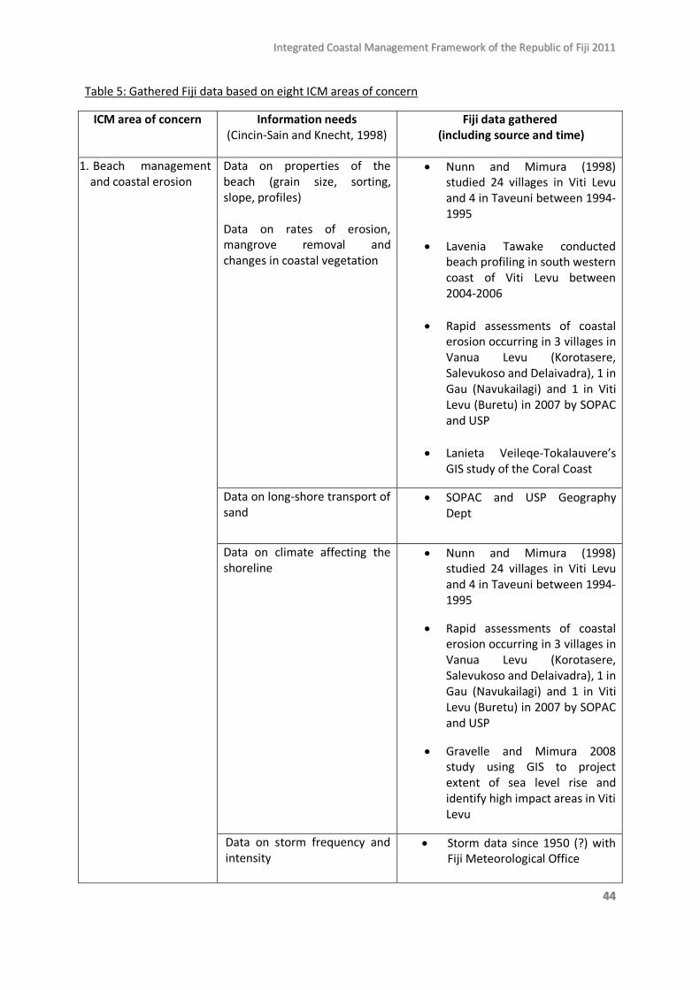
IInntteeggrraatteedd CCooaassttaall MMaannaaggeemmeenntt FFrraammeewwoorrkk ooff tthhee RReeppuubblliicc ooff FFiijjii 22001111
4444
Table 5: Gathered Fiji data based on eight ICM areas of concern
ICM area of concern Information needs (Cincin-Sain and Knecht, 1998)
Fiji data gathered (including source and time)
1. Beach management and coastal erosion
Data on properties of the beach (grain size, sorting, slope, profiles) Data on rates of erosion, mangrove removal and changes in coastal vegetation
• Nunn and Mimura (1998) studied 24 villages in Viti Levu and 4 in Taveuni between 1994-1995
• Lavenia Tawake conducted beach profiling in south western coast of Viti Levu between 2004-2006
• Rapid assessments of coastal erosion occurring in 3 villages in Vanua Levu (Korotasere, Salevukoso and Delaivadra), 1 in Gau (Navukailagi) and 1 in Viti Levu (Buretu) in 2007 by SOPAC and USP
• Lanieta Veileqe-Tokalauvere’s GIS study of the Coral Coast
Data on long-shore transport of sand
• SOPAC and USP Geography Dept
Data on climate affecting the shoreline
• Nunn and Mimura (1998) studied 24 villages in Viti Levu and 4 in Taveuni between 1994-1995
• Rapid assessments of coastal erosion occurring in 3 villages in Vanua Levu (Korotasere, Salevukoso and Delaivadra), 1 in Gau (Navukailagi) and 1 in Viti Levu (Buretu) in 2007 by SOPAC and USP
• Gravelle and Mimura 2008 study using GIS to project extent of sea level rise and identify high impact areas in Viti Levu
Data on storm frequency and intensity
• Storm data since 1950 (?) with Fiji Meteorological Office
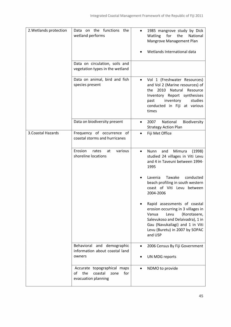
IInntteeggrraatteedd CCooaassttaall MMaannaaggeemmeenntt FFrraammeewwoorrkk ooff tthhee RReeppuubblliicc ooff FFiijjii 22001111
4455
2.Wetlands protection Data on the functions the wetland performs
• 1985 mangrove study by Dick Watling for the National Mangrove Management Plan
• Wetlands International data
Data on circulation, soils and vegetation types in the wetland
Data on animal, bird and fish species present
• Vol 1 (Freshwater Resources) and Vol 2 (Marine resources) of the 2010 Natural Resource Inventory Report synthesises past inventory studies conducted in Fiji at various times
Data on biodiversity present
• 2007 National Biodiversity Strategy Action Plan
3.Coastal Hazards Frequency of occurrence of coastal storms and hurricanes
• Fiji Met Office
Erosion rates at various shoreline locations
• Nunn and Mimura (1998) studied 24 villages in Viti Levu and 4 in Taveuni between 1994-1995
• Lavenia Tawake conducted beach profiling in south western coast of Viti Levu between 2004-2006
• Rapid assessments of coastal erosion occurring in 3 villages in Vanua Levu (Korotasere, Salevukoso and Delaivadra), 1 in Gau (Navukailagi) and 1 in Viti Levu (Buretu) in 2007 by SOPAC and USP
Behavioral and demographic information about coastal land owners
• 2006 Census By Fiji Government
• UN MDG reports
Accurate topographical maps of the coastal zone for evacuation planning
• NDMO to provide
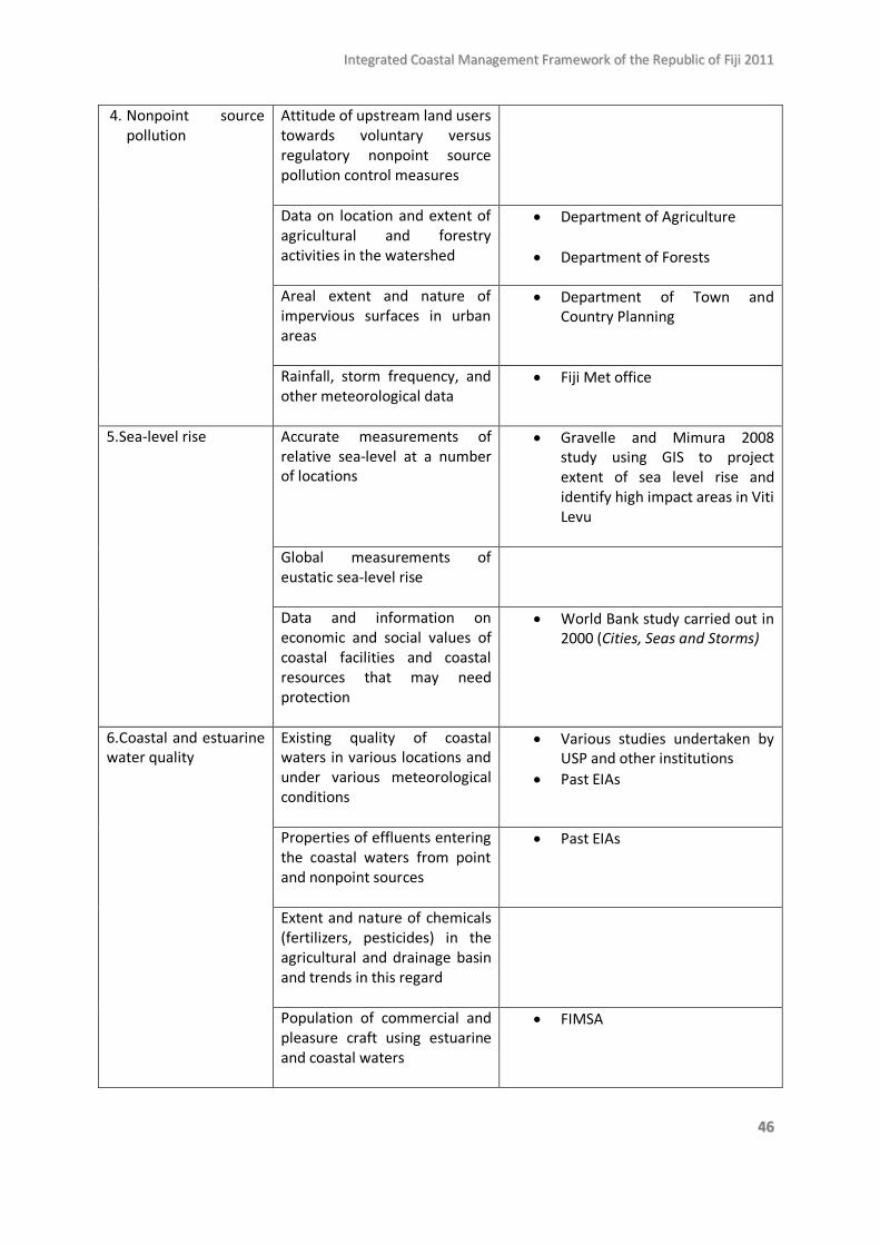
IInntteeggrraatteedd CCooaassttaall MMaannaaggeemmeenntt FFrraammeewwoorrkk ooff tthhee RReeppuubblliicc ooff FFiijjii 22001111
4466
4. Nonpoint source pollution
Attitude of upstream land users towards voluntary versus regulatory nonpoint source pollution control measures
Data on location and extent of agricultural and forestry activities in the watershed
• Department of Agriculture
• Department of Forests
Areal extent and nature of impervious surfaces in urban areas
• Department of Town and Country Planning
Rainfall, storm frequency, and other meteorological data
• Fiji Met office
5.Sea-level rise Accurate measurements of relative sea-level at a number of locations
• Gravelle and Mimura 2008 study using GIS to project extent of sea level rise and identify high impact areas in Viti Levu
Global measurements of eustatic sea-level rise
Data and information on economic and social values of coastal facilities and coastal resources that may need protection
• World Bank study carried out in 2000 (Cities, Seas and Storms)
6.Coastal and estuarine water quality
Existing quality of coastal waters in various locations and under various meteorological conditions
• Various studies undertaken by USP and other institutions
• Past EIAs
Properties of effluents entering the coastal waters from point and nonpoint sources
• Past EIAs
Extent and nature of chemicals (fertilizers, pesticides) in the agricultural and drainage basin and trends in this regard
Population of commercial and pleasure craft using estuarine and coastal waters
• FIMSA
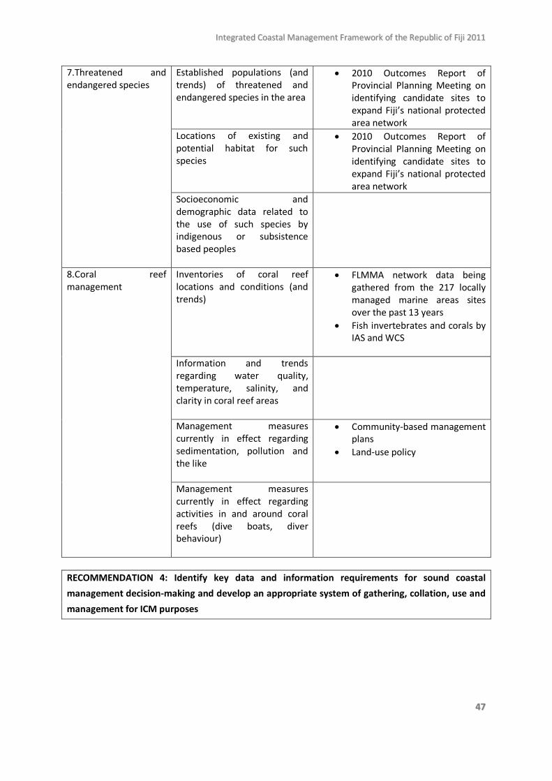
IInntteeggrraatteedd CCooaassttaall MMaannaaggeemmeenntt FFrraammeewwoorrkk ooff tthhee RReeppuubblliicc ooff FFiijjii 22001111
4477
7.Threatened and endangered species
Established populations (and trends) of threatened and endangered species in the area
• 2010 Outcomes Report of Provincial Planning Meeting on identifying candidate sites to expand Fiji’s national protected area network
Locations of existing and potential habitat for such species
• 2010 Outcomes Report of Provincial Planning Meeting on identifying candidate sites to expand Fiji’s national protected area network
Socioeconomic and demographic data related to the use of such species by indigenous or subsistence based peoples
8.Coral reef management
Inventories of coral reef locations and conditions (and trends)
• FLMMA network data being gathered from the 217 locally managed marine areas sites over the past 13 years
• Fish invertebrates and corals by IAS and WCS
Information and trends regarding water quality, temperature, salinity, and clarity in coral reef areas
Management measures currently in effect regarding sedimentation, pollution and the like
• Community-based management plans
• Land-use policy
Management measures currently in effect regarding activities in and around coral reefs (dive boats, diver behaviour)
RECOMMENDATION 4: Identify key data and information requirements for sound coastal management decision-making and develop an appropriate system of gathering, collation, use and management for ICM purposes
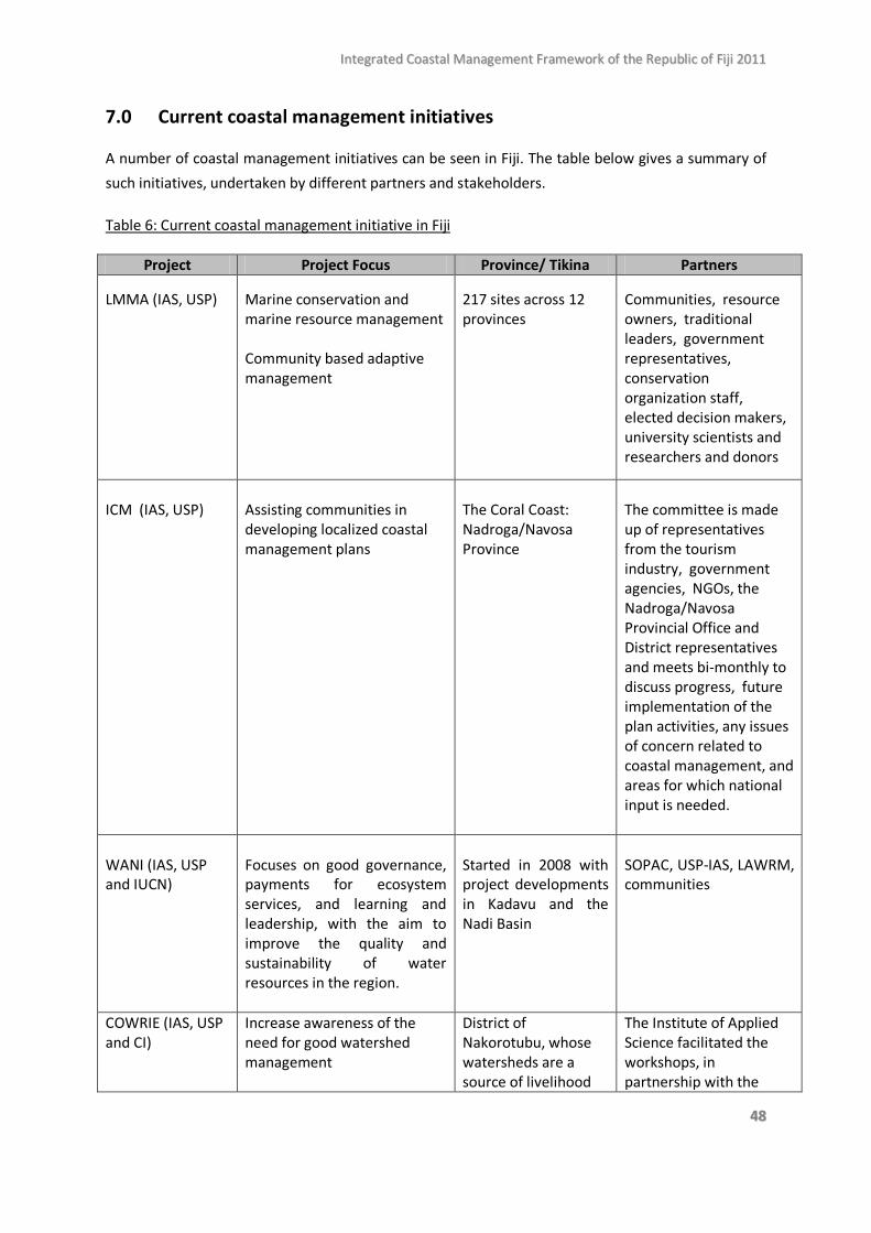
IInntteeggrraatteedd CCooaassttaall MMaannaaggeemmeenntt FFrraammeewwoorrkk ooff tthhee RReeppuubblliicc ooff FFiijjii 22001111
4488
7.0 Current coastal management initiatives A number of coastal management initiatives can be seen in Fiji. The table below gives a summary of such initiatives, undertaken by different partners and stakeholders.
Table 6: Current coastal management initiative in Fiji
Project Project Focus Province/ Tikina Partners LMMA (IAS, USP)
Marine conservation and marine resource management Community based adaptive management
217 sites across 12 provinces
Communities, resource owners, traditional leaders, government representatives, conservation organization staff, elected decision makers, university scientists and researchers and donors
ICM (IAS, USP)
Assisting communities in developing localized coastal management plans
The Coral Coast: Nadroga/Navosa Province
The committee is made up of representatives from the tourism industry, government agencies, NGOs, the Nadroga/Navosa Provincial Office and District representatives and meets bi-monthly to discuss progress, future implementation of the plan activities, any issues of concern related to coastal management, and areas for which national input is needed.
WANI (IAS, USP and IUCN)
Focuses on good governance, payments for ecosystem services, and learning and leadership, with the aim to improve the quality and sustainability of water resources in the region.
Started in 2008 with project developments in Kadavu and the Nadi Basin
SOPAC, USP-IAS, LAWRM, communities
COWRIE (IAS, USP and CI)
Increase awareness of the need for good watershed management
District of Nakorotubu, whose watersheds are a source of livelihood
The Institute of Applied Science facilitated the workshops, in partnership with the
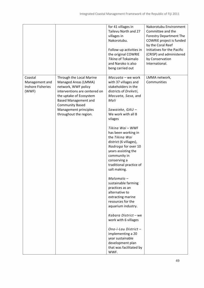
IInntteeggrraatteedd CCooaassttaall MMaannaaggeemmeenntt FFrraammeewwoorrkk ooff tthhee RReeppuubblliicc ooff FFiijjii 22001111
4499
for 41 villages in Tailevu North and 27 villages in Nakorotubu. Follow-up activities in the original COWRIE Tikina of Tokaimalo and Naroko is also beng carried out
Nakorotubu Environment Committee and the Forestry Department The COWRIE project is funded by the Coral Reef Initiatives for the Pacific (CRISP) and administered by Conservation International.
Coastal Management and Inshore Fisheries (WWF)
Through the Local Marine Managed Areas (LMMA) network, WWF policy interventions are centered on the uptake of Ecosystem Based Management and Community Based Management principles throughout the region.
Macuata – we work with 37 villages and stakeholders in the districts of Dreketi, Macuata, Sasa, and Mali Sawaieke, GAU – We work with all 8 vilages Tikina Wai – WWF has been working in the Tikina Wai district (6 villages), Nadroga for over 10 years assisting the community in conserving a traditional practice of salt making. Malomalo – sustainable farming practices as an alternative to extracting marine resources for the aquarium industry. Kabara District – we work with 6 villages Ono-i-Lau District – implementing a 20 year sustainable development plan that was facilitated by WWF.
LMMA network, Communities
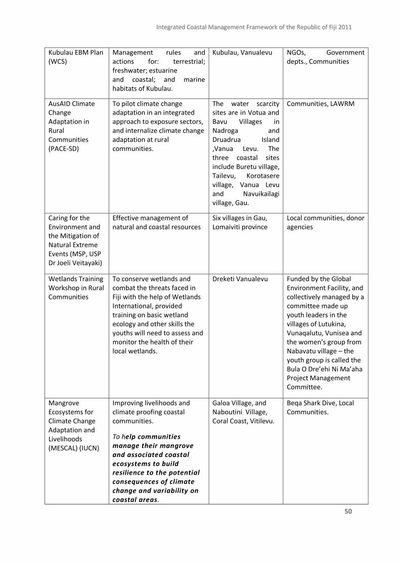
IInntteeggrraatteedd CCooaassttaall MMaannaaggeemmeenntt FFrraammeewwoorrkk ooff tthhee RReeppuubblliicc ooff FFiijjii 22001111
5500
Kubulau EBM Plan (WCS)
Management rules and actions for: terrestrial; freshwater; estuarine and coastal; and marine habitats of Kubulau.
Kubulau, Vanualevu NGOs, Government depts., Communities
AusAID Climate Change Adaptation in Rural Communities (PACE-SD)
To pilot climate change adaptation in an integrated approach to exposure sectors, and internalize climate change adaptation at rural communities.
The water scarcity sites are in Votua and Bavu Villages in Nadroga and Druadrua Island ,Vanua Levu. The three coastal sites include Buretu village, Tailevu, Korotasere village, Vanua Levu and Navuikailagi village, Gau.
Communities, LAWRM
Caring for the Environment and the Mitigation of Natural Extreme Events (MSP, USP Dr Joeli Veitayaki)
Effective management of natural and coastal resources
Six villages in Gau, Lomaiviti province
Local communities, donor agencies
Wetlands Training Workshop in Rural Communities
To conserve wetlands and combat the threats faced in Fiji with the help of Wetlands International, provided training on basic wetland ecology and other skills the youths will need to assess and monitor the health of their local wetlands.
Dreketi Vanualevu Funded by the Global Environment Facility, and collectively managed by a committee made up youth leaders in the villages of Lutukina, Vunaqalutu, Vunisea and the women’s group from Nabavatu village – the youth group is called the Bula O Dre’ehi Ni Ma’aha Project Management Committee.
Mangrove Ecosystems for Climate Change Adaptation and Livelihoods (MESCAL) (IUCN)
Improving livelihoods and climate proofing coastal communities.
To help communities manage their mangrove and associated coastal ecosystems to build resilience to the potential consequences of climate change and variability on coastal areas.
Galoa Village, and Naboutini Village, Coral Coast, Vitilevu.
Beqa Shark Dive, Local Communities.
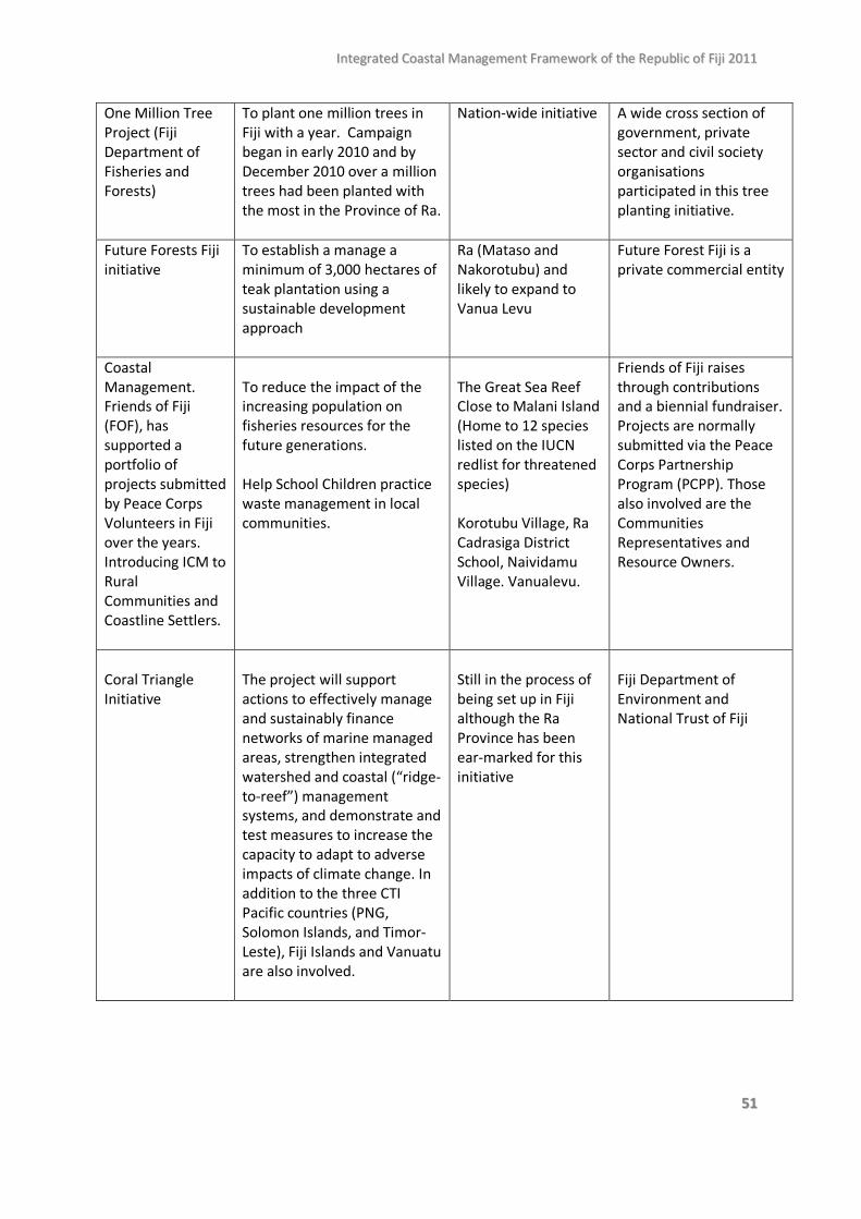
IInntteeggrraatteedd CCooaassttaall MMaannaaggeemmeenntt FFrraammeewwoorrkk ooff tthhee RReeppuubblliicc ooff FFiijjii 22001111
5511
One Million Tree Project (Fiji Department of Fisheries and Forests)
To plant one million trees in Fiji with a year. Campaign began in early 2010 and by December 2010 over a million trees had been planted with the most in the Province of Ra.
Nation-wide initiative A wide cross section of government, private sector and civil society organisations participated in this tree planting initiative.
Future Forests Fiji initiative
To establish a manage a minimum of 3,000 hectares of teak plantation using a sustainable development approach
Ra (Mataso and Nakorotubu) and likely to expand to Vanua Levu
Future Forest Fiji is a private commercial entity
Coastal Management. Friends of Fiji (FOF), has supported a portfolio of projects submitted by Peace Corps Volunteers in Fiji over the years. Introducing ICM to Rural Communities and Coastline Settlers.
To reduce the impact of the increasing population on fisheries resources for the future generations.
Help School Children practice waste management in local communities.
The Great Sea Reef Close to Malani Island (Home to 12 species listed on the IUCN redlist for threatened species)
Korotubu Village, Ra Cadrasiga District School, Naividamu Village. Vanualevu.
Friends of Fiji raises through contributions and a biennial fundraiser. Projects are normally submitted via the Peace Corps Partnership Program (PCPP). Those also involved are the Communities Representatives and Resource Owners.
Coral Triangle Initiative
The project will support actions to effectively manage and sustainably finance networks of marine managed areas, strengthen integrated watershed and coastal (“ridge-to-reef”) management systems, and demonstrate and test measures to increase the capacity to adapt to adverse impacts of climate change. In addition to the three CTI Pacific countries (PNG, Solomon Islands, and Timor-Leste), Fiji Islands and Vanuatu are also involved.
Still in the process of being set up in Fiji although the Ra Province has been ear-marked for this initiative
Fiji Department of Environment and National Trust of Fiji
IInntteeggrraatteedd CCooaassttaall MMaannaaggeemmeenntt FFrraammeewwoorrkk ooff tthhee RReeppuubblliicc ooff FFiijjii 22001111
5522
8.0 Funding possibilities Funding for the development of the National ICM Plan is expected to be sourced from the Global Environment Fund, under the new four-year funding round. 9.0 Conclusion The process of developing Fiji’s National ICM Plan is an opportunity for all coastal stakeholders to share their interests and concerns on how best in improve decision-making around coastal resource management. Hence, the national ICM planning process is largely a positive step for most stakeholders given the limitations of the existing legislative and institutional framework governing coastal management in Fiji. As reflected in recommendation 2, given the competing stakeholder interests and scientific uncertainty that often surrounds natural resource management decision-making, a province-based approach to planning should be a more effective way of developing an ICM plan that is relevant and practical. This National ICM framework outlines the scope and structure of what an ICM plan should cover. Hence, the next step, following the formal endorsement of this National ICM Framework would be to plan and conduct and Provincial ICM Planning workshops which will be the task of the ICMC.
IInntteeggrraatteedd CCooaassttaall MMaannaaggeemmeenntt FFrraammeewwoorrkk ooff tthhee RReeppuubblliicc ooff FFiijjii 22001111
5533
REFERENCE Aalbersberg W., Tawake A. and Parras T., 2005, “Village by village: recovering Fiji’s coastal fisheries. In: The Wealth of the Poor: Managing ecosystems to fight poverty, pp 144-152, World Resources Institute, Washington DC, USA. Aalbersberg W. and Thaman B., 2006, Progress and Lessons Learned on Integrated Coastal Management in Fiji, Institute of Applied Science, University of the South Pacific, Suva, Fiji. ADB, 2003, Millenium Development Goals in the Pacific: Relevance and progress, Office of External Relations and Printing and Graphics Section, Asian Development Bank. Adger N, 2006, “Vulnerability”, Global Environment Change, 16: 268-281. Agrawal S., Ota T., Hagenstad M., Smith J., van Aalst M., Koshy K. and Prasad B., 2003, Development and climate change in Fiji: Focus on coastal mangroves, Working Party on Global and Structural Policies, Organisation for Economic Cooperation and Development. Alley D., Makgill R. and Stalenberg N. 2009, Summary report: Integrated coastal management in Fiji and recommendations for improved decision-making, A report commissioned by USP in partnership with IUCN and North South Environmental Law (New Zealand). Barnett J. The effect of aid on capacity to adapt to climate change: insights from Niue. Polit Sci 2008, 60:31–45. Barnett J., 2001, Adapting to climate change in Pacific Island Countries: The problem of uncertainty, World Development, 29(6):977-993. Boadi K. O. and Kuitunen M., 2005, “Environmental and health impacts of household solid waste handling and disposal practices in Third World cities: The case of the Accra Metropolitan Area, Ghana”, Journal of Environmental Health, 68(2):32-36.
Burke L., Reytar K., Spalding M. and Perry A., 2011, Reefs at risk revisited, World Resources Institute, Washington DC. Carter R., 1990, Predicted storm surge and wave setup for Suva and Laucala Bay Harbours on Viti Levu, Fiji, SOPAC Technical Report 115. Cincin-Sain B. and Knetch R., 1998, Integrated coastal and ocean management: Concepts and practices, Island Press, Washington DC. Clark P. and Jupiter S., 2010, “Law, custom and community-based natural resource management in Kubulau”, Environmental Conservation, 37(1): 98-106. Chape S. and Watling D., 1992, Country Report for UNCED:Fiji, South Pacific Regional Environment Programme. Comley James, personal communication in Feb 2011.
IInntteeggrraatteedd CCooaassttaall MMaannaaggeemmeenntt FFrraammeewwoorrkk ooff tthhee RReeppuubblliicc ooff FFiijjii 22001111
5544
Davies J., 1998, “The causes and consequences of cane burning”, The Journal of Pacific Studies, 22:1-25. De Silva S., 2000, A Global perspective of aquaculture in the new millennium, Technical proceedings of the Conference on aquaculture in the Third Millenium, 20-25 Feb, 200, Network of Aquaculture Centres in Asia-pacific, Bangkok, Thailand. http://www.deakin.edu.au/dro/view/DU:30013693 (Accessed May 2011) Eldredge L. G. And Smith C. M. (Eds.), 2001, A Guidebook of Introduced Marine Species in Hawaii, Bishop Museum Technical Report. Evans N. 2004. Natural Resources and the Environment in Fiji: A Review of Existing and Proposed Legislation, A Report for the Fiji Department of Environment and the International Waters Programme of the Secretariat of the Pacific Regional Environment Programme. EU EDF 8 – SOPAC Project Report 35: Reducing Vulnerability of Pacific ACP States PROCEEDINGS OF THE 5th FIJI MULTI-STAKEHOLDER CONSULTATIONS Nadroga Provincial House, Sigatoka, Fiji 2nd July 2004 Fa’asili U., Vunisea A., Ledua E., Mate F. And Vuiyasawa V., 2002, Proposed community-based fisheries management programme for the Republic of Fiji, Field Report No.11, Secretariat of the Pacific Community. Fiji Sun, 2008, Cane burning increases, 27th July. http://www.fijisun.com.fj/main_page/view.asp?id=3328 (Accessed May, 2011) FOA, 2011, Impacts of Aquaculture on the Environment, Fisheries Issues, Fisheries and Aquaculture Department. http://www.fao.org/fishery/topic/14894/en (Accessed May, 2011) FOA, 2010, The State of the World Fisheries and Aquaculture 2010, Fisheries and Aquaculture Department, Food and Agriculture Organisation of the United Nations, Rome. FAO, 2009, Fishery and Aquaculture country profile Fiji. http://www.fao.org/fi/default.asps
. (Accessed December 2010).
Fiji Department of Environment, 2010, Integrated Coastal Management Framework Workshop Outcome, Fiji Department of Environment. Fiji Department of Environment, 2010, Protected Area Committee 2009 Annual Report, Fiji Department of Environment. Fiji Department of Environment, 2007, Fiji National Biodiversity Strategy Action Plan, Fiji Department of Environment. Fiji Department of Environment, 2007a, National Air Pollution Control Strategy, Fiji Department of Environment. Fiji Department of Environment, 2006, Fiji National Liquid Waste Management Strategy and Action Plan, Fiji Department of Environment.
IInntteeggrraatteedd CCooaassttaall MMaannaaggeemmeenntt FFrraammeewwoorrkk ooff tthhee RReeppuubblliicc ooff FFiijjii 22001111
5555
Fiji Department of Environment, 2005, National Solid Waste Management Strategy and Action Plans 2008-2010, Fiji Department of Environment. Fiji Department of Tourism, 2007, Fiji Tourism Development Plan 2007-2016, Tourism – Fiji’s Opportunity, Sustainable Tourism Development Consortium. Fiji Ministry of Tourism, 2005, Tourism Infrastructure Development Policy Conference Report, held at Lagoon Resort, 17th December, 2005. Research and Planning Section, Ministry of Toursim, Suva Fiji. Fiji Ministry of Tourism, 2006, Adaptation to Climate Change in the Tourism Sector in the Fiji Islands, A Summary Report of the Initial Stakeholder Workshop convened by the Fiji Ministry of Tourism with the United Nations World Tourism Organisation and the United Nations Environment Programme. Floerl O., Inglis G., Hall V., Underwater hitch hikers on the bottom of boats, CRC Reef Research Centre Ltd Website http://www.reef.crc.org.au/publications/explore/feat53.html accessed Jan 2011. Gravelle G. and Mimura N., 2008, “Vulnerability assessment of sea-level rise in Viti Levu, Fiji Islands”, Sustainable Science, 3:171-180. Hall M C., 2001, “Trends in ocean and coastal tourism: the end of the last frontie, Ocean and Coastal Management, 44:601-618. IAS, 2004, A review of the standard of wastewater treatment in Fiji’s tourism industry.IAS, USP. JICA (Japan International Cooperation Agency), 1998, A study of watershed management and flood control for the four major Viti Levu Rivers in the Republic of Fiji Islands: Summary, Ministry of Agriculture, Fisheries and Forests. JICA (Japan International Cooperation Agency) 1998, The study of watershed management and flood control for the four major Viti Levu rivers in the republic of Fiji Islands - Final Report Summary, Yachiyo Engineering Co., Ltd, Ministry of Agriculture, Fisheries and Forests. Jupiter S., Tora K., Mills M., Weeks R., Adams V., Qauqau I., Nakeke A., Tui T., Nand Y., Yakub N., 2011, Filling the gaps: Identifying candidate sites to expand Fiji’s national protected area network, Outcomes report from the provincial planning meeting, 20-21 September 2010, Wildlife Conservation Society, Suva, Fiji. Jupiter Stacy, personal communication in April 2011. Keith-Reid R., 2005, “Sorry state of the land – but can it be rescued?”, Islands Business International, October. http://www.islandsbusiness.com/fiji_business/index_dynamic/containerNameToReplace=MiddleMiddle/focusModuleID=5418/overideSkinName=issueArticle-full.tpl (Accessed May 2011) Kraus N. C. and McDougal W. G., 1996, “The effects of seawalls on the beach: Part I, An updated literature review”, Journal of Coastal Research, 12(3):691-701. Lal P., Singh R. and Holland P., 2009, Relationship between natural disasters and poverty: A Fiji case study, SOPAC Miscellaneous Report 678.
IInntteeggrraatteedd CCooaassttaall MMaannaaggeemmeenntt FFrraammeewwoorrkk ooff tthhee RReeppuubblliicc ooff FFiijjii 22001111
5566
Lal P. Tabunakawai M. and Singh S., 2007, Economics of rural waste management practices in the Rewa Province and development of a rural solid waste management policy for Fiji, IWP Pacific Technical Report (International Waters Project) No. 57. Kostaschuk R. and Terry J., 2001, “Tropical cyclones and floods in Fiji”, Hydrological Sciences-Journal-des Sciences Hydrologiques, 46(3). Lal P., 2010 Vulnerability to natural disasters: an economic analysis of the impact of the 2009 floods on the Fijian sugar belt, Pacific Economic Bulletin Volume 25 Number 2 © 2010 The Australian National University. Lane M., 2006, The governance of coastal resources in Fiji: an analysis of the strategic issues, IWP Technical Report No.20, South Pacific Regional Environment Programme (SPREP). Levett R. and McNelly R., 2003, A strategic environmental assessment of Fiji’s tourism development plan, WWF South Pacific Programme. Limalevu L., Aalbersberg B., Dumaru P. and Weir T., “Community adaptation in a small island developing country”, Tiempo Climate Newswatch, August 2010. LMMA (Locally Managed Marine Areas) Network, 2010, 2009 Annual Report: A new age of community-based adaptive management, LMMA Network. McCarthy, J.J., Canziani, O.F., Leary, N.A., Dokken, D.J., White, K.S. (Eds.), 2001. Climate Change 2001: Impacts, Adaptation and Vulnerability. Cambridge University Press, Cambridge. McKenzie, L.J. and Yoshida, R.L. (2007). Seagrass-Watch: Guidelines for Monitoring Seagrass Habitats in the Fiji Islands. Proceedings of a training workshop, Corpus Christi Teachers College, Laucala Bay, Suva, Fiji, 16th June 2007, Seagrass-Watch HQ, Cairns. Mimura N. And Nunn P., 1998, “Trends of beach erosion and shoreline protection in Fiji”, Journal of Coastal Research, 14(1):37-46. Mimura N., 1999, “Vulnerability of island countries in the South Pacific to sea level rise and climate change”, Climate Research, 12: 137-143. Minter A., 2008, Compliance and enforcement for fisheries management in Fiji, IUCN Regional Office of Oceania and the University of the South Pacific. Morrison J. R., Gangagaiya P., Garimella S., Singh S. K., Maata M. and Chandra A., 2005, Contamination of Suva Lagoon. In Aalbersberg A. and Morrison J., eds. At the Cross Roads: Science and Management of the Suva Lagoon, Institute of Applied Sciences, University of the South Pacific, pp 146-155. Mosley L. M. and Aalbersberg W. G. M., 2003, “Nutrient levels in sea and river water along the ‘Coral Coast’ of Viti Levu, Fiji”, South Pacific Journal of Natural Science, 21(1):35 - 40. Nature Fiji Mareqeti Viti, 2010, Ba mangroves under threat from dredging plans, Nature Fiji Mareqeti Viti Newsletter No. 7.
IInntteeggrraatteedd CCooaassttaall MMaannaaggeemmeenntt FFrraammeewwoorrkk ooff tthhee RReeppuubblliicc ooff FFiijjii 22001111
5577
Nature Fiji Mareqeti Viti, 2008, Destruction of Fiji’s rivers and streams, Nature Fiji Mareqeti Viti Newsletter No. 1. Nawadra S., Polglaze J., Provost I., Hayes T., Lindsay S., Pasis B., Hillman S. and Hillard R., 2002 Improving Ships’ waste management in Pacific islands ports, SPREP. Nelson, D., Adger, N., Brown, K. 2007. `Adaptation to environmental change: contributions of a resilience framework', Annual Review of Environment and Resources 32: 395-419. Patterson S. and Hughes B., 2006, Carrying capacity assessment for tourism development in Fiji, Institute of Applied Science unpublished report, USP. Prasad S. and Jupiter S., 2007, “Why protecting coral reefs is more than just fisheries management”, Islands Business International. (http://www.islandsbusiness.com/fiji_business/index_dynamic/containerNameToReplace=MiddleMiddle/focusModuleID=18994/overideSkinName=issueArticle-full.tpl) accessed may, 2011. Ravuvu A., 1985, Fijian ethos as expressed in ceremonies, Phd Thesis submitted to University of Auckland. Rahiman T. I. H., Pettinga J. R., 2006, ‘The off shore morphostructure and tsunami sources of the Viti Levu seismic zone, southeast Viti Levu, Fiji’, Marine Geology, 232:203-225. Rigamoto R. And Tyagi A., 2005, ‘Biodiversity of the coastal littoral vegetation of Rotuma Island’, International Journal of Agriculture and Biology, Vol 7, No. 1, pp 79-81. Runyan K. and Griggs G. B., 2003, “The effects of armouring seacliffs on the natural sand supply to the natural beaches of California”, Journal of coastal research, 19(2): 336-347. Sykes H. and Lovell E., 2008, Rapid recovery from bleaching events – Fiji coral reef monitoring network assessment of hard coral cover from 1999-2007, 11th International Coral Reef Symposium, Florida, Session 18. Sykes H. 2007 Knowledge, monitoring, management andbeneficial use of coral reef ecosystems, Status of Coral reefs in the Fiji Islands. Coral reef Initiative of the South Pacific. 64 pp. Sykes H. 2007. Mangrove management plan for Vulani Islands. Stage 1: General mangrove management, Marine Ecology Consulting, Fiji. Tawake Lavenia, Personal communication December 2010. Terry J., Garimella S., Kostaschuk R A., 2002, “Rates of f loodplain accretion in a tropical island river system impacted by cyclones and large floods”, Geomorphology, 42 171– 182. Thaman B. and Aalbersberg B., 2004, Initiating Integrated Coastal Management (ICM) in the Fiji Islands, A paper presented at the Coastal Zone Asia-Pacific (CZAP) symposium. Thaman B., Robadue D. And Ricci G., 2005, Strengthening a Nested System of Coastal Management in Fiji: Progress and Lessons learned towards Integrated Coastal Management in and the Coral Coast and their implications for National Policy, A joint project between the Government of Fiji, the
IInntteeggrraatteedd CCooaassttaall MMaannaaggeemmeenntt FFrraammeewwoorrkk ooff tthhee RReeppuubblliicc ooff FFiijjii 22001111
5588
Institute of Applied Science of the University of the South Pacific, and the Coastal Resources Centre of University of Rhode Island. Thaman R., 2006, “The coastal and littoral vegetation of Suva Lagoon and Makuluva Reef Islet: A study of degradation, extirpation and the need for restoration” in J. Morrison and B. Aalbersberg (eds.), At the Crossroads: Science and management of Suva Lagoon, Proceedings of a Symposium, University of the South Pacific, 30 March – 1April, 2005. Thaman, R.R., 1992. Batiri kei Baravi: The ethnobotany of the Pacific island coastal plants. Atoll Res. Bull., 333: 1–29 Tawake L., Personal communications, December 2010. Thomas N., 2007, Distribution and abundance of the Fijian ground frog (platymantis vitianus) and the cane toad (chaunus [Bufo] marianus) on Viwa Island, Tailevu, Fiji, a masters thesis submitted to the University of the South Pacific. Teh L. C., Teh L. S., Starkhouse B. and Sumaila U. R., 2009, “An overview of socio-economic and ecological perspectives of Fiji’s inshore reef fisheries”. Tokalauvere L. V., 2007, The application of remote sensing and geographical information systems to change detection in integrated coastal management: the Sigatoka Coral Coast in Fiji, a masters thesis submitted to the University of the South Pacific. Vanualailai P., 2004, Impacts of climate change on coastal infrastructures, Ibaraki University, Japan. http://enviroscope.iges.or.jp/modules/envirolib/upload/147/attach/S3-5-Paulo-Vanualailai.pdf (accessed in December 2010). Watling D., 1985, Mangrove Management Plan for Fiji, Phase 1. Government Printer, Suva, Fiji. Webb A., 2007, Fiji Technical Note: Rapid appraisal assessment of erosion and flooding at Korotasere village, Vanua Levu and Delaivadra and Salevukoso villages, Druadrua Island, EU-SOPAC (EDF 9) Project Report 91. World Bank, 2000a, Cities, Seas and Storms, World Bank. Yeo S., Blong R. and McAneney J., 2007, “Flooding in Fiji: findings from a 100-year historical series”, Hydrological Sciences–Journal–des Sciences Hydrologiques, 52(5): 1004-1015 Yarrow Robin, personal communication in April 2011.
Produced by the Department of Environment Ministry of Local Government, Urban Development, Housing and Environment
Level 1 P D Patel Building 90 Raojibhai Patel Street
Suva Republic of Fiji
P O Box 2109, Government Building, Suva, Republic of Fiji
Ph: (679) 3311 699 Fax: (679) 3312 879
www.environment.gov.fj