Embed Size (px)
Citation preview
Integrating Disaster Data into Hazard Mitigation PlanningA State and Local Mitigation Planning How-to-Guide
February 2015

About the Cover:Manitou Springs, Colorado September 21, 2013-- Roads were badly damage in the Manitou Springs, Colorado area due to flooding. Photo by Patsy Lynch/FEMA.
Integrating Disaster Data into Hazard Mitigation Planning 2
Integrating DiIntegrating Disaster Data into Hazard Mitigation 3
Table of ContentsIntroduction .................................................................................................................................................................. 4
Definitions ............................................................................................................................................................... 5
Organization ........................................................................................................................................................... 5
Intended Audience ............................................................................................................................................... 6
Roles and Responsibilities ........................................................................................................................................ 7
Disaster Integration Significance ........................................................................................................................... 9
The Business Case ................................................................................................................................................. 10
Challenges ............................................................................................................................................................... 11
Opportunities for Partnerships ........................................................................................................................ 12
How to Improve Your Resiliency: Integrating Disaster Data into Local Hazard Mitigation Planning ......................................................................................................................... 13
Step 1: Identify Data and Partnerships .......................................................................................................... 14
Step 2: Understand Where Data is Stored ................................................................................................... 41
Step 3: Integrate Data into Planning ............................................................................................................. 48
Get Local Buy-In ........................................................................................................................................................... 53
Integration Examples ................................................................................................................................................. 56
EPA and FEMA Partner to Strengthen Vermont Communities’ Flood Response and Preparation ................................................................................................................... 57
Charlotte-Mecklenburg, North Carolina ...................................................................................................... 58
NYC Special Initiative for Rebuilding and Resiliency: Stronger, More Resilient New York ................................................................................................................. 59
AppendicesAppendix A: Additional Online Resources ....................................................................................................... 62
List of FiguresFigure 1. Map of Regions and Offices .................................................................................................................. 17
Figure 2. Example of Local Data Collection Process ....................................................................................... 46
List of TablesTable 1. National Mitigation Framework Core Capabilities .......................................................................... 18
Table 2. National Mitigation Framework System Considerations for Hazard Mitigation .................. 22
Table 3. Recovery Support Function Overview ................................................................................................ 25
Table 4. Recovery Support Function Data and Hazard Mitigation Plan Integration ........................... 27
Table 5. Recovery Core Principles and Hazard Mitigation Integration ..................................................... 30
Table 6. HM FOG Operating Procedures with Hazard Mitigation Integration Highlights ................. 33
Table 7. FEMA Hazard Mitigation Assistance Programs ................................................................................ 38
Table 8. Other Federal Agency Mitigation Programs and Assistance ....................................................... 40
Table 9. Summary of Disaster Data and Information ...................................................................................... 48
Table 10. Example Hazard Mitigation Strategy and Action Updates Based on Data Identified ...... 51
4
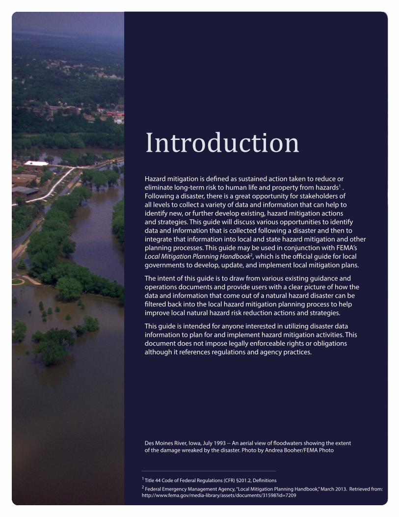
IntroductionHazard mitigation is defined as sustained action taken to reduce or eliminate long-term risk to human life and property from hazards1 . Following a disaster, there is a great opportunity for stakeholders of all levels to collect a variety of data and information that can help to identify new, or further develop existing, hazard mitigation actions and strategies. This guide will discuss various opportunities to identify data and information that is collected following a disaster and then to integrate that information into local and state hazard mitigation and other planning processes. This guide may be used in conjunction with FEMA’s Local Mitigation Planning Handbook2, which is the official guide for local governments to develop, update, and implement local mitigation plans.
The intent of this guide is to draw from various existing guidance and operations documents and provide users with a clear picture of how the data and information that come out of a natural hazard disaster can be filtered back into the local hazard mitigation planning process to help improve local natural hazard risk reduction actions and strategies.
This guide is intended for anyone interested in utilizing disaster data information to plan for and implement hazard mitigation activities. This document does not impose legally enforceable rights or obligations although it references regulations and agency practices.
Des Moines River, Iowa, July 1993 -- An aerial view of floodwaters showing the extent of the damage wreaked by the disaster. Photo by Andrea Booher/FEMA Photo
1 Title 44 Code of Federal Regulations (CFR) §201.2, Definitions2 Federal Emergency Management Agency, “Local Mitigation Planning Handbook,” March 2013. Retrieved from: http://www.fema.gov/media-library/assets/documents/31598?id=7209
DefinitionsIntegration Integration is defined as the act of combining two or more things to
create something – to make something a part of another larger thing. In the case of this guide, we are talking about taking data and information that are discovered, developed, or learned as a result of natural hazard disaster events and integrating that knowledge into a larger process that helps stakeholders identify activities that will ultimately reduce risk to life and property from natural hazards. Mitigation should be continuous and should filter through every aspect of local decision-making. Disaster data and information are important pieces that feed the cycle of continuously improving our risk reduction activities.
Disaster Data For the purpose of this guide, when we refer to disaster data we are referring to raw, unorganized facts that need to be processed.
Disaster Information When we refer to disaster information, we are discussing data that are processed, organized, structured, or presented in a given context already so as to make them useful to the user. Information is therefore data that have already been interpreted.
OrganizationThis guide is organized to help users identify where and when data and information following a disaster may be collected, where it is stored and who may have access to it, and how to integrate that into local hazard mitigation activities. Disaster data and information may include, but are certainly not limited to, high-water marks, building damage data, geographical extent of damages, frequency of an event, risk assessment, disaster outreach materials, grant application opportunities and information, action plans, and hazard mitigation strategies specific to a disaster – all of which may directly or indirectly assist in promoting mitigation solutions and improving resilient and sustainable communities. Obtaining and integrating disaster information must be thought out and flexible, and will be different for each disaster, especially depending on frequency and magnitude of the event. Below describes the purpose of each section in this guide.
Roles & Responsibilities Clarifies roles and responsibilities related to the integration of disaster data and information.
Disaster Integration Builds a business case for integrating disaster data and information into Significance local mitigation planning and activities.
How to Improve Your Offers a process to help users see integration opportunities in a step by Resiliency: Integrating step manner.Disaster Data into Planning
Get Local Buy-In Discusses getting local buy-in to execute a risk reduction project or action
Disaster Data and Planning Provides examples of integration of disaster data and information into Integration Examples mitigation activities.
Introduction | Definitions and Organization
5
Integrating Disaster Data into Hazard Mitigation Planning
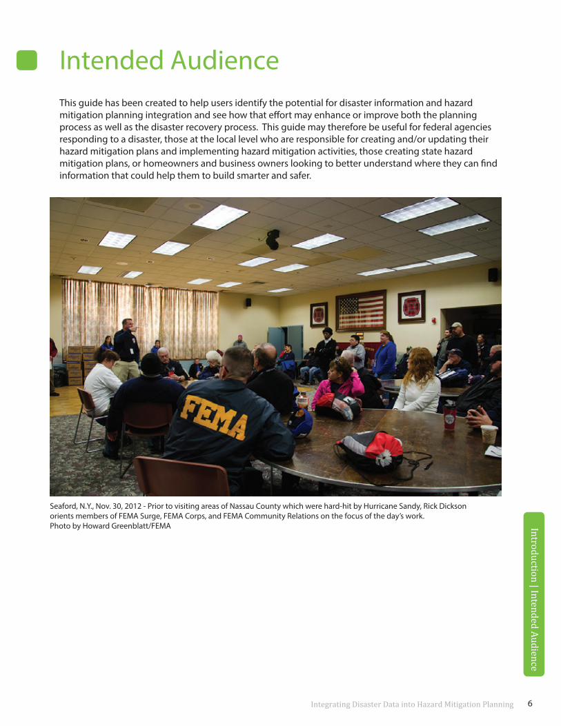
Intended AudienceThis guide has been created to help users identify the potential for disaster information and hazard mitigation planning integration and see how that effort may enhance or improve both the planning process as well as the disaster recovery process. This guide may therefore be useful for federal agencies responding to a disaster, those at the local level who are responsible for creating and/or updating their hazard mitigation plans and implementing hazard mitigation activities, those creating state hazard mitigation plans, or homeowners and business owners looking to better understand where they can find information that could help them to build smarter and safer.
Introduction | Intended Audience
Seaford, N.Y., Nov. 30, 2012 - Prior to visiting areas of Nassau County which were hard-hit by Hurricane Sandy, Rick Dickson orients members of FEMA Surge, FEMA Corps, and FEMA Community Relations on the focus of the day’s work. Photo by Howard Greenblatt/FEMA
6

ROLES & RESPONSIBILITIES
Disaster data and information may be integrated into hazard mitigation planning, strategies, and actions across many levels of stakeholders – from the actions a family takes to protect themselves and their home from the next flood to the steps a state or local community takes to update their hazard mitigation plan, prioritize mitigation projects, and secure funding to move those projects forward to reduce risk in the community from the multiple hazards they face. Regardless of the stakeholders who are implementing the actions, all risk reduction measures are completed in order to better protect the individual, the families, and the businesses that fall within communities and reduce the economic and social hardships.
Introduction | Intended Audience
Ocean Springs, Miss., September 8, 2005 -- The Small Business Administration helps residents affected by Hurricane Katrina fill out loan applications at the Disaster Recovery Center (DRC) in Ocean Springs, Miss. FEMA opens DRCs to help residents with its recovery process. FEMA/Mark Wolfe
Below is a description of the various roles stakeholders may play in advancing mitigation activities to reduce risk from natural hazards by integrating disaster data and information.
Federal Support activities post-disaster that may result in new disaster data and information and provide that data to the state, local communities, and other stakeholders, as appropriate. Provide guidance and suggestions for identifying and advancing new or improved hazard mitigation actions based on information and data available. Assist state and local communities in identifying and forming partnerships.
State and Tribal Coordinate with federal partners to ensure state, tribal, and local
Governments priorities are incorporated into disaster recovery efforts, including data collection and dissemination. Work with local communities and stakeholders to keep them informed and provide data and information, as appropriate. Communicate to communities where grants may be available and discuss how disaster-related data and information may feed into that process. Update state hazard mitigation plan with disas-ter data and information. Integrate national-level resources and data into localized data and priorities.
Communities Identify data needs pre- and post-disaster and track data and informa-tion that is collected within the community as a result of the disaster event. Coordinate with state and federal agencies to obtain data and information they have collected. Review local plans, including hazard mitigation plans, comprehensive plans, and capital improvement plans (CIP), to see if disaster data and information can be utilized to update project priorities and to incorporate new hazard mitigation actions and strategies. Provide appropriate data and information to community members during and following the disaster that may assist them in taking action to mitigate against the risk to their business, property, and families.
Private Sector This may include businesses, non-profit organizations, and other
Organizations non-governmental entities such as universities. Understand, analyze, and manage your risk. Be aware of data and information that may be available post-disaster and coordinate with state and local officials to become involved in projects that may benefit your organization or the community your organization is in. If you collect data as a result of the disaster, consider sharing it with the local government so they may use it for additional purposes and mitigation goals. Promote the return on investment realized from increased resilience and reduced vulnerability.
Individuals/ Participate in local community discussions and meetings about hazard
Household mitigation and taking action to reduce risk. Look for initiatives at the local and state level that share information about a recent disaster and recovery efforts underway. Understand the ongoing projects in your community and identify if those projects include hazard mitigation components, such as building outside the floodplain, adding a safe room, and increasing capacity of a storm drain, and how they may affect you. Identify where you can obtain data and information specific to a disaster and how that information can help you to rebuild stronger and safer. Utilize available information to understand your risk and to take action to reduce risk posed by hazards and avoid the personal, financial and psychological consequences of disasters.
Roles and Responsibilities
8
Roles and Responsibilities
Disaster Integration SignificanceThe business case, challenges, and opportunities for partnerships.
Fargo, N.D., March 28, 2009 --The Riverview section of Fargo experienced flooding. Temporary levees were created to stop additional flooding from the Red. Photo by Patsy Lynch/FEMA.
Integrating Disaster Data into Hazard Mitigation Planning 10
3 U.S. Department of Homeland Security, “National Mitigation Framework,” May, 2013. Available at: http://www.fema.gov/media-library/assets/documents/32209?id=73634 FEMA, Integrating Hazard Mitigation into Local Planning, http://www.fema.gov/media-library-data/20130726-1908-25045-0016/integrating_hazmit.pdf.
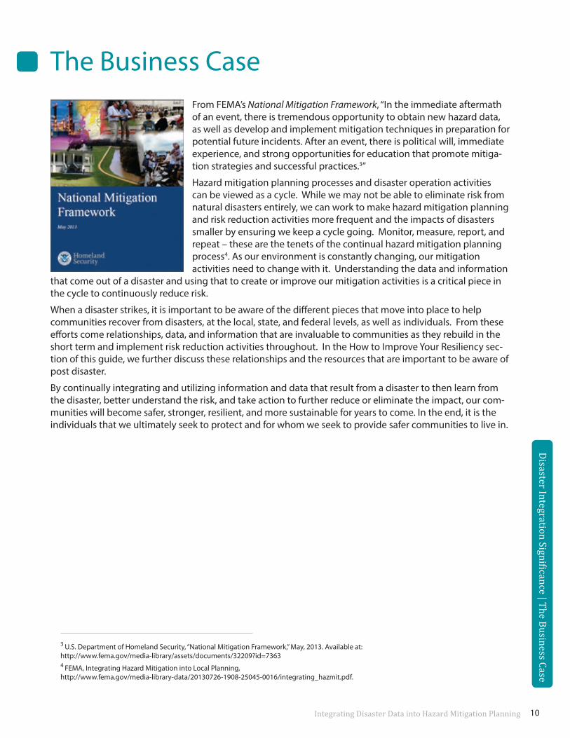
The Business CaseFrom FEMA’s National Mitigation Framework, “In the immediate aftermath of an event, there is tremendous opportunity to obtain new hazard data, as well as develop and implement mitigation techniques in preparation for potential future incidents. After an event, there is political will, immediate experience, and strong opportunities for education that promote mitiga-tion strategies and successful practices.3”
Hazard mitigation planning processes and disaster operation activities can be viewed as a cycle. While we may not be able to eliminate risk from natural disasters entirely, we can work to make hazard mitigation planning and risk reduction activities more frequent and the impacts of disasters smaller by ensuring we keep a cycle going. Monitor, measure, report, and repeat – these are the tenets of the continual hazard mitigation planning process4. As our environment is constantly changing, our mitigation activities need to change with it. Understanding the data and information
that come out of a disaster and using that to create or improve our mitigation activities is a critical piece in the cycle to continuously reduce risk.
When a disaster strikes, it is important to be aware of the different pieces that move into place to help communities recover from disasters, at the local, state, and federal levels, as well as individuals. From these efforts come relationships, data, and information that are invaluable to communities as they rebuild in the short term and implement risk reduction activities throughout. In the How to Improve Your Resiliency sec-tion of this guide, we further discuss these relationships and the resources that are important to be aware of post disaster.
By continually integrating and utilizing information and data that result from a disaster to then learn from the disaster, better understand the risk, and take action to further reduce or eliminate the impact, our com-munities will become safer, stronger, resilient, and more sustainable for years to come. In the end, it is the individuals that we ultimately seek to protect and for whom we seek to provide safer communities to live in.
Disaster Integration Significance | The Business Case
Integrating Disaster Data into Hazard Mitigation Planning
ChallengesExisting capabilities and coordination are not yet at a point that allows the seamless dissemination and dispersion of information and data immediately following a disaster on a local to national scale. As a result, throughout this guide, users will notice that often data and information are discussed as being developed post disaster, but where the data are stored and at what level (i.e., community versus state) may vary depending on where the disaster occurred and who collected the data.
There are tools and processes in place to help facilitate data and information collection and sharing at a national level, including OpenFEMA5, the National Information Sharing Consortium (NISC), and the National Voluntary Organizations Active in Disaster (VOAD). These types of data sharing organizations and other databases are discussed more in the How to Improve Your Resiliency, Step 2 of this guide.
Disaster Integration Significance | The Business Case
Disaster Integration Significance | Challenges
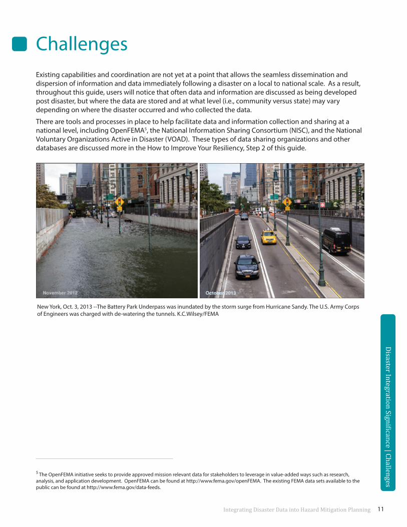
New York, Oct. 3, 2013 --The Battery Park Underpass was inundated by the storm surge from Hurricane Sandy. The U.S. Army Corps of Engineers was charged with de-watering the tunnels. K.C.Wilsey/FEMA
5 The OpenFEMA initiative seeks to provide approved mission relevant data for stakeholders to leverage in value-added ways such as research, analysis, and application development. OpenFEMA can be found at http://www.fema.gov/openFEMA. The existing FEMA data sets available to the public can be found at http://www.fema.gov/data-feeds.
11
Opportunities for PartnershipsAs users of this guide begin to identify and collect disaster data and information, the opportunities for partnerships will become evident.
Existing guidance, processes, and procedures have been written or are currently being written from various agencies that help to show relationships, partnerships, and integrations between people and resources and will be discussed throughout this guide. This includes Presidential Policy Directives’ (PPD-8) National Planning Frameworks, which represent an important step forward in describing how all levels of govern-ment, the private sector, nongovernmental organizations, and the public at-large work together to build and sustain the capabilities we need to prevent, protect, mitigate against, respond to, and recover from threats and hazards, as well as existing guidance documents such as the American Planning Association’s Hazard Mitigation: Integrating Best Practices into Planning6 , FEMA’s Hazard Mitigation Field Operating Guidance (HM FOG)7, FEMA’s Local Mitigation Planning Handbook8 , and FEMA’s Integrating Hazard Mitigation into Local Planning9.
Disaster Integration Significance | Opportunities for Partnerships
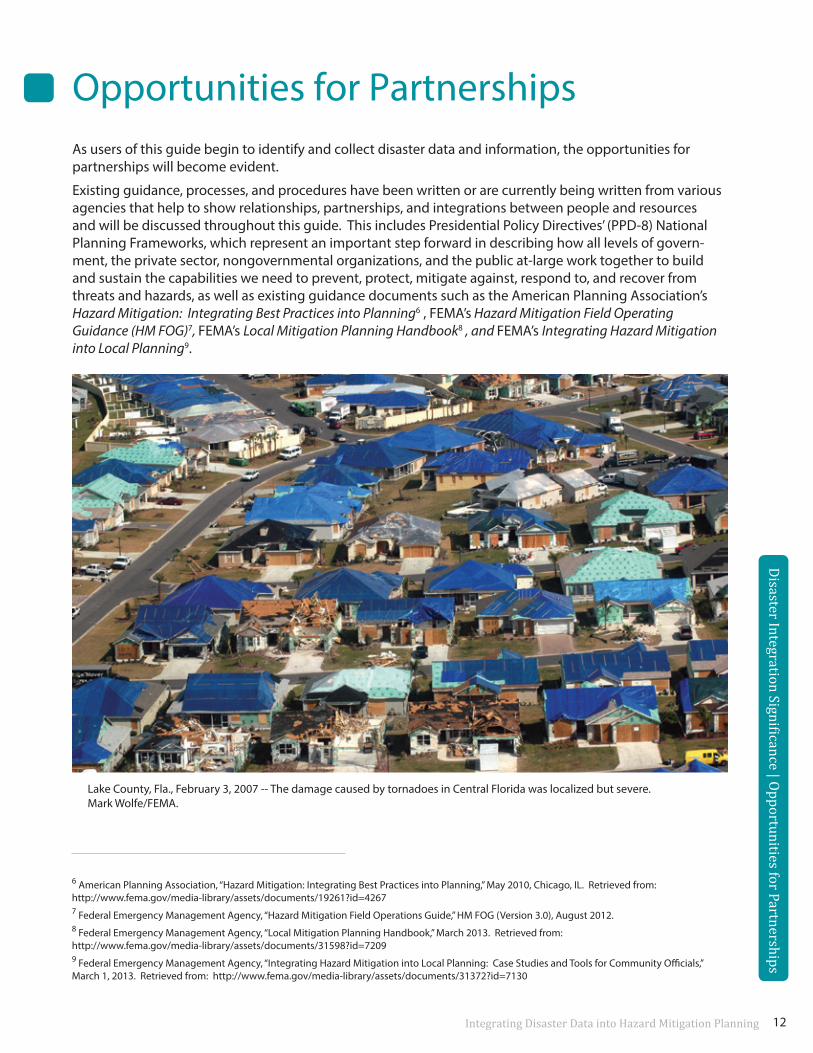
Lake County, Fla., February 3, 2007 -- The damage caused by tornadoes in Central Florida was localized but severe. Mark Wolfe/FEMA.
Integrating Disaster Data into Hazard Mitigation Planning
6 American Planning Association, “Hazard Mitigation: Integrating Best Practices into Planning,” May 2010, Chicago, IL. Retrieved from: http://www.fema.gov/media-library/assets/documents/19261?id=42677 Federal Emergency Management Agency, “Hazard Mitigation Field Operations Guide,” HM FOG (Version 3.0), August 2012. 8 Federal Emergency Management Agency, “Local Mitigation Planning Handbook,” March 2013. Retrieved from: http://www.fema.gov/media-library/assets/documents/31598?id=72099 Federal Emergency Management Agency, “Integrating Hazard Mitigation into Local Planning: Case Studies and Tools for Community Officials,” March 1, 2013. Retrieved from: http://www.fema.gov/media-library/assets/documents/31372?id=7130
12
How to Improve Your Resiliency:Integrating Disaster Data into Local Hazard Mitigation Planning
This section will discuss three steps users may take to identify the data and information that may result from national disaster operations that are initiated following a disaster, understand where and how the data and information may be stored, and learn how to integrate disaster operations data and information into local planning processes, including hazard mitigation plans, comprehensive or master plans, and mitigation strategies and actions.
For the purpose of this guide, when we refer to disaster data, we are referring to raw, unorganized facts that need to be processed. When we refer to disaster information, we are talking about data that are processed, organized, structured, or presented in a given context already so as to make it useful to the user. Information is therefore data that have already been interpreted.
Step 1 Identify Data and Partnerships
Step 2Understand Where Data is Stored
Step 3 Integrate Data into Planning
Disaster Integration Significance | Opportunities for Partnerships
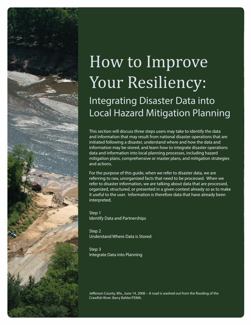
Jefferson County, Wis., June 14, 2008 -- A road is washed out from the flooding of the Crawfish River. Barry Bahler/FEMA.
Step 1: Identify Data and PartnershipsThis step will focus on a review of the existing guidance documents and topics to support in data, information, and partnership identification. The guidance docu-ments and topics are listed in the text box to the right.
Our review of these specific documents and topics focused on areas that may result in disaster-related data and information that could be integrated into hazard mitigation planning and other local planning processes to improve hazard mitigation strategies and actions and reduce risk in the future. Users should therefore refer to the full documents and referenced website links if additional information is needed.
Although not a focus of this guide, it should be noted that integrating information from the existing local hazard mitigation plans and other local plans into the disaster recovery process is a critical piece of the risk reduction cycle. Even though a community may have a post-disaster recovery plan in place, a community should also consider using their local hazard mitigation plan or capital improvement plan. It is important to utilize existing data and information to implement mitigation activities as well as to integrate new data and information from disasters to improve those mitigation activities moving forward. FEMA’s Recovery Pre-Disaster Planning Guidance10 suggests that communities take 10 steps to complete pre-disaster recovery planning so they are organized before a disaster strikes. To prepare for recovery means planning for leadership roles, staff roles, post-event planning processes, decision-making, stakeholder engagement, and new policies or guidance needed to carry out the recovery process. This pre-disaster planning effort also includes understanding existing hazard mitigation plans and knowing how they can assist with post-disaster recovery efforts, including mitigation activities. The guide outlines 10 steps for local pre-disaster recovery planning. The steps include determining community’s risks, impacts, and consequences; deter-mining leadership positions and defining operations necessary for post-disaster recovery planning and management efforts; establishing partnerships; and defining capabilities and roles in support of disaster recovery, amongst others. Within these steps, communities can also consider what data and information would be useful to collect following a disaster to further develop a risk reduction goal or to gain funding for mitigation projects that reduce risk.
How
to Improve Your Resiliency | Step 1: Identify Data and Partnerships
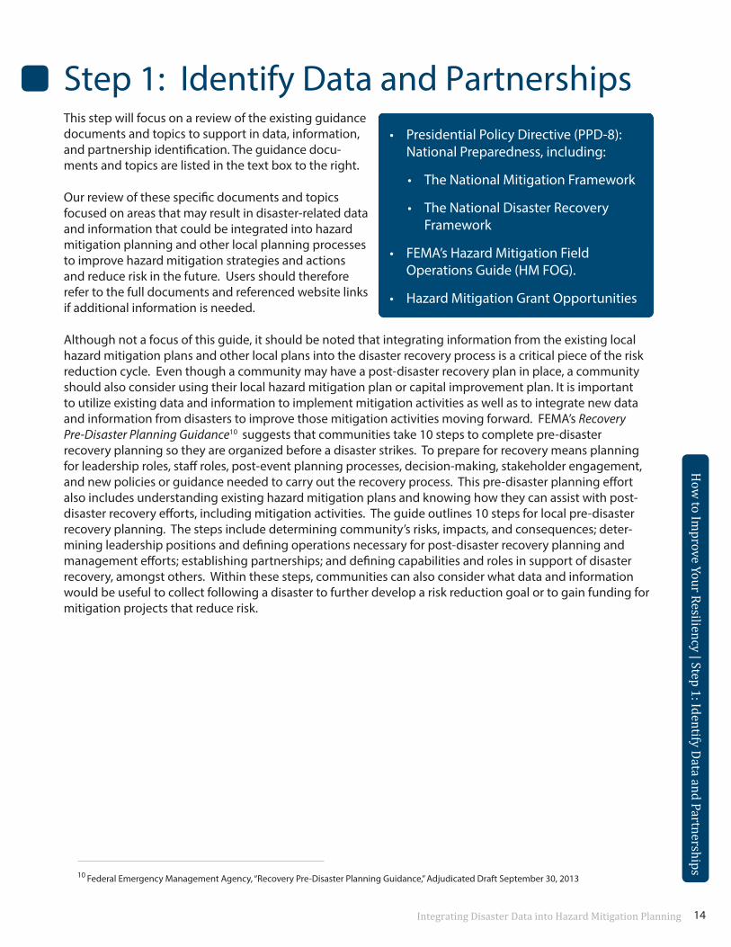
• Presidential Policy Directive (PPD-8):National Preparedness, including:
• The National Mitigation Framework
• The National Disaster RecoveryFramework
• FEMA’s Hazard Mitigation FieldOperations Guide (HM FOG).
• Hazard Mitigation Grant Opportunities
10 Federal Emergency Management Agency, “Recovery Pre-Disaster Planning Guidance,” Adjudicated Draft September 30, 2013
Integrating Disaster Data into Hazard Mitigation Planning 14
How
to Improve Your Resiliency | Step 1: Identify Data and Partnerships
PPD-8 and the National FrameworksOn March 30, 2011, President Barack Obama released Presidential Policy Directive/PPD-8: National Preparedness and described it as a directive that is “aimed at strengthening the security and resilience of the U.S. through systematic preparation for the threats that pose the greatest risk to the security of the nation, including acts of terrorism, cyber-attacks, pandemics, and catastrophic natural disasters.11” For the purpose of the PPD-8 directive, the term “national preparedness” refers to the actions taken to plan, organize, equip, train, and exercise to build and sustain the capabilities necessary to prevent, protect against, mitigate the effects of, respond to, and recover from those threats that pose the greatest risk to the security of the nation. The term “mitigation” refers to those capabilities necessary to reduce loss of life and property by lessening the impact of disasters. From PPD-8, mitigation capabilities include, but are not limited to, community-wide risk reduction projects, efforts to improve the resilience of critical infrastructure and key resource lifelines, risk reduction for specific vulnerabilities from natural hazards or acts of terrorism, and initiatives to reduce future risks after a disaster has occurred. Additional information on PPD-8 can be found at http://www.dhs.gov/presidential-policy-directive-8-national-preparedness.
To support this directive, the federal government and its partners created five National Planning Frameworks (Prevention, Protection, Mitigation, Response, and Recovery). The National Planning Frameworks, herein referred to as “frameworks,” seek to describe how the whole community can work together to achieve national preparedness. Whole community, in this context, includes individuals, families, and households; communities; the private and nonprofit sectors (including faith-based organizations); and local, state, tribal, territorial, and federal governments. The frameworks include prevention, protection, mitigation, response, and recovery. The frameworks help us understand how we, as a nation, coordinate, share information, and work together, which may ultimately result in a more secure and resilient nation. Each framework corresponds to a preparedness mission area, as addressed within PPD-8.
This guide will summarize and assess two of the five frameworks, the National Mitigation Framework (NMF) and the National Disaster Recovery Framework (NDRF), with a specific focus on the review of data, information, and partnerships that may result from the operations and implementation of these frameworks. Additional information on all the frameworks, as well as the full framework documents, may be found at http://www.fema.gov/national-planning-frameworks.
How
to Improve Your Resiliency | Step 1: Identify Data and Partnerships11 Obama, President Barack (2011, May 30). Homeland Security. Retrieved October 2013, from Department of Homeland Security:
http://www.dhs.gov/presidential-policy-directive-8-national-preparedness
Integrating Disaster Data into Hazard Mitigation Planning 15
National Mitigation Framework (NMF)The NMF establishes a common platform and forum for coordinating and addressing how the nation man-ages risk through mitigation capabilities. This framework addresses how the nation will develop, employ, and coordinate core mitigation capabilities to reduce loss of life and property by lessening the impact of disasters. The framework defines the capabilities necessary to reduce loss of life and property by lessening the impacts of disasters. The intended audience of the framework includes a range from individuals to the nation as a whole, as everyone can play a role in mitigation and managing risk.
The framework outlines seven core capabilities necessary for mitigation to be successful:
• Threats and hazard identification
• Risk and disaster resilience assessment
• Planning
• Public information and warning
• Community resilience
• Long-term vulnerability reduction
• Operational coordination
Representatives from multiple departments or agencies, public and/or private sector organizations, or a combination of these help to facilitate the delivery of the core capabilities and are referred to in the framework as coordinating structures. These groups also provide guidance, support, and integration to aid in the whole community building resilience at the local, regional, and national levels. They ensure ongoing communication and coordination among all parties involved in preparing and delivering capabilities. Coordinating structures may help to organize and incorporate mitigation and integration efforts immedi-ately following a disaster as well as in steady-state conditions.
Per the NMF, in the immediate aftermath of an event, there is tremendous opportunity to obtain new hazard data, as well as develop and implement mitigation techniques in preparation for potential future incidents. After an event, there is political will, immediate experience, and strong opportunities for education that promote mitigation strategies and successful practices. The coordinating structures should take advantage of this to ensure that the opportunities available during this unique time are captured and used. It is important to note that coordination contacts and coordination levels will vary depending on community and/or event.12
How
to Improve Your Resiliency | Step 1: Identify Data and Partnerships12 U.S. Department of Homeland Security, “National Mitigation Framework,” May, 2013. Available at:
http://www.fema.gov/media-library/assets/documents/32209?id=7363
Integrating Disaster Data into Hazard Mitigation Planning 11Integrating Disaster Data into Hazard Mitigation Planning 11
Integrating Disaster Data into Hazard Mitigation Planning 16
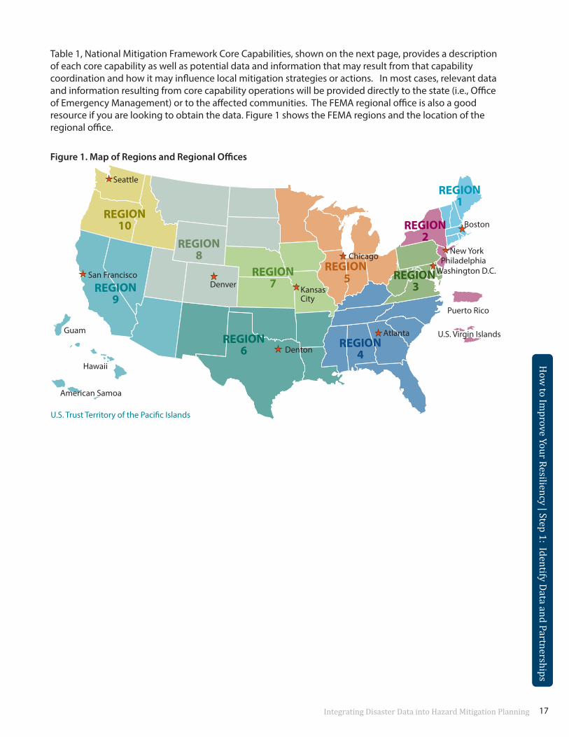
Table 1, National Mitigation Framework Core Capabilities, shown on the next page, provides a description of each core capability as well as potential data and information that may result from that capability coordination and how it may influence local mitigation strategies or actions. In most cases, relevant data and information resulting from core capability operations will be provided directly to the state (i.e., Office of Emergency Management) or to the affected communities. The FEMA regional office is also a good resource if you are looking to obtain the data. Figure 1 shows the FEMA regions and the location of the regional office.
How
to Improve Your Resiliency | Step 1: Identify Data and Partnerships
Figure 1. Map of Regions and Regional Offices
REGION1
REGION2
REGION 3
Washington D.C.Philadelphia
New York
Boston
REGION4
Atlanta
REGION 5
Chicago
REGION6 Denton
REGION7
Kansas City
REGION8
DenverREGION9
San Francisco
REGION10
Seattle
Guam
Puerto Rico
U.S. Trust Territory of the Pacific Islands
American Samoa
Hawaii
U.S. Virgin Islands
How
to Improve Your Resiliency | Step 1: Identify Data and Partnerships
Integrating Disaster Data into Hazard Mitigation Planning 17
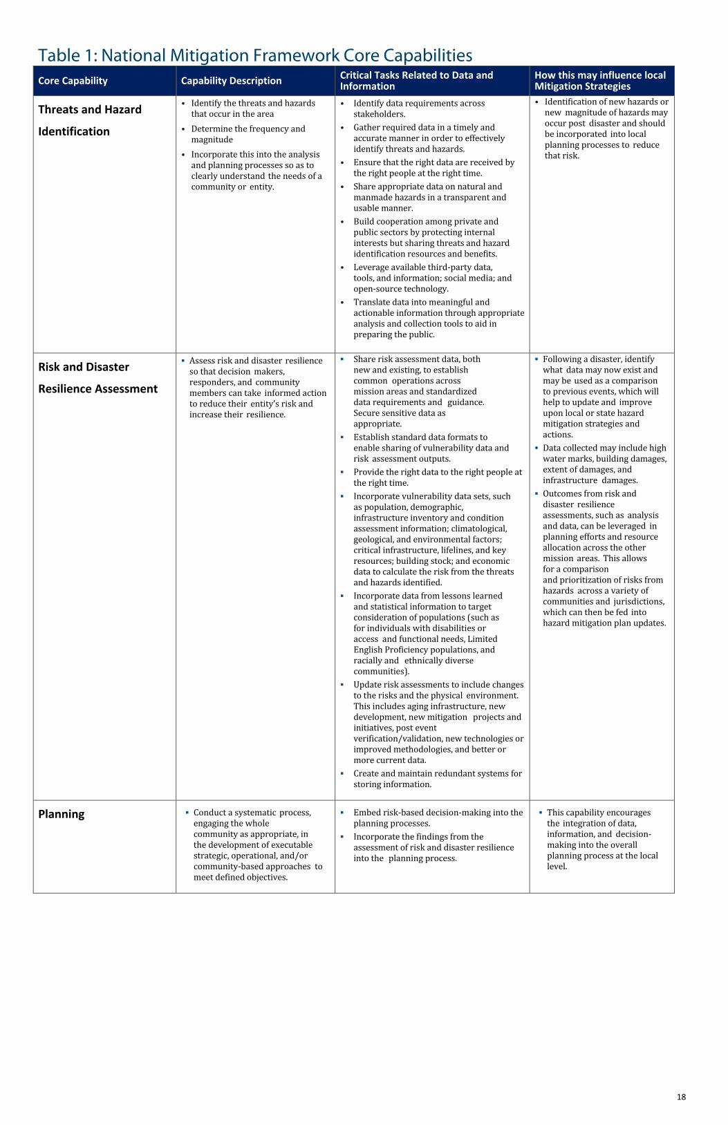
Table 1: National Mitigation Framework Core Capabilities Core Capability Capability Description Critical Tasks Related to Data and
Information How this may influence local Mitigation Strategies
Threats and Hazard
Identification
• Identify the threats and hazardsthat occur in the area
• Determine the frequency andmagnitude
• Incorporate this into the analysisand planning processes so as toclearly understand the needs of acommunity or entity.
• Identify data requirements acrossstakeholders.
• Gather required data in a timely andaccurate manner in order to effectivelyidentify threats and hazards.
• Ensure that the right data are received bythe right people at the right time.
• Share appropriate data on natural andmanmade hazards in a transparent andusable manner.
• Build cooperation among private andpublic sectors by protecting internalinterests but sharing threats and hazardidentification resources and benefits.
• Leverage available third-party data,tools, and information; social media; andopen-source technology.
• Translate data into meaningful andactionable information through appropriateanalysis and collection tools to aid inpreparing the public.
• Identification of new hazards ornew magnitude of hazards mayoccur post disaster and shouldbe incorporated into localplanning processes to reducethat risk.
Risk and Disaster
Resilience Assessment
Assess risk and disaster resilienceso that decision makers,responders, and communitymembers can take informed actionto reduce their entity’s risk andincrease their resilience.
Share risk assessment data, bothnew and existing, to establishcommon operations acrossmission areas and standardizeddata requirements and guidance.Secure sensitive data asappropriate.
Establish standard data formats toenable sharing of vulnerability data andrisk assessment outputs.
Provide the right data to the right people atthe right time.
Incorporate vulnerability data sets, suchas population, demographic,infrastructure inventory and conditionassessment information; climatological,geological, and environmental factors;critical infrastructure, lifelines, and keyresources; building stock; and economicdata to calculate the risk from the threatsand hazards identified.
Incorporate data from lessons learnedand statistical information to targetconsideration of populations (such asfor individuals with disabilities oraccess and functional needs, LimitedEnglish Proficiency populations, andracially and ethnically diversecommunities).
Update risk assessments to include changesto the risks and the physical environment.This includes aging infrastructure, newdevelopment, new mitigation projects andinitiatives, post eventverification/validation, new technologies orimproved methodologies, and better ormore current data.
Create and maintain redundant systems forstoring information.
Following a disaster, identifywhat data may now exist andmay be used as a comparisonto previous events, which willhelp to update and improveupon local or state hazardmitigation strategies andactions.
Data collected may include highwater marks, building damages,extent of damages, andinfrastructure damages.
Outcomes from risk anddisaster resilienceassessments, such as analysisand data, can be leveraged inplanning efforts and resourceallocation across the othermission areas. This allowsfor a comparisonand prioritization of risks fromhazards across a variety ofcommunities and jurisdictions,which can then be fed intohazard mitigation plan updates.
Planning Conduct a systematic process,engaging the wholecommunity as appropriate, inthe development of executablestrategic, operational, and/orcommunity-based approaches tomeet defined objectives.
Embed risk-based decision-making into theplanning processes.
Incorporate the findings from theassessment of risk and disaster resilienceinto the planning process.
This capability encouragesthe integration of data,information, and decision-making into the overallplanning process at the locallevel.
18
Table 1: National Mitigation Framework Core Capabilities Core Capability Capability Description Critical Tasks Related to Data and
Information How this may influence local Mitigation Strategies
Community Resilience
• Lead the integrated effort torecognize, understand,communicate, plan, and addressrisks so that the community candevelop a set of actions toaccomplish mitigation andimprove resilience.
• Know the community’s system – those whomakes up the community and how to buildconstructive partnerships.
• Understand the risks facing a community,including physical, social, economic, andenvironmental vulnerabilities to all threatsand hazards.
• Recognize and communicate thereinforcing relationships betweenenvironmental stewardship and naturalhazard risk reduction (e.g., enhancement offlood storage through wetlandprotection/restoration and holisticfloodplain management).
• Communicate and utilize the best availablelocalized climate projections so that thepublic and private sectors can makeinformed decisions.
• Know the community’s permanent andtransient population demographics and usethat information to plan ahead to addressresilience for the whole community,including individuals with disabilities andothers with access and functional needs.
• Foster sustained communication, civicengagement, and the development andimplementation of proactive planning,response, and long-term risk reductionactions in the whole community.
• Convince community members of the valueof mitigation for reducing the impact ofdisasters and the scale of response andrecovery efforts.
• Identify and promote sound choices anddiscourage choices that increasevulnerabilities and risks.
• Inspire transparency in risk managementdecision-making so that individuals,communities, private organizations, and alllevels of government demonstrate howresilience is considered.
• Recognize the interdependent nature of theeconomy, health and social services,housing infrastructure, and natural andcultural resources within a community.
• Acknowledge and seek out naturallyoccurring relationships withincommunities and build partnerships andcoalitions before disasters or incidentsoccur.
• Educate the next generation of communityleaders and resilience professionals; learnfrom the past and from what is working inthe present.
• This capability, by definition,will seek to put communities ina position to develop a set ofactions to improve resiliencebased on efforts to identify,understand, and address risks.
Public Information and Warning
• Deliver coordinated, prompt,reliable, and actionableinformation to the wholecommunity through the use ofclear, consistent, accessible, andculturally and linguisticallyappropriate methods to effectivelyrelay information regarding anythreat or hazard and, asappropriate, the actions beingtaken and the assistance beingmade available.
Incident-Driven Operations • Provide the tools necessary to make
decisions quickly, such as a synchronizationmatrix that allows multiple leaders to makeindependent decisions.
• Share information obtained throughcoordinating activities to inform responseand recovery decision-making by effectivelycommunicating threat and hazard riskanalysis
• Conduct outreach with atypical partners.Coordinate common messaging and verifiedsource communications through localcommunity leaders.
• Capitalize on the critical post-disasterwindow of opportunity and the mediainformation cycle to influence publicopinion to take steps toward futuremitigation.
• The most critical elements ofinformation concerninghazards, risk, responsibilities,successful practices, preventivemeasures, situationalawareness, capabilities, andavailable assistance should beclearly and openlycommunicated by leaders to thewhole community as part of thiscapability.
• This may help a variety ofcommunity members to becomemore involved in understandingtheir individual hazard risk andhow they may be able tomitigate that risk on anindividual or community level.
19
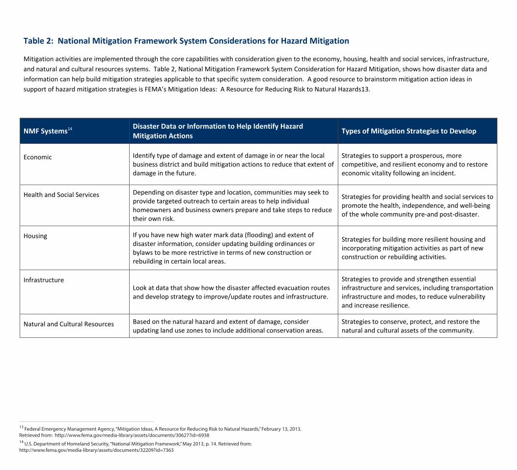
Table 2: National Mitigation Framework System Considerations for Hazard Mitigation
Mitigation activities are implemented through the core capabilities with consideration given to the economy, housing, health and social services, infrastructure, and natural and cultural resources systems. Table 2, National Mitigation Framework System Consideration for Hazard Mitigation, shows how disaster data and information can help build mitigation strategies applicable to that specific system consideration. A good resource to brainstorm mitigation action ideas in support of hazard mitigation strategies is FEMA’s Mitigation Ideas: A Resource for Reducing Risk to Natural Hazards13.
NMF Systems14 Disaster Data or Information to Help Identify Hazard Mitigation Actions Types of Mitigation Strategies to Develop
Economic Identify type of damage and extent of damage in or near the local business district and build mitigation actions to reduce that extent of damage in the future.
Strategies to support a prosperous, more competitive, and resilient economy and to restore economic vitality following an incident.
Health and Social Services Depending on disaster type and location, communities may seek to provide targeted outreach to certain areas to help individual homeowners and business owners prepare and take steps to reduce their own risk.
Strategies for providing health and social services to promote the health, independence, and well-being of the whole community pre-and post-disaster.
Housing If you have new high water mark data (flooding) and extent of disaster information, consider updating building ordinances or bylaws to be more restrictive in terms of new construction or rebuilding in certain local areas.
Strategies for building more resilient housing and incorporating mitigation activities as part of new construction or rebuilding activities.
Infrastructure Look at data that show how the disaster affected evacuation routes and develop strategy to improve/update routes and infrastructure.
Strategies to provide and strengthen essential infrastructure and services, including transportation infrastructure and modes, to reduce vulnerability and increase resilience.
Natural and Cultural Resources Based on the natural hazard and extent of damage, consider updating land use zones to include additional conservation areas.
Strategies to conserve, protect, and restore the natural and cultural assets of the community.
13 Federal Emergency Management Agency, “Mitigation Ideas, A Resource for Reducing Risk to Natural Hazards,” February 13, 2013. Retrieved from: http://www.fema.gov/media-library/assets/documents/30627?id=6938 14 U.S. Department of Homeland Security, “National Mitigation Framework,” May 2013, p. 14. Retrieved from:http://www.fema.gov/media-library/assets/documents/32209?id=7363
How
to Improve Your Resiliency | Step 1: Identify Data and Partnerships
How
to Improve Your Resiliency | Step 1: Identify Data and Partnerships
National Disaster Recovery Framework (NDRF)
The NDRF provides guidance that enables effective recovery support to disaster-impacted states, tribes, and local jurisdictions. From the NDRF, “it provides a flexible structure that enables disaster recovery managers to operate in a unified and collaborative manner. It also focuses on how best to restore, redevelop and revital-ize the health, social, economic, natural and environmental fabric of the commu-nity and build a more resilient Nation.15”
The NDRF, among other things, provides guidance for pre-and post-disaster recovery planning and defines the overall process by which communities can capitalize on opportunities to build a more resilient community. It defines the coordinating structures that facilitate communication and collaboration among all
stakeholders. Similar to NMF, the coordinating structures are made up of a combination of federal, state, and local stakeholders.
The NDRF introduces some new concepts and leadership roles into the disaster recovery process, as sum-marized below:
Federal Disaster Recovery In large-scale disasters and catastrophic incidents where a federal role Coordinator (FDRC) may be necessary, the FDRC is a focal point for incorporating recovery
and mitigation considerations into the early decision-making processes. The FDRC is responsible for facilitating disaster recovery coordination and collaboration between the federal, tribal, state and local govern-ments; the private sector; and voluntary, faith-based and community organizations. Their role includes working with the impacted com-munity to incorporate mitigation and resilience-building measures into recovery plans and implementation.
State or Tribal Disaster The role of the SDRCs, TDRCs, and LDRMs is to organize, coordinate, and Recovery Coordinators advance recovery at the local, state or tribal level. Their primary role is to (SDRC or TDRC) and manage and coordinate the redevelopment and building of community.
Local Disaster Recovery These roles have both pre-disaster and post-disaster responsibilities.
Managers (LDRM)
Recovery Support These new functions will work together to incorporate recovery con-Functions (RSFs) siderations into the decision-making process as communities rebuild
and improve their resilience. The RSFs provide structure to the recovery process while leadership is provided through the SDRC or TDRC and LDRMs, as well as private sector and nongovernmental organization (NGO) leaders, and the FDRC when needed.
15 U.S. Department of Homeland Security, “National Disaster Recovery Framework: Strengthening Disaster Recovery for the Nation,” September 2011, p. 1. Retrieved from: http://www.fema.gov/media-library/assets/documents/24647?fromSearch=fromsearch&id=5124
Integrating Disaster Data into Hazard Mitigation Planning 21
22
For the purposes of this guide, we will focus on discussing the RSFs in more detail to demonstrate how their coordination and facilitation of post-disaster activities may result in data and information that can then be integrated into hazard mitigation planning processes, mitigation strategies, and risk reduction activities.
Recovery Support Functions
The RSFs are six groupings of core recovery capabilities that provide a structure to facilitate problem solving, improve access to resources, and foster coordination among state and federal agencies, nongovernmental partners, and stakeholders. Each RSF has coordinating and primary federal agencies and supporting orga-nizations that operate together with local, state and tribal government officials, NGOs, and private sector partners to promote communication and collaboration among its members.
According to NDRF, “the purpose of each RSF is to support local governments by facilitating problem solving, improving access to resources, integrating principles of resiliency, sustainability and mitigation, and fostering coordination among State and Federal agencies, nongovernmental partners and stakeholders.16”
How
to Improve Your Resiliency | Step 1: Identify Data and Partnerships
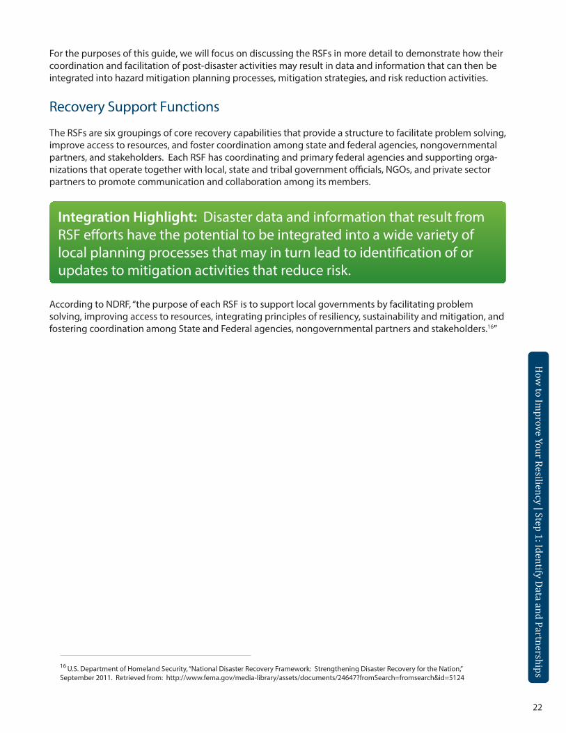
Integration Highlight: Disaster data and information that result from RSF efforts have the potential to be integrated into a wide variety of local planning processes that may in turn lead to identification of or updates to mitigation activities that reduce risk.
16 U.S. Department of Homeland Security, “National Disaster Recovery Framework: Strengthening Disaster Recovery for the Nation,” September 2011. Retrieved from: http://www.fema.gov/media-library/assets/documents/24647?fromSearch=fromsearch&id=5124
25
How
to Improve Your Resiliency | Step 1: Identify Data and Partnerships
How
to Improve Your Resiliency | Step 1: Identify Data and Partnerships
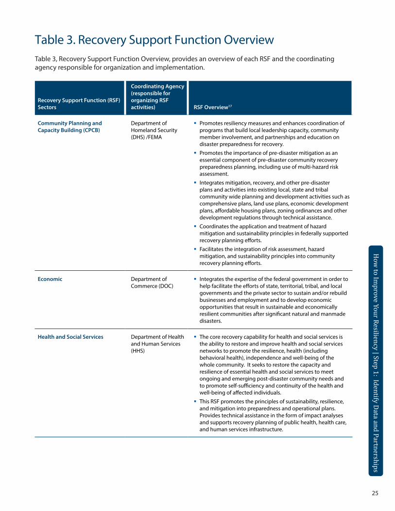
Table 3. Recovery Support Function OverviewTable 3, Recovery Support Function Overview, provides an overview of each RSF and the coordinating agency responsible for organization and implementation.
Recovery Support Function (RSF) Sectors
Coordinating Agency (responsible for organizing RSF activities) RSF Overview17
Community Planning and Capacity Building (CPCB)
Department of Homeland Security (DHS) /FEMA
Promotes resiliency measures and enhances coordination of programs that build local leadership capacity, community member involvement, and partnerships and education on disaster preparedness for recovery.
Promotes the importance of pre-disaster mitigation as an essential component of pre-disaster community recovery preparedness planning, including use of multi-hazard risk assessment.
Integrates mitigation, recovery, and other pre-disaster plans and activities into existing local, state and tribal community wide planning and development activities such as comprehensive plans, land use plans, economic development plans, affordable housing plans, zoning ordinances and other development regulations through technical assistance.
Coordinates the application and treatment of hazard mitigation and sustainability principles in federally supported recovery planning efforts.
Facilitates the integration of risk assessment, hazard mitigation, and sustainability principles into community recovery planning efforts.
Economic Department of Commerce (DOC)
Integrates the expertise of the federal government in order to help facilitate the efforts of state, territorial, tribal, and local governments and the private sector to sustain and/or rebuild businesses and employment and to develop economic opportunities that result in sustainable and economically resilient communities after significant natural and manmade disasters.
Health and Social Services Department of Health and Human Services (HHS)
The core recovery capability for health and social services is the ability to restore and improve health and social services networks to promote the resilience, health (including behavioral health), independence and well-being of the whole community. It seeks to restore the capacity and resilience of essential health and social services to meet ongoing and emerging post-disaster community needs and to promote self-sufficiency and continuity of the health and well-being of affected individuals.
This RSF promotes the principles of sustainability, resilience, and mitigation into preparedness and operational plans. Provides technical assistance in the form of impact analyses and supports recovery planning of public health, health care, and human services infrastructure.
26
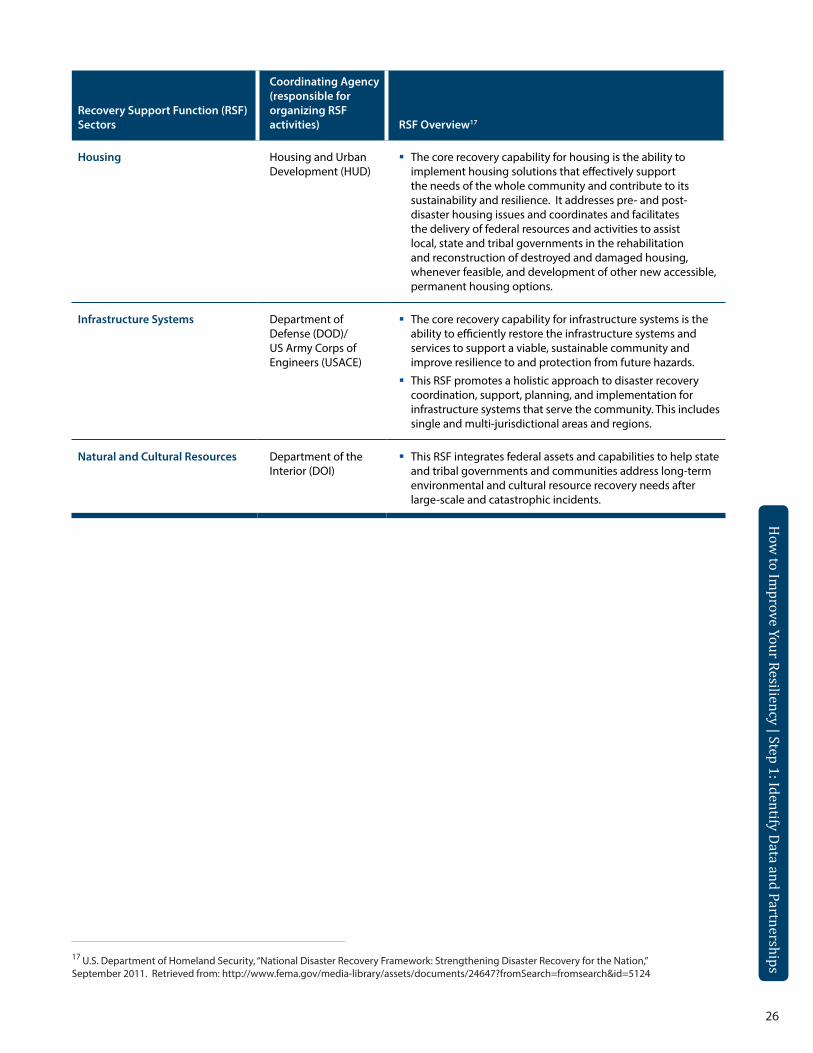
Recovery Support Function (RSF) Sectors
Coordinating Agency (responsible for organizing RSF activities) RSF Overview17
Housing Housing and Urban Development (HUD)
The core recovery capability for housing is the ability to implement housing solutions that effectively support the needs of the whole community and contribute to its sustainability and resilience. It addresses pre- and post-disaster housing issues and coordinates and facilitates the delivery of federal resources and activities to assist local, state and tribal governments in the rehabilitation and reconstruction of destroyed and damaged housing, whenever feasible, and development of other new accessible, permanent housing options.
Infrastructure Systems Department of Defense (DOD)/US Army Corps of Engineers (USACE)
The core recovery capability for infrastructure systems is the ability to efficiently restore the infrastructure systems and services to support a viable, sustainable community and improve resilience to and protection from future hazards.
This RSF promotes a holistic approach to disaster recovery coordination, support, planning, and implementation for infrastructure systems that serve the community. This includes single and multi-jurisdictional areas and regions.
Natural and Cultural Resources Department of the Interior (DOI)
This RSF integrates federal assets and capabilities to help state and tribal governments and communities address long-term environmental and cultural resource recovery needs after large-scale and catastrophic incidents.
How
to Improve Your Resiliency | Step 1: Identify Data and Partnerships17 U.S. Department of Homeland Security, “National Disaster Recovery Framework: Strengthening Disaster Recovery for the Nation,”
September 2011. Retrieved from: http://www.fema.gov/media-library/assets/documents/24647?fromSearch=fromsearch&id=5124
25
How
to Improve Your Resiliency | Step 1: Identify Data and Partnerships
How
to Improve Your Resiliency | Step 1: Identify Data and Partnerships
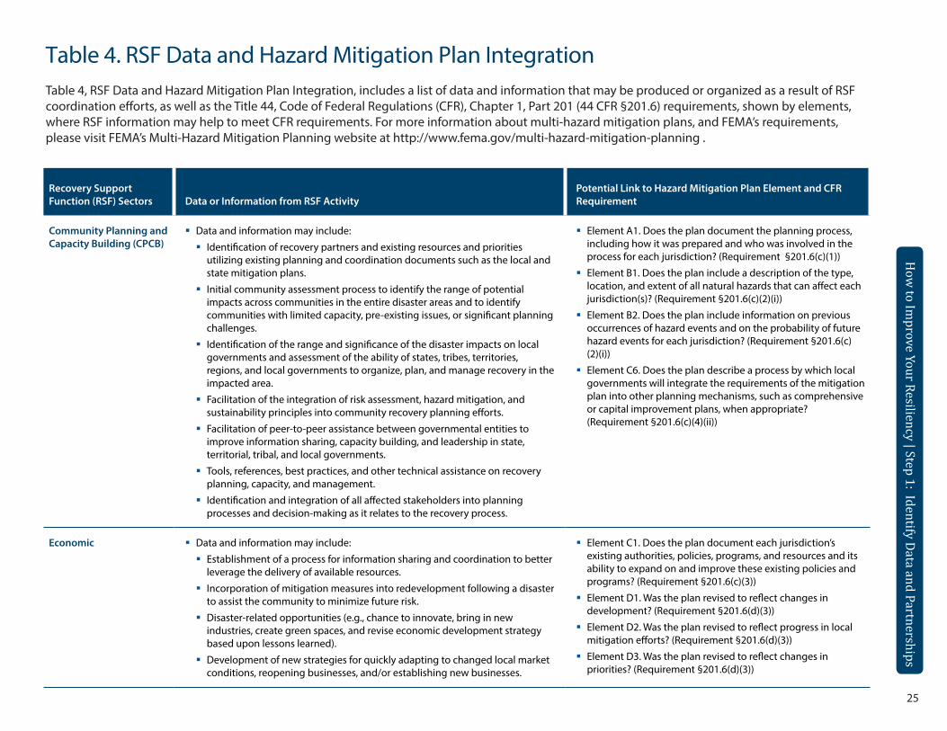
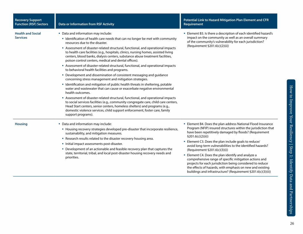
Table 4. RSF Data and Hazard Mitigation Plan IntegrationTable 4, RSF Data and Hazard Mitigation Plan Integration, includes a list of data and information that may be produced or organized as a result of RSF coordination efforts, as well as the Title 44, Code of Federal Regulations (CFR), Chapter 1, Part 201 (44 CFR §201.6) requirements, shown by elements, where RSF information may help to meet CFR requirements. For more information about multi-hazard mitigation plans, and FEMA’s requirements, please visit FEMA’s Multi-Hazard Mitigation Planning website at http://www.fema.gov/multi-hazard-mitigation-planning .
Recovery Support Function (RSF) Sectors Data or Information from RSF Activity
Potential Link to Hazard Mitigation Plan Element and CFR Requirement
Community Planning and Capacity Building (CPCB)
Data and information may include:
Identification of recovery partners and existing resources and priorities utilizing existing planning and coordination documents such as the local and state mitigation plans.
Initial community assessment process to identify the range of potential impacts across communities in the entire disaster areas and to identify communities with limited capacity, pre-existing issues, or significant planning challenges.
Identification of the range and significance of the disaster impacts on local governments and assessment of the ability of states, tribes, territories, regions, and local governments to organize, plan, and manage recovery in the impacted area.
Facilitation of the integration of risk assessment, hazard mitigation, and sustainability principles into community recovery planning efforts.
Facilitation of peer-to-peer assistance between governmental entities to improve information sharing, capacity building, and leadership in state, territorial, tribal, and local governments.
Tools, references, best practices, and other technical assistance on recovery planning, capacity, and management.
Identification and integration of all affected stakeholders into planning processes and decision-making as it relates to the recovery process.
Element A1. Does the plan document the planning process, including how it was prepared and who was involved in the process for each jurisdiction? (Requirement §201.6(c)(1))
Element B1. Does the plan include a description of the type, location, and extent of all natural hazards that can affect each jurisdiction(s)? (Requirement §201.6(c)(2)(i))
Element B2. Does the plan include information on previous occurrences of hazard events and on the probability of future hazard events for each jurisdiction? (Requirement §201.6(c)(2)(i))
Element C6. Does the plan describe a process by which local governments will integrate the requirements of the mitigation plan into other planning mechanisms, such as comprehensive or capital improvement plans, when appropriate? (Requirement §201.6(c)(4)(ii))
Economic Data and information may include:
Establishment of a process for information sharing and coordination to better leverage the delivery of available resources.
Incorporation of mitigation measures into redevelopment following a disaster to assist the community to minimize future risk.
Disaster-related opportunities (e.g., chance to innovate, bring in new industries, create green spaces, and revise economic development strategy based upon lessons learned).
Development of new strategies for quickly adapting to changed local market conditions, reopening businesses, and/or establishing new businesses.
Element C1. Does the plan document each jurisdiction’s existing authorities, policies, programs, and resources and its ability to expand on and improve these existing policies and programs? (Requirement §201.6(c)(3))
Element D1. Was the plan revised to reflect changes in development? (Requirement §201.6(d)(3))
Element D2. Was the plan revised to reflect progress in local mitigation efforts? (Requirement §201.6(d)(3))
Element D3. Was the plan revised to reflect changes in priorities? (Requirement §201.6(d)(3))
26
Recovery Support Function (RSF) Sectors Data or Information from RSF Activity
Potential Link to Hazard Mitigation Plan Element and CFR Requirement
Health and Social Services
Data and information may include:
Identification of health care needs that can no longer be met with community resources due to the disaster.
Assessment of disaster-related structural, functional, and operational impacts to health care facilities (e.g., hospitals, clinics, nursing homes, assisted living centers, blood banks, dialysis centers, substance abuse treatment facilities, poison control centers, medical and dental offices).
Assessment of disaster-related structural, functional, and operational impacts to behavioral health facilities and programs.
Development and dissemination of consistent messaging and guidance concerning stress management and mitigation strategies.
Identification and mitigation of public health threats in sheltering, potable water and wastewater that can cause or exacerbate negative environmental health outcomes.
Assessment of disaster-related structural, functional, and operational impacts to social services facilities (e.g., community congregate care, child care centers, Head Start centers, senior centers, homeless shelters) and programs (e.g., domestic violence services, child support enforcement, foster care, family support programs).
Element B3. Is there a description of each identified hazard’s impact on the community as well as an overall summary of the community’s vulnerability for each jurisdiction? (Requirement §201.6(c)(2)(ii))
Housing Data and information may include:
Housing recovery strategies developed pre-disaster that incorporate resilience, sustainability, and mitigation measures.
Research results related to the disaster recovery housing area.
Initial impact assessments post-disaster.
Development of an actionable and feasible recovery plan that captures the state, territorial, tribal, and local post-disaster housing recovery needs and priorities.
Element B4. Does the plan address National Flood Insurance Program (NFIP) insured structures within the jurisdiction that have been repetitively damaged by floods? (Requirement §201.6(c)(2)(ii))
Element C3. Does the plan include goals to reduce/avoid long-term vulnerabilities to the identified hazards? (Requirement §201.6(c)(3)(i))
Element C4. Does the plan identify and analyze a comprehensive range of specific mitigation actions and projects for each jurisdiction being considered to reduce the effects of hazards, with emphasis on new and existing buildings and infrastructure? (Requirement §201.6(c)(3)(ii))
How
to Improve Your Resiliency | Step 1: Identify Data and Partnerships
27
How
to Improve Your Resiliency | Step 1: Identify Data and Partnerships
Recovery Support Function (RSF) Sectors Data or Information from RSF Activity
Potential Link to Hazard Mitigation Plan Element and CFR Requirement
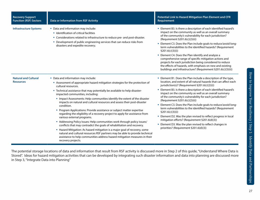
Infrastructure Systems Data and information may include:
Identification of critical facilities
Considerations related to infrastructure to reduce pre- and post-disaster.
Development of public engineering services that can reduce risks from disasters and expedite recovery;
Element B3. Is there a description of each identified hazard’s impact on the community as well as an overall summary of the community’s vulnerability for each jurisdiction? (Requirement §201.6(c)(2)(ii))
Element C3. Does the Plan include goals to reduce/avoid long-term vulnerabilities to the identified hazards? (Requirement §201.6(c)(3)(i))
Element C4. Does the Plan identify and analyze a comprehensive range of specific mitigation actions and projects for each jurisdiction being considered to reduce the effects of hazards, with emphasis on new and existing buildings and infrastructure? (Requirement §201.6(c)(3)(ii))
Natural and Cultural Resources
Data and information may include:
Assessment of appropriate hazard mitigation strategies for the protection of cultural resources.
Technical assistance that may potentially be available to help disaster-impacted communities, including:
Impact Assessments: Help communities identify the extent of the disaster impacts on natural and cultural resources and assess their post-disaster condition.
Program Applications: Provide assistance or subject matter expertise regarding the eligibility of a recovery project to apply for assistance from various external programs.
Addressing Policy Issues: Help communities work through policy issues/conflicts that may contradict the goals of rehabilitation and recovery.
Hazard Mitigation: As hazard mitigation is a major goal of recovery, some natural and cultural resources RSF partners may be able to provide technical assistance to help communities address hazard mitigation measures in their recovery projects.
Element B1. Does the Plan include a description of the type, location, and extent of all natural hazards that can affect each jurisdiction(s)? (Requirement §201.6(c)(2)(i))
Element B3. Is there a description of each identified hazard’s impact on the community as well as an overall summary of the community’s vulnerability for each jurisdiction? (Requirement §201.6(c)(2)(ii))
Element C3. Does the Plan include goals to reduce/avoid long-term vulnerabilities to the identified hazards? (Requirement §201.6(c)(3)(i))
Element D2. Was the plan revised to reflect progress in local mitigation efforts? (Requirement §201.6(d)(3))
Element D3. Was the plan revised to reflect changes in priorities? (Requirement §201.6(d)(3))
The potential storage locations of data and information that result from RSF activity is discussed more in Step 2 of this guide, “Understand Where Data is Stored”. Ideas for hazard mitigation activities that can be developed by integrating such disaster information and data into planning are discussed more in Step 3, “Integrate Data into Planning”
How
to Improve Your Resiliency | Step 1: Identify Data and Partnerships
30
How
to Improve Your Resiliency | Step 1: Identify Data and Partnerships
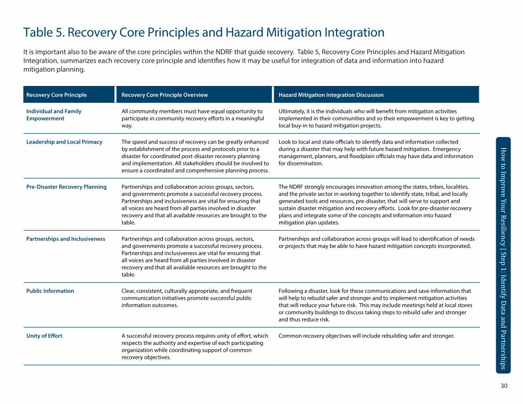
Table 5. Recovery Core Principles and Hazard Mitigation IntegrationIt is important also to be aware of the core principles within the NDRF that guide recovery. Table 5, Recovery Core Principles and Hazard Mitigation Integration, summarizes each recovery core principle and identifies how it may be useful for integration of data and information into hazard mitigation planning.
Recovery Core Principle Recovery Core Principle Overview Hazard Mitigation Integration Discussion
Individual and Family Empowerment
All community members must have equal opportunity to participate in community recovery efforts in a meaningful way.
Ultimately, it is the individuals who will benefit from mitigation activities implemented in their communities and so their empowerment is key to getting local buy-in to hazard mitigation projects.
Leadership and Local Primacy The speed and success of recovery can be greatly enhanced by establishment of the process and protocols prior to a disaster for coordinated post-disaster recovery planning and implementation. All stakeholders should be involved to ensure a coordinated and comprehensive planning process.
Look to local and state officials to identify data and information collected during a disaster that may help with future hazard mitigation. Emergency management, planners, and floodplain officials may have data and information for dissemination.
Pre-Disaster Recovery Planning Partnerships and collaboration across groups, sectors, and governments promote a successful recovery process. Partnerships and inclusiveness are vital for ensuring that all voices are heard from all parties involved in disaster recovery and that all available resources are brought to the table.
The NDRF strongly encourages innovation among the states, tribes, localities, and the private sector in working together to identify state, tribal, and locally generated tools and resources, pre-disaster, that will serve to support and sustain disaster mitigation and recovery efforts. Look for pre-disaster recovery plans and integrate some of the concepts and information into hazard mitigation plan updates.
Partnerships and Inclusiveness Partnerships and collaboration across groups, sectors, and governments promote a successful recovery process. Partnerships and inclusiveness are vital for ensuring that all voices are heard from all parties involved in disaster recovery and that all available resources are brought to the table.
Partnerships and collaboration across groups will lead to identification of needs or projects that may be able to have hazard mitigation concepts incorporated.
Public Information Clear, consistent, culturally appropriate, and frequent communication initiatives promote successful public information outcomes.
Following a disaster, look for these communications and save information that will help to rebuild safer and stronger and to implement mitigation activities that will reduce your future risk. This may include meetings held at local stores or community buildings to discuss taking steps to rebuild safer and stronger and thus reduce risk.
Unity of Effort A successful recovery process requires unity of effort, which respects the authority and expertise of each participating organization while coordinating support of common recovery objectives.
Common recovery objectives will include rebuilding safer and stronger.
31
How
to Improve Your Resiliency | Step 1: Identify Data and Partnerships
How
to Improve Your Resiliency | Step 1: Identify Data and Partnerships
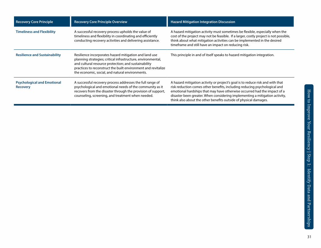
Recovery Core Principle Recovery Core Principle Overview Hazard Mitigation Integration Discussion
Timeliness and Flexibility A successful recovery process upholds the value of timeliness and flexibility in coordinating and efficiently conducting recovery activities and delivering assistance.
A hazard mitigation activity must sometimes be flexible, especially when the cost of the project may not be feasible. If a larger, costly project is not possible, think about what mitigation activities can be implemented in the desired timeframe and still have an impact on reducing risk.
Resilience and Sustainability Resilience incorporates hazard mitigation and land use planning strategies; critical infrastructure, environmental, and cultural resource protection; and sustainability practices to reconstruct the built environment and revitalize the economic, social, and natural environments.
This principle in and of itself speaks to hazard mitigation integration.
Psychological and Emotional Recovery
A successful recovery process addresses the full range of psychological and emotional needs of the community as it recovers from the disaster through the provision of support, counseling, screening, and treatment when needed.
A hazard mitigation activity or project’s goal is to reduce risk and with that risk reduction comes other benefits, including reducing psychological and emotional hardships that may have otherwise occurred had the impact of a disaster been greater. When considering implementing a mitigation activity, think also about the other benefits outside of physical damages.
32
How
to Improve Your Resiliency | Step 1: Identify Data and Partnerships
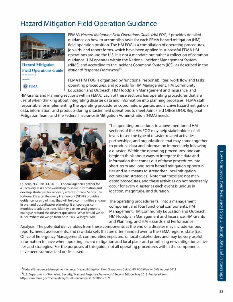
Hazard Mitigation Field Operation GuidanceFEMA’s Hazard Mitigation Field Operations Guide (HM FOG)18 provides detailed guidance on how to accomplish tasks for each FEMA hazard mitigation (HM) field operation position. The HM FOG is a compilation of operating procedures, job aids, and report forms, which have been applied in successful FEMA HM operations around the U.S. It is not a mandate but rather a collection of common guidance. HM operates within the National Incident Management System (NIMS) and according to the Incident Command System (ICS), as described in the National Response Framework19.
FEMA’s HM FOG is organized by functional responsibilities, work flow and tasks, operating procedures, and job aids for HM Management, HM Community Education and Outreach, HM Floodplain Management and Insurance, and
HM Grants and Planning sections within FEMA. Each of these sections has operating procedures that are useful when thinking about integrating disaster data and information into planning processes. FEMA staff responsible for implementing the operating procedures coordinate, organize, and archive hazard mitigation data, information, and products during disaster field operations to meet Joint Field Office (JFO), Regional Mitigation Team, and the Federal Insurance & Mitigation Administration (FIMA) needs.
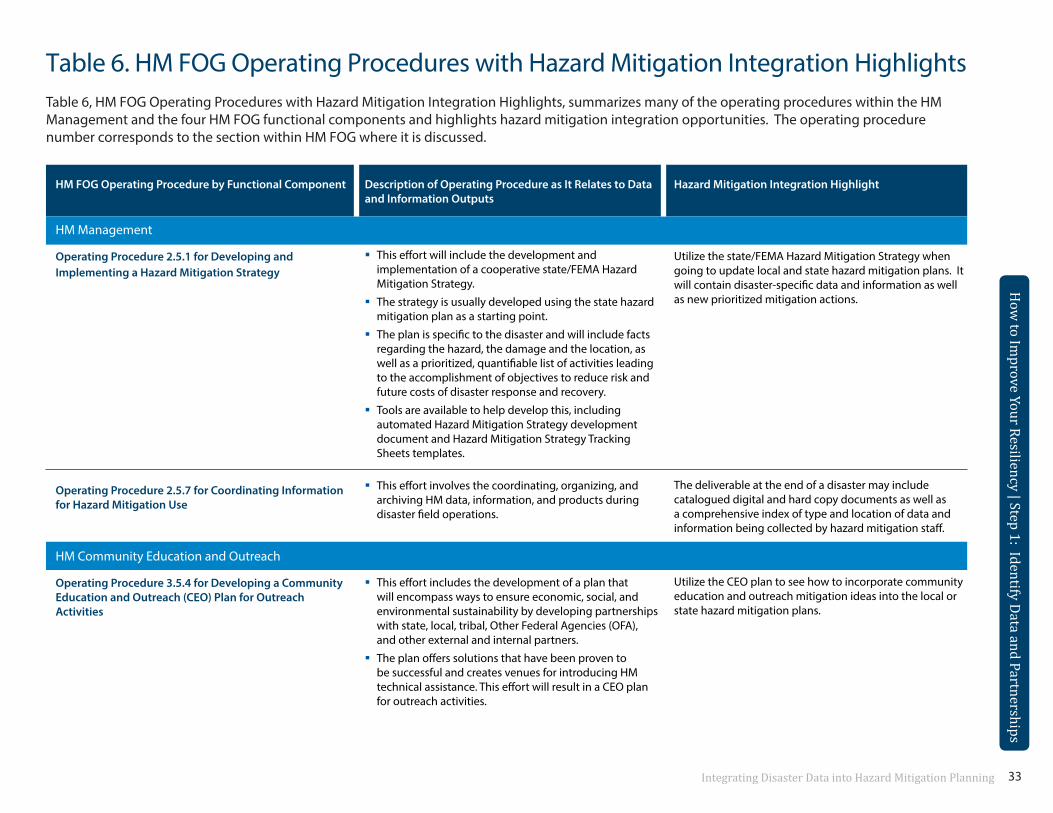
Queens, N.Y., Jan. 14, 2013 -- Federal agencies gather for a Recovery Task Force workshop to share information and develop strategies for recovery after Hurricane Sandy. The National Disaster Recovery Framework (NDRF) provides guidance for a road map that will help communities engage in pre- and post-disaster planning. It encourages com-munities to ask questions, identify barriers and generate dialogue around the disaster questions “What would we do if...” or “Where do we go from here?” K.C.Wilsey/FEMA.
The operating procedures in above-mentioned HM sections of the HM FOG may help stakeholders of all levels to see the type of disaster-related activities, partnerships, and organizations that may come together to produce data and information immediately following a disaster. Within the operating procedures, one can begin to think about ways to integrate the data and information that comes out of these procedures into short-term and long-term hazard mitigation opportuni-ties and as a means to strengthen local mitigation actions and strategies. Note that these are not man-dated procedures, and these activities do not necessarily occur for every disaster as each event is unique in location, magnitude, and duration.
The operating procedures fall into a management component and four functional components: HM Management, HM Community Education and Outreach, HM Floodplain Management and Insurance, HM Grants and Planning, and HM Hazards and Performance
Analysis. The potential deliverables from these components at the end of a disaster may include various reports, needs assessments, and raw data sets that are often handed over to the FEMA regions, state (i.e., Office of Emergency Management), communities impacted, or local stakeholders and may be very useful information to have when updating hazard mitigation and local plans and prioritizing new mitigation activi-ties and strategies. For the purposes of this guide, not all operating procedures within the components have been summarized or discussed.
18 Federal Emergency Management Agency, “Hazard Mitigation Field Operations Guide,” HM FOG (Version 3.0), August 201219 U.S. Department of Homeland Security, “National Response Framework,” Second Edition, May 2013. Retrieved from: http://www.fema.gov/media-library/assets/documents/32230?id=7371
33Integrating Disaster Data into Hazard Mitigation Planning
How
to Improve Your Resiliency | Step 1: Identify Data and Partnerships
How
to Improve Your Resiliency | Step 1: Identify Data and Partnerships
Table 6. HM FOG Operating Procedures with Hazard Mitigation Integration HighlightsTable 6, HM FOG Operating Procedures with Hazard Mitigation Integration Highlights, summarizes many of the operating procedures within the HM Management and the four HM FOG functional components and highlights hazard mitigation integration opportunities. The operating procedure number corresponds to the section within HM FOG where it is discussed.
HM FOG Operating Procedure by Functional Component
HM Management
Operating Procedure 2.5.1 for Developing and Implementing a Hazard Mitigation Strategy
Operating Procedure 2.5.7 for Coordinating Information for Hazard Mitigation Use
HM Community Education and Outreach
Operating Procedure 3.5.4 for Developing a Community Education and Outreach (CEO) Plan for Outreach Activities
Description of Operating Procedure as It Relates to Data and Information Outputs
This effort will include the development and implementation of a cooperative state/FEMA Hazard Mitigation Strategy.
The strategy is usually developed using the state hazard mitigation plan as a starting point.
The plan is specific to the disaster and will include facts regarding the hazard, the damage and the location, as well as a prioritized, quantifiable list of activities leading to the accomplishment of objectives to reduce risk and future costs of disaster response and recovery.
Tools are available to help develop this, including automated Hazard Mitigation Strategy development document and Hazard Mitigation Strategy Tracking Sheets templates.
This effort involves the coordinating, organizing, and archiving HM data, information, and products during disaster field operations.
This effort includes the development of a plan that will encompass ways to ensure economic, social, and environmental sustainability by developing partnerships with state, local, tribal, Other Federal Agencies (OFA), and other external and internal partners.
The plan offers solutions that have been proven to be successful and creates venues for introducing HM technical assistance. This effort will result in a CEO plan for outreach activities.
Hazard Mitigation Integration Highlight
Utilize the state/FEMA Hazard Mitigation Strategy when going to update local and state hazard mitigation plans. It will contain disaster-specific data and information as well as new prioritized mitigation actions.
The deliverable at the end of a disaster may include catalogued digital and hard copy documents as well as a comprehensive index of type and location of data and information being collected by hazard mitigation staff.
Utilize the CEO plan to see how to incorporate community education and outreach mitigation ideas into the local or state hazard mitigation plans.
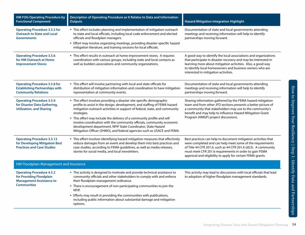
34Integrating Disaster Data into Hazard Mitigation Planning
HM FOG Operating Procedure by Functional Component
Operating Procedure 3.5.5 for Outreach to State and Local Governments
Description of Operating Procedure as It Relates to Data and Information Outputs
This effort includes planning and implementation of mitigation outreach to state and local officials, including local code enforcement and elected officials and floodplain managers.
Effort may involve organizing meetings, providing disaster-specific hazard mitigation literature, and training sessions for local officials.
Hazard Mitigation Integration Highlight
Documentation of state and local governments attending meetings and receiving information will help to identify partnerships moving forward.
Operating Procedure 3.5.6 for HM Outreach at Home Improvement Stores
This effort results in outreach at home improvement stores. It requires coordination with various groups, including state and local contacts as well as builders associations and community organizations.
A good way to identify the local associations and organizations that participate in disaster recovery and may be interested in learning more about mitigation activities. Also, a good way to identify local homeowners and business owners who are interested in mitigation activities.
Operating Procedure 3.5.8 for Establishing Partnerships with Community Relations
This effort will involve partnering with local and state officials for distribution of mitigation information and coordination to have mitigation representation at community events.
Documentation of state and local governments attending meetings and receiving information will help to identify partnerships moving forward.
Operating Procedure 3.5.9 for Disaster Data Gathering, Utilization, and Sharing
This effort involves providing a disaster site-specific demographic profile to assist in the design, development, and staffing of FEMA hazard mitigation outreach activities in support of federal, state, and community strategies.
This effort may include the delivery of a community profile and will involve coordination with the community officials, community economic development department, NFIP State Coordinator, State Hazard Mitigation Officer (SHMO), and federal agencies such as USACE and FEMA.
Sharing information gathered by the FEMA hazard mitigation team and from other JFO sections presents a better picture of a community that stakeholders may use to the community’s benefit and may help to influence Hazard Mitigation Grant Program (HMGP) project discussions.
Operating Procedure 3.5.12 This effort involves identifying hazard mitigation measures that effectively for Developing Mitigation Best reduce damages from an event and develop them into best practices and Practices and Case Studies case studies, according to FEMA guidelines, as well as media releases,
stories for social media, and local newsletters.
HM Floodplain Management and Insurance
Best practices can help to document mitigation activities that were completed and can help meet some of the requirements of Title 44 CFR 201.6, such as 44 CFR 201.6 (d)(3). A community must meet CFR 201.6 requirements in order to gain FEMA approval and eligibility to apply for certain FEMA grants.
Operating Procedure 4.5.2 for Providing Floodplain Management Assistance to Communities
This activity is designed to motivate and provide technical assistance to community officials and other stakeholders to comply with and enforce their floodplain management ordinance.
There is encouragement of non-participating communities to join the NFIP.
Efforts may result in providing the communities with publications, including public information about substantial damage and mitigation options.
This activity may lead to discussions with local officials that lead to adoption of higher floodplain management standards.
How
to Improve Your Resiliency | Step 1: Identify Data and Partnerships
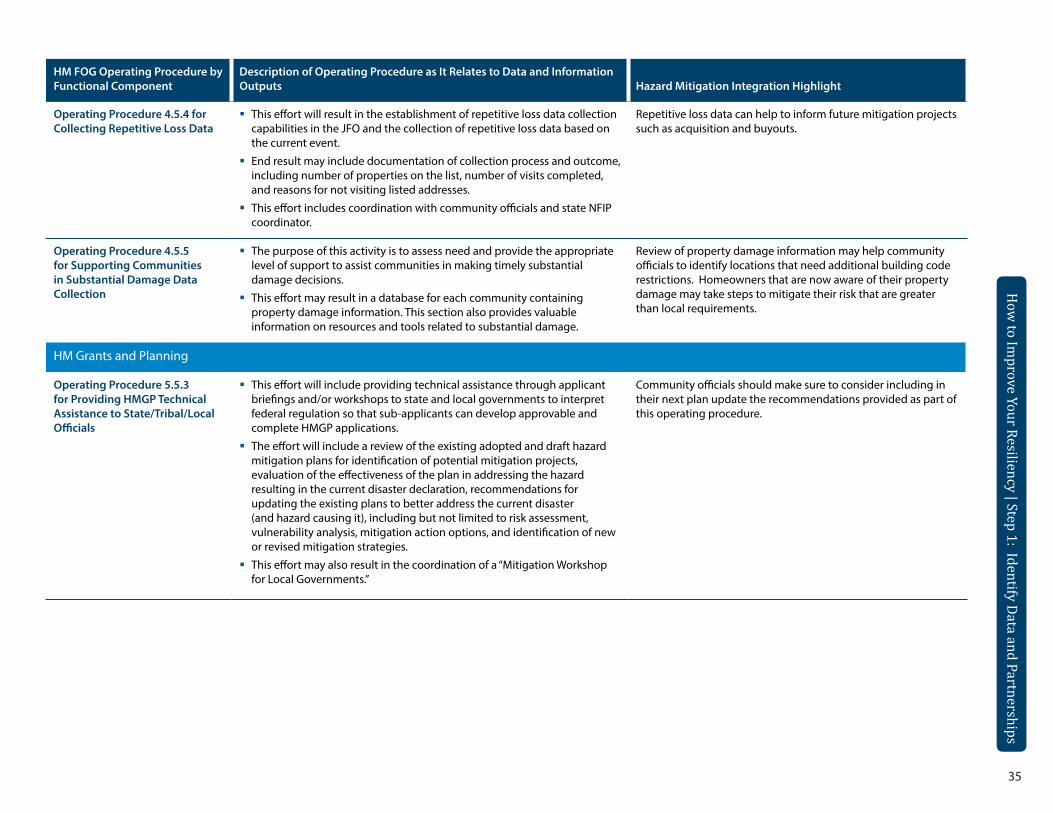
35
How
to Improve Your Resiliency | Step 1: Identify Data and Partnerships
How
to Improve Your Resiliency | Step 1: Identify Data and Partnerships
HM FOG Operating Procedure by Description of Operating Procedure as It Relates to Data and Information Functional Component Outputs Hazard Mitigation Integration Highlight
Operating Procedure 4.5.4 for This effort will result in the establishment of repetitive loss data collection Repetitive loss data can help to inform future mitigation projects Collecting Repetitive Loss Data capabilities in the JFO and the collection of repetitive loss data based on such as acquisition and buyouts.
the current event.
End result may include documentation of collection process and outcome, including number of properties on the list, number of visits completed, and reasons for not visiting listed addresses.
This effort includes coordination with community officials and state NFIP coordinator.
Operating Procedure 4.5.5 for Supporting Communities in Substantial Damage Data Collection
HM Grants and Planning
Operating Procedure 5.5.3 for Providing HMGP Technical Assistance to State/Tribal/Local Officials
The purpose of this activity is to assess need and provide the appropriate level of support to assist communities in making timely substantial damage decisions.
This effort may result in a database for each community containing property damage information. This section also provides valuable information on resources and tools related to substantial damage.
This effort will include providing technical assistance through applicant briefings and/or workshops to state and local governments to interpret federal regulation so that sub-applicants can develop approvable and complete HMGP applications.
The effort will include a review of the existing adopted and draft hazard mitigation plans for identification of potential mitigation projects, evaluation of the effectiveness of the plan in addressing the hazard resulting in the current disaster declaration, recommendations for updating the existing plans to better address the current disaster (and hazard causing it), including but not limited to risk assessment, vulnerability analysis, mitigation action options, and identification of new or revised mitigation strategies.
This effort may also result in the coordination of a “Mitigation Workshop for Local Governments.”
Review of property damage information may help community officials to identify locations that need additional building code restrictions. Homeowners that are now aware of their property damage may take steps to mitigate their risk that are greater than local requirements.
Community officials should make sure to consider including in their next plan update the recommendations provided as part of this operating procedure.
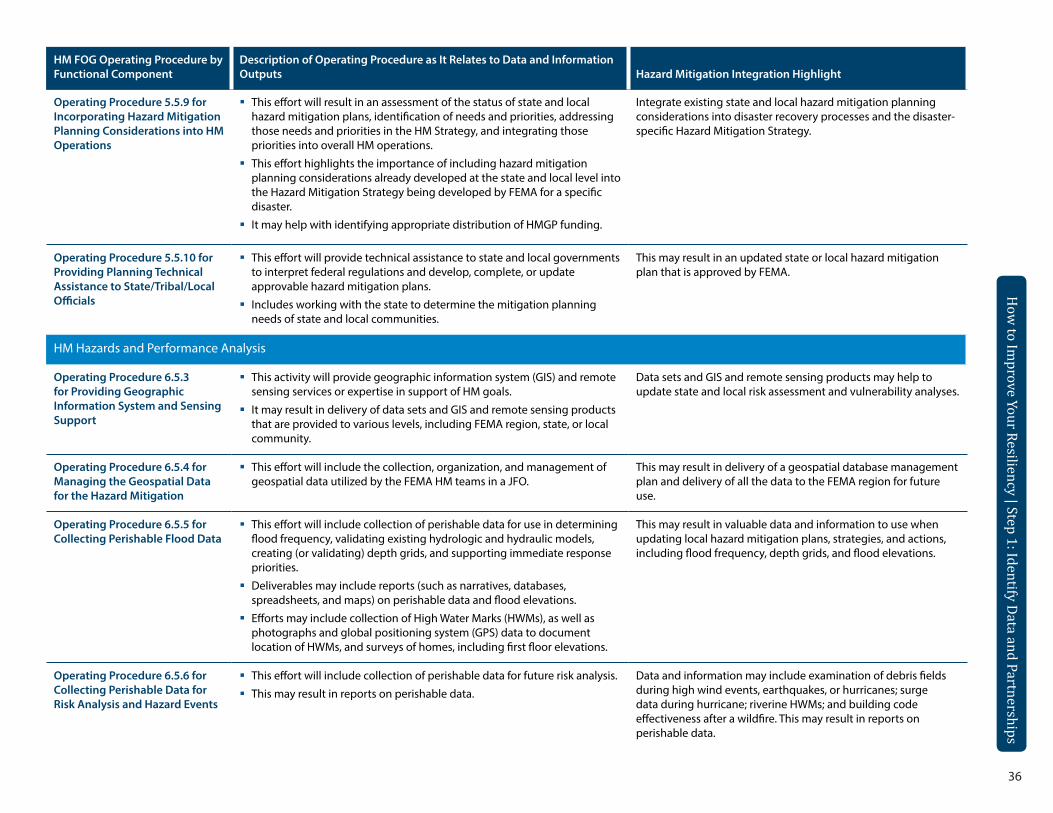
36
How
to Improve Your Resiliency | Step 1: Identify Data and Partnerships
HM FOG Operating Procedure by Functional Component
Operating Procedure 5.5.9 for Incorporating Hazard Mitigation Planning Considerations into HM Operations
Description of Operating Procedure as It Relates to Data and Information Outputs
This effort will result in an assessment of the status of state and local hazard mitigation plans, identification of needs and priorities, addressing those needs and priorities in the HM Strategy, and integrating those priorities into overall HM operations.
This effort highlights the importance of including hazard mitigation planning considerations already developed at the state and local level into the Hazard Mitigation Strategy being developed by FEMA for a specific disaster.
It may help with identifying appropriate distribution of HMGP funding.
Hazard Mitigation Integration Highlight
Integrate existing state and local hazard mitigation planning considerations into disaster recovery processes and the disaster-specific Hazard Mitigation Strategy.
Operating Procedure 5.5.10 for This effort will provide technical assistance to state and local governments Providing Planning Technical to interpret federal regulations and develop, complete, or update Assistance to State/Tribal/Local approvable hazard mitigation plans.Officials Includes working with the state to determine the mitigation planning
needs of state and local communities.
HM Hazards and Performance Analysis
Operating Procedure 6.5.3 This activity will provide geographic information system (GIS) and remote for Providing Geographic sensing services or expertise in support of HM goals.Information System and Sensing It may result in delivery of data sets and GIS and remote sensing products Support that are provided to various levels, including FEMA region, state, or local
community.
This may result in an updated state or local hazard mitigation plan that is approved by FEMA.
Data sets and GIS and remote sensing products may help to update state and local risk assessment and vulnerability analyses.
Operating Procedure 6.5.4 for Managing the Geospatial Data for the Hazard Mitigation
This effort will include the collection, organization, and management of geospatial data utilized by the FEMA HM teams in a JFO.
This may result in delivery of a geospatial database management plan and delivery of all the data to the FEMA region for future use.
Operating Procedure 6.5.5 for Collecting Perishable Flood Data
This effort will include collection of perishable data for use in determining flood frequency, validating existing hydrologic and hydraulic models, creating (or validating) depth grids, and supporting immediate response priorities.
Deliverables may include reports (such as narratives, databases, spreadsheets, and maps) on perishable data and flood elevations.
Efforts may include collection of High Water Marks (HWMs), as well as photographs and global positioning system (GPS) data to document location of HWMs, and surveys of homes, including first floor elevations.
This may result in valuable data and information to use when updating local hazard mitigation plans, strategies, and actions, including flood frequency, depth grids, and flood elevations.
Operating Procedure 6.5.6 for Collecting Perishable Data for Risk Analysis and Hazard Events
This effort will include collection of perishable data for future risk analysis.
This may result in reports on perishable data.
Data and information may include examination of debris fields during high wind events, earthquakes, or hurricanes; surge data during hurricane; riverine HWMs; and building code effectiveness after a wildfire. This may result in reports on perishable data.
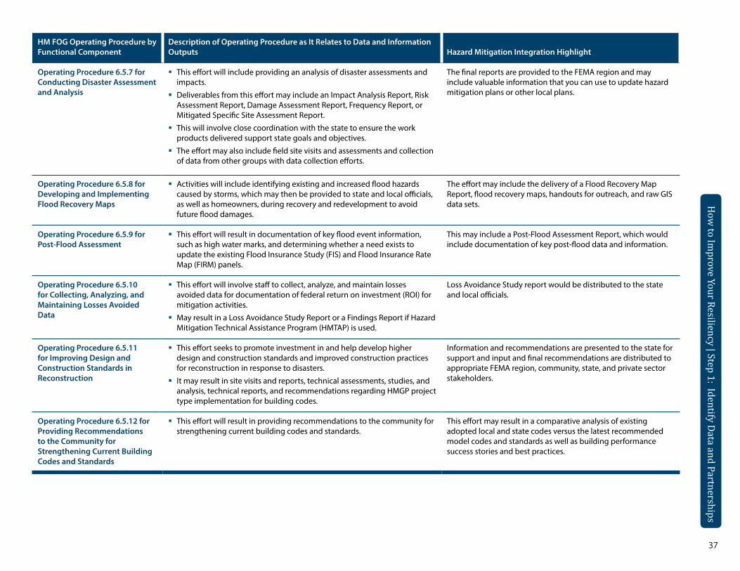
37
How
to Improve Your Resiliency | Step 1: Identify Data and Partnerships
How
to Improve Your Resiliency | Step 1: Identify Data and Partnerships
HM FOG Operating Procedure by Functional Component
Operating Procedure 6.5.7 for Conducting Disaster Assessment and Analysis
Description of Operating Procedure as It Relates to Data and Information Outputs
This effort will include providing an analysis of disaster assessments and impacts.
Deliverables from this effort may include an Impact Analysis Report, Risk Assessment Report, Damage Assessment Report, Frequency Report, or Mitigated Specific Site Assessment Report.
This will involve close coordination with the state to ensure the work products delivered support state goals and objectives.
The effort may also include field site visits and assessments and collection of data from other groups with data collection efforts.
Hazard Mitigation Integration Highlight
The final reports are provided to the FEMA region and may include valuable information that you can use to update hazard mitigation plans or other local plans.
Operating Procedure 6.5.8 for Developing and Implementing Flood Recovery Maps
Activities will include identifying existing and increased flood hazards caused by storms, which may then be provided to state and local officials, as well as homeowners, during recovery and redevelopment to avoid future flood damages.
The effort may include the delivery of a Flood Recovery Map Report, flood recovery maps, handouts for outreach, and raw GIS data sets.
Operating Procedure 6.5.9 for Post-Flood Assessment
This effort will result in documentation of key flood event information, such as high water marks, and determining whether a need exists to update the existing Flood Insurance Study (FIS) and Flood Insurance Rate Map (FIRM) panels.
This may include a Post-Flood Assessment Report, which would include documentation of key post-flood data and information.
Operating Procedure 6.5.10 for Collecting, Analyzing, and Maintaining Losses Avoided Data
This effort will involve staff to collect, analyze, and maintain losses avoided data for documentation of federal return on investment (ROI) for mitigation activities.
May result in a Loss Avoidance Study Report or a Findings Report if Hazard Mitigation Technical Assistance Program (HMTAP) is used.
Loss Avoidance Study report would be distributed to the state and local officials.
Operating Procedure 6.5.11 for Improving Design and Construction Standards in Reconstruction
This effort seeks to promote investment in and help develop higher design and construction standards and improved construction practices for reconstruction in response to disasters.
It may result in site visits and reports, technical assessments, studies, and analysis, technical reports, and recommendations regarding HMGP project type implementation for building codes.
Information and recommendations are presented to the state for support and input and final recommendations are distributed to appropriate FEMA region, community, state, and private sector stakeholders.
Operating Procedure 6.5.12 for Providing Recommendations to the Community for Strengthening Current Building Codes and Standards
This effort will result in providing recommendations to the community for strengthening current building codes and standards.
This effort may result in a comparative analysis of existing adopted local and state codes versus the latest recommended model codes and standards as well as building performance success stories and best practices.
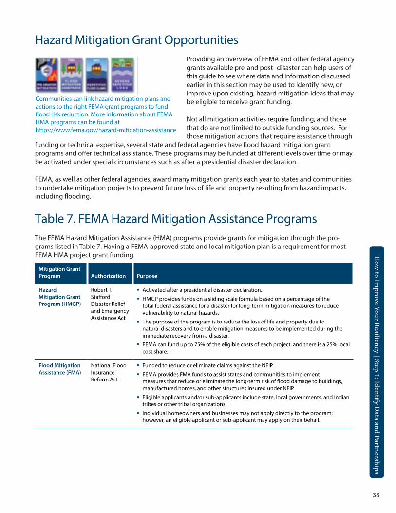
38
How
to Improve Your Resiliency | Step 1: Identify Data and Partnerships
Hazard Mitigation Grant Opportunities
Communities can link hazard mitigation plans and actions to the right FEMA grant programs to fund flood risk reduction. More information about FEMA HMA programs can be found at https://www.fema.gov/hazard-mitigation-assistance
Providing an overview of FEMA and other federal agency grants available pre-and post -disaster can help users of this guide to see where data and information discussed earlier in this section may be used to identify new, or improve upon existing, hazard mitigation ideas that may be eligible to receive grant funding.
Not all mitigation activities require funding, and those that do are not limited to outside funding sources. For those mitigation actions that require assistance through
funding or technical expertise, several state and federal agencies have flood hazard mitigation grant programs and offer technical assistance. These programs may be funded at different levels over time or may be activated under special circumstances such as after a presidential disaster declaration.
FEMA, as well as other federal agencies, award many mitigation grants each year to states and communities to undertake mitigation projects to prevent future loss of life and property resulting from hazard impacts, including flooding.
Table 7. FEMA Hazard Mitigation Assistance ProgramsThe FEMA Hazard Mitigation Assistance (HMA) programs provide grants for mitigation through the pro-grams listed in Table 7. Having a FEMA-approved state and local mitigation plan is a requirement for most FEMA HMA project grant funding.
Mitigation Grant Program Authorization Purpose
Hazard Mitigation Grant Program (HMGP)
Robert T. Stafford Disaster Relief and Emergency Assistance Act
Activated after a presidential disaster declaration.
HMGP provides funds on a sliding scale formula based on a percentage of the total federal assistance for a disaster for long-term mitigation measures to reduce vulnerability to natural hazards.
The purpose of the program is to reduce the loss of life and property due to natural disasters and to enable mitigation measures to be implemented during the immediate recovery from a disaster.
FEMA can fund up to 75% of the eligible costs of each project, and there is a 25% local cost share.
Flood Mitigation Assistance (FMA)
National Flood Insurance Reform Act
Funded to reduce or eliminate claims against the NFIP.
FEMA provides FMA funds to assist states and communities to implement measures that reduce or eliminate the long-term risk of flood damage to buildings, manufactured homes, and other structures insured under NFIP.
Eligible applicants and/or sub-applicants include state, local governments, and Indian tribes or other tribal organizations.
Individual homeowners and businesses may not apply directly to the program; however, an eligible applicant or sub-applicant may apply on their behalf.
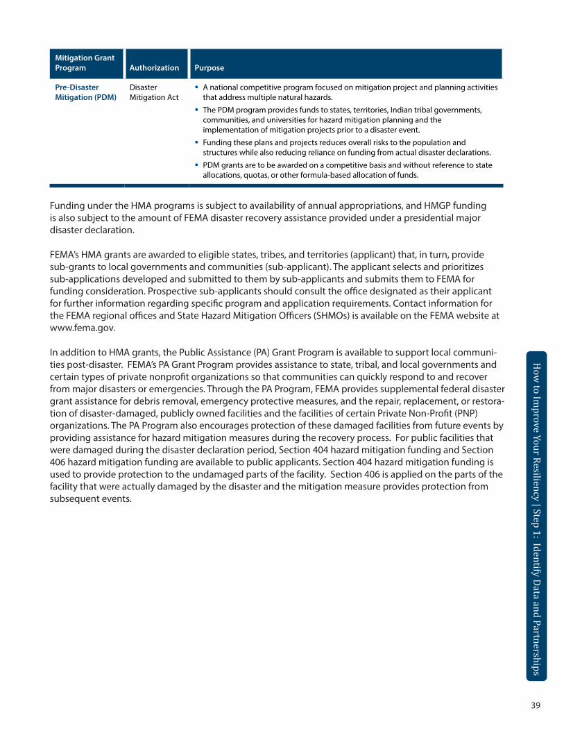
39
How
to Improve Your Resiliency | Step 1: Identify Data and Partnerships
How
to Improve Your Resiliency | Step 1: Identify Data and Partnerships
Mitigation Grant Program Authorization Purpose
Pre-Disaster Mitigation (PDM)
Disaster Mitigation Act
A national competitive program focused on mitigation project and planning activities that address multiple natural hazards.
The PDM program provides funds to states, territories, Indian tribal governments, communities, and universities for hazard mitigation planning and the implementation of mitigation projects prior to a disaster event.
Funding these plans and projects reduces overall risks to the population and structures while also reducing reliance on funding from actual disaster declarations.
PDM grants are to be awarded on a competitive basis and without reference to state allocations, quotas, or other formula-based allocation of funds.
Funding under the HMA programs is subject to availability of annual appropriations, and HMGP funding is also subject to the amount of FEMA disaster recovery assistance provided under a presidential major disaster declaration.
FEMA’s HMA grants are awarded to eligible states, tribes, and territories (applicant) that, in turn, provide sub-grants to local governments and communities (sub-applicant). The applicant selects and prioritizes sub-applications developed and submitted to them by sub-applicants and submits them to FEMA for funding consideration. Prospective sub-applicants should consult the office designated as their applicant for further information regarding specific program and application requirements. Contact information for the FEMA regional offices and State Hazard Mitigation Officers (SHMOs) is available on the FEMA website at www.fema.gov.
In addition to HMA grants, the Public Assistance (PA) Grant Program is available to support local communi-ties post-disaster. FEMA’s PA Grant Program provides assistance to state, tribal, and local governments and certain types of private nonprofit organizations so that communities can quickly respond to and recover from major disasters or emergencies. Through the PA Program, FEMA provides supplemental federal disaster grant assistance for debris removal, emergency protective measures, and the repair, replacement, or restora-tion of disaster-damaged, publicly owned facilities and the facilities of certain Private Non-Profit (PNP) organizations. The PA Program also encourages protection of these damaged facilities from future events by providing assistance for hazard mitigation measures during the recovery process. For public facilities that were damaged during the disaster declaration period, Section 404 hazard mitigation funding and Section 406 hazard mitigation funding are available to public applicants. Section 404 hazard mitigation funding is used to provide protection to the undamaged parts of the facility. Section 406 is applied on the parts of the facility that were actually damaged by the disaster and the mitigation measure provides protection from subsequent events.
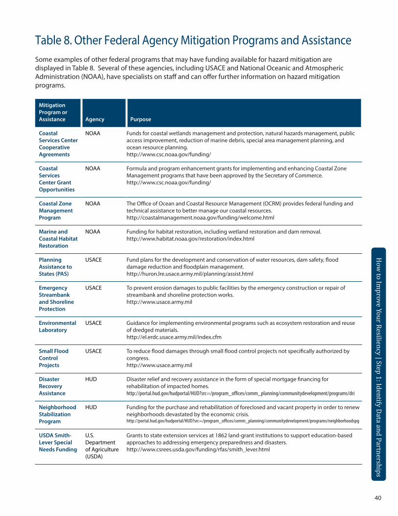
40
How
to Improve Your Resiliency | Step 1: Identify Data and Partnerships
Table 8. Other Federal Agency Mitigation Programs and AssistanceSome examples of other federal programs that may have funding available for hazard mitigation are displayed in Table 8. Several of these agencies, including USACE and National Oceanic and Atmospheric Administration (NOAA), have specialists on staff and can offer further information on hazard mitigation programs.
Mitigation Program or Assistance Agency Purpose
Coastal Services Center Cooperative Agreements
NOAA Funds for coastal wetlands management and protection, natural hazards management, public access improvement, reduction of marine debris, special area management planning, and ocean resource planning. http://www.csc.noaa.gov/funding/
Coastal Services Center Grant Opportunities
NOAA Formula and program enhancement grants for implementing and enhancing Coastal Zone Management programs that have been approved by the Secretary of Commerce. http://www.csc.noaa.gov/funding/
Coastal Zone Management Program
NOAA The Office of Ocean and Coastal Resource Management (OCRM) provides federal funding and technical assistance to better manage our coastal resources. http://coastalmanagement.noaa.gov/funding/welcome.html
Marine and Coastal Habitat Restoration
NOAA Funding for habitat restoration, including wetland restoration and dam removal. http://www.habitat.noaa.gov/restoration/index.html
Planning Assistance to States (PAS)
USACE Fund plans for the development and conservation of water resources, dam safety, flood damage reduction and floodplain management. http://huron.lre.usace.army.mil/planning/assist.html
Emergency Streambank and Shoreline Protection
USACE To prevent erosion damages to public facilities by the emergency construction or repair of streambank and shoreline protection works. http://www.usace.army.mil
Environmental Laboratory
USACE Guidance for implementing environmental programs such as ecosystem restoration and reuse of dredged materials. http://el.erdc.usace.army.mil/index.cfm
Small Flood Control Projects
USACE To reduce flood damages through small flood control projects not specifically authorized by congress. http://www.usace.army.mil
Disaster Recovery Assistance
HUD Disaster relief and recovery assistance in the form of special mortgage financing for rehabilitation of impacted homes. http://portal.hud.gov/hudportal/HUD?src=/program_offices/comm_planning/communitydevelopment/programs/dri
Neighborhood Stabilization Program
HUD Funding for the purchase and rehabilitation of foreclosed and vacant property in order to renew neighborhoods devastated by the economic crisis. http://portal.hud.gov/hudportal/HUD?src=/program_offices/comm_planning/communitydevelopment/programs/neighborhoodspg
USDA Smith-Lever Special Needs Funding
U.S. Department of Agriculture (USDA)
Grants to state extension services at 1862 land-grant institutions to support education-based approaches to addressing emergency preparedness and disasters. http://www.csrees.usda.gov/funding/rfas/smith_lever.html
41
How
to Improve Your Resiliency | Step 1: Identify Data and Partnerships
How
to Improve Your Resiliency | Step 2: Understand W
here Data is Stored
Mitigation Program or Assistance Agency Purpose
Community Facilities Direct Loans
USDA Loans for essential community facilities. http://www.rurdev.usda.gov/HCF_CF.html
Community Facilities Direct Grants
USDA Grants to develop essential community facilities. http://www.rurdev.usda.gov/HCF_CF.html
Farm Service Agency Disaster Assistance Programs
USDA Emergency funding and technical assistance for farmers and ranchers to rehabilitate farmland and livestock damaged by natural disasters. http://www.fsa.usda.gov/
Small Business Administration Loan Program
U.S. Small Business Administration (SBA)
Low-interest, fixed rate loans to small businesses for the purpose of implementing mitigation measures to protect business property from damage that may be caused by future disasters. Also available for disaster damaged property. http://www.sba.gov/about-sba-services/208
The programs described in Table 8 may require a local match or have requirements that must be met in order for one to be eligible. To learn more about these programs and assistance, please contact your SHMO as they are the state-level source of information and assistance. A listing of SHMOs can be found by visiting http://www.fema.gov/state-hazard-mitigation-officers .
Step 2: Understand Where Data Is Stored Disaster Data Access and StorageThe time following a disaster is hectic, chaotic, and demanding to all who are impacted. Forward-thinking decision makers with a long-term plan can revive a community if given the right tools and knowledge. Gathering information in a timely, accurate manner is essential in making educated decisions. Once the dust settles, often a wealth of data have been generated on multiple scales – from the individual public facility to the impacted community to an entire region. If appropriately managed, these data can be aggregated and assembled to inform decisions on a local, state, or disaster-wide scale.
Incorporating these data and preparing a strategic and smart response in the post-disaster environment will improve a community’s resiliency as well as an individual’s. It is important to understand where the various types of disaster data and information may be stored and how to access it. This section of the guide will help users in identifying where data and information collected through national pre- and post-disaster recovery efforts may be stored and also provides recommendations for how communities may store their data to assist in potential future grant applications.
From the national guidance documents discussed in Step 1, the majority of the data and information will be provided to the state (i.e. Office of Emergency Management) or at the local level, as well as the FEMA regional office. The data may be in a variety of formats and may be provided digitally or as a hard copy. Users should check with the state emergency managers or SHMO for their state first.
There are also several national online storage tools and websites where data and information from or related to a disaster may already exist and where federal agencies, states and communities may wish to store future data. A few of these initiatives, tools, and websites are described below, and an additional list can be found in Appendix A of this guide.
How
to Improve Your Resiliency | Step 2: Understand W
here Data is Stored
OpenFEMA From http://www.fema.gov/openfema, the mission of the OpenFEMA initiative is to expand and promote a culture of Open Government within the Agency and build public trust among the whole community; to increase transparency, participation, and collaboration in support of the Nation’s ability to prepare for, protect against, respond to, recover from, and mitigate all hazards. One of the goals of the OpenFEMA initiative is to release high-value data sets on an ongoing basis, so it is easier to locate data and so it is more accessible to the public in times of a disaster. Another goal is to provide that information and data in more useful formats to enable the public to leverage the data in innovative and value-added ways. Through the OpenFEMA website, or by visiting http://www.fema.gov/data-feeds, users can discover a wealth of data already available for use. Data sets include FEMA Disaster Declarations Summary, FEMA Public Assistance Funded Project Details and Summary, FEMA Hazard Mitigation Grant Program Summary, U.S. Fire Administration Fire Estimates, Housing Assistance Data for Hurricane Sandy, FEMA National Flood Hazard Layer, Oklahoma Tornado Housing Assistance Program Data, and much more. There is also a link to FEMA’s GeoPortal at http://fema.maps.arcgis.com/home/, which hosts a variety of data that are depicted geospatially and can be viewed interactively.
Data.gov This is the official U.S. government site providing increased public access to federal government data sets. It includes metadata, and how to access the data sets, tools, and resources. Available raw data are organized by U.S. Federal Executive Branch, which can be accessed by visiting www.Data.gov.
National Information Sharing Consortium (NISC)NISC, an independent consortium, is a membership organization that works to bring together data owners, custodians, and users involved in the fields of homeland security, public safety, and emergency manage-ment and response to leverage efforts related to governance, development, and sharing of technology, dataprocesses, and best practices. Their vision includes information that will be found, discovered, and shared effortlessly across all levels of government, and every community across the nation will be resilient in the face of disaster or emergency. The ultimate goal is to help save lives, reduce human suffering, better protectproperty, and build a safer, more secure nation. Members include public safety, emergency preparedness, management, and response stakeholders from the local to federal levels20. Additional information on NISC can be found at http://nisconsortium.org/.
National Voluntary Organizations Active in Disaster (VOAD)VOAD is a non-profit, nonpartisan membership organization that serves as the forum where organizations share knowledge and resources throughout the disaster cycle—preparation, response, recovery and mitigation21. Additional information can be found at http://www.nvoad.org/
20 National Information Sharing Consortium. (2014). Retrieved February 4, 2014 from http://nisconsortium.org/ 21 National Voluntary Organizations Active in Disaster. (204). Retrieved February 4, 2014 from http://www.nvoad.org/
42Integrating Disaster Data into Hazard Mitigation Planning
43
How
to Improve Your Resiliency | Step 2: Understand W
here Data is Stored
How
to Improve Your Resiliency | Step 2: Understand W
here Data is Stored
The National The National Disaster Housing Strategy, published in 2009, led to the creation of a
Disaster web-based tool that collects data on different programs to help communities rebuild after a disaster. This web-based tool, NDRPD, is a central location for local, state
Recovery and tribal governments and emergency managers to view recovery programs from Program governments, for-profit, nonprofit, and charitable organizations. The NDRPD provides
Database easy access to information on programs, improves the visibility of programs that can
(NDRPD) help communities, and enables communities to focus on those programs that can best suit their needs. The NDRPD may be accessed at https://asd.fema.gov/inter/ndhpd/public/home.htm.
Although the program information on the NDRPD is available for anyone to view, it is designed for local, state and tribal governments and emergency managers. The database’s programs are not intended for individual applicants; individuals and families may visit http://www.disasterassistance.gov to find and apply for individual assistance related to disaster recovery.
U.S. IGEMS provides the public with both an overview and more specific information on
Department current natural hazard events. It is supported by the Department of the Interior Office of Emergency Management and can be accessed at http://igems.doi.gov/.
of the Interior Geospatial Emergency Management System (IGEMS)Climate This is an independent organization of leading scientists and journalists researching
Central and reporting the facts about our changing climate and its impact on the American public. They survey and conduct scientific research on climate change and inform the public of key findings. Additional information is located at http://www.climatecentral.org/.
Grants.gov http://www.grants.gov provides an overview of the process to apply for federal grants. In order to apply for a grant, individuals or organizations must complete the Grants.gov registration process. You can browse by the latest opportunity, category (i.e., Disaster Prevention and Relief ), agency offering the grant, or eligibility (i.e., city or township government, county government, individuals).
44
How
to Improve Your Resiliency | Step 2: Understand W
here Data is Stored
FEMA Grant Databases:
e-Grants FEMA developed the Mitigation electronic Grants (eGrants accessible at http://www.fema.gov/mitigation-egrants-system-0) system to meet the intent of the eGovernment initiative to reduce the time and paperwork involved in managing the grant process. eGrants supports the following HMA grant programs: PDM, FMA, Severe Repetitive Loss, and Repetitive Flood Claims. The Mitigation eGrants system consists of two parts:
• The external mitigation eGrants system for subgrant applicants and grant applicants is available on the internet at: https://portal.fema.gov
• The internal mitigation eGrants system for FEMA users is available on the FEMA intranet at: https://portal.fema.net.
Automated Disaster Assistance Management System (ADAMS)
This is an historical assistance information database accessible by FEMA.
National Emergency Management Information System (NEMIS)
This is an historical assistance information database that was developed after ADAMS and is accessible by FEMA.
Emergency Management Mission Integrated Environment (EMMIE)
This is the most recent assistance information database utilized by FEMA. This software system is a web-based platform that manages PA grants in an electronic environment that is accessible to both the state and PA applicants. The system allows users to electronically review and monitor projects and grants. It was designed to improve information sharing within the PA process and allow for more effective communication among federal, state, and local entities. The site requires a username and password for authorized users only and can be found by visiting https://portal.fema.gov/famsVuWeb/home.
State Databases, Reports or Trackers
Many states have their own method for storing data and information collected or compiled following a disaster or for data in general. For example, in Massachusetts, through the Office of Geographic Information (MassGIS), the commonwealth has created a comprehensive, statewide database of spatial information for mapping and analysis, supporting emergency response, environmental planning and management, transportation planning, economic development, and transparency in state government operations. MassGIS is accessible at http://www.mass.gov/anf/research-and-tech/it-serv-and-support/application-serv/office-of-geographic-information-massgis/ . You may be able to learn more about other state-level systems by contacting the State Office of Emergency Management or the SHMO.
45
How
to Improve Your Resiliency | Step 2: Understand W
here Data is Stored
How
to Improve Your Resiliency | Step 2: Understand W
here Data is Stored
Non-profit Organizations
Non-profit Organizations, such as local universities: These organizations may collect data as part of their programs, and the data could be available for free. For example, the Natural Hazards Center at the University of Colorado fosters information sharing and integration activities and information and is accessible at http://www.colorado.edu/hazards/. The site serves as a national and international clearinghouse of knowledge concerning the social science and policy aspects of disasters. Check with your local university or other non-profit organizations to see how they may have assisted in disaster recovery efforts in the past and how they store their data for public access.
Other Federal Agencies
OFAs, such as NOAA, U.S. Geological Survey (USGS), and USACE, often have programs that allow for collection of data and may issue reports with valuable information. Check out USGS’s Natural Hazards Mission Area programs and activities at http://www.usgs.gov/natural_hazards/, NOAA’s Natural Hazards Data, Images, and Education site at http://www.ngdc.noaa.gov/hazard/ , NOAA’s Coastal Services Center at http://www.csc.noaa.gov/, or NOAA’s National Climatic Data Center at http://www.ncdc.noaa.gov/ . Additional links can be found in Appendix A.
Some local communities may have processes in place to store disaster-related data and information, and if not, it is a valuable tool or process to have when disaster strikes. Collecting local data and information
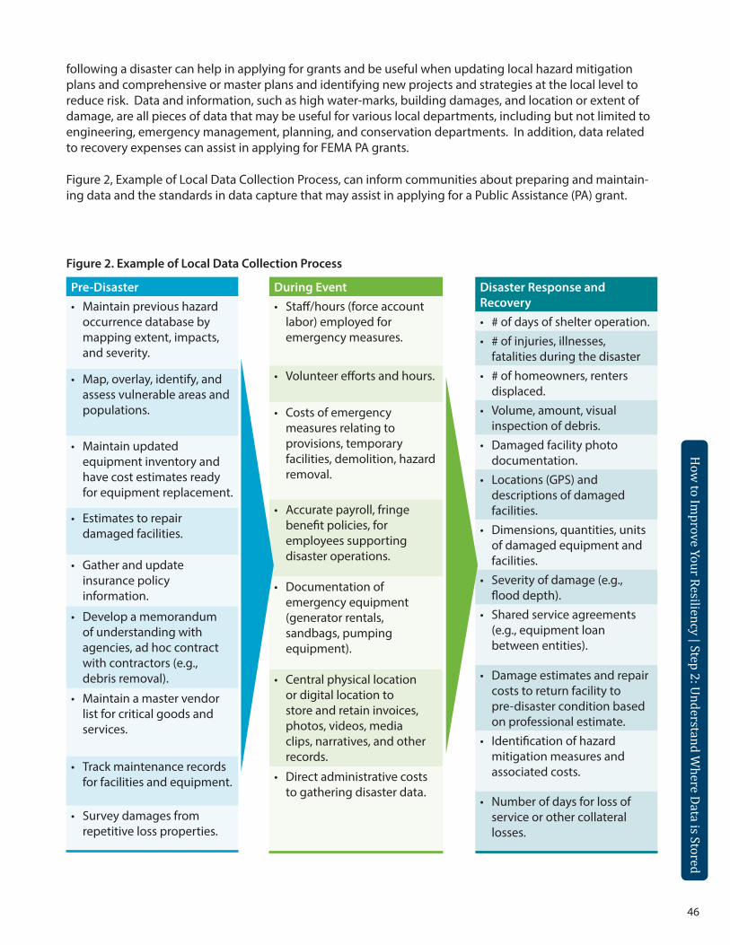
46
How
to Improve Your Resiliency | Step 2: Understand W
here Data is Stored
following a disaster can help in applying for grants and be useful when updating local hazard mitigation plans and comprehensive or master plans and identifying new projects and strategies at the local level to reduce risk. Data and information, such as high water-marks, building damages, and location or extent of damage, are all pieces of data that may be useful for various local departments, including but not limited to engineering, emergency management, planning, and conservation departments. In addition, data related to recovery expenses can assist in applying for FEMA PA grants.
Figure 2, Example of Local Data Collection Process, can inform communities about preparing and maintain-ing data and the standards in data capture that may assist in applying for a Public Assistance (PA) grant.
During Event• Staff/hours (force account
labor) employed for emergency measures.
• Volunteer efforts and hours.
• Costs of emergency measures relating to provisions, temporary facilities, demolition, hazard removal.
• Accurate payroll, fringe benefit policies, for employees supporting disaster operations.
• Documentation of emergency equipment (generator rentals, sandbags, pumping equipment).
• Central physical location or digital location to store and retain invoices, photos, videos, media clips, narratives, and other records.
• Direct administrative costs to gathering disaster data.
Pre-Disaster• Maintain previous hazard
occurrence database by mapping extent, impacts, and severity.
• Map, overlay, identify, and assess vulnerable areas and populations.
• Maintain updated equipment inventory and have cost estimates ready for equipment replacement.
• Estimates to repair damaged facilities.
• Gather and update insurance policy information.
• Develop a memorandum of understanding with agencies, ad hoc contract with contractors (e.g., debris removal).
• Maintain a master vendor list for critical goods and services.
• Track maintenance records for facilities and equipment.
• Survey damages from repetitive loss properties.
Disaster Response and Recovery• # of days of shelter operation.• # of injuries, illnesses,
fatalities during the disaster• # of homeowners, renters
displaced.• Volume, amount, visual
inspection of debris.• Damaged facility photo
documentation.• Locations (GPS) and
descriptions of damaged facilities.
• Dimensions, quantities, units of damaged equipment and facilities.
• Severity of damage (e.g., flood depth).
• Shared service agreements (e.g., equipment loan between entities).
• Damage estimates and repair costs to return facility to pre-disaster condition based on professional estimate.
• Identification of hazard mitigation measures and associated costs.
• Number of days for loss of service or other collateral losses.
Figure 2. Example of Local Data Collection Process
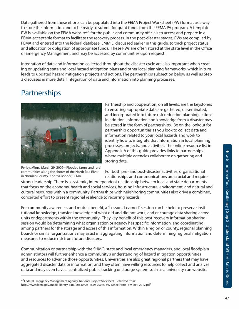
47
How
to Improve Your Resiliency | Step 2: Understand W
here Data is Stored
How
to Improve Your Resiliency | Step 2: Understand W
here Data is Stored
Data gathered from these efforts can be populated into the FEMA Project Worksheet (PW) format as a way to store the information and to be ready to submit for grant funds from the FEMA PA program. A template PW is available on the FEMA website22 for the public and community officials to access and prepare in a FEMA-acceptable format to facilitate the recovery process. In the post-disaster stages, PWs are compiled by FEMA and entered into the federal database, EMMIE, discussed earlier in this guide, to track project status and allocation or obligation of appropriate funds. These PWs are often stored at the state level in the Office of Emergency Management and may be accessed by communities upon request.
Integration of data and information collected throughout the disaster cycle are also important when creat-ing or updating state and local hazard mitigation plans and other local planning frameworks, which in turn leads to updated hazard mitigation projects and actions. The partnerships subsection below as well as Step 3 discusses in more detail integration of data and information into planning processes.
Partnerships
Perley, Minn., March 29, 2009 --Flooded farms and rural communities along the shores of the North Red River in Norman County. Andrea Booher/FEMA.
Partnership and cooperation, on all levels, are the keystones to ensuring appropriate data are gathered, disseminated, and incorporated into future risk reduction planning actions. In addition, information and knowledge from a disaster may be stored in the form of partnerships. Be on the lookout for partnership opportunities as you look to collect data and information related to your local hazards and work to identify how to integrate that information in local planning processes, projects, and activities. The online resource list in Appendix A of this guide provides links to partnerships where multiple agencies collaborate on gathering and storing data.
For both pre- and post-disaster activities, organizational relationships and communications are crucial and require
strong leadership. There is a systemic, interdependent relationship between local and state departments that focus on the economy, health and social services, housing infrastructure, environment, and natural and cultural resources within a community. Partnerships with neighboring communities also drive a combined, concerted effort to present regional resilience to recurring hazards.
For community awareness and mutual benefit, a “Lessons Learned” session can be held to preserve insti-tutional knowledge, transfer knowledge of what did and did not work, and encourage data sharing across units or departments within the community. They key benefit of this post-recovery information sharing session would be determining what organization or agency has specific information, and coordinating among partners for the storage and access of this information. Within a region or county, regional planning boards or similar organizations may assist in aggregating information and determining regional mitigation measures to reduce risk from future disasters.
Communication or partnership with the SHMO, state and local emergency managers, and local floodplain administrators will further enhance a community’s understanding of hazard mitigation opportunities and resources to advance those opportunities. Universities are also great regional partners that may have aggregated disaster data or information, and they often have willing resources to help collect and analyze data and may even have a centralized public tracking or storage system such as a university-run website.
22 Federal Emergency Management Agency, National Project Worksheet. Retrieved from: http://www.fema.gov/media-library-data/20130726-1859-25045-5971/electronic_pw_oct_2012.pdf
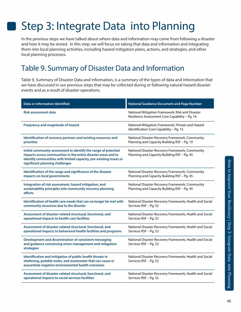
48
Step 3: Integrate Data into Planning In the previous steps we have talked about where data and information may come from following a disaster and how it may be stored. In this step, we will focus on taking that data and information and integrating them into local planning activities, including hazard mitigation plans, actions, and strategies, and other local planning processes.
Table 9. Summary of Disaster Data and InformationTable 9, Summary of Disaster Data and Information, is a summary of the types of data and information that we have discussed in our previous steps that may be collected during or following natural hazard disaster events and as a result of disaster operations.
Data or Information Identified National Guidance Document and Page Number
Risk assessment data National Mitigation Framework; Risk and Disaster Resilience Assessment Core Capability – Pg. 16
Frequency and magnitude of hazard National Mitigation Framework; Threats and Hazard Identification Core Capability – Pg. 15
Identification of recovery partners and existing resources and priorities
National Disaster Recovery Framework, Community Planning and Capacity Building RSF – Pg. 19
Initial community assessment to identify the range of potential impacts across communities in the entire disaster areas and to identify communities with limited capacity, pre-existing issues or significant planning challenges
National Disaster Recovery Framework, Community Planning and Capacity Building RSF – Pg. 45
Identification of the range and significance of the disaster impacts on local governments
National Disaster Recovery Framework, Community Planning and Capacity Building RSF – Pg. 45
Integration of risk assessment, hazard mitigation, and sustainability principles into community recovery planning efforts
National Disaster Recovery Framework, Community Planning and Capacity Building RSF – Pg. 45
Identification of health care needs that can no longer be met with community resources due to the disaster
National Disaster Recovery Framework, Health and Social Services RSF – Pg. 52
Assessment of disaster-related structural, functional, and operational impacts to health care facilities
National Disaster Recovery Framework, Health and Social Services RSF – Pg. 52
Assessment of disaster-related structural, functional, and operational impacts to behavioral health facilities and programs
National Disaster Recovery Framework, Health and Social Services RSF – Pg. 52
Development and dissemination of consistent messaging and guidance concerning stress management and mitigation strategies
National Disaster Recovery Framework, Health and Social Services RSF – Pg. 52
Identification and mitigation of public health threats in sheltering, potable water, and wastewater that can cause or exacerbate negative environmental health outcomes
National Disaster Recovery Framework, Health and Social Services RSF – Pg. 52
Assessment of disaster-related structural, functional, and operational impacts to social services facilities
National Disaster Recovery Framework, Health and Social Services RSF – Pg. 52
How
to Improve Your Resiliency | Step 3: Integrate Data into Planning
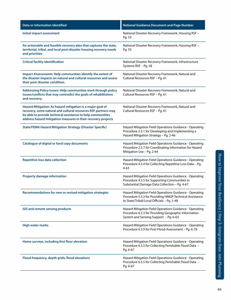
49
How
to Improve Your Resiliency | Step 3: Integrate Data into Planning
How
to Improve Your Resiliency | Step 3: Integrate Data into Planning
Data or Information Identified National Guidance Document and Page Number
Initial impact assessment National Disaster Recovery Framework, Housing RSF – Pg. 55
An actionable and feasible recovery plan that captures the state, territorial, tribal, and local post-disaster housing recovery needs and priorities
National Disaster Recovery Framework, Housing RSF – Pg. 55
Critical facility identification National Disaster Recovery Framework, Infrastructure Systems RSF – Pg. 58
Impact Assessments: Help communities identify the extent of the disaster impacts on natural and cultural resources and assess their post-disaster condition.
National Disaster Recovery Framework, Natural and Cultural Resources RSF – Pg. 61
Addressing Policy Issues: Help communities work through policy issues/conflicts that may contradict the goals of rehabilitation and recovery.
National Disaster Recovery Framework, Natural and Cultural Resources RSF – Pg. 61
Hazard Mitigation: As hazard mitigation is a major goal of recovery, some natural and cultural resources RSF partners may be able to provide technical assistance to help communities address hazard mitigation measures in their recovery projects
National Disaster Recovery Framework, Natural and Cultural Resources RSF – Pg. 61
State/FEMA Hazard Mitigation Strategy (Disaster Specific) Hazard Mitigation Field Operations Guidance - Operating Procedure 2.5.1 for Developing and Implementing a Hazard Mitigation Strategy – Pg. 2-46
Catalogue of digital or hard copy documents Hazard Mitigation Field Operations Guidance - Operating Procedure 2.5.7 for Coordinating Information for Hazard Mitigation Use – Pg. 2-64
Repetitive loss data collection Hazard Mitigation Field Operations Guidance - Operating Procedure 4.5.4 for Collecting Repetitive Loss Data – Pg. 4-63
Property damage information Hazard Mitigation Field Operations Guidance - Operating Procedure 4.5.5 for Supporting Communities in Substantial Damage Data Collection – Pg. 4-67
Recommendations for new or revised mitigation strategies Hazard Mitigation Field Operations Guidance - Operating Procedure 5.5.3 for Providing HMGP Technical Assistance to State/Tribal/Local Officials – Pg. 5-48
GIS and remote sensing products Hazard Mitigation Field Operations Guidance - Operating Procedure 6.5.3 for Providing Geographic Information System and Sensing Support – Pg. 6-63
High water marks Hazard Mitigation Field Operations Guidance - Operating Procedure 6.5.9 for Post-Flood Assessment – Pg. 6-78
Home surveys, including first floor elevation Hazard Mitigation Field Operations Guidance - Operating Procedure 6.5.5 for Collecting Perishable Flood Data – Pg. 6-67
Flood frequency, depth grids, flood elevations Hazard Mitigation Field Operations Guidance - Operating Procedure 6.5.5 for Collecting Perishable Flood Data – Pg. 6-67
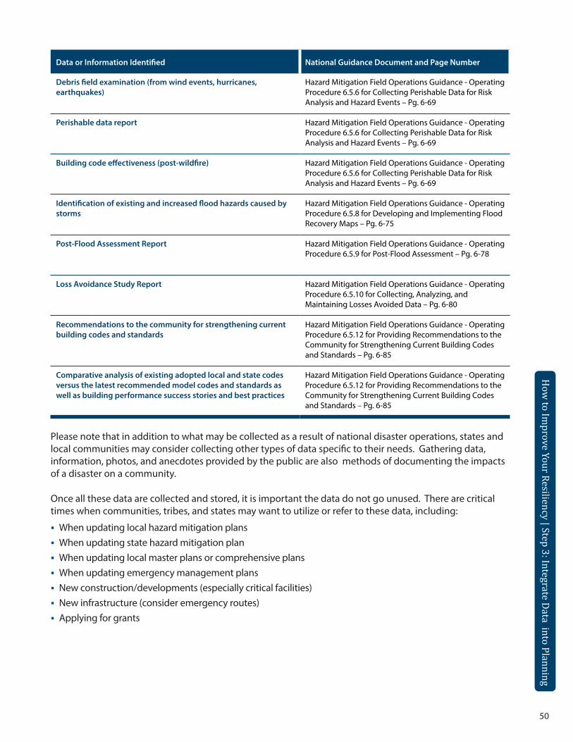
50
Data or Information Identified National Guidance Document and Page Number
Debris field examination (from wind events, hurricanes, earthquakes)
Hazard Mitigation Field Operations Guidance - Operating Procedure 6.5.6 for Collecting Perishable Data for Risk Analysis and Hazard Events – Pg. 6-69
Perishable data report Hazard Mitigation Field Operations Guidance - Operating Procedure 6.5.6 for Collecting Perishable Data for Risk Analysis and Hazard Events – Pg. 6-69
Building code effectiveness (post-wildfire) Hazard Mitigation Field Operations Guidance - Operating Procedure 6.5.6 for Collecting Perishable Data for Risk Analysis and Hazard Events – Pg. 6-69
Identification of existing and increased flood hazards caused by storms
Hazard Mitigation Field Operations Guidance - Operating Procedure 6.5.8 for Developing and Implementing Flood Recovery Maps – Pg. 6-75
Post-Flood Assessment Report Hazard Mitigation Field Operations Guidance - Operating Procedure 6.5.9 for Post-Flood Assessment – Pg. 6-78
Loss Avoidance Study Report Hazard Mitigation Field Operations Guidance - Operating Procedure 6.5.10 for Collecting, Analyzing, and Maintaining Losses Avoided Data – Pg. 6-80
Recommendations to the community for strengthening current building codes and standards
Hazard Mitigation Field Operations Guidance - Operating Procedure 6.5.12 for Providing Recommendations to the Community for Strengthening Current Building Codes and Standards – Pg. 6-85
Comparative analysis of existing adopted local and state codes versus the latest recommended model codes and standards as well as building performance success stories and best practices
Hazard Mitigation Field Operations Guidance - Operating Procedure 6.5.12 for Providing Recommendations to the Community for Strengthening Current Building Codes and Standards – Pg. 6-85
Please note that in addition to what may be collected as a result of national disaster operations, states and local communities may consider collecting other types of data specific to their needs. Gathering data, information, photos, and anecdotes provided by the public are also methods of documenting the impacts of a disaster on a community.
Once all these data are collected and stored, it is important the data do not go unused. There are critical times when communities, tribes, and states may want to utilize or refer to these data, including:
When updating local hazard mitigation plansWhen updating state hazard mitigation planWhen updating local master plans or comprehensive plans When updating emergency management plans New construction/developments (especially critical facilities) New infrastructure (consider emergency routes) Applying for grants
How
to Improve Your Resiliency | Step 3: Integrate Data into Planning
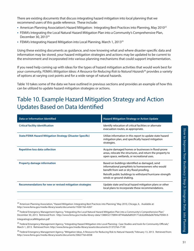
51
There are existing documents that discuss integrating hazard mitigation into local planning that we recommend users of this guide reference. These include: American Planning Association’s Hazard Mitigation: Integrating Best Practices into Planning, May 201023 FEMA’s Integrating the Local Natural Hazard Mitigation Plan into a Community’s Comprehensive Plan,
December 30, 201324 FEMA’s Integrating Hazard Mitigation into Local Planning, March 1, 201325
Using these existing documents as guidance, and now knowing what and where disaster-specific data and information may be stored, your hazard mitigation strategies and actions may be updated to be current to the environment and incorporated into various planning mechanisms that could support implementation.
If you need help coming up with ideas for the types of hazard mitigation activities that would work best for your community, FEMA’s Mitigation Ideas: A Resource for Reducing Risk to Natural Hazards26 provides a variety of options at varying cost points and for a wide range of natural hazards.
Table 10 takes some of the data we have outlined in previous sections and provides an example of how this can be utilized to update hazard mitigation strategies or actions.
Table 10. Example Hazard Mitigation Strategy and Action Updates Based on Data Identified
Data or Information Identified Hazard Mitigation Strategy or Action Update
Critical facility identification Identify relocation of critical facilities or alternate evacuation routes, as appropriate.
State/FEMA Hazard Mitigation Strategy (Disaster Specific) Utilize information in this report to update state hazard mitigation plan, and specifically hazard mitigation strategies.
Repetitive loss data collection Acquire damaged homes or businesses in flood-prone areas, relocate the structures, and return the property to open space, wetlands, or recreational uses.
Property damage information Based on buildings identified as damaged, send informational pamphlets to homeowners who would benefit from wet or dry flood proofing.
Retrofit public buildings to withstand hurricane-strength winds or ground shaking.
Recommendations for new or revised mitigation strategies Update state and local hazard mitigation plans or other local plans to incorporate these recommendations.
How
to Improve Your Resiliency | Step 3: Integrate Data into Planning
How
to Improve Your Resiliency | Step 3: Integrate Data into Planning
23 American Planning Association, “Hazard Mitigation: Integrating Best Practices into Planning,” May 2010, Chicago, IL. Available at: http://www.fema.gov/media-library/assets/documents/19261?id=4267 24 Federal Emergency Management Agency, “Integrating the Local Natural Hazard Mitigation Plan into a Community’s Comprehensive Plan,” December 30, 2013. Retrieved from: http://www.fema.gov/media-library-data/1388432170894-6f744a8afa8929171dc62d96da067b9a/FEMA-X-
IntegratingLocalMitigation.pdf25 Federal Emergency Management Agency, “Integrating Hazard Mitigation into Local Planning: Case Studies and tools for Community Officials,” March 1, 2013. Retrieved from: http://www.fema.gov/media-library/assets/documents/31372?id=713026 Federal Emergency Management Agency, “Mitigation Ideas, A Resource for Reducing Risk to Natural Hazards,” February 13, 2013. Retrieved from: http://www.fema.gov/media-library/assets/documents/30627?id=6938
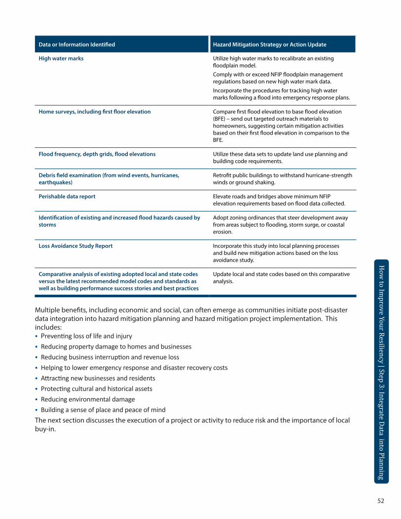
52
Data or Information Identified Hazard Mitigation Strategy or Action Update
High water marks Utilize high water marks to recalibrate an existing floodplain model.
Comply with or exceed NFIP floodplain management regulations based on new high water mark data.
Incorporate the procedures for tracking high water marks following a flood into emergency response plans.
Home surveys, including first floor elevation Compare first flood elevation to base flood elevation (BFE) – send out targeted outreach materials to homeowners, suggesting certain mitigation activities based on their first flood elevation in comparison to the BFE.
Flood frequency, depth grids, flood elevations Utilize these data sets to update land use planning and building code requirements.
Debris field examination (from wind events, hurricanes, earthquakes)
Retrofit public buildings to withstand hurricane-strength winds or ground shaking.
Perishable data report Elevate roads and bridges above minimum NFIP elevation requirements based on flood data collected.
Identification of existing and increased flood hazards caused by storms
Adopt zoning ordinances that steer development away from areas subject to flooding, storm surge, or coastal erosion.
Loss Avoidance Study Report Incorporate this study into local planning processes and build new mitigation actions based on the loss avoidance study.
Comparative analysis of existing adopted local and state codes versus the latest recommended model codes and standards as well as building performance success stories and best practices
Update local and state codes based on this comparative analysis.
Multiple benefits, including economic and social, can often emerge as communities initiate post-disaster data integration into hazard mitigation planning and hazard mitigation project implementation. This includes:Preventing loss of life and injuryReducing property damage to homes and businesses Reducing business interruption and revenue loss Helping to lower emergency response and disaster recovery costs Attracting new businesses and residents Protecting cultural and historical assets Reducing environmental damage Building a sense of place and peace of mindThe next section discusses the execution of a project or activity to reduce risk and the importance of local buy-in.
How
to Improve Your Resiliency | Step 3: Integrate Data into Planning
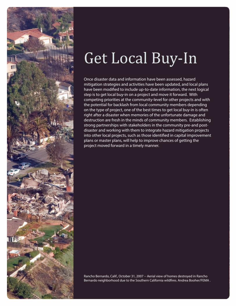
53
Rancho Bernardo, Calif., October 31, 2007 -- Aerial view of homes destroyed in Rancho Bernardo neighborhood due to the Southern California wildfires. Andrea Booher/FEMA .
How
to Improve Your Resiliency | Step 3: Integrate Data into Planning
Get Local Buy-InOnce disaster data and information have been assessed, hazard mitigation strategies and activities have been updated, and local plans have been modified to include up-to-date information, the next logical step is to get local buy-in on a project and move it forward. With competing priorities at the community-level for other projects and with the potential for backlash from local community members depending on the type of project, one of the best times to get local buy-in is often right after a disaster when memories of the unfortunate damage and destruction are fresh in the minds of community members. Establishing strong partnerships with stakeholders in the community pre-and post-disaster and working with them to integrate hazard mitigation projects into other local projects, such as those identified in capital improvement plans or master plans, will help to improve chances of getting the project moved forward in a timely manner.
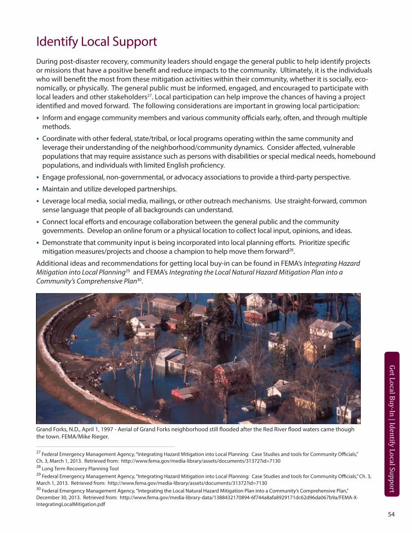
54
Get Local Buy-In | Identify Local Support
Identify Local SupportDuring post-disaster recovery, community leaders should engage the general public to help identify projects or missions that have a positive benefit and reduce impacts to the community. Ultimately, it is the individuals who will benefit the most from these mitigation activities within their community, whether it is socially, eco-nomically, or physically. The general public must be informed, engaged, and encouraged to participate with local leaders and other stakeholders27. Local participation can help improve the chances of having a project identified and moved forward. The following considerations are important in growing local participation:
Inform and engage community members and various community officials early, often, and through multiple methods.
Coordinate with other federal, state/tribal, or local programs operating within the same community and leverage their understanding of the neighborhood/community dynamics. Consider affected, vulnerable populations that may require assistance such as persons with disabilities or special medical needs, homebound populations, and individuals with limited English proficiency.
Engage professional, non-governmental, or advocacy associations to provide a third-party perspective.
Maintain and utilize developed partnerships.
Leverage local media, social media, mailings, or other outreach mechanisms. Use straight-forward, common sense language that people of all backgrounds can understand.
Connect local efforts and encourage collaboration between the general public and the community governments. Develop an online forum or a physical location to collect local input, opinions, and ideas.
Demonstrate that community input is being incorporated into local planning efforts. Prioritize specific mitigation measures/projects and choose a champion to help move them forward28.
Additional ideas and recommendations for getting local buy-in can be found in FEMA’s Integrating Hazard Mitigation into Local Planning29 and FEMA’s Integrating the Local Natural Hazard Mitigation Plan into a Community’s Comprehensive Plan30.
27 Federal Emergency Management Agency, “Integrating Hazard Mitigation into Local Planning: Case Studies and tools for Community Officials,” Ch. 3, March 1, 2013. Retrieved from: http://www.fema.gov/media-library/assets/documents/31372?id=713028 Long Term Recovery Planning Tool29 Federal Emergency Management Agency, “Integrating Hazard Mitigation into Local Planning: Case Studies and tools for Community Officials,” Ch. 3, March 1, 2013. Retrieved from: http://www.fema.gov/media-library/assets/documents/31372?id=713030 Federal Emergency Management Agency, “Integrating the Local Natural Hazard Mitigation Plan into a Community’s Comprehensive Plan,” December 30, 2013. Retrieved from: http://www.fema.gov/media-library-data/1388432170894-6f744a8afa8929171dc62d96da067b9a/FEMA-X-IntegratingLocalMitigation.pdf
Grand Forks, N.D., April 1, 1997 - Aerial of Grand Forks neighborhood still flooded after the Red River flood waters came though the town. FEMA/Mike Rieger.
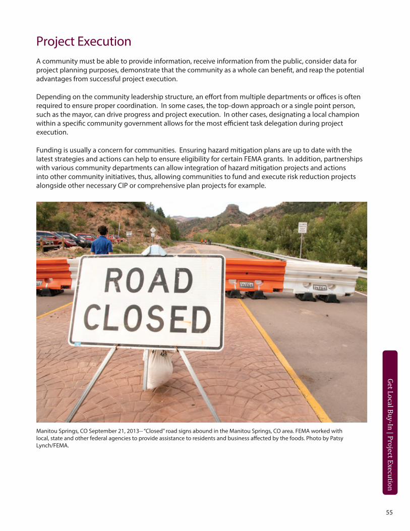
55
Get Local Buy-In | Identify Local Support
Get Local Buy-In | Project Execution
Manitou Springs, CO September 21, 2013-- “Closed” road signs abound in the Manitou Springs, CO area. FEMA worked with local, state and other federal agencies to provide assistance to residents and business affected by the foods. Photo by Patsy Lynch/FEMA.
Project ExecutionA community must be able to provide information, receive information from the public, consider data for project planning purposes, demonstrate that the community as a whole can benefit, and reap the potential advantages from successful project execution.
Depending on the community leadership structure, an effort from multiple departments or offices is often required to ensure proper coordination. In some cases, the top-down approach or a single point person, such as the mayor, can drive progress and project execution. In other cases, designating a local champion within a specific community government allows for the most efficient task delegation during project execution.
Funding is usually a concern for communities. Ensuring hazard mitigation plans are up to date with the latest strategies and actions can help to ensure eligibility for certain FEMA grants. In addition, partnerships with various community departments can allow integration of hazard mitigation projects and actions into other community initiatives, thus, allowing communities to fund and execute risk reduction projects alongside other necessary CIP or comprehensive plan projects for example.
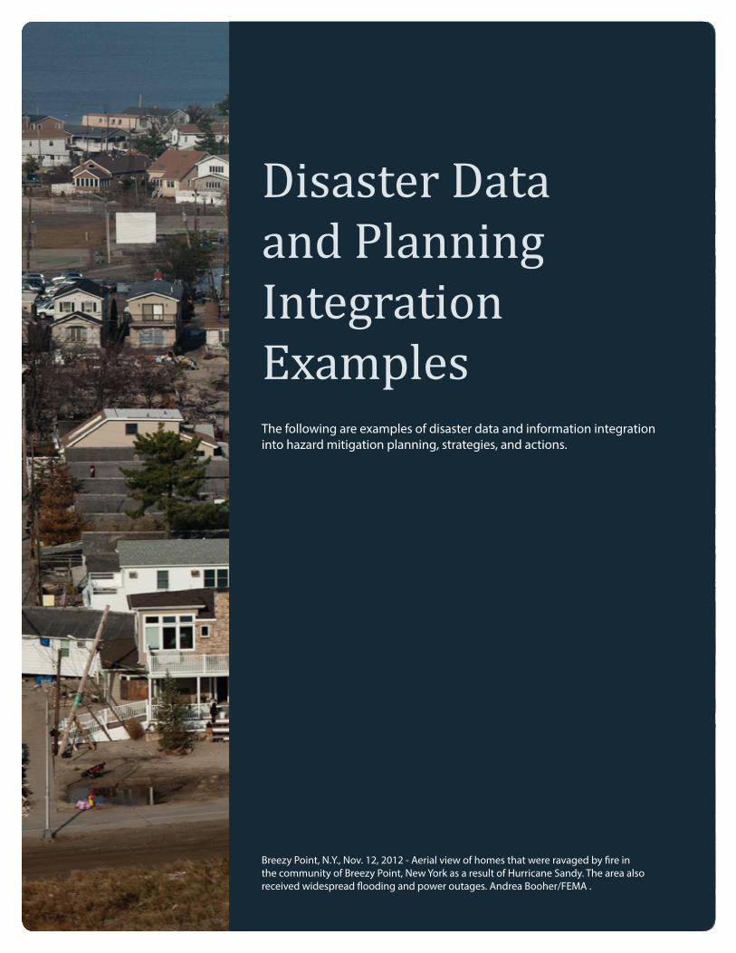
56
Breezy Point, N.Y., Nov. 12, 2012 - Aerial view of homes that were ravaged by fire in the community of Breezy Point, New York as a result of Hurricane Sandy. The area also received widespread flooding and power outages. Andrea Booher/FEMA .
Disaster Data and Planning Integration ExamplesThe following are examples of disaster data and information integration into hazard mitigation planning, strategies, and actions.
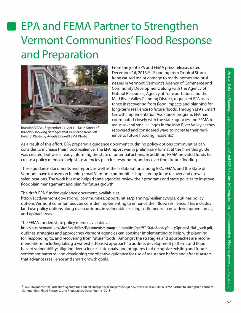
57
Disaster Data and Planning Integration Examples | EPA and FEM
A Partner to Strengthen Vermont Com
munities’ Flood Response and Preparation
EPA and FEMA Partner to Strengthen Vermont Communities’ Flood Response and Preparation
Brandon VT, Vt., September 11, 2011 -- Main Street of Brandon showing damages that Hurricane Irene left behind. Photo by Angela Drexel/FEMA Photo.
From the joint EPA and FEMA press release, dated December 16, 2013,31 “Flooding from Tropical Storm Irene caused major damage to roads, homes and busi-nesses in Vermont. Vermont’s Agency of Commerce and Community Development, along with the Agency of Natural Resources, Agency of Transportation, and the Mad River Valley Planning District, requested EPA assis-tance in recovering from flood impacts and planning for long-term resilience to future floods. Through EPA’s Smart Growth Implementation Assistance program, EPA has coordinated closely with the state agencies and FEMA to assist several small villages in the Mad River Valley as they recovered and considered ways to increase their resil-ience to future flooding incidents.”
As a result of this effort, EPA prepared a guidance document outlining policy options communities can consider to increase their flood resilience. The EPA report was in preliminary format at the time this guide was created, but was already informing the state of potential actions. In addition, FEMA provided funds to create a policy memo to help state agencies plan for, respond to, and recover from future flooding.
These guidance documents and report, as well as the collaboration among EPA, FEMA, and the State of Vermont, have focused on helping small Vermont communities impacted by Irene recover and grow in safer locations. The work has also helped state agencies review their programs and state policies to improve floodplain management and plan for future growth.
The draft EPA-funded guidance document, available at http://accd.vermont.gov/strong_communities/opportunities/planning/resiliency/sgia, outlines policy options Vermont communities can consider implementing to enhance their flood resilience. This includes land use policy options along river corridors, in vulnerable existing settlements, in new development areas, and upload areas.
The FEMA-funded state policy memo, available at http://accd.vermont.gov/sites/accd/files/Documents/strongcommunities/cpr/VT-StateAgencyPolicyOptionsFINAL_web.pdf, outlines strategies and approaches Vermont agencies can consider implementing to help with planning for, responding to, and recovering from future floods. Amongst the strategies and approaches are recom-mendations including taking a watershed-based approach to address development patterns and flood hazard vulnerability; aligning river science, state goals, and programs that recognize existing and future settlement patterns; and developing coordinative guidance for use of assistance before and after disasters that advances resilience and smart growth goals.
31 U.S. Environmental Protection Agency and Federal Emergency Management Agency, News Release, “EPA & FEMA Partner to Strengthen Vermont Communities’ Flood Response and Preparation,” December 16, 2013
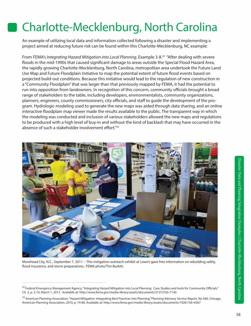
58
Disaster Data and Planning Integration Examples | Charlotte-M
ecklenburg, North Carolina
Charlotte-Mecklenburg, North CarolinaAn example of utilizing local data and information collected following a disaster and implementing a project aimed at reducing future risk can be found within this Charlotte-Mecklenburg, NC example:
From FEMA’s Integrating Hazard Mitigation into Local Planning, Example 3-8.32 “After dealing with severe floods in the mid-1990s that caused significant damage to areas outside the Special Flood Hazard Area, the rapidly growing Charlotte-Mecklenburg, North Carolina, metropolitan area undertook the Future Land Use Map and Future Floodplain Initiative to map the potential extent of future flood events based on projected build-out conditions. Because this initiative would lead to the regulation of new construction in a “Community Floodplain” that was larger than that previously mapped by FEMA, it had the potential to run into opposition from landowners. In recognition of this concern, community officials brought a broad range of stakeholders to the table, including developers, environmentalists, community organizations, planners, engineers, county commissioners, city officials, and staff to guide the development of the pro-gram. Hydrologic modeling used to generate the new maps was aided through data sharing, and an online interactive floodplain map viewer made the results available to the public. The transparent way in which the modeling was conducted and inclusion of various stakeholders allowed the new maps and regulations to be produced with a high level of buy-in and without the kind of backlash that may have occurred in the absence of such a stakeholder involvement effort.”33
32 Federal Emergency Management Agency, “Integrating Hazard Mitigation into Local Planning: Case Studies and tools for Community Officials,” Ch. 3, p. 3-10, March 1, 2013. Available at: http://www.fema.gov/media-library/assets/documents/31372?id=713033 American Planning Association, “Hazard Mitigation: Integrating Best Practices into Planning,” Planning Advisory Service Report, No 560, Chicago, American Planning Association, 2010, p. 74-86. Available at: http://www.fema.gov/media-library/assets/documents/19261?id=4267
Morehead City, N.C., September 7, 2011 -- This mitigation outreach exhibit at Lowe’s gave free information on rebuilding safely, flood insurance, and storm preparations.. FEMA photo/Tim Burkitt.
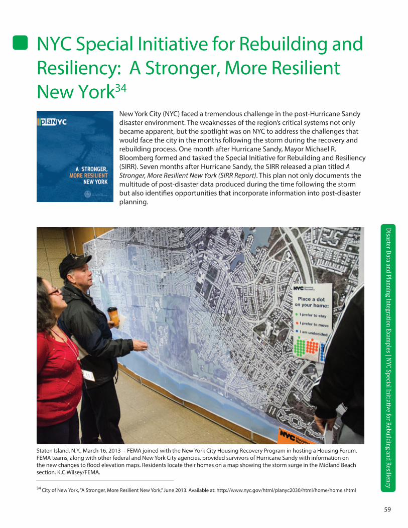
59
Disaster Data and Planning Integration Examples | Charlotte-M
ecklenburg, North Carolina
34 City of New York, “A Stronger, More Resilient New York,” June 2013. Available at: http://www.nyc.gov/html/planyc2030/html/home/home.shtml
Disaster Data and Planning Integration Examples | NYC Special Initiative for Rebuilding and Resiliency
NYC Special Initiative for Rebuilding and Resiliency: A Stronger, More Resilient New York34
New York City (NYC) faced a tremendous challenge in the post-Hurricane Sandy disaster environment. The weaknesses of the region’s critical systems not only became apparent, but the spotlight was on NYC to address the challenges that would face the city in the months following the storm during the recovery and rebuilding process. One month after Hurricane Sandy, Mayor Michael R. Bloomberg formed and tasked the Special Initiative for Rebuilding and Resiliency (SIRR). Seven months after Hurricane Sandy, the SIRR released a plan titled A Stronger, More Resilient New York (SIRR Report). This plan not only documents the multitude of post-disaster data produced during the time following the storm but also identifies opportunities that incorporate information into post-disaster planning.
Staten Island, N.Y., March 16, 2013 -- FEMA joined with the New York City Housing Recovery Program in hosting a Housing Forum. FEMA teams, along with other federal and New York City agencies, provided survivors of Hurricane Sandy with information on the new changes to flood elevation maps. Residents locate their homes on a map showing the storm surge in the Midland Beach section. K.C.Wilsey/FEMA.
60
Disaster Data and Planning Integration Examples | NYC Special Initiative for Rebuilding and Resiliency
The SIRR Report closely aligns with the FEMA National Disaster Recovery Framework (NDRF) six Recovery Support Functions (RSFs). Although the SIRR Report was fast-tracked to provide a plan specifically detailing resiliency efforts in response to Hurricane Sandy, documented information can be streamlined to be incor-porated into NYC’s comprehensive hazard mitigation plan. The SIRR Report identifies the response actions of NYC and its partner organizations, specific mitigation strategies and initiatives in relation to the RSFs, and opportunities to incorporate post-disaster information into future mitigation planning.
Community Planning and Capacity Building
The SIRR Report defined an implementation structure that identified strategies, milestones, and responsible parties to report progress on mitigation and planning initiatives. This structure allows for transparency on the larger-scale community planning function. Due to the size and nature of NYC’s distinct waterfront areas, the SIRR Report also provided information about the neighborhood’s existing demographics, affected physical regions, disaster anecdotes, risk assessments, and city-wide and neighborhood-specific public outreach efforts. Documentation of each neighborhood’s “story” was concisely compiled – this has the immediate potential to be incorporated into the NYC HMP and future planning initiatives.
Economic Although NYC is the hub to large, international economic corporations, it is often the small-scale, privately owned and operated businesses that struggle during disaster recovery. The SIRR Report documented that NYC initiated Restoration Business Acceleration Teams to expedite coordination of permits and inspections as well as proactively identifying Business Recovery Zones, Business Solution and Restoration Centers, and the Neighborhood Retail Recovery Program. NYC also leveraged existing capabilities and data gathering opportunities through the established Small Business Services and Business Outreach Emergency Response unit to aid local businesses to bounce back faster and stronger. Other public outreach efforts included HireNYC, which connected low-income individuals to aid economic development projects sponsored by the city, and the Support NYC Small Business Ad Campaign, which encouraged the public to patron-ize local and small businesses.
Health and Social Services
The SIRR Report recognized that an infrastructure weakness was the number of critical facilities within the floodplain, especially the quantity of hospital beds and the vulnerable populations that were at risk. Certain health and social services organizations may be considered private non-profit organizations. Once they are deemed eligible through the FEMA Public Assistance grant program, they may also be eligible for reimburse-ment for physical disaster-related damages as well as emergency measures rendered such as rental/purchase of emergency generators or fuel supplies. Information compiled by the New York State (NYS) Department of Health, NYC Department of Health and Mental Hygiene, the Joint Commission, and the Mayor’s Office of Analytics serves for strategic mitigation practices, and in the case of hospitals, an opportunity for redundancy due to its critical role in emergency response during a disaster.
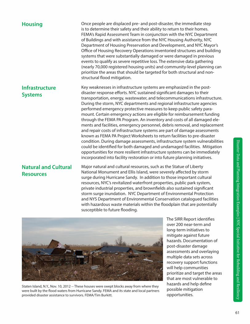
61
Disaster Data and Planning Integration Examples | NYC Special Initiative for Rebuilding and Resiliency
Disaster Data and Planning Integration Examples | NYC Special Initiative for Rebuilding and Resiliency
Housing Once people are displaced pre- and post-disaster, the immediate step is to determine their safety and their ability to return to their homes. FEMA’s Rapid Assessment Team in conjunction with the NYC Department of Buildings and with assistance from the NYC Housing Authority, NYC Department of Housing Preservation and Development, and NYC Mayor’s Office of Housing Recovery Operations inventoried structures and building systems that were substantially damaged or were damaged in previous events to qualify as severe repetitive loss. The extensive data gathering (nearly 70,000 registered housing units) and community-level planning can prioritize the areas that should be targeted for both structural and non-structural flood mitigation.
Infrastructure Systems
Key weaknesses in infrastructure systems are emphasized in the post-disaster response efforts. NYC sustained significant damages to their transportation, energy, wastewater, and telecommunications infrastructure. During the storm, NYC departments and regional infrastructure agencies performed emergency protective measures to keep public safety para-mount. Certain emergency actions are eligible for reimbursement funding through the FEMA PA Program. An inventory and costs of all damaged ele-ments and facilities, emergency personnel, debris removal, and replacement and repair costs of infrastructure systems are part of damage assessments known as FEMA PA Project Worksheets to return facilities to pre-disaster condition. During damage assessments, infrastructure system vulnerabilities could be identified for both damaged and undamaged facilities. Mitigation opportunities for more resilient infrastructure systems can be immediately incorporated into facility restoration or into future planning initiatives.
Natural and Cultural Resources
Major natural and cultural resources, such as the Statue of Liberty National Monument and Ellis Island, were severely affected by storm surge during Hurricane Sandy. In addition to those important cultural resources, NYC’s revitalized waterfront properties, public park system, private industrial properties, and brownfields also sustained significant storm surge inundation. NYC Department of Environmental Protection and NYS Department of Environmental Conservation catalogued facilities with hazardous waste materials within the floodplain that are potentially susceptible to future flooding.
Staten Island, N.Y., Nov. 10, 2012 -- These houses were swept blocks away from where they were built by the flood waters from Hurricane Sandy. FEMA and its state and local partners provided disaster assistance to survivors. FEMA/Tim Burkitt.
The SIRR Report identifies over 200 near-term and long-term initiatives to mitigate against future hazards. Documentation of post-disaster damage assessments and overlaying multiple data sets across recovery support functions will help communities prioritize and target the areas that are most vulnerable to hazards and help define possible mitigation opportunities.

62
Appendix A Additional Online Resources
63
GENERAL DATA GATHERING
OpenFEMA: Provides approved mission relevant data for stakeholders to leverage in value-added ways such as research, analysis, app development, and other purposes. http://www.fema.gov/openFEMA
FEMA-How to deal with specific hazards: http://www.ready.gov/natural-disasters
National Oceanic and Atmospheric Administration (NOAA): Information on various projects and research on climate and weather. http://www.websites.noaa.gov
National Climatic Data Center: Active archive of weather data. http://lwf.ncdc.noaa.gov/oa/ncdc.html
The Hydrologic Engineering Center (HEC), an organization within the Institute for Water Resources, is the designated Center of Expertise for the U.S. Army Corps of Engineers: http://www.hec.usace.army.mil/
National Water and Climate Center: http://www.wcc.nrcs.usda.gov/
WinTR-55 Watershed Hydrology: http://www.nrcs.usda.gov/wps/portal/nrcs/detailfull/national/water/?&cid=stelprdb1042901
USACE Hydrologic Engineering Center (HEC): http://www.hec.usace.army.mil/software/
Stormwater Manager’s Resource Center SMRC: http://www.stormwatercenter.net
USGS Current Water Data for the Nation: http://waterdata.usgs.gov/nwis/rt
USGS Water Data for the Nation: http://waterdata.usgs.gov/nwis /
Topography Maps and Aerial photos: http://www.terraserver.com/view.asp?tid=142
National Register of Historic Places: http://www.nps.gov/nr/about.htm
National Wetlands Inventory: http://www.fws.gov/wetlands/
FIRE RELATED HAZARDS
Firewise: http://www.firewise.org
NOAA Fire Event Satellite Photos: http://www.osei.noaa.gov/Events/Fires
U.S. Forest Service, USDA: http://www.fs.fed.us/land/wfas/welcome.htm
Wildfire Hazards - A National Threat:
http://pubs.usgs.gov/fs/2006/3015/2006-3015.pdf
FLOOD RELATED HAZARDS
FEMA Coastal Flood Hazard Analysis and Mapping: http://www.fema.gov/national-flood-insurance-program-0/fema-coastal-flood-hazard-analyses-and-mapping-1
Floodsmart: http://www.floodsmart.gov/floodsmart/
National Flood Insurance Program (NFIP): http://www.fema.gov/nfip
Digital quality Level 3 flood maps: http://msc.fema.gov/MSC/statemap.htm
Reducing Damage from Localized Flooding: A Guide for Communities, 2005 FEMA 511: http://www.fema.gov/library/viewRecord.do?id=1448
Association of State Floodplain Managers (ASFPM): ASFPM has developed a series of technical and topical research papers and a series of proceedings from their annual conferences: www.floods.org
64
GEOLOGIC RELATED HAZARDS
USGS Topographic Maps: http://topomaps.usgs.gov/
Building Seismic Safety Council: http://www.nibs.org/?page=bssc
Earthquake hazard history by state: http://earthquake.usgs.gov/earthquakes/states/
USGS data on earthquakes: http://earthquake.usgs.gov/monitoring/deformation/data/download/
USGS Earthquake homepage: http://quake.wr.usgs.gov
National Cooperative Geologic Mapping Program (NCGMP): http://ncgmp.usgs.gov/
Landslide Overview Map of the Conterminous United States: http://landslides.usgs.gov/learning/nationalmap/
WIND RELATED HAZARDS
ATC Wind Speed Web Site: http://www.atcouncil.org/windspeed/index.php
U.S. Wind Zone Maps: http://www.fema.gov/safe-rooms/wind-zones-united-states
Tornado Project Online: http://www.tornadoproject.com/
National Hurricane Center: http://www.nhc.noaa.gov
Community Hurricane Preparedness Tutorial: http://meted.ucar.edu/hurrican/chp/hp.htm
National Severe Storms Laboratory, 2009, “Tornado Basics”: http://www.nssl.noaa.gov/primer/tornado/tor_basics.html
RISK AND VULNERABILITY
HAZUS: http://www.hazus.org
FEMA Hazus Average Annualized Loss Viewer: http://fema.maps.arcgis.com/home/webmap/viewer.html?webmap=cb8228309e9d405ca6b4db6027df36d9
GENERAL PLANNING
American Planning Association: http://www.planning.org
PlannersWeb: Provides city and regional planning resources: http://www.plannersweb.com
GEOGRAPHIC INFORMATION SYSTEMS (GIS) AND MAPPING
The National Spatial Data Infrastructure and Clearinghouse (NSDI) and Federal Geographic Data Committee (FGDC) Source for information on producing and sharing geographic data: http://www.fgdc.gov
Northeast States Emergency Consortium (NESEC): Provides information on various hazards, funding resources, and other information: http://www.nesec.org.
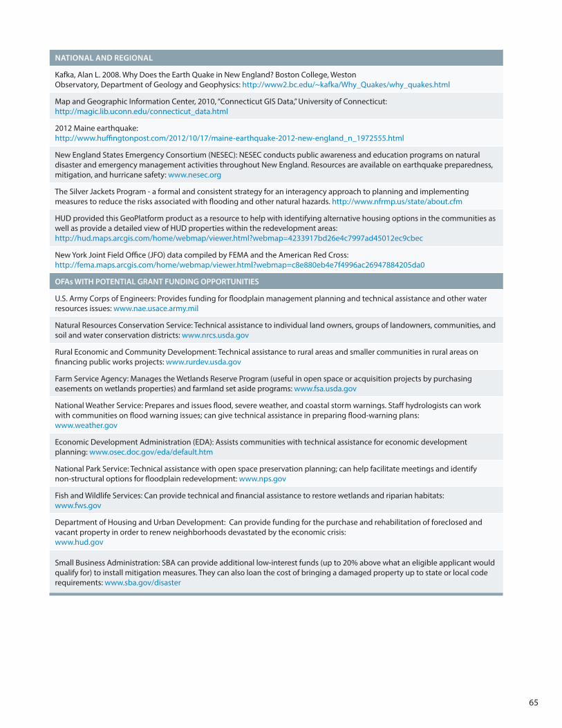
65
NATIONAL AND REGIONAL
Kafka, Alan L. 2008. Why Does the Earth Quake in New England? Boston College, Weston Observatory, Department of Geology and Geophysics: http://www2.bc.edu/~kafka/Why_Quakes/why_quakes.html
Map and Geographic Information Center, 2010, “Connecticut GIS Data,” University of Connecticut: http://magic.lib.uconn.edu/connecticut_data.html
2012 Maine earthquake: http://www.huffingtonpost.com/2012/10/17/maine-earthquake-2012-new-england_n_1972555.html
New England States Emergency Consortium (NESEC): NESEC conducts public awareness and education programs on natural disaster and emergency management activities throughout New England. Resources are available on earthquake preparedness, mitigation, and hurricane safety: www.nesec.org
The Silver Jackets Program - a formal and consistent strategy for an interagency approach to planning and implementing measures to reduce the risks associated with flooding and other natural hazards. http://www.nfrmp.us/state/about.cfm
HUD provided this GeoPlatform product as a resource to help with identifying alternative housing options in the communities as well as provide a detailed view of HUD properties within the redevelopment areas: http://hud.maps.arcgis.com/home/webmap/viewer.html?webmap=4233917bd26e4c7997ad45012ec9cbec
New York Joint Field Office (JFO) data compiled by FEMA and the American Red Cross:http://fema.maps.arcgis.com/home/webmap/viewer.html?webmap=c8e880eb4e7f4996ac26947884205da0
OFAs WITH POTENTIAL GRANT FUNDING OPPORTUNITIES
U.S. Army Corps of Engineers: Provides funding for floodplain management planning and technical assistance and other water resources issues: www.nae.usace.army.mil
Natural Resources Conservation Service: Technical assistance to individual land owners, groups of landowners, communities, and soil and water conservation districts: www.nrcs.usda.gov
Rural Economic and Community Development: Technical assistance to rural areas and smaller communities in rural areas on financing public works projects: www.rurdev.usda.gov
Farm Service Agency: Manages the Wetlands Reserve Program (useful in open space or acquisition projects by purchasing easements on wetlands properties) and farmland set aside programs: www.fsa.usda.gov
National Weather Service: Prepares and issues flood, severe weather, and coastal storm warnings. Staff hydrologists can work with communities on flood warning issues; can give technical assistance in preparing flood-warning plans: www.weather.gov
Economic Development Administration (EDA): Assists communities with technical assistance for economic development planning: www.osec.doc.gov/eda/default.htm
National Park Service: Technical assistance with open space preservation planning; can help facilitate meetings and identify non-structural options for floodplain redevelopment: www.nps.gov
Fish and Wildlife Services: Can provide technical and financial assistance to restore wetlands and riparian habitats: www.fws.gov
Department of Housing and Urban Development: Can provide funding for the purchase and rehabilitation of foreclosed and vacant property in order to renew neighborhoods devastated by the economic crisis: www.hud.gov
Small Business Administration: SBA can provide additional low-interest funds (up to 20% above what an eligible applicant would qualify for) to install mitigation measures. They can also loan the cost of bringing a damaged property up to state or local code requirements: www.sba.gov/disaster