Embed Size (px)
Citation preview
Interim Geologic Map of the Cedar City NW Quadrangle, Iron County, Utah
by
Tyler R. Knudsen and Robert F. Biek
DISCLAIMER This open-file report makes information available to the public during the review and production period necessary for a formal UGS publication. The map may be incomplete, and inconsistencies, errors, and omissions have not been resolved. While the document is in the review process, it may not conform to UGS standards; therefore it may be premature for an individual or group to take actions based on its contents. Although this product represents the work of professional scientists, the Utah Department of Natural Resources, Utah Geological Survey, makes no warranty, expressed or implied, regarding its suitability for a particular use. The Utah Department of Natural Resources, Utah Geological Survey, shall not be liable under any circumstances for any direct, indirect, special, incidental, or consequential damages with respect to claims by users of this product. For use at 1:24,000 scale only. This geologic map was funded by the Utah Geological Survey and the U.S. Geological Survey, National Cooperative Geologic Mapping Program through USGS STATEMAP award numbers G11AC20249 and G12AC20226. The views and conclusions contained in this document are those of the author and should not be interpreted as necessarily representing the official policies, either expressed or implied, of the U.S. Government.
OPEN-FILE REPORT 627 UTAH GEOLOGICAL SURVEY a division of Utah Department of Natural Resources 2014
2
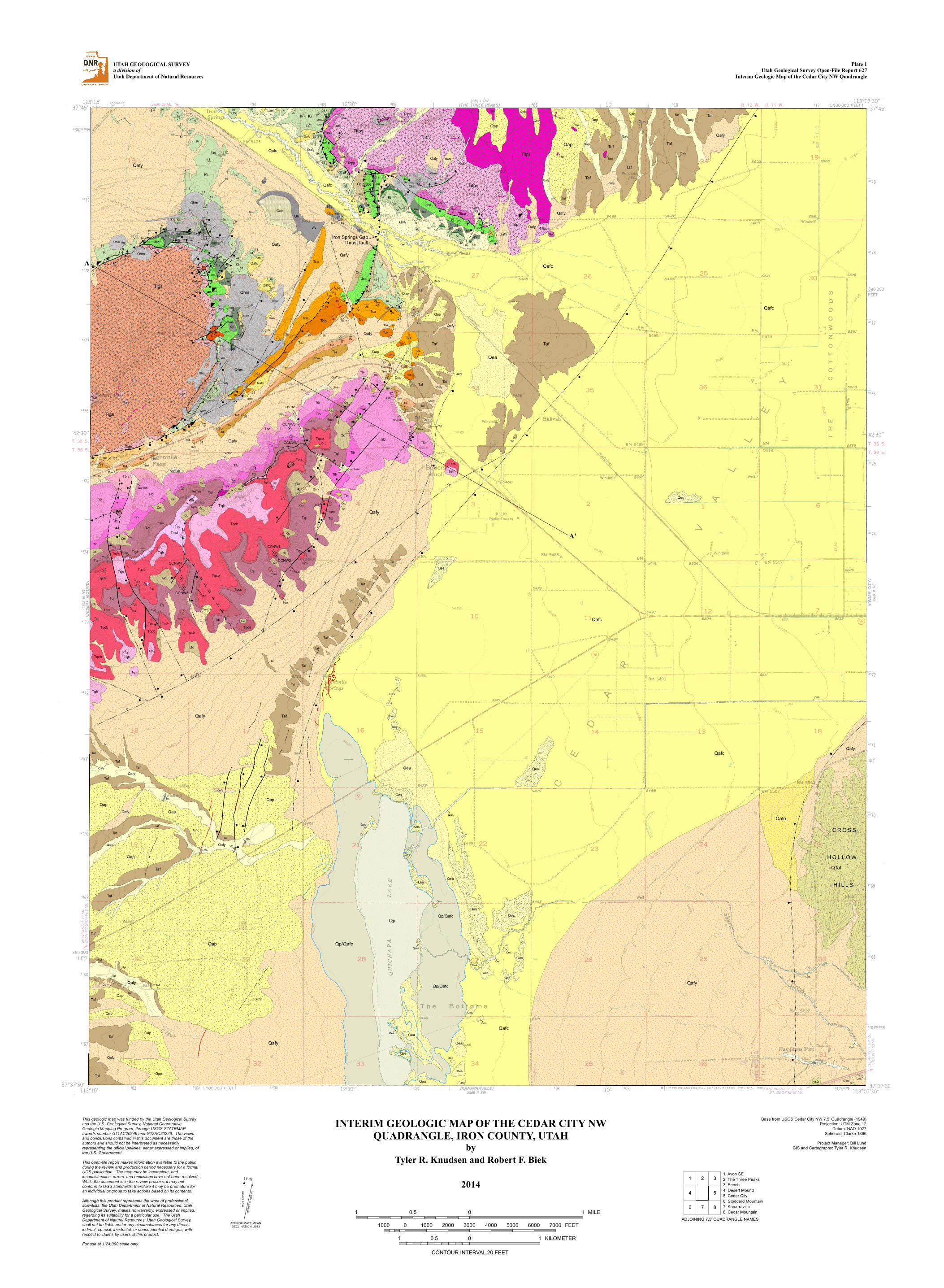
MAP UNIT DESCRIPTIONS QUATERNARY Alluvial deposits Qal1 Stream deposits (upper Holocene) – Stratified, moderately to well-sorted gravel, sand, silt, and
clay deposited in stream channels, floodplains, and man-made flood conveyance channels; includes small alluvial-fan and colluvial deposits, and minor terraces less than 10 feet (3 m) above modern base level; 0 to 30 feet (0–10 m) thick.
Qaly Young alluvial deposits (Holocene to upper Pleistocene) – Moderately sorted sand, silt, clay, and
pebble to boulder gravel deposited in low-gradient stream channels and floodplains; locally includes colluvium from adjacent slopes; incised by active stream channels; probably less than 20 feet (6 m) thick.
Qaf1 Level-1 fan alluvium (Holocene to upper Pleistocene) – Poorly to moderately sorted, subangular
to subrounded, clay- to boulder-size sediment deposited principally by debris flows and debris floods; deposits form active depositional surfaces, although locally the master stream may be deeply entrenched; equivalent to the upper part of younger fan alluvium (Qafy), but differentiated where deposits can be mapped separately; typically less than 30 feet (<9 m) thick, but coalesced deposits may exceed 100 feet (30 m) thick.
Qafy Younger fan alluvium (Holocene to upper Pleistocene) – Poorly to moderately sorted, non-
stratified, subangular to subrounded, boulder- to clay-size sediment deposited at the mouths of streams and washes; forms both active depositional surfaces (Qaf1 equivalent) and low-level inactive surfaces incised by small streams (Qaf2 equivalent) that are undivided here; deposited principally as debris flows and debris floods, but colluvium locally constitutes a significant part of the deposits; small isolated deposits are typically less than a few tens of feet thick, but large, coalesced deposits are probably as much as 200 feet (60 m) thick.
Qafc Coalesced fan alluvium (Holocene to upper Pleistocene) – Similar to younger fan alluvium
(Qafy) but forms large, coalesced fans in central Cedar Valley; typically exhibits a lower overall slope than younger fan alluvium; locally includes small eolian-sand deposits too small to map separately; unconsolidated to poorly consolidated basin-fill deposits are as much as 2000 (600 m) thick in central Cedar Valley in the northeast part of map (Hurlow, 2002); only the uppermost part of this basin fill is included in map unit Qafc, which is likely in excess of several tens of feet thick.
Qap Pediment alluvium (Holocene to middle Pleistocene?) – Poorly sorted, subangular to rounded,
silt and sand to small-boulder gravel partially covering gently-sloping and deeply dissected erosional surfaces cut into quartz monzonite (Titpi) and upper Tertiary fan alluvium (Taf); deposited principally as debris flows, debris floods, and as ephemeral stream channel deposits; 0 to 30 feet (0–10 m) thick.
Qafo Older alluvial-fan deposits (Pleistocene) – Poorly to moderately sorted, non-stratified, clay- to
boulder-size sediment with moderately developed pedogenic carbonate; forms broad, gently sloping, dissected surfaces; deposited principally as debris flows and debris floods; may contain clasts from rocks exotic to modern drainages; exposed thickness is less than 15 feet (<5 m).
QTaf Basin-fill deposits (Pleistocene to Pliocene) – Poorly to moderately sorted, non-stratified,
subangular to subrounded, clay- to boulder-size sediment with moderately to well-developed calcic soils (caliche); forms deeply dissected surfaces with no remaining fan morphology; widely exposed in the Cross Hollow and North Hills (only extreme northern tip of the North Hills is in the southeast corner of the quadrangle) where exhumed as a fault-bounded horst blocks; prominent clasts include Tertiary volcanic rocks, pale-reddish-orange and light-pinkish-gray limestone and
3
calcareous mudstone of the Claron Formation, and yellowish-brown Cretaceous siltstone, sandstone, and coquina; includes lesser amounts of chalcedony and recycled quartzite; quartz monzonite clasts are common in the extreme western part of the Cross Hollow Hills, and are locally the dominant clast type in the North Hills (Biek and Hayden, 2013); deposits appear to be interbedded with at least two different lava flows in the eastern part of the Cross Hollow Hills (Knudsen, 2014a)—one of which yielded an 40Ar/39Ar age of 1.12 ± 0.08 Ma; deposited principally as debris flows; maximum exposed thickness is about 200 feet (60 m) in the western Cross Hollow Hills.
Colluvial deposits Qc, Qc/Tbh, Qco Colluvium (Holocene to middle[?] Pleistocene) – Poorly to moderately sorted, angular, clay- to
boulder-size, locally derived sediment deposited principally by slope wash and soil creep on moderate slopes and in shallow depressions; locally includes talus and alluvium deposits too small to map separately; younger colluvial deposits (Qc) form active depositional surfaces; older colluvial deposits (Qco) cap ridge crests in the Eightmile Hills; Brian Head Formation is typically obscured by colluvium (Qc/Tbh) derived from the overlying Isom Formation (Tib); typically less than 20 feet (6 m) thick.
Eolian deposits Qes Eolian sand (Holocene to upper Pleistocene) – Pale yellowish-gray to greenish-gray, moderately
well- to well-sorted windblown sand and silt deposited in sheets, mounds, and small poorly-developed dunes; largely stabilized by vegetation; locally derived from deflation of playa and fine-grained distal-fan deposits; typically less than 15 feet (5 m) thick; larger stabilized dunes east of the Quichapa Lake playa are as much as 30 feet (9 m) thick.
Human-derived deposits Qh, Qhm
Artificial fill (Historical) – Borrow material and engineered fill used to construct flood-control dams, retaining ponds and other uses; minor fill placed for roadways and building pads generally not mapped; includes extensive deposits of waste rock (Qhm) from open-pit mines near Granite Mountain and Three Peaks; variable thickness as much as 165 feet (50 m).
Playa deposits Qp, Qp/Qafc
Quichapa Lake playa deposits (Holocene to upper Pleistocene) – Calcareous, saline, and gypsiferous light-gray clay, silt, and fine-grained sand deposited on the playa lake bed of Quichapa Lake; Qp/Qafc denotes very thin (generally less than 1 foot thick [0.3 m]) accumulations of clay, silt, and locally dried mats of filamentous algae over low-relief alluvial-fan deposits (Qafc); Qp/Qafc was deposited during high lake levels, including several flood events in historical time (Lips, 2010); extent of Qp/Qafc corresponds to the approximate highstand shoreline established during a 2005 flood event; central playa deposits (Qp) are probably at least 25 feet (8 m) thick.
Mass-movement deposits Qms? Queried landslide (Holocene to upper[?] Pleistocene) – Suspected landslide mapped in the
Eightmile Hills consisting of poorly sorted material derived from local volcanic-rock units; likely deposited by rotational and translational movement; probably less than 50 feet (15 m) thick.

4
Mixed-environment deposits Qac Alluvium and colluvium (Holocene to upper Pleistocene) – Poorly to moderately sorted, clay- to
boulder-size, locally derived sediment deposited in swales and small drainages by fluvial, slope-wash, and creep processes; gradational with alluvial and colluvial deposits; generally less than 20 feet (6 m) thick.
Qea Eolian sand and alluvium (Holocene to upper Pleistocene) – Light-gray to light-orangish-red,
moderately to well-sorted, fine- to medium-grained eolian sand locally reworked by alluvial processes, and poorly to moderately sorted gravel, sand, and silt deposited in small stream channels; generally less than 20 feet (6 m) thick.
TERTIARY Taf Upper Tertiary fan alluvium (Pliocene to Miocene) – Poorly to moderately consolidated, poorly
to moderately stratified, subangular to subrounded, clay- to small boulder-size sediment exposed around the northern and western margins of Cedar Valley; prominent clasts include Tertiary volcanic rocks, recycled quartzite and chert pebbles, and locally, red and orange sandstone and siltstone derived from Mesozoic units to the east (Mackin and others, 1976); depositional form is not preserved and a gently sloping pediment surface is cut across much of the deposit; deposits are generally poorly exposed and covered by a veneer of younger, locally active pediment alluvium, and east of Eightmile Hills, by coalesced younger fan deposits (Qafy); although displaced by several northeast-trending normal faults, the deposit is generally little disturbed; 9 to 10 Ma basalt (Anderson and Mehnert, 1979) is interbedded with Taf-equivalent deposits about 15 miles to the north in the Enoch NE quadrangle (Rowley, 1975); interpreted to represent early basin fill deposited principally as debris flows, debris floods, and in ephemeral stream channels; about 60 feet (18 m) exposed in low hill east of Iron Springs Gap, but is likely several hundred feet thick where preserved beneath the valley floor.
unconformity Tigs, Tigp, Titps, Titpp, Titpi, Tir Granite Mountain and Three Peaks laccoliths and associated ore bodies (early Miocene) –
Light-gray to greenish-brown, crystal-rich quartz monzonite porphyry of the Granite Mountain (Tigs, Tigp) and Three Peaks (Titps, Titpp, Titpi) intrusions, which have a similar age and composition; contains phenocrysts of plagioclase (andesine-labradorite), biotite, hornblende, pyroxene (diopsidic augite) in a groundmass of fine-grained quartz and potassium feldspar (Barker, 1995; Hacker and others, 2007); magnetite veins up to 8 feet (2.5 m) thick with accessory hematite and apatite are common throughout the intrusions; the intrusions have several lithologic phases: (1) a thin outer peripheral-shell phase (Tigp and Titpp) developed along the sides and top of the intrusions as a chilled border zone that is resistant to weathering and forms bold outcrops, (2) an interior phase (Titpi) of altered greenish-brown, coarse-grained monzonite exposed only at Three Peaks that is easily friable and weathers to rounded gruss-covered hills, and (3) an intermediate zone of selvage joints (Tigs and Titps) consisting of light-gray monzonite cut by subvertical joints that are bleached from less than 0.4 inch (<1 cm) to nearly 3 feet (1 m) on each side of the joint (Mackin, 1947, 1954, 1960; Bullock, 1973; Mackin and others, 1976; Hacker and others, 2007); map contacts between the various lithologic phases are from Mackin and others (1976); both laccoliths were intruded principally at the stratigraphic level of the Temple Cap Formation; Granite Mountain monzonite yielded a K-Ar age of 21.5 Ma (Armstrong, 1970) and the Three Peaks intrusion yielded an 40Ar/39Ar age of 21.76 ± 0.06 (Rowley and others, 2006); as much as 1000 feet (300 m) exposed.
The Granite Mountain and Three Peaks intrusions are part of the Iron Axis, a northeast-trending belt of early Miocene calc-alkaline laccoliths and concordant stocks that rose at about 22 to 20 Ma above the roof of an inferred large batholith (Blank and Mackin, 1967; Cook and Hardman, 1967; Rowley, 1998; Rowley and others, 1998). Most of the central quartz monzonite

5
plutons, including the Granite Mountain and Three Peaks intrusions, appear to be partly controlled by the northeast-striking, southeast-verging Sevier-age Iron Springs Gap thrust fault and were emplaced at shallow depths, mostly within about 1.2 miles (2 km) of the surface (Mackin and others, 1976; Van Kooten, 1988; Hacker and others, 2002, 2007; Rowley and others, 2006). The laccoliths probably formed rapidly following a two-stage emplacement process—injection of a sill immediately followed by inflation—at shallow crustal depth of less than 4000 feet (1200 m) based on stratigraphic reconstructions (Spurney, 1984; see also Hacker and others, 2002, 2007; Willis, 2002). Rapid inflation of the laccoliths commonly led to partial unroofing by gravity sliding, immediately followed by volcanic eruptions (Mackin, 1960; Blank and Mackin, 1967; Hacker and others, 1996, 2002, 2007; Hacker, 1998; Willis, 2002). The Three Peaks, Granite Mountain, and Iron Mountain intrusions make up the Iron Springs mining district and are associated with strata-bound replacement ores (Tir) found mainly in the Co-op Creek Limestone Member of the Carmel Formation. The tabular-shaped ore bodies contain finely crystalline magnetite (5–50%) and hematite with minor amounts of calcite, quartz, apatite, jarosite, limonite, and garnet (Mackin, 1947, 1954, 1960; Bullock, 1973). Extensive mining of replacement ore bodies and a few of the thicker magnetite veins has made the Iron Springs mining district the largest iron-producing district in the western U.S. (Mackin, 1947, 1954, 1960, 1968; Blank and Mackin, 1967; Bullock, 1973; Mackin and others, 1976; Mackin and Rowley, 1976; Rowley and Barker, 1978; Barker, 1995; Rowley and others, 2006).
Quichapa Group (lower Miocene to upper Oligocene) – Consists of three regionally distinctive ash-flow tuffs: in ascending order, the Leach Canyon Formation, Condor Canyon Formation, and Harmony Hills Tuff (Mackin, 1960; Williams, 1967; Anderson and Rowley, 1975; Rowley and others, 1995). A lens of Mount Dutton Formation volcanic mudflow breccia locally separates the Swett and Bauers Tuff Members of the Condor Canyon Formation. Tqh Harmony Hills Tuff (lower Miocene) – Resistant, pale-pink to grayish-orange-pink, crystal-rich,
moderately welded, dacitic ash-flow tuff; contains about 50% phenocrysts of plagioclase (63%), biotite (16%), hornblende (9%), quartz (7%), pyroxene (5%), and sanidine (trace) (Williams, 1967); disconformably overlies the Bauers Tuff; yielded an 40Ar/39Ar plateau age of 22.03 ± 0.15 Ma (Cornell and others, 2001); incomplete section is as much as about 200 feet (60 m) thick in the Eightmile Hills, similar to the 180 to 250 feet (55–75 m) reported by Mackin and others (1976).
The source of the Harmony Hills Tuff is unknown, but isopachs are centered on Bull Valley (Williams, 1967), suggesting that it was derived from the eastern Bull Valley Mountains, probably from an early, much more voluminous eruptive phase of the Bull Valley/Hardscrabble Hollow/Big Mountain intrusive arch as suggested by Blank (1959), Williams (1967), and Rowley and others (1995, 2008). Consistent with this interpretation is the fact that its age is nearly identical to that of those intrusions.
Tqcb Bauers Tuff Member of Condor Canyon Formation (lower Miocene) – Resistant, light-
brownish-gray to pinkish-gray, densely welded, rhyolitic ash-flow tuff; contains about 10 to 20% phenocrysts of plagioclase (40–70%), sanidine (25–50%), biotite (2–10%), Fe-Ti oxides (1–8%), and pyroxene (<3%), but lacks quartz phenocrysts (Rowley and others, 1995); bronze-colored biotite and light-gray flattened lenticules are conspicuous in the upper, vapor-phase part of the tuff, and a basal vitrophyre 10 to 20 feet (3–6 m) thick is normally present; disconformably overlies the Leach Canyon Formation; incomplete type section is at Bauers Knoll (Mackin, 1960); about 150 feet (45 m) thick in the Eightmile Hills, similar to the 100 to 180 feet (30–55 m) reported by Mackin and others (1976).
The Bauers Tuff erupted from the northwest part (Clover Creek caldera) of the Caliente caldera complex and covered an area of at least 8900 square miles (23,000 km2) (Best and others, 1989b; Rowley and others, 1995) with an estimated volume of 740 mi3 (3200 km3) (Best and others, in preparation). The prefered 40Ar/39Ar age of the Bauers Tuff is 22.7 Ma (Best and others, 1989a) or 22.8 Ma (Rowley and others, 1995), which is also the 40Ar/39Ar age of its intracaldera intrusion exposed just north of Caliente, Nevada (Rowley and others, 1994b). Fleck and others (1975) reported a K-Ar age (corrected according to Dalrymple, 1979) of 22.7 ± 0.6 Ma (plagioclase) for Bauers Tuff Member on the Markagunt Plateau, east of Fivemile Ridge.
6
Tmd Mount Dutton Formation, alluvial facies (lower Miocene to upper Oligocene) – Light- to dark-gray and
brown, andesitic volcanic mudflow breccia locally present between the 23.7 Ma Swett and 22.8 Ma Bauers Tuffs; Anderson and Rowley (1975) noted similar volcanic mudflow deposits at this stratigraphic horizon in the southwestern Black Mountains, about 30 miles (50 km) north of the map area; Anderson and Rowley (1975) defined the Mount Dutton Formation as consisting of most of the rocks exposed on the south flank of the Marysvale volcanic field—one of several voluminous calc-alkaline, subduction-related volcanic centers and underlying source plutons that characterized the West from Oligocene to Miocene time at this latitude (Lipman and others, 1972; Rowley and Dixon, 2001)—and divided it into complexly interfingering and cross-cutting vent and alluvial facies derived from clustered stratovolcanoes and dikes; 0 to about 75 feet (0–23 m) thick, somewhat less than that estimated by Mackin and others (1976).
Tqcs Swett Tuff Member of Condor Canyon Formation (upper Oligocene) – Pinkish-gray, densely
welded, rhyolitic ash-flow tuff; like the Bauers Tuff, contains 5 to 15% phenocrysts of plagioclase (70 to 90%), minor biotite (10 to 20%), and Fe-Ti oxides (<7%), but lacks sanidine and clinopyroxene (Rowley and others, 1995; Best and others, in preparation); prominent vitrophyre is nearly as thick as tuff itself; basal part is locally vuggy, walls of vugs are typically dark reddish brown, and vugs commonly partly filled with chalcedony in the form of rosettes; weathers to grussy slope; typically 25 to 30 feet (7–9 m) thick, but is locally missing due south of Eightmile Pass and locally may be as much as about 50 feet (15 m) thick.
The source of the Swett Tuff is unknown, but it may have been derived from eruption of a caldera later destroyed by the Clover Creek caldera (Rowley and others, 1995). The total volume of the Swett Tuff is estimated to be about 90 mi3 (400 km3) (Best and others, in preparation) initially spread over an area of at least 2340 mi2 (6000 km2) (Rowley and others, 1995). The average of six K-Ar ages is 23.7 Ma (Armstrong, 1970).
Tql Leach Canyon Formation (upper Oligocene) – Grayish-orange-pink to pinkish-gray, moderately
welded, crystal-rich rhyolite tuff that contains abundant white or light-pink collapsed pumice fragments and several percent lithic clasts, many of which are reddish brown; contains 25 to 35% phenocrysts of plagioclase, slightly less but subequal amounts of quartz and sanidine, and minor biotite, hornblende, Fe-Ti oxides, and a trace of pyroxene; disconformably overlies the Isom Formation; served as the principal detachment horizon for the Eightmile Hills gravity slide, which was triggered by emplacement of the 21.5 Ma Granite Mountain laccolith; 150 to 300 feet (45–90 m) thick in the Eightmile Hills.
The Leach Canyon Formation is widely agreed to be about 23.8 Ma (Best and others, 1993; Rowley and others, 1995; Biek and others, 2012). Its source is unknown, but it is probably the Caliente caldera complex because isopachs show that it thickens toward the complex (Williams, 1967; Rowley and others, 1995). The total volume of the Leach Canyon is estimated to be 830 mi3 (3600 km3), representing the largest eruption of the Caliente caldera complex (Best and others, in preparation).
Ti Isom Formation (upper Oligocene) – At its type area in the Three Peaks quadrangle just north of this map
area, Mackin (1960) defined three members, a lower unnamed member, the Baldhills Tuff Member, and the upper Hole-in-the-Wall Tuff Member; Rowley and others (1975) redefined the Baldhills Tuff Member to include Mackin’s lower unnamed member, and noted that the Baldhills consists of at least six cooling units. Both members, the thick Baldhills and the thin overlying Hole-in-the-Wall, are present at Eightmile Hills.
Regionally, many outcrops of all cooling units in the Isom Formation reveal secondary flow characteristics, including flow breccias, contorted flow layering, and linear vesicles such that the unit was considered a lava flow until Mackin (1960) mapped its widespread distribution (300 cubic miles [1300 km3] today spread over an area of 9500 square miles [25,000 km2] Best and others, 1989a) and found evidence of glass shards, thus showing its true ash-flow tuff nature. For that reason it is commonly referred to as a tufflava, and is also called a rheomorphic ignimbrite, an ash-flow tuff that was sufficiently hot to move with laminar flow as a coherent ductile mass―see, for example, Anderson and Rowley (1975, 2002), Andrews and Branney (2005), and Geissman and others (2010).
The Isom Formation is about 27 to 26 Ma on the basis of many 40Ar/39Ar and K-Ar ages (Best and others, 1989b; Rowley and others, 1994a). Its source is unknown, but isopach maps and pumice
7
distribution suggest that it was derived from late-stage eruptions of the 32–27 Ma Indian Peak caldera complex that straddles the Utah-Nevada border, possibly in an area now concealed by the western Escalante Desert (Rowley and others, 1979; Best and others, 1989a, 1989b). Estimated crystallization temperature and pressure of phenocrysts of the Isom is 950°C and <2 kbar (Best and others, 1993), and this relatively high temperature is supported by its degree of welding and secondary flow features.
Tih Hole-in-the-Wall Tuff Member – Medium-gray, commonly with reddish-gray hues, crystal-poor,
densely welded, trachydacitic ash-flow tuff; small (1–3 mm) euhedral crystals constitute 10 to 15% or less of the rock and are mostly plagioclase (90%) and minor pyroxene and Fe-Ti oxides set in a devitrified-glass groundmass; exhibits pronounced subhorizontal lamination or platiness, which Mackin (1960) called “lenticules” and that locally are dark reddish brown to dusky red; lenticles are typically not as flattened as those of the Baldhills Member; Mackin and others (1976) reported that the Hole-in-the-Wall Member is 10 to 60 feet (3–18 m) thick at Eightmile Hills, with which we concur.
Tib Baldhills Tuff Member – Medium-gray, crystal-poor, densely welded, trachydacitic ash-flow
tuff; small (1–3 mm) euhedral crystals constitute 10 to 15% or less of the rock and are mostly plagioclase (90%) and minor pyroxene and Fe-Ti oxides set in a devitrified-glass groundmass; exhibits pronounced subhorizontal lamination or platiness, which Mackin (1960) called “lenticules” and that locally are dark reddish brown to dusky red; almost everywhere fractured like glass, and so weathers to grussy, ledgy slopes; about 250 feet (75 m) thick at Eightmile Hills.
unconformity Brian Head Formation (lower Oligocene to middle Eocene) – The Brian Head Formation is the oldest widespread Tertiary volcaniclastic unit in the region. On the nearby Markagunt Plateau, it disconformably overlies the Claron Formation (Biek and others, 2012) whereas farther east on the Sevier Plateau, Brian Head strata disconformably overlie the conglomerate at Boat Mesa. Sable and Maldonado (1997) designated a type section at Brian Head peak and divided the Brian Head Formation into three informal units, ascending: (1) nontuffaceous sandstone and conglomerate, (2) a volcaniclastic unit that has minor but conspicuous limestone and chalcedony, and (3) a volcanic unit, locally present in the northern Markagunt Plateau but not at the type section, characterized by volcanic mudflow breccia, mafic lava flows, volcaniclastic sandstone and conglomerate, and ash-flow tuff. Only their middle volcaniclastic unit is present in the map area, where it disconformably overlies a pebbly conglomerate interval that we tentatively assign to the conglomerate at Boat Mesa. Biek and others (2012) summarized radiometric ages for the formation that show it to be about 33 to 37 Ma; regionally it is disconformably overlain by the 30 Ma Wah Wah Springs Formation or, as in this map area, by the 26 to 27 Ma Isom Formation. Eaton and others (1999c) and Korth and Eaton (2004) reported on Duchesnean (middle Eocene) vertebrate fossils in lower Brian Head strata of the Sevier Plateau. The Brian Head Formation is thus early Oligocene to latest middle Eocene. Tbh Middle volcaniclastic unit – White to light-gray volcaniclastic mudstone, siltstone, silty
sandstone, sandstone, conglomerate, volcanic ash, micritic limestone, and multi-hued chalcedony; exceptionally poorly exposed in this map area; sandstone is commonly bioturbated with pencil-size root or burrow casts that weather out in relief; conglomerate clasts are quartzite, limestone, and chert—surprisingly, clasts of intermediate-composition volcanic rocks are virtually absent, except for rare pebbles at the top of the section in the SW1/4 section 32, T. 35. S., R. 12 W.; chalcedony is various shades of white, gray, yellow, red, black, and brown, typically has a white weathering rind, is commonly highly brecciated and resilicified, typically occurs in beds 1 to 3 feet (0.3–1 m) thick but locally as much as 8 feet (2.5 m) thick, is locally stained by manganese oxides, and likely resulted from silicification of limestone beds (Maldonado, 1995; Sable and Maldonado, 1997; Schinkel, 2012); chalcedony is almost always highly fractured, but some is useful for lapidary purposes (Strong, 1984); equivalent to the upper part of Mackin and others’ (1976) informal member E of their Claron Formation; because of abundant bentonitic clay derived from weathered volcanic ash, this unit weathers to strongly swelling soils (unlike the underlying Claron Formation) and regionally forms large landslide complexes (for example, on the nearby
8
Markagunt Plateau; Biek and others, 2012); deposited in low-relief fluvial, floodplain, and lacustrine environments in which large amounts of volcanic ash accumulated (Sable and Maldonado, 1997); about 500 feet (150 m) thick at its type section on Brian Head peak (Sable and Maldonado, 1997; Biek and others, 2012; Rowley and others, in preparation) and probably of similar thickness in the structurally complicated Eightmile Pass area.
unconformity
Tbm Conglomerate at Boat Mesa (middle Eocene) – Light-gray pebbly conglomerate and conglomeratic sandstone and minor white to light-gray conglomeratic limestone overlain by yellowish-brown sandstone and pebble to cobble sandstone; clasts are rounded black chert, brown, white, and gray quartzite, and bluish-gray Paleozoic limestone; no volcanic or intrusive clasts are present; in the limestone intervals, clasts commonly appear to float in a carbonate mud matrix, but otherwise the conglomerates are clast supported; equivalent to the lower part of Mackin and others’ (1976) informal member E of their Claron Formation; named for exposures at Boat Mesa in Bryce Canyon National Park where it is about 100 feet (30 m) thick (Bowers, 1990) and tentatively used here for lithologically similar strata that occupy the same straigraphic position; as much as 100 feet (30 m) thick on the southwest flank of the Sevier Plateau, and only a few feet to perhaps 10 feet (3 m) thick on the Markagunt Plateau (Biek and others, 2012), but this conglomeratic interval is at least 300 feet (90 m) thick in this map area.
The conglomerate at Boat Mesa represents deposits of braided stream channels and minor floodplains incised into the Claron Formation. Bowers (1990) suggested the conglomerate at Boat Mesa was Oligocene and Davis and Pollock (2010) thought it was Oligocene or Miocene, but lack of volcanic clasts suggests latest middle Eocene age, confirmed by an overlying 36.51 ± 1.69 Ma volcanic ash in the Brian Head Formation on the nearby Markagunt Plateau (Biek and others, 2012); Biek and others (2012) also reported a U-Pb detrital age on zircon of 37.97 +1.78 /- 2.70 Ma (Gary Hunt, UGS, written communication, March 7, 2012; UGS and A2Z, Inc., 2013) for the unit on the southwest flank of the Sevier Plateau. This sample also yielded a Middle Jurassic U-Pb peak of about 168 Ma from a coherent group of 34 detrital zircon grains, indicating that Middle Jurassic volcanic or intrusive rocks provided a significant source of sediment to the formation even though it lacks such clasts locally. unconformity Claron Formation (Eocene and Paleocene) Claron Formation strata are among the most visually arresting rocks in southwestern Utah, being prominently displayed at Cedar Breaks National Monument and Bryce Canyon National Park among other places. However, because the formation lacks a type section and was named for relatively poor exposures in the Iron Springs mining district (Leith and Harder, 1908), the nomenclatural history of these rocks is complicated as described by Biek and others (2012). In the Iron Springs district the Claron Formation was subdivided into five informal members by Mackin (1954), Mackin and others (1976), and Mackin and Rowley (1976), from lowest to highest: (1) resistant purplish-red limestone, shale, sandstone, and conglomerate of member A, (2) red, poorly resistant shale, sandstone, and conglomerate of member B, (3) white, poorly resistant sandstone, limestone, shale, and minor conglomerate of member C, (4) thick-bedded white limestone of member D, and (5) white sandstone, shale, limestone, and conglomerate of member E. We generally follow the nomenclature of Mackin and others (1976), although we note that members A and B likely represent the informal pink member of the Claron Formation described on the Markagunt Plateau and in the Red Hills by Biek and others (2012). Similarly, Mackin and others’ (1976) members C and D may be equivalent to the informal white member of the Claron Formation (Biek and others, 2012). The lower part of Mackin and others’ (1976) member E is here assigned to the conglomerate at Boat Mesa (Tbm), and the upper part of member E to the Brian Head Formation (see descriptions for units Tbm and Tbh above). As now defined, the Claron Formation lacks volcanic clasts or ash-flow or ash-fall tuff.
Claron strata were deposited in fluvial, floodplain, and lacustrine environments of an intermontaine basin bounded by Laramide uplifts; the pink member (members A and B) is almost wholly fluvial and the white member (members C and D) is both lacustrine and fluvial (Goldstrand, 1990, 1991, 1992, 1994; Bown and others, 1997). Much of the pink member, and clastic parts of the white member,
9
were greatly modified by bioturbation and pedogenic processes, creating a stacked series of paleosols (Mullett and others, 1988a, 1988b; Mullett, 1989; Mullett and Wells, 1990). Claron strata rest unconformably on Middle Jurassic Co-op Creek Limestone of the Carmel Formation and are deformed in the SW1/4 section 28, T. 35. S., R. 12 W., apparently by the underlying Iron Springs thrust fault, thus indicating continued movement on the Iron Springs thrust fault into early Claron time (Mackin, 1947). Similar relations were reported by Anderson and Dinter (2010) and Biek and others (2012) in the Parowan Gap area 18 miles (29 km) to the northeast. The age of the white member is well constrained as late middle Eocene (Duchesnean land mammal age) based on sparse vertebrate fossils and constraining U-Pb zircon ages of overlying strata (Biek and others, 2012, and references therein), but the maximum age of the mostly nonfossiliferous pink member is poorly constrained as Eocene to Paleocene(?) (Goldstrand, 1994). Biek and others (2012) noted that the lower part of the pink member is likely Paleocene in age, but given its paucity of datable materials, could not rule out the possibility of a latest Cretaceous age. Tcd Member D (Eocene) – White, light-gray, and pale-yellowish-gray, poorly bedded micritic
limestone locally containing intraformational rip-up clasts; resistant and so forms prominent ledge; may be correlative with the upper limestone interval of the white member described by Biek and others (2012) on the Markagunt Plateau and Red Hills; upper contact is unconformable with the overlying conglomerate at Boat Mesa; about 30 feet (10 m) thick.
Tcc Member C (Eocene) – White and light-tan calcareous sandstone and siltstone, varicolored
mudstone, and minor limestone and conglomerate; sandstone is typically friable; an interval of interbedded tan pebbly sandstone and varicolored mudstone near the base resembles upper Iron Springs Formation; limestone is very pale reddish-gray or grayish-blue, locally mottled, and commonly contains intraformational rip-up clasts; a few orangish-red-weathering conglomerate beds contain white, light-gray, and red chert clasts up to 1 foot in diameter; typically poorly exposed, but well exposed in the Eightmile Pass area; about 350 feet (105 m) thick northeast of Granite Mountain and thins northward to 100 to 250 feet (30–75 m) thick in the Three Peaks quadrangle (Mackin and others, 1976; Mackin and Rowley, 1976).
Tcb Member B (Eocene and Paleocene?) – Varicolored and commonly mottled, reddish-orange,
reddish-brown, and purplish-red calcareous mudstone, sandstone, conglomerate, and limestone; mudstone is moderate reddish orange, silty, calcareous, and contains calcareous nodules; sandstone is thick-bedded, fine- to coarse-grained, calcareous, locally cross-bedded quartz arenite; distinctive conglomerate forms lenticular beds typically 5 to 15 feet (2–5 m) thick containing 80% rounded blue, light-blue-gray, and reddish-blue limestone pebbles, with minor amounts of red and gray quartzite and chert pebbles; limestone is poorly bedded, microcrystalline, and is locally argillaceous; likely represents the upper part of the pink member mapped in quadrangles to the east (e.g., Knudsen, 2014a, 2014b; Biek and Hayden, 2013; Biek and others, 2012); contact with overlying member C corresponds to a pronounced color change from reddish-orange slope-forming mudstone of member B to white and light-tan-weathering ledgy sandstone of member C; about 400 feet (120 m) thick northeast of Granite Mountain and thins northward to 100 to 200 feet (30–60 m) thick in the Three Peaks quadrangle (Mackin and others, 1976; Mackin and Rowley, 1976).
Tca Member A (Paleocene?) – Varicolored and commonly mottled, pale-reddish-orange, reddish-
brown, moderate-orange-pink, dark-yellowish-orange, and grayish-pink sandy and micritic limestone, calcite-cemented sandstone, calcareous mudstone, and conglomerate that weather to colluvium-covered slopes; similar to member B strata, but contains a greater component of conglomerate and limestone which form a series of resistant ridges; its overall lighter reddish-orange color and tendency to form ridges distinguishes member A strata from member B strata in aerial photographs; a 0 to 50-foot-thick (0–15 m) red basal conglomerate marks the unconformable lower contact with the Iron Springs Formation; rests on Co-op Creek Limestone of the Carmel Formation and appears to be deformed by the underlying Iron Springs Gap thrust fault in the SW1/4 section 28, T. 35. S., R. 12 W.; likely correlative with the lower part of the informal pink member of the Claron Formation mapped in adjoining quadrangles to the east (Knudsen, 2014a, 2014b; Biek and Hayden, 2013; Biek and others, 2012); 200 to 300 feet (60–90 m) thick,
10
but only about 100 feet (30 m) thick near the Iron Springs Gap thrust fault; thickens abruptly northward to 450–750 feet (140–230 m) thick in the Three Peaks quadrangle (Mackin and Rowley, 1976).
unconformity CRETACEOUS
Ki Iron Springs Formation (Upper Cretaceous, Santonian or lower Campanian to Cenomanian) – Interbedded, ledge-forming, calcareous sandstone, siltstone, conglomerate and less-resistant, poorly exposed varicolored mudstone; includes several 1- to 5- foot-thick (0.3–1.5 m) limestone beds near its base; yellowish-brown to reddish-brown sandstone and siltstone beds are typically cross-bedded, locally display soft-sediment deformation, locally contain thin chert-pebble-rich zones, and range from quartz arenite to litharenite (Fillmore, 1991; Goldstrand, 1992); lenticular conglomerate beds in the lower part of the formation are as much as 50 feet (15 m) thick and contain pebble to cobble clasts of quartzite, chert, and limestone; a 5- to 40-foot-thick (1.5–12 m) basal conglomerate consists almost entirely of red, orange, white, and gray quartzite and chert clasts; gray, greenish-gray, and maroon mudstone is rarely exposed between thick tabular beds of sandstone and conglomerate; near its base, several blue and bluish-gray limestone beds with abundant rip-up clasts are interbedded with sandstone, conglomerate, and mudstone; subdivided into eight informal units by Mackin (1947) and into upper, middle, and lower members by Mackin and others (1976), who noted that contacts between their informal units are gradational and placed arbitrarily since the individual members are largely laterally discontinuous and not everywhere contemporaneous—due to these mapping difficulties in addition to poor exposures and structural complications, we leave the formation undivided; the quadrangle lacks a complete section, but the Iron Springs ranges from 0 (where it is locally eroded away in the hanging wall of the Iron Springs Gap thrust fault) to probably at least 3000 feet (0–915 m) thick (Mackin, 1947; Mackin and others, 1976); regionally, the formation is 3500 to 4000 feet (1070–1220 m) thick in the Pine Valley Mountains (Cook, 1960).
Iron Springs strata were deposited principally in braided-stream and floodplain environments of a coastal plain (Johnson, 1984; Fillmore, 1991; Eaton and others, 2001; Milner and others, 2006), but near its base, also includes freshwater limestone (Mackin, 1947; Mackin and others, 1976) deposited in shallow lakes. In the Red Hills 17 miles (27 km) to the northeast, Eaton (1999) and Eaton and others (2001) correlated the Iron Springs Formation with the Dakota Formation, Tropic Shale, and Straight Cliffs Formation, but we found little resemblance among the Dakota-Straight Cliffs interval of the Red Hills/Markagunt Plateau and Iron Springs strata in the Iron Springs/Three Peaks area. The abundance of generally unfossiliferous limestone and apparent complete absence of coquina beds and carbonaceous/coal zones are particularly anomalous for Upper Cretaceous strata mapped regionally to the east. The bulk of the formation, above the lower section that includes limestone and thick conglomerate beds, consisting of monotonous interbedded reddish-brown sandstone and varicolored mudstone does resemble the Wahweap Formation mapped at the western edge of the Markagunt Plateau by Knudsen (2014a); age is from Goldstrand (1994). Unconformity(?)
Km Marshall Creek breccia (Cretaceous?) – Distinct limestone breccia, named the Marshall Creek breccia by Mackin (1947), commonly exposed between maroon and tan sandstone of the Crystal Creek Member of the Carmel Formation and the basal chert-pebble conglomerate of the Iron Springs Formation; consists of angular pebble to boulder clasts of bluish-gray and pale-blue limestone floating in a brown to pale-orange limy siltstone matrix; locally, clasts are imbricated and resemble accumulations of rip-ups; the siltstone matrix is resistant to weathering and commonly stands up to 2 inches (5 cm) in relief above adjacent limestone clasts; clasts up to several feet across, and rare outcrops of minimally disturbed strata indicate the unit was originally deposited as alternating thin interbeds of lime and silt; includes plastically deformed beds; silt matrix commonly includes floating clasts of well-rounded, red, gray, and cream pebbles of chert derived from overlying Iron Springs conglomerate; described as fanglomerate-mudflow breccia and talus consisting of limestone clasts derived from locally uplifted Homestake Member (Co-op Creek Limestone) by Mackin (1947), but here interpreted to comprise intraformational rip-up clasts and sediment softly deformed in situ via subaqueous sliding, perhaps triggered by nearby tectonic activity along the Sevier
11
orogenic front; deformation occurred soon after the deposition of at least the basal conglomerate of the Iron Springs Formation and while both units were still in a partially lithified state; age is uncertain but because Marshall Creek and basal Iron Springs were deformed prior to lithification and because the original character of the Marshall Creek, before being deformed, resembles limestone beds in the lower part of the Iron Springs Formation, we consider the limestone to be only slightly older than basal Iron Springs conglomerate and that perhaps it should be considered to be part of the Iron Springs Formation; 0 to 80 feet (0–24 m) thick. unconformity JURASSIC Carmel Formation (Middle Jurassic) – Nomenclature follows that of Doelling and Davis (1989); deposited in a shallow inland sea of a back-bulge basin, together with the underlying Temple Cap Formation, the first clear record of the effects of the Sevier orogeny in southwestern Utah; age from Imlay (1980). Jcx Crystal Creek Member (Middle Jurassic) – Thin- to medium-bedded, reddish-brown siltstone,
mudstone, and fine- to medium-grained sandstone; locally gypsiferous; forms vegetated, poorly exposed slopes; best exposed at the abandoned Lindsay Hill mine (now part of the Iron County landfill); exposures on the north flank of Granite Mountain and near the Three Peaks intrusion include a considerable component of cream and very pale-red sandstone and siltstone beds up to 15 feet (5 m) thick, especially near the top of the member; upper contact with Marshall Creek breccia, where present, or basal conglomerate of the Iron Springs Formation is sharp; mapped as “Entrada” formation by Mackin (1947) and as the banded member by Mackin and others (1976); deposited in coastal-sabkha and tidal-flat environments (Imlay, 1980; Blakey and others, 1983); about 200 feet (60 m) thick in the northeastern foothills of Granite Mountain.
Jcc Co-op Creek Limestone Member (Middle Jurassic) – Thin- to thick-bedded, light-blue-gray and
yellowish-gray micritic limestone and minor calcareous siltstone and shale that weather to steep, ledgy slopes; includes a distinctive 5- to 10-foot-thick (1.5–3 m) mud-cracked and rippled argillaceous limestone at the top (Mackin, 1947); contains fossil hash, and sparse crinoids and bivalve fragments; is the host rock for the hematite ore bodies of the Iron Springs mining district; mapped as Homestake Limestone by Leith and Harder (1908) and correlated to the “limestone member” (Co-op Creek Limestone Member) of the Carmel Formation in the Marakagunt Plateau by Mackin (1947, 1954); Mackin (1947) attributed intense brecciation of Co-op Creek Limestone (mapped separately as “disturbed Homestake” by Mackin [1947], and as “crackled phase of the Homestake Limestone” by Mackin and others [1976]) in sections 21 and 28, T. 35. S., R. 12 W. to in situ deformation associated with local uplift that occurred after deposition of the “Entrada” sandstone (Crystal Creek Member) and before deposition of the Iron Springs Formation; because our mapping shows that the brecciated Co-op Creek Limestone everywhere rests on top of Iron Springs Formation as part of the upper plate of the Iron Springs Gap thrust and related faults, we consider the brecciation to be associated with transport above the Sevier-age thrust fault; deposited in a shallow-marine environment (Imlay, 1980; Blakey and others, 1983); about 280 feet (85 m) thick.
Jt Temple Cap Formation (Middle to Lower Jurassic) – Light- to dark-gray, light-orange-brown, or
olive, fine-grained, calcareous sandstone and siltstone; typically forms a thin band of poor outcrops of light-orangish-brown platy fragments between light-blue Co-op Creek Limestone and light-gray quartz monzonite; everywhere exposed, it is in contact with quartz monzonite intrusions, and thus typically has altered grains and exhibits hornfels-grade contact metamorphism (Mackin, 1947, 1954; Mackin and others, 1976); tentatively correlated with non-eolian sandstone, siltstone, and mudstone with gypsum of the Manganese Wash Member of the Temple Cap Formation mapped near Cedar City (Knudsen, 2014a) and the Pine Valley Mountains-Gunlock area (Sprinkel and others, 2011), although we observed no gypsum in the Iron Springs area; gypsum may have been removed by thrust faulting and/or emplacement of intrusions that later
12
followed the Temple Cap horizon; deposited in coastal-sabkha and tidal-flat environments (Blakey, 1994; Peterson, 1994); Sprinkel and others (2009) and Kowallis and others (2011) reported that the Temple Cap Formation ranges from about 179 to 171 Ma based on several 40Ar/39Ar and U-Pb zircon ages; maximum exposed thickness is about 50 feet (15 m).
ACKNOWLEDGMENTS
The geologic map of the Cedar City NW quadrangle by Mackin, Nelson, and Rowley, published in 1976, provided a firm foundation for our new map of this same area. Major additions of our mapping include new structural interpretations based on recent research on laccolith emplacement, the discovery in the Eightmile Hills of a gravity slide shed off the Granite Mountain laccolith, more detailed mapping of surficial deposits that will support the creation of a geologic hazard map folio of the greater Cedar Valley area, and the discovery of numerous fault scarps and earth fissures in Cedar Valley. We thank Pete Rowley (Geologic Mapping, Inc.) and Dave Hacker (Kent State University) for sharing their considerable knowledge of the Cenozoic geology of the region. Bill Lund (Utah Geological Survey [UGS]) helped map earth fissures. Grant Willis and Mike Hylland (both UGS) reviewed the map and we are grateful for their collective wisdom.
REFERENCES Anderson, J.J., and Rowley, P.D., 1975, Cenozoic stratigraphy of the southwestern High Plateaus of Utah,
in Anderson, J.J., Rowley, P.D., Fleck, R.J., and Nairn, A.E.M., editors, Cenozoic geology of southwestern High Plateaus of Utah: Geological Society of America Special Paper 160, p. 1–52.
Anderson, J.J., and Rowley, P.D., 2002, The Oligocene Isom Formation, Utah and Nevada―a regional ash-
flow tuff sheet containing fluidal features of a lava flow [abs.]: Geological Society of America Abstracts with Programs, v. 34, no. 4, p. 9.
Anderson, L.P., and Dinter, D.A., 2010, Deformation and sedimentation in the southern Sevier Foreland,
Red Hills, southwestern Utah, in Carney, S.M., Tabet, D.E., and Johnson, C.L., editors, Geology of south-central Utah: Utah Geological Association Publication 39, p. 338–366.
Anderson, R.E., and Mehnert, H.H., 1979, Reinterpretation of the history of the Hurricane fault in Utah, in
Newman, G.W., and Goode, H.D., editors, Basin and Range symposium: Rocky Mountain Association of Geologists and Utah Geological Association, p. 145–165.
Andrews, G.D.M., and Branney, M.J., 2005, Folds, fabrics, and kinematic criteria in rheomorphic
ignimbrites of the Snake River Plain, Idaho―insights into emplacement and flow, in Pederson, J., and Dehler, C.M., editors, Interior Western United States: Geological Society of America Field Guide 6, p. 311–327.
Armstrong, R.L., 1970, Geochronology of Tertiary igneous rocks, eastern Basin and Range province,
western Utah, eastern Nevada, and vicinity, U.S.A.: Geochimica et Cosmochimica Acta, v. 34, p. 203–232.
Barker, D.S., 1995, Crystallization and alteration of quartz monzonite, Iron Springs mining district, Utah—
relation to associated iron deposits: Economic Geology, v. 90, p. 2197–2217. Best, M.G., Christiansen, E.H., and Blank, R.H., Jr., 1989a, Oligocene caldera complex and calc-alkaline
tuffs and lavas of the Indian Peak volcanic field, Nevada and Utah: Geological Society of America Bulletin, v. 101, p. 1076–1090.
13
Best, M.G., Christiansen, E.H., Deino, A.L., Grommé, S., Hart, G.L., and Tingey, D.G., in preparation, The 36–18 Ma Indian Peak-Caliente ignimbrite field and calderas, southeastern Great Basin, USA—Multicyclic super-eruptions: Geological Society of America Geosphere, v. 9, p. 1–87.
Best, M.G., Christiansen, E.H., Deino, A.L., Gromme, C.S., McKee, E.H., and Noble, D.C., 1989b,
Excursion 3A—Eocene through Miocene volcanism in the Great Basin of the western United States: New Mexico Bureau of Mines and Mineral Resources Memoir 47, p. 91–133.
Best, M.G., Scott, R.B., Rowley, P.D., Swadley, W.C., Anderson, R.E., Gromme, C.S., Harding, A.E.,
Deino, A.L., Christiansen, E.H., Tingey, D.G., and Sullivan, K.R., 1993, Oligocene-Miocene caldera complexes, ash-flow sheets, and tectonism in the central and southeastern Great Basin, in Lahren, M.M., Trexler, J.H., Jr., and Spinosa, C., editors, Crustal evolution of the Great Basin and Sierra Nevada: Field trip guide, Geological Society of America, Cordilleran and Rocky Mountain Sections meeting, p. 285–311.
Biek, R.F., and Hayden, J.M., 2013, Interim geologic map of the Kanarraville quadrangle, Iron County,
Utah: Utah Geological Survey Open-File Report 618, 24 p., 1 plate, scale 1:24,000. Biek, R.F., Rowley, P.D., Anderson, J.J., and Maldonado, F., Moore, D.W., Eaton, J.G., Hereford, R., and
Matyjasik, B., 2012, Interim geologic map of the Panguitch 30' x 60' quadrangle, Garfield, Iron, and Kane Counties, Utah: Utah Geological Survey Open-File Report 599, 124 p., 3 plates, scale 1:62,500.
Blakey, R.C., 1994, Paleogeographic and tectonic controls on some Lower and Middle Jurassic erg
deposits, Colorado Plateau, in Caputo, M.V., Peterson, J.A., and Franczyk, K.J., editors, Mesozoic systems of the Rocky Mountain region, USA: Denver, Colorado, Rocky Mountain Section of the Society for Sedimentary Geology, p. 273–298.
Blakey, R.C., Peterson, F., Caputo, M.V., Geesman, R.C., and Voorhees, B.J., 1983, Paleogeography of
Middle Jurassic continental, shoreline, and shallow marine sedimentation, southern Utah, in Reynolds, M.W., and Dolley, E.D., editors, Mesozoic paleogeography of west-central United States: Denver, Colorado, Rocky Mountain Section of Society of Economic Paleontologists and Mineralogists, p. 77–100.
Blank, H.R., Jr., 1959, Geology of the Bull Valley district, Washington County, Utah: Seattle, University of
Washington, Ph.D. dissertation, 177 p. Blank, H.R., Jr., and Mackin, J.H., 1967, Geologic interpretation of an aeromagnetic survey of the Iron
Springs district, Utah: U.S. Geological Survey Professional Paper 516-B, 14 p. Bowers, W.E., 1990, Geologic map of Bryce Canyon National Park and vicinity, southwestern Utah: U.S.
Geological Survey Miscellaneous Investigations Series Map I-2108, 15 p., 1 plate, scale 1:24,000. Bown, T.M., Hasiotis, S.T., Genise, J.F., Maldonado, F., and Bowers, E.M., 1997, Trace fossils of
Hymenoptera and other insects, and paleoenvironments of the Claron Formation (Paleocene and Eocene), southwestern Utah, in Maldonado, F., and Nealey, L.D., editors, Geologic studies in the Basin and Range-Colorado Plateau transition in southeastern Nevada, southwestern Utah, and northwestern Arizona, 1995: U.S. Geological Survey Bulletin 2153, p. 43–58.
Bullock, K.C., 1973, Geology and Iron deposits of the Iron Springs district, Iron County, Utah: Brigham
Young University Geology Studies, v. 20, p. 27–63. Cook, E.F., 1960, Geologic atlas of Utah, Washington County: Utah Geological and Mineralogical Survey
Bulletin 70, 119 p., scale 1:125,000.
14
Cook, K.L., and Hardman, E., 1967, Regional gravity survey of the Hurricane fault area and Iron Springs district, Utah: Geological Society of America Bulletin, v. 78, p. 1063–1076.
Cornell, D., Butler, T., Holm, D., Hacker, D., and Spell, T., 2001, Stratigraphy and 40Ar/39Ar ages of
volcanic rocks of the Pinto quadrangle, Colorado Plateau transition zone, SW Utah [abs.], in Erskine, M.C., Faulds, J.E., Bartley, J.M., and Rowley, P.D., editors, The geologic transition, High Plateaus to Great Basin—a symposium and field guide (The Mackin Volume): Utah Geological Association and Pacific Section of the American Association of Petroleum Geologists, Utah Geological Association Publication 30, p. 420–421.
Dalrymple, G.B., 1979, Critical tables for conversion of K-Ar ages from old to new constants: Geology, v.
7, p. 558–560. Davis, G.H., and Pollock, G.L., 2010, Geology of Bryce Canyon National Park, in Sprinkel, D.A., Chidesy,
T.C., Jr., and Anderson, P.B., editors, Geology of Utah’s parks and monuments, third edition, p. 37–60.
Doelling, H.H., and Davis, F.D., 1989, The geology of Kane County, Utah—geology, mineral resources,
geologic hazards: Utah Geological and Mineral Survey Bulletin 124, 192 p., 10 plates, scale 1:100,000.
Eaton, J.G., 1999, Vertebrate paleontology of the Iron Springs Formation, Upper Cretaceous, southwestern
Utah, in Gillette, D.D., editor, Vertebrate paleontology in Utah: Utah Geological Survey Miscellaneous Publication 99-1, p. 339–343.
Eaton, J.G., Hutchinson, J.H., Holroyd, P.A., Korth, W.W., and Goldstrand, P.M., 1999, Vertebrates of the
turtle basin local fauna, middle Eocene, Sevier Plateau, south-central Utah, in Gillette, D.D., editor, Vertebrate paleontology in Utah: Utah Geological Survey Miscellaneous Publication 99-1, p. 463–468.
Eaton, J.G., Laurin, J., Kirkland, J.I., Tibert, N.E., Leckie, R.M., Sageman, B.B., Goldstrand, P.M., Moore,
D.W., Straub, A.W., Cobban, W.A., and Dalebout, J.D., 2001, Cretaceous and early Tertiary geology of Cedar and Parowan Canyons, western Markagunt Plateau, Utah, in Erskine, M.C., Faulds, J.E., Bartley, J.M., and Rowley, P.D., editors, The geologic transition, High Plateaus to Great Basin—a symposium and field guide (The Mackin Volume): Utah Geological Association and Pacific Section of the American Association of Petroleum Geologists, Utah Geological Association Publication 30, p. 337–363.
Fillmore, R.P., 1991, Tectonic influence on sedimentation in the southern Sevier foreland, Iron Springs
Formation (Upper Cretaceous), southwestern Utah, in Nations, J.D., and Eaton, J.G., editors, Stratigraphy, depositional environments, and sedimentary tectonics of the western margin, Cretaceous Western Interior Seaway: Geological Society of America Special Paper 260, p. 9–25.
Fleck, R.J., Anderson, J.J., and Rowley, P.D., 1975, Chronology of mid-Tertiary volcanism in High
Plateaus region of Utah, in Anderson, J.J., Rowley, P.D., Fleck, R.J., and Nairn, A.E.M., editors, Cenozoic geology of southwestern High Plateaus of Utah: Geological Society of America Special Paper 160, p. 53–62.
Geissman, J.W., Holm, D., Harlan, S.S., and Embree, G.F., 2010, Rapid, high-temperature formation of
large-scale rheomorphic structures in the 2.06 Ma Huckleberry Ridge Tuff, Idaho, USA: Geology, v. 38, p. 263–266.
Goldstrand, P.M., 1990, Stratigraphy and paleogeography of Late Cretaceous and Early Tertiary rocks of
southwest Utah: Utah Geological Survey Miscellaneous Publication 90-2, 58 p.
15
Goldstrand, P.M., 1991, Tectonostratigraphy, petrology, and paleogeography of the Upper Cretaceous to Eocene rocks of southwest Utah: Reno, University of Nevada, Ph.D. dissertation, 205 p.
Goldstrand, P.M., 1992, Evolution of Late Cretaceous and early Tertiary basins of southwest Utah based on
clastic petrology: Journal of Sedimentary Petrology, v. 62, no. 3, p. 495–507. Goldstrand, P.M., 1994, Tectonic development of Upper Cretaceous to Eocene strata of southwestern Utah:
Geological Society of America Bulletin, v. 106, p. 145–154. Hacker, D.B., 1998, Catastrophic gravity sliding and volcanism associated with the growth of
laccoliths―examples from early Miocene hypabyssal intrusions of the Iron Axis magmatic province, Pine Valley Mountains, southwestern Utah: Kent, Ohio, Kent State University, Ph.D. dissertation, 5 plates, 258 p.
Hacker, D.B., Holm, D.K., Rowley, P.D., and Blank, H.R., 2002, Associated Miocene laccoliths, gravity
slides, and volcanic rocks, Pine Valley Mountains and Iron Axis region, southwestern Utah, in Lund, W.R., editor, Field guide to geologic excursions in southwestern Utah and adjacent areas of Arizona and Nevada: U.S. Geological Survey Open-File Report OF 02-0172, p. 235–283.
Hacker, D.B., Petronis, M.S., Holm, D.K., and Geissman, J.W., 2007, Shallow emplacement mechanisms
of the Miocene Iron Axis laccolith group, southwest Utah, in Lund, W.R., editor, Field guide to geologic excursions in southern Utah: Utah Geological Association Publication 35, 49 p., compact disk.
Hacker, D.B., Rowley, P.D., Blank, H.R., and Snee, L.W., 1996, Deformational structures related to the
emplacement and growth of the Pine Valley laccolith, southern Iron Axis region, Washington County, Utah [abs.]: Eos Transactions, American Geophysical Union, v. 76, no. 46, p. 625.
Hurlow, H.A., 2002, The geology of Cedar Valley, Iron County, Utah, and its relation to ground-water
conditions: Utah Geological Survey Special Study 103, 74 p., 2 plates. Imlay, R.W., 1980, Jurassic paleobiogeography of the conterminous United States in its continental setting:
U.S. Geological Survey Professional Paper 1062, 134 p. Johnson, B.T., 1984, Depositional environments of the Iron Springs Formation, Gunlock, Utah: Brigham
Young University Geology Studies, v. 31, pt. 1, p. 29–46. Knudsen, T.R., 2014a, Interim geologic map of the Cedar City 7.5-minute quadrangle, Iron County, Utah:
Utah Geological Survey Open-File Report, 2 plates, scale 1:24,000. Knudsen, T.R., 2014b, Interim geologic map of the Enoch quadrangle, Iron County, Utah: Utah Geological
Survey Open-File Report, 2 plates, scale 1:24,000. Korth, W.W., and Eaton, J.G., 2004, Rodents and a marsupial (Mammalia) from the Duschesnean (Eocene)
of the Sevier Plateau, Utah, in Dawson, M.R., and Lillegraven, J.A., editors, Fanfare for an uncommon paleontologist―papers on vertebrate evolution in honor of Malcolm C. McKenna: Carnegie Museum of Natural History Bulletin, no. 36, p. 109–119.
Kowallis, B.J., Sprinkel, D.A., Doelling, H.H., and Kuehne, P.A., 2011, New isotopic ages from the Early
and Middle Jurassic of Utah―resolving the age of the Gypsum Spring and Temple Cap Formations: Geological Society of America Abstracts with Programs, v. 43, no. 4, p. 1.
LeBas, M.J., LeMaitre, R.W., Streckeisen, A., and Zanettin, B., 1986, A chemical classification of volcanic
rocks based on the total alkali-silica diagram: Journal of Petrology, v. 27, p. 745–750.
16
Leith, C.K., and Harder, E.C., 1908, The Iron Springs district, southern Utah: U.S. Geological Survey Bulletin 316-E, p. 359–375.
Lipman, P.W., Prostka, H.J., and Christiansen, R.L., 1972, Cenozoic volcanism and plate-tectonic
evolution of the Western United States – I. Early and middle Cenozoic: Philosophical Transactions of the Royal Society of London, v. A271, p. 217–248.
Lips, E.W., 2010, History of Quichapa Lake, Iron County, Utah: Salt Lake City, Great Basin Earth Science,
Inc., unpublished consultants report, 61 p. Mackin, J.H., 1947, Some structural features of the intrusions in the Iron Springs district: Utah Geological
Society Guidebook 2, 62 p. Mackin, J.H., 1954, Geology and iron deposits of the Granite Mountain area, Iron County, Utah: U.S.
Geological Survey Mineral Investigations Field Studies Map MF-14, scale 1:12,000. Mackin, J.H., 1960, Structural significance of Tertiary volcanic rocks in southwestern Utah: American
Journal of Science, v. 258, no. 2, p. 81–131. Mackin, J.H., 1968, Iron ore deposits of the Iron Springs district, southwestern Utah, in Ridge, J.D., editor,
Ore deposits of the United States, 1933–1967 (Graton-Sales volume): New York, American Institute of Mining and Metallurgical Petroleum Engineers, v. 2, p. 992–1019.
Mackin, J.H., Nelson, W.H., and Rowley, P.D., 1976, Geologic map of the Cedar City NW quadrangle,
Iron County, Utah: U.S. Geological Survey Geologic Quadrangle Map GQ-1295, scale 1:24,000. Mackin, J.H., and Rowley, P.D., 1976, Geologic map of The Three Peaks quadrangle, Iron County, Utah:
U.S. Geological Survey Geologic Quadrangle Map GQ-1297, scale 1:24,000. Maldonado, F., 1995, Decoupling of mid-Tertiary rocks, Red Hills-western Markagunt Plateau,
southwestern Utah, in Scott, R.B., and Swadley, W C, editors, Geologic studies in the Basin and Range-Colorado Plateau transition in southeastern Nevada, southwestern Utah, and northwestern Arizona, 1992: U.S. Geological Survey Bulletin 2056, p. 233–254.
Milner, A.R.C., Vice, G.S., Harris, J.D., and Lockley, M.G., 2006, Dinosaur tracks from the Upper
Cretaceous Iron Springs Formation, Iron County, Utah, in Lucas, S.G., and Sullivan, R.M., editors, Late Cretaceous vertebrates from the Western Interior: New Mexico Museum of Natural History and Science Bulletin 35, p. 105–113.
Mullett, D.J., 1989, Interpreting the early Tertiary Claron Formation of southern Utah [abs.]: Geological
Society of America Abstracts with Programs, v. 21, no. 5, p. 120. Mullett, D.J., and Wells, N.A., 1990, Soil fabrics and horizontal cracking in the Paleogene Claron
Formation of southern Utah [abs.]: Geological Society of America Abstracts with Programs, v. 22, no. 7, p. 335.
Mullett, D.J., Wells, N.A., and Anderson, J.J., 1988a, Early Cenozoic deposition in the Cedar-Bryce
depocenter—certainities, uncertainities, and comparisons with other Flagstaff-Green River basins [abs.]: Geological Society of America Abstracts with Programs, v. 20, no. 3, p. 217.
Mullett, D.J., Wells, N.A., and Anderson, J.J., 1988b, Unusually intense pedogenic modification of the
Paleocene-Eocene Claron Formation of southwestern Utah [abs.]: Geological Society of America Abstracts with Programs, v. 20, no. 5, p. 382.
Peterson, F., 1994, Sand dunes, sabkhas, streams, and shallow seas—Jurassic paleogeography in the
southern part of the Western Interior basin, in Caputo, M.V., Peterson, J.A., and Franczyk, K.J.,
17
editors, Mesozoic systems of the Rocky Mountain region, USA: Denver, Colorado, Rocky Mountain Section of the Society for Sedimentary Geology, p. 233–272.
Rowley, P.D., 1975, Geologic map of the Enoch NE quadrangle, Iron County, Utah: U.S. Geological
Survey Geologic Quadrangle Map GQ-1301, scale 1:24,000. Rowley, P.D., 1998, Cenozoic transverse zones and igneous belts in the Great Basin, western United
States—their tectonic and economic implications, in Faulds, J.E., and Stewart, J.H., editors, Accommodation zones and transfer zones—the regional segmentation of the Basin and Range Province: Geological Society of America Special Paper 323, p. 195–228.
Rowley, P.D., Anderson, J.J., and Williams, P.L., 1975, A summary of Tertiary volcanic stratigraphy of the
southwestern High Plateaus and adjacent Great Basin, Utah: U.S. Geological Survey Bulletin, 1405-B, 20 p.
Rowley, P.D., and Barker, D.S., 1978, Geology of the Iron Springs mining district, Utah, in Shawe, D.R.,
and Rowley, P.D., editors, Guidebook to mineral deposits of southwestern Utah: Utah Geological Association Publication 7, p. 49–58.
Rowley, P.D., Biek, R.F., Sable, E.G., Boswell, J.T., Vice, G.S., Hatfield, S.C., Maxwell, D.J., and
Anderson, J.J., in preparation, Geologic map of the Brian Head quadrangle, Iron County, Utah: Utah Geological Survey Map, scale 1:24,000.
Rowley, P.D., Cunningham, C.G., Steven, T.A., Mehnert, H.H., and Naeser, C.W., 1998, Cenozoic igneous
and tectonic setting of the Marysvale volcanic field, and its relation to other igneous centers in Utah and Nevada, in Friedman, J.D., and Huffman, A.C., Jr., coordinators, Laccolith complexes of southeastern Utah—time of emplacement and tectonic setting—workshop proceedings: U.S. Geological Survey Bulletin 2158, p. 167–202.
Rowley, P.D., and Dixon, G.L., 2001, The Cenozoic evolution of the Great Basin area, U.S.A.―new
interpretations based on regional geologic mapping, in Erskine, M.C., Faulds, J.E., Bartley, J.M., and Rowley, P.D., editors, The geologic transition, High Plateaus to Great Basin―a symposium and field guide (The Mackin Volume): Utah Geological Association and Pacific Section of the American Association of Petroleum Geologists, Utah Geological Association Publication 30, p. 169–188.
Rowley, P.D., Hacker, D.B., Maxwell, D.J., and Boswell, J.T., 2008, Interim geologic map of the Utah part
of the Deer Lodge Canyon, Prohibition Flat, Uvada, and Pine Park quadrangles (east part of the Caliente 30' x 60' quadrangle), Iron and Washington Counties, Utah: Utah Geological Survey Open-File Report 531, 21 p., 1 plate, scale 1:24,000.
Rowley, P.D., Mehnert, H.H., Naeser, C.W., Snee, L.W., Cunningham, C.G., Steven, T.A., Anderson, J.J.,
Sable, E.G., and Anderson, R.E., 1994a, Isotopic ages and stratigraphy of Cenozoic rocks of the Marysvale volcanic field and adjacent areas, west-central Utah: U.S. Geological Survey Bulletin 2071, 35 p.
Rowley, P.D., Nealey, L.D., Unruh, D.M., Snee, L.W., Mehnert, H.H., Anderson, R.E., and Gromme, C.S.,
1995, Stratigraphy of Miocene ash-flow tuffs in and near the Caliente caldera complex, southeastern Nevada and southwestern Utah, in Scott, R.B., and Swadley, W C, editors, Geologic studies in the Basin and Range–Colorado Plateau transition in southeastern Nevada, southwestern Utah, and northwestern Arizona, 1992: U.S. Geological Survey Bulletin 2056, p. 43–88.
Rowley, P.D., Shroba, R.R., Simonds, F.W., Burke, K.J., Axen, G.J., and Olmore, S.D., 1994b, Geologic
map of the Chief Mountain quadrangle, Lincoln County, Nevada: U.S. Geological Survey Geologic Quadrangle Map GQ-1731, scale 1:24,000.
18
Rowley, P.D., Steven, T.A., Anderson, J.J., and Cunningham, C.G., 1979, Cenozoic stratigraphic and structural framework of southwestern Utah: U.S. Geological Survey Professional Paper 1149, 22 p.
Rowley, P.D., Williams, V.S., Vice, G.S., Maxwell, D.J., Hacker, D.B., Snee, L.W., and Mackin, J.H.,
2006, Interim geologic map of the Cedar City 30' x 60' quadrangle, Iron and Washington Counties, Utah: Utah Geological Survey Open-File Report 476DM, scale 1:100,000.
Sable, E.G., and Maldonado, F., 1997, The Brian Head Formation (revised) and selected Tertiary
sedimentary rock units, Markagunt Plateau and adjacent areas, southwestern Utah, in Maldonado, F., and Nealey, L.D., editors, Geologic studies in the Basin and Range-Colorado Plateau transition zone in southeastern Nevada, southwestern Utah, and northwestern Arizona, 1995: U.S. Geological Survey Bulletin 2153, p. 7–26.
Schinkel, T., 2012, Investigation of the origin of silicified layers within Paloegene-aged volcaniclastic
Brian Head Formation, southern Utah: New Britain, Connecticut, unpublished M.S. thesis, 100 p. Sprinkel, D.A., Doelling, H.H., Kowallis, B.J., Waanders, G., and Kuehne, P.A., 2011, Early results of a
study of Middle Jurassic strata in the Sevier fold and thrust belt, Utah, in Sprinkel, D.A., Yonkee, W.A., and Chidsey, T.C., Jr., editors, Sevier thrust belt: northern and central Utah and adjacent areas: Utah Geological Association Publication 40, p. 151–172.
Sprinkel, D.A., Kowallis, B.J., Waanders, G., Doelling, H.H., and Kuehne, P.A., 2009, The Middle Jurassic Temple Cap Formation, southern Utah―radiometric age, palynology, and correlation with the Gypsum Spring Member of the Twin Creek Limestone and Harris Wash Member of the Page Sandstone [abs.]: Geological Society of America Abstracts with Programs, v. 41, no. 7, p. 690.
Spurney, J.C., 1984, Geology of the Iron Peak intrusion, Iron County, Utah: Kent, Ohio, Kent State
University, M.S. thesis, 84 p., 8 plates, scale 1:16,500. Strong, M.F., 1984, Brianhead agate at Cedar Breaks: Jewelry Making Gems & Minerals, v. 562, p. 10–11. Utah Geological Survey and Apatite to Zircon, Inc, 2013, U-Pb geochronology results for the Panguitch 30'
x 60' quadrangle, Utah: Utah Geological Survey Open-File Report, variously paginated. Van Kooten, G.K., 1988, Structure and hydrocarbon potential beneath the Iron Springs laccolith,
southwestern Utah: Geological Society of America Bulletin, v. 100, p. 1533–1540. Williams, P.L., 1967, Stratigraphy and petrography of the Quichapa Group, southwestern Utah and
southeastern Nevada: Seattle, University of Washington, Ph.D. dissertation, 141 p. Willis, G.C., 2002, Massive gravity slides show the value of detailed mapping: Utah Geological Survey,
Survey Notes, v. 34, no. 3, p. 1–3.
! ! ! ! ! ! ! ! ! ! ! ! ! ! ! ! ! ! ! ! ! ! ! ! ! ! ! ! ! ! ! ! ! ! ! ! ! ! ! ! ! ! !
!!
!!
!!
!!
!!
!!
!!
!!
!!
!!
!!
!!
!!
!!
!!
!!
!!
!!
!!
!!
!!
!!
!!
!!
!!
!!
!!
!!
!!
!!
!!
!!
!!
!!
!!
!!
!!
!!
!!
!!
!!
!!
!!
!!
!!
!!
!!
!!
!!
!!
!!
!!
!!
!!
!!
!!
!!
!!
!!
!!
!!
!!
!!
!!
!!
!!
!!
!!
!!
!!
!!
!!
!!
!!
!!
!!
!!
!!
!!
!!
!!
!!
!!
!!
!!
!!
!!
!!
!!
!!
!!
!!
!!
!!
!!
!!
!!
!!
!!
!!
!!
!!
!!
!!
!!
!!
!!
!!
!!
!!
!!
!!
!!
!!
!!
!!
!!
!!
!!
!!
!!
!!
!!
!!
!!
!!
!!
!!
!!
!!
!!
!!
!!
!!
!!
!!
!!
!!
!!
!!
!!
!!
!!
!!
!!
!!
!!
!!
!!
!!
!!!!!!!
!!!!!!!!
!!
!!
!!
!!
!!
!!
!!
!!
!!
!
!!!!!
!!!!!
!!!!
!!!!!
!!!!!!
!!!!!
!!!!!
!!!
!!
!!
!!
!!
!!
!!
!!
!!
!!
!!!
!!
!!
!!
!!!
!!
!!
!!
!!
!!!
!!
!!
!!
!!
!!
!!!
!!
!!
!!
!!
!!
!!
!!
!!!
!!
!!
!!
!!!
!!
!!
!!!
!!!
!!
!
!!!
!!!
!!!
!!!
!!!
!!!
!!!!
!!!
!!
!!!!!!!
!!!
!!!!!
!!!
!!!!
!!!!!
!!
!!!!!!
!!!
!!!!!
!!!
!!!
!!
!!
!!!
!!!!
!!
!!
!!!
!!!
!!!
!!
!!!
!!!
!!!
!!
!!!
!!!
!!!
!!!
!!
!!
!!
!!
!!
!!
!!
!!
!!
!!
!!
!!
!!
!!
!!
!!
!!
!!
!!
!!
!!
!!
!!
!!
!!
!!
!!
!!
!!
!!
!!
!!
!!
!!
!!
!!
!!
!!
!!
!!
!!
!!
!!
!!
!!
!!
!!
!!
!!
!!
!!
!!
!!
!!
!!
!!
!!
!!
!!
!!
!!
!!
!!
!!
!!
!!
!!
!!
!!
!!
!!
!!
!!
!!
!!
!!
!!
!!
!!
!!
!!
!!
!!
!!
!!
!!
!!
!!
!!
!!
!!
!!
!!
!!
!!
!!
!!
!!
!!
!!
!!
!!
!!
!!
!!
!!
!!
!!
!!
!!
!!
!!
!!
!!
!!
!!
!!
!!
!!
!!
!!
!!
!!
!!
!!
!!
!!
!!
!!
!!
!!
!!
!!
!!
!!
!!
!!
!!
!!
!!
!!
!!
!!
!!
!!
!!
!!
!!
!!
!!
!!
!!
!!
!!
!!
!!
!!
!!
!!
!!
!!
!!
!!
!!
!!
!!
!!
!!
!!
!!
!!
!!
!!
!!
!!
!!
!!
!!
!!
!!
!!
!!
!!
!!
!!
!!
!!
!!
!!
!!
!!
!!
!!
!!
!!
!!
!!
!!
!!
!!
!!
!!
!!
!!
!!
!!
!!
!!
!!
!!
!!
!!
!!
!!
!!
!!
!!
!!
!!
!!
!!
!!
!!
!!
!!
!!
!!
!!
!!
!!
!!
!!
!!
!!
!!
!!
!!
!!
!!
!!
!!
!!
!!
!!
!!
!!
!!
!!
!!
!!
!!
!!
!!
!!
!!
!!
!!
!!
!!
!!
!!
!!
!!
!!
!!
!!
!!
!!
!!
!!
!!
!!
!!
!!
!!
!!
!!
!!
!!
!!
!!
!!
!!
!!
!!
!!
!!
!!
!!
!!
!!
!!
!!
!!
!!
!!
!!
!!
!!
!!
!!
!!
!!
!!
!!
!!
!!
!!
!!
!!
!!
!!
!!
!!
!!
!!
!!
!!
!!
!!
!!
!!
!!
!!
!!
!!
!!
!!
!!
!!
!!
!!
!!
!!
!!
!!
!!
!!!
!!
!!
!!
!!
!!
!!
!!
!!
!!
!!
!!
!!
!!
!!
!!
!!
!!
!!
!!
!!
!!
!!
!!
!!
!!
!!
!!
!!
!!
!!
!!
!!
!!
!!
!!
!!
!!
!!
!
!!
!!
!!
!!
!!
!!
!!
!!
!!
!!
!!
!!
!!
!!
!!
!!
!!
!!
!
E
EE
EE
E
E
E
E
E
E
E
E
E
E
E
E
E
E
E
E
E
E
E
EE
E
!!
!!
!!
!!
!!
!!
!!
!!
E
E
E
EE
E
! ! ! ! !
!!
!!!
E E#
E
E!
!!
E
#
EE!
!!
!!
!!
!!
!!
!!
!!
!!
EE
!
!!
!!
!!
!!
!!
!!
!!
!!
!!
!!
!!
!!
!!
!!
!!
!!
!!
E
!
!
!
!!
!!
!!
!!
!!
!!
!!
!!
!!
!!
!!
!!
!!
!!
!!
!!
!!
!!
!!
!!
!!
!!
!!
!!
!!
!!
!!
!!
!!
!!
!!
!!
!!
!!
!!
!!
!!
!!
!!
!!
!!
!!
!!
!!
!!
!!
!!
!!
!!
!!
!!
!!
!!
!!
!!
!!
!!
!!!!
E
E
##
##
##
##
!
!
!
!
!!
!!
!!
!!
!!
!!
!!
!!
!!
!!
!!
!!
!!
!!
!!
!!
!!
!!
!!
!!
!!
!!
!!
!!
!!
!!
!!
!!
!!
!!
!!
!!
!!
!!
!!
!!
!!
!!
!!
E
E#
##
#
!!
!!
E! ! !
E E
E
E
EE
!!
!!
!!
!!
!!
!!
!!
E
E! !
E
! ! ! ! ! ! ! ! ! ! ! ! !E
! ! ! ! ! ! ! ! ! ! ! ! ! ! ! ! !
EE
E
E
E
E
E
!!
!!
!!
!!
!!
!!
!!
!
EEEE
!!
!!
!!
!!
!!
!!
!!
!!
!!
!!
!!
!!
!!
!!
!!
!!
E
!!
!!
!!
!!
!!
!!
E!
!!
!!
!!
!!
!!
E!!
!!
!!
!!
!!
!
EE! ! ! ! ! ! ! ! !
!!
!!
!!
!!
!!
!!
!
E!! ! ! ! ! ! ! ! ! ! ! ! ! ! ! ! ! !
! ! ! !!
!!
E
EEE
!
EE! ! ! !
! !! !
! ! ! ! !
E! ! ! ! ! !
!
!!
!!
!!
!!
!!
!!
!!
E!!
! ! ! ! ! ! ! ! ! ! ! ! ! !E
E!
!
##
##
!
!
!
!
##
##
##
##
#!
!!
!!
!!
!!
!!
!!
!!
!!
!!
!!
!!
!!
!!
!!
!!
!!
!!
!
!!!
!!
!!
!!
!!
!!
!!!!!!!!!
E
E!
!!
!!!
!
EE!
!!
!
E
! ! !
!!
!
!!
!
E
#
#
##
!
!
!
!
!!
!!!
E
E##
##
##
!
!
!!
!!
!!
!!
!!
!!
!!
!
E
EE
EEE !
!!
!!
!!
EE
E!
!!
EE
!!
!!!
E
E
!!
!!
!!
!!
!!
!!
!!
!!!
!!
!!
!!
!!!!
E
E!!
!!!!!!! E
## !!!
!
E
!!
!!
!!
!E#
##
!!
!
!
!
!
!
##
#
!!
!!
!!
!!
!!
!!
!!
!!
!!
!!
!!
!!
!!
!!
!!
!!
!!
!!
!!
!!
E
E
!
!!!!
!!
E
!!!
!!!!
!!!!!
E
!!!
!!
!!
!!!!!
!!!!!
!!!!!!
!!!!
!!!
!!
!!!
!!
!!
!
!!
!!
!!
!!
!!
!!
!!
!!
!!
!!
!!
!!
!!
!!
!!
!!
!!
!!
!!
!!
!!
!!
!!
!!
!!
!!
!!
!!
!!
!!
!!
!!
!!
!!
!!
!!
E
E
E
!!
!!
!!
!!
!!
!!
!!
!!
!!
!!
!!
!!
!!
!!
!!
!!
!!
!!
!!
!!
!!
!!
!!
!!
!!
!!
!!
!!
!!
!!
!!
!!
!!
!!
!!
!!
!!
!!
!!
!!
!!
!!
!!
!!
!!
!!
!!
!!
!!
!!
!!
!!
!!
!!
!!
!!
!!
!!
!!
!
E
E
!!
!!
!!!
!!
!!
!!
!!
!!
!!
!!
!!
!!
!!
!!
!!
!!
!!
!!
!!
!!
!!
!!
!!
!!!
E
E
E
#!
! ! ! ! ! ! ! !E! ! ! ! ! ! ! ! ! ! ! ! ! !
E
E
E
E!
!!
!!
!!
!!
!!
!!
!!
!!
!!
!!
!!
E
!!
!!
!!
!!
!E
E
EE
E
E
!!!
!!
!!
!!
!!
!!
!!
!!
!!
!!
!!
!!
!!
!!
!!
!!
!!
!!
!!
!!
E!
!!
!!
!
EE
E!
!!
!!
!!
!!
!!
!!
!!
!!
!!
!!
E
!!
!!
!!
!! !
!!
!!
EE
!!
!!
!!
!!
!!
! !
E
E
E
!!
!!
!!
!!
!!
!!
!!
!!
!!
!
E
!!
!!
!!
!!
!!
!
E!
!
!!
!!
!!
!!
!!
E
E
E
E!
!!
!!
!!E
!!!
!!
!!
!!!
!!!!!
!!
E
!!!!!
!!!!!
!!!!!!!!!!!!!!!!!!!
!!!!!!!!!!!!
!!!!!!
EE
EE
E
E
E
E
!!
!
!!
!!
!!
!!
!!
!!!E
!!
!!
!!
!!
!!
!!
!
E
E
!!
!!
!!
!!
E
!!
!!
!!
!!
EE
!!
!!
!!
!!
!!
!!
!!
!!
!!
!!
!!
!!
!!
!!
!!
!!
!!
!!
!
E
!!
!!
!!
!!
!!
!!
!!
!!
!!
!!
!!
!!
!!
!!
!!
!!
!!
!!
!!
!!
!!
!!
!!
!!
!!
E
??
?
E??
?
!!
!!
!!
!!
!!
!!
!!
!!
!!
!!
!!
!!
!!
!!
!!
!!
!!
!!
!!
!!
!!
!!
!!
!!
!!
!!
!!
!!
!!
!!
!!
!!
!!
!!
!!
!!
!!
!!
!!
!!
!!
!!
!!
!!
E
E
!!
!!
!!
!!
!!
E
!!
!!
!!
!!
!!
!
!!
!!
! !!
!!!!
!!
!!
! ! ! !
#!
!
E
!!!!
!!!!!!!
E
!!
!!
!!
!!
!E
! !
!!!!!
!!
!!
!!
!!
!!
!!
!!
!!
!!
!!
!!
!!
!!
!!
!!
!!
!!
!!
!!
!!
E
!!
!!
!!
!
!!
!
!!
!!
!!
!!
!!
!!
!!
!!
!!
!!
!!
!!
!!
!!
!!
!!
!!
!!
!!
!!
!!
!!
!!
!!
!!
!!
!!
!!
!!
!!
!!
!!
!!
!!
!!
!!
!!
!!
!!
!!
!!
!!
!!
!!
!!
!!
!!
!!
!!
!!
!!
!!
!!
!!
!!
!!
!!
!!
!!
!!
!!
!!
!!
!!
!!
!!
!!
!!
!!
!!
!!
!!
!!
!!
!!
!!
!!
!!
!!
!!
!!
!!
!!
!!
!!
!!
!!
!!
!!
!!
!!
!!
!!
!!
!!
!!
!!
!!
!!
!!
!!
!!
!!
!!
!!
!!
!!
!!
!!
!!
!!
!!
!!
!!
!!
!!
!!
!!
!!
!!
!!
!!
!!
!!
!!
!!
!!
!!!
!!!
!!
!!!
!!
!!
!!
!!!
!!
!!
!!
!!!
!!!
!!!
!!
!!!
!!
!!
!!
!!!
!!
!!
!!
!!
!!!
!!
!!
!!
!!!
!!
!!!
!!
!!
!!
!!
!!
!!
!!
!!
!!!
!!
!!
!!
!!
!!
!!
!!
!!!
!!
!!
!!!
!!!!
!!!
!!!
!!!!
!!!
!!!
!!
!!!
!!
!!
!!!
!!!
!!!!
!!!
!!!
!!
!!
!!!
!!
!!!
!!!!
!!!
!!!
!!!
!!
!!
!!
!!!
!!!
!!
!!
!!
!!!
!!
!!
!!
!!!
!!
!!
!!
!!
!!
!!
!!
!!
!!
!!
!!
!!
!!
!!
!!!
!!
!!
!!
!!
!!
!!
!!
!!
!!
!!
!!
!!
!!!
!!
!!
!!
!!
!!
!!
!!
!!
!!!
!!
E
E
E
E
E
E
E
E
E
!!
!!
!!
!!
!!
!!
!!
!!
!!
!!
!!
!!
!!
!!
!!
!!
!!
!!
!!
!!
!!
!!
!!
!!
!!
!!
!!
!!
!!
!!
!!
!!
!!
!!
!!
!!
!!
!!
!!
!!
!!
!!
!!
!!
!!
!!
!!
!!
!!
!!
!!
!!
!!
!!
!!
!!
!!
!!
!!
!!
!!
!!
!!
!!
!!
!!
!!
!!
!!
!!
!!
!!
!!
!!
!!
!!
!!
!!
!!
!!
!!
!!
!!
!!
!!
!!
!!
!!
!!
!!
!
E
E
E
!!
!!
!!
!!
!!
!!
!!
!!
!!
!!
!!
!!
!!
!!
!!
!!
!!
!!
!!
!!
!!
!!
!!
!!
!!
!!
!!
!!
!!
!!
!!
!!
!!
!!
!!
!!!
!!
!!!
!!!
!!!
!!!
!!
!!!
!!!
!!!
!!
!!
!!
!!
!!
!!
!!
!!!
!!
!!
!!
!!!
!!
!!!
!!
!!
!!
!!!
!!
!!
!!
!!!
!!
!!
!!
!!
!!
!!
!!
!!
!!
!!
!!
!!
!!
!!!
!!
!!
!!
!!!
!!
!!!
!!
!!
!!
!!!
!!
!!
!!
!!
!!
!!
!!!
!!
!!
!!!
!!
!!
!!!
!!
!!
!!
!!
!!
!!!
!!
!!
!!!
!!
!!
!!!
!!
!!
!!!
!!
!!
!!!
!!
!!
!!
!!
!!
!!
!!
!!
!!
!!
!!
!!
!!
!!
!!
!!
!!
!!
!!
!!
!!
!!
!!
!!
!!
!!
!!
!!
!!
!!
!!
!!
!!
!!
!!
!!
!!
!!
!!
!!
!!
!!
!!
!!
!!
!!
!!
!!
!!
!!
!!
!!
!!
!!
!!
!!
!!
!!
!!
!!
!!
!!
!!
!!
!!
!!
!!
!!
!!
!!
!!
!!
!!
!
E
E
E
E
E
E!
!!
!!
!!
!!
!!
!!
!!
!!
!!
!!
!!
!!
!!
!!
!!
!!
!!!
!!!
!!!!
!!!
!!
!!
!!
!!
!!
!!
!
E
E
EEE
!!
!!
!!
!!
!!
!
!!
!!
!!
!!
!!
!!
!!
!!
!!
!!
!!
!!
!!
!!
!!
!
E !!
!!
!!
!!
!!
!!
!!
!!
!!
!!
!!
!!
!!
!!
!!
!!
!!
!!
!!
!!
!!
!!
!!
!!
!!
!!
!!
!!
!!
!!
!!
!!
!!
!!
!!
!!
!!
!!
!!
!!
!!
!!
!!
!!
!!
!!
!!
!!
!!
!!
!!
!!
!!
!!
!!
!!
!!
E
E
?
?
?
?
?
?
/
bbbg
c b
bb
bbb
b
b
b
bbb
bb
b
bb
b
b
b
b
bbbb
b
bbY
b
b
b b b b
bb
b
bb
b
b
b
b
b b
b
b
b
b
p
g
bbb
b bb
b
/
bb
b
b
bb
b
b
bc
b
b
bb
b
bbbbbb
bbb
g
Y
bbb
bbb
b
b
bb
b “
b b bbbb
b
b
b bb
b
bb
b
b
/
b
“
b
b
b
b
b
b
bb
bb
bb
b
b
b
b
b
b
bbb
b
b““
b
g
b
b b
b
b b
bb
b
b
bbbb b
b
b
b
b
b
b
b
b
b
Š
g
b
bb
b
ƒƒ
b
ƒƒ
b
b
ee
e
e
ƒƒ
Š
“Š
…
b
“
Qafc
Qafc
JccJcx
Qaf1Km
Km
Jcx
KmKi
Ki
Jcc
Qafo
Qafo
Ki Qafo Ki
Qafo
Km
Qc
Qc
Qafy
Jcx
Ki
Jcc
JcxKi
Jcx
JccJcx
Qes
Qafo
Qafy
Taf
Taf
Taf
TitpiTitpi
Tbm
Tbh
Tbm
Ki
Qafy
Qc
Jcc Ki
Tca
Ki
Qh
TcaKiQh
Qh
Qhm
Qes
Jcx
JccJcc
Qes
Jcc
Qc
Ki
Taf
Titps
Titpi
TafQafy
Ki
Jcc
Ki
Ki
Qhm
Tigs
Tigp Jcx
Tigp
JccQafo
Qafy
Km
Ki
Tir
JtKi
Qafo
Qafo
Qafy
Tir
Qafy
Qafy
Qafo
Tca
Jcc
Qhm
Qafy
Qac
Jt
Qafy
Qh
Ki
Qafo
KiJt
Jt
JtTir
Qh
Qhm
Jcc
Qap
Qaly
Qap
Taf
Taf
Qap
Qap
Titpi Qap
Qap
Qal1Qafy Qafy
Qaly
Qhm
Titps
Titps
Ki
Qal1
Qea
Tcb
Tca
Qafy
Qap
Qafy
TafQalyQaly
Qaly TafTaf
Qafy
Qafy
Qal1
Qaf1
Taf
Qafy
Taf
Qafy
Tbm
Tcd
Jcc Jt
Qhm
QhmQhm
Jt
Qes
Qes
Qafy
Qafy
Tcd
Qafo
Tcc
Tcc
Tcc
Tigs
Tcc
Tcb
Tbm
Tcb
TbhTbh
Taf
Qafy
Qap
Qafy
Jt
Qap
Qap
Taf
Taf Qap
Taf
Taf
Taf
Taf
Taf
Qes
Qea
Qp
Tbm
Qea
Qes
Qes
Qea
Qea
Qea
Qafc
Qes
QTaf
Qea
QTaf
Qap
Tcd
Tcc
TafQc/Tbh
Tbh
Qea
Qes
Qes
Qes
Qea
Qea
Qal1
Qal1
Qal1
Qafy
Qal1
Qal1
QafyQaly
Qac
Ki
Ki
Ki
Qhm
Qhm
QhmQac
Ki
Tca Tcb Tcb
Qac
Qac
Qafy
Qafy
Qafy
Qac
Taf
Qc
Qaly
QafyQaly
Qaly
Qafy
Qes
Qp/Qafc
Qp/Qafc
Qp/Qafc
Qes
Taf
Taf
Tqh
Tqcb
Tqcb
TqhTqh
QcTqcs
Tql
Tqcb
Tql
Qc
Tib
Qc/Tbh
Qc/TbhTib
Tih
Tih
Qc
Qc
Qc
Tqcs
Tmd
Tqcs
Tql
Tqh
Tqcs
Tqh
Tqcb
Tqh
Qc
Tql
Tqcb Tqh
Qc
TqhTqcb TmdTqcs
Tql?
Tcd
Qc/Tbh
Qc
Tqcb
Tm(Tql)
Qc
Qc
Tql
Tql
Tqcb
Qc
Tql
Tqcs
Qms(?)
Tqcs
TqcsQcTql
Tqcb
Tqh
Tih
Tib
Tih
Tqh Tqh
Tqcs
Tqc?
Tql
Qc
Tqcb
Tbh
Qco
Qc/Tbh
Qac
Qco
Tqcs
Tqcb
Tih
Tib
Tbh
Qc/Tbh
Tbh
Qc
Qc
Tih
Tql
Qc
Qc
Tql
Qco
Tbh Qc
Tib
QacTih
Tib
Tql
Tqcs
Tih
Qco
Tql
Qco
Tqcb
Qc
Qc
Qc
TqcsTql Tqcs
Tqcs
Tqcb
Tib
Tqcb
Tqh
Tigp
Tigp
Tigp
Tigp
Tigp
Titpp
Titpp
Titpp
TitppTitps
Titps
TitpsTitpp
Qafy
Qap
Qap
Taf
Qap
QapQap
Taf
Qap
Taf
Taf
Taf
Taf
Taf
Taf
Taf
Taf
Taf
Qap
Taf
Taf
Taf
Qafc
Qafc
QTaf
Qc
Tir
Tih
Tih
Ki
Ki
Ki
Ki
Ki
Ki
Ki
Ki Jcx
Ki
Ki
Jcc
Ki
KiKiKi
Ki
JcxJcx
Jcx Jcx
Ki Km
Jcc
Jcc
Titpi
TitpiQalyQafc
Qafc
Titpp
Tca
Tcb
Qafo
Ki
Ki
Tqh
Tqh
Tqh
Tqsc
Tqcb
Tqcs
Tqcs
Tqcs
Tih
Jt
Tir
Jcc
Qafo
Ki
Jcx
Ki
KiKi
Ki
Ki
JtJcc
Jcx
Tbm
TirKi
TcdTbm
TcdTccQc/Tbh
Taf
Tbh Tbm
TcdTcb
Tigp
Tcd Taf
Taf
Taf
Qafy
Taf
Qh
Qh
Taf
Taf
Taf
Qh
Qh
Qafy
Qea
Qea
Qes
Qes
Qes
Qea
Qes
Qes
Qes
Qal1
Qal1
Qal1
Qafy
Tca
Ki
Qafy
Qafy
Tca
Qafy
Qafy
Qafy
QesTaf
Tih
485359
8038
4246
30 55
49
39
51
68
4626
22
53
3910 16
48
47
4542
4347
41
42
45
20
42
3628
50 24
2120
31
23
1513
20
27
1214
17
13
14
20
55
2739
26 2325
70
6769
74
67
5132
72
56
34
45 61
34
23 3421
2522
1614
24
12
23
21
34192931
39
35
23 3628
2427
25
20
28
31
45
384434
43
26
41
18
35
69
13
21
18
1635
17
35
3627
48
38
14
63
31
43
24
2636
72
30
72
64
5938
56
6752
17 22
26
37
25
24
25 34 12
33
58
58
25
8
25
15
20
43
50
20
20
18
15
25
8
11
15
13
35
16 15
32
25
28
30
34
79
Plate 1Utah Geological Survey Open-File Report 627
Interim Geologic Map of the Cedar City NW Quadrangle
1 0 10.5 MILE
1000 0 1000 2000 3000 4000 5000 6000 7000 FEET
1 0 10.5 KILOMETER
CONTOUR INTERVAL 20 FEET
This geologic map was funded by the Utah Geological Surveyand the U.S. Geological Survey, National CooperativeGeologic Mapping Program, through USGS STATEMAPawards number G11AC20249 and G12AC20226. The viewsand conclusions contained in this document are those of theauthors and should not be interpreted as necessarilyrepresenting the official policies, either expressed or implied, ofthe U.S. Government.This open-file report makes information available to the publicduring the review and production period necessary for a formalUGS publication. The map may be incomplete, andinconsistencies, errors, and omissions have not been resolved.While the document is in the review process, it may notconform to UGS standards; therefore it may be premature foran individual or group to take actions based on its contents.Although this product represents the work of professionalscientists, the Utah Department of Natural Resources, UtahGeological Survey, makes no warranty, expressed or implied,regarding its suitability for a particular use. The UtahDepartment of Natural Resources, Utah Geological Survey,shall not be liable under any circumstances for any direct,indirect, special, incidental, or consequential damages, withrespect to claims by users of this product.For use at 1:24,000 scale only.
Base from USGS Cedar City NW 7.5’ Quadrangle (1949)Projection: UTM Zone 12
Datum: NAD 1927Spheroid: Clarke 1866
Project Manager: Bill LundGIS and Cartography: Tyler R. Knudsen
INTERIM GEOLOGIC MAP OF THE CEDAR CITY NWQUADRANGLE, IRON COUNTY, UTAH
byTyler R. Knudsen and Robert F. Biek
2014
UTAH GEOLOGICAL SURVEYa division ofUtah Department of Natural Resources
1 2 3
4 5
6 7 8
1. Avon SE2. The Three Peaks3. Enoch4. Desert Mound5. Cedar City6. Stoddard Mountain7. Kanarraville8. Cedar Mountain
ADJOINING 7.5' QUADRANGLE NAMES
A
A'
APPROXIMATE MEANDECLINATION, 2013
11°82'
TRUE
NOR
THMA
GNET
IC N
ORTH
C R O S S
H O L L O W
H I L L S
CCNW1
CCNW2
CCNW3
CCNW4
CCNW5
CCNW6
Iron Springs GapThrust fault
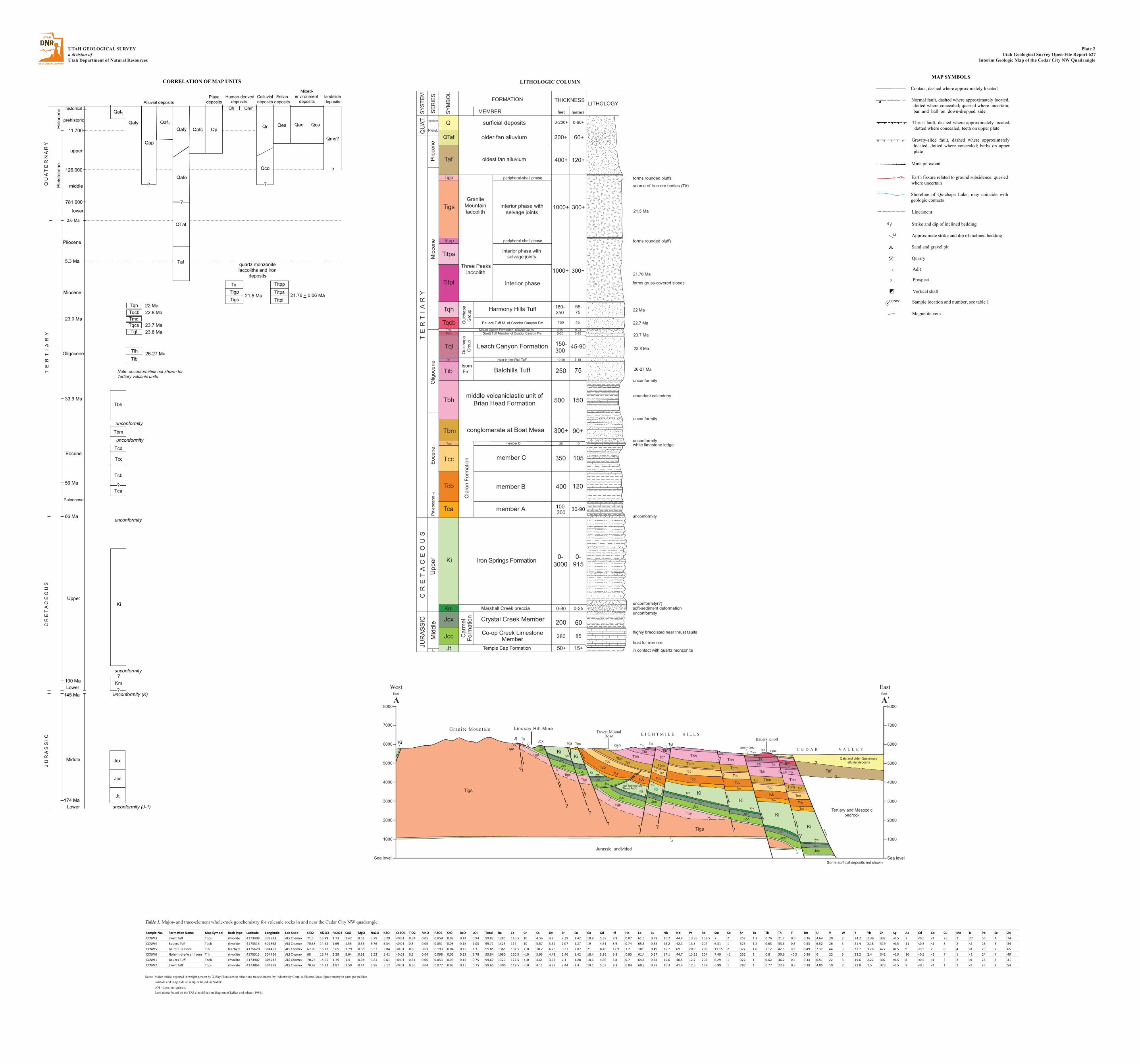
UTAH GEOLOGICAL SURVEYa division of Utah Department of Natural Resources
Plate 2Utah Geological Survey Open-File Report 627
Interim Geologic Map of the Cedar City NW Quadrangle
LITHOLOGIC COLUMN
200
Iron Springs Formation 0-3000
0-915Ki
member B 400 120
Tca member A 100-300 30-90
Tcc member C 350 105
Tib
member D
10-60 3-18
conglomerate at Boat Mesa 300+ 90+
500 150
Tcd
Tbm
Tqcs
Tql
Tih
IsomFm.
Tqh
oldest fan alluvium 400+ 120+
surficial depositsQ 0-200+ 0-60+
Upp
erC
RE
TA
CE
OU
ST
ER
TI
AR
YM
ioce
neP
lioce
ne
QU
AT.
Pleist.
Holocene
THICKNESS LITHOLOGYFORMATION
MEMBERSY
MB
OL
SE
RIE
S
SY
STE
M
feet meters
in contact with quartz monzonite
unconformity
unconformity
unconformity
Cla
ron
Form
atio
n
Pal
eoce
neE
ocen
e
Tbhmiddle volcaniclastic unit of
Brian Head Formation
30 10
250 75Baldhills Tuff
Hole-in-the-Wall Tuff
150-300
45-90
0-50 0-15
QTaf older fan alluvium
source of Iron ore bodies (Tir)
white limestone ledge
200+ 60+
Temple Cap FormationJt
Car
mel
Form
atio
n
Co-op Creek LimestoneMemberJcc
Km Marshall Creek breccia
Crystal Creek Member
0-80 0-25
Jcx
50+ 15+
280 85
60
Mid
dle
unconformity
unconformity(?)
host for iron ore
abundant calcedony
Tcb
Leach Canyon Formation
Bauers Tuff M. of Condor Canyon Fm.
Harmony Hills Tuff
Swett Tuff Member of Condor Canyon Fm.Mount Dutton Formation, alluvial facies 0-75 0-23
150 45
Tmd
Qui
chap
aG
roup
180-250
55-75
Tqcb
Qui
chap
aG
roup
Three Peakslaccolith
GraniteMountainlaccolith
Tigp
Taf
peripheral-shell phase
interior phase withselvage joints
interior phase
peripheral-shell phase
interior phase withselvage joints
1000+ 300+
1000+ 300+
Titpi
Titps
Titpp
Tigs
L.
JUR
AS
SIC
?
Olig
ocen
e
unconformity
forms gruss-covered slopes
forms rounded bluffs
forms rounded bluffs
highly brecciated near thrust faults
soft-sediment deformation
21.5 Ma
21.76 Ma
22 Ma
22.7 Ma
23.7 Ma
23.8 Ma
26-27 Ma
Sea level
1000
4000
5000
6000
7000
8000
3000
2000
A’feetEast
Sea level
1000
4000
5000
6000
7000
8000
3000
2000
Afeet
West
E I G H T M I L E H I L L S
C E D A R V A L L E Y
Ki
Qafc and older Quaternaryalluvial deposits?
?
Some surficial deposits not shown
Tertiary and Mesozoicbedrock
Taf
?
Ki
KiKi
KiKi
KiKi
Tigs
KiTigp
Jt TirJt
Jcc
Jcx
Tigp
TigpTigp
Tigp
Tigp
Tca Tca
TcbTca
Tcc TcdTbm Tbh
Tib
Tih TqlQafy
Tigs
?
KmJcx
JccJt
Jcx
JcxJcc
JccKm
Ki
Jt
JtJcc Jcx
Tca
Tcb
TibTih Tql
TccTcd
Tbm
Tbh
TcbTca
Tib
TccTcd
Tbm
Tbh
Tcb
Jt JccJcx
Km
JccJcx
Tca
Tib
Tcc
Km
Tbm
Tbh
Tcb
JccJcx
Tca
Tib
Tcc
Tbm
Tbh
Tcb
Tcd
Tih
Tql
Tqcs TqcbTqhQafc + Qafy
Taf
Tca
Tib
Tcc
Tbm
Tbh
Tcb
Tcd
Tih
Tql
Tqcb
Bauers Knoll
Grani te Mountain Lindsay Hi l l MineDesert Mound
Road
Iron Springs GapThrust Fault
Jt
Km
??
? ? ??
Jurassic, undivided
Jcc
Jcx
JccJcx
Jt
?
?
?
?
Q U
AT
E R
NA
RY
T E
R T
I A
R Y
C R
ET
A C
E O
U S
J U
RA
S S
I C
Hol
ocen
eP
leis
toce
ne
historical
prehistoric
upper
11,700
126,000
781,000
2.6 Ma
middle
lower
Pliocene
Miocene
Oligocene
Eocene
Upper
Paleocene
Lower
Middle
Alluvial depositsHuman-derived
deposits
Mixed-environment
depositsColluvialdeposits
Qal1
Qaf1Qaly
Qap
Qafy
QTaf
Qh
Qc Qac
Eoliandeposits
Qes
Tql
Titpi
Tib
Tca
Tcb
Tcc
Tcd
Ki
Km
Jcx
Jcc
Jt
CORRELATION OF MAP UNITS
5.3 Ma
23.0 Ma
33.9 Ma
66 Ma
56 Ma
100 Ma
145 Ma
174 Ma
Taf
23.8 Ma23.7 Ma
Tqcb 22.8 MaTqh 22 Ma
quartz monzonitelaccoliths and iron
deposits
unconformity
unconformity
unconformity
unconformity (K)
unconformity (J-1)
Qafc
Qhm
Qea
26-27 Ma
Note: unconformities not shown forTertiary volcanic units
Tbh
Tbm
?
unconformity
Tih
TqcsTmd
Titps
Titpp
TigsTigpTir
21.76 + 0.06 Ma21.5 Ma
Playadeposits
Qafo
Qp
landslidedeposits
?
Qms?
Qco
?
?
?
Lower
?
?
MAP SYMBOLS
Contact, dashed where approximately located
Normal fault, dashed where approximately located,dotted where concealed; queried where uncertain;bar and ball on down-dropped side
Mine pit extent
Strike and dip of inclined bedding
Approximate strike and dip of inclined bedding
Sand and gravel pit
Quarry
Earth fissure related to ground subsidence; queriedwhere uncertain
6
13
Gravity-slide fault, dashed where approximately located, dotted where concealed; barbs on upper plate
?
Lineament
Thrust fault, dashed where approximately located,dotted where concealed; teeth on upper plate
0 Adit
Š Prospect
Vertical shaft“
ƒ Sample location and number, see table 1
Magnetite vein
Shoreline of Quichapa Lake; may coincide with geologic contacts
CCNW1
Table 1. Major- and trace-element whole-rock geochemistry for volcanic rocks in and near the Cedar City NW quadrangle.
Notes: Major oxides reported in weight percent by X-Ray Florescence; minor and trace elements by Inductively Coupled Plasma-Mass Spectrometry in parts per million.
Latitude and longitude of samples based on NAD83.
LOI = Loss on ignition. Rock names based on the TAS classification diagram of LeBas and others (1986).
Sample No. Formation Name Map Symbol Rock Type Latitude Longitude Lab Used SiO2 Al2O3 Fe2O3 CaO MgO Na2O K2O Cr2O3 TiO2 MnO P2O5 SrO BaO LOI Total Ba Ce Cr Cs Dy Er Eu Ga Gd Hf Ho La Lu Nb Nd Pr Rb Sm Sn Sr Ta Tb Th Tl Tm U V W Y Yb Zr Ag As Cd Co Cu Mo Ni Pb Sc ZnCCNW3 Swett Tuff Tqcs rhyolite 4173409 302883 ALS Chemex 71.5 13.99 1.73 1.47 0.51 3.79 5.29 <0.01 0.34 0.05 0.059 0.02 0.14 0.94 99.82 1285 116.5 10 4.56 4.2 2.39 1.42 18.9 5.38 8.9 0.87 61.5 0.39 16.2 44.4 13.35 168.5 7 2 252 1.2 0.76 21.7 0.6 0.36 4.64 20 2 24.2 2.36 332 <0.5 7 <0.5 <1 26 2 27 55 4 74CCNW4 Bauers Tuff Tqcb rhyolite 4173515 302898 ALS Chemex 70.68 14.53 1.69 1.55 0.36 3.76 5.54 <0.01 0.3 0.05 0.051 0.03 0.15 1.03 99.71 1325 117 10 5.67 3.62 2.07 1.27 19 4.51 8.9 0.74 65.3 0.35 15.2 42.1 13.3 204 6.31 1 325 1.2 0.63 33.6 0.5 0.33 6.52 26 3 21.4 2.18 319 <0.5 11 <0.5 <1 3 2 <1 26 3 34CCNW5 Bald Hil ls Isom Tib trachyte 4175620 304457 ALS Chemex 67.03 15.12 3.65 1.79 0.38 3.52 5.84 <0.01 0.8 0.03 0.193 0.04 0.16 1.3 99.85 1365 192.5 <10 10.2 6.23 3.37 2.07 21 8.45 12.9 1.2 101 0.49 25.7 69 20.9 250 11.15 2 377 1.6 1.12 42.6 0.5 0.49 7.37 44 3 31.7 3.26 477 <0.5 9 <0.5 2 8 4 <1 29 7 65CCNW6 Hole-in-the-Wall Isom Tih rhyolite 4175513 304466 ALS Chemex 68 13.74 2.28 3.04 0.38 3.53 5.41 <0.01 0.5 0.04 0.098 0.02 0.13 2.78 99.94 1080 120.5 <10 5.95 4.48 2.46 1.42 18.4 5.86 9.8 0.83 61.4 0.37 17.1 44.7 13.25 204 7.49 <1 232 1 0.8 30.6 <0.5 0.36 6 23 3 23.2 2.4 342 <0.5 10 <0.5 <1 7 1 <1 24 4 49CCNW1 Bauers Tuff Tccb rhyolite 4173907 304247 ALS Chemex 70.74 14.65 1.79 1.4 0.34 3.81 5.61 <0.01 0.31 0.05 0.053 0.03 0.15 0.75 99.67 1320 122.5 <10 4.64 3.67 2.1 1.28 18.6 4.66 8.8 0.7 64.8 0.34 15.6 40.5 12.7 208 6.29 1 322 1 0.62 36.2 0.5 0.33 6.51 22 3 19.6 2.22 302 <0.5 8 <0.5 <1 3 2 <1 26 3 31CCNW2 Swett Tuff Tqcs rhyolite 4173864 304278 ALS Chemex 70.92 14.33 1.87 1.59 0.44 3.98 5.12 <0.01 0.36 0.04 0.077 0.03 0.15 0.75 99.65 1300 119.5 <10 4.11 4.33 2.44 1.4 19.1 5.53 9.3 0.84 60.2 0.38 16.3 41.4 12.5 169 6.99 1 287 1 0.77 22.9 0.6 0.38 4.85 19 2 22.8 2.5 323 <0.5 9 <0.5 <1 1 2 <1 26 3 54