Embed Size (px)
Citation preview
Introducing ArcGIS Enterprise 10.5Rob Hathcock
Account Manager
ArcGIS for Your OrganizationWhere Geography Intersects
with Your Business
“Maps are never fully
complete.”
Stephen P. Hanna
What is ArcGIS Enterprise?
• The new name for the ArcGIS for Server product line
• How you get Esri server technology
• How you deploy Web GIS in your infrastructure
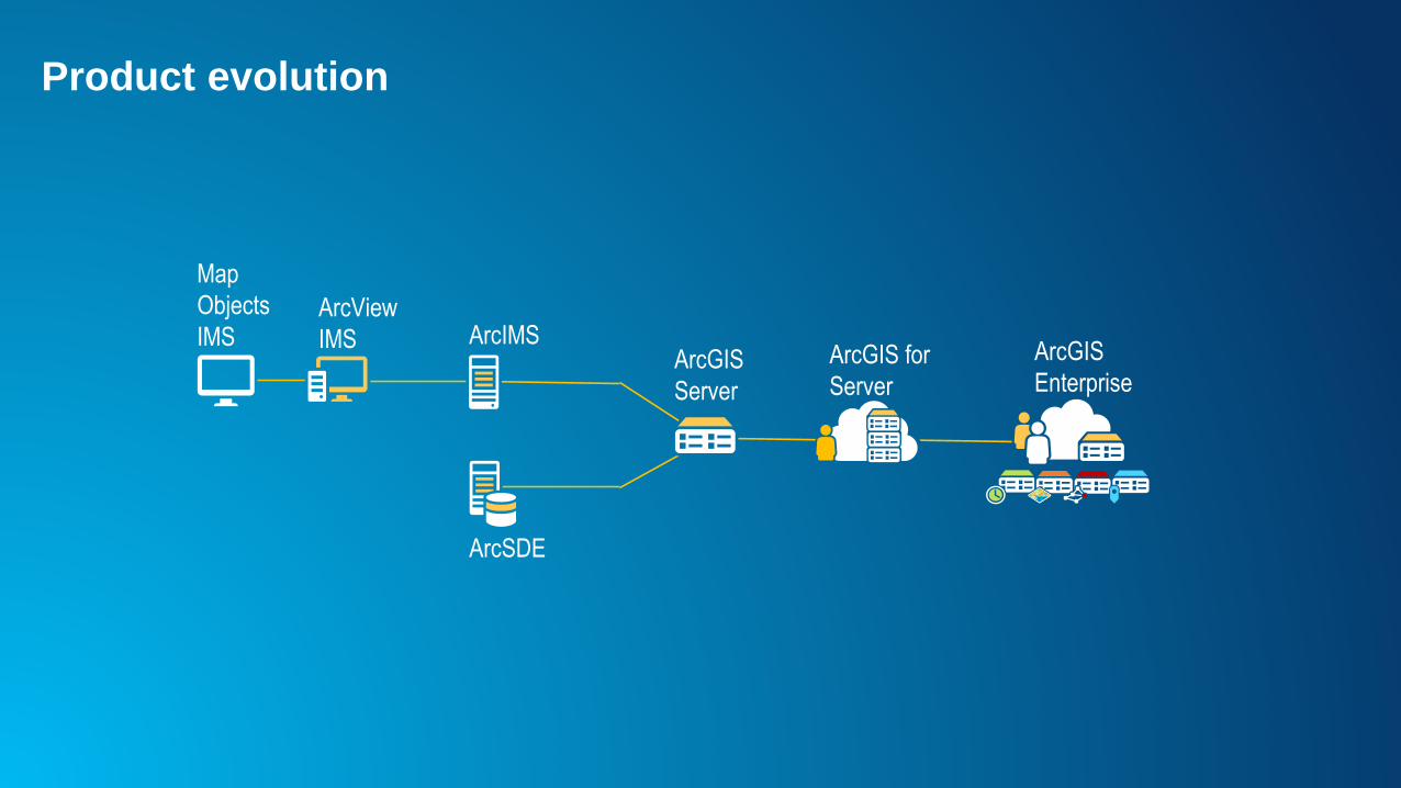
Product evolution
ArcSDE
ArcGIS
Server
Map
Objects
IMSArcGIS
EnterpriseArcGIS for
Server
ArcIMSArcView
IMS
Portal
for
ArcGIS
ArcGIS
Server
ArcGIS
Data
Store
ArcGIS
Web
Adaptor
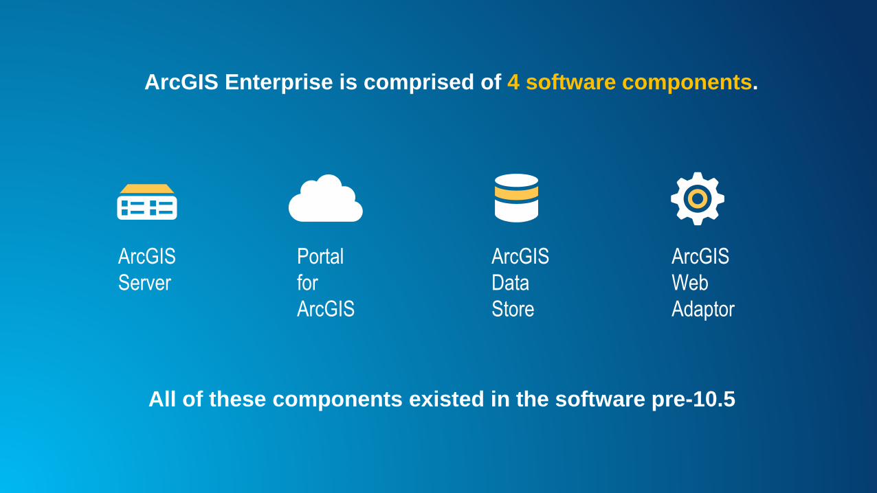
All of these components existed in the software pre-10.5
ArcGIS Enterprise is comprised of 4 software components.
Portal
for
ArcGIS
ArcGIS
ServerArcGIS
Data
Store
ArcGIS
Web
Adaptor
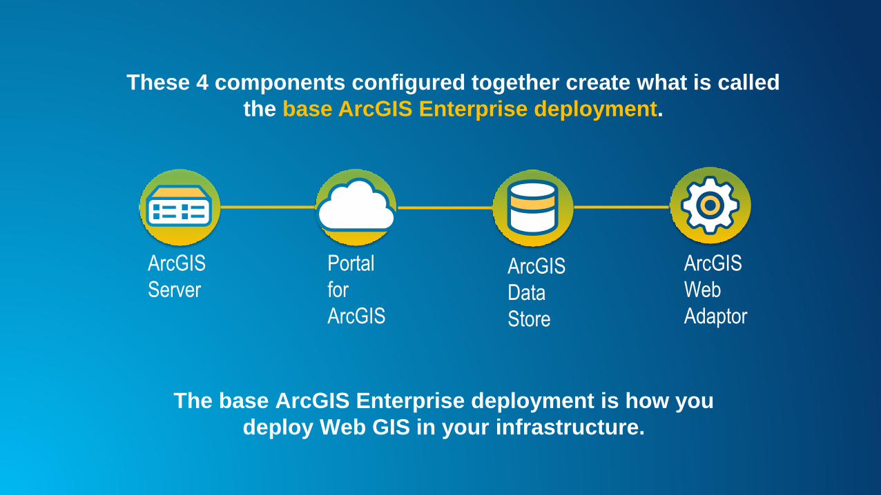
The base ArcGIS Enterprise deployment is how you
deploy Web GIS in your infrastructure.
These 4 components configured together create what is called
the base ArcGIS Enterprise deployment.
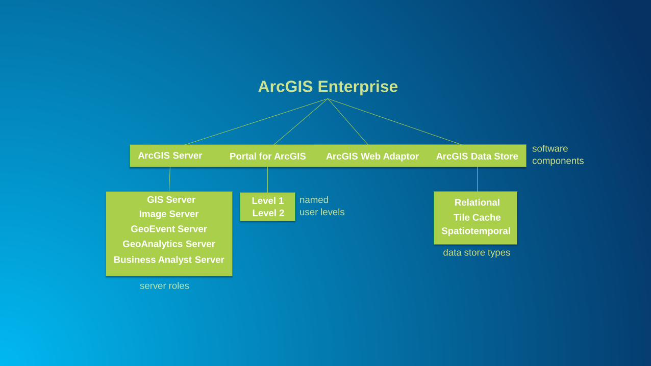
ArcGIS Enterprise
ArcGIS Server Portal for ArcGIS ArcGIS Web Adaptor ArcGIS Data Store
GIS Server
Image Server
GeoEvent Server
GeoAnalytics Server
Business Analyst Server
Relational
Tile Cache
Spatiotemporal
server roles
data store types
Level 1
Level 2
named
user levels
software
components

ArcGIS
Business
Analyst
Server
ArcGIS Enterprise | Server Roles
ArcGIS
GIS
Server
ArcGIS
GeoEvent
Server
ArcGIS
Image
Server
ArcGIS
GeoAnalytics
Server
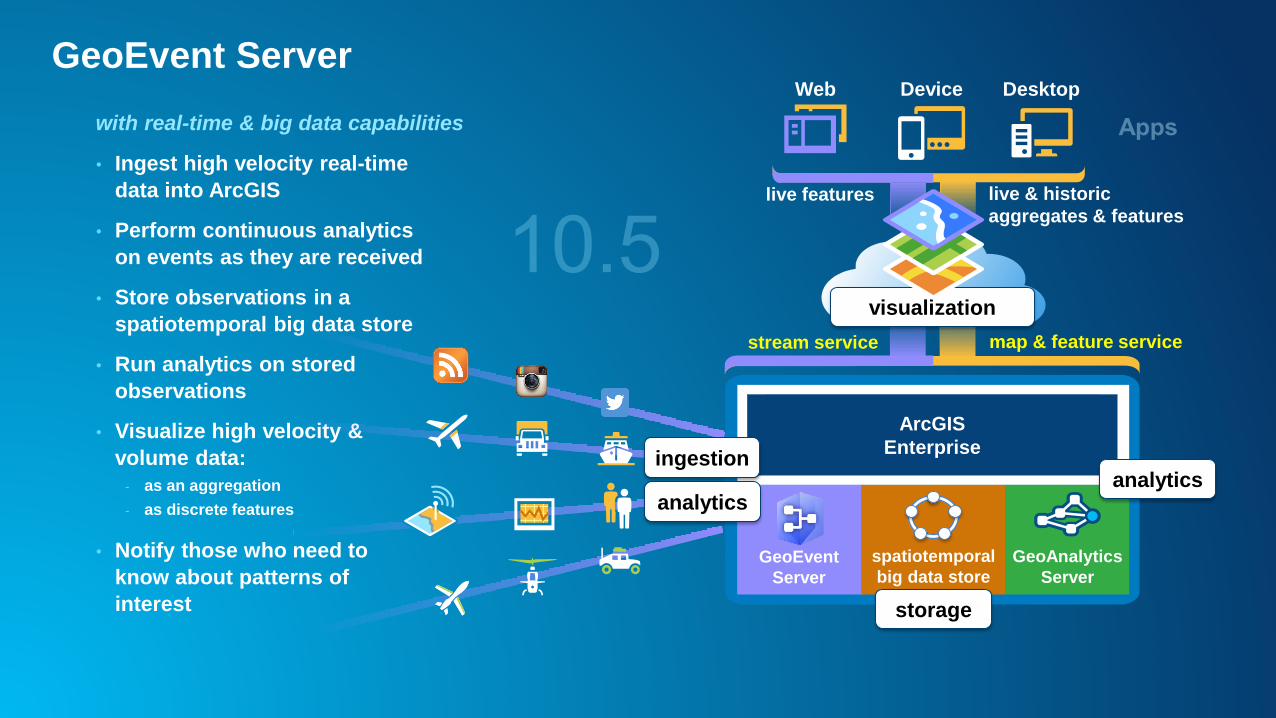
GeoEvent Server
with real-time & big data capabilities
ArcGIS
Enterprise
DesktopWeb Device
GeoEvent
Server
visualization
live & historic
aggregates & features
spatiotemporal
big data store
map & feature service
• Ingest high velocity real-time
data into ArcGIS
• Perform continuous analytics
on events as they are received
• Store observations in a
spatiotemporal big data store
• Run analytics on stored
observations
• Visualize high velocity &
volume data:
- as an aggregation
- as discrete features
• Notify those who need to
know about patterns of
interest
stream service
live features
storage
ingestion
analytics
GeoAnalytics
Server
analytics
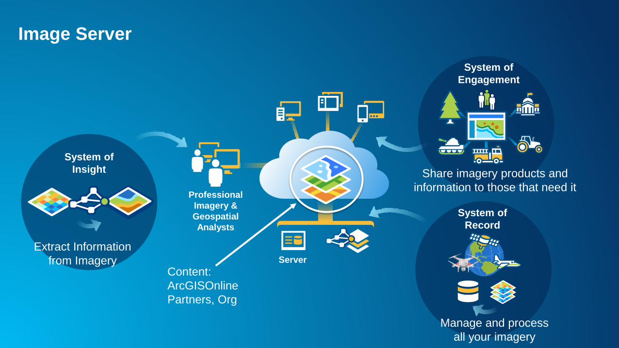
Professional
Imagery &
Geospatial
Analysts
Server
System of
Record
Manage and process
all your imagery
System of
Insight
Extract Information
from Imagery
System of
Engagement
Share imagery products and
information to those that need it
Content:
ArcGISOnline
Partners, Org
Image Server
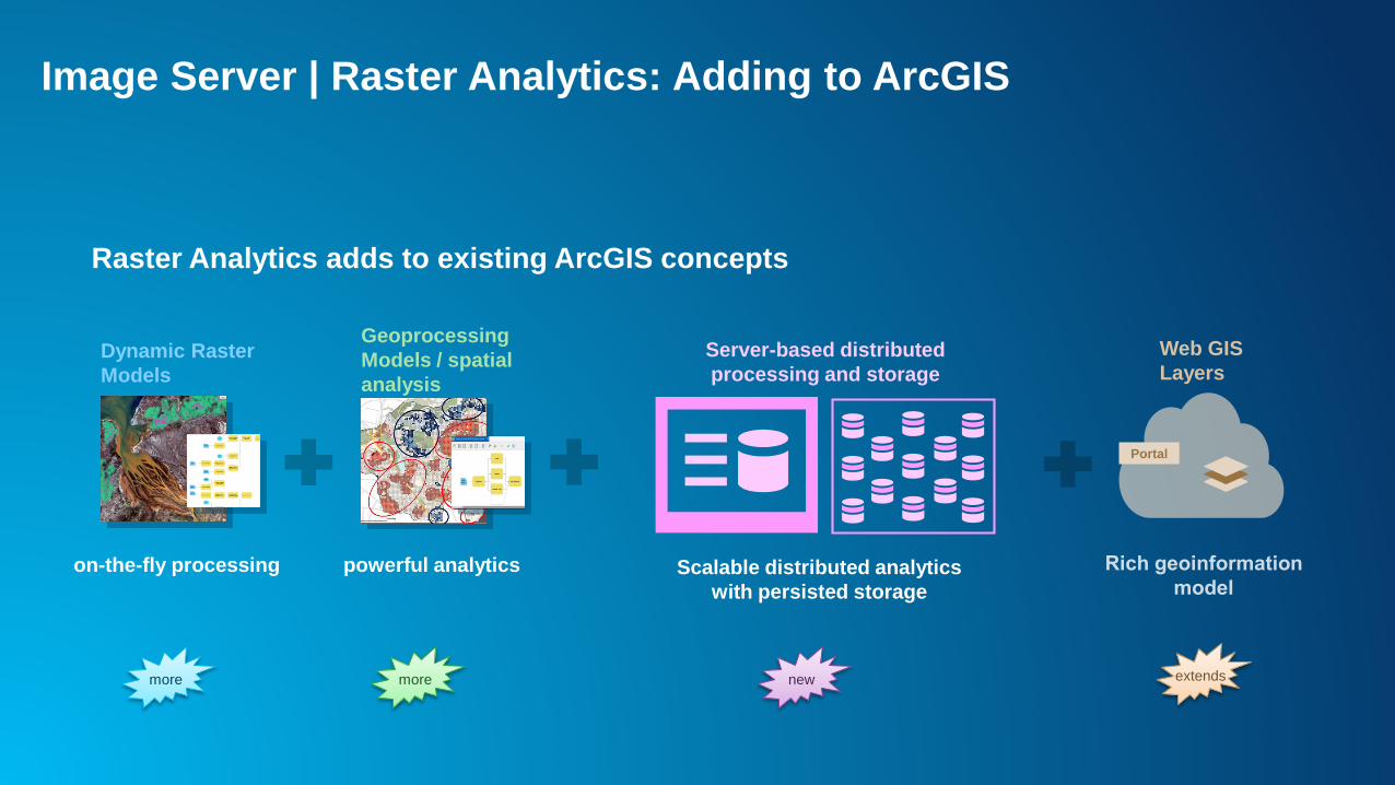
Raster Analytics adds to existing ArcGIS concepts
Dynamic Raster
Models
on-the-fly processing
Geoprocessing
Models / spatial
analysis
powerful analytics Scalable distributed analytics
with persisted storage
Server-based distributed
processing and storage
Portal
Web GIS
Layers
newmoremore extends
Image Server | Raster Analytics: Adding to ArcGIS
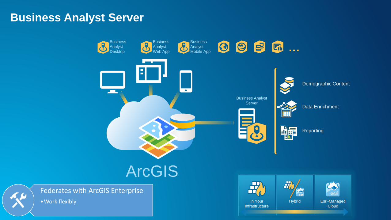
Business Analyst
ServerData Enrichment
Demographic Content
Business
Analyst
Desktop
Business
Analyst
Web App
Business
Analyst
Mobile App …
Reporting
ArcGIS
In Your
Infrastructure
Hybrid Esri-Managed
Cloud
Federates with ArcGIS Enterprise
•Work flexibly
Business Analyst Server

ArcGIS has a new way of processing vector and tabular datawith both spatial (location) and temporal (time) components
that is designed fast distributed analytics and storage
GeoAnalytics Server
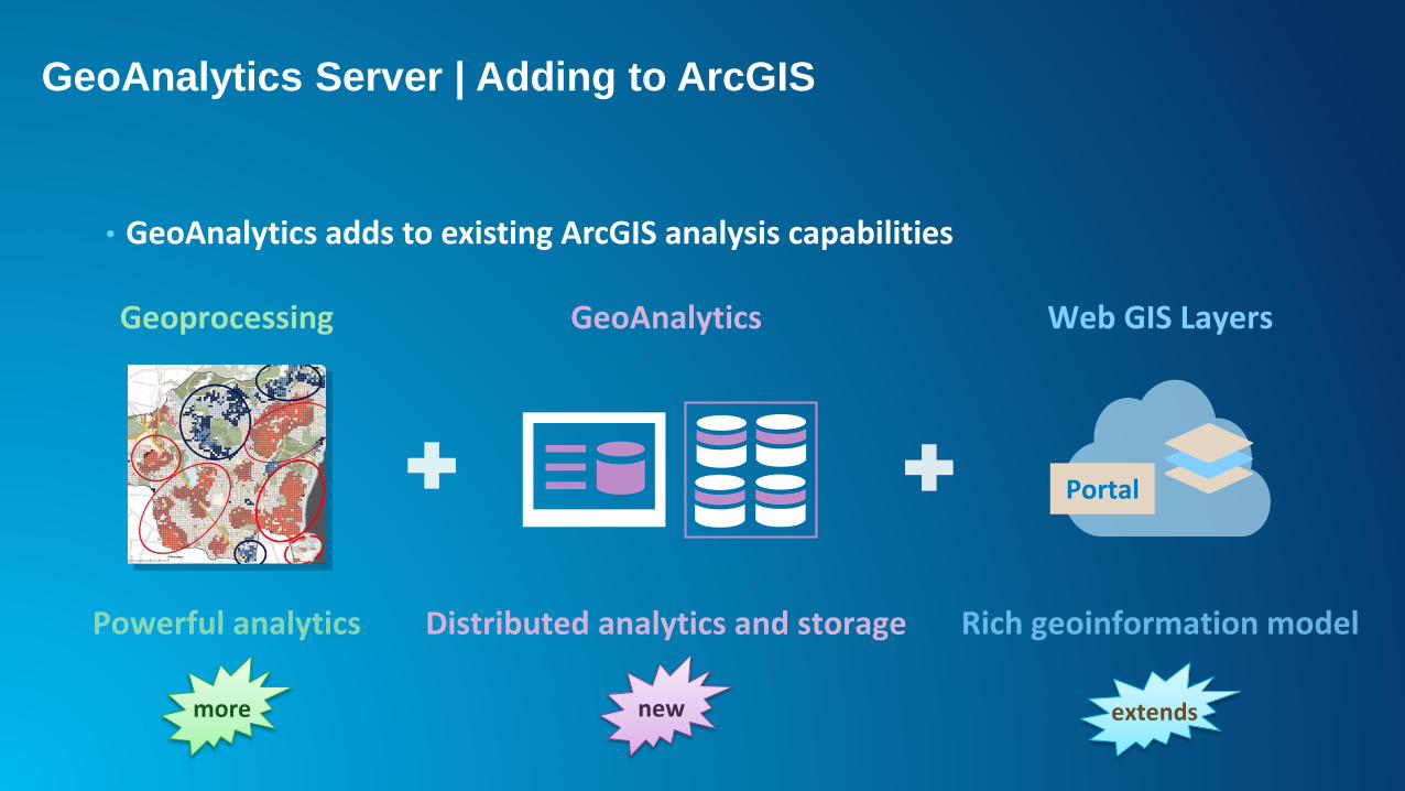
• GeoAnalytics adds to existing ArcGIS analysis capabilities
Geoprocessing
Distributed analytics and storage
GeoAnalytics
Portal
Web GIS Layers
newmore extends
GeoAnalytics Server | Adding to ArcGIS
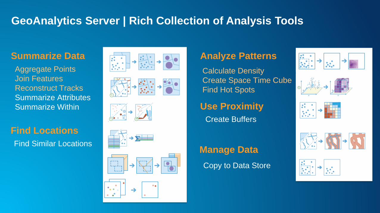
Aggregate Points
Join Features
Reconstruct Tracks
Summarize Attributes
Summarize Within
Summarize Data
Find Locations
Analyze Patterns
Use Proximity
Manage DataFind Similar Locations
Calculate Density
Create Space Time Cube
Find Hot Spots
Create Buffers
Copy to Data Store
GeoAnalytics Server | Rich Collection of Analysis Tools
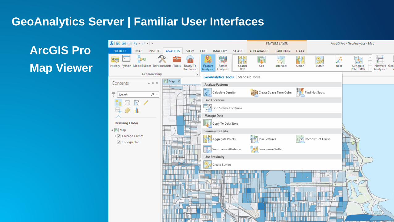
ArcGIS Pro
Map Viewer
GeoAnalytics Server | Familiar User Interfaces
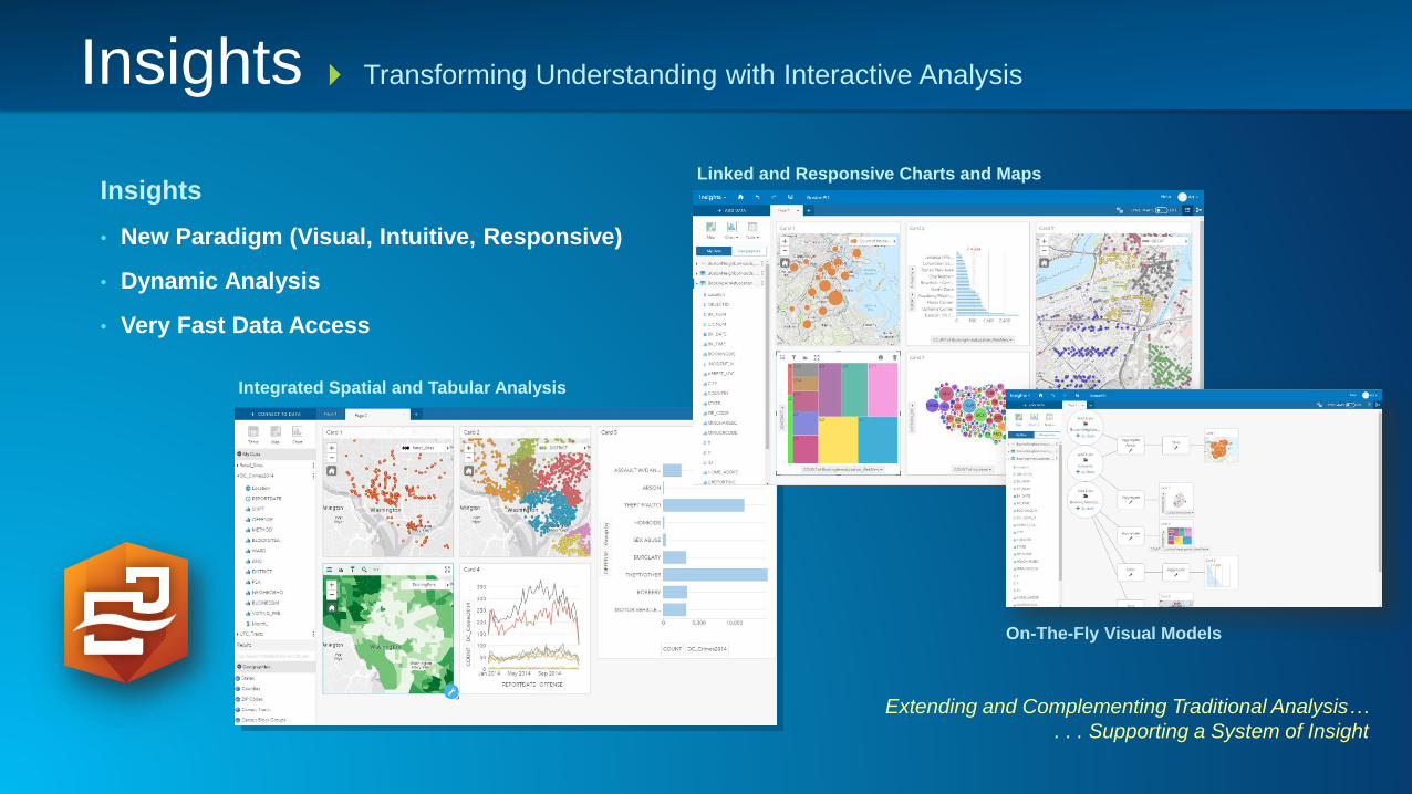
Insights
• New Paradigm (Visual, Intuitive, Responsive)
• Dynamic Analysis
• Very Fast Data Access
Extending and Complementing Traditional Analysis…
. . . Supporting a System of Insight
Transforming Understanding with Interactive Analysis
Linked and Responsive Charts and Maps
On-The-Fly Visual Models
Integrated Spatial and Tabular Analysis
Insights
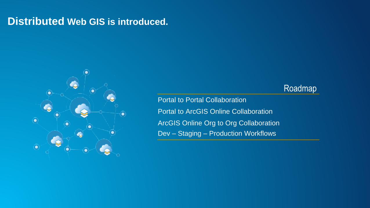
Distributed Web GIS is introduced.
RoadmapPortal to Portal Collaboration
Portal to ArcGIS Online Collaboration
ArcGIS Online Org to Org Collaboration
Dev – Staging – Production Workflows
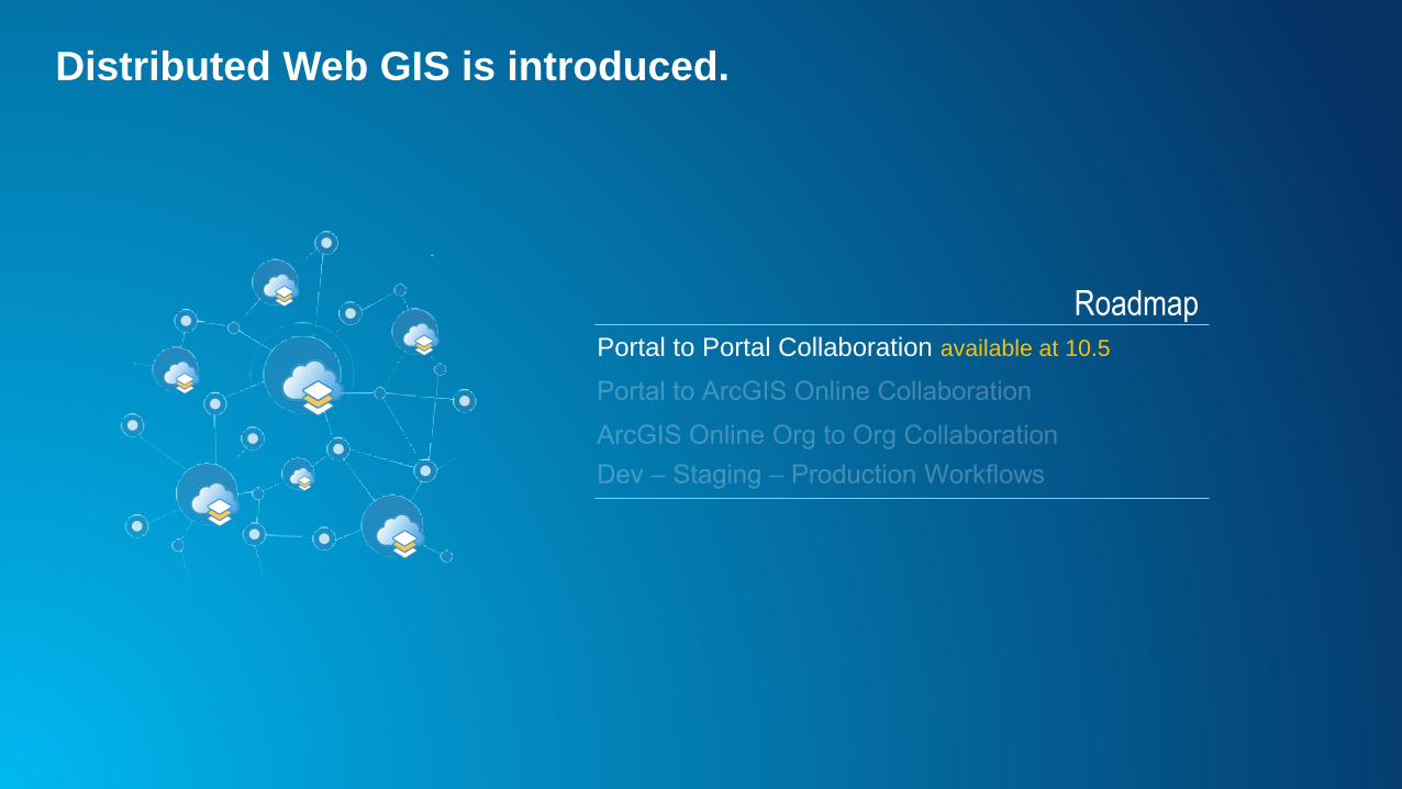
Distributed Web GIS is introduced.
RoadmapPortal to Portal Collaboration available at 10.5
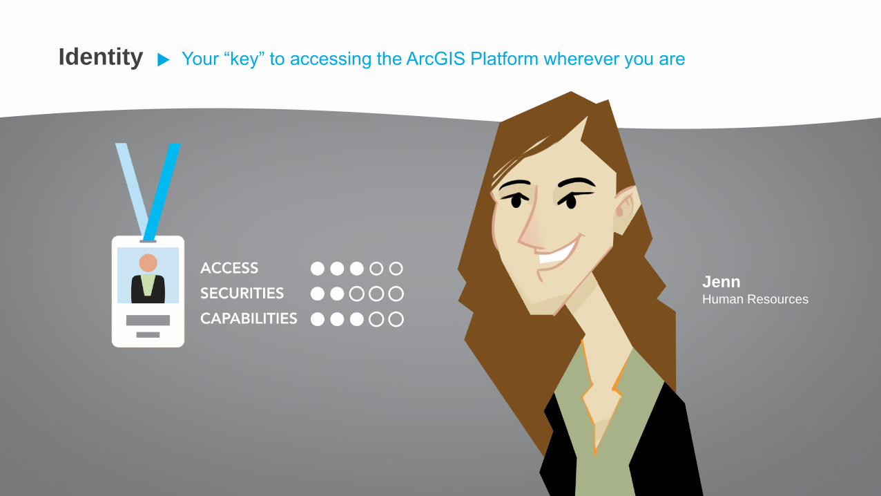
JennHuman Resources
Identity Your “key” to accessing the ArcGIS Platform wherever you are
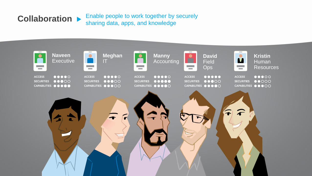
NaveenExecutive
MeghanIT
MannyAccounting
DavidField Ops
KristinHuman Resources
Collaboration Enable people to work together by securely
sharing data, apps, and knowledge
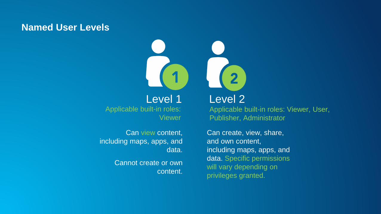
Named User Levels
Level 1 Level 2
Can view content,
including maps, apps, and
data.
Cannot create or own
content.
Can create, view, share,
and own content,
including maps, apps, and
data. Specific permissions
will vary depending on
privileges granted.
Applicable built-in roles:
ViewerApplicable built-in roles: Viewer, User,
Publisher, Administrator
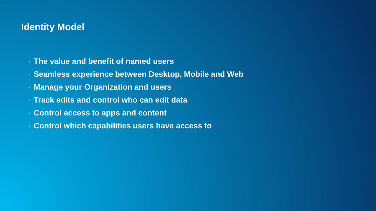
Identity Model
• The value and benefit of named users
• Seamless experience between Desktop, Mobile and Web
• Manage your Organization and users
• Track edits and control who can edit data
• Control access to apps and content
• Control which capabilities users have access to
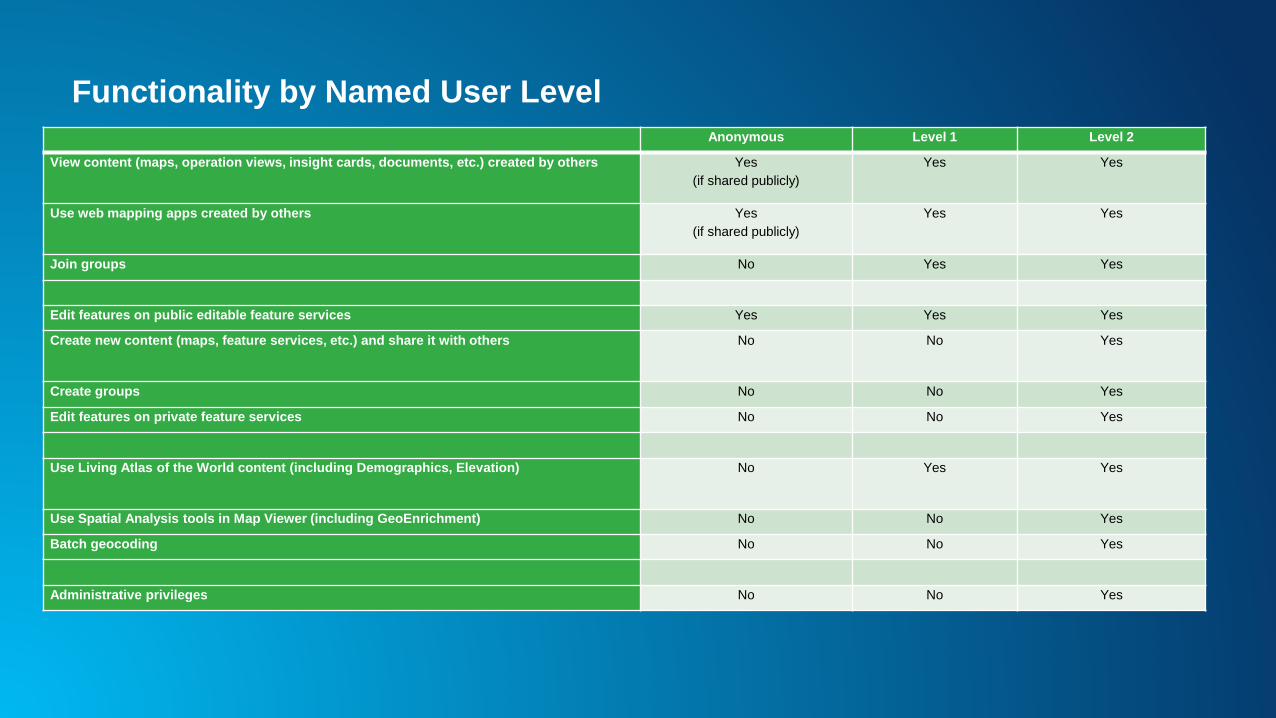
Functionality by Named User Level
Anonymous Level 1 Level 2
View content (maps, operation views, insight cards, documents, etc.) created by others Yes
(if shared publicly)
Yes Yes
Use web mapping apps created by others Yes
(if shared publicly)
Yes Yes
Join groups No Yes Yes
Edit features on public editable feature services Yes Yes Yes
Create new content (maps, feature services, etc.) and share it with others No No Yes
Create groups No No Yes
Edit features on private feature services No No Yes
Use Living Atlas of the World content (including Demographics, Elevation) No Yes Yes
Use Spatial Analysis tools in Map Viewer (including GeoEnrichment) No No Yes
Batch geocoding No No Yes
Administrative privileges No No Yes
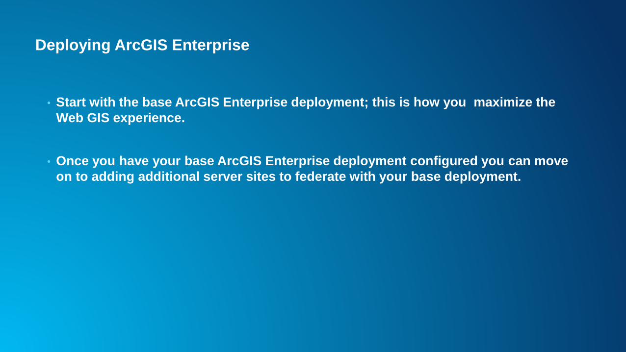
Deploying ArcGIS Enterprise
• Start with the base ArcGIS Enterprise deployment; this is how you maximize the
Web GIS experience.
• Once you have your base ArcGIS Enterprise deployment configured you can move
on to adding additional server sites to federate with your base deployment.
ArcGIS Enterprise Web GIS
• Provides a centralized repository for storing geospatial and non-geospatial content,
there are 80+ item types you can add to Portal for ArcGIS.
• Provides access to view, create, and share geospatial information through web
maps and apps.
• Provides access to a rich library of Esri curated content through Living Atlas; this
data can be used in maps, apps, and analysis tools.
• Gives you the ability to search and use any publicly shared content shared in the
ArcGIS Online community.
ArcGIS Enterprise and Web GIS
• The Portal for ArcGIS component of ArcGIS Enterprise is code-free by default, but
this does not mean you cannot use code to script, automate, expand or customize
your Web GIS.
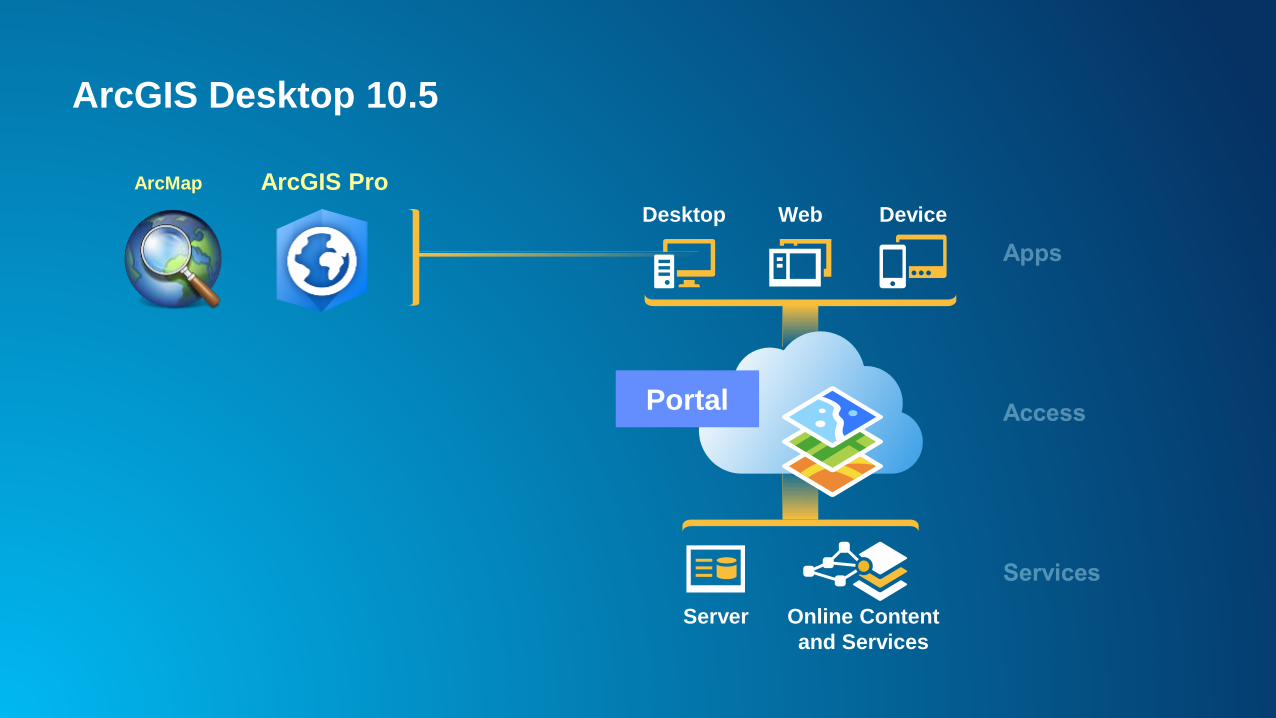
ArcGIS Desktop 10.5
Desktop Web Device
Server Online Content
and Services
Portal
ArcMap ArcGIS Pro
2017 is the Year for ArcGIS Pro
• ArcGIS Pro 1.4
- Major development efforts
- Increased and in some cases advanced functionality
- Only way to do some sharing
- Access to new tools for GeoAnalytics and Raster analysis
- License management for ArcGIS Pro
- Utility Network beta available in April 2017
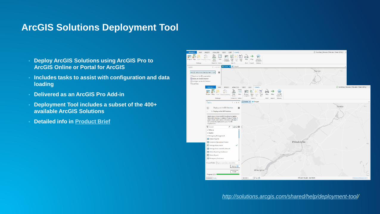
ArcGIS Solutions Deployment Tool
• Deploy ArcGIS Solutions using ArcGIS Pro to
ArcGIS Online or Portal for ArcGIS
• Includes tasks to assist with configuration and data
loading
• Delivered as an ArcGIS Pro Add-in
• Deployment Tool includes a subset of the 400+
available ArcGIS Solutions
• Detailed info in Product Brief
http://solutions.arcgis.com/shared/help/deployment-tool/
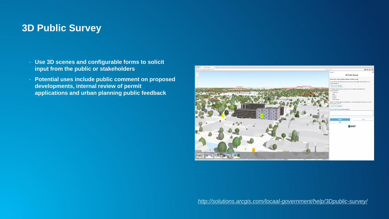
3D Public Survey
• Use 3D scenes and configurable forms to solicit
input from the public or stakeholders
• Potential uses include public comment on proposed
developments, internal review of permit
applications and urban planning public feedback
http://solutions.arcgis.com/locaal-government/help/3Dpublic-survey/
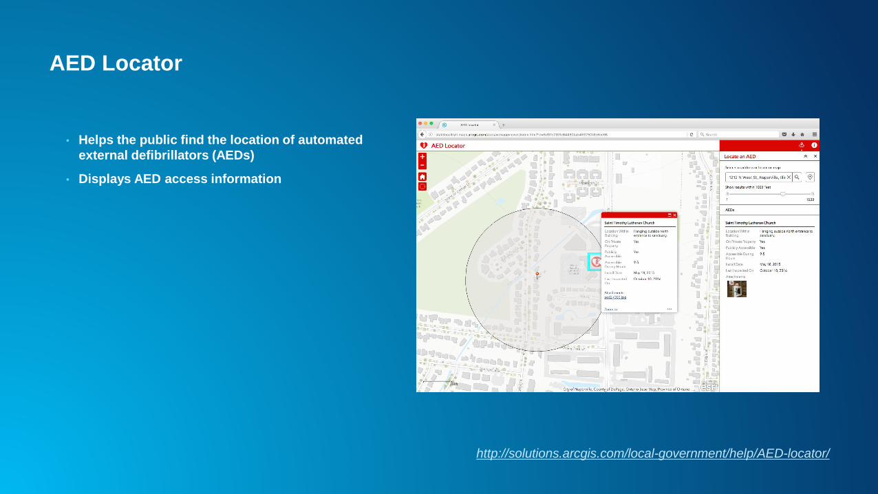
AED Locator
• Helps the public find the location of automated
external defibrillators (AEDs)
• Displays AED access information
http://solutions.arcgis.com/local-government/help/AED-locator/
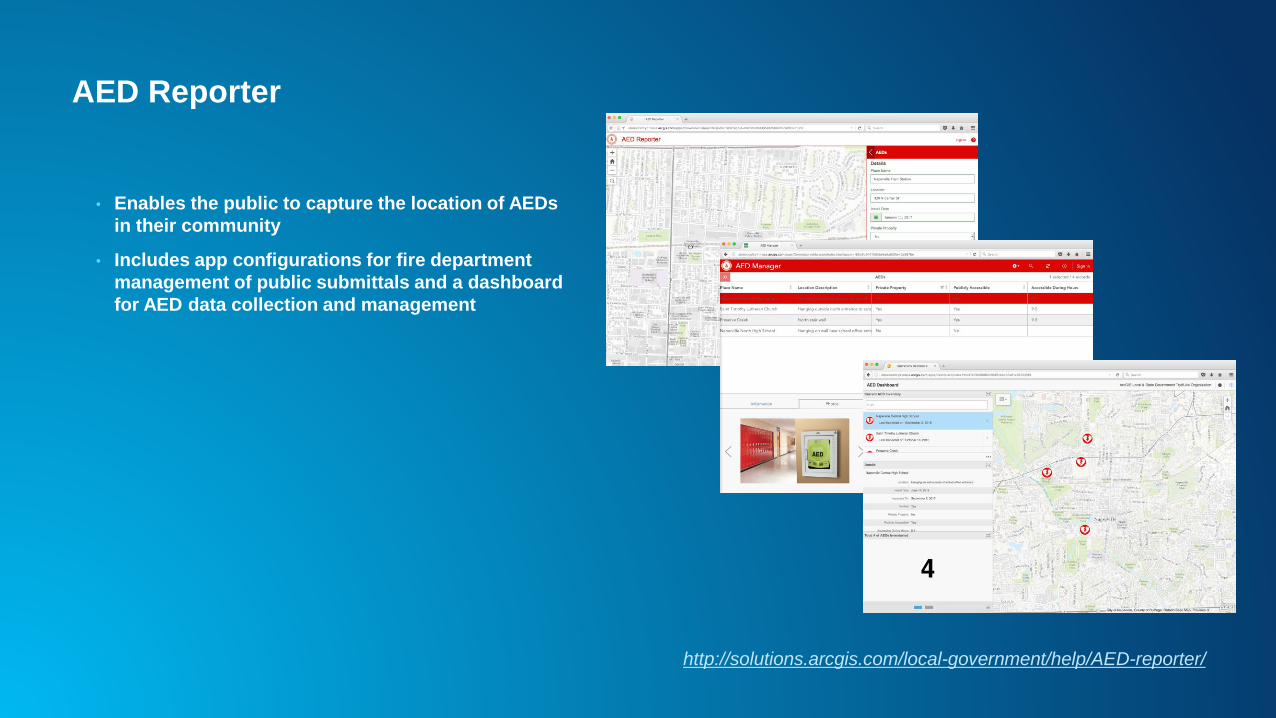
AED Reporter
• Enables the public to capture the location of AEDs
in their community
• Includes app configurations for fire department
management of public submittals and a dashboard
for AED data collection and management
http://solutions.arcgis.com/local-government/help/AED-reporter/
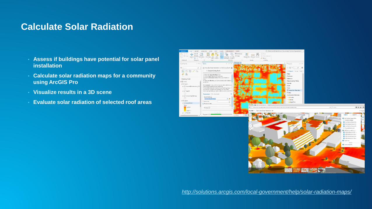
Calculate Solar Radiation
• Assess if buildings have potential for solar panel
installation
• Calculate solar radiation maps for a community
using ArcGIS Pro
• Visualize results in a 3D scene
• Evaluate solar radiation of selected roof areas
http://solutions.arcgis.com/local-government/help/solar-radiation-maps/
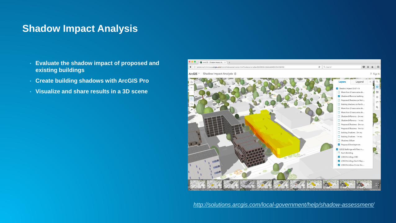
Shadow Impact Analysis
• Evaluate the shadow impact of proposed and
existing buildings
• Create building shadows with ArcGIS Pro
• Visualize and share results in a 3D scene
http://solutions.arcgis.com/local-government/help/shadow-assessment/


![Python and ArcGIS Enterprise - static.packt-cdn.com€¦ · Python and ArcGIS Enterprise [ 2 ] ArcGIS enterprise Starting with ArcGIS 10.5, ArcGIS Server is now called ArcGIS Enterprise](https://img.pdfslide.net/doc/110x75/5ecf20757db43a10014313b7/python-and-arcgis-enterprise-python-and-arcgis-enterprise-2-arcgis-enterprise.jpg)