Embed Size (px)
Citation preview
B-1
Ironstones, condensed beds, and sequence stratigraphy of the Clinton
Group (Lower Silurian) in its type area, central New York
Nicholas Sullivan
Department of Geology, University of Cincinnati, Cincinnati, OH 45221-0013
Carlton E. Brett
Department of Geology, University of Cincinnati, Cincinnati, OH 45221-0013
Patrick McLaughlin
Wisconsin Geological and Natural History Survey, 3817 Mineral Point Rd., Madison, WI 53705
ABSTRACT
The fossiliferous and oolitic ironstones of the Clinton Group (Silurian, late Llandovery to
early Wenlock) in central New York have inspired considerable interest since the early surveys of
Eaton in the 1820s. Although these ores have never been mined on industrial scales, they were
processed extensively up to the mid 1900s for oxides used in red paints. Three of these horizons,
Westmoreland, "basal Dawes" or Salmon Creek, and Kirkland, will be examined and discussed on
this excursion, with emphasis placed on their sedimentology, taphonomy, correlation, and regional
significance in the context of depositional cycles.
Recent work has recast these classic deposits in the context of sequence stratigraphy, wherein
ironstones and related phosphatic and shelly deposits are viewed as condensed facies: the product of
siliciclastic sediment starvation during periods of rapid transgression at the bases of small- and large
-scale depositional sequences. These strata and the environmental conditions they represent will also
be considered in the context of recently collected geochemical and geophysical data, which have
implications for the correlation of these sections and their importance with regard to regional and
global environmental changes and bioevents.
Sullivan, N. B.; Brett, C. E.; McLaughlin, P. I.; Ironstones, condensed beds, and sequence stratigraphy of the Clinton Group (Lower
Silurian) in its type area, central New York in Rayne, T. W., ed., Field Trip Guidebook for the 84th Annual Meeting of the New York State Geological Association, pp. B5-1—B5-40, ISSN: 1061-8724
B-2
1. INTRODUCTION
Although iron rich horizons in the sedimentary record are the subject of numerous studies,
many critical questions remain concerning the processes of their formation (see Van Houten and
Bhattacharyya, 1982; Kimberley, 1994 and references therein). Ferruginous strata of the lower
Silurian (Aeronian-Sheinwoodian) Clinton Group in east central New York State feature
prominently in this debate, owing to many excellent exposures and a rich history of study (e. g.
Eaton, 1824; Vanuxem, 1839, James Hall, 1852, Smyth, 1918). These ores, commonly referred to as
the “Clinton Ironstones”, have never been mined on industrial scales, but they were processed
extensively up to the mid 1900s as a source of red paint pigment (for a more comprehensive history
see also Van Houten, 1991; Williams, 1998). Eight named ironstones are recognized within the
Clinton Group; although these strata are of little economic importance today, they hold considerable
stratigraphic, paleoecological, taphonomic, and sedimentological interest (e. g. Smyth, 1918;
Gillette, 1947; Schoen, 1964; Brett et al., 1998; see Van Houten, 1991 for a detailed review). Three
of the aforementioned eight ironstones will be featured in this field excursion through the classic
type area of the Clinton Group, with considerations given to their history, stratigraphic significance,
depositional conditions, and sedimentological features.
2. GEOLOGIC SETTING
2.1 Regional Structure
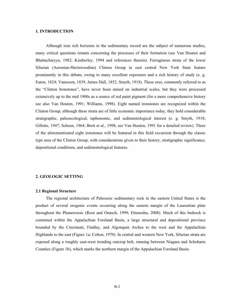
The regional architecture of Paleozoic sedimentary rock in the eastern United States is the
product of several orogenic events occurring along the eastern margin of the Laurentian plate
throughout the Phanerozoic (Root and Onasch, 1999; Ettensohn, 2008). Much of this bedrock is
contained within the Appalachian Foreland Basin, a large structural and depositional province
bounded by the Cincinnati, Findlay, and Algonquin Arches to the west and the Appalachian
Highlands to the east (Figure 1a; Colton, 1970). In central and western New York, Silurian strata are
exposed along a roughly east-west trending outcrop belt, running between Niagara and Schoharie
Counties (Figure 1b), which marks the northern margin of the Appalachian Foreland Basin.
B-3
2.2 Early Silurian Tectonics and
Paleogeography
Accretion of one or more island arcs
onto the eastern margin of the
paleocontinent Laurentia produced several
episodes of mountain building during the
Late Ordovician into the Early Silurian
(Rodgers, 1970; Waldron and van Staal.,
2001; Ettensohn and Brett, 2002; van
Staal et al., 2007). These episodes of
uplift, referred to collectively as the
Taconic Orogeny, resulted in structural
loading and subsidence in the
Appalachian Basin, which was rapidly
filled with clastics flushed off the newly
formed mountain ranges (Beaumont et al.,
Figure 1a – Regional geographic map of the northeastern
United States. Major structural features are labeled.
Silurian outcrop is highlighted with horizontal lines;
subsurface distribution of Silurian strata is highlighted in
diagonal lines. Modified from Berry and Boucot, 1970.
1988; Ettensohn and Brett, 1998; Ettensohn, 2008). However, toward the end of the Rhuddanian,
local orogenic activity had begun to taper off, commencing a period of relative tectonic quiescence
that lasted until the end of the Telychian.
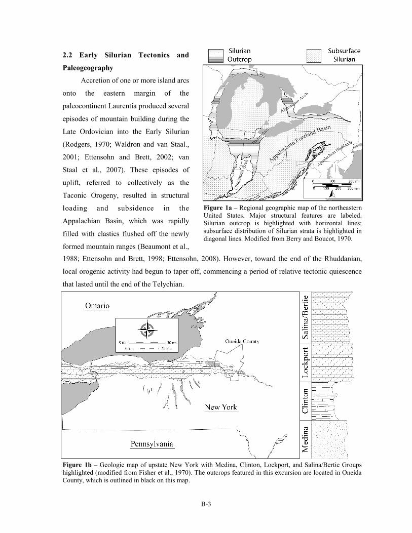
Figure 1b – Geologic map of upstate New York with Medina, Clinton, Lockport, and Salina/Bertie Groups
highlighted (modified from Fisher et al., 1970). The outcrops featured in this excursion are located in Oneida
County, which is outlined in black on this map.
B-4
At this time renewed tectonic loading caused the basin axis to migrate and form a new
forebulge in the Appalachian Basin (Goodman and Brett, 1994; Ettensohn and Brett, 1998). This
minor episode of uplift and erosion, termed the Salinic Disturbance, is recorded by the thick
siliciclastic successions of the Upper Clinton Group in New York and the Shawangunk
Conglomerate of southeast New York (Goodman and Brett, 1994; Ettensohn and Brett, 1998; Brett
et al., 1998). These recurrent pulses of tectonic activity, followed by episodes of quiescence
occurred lock-step with a lateral migration of the basin depocenter, a phenomenon that reflected the
repeated flexure and relaxation of the crust (Goodman and Brett, 1994; Ettensohn and Brett, 1998).
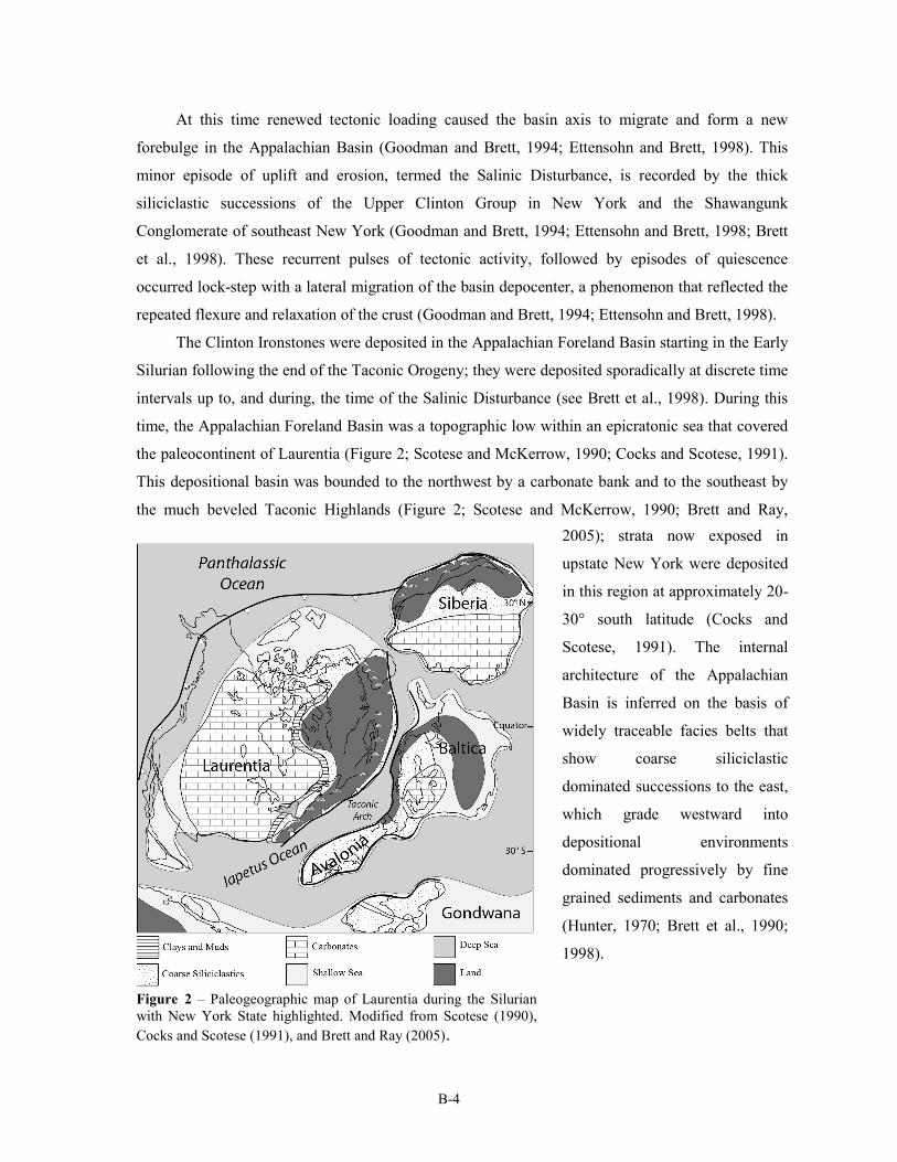
The Clinton Ironstones were deposited in the Appalachian Foreland Basin starting in the Early
Silurian following the end of the Taconic Orogeny; they were deposited sporadically at discrete time
intervals up to, and during, the time of the Salinic Disturbance (see Brett et al., 1998). During this
time, the Appalachian Foreland Basin was a topographic low within an epicratonic sea that covered
the paleocontinent of Laurentia (Figure 2; Scotese and McKerrow, 1990; Cocks and Scotese, 1991).
This depositional basin was bounded to the northwest by a carbonate bank and to the southeast by
the much beveled Taconic Highlands (Figure 2; Scotese and McKerrow, 1990; Brett and Ray,
Figure 2 – Paleogeographic map of Laurentia during the Silurian
with New York State highlighted. Modified from Scotese (1990),
Cocks and Scotese (1991), and Brett and Ray (2005).
2005); strata now exposed in
upstate New York were deposited
in this region at approximately 20-
30° south latitude (Cocks and
Scotese, 1991). The internal
architecture of the Appalachian
Basin is inferred on the basis of
widely traceable facies belts that
show coarse siliciclastic
dominated successions to the east,
which grade westward into
depositional environments
dominated progressively by fine
grained sediments and carbonates
(Hunter, 1970; Brett et al., 1990;
1998).
B-5
2.3 Climate and Oceanographic Conditions
The Early Silurian has traditionally been characterized as a period of climatic stability marked
by high sea levels, extensive reef buildups, and widespread greenhouse climates (Copper and
Brunton, 1991; Brenchley et al., 1994; Brunton et al., 1998; Veizer et al., 2000; Copper, 2002;
Miller et al., 2005). However, a recent and ongoing resurgence of interest and study in the Silurian
has characterized the time period as one of exceptional and unusual climatic, oceanic, and biotic
trends (e. g. Jeppsson, 1990; 1997; Munnecke et al., 2003; McLaughlin et al., 2008; Cramer et al.,
2011; McLaughlin et al., in review). Several short-lived episodes of cooling and glaciations have
been documented through this interval on the basis of oxygen isotopes (Lehnert et al., 2010) and
regional mapping of diamictites in South America (Caputo, 1998). Related to these climatic changes
are widely documented oscillations in relative sea-level, which appear to reflect eustatic fluctuations
(Johnson et al., 1998; Loydell, 1998; Brett et al., 2009). These sea level changes, together with
tectonic uplift and subsidence, have produced widespread depositional sequences, which form a
major theme of this trip.
Over the past few decades, high-resolution biostratigraphic studies of the Silurian have
revealed widespread and severe biotic crises affecting a broad range of taxa around the world
(Jeppsson et al., 1995; Jeppsson, 1997; Gelsthorpe, 2004; Eriksson, 2006; Manda et al., 2011). Many
of these biotic events are closely coupled with strong shifts in the ratios of stable carbon isotopes (i.
e. δ13C) recorded in marine carbonate rocks, which is thought to reflect dramatic and widespread
fluctuations in marine circulation patterns, rates of primary productivity, and the efficiency of
nutrient recycling (see Cramer and Saltzman, 2007 for a more detailed review). During this time,
New York State was situated in the subtropics, where the shallow seas would likely have been
subjected to consistently warm weather, with sharp annual variation in precipitation and powerful
tropical storms. These warm, shallow waters were home to a rich and diverse fauna of epibenthic
suspension feeders such as brachiopods, favositid and rugosan corals, bryozoans and echinoderms,
which are present in great abundance throughout lower Silurian strata (e. g. Hall, 1852; Foerste,
1931; Gillette, 1947).
3. STRATIGRAPHY OF THE CLINTON GROUP
3.1 Overview
The Lower Silurian Clinton Group in east central New York is bounded at its base by the
coarse siliciclastic successions of the Medina Group and at its upper contact by the carbonate
B-6
dominated Lockport Group (Fisher et al., 1970; Rickard, 1975). The name Clinton Group was
proposed by Lardner Vanuxem in 1842, though Amos Eaton, working in 1824 made reference to
“ferriferous slates” distributed throughout east central and western New York. The Clinton Group
received numerous revisions and refinements from several authors working in the early twentieth
century, notably Hartnagel (1907), Chadwick (1918), Goldring (1931), and Sanford (1935).
Working primarily in Maryland, Ulrich and Bassler (1923) developed a detailed ostracod
biozonation for lower Silurian strata of the Appalachian Basin. Given the relative paucity of zonally
significant conodonts and graptolites in these successions, Ulrich and Bassler’s zonation remains a
primary standard for interregional correlation of Clinton Group strata to this day.
The lithostratigraphic nomenclature proposed by workers in New York and the ostracod
biozonation of Ulrich and Bassler (1923) was integrated by Tracy Gillette in his 1947 publication
The Clinton of Western and Central New York, a work of considerable scope. Gillette (1947)
subdivided the Clinton Group into Lower, Middle and Upper subdivisions on the basis of lithology
and ostracod faunas (Figure 3). He argued that an unconformity beneath the Upper Clinton
Figure 3 – Regional cross section, showing litho– and sequence stratigraphic relationships of the Clinton
Group. Cross section modified from Gillette (1947) and Brett and others (1998). Map modified from Fisher
and others (1970).
B-7
progressively truncates strata to the west; in the vicinity of Niagara Falls, much of the Lower
Clinton and all of the Middle Clinton are missing (Gillette, 1947). Hunter (1970) further refined this
stratigraphy, correlated strata to this reference standard along the Appalachian Basin as far as
eastern Kentucky and Virginia, and emphasized the importance of ironstones as regional markers.
A sequence stratigraphic framework was erected for the Clinton Group by Brett and others
(1990, 1998) who divided the unit into four unconformity-bound packages of genetically linked
strata (Figure 3). They argued that many the ironstones distributed throughout the Clinton Group
represent transgressive units overlying regionally angular unconformities (Brett et al., 1990). As
such, they would represent deposition during times of sea-level transgression, when landward
migration of depocenters, and sequestration of siliciclastic sediments in coastal area, caused a
decrease in the amount of sediment reaching the basin and offshore sediment starvation. Brett and
others (1990, 1998) subdivided the Silurian strata of New York State into seven or eight major, third
-order sequences, termed S-I to S-VIII. Sequences S-III (the Sauquoit Formation of the Middle
Clinton), S-IV (the Willowvale and Dawes Formations of the Upper Clinton), and S-V (the Kirkland
Iron Ore and Herkimer Formations of the Upper Clinton) will be the focus of this trip.
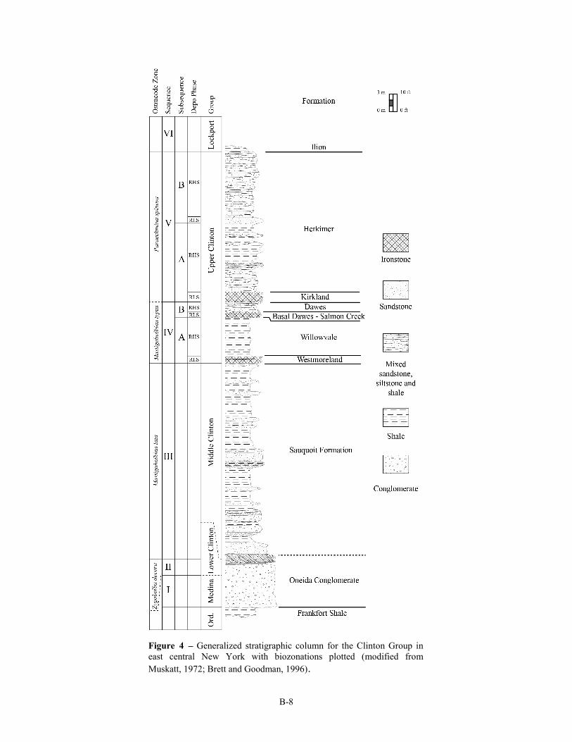
3.2. Overview of Stratigraphic Units Exposed in the Type Clinton Area
Eight named rock units will be observed and discussed during this excursion. These units
collectively comprise the Clinton Group as it is expressed in Oneida County; an idealized
representation of this succession is shown in Figure 4. Each named unit is described briefly herein.
Oneida Conglomerate
Definition and Type Area - Defined by Vanuxem (1842) as the conglomeratic unit exposed in
Oneida County
Thickness and Extent - The Oneida Conglomerate has been traced as far west as the Oswego
River; to the east, it grades into thick undifferentiated siliciclastic successions. In the
vicinity of Oneida County, it attains a maximum thickness of approximately 10 meters
(30 feet)
Age - Late Aeronian to Middle Telychian (Brett et al., 1990)
Sequence Stratigraphy - S-II to lower S-III lowstand and transgressive systems tract (Brett et
al., 1998)
Facies and Deposition Environment - Massive quartz pebble conglomerates are typical of the
Oneida, but these are commonly interbedded with light grey sandstones and dark, clay
shales. The coarser beds are generally cemented with silica.
B-8
Figure 4 – Generalized stratigraphic column for the Clinton Group in
east central New York with biozonations plotted (modified from
Muskatt, 1972; Brett and Goodman, 1996).
B-9
Biostratigraphy -
Mastigobolbina lata Zone (Gillette, 1947)
Paleoecology - The Oneida Conglomerate is typically unfossiliferous. However, several shale
and sandstone beds occurring near the top of the formation in the Clinton Area may
yield a typical normal marine fossil assemblage that includes bivalves, brachiopods, and
ostracodes.
Correlations
Thorold Sandstone of western New York (in part; Gillette, 1947)
Shawangunk Formation of southeastern New York (Willard, 1928)
Possibly much of the Lower Clinton Group in western New York (Brett et al., 1990)
Sauquoit (Shale) Formation
Definition and Type Area – Defined as all sandstone and shale beds between the Oneida
conglomerate and the Westmoreland Hematite at Swift Creek, the type section, which is
just north of the hamlet of Sauquoit (Chadwick, 1918)
Thickness and Extent – The Sauquoit attains its maximum thickness of approximately 27 m
(90 feet) near Verona Station; the Sauquoit thins dramatically to the west and pinches
out somewhere between the towns of Fulton and Wolcott, NY (Gillette, 1947)
Age – middle Telychian (C-5 of Berry and Boucot, 1970; see Brett et al., 1998)
Sequence Stratigraphy - Sequence III highstand (Brett et al., 1998)
Facies and Depositional Environment – The Sauquoit Formation is predominantly greenish
to bluish gray shales with interbedded sandy limestones, calcareous sandstones, and
conglomeratic horizons.
Biostratigraphy –
Eocoelia sulcata brachiopod Zone (Gillette, 1947; Brett et al., 1998)
Mastigobolbina lata ostracod Zone (Gillette, 1947)
Pterospathodus amorphognathoides conodont Zone (Rexroad and Richard, 1965)
Pterospathodus celloni Zone (Kleffner, pers. comm. in Brett et al., 1998)
Pterospathodus amorphognathoides Zone conodonts were reported by Kleffner (pers.
comm. in Brett et al., 1998) from dolomitic sandstones at the base the Westmoreland
Formation.
Paleoecology – The fossil assemblages of the Sauquoit formation are distinct from those of
over- and underlying units (Gillette, 1947). Bivalves are the dominant macrofossils,
though brachiopods and gastropods are also common. Ostracodes are also present in
B-10
great abundance and many of them are biostratigraphically useful, at least within the
Appalachian Basin. The lower Sauquoit contains fine- to medium- grained interbedded
sandstones and conglomerates that display hummocky cross stratification, well defined
sole marks, and hummocky to symmetrical ripples (Muskatt, 1972). These indicate
deposition within shallow storm wave base, at perhaps 10 to 30 m depths; sands and
well rounded quartz pebbles were transported offshore from proximal sources, perhaps
Taconic terranes re-uplifted in early phases of the Salinic Orogeny. The mixture of
quartz pebbles with phosphatic nodules including fossil steinkerns at three or more
levels within the Sauquoit indicates that some of these pebbly beds reflect remaining
sediments associated with prolonged periods of sediment starvation. Abundant
phosphates may reflect inputs from fluvial sources or possibly upwelling in the narrow
Sauquoit foreland basin. The Sauquoit passes eastward gradationally with red
sandstones and conglomerates of the Otsquago Formation within about 60-70 km of the
study area; the latter reflect near-shore, possibly tidal deltas to non-marine sediments.
The presence of abundant Eocoelia brachiopods in some beds of the Sauquoit suggests a
BA-2 (Eocoelia community of Ziegler, Cocks and Bambach (1968). However, some
portions of the Sauquoit contain more typical offshore biotas, including dalmanitid
trilobites, suggesting possibly deeper water conditions.
Correlations –
Otsquago Sandstone of central New York (Gillette, 1947; Brett et al., 1998)
Center Member of the Rose Hill Formation of Pennsylvania (Brett et al., 1998)
Westmoreland Iron Ore
Definition and Type Area – The dark red, oolitic, hematitic iron ore exposed at Roaring
Brook, which is the informal name given to a small tributary of Oriskany Creek
approximately half a mile east of Lairdsville in the town of Westmoreland, Oneida
County (Gillette, 1947).
Thickness and Extent – The Westmoreland Iron Ore is approximately 70 centimeters thick at
its type section, it reaches its maximum thickness in the vicinity of Clinton, where it
may reach up to 80 centimeters in thickness. Exposures of this unit are scarce outside of
Oneida County though a thin phosphatic and glauconitic zone containing some hematite
has been recognized at the top of the Sauquoit Formation in drill cores taken east of
Oneida Lake (Gillette, 1947).
Age – Late Telychian (Rickard, 1975; Brett et al., 1998); Early Sheinwoodian (McLaughlin et
B-11
al., in review)
Sequence Stratigraphy - Relative lowstand (=lowstand to early transgressive systems tract) of
subsequence IV-A (Brett et al., 1998)
Facies and Depositional Environment – The Westmoreland Iron Ore is a dark red ironstone
composed primarily of rounded, sand sized grains that display concentric laminae,
textures that have been characterized as oolitic (Smyth, 1918; Gillette, 1947). The lower
contact of the Westmoreland is sharp, and the upper contact contains large, symmetrical
ripple marks. The unit may also contain rip-up clasts, apparently derived from
underlying strata. At some sections, the Westmoreland Iron Ore contains a thin tongue
of dark gray shale. The latter contains fossils, including brachiopods and graptolites.
This juxtaposition of evidently high energy and low energy, dysoxic facies is difficult to
reconcile. Baird and Brett (1986) reported similar ripple-like features interbedded with
black shale in the Leicester Pyrite, another transgressive lag deposit but in that case
conditions were evidently dysoxic to anoxic. In the case of the Westmoreland, the
presence of hematitic ooids indicates well oxygnated conditions at least episodically on
the seafloor. It is possible that the ooids were originally chamosite and thus represent
mildly reducing conditions in the sediment. However, the presence of large ripple forms
in red hematite indicates that these ooids were subsequently reworked and concentrated
under fully oxic and intermittently high-energy conditions, possibly forming submarine
shoals or bars. The interbedded dark shale could record preservation of dysoxic lagoonal
or intershoal muds. However, the fauna, including monograptid graptolites, suggests an
offshore setting (BA 3 to 4). It is possible that the dark shale represents a remnant of
highstand muds associated with a small scale (high frequency) depositional sequence; in
this case true deepening to muddy out shelf conditions occurred following the initiation
of the larger scale (3rd order) transgression. A second lowering of base level may have
removed much of the shale and stacked a younger, transgressive oolitic hematite onto
the erosion surface.
Biostratigraphy –
Stimulograptus clintonensis (formerly assigned to Monograptus clintonensis) was reported
by Gillette (1947); however, this report has not been confirmed. All specimens studied
by Loydell et al. (2007) from the overlying Willowvale Shale turned out to be the long-
ranging Monograptus priodon.
Retiolites geinitzianus venosus, a graptolite typical of the Williamson Shale and
characteristic of late Llandovery faunas, was reported by Gillette (1947) from the
B-12
Westmoreland shale tongue.
Palaeocyclus rotuloides (Gillette, 1947)
Mastigobolbina typus Zone (Gillette, 1947)
Paleoecology – In contrast to the other ironstones in the region, the Westmoreland Iron Ore is
sparsely fossiliferous. Nearly all fossils reported from the unit are found within the
black shale interbed described above. This fossil assemblage is noted for its similarity to
that of the overlying Willowvale (Gillette, 1947).
Correlations –
Second Creek Phosphate Bed of west-central New York State on the basis of similar faunas
and seemingly transitional phosphatic nodule beds underlying the Williamson in drill
cores recovered from near Syracuse (Gillette, 1947; Lin and Brett, 1988; Eckert and
Brett, 1989; Brett et al., 1998). However, this correlation has not been substantiated by
subsequent biostratigraphic work (see Kleffner, pers. comm. in Brett et al., 1998;
Loydell et al., 2007).
Merritton Limestone of Ontario (Brett et al., 1998). However, this unit underlies the Second
Creek Phosphate Bed, making this correlation unlikely for the reasons described above.
Ferruginous limestones bearing Palaeocyclus at the base of the Upper Shaly Member of the
Rose Hill Shale in Pennsylvania (Brett et al., 1998).
Willowvale Shale
Definition and Type Area – The term Willowvale was introduced by Gillette (1947) to
include the blue grey shales between the Westmoreland and the Kirkland Iron ores, or
the base of the Dawes Sandstone where it is present. As a type locality he designated a
small, east-flowing tributary of Sauquoit Creek, informally referred to as “The Glen” or
“Willowvale Creek” in the town of Willowvale, New York (Gillette, 1947).
Thickness and Extent – The Willowvale Shale is approximately 6.7 m (22 feet) thick at its
type section, a value that remains consistent where typical Willowvale is exposed
(Gillette, 1947). The unit is not found west of Oneida County, though its proposed
lateral equivalent, the Williamson Formation, has been traced as far as Niagara County
(Gillette, 1947; Brett et al., 1990). The Willowvale grades eastward into large,
undifferentiated sections of coarse clastics (Gillette, 1947).
Age – Late Telychian (Brett et al., 1998), Early Sheinwoodian (McLaughlin et al., in review)
Sequence Stratigraphy – Relative highstand of subsequence IV-A (Brett et al., 1998)
B-13
Facies and Depositional Environment – The Willowvale Formation is predominantly dark
gray to purple, thin bedded shales with calcareous sandstone and argillaceous, shelly
limestone interbeds. The unit is interpreted as the product of proximal deposition in
relatively shallow and well oxygenated environments (Eckert and Brett, 1989). The
presence of siltstones and silty carbonates with small scale hummocky cross lamination
and tool marks suggests at position near storm wave base.
Biostratigraphy –
Ancyrochitina gutinica (Loydell et al., 2007)
Conochitina proboscifera (Loydell et al., 2007)
Mastigobolbina typus Zone (Gillette, 1947)
Monograptus priodon (Loydell et al., 2007), reported as Monograptus clintonensis (Gillette,
1947)
Palaeocyclus rotuloides (Gillette, 1947)
Pterospathodus amorphognathoides Zone (Kleffner, pers. comm. reported in Brett et al.,
1998)
Paleoecology – The Willowvale Shale has a rich and varied fossil fauna that is noted for its
unusual co-occurrence of disparate taxa not known to inhabit similar depositional
environments; graptolites, cephalopods, bryozoans, corals, and brachiopods are all
commonly found (Gillette, 1947). Eckert and Brett (1989) characterized the Willowvale
fauna in easternmost outcrops as a near-shore benthic assemblage (BA-2 to 3 of their
terminology) dominated by Eocoelia. However, in the Clinton area, the occurrence of a
diverse fauna with Dicoelosia, Skenidioides, Eoplectodonta and rare Costisticklandia
indicate a BA 4-5 position (Eckert and Brett, 1989). This fauna shows affinities with
that of the Williamson Formation to the west, a relationship also noted by Gillette
(1947). The lower part of this unit and the underlying Westmoreland Iron Ore contain
abundant specimens of the solitary coral Palaeocyclus rotuloides, an unusual, button-
shaped coral found in coeval sections worldwide (Duncan, 1867; Gillette, 1947; Ehlers,
1973; Munnecke et al., 2003). The widespread, but stratigraphically narrow occurrence
constitutes a useful marker, representing a global epibole of this unusual organism. Rare
Palaeocyclus have been found in what appear to be transitional facies the lower
Williamson-Westmoreland as far west as Syracuse, NY. The near-simultaneous
invasion of what may have been a deep-water coral into shallow seas on several
continents may reflect a response to elevated sea level and incursion of cool and perhaps
dysoxic water masses onto the craton during the strong and rapid late Telychian
B-14
transgression (locally Sequence IV TST).
Correlations –
Williamson Formation of west-central New York has been correlated with the lower
Willowvale Shale and both units have yielded diagnostic Mastigobolbina typus Zone
ostracodes (Gillette, 1947; Lin and Brett, 1988; Eckert and Brett, 1989; Brett et al.,
1990; 1998). However, graptolite and conodont work suggests that the basal Williamson
may actually be older than the lower Willowvale, belonging to the Pt.
amorphognathoides angulatus Zone (Rexroad and Richard, 1965; Loydell et al., 2007).
Upper Shaly Member of the Rose Hill Formation of Pennsylvania, which contains the
diagnostic ostracod Mastigobolbina typus (Brett et al., 1998)
Salmon Creek (“Basal Dawes”) Bed
Definition and Type Area – The term “Salmon Creek Bed” was proposed by Lin and Brett
(1988), who established the type section at Salmon Creek West, approximately 50
meters south of NY route 104 in the town of Williamson, Wayne County, New York. In
its type area, the Salmon Creek Bed is a phosphatic, quartz bearing conglomeratic bed
that separates the Irondequoit Formation from the underlying Williamson (Lin and
Brett, 1988). However, this unit was correlated eastward to a cross-bedded, impure
hematitic sandy carbonate referred to in some publications as the “basal Dawes
bed” (Lin and Brett, 1988; Eckert and Brett, 1989; Brett et al., 1998).
Thickness and Extent – The Salmon Creek Bed has been traced from Tryon Park in
Rochester New York, to the Clinton Type Area (Lin and Brett, 1988). Although this unit
is only a few centimeters thick at its type locality in northern Wayne County, it reaches
a thickness of 80 centimeters in Oneida County. The Salmon Creek Bed has been traced
eastward at least to Ohisa Creek in Herkimer County (Zenger, 1971; Brett, pers.
observation)
Age – Late Telychian (Brett et al., 1998); Late Llandovery to early Wenlock (Lin and Brett,
1988); Early Sheinwoodian (McLaughlin et al., in review)
Sequence Stratigraphy – Relative lowstand (LST to early TST) of subsequence IV-B (Brett et
al., 1998).
Facies and Depositional Environment – The Salmon Creek Bed in the Clinton type area is
characterized as a crossbedded, sandy dolostone with locally abundant stringers of
hematite and phosphate nodules (Brett and Goodman, 1996). The unit has a sharp base,
which is interpreted as an erosive contact.
B-15
Biostratigraphy –
Upper Mastigobolbina typus Zone (Gillette, 1947)
Pterospathodus amorphognathoides amorphognathoides Zone (Loydell et al., 2007)
Paleoecology – Stalked echinoderm fragments are the dominant component of the Salmon
Creek Bed. This, coupled with observations of sedimentary structures such as cross
stratification, suggest the bed was deposited in a relatively high energy, well oxygenated
environment similar to the Kirkland Formation (see below).
Correlations –
Basal bed of the Keefer Sandstone in Pennsylvania, Maryland, Virginia, and Tennessee
(Brett et al., 1998)
Salmon Creek Phosphate Bed of central-western New York (Lin and Brett, 1988)
Dawes Formation
Definition and Type Area – The Dawes Formation is defined as the dolomitic sandstones,
siltstones, and shales found between the top of the Willowvale Shale and the base of the
Kirkland Iron Ore; the designated type locality is Dawes Quarry creek, a westward
flowing stream in the village of Clinton (Gillette, 1947).
Thickness and Extent – In his original description of the Dawes Sandstone, Gillette (1947)
suggested that it was restricted to the area between College Hill Creek in Clinton and
the unit's type locality at Dawes Quarry Creek, where it is approximately 2.5 meters
thick. At localities further to the east, the overlying Kirkland Iron Ore rests directly on
mudstones that have been referred to as the upper Willowvale Shale (Gillette, 1947).
However, at localities to the west, other authors have recognized the position of the
Dawes-Rockway interval based on the presence of a basal hematitic, pyritic and
phosphatic carbonate bed, the Salmon Creek equivalent (Lin and Brett, 1988).
Age – Late Telychian (Brett et al., 1998); Late Telychian to Early Sheinwoodian (Brett and
Goodman, 1996); Early Wenlock (Lin and Brett, 1988), Early Sheinwoodian
(McLaughlin et al., in review)
Sequence Stratigraphy – Relative highstand of subsequence IV-B (Brett et al., 1998); late
highstand to falling stage of third-order Sequence IV.
Facies and Depositional Environment – The Dawes Sandstone is predominantly light gray,
slightly calcareous sandstones. Gillette (1947) describes the bed as irregularly bedded,
and very cross-bedded, though finely laminated siltstones and sandstones characterize
the unit at some localities (e. g., Theime Gulf). On the basis of these sedimentary
B-16
structures, the rarity of normal marine fossil assemblages, and the limited extent of this
unit, Gillette (1947) hypothesized that this unit may represent a small delta deposit.
Several sections of the Dawes Sandstone contain a zone of deformed calcareous
sandstones and shales just below the overlying hematitic unit. These beds are interpreted
as the product of soft sediment deformation, possibly formed by seismic activity.
Biostratigraphy –
Mastigobolbina typus Zone (inferred by Brett et al., 1998; though no ostracodes have been
reported directly from this unit)
Pterospathodus amorphognathoides Zone (inferred by Brett et al., 1998; though no
conodonts have been reported directly from this unit)
Paleoecology – In contrast to the hematitic beds that bracket this unit, the Dawes Sandstone
contains very few fossils, though occasional, fragmentary remains of brachiopods,
gastropods, and cephalopods have been reported (Brett and Goodman, 1996). Like the
Sauquoit, the Dawes Sandstone shows evidence of deposition in shallow, storm
influenced waters. Fossils, other than burrows are generally scarce but some bedding
planes are covered with Strophochonetes cornutus, which is viewed as an opportunistic
shallow water species. The lenticular fine sandstones of the Dawes may represent
offshore sandbars. Their rapid accumulation on mud may have produced substrate
instability that, in the presence of seismic shocks may have resulted in extensive
foundering of ball and pillow masses (seismites). The presence of abundant small
brachiopod Clorinda, together with Skenidioides and Dicoelosia suggests BA-4 to 5
positions. However, the occurrence of small ischaditid algae within these beds at
Second Creek and bedding planes covered with these algal thalli near Verona suggest
that water depths were still relatively shallow and well within the photic zone.
Correlations –
Rockway Dolostone (or Rockway Member of the Irondequoit Formation) of west-central
New York (Eckert and Brett, 1989; Brett et al., 1998)
Lower Keefer Sandstone of Pennsylvania, Virginia, and Maryland (Brett et al., 1998;
McLaughlin et al., in review)
Kirkland Iron Ore
Definition and Type Area – The Kirkland Iron Ore was defined by Chadwick (1918) as the
fossiliferous hematitic bed well exposed in the vicinity of Kirkland in Oneida County,
New York. Also referred to as the upper iron ore of Vanuxem (1842) and the red-flux
B-17
ore of Smyth (1895), the Kirkland sharply overlies the Willowvale Shale or the Dawes
Sandstone where it is present. Its upper contact with the Herkimer Sandstone is
gradational (Gillette, 1947).
Thickness and Extent – The Kirkland Iron Ore is highly variable in thickness, reaching up to
two meters at sections near Lairdsville, New York. Within the Clinton Type area, the
Kirkland serves as an important stratigraphic marker. However, like many of the other
Clinton Ironstones, the Kirkland cannot be easily traced in surface exposures outside of
Oneida County (Gillette, 1947).
Age – Sheinwoodian (Brett and Goodman, 1996; Brett et al., 1998; McLaughlin et al., in
review)
Sequence Stratigraphy – Relative lowstand (LST to early TST) of subsequence V-A (Brett et
al., 1998)
Facies and Depositional Environment – The Kirkland is a fossiliferous, hematitic grainstone
with highly variable concentrations of iron and several cross-stratified horizons. The
beds also have high concentrations of carbonate which made this unit it a valuable target
for miners and smelters as a self-fluxing ore (Van Houten, 1991). It is composed
primarily of crinoid-dominated packstones and grainstones, indicative of relatively
shallow water and moderate- to high energy transgressive shoal conditions.
Biostratigraphy –
Kockelella ranuliformis Zone (Kleffner pers. comm. reported in Brett et al., 1998)
Paraechmina spinosa Zone (Gillette, 1947)
Paleoecology – Like the Salmon Creek Bed, the Kirkland contains abundant remains of rather
large pelmatozoans (stalked echinoderms), though bryozoans and brachiopods are also
common. The preservational state of these organisms is highly variable, and a
taphonomic gradient of ferruginization has been noted by previous workers (Gillette,
1947) suggesting strong reworking and time-averaging the Kirkland with preferential
preservation of more robust skeletal elements. The presence of moderately large
brachiopods including Meristina (=Cryptothyrella) cylindrica, Coolinia and Leptaena
suggests a BA-3 open shelf, shoal position.
Correlations –
Upper Irondequoit Formation of west-central New York and Ontario (Lin and Brett, 1988;
Brett et al., 1998)
Upper Keefer Of Pennsylvania, Maryland, and Virginia (Brett et al., 1998)
Lower Keefer of Pennsylvania (McLaughlin et al., in review)
B-18
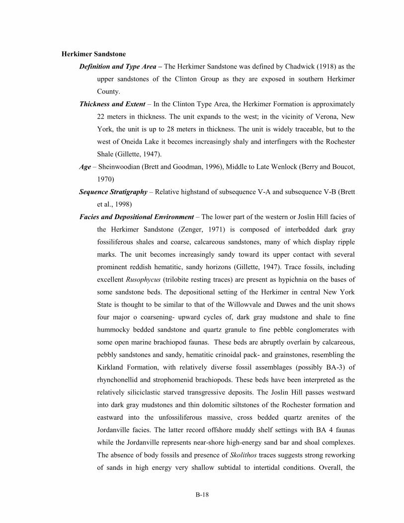
Herkimer Sandstone
Definition and Type Area – The Herkimer Sandstone was defined by Chadwick (1918) as the
upper sandstones of the Clinton Group as they are exposed in southern Herkimer
County.
Thickness and Extent – In the Clinton Type Area, the Herkimer Formation is approximately
22 meters in thickness. The unit expands to the west; in the vicinity of Verona, New
York, the unit is up to 28 meters in thickness. The unit is widely traceable, but to the
west of Oneida Lake it becomes increasingly shaly and interfingers with the Rochester
Shale (Gillette, 1947).
Age – Sheinwoodian (Brett and Goodman, 1996), Middle to Late Wenlock (Berry and Boucot,
1970)
Sequence Stratigraphy – Relative highstand of subsequence V-A and subsequence V-B (Brett
et al., 1998)
Facies and Depositional Environment – The lower part of the western or Joslin Hill facies of
the Herkimer Sandstone (Zenger, 1971) is composed of interbedded dark gray
fossiliferous shales and coarse, calcareous sandstones, many of which display ripple
marks. The unit becomes increasingly sandy toward its upper contact with several
prominent reddish hematitic, sandy horizons (Gillette, 1947). Trace fossils, including
excellent Rusophycus (trilobite resting traces) are present as hypichnia on the bases of
some sandstone beds. The depositional setting of the Herkimer in central New York
State is thought to be similar to that of the Willowvale and Dawes and the unit shows
four major o coarsening- upward cycles of, dark gray mudstone and shale to fine
hummocky bedded sandstone and quartz granule to fine pebble conglomerates with
some open marine brachiopod faunas. These beds are abruptly overlain by calcareous,
pebbly sandstones and sandy, hematitic crinoidal pack- and grainstones, resembling the
Kirkland Formation, with relatively diverse fossil assemblages (possibly BA-3) of
rhynchonellid and strophomenid brachiopods. These beds have been interpreted as the
relatively siliciclastic starved transgressive deposits. The Joslin Hill passes westward
into dark gray mudstones and thin dolomitic siltstones of the Rochester formation and
eastward into the unfossiliferous massive, cross bedded quartz arenites of the
Jordanville facies. The latter record offshore muddy shelf settings with BA 4 faunas
while the Jordanville represents near-shore high-energy sand bar and shoal complexes.
The absence of body fossils and presence of Skolithos traces suggests strong reworking
of sands in high energy very shallow subtidal to intertidal conditions. Overall, the
B-19
increased input of siliciclastic sediments into the foreland basin during Rochester-
Herkimer depositions suggests an increased pulse of uplift and erosion associated with a
second Salinic tectophase.
Biostratigraphy –
Paraechmina spinosa Zone (Gillette, 1947)
Paleoecology – Fossil assemblage reported in the Herkimer Sandstone are indicative of
normal marine deposition. The sandstone beds of the lower Herkimer Sandstone are
sparsely fossiliferous. However the shales yield fairly common brachiopods, bivalves,
and ostracodes.
Correlations –
Rochester Shale of west-central New York (Gillette, 1947; Berry and Boucot, 1970; Brett et
al., 1998).
Upper Rochester Shale of west-central New York (McLaughlin et al., in review)
Upper Keefer of Pennsylvania (McLaughlin et al., in review)
4. THE NATURE OF IRONSTONES
4.1 Mineralogy and Sedimentology
Phanerozoic ironstones are a heterogeneous mixture of various iron-bearing and non-
ferruginous minerals. The predominant iron oxide mineral found within the Clinton Ironstones is
hematite, which gives the horizons their characteristic dark red color (Schoen, 1962). Although the
predominance of these oxides within the Clinton Ironstones suggests an oxic depositional
environment, the presence of reduced iron minerals such as chamosite and berthierine indicates a
complex history of redox conditions. Small, but ubiquitous crystals of pyrite are also present, and in
nearly all cases show a late-stage mineral replacement history. Other common minerals within the
Clinton Ironstones are illite, calcite, and quartz.
Iron bearing minerals in the Clinton Ironstones are commonly manifested as intergranular
cements, cavity fillings, or concentric laminae accreted around a nucleus (Cotter and Link, 1993).
Beds composed primarily of sand-sized quartz grains surrounded by concentric, ferruginous laminae
have been characterized as having an "oolitic" texture (Smyth, 1892; 1919), though in contrast to
carbonate ooids, these grains typically have an elliptical flax-seed shape (Chowns, 1996).
Fossiliferous ironstones are similar to oolitic ironstones in many ways, though bioclasts commonly
form the nucleus for accreted rinds of iron minerals in these beds. Fossils in ironstone horizons may
B-20
be tinted bright red where carbonate minerals have been impregnated or replaced by iron oxides.
4.2 Genetic Models
The ubiquity of ferric iron bearing minerals in many types of ironstones suggests that they
were deposited in environments that experienced oxidizing conditions at least sporadically, yet it is
widely acknowledged that iron is highly immobile in oxic environments (Kimberley, 1989, Boggs,
2001). This apparent contradiction is referred to as the "ironstone paradox" or the "oxidation-
reduction paradox", which has been the subject of numerous studies (Maynard, 1986; Cotter, 1992;
Kimberley, 1994; McLaughlin et al., in review).
Ironstones occur non-randomly within the Phanerozoic, and are particularly common within the
Ordovician through Devonian and Jurassic through Early Cenozoic (Van Houten and Bhattacharrya,
1982; Van Houten and Arthur, 1989). These intervals of earth's history are traditionally associated
with greenhouse climates and subdued tectonism, leading to the conclusion that deep weathering of
continental bedrock would provide a ready source of iron, favoring the deposition of ironstones
(Van Houten and Bhattacharrya, 1982). However, Van Houten and Arthur (1989), citing a close
temporal relationship between ironstones and black shales, suggested a common cause in poorly
circulated anoxic water masses, which have the capacity to transport large quantities of dissolved
iron in its reduced, ferrous state. Cotter and Link (1993) expanded on this idea suggesting that
ironstones could form along the pycnocline, where dysoxic deeper waters came into contact with
more oxygenated shallow waters. Under these mildly reducing conditions, ferrous iron dissolved in
the dysoxic water mass could have precipitated near the sediment water interface as iron rich clays
such as chamosite and berthierine, which may occur as intergranular cements, oolitic coatings, or
cavity fillings, possibly mediated by microbial activity (Cotter and Link, 1993; Chowns, 1996).
They argue that these minerals could then be altered to ferric oxide during later diagenesis (Cotter
and Link, 1993).
However, Silurian ironstones are commonly associated with diverse open marine fossil
assemblages (Gillette, 1947) and in situ bioturbating organisms (Chowns, 1996) indicating oxic
conditions at the site of deposition. Regional stratigraphic studies traced many of these ironstones
laterally into thin, pyrite and phosphate rich conglomeratic horizons, suggesting a genetic link
between them (Lin and Brett, 1988). The position of some ironstones and coeval phosphatic
horizons upon unconformities, created during global lowstands of sea level, indicate that deposition
occurred during times of sea level rise (transgression) and siliciclastic sediment starvation. As such,
ironstones were interpreted to represent highly condensed beds that represent much more time per
B-21
unit thickness than the shales and sandstones that bracket them (Brett et al., 1990; 1998;
McLaughlin, Brett, and Wilson 2008). However, because the iron transported into the Appalachian
Basin was in the form of grain coatings on clay particles and silt and sand grains under background
conditions, siliciclastic sediment starvation would stop the influx of iron into the basin during
transgression, thus requiring mobilization of iron from out of the preexisting basin sediments or
from a source outside the basin.
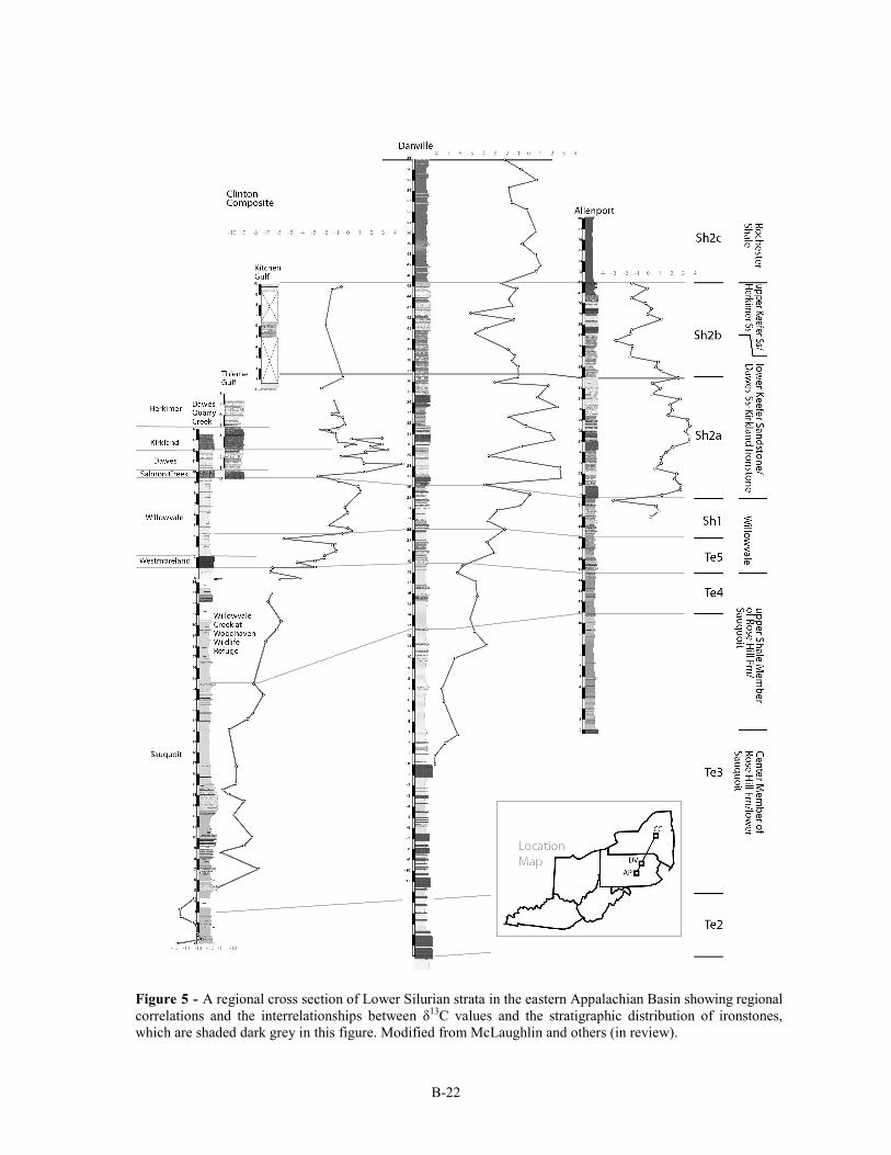
Recent carbon isotope analysis across the Appalachian Basin indicates synchrony between the
timing of globally recognized positive carbon isotope excursions and the occurrence of ironstones
(Figure 5; McLaughlin and others, in review). The large positive shifts in carbon isotopes reflect
burial of massive amounts of light organic carbon globally. The incredible increase in primary
productivity and burial required to drive such enormous fractionation (up to 10 per mil in the late
Ludlow) required oceanic anoxia. The presence of widespread anoxic conditions is supported by
proxy data from geochemical studies and the shift to black, laminated shales in basin-center deposits
during these events around the world. Within the Appalachian Basin a shift from red and green
shales to olive, gray and black shales records this change in organic carbon burial. Ironstones and
phosphorites are coincident with this shift in sediment color. Where ironstones are traced down-
ramp into phosphorites, the position of this facies transition reflects the original position of a redox
interface within the basin. Geochemical analysis of tens of meters of strata below the ironstones
shows an iron concentration typical of marine rocks (several orders of magnitude lower than the
ironstones) and no significant stratigraphic variation in iron concentration. Thus, there is no
evidence that the iron that makes up the ironstones was leached from the underlying strata. Thus,
without a sufficient source of iron from riverine input (as predicted during transgressive siliciclastic
sediment starvation) or from the underlying sediments, it follows that the primary source of iron was
extra-basinal. It is likely therefore that advance of an anoxic water mass into the Appalachian during
global organic carbon burial events provided the medium for delivery of massive amounts of
dissolved iron. The ironstones and iron-rich carbonates were deposited at a water mass boundary as
indicated by their "bath tub ring" distribution around the margins of the basin. The composition and
distribution of the ironstones indicates that this water mass boundary was somewhat diffuse and
fluctuated between oxic conditions prevalent above and the anoxic conditions present below.
No clear consensus has emerged among the scientific community regarding the origin of
ironstones; it may well be that several models or a combination thereof may be responsible for their
genesis. Several of the classic "Clinton Ironstones" will be examined through the course of this
excursion in the context of these models.
B-22
Figure 5 - A regional cross section of Lower Silurian strata in the eastern Appalachian Basin showing regional
correlations and the interrelationships between δ13C values and the stratigraphic distribution of ironstones,
which are shaded dark grey in this figure. Modified from McLaughlin and others (in review).
B-23
4. CONCLUSIONS
Dramatic and dynamic global patterns of climatic, biotic, and oceanographic change in the
Silurian are now thoroughly documented and the equally vivid record of these patterns are well
represented in the ironstone bearing stratigraphic successions of Oneida County. Considerable
progress has been made in constraining the depositional setting of Phanerozoic sedimentary
ironstones such as these, though much remains to be done. For example, ironstones appear to be
preferentially associated with basal lowstand to early transgressive lag deposits of depositional
sequence; sediment starvation appears to have allowed buildup of early diagenetic minerals without
dilution. However, ironstones are also restricted to particular time intervals (McLaughlin et al., in
press) and the source of the iron, whether intra- or extrabasinal, and the process of concentration
remain a source of discussion. As this debate and others evolve, the Silurian successions of east
central New York will continue to play an important role in our understanding in this pivotal episode
of earth's history.
6. REFERENCES CITED
Baird, G. C., and Brett, C. E., 1986, Erosion on an Anaerobic Seafloor: Significance of Reworked Pyrite Deposits from the
Devonian of New York State: Palaeogeography, Palaeoclimatology, Palaeoecology, v. 57, p. 157-193.
Beaumont, C., Quinlan, G., and Hamilton, J., 1988, Orogeny and Stratigraphy: Numerical Models of the Paleozoic in
Eastern North America: Tectonics, v. 7, no. 3, p. 389-416.
Berry, W. B. N., and Boucot, A. J., 1970, Correlation of the North American Silurian Rocks, Geological Society of
America Special Paper 102, 289 p.:
Bolton, T. E., 1957, Silurian Stratigraphy and Paleontology of the Niagara Escarpment in Ontario: Geological Society of
Canada, Memoir 289.
Boucot, A. J., 1975, Evolution and Extinction Rate Controls, Amsterdam, NY, Elsevier, 427 p.:
Brenchley, P. J., Marshall, J. D., Carden, G. A. F., Robertson, D. B. R., Long, D. G. F., Meidla, T., Hints, L., and
Anderson, T. F., 1994, Bathymetric and isotopic evidence for a short-lived Late Ordovician glaciation in a
greenhouse period: Geology, v. 22, p. 295-298.
Brett, C. E., Baarli, B. G., Chowns, T., Cotter, E., Driese, S. G., Goodman, W., M., and Johnson, M. E., 1998, Early
Silurian Condensed Intervals, Ironstones, and Sequence Stratigraphy in the Appalachian Foreland Basin, in
Landing, E., and Johnson, M. E., eds., Silurian Cycles: Linkages of Dynamic Stratigraphy with Atmospheric,
Oceanic and Tectonic Changes. New York State Museum Bulletin, Volume 491: Albany, NY, New York State
Museum, p. 89-143.
Brett, C. E., Ferretti, A., Histon, K., and Schöenlaub, H. P., 2009, Silurian sequence stratigraphy of the Carnic Alps,
Austria: Palaeogeography, Palaeoclimatology, Palaeoecology, v. 279, p. 1-28.
Brett, C. E., and Goodman, W., M., 1996, Silurian Stratigraphy of the Type Clinton Area of Central New York, in
Broadhead, T. W., ed., Sedimentary Environments of Silurian Taconia: Fieldtrips to the Appalachians and Southern
Craton of Eastern North America, Volume 26.
Brett, C. E., Goodman, W., M., and LoDuca, S. T., 1990, Sequences, cycles, and basin dynamics in the Silurian of the
Appalachian Foreland Basin: Sedimentary Geology, v. 69, p. 191-244.
Brett, C. E., and Ray, D., C., 2005, Sequence and Event Stratigraphy of the Silurian Strata of the Cincinnati Arch Region:
Correlations with New York-Ontario Successions: Proceedings of the Royal Society of Victoria, v. 117, no. 2, p.
175-198.
Boggs, S., 2001, Principles of Sedimentology and Stratigraphy (Third Edition), Upper Saddle River, New Jersey, Prentice
Hall, 726 p.:
Brunton, F. R., Smith, L., Dixon, O. A., Copper, P., Nestor, H., and Kershaw, S., 1998, Silurian Reef Episodes, Changing
Seascapes, and Paleobiolgeography, in Landing, E., and Johnson, M. E., eds., Silurian Cycles: Linkages of
Dynamic Stratigraphy with Atmospheric, Oceanic and Tectonic Changes. New York State Museum Bulletin,
Volume 491: Albany, NY, New York State Museum, p. 265-282.
B-24
Caputo, M. V., 1998, Ordovician-Silurian Glaciations and Global Sea-Level Changes, in Landing, E., and Johnson, M. E.,
eds., Silurian Cycles: Linkages of Dynamic Stratigraphy with Atmospheric, Oceanic and Tectonic Changes. New
York State Museum Bulletin, Volume 491: Albany, NY, New York State Museum, p. 15-25.
Chadwick, G. H., 1918, Stratigraphy of the New York Clinton: Geological Society of America Bulletin, v. 29, p. 327-368.
Chowns, T. M., 1996, Sequence Stratigraphy of the Silurian Red Mountain Formation in Alabama and Georgia, in
Broadhead, T. W., ed., Sedimentary Environments of Silurian Taconia: Field Trips to the Appalachians and
Southern Craton of Eastern North America. University of Tennessee, Department of Geological Science, Studies in
Geology 26, p. 31-42.
Cocks, L. R. M., and Scotese, C. R., 1991, Global Biogeography of the Silurian Period: Special Papers in Paleontology, v.
44, p. 109-112.
Colton, G. W., 1970, The Appalachian Basin - Its depositional sequences and their geologic relationships, in Fisher, G. W.,
Pettijohn, F. J., Reed, J. C., and Weaver, K. N., eds., Studies of Appalachian Geology Central and Southern: New
York, NY, John Wiley.
Copper, P., 2002, Silurian and Devonian Reefs: 80 Myr of global greenhouse between two ice ages, in Flugel, E., and
Kiessling, W., eds., Society of Economic Paleontologists and Mineralogists Special Publication, Volume 72, p. 181
-238.
Copper, P., and Brunton, F. R., 1991, A Global Review of Silurian Reefs: Special Papers in Paleontology, v. 44, p. 225-
259.
Cotter, E., 1992, Diagenetic alteration of chamositic clay minerals to ferric oxide in oolitic ironstone: Journal of
Sedimentary Petrology, v. 62, p. 54-60.
Cotter, E., and Link, J. E., 1993, Deposition and diagenesis of Clinton ironstones (Silurian) in the Appalachian Foreland
Basin of Pennsylvania: Geological Society of America Bulletin, v. 105, no. 7, p. 911-922.
Cramer, B. D., Brett, C. E., Melchin, M. J., Männik, P., Kleffner, M. A., McLaughlin, P. I., Loydell, D. K., Munnecke, A.,
Jeppsson, L., Corradini, C., Brunton, F. R., and Saltzman, M. R., 2011, Revised correlation of Silurian Provincial
Series of North America with global and regional chronostratigraphic units and δ13Ccarb chemostratigraphy:
Lethaia, v. 44, no. 2, p. 185-202.
Cramer, B. D., and Saltzman, M. R., 2007, Fluctuations in epeiric sea carbonate production during Silurian positive carbon
isotope excursions: A review of proposed paleoceanographic models: Palaeogeography, Palaeoclimatology,
Palaeoecology, v. 245, no. 1-2, p. 37-45.
Duncan, P. M., 1867, On the Genera Heterophyllia, Battersbyia, Palaeocyclus, and Asterosmilia; The Anatomy of Their
Species, and Their Position in the Classification of the Sclerodermic Zoantharia: Philosophical Transactions of the
Royal Society of London, v. 157, p. 643-656.
Eaton, A., 1824, A Geological and Agricultural Survey of the District Adjoining the Erie Canal, in the State of New York,
Albany, NY, Packard and Van Benthuysen.
Eckert, B.-Y., and Brett, C. E., 1989, Bathymetry and paleoecology of Silurian benthic assemblages, late Llandoverian,
New York State: Palaeogeography, Palaeoclimatology, Palaeoecology, v. 74, p. 297-326.
Ehlers, G. M., 1973, Stratigraphy of the Niagaran Series of the Northern Peninsula of Michigan, University of Michigan
Museum of Paleontology Papers on Paleontology, v. 3, 200 p.:
Eriksson, M. E., 2006, The Silurian Ireviken Event and vagile benthic faunal turnovers (Polychaeta; Eunicida) on Gotland,
Sweden: GFF, v. 128, p. 91-95.
Ettensohn, F. R., 2008, Chapter 4: The Appalachian Foreland Basin in Eastern United States: Sedimentary Basins of the
World, v. 5, p. 105-179.
Ettensohn, F. R., and Brett, C. E., 1998, Tectonic components in Third-Order Silurian Cycles: Examples from the
Appalachian Basin and Global Implications, in Landing, E., and Johnson, M. E., eds., Silurian Cycles: Linkages
of Dynamic Stratigraphy with Atmospheric, Oceanic and Tectonic Changes. New York State Museum Bulletin,
Volume 491: Albany, NY, New York State Museum, p. 89-143.
Ettensohn, F. R., and Brett, C. E., 2002, Stratigraphic evidence from the Appalachian Basin for continuation of the
Taconian Orogeny into Early Silurian time: Physics and Chemistry of the Earth, v. 27, p. 279-288.
Fisher, D. W., Isachsen, Y. W., Rickard, L. V., 1970. Geologic Map of New York State. 1:250,000, New York State
Museum Map and Chart Series No. 15.
Foerste, A. F., 1931, The Silurian Fauna of Kentucky, in Jillson, W. R., ed., The Paleontology of Kentucky: Frankfort
Kentucky, The Kentucky Geological Survey, p. 170-193.
Gelsthorpe, D. N., 2004, Microplankton changes through the early Silurian Ireviken extinction event on Gotland, Sweden:
Review of Palaeobotany and Palynology, v. 130, p. 89-103.
Gillette, T., 1947, The Clinton of Western and Central New York: New York State Museum Bulletin, v. 41, p. 1-191.
Goldring, W., 1931, Handbook of paleontology for beginners and amateurs, Part II: The Formations: New York State
Museum Handbook, v. 10, p. 488.
Goodman, W., M., and Brett, C. E., 1994, Roles of Eustasy and Tectonics in Development of Silurian Stratigraphic
Architecture of the Appalachian Foreland Basin: Tectonic and Eustatic Controls on Sedimentary Cycles, SEPM
Concepts in Sedimentology and Paleontology #4, p. 147-169.
Hall, J., 1852, Palaeontology of New York. Volume II. Containing Descriptions of the Organic Remains of the Lower
Middle Division of the Silurian System (Equivalent in Part to the Middle Silurian Rocks of Europe), Albany, New
B-25
York, C. Van Benthuysen.
Hartnagel, C. A., 1907, Geologic Map of the Rochester and Ontario Beach quadrangles: New York State Museum
Bulletin, v. 114, p. 1-35.
Hunter, R. E., 1970, Facies of iron sedimentation in the Clinton group, in Fisher, G. W., ed., Studies of Appalachian
geology, central and southern: New York City, New York, John Wiley and Sons, p. 101-121.
Jeppsson, L., 1990, An oceanic model for lithological and faunal changes tested on the Silurian record: Journal of the
Geological Society, v. 147, p. 663-674.
Jeppsson, L., 1997, The anatomy of the mid-Early Silurian Ireviken Event, in Brett, C. E., and Baird, G. C., eds.,
Paleontological Event Horizons - Ecological and Evolutionary Implications, Columbia University Press, p. 451-
492.
Jeppsson, L., Aldridge, R. J., and Dorning, K. J., 1995, Wenlock (Silurian) oceanic episodes and events: Journal the
Geological Society, London, v. 152, p. 487-498.
Johnson, M. E., Rong, J.-y., and Kershaw, S., 1998, Calibrating Silurian eustasy against the erosion and burial of coastal
paleotopography, in Landing, E., and Johnson, M. E., eds., Silurian Cycles: Linkages of Dynamic Stratigraphy
with Atmospheric Ocean and Tectonic Changes. New York State Museum Bullettin, Volume 491: Albany, NY,
New York State Museum, p. 3-13.
Kimberley, M. M., 1989, Exhalative Origins of Iron Formations: Ore Geology Reviews, v. 5, p. 13-145.
Kimberley, M. M., 1994, Debate about ironstone: has solute supply been surficial weathering, hydrothermal convection, or
exhalation of deep fluids: Terra Nova, v. 6, no. 116-132.
Lehnert, O., Männik, P., Joachimski, M. M., Calner, M., and Frýda, J., 2010, Palaeoclimate perturbations before the
Sheinwoodian glaciation: A trigger for extinctions during the ‘Ireviken Event’: Palaeogeography,
Palaeoclimatology, Palaeoecology, v. 296, no. 3-4, p. 320-331.
Lin, B.-Y., and Brett, C. E., 1988, Stratigraphy and disconformable contacts of the Williamson-Willowvale interval:
revised correlations of the late Llandoverian (Silurian) in New York State: Northeastern Geology, v. 10, p. 241-253.
Loydell, D. K., 1998, Early Silurian sea-level changes: Geological Magazine, v. 135, no. 4, p. 447-471.
Loydell, D. K., Kleffner, M. A., Mullins, G. L., Butcher, A., Matteson, D. K., and Ebert, J. R., 2007, The lower
Williamson Shale (Silurian) of New York: a biostratigraphical enigma: Geological Magazine, v. 144, no. 02, p. 225.
Manda, Š., Štorch, P., Slavík, L., Frýda, J., Kříž, J., and Tasáryová, Z., 2011, The graptolite, conodont and sedimentary
record through the late Ludlow Kozlowskii Event (Silurian) in the shale-dominated succession of Bohemia:
Geological Magazine, p. 1-25.
Maynard, J. B., 1986, Geochemistry of oolitic iron ores, an electron microprobe study: Economic Geology, v. 81, p. 1473-
1483.
McLaughlin, P.I., Brett, C. E., and Emsbo, P., in review. Beyond black shales: the sedimentary and stable isotope records
of oceanic anoxic events in a dominantly oxic basin (Silurian; Appalachian Basin, USA). Palaeogeography,
Palaeoclimatology, Palaeoecology.
McLaughlin, P. I., Brett, C. E., and Wilson, M. A., 2008, Heirarchy of Sedimentary Discontinuity Surfaces and Condensed
Beds from the Middle Paleozoic of Eastern North America: Implications for Cratonic Sequence Stratigraphy, in
Pratt, B. R., and Holmden, C., eds., Geological Association of Canada Special Paper 48: Dynamics of Epeiric Seas,
p. 175-200.
McLaughlin, P. I., Cramer, B. D., Brett, C. E., and Kleffner, M. A., 2008, Silurian high-resolution stratigraphy of the
Cincinnati Arch: Progress in recalibrating the layer-cake, in Maria, A. H., and Counts, R. C., eds., From the
Cincinnati Arch to the Illinois Basin. Geological Field Excursions along the Ohio River Valley: Geological Society
of America Field Guide 12, p. 119-180.
Miller, K. G., Kominz, M. A., Browning, J. V., Wright, J. D., Mountain, G. S., Katz, M. E., Sugarman, P. J., Cramer, B. S.,
Christie-Blick, N., and Pekar, S. F., 2005, The Phanerozoic Record of Global Sea-Level Change: Science, v. 310,
p. 1293-1298.
Munnecke, A., Samtleben, C., and Bickert, T., 2003, The Ireviken Event in the lower Silurian of Gotland, Sweden –
relation to similar Palaeozoic and Proterozoic events: Palaeogeography, Palaeoclimatology, Palaeoecology, v. 195,
no. 1-2, p. 99-124.
Muskatt, H. S., 1972, The Clinton Group of east-central New York: New York State Geological Association 44th Annual
Meeting Guidebook, p. A1-A37.
Rexroad, C. B., and Richard, L. V., 1965, Zonal Conodonts from the Silurian Strata of the Niagara Gorge: Journal of
Paleontology, v. 39, no. 6, p. 1217-1220.
Rickard, L. V., 1975, Correlation of the Silurian and Devonian Rocks of New York State: New York state Museum, Map
and Chart Series, v. 24.
Rodgers, J., 1970, The Tectonics of the Appalachians, New York, NY, Wiley/Interscience, 271 p.:
Root, S., and Onasch, C., M., 1999, Structure and tectonic evolution of the transitional region between the central
Appalachian foreland and interior cratonic basins: Tectonophysics, v. 305, p. 205-223.
Sanford, J. T., 1935, The "Clinton" in Western New York: The Journal of Geology, v. 43, no. 2, p. 169-183.
Schoen, R., 1962, Petrology of Iron-Bearing Rocks of the Clinton Group in New York State, Unpublished Doctoral Thesis,
p. 151.
Schoen, R., 1964, Clay Minerals of the Silurian Clinton Ironstones, New York State: Journal of Sedimentary Petrology, v.
B-26
34, no. 4, p. 855-863.
Scotese, C. R., and McKerrow, W. S., 1990, Revised World maps and introduction: Geological Society, London, Memoirs,
v. 12, no. 1, p. 1-21.
Smyth, C. H., 1892, On the Clinton iron ore: American Journal of Science, Third Series, v. 43.
Smyth, C. H., 1918, On the genetic significance of ferrous silicate associated with the Clinton iron ores: New York State
Museum Bulletin, v. 208, p. 178-198.
Ulrich, E. O., and Bassler, R. S., 1923, Paleozoic Ostracoda; Their Morphology, Classification, and Occurrence: Maryland
Geological Survey Publication.
Van Diver, B., 1985, Roadside Geology of New York, New York, NY, Mountain Press Publishing Company, 411 p.:
Van Houten, F. B., 1991, Interpreting Silurian Clinton Oolitic Ironstones: Journal of Geological Education, v. 39, p. 19-22.
Van Houten, F. B., and Arthur, M. A., 1989, Temporal patterns among Phanerozoic oolitic ironstones and oceanic anoxia,
in Young, T. P., and Taylor, W. E. G., eds., Phanerozoic Ironstones Geological Society Special Publication No. 46,
p. 33-49.
Van Houten, F. B., and Bhattacharyya, D. P., 1982, Phanerozoic Oolitic Ironstones - Geologic Record and Facies Model:
Annual Review of Earth and Planetary Sciences, v. 10, p. 441-457.
van Staal, C. R., Whalen, J. B., McNicoll, V. J., Pehrsson, S., Lissenberg, C. J., Zagorevski, A., van Breeman, O., and
Jenner, G. A., 2007, The Notre Dame arc and the Taconic Orogeny in Newfoundland: Geological Society of
America Memoirs, v. 200, p. 511-552.
Vanuxem, L., 1839, Third Annual Report of the Geological Survey of the Third District: New York State Geological
Survey Annual Report, v. 3, p. 241-285.
Vanuxem, L., 1842, Geology of New York, Part III. Comprising the Survey of the Third Geologic District, Albany, NY, C.
Van Benthuysen, 306 p.:
Veizer, J., Godderis, Y., and Francois, L. M., 2000, Evidence for decoupling of atmospheric CO2 and global climate during
the Phanerozoic eon: Nature, v. 408, p. 698-701.
Waldron, J. W. F., and van Staal, C. R., 2001, Taconian Orogeny and the accretion of the Dashwoods block: A peri-
Laurentian microcontinent in the Iapetus Ocean: Geology, v. 29, p. 811-814.
Willard, B., 1928, The Age and Origin of the Shawangunk Formation: Journal of Paleontology, v. 1, no. 4, p. 255-258.
Williams, R. L., 1998, Iron Ore Mining and Manufacturing in the Town of Kirkland. Lecture Presented at the Clinton
Historical Society Meeting on 16 April, 1998. Retrieved from [http://www.clintonhistory.org/A019.html]
Zenger, D. H., 1971, Stratigraphy of the Lockport Formation (Middle Silurian) in New York State: New York State
Museum Bulletin, v. 404.
Ziegler, A. M., Cocks, L. R. M., and Bambach, R. K., 1968, The Composition and Structure of Lower Silurian Marine
Communities: Lethaia, v. 1, p. 1-27.
B-27
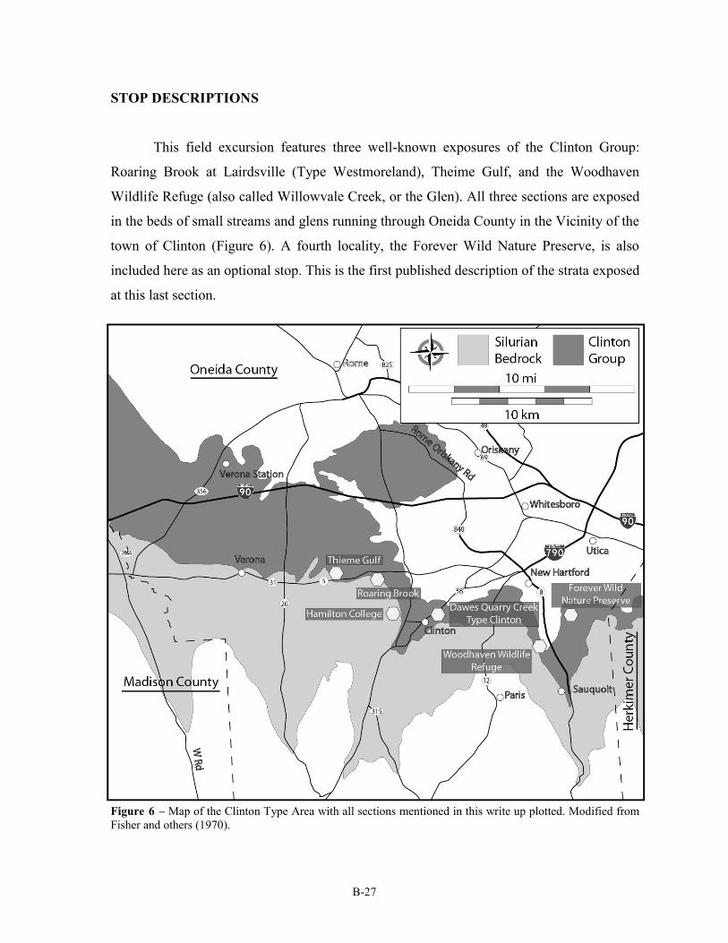
STOP DESCRIPTIONS
This field excursion features three well-known exposures of the Clinton Group:
Roaring Brook at Lairdsville (Type Westmoreland), Theime Gulf, and the Woodhaven
Wildlife Refuge (also called Willowvale Creek, or the Glen). All three sections are exposed
in the beds of small streams and glens running through Oneida County in the Vicinity of the
town of Clinton (Figure 6). A fourth locality, the Forever Wild Nature Preserve, is also
included here as an optional stop. This is the first published description of the strata exposed
at this last section.
Figure 6 – Map of the Clinton Type Area with all sections mentioned in this write up plotted. Modified from
Fisher and others (1970).
B-28
Stop #1. Roaring Brook - Type Section of the Westmoreland Iron Ore
Coordinates: N 43° 04' 48.30", W 75° 25' 16.79"
Roaring Brook is the informal name given to a small, south flowing tributary of Oriskany
Creek found in Lairdsville, a small Hamlet of Clinton, New York, in Oneida County. This locality
was designated by Gillette (1947; p. 91-93) as the type section for the Westmoreland Hematite,
though no detailed description of the outcrop was given. This section is located on private property
and those wishing to view it must first obtain permission from the residents of 7012 NY Rte. 5
(Seneca Turnpike), in Lairdsville, NY. The most straightforward way of accessing the stream bed is
by walking down the western slope of the valley cut by the stream where several paths provide
relatively easy access to the section. A large (3-4 meter) waterfall, capped by the Westmoreland Iron
Ore is a notable feature of this locality. A smaller falls, upstream and closer to the road, is capped by
the Salmon Creek Bed.
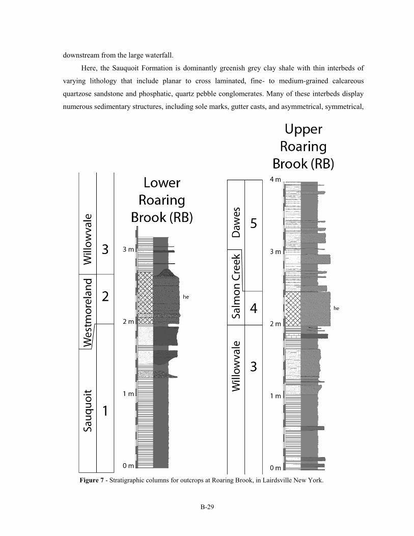
This section has been featured previously as stop 13 of Brett and Goodman (1996). Five
named rock units are exposed here; they are described and illustrated in ascending order herein
(Figure 7).
Unit 1 - Sauquoit Formation
All strata exposed below the large waterfall at this locality are assigned to the Sauquoit
Formation of the Middle Clinton Group (Sequence S-III of Brett et al, 1990). The Sauquoit
Formation is reported to be approximately 30 meters thick in this area; the upper 6-7 meters of the
unit is relatively well exposed along an approximately 0.25 kilometer stretch of creek bed extending
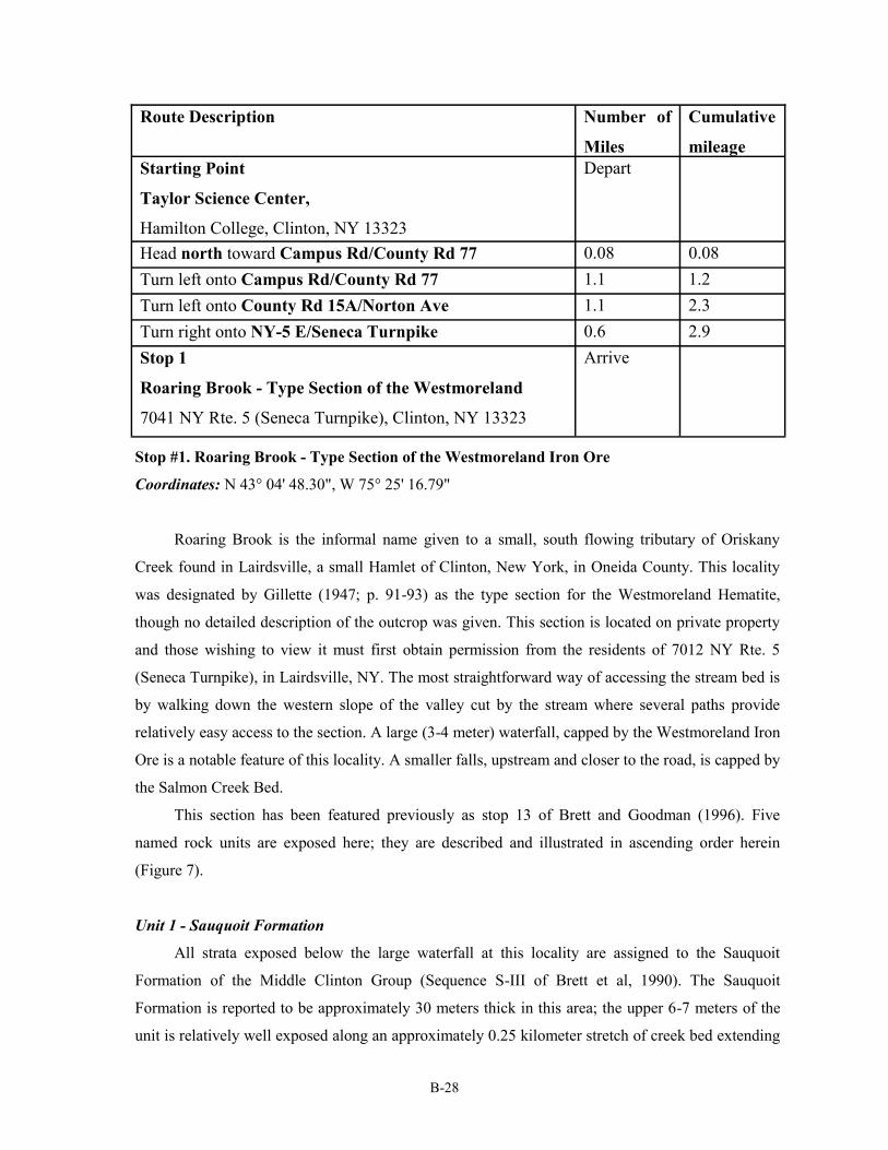
Route Description Number of
Miles
Cumulative
mileage
Starting Point
Taylor Science Center,
Hamilton College, Clinton, NY 13323
Depart
Head north toward Campus Rd/County Rd 77 0.08 0.08
Turn left onto Campus Rd/County Rd 77 1.1 1.2
Turn left onto County Rd 15A/Norton Ave 1.1 2.3
Turn right onto NY-5 E/Seneca Turnpike 0.6 2.9
Stop 1
Roaring Brook - Type Section of the Westmoreland
7041 NY Rte. 5 (Seneca Turnpike), Clinton, NY 13323
Arrive
B-29
Figure 7 - Stratigraphic columns for outcrops at Roaring Brook, in Lairdsville New York.
downstream from the large waterfall.
Here, the Sauquoit Formation is dominantly greenish grey clay shale with thin interbeds of
varying lithology that include planar to cross laminated, fine- to medium-grained calcareous
quartzose sandstone and phosphatic, quartz pebble conglomerates. Many of these interbeds display
numerous sedimentary structures, including sole marks, gutter casts, and asymmetrical, symmetrical,
B-30
and interference ripple marks. Several thick, cross bedded sandstone interbeds occur near the top of
the Sauquoit Formation at this locality, which contain abundant phosphatic shell fragments
tentatively interpreted as lingulid remains. Below these upper sandstone beds is a locally present,
rippled quartz phosphate pebble conglomerate.
Macrofossils are relatively sparse, though bedding planes may contain abundant bivalves and
brachiopods. The brachiopods Strophochonetes (?) cornutus, Leptaena rhomboidalis, and Eocoelia
sulcata are all relatively common, suggesting assignment to Boucot’s (1975) benthic assemblage 2.
Bivalves are also quite common on some bedding planes, and very rare large trilobites have been
found here as well. The presence of Ostracodes belonging to the Mastigobolbina typus Zone suggest
a mid Telychian (C-5) age for these beds.
Unit 2 - Westmoreland Iron Ore
The large waterfall at Roaring Brook is capped by a 70-80 centimeter thick interval of bright
red hematitic beds assigned to the Westmoreland Iron Ore. This horizon has been mined extensively
here, and large portions of this unit are removed.
The bed is composed primarily of small, sand sized "oolitic" sediments composed of
concentric laminae of hematite, chamosite, and berthierine surrounding a nucleus that is usually
composed of a rounded quartz grain (Schoen, 1962). Several conglomeratic horizons are also found
in the Westmoreland Iron Ore at this locality, composed primarily of quartz and phosphatic pebbles
surrounded by a matrix of oolitic, hematitic grains. Brett and Goodman (1996) reported centimeter
wide rectilinear cracks infilled with quartz and phosphate grains underlying the Westmoreland,
which they interpreted as sedimentation within emergent mudcracks forming in the underlying
Sauquoit. The upper surface of the unit displays large (~10 cm high) symmetrical ripple marks.
The Westmoreland is sparsely fossiliferous here, though conodonts of the Pterospathodus
celloni to Pterospathodus amorphognathoides Zones have been reported from the unit here (M.
Kleffner, pers. comm. 1990 in Brett and Goodman, 1996). Brett and Goodman (1996) also report
Eocoelia sulcata, Eospirifer radiatus, and Eoplectodonta transversalis, suggesting a late Telychian
age for this unit. The thin, fossiliferous black shale bed reported in the Westmoreland Iron Ore at
other sections by Gillette (1947) is not present here.
Unit 3 - Willowvale Shale
Sharply overlying the Westmoreland Iron Ore is the Willowvale Shale, which is
approximately 6.1-7.6 meters thick in this area. At Roaring Brook, the unit is primarily gray to olive
grey shaly mudstone with minor interbeds of light colored, sandy fossiliferous dolostones.
B-31
The Willowvale Shale yields a diverse marine fossil assemblage interpreted as the remnants of
a relatively deepwater fauna (Eckert and Brett, 1989). The lower 0.3 to 0.75 meters of the
Willowvale Shale contains several dolostone interbeds, which contain abundant specimens of a
small discoidal rugose coral identified as Palaeocyclus rotuloides a fossil that appears in equivalent
late Telychian strata throughout the world.
Unit 4 - Salmon Creek - Basal Dawes Bed
Upstream from the Willowvale bank exposures, the stream takes a sharp bend that leads up to
a second, small falls just below the culvert under NY Route 5. This small falls is capped by a 40-50
centimeter thick, pinkish, blocky, sandy dolostone, which contains numerous small stringers of
hematite; in the past this unit has been misidentified as Kirkland iron ore at some sections. This bed
is interpreted as the basal bed of the Dawes, also referred to as the Salmon Creek Bed. The dominant
fossils found in this unit are fragments of stalked echinoderms, primarily crinoids which are highly
disarticulated and often impregnated with hematite.
Unit 5 - Dawes Sandstone
Above Unit 4 are a few meters of interbedded siltstones, sandstones and shales assigned to the
Dawes Sandstone, which is the highest stratigraphic unit observed in Roaring Brook on the south
side of NY Route 5. The unit is not fossiliferous and it is poorly exposed, being largely covered by
soil and rip-rap sitting below the culvert under the road. Better exposures of this unit and some of
the underlying beds can be viewed at the next stop.
Route Description Number
of Miles
Cumulative
mileage
Stop 1
Roaring Brook - Type Section of the Westmoreland
7012 NY Rte. 5 (Seneca Turnpike), Clinton, NY 13323
Depart
Head west on NY-5 W/Seneca Turnpike toward County Rd 15A/
Norton Ave
0.8 3.7
Take the 1st right onto Theime Gulf Rd 0.2 3.9
Stop 2
Theime Gulf
4486 Theime Gulf Rd, Clinton NY 13323
Arrive
B-32
Stop #2. Theime Gulf
Coordinates: N 43° 04' 48.17", W 75° 26' 10.80"
The outcrops exposed at Theime Gulf are found in the banks of a small, northwest
flowing tributary of Oriskany Creek. Five named stratigraphic units are featured at this stop,
which partially overlap the section exposed in Roaring Brook at Stop # 2 (See Figure 8).
These outcrops are located on a private residence at 4486 Theime Gulf Road, in Clinton
New York; visitors must obtain permission before entering. This section has been featured
previously as Stop 14 of Brett and Goodman (1996).
Unit 1 - Willowvale Shale
The lowest exposed strata at Theime Gulf are assigned to the upper part of the
Willowvale Shale. Here the unit is primarily a dark grey shaly mudstone with very few
interbeds. Only the upper few meters of the Willowvale Formation are exposed here, and
these can only be accessed with some excavation. A single interbed was observed,
approximately 15 centimeters below the base of Unit 2. This bed was a dark grey, orange-
brown weathering dolomitic carbonate containing abundant fossils, particularly the high
spired gastropod Murchisonia, which is commonly infilled by a black mineral interpreted as
phosphate.
Unit 2 - Salmon Creek - Basal Dawes
Overlying the Unit 1 is an 80-90 centimeter, reddish pink sandy carbonate grainstone
horizon interpreted as the Salmon Creek, or Basal Dawes Bed which supports a small falls
near the bottom of this section. This horizon appears to be much more ferruginous at this
locality than at Roaring Brook (Stop 2). The unit is blocky and heavily cross stratified. Its
upper and lower contacts are sharp, and small rip-up clasts are observed at several horizons.
In contrast to the overlying beds, the Salmon Creek Bed is fairly fossiliferous. Stalked
echinoderm columnals are the primary constituent of this assemblage, many of which are
stained dark red with hematite.
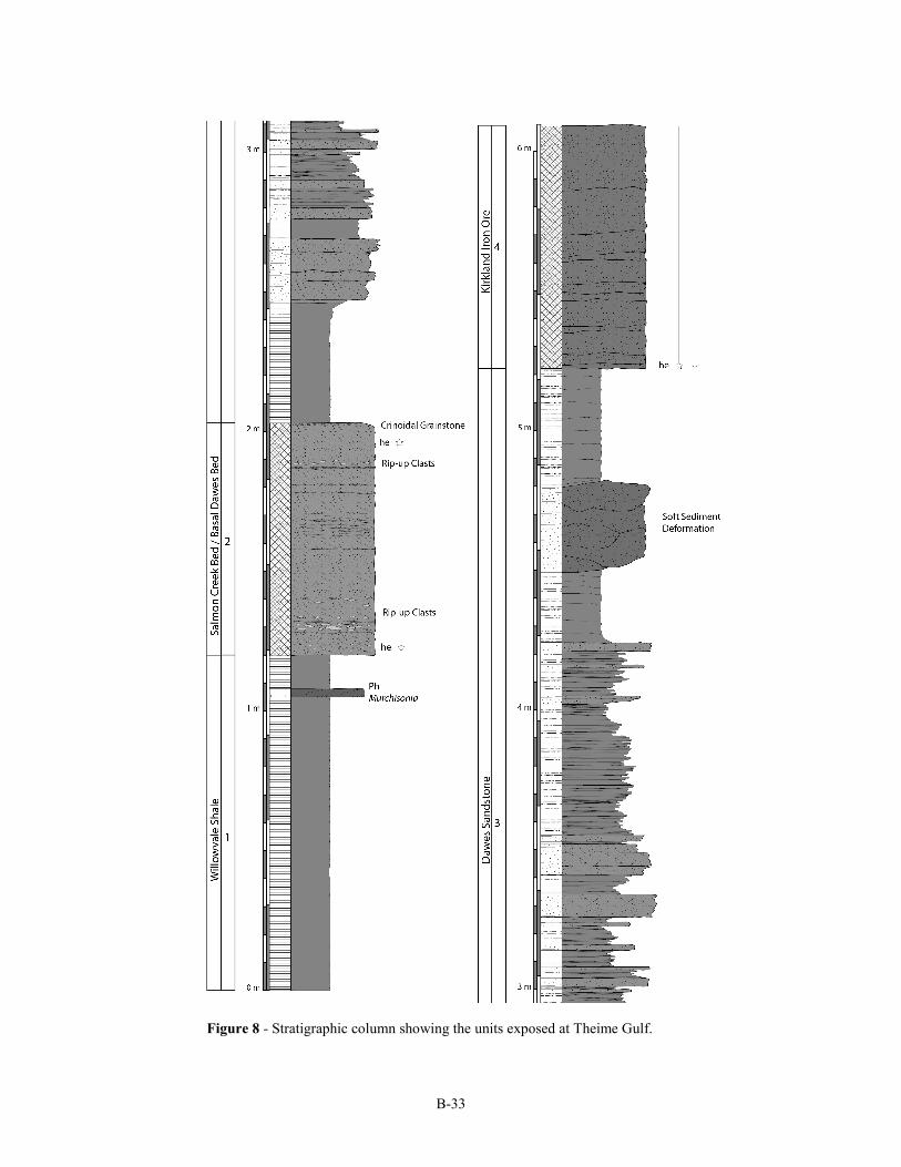
B-33
Figure 8 - Stratigraphic column showing the units exposed at Theime Gulf.
B-34
Unit 3 - Dawes Sandstone
Overlying Unit 2 are approximately 3.2 meters of dark grey shales, siltstones and
sandstones assigned to the Dawes. Fine grained shales and siltstones are the predominant
lithology this interval, in contrast to the coarser beds observed at Dawes Quarry Creek.
These units are generally finely laminated, though the numerous 5-25 centimeter sandstone
interbeds are often massive, with ripples on their upper surfaces. Near the top of this unit is an
approximately half meter interval of sandstone and shale showing extensive deformation and ball
and pillow structures, which are interpreted as post depositional soft-sediment deformation.
Unit 4- Kirkland Iron Ore
Approximately two meters of massive, dark red dolomitic carbonates overlie Unit 3; these
beds are assigned to the Kirkland Iron Ore. The unit is a highly fossiliferous crinoidal, pack- to
grainstone with hematitic cement. Although crinoids are the dominant component of the Kirkland's
fossil assemblage, bryozoans such as Acanthoclema and Eridotrypa are also important components.
Several beds of the Kirkland are display prominent cross stratification. The basal contact of the unit
is sharp, but its upper boundary with the overlying unit is gradational.
Route Description Number
of Miles
Cumulative
mileage
Stop 2
Theime Gulf
4486 Theime Gulf Rd, Clinton NY 13323
Depart
Head south on Theime Gulf Rd toward NY-5 W/Seneca
Turnpike
0.2 4.1
Turn left onto NY-5 E/Seneca Turnpike Continue to follow NY-5 E
6.8 10.9
Continue onto NY-12 N 0.6 11.5
Take the exit toward NY-8 S/New Hartford 0.2 11.7
Merge onto Campion Rd 0.4 12.1
Continue onto Oxford Rd 2.6 14.7
Turn right onto Oneida St 0.6 15.3
Stop 3.
Willowvale Creek at Woodhaven Wildlife Refuge
Woodhaven Lane and Oneida Street, Chadwicks, NY, 13319
Arrive
B-35
Stop #3. Willowvale Creek at Woodhaven Wildlife Refuge
Coordinates: N 43° 01' 50.02, W 75° 16' 44.42"
The Woodhaven Wildlife Refuge is a privately owned nature preserve occupying the site of a
former picnic area in Chadwicks, New York. At this locality several tens of meters of section can be
observed in the bed of Willowvale Creek, a small east-flowing stream which eventually passes
under Oneida Street in Chadwicks. This section was described in detail by Gillette (1947; Section
34), and it represents perhaps the most complete, and best exposed outcrop of the Clinton Group in
its Type Area. However, only thin, ironstone bearing excerpts of this entire section have been
drafted here. Those interested in a more detailed and comprehensive descriptions of the outcrop are
referred to Gillette (1947).
The creek was dammed in three places, forming small artificial ponds along the creek. At least
two ironstone horizons are located some distance upstream; they may be accessed by a short walk
through the scenic preserve. All outcrops described herein are on private land, visitors must first
obtain permission from the administrators of the Woodhaven Wildlife Refuge.
Unit 1 – Sauquoit Formation
Unit 1, assigned to the Sauquoit Formation, is at least 35 meters thick at this locality,
consisting primarily of blue grey to green gray shales and mudstones with many interbeds composed
of calcareous sandstone, siltstone, and quartz-phosphate pebble conglomerates. The unit is
abundantly fossiliferous; bivalves, ostracodes, and brachiopods predominate though some trilobites
have been reported here as well. Intervals containing ball-and-pillow structures have been observed
in shales at several intervals of the Sauquoit at this locality, which are interpreted as the post
depositional soft sediment deformation of units, possibly due to seismic activity. The upper few
meters of the Sauquoit Formation at this locality are difficult to access, though a relatively complete
reconstruction can be compiled through a comparison of creek bed and gully wall outcrops.
Unit 2 – The Westmoreland Hematite
Numerous fragments of oolitic ironstone litter the creek bed, where their bright red color
makes them easy to pick out. Many of these fragments are believed to originate from Unit 2, which
is assigned to the Westmoreland Hematite. The only outcrop of this bed is located at N 43° 01'
47.39", W 75° 16' 49.25", this is within a very steep gully above the lake formed behind the lowest
of the three Willowvale dams (Figure 9). Accessing the outcrop is quite difficult.
The unit is composed primarily of sand sized, iron coated grains which are deeply weathered
B-36
Figure 9 – Stratigraphic column of the upper Sauquoit Formation, Westmoreland Hematite, and
Willowvale Shale exposed within the steep gully above the lake formed by the lowest dam on
Willowvale Creek.
B-37
Unit 4 - Dawes Sandstone
Unit 4 is a succession of relatively unfossiliferous blue grey shales with sandstone and
siltstone interbeds. Although these beds were interpreted previously by Gillette, 1947, as the
Willowvale Formation, we submit that this is a manifestation of the Dawes Sandstone. Although the
Dawes is more shaly here than at Roaring Brook and Theime Gulf the zone of ball-and-pillow
structures is similar to that of those and other successions of the Dawes.
Unit 5 - Kirkland Hematite
Unit 5 is a ferruginous limestone that forms the caprock of a small waterfall at approximately
N 43° 01' 44.40", W 75°16' 57.31", just upstream from the lake formed by the middle Willowvale
Dam. This bed is interpreted as the Kirkland hematite (or flux ore), a calcareous, fossiliferous
hematitic ore overlying a zone of soft sediment deformation in the upper Dawes Formation (Figure
in the outcrop. These are bright red in color, and
unfossiliferous. A black shale lens within the
hematite was observed here, similar to the ones
described by Gillette (1947), but no fossils were
observed in this horizon either.
Unit 3 – Willowvale Shale
Unit 3 constitutes the predominantly shaly
unit between the ironstones represented by Units
2 and 4.This interval is interpreted as the
Willowvale Shale which, like the Sauquoit
Formation, consists of dark grey shales with
occasional interbedded, fossiliferous calcareous
sandstones. Unlike the Sauquoit, the shales of the
Willowvale are dark to olive grey in color, and
there are no conglomeratic horizons. The coral
Palaeocyclus is abundant in the beds of the lower
part of this horizon, though these can only be
accessed with difficulty here. Other common
fossils are brachiopods, bivalves, ostracodes, and
graptolites.
Figure 10– Stratigraphic column of the upper
Willowvale Shale, Kirkland Hematite, and lower
Herkimer Sandstone exposed at the waterfall just
upstream from the lake formed by the middle
Willowvale Creek dam.
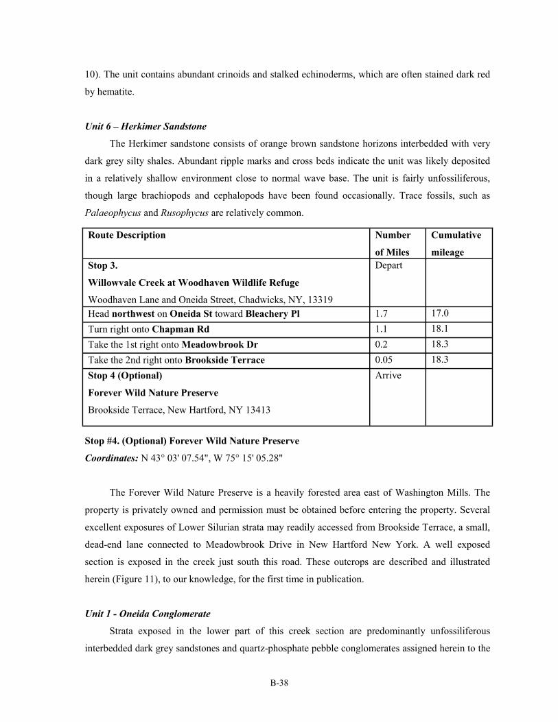
B-38
10). The unit contains abundant crinoids and stalked echinoderms, which are often stained dark red
by hematite.
Unit 6 – Herkimer Sandstone
The Herkimer sandstone consists of orange brown sandstone horizons interbedded with very
dark grey silty shales. Abundant ripple marks and cross beds indicate the unit was likely deposited
in a relatively shallow environment close to normal wave base. The unit is fairly unfossiliferous,
though large brachiopods and cephalopods have been found occasionally. Trace fossils, such as
Palaeophycus and Rusophycus are relatively common.
Route Description Number
of Miles
Cumulative
mileage
Stop 3.
Willowvale Creek at Woodhaven Wildlife Refuge
Woodhaven Lane and Oneida Street, Chadwicks, NY, 13319
Depart
Head northwest on Oneida St toward Bleachery Pl 1.7 17.0
Turn right onto Chapman Rd 1.1 18.1
Take the 1st right onto Meadowbrook Dr 0.2 18.3
Take the 2nd right onto Brookside Terrace 0.05 18.3
Stop 4 (Optional)
Forever Wild Nature Preserve
Brookside Terrace, New Hartford, NY 13413
Arrive
Stop #4. (Optional) Forever Wild Nature Preserve
Coordinates: N 43° 03' 07.54", W 75° 15' 05.28"
The Forever Wild Nature Preserve is a heavily forested area east of Washington Mills. The
property is privately owned and permission must be obtained before entering the property. Several
excellent exposures of Lower Silurian strata may readily accessed from Brookside Terrace, a small,
dead-end lane connected to Meadowbrook Drive in New Hartford New York. A well exposed
section is exposed in the creek just south this road. These outcrops are described and illustrated
herein (Figure 11), to our knowledge, for the first time in publication.
Unit 1 - Oneida Conglomerate
Strata exposed in the lower part of this creek section are predominantly unfossiliferous
interbedded dark grey sandstones and quartz-phosphate pebble conglomerates assigned herein to the
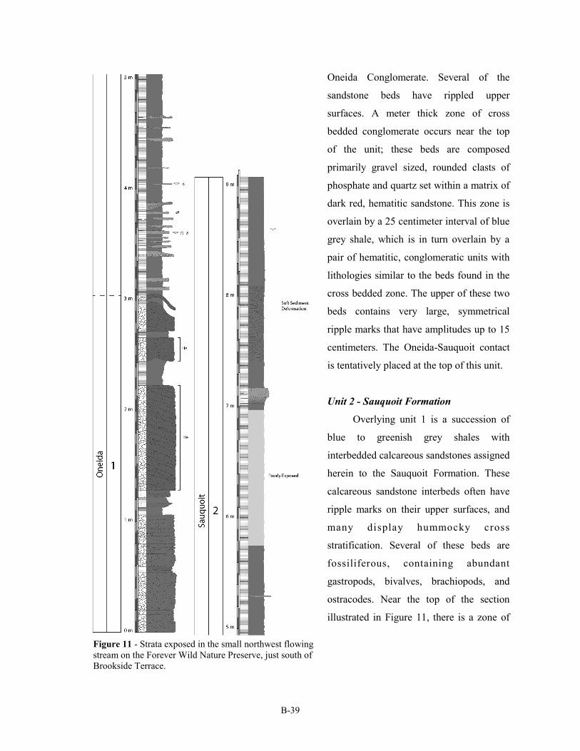
B-39
Oneida Conglomerate. Several of the
sandstone beds have rippled upper
surfaces. A meter thick zone of cross
bedded conglomerate occurs near the top
of the unit; these beds are composed
primarily gravel sized, rounded clasts of
phosphate and quartz set within a matrix of
dark red, hematitic sandstone. This zone is
overlain by a 25 centimeter interval of blue
grey shale, which is in turn overlain by a
pair of hematitic, conglomeratic units with
lithologies similar to the beds found in the
cross bedded zone. The upper of these two
beds contains very large, symmetrical
ripple marks that have amplitudes up to 15
centimeters. The Oneida-Sauquoit contact
is tentatively placed at the top of this unit.
Unit 2 - Sauquoit Formation
Overlying unit 1 is a succession of
blue to greenish grey shales with
interbedded calcareous sandstones assigned
herein to the Sauquoit Formation. These
calcareous sandstone interbeds often have
ripple marks on their upper surfaces, and
many display hummocky cross
stratification. Several of these beds are
fossiliferous, containing abundant
gastropods, bivalves, brachiopods, and
ostracodes. Near the top of the section
illustrated in Figure 11, there is a zone of
Figure 11 - Strata exposed in the small northwest flowing
stream on the Forever Wild Nature Preserve, just south of
Brookside Terrace.
B-40
irregularly bedded shales interpreted as the product of post depositional, soft-sediment deformation,
possibly as a result of seismicity.
Route Description Number of
Miles
Cumulative
mileage
Stop 4 (Optional)
Forever Wild Nature Preserve
Brookside Terrace, New Hartford, NY 13413
Depart
Head northeast on Brookside Terrace toward Meadowbrook Dr 0.05 18.4
Turn left onto Meadowbrook Dr 0.2 18.6
Take the 2nd left onto Chapman Rd 1.2 19.8
Turn right onto the NY-8 ramp 0.3 20.1
Merge onto New York 8 N 1.8 21.9
Continue onto NY-840 W 0.2 22.1
Take the exit onto NY-12 S/NY-5 W toward Syracuse/
Binghamton
1.1 23.2
Turn left onto New York 12B S/Clinton Rd 4.1 27.3
Slight left onto E Park Row 0.1 27.4
Take the 2nd right onto S Park Row 0.05 27.4
Continue onto College St 0.9 28.3
Continue onto College Hill Rd/County Rd 13 0.5 28.8
Turn right onto Campus Rd/County Rd 77 0.3 29.1
Turn left 0.05 29.2
Ending Point
Taylor Science Center,
Hamilton College, Clinton, NY 13323
Arrive

![Welcome [] · Fonts: Helvetica, Zapf Chancery, Zapf Dingbats, Garamond Ultra, Garamond Bold Condensed, Garamond Book Condensed, Garamond Bold Condensed Italic, Garamond Book Condensed](https://img.pdfslide.net/doc/110x75/6012d296ce02d15e58711fea/welcome-fonts-helvetica-zapf-chancery-zapf-dingbats-garamond-ultra-garamond.jpg)