Embed Size (px)
Citation preview
C O U N T Y T R A I L S P R O G R A M
C O M M U N I T Y T R A I L S M A S T E R P L A N
Jamul-Dulzura Community Trails and Pathways Plan JD1
Jamul-Dulzura Community Trail and Pathway Plan Trails: The Community Connection
he Community Trails Master Plan will be utilized to develop a system of interconnected regional and
community trails and pathways. These trails and pathways are intended to address an established public need for recreation and transportation, but will also provide health and quality of life benefits associated with hiking, biking, and horseback riding throughout the County’s biologically diverse environments.
Community trails serve a different function than regional trails, which are focused on the provision of long linear distances. Instead, community trails are “local public facilities” in close proximity to residents that provide transportation, recreation, access, infrastructure, linkages and safe routes throughout a community. The Community Trails Master Plan (CTMP) involves both trail development and management on public, semi-public and private lands. The CTMP has established two forms of non-motorized facilities called “Trails” and “Pathways” that provide passive recreational, and alternative modes of transportation.
Trails are typically away from vehicular roads that are primarily recreational in nature but can also serve as an alternative mode of transportation. They are soft-surface facilities for single or multiple uses by pedestrians, equestrians, and mountain bicyclists.
Pathways are a non-motorized transportation facility located within a parkway or road right of way. A riding and hiking trail located in the road right of way is considered a pathway. They are soft-surfaced facilities intended to serve both circulation and recreation purposes. Pathways help make critical connections and are an integral part of a functional trail system.
COMMUNITY TRAIL STATEMENT
The Jamul-Dulzura Community Plan Area has a large percentage of public lands that have been purchased as wildlife corridors and preserves. The varied terrain provides for many opportunities to enjoy natural beauty of the region. The California Riding and Hiking Trail, established in 1948 by the State of California, runs north and south
T
C O U N T Y T R A I L S P R O G R A M
C O M M U N I T Y T R A I L S M A S T E R P L A N
Jamul-Dulzura Community Trails and Pathways Plan JD2
throughout the area. Unfortunately, some of that easement has been lost and re-establishing that trails in its entirety should be a priority of the San Diego County Trails Master Plan. The Jamul-Dulzura Community Planning Group encourages connector trails, especially those linking up to the California Riding and Hiking Trail. New development (major subdivisions) should be encouraged to provide for non-motorized, multi-use trails as designated in the Jamul Community trial Plan. Wilderness trails are preferred except in the more heavily populated areas.
THE NEED FOR TRAILS
The community trail needs are based on an equation established by the Trails System Assessment (TSA) in 2001, which identified a minimum baseline level of service for each community by population. The Baseline Level of Service or Trail Need is 0.8 miles of trail per 1,000 people.
The “Trail Need” is the minimum length of trail miles (baseline level of service) for each Community and Subregional Plan Area. The TSA calculations for community trail needs are as follows:
Trail Need = (Community Population /1,000 residents x 0.8 miles of trails)
2000 Trail Need = (2000 population /1,000 residents x 0.8 miles of trails)
2020 Trail Need = (2020 population /1,000 residents x 0.8 miles of trails)
Population statistics from the 2000 U.S. Census were used to determine the current trail needs in Jamul-Dulzura. Based on the census, the population of the Jamul-Dulzura Community Plan Area is 9,221 and there is a current need for 7 miles of community trails. In the year 2020, the population is projected to increase to 21,400 and there would be a future need for 17 miles of community trails.
For additional information about the baseline level of service and trail needs, please refer to the discussion under “The Need for Trails” and Tables NT-1 and NT-2 in the CTMP.
COUNTYWIDE TRAIL GOALS AND POLICIES
The “Countywide Goals and Policies” contained in the CTMP apply to all community and sub-regional plan areas. Community-specific goals and policies are intended to accommodate specific needs and they will be implemented when feasible. Where Community-specific goals and policies are not addressed, the “Countywide Goals and Policies” contained in CTMP shall apply.
DESIGN AND CONSTRUCTION GUIDELINES
Countywide trail guidelines in the Community Trails Master Plan apply to all community and sub-regional plan areas. Community-specific guidelines are intended to accommodate specific community needs
C O U N T Y T R A I L S P R O G R A M
C O M M U N I T Y T R A I L S M A S T E R P L A N
Jamul-Dulzura Community Trails and Pathways Plan JD3
and they will be implemented when feasible. Where Community specific guidelines are not addressed, the Countywide “Design and Construction Guidelines” contained in the CTMP shall apply.
JAMUL-DULZURA COMMUNITY TRAILS MAP SUMMARY
As a result of the community trails outreach process for development of the CTMP, the Jamul-Dulzura Community Planning Group completed several tasks, and prioritized community trails and pathways as well as their special features. Each trail and pathway was labeled and recorded producing a community trails map and index.
Proposed trails shown on trails maps contained in the Community Trail Master Plan depict corridors of general alignments. The term “general alignment” is used to describe the general location of a future trail
within a designated corridor so that the specific alignment can be determined during the review and approval process when a discretionary application is submitted for a development permit for land that includes a trail corridor. The designated corridor is approximately one–quarter mile wide. A general alignment is useful because it allows the trail to be located to avoid extreme topographical conditions, sensitive habit or other site-specific constraints.
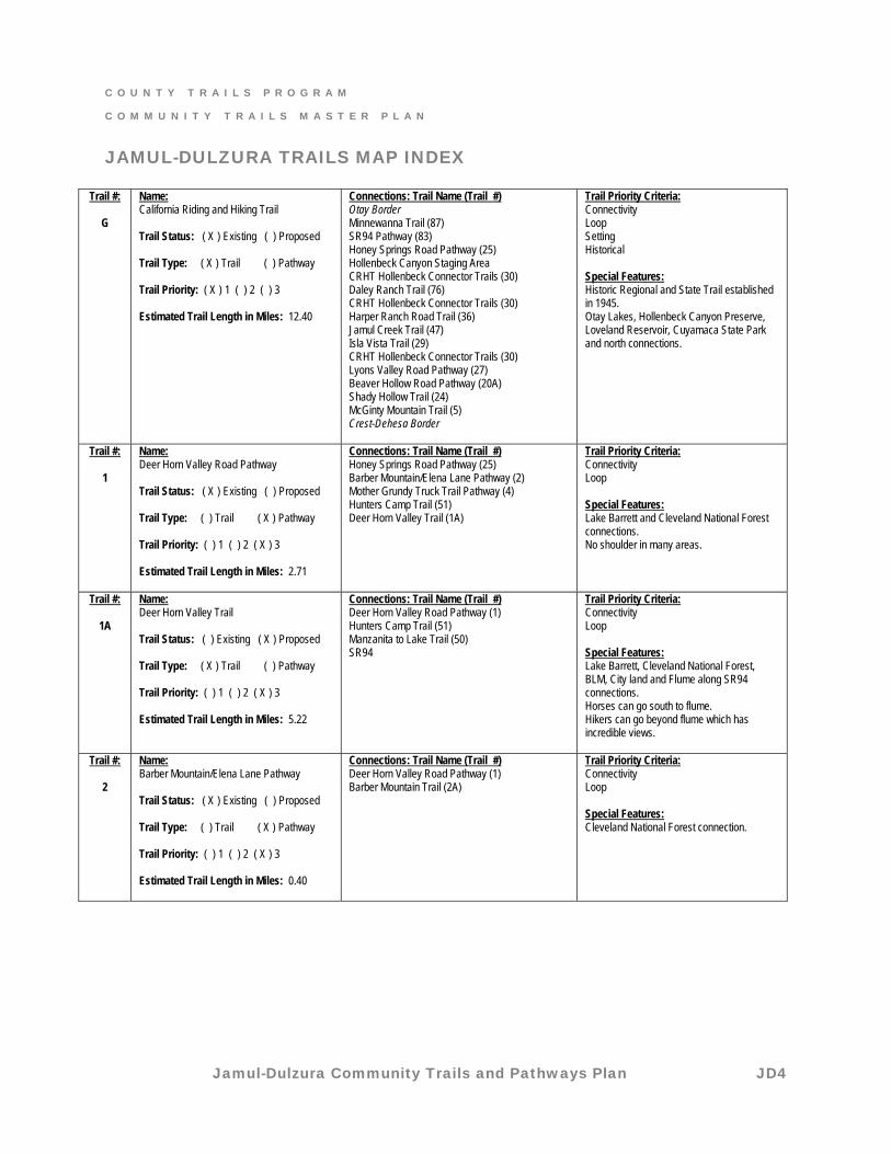
JAMUL-DULZURA COMMUNITY TRAILS MAP INDEX
The following community trails map index was completed by the Jamul-Dulzura Community Planning Group and will be used as a reference tool. Neighboring communities are italicized and where trail or pathway connections exist, the community trail name and number are included.
C O U N T Y T R A I L S P R O G R A M
C O M M U N I T Y T R A I L S M A S T E R P L A N
Jamul-Dulzura Community Trails and Pathways Plan JD4
JAMUL-DULZURA TRAILS MAP INDEX
Trail #:
G
Name: California Riding and Hiking Trail Trail Status: ( X ) Existing ( ) Proposed Trail Type: ( X ) Trail ( ) Pathway Trail Priority: ( X ) 1 ( ) 2 ( ) 3 Estimated Trail Length in Miles: 12.40
Connections: Trail Name (Trail #) Otay Border Minnewanna Trail (87) SR94 Pathway (83) Honey Springs Road Pathway (25) Hollenbeck Canyon Staging Area CRHT Hollenbeck Connector Trails (30) Daley Ranch Trail (76) CRHT Hollenbeck Connector Trails (30) Harper Ranch Road Trail (36) Jamul Creek Trail (47) Isla Vista Trail (29) CRHT Hollenbeck Connector Trails (30) Lyons Valley Road Pathway (27) Beaver Hollow Road Pathway (20A) Shady Hollow Trail (24) McGinty Mountain Trail (5) Crest-Dehesa Border
Trail Priority Criteria: Connectivity Loop Setting Historical Special Features: Historic Regional and State Trail established in 1945. Otay Lakes, Hollenbeck Canyon Preserve, Loveland Reservoir, Cuyamaca State Park and north connections.
Trail #:
1
Name: Deer Horn Valley Road Pathway Trail Status: ( X ) Existing ( ) Proposed Trail Type: ( ) Trail ( X ) Pathway Trail Priority: ( ) 1 ( ) 2 ( X ) 3 Estimated Trail Length in Miles: 2.71
Connections: Trail Name (Trail #) Honey Springs Road Pathway (25) Barber Mountain/Elena Lane Pathway (2) Mother Grundy Truck Trail Pathway (4) Hunters Camp Trail (51) Deer Horn Valley Trail (1A)
Trail Priority Criteria: Connectivity Loop Special Features: Lake Barrett and Cleveland National Forest connections. No shoulder in many areas.
Trail #:
1A
Name: Deer Horn Valley Trail Trail Status: ( ) Existing ( X ) Proposed Trail Type: ( X ) Trail ( ) Pathway Trail Priority: ( ) 1 ( ) 2 ( X ) 3 Estimated Trail Length in Miles: 5.22
Connections: Trail Name (Trail #) Deer Horn Valley Road Pathway (1) Hunters Camp Trail (51) Manzanita to Lake Trail (50) SR94
Trail Priority Criteria: Connectivity Loop Special Features: Lake Barrett, Cleveland National Forest, BLM, City land and Flume along SR94 connections. Horses can go south to flume. Hikers can go beyond flume which has incredible views.
Trail #:
2
Name: Barber Mountain/Elena Lane Pathway Trail Status: ( X ) Existing ( ) Proposed Trail Type: ( ) Trail ( X ) Pathway Trail Priority: ( ) 1 ( ) 2 ( X ) 3 Estimated Trail Length in Miles: 0.40
Connections: Trail Name (Trail #) Deer Horn Valley Road Pathway (1) Barber Mountain Trail (2A)
Trail Priority Criteria: Connectivity Loop Special Features: Cleveland National Forest connection.
C O U N T Y T R A I L S P R O G R A M
C O M M U N I T Y T R A I L S M A S T E R P L A N
Jamul-Dulzura Community Trails and Pathways Plan JD5
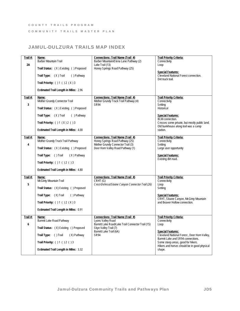
JAMUL-DULZURA TRAILS MAP INDEX
Trail #:
2A
Name: Barber Mountain Trail Trail Status: ( X ) Existing ( ) Proposed Trail Type: ( X ) Trail ( ) Pathway Trail Priority: ( ) 1 ( ) 2 ( X ) 3 Estimated Trail Length in Miles: 2.96
Connections: Trail Name (Trail #) Barber Mountain/Elena Lane Pathway (2) Lake Trail (13) Honey Springs Road Pathway (25)
Trail Priority Criteria: Connectivity Loop Special Features: Cleveland National Forest connection. Dirt truck trail.
Trail #:
3
Name: Mother Grundy Connector Trail Trail Status: ( X ) Existing ( ) Proposed Trail Type: ( X ) Trail ( ) Pathway Trail Priority: ( ) 1 ( X ) 2 ( ) 3 Estimated Trail Length in Miles: 4.00
Connections: Trail Name (Trail #) Mother Grundy Truck Trail Pathway (4) SR94
Trail Priority Criteria: Connectivity Setting Historical Special Features: BLM connection. Crosses some private, but mostly public land. Old bunkhouse along trail was a camp station.
Trail #:
4
Name: Mother Grundy Truck Trail Pathway Trail Status: ( X ) Existing ( ) Proposed Trail Type: ( ) Trail ( X ) Pathway Trail Priority: ( ) 1 ( ) 2 ( ) 3 Estimated Trail Length in Miles: 4.80
Connections: Trail Name (Trail #) Honey Springs Road Pathway (25) Mother Grundy Connector Trail (3) Deer Horn Valley Road Pathway (1)
Trail Priority Criteria: Connectivity Setting Large user opportunity Special Features: Existing dirt road.
Trail #:
5
Name: McGinty Mountain Trail Trail Status: ( X) Existing ( ) Proposed Trail Type: ( X) Trail ( ) Pathway Trail Priority: ( ) 1 ( ) 2 ( X ) 3 Estimated Trail Length in Miles: 0.91
Connections: Trail Name (Trail #) CRHT (G) Crest-Dehesa/Sloane Canyon Connector Trail (26)
Trail Priority Criteria: Connectivity Loop Setting Special Features: CRHT, Sloane Canyon, McGinty Mountain and Beaver Hollow connection.
Trail #:
6
Name: Barrett Lake Road Pathway Trail Status: ( X) Existing ( ) Proposed Trail Type: ( ) Trail ( X) Pathway Trail Priority: ( ) 1 ( ) 2 ( ) 3 Estimated Trail Length in Miles: 3.32
Connections: Trail Name (Trail #) Lyons Valley Road Barrett Lake Road/Lake Trail Connector Trail (15) Skye Valley Trail (7) Barrett Lake Trail (6A) SR94
Trail Priority Criteria: Connectivity Loop Special Features: Cleveland National Forest , Deer Horn Valley, Barrett Lake and SR94 connections. Some steep areas, good for hikers. Hikers and horses should be in good physical shape.
C O U N T Y T R A I L S P R O G R A M
C O M M U N I T Y T R A I L S M A S T E R P L A N
Jamul-Dulzura Community Trails and Pathways Plan JD6
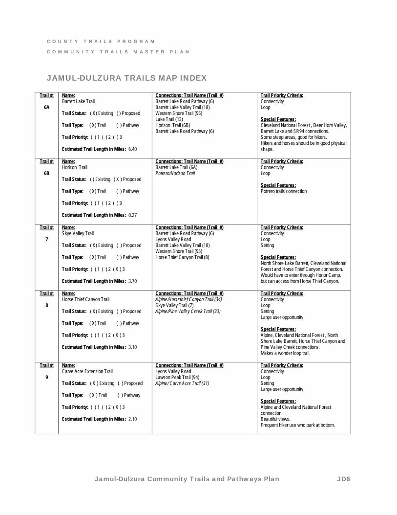
JAMUL-DULZURA TRAILS MAP INDEX
Trail #:
6A
Name: Barrett Lake Trail Trail Status: ( X) Existing ( ) Proposed Trail Type: ( X) Trail ( ) Pathway Trail Priority: ( ) 1 ( ) 2 ( ) 3 Estimated Trail Length in Miles: 6.40
Connections: Trail Name (Trail #) Barrett Lake Road Pathway (6) Barrett Lake Valley Trail (18) Western Shore Trail (95) Lake Trail (13) Horizon Trail (6B) Barrett Lake Road Pathway (6)
Trail Priority Criteria: Connectivity Loop Special Features: Cleveland National Forest , Deer Horn Valley, Barrett Lake and SR94 connections. Some steep areas, good for hikers. Hikers and horses should be in good physical shape.
Trail #:
6B
Name: Horizon Trail Trail Status: ( ) Existing ( X ) Proposed Trail Type: ( X) Trail ( ) Pathway Trail Priority: ( ) 1 ( ) 2 ( ) 3 Estimated Trail Length in Miles: 0.27
Connections: Trail Name (Trail #) Barrett Lake Trail (6A) Potrero/Horizon Trail
Trail Priority Criteria: Connectivity Loop Special Features: Potrero trails connection
Trail #:
7
Name: Skye Valley Trail Trail Status: ( X) Existing ( ) Proposed Trail Type: ( X) Trail ( ) Pathway Trail Priority: ( ) 1 ( ) 2 ( X ) 3 Estimated Trail Length in Miles: 3.70
Connections: Trail Name (Trail #) Barrett Lake Road Pathway (6) Lyons Valley Road Barrett Lake Valley Trail (18) Western Shore Trail (95) Horse Thief Canyon Trail (8)
Trail Priority Criteria: Connectivity Loop Setting Special Features: North Shore Lake Barrett, Cleveland National Forest and Horse Thief Canyon connection. Would have to enter through Honor Camp, but can access from Horse Thief Canyon.
Trail #:
8
Name: Horse Thief Canyon Trail Trail Status: ( X) Existing ( ) Proposed Trail Type: ( X) Trail ( ) Pathway Trail Priority: ( ) 1 ( ) 2 ( X ) 3 Estimated Trail Length in Miles: 3.10
Connections: Trail Name (Trail #) Alpine/Horsethief Canyon Trail (34) Skye Valley Trail (7) Alpine/Pine Valley Creek Trail (33)
Trail Priority Criteria: Connectivity Loop Setting Large user opportunity Special Features: Alpine, Cleveland National Forest , North Shore Lake Barrett, Horse Thief Canyon and Pine Valley Creek connections. Makes a wonder loop trail.
Trail #:
9
Name: Carve Acre Extension Trail Trail Status: ( X ) Existing ( ) Proposed Trail Type: ( X ) Trail ( ) Pathway Trail Priority: ( ) 1 ( ) 2 ( X ) 3 Estimated Trail Length in Miles: 2.10
Connections: Trail Name (Trail #) Lyons Valley Road Lawson Peak Trail (94) Alpine/ Carve Acre Trail (31)
Trail Priority Criteria: Connectivity Loop Setting Large user opportunity Special Features: Alpine and Cleveland National Forest connection. Beautiful views. Frequent hiker use who park at bottom.
C O U N T Y T R A I L S P R O G R A M
C O M M U N I T Y T R A I L S M A S T E R P L A N
Jamul-Dulzura Community Trails and Pathways Plan JD7
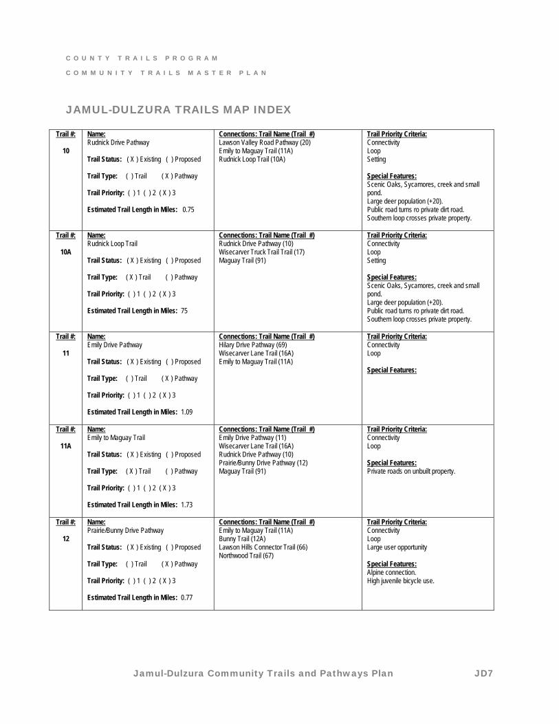
JAMUL-DULZURA TRAILS MAP INDEX
Trail #:
10
Name: Rudnick Drive Pathway Trail Status: ( X ) Existing ( ) Proposed Trail Type: ( ) Trail ( X ) Pathway Trail Priority: ( ) 1 ( ) 2 ( X ) 3 Estimated Trail Length in Miles: 0.75
Connections: Trail Name (Trail #) Lawson Valley Road Pathway (20) Emily to Maguay Trail (11A) Rudnick Loop Trail (10A)
Trail Priority Criteria: Connectivity Loop Setting Special Features: Scenic Oaks, Sycamores, creek and small pond. Large deer population (+20). Public road turns ro private dirt road. Southern loop crosses private property.
Trail #:
10A
Name: Rudnick Loop Trail Trail Status: ( X ) Existing ( ) Proposed Trail Type: ( X ) Trail ( ) Pathway Trail Priority: ( ) 1 ( ) 2 ( X ) 3 Estimated Trail Length in Miles: 75
Connections: Trail Name (Trail #) Rudnick Drive Pathway (10) Wisecarver Truck Trail Trail (17) Maguay Trail (91)
Trail Priority Criteria: Connectivity Loop Setting Special Features: Scenic Oaks, Sycamores, creek and small pond. Large deer population (+20). Public road turns ro private dirt road. Southern loop crosses private property.
Trail #:
11
Name: Emily Drive Pathway Trail Status: ( X ) Existing ( ) Proposed Trail Type: ( ) Trail ( X ) Pathway Trail Priority: ( ) 1 ( ) 2 ( X ) 3 Estimated Trail Length in Miles: 1.09
Connections: Trail Name (Trail #) Hilary Drive Pathway (69) Wisecarver Lane Trail (16A) Emily to Maguay Trail (11A)
Trail Priority Criteria: Connectivity Loop Special Features:
Trail #:
11A
Name: Emily to Maguay Trail Trail Status: ( X ) Existing ( ) Proposed Trail Type: ( X ) Trail ( ) Pathway Trail Priority: ( ) 1 ( ) 2 ( X ) 3 Estimated Trail Length in Miles: 1.73
Connections: Trail Name (Trail #) Emily Drive Pathway (11) Wisecarver Lane Trail (16A) Rudnick Drive Pathway (10) Prairie/Bunny Drive Pathway (12) Maguay Trail (91)
Trail Priority Criteria: Connectivity Loop Special Features: Private roads on unbuilt property.
Trail #:
12
Name: Prairie/Bunny Drive Pathway Trail Status: ( X ) Existing ( ) Proposed Trail Type: ( ) Trail ( X ) Pathway Trail Priority: ( ) 1 ( ) 2 ( X ) 3 Estimated Trail Length in Miles: 0.77
Connections: Trail Name (Trail #) Emily to Maguay Trail (11A) Bunny Trail (12A) Lawson Hills Connector Trail (66) Northwood Trail (67)
Trail Priority Criteria: Connectivity Loop Large user opportunity Special Features: Alpine connection. High juvenile bicycle use.
C O U N T Y T R A I L S P R O G R A M
C O M M U N I T Y T R A I L S M A S T E R P L A N
Jamul-Dulzura Community Trails and Pathways Plan JD8
JAMUL-DULZURA TRAILS MAP INDEX
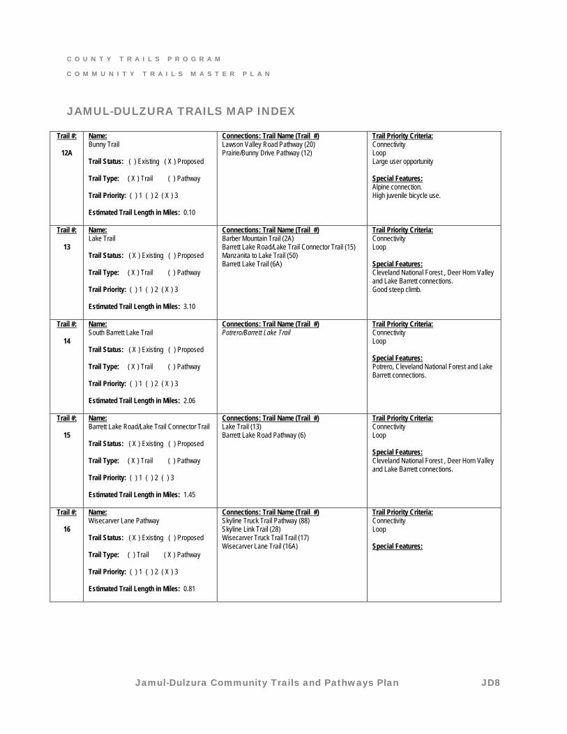
Trail #:
12A
Name: Bunny Trail Trail Status: ( ) Existing ( X ) Proposed Trail Type: ( X ) Trail ( ) Pathway Trail Priority: ( ) 1 ( ) 2 ( X ) 3 Estimated Trail Length in Miles: 0.10
Connections: Trail Name (Trail #) Lawson Valley Road Pathway (20) Prairie/Bunny Drive Pathway (12)
Trail Priority Criteria: Connectivity Loop Large user opportunity Special Features: Alpine connection. High juvenile bicycle use.
Trail #:
13
Name: Lake Trail Trail Status: ( X ) Existing ( ) Proposed Trail Type: ( X ) Trail ( ) Pathway Trail Priority: ( ) 1 ( ) 2 ( X ) 3 Estimated Trail Length in Miles: 3.10
Connections: Trail Name (Trail #) Barber Mountain Trail (2A) Barrett Lake Road/Lake Trail Connector Trail (15) Manzanita to Lake Trail (50) Barrett Lake Trail (6A)
Trail Priority Criteria: Connectivity Loop Special Features: Cleveland National Forest , Deer Horn Valley and Lake Barrett connections. Good steep climb.
Trail #:
14
Name: South Barrett Lake Trail Trail Status: ( X ) Existing ( ) Proposed Trail Type: ( X ) Trail ( ) Pathway Trail Priority: ( ) 1 ( ) 2 ( X ) 3 Estimated Trail Length in Miles: 2.06
Connections: Trail Name (Trail #) Potrero/Barrett Lake Trail
Trail Priority Criteria: Connectivity Loop Special Features: Potrero, Cleveland National Forest and Lake Barrett connections.
Trail #:
15
Name: Barrett Lake Road/Lake Trail Connector Trail Trail Status: ( X ) Existing ( ) Proposed Trail Type: ( X ) Trail ( ) Pathway Trail Priority: ( ) 1 ( ) 2 ( ) 3 Estimated Trail Length in Miles: 1.45
Connections: Trail Name (Trail #) Lake Trail (13) Barrett Lake Road Pathway (6)
Trail Priority Criteria: Connectivity Loop Special Features: Cleveland National Forest , Deer Horn Valley and Lake Barrett connections.
Trail #:
16
Name: Wisecarver Lane Pathway Trail Status: ( X ) Existing ( ) Proposed Trail Type: ( ) Trail ( X ) Pathway Trail Priority: ( ) 1 ( ) 2 ( X ) 3 Estimated Trail Length in Miles: 0.81
Connections: Trail Name (Trail #) Skyline Truck Trail Pathway (88) Skyline Link Trail (28) Wisecarver Truck Trail Trail (17) Wisecarver Lane Trail (16A)
Trail Priority Criteria: Connectivity Loop Special Features:
C O U N T Y T R A I L S P R O G R A M
C O M M U N I T Y T R A I L S M A S T E R P L A N
Jamul-Dulzura Community Trails and Pathways Plan JD9
JAMUL-DULZURA TRAILS MAP INDEX
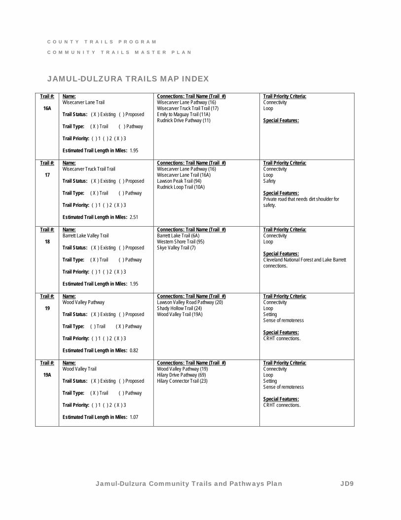
Trail #:
16A
Name: Wisecarver Lane Trail Trail Status: ( X ) Existing ( ) Proposed Trail Type: ( X ) Trail ( ) Pathway Trail Priority: ( ) 1 ( ) 2 ( X ) 3 Estimated Trail Length in Miles: 1.95
Connections: Trail Name (Trail #) Wisecarver Lane Pathway (16) Wisecarver Truck Trail Trail (17) Emily to Maguay Trail (11A) Rudnick Drive Pathway (11)
Trail Priority Criteria: Connectivity Loop Special Features:
Trail #:
17
Name: Wisecarver Truck Trail Trail Trail Status: ( X ) Existing ( ) Proposed Trail Type: ( X ) Trail ( ) Pathway Trail Priority: ( ) 1 ( ) 2 ( X ) 3 Estimated Trail Length in Miles: 2.51
Connections: Trail Name (Trail #) Wisecarver Lane Pathway (16) Wisecarver Lane Trail (16A) Lawson Peak Trail (94) Rudnick Loop Trail (10A)
Trail Priority Criteria: Connectivity Loop Safety Special Features: Private road that needs dirt shoulder for safety.
Trail #:
18
Name: Barrett Lake Valley Trail Trail Status: ( X ) Existing ( ) Proposed Trail Type: ( X ) Trail ( ) Pathway Trail Priority: ( ) 1 ( ) 2 ( X ) 3 Estimated Trail Length in Miles: 1.95
Connections: Trail Name (Trail #) Barrett Lake Trail (6A) Western Shore Trail (95) Skye Valley Trail (7)
Trail Priority Criteria: Connectivity Loop Special Features: Cleveland National Forest and Lake Barrett connections.
Trail #:
19
Name: Wood Valley Pathway Trail Status: ( X ) Existing ( ) Proposed Trail Type: ( ) Trail ( X ) Pathway Trail Priority: ( ) 1 ( ) 2 ( X ) 3 Estimated Trail Length in Miles: 0.82
Connections: Trail Name (Trail #) Lawson Valley Road Pathway (20) Shady Hollow Trail (24) Wood Valley Trail (19A)
Trail Priority Criteria: Connectivity Loop Setting Sense of remoteness Special Features: CRHT connections.
Trail #:
19A
Name: Wood Valley Trail Trail Status: ( X ) Existing ( ) Proposed Trail Type: ( X ) Trail ( ) Pathway Trail Priority: ( ) 1 ( ) 2 ( X ) 3 Estimated Trail Length in Miles: 1.07
Connections: Trail Name (Trail #) Wood Valley Pathway (19) Hilary Drive Pathway (69) Hilary Connector Trail (23)
Trail Priority Criteria: Connectivity Loop Setting Sense of remoteness Special Features: CRHT connections.
C O U N T Y T R A I L S P R O G R A M
C O M M U N I T Y T R A I L S M A S T E R P L A N
Jamul-Dulzura Community Trails and Pathways Plan JD10
JAMUL-DULZURA TRAILS MAP INDEX
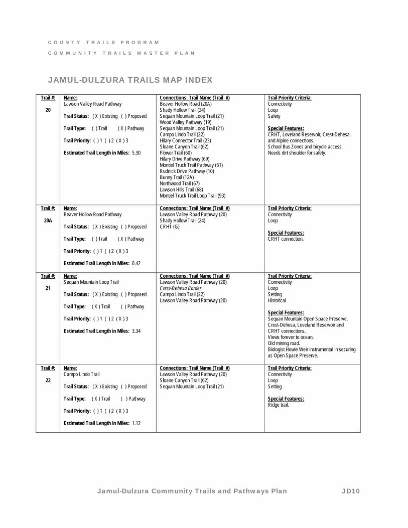
Trail #:
20
Name: Lawson Valley Road Pathway Trail Status: ( X ) Existing ( ) Proposed Trail Type: ( ) Trail ( X ) Pathway Trail Priority: ( ) 1 ( ) 2 ( X ) 3 Estimated Trail Length in Miles: 5.30
Connections: Trail Name (Trail #) Beaver Hollow Road (20A) Shady Hollow Trail (24) Sequan Mountain Loop Trail (21) Wood Valley Pathway (19) Sequan Mountain Loop Trail (21) Campo Lindo Trail (22) Hilary Connector Trail (23) Sloane Canyon Trail (62) Flower Trail (60) Hilary Drive Pathway (69) Montiel Truck Trail Pathway (61) Rudnick Drive Pathway (10) Bunny Trail (12A) Northwood Trail (67) Lawson Hills Trail (68) Montiel Truck Trail Loop Trail (93)
Trail Priority Criteria: Connectivity Loop Safety Special Features: CRHT, Loveland Reservoir, Crest-Dehesa, and Alpine connections. School Bus Zones and bicycle access. Needs dirt shoulder for safety.
Trail #:
20A
Name: Beaver Hollow Road Pathway Trail Status: ( X ) Existing ( ) Proposed Trail Type: ( ) Trail ( X ) Pathway Trail Priority: ( ) 1 ( ) 2 ( X ) 3 Estimated Trail Length in Miles: 0.42
Connections: Trail Name (Trail #) Lawson Valley Road Pathway (20) Shady Hollow Trail (24) CRHT (G)
Trail Priority Criteria: Connectivity Loop Special Features: CRHT connection.
Trail #:
21
Name: Sequan Mountain Loop Trail Trail Status: ( X ) Existing ( ) Proposed Trail Type: ( X ) Trail ( ) Pathway Trail Priority: ( ) 1 ( ) 2 ( X ) 3 Estimated Trail Length in Miles: 3.34
Connections: Trail Name (Trail #) Lawson Valley Road Pathway (20) Crest-Dehesa Border Campo Lindo Trail (22) Lawson Valley Road Pathway (20)
Trail Priority Criteria: Connectivity Loop Setting Historical Special Features: Sequan Mountain Open Space Preserve, Crest-Dehesa, Loveland Reservoir and CRHT connections. Views forever to ocean. Old mining road. Biologist Howie Weir instrumental in securing as Open Space Preserve.
Trail #:
22
Name: Campo Lindo Trail Trail Status: ( X ) Existing ( ) Proposed Trail Type: ( X ) Trail ( ) Pathway Trail Priority: ( ) 1 ( ) 2 ( X ) 3 Estimated Trail Length in Miles: 1.12
Connections: Trail Name (Trail #) Lawson Valley Road Pathway (20) Sloane Canyon Trail (62) Sequan Mountain Loop Trail (21)
Trail Priority Criteria: Connectivity Loop Setting Special Features: Ridge trail.
C O U N T Y T R A I L S P R O G R A M
C O M M U N I T Y T R A I L S M A S T E R P L A N
Jamul-Dulzura Community Trails and Pathways Plan JD11
JAMUL-DULZURA TRAILS MAP INDEX
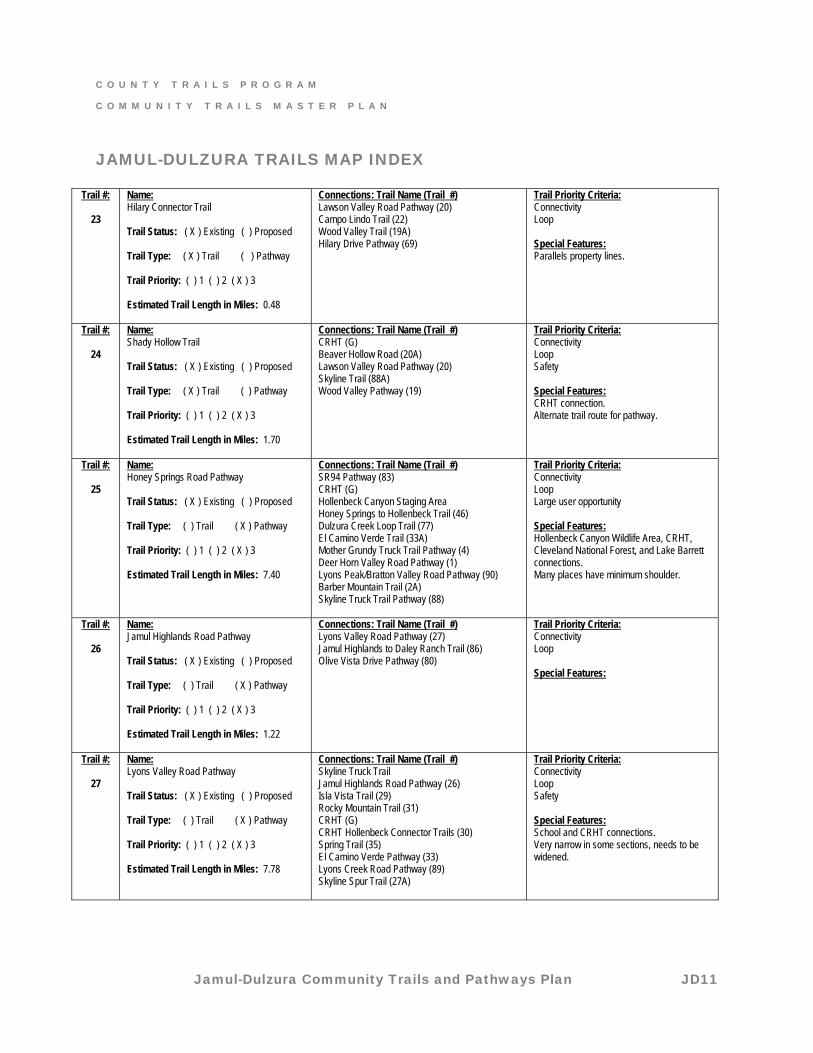
Trail #:
23
Name: Hilary Connector Trail Trail Status: ( X ) Existing ( ) Proposed Trail Type: ( X ) Trail ( ) Pathway Trail Priority: ( ) 1 ( ) 2 ( X ) 3 Estimated Trail Length in Miles: 0.48
Connections: Trail Name (Trail #) Lawson Valley Road Pathway (20) Campo Lindo Trail (22) Wood Valley Trail (19A) Hilary Drive Pathway (69)
Trail Priority Criteria: Connectivity Loop Special Features: Parallels property lines.
Trail #:
24
Name: Shady Hollow Trail Trail Status: ( X ) Existing ( ) Proposed Trail Type: ( X ) Trail ( ) Pathway Trail Priority: ( ) 1 ( ) 2 ( X ) 3 Estimated Trail Length in Miles: 1.70
Connections: Trail Name (Trail #) CRHT (G) Beaver Hollow Road (20A) Lawson Valley Road Pathway (20) Skyline Trail (88A) Wood Valley Pathway (19)
Trail Priority Criteria: Connectivity Loop Safety Special Features: CRHT connection. Alternate trail route for pathway.
Trail #:
25
Name: Honey Springs Road Pathway Trail Status: ( X ) Existing ( ) Proposed Trail Type: ( ) Trail ( X ) Pathway Trail Priority: ( ) 1 ( ) 2 ( X ) 3 Estimated Trail Length in Miles: 7.40
Connections: Trail Name (Trail #) SR94 Pathway (83) CRHT (G) Hollenbeck Canyon Staging Area Honey Springs to Hollenbeck Trail (46) Dulzura Creek Loop Trail (77) El Camino Verde Trail (33A) Mother Grundy Truck Trail Pathway (4) Deer Horn Valley Road Pathway (1) Lyons Peak/Bratton Valley Road Pathway (90) Barber Mountain Trail (2A) Skyline Truck Trail Pathway (88)
Trail Priority Criteria: Connectivity Loop Large user opportunity Special Features: Hollenbeck Canyon Wildlife Area, CRHT, Cleveland National Forest, and Lake Barrett connections. Many places have minimum shoulder.
Trail #:
26
Name: Jamul Highlands Road Pathway Trail Status: ( X ) Existing ( ) Proposed Trail Type: ( ) Trail ( X ) Pathway Trail Priority: ( ) 1 ( ) 2 ( X ) 3 Estimated Trail Length in Miles: 1.22
Connections: Trail Name (Trail #) Lyons Valley Road Pathway (27) Jamul Highlands to Daley Ranch Trail (86) Olive Vista Drive Pathway (80)
Trail Priority Criteria: Connectivity Loop Special Features:
Trail #:
27
Name: Lyons Valley Road Pathway Trail Status: ( X ) Existing ( ) Proposed Trail Type: ( ) Trail ( X ) Pathway Trail Priority: ( ) 1 ( ) 2 ( X ) 3 Estimated Trail Length in Miles: 7.78
Connections: Trail Name (Trail #) Skyline Truck Trail Jamul Highlands Road Pathway (26) Isla Vista Trail (29) Rocky Mountain Trail (31) CRHT (G) CRHT Hollenbeck Connector Trails (30) Spring Trail (35) El Camino Verde Pathway (33) Lyons Creek Road Pathway (89) Skyline Spur Trail (27A)
Trail Priority Criteria: Connectivity Loop Safety Special Features: School and CRHT connections. Very narrow in some sections, needs to be widened.
C O U N T Y T R A I L S P R O G R A M
C O M M U N I T Y T R A I L S M A S T E R P L A N
Jamul-Dulzura Community Trails and Pathways Plan JD12
JAMUL-DULZURA TRAILS MAP INDEX
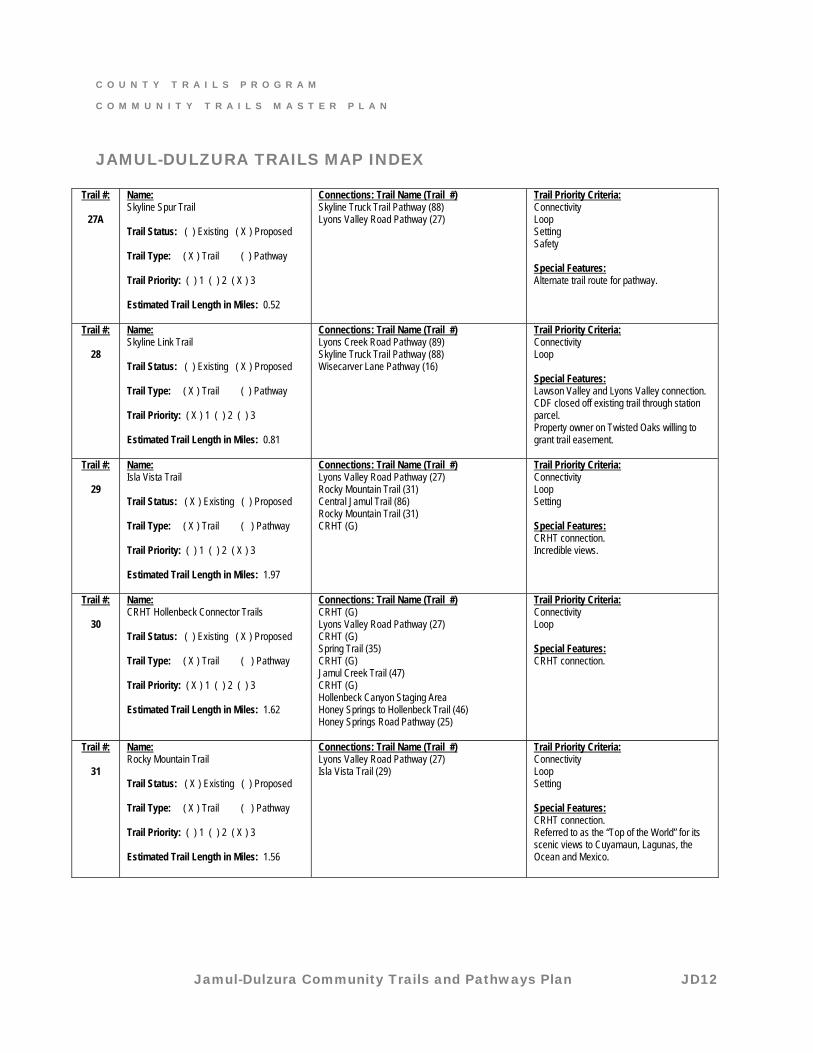
Trail #:
27A
Name: Skyline Spur Trail Trail Status: ( ) Existing ( X ) Proposed Trail Type: ( X ) Trail ( ) Pathway Trail Priority: ( ) 1 ( ) 2 ( X ) 3 Estimated Trail Length in Miles: 0.52
Connections: Trail Name (Trail #) Skyline Truck Trail Pathway (88) Lyons Valley Road Pathway (27)
Trail Priority Criteria: Connectivity Loop Setting Safety Special Features: Alternate trail route for pathway.
Trail #:
28
Name: Skyline Link Trail Trail Status: ( ) Existing ( X ) Proposed Trail Type: ( X ) Trail ( ) Pathway Trail Priority: ( X ) 1 ( ) 2 ( ) 3 Estimated Trail Length in Miles: 0.81
Connections: Trail Name (Trail #) Lyons Creek Road Pathway (89) Skyline Truck Trail Pathway (88) Wisecarver Lane Pathway (16)
Trail Priority Criteria: Connectivity Loop Special Features: Lawson Valley and Lyons Valley connection. CDF closed off existing trail through station parcel. Property owner on Twisted Oaks willing to grant trail easement.
Trail #:
29
Name: Isla Vista Trail Trail Status: ( X ) Existing ( ) Proposed Trail Type: ( X ) Trail ( ) Pathway Trail Priority: ( ) 1 ( ) 2 ( X ) 3 Estimated Trail Length in Miles: 1.97
Connections: Trail Name (Trail #) Lyons Valley Road Pathway (27) Rocky Mountain Trail (31) Central Jamul Trail (86) Rocky Mountain Trail (31) CRHT (G)
Trail Priority Criteria: Connectivity Loop Setting Special Features: CRHT connection. Incredible views.
Trail #:
30
Name: CRHT Hollenbeck Connector Trails Trail Status: ( ) Existing ( X ) Proposed Trail Type: ( X ) Trail ( ) Pathway Trail Priority: ( X ) 1 ( ) 2 ( ) 3 Estimated Trail Length in Miles: 1.62
Connections: Trail Name (Trail #) CRHT (G) Lyons Valley Road Pathway (27) CRHT (G) Spring Trail (35) CRHT (G) Jamul Creek Trail (47) CRHT (G) Hollenbeck Canyon Staging Area Honey Springs to Hollenbeck Trail (46) Honey Springs Road Pathway (25)
Trail Priority Criteria: Connectivity Loop Special Features: CRHT connection.
Trail #:
31
Name: Rocky Mountain Trail Trail Status: ( X ) Existing ( ) Proposed Trail Type: ( X ) Trail ( ) Pathway Trail Priority: ( ) 1 ( ) 2 ( X ) 3 Estimated Trail Length in Miles: 1.56
Connections: Trail Name (Trail #) Lyons Valley Road Pathway (27) Isla Vista Trail (29)
Trail Priority Criteria: Connectivity Loop Setting Special Features: CRHT connection. Referred to as the “Top of the World” for its scenic views to Cuyamaun, Lagunas, the Ocean and Mexico.
C O U N T Y T R A I L S P R O G R A M
C O M M U N I T Y T R A I L S M A S T E R P L A N
Jamul-Dulzura Community Trails and Pathways Plan JD13
JAMUL-DULZURA TRAILS MAP INDEX
Trail #:
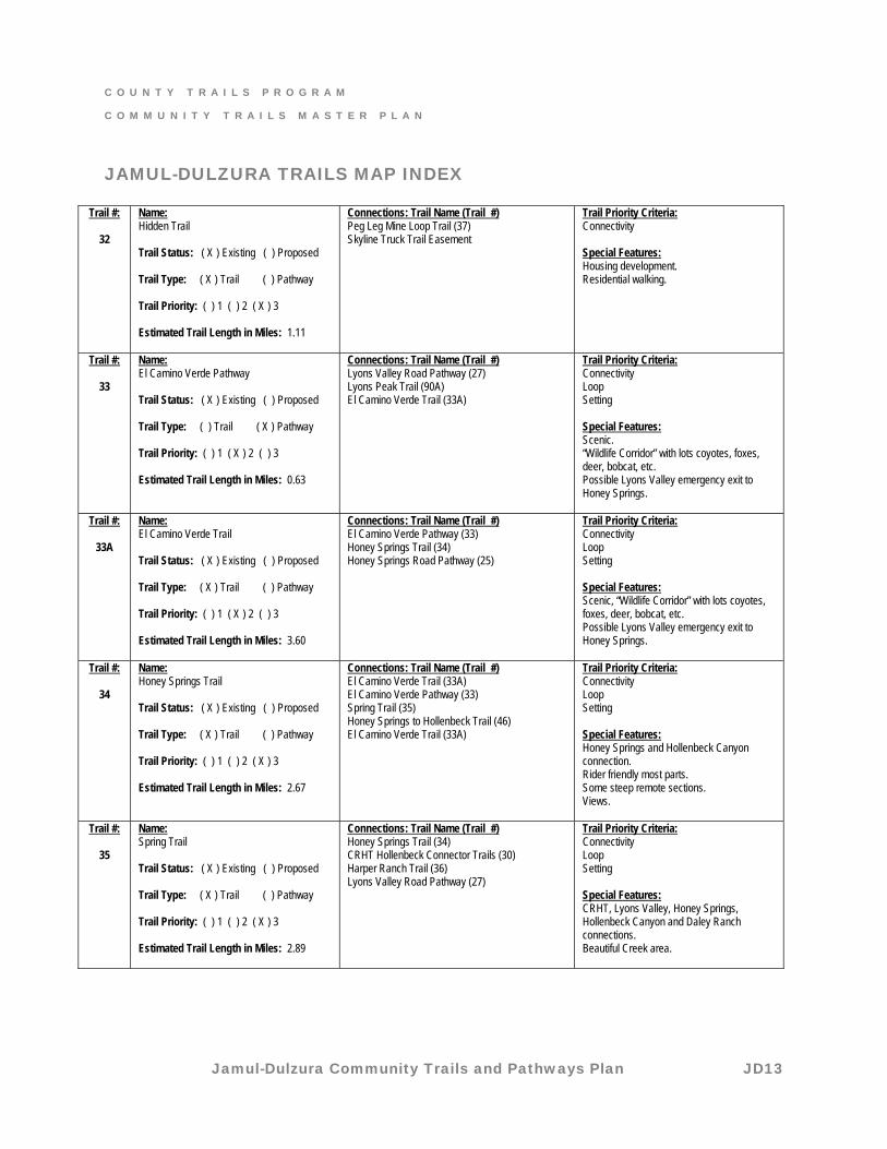
32
Name: Hidden Trail Trail Status: ( X ) Existing ( ) Proposed Trail Type: ( X ) Trail ( ) Pathway Trail Priority: ( ) 1 ( ) 2 ( X ) 3 Estimated Trail Length in Miles: 1.11
Connections: Trail Name (Trail #) Peg Leg Mine Loop Trail (37) Skyline Truck Trail Easement
Trail Priority Criteria: Connectivity Special Features: Housing development. Residential walking.
Trail #:
33
Name: El Camino Verde Pathway Trail Status: ( X ) Existing ( ) Proposed Trail Type: ( ) Trail ( X ) Pathway Trail Priority: ( ) 1 ( X ) 2 ( ) 3 Estimated Trail Length in Miles: 0.63
Connections: Trail Name (Trail #) Lyons Valley Road Pathway (27) Lyons Peak Trail (90A) El Camino Verde Trail (33A)
Trail Priority Criteria: Connectivity Loop Setting Special Features: Scenic. “Wildlife Corridor” with lots coyotes, foxes, deer, bobcat, etc. Possible Lyons Valley emergency exit to Honey Springs.
Trail #:
33A
Name: El Camino Verde Trail Trail Status: ( X ) Existing ( ) Proposed Trail Type: ( X ) Trail ( ) Pathway Trail Priority: ( ) 1 ( X ) 2 ( ) 3 Estimated Trail Length in Miles: 3.60
Connections: Trail Name (Trail #) El Camino Verde Pathway (33) Honey Springs Trail (34) Honey Springs Road Pathway (25)
Trail Priority Criteria: Connectivity Loop Setting Special Features: Scenic, “Wildlife Corridor” with lots coyotes, foxes, deer, bobcat, etc. Possible Lyons Valley emergency exit to Honey Springs.
Trail #:
34
Name: Honey Springs Trail Trail Status: ( X ) Existing ( ) Proposed Trail Type: ( X ) Trail ( ) Pathway Trail Priority: ( ) 1 ( ) 2 ( X ) 3 Estimated Trail Length in Miles: 2.67
Connections: Trail Name (Trail #) El Camino Verde Trail (33A) El Camino Verde Pathway (33) Spring Trail (35) Honey Springs to Hollenbeck Trail (46) El Camino Verde Trail (33A)
Trail Priority Criteria: Connectivity Loop Setting Special Features: Honey Springs and Hollenbeck Canyon connection. Rider friendly most parts. Some steep remote sections. Views.
Trail #:
35
Name: Spring Trail Trail Status: ( X ) Existing ( ) Proposed Trail Type: ( X ) Trail ( ) Pathway Trail Priority: ( ) 1 ( ) 2 ( X ) 3 Estimated Trail Length in Miles: 2.89
Connections: Trail Name (Trail #) Honey Springs Trail (34) CRHT Hollenbeck Connector Trails (30) Harper Ranch Trail (36) Lyons Valley Road Pathway (27)
Trail Priority Criteria: Connectivity Loop Setting Special Features: CRHT, Lyons Valley, Honey Springs, Hollenbeck Canyon and Daley Ranch connections. Beautiful Creek area.
C O U N T Y T R A I L S P R O G R A M
C O M M U N I T Y T R A I L S M A S T E R P L A N
Jamul-Dulzura Community Trails and Pathways Plan JD14
JAMUL-DULZURA TRAILS MAP INDEX
Trail #:
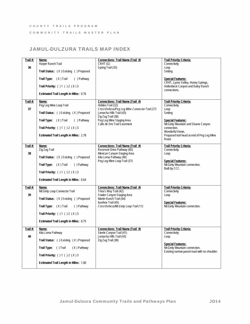
36
Name: Harper Ranch Trail Trail Status: ( X ) Existing ( ) Proposed Trail Type: ( X ) Trail ( ) Pathway Trail Priority: ( ) 1 ( ) 2 ( X ) 3 Estimated Trail Length in Miles: 0.76
Connections: Trail Name (Trail #) CRHT (G) Spring Trail (35)
Trail Priority Criteria: Connectivity Loop Setting Special Features: CRHT, Lyons Valley, Honey Springs, Hollenbeck Canyon and Daley Ranch connections.
Trail #:
37
Name: Peg Leg Mine Loop Trail Trail Status: ( ) Existing ( X ) Proposed Trail Type: ( X ) Trail ( ) Pathway Trail Priority: ( ) 1 ( ) 2 ( X ) 3 Estimated Trail Length in Miles: 2.78
Connections: Trail Name (Trail #) Hidden Trail (32) Crest-Dehesa/Peg Leg Mine Connector Trail (27) Jamacha Hills Trail (43) Zig Zag Trail (38) Peg Leg Mine Staging Area Calle de Oro Trail Easement
Trail Priority Criteria: Connectivity Loop Setting Special Features: McGinty Mountain and Sloane Canyon connection. Wonderful Views. Proposed trail head at end of Peg Leg Mine Road.
Trail #:
38
Name: Zig Zag Trail Trail Status: ( X ) Existing ( ) Proposed Trail Type: ( X ) Trail ( ) Pathway Trail Priority: ( ) 1 ( ) 2 ( X ) 3 Estimated Trail Length in Miles: 0.64
Connections: Trail Name (Trail #) Reservoir Drive Pathway (85) Mexican Canyon Staging Area Alta Loma Pathway (40) Peg Leg Mine Loop Trail (37)
Trail Priority Criteria: Connectivity Loop Special Features: McGinty Mountain connection. Built by CCC.
Trail #:
39
Name: McGinty Loop Connector Trail Trail Status: ( X ) Existing ( ) Proposed Trail Type: ( X ) Trail ( ) Pathway Trail Priority: ( ) 1 ( ) 2 ( X ) 3 Estimated Trail Length in Miles: 0.75
Connections: Trail Name (Trail #) Trina’s Way Trail (42) Fowler Canyon Staging Area Martin Ranch Trail (44) Ivanhoe Trail (45) Crest-Dehesa/McGinty Loop Trail (11)
Trail Priority Criteria: Connectivity Loop Special Features: McGinty Mountain connection.
Trail #:
40
Name: Alta Loma Pathway Trail Status: ( ) Existing ( X ) Proposed Trail Type: ( ) Trail ( X ) Pathway Trail Priority: ( ) 1 ( ) 2 ( X ) 3 Estimated Trail Length in Miles: 1.00
Connections: Trail Name (Trail #) Steele Canyon Trail (41) Jamacha Hills Trail (43) Zig Zag Trail (38)
Trail Priority Criteria: Connectivity Loop Special Features: McGinty Mountain connection. Existing narrow paved road with no shoulder.
C O U N T Y T R A I L S P R O G R A M
C O M M U N I T Y T R A I L S M A S T E R P L A N
Jamul-Dulzura Community Trails and Pathways Plan JD15
JAMUL-DULZURA TRAILS MAP INDEX
Trail #:
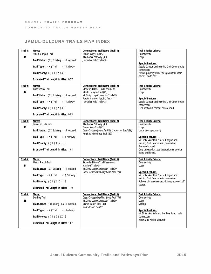
41
Name: Steele Canyon Trail Trail Status: ( X ) Existing ( ) Proposed Trail Type: ( X ) Trail ( ) Pathway Trail Priority: ( ) 1 ( ) 2 ( X ) 3 Estimated Trail Length in Miles: 0.57
Connections: Trail Name (Trail #) Trina’s Way Trail (42) Alta Loma Pathway (40) Jamacha Hills Trail (43)
Trail Priority Criteria: Connectivity Loop Special Features: Steele Canyon and existing Golf Course trails connection. Private property owner has given trail users permission to pass.
Trail #:
42
Name: Trina’s Way Trail Trail Status: ( X ) Existing ( ) Proposed Trail Type: ( X ) Trail ( ) Pathway Trail Priority: ( ) 1 ( ) 2 ( X ) 3 Estimated Trail Length in Miles: 0.83
Connections: Trail Name (Trail #) Stonefield Drive Trail Easement Steele Canyon Trail (41) McGinty Loop Connector Trail (39) Fowler Canyon Staging Area Jamacha Hills Trail (43)
Trail Priority Criteria: Connectivity Loop Special Features: Steele Canyon and existing Golf Course trails connection. First section is cement private road.
Trail #:
43
Name: Jamacha Hills Trail Trail Status: ( X ) Existing ( ) Proposed Trail Type: ( X ) Trail ( ) Pathway Trail Priority: ( ) 1 ( X ) 2 ( ) 3 Estimated Trail Length in Miles: 1.08
Connections: Trail Name (Trail #) Alta Loma Pathway (40) Trina’s Way Trail (42) Crest-Dehesa/Jamacha Hills Connector Trail (28) Peg Leg Mine Loop Trail (37)
Trail Priority Criteria: Connectivity Loop Large user opportunity Special Features: McGinty Mountain, Steele Canyon and existing Golf Course trails connection. Private dirt road. Only unpaved access that residents use for riding and hiking.
Trail #:
44
Name: Martin Ranch Trail Trail Status: ( X ) Existing ( ) Proposed Trail Type: ( X ) Trail ( ) Pathway Trail Priority: ( ) 1 ( X ) 2 ( ) 3 Estimated Trail Length in Miles: 1.10
Connections: Trail Name (Trail #) Stonefield Drive Trail Easement Ivanhoe Trail (45) McGinty Loop Connector Trail (39) Crest-Dehesa/McGinty Loop Trail (11)
Trail Priority Criteria: Connectivity Loop Special Features: McGinty Mountain, Steele Canyon and existing Golf Course trails connection. Follows dirt easement road along edge of golf course.
Trail #:
45
Name: Ivanhoe Trail Trail Status: ( ) Existing ( X ) Proposed Trail Type: ( X ) Trail ( ) Pathway Trail Priority: ( ) 1 ( ) 2 ( X ) 3 Estimated Trail Length in Miles: 1.07
Connections: Trail Name (Trail #) Crest-Dehesa/McGinty Loop Trail (11) McGinty Loop Connector Trail (39) Martin Ranch Trail (44) Valle de Oro Border
Trail Priority Criteria: Connectivity Loop Setting Special Features: McGinty Mountain and Ivanhoe Ranch trails connection. Views and wildlife abound.
C O U N T Y T R A I L S P R O G R A M
C O M M U N I T Y T R A I L S M A S T E R P L A N
Jamul-Dulzura Community Trails and Pathways Plan JD16
JAMUL-DULZURA TRAILS MAP INDEX
Trail #:
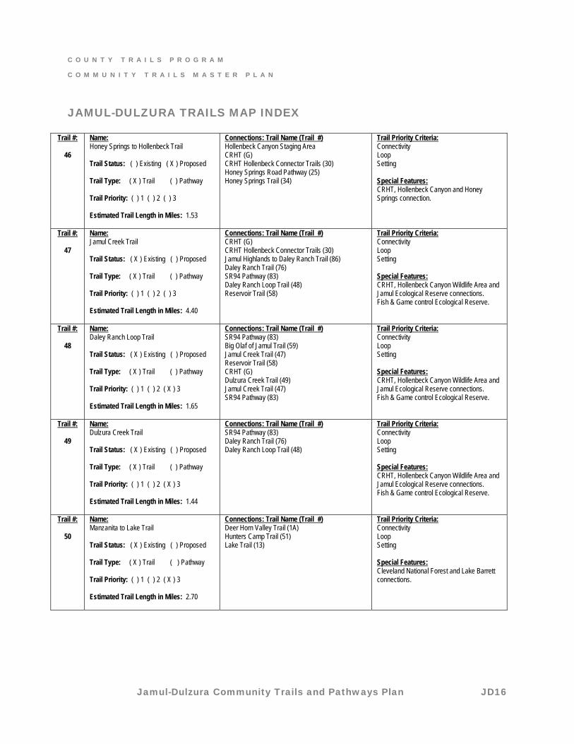
46
Name: Honey Springs to Hollenbeck Trail Trail Status: ( ) Existing ( X ) Proposed Trail Type: ( X ) Trail ( ) Pathway Trail Priority: ( ) 1 ( ) 2 ( ) 3 Estimated Trail Length in Miles: 1.53
Connections: Trail Name (Trail #) Hollenbeck Canyon Staging Area CRHT (G) CRHT Hollenbeck Connector Trails (30) Honey Springs Road Pathway (25) Honey Springs Trail (34)
Trail Priority Criteria: Connectivity Loop Setting Special Features: CRHT, Hollenbeck Canyon and Honey Springs connection.
Trail #:
47
Name: Jamul Creek Trail Trail Status: ( X ) Existing ( ) Proposed Trail Type: ( X ) Trail ( ) Pathway Trail Priority: ( ) 1 ( ) 2 ( ) 3 Estimated Trail Length in Miles: 4.40
Connections: Trail Name (Trail #) CRHT (G) CRHT Hollenbeck Connector Trails (30) Jamul Highlands to Daley Ranch Trail (86) Daley Ranch Trail (76) SR94 Pathway (83) Daley Ranch Loop Trail (48) Reservoir Trail (58)
Trail Priority Criteria: Connectivity Loop Setting Special Features: CRHT, Hollenbeck Canyon Wildlife Area and Jamul Ecological Reserve connections. Fish & Game control Ecological Reserve.
Trail #:
48
Name: Daley Ranch Loop Trail Trail Status: ( X ) Existing ( ) Proposed Trail Type: ( X ) Trail ( ) Pathway Trail Priority: ( ) 1 ( ) 2 ( X ) 3 Estimated Trail Length in Miles: 1.65
Connections: Trail Name (Trail #) SR94 Pathway (83) Big Olaf of Jamul Trail (59) Jamul Creek Trail (47) Reservoir Trail (58) CRHT (G) Dulzura Creek Trail (49) Jamul Creek Trail (47) SR94 Pathway (83)
Trail Priority Criteria: Connectivity Loop Setting Special Features: CRHT, Hollenbeck Canyon Wildlife Area and Jamul Ecological Reserve connections. Fish & Game control Ecological Reserve.
Trail #:
49
Name: Dulzura Creek Trail Trail Status: ( X ) Existing ( ) Proposed Trail Type: ( X ) Trail ( ) Pathway Trail Priority: ( ) 1 ( ) 2 ( X ) 3 Estimated Trail Length in Miles: 1.44
Connections: Trail Name (Trail #) SR94 Pathway (83) Daley Ranch Trail (76) Daley Ranch Loop Trail (48)
Trail Priority Criteria: Connectivity Loop Setting Special Features: CRHT, Hollenbeck Canyon Wildlife Area and Jamul Ecological Reserve connections. Fish & Game control Ecological Reserve.
Trail #:
50
Name: Manzanita to Lake Trail Trail Status: ( X ) Existing ( ) Proposed Trail Type: ( X ) Trail ( ) Pathway Trail Priority: ( ) 1 ( ) 2 ( X ) 3 Estimated Trail Length in Miles: 2.70
Connections: Trail Name (Trail #) Deer Horn Valley Trail (1A) Hunters Camp Trail (51) Lake Trail (13)
Trail Priority Criteria: Connectivity Loop Setting Special Features: Cleveland National Forest and Lake Barrett connections.
C O U N T Y T R A I L S P R O G R A M
C O M M U N I T Y T R A I L S M A S T E R P L A N
Jamul-Dulzura Community Trails and Pathways Plan JD17
JAMUL-DULZURA TRAILS MAP INDEX
Trail #:
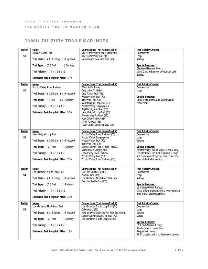
51
Name: Hunters Camp Trail Trail Status: ( X ) Existing ( ) Proposed Trail Type: ( X ) Trail ( ) Pathway Trail Priority: ( ) 1 ( ) 2 ( X ) 3 Estimated Trail Length in Miles: 3.10
Connections: Trail Name (Trail #) Deer Horn Valley Road Pathway (1) Deer Horn Valley Trail (1A) Manzanita to Pole Line Trail (50)
Trail Priority Criteria: Connectivity Loop Setting Special Features: Cleveland National Forest. Many Oaks with scenic overlook of Lake Barrett.
Trail #:
52
Name: Proctor Valley Road Pathway Trail Status: ( ) Existing ( X ) Proposed Trail Type: ( ) Trail ( X ) Pathway Trail Priority: ( ) 1 ( ) 2 ( X ) 3 Estimated Trail Length in Miles: 5.50
Connections: Trail Name (Trail #) Chula Vista Border Otay Lakes Trail (96) Otay Ranch Trail (71) Proctor Valley Trail (70) Reservoir Trail (58) Mount Miguel Loop Trail (53) Proctor Valley Staging Area Big Olaf of Jamul Trail (59) Mount Miguel Loop Trail (53) Pioneer Way Pathway (82) Post Office Pathway (84) SR94 Pathway (83) Town Center Loop Pathway (81)
Trail Priority Criteria: Connectivity Loop Special Features: Chula Vista, Bonita and Mount Miguel connections.
Trail #:
53
Name: Mount Miguel Loop Trail Trail Status: ( ) Existing ( X ) Proposed Trail Type: ( X ) Trail ( ) Pathway Trail Priority: ( ) 1 ( ) 2 ( X ) 3 Estimated Trail Length in Miles: 7.20
Connections: Trail Name (Trail #) Proctor Valley Road Pathway (52) Proctor Valley Staging Area Proctor Valley Trail (70) Reservoir Trail (58) Steele Canyon High School Trail (73) Millar Ranch Staging Area Echo Valley Loop Trail (56) Proctor Valley Trail (70) Proctor Valley Road Pathway (52)
Trail Priority Criteria: Connectivity Loop Setting Special Features: Proctor Valley, Mount Miguel, Echo Valley, Los Montanas, US Fish & Wildlife Refuge and Sweetwater Regional Trail connections. Most of the trail is existing.
Trail #:
54
Name: Los Montanas South Loop Trail Trail Status: ( X ) Existing ( ) Proposed Trail Type: ( X ) Trail ( ) Pathway Trail Priority: ( ) 1 ( ) 2 ( X ) 3 Estimated Trail Length in Miles: 2.40
Connections: Trail Name (Trail #) Over the Saddle Trail (57) Pioneer Trail (82A) Los Montanas North Loop Trail (55) Over the Saddle Trail (57)
Trail Priority Criteria: Connectivity Loop Setting Special Features: US Fish & Wildlife Refuge. Many different terrains with a lovely riparian area in the northwest corner.
Trail #:
55
Name: Los Montanas North Loop Trail Trail Status: ( X ) Existing ( ) Proposed Trail Type: ( X ) Trail ( ) Pathway Trail Priority: ( ) 1 ( ) 2 ( X ) 3 Estimated Trail Length in Miles: 1.94
Connections: Trail Name (Trail #) Los Montanas South Loop Trail (54) Calle de Sol (75) Valle de Oro/Steele Canyon Trail Easements Steele Canyon/Vista Cielo Trail (72) Los Montanas South Loop Trail (54)
Trail Priority Criteria: Connectivity Loop Setting Safety Special Features: US Fish & Wildlife Refuge. Steele Canyon connection. Rugged with views. SR94 crossing at Pump Station dangerous.
C O U N T Y T R A I L S P R O G R A M
C O M M U N I T Y T R A I L S M A S T E R P L A N
Jamul-Dulzura Community Trails and Pathways Plan JD18
JAMUL-DULZURA TRAILS MAP INDEX
Trail #:
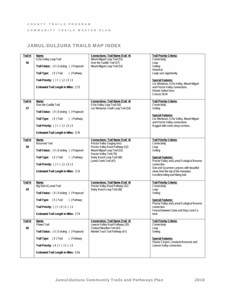
56
Name: Echo Valley Loop Trail Trail Status: ( X ) Existing ( ) Proposed Trail Type: ( X ) Trail ( ) Pathway Trail Priority: ( ) 1 ( ) 2 ( X ) 3 Estimated Trail Length in Miles: 2.73
Connections: Trail Name (Trail #) Mount Miguel Loop Trail (53) Over the Saddle Trail (57) Mount Miguel Loop Trail (53)
Trail Priority Criteria: Connectivity Loop Setting Historical Large user opportunity Special Features: Los Montanas, Echo Valley, Mount Miguel and Proctor Valley connections. Historic Indian Dam. Crosses BLM
Trail #:
57
Name: Over the Saddle Trail Trail Status: ( X ) Existing ( ) Proposed Trail Type: ( X ) Trail ( ) Pathway Trail Priority: ( ) 1 ( ) 2 ( X ) 3 Estimated Trail Length in Miles: 0.76
Connections: Trail Name (Trail #) Echo Valley Loop Trail (56) Los Montanas South Loop Trail (54)
Trail Priority Criteria: Connectivity Setting Special Features: Los Montanas, Echo Valley, Mount Miguel and Proctor Valley connections. Rugged with some steep sections.
Trail #:
58
Name: Reservoir Trail Trail Status: ( X ) Existing ( ) Proposed Trail Type: ( X ) Trail ( ) Pathway Trail Priority: ( ) 1 ( ) 2 ( X ) 3 Estimated Trail Length in Miles: 3.10
Connections: Trail Name (Trail #) Proctor Valley Staging Area Proctor Valley Road Pathway (52) Mount Miguel Loop Trail (53) Proctor Valley Trail (70) Daley Ranch Loop Trail (48) Jamul Creek Trail (47)
Trail Priority Criteria: Connectivity Loop Setting Special Features: Proctor Valley and Jamul Ecological Reserve connection. Oak and Sycamore canyons with beautiful views from the top of the mountain. Excellent riding and hiking trail.
Trail #:
59
Name: Big Olaf of Jamul Trail Trail Status: ( X ) Existing ( ) Proposed Trail Type: ( X ) Trail ( ) Pathway Trail Priority: ( ) 1 ( X ) 2 ( ) 3 Estimated Trail Length in Miles: 2.74
Connections: Trail Name (Trail #) Proctor Valley Road Pathway (52) Daley Ranch Loop Trail (48)
Trail Priority Criteria: Connectivity Loop Setting Special Features: Proctor Valley and Jamul Ecological Reserve connection. Fenced between State and Otay Land Co. land.
Trail #:
60
Name: Flower Trail Trail Status: ( X ) Existing ( ) Proposed Trail Type: ( X ) Trail ( ) Pathway Trail Priority: ( X ) 1 ( ) 2 ( ) 3 Estimated Trail Length in Miles: 0.56
Connections: Trail Name (Trail #) Lawson Valley Road Pathway (20) Chabad Meadow Trail (63) Montiel Truck Trail Pathway (61)
Trail Priority Criteria: Connectivity Loop Setting Special Features: Sloane Canyon, Loveland Reservoir and Lawson Valley connection.
C O U N T Y T R A I L S P R O G R A M
C O M M U N I T Y T R A I L S M A S T E R P L A N
Jamul-Dulzura Community Trails and Pathways Plan JD19
JAMUL-DULZURA TRAILS MAP INDEX
Trail #:
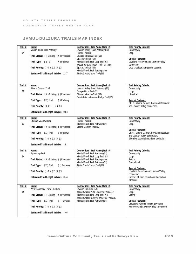
61
Name: Montiel Truck Trail Pathway Trail Status: ( ) Existing ( X ) Proposed Trail Type: ( ) Trail ( X ) Pathway Trail Priority: ( ) 1 ( ) 2 ( X ) 3 Estimated Trail Length in Miles: 2.17
Connections: Trail Name (Trail #) Lawson Valley Road Pathway (20) Flower Trail (60) Chabad Meadow Trail (63) Spaceship Trail (64) Montiel Truck Trail Loop Trail (93) West Boundary Truck Trail Trail (65) Spaceship Trail (64) Montiel Truck Trail Staging Area Alpine/South Shore Trail (29)
Trail Priority Criteria: Connectivity Loop Special Features: Loveland Reservoir and Lawson Valley connection. Little shoulder along some sections.
Trail #:
62
Name: Sloane Canyon Trail Trail Status: ( X ) Existing ( ) Proposed Trail Type: ( X ) Trail ( ) Pathway Trail Priority: ( X ) 1 ( ) 2 ( ) 3 Estimated Trail Length in Miles: 0.63
Connections: Trail Name (Trail #) Lawson Valley Road Pathway (20) Campo Lindo Trail (22) Chabad Meadow Trail (63) Crest-Dehesa/Lawson Valley Trail (25)
Trail Priority Criteria: Connectivity Loop Historical Special Features: CRHT, Sloane Canyon, Loveland Reservoir and Lawson Valley connection.
Trail #:
63
Name: Chabad Meadow Trail Trail Status: ( X ) Existing ( ) Proposed Trail Type: ( X ) Trail ( ) Pathway Trail Priority: ( ) 1 ( ) 2 ( X ) 3 Estimated Trail Length in Miles: 1.01
Connections: Trail Name (Trail #) Flower Trail (60) Montiel Truck Trail Pathway (61) Sloane Canyon Trail (62)
Trail Priority Criteria: Connectivity Loop Special Features: CRHT, Sloane Canyon, Loveland Reservoir and Lawson Valley connection. Short but beautiful meadows and oaks.
Trail #:
64
Name: Spaceship Trail Trail Status: ( X ) Existing ( ) Proposed Trail Type: ( X ) Trail ( ) Pathway Trail Priority: ( ) 1 ( ) 2 ( X ) 3 Estimated Trail Length in Miles: 0.74
Connections: Trail Name (Trail #) Montiel Truck Trail Pathway (61) Montiel Truck Trail Loop Trail (93) Montiel Truck Trail Staging Area Montiel Truck Trail Pathway (61) Alpine/South Shore Trail (29)
Trail Priority Criteria: Connectivity Loop Setting Educational Special Features: Loveland Reservoir and Lawson Valley connection. Crosses 80 acre educational foundation (Unarius)
Trail #:
65
Name: West Boundary Truck Trail Trail Trail Status: ( ) Existing ( X ) Proposed Trail Type: ( X ) Trail ( ) Pathway Trail Priority: ( ) 1 ( ) 2 ( X ) 3 Estimated Trail Length in Miles: 1.46
Connections: Trail Name (Trail #) Lawson Hills Trail (68) Alpine/Lawson Hills Connector Trail (37) Montiel Truck Trail Loop Trail (93) Alpine/Lawson Valley Connector Trail (30) Montiel Truck Trail Pathway (61)
Trail Priority Criteria: Connectivity Loop Setting Special Features: Cleveland National Forest, Loveland Reservoir and Lawson Valley connection.
C O U N T Y T R A I L S P R O G R A M
C O M M U N I T Y T R A I L S M A S T E R P L A N
Jamul-Dulzura Community Trails and Pathways Plan JD20
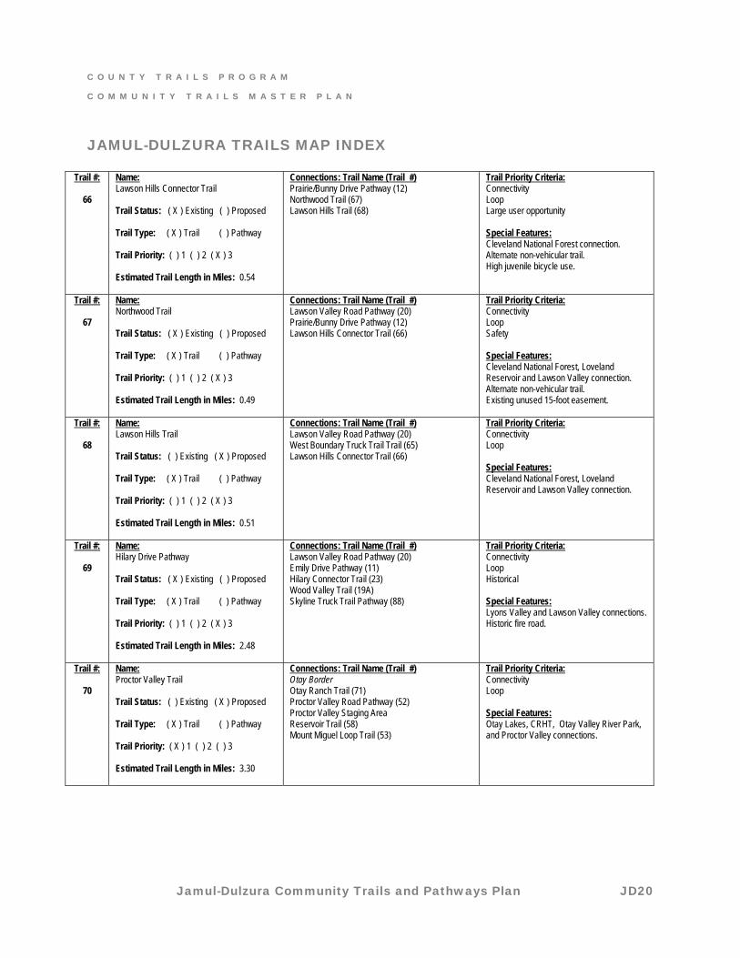
JAMUL-DULZURA TRAILS MAP INDEX
Trail #:
66
Name: Lawson Hills Connector Trail Trail Status: ( X ) Existing ( ) Proposed Trail Type: ( X ) Trail ( ) Pathway Trail Priority: ( ) 1 ( ) 2 ( X ) 3 Estimated Trail Length in Miles: 0.54
Connections: Trail Name (Trail #) Prairie/Bunny Drive Pathway (12) Northwood Trail (67) Lawson Hills Trail (68)
Trail Priority Criteria: Connectivity Loop Large user opportunity Special Features: Cleveland National Forest connection. Alternate non-vehicular trail. High juvenile bicycle use.
Trail #:
67
Name: Northwood Trail Trail Status: ( X ) Existing ( ) Proposed Trail Type: ( X ) Trail ( ) Pathway Trail Priority: ( ) 1 ( ) 2 ( X ) 3 Estimated Trail Length in Miles: 0.49
Connections: Trail Name (Trail #) Lawson Valley Road Pathway (20) Prairie/Bunny Drive Pathway (12) Lawson Hills Connector Trail (66)
Trail Priority Criteria: Connectivity Loop Safety Special Features: Cleveland National Forest, Loveland Reservoir and Lawson Valley connection. Alternate non-vehicular trail. Existing unused 15-foot easement.
Trail #:
68
Name: Lawson Hills Trail Trail Status: ( ) Existing ( X ) Proposed Trail Type: ( X ) Trail ( ) Pathway Trail Priority: ( ) 1 ( ) 2 ( X ) 3 Estimated Trail Length in Miles: 0.51
Connections: Trail Name (Trail #) Lawson Valley Road Pathway (20) West Boundary Truck Trail Trail (65) Lawson Hills Connector Trail (66)
Trail Priority Criteria: Connectivity Loop Special Features: Cleveland National Forest, Loveland Reservoir and Lawson Valley connection.
Trail #:
69
Name: Hilary Drive Pathway Trail Status: ( X ) Existing ( ) Proposed Trail Type: ( X ) Trail ( ) Pathway Trail Priority: ( ) 1 ( ) 2 ( X ) 3 Estimated Trail Length in Miles: 2.48
Connections: Trail Name (Trail #) Lawson Valley Road Pathway (20) Emily Drive Pathway (11) Hilary Connector Trail (23) Wood Valley Trail (19A) Skyline Truck Trail Pathway (88)
Trail Priority Criteria: Connectivity Loop Historical Special Features: Lyons Valley and Lawson Valley connections. Historic fire road.
Trail #:
70
Name: Proctor Valley Trail Trail Status: ( ) Existing ( X ) Proposed Trail Type: ( X ) Trail ( ) Pathway Trail Priority: ( X ) 1 ( ) 2 ( ) 3 Estimated Trail Length in Miles: 3.30
Connections: Trail Name (Trail #) Otay Border Otay Ranch Trail (71) Proctor Valley Road Pathway (52) Proctor Valley Staging Area Reservoir Trail (58) Mount Miguel Loop Trail (53)
Trail Priority Criteria: Connectivity Loop Special Features: Otay Lakes, CRHT, Otay Valley River Park, and Proctor Valley connections.
C O U N T Y T R A I L S P R O G R A M
C O M M U N I T Y T R A I L S M A S T E R P L A N
Jamul-Dulzura Community Trails and Pathways Plan JD21
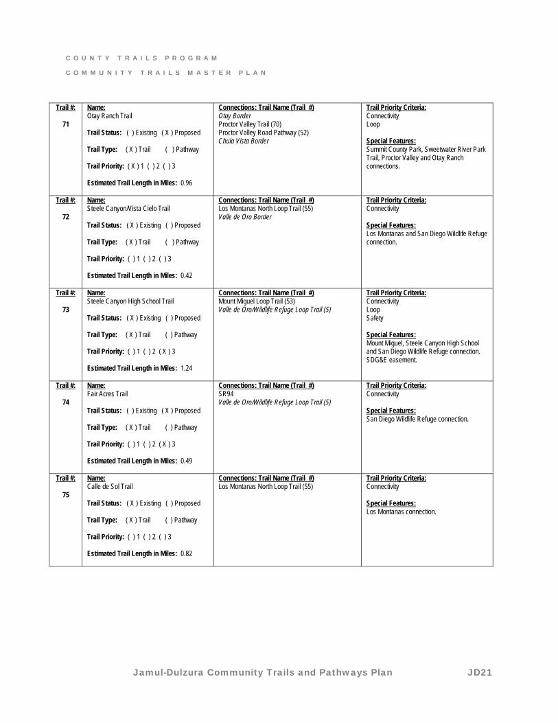
Trail #:
71
Name: Otay Ranch Trail Trail Status: ( ) Existing ( X ) Proposed Trail Type: ( X ) Trail ( ) Pathway Trail Priority: ( X ) 1 ( ) 2 ( ) 3 Estimated Trail Length in Miles: 0.96
Connections: Trail Name (Trail #) Otay Border Proctor Valley Trail (70) Proctor Valley Road Pathway (52) Chula Vista Border
Trail Priority Criteria: Connectivity Loop Special Features: Summit County Park, Sweetwater River Park Trail, Proctor Valley and Otay Ranch connections.
Trail #:
72
Name: Steele Canyon/Vista Cielo Trail Trail Status: ( X ) Existing ( ) Proposed Trail Type: ( X ) Trail ( ) Pathway Trail Priority: ( ) 1 ( ) 2 ( ) 3 Estimated Trail Length in Miles: 0.42
Connections: Trail Name (Trail #) Los Montanas North Loop Trail (55) Valle de Oro Border
Trail Priority Criteria: Connectivity Special Features: Los Montanas and San Diego Wildlife Refuge connection.
Trail #:
73
Name: Steele Canyon High School Trail Trail Status: ( X ) Existing ( ) Proposed Trail Type: ( X ) Trail ( ) Pathway Trail Priority: ( ) 1 ( ) 2 ( X ) 3 Estimated Trail Length in Miles: 1.24
Connections: Trail Name (Trail #) Mount Miguel Loop Trail (53) Valle de Oro/Wildlife Refuge Loop Trail (5)
Trail Priority Criteria: Connectivity Loop Safety Special Features: Mount Miguel, Steele Canyon High School and San Diego Wildlife Refuge connection. SDG&E easement.
Trail #:
74
Name: Fair Acres Trail Trail Status: ( ) Existing ( X ) Proposed Trail Type: ( X ) Trail ( ) Pathway Trail Priority: ( ) 1 ( ) 2 ( X ) 3 Estimated Trail Length in Miles: 0.49
Connections: Trail Name (Trail #) SR94 Valle de Oro/Wildlife Refuge Loop Trail (5)
Trail Priority Criteria: Connectivity Special Features: San Diego Wildlife Refuge connection.
Trail #:
75
Name: Calle de Sol Trail Trail Status: ( X ) Existing ( ) Proposed Trail Type: ( X ) Trail ( ) Pathway Trail Priority: ( ) 1 ( ) 2 ( ) 3 Estimated Trail Length in Miles: 0.82
Connections: Trail Name (Trail #) Los Montanas North Loop Trail (55)
Trail Priority Criteria: Connectivity Special Features: Los Montanas connection.
C O U N T Y T R A I L S P R O G R A M
C O M M U N I T Y T R A I L S M A S T E R P L A N
Jamul-Dulzura Community Trails and Pathways Plan JD22
JAMUL-DULZURA TRAILS MAP INDEX
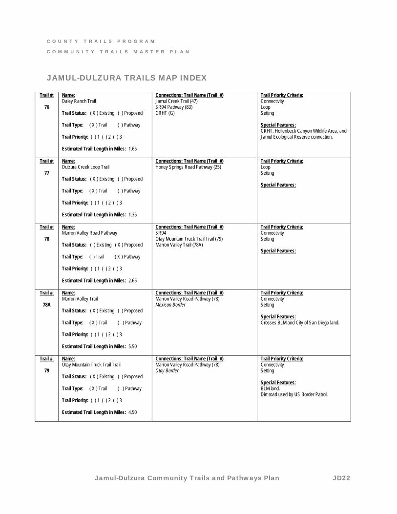
Trail #:
76
Name: Daley Ranch Trail Trail Status: ( X ) Existing ( ) Proposed Trail Type: ( X ) Trail ( ) Pathway Trail Priority: ( ) 1 ( ) 2 ( ) 3 Estimated Trail Length in Miles: 1.65
Connections: Trail Name (Trail #) Jamul Creek Trail (47) SR94 Pathway (83) CRHT (G)
Trail Priority Criteria: Connectivity Loop Setting Special Features: CRHT, Hollenbeck Canyon Wildlife Area, and Jamul Ecological Reserve connection.
Trail #:
77
Name: Dulzura Creek Loop Trail Trail Status: ( X ) Existing ( ) Proposed Trail Type: ( X ) Trail ( ) Pathway Trail Priority: ( ) 1 ( ) 2 ( ) 3 Estimated Trail Length in Miles: 1.35
Connections: Trail Name (Trail #) Honey Springs Road Pathway (25)
Trail Priority Criteria: Loop Setting Special Features:
Trail #:
78
Name: Marron Valley Road Pathway Trail Status: ( ) Existing ( X ) Proposed Trail Type: ( ) Trail ( X ) Pathway Trail Priority: ( ) 1 ( ) 2 ( ) 3 Estimated Trail Length in Miles: 2.65
Connections: Trail Name (Trail #) SR94 Otay Mountain Truck Trail Trail (79) Marron Valley Trail (78A)
Trail Priority Criteria: Connectivity Setting Special Features:
Trail #:
78A
Name: Marron Valley Trail Trail Status: ( X ) Existing ( ) Proposed Trail Type: ( X ) Trail ( ) Pathway Trail Priority: ( ) 1 ( ) 2 ( ) 3 Estimated Trail Length in Miles: 5.50
Connections: Trail Name (Trail #) Marron Valley Road Pathway (78) Mexican Border
Trail Priority Criteria: Connectivity Setting Special Features: Crosses BLM and City of San Diego land.
Trail #:
79
Name: Otay Mountain Truck Trail Trail Trail Status: ( X ) Existing ( ) Proposed Trail Type: ( X ) Trail ( ) Pathway Trail Priority: ( ) 1 ( ) 2 ( ) 3 Estimated Trail Length in Miles: 4.50
Connections: Trail Name (Trail #) Marron Valley Road Pathway (78) Otay Border
Trail Priority Criteria: Connectivity Setting Special Features: BLM land. Dirt road used by US Border Patrol.
C O U N T Y T R A I L S P R O G R A M
C O M M U N I T Y T R A I L S M A S T E R P L A N
Jamul-Dulzura Community Trails and Pathways Plan JD23
JAMUL-DULZURA TRAILS MAP INDEX
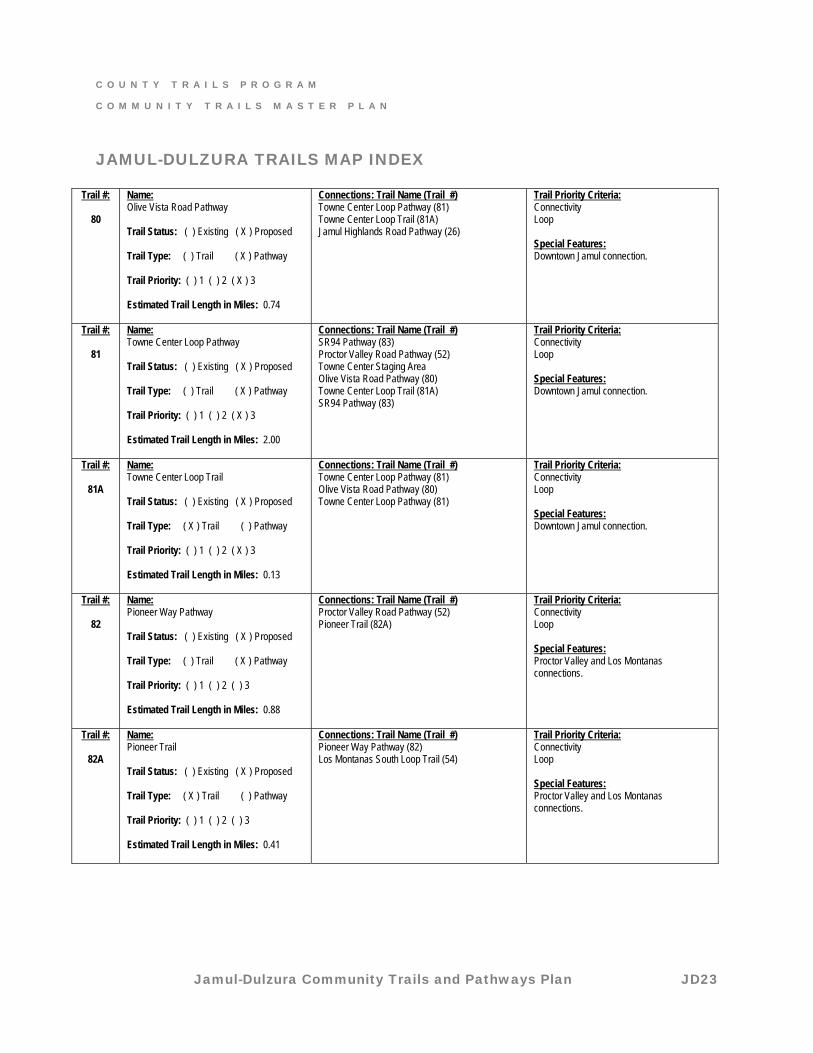
Trail #:
80
Name: Olive Vista Road Pathway Trail Status: ( ) Existing ( X ) Proposed Trail Type: ( ) Trail ( X ) Pathway Trail Priority: ( ) 1 ( ) 2 ( X ) 3 Estimated Trail Length in Miles: 0.74
Connections: Trail Name (Trail #) Towne Center Loop Pathway (81) Towne Center Loop Trail (81A) Jamul Highlands Road Pathway (26)
Trail Priority Criteria: Connectivity Loop Special Features: Downtown Jamul connection.
Trail #:
81
Name: Towne Center Loop Pathway Trail Status: ( ) Existing ( X ) Proposed Trail Type: ( ) Trail ( X ) Pathway Trail Priority: ( ) 1 ( ) 2 ( X ) 3 Estimated Trail Length in Miles: 2.00
Connections: Trail Name (Trail #) SR94 Pathway (83) Proctor Valley Road Pathway (52) Towne Center Staging Area Olive Vista Road Pathway (80) Towne Center Loop Trail (81A) SR94 Pathway (83)
Trail Priority Criteria: Connectivity Loop Special Features: Downtown Jamul connection.
Trail #:
81A
Name: Towne Center Loop Trail Trail Status: ( ) Existing ( X ) Proposed Trail Type: ( X ) Trail ( ) Pathway Trail Priority: ( ) 1 ( ) 2 ( X ) 3 Estimated Trail Length in Miles: 0.13
Connections: Trail Name (Trail #) Towne Center Loop Pathway (81) Olive Vista Road Pathway (80) Towne Center Loop Pathway (81)
Trail Priority Criteria: Connectivity Loop Special Features: Downtown Jamul connection.
Trail #:
82
Name: Pioneer Way Pathway Trail Status: ( ) Existing ( X ) Proposed Trail Type: ( ) Trail ( X ) Pathway Trail Priority: ( ) 1 ( ) 2 ( ) 3 Estimated Trail Length in Miles: 0.88
Connections: Trail Name (Trail #) Proctor Valley Road Pathway (52) Pioneer Trail (82A)
Trail Priority Criteria: Connectivity Loop Special Features: Proctor Valley and Los Montanas connections.
Trail #:
82A
Name: Pioneer Trail Trail Status: ( ) Existing ( X ) Proposed Trail Type: ( X ) Trail ( ) Pathway Trail Priority: ( ) 1 ( ) 2 ( ) 3 Estimated Trail Length in Miles: 0.41
Connections: Trail Name (Trail #) Pioneer Way Pathway (82) Los Montanas South Loop Trail (54)
Trail Priority Criteria: Connectivity Loop Special Features: Proctor Valley and Los Montanas connections.
C O U N T Y T R A I L S P R O G R A M
C O M M U N I T Y T R A I L S M A S T E R P L A N
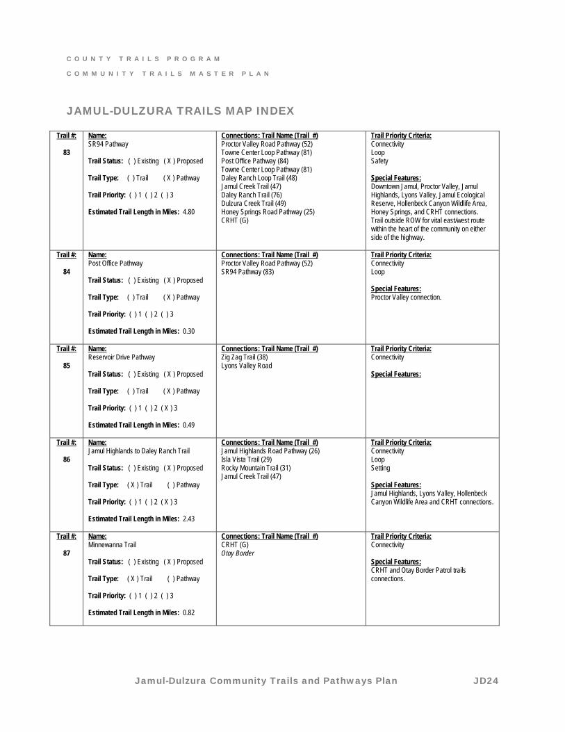
Jamul-Dulzura Community Trails and Pathways Plan JD24
JAMUL-DULZURA TRAILS MAP INDEX
Trail #:
83
Name: SR94 Pathway Trail Status: ( ) Existing ( X ) Proposed Trail Type: ( ) Trail ( X ) Pathway Trail Priority: ( ) 1 ( ) 2 ( ) 3 Estimated Trail Length in Miles: 4.80
Connections: Trail Name (Trail #) Proctor Valley Road Pathway (52) Towne Center Loop Pathway (81) Post Office Pathway (84) Towne Center Loop Pathway (81) Daley Ranch Loop Trail (48) Jamul Creek Trail (47) Daley Ranch Trail (76) Dulzura Creek Trail (49) Honey Springs Road Pathway (25) CRHT (G)
Trail Priority Criteria: Connectivity Loop Safety Special Features: Downtown Jamul, Proctor Valley, Jamul Highlands, Lyons Valley, Jamul Ecological Reserve, Hollenbeck Canyon Wildlife Area, Honey Springs, and CRHT connections. Trail outside ROW for vital east/west route within the heart of the community on either side of the highway.
Trail #:
84
Name: Post Office Pathway Trail Status: ( ) Existing ( X ) Proposed Trail Type: ( ) Trail ( X ) Pathway Trail Priority: ( ) 1 ( ) 2 ( ) 3 Estimated Trail Length in Miles: 0.30
Connections: Trail Name (Trail #) Proctor Valley Road Pathway (52) SR94 Pathway (83)
Trail Priority Criteria: Connectivity Loop Special Features: Proctor Valley connection.
Trail #:
85
Name: Reservoir Drive Pathway Trail Status: ( ) Existing ( X ) Proposed Trail Type: ( ) Trail ( X ) Pathway Trail Priority: ( ) 1 ( ) 2 ( X ) 3 Estimated Trail Length in Miles: 0.49
Connections: Trail Name (Trail #) Zig Zag Trail (38) Lyons Valley Road
Trail Priority Criteria: Connectivity Special Features:
Trail #:
86
Name: Jamul Highlands to Daley Ranch Trail Trail Status: ( ) Existing ( X ) Proposed Trail Type: ( X ) Trail ( ) Pathway Trail Priority: ( ) 1 ( ) 2 ( X ) 3 Estimated Trail Length in Miles: 2.43
Connections: Trail Name (Trail #) Jamul Highlands Road Pathway (26) Isla Vista Trail (29) Rocky Mountain Trail (31) Jamul Creek Trail (47)
Trail Priority Criteria: Connectivity Loop Setting Special Features: Jamul Highlands, Lyons Valley, Hollenbeck Canyon Wildlife Area and CRHT connections.
Trail #:
87
Name: Minnewanna Trail Trail Status: ( ) Existing ( X ) Proposed Trail Type: ( X ) Trail ( ) Pathway Trail Priority: ( ) 1 ( ) 2 ( ) 3 Estimated Trail Length in Miles: 0.82
Connections: Trail Name (Trail #) CRHT (G) Otay Border
Trail Priority Criteria: Connectivity Special Features: CRHT and Otay Border Patrol trails connections.
C O U N T Y T R A I L S P R O G R A M
C O M M U N I T Y T R A I L S M A S T E R P L A N
Jamul-Dulzura Community Trails and Pathways Plan JD25
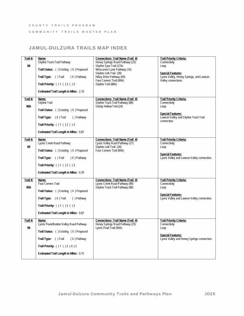
JAMUL-DULZURA TRAILS MAP INDEX
Trail #:
88
Name: Skyline Truck Trail Pathway Trail Status: ( ) Existing ( X ) Proposed Trail Type: ( ) Trail ( X ) Pathway Trail Priority: ( ) 1 ( ) 2 ( ) 3 Estimated Trail Length in Miles: 2.10
Connections: Trail Name (Trail #) Honey Springs Road Pathway (25) Skyline Spur Trail (27A) Wisecarver Lane Pathway (16) Skyline Link Trail (28) Hilary Drive Pathway (69) Four Corners Trail (89A) Skyline Trail (88A)
Trail Priority Criteria: Connectivity Loop Special Features: Lyons Valley, Honey Springs, and Lawson Valley connections.
Trail #:
88A
Name: Skyline Trail Trail Status: ( ) Existing ( X ) Proposed Trail Type: ( X ) Trail ( ) Pathway Trail Priority: ( ) 1 ( ) 2 ( ) 3 Estimated Trail Length in Miles: 0.87
Connections: Trail Name (Trail #) Skyline Truck Trail Pathway (88) Shady Hollow Trail (24)
Trail Priority Criteria: Connectivity Loop Special Features: Lawson Valley and Skyline Truck Trail connection.
Trail #:
89
Name: Lyons Creek Road Pathway Trail Status: ( ) Existing ( X ) Proposed Trail Type: ( ) Trail ( X ) Pathway Trail Priority: ( ) 1 ( ) 2 ( ) 3 Estimated Trail Length in Miles: 0.70
Connections: Trail Name (Trail #) Lyons Valley Road Pathway (27) Skyline Link Trail (28) Four Corners Trail (89A)
Trail Priority Criteria: Connectivity Loop Special Features: Lyons Valley and Lawson Valley connection.
Trail #:
89A
Name: Four Corners Trail Trail Status: ( ) Existing ( X ) Proposed Trail Type: ( X ) Trail ( ) Pathway Trail Priority: ( ) 1 ( ) 2 ( ) 3 Estimated Trail Length in Miles: 0.87
Connections: Trail Name (Trail #) Lyons Creek Road Pathway (89) Skyline Truck Trail Pathway (88)
Trail Priority Criteria: Connectivity Loop Special Features: Lyons Valley and Lawson Valley connection.
Trail #:
90
Name: Lyons Peak/Bratton Valley Road Pathway Trail Status: ( ) Existing ( X ) Proposed Trail Type: ( ) Trail ( X ) Pathway Trail Priority: ( ) 1 ( ) 2 ( X ) 3 Estimated Trail Length in Miles: 0.75
Connections: Trail Name (Trail #) Honey Springs Road Pathway (25) Lyons Peak Trail (90A)
Trail Priority Criteria: Connectivity Loop Special Features: Lyons Valley and Honey Springs connection.
C O U N T Y T R A I L S P R O G R A M
C O M M U N I T Y T R A I L S M A S T E R P L A N
Jamul-Dulzura Community Trails and Pathways Plan JD26
JAMUL-DULZURA TRAILS MAP INDEX
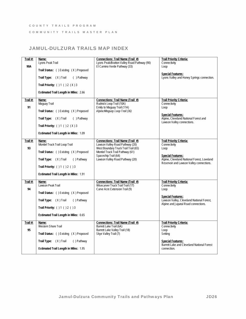
Trail #:
90A
Name: Lyons Peak Trail Trail Status: ( ) Existing ( X ) Proposed Trail Type: ( X ) Trail ( ) Pathway Trail Priority: ( ) 1 ( ) 2 ( X ) 3 Estimated Trail Length in Miles: 2.66
Connections: Trail Name (Trail #) Lyons Peak/Bratton Valley Road Pathway (90) El Camino Verde Pathway (33)
Trail Priority Criteria: Connectivity Loop Special Features: Lyons Valley and Honey Springs connection.
Trail #:
91
Name: Maguay Trail Trail Status: ( ) Existing ( X ) Proposed Trail Type: ( X ) Trail ( ) Pathway Trail Priority: ( ) 1 ( ) 2 ( X ) 3 Estimated Trail Length in Miles: 1.09
Connections: Trail Name (Trail #) Rudnick Loop Trail (10A) Emily to Maguay Trail (11A) Alpine/Maguay Loop Trail (36)
Trail Priority Criteria: Connectivity Loop Special Features: Alpine, Cleveland National Forest and Lawson Valley connections.
Trail #:
93
Name: Montiel Truck Trail Loop Trail Trail Status: ( ) Existing ( X ) Proposed Trail Type: ( X ) Trail ( ) Pathway Trail Priority: ( ) 1 ( ) 2 ( ) 3 Estimated Trail Length in Miles: 1.91
Connections: Trail Name (Trail #) Lawson Valley Road Pathway (20) West Boundary Truck Trail Trail (65) Montiel Truck Trail Pathway (61) Spaceship Trail (64) Lawson Valley Road Pathway (20)
Trail Priority Criteria: Connectivity Loop Special Features: Alpine, Cleveland National Forest, Loveland Reservoir and Lawson Valley connections.
Trail #:
94
Name: Lawson Peak Trail Trail Status: ( ) Existing ( X ) Proposed Trail Type: ( X ) Trail ( ) Pathway Trail Priority: ( ) 1 ( ) 2 ( ) 3 Estimated Trail Length in Miles: 0.65
Connections: Trail Name (Trail #) Wisecarver Truck Trail Trail (17) Carve Acre Extension Trail (9)
Trail Priority Criteria: Connectivity Loop Special Features: Lawson Valley, Cleveland National Forest, Alpine and Japatul Road connections.
Trail #:
95
Name: Western Shore Trail Trail Status: ( ) Existing ( X ) Proposed Trail Type: ( X ) Trail ( ) Pathway Estimated Trail Length in Miles: 1.95
Connections: Trail Name (Trail #) Barrett Lake Trail (6A) Barrett Lake Valley Trail (18) Skye Valley Trail (7)
Trail Priority Criteria: Connectivity Loop Setting Special Features: Barrett Lake and Cleveland National Forest connection.
C O U N T Y T R A I L S P R O G R A M
C O M M U N I T Y T R A I L S M A S T E R P L A N
Jamul-Dulzura Community Trails and Pathways Plan JD27
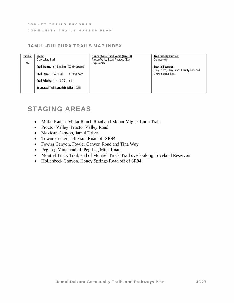
JAMUL-DULZURA TRAILS MAP INDEX
Trail #:
96
Name: Otay Lakes Trail Trail Status: ( ) Existing ( X ) Proposed Trail Type: ( X ) Trail ( ) Pathway Trail Priority: ( ) 1 ( ) 2 ( ) 3 Estimated Trail Length in Miles: 0.55
Connections: Trail Name (Trail #) Proctor Valley Road Pathway (52) Otay Border
Trail Priority Criteria: Connectivity Special Features: Otay Lakes, Otay Lakes County Park and CRHT connections.
STAGING AREAS
• Millar Ranch, Millar Ranch Road and Mount Miguel Loop Trail • Proctor Valley, Proctor Valley Road • Mexican Canyon, Jamul Drive • Towne Center, Jefferson Road off SR94 • Fowler Canyon, Fowler Canyon Road and Tina Way • Peg Leg Mine, end of Peg Leg Mine Road • Montiel Truck Trail, end of Montiel Truck Trail overlooking Loveland Reservoir • Hollenbeck Canyon, Honey Springs Road off of SR94