Embed Size (px)
Citation preview
!Jr;:, Entrance Anchorage
p sach~ Self Pt C;;r H:~tWII })
a~by ls O
Pt
Ef,:;:Z:3Taylor Is
K.iix?in National
H i storic Site
extensive mud flats at low tde passable at tides6ft!1.8m
American barque "CHARLES B. KINNEY" Nov. 1886, with lumber out of Port Townsend for Australia, no survivors.
Regional Setting
Pari<svitle o',. ' ~ r.~((l.o ,..~,./ 19 ~ o,,.. N
o.,
Pacific Ocean Cape Flattery
0~ Q,,.~
/
WCT lnlormation
/ - / ~naq~a (HFN)
/ /An-ag-ffa)
Centre - register ob and off the trail her . MayOt - Sept 30 J
' (Bamfield = 5k )
_ Main village Pachena Bay _ The point in which the steam splits In two
.it
'\I l
l
~ Wooden steamer "ALASKAN" 150 tons, Jan. 1923 out of Victoria loaded with salt for the salteries in Barkley Sound, entire crew lost.
~ Seabird Rocks
~ 767 ton wooden schooner "SEQUEL', Jan. 1909, out of Callao in ballast, captain's wile and 3 year old daughter lost, all others survived.
PA C I Fl C O C EA N
3 masted barque "SARAH", 1206 tons, Nov 1891 , a Bnt1sh ship from Manila m ballast for Puget Sound, 2 crew lost
LEGEND ~ highway
~ ~ .,,!tc &
·-~ ~
6 r-~ ·~
all-weather road
West Coast Trail forest route distance in km from Pachena Access
West Coast Trail - beach route
Indian Reserve ii ~ Treaty Settlement Lands
DD swampy area
~ buildings -sand, foreshore flats
C rocky ledge, rocky reef • shipwreck, general location only iii campsi:e - all campsites are located on the beaches Fri West Coast Trail Information Centre me - register on and off ri1
Pacific Rim National Park Reserve w1 Pacific Aim National Park Reserve (HFN) Marine Zone (DFN)
(PFN)
IN CASE OF EARTHQUAKE, GO TO HIGH GROUND OR INLAND
outhouse
access
beach access
parking
cable car
impassable headland
difficult surge channel
viewpoint, point of interest
Guardian cabin
Ditidaht luxury tent
Food locker
Huu-ay-aht Place Name Ditidaht Place Name Pacheedaht Place Name
contour interval - 30m
Tide heights quoted on tho face of the m.Jp arc ypproximato and pholographs courtesy assume calm seas; use tide tables for Tolino, 8.C. Add one hour Parks Canada during summer months tor Pacific Daylight Sav,ig Time. 20/6edition
-----/
-----
Q) .... C::, Q) 0 .c .c o(U.C
n."' ::,I Satsnit IHFN)
(Suts-nit) Pachena Pt.
Place of many tyee (large spring) salmon
<1l ~ Cun'aqu?i s (HFN) .c (Cha-naq-oo-is) u Beach and or Bay g:_ at Pachena Pl.
Vulva at it's mouth or Vulva mouth beach
(DFN) Chuldaksuss Beach or bay at Pachena Pl.
Vulva mouth beach
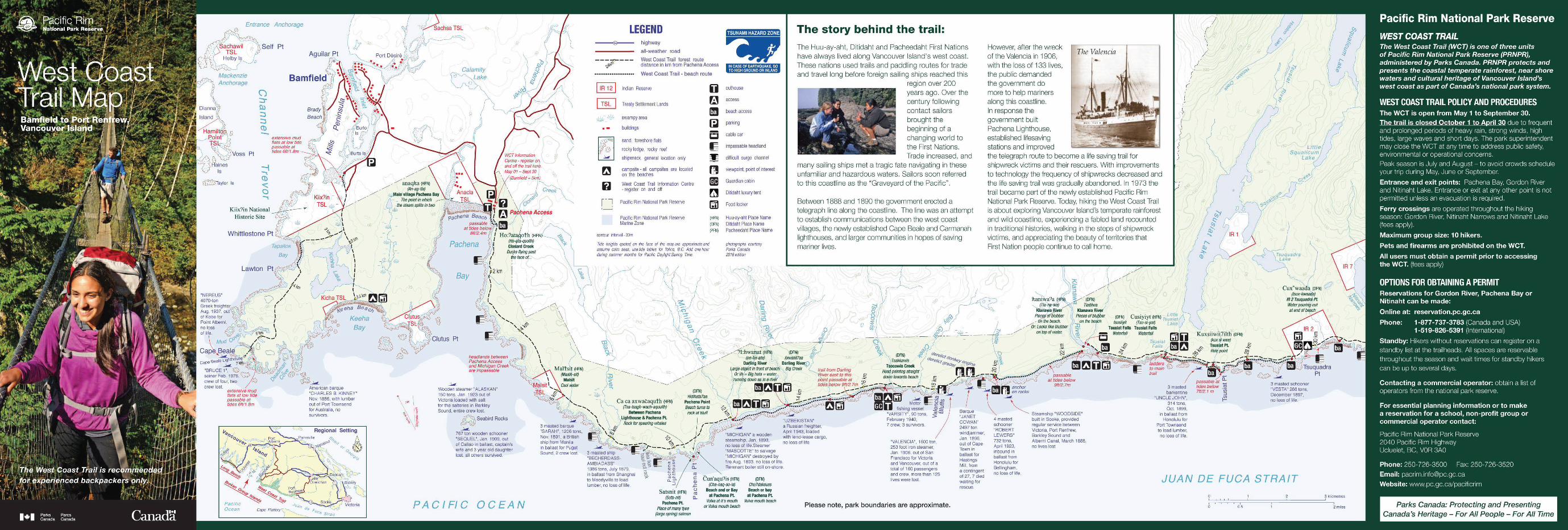
The story behind the trail: The Huu-ay-aht, Ditidaht and Pacheedaht First Nations have always lived along Vancouver Island's west coast. These nations used trails and paddling routes for trade and travel long before foreign sailing ships reached this
region over 200 years ago. Over the century following contact sailors brought the beginning of a changing world to the First Nations. Trade increased, and
many sailing ships met a tragic fate navigating in these unfamiliar and hazardous waters. Sailors soon referred to this coastline as the "Graveyard of the Pacific".
Retween 1888 and 1890 the government erected a telegraph line along the coastline. The line was an attempt to establish communications between the west coast villages, the newly established Cape Beale and Carmanah lighthouses, and larger communities in hopes of saving mariner lives.
"VALENCIA", 1600 ton, 253 foot iron steamer, Jan. 1906, out of San Francisco for Victoria and Vancouver, out of a total of 160 passengers and crew, more than 125 lives were lost.
Please note, park boundaries are approximate.
windjammer, Jan. 1896, out of Cape Town in ballast for Hastings Mill.from a contirgent of 27, ?died waiting for rescue.
However, after the wreck of the Valencia in 1906, with the loss of 133 lives, the public demanded the government do more to help mariners along this coastline. In response the government built Pachena Lighthouse, established lifesaving stations and improved
The Valencia •
the telegraph route to become a life saving trail for shipwreck victims and their rescuers. With improvements to technology the frequency of shipwrecks decreased and the life saving trail was gradually abandoned. In 1973 the trail became part of the newly established Pacific Rim National Park Reserve. Today, hiking the West Coast Trail is about exploring Vancouver Island's temperate rainforest and wild coastline, experiencing a fabled land recounted in traditional histories, walking in the steps of shipwreck victims, and appreciating the beauty of territories that First Nation people continue to call home.
' ,l > '
\ f ( )
f (
' / /
) I
~/ Cuxwwaada (DFN) \r
/tsux-i<Waada) IR 2 Tsuquad~ Pt. Water pourinp out at end of beach
JUAN DE FUCA STRAIT
3 kilometres
0.5 2miles Parks Canada: Protecting and Presenting Canada's Heritage- For All People - For All Time
Nitinaht Village Entrance
tidal
0 Nitinaht Cone
.. . Clo-oose N,tmaht Narrows impassable Lako
caax· iyt (DFNJ (Cheewat)
Cheewhat River Little stream of
except by boat - ferry service available for a fee. 9:30am - 4:30pm
barkentine "SKAGIT" 506 tons Oct. 1906, inbound from San Francisco to Port Gamble to load lumber, no loss of life.
..:,,,,,_
600 tons, steel steamer, "SANTA RITA" Feb, 1923, no loss 01 1,te.
During dry weather fresh water can be scarce between Tsquadra (KM 30) and Dare Beach (KM 40).
Please note, park boundaries are approximate.
Cheewhat Lake
I \
/ I
\ \
' o \ '
\\
-.\11,--_
""
between 38.6km and 41 km passable at tides
below 7ft/2.1m
~ schooner 8 "DARE', 259tons, Dec. 1890, out of San Francisco in ballast tor Tacoma to load lumber, no loss of life.
)
waawaax~adis (OFN) Coal Creek
Sounding beach or farting beach
sea/ion/• ..c haul oul rock ~
co E ~ (.)
) q· abaaduwa? (DFN) '
IR S
()
Feb. 1884, no loss of life.
~ % - -/--~~~---
,/·\ _.,,.../ ~\() / _ Cl> I::, X
/ ,. - ~ ~ ~ nowater -
\ / "' '£ ava,fable c-:a n /,. ~ /t -~----- ', -----~ ~ _/ .. t&J~'~·•m~ . ...,.,. '...........- ~ __ .,, \ _..,,.., - ~-.. ......_ ~
-· ---- , ........ - ... 1~ l!!J. Ss.,.. ..... --. •••• ., [!1.,.. ...... ----o- ~- ~~ ~ :...:.,,L._(9 0:
~:"::~ ~ ················· •·· · .. : . ' ~ ·- ' ,, • ., Bnt,sh ironbarque o.,_$ \{,j,~T~ . ..-•• • • · · I , . ':L,.c:--:-:'.:.:..,.·.~ ~ "DUCHESS OF betweenth,spomt -1:J\ ft~ '~ ._,.,. ·· , - - ARGYLE" Nov 1887 and Bon•lfa Pt passable >- between here and Wl!!J dangerous surge channel in ballast from. San · al tides below 10ft/3.0m; ~ Walbran Creek passable at watelfa/1, hikers stay on Francisco for beach ,s the usual route. 5 CL al tides below 9/V2. lm; the trail between Logan and Vancouver,
4 masted wooden O and when Walbran Creek Walbran Creeks and do not no loss of life. schooner "WEMPE c ,snot m flood. attempt to cross Adrenaline
BROTHERS' , 681 tons. ~ surge channel. Oct. 1901 , inbound from
San Pedro to pick up lumber in Puget Sound.
3 masted ship "JOHN MARSHALL" 321 tons, Nov. 1860, out of San Francisco
in ballast bound for Seaback, Washington.
no loss of life.
1153 tons. Dec. 1865,
inbound from South Africa in ballast for
Puget Sound, no loss of life.
Mulliple surge channels
;~
* Kellet Rock
Beach Access A lo Thrasher Cove is passable at tides below Bft/2.4 m except at Owen Pt where tides below 6 IV1.8 mare required. 1/Jis is a d1fficull route with surge channels and many boulders.
JUAN DE FUCA
C co :::,
--:,
C co
Cl)
STRAIT
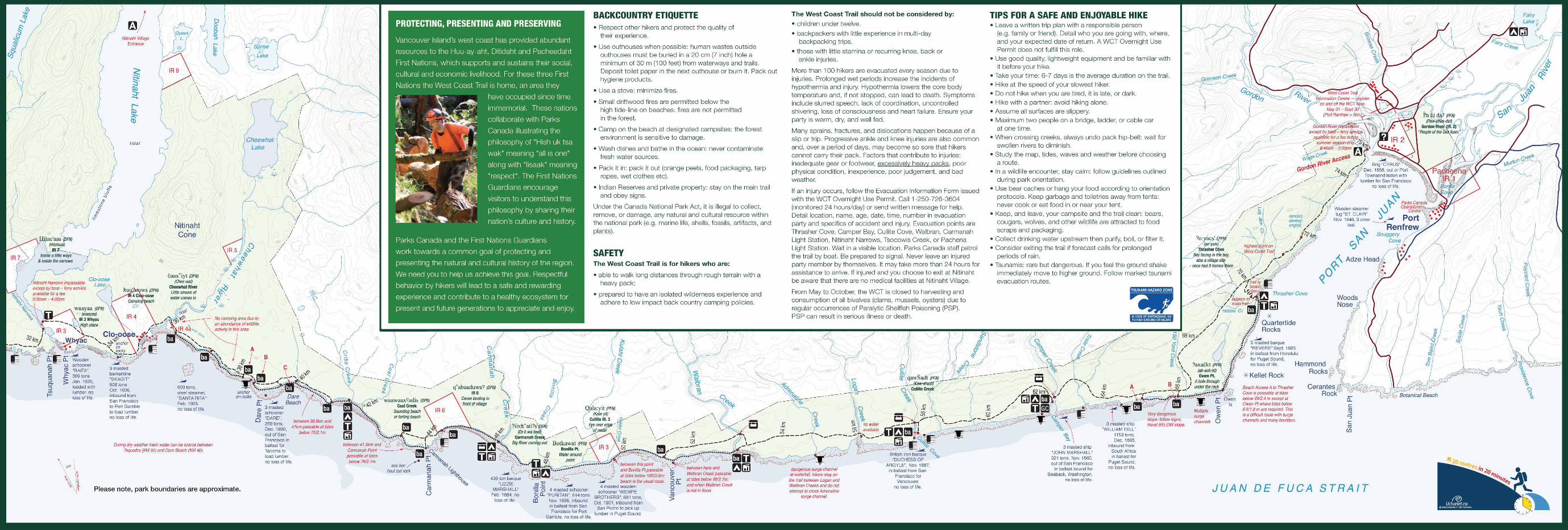
BACKCOUNTRY ETIQUETTE • Respect other hikers and protect the quality of
their experience.
• Use outhouses when possible: human wastes outside outhouses must be buried in a 20 cm (7 inch) hole a minimum of 30 m (1 00 feet) from waterways and trails. Deposit toilet paper in the next outhouse or burn it. Pack out hygiene products.
• Use a stove: minimize fires.
• Small driftwood fires are permitted below the high tide-line on beaches: fires are not permitted in the forest.
• Camp on the beach at designated campsites: the forest environment is sensitive to damage.
• Wash dishes and bathe in the ocean: never contaminate fresh water sources.
• Pack it in: pack it out (orange peels, food packaging, tarp ropes, wet clothes etc).
• Indian Reserves and private property: stay on the main trail and obey signs.
Under the Canada National Park Act, it is illegal to collect, remove, or damage, any natural and cultural resource within the national park (e.g. marine life, shells, fossils, artifacts, and plants).
SAFETY The West Coast Trail is for hikers who are:
• able to walk long distances through rough terrain with a heavy pack;
• prepared to have an isolated wilderness experience and adhere to low impact back country camping policies.
The West Coast Trail should not be considered by:
• children under twelve.
• backpackers with little experience in multi-day backpacking trips.
• those with little stamina or recurring knee, back or ankle injuries.
More than 100 hikers are evacuated every season due to injuries. Prolonged wet periods increase the incidents of hypothermia and injury. Hypothermia lowers the core body temperature and, if not stopped, can lead to death. Symptoms include slurred speech, lack of coordination, uncontrolled shivering, loss of consciousness and heart failure. Ensure your party is warm, dry, and well fed.
Many sprains, fractures, and dislocations happen because of a slip or trip. Progressive ankle and knee injuries are also common and, over a period of days, may become so sore that hikers cannot carry their pack. Factors that contribute to injuries: inadequate gear or footwear, excessively heavy packs, poor physical condition, inexperience, poor judgement , and bad weather.
If an injury occurs, follow the Evacuation Information Form issued with the WCT Overnight Use Permit. Call 1-250· 726-3604 (monitored 24 hours/day) or send written message for help. Detail location, name, age, date, time, number in evacuation party and specifics of accident and injury. Evacuation points are Thrasher Cove, Camper Bay, Cullite Cove, Walbran, Carmanah Light Station, Nitinaht Narrows, Tsocowis Creek, or Pachena Light Station. Wait in a visible location. Parks Canada staff patrol the trail by boat. Be prepared to signal. Never leave an injured party member by themselves. It may take more than 24 hours for assistance to arrive. If injured and you choose to exit at Nitinaht be aware that there are no medical facilities at Nitinaht Village.
From May to October, the WCT is closed to harvesting and consumption of all bivalves (clams, mussels, oysters) due to regular occurrences of Paralytic Shellfish Poisoning (PSP). PSP can result in serious illness or death.
TIPS FOR A SAFE AND ENJOYABLE HIKE • Leave a written trip plan with a responsible person
(e.g. family or friend). Detail who you are going with, where, and your expected date of return. A WCT Overnight Use Permit does not fulfill this role.
• Use good quality, lightweight equipment and be familiar with it before your hike.
• Take your time: 6-7 days is the average duration on the trail. • Hike at the speed of your slowest hiker. • Do not hike when you are tired, it is late, or dark. • Hike with a partner: avoid hiking alone. • Assume all surfaces are slippery. • Maximum two people on a bridge, ladder, or cable car
at onetime. • When crossing creeks, always undo pack hip-belt: wait for
swollen rivers to diminish. • Study the map, tides, waves and weather before choosing
a route. • In a wildlife encounter, stay calm: follow guidelines out lined
during park orientation. • Use bear caches or hang your food according to orientation
protocols. Keep garbage and toiletries away from tents: never cook or eat food in or near your tent.
• Keep, and leave, your campsite and the trail clean: bears, cougars, wolves, and other wildlife are attracted to food scraps and packaging.
• Collect drinking water upstream then purify, boil, or filter it. • Consider exiting the trail if forecast calls for prolonged
periods of rain. • Tsunamis: rare but dangerous. If you feel the ground shake
immediately move to higher ground. Follow marked tsunami evacuation routes.