Embed Size (px)
DESCRIPTION
The latest from the Kamloops Fire Centre
Citation preview
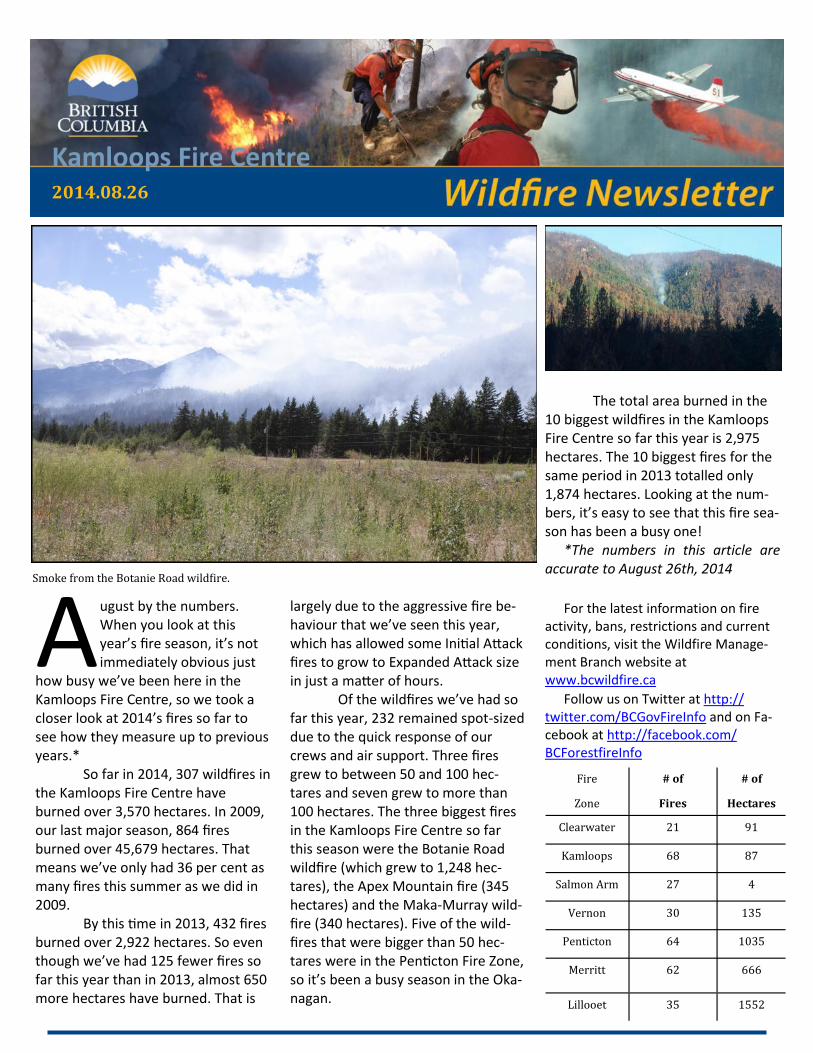
Kamloops Fire Centre 2014.08.26
A ugust by the numbers. When you look at this year’s fire season, it’s not immediately obvious just
how busy we’ve been here in the Kamloops Fire Centre, so we took a closer look at 2014’s fires so far to see how they measure up to previous years.* So far in 2014, 307 wildfires in the Kamloops Fire Centre have burned over 3,570 hectares. In 2009, our last major season, 864 fires burned over 45,679 hectares. That means we’ve only had 36 per cent as many fires this summer as we did in 2009. By this time in 2013, 432 fires burned over 2,922 hectares. So even though we’ve had 125 fewer fires so far this year than in 2013, almost 650 more hectares have burned. That is
largely due to the aggressive fire be-haviour that we’ve seen this year, which has allowed some Initial Attack fires to grow to Expanded Attack size in just a matter of hours. Of the wildfires we’ve had so far this year, 232 remained spot-sized due to the quick response of our crews and air support. Three fires grew to between 50 and 100 hec-tares and seven grew to more than 100 hectares. The three biggest fires in the Kamloops Fire Centre so far this season were the Botanie Road wildfire (which grew to 1,248 hec-tares), the Apex Mountain fire (345 hectares) and the Maka-Murray wild-fire (340 hectares). Five of the wild-fires that were bigger than 50 hec-tares were in the Penticton Fire Zone, so it’s been a busy season in the Oka-nagan.
The total area burned in the 10 biggest wildfires in the Kamloops Fire Centre so far this year is 2,975 hectares. The 10 biggest fires for the same period in 2013 totalled only 1,874 hectares. Looking at the num-bers, it’s easy to see that this fire sea-son has been a busy one!
*The numbers in this article are accurate to August 26th, 2014
For the latest information on fire activity, bans, restrictions and current conditions, visit the Wildfire Manage-ment Branch website at www.bcwildfire.ca
Follow us on Twitter at http://twitter.com/BCGovFireInfo and on Fa-cebook at http://facebook.com/BCForestfireInfo
Fire
Zone
# of
Fires
# of
Hectares
Clearwater 21 91
Kamloops 68 87
Salmon Arm 27 4
Vernon 30 135
Penticton 64 1035
Merritt 62 666
Lillooet 35 1552
Smoke from the Botanie Road wildfire.
P A G E 2
Open Burning Prohibitions
Campfires permitted in the Kamloops Fire Centre KAMLOOPS – Effective at 5 p.m. on Thursday, Aug. 21, campfires were once again permitted through-out the Kamloops Fire Centre.
The campfire prohibition was rescinded due to pre-cipitation, which resulted in a decreased wildfire risk in the region.
Anyone lighting a campfire must use caution and follow provincial regulations:
• The campfire must not be bigger than a half-metre wide or a half-metre high.
• Flammable material (such a twigs and pine nee-dles) must be removed from around the campfire area and this fuel-free area must be maintained while the campfire is burning.
• A shovel or at least eight litres of water must be available onsite to properly extinguish the fire.
• A campfire must never be left unattended.
• The ashes must be cool to the touch before you leave the area for any length of time.
Category 2 and 3 open fires, however, remain pro-hibited throughout the entire Kamloops Fire Centre. This prohibition includes any open fire larger than a half-metre high by a half-metre wide, fires requiring a burn registration number, industrial burning, fire-works, sky lanterns and burning barrels of any size and description.
Anyone found in violation of an open fire prohibi-tion may be issued a ticket for up to $345. If the fire leads to a wildfire, the person(s) responsible may be fined up to $1 million, spend up to three years in prison and be held accountable for associated fire-fighting costs.
These open burning prohibitions cover all BC Parks, Crown lands and private lands, but do not apply within the boundaries of local governments that have forest fire prevention bylaws and are serviced by fire departments. Please check with local govern-ments for any other restrictions before lighting any fire.
For more information, see www.bcwildfire.ca
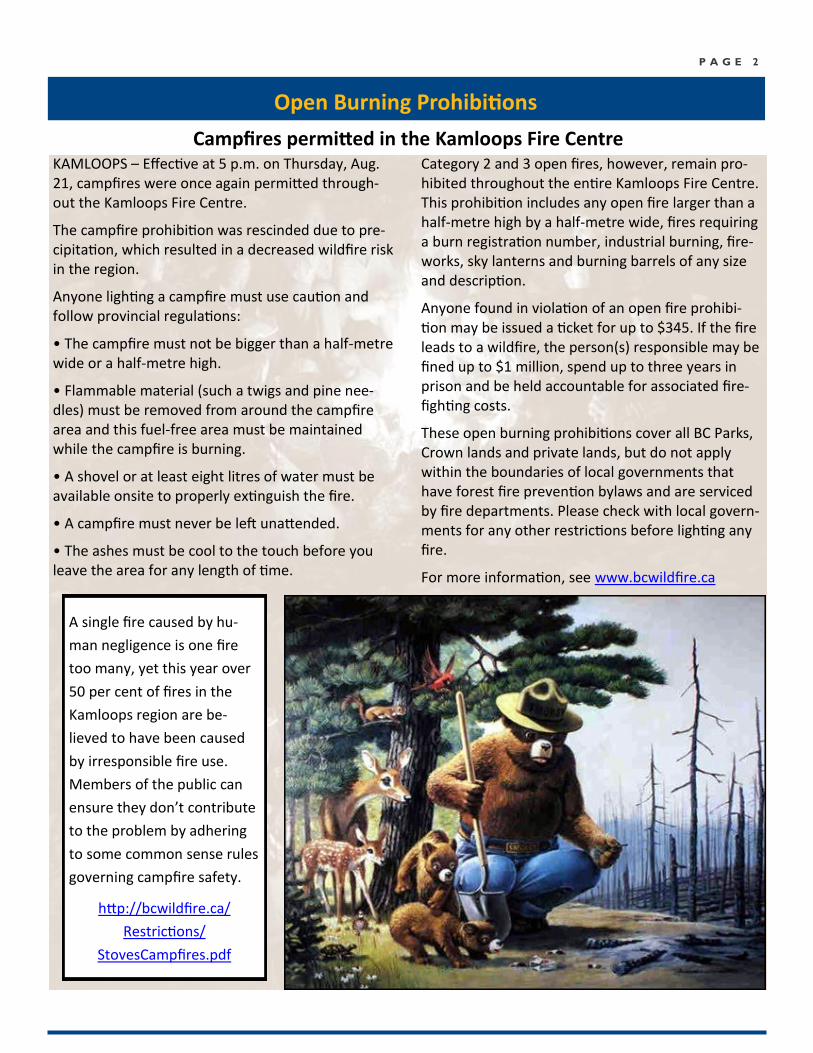
A single fire caused by hu-
man negligence is one fire
too many, yet this year over
50 per cent of fires in the
Kamloops region are be-
lieved to have been caused
by irresponsible fire use.
Members of the public can
ensure they don’t contribute
to the problem by adhering
to some common sense rules
governing campfire safety.
http://bcwildfire.ca/
Restrictions/
StovesCampfires.pdf
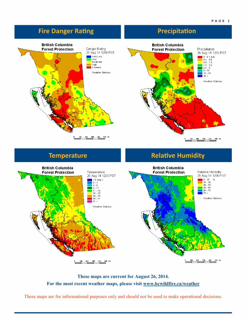
P A G E 3
Precipitation
Temperature Relative Humidity
These maps are for informational purposes only and should not be used to make operational decisions.
Fire Danger Rating
These maps are current for August 26, 2014.
For the most recent weather maps, please visit www.bcwildfire.ca/weather
P A G E 4
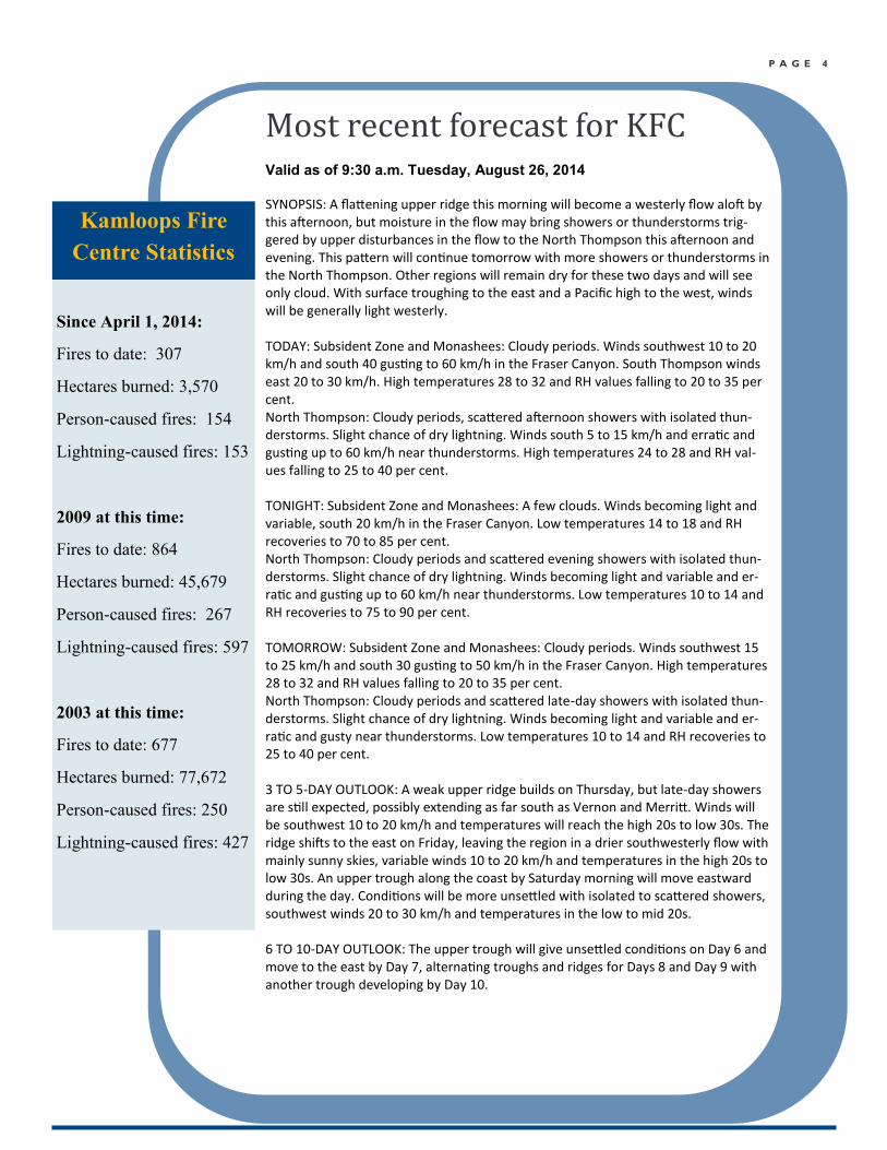
Most recent forecast for KFC Valid as of 9:30 a.m. Tuesday, August 26, 2014
SYNOPSIS: A flattening upper ridge this morning will become a westerly flow aloft by this afternoon, but moisture in the flow may bring showers or thunderstorms trig-gered by upper disturbances in the flow to the North Thompson this afternoon and evening. This pattern will continue tomorrow with more showers or thunderstorms in the North Thompson. Other regions will remain dry for these two days and will see only cloud. With surface troughing to the east and a Pacific high to the west, winds will be generally light westerly. TODAY: Subsident Zone and Monashees: Cloudy periods. Winds southwest 10 to 20 km/h and south 40 gusting to 60 km/h in the Fraser Canyon. South Thompson winds east 20 to 30 km/h. High temperatures 28 to 32 and RH values falling to 20 to 35 per cent. North Thompson: Cloudy periods, scattered afternoon showers with isolated thun-derstorms. Slight chance of dry lightning. Winds south 5 to 15 km/h and erratic and gusting up to 60 km/h near thunderstorms. High temperatures 24 to 28 and RH val-ues falling to 25 to 40 per cent. TONIGHT: Subsident Zone and Monashees: A few clouds. Winds becoming light and variable, south 20 km/h in the Fraser Canyon. Low temperatures 14 to 18 and RH recoveries to 70 to 85 per cent. North Thompson: Cloudy periods and scattered evening showers with isolated thun-derstorms. Slight chance of dry lightning. Winds becoming light and variable and er-ratic and gusting up to 60 km/h near thunderstorms. Low temperatures 10 to 14 and RH recoveries to 75 to 90 per cent. TOMORROW: Subsident Zone and Monashees: Cloudy periods. Winds southwest 15 to 25 km/h and south 30 gusting to 50 km/h in the Fraser Canyon. High temperatures 28 to 32 and RH values falling to 20 to 35 per cent. North Thompson: Cloudy periods and scattered late-day showers with isolated thun-derstorms. Slight chance of dry lightning. Winds becoming light and variable and er-ratic and gusty near thunderstorms. Low temperatures 10 to 14 and RH recoveries to 25 to 40 per cent. 3 TO 5-DAY OUTLOOK: A weak upper ridge builds on Thursday, but late-day showers are still expected, possibly extending as far south as Vernon and Merritt. Winds will be southwest 10 to 20 km/h and temperatures will reach the high 20s to low 30s. The ridge shifts to the east on Friday, leaving the region in a drier southwesterly flow with mainly sunny skies, variable winds 10 to 20 km/h and temperatures in the high 20s to low 30s. An upper trough along the coast by Saturday morning will move eastward during the day. Conditions will be more unsettled with isolated to scattered showers, southwest winds 20 to 30 km/h and temperatures in the low to mid 20s. 6 TO 10-DAY OUTLOOK: The upper trough will give unsettled conditions on Day 6 and move to the east by Day 7, alternating troughs and ridges for Days 8 and Day 9 with another trough developing by Day 10.
Kamloops Fire
Centre Statistics
Since April 1, 2014:
Fires to date: 307
Hectares burned: 3,570
Person-caused fires: 154
Lightning-caused fires: 153
2009 at this time:
Fires to date: 864
Hectares burned: 45,679
Person-caused fires: 267
Lightning-caused fires: 597
2003 at this time:
Fires to date: 677
Hectares burned: 77,672
Person-caused fires: 250
Lightning-caused fires: 427
P A G E 5
Thank you
If you were to ask a Wild-
fire Management Branch
firefighter what one of
their favourite things
about the job was, nine
out of 10 times they
would say it’s the satis-
faction they get from be-
ing able to make a differ-
ence. So far this season,
several wildfires in the
Kamloops Fire Centre
have led to evacuation
orders and alerts, threat-
ened homes and dis-
placed the public. Due to
the hard work of person-
nel on the ground, air
support and all the folks
working tirelessly behind
the scenes, we were able
to prevent those wildfires
turning into fires like the
ones we saw in 2003 and
2009. The overwhelming
support that our crews
have received from the
public in areas affected
by wildfire has been in-
spiring, and we’d like to
share the responses.
Here are some pictures
that speak louder than
words.
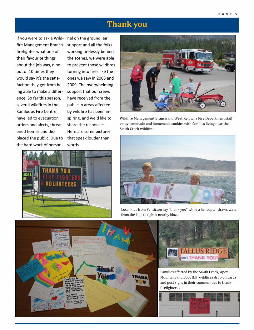
Wildfire Management Branch and West Kelowna Fire Department staff
enjoy lemonade and homemade cookies with families living near the
Smith Creek wildfire.
Local kids from Penticton say “thank you” while a helicopter draws water
from the lake to fight a nearby blaze.
Families affected by the Smith Creek, Apex
Mountain and Boot Hill wildfires drop off cards
and post signs in their communities to thank
firefighters .
P A G E 6
Fuel Moisture Codes
Want more information? Visit the website at bcwildfire.ca
Report a Wildfire *5555 on a cell or 1 800 663-5555
Wildfire Information Line 1 888 3FOREST
Burn Registration Line 1 888 797-1717
Kamloops Fire Centre 1 250 554-5965
Media and Public Line
Important Numbers
W eather information is used to develop
codes to indicate how dry the different
classes of fuels are in the forest. From
this information, preparedness levels are set on a daily
basis.
The FFMC (Fine Fuel Moisture Code) is a code that
measures the dryness of fine fuels (grasses, needles,
etc.). A number of 85 or higher indicates a good
chance of a fire start from an ignition source. Once 90
or higher is reached, all the fine fuels are available to
burn.
The DMC (Duff Moisture Code) measures about 10
cm into the ground and is an indication of whether a
fire that starts will continue to burn in the duff. A num-
ber of 40 or greater would indicate that a fire will con-
tinue to burn.
The DC is the Drought Code, measuring deeper in the
ground. A number of 300 or greater indicates that the
fire will burn deep into the ground, providing challeng-
es to mop it up.
The Danger Class is the typical Fire Danger Rating that
is seen on fire signage, where 1 and 2 represent “low”,
3 is “moderate,” 4 is “high” and 5 is “extreme.” A map
of the current Fire Danger Ratings is on Page 3.
* If you have any questions about which weather
station you should be monitoring, please contact your
company forester or local fire zone for information.
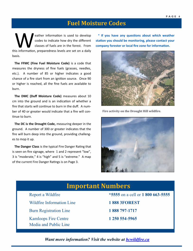
Fire activity on the Drought Hill wildfire.
P A G E 7
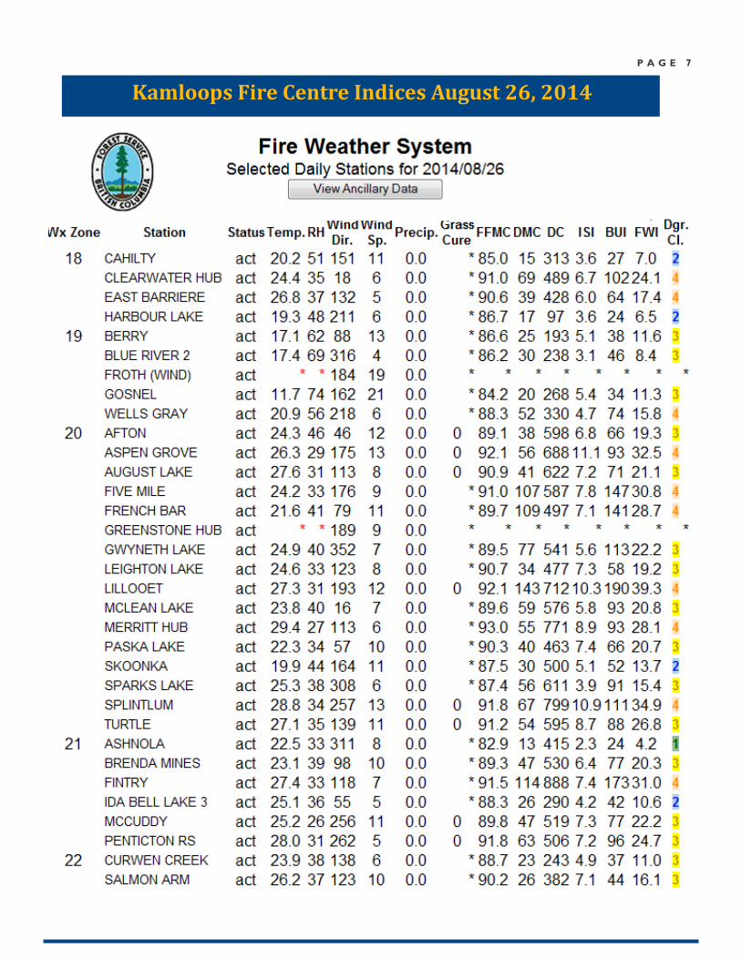
Kamloops Fire Centre Indices August 26, 2014