Embed Size (px)
Citation preview
LAGUNA ATASCOSA NATIONAL WILDLIFE REFUGE
SOUTH TEXAS REFUGE COMPLEX
PROPOSED RE-FLOODING AND RESTORATION OF BAHIA GRANDE
FINAL DRAFT
ENVIRONMENTAL ASSESSMENT
In 1998 and 1999, the U.S. Fish and Wildlife Service bought privately owned lands surroundingthe Bahia Grande wetland complex. The primary reasons for restoring this wetland system are:
! to provide nursery areas and habitat for aquatic organisms such as shrimp, crabs,and finfish
! to provide habitat for migratory wildlife such as water birds! to reduce Bahia Grande as a source of windblown dust! to provide increased public recreational areas
30-DAY PUBLIC COMMENT PERIOD: AUGUST 4 - SEPTEMBER 5, 3003
Please send written comments to:
South Texas Refuge ComplexRt. 2, Box 202-AAlamo, Texas 78516
or e-mail comments to:
A PUBLIC MEETING IS SCHEDULED TO PROVIDE INFORMATION AND TOSOLICIT PUBLIC COMMENTS:
! Thursday, August 14, 2003! 5:00 p.m. to 9:00 p.m.! Port Isabel High School - Cafeteria! Located on State Highway 100 just east of Laguna Heights, Texas
Return to Laguna Atascosa National Wildlife Refuge website
FINAL DRAFT
3
SUMMARY
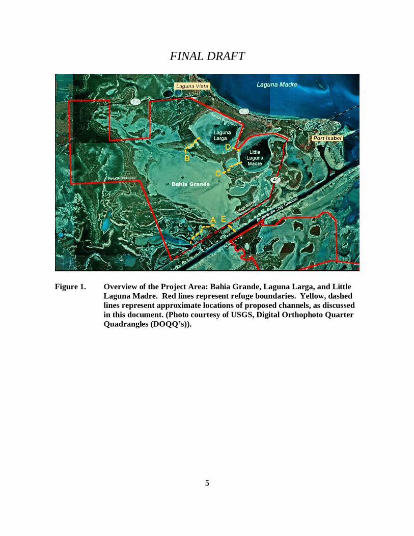
The U.S. Fish and Wildlife Service proposes to restore tidal flow to the Bahia Grande wetlandcomplex, a portion of the Bahia Grande Unit of the Laguna Atascosa National Wildlife Refuge. The Bahia Grande Unit covers 21,762.451 acres of land at the present time, including bay,basins, lomas, low-lying flats, resacas, and native brush. The Bahia Grande, historically ashallow bay, is the major wetland feature on the unit and consists of approximately 6,500 acres.The bay is ephemeral in nature and is covered with water only following extreme rainfall eventsor tropical storm surges. The majority of time, the basin remains dry. The project area is shownin Figure 1.
The Bahia Grande Unit is located in Cameron County west of Port Isabel, Texas. Part of theTamaulipan Biotic Province, this unit of the refuge is close to the Gulf of Mexico and consists ofwind tidal flats and high ground that includes brush covered clay dunes (lomas) that attainheights of up to 30 feet. This matrix of stabilized clay dunes is interspersed with grass and brushcovered uplands, saline flats, marshes and shallow bays. Historically, the Bahia Grande area wasrich in biological resources and contained important waterfowl habitat, especially for winteringwaterfowl. Bahia Grande was also an important estuarine nursery area, contributing to aproductive sport and commercial fishery. A small island within the bay provided nesting habitatfor more than 10,000 terns, gulls and black skimmers. With the construction of the BrownsvilleShip Channel in the 1930's and the placement of dredge spoil on the north side of the channel,the shallow bay and wind tidal flats were isolated from the Laguna Madre. Open exchange ofwater was effectively blocked. An additional blockage was caused by the construction of StateHighway 48 when a road bed was created across a portion of the Bahia Grande. Theseinterruptions of the natural hydrological connection between Bahia Grande and the LagunaMadre caused a decline in biological productivity of the tidal flats and loss of wildlife dependenton this productivity, including a decline in waterfowl numbers. In its historical condition of the1920's, Bahia Grande must have supported wintering flocks of redheads and other ducks, muchas the adjacent Lower Laguna Madre does today. Once converted from a dry basin to oneinundated by tidal variations, it is highly probable that flocks of redheads and other waterfowlwill once again use the area on a regular basis in the winter months. In addition, floralassemblages were altered. At present, Bahia Grande is barren and dry most of the year with onlyportions having ephemeral, moist sediment or standing water conditions. Primary inflows arelimited to water captured during precipitation events and occasional storm surges.
Reasons for restoring flow to this system are:
(1) to provide nursery areas and habitat for aquatic organisms such as shrimp, crabs and finfish,
(2) to provide habitat for resident and migratory wildlife such as water birds,
FINAL DRAFT
4
(3) to reduce Bahia Grande as a source of windblown dust, and
(4) to provide increased public recreational areas.
The U.S. Fish and Wildlife Service proposes to re-flood and restore the Bahia Grande throughconstruction of a channel or channels designed to take advantage of the normal tidal regime inthe area and permit adequate tidal exchange of salt water to maximize water circulation as wellas allow migration of marine organisms into and out of the basin. These actions willsignificantly increase productivity of this wetland system. Engineering and hydrological studiesindicate that under favorable conditions water may inundate approximately 6,500 acres. Atopographic survey shows that most of the Bahia Grande basin lies below mean sea level (MSL)and would be inundated with seawater during low tides. Additional acreage would be inundatedby high tides, storm surges or periods of high rainfall.
There is much local interest between both private individuals and agencies in the prospect ofrestoring flow and productivity to Bahia Grande. Support comes from local landowners,officials and residents of nearby communities, and a number of conservation organizations (TheOcean Trust, The Conservation Fund, Natural Resources Conservation Service, DucksUnlimited, Coastal Conservation Association, National Marine Fisheries Service, NationalFisheries Institute and Texas Parks and Wildlife Department). Several organizations haveoffered financial and technical assistance for the Bahia Grande restoration project.
A hydrological modeling and channel design study has been funded by the National MarineFisheries Service, and is available on request from the South Texas Refuge Complex. It wasproduced as a thesis headed by Dr. Billy Edge of the Ocean Engineering Program, Departmentof Civil Engineering, Texas A&M University. This study details the water circulation andmixing needed in the Bahia Grande to accomplish biological productivity goals and givesrecommendations on the technical aspects of channel design needed to accomplish these goals. It was from this thesis, by Dianna L. Van Valkenburg, that channel designs for this project weretaken.
The proposed re-flooding and restoration project of Bahia Grande has four different alternatives:
(I) Alternative I: (No Action Alternative) No Flooding,
(II) Alternative II: Flooding from San Martin Lake only (Channel A),
(III) Alternative III: Flooding from Brownsville Ship Channel only (Channel E), and
(IV) Alternative IV: (Preferred Alternative) Flooding from both directions (II and III).
See Figure 1. for a graphical depiction of the approximate locations of these planned channels.
FINAL DRAFT
5
Figure 1. Overview of the Project Area: Bahia Grande, Laguna Larga, and LittleLaguna Madre. Red lines represent refuge boundaries. Yellow, dashedlines represent approximate locations of proposed channels, as discussedin this document. (Photo courtesy of USGS, Digital Orthophoto QuarterQuadrangles (DOQQ’s)).
FINAL DRAFT
6
TABLE OF CONTENTS
1.0 PURPOSE AND NEED FOR ACTION1.1 Purpose and Need1.1.1 Purpose1.1.2. Need1.2 Proposed Action1.3 Decisions Needed
2.0 DESCRIPTION OF ALTERNATIVES2.1 Alternative I: (No Action Alternative) No Flooding2.2 Alternative II: Flooding from San Martin Lake only (Channel A)2.3 Alternative III: Flooding from Brownsville Ship Channel only (Channel E)2.4 Alternative IV: (Preferred Alternative) Flooding from both directions (II and III)2.41 Study Results
3.0 AFFECTED ENVIRONMENT3.1 Climate3.2 Air Quality3.3 Geology and Soils3.4 Water Resources3.5 Biological Resources3.5.1. Wildlife3.5.2 Vegetation3.6 Cultural Resources3.7 Land Use3.8 Socioeconomic Considerations3.8.1 Tax Revenues3.9 Public Use and Recreation3.10 Contaminants and Hazardous Wastes
4.0 ALTERNATIVES AND ENVIRONMENTAL CONSEQUENCES4.1 Alternative I: (No Action Alternative) No Flooding4.1.1 Climate4.1.2 Air Quality4.1.3 Geology and Soils4.1.4 Water Resources4.1.5 Biological Resources4.1.6 Cultural Resources4.1.7 Land Use4.1.8 Socioeconomic Considerations4.1.8.1 Tax Revenues4.1.9 Public Use and Recreation4.1.10 Contaminants and Hazardous Wastes
FINAL DRAFT
7
4.2 Alternative II: Flooding from San Martin Lake only (Channel A)4.2.1 Climate4.2.2 Air Quality4.2.3 Geology and Soils4.2.4 Water Resources4.2.5 Biological Resources4.2.6 Cultural Resources4.2.7 Land Use4.2.8 Socioeconomic Considerations4.2.8.1 Tax Revenues4.2.9 Public Use and Recreation4.2.10 Contaminants and Hazardous Wastes4.3 Alternative III: Flooding from Brownsville Ship Channel only (Channel E)4.3.1 Climate4.3.2 Air Quality4.3.3 Geology and Soils4.3.4 Water Resources4.3.5 Biological Resources4.3.6 Cultural Resources4.3.7 Land Use4.3.8 Socioeconomic Considerations4.3.8.1 Tax Revenues4.3.9 Public Use and Recreation4.3.10 Contaminants and Hazardous Wastes4.4 Alternative IV: (Preferred Alternative) Flooding from both areas (II and III). 4.4.1 Climate4.4.2 Air Quality4.4.3 Geology and Soils4.4.4 Water Resources4.4.5 Biological Resources4.4.6 Cultural Resources4.4.7 Land Use4.4.8 Socioeconomic Considerations4.4.8.1 Tax Revenues4.4.9 Public Use and Recreation4.4.10 Contaminants and Hazardous Wastes
5.0 UNEXPECTED IMPACTS - CONTROLLED/MINIMIZED
6.0 REFUGE OVERSIGHT7.0 ENVIRONMENTAL JUSTICE ISSUES
8.0 PERMITS REQUIRED8.1 U.S. Army Corps of Engineers
FINAL DRAFT
8
8.2 Texas Historic Preservation Office8.3 Texas Council on Environmental Quality8.4 National Environmental Policy Compliance Act
9.0 PUBLIC COMMENTS
10.0 CUMULATIVE IMPACTS
11.0 MITIGATION
12.0 DOCUMENT PREPARATION
13.0 OTHER FEDERAL AGENCIES CONSULTED
APPENDIX A: REFERENCES
APPENDIX B: LETTERS OF SUPPORT1. Letter from the Garcia Family
APPENDIX C: HISTORIC DOCUMENTS1. Reprint of a 1945 Newspaper Article2. Letter from the Superintendent, Port Isabel/South Padre Island ISD
APPENDIX D: TOPOGRAPHIC MAP AND SECTIONAL VIEWS OF CHANNELS
LIST OF FIGURES
FIGURE 1. Map of Project Area
FIGURE 2. Windblown Dust Photograph
FIGURE 3. From Clouds of Dust to Schools of Fish
FIGURE 4. Table of Channels A and E, Dimensions
FIGURE 5. Table of Channels A and E, Lunar Tides Effects
FIGURE 6. Table of Channel Dimensions and Estimate Construction Costs
FIGURE 7. Table of Wind Tide Measurements in Bahia Grande
FINAL DRAFT
9
1.0 PURPOSE AND NEED FOR ACTION
1.1 Purpose and Need
1.1.1 Purpose
The purpose of the proposed action is to reestablish, as much as possible, the natural characterand biological functions of the Bahia Grande. Ultimately, implementing the proposed actionwould allow the Laguna Atascosa National Wildlife Refuge (the Refuge) to further accomplishits migratory bird objectives, while being able to develop, manage, conserve and protect fish andwildlife resources (under the Fish and Wildlife Act of 1956). The original enabling legislationfor the Refuge and its current purposes make it clear that refuge objectives include conservationand maintenance of wintering habitat for migratory waterfowl.
1.1.2 Need
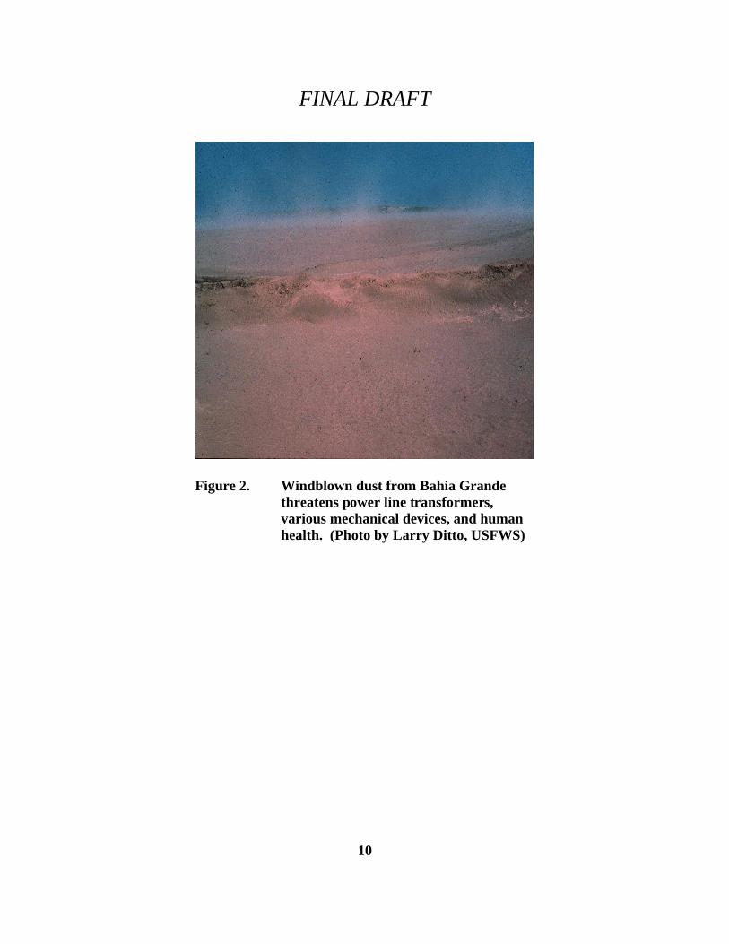
Restoration of flow to the Bahia Grande will greatly enhance biological productivity, restorehabitat for wintering waterfowl and migratory shorebirds, create additional nursery habitat forfinfish and shellfish populations and restore and enhance other native wildlife and plantcommunities, including seagrass beds and fringing black mangrove stands. This effortrepresents an opportunity to restore a natural tidal hydrological pattern in the Bahia Grande, withthe goal of achieving a biodiversity level currently present at nearby San Martin Lake. As wellas providing needed habitat for waterfowl, shorebirds, wading birds and other wildlife, thisrestoration could open up new recreational fishing opportunities and contribute to thecommercial shellfish and finfish industries. In addition, a blowing sediment problem, which isaffecting air quality in nearby communities, will be greatly reduced (Photo A, Figure 2).
FINAL DRAFT
10
Figure 2. Windblown dust from Bahia Grandethreatens power line transformers,various mechanical devices, and humanhealth. (Photo by Larry Ditto, USFWS)
FINAL DRAFT
11
San Martin Lake is a presently an active estuary, connected to the Brownsville Ship Channel. The lower third of this estuary is on the Bahia Grande Unit. Lined with black mangroves, andwind tidal flats, San Martin Lake is habitat for cormorants, pelicans, night-herons, herons, egrets,spoonbills, ducks, gulls, terns, and various passerine species. It receives copious freshwaterflows from its upper end where several major drainage ditches from Brownsville converge. Because of these drainage ditches’ effects, San Martin is often much less salty than the LowerLaguna Madre and Brownsville Ship Channel.
Two documents in Appendix C cite the substantial need for flooding Bahia Grande, LagunaLarga, and Little Laguna Madre, all on refuge lands, to curtail the blowing dust problem. One isa newspaper article from 1945, illustrating the longevity of this dust problem. The other is aletter from the Superintendent of Schools in Port Isabel, listing the problems associated with theblowing dust, including mechanical failure, landscape destruction, and human health threats. While this is not a mandated responsibility of the U.S. Fish and Wildlife Service (the Service),this is an exceptional case, and the alleviation of blowing dust for communities and schoolsaround the refuge is paramount in importance, along with re-creation of wetland habitats forinvertebrates, fish, migratory birds, and other wildlife.
There are many positive, beneficial effects that will occur as a result of introducing the historicaltidal flow to Bahia Grande, as opposed to the occasional rainwater pool that now occurs therein. The estuarine nature of the restored Bahia Grande will allow shrimp, crabs, finfish, mangroves,and other animals and plants to reenter the basin for purposes of growth and reproduction. Evenintermittent dust storms, originating in Bahia Grande, Laguna Larga, or the Little Laguna Madre,will be a past memory and nothing more. Finally, with cessation of the blowing, salty dust,vegetation on the surrounding lomas should be healthier with higher rates of reproduction,resulting ultimately in denser covers of native brush and grasses to benefit, endangered cats,peripheral birds, and other species.
FINAL DRAFT
12
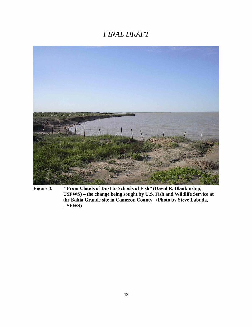
Figure 3. “From Clouds of Dust to Schools of Fish” (David R. Blankinship,USFWS) – the change being sought by U.S. Fish and Wildlife Service atthe Bahia Grande site in Cameron County. (Photo by Steve Labuda,USFWS)
FINAL DRAFT
13
1.2 Proposed Action
The Service proposes to restore tidal flow to the Bahia Grande, a portion of the Bahia GrandeUnit of the Laguna Atascosa National Wildlife Refuge.
This proposed action has resulted from interest and partnerships between the Service and TheConservation Fund, Natural Resources Conservation Service, Ducks Unlimited, CoastalConservation Association, National Marine Fisheries Service, National Fisheries Institute, TexasParks and Wildlife Department, and representatives of the shrimping industry and localcommunities.
Letters of support for this project have been received and references are included in Appendix B. This includes such letters, not only from the entities listed above, but from the adjacent privatelandowners as well.
1.3 Decisions Needed
The Regional Director, Fish and Wildlife Service, Region 2, will use the final environmentalassessment (EA) to make two decisions. The first decision is selecting the alternative toimplement. The second decision, required by the National Environmental Policy Act (NEPA), isto determine if the selected alternative will or will not have significant impact on the quality ofpeople’s lives or the natural environment. If it is determined that the selected alternative willhave significant negative impacts on the human and natural environment, the Service mustprepare an environmental impact statement of the proposed action. If not, the Regional Directorwill sign a finding of No Significant Impact (FONSI), after which the Service can begin theselected alternative as funding is available.
2.0 Description of Alternatives
The proposed re-flooding and restoration project of Bahia Grande has four different alternatives:
(I) Alternative I: (No Action Alternative) No Flooding,
(II) Alternative II: Flooding from San Martin Lake only (Channel A),
(III) Alternative III: Flooding from Brownsville Ship Channel only (Channel E), and
(IV) Alternative IV: (Preferred Alternative) Flooding from both directions (II and III).
FINAL DRAFT
14
2.1 Alternative I: (No Action Alternative) No Flooding
This alternative continues the status quo. No effort to flood will take place and the BahiaGrande will remain an ephemeral wetland, only partially filling with water during extremerainfall events or tropical storm surges and allowing restricted water access via the current small,deteriorated culverts in place under State Highway 48. At present, according to Dr. DoloresMunoz, Superintendent of Port Isabel Independent School District (Port Isabel ISD), damages tomechanical equipment, amortized over time, amount to an estimated $100,000.00 per year; tolandscape and maintain grounds, an estimated $35,000.00 per year; and to human health costs,an estimated $1,500,000.00 per year. This does not include estimates for lost income throughfines or lowered air quality in the local area. Land use issues will remain essentially unchanged,except for closer oversight by the Refuge.
Wildlife and fisheries would remain unaffected under this alternative. The basins would remaindry, except for occasional flooding from rainfall. Fisheries resources would be as they are now,minimal to non-existent. Wildlife resources would continue to suffer loss of habitat, from theblowing, salty dust, which kills vegetation on upland sites, and basin rims.
2.2 Alternative II: Flooding from San Martin Lake only (Channel A)
Under this alternative, water will be diverted from San Martin Lake and pass through aconstructed channel to inundate Bahia Grande. The size and orientation of the channel willdetermine the volume and rate of water exchange between the two sites. Estimates from the VanValkenburg thesis configure the channel at 8,255 feet long, by 50 feet wide, by 4 feet deep(minus 4 feet below mean sea level (MSL)). The engineering drawings of this channel inAppendix D were provided by Richard Bettge of the Natural Resources Conservation Service. Land use issues will remain essentially unchanged, except for closer oversight by the refuge.
The proposed flooding of Bahia Grande, Laguna Larga, and Little Laguna Madre with tidalwater will have a positive, beneficial socioeconomic impact on surrounding communities ofpeople. Land developers will build houses on the northern bluffs, along State Highway 100,overlooking the basins. Already (because of recent heavy rainfall that flooded the basin), peopleare catching crabs along State Highway 48 where the single culvert allows water to flow in andout of Bahia Grande at the present time. Fishing activity, bird watching, and other compatiblepublic uses will have significant beneficial effects in the socioeconomic arena of the localpopulace.
Wildlife and fisheries would be beneficially affected under this alternative. The basins would bepermanently flooded with tidal waters, although mixing and aeration of the water would beminimal. Fishery resources would increase, with many saltwater species, both vertebrate andinvertebrate, moving into the Bahia Grande system. Wildlife resources would no longer sufferloss of habitat, from the blowing, salty dust, which kills vegetation on upland sites, and basin
FINAL DRAFT
15
rims. The resultant flush of vegetation would encourage colonization and survival of more anddifferent wildlife species, both on the lomas and on the basins’ rims.
2.3 Alternative III: Flooding from Brownsville Ship Channel only (Channel E)
Under this alternative, water will be diverted from the Brownsville Ship Channel, pass through arelatively straight constructed channel and enter under a bridge over State Highway 48 toinundate Bahia Grande. Cooperation must be obtained from the Port of Brownsville as theowners of the channel site. Close coordination is also needed with the Texas Department ofTransportation (TXDOT). The size and orientation of the channel will determine the volumeand rate of water exchange between the two sites. Estimates from the Van Valkenburg thesisconfigure the channel at 2,400 feet long, by 200 feet wide, by 9 feet deep (minus 9 feet MSL). The engineering drawings of this channel in Appendix D were provided by Richard Bettge of theNatural Resources Conservation Service. Land use issues will remain essentially unchanged,except for closer oversight by the refuge.
The proposed flooding of Bahia Grande, Laguna Larga, and Little Laguna Madre with tidalwater will have a positive, beneficial socioeconomic impact on surrounding communities ofpeople. Land developers will build houses on the northern bluffs, along State Highway 100,overlooking the basins. Already (because of recent heavy rainfall that flooded the basin), peopleare catching crabs along State Highway 48 where the single culvert allows water to flow in andout of Bahia Grande at the present time. Fishing activity, bird watching, and other compatiblepublic uses will have significant beneficial effects in the socioeconomic arena of the localpopulace.
Wildlife and fisheries would be beneficially affected under this alternative. The basins would bepermanently flooded with tidal waters. Fishery resources would increase and new marinespecies would colonize the Bahia Grande. Mixing of waters would be even greater than inAlternative II, and this should result in increased survival of seagrasses, mangroves, crustaceans,fish, and other marine species. Wildlife resources would no longer suffer loss of habitat, fromthe blowing, salty dust, which kills vegetation on upland sites and the basins’ rims. Instead,vegetation would flourish, and dependent wildlife species would increase.
2.4 Alternative IV: (Preferred Alternative) Flooding from both directions (II and III)
Under this alternative, two channels (Alternatives II and III) will be constructed. The level ofcirculation desired in the Bahia Grande will necessitate implementation of both channels. Thesewill be used simultaneously or individually to provide adequate tidal circulation. Hydrological,topographic and engineering studies provide recommendations on channel dimensions necessaryfor adequate tidal circulation in Bahia Grande and assist restoration planning. The final resultsof this study, in thesis format, are included in Appendix C, and are summarized in the following
FINAL DRAFT
16
section, Study Results. Land use issues will remain essentially unchanged, except for closeroversight by the refuge.
The proposed flooding of Bahia Grande, Laguna Larga, and Little Laguna Madre with tidalwater will have a positive, beneficial socioeconomic impact on surrounding communities ofpeople. Land developers will build houses on the northern bluffs, along State Highway 100,overlooking the basins. Already (because of recent heavy rainfall that flooded the basin), peopleare catching crabs along State Highway 48 where the single culvert allows water to flow in andout of Bahia Grande at the present time. Fishing activity, bird watching, and other compatiblepublic uses will have significant beneficial effects in the socioeconomic arena of the localpopulace.
Wildlife and fisheries would be beneficially affected under this alternative. The basins would bepermanently flooded with tidal waters. Fishery resources would increase and new marinespecies would colonize the Bahia Grande. Mixing of waters would be even greater than inAlternative II or III, individually, and this should result in increased survival of seagrasses,mangroves, crustaceans, fish, and other marine species. Wildlife resources would no longersuffer loss of habitat, from the blowing, salty dust, which kills vegetation on upland sites and thebasins’ rims. Instead, vegetation would flourish, and dependent wildlife species would increase.
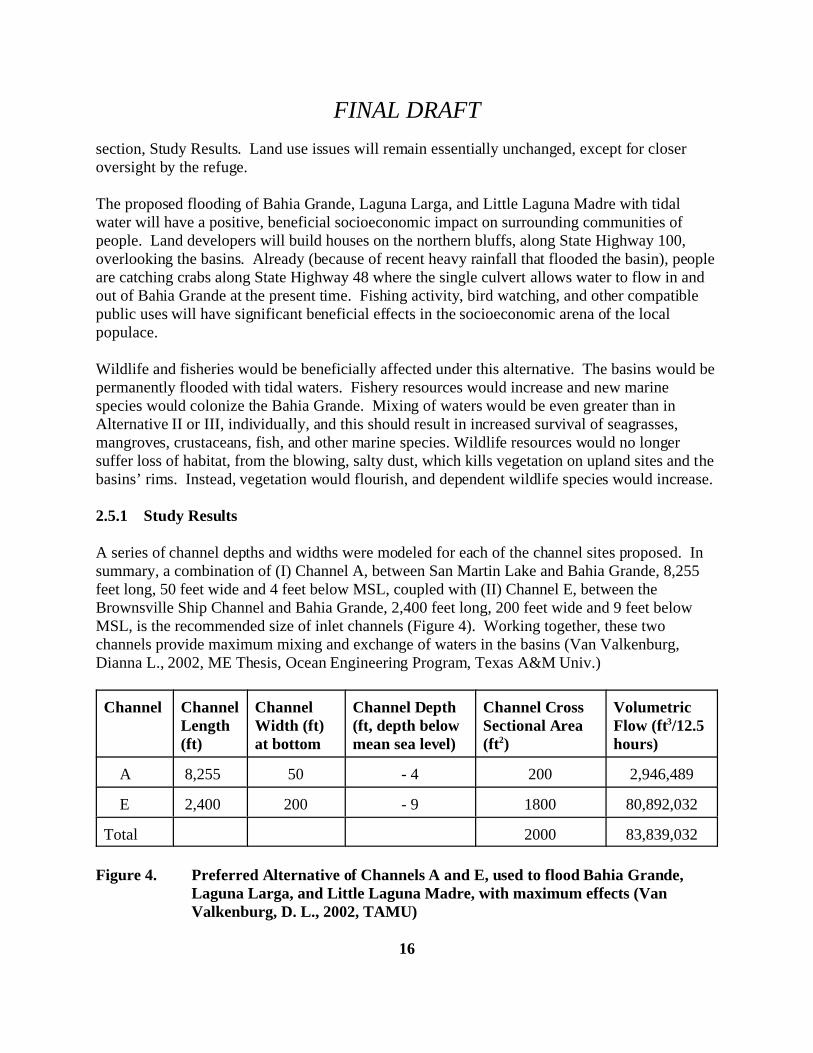
2.5.1 Study Results
A series of channel depths and widths were modeled for each of the channel sites proposed. Insummary, a combination of (I) Channel A, between San Martin Lake and Bahia Grande, 8,255feet long, 50 feet wide and 4 feet below MSL, coupled with (II) Channel E, between theBrownsville Ship Channel and Bahia Grande, 2,400 feet long, 200 feet wide and 9 feet belowMSL, is the recommended size of inlet channels (Figure 4). Working together, these twochannels provide maximum mixing and exchange of waters in the basins (Van Valkenburg,Dianna L., 2002, ME Thesis, Ocean Engineering Program, Texas A&M Univ.)
Channel ChannelLength(ft)
ChannelWidth (ft)at bottom
Channel Depth(ft, depth belowmean sea level)
Channel CrossSectional Area(ft2)
VolumetricFlow (ft3/12.5hours)
A 8,255 50 - 4 200 2,946,489
E 2,400 200 - 9 1800 80,892,032
Total 2000 83,839,032
Figure 4. Preferred Alternative of Channels A and E, used to flood Bahia Grande,
Laguna Larga, and Little Laguna Madre, with maximum effects (VanValkenburg, D. L., 2002, TAMU)
FINAL DRAFT
17
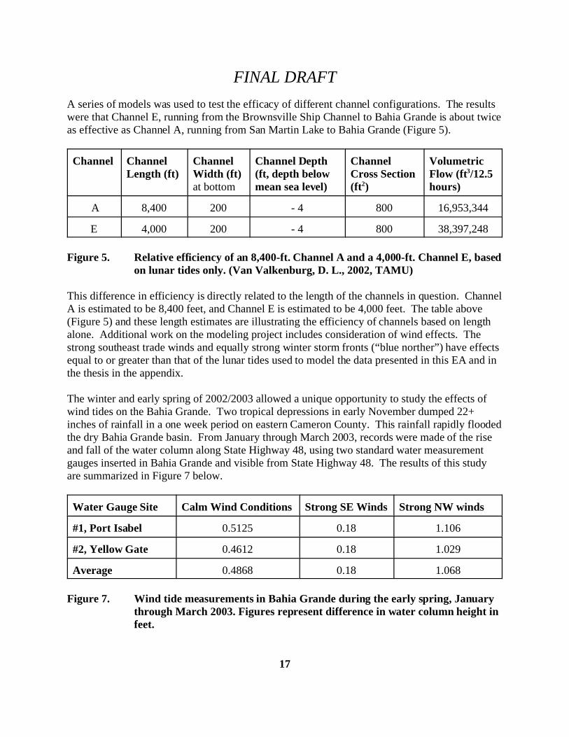
A series of models was used to test the efficacy of different channel configurations. The resultswere that Channel E, running from the Brownsville Ship Channel to Bahia Grande is about twiceas effective as Channel A, running from San Martin Lake to Bahia Grande (Figure 5).
Channel ChannelLength (ft)
ChannelWidth (ft)at bottom
Channel Depth(ft, depth belowmean sea level)
ChannelCross Section(ft2)
VolumetricFlow (ft3/12.5hours)
A 8,400 200 - 4 800 16,953,344
E 4,000 200 - 4 800 38,397,248
Figure 5. Relative efficiency of an 8,400-ft. Channel A and a 4,000-ft. Channel E, basedon lunar tides only. (Van Valkenburg, D. L., 2002, TAMU)
This difference in efficiency is directly related to the length of the channels in question. ChannelA is estimated to be 8,400 feet, and Channel E is estimated to be 4,000 feet. The table above(Figure 5) and these length estimates are illustrating the efficiency of channels based on lengthalone. Additional work on the modeling project includes consideration of wind effects. Thestrong southeast trade winds and equally strong winter storm fronts (“blue norther”) have effectsequal to or greater than that of the lunar tides used to model the data presented in this EA and inthe thesis in the appendix.
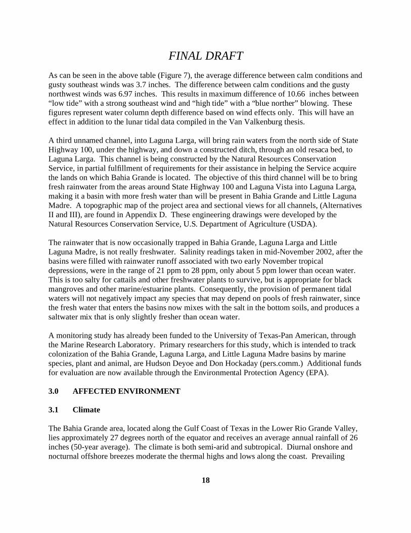
The winter and early spring of 2002/2003 allowed a unique opportunity to study the effects ofwind tides on the Bahia Grande. Two tropical depressions in early November dumped 22+inches of rainfall in a one week period on eastern Cameron County. This rainfall rapidly floodedthe dry Bahia Grande basin. From January through March 2003, records were made of the riseand fall of the water column along State Highway 48, using two standard water measurementgauges inserted in Bahia Grande and visible from State Highway 48. The results of this studyare summarized in Figure 7 below.
Water Gauge Site Calm Wind Conditions Strong SE Winds Strong NW winds
#1, Port Isabel 0.5125 0.18 1.106
#2, Yellow Gate 0.4612 0.18 1.029
Average 0.4868 0.18 1.068
Figure 7. Wind tide measurements in Bahia Grande during the early spring, Januarythrough March 2003. Figures represent difference in water column height infeet.
FINAL DRAFT
18
As can be seen in the above table (Figure 7), the average difference between calm conditions andgusty southeast winds was 3.7 inches. The difference between calm conditions and the gustynorthwest winds was 6.97 inches. This results in maximum difference of 10.66 inches between“low tide” with a strong southeast wind and “high tide” with a “blue norther” blowing. Thesefigures represent water column depth difference based on wind effects only. This will have aneffect in addition to the lunar tidal data compiled in the Van Valkenburg thesis.
A third unnamed channel, into Laguna Larga, will bring rain waters from the north side of StateHighway 100, under the highway, and down a constructed ditch, through an old resaca bed, toLaguna Larga. This channel is being constructed by the Natural Resources ConservationService, in partial fulfillment of requirements for their assistance in helping the Service acquirethe lands on which Bahia Grande is located. The objective of this third channel will be to bringfresh rainwater from the areas around State Highway 100 and Laguna Vista into Laguna Larga,making it a basin with more fresh water than will be present in Bahia Grande and Little LagunaMadre. A topographic map of the project area and sectional views for all channels, (Alternatives II and III), are found in Appendix D. These engineering drawings were developed by theNatural Resources Conservation Service, U.S. Department of Agriculture (USDA).
The rainwater that is now occasionally trapped in Bahia Grande, Laguna Larga and LittleLaguna Madre, is not really freshwater. Salinity readings taken in mid-November 2002, after thebasins were filled with rainwater runoff associated with two early November tropicaldepressions, were in the range of 21 ppm to 28 ppm, only about 5 ppm lower than ocean water. This is too salty for cattails and other freshwater plants to survive, but is appropriate for blackmangroves and other marine/estuarine plants. Consequently, the provision of permanent tidalwaters will not negatively impact any species that may depend on pools of fresh rainwater, sincethe fresh water that enters the basins now mixes with the salt in the bottom soils, and produces asaltwater mix that is only slightly fresher than ocean water.
A monitoring study has already been funded to the University of Texas-Pan American, throughthe Marine Research Laboratory. Primary researchers for this study, which is intended to trackcolonization of the Bahia Grande, Laguna Larga, and Little Laguna Madre basins by marinespecies, plant and animal, are Hudson Deyoe and Don Hockaday (pers.comm.) Additional fundsfor evaluation are now available through the Environmental Protection Agency (EPA).
3.0 AFFECTED ENVIRONMENT
3.1 Climate
The Bahia Grande area, located along the Gulf Coast of Texas in the Lower Rio Grande Valley,lies approximately 27 degrees north of the equator and receives an average annual rainfall of 26inches (50-year average). The climate is both semi-arid and subtropical. Diurnal onshore andnocturnal offshore breezes moderate the thermal highs and lows along the coast. Prevailing
FINAL DRAFT
19
winds, from the southeast off the Gulf of Mexico bring high humidity most of the year. Seasonaltemperature variations range from a mean of 620 F in the winter to 840 F in the summer. Freezing temperatures occur once every four years on the average. Tropical storms andhurricanes periodically strike the area during the summer and fall months. Drought conditions,some of which extend over several years, also occur periodically.
3.2 Air Quality
The Bahia Grande area is within Region 15 of the Texas Commission on Environmental Quality(TCEQ). According to information released by the TCEQ, the area is in attainment ofunclassifiable for all National Ambient Air Quality Standards (NAAQS). Blowing dust accountsfor most of the particulate matter in the region’s air. This information was obtained frompersonal communication with the TCEQ office in Harlingen, Texas, (956) 425-6010.
3.3 Geology and Soils
The Gulf Coast Plain is geologically of recent origin. The area is typified by sedimentsdeposited during Pleistocene interglacial periods. Most of the sediments were derived fromdeltaic or fluvial deposits of the ancestral Nueces and Rio Grande Rivers. Large portions weresubsequently covered by wind-deposited silts and sands. These sediments continue to undergowind transport and form extensive dune fields on the barrier islands and clay lomas (brushydunes) in the Rio Grande delta. Wetland soils in the area are scattered and highly variable,usually with little peat and high sand content. This information was obtained from “Soil Surveyof Cameron County, Texas. United States Department of Agriculture. Soil ConservationService. Texas Agricultural Experiment Station. 1977.”
3.4 Water Resources
Several types of wetland habitat are found in the Bahia Grande area including inland ponds andimpoundments, resacas (old oxbow river channels), estuaries and tidal flats. San Martin Lakecontains permanent water even in drought years. Other surface waters are seasonal in nature. The Bahia Grande is a tidal bay that was disconnected from the Gulf of Mexico by theconstruction of the Brownsville Ship Channel in the 1930's.
According to the Texas Parks and Wildlife Department in Brownsville, the Lower Laguna Madrearea has tremendous importance as a finfish and shellfish nursery area on which a majorcommercial fishery and a lucrative recreational fishery are dependent. The Lower LagunaMadre supports the largest shrimping fleet in Texas.
FINAL DRAFT
20
3.5 Biological Resources
3.5.1 Wildlife
The Bahia Grande Unit of the Laguna Atascosa National Wildlife Refuge is located within theTamaulipan Biotic Province and, in conjunction with surrounding natural lands, is regarded as animportant reservoir of natural biological diversity. Limited wildlife surveys on the Unit haverecorded several of the Valley’s “million dollar” birds, the plain chachalaca, groove-billed ani,great kiskadee, and green jay. Other wildlife of interest encountered on the Unit are the Texashorned lizard, Rio Grande lesser siren, bobcat, ocelot, javelina, and nilgai. Just since Novemberof 2002, anglers have been catching blue crabs (Callinectes sapidus) at the single culvert thatallows water to flow into and out of Bahia Grande, under State Highway 48. It is certain thatwith permanent tidal flooding of the basin, marine life like crabs, shellfish, various otherinvertebrates, and finfish will colonize the restored bay. The uplands likewise should supportmore species than are presently there, and denser populations of native wildlife are an expectedresult. The Laguna Atascosa National Wildlife Refuge has documented more than 400 speciesof birds, one of the highest diversities on National Wildlife Refuges in the nation. The RioGrande lesser siren, black-spotted newt, green jay, brown jay, tropical parula, Texas ayenia,Coues rice rat, ocelot, and jaguarundi occur only in the Tamaulipan Biotic province. (RefugeChecklists.)
The piping plover, a federally listed threatened species, is particularly dependent on both sides ofthe Lower Laguna Madre for its winter habitat, spending more than nine months a year in thearea. Depending on wind direction and tidal influence, this species may need algal flats on thenorth end of South Padre Island and wind tidal flats on the mainland, including the Bahia Grandearea. It has been estimated that 10 to 20 percent of the world’s population of piping plovers usethe Lower Laguna Madre area. In addition, the snowy plover, a species of concern, is both asummer nesting and winter species. (Refuge files, a thesis by Mike and Rose Farmer, 1996) Thisspecies’ habitat will be enhanced by the proposed flooding of Bahia Grande and the ancillarywetlands.
Sand/mud/algal flat environments are important feeding sites for a variety of wildlife speciesincluding the piping plover, which is listed as a threatened species by the federal government. These flats provide a rich source of aquatic and surface invertebrates such as worms, flies, smallcrustaceans (including crabs and shrimp) and molluscs (including clams and snails), which areessential food for shorebirds and wading birds as well as other wildlife. These species will alsobenefit from enhanced habitat conditions as a result of flooding Bahia Grande and the ancillarywetlands.
The Lower Laguna Madre area contains important habitat for migratory and resident waterfowland shorebirds and as well as wading birds. It is an important migration corridor for other birdssuch as peregrine falcons, ospreys and swallow-tailed kites and is an important resting and
FINAL DRAFT
21
feeding area for trans-Gulf neotropical migrant bird species. (The Peregrine Fund, AnnualReport, 1998.)
The Bahia Grande area supports the federally endangered northern aplomado falcon. Through areintroduction program headed by The Peregrine Fund, several releases of falcons have occurredin the area. Aplomado falcons have successfully nested nearby. This popular falcon attracts birdwatchers from all over the world, and its numbers will assuredly increase as a result of thepermanent tidal flooding of Bahia Grande. More shorebirds on the flooded flats, and morepasserines on the restored lomas will represent more prey available for these avian predators.
3.5.2. Vegetation
The general area in which the Bahia Grande is located is classified by Blair (1950) as theTamaulipan Biotic Province of Texas. The boundaries of the Tamaulipan Biotic Provinceapproximate those of South Texas Plain vegetation, also known as the Rio Grande Plain, whichlies south of San Antonio between the Rio Grande and the Gulf Coast.
By examining San Martin Lake, immediately south of Bahia Grande, one can envision thechanges that will probably occur in the dry basin when it is flooded with tidal waters. SanMartin Lake is ringed with black mangroves and open shorelines, providing habitat for myriadcormorants (both neotropic and double-crested), white and brown pelicans, terns, gulls, night-herons (black-crowned and yellow-crowned), herons, egrets, ducks, American pipits, eastern andwestern meadowlarks, horned larks, and others.
The topographically diverse nature of Bahia Grande, with basins and lomas, prairies andwoodlands, will contribute to a diverse assemblage of wildlife species. Different species inhabitdifferent habitats and there will be a variety of different habitats available when the permanenttidal flooding is realized. By putting permanent water on the basins, even the highest lomas willbenefit. Windblown, salty dust will be a thing of the past, and as future rains leach the existingsalt out of the topsoil layers, plant life will flourish, and the dependent wildlife species will notbe far behind.
3.6 Cultural Resources
An important cultural resource is an abandoned railroad bed that bisects the Bahia Grande. Therailroad bed consists of local fill and windblown sand/clay drifts around approximately 2 milesof degraded cypress pilings on which a narrow-gauge railroad trestle was historically supported. From information provided by the Port Isabel Museum, it has been determined that this railroadwas originally constructed in 1865 under command of General Phil Sheridan to move Uniontroops between Brownsville and Port Isabel. Later, in 1872, Simon Celaya converted the armyrailroad to a “42-inch gauge” railroad, and named it the Rio Grande Railroad. This railroad ran atotal of 24 miles between Brownsville and Port Isabel. Some of the railroad bed is deteriorated
FINAL DRAFT
22
and some pilings are missing; therefore, this resource is no longer intact. A review of thisresource was conducted by Service archaeologist David Siegel. No problems were anticipated,as restoring flow to the Bahia Grande would not produce areas of inundation of water depthsgreater than what occurred historically under natural high tide conditions more than 70 years agobefore the Bahia Grande was isolated. It was determined that breaching the railroad bed wouldnot diminish the overall integrity of the property’s location, design, setting, materials, orworkmanship. The restoration project would replicate historic flooding conditions, would notexceed historical flood levels, and was determined to represent the type of activity that has nopotential to cause effects on historical properties present. The freshwater ditch that will bringrainwater into Laguna Larga will cut though the railroad right of way, but only where local fillmaterials were used to elevate it. No pilings or other structures will be impacted by thisfreshwater ditch’s crossing of the right of way.
Bill Martin of the Texas Historical Commission, Archeology Division, has been contacted andhad asked that the Service use an archeologist to examine all of the shoreline areas of BahiaGrande, and the area planned for Channel D, in particular. A high ridge of loma, lying betweenthe Laguna Larga and Little Laguna Madre basins, is a site that has the highest potential to be apre-Columbian Indian site. The Service contacted the Natural Resources Conservation Service(NRCS), which has a state archeologist in Temple, Texas. The Service requested to have theNRCS archeologist examine the area at the same time he was scheduled to examine anotherproposed work site that NRCS had designated for channeling water from the north side of StateHighway 100 into Laguna Larga. This site visit by Calvin Sanders, NRCS State archeologist,occurred on Tuesday, May 13, 2003. Accompanied by Service personnel, Sonny Perez, RudyEscamilla, and Stephen E. Labuda, Jr., Mr. Sanders made an inspection of the area, includingtwo, known, minor sites. No artifacts were found, and the preliminary indication is that anegative report will be sent to the State Historical Protection Office (SHPO) by Mr. Sanders.
3.7 Land Use
Grazing is the primary land use on private lands outside of refuge boundaries in the vicinity ofthe Bahia Grande. Also nearby are the communities of Port Isabel, Laguna Heights, and LagunaVista. Urbanization is steadily enlarging the boundaries of these communities and many ruralproperties are being developed as commercial and residential areas. Figure 1. is a map of BahiaGrande and the surrounding area. It shows these various towns, highways, and other landscapefeatures on and around the Bahia Grande Unit.
The Brownsville Port Authority (Brownsville Navigation District, BND) owns the BrownsvilleShip Channel that parallels the southern boundary of the Bahia Grande Unit. The BrownsvilleShip Channel would be a major source of water inflow into the system should Channel E beconstructed between the Brownsville Ship Channel and Bahia Grande. Presently, the Serviceleases land along the ship channel from the BND as the Lomas Ecological Preserve, a unit of theLower Rio Grande Valley NWR. This lease was originally negotiated for a period of forty years.
FINAL DRAFT
23
The BND has easements for spoil placement on private lands adjacent to the Brownsville ShipChannel.
There is a limited amount of oil and gas drilling in and near the Bahia Grande Unit. In additionto a lease agreement from the Texas General Land Office, and permit(s) from the U.S. ArmyCorps of Engineers, potential oil and gas exploration companies are required to obtain a SpecialUse Permit from the Refuge, the surface owner and land manager, before drilling for oil and gason the Unit. A Special Use Permit was recently issued authorizing the drilling of an exploratorygas well about three-quarters of a mile north of the proposed location for Channel A.
Land use issues, such as oil and gas exploration and development, will remain essentiallyunchanged. The Service’s Comprehensive Conservation Planning (CCP) process, whichprovides for significant public input on land and public use issues, is in the early planning stagesfor the Laguna Atascosa National Wildlife Refuge. When completed, it will include the BahiaGrande Unit.
3.8 Socioeconomic Considerations
This issue includes concerns about individual and local economic endeavors and quality of liferesulting from the restoration project.
The Lower Laguna Madre supports the largest shrimping fleet in Texas. The local shrimpfishing industry’s harvested shrimp value reaches $50,000,000 a year (Lower Laguna MadreFoundation).
The Lower Laguna Madre Foundation estimates the Lower Laguna Madre is worth more than$400 million to Texas businesses yearly from sport fishing and recreational use.
Tourism and related economic sectors, such as retail trade and lodging, are very important to thelocal economy. Nature tourism is increasing in popularity and many people are coming to theLower Rio Grande Valley to see its rich and diverse natural resources, including its wildlifespecies, many of which are found nowhere else in the country.
The proposed flooding of Bahia Grande, Laguna Larga, and Little Laguna Madre with tidalwater will have a positive, beneficial socioeconomic impact on surrounding communities ofpeople. With elimination of the blowing dust from these particular basins, land developers willbuild houses on the northern bluffs, along State Highway 100, overlooking the basins. Already,people are catching crabs along State Highway 48 where the single culvert allows water to flowin and out of Bahia Grande at the present time. Fishing activity, bird watching, and othercompatible public uses will have significant beneficial effects in the socioeconomic arena of thelocal populace.
FINAL DRAFT
24
3.8.1 Tax Revenues
For fiscal year 2001, the Service paid a Refuge Revenue Sharing amount of $166,210 toCameron County to help compensate the county for lost property taxes attributable to the LagunaAtascosa National Wildlife Refuge, including the Bahia Grande Unit.
This proposed action would have no effect on these Refuge Revenue Sharing payments toCameron County.
3.9 Public Use and Recreation
Many Texans believe preserving environmental quality for recreation and nature tourism is animportant concern. Eye on Nature, a booklet published by Texas Parks and Wildlife Department(Austin, Texas, 1998) reported that by the year 2000, an estimated 18 million Texans willparticipate in nature tourism, especially birdwatching. Economists generally recognize thatincome that comes from people from outside of a given area, but spent within that area realizesmore positive economic benefits to that area than income generated and spent within that area.
The current direction of public use, recreation, and management of the Bahia Grande Unit of theLaguna Atascosa NWR is guided by the Final Conceptual Management Plan (FCMP), which isincluded in Appendix D of the Laguna Atascosa National Wildlife Refuge - Proposed RefugeExpansion Plan (Environmental Assessment and Conceptual Management Plan), approved inSeptember 1999. Future direction of public use, recreation, and management of the Unit will bedetermined during the development and completion of a Comprehensive Conservation Plan(CCP), which is scheduled to be started in fiscal year 2004, for the Laguna Atascosa NWR. TheCCP process will include extensive public involvement through public outreach and multiplepublic meetings at various stages of the process.
The FCMP found six public recreational activities compatible with the purposes of the BahiaGrande Unit: recreational fishing, recreational hunting, wildlife observation, wildlifephotography, environmental education, and interpretation. However, the only legal, andcompatible, public recreational use that occurred on the Unit prior to acquisition by the Servicewas bank fishing (for crabs and finfish) along the right-of-way boundary of State Highway 48 atSan Martin Lake and the Bahia Grande lake basin (when seasonally flooded). This traditionaluse will continue to be allowed. Private (not public) hunting leases for deer, waterfowl, dove,and quail occurred on the Unit prior to acquisition by the Service. Public recreational hunting(e.g., white-tailed deer, waterfowl, and feral pig) is not currently allowed; however, it will, alongwith wildlife observation (e.g., wildlife tour loop, observation platforms), wildlife photography,expanded recreational fishing (e.g., wade fishing), boating access (e.g., canoe, kayak),environmental education, and interpretation (e.g., guided environmental and cultural resourcetours) will be evaluated through the CCP process. The final, approved CCP will identify the
FINAL DRAFT
25
scope and intensity of each of these wildlife-dependent public recreational uses on the BahiaGrande Unit.
The only refuge sanctioned public use now occurring on the Bahia Grande Unit includes walk-inbank fishing on San Martin Lake, with access from State Highway 48. As mentioned above,some crabbing by locals also occurs in the vicinity of the single culvert under State Highway 48that allows water in and out of Bahia Grande.
Fishing and boating occur adjacent to the Bahia Grande in the Lower Laguna Madre,Brownsville Ship Channel and at an access point along State Highway 48. If permanent tidalwaters are introduced to Bahia Grande it may be compatible, as mentioned above, to allow non-motorized watercraft such as kayaks and canoes to use the area. Certainly, wading anglerswould want to try their luck in the shallow bay. Flounder, redfish, and spotted seatrout are themost avidly sought species in such locations.
Hunting for waterfowl, bobwhite quail, mourning and white-winged doves, nilgai (an exoticantelope), white-tailed deer and wild hogs occur in areas adjacent to the Bahia Grande. Whilepublic hunting is not currently allowed on Bahia Grande, it may be possible to provide somehigh quality hunting for waterfowl, doves and quail. White-tailed deer are not numerous enoughat the present time to support such a refuge hunt; however, public hunts may be allowed to helpcontrol exotic wild hogs and nilgai, both of which compete directly with native wildlife anddestroy habitat.
Some unauthorized public use also occurs. The most common infractions are trespass vehicles,littering, and fishing without a license, particularly in the area along San Martin Lake wherewalk-in bank fishing is permitted. Some limited poaching of javelina, nilgai, and white-taileddeer occurs along the western section of the Unit where a county road parallels the refugeboundary. Also, cattle trespass occurs at varying degrees; however, Refuge law enforcementactions have greatly reduced, but not eliminated this persistent problem.
3.10 Contaminants and Hazardous Wastes
In 2000, a tank truck on State Highway 48 overturned near San Martin Lake. Its cargo, achemical called Furfural, spilled into the borrow ditches on the sides of State Highway 48,which at the time were filled with water, connected to San Martin Lake. Texas Parks andWildlife Department took the lead in cleaning up this toxic spill, and minimal loss of wildlifewas reported, probably due to the volatile nature of the chemical which did not stay in the wateror the environment for more than three or four days. Still, this spill alone gives cause forconcern. The Service knows that such accidents may happen again. For this reason, a SpillContingency Plan is maintained by Laguna Atascosa National Wildlife Refuge, and supplies (oilspill booms, rubber gloves, detergent, etc.) are maintained in refuge storage areas.
FINAL DRAFT
26
4.0 ALTERNATIVES AND ENVIRONMENTAL CONSEQUENCES
4.1 Alternative I - (No Action Alternative) No Tidal Flooding
This alternative continues the status quo. No effort to flood would take place and the BahiaGrande would remain an ephemeral wetland, only partially filling with water during extremerainfall events or tropical storm surges and by very restricted water access via the current small,deteriorated culverts in place under State Highway 48. Salty dust would continue to blow out ofthe basin, and into surrounding communities, increasing the incidence and severity of respiratorysymptoms, degradation of metal structures (e.g., HVAC units), and causing wildfires throughshort circuits on power line transformers (two wildfires known in the past five years).
Wildfires have been started by blowing, salty dust affecting power line transformers. Thepossibility of eventual litigation against the Service as a result of wildfires, property loss, andhuman health problems remains a distinct possibility.
Various wildlife watering devices, including “guzzlers” and water from oil and gas explorationwells, are used to provide potable water for various wildlife species present. The continuedblowing dust will also impact plants growing on upland loma sites around the basins. Withreduced cover, low wildlife diversity and numbers will be the norm.
4.1.1 Climate
This alternative would not have an effect on climate.
4.1.2 Air Quality
Under this alternative, air quality would remain unchanged. Blowing dust accounts for most ofthe particulate matter in the region’s air. A traffic hazard will be occasionally present in theform of blowing dust, which reduces visibility, across State Highway 48. As urbanizationprogresses around the Bahia Grande, it can be expected that more and more people will sufferrespiratory problems as a result of the continuing dusty conditions.
4.1.3 Geology and Soils
There would be the continuing effect on soils in the area, because silt and sand would still bewind transported and dust will continue to be a problem. These “blowouts” are created by thewind’s scouring action on the bay bottom, digging ever deeper, and deeper. Salty dust blown outcovers upland vegetation, killing it and preventing other vegetation from getting established. This results in erosion, possibly affecting even geological formations. The effect on soils andgeology of the continuing dry basins is negative, and potentially significant.
FINAL DRAFT
27
4.1.4 Water Resources
The tidal flat area of the Bahia Grande would remain an ephemeral wetland. Only a smallportion of this acreage will be covered with water during extreme rainfall events or tropicalstorm surges.
4.1.5 Biological Resources
Little habitat for wading birds, shorebirds, and threatened species like the piping plover wouldcontinue under this alternative. Fishery resources would continue to blossom with tropicalrainfall events, and then literally “dry up” as drier months ensue. Furthermore, increasedurbanization in the surrounding areas, which will occur whether or not Bahia Grande is flooded,would introduce feral dogs and cats that would have far-reaching effects on native wildlifespecies. In addition, new drains from urbanized areas might affect the area in ways unknown atthis point in time.
4.1.6 Cultural Resources
The refuge would continue protection of cultural resources under this alternative.
4.1.7 Land Use
Land use would continue as at present.
4.1.8 Socioeconomic Resources
The area surrounding the Bahia Grande would continue to follow a trend of increasedurbanization. Under this alternative, land values would change only as the local markets areaffected by future trends. Market values might increase due to anticipated increaseddevelopment in areas such as along State Highway 100 and close to towns. There would be noeffect on the commercial shellfish and finfish industry. The continued blowing dust may affectsome real estate values in certain areas.
4.1.9 Effects on Tax Revenues
There should be no effect.
4.1.10 Public Use and Recreation
Presently there is a good deal of tourism and economic benefit associated with South PadreIsland. A good parallel would be to look at the City of Harlingen. Harlingen was the very firstcity in the Lower Rio Grande Valley (Valley) to sponsor a Birding Festival. In their first year,
FINAL DRAFT
28
1995, the Festival brought in $3.5 million in a five-day period. This was all nature-relatedtourism, and about 50% of it was directly related to the Valley refuges, particularly LagunaAtascosa NWR. Tours, talks, and help with building and setting up props for a lunch area at theFestival, all helped generate more economic benefit because of the refuge. Unfortunately, thelandscape of the Bahia Grande Unit is very xeric and relatively unattractive, and it will stay thatway with no admittance of permanent tidal waters into the basins thereon.
Very little to no benefit is associated with Bahia Grande under this alternative. This status quowould not change if the basins are not flooded with permanent tidal waters.
4.1.11 Contaminants and Hazardous Waste
No change in levels of contaminants or hazardous waste is expected.
4.2 Alternative II: Flooding from San Martin Lake only (Channel A)
Under this alternative, water will be diverted from San Martin Lake and pass through a 8,255-foot, constructed channel to inundate Bahia Grande. The size and orientation of the channel willdetermine the volume and rate of water exchange between the two sites. Hydrological,topographic and engineering studies have been completed and recommendations provided byTexas A&M University’s Department of Civil Engineering, School of Ocean Engineering. Channel dimensions necessary for adequate tidal circulation in Bahia Grande also assistrestoration planning.
In addition to Channel A itself, a series of three other channels will be dug. These have beendesignated as Channels B, C, and D as follows:
Channel B, 60 feet wide, by -2 feet below MSL, and 7,800 feet long, will connect BahiaGrande to Laguna Larga, allowing 1,669 acres of additional flooding in Laguna Larga;
Channel B2, an alternative route for Channel B, 60 feet wide by -2 feet below MSL, and3,270 feet long will connect Bahia Grande to Laguna Larga, allowing 1,669 acres ofadditional flooding in Laguna Larga, if selected for implementation;
Channel C, 60 feet wide, by -2 feet below MSL, and 8,400 feet long, will connect BahiaGrande to Little Laguna Madre, allowing 1,411 acres of additional flooding in LittleLaguna Madre; and.
Channel D, 60 feet wide, by -2 feet below MSL, and 5,000 feet long, will connect LagunaLarga to Little Laguna Madre, enhancing circulation of water between these two basins.
FINAL DRAFT
29
A total of about 6,500 acres will be flooded in Bahia Grande under this alternative, 4,000permanently, and 2,500 tidally. In addition, 1,669 acres in Laguna Larga would be flooded,either by freshwater from the NRCS diversions under State Highway 100, or by saltwater fromBahia Grande. Another 1,411 acres will be inundated in Little Laguna Madre under thisalternative. Therefore a total of approximately 9,580 acres will be flooded, either permanently(4,000-plus acres) or periodically by lunar and wind tidal effects (2,500-plus acres). AppendixD provides drawings of various channels, both cross-sectional and longitudinal. There is also atopographic view of the entire project.
Water depths will be very shallow. Average depth will probably be less than 6 inches due to thevast areas that will be covered by the sheet water flows of wind tides. Some areas will be asdeep as 3 to 4 feet below mean sea level. The amount of water introduced by lunar and windtides under this alternative will be significantly less than that introduced by Alternative II. Thatis because of the direct alignment of Channel E with the prevailing southeast winds. Channel Ain this alternative is not aligned so beneficially, and its greater length, 8,255 linear feet comparedto 2,400 linear feet with Channel E, work against effective flooding, as well.
4.2.1 Climate
This alternative would not have a singular effect on climate.
Drought will cause some adverse impacts to some wildlife species and their habitats, althoughthese impacts may be ameliorated by the reduction of blowing dust caused by the filling of thebasins.
4.2.2 Air Quality
Under this alternative, air quality would improve. Blowing dust would still account for most ofthe particulate matter in the region’s air, but would be reduced in the Bahia Grande area byrestoring a tidal hydrological pattern to flood the dry basin. A traffic hazard may still beoccasionally present in the form of blowing dust across State Highway 48, but it would be muchreduced. The major source of blowing dust would be eliminated, representing perhaps 60% ofthe total problem. Additional dust may still come from Long Island, from the sides of theBrownsville Ship Channel, and from U.S. Army Corps of Engineers spoil areas in the vicinity.
4.2.3 Geology and Soils
There would be an effect to geology and soils in the area. Silt and sand would continue to bewind transported but these effects would be reduced in the Bahia Grande area by restoring a tidalhydrological pattern to flood the dry basin. Dust storms that adversely affect Laguna Vista,Laguna Heights, and Port Isabel would be reduced in severity. Positive beneficial effect on lomavegetation has already been addressed. In addition, some of the soils removed in digging
FINAL DRAFT
30
channels, when appropriate, will be used to “patch” eroded gullies and other damage to theexisting lomas. This should stabilize the erosion problem, conserve the topsoil, and encouragecolonization by various plant species, which will further stabilize the areas.
4.2.4 Water Resources
Restoring tidal hydrological patterns in these waters would greatly increase wildlife and fisheryvalues and provide additional recreational opportunities. The exchange of salt water wouldcontribute to improving water circulation in the Bahia Grande. This alternative alone may notprovide enough circulation and water mixing to maintain the system at maximum biologicalproductivity. The channel planned for the connection from San Martin Lake to Bahia Grandewill be located close to the mouth of San Martin Lake, and in the vicinity of the BrownsvilleShip Channel. This placement will minimize the expected turbidity levels that would result fromtidal waters flowing back and forth between the two bodies of water. Turbidity effects should beisolated near the mouth of San Martin Lake, and should not affect the entire lake.
A total of about 6,500 acres will be flooded in Bahia Grande under this alternative, 4,000permanently, and 2,500 tidally. In addition, 1,669 acres in Laguna Larga would be flooded,either by freshwater from the NRCS diversions around State Highway 100, or by saltwater fromBahia Grande. Another 1,411 acres will be inundated in Little Laguna Madre under thisalternative. Therefore a total of approximately 9,580 acres will be flooded, either permanently(4,000-plus acres) or periodically by lunar and wind tidal effects (2,500-plus acres). AppendixD provides drawings of various channels, both cross-sectional and longitudinal. There is also atopographic view of the entire project.
All of this additional water is habitat for shrimp, crabs, other shellfish and invertebrates, andfinfish, which in turn provide a rich feeding source for shorebirds, wading birds, and waterfowl.
4.2.5 Biological Resources
Habitat for wading birds, shorebirds, and threatened species like the piping plover would befavorably impacted under this alternative. Migration of marine organisms into and out of theBahia Grande would be increased. Biological productivity will be significantly increased. Inaddition to the obvious habitat improvement for shrimp, crabs, shellfish and other invertebrates,and finfish, these species will provide a rich feeding source for shorebirds, wading birds, andwaterfowl.
Evaluation of the effects of flooding on marine plant and animal species will be provided by oneor more of the regional universities. The University of Texas-Pan American, which has arecognized coastal marine science department, has already proposed and had approved a requestfor funding to the Department of Housing and Urban Development to implement a study ofseagrass colonization, using minority students. Texas A&M-Corpus Christi University has
FINAL DRAFT
31
shown interest in conducting a more thorough study of marine organisms colonization in therestored Bahia Grande estuarine system.
The alleviation of the dust problem and restoration efforts creating an attractive wetland mayalso increase development and market values for properties near the Bahia Grande. This couldhave a detrimental effect on biological resources on private lands near the Bahia Grande as ruralproperties are developed and native habitat for wildlife is destroyed. Species impacted with suchan urbanization scenario might include Texas tortoise, Texas horned lizard, plain chachalaca,white-tipped dove, Harris’ hawk, ladder-backed woodpecker, green jay, great kiskadee, altamiraoriole, olive sparrow, bobcat, ocelot, jaguarundi, javelina, and white-tailed deer.
4.2.6 Cultural Resources
Protection of cultural resources would continue under this alternative.
4.2.7 Land Use
The Bahia Grande would be partially restored to a historical natural condition. Recreational useof the Bahia Grande area may be enhanced under this alternative.
The flooding of Bahia Grande will provide a rich study site for universities. Already theUniversity of Texas Pan-American has submitted a proposal to the National Oceanic andAtmospheric Administration (NOAA) to fund a study of seagrasses colonizing the floodedbasins, as well as the potential for introducing black mangroves and seagrasses to the site, (DonHockaday, pers. comm.) Texas A&M University Kingsville has contacted the Service aboutdoing studies of changes in the upland habitats as a result of flooding Bahia Grande, looking atthe plant and animal communities, to assess the changes that occur therein (Bill Kuvlesky, pers.comm.). Texas A&M University-Corpus Christi is preparing a funding proposal to assess thecomplex issue of marine organism colonization, including both plant and animal species (WesTunnel and Liz Smith, pers.comm.).
The Service has an interest in encouraging more northern aplomado falcons on the site, throughimprovement of the habitat, and would also support the natural proliferation of plant life, re-vegetation of denuded loma sites, and stabilization of all wildlife populations native to the site.
4.2.8 Socioeconomic Resources
The area surrounding the Bahia Grande would continue to follow a trend of increasedurbanization. Under this alternative, land values would change only as the local markets areaffected by future trends. Market values might increase due to anticipated increaseddevelopment in areas such as along State Highway 100 and close to towns. Alleviation of the
FINAL DRAFT
32
dust problem may also increase development and market value for properties near the BahiaGrande.
Nature tourism and other recreational activities will increase under this alternative due to theincrease in wildlife resources. This is likely to have a positive impact on the local economy(Pete Moore, South Padre Island Development Council, pers. comm., and Patrick Marchan, PortIsabel Mayor, pers. comm.).
In addition, commercial and recreational fisheries will be enhanced by restoration of estuarinenursery habitat for shellfish and finfish.
4.2.9 Effects on Tax Revenues
There should be no effect.
4.2.10 Public Use and Recreation
Opportunities for wildlife-oriented recreation, including the “Big Six” priority public uses onnational wildlife refuges: hunting, fishing, wildlife observation, photography, environmentaleducation, and interpretation, under this alternative will be explored as part of theComprehensive Conservation Planning initiative.
4.2.11 Contaminants and Hazardous Waste
No change in levels of contaminants or hazardous waste is expected under this alternative. However, because of the connection to San Martin Lake, there would be potential for theintroduction of toxic chemicals into the Bahia Grande due to a spill.
4.3 Alternative III: Flooding from Brownsville Ship Channel only
Under this alternative water will be diverted from the Brownsville Ship Channel, pass through arelatively straight 2,400 feet long by 200 feet wide by 9 feet below MSL, constructed channeland enter under a bridge at State Highway 48 to inundate Bahia Grande. Cooperation must beobtained from the Port of Brownsville as the owners of the channel site. Close coordination isalso needed with the Texas Department of Transportation (TXDOT). The size and orientation ofthe channel will determine the volume and rate of water exchange between the two sites.Hydrological, topographic and engineering studies have been initiated to providerecommendations on channel dimensions necessary for adequate tidal circulation in BahiaGrande and to assist restoration planning. An advantage of this channel is that prevailing windsfrom the southeast can facilitate maximum inundation of the basin by pushing tidal waters.
FINAL DRAFT
33
In addition to Channel E itself, a series of three other channels will be dug. These have beendesignated as Channels B, C, and D:
Channel B, 60 feet wide, by 2 feet below MSL, and 7,800 feet long, will connect BahiaGrande to Laguna Larga, allowing 1,669 acres of additional flooding in Laguna Larga;
Channel B2, an alternative route for Channel B, 60 feet wide by -2 feet below MSL, and3,270 feet long will connect Bahia Grande to Laguna Larga, allowing 1,669 acres ofadditional flooding in Laguna Larga, if selected for implementation;
Channel C, 60 feet wide, by -2 feet below MSL, and 8,400 feet long, will connect BahiaGrande to Little Laguna Madre, allowing 1,411 acres of additional flooding in LittleLaguna Madre; and
Channel D, 60 feet wide, by -2 feet below MSL, and 5,000 feet long, will connect LagunaLarga to Little Laguna Madre, enhancing circulation of water between these two basins.
A total of about 6,500 acres will be flooded in Bahia Grande under this alternative, 4,000permanently, and 2,500 tidally. In addition, 1,669 acres in Laguna Larga would be flooded,either by freshwater from the NRCS diversions under State Highway 100, or by saltwater fromBahia Grande. Another 1,411 acres will be inundated in Little Laguna Madre under thisalternative. Therefore a total of approximately 9,580 acres will be flooded, either permanently(4,000-plus acres) or periodically by lunar and wind tidal effects (2,500-plus acres). AppendixD contains drawings of these channels, both cross-sectional and longitudinal. There is also atopographic view of the entire project.
Water depths will be very shallow. Average depth will probably be less than 6 inches due to thevast areas that will be covered by the sheet water flows of wind tides. Some areas will be asdeep as 3 to 4 feet below mean sea level. The amount of water introduced by lunar and windtides under this alternative will be significantly greater than that introduced by either AlternativeI or IV. That is because of the direct alignment of Channel E with the prevailing southeastwinds. Channel A in this alternative is not aligned so beneficially, and its greater length, 8,255linear feet compared to 2,400 linear feet with Channel E, work against efficient flooding, as well.
TXDOT is presently reviewing the need to widen Texas 48 to a four-lane expressway, and hasseparated out the bridge required for Channel E, to “put it on the fast track”. Recent estimatesgiven in meetings with the Cameron County Judge have the estimates for this bridge being let byDecember 2003, contractor selection by April 2004, and completion of the project by December2004.
FINAL DRAFT
34
4.3.1 Climate
This alternative would not have a singular effect on climate.
Drought will cause some adverse impacts to some wildlife species and their habitats, althoughthese impacts may be ameliorated by the reduction of blowing dust caused by the filling of thebasins.
4.3.2 Air Quality
Under this alternative, air quality would improve. Blowing dust would still account for most ofthe particulate matter in the region’s air, but it would be reduced in the Bahia Grande area byrestoring a tidal hydrological pattern to flood the dry basin. A traffic hazard may still beoccasionally present in the form of blowing dust across State Highway 48 but would be muchreduced. The major source of blowing dust would be eliminated, representing perhaps 60% ofthe total problem. Additional dust will still come from Long Island, from the sides of theBrownsville Ship Channel, and from U. S. Army Corps of Engineers spoil areas in the vicinity.
4.3.3 Geology and Soils
There would be an effect to geology and soils in the area. Silt and sand would continue to bewind transported, but these effects would be reduced in the Bahia Grande area by restoring atidal hydrological pattern to flood the dry basin. Dust storms that adversely affect Laguna Vista,Laguna Heights, and Port Isabel would be reduced in severity. Positive beneficial effect on lomavegetation has already been addressed. In addition, some of the soils removed in diggingchannels, when appropriate, will be used to “patch” eroded gullies and other damage to theexisting lomas. This should stabilize the erosion problem, conserve the topsoil, and encouragecolonization by various plant species, which will further stabilize the areas.
4.3.4 Water Resources
Restoring tidal hydrological patterns in these waters would greatly increase wildlife and fisheryresources, and may provide additional recreational opportunities. The exchange of salt waterwould contribute to improving water circulation in the Bahia Grande. This alternative alone maynot provide enough circulation and water mixing to maintain the system at maximum biologicalproductivity, but it will be more efficient than Channel A alone, Alternative II.
A total of about 6,500 acres will be flooded in Bahia Grande under this alternative, 4,000permanently, and 2,500 tidally. In addition, 1,669 acres in Laguna Larga would be flooded,either by freshwater from the NRCS diversions under State Highway 100, or by saltwater fromBahia Grande. Another 1,411 acres will be inundated in Little Laguna Madre under thisalternative. Therefore a total of approximately 9,580 acres will be flooded, either permanently
FINAL DRAFT
35
(4,000-plus acres) or periodically by lunar and wind tidal effects (2,500-plus acres). AppendixD contains drawings of these channels, both cross-sectional and longitudinal. There is also atopographic view of the entire project.
The effects of this Channel E, while similar to those for Channel A, will, by virtue of its widerand deeper dimensions, and shorter distance overland, provide for faster inflows and exodus ofwater inside the basin. This may be of special importance during times of heavy rainfall events. Also, because Channel E is more directly aligned with the prevailing southeast winds, wind tidalflooding will be magnified in this alternative.
4.3.5 Biological Resources
Greatly improved habitat for wading birds, shorebirds, and threatened species like the pipingplover would be beneficial under this alternative. Migration of marine organisms into and out ofthe Bahia Grande would be facilitated. Biological productivity will be significantly increased. In addition to the obvious habitat provision for shrimp, crabs, shellfish and other invertebrates,and finfish, these will provide a rich feeding source for shorebirds, wading birds, and waterfowl.
The alleviation of the dust problem and restoration efforts creating an attractive wetland mayalso increase development and market value for properties near the Bahia Grande. This couldhave a detrimental effect on biological resources on private lands near the Bahia Grande, as ruralproperties are developed and native wildlife habitat is destroyed.
Monitoring of marine organisms entering Bahia Grande will be needed to evaluate the survival,reproduction, and use of habitat by marine organisms in the basin. A management plan may bedeveloped through use of a graduate study from one of the regional universities, such as theUniversity of Texas-Pan American, which has a recognized coastal marine science department.
As mentioned under the previous section for Alternative II, alleviation of the dust problem andrestoration efforts creating an attractive wetland may also increase development and marketvalue for properties near the Bahia Grande. This could have a detrimental effect on biologicalresources on private lands near the Bahia Grande as rural properties are developed and nativehabitat for wildlife is destroyed. Species impacted with such an urbanization scenario mightinclude Texas tortoise, Texas horned lizard, plain chachalaca, white-tipped dove, Harris’ hawk,ladder-backed woodpecker, green jay, great kiskadee, altamira oriole, olive sparrow, bobcat,ocelot, jaguarundi, javelina, and white-tailed deer.
On the refuge, marine organisms, fish, crabs, shellfish and other invertebrates, finfish,shorebirds, herons and egrets, ospreys, raccoons, coyotes, and other species, which all benefitfrom shallow flooding in coastal wetlands, will benefit. Other, upland species, which may nothave as direct a relationship with the flooded basins, such as plain chachalaca, great kiskadee,

FINAL DRAFT
36
green jay, Harris’ hawk, and others, will benefit as their upland habitats are improved by thereduction of blowing salty dust, and the leaching out of salts by future rainfall events.
The flooding of Bahia Grande will provide a rich study site for universities. Already theUniversity of Texas Pan-American has submitted a proposal to the National Oceanic andAtmospheric Administration (NOAA) to fund a study of seagrasses colonizing the floodedbasins, as well as the potential for introducing black mangroves and seagrasses to the site, (DonHockaday, pers. comm.). Texas A&M University Kingsville has contacted the Service aboutdoing studies of changes in the upland habitats as a result of flooding Bahia Grande, looking atthe plant and animal communities, to assess the changes that occur therein (Bill Kuvlesky, pers.comm.). Texas A&M University-Corpus Christi is preparing a funding proposal to assess thecomplex issue of marine organism colonization, including both plant and animal species (WesTunnel and Liz Smith, pers.comm.).
In summary, flooding basins may have a negative impact on wildlife off the refuge, due tourbanization and land clearing. In contrast, flooding the basins will have a beneficial impact onwildlife on the refuge, through habitat improvement associated with the reduction of blowingdust.
4.3.6 Cultural Resources
Protection of cultural resources would continue.
4.3.7 Land Use
The Bahia Grande would be partially restored to a historical natural condition. Recreational useof the Bahia Grande area may be enhanced under this alternative.
The flooding of Bahia Grande will provide a rich study site for universities. Already theUniversity of Texas Pan-American has submitted a proposal to the National Oceanic andAtmospheric Administration (NOAA) to fund a study of seagrasses colonizing the floodedbasins, as well as the potential for introducing black mangroves and seagrasses to the site, (DonHockaday, pers. comm.). Texas A&M University-Kingsville has contacted the Service aboutdoing studies of changes in the upland habitats as a result of flooding Bahia Grande, looking atthe plant and animal communities, to assess the changes that occur therein (Bill Kuvlesky, pers.comm.). Texas A&M University-Corpus Christi is preparing a funding proposal to assess thecomplex issue of marine organism colonization, including both plant and animal species (WesTunnel and Liz Smith, pers.comm.).
An EPA grant is available at present, for use in monitoring the biological effects of flooding.
FINAL DRAFT
37
The Service has an interest in encouraging more northern aplomado falcons on the site, throughimprovement of the habitat, and would also support the natural proliferation of plant life, re-vegetation of denuded loma sites, and stabilization of all wildlife populations native to the site.
4.3.8 Socioeconomic Resources
The area surrounding the Bahia Grande would continue to follow a trend of increasedurbanization. Under this alternative, land values would change only as the local markets areaffected by future trends. Market values might increase due to anticipated increaseddevelopment in areas such as along State Highway 100 and close to towns. Alleviation of thedust problem may also increase development and market value for properties near the BahiaGrande. Also, and related to the urbanization problem, but in a positive sense, nature tourismand other recreational activities may increase under this alternative due to the increase in wildliferesources, commensurate with the increased human population. This is likely to have a positiveimpact the local economy (Pete Moore, South Padre Island Development Council, pers. comm.,and Patrick Marchan, Port Isabel Mayor, pers. comm.).
In addition, commercial and recreational fisheries will be enhanced by restoration of estuarinenursery habitat for shellfish and finfish.
4.3.8.1 Effects on Tax Revenues
There should be no effect.
4.3.9 Public Use and Recreation
Opportunities for wildlife-oriented recreation under this alternative will be positive for thegeneral public. The restoration of the Bahia Grande will increase wildlife viewing opportunities,such as birdwatching. Additional public uses, including the “Big Six” priority public uses onnational wildlife refuges: hunting, fishing, wildlife observation, photography, environmentaleducation, and interpretation, will be explored. The development of the CCP will includeseveral public meetings to allow the public to propose and comment on potential publicrecreational uses for the Bahia Grande Unit.
4.3.10 Contaminants and Hazardous Waste
No change in levels of contaminants or hazardous waste is expected under this alternative. However, because of the connection to the Brownsville Ship Channel, there would be potentialfor the introduction of toxic chemicals into the Bahia Grande due to a spill. The refugemaintains a supply of booms, suits, and other gear to be used by the U.S. Coast Guard (leadagency) and other cooperators, in case of a spill. The refuge Spill Contingency Plan will beupdated prior to flooding the basins.
FINAL DRAFT
38
4.4 Alternative IV: (Preferred Alternative) Tidal Flooding from both directions(channels A and E)
The level of water circulation desired in the Bahia Grande will necessitate the construction ofboth channels. These will be used individually, or simultaneously, to provide adequate tidalcirculation. Hydrological, topographic and engineering studies have been completed by TexasA&M University’s Department of Civil Engineering, Ocean Engineering Branch, to providerecommendations on channel dimensions necessary for adequate tidal circulation in BahiaGrande and to assist restoration planning with Channels A, B, C, D, and E.
This alternative is the Preferred Alternative because it provides the greatest level of naturalcirculation of waters in Bahia Grande, Laguna Larga, and Little Laguna Madre. With both“feeder channels” in place, an optimum environment for fish, shrimp, and other marineorganisms will be in place.
In addition to the “feeder channels”, A and E, a series of three other channels will be dug. Thesehave been designated as Channels B, C, and D:
Channel B, 60 feet wide, by 2 feet below MSL, and 7,800 feet long, will connect BahiaGrande to Laguna Larga, allowing 1,669 acres of additional flooding in Laguna Larga;
Channel B2, an alternative route for Channel B, 60 feet wide by -2 feet below MSL, and3,270 feet long will connect Bahia Grande to Laguna Larga, allowing 1,669 acres ofadditional flooding in Laguna Larga, if selected for implementation;
Channel C, 60 feet wide, by -2 feet below MSL, and 8,400 feet long, will connect BahiaGrande to Little Laguna Madre, allowing 1,411 acres of additional flooding in LittleLaguna Madre; and
Channel D, 60 feet wide, by -2 feet below MSL, and 5,000 feet long, will connect LagunaLarga to Little Laguna Madre, enhancing circulation of water between these two basins.
A total of about 6,500 acres will be flooded in Bahia Grande under this alternative, 4,000permanently, and 2,500 tidally. In addition, 1,669 acres in Laguna Larga would be flooded,either by freshwater from the NRCS diversions under State Highway 100, or by saltwater fromBahia Grande. Another 1,411 acres will be inundated in Little Laguna Madre under thisalternative. Therefore a total of approximately 9,580 acres will be flooded, either permanently(4,000-plus acres) or periodically by lunar and wind tidal effects (2,500-plus acres).
Appendix D contains drawings of these channels, both cross-sectional and longitudinal. There isalso a topographic view of the entire project.
FINAL DRAFT
39
All of this additional water is habitat for shrimp, crabs, shellfish and other invertebrates, andfinfish, which in turn provide a rich feeding source for shorebirds, wading birds, and waterfowl. Additional water would be better aerated, and seagrasses and other plants would experiencemuch greater success. As a result, under Alternative IV, there should occur higher survivability,reproduction, and density of marine organisms than in either of the prior alternatives, II or III,which, in turn, would provide a richer feeding site for greater numbers of shorebirds, wadingbirds, waterfowl, osprey, and other species.
Channel construction will generate spoil material. If transport of the spoil by heavy truck acrossthe dry basin is feasible, spoil islands may be created. These spoil islands will be shaped toretain as much material as possible in high wind situations, and are expected to prove valuable asnesting areas for colonial water birds. Historically, two small islands within Bahia Grandeprovided nesting habitat for over 10,000 terns, gulls, and black skimmers. Restoring this type ofhabitat would be a secondary goal of the project.
Additional possibilities for the disposal of spoil from the channel construction process are use bythe Brownsville Landfill for “capping debris” with soil, and by TXDOT for use in the roadbed ofan expanded State Highway 48.
4.5.1 Climate
This alternative will not have an effect on climate.
Drought will continue to cause some adverse impacts to some wildlife species and their habitats,although these impacts may be ameliorated by the reduction of blowing dust caused by thefilling of the basins.
4.5.2 Air Quality
Under this alternative, air quality would improve. Blowing dust would still account for most ofthe particulate matter in the region’s air, but it would be reduced in the Bahia Grande area byrestoring a tidal hydrological pattern to flood the dry basin. A traffic hazard may still beoccasionally present in the form of blowing dust across State Highway 100, but would be muchreduced. The major source of blowing dust would be eliminated, representing perhaps 60% ofthe total problem. Additional dust will still come from Long Island, from the sides of theBrownsville Ship Channel, and from U.S. Army Corps of Engineers spoil areas in the vicinity.
4.5.3 Geology and Soils
There would be an effect to geology and soils in the area. Silt and sand would continue to bewind transported, but these effects would be reduced in the Bahia Grande area by restoring a
FINAL DRAFT
40
tidal hydrological pattern to flood the dry basin. Dust storms that adversely affect Laguna Vista,Laguna Heights, and Port Isabel would be reduced in severity.
Positive beneficial effects on loma vegetation have already been addressed. In addition, some ofthe soils removed in digging this channel, if appropriate, will be used to “patch” eroded gulliesand other damage to the existing lomas. This should stabilize the erosion problem, conserve thetopsoil, and encourage colonization by various plant species, which will further stabilize theareas.
4.5.4 Water Resources
Restoring tidal hydrological patterns in these waters would greatly increase wildlife and fisheryresources and may provide additional recreational opportunities. The exchange of salt waterwould contribute to improving water circulation in the Bahia Grande. This alternative alone willprovide circulation and water mixing to maintain the system at maximum biologicalproductivity. It is more efficient than either Channels A or E alone.
A total of about 6,500 acres will be flooded in Bahia Grande under this alternative, 4,000permanently, and 2,500 tidally. In addition, 1,669 acres in Laguna Larga would be flooded,either by freshwater from the NRCS diversions under State Highway 100, or by saltwater fromBahia Grande. Another 1,411 acres will be inundated in Little Laguna Madre under thisalternative. Therefore a total of approximately 9,580 acres will be flooded, either permanently(7,080 acres) or daily by lunar and wind tidal effects (2,500 acres).
Appendix D has drawings of these channels, both cross-sectional and longitudinal. There is alsoa topographic view of the entire project.
The effects of this Preferred Alternative, while similar to those for Channels A and E, will, byvirtue of its combination of both, provide for faster inflows and exodus of water inside the basin. This may be of special importance during times of heavy rainfall events.
4.5.5 Biological Resources
Habitat for wading birds, shorebirds, and threatened species like the piping plover would beenhanced under this alternative. Migration of marine organisms into and out of the BahiaGrande would be possible. Biological productivity will be significantly increased. In addition tothe obvious habitat provision for shrimp, crabs, shellfish and other invertebrates, and finfish,these will provide a rich feeding source for shorebirds, wading birds, and waterfowl.
As mentioned above, various grants, universities, and proposed studies, will evaluate the effectsof flooding on both plant and animal species in the Bahia Grande system.
FINAL DRAFT
41
The alleviation of the dust problem and restoration efforts creating an attractive wetland mayalso increase development and market value for properties near the Bahia Grande. This couldhave a detrimental effect on biological resources on private lands near the Bahia Grande as ruralproperties are developed and native habitat for wildlife is destroyed. Species impacted with suchan urbanization scenario might include Texas tortoise, Texas horned lizard, plain chachalaca,white-tipped dove, Harris’ hawk, ladder-backed woodpecker, green jay, great kiskadee, altamiraoriole, olive sparrow, bobcat, ocelot, jaguarundi, javelina, and white-tailed deer.
4.5.6 Cultural Resources
Protection of cultural resources would continue.
4.5.7 Land Use
The Bahia Grande would be partially restored to a historical natural condition. Recreational useof the Bahia Grande area would be greatly enhanced under this alternative.
The flooding of Bahia Grande will provide a rich study site for universities. Already theUniversity of Texas Pan-American has submitted a proposal to the National Oceanic andAtmospheric Administration (NOAA) to fund a study of seagrasses colonizing the floodedbasins, as well as the potential for introducing black mangroves and seagrasses to the site, (DonHockaday, pers. comm.). Texas A&M University-Kingsville has contacted the Service aboutdoing studies of changes in the upland habitats as a result of flooding Bahia Grande, looking atthe plant and animal communities, to assess the changes that occur therein (Bill Kuvlesky, pers.comm.). Texas A&M University-Corpus Christi is preparing a funding proposal to assess thecomplex issue of marine organism colonization, including both plant and animal species (WesTunnel and Liz Smith, pers.comm.)
Another grant from EPA is available for award to a research entity for evaluation of the effectsof flooding on marine plant and animal resources.
The Service has an interest in encouraging more northern aplomado falcons on the site, throughimprovement of the habitat, and would also support the natural proliferation of plant life, re-vegetation of denuded loma sites, and stabilization of all wildlife populations native to the site.
The Preferred Alternative differs from Alternatives II and III in that it will provide a muchgreater circulation and aeration of waters in Bahia Grande, Laguna Larga, and Little LagunaMadre. This will result in a proliferation of plant and animal life in the aquatic habitat, and thepermanent flooding with tidal waters will benefit upland plants and wildlife on lomas and othersites by suppressing the windblown, salty dust that heretofore has impacted negatively the plantsand wildlife thereon.
FINAL DRAFT
42
4.5.8 Socioeconomic Resources
The area surrounding the Bahia Grande would continue to follow a trend of increasedurbanization. Under this alternative, land values would change only as the local markets areaffected by future trends. Market values might increase due to anticipated increaseddevelopment in areas such as along State Highway 100 and close to towns. The alleviation ofthe dust problem may also increase development and market value for properties near the BahiaGrande. Also, and related to the urbanization problem, but in a positive sense, nature tourismand other recreational activities will increase under this alternative due to the increase in wildliferesources, commensurate with the increased human population. This is likely to positivelyimpact the local economy (Pete Moore, South Padre Island Development Council, pers. comm.,and Patrick Marchan, Port Isabel Mayor, pers. comm.).
In addition, commercial and recreational fisheries will be enhanced by restoration of estuarinenursery habitat for shellfish and finfish.
4.5.8.1 Effects on Tax Revenues
There should be no effect.
4.5.9 Public Use and Recreation
Opportunities for wildlife-oriented recreation under this alternative will be positive for thegeneral public. The restoration of the Bahia Grande will increase wildlife viewing opportunities,such as birdwatching. Additional public uses, including the “Big Six” priority public uses onnational wildlife refuges: hunting, fishing, wildlife observation, photography, environmentaleducation, and interpretation, will be explored. The development of the CCP will includeseveral public meetings to allow the public to propose and comment on potential publicrecreational uses for the Bahia Grande Unit.
4.5.10 Contaminants and Hazardous Waste
No change in levels of contaminants or hazardous waste is expected. However, because of theconnection to the Brownsville Ship Channel, there would be potential for the introduction oftoxic chemicals into the Bahia Grande due to a spill. The refuge maintains a supply of booms,suits, and other gear to be used by the U.S. Coast Guard (lead agency) and other cooperators, incase of a spill. The refuge Spill Contingency Plan will be updated prior to flooding the basins.
5.0 Unexpected Impacts - Controlled/Minimized
Unexpected impacts are likely to come from urbanization around the communities of Port Isabel,Laguna Heights, and Laguna Vista. To reduce negative impacts from this source, the Service

FINAL DRAFT
43
will maintain frequent communications with the county judge, mayors, and town councils ofthese three communities.
6.0 Refuge Oversight
The Bahia Grande Unit is a part of the National Wildlife Refuge System, and is managed by theRefuge Manager of the Laguna Atascosa National Wildlife Refuge, which is part of the SouthTexas Refuge Complex.
7.0 Environmental Justice Issues
No negative impacts are anticipated under Environmental Justice Issues. The significantreduction of blowing dust, negatively impacting local communities, will be a beneficial impactof this project on Environmental Justice Issues. The towns of South Padre Island, Port Isabel,Laguna Heights, Laguna Vista, Bayview, and Los Fresnos, will all experience an increase inquality of life, due to the effect of this project in reducing blowing dust.
8.0 Permits Required
8.0.1 U.S. Army Corps of Engineers: Section 404 Permit
8.0.2 Texas Historic Preservation Office: Concurrence with the Proposed Project
8.0.3 Texas Council on Environmental Quality: Concurrence
8.0.4 National Environmental Policy Act: Compliance
9.0 Public Comments
The Service will provide an opportunity for the public to comment on this proposed action. A30-day comment period, during which the Service will accept written comments, will feature apublic meeting, to be held in the vicinity of Port Isabel. The purpose of the 30-day commentperiod and this public meeting will be to solicit public opinion about the project, as described inthe final “draft” EA. Comments received will be carefully considered, and incorporated in thebody of the final EA, as their content merits.
10.0 Cumulative Impacts
The only other federal action in the foreseeable future is the proposed improvements on StateHighway 48, which runs between Brownsville and Port Isabel. The Texas Department ofTransportation proposes to widen this road, from its present two-lane status to a four-lanehighway with shoulders. This road improvement will include construction of an approximately
FINAL DRAFT
44
240-foot wide bridge to span the channel connecting Bahia Grande directly to the BrownsvilleShip Channel. Initially, the Brownsville Navigation District, in cooperation with the TexasDepartment of Transportation, may construct a “pilot channel”, smaller than the final one(Channel E). If constructed, this planned “pilot channel” will cross under State Highway 48 viaa series of new culverts to be installed by the Texas Department of Transportation.
11.0 Mitigation
Placement of fill will be mitigated for by the extent of wetlands to be restored by the project. Approximately 4,130,680 cubic feet of fill material will be excavated in digging the proposedchannels A, B, C, and D. In return, approximately 19,160 acre/feet of tidal water will coverapproximately 9,580 acres of bay bottoms as follows: 6,500 acres in Bahia Grande, 1,669 acresin Laguna Larga, and 1,411 acres in Little Laguna Madre. This trade off of fill material to acresflooded is believed to be beneficial to wildlife and wetland resources when the overall project isconsidered. In addition, the restored wetlands will be covered with permanent, tidal water, whilethe areas covered by fill are ephemeral wetlands covered intermittently with rain water.
12.0 Document Preparation
This document has been drafted by personnel of the South Texas Refuge Complex, Region 2,U.S. Fish and Wildlife Service, U.S. Department of Interior. Primary responsibility for writingthis document was given to Stephen E. Labuda, Jr. The initial draft of the document wasprepared by Marie Fernandez. Others who offered significant help in fine-tuning theEnvironmental Assessment were Ken Merritt, David Blankinship, John D. Wallace, ErnestoReyes (Santa Ana Ecological Services Office), and Tim Cooper (Mackay Island NWR). Additional significant assistance came from Pat Clements at the Corpus Christi EcologicalServices Office.
13.0 Other Federal Agencies Consulted
The following list entails the other Federal Agencies consulted during the course of writing thisdraft Environmental Assessment:
Natural Resource Conservation Service, U.S. Department of AgricultureU.S. Army Corps of Engineers, Department of the ArmyOffice of Congressman Solomon Ortiz, Congress of the United States of AmericaNational Oceanic and Atmospheric Administration, U.S. Department of Commerce
FINAL DRAFT
45
APPENDIX A: REFERENCES
Blair, W.F. 1950. The biotic provinces of Texas. Texas Journal of Science 2(1):93-117
Eye on Nature, a publication of the Nongame and Urban Program, Texas Parks and WildlifeDepartment, 1995.
Morton, R.A. 1991. Physical evaluation of proposed flooding of Bahia Grande, CameronCounty, Texas. Bureau of Economic Geology, University of Texas, Austin, Texas. 13pp.
Natural Resource Conservation Service. 2002. Topographic map and channel sectionals forBahia Grande WRP. USDA. 6 pp., one over-size.
U.S. Fish and Wildlife Service. 1999. Laguna Atascosa National Wildlife Refuge - ProposedRefuge Expansion Plan (Environmental Assessment and Conceptual Management Plan). 63 pp.
Van Valkenburg, Dianna L., and Billy L. Edge. February 2003. Analysis of Proposed Floodingof Bahia Grande, Cameron County, Texas. A Thesis. Ocean Engineering Program, CivilEngineering Department, Texas A&M University, College Station, Texas 77843-3136.
APPENDIX B: LETTERS OF SUPPORT
N.B. Letters of support will be published in their entirety after the public review processhas been completed. Here they are only referenced in the order in which they have beenreceived.
1. Letter from Tim Fitch, of James A. Dougherty Properties, P. O. Box 640, Beeville,Texas, 78104-0640. Expressing support of the Garcia family for the proposed floodingof Bahia Grande, Laguna Larga, and Little Laguna Madre. Dated 14 February 2002. This letter will be included as a part of this document after the period for public commenthas been concluded.
APPENDIX C: HISTORIC DOCUMENTS
1. Reprint of a 1945 newspaper article, in 2002, :
Dust has always been a problem for Port Isabel, and in 1945 some action was taken tocontrol the dust. In the Wednesday, November 14, 1945 edition of The Port Isabel Pilot,an article describing this nuisance ran, as follows:
“Definite Action Taken to Control Dust Nuisance
FINAL DRAFT
46
Definite action was taken by the Directors of the Port Isabel Chamber ofCommerce to abate the dust that at intervals in recent years has been not only a scourgeto the people but a health menace as well.
Earl Long was employed to put the present pump in working order and executeplans for, if not completely eliminating the dust nuisance, to at least control it. Thepresent levees about the spoil banks between the South channel and ship channel are tobe strengthened and made higher. A flood gate is to be installed and so arranged thatwhen these flats are covered during high tide, the gate can be closed, retaining this waterwithin the confines of the dykes.
To finance this project, estimated to cost not less than $300, business institutionsand individuals will be called upon to donate. A “Dust Bowl Committee” composed of E.W. “Fritz” Edwards, chairman, Flem L. Marlin, and James J. Jaudon was appointed tocontact business institutions and others to raise the necessary amount to complete thisproject.
“These funds are to be kept separate and apart from those of the Chamber ofCommerce and are to be used exclusively in the matter of dust control”, so statedSecretary Stuart Adkins.”
2. Unfortunately, this attempt in 1945 was not successful in controlling the dust problem, asattested to by the following letter from the Point Isabel Independent School District,dated June 25, 2001.
“RE: Environmental Restoration and Enhancement Project
Mr. Labuda,
Allow me to express my gratitude for meeting with me and having other staff meet withour administrators, Mr. Raul Villareal and Dr. Estella Guetzow and for addressing aserious and hazardous situation that we currently have in our school district. I wouldcertainly like to see the sandy area behind our Port Isabel Junior High flooded; Iunderstand that a channel will efficiently flood that zone. Frankly, it is critical that sometype of action take effect.The current condition of the blowing sand on a daily basis creates a hazardous situationfor our students and the air quality in the school. The results are highly detrimental: sick buildings and ill student and staff members. Our schools staff are already feelingthe effects of this hazardous situation. The Junior High playground is profoundlyaffected as well; there is no recreational area for the students due to the sand dunes thataccumulate in this area. In addition, the past three years and to date, we have workingon improving the air quality of our schools by fixing and redoing our whole HVAC(Heating, Ventilating, and Air Conditioning) systems. We have spent approximately fivemillion dollars in this improvement effort. However, our engineers have advised us that
FINAL DRAFT
47
the sandy conditions of this area will cause severe harm to the improvements that we aremaking; thus, possibly throwing away tax dollars that are important to our community.
Furthermore, some of our students are frail and have special needs. Some of thesechildren can get very ill if our air quality diminishes and if the sand conditions of ourplaygrounds and surrounding areas continues to deteriorate. I have witnessed thesesituations in these past two years. We are extremely concerned about the health of ourstudents and employees and in protecting the investment of our taxpayers. I believe thatthis situation needs immediate attention in order to avoid future litigation and significanthealth problems.
It is, therefore, urgent that the County, State, and all entities affected, find a remedy toour duster-sand control for Port Isabel, particularly the areas surrounding our schools. Please keep us informed as a partnership in this worthwhile health related issue.
Sincerely,
s/Dr. Dolores MunozSuperintendent
Xc: Robert Cornelison Raul Besteiro Raul Villareal Daniel L. Rentfro, Jr.”
The carbon copy addressees in this letter are: (1) Robert Cornelison, Director of the PortIsabel/San Benito Navigation District, (2) Raul Villareal, Maintenance Supervisor for the PointIsabel School District, (3) Raul Besteiro, Director of the Brownsville Navigation District, and (4)Daniel L. Rentfro, Jr., Attorney for the Brownsville Navigation District.
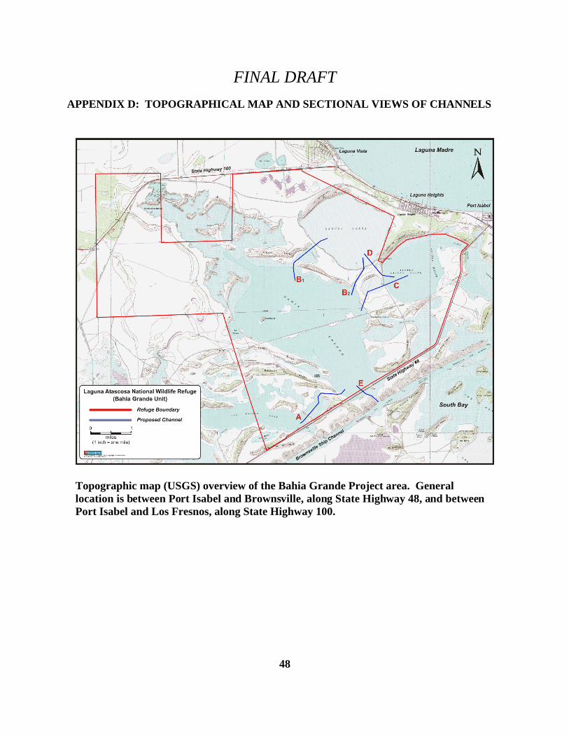
FINAL DRAFT
48
Topographic map (USGS) overview of the Bahia Grande Project area. Generallocation is between Port Isabel and Brownsville, along State Highway 48, and betweenPort Isabel and Los Fresnos, along State Highway 100.
APPENDIX D: TOPOGRAPHICAL MAP AND SECTIONAL VIEWS OF CHANNELS