Embed Size (px)
Citation preview
US Army Corps of Engineers – Baltimore District US Department of the Treasury
Proposed Currency Production Facility November 6, 2020 I 1 Land Use Technical Memorandum
Land Use 1
1.1 Introduction 2
This Technical Memorandum describes the land use in the Proposed Action’s Region of Influence (ROI) 3
and potential impacts on land use from the Proposed Action (i.e., Preferred Alternative) and No Action 4
Alternative. Measures to reduce potential adverse effects on land use from the Proposed Action are also 5
identified. 6
Land use includes two primary categories: natural and human-modified. Examples of natural land use 7
include woodlands, grasslands, and other undeveloped areas. Examples of human-modified land use 8
include residential, commercial, industrial, agricultural, and other developed areas. Land use is typically 9
guided and regulated by management plans, policies, regulations, and ordinances (i.e., zoning) that both 10
determine the type and extent of land use allowable in specific areas and protect specially designated or 11
environmentally sensitive areas. 12
Treasury received comments related to land use from stakeholders during the public scoping period. 13
Scoping comments expressed concern over the potential land use impacts of the Proposed Action, such 14
as the conversion of agricultural land to an industrial facility and the potential lost benefits of maintaining 15
undeveloped land. Please refer to Treasury’s Public Scoping Report for further details on the comments 16
received during the scoping period. Concerns expressed during public scoping regarding land use are 17
considered and addressed in this analysis. 18
1.2 Affected Environment 19
1.2.1 Region of Influence 20
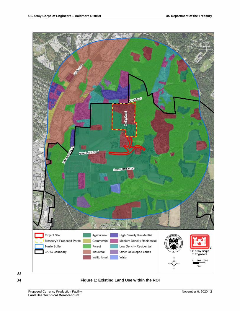
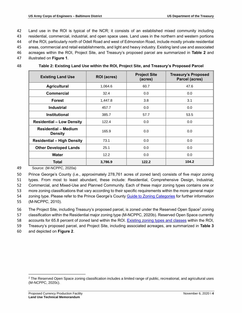
The ROI for this analysis includes the Project Site and all areas within one mile of the Project Site (see 21
Figure 1). These areas may be influenced, directly or indirectly, by activities associated with the Proposed 22
Action. 23
1.2.2 Applicable Guidance 24
Table 1 identifies federal, state, and local guidance and regulations relevant to this land use analysis. Per 25
the United States (US) Constitution, state and local agencies cannot regulate land use on or zone federal 26
property. Treasury, however, considered the land use and zoning designations and guidance within the ROI 27
as part of this analysis. 28
Further to the above, local planning authorities have developed policies and goals for preservation of 29
agricultural areas and open space within the ROI; some of these plans identify the Beltsville Agricultural 30
Research Center (BARC) specifically. These local plans, policies, and goals related to agricultural land 31
preservation are considered in this analysis. 32
US Army Corps of Engineers – Baltimore District US Department of the Treasury
Proposed Currency Production Facility November 6, 2020 I 2 Land Use Technical Memorandum
33
Figure 1: Existing Land Use within the ROI 34
US Army Corps of Engineers – Baltimore District US Department of the Treasury
Proposed Currency Production Facility November 6, 2020 I 3 Land Use Technical Memorandum
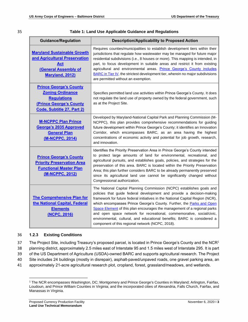
Table 1: Land Use Applicable Guidance and Regulations 35
Guidance/Regulation Description/Applicability to Proposed Action
Maryland Sustainable Growth
and Agricultural Preservation
Act
(General Assembly of
Maryland, 2012)
Requires counties/municipalities to establish development tiers within their
jurisdictions that regulate how wastewater may be managed for future major
residential subdivisions (i.e., 8 houses or more). This mapping is intended, in
part, to focus development in suitable areas and restrict it from existing
agricultural and environmental areas. Prince George’s County includes
BARC in Tier IV, the strictest development tier, wherein no major subdivisions
are permitted without an exemption.
Prince George’s County
Zoning Ordinance
Regulations
(Prince George’s County
Code, Subtitle 27, Part 2)
Specifies permitted land use activities within Prince George’s County. It does
not regulate the land use of property owned by the federal government, such
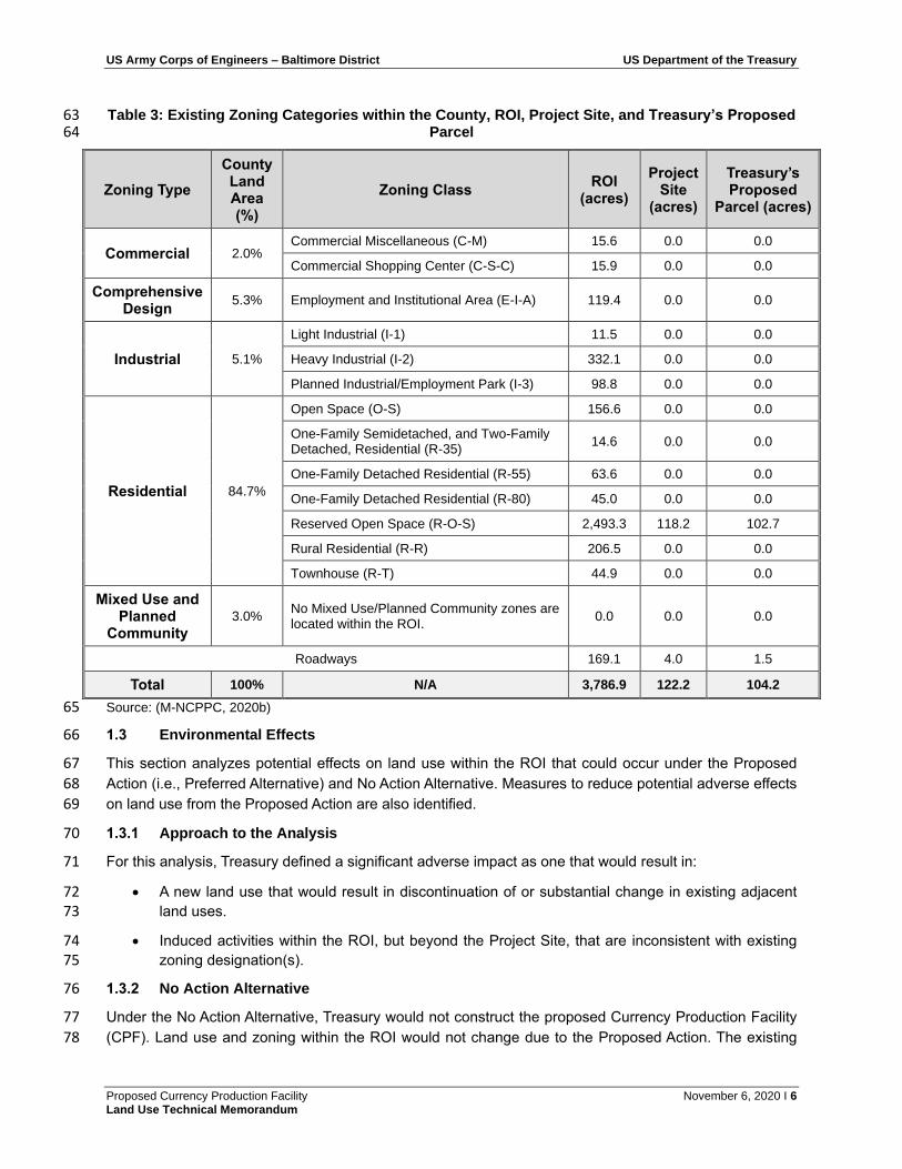
as at the Project Site.
M-NCPPC Plan Prince
George’s 2035 Approved
General Plan
(M-NCPPC, 2014)
Developed by Maryland-National Capital Park and Planning Commission (M-
NCPPC), this plan provides comprehensive recommendations for guiding
future development within Prince George’s County; it identifies an Innovation
Corridor, which encompasses BARC, as an area having the highest
concentrations of economic activity and potential for job growth, research,
and innovation.
Prince George’s County
Priority Preservation Area
Functional Master Plan
(M-NCPPC, 2012)
Identifies the Priority Preservation Area in Prince George’s County intended
to protect large amounts of land for environmental, recreational, and
agricultural pursuits, and establishes goals, policies, and strategies for the
preservation of this area. BARC is located within the Priority Preservation
Area; this plan further considers BARC to be already permanently preserved
since its agricultural land use cannot be significantly changed without
Congressional authorization.
The Comprehensive Plan for
the National Capital, Federal
Elements
(NCPC, 2016)
The National Capital Planning Commission (NCPC) establishes goals and
policies that guide federal development and provide a decision-making
framework for future federal initiatives in the National Capital Region (NCR),
which encompasses Prince George’s County. Further, the Parks and Open
Space Element of this plan encourages the management of a regional parks
and open space network for recreational, commemorative, social/civic,
environmental, cultural, and educational benefits; BARC is considered a
component of this regional network (NCPC, 2018).
1.2.3 Existing Conditions 36
The Project Site, including Treasury’s proposed parcel, is located in Prince George’s County and the NCR1 37
planning district, approximately 2.5 miles east of Interstate 95 and 1.5 miles west of Interstate 295. It is part 38
of the US Department of Agriculture (USDA)-owned BARC and supports agricultural research. The Project 39
Site includes 24 buildings (mostly in disrepair), asphalt-paved/unpaved roads, one gravel parking area, an 40
approximately 21-acre agricultural research plot, cropland, forest, grassland/meadows, and wetlands. 41
1 The NCR encompasses Washington, DC; Montgomery and Prince George's Counties in Maryland; Arlington, Fairfax, Loudoun, and Prince William Counties in Virginia; and the incorporated cities of Alexandria, Falls Church, Fairfax, and Manassas in Virginia.
US Army Corps of Engineers – Baltimore District US Department of the Treasury
Proposed Currency Production Facility November 6, 2020 I 4 Land Use Technical Memorandum
Land use in the ROI is typical of the NCR; it consists of an established mixed community including 42
residential, commercial, industrial, and open space uses. Land uses in the northern and western portions 43
of the ROI, particularly north of Odell Road and west of Edmonston Road, include mostly private residential 44
areas, commercial and retail establishments, and light and heavy industry. Existing land use and associated 45
acreages within the ROI, Project Site, and Treasury’s proposed parcel are summarized in Table 2 and 46
illustrated on Figure 1. 47
Table 2: Existing Land Use within the ROI, Project Site, and Treasury’s Proposed Parcel 48
Existing Land Use ROI (acres) Project Site
(acres) Treasury’s Proposed
Parcel (acres)
Agricultural 1,064.6 60.7 47.6
Commercial 32.4 0.0 0.0
Forest 1,447.8 3.8 3.1
Industrial 457.7 0.0 0.0
Institutional 385.7 57.7 53.5
Residential – Low Density 122.4 0.0 0.0
Residential – Medium Density
165.9 0.0 0.0
Residential – High Density 73.1 0.0 0.0
Other Developed Lands 25.1 0.0 0.0
Water 12.2 0.0 0.0
Total 3,786.9 122.2 104.2
Source: (M-NCPPC, 2020a) 49
Prince George’s County (i.e., approximately 278,761 acres of zoned land) consists of five major zoning 50
types. From most to least abundant, these include: Residential, Comprehensive Design, Industrial, 51
Commercial, and Mixed-Use and Planned Community. Each of these major zoning types contains one or 52
more zoning classifications that vary according to their specific requirements within the more general major 53
zoning type. Please refer to the Prince George’s County Guide to Zoning Categories for further information 54
(M-NCPPC, 2010). 55
The Project Site, including Treasury’s proposed parcel, is zoned under the Reserved Open Space2 zoning 56
classification within the Residential major zoning type (M-NCPPC, 2020b). Reserved Open Space currently 57
accounts for 65.8 percent of zoned land within the ROI. Existing zoning types and classes within the ROI, 58
Treasury’s proposed parcel, and Project Site, including associated acreages, are summarized in Table 3 59
and depicted on Figure 2. 60
2 The Reserved Open Space zoning classification includes a limited range of public, recreational, and agricultural uses (M-NCPPC, 2020c).
US Army Corps of Engineers – Baltimore District US Department of the Treasury
Proposed Currency Production Facility November 6, 2020 I 5 Land Use Technical Memorandum
61
Figure 2: Existing Zoning within the ROI 62
US Army Corps of Engineers – Baltimore District US Department of the Treasury
Proposed Currency Production Facility November 6, 2020 I 6 Land Use Technical Memorandum
Table 3: Existing Zoning Categories within the County, ROI, Project Site, and Treasury’s Proposed 63 Parcel 64
Zoning Type
County Land Area (%)
Zoning Class ROI
(acres)
Project Site
(acres)
Treasury’s Proposed
Parcel (acres)
Commercial 2.0% Commercial Miscellaneous (C-M) 15.6 0.0 0.0
Commercial Shopping Center (C-S-C) 15.9 0.0 0.0
Comprehensive Design
5.3% Employment and Institutional Area (E-I-A) 119.4 0.0 0.0
Industrial 5.1%
Light Industrial (I-1) 11.5 0.0 0.0
Heavy Industrial (I-2) 332.1 0.0 0.0
Planned Industrial/Employment Park (I-3) 98.8 0.0 0.0
Residential 84.7%
Open Space (O-S) 156.6 0.0 0.0
One-Family Semidetached, and Two-Family Detached, Residential (R-35)
14.6 0.0 0.0
One-Family Detached Residential (R-55) 63.6 0.0 0.0
One-Family Detached Residential (R-80) 45.0 0.0 0.0
Reserved Open Space (R-O-S) 2,493.3 118.2 102.7
Rural Residential (R-R) 206.5 0.0 0.0
Townhouse (R-T) 44.9 0.0 0.0
Mixed Use and Planned
Community
3.0% No Mixed Use/Planned Community zones are located within the ROI.
0.0 0.0 0.0
Roadways 169.1 4.0 1.5
Total 100% N/A 3,786.9 122.2 104.2
Source: (M-NCPPC, 2020b) 65
1.3 Environmental Effects 66
This section analyzes potential effects on land use within the ROI that could occur under the Proposed 67
Action (i.e., Preferred Alternative) and No Action Alternative. Measures to reduce potential adverse effects 68
on land use from the Proposed Action are also identified. 69
1.3.1 Approach to the Analysis 70
For this analysis, Treasury defined a significant adverse impact as one that would result in: 71
• A new land use that would result in discontinuation of or substantial change in existing adjacent 72 land uses. 73
• Induced activities within the ROI, but beyond the Project Site, that are inconsistent with existing 74 zoning designation(s). 75
1.3.2 No Action Alternative 76
Under the No Action Alternative, Treasury would not construct the proposed Currency Production Facility 77
(CPF). Land use and zoning within the ROI would not change due to the Proposed Action. The existing 78
US Army Corps of Engineers – Baltimore District US Department of the Treasury
Proposed Currency Production Facility November 6, 2020 I 7 Land Use Technical Memorandum
facilities within the Project Site would continue to fall into disrepair, potentially resulting in a continued less-79
than significant adverse impact on land use in the Project Site and ROI. 80
Further, the Project Site would remain available as a viable location for federal proponent(s) to redevelop 81
for other purposes with Congressional authorization. Thus, future redevelopment of the Project Site would 82
not be precluded under the No Action Alternative. 83
1.3.3 Preferred Alternative 84
Land Use 85
Construction 86
During construction of the proposed CPF, the majority of the Project Site (i.e., all areas except the northern 87
forested buffer and the wetland area in the southeast corner of Treasury’s proposed parcel) would become 88
an active construction area, including demolition, excavation, grading, filling, paving, building, landscaping, 89
and other development activities. All activities would be confined to the Project Site. Construction impact-90
reduction measures would be implemented to minimize adverse impacts from dust, noise, or road closures 91
to nearby residential areas and receptors (see the Air Quality Technical Memorandum, Noise Technical 92
Memorandum, and Traffic and Transportation Technical Memorandum). Construction access to and 93
from the Project Site would be from Powder Mill Road, thereby avoiding potential direct impacts (such as 94
fugitive dust and traffic concerns) along Odell Road. Additionally, temporary privacy fencing would be 95
erected along Odell Road and along the proposed entrance road, where needed, to supplement existing 96
vegetative buffers and to obstruct the view of most construction activities from public areas (see the Visual 97
Resources Technical Memorandum). 98
As evidenced by the established mixed-use community within the ROI, similar construction activities have 99
occurred within the ROI throughout the past several decades. Thus, construction of the Proposed Action 100
would be typical for the area and shielded from direct view off-site, resulting in a less-than-significant 101
adverse impact on land use in the ROI. 102
Operation 103
Under the Preferred Alternative, the USDA would transfer the 104.2-acre proposed parcel to Treasury; thus, 104
the site would remain under federal ownership, which is consistent with the NCPC Comprehensive Plan 105
and M-NCPPC Plan (see Table 1). Further, Treasury would use the site for innovative industrial 106
technologies and employ approximately 1,200 staff, also consistent with the M-NCPPC Plan (M-NCPPC, 107
2014). Designated land use, however, would permanently change from “Agricultural” (47.6 acres), 108
“Institutional” (53.5 acres), and “Forest” (3.1 acres) to “Industrial” (104.2 acres) land use, effectively 109
converting land use from agricultural production and research to industrial manufacturing (see Figure 1). 110
No change in land use would occur outside Treasury’s proposed parcel; the proposed entrance road and 111
Powder Mill Road rights-of-way would remain under the USDA’s ownership and classified according to their 112
existing land use (i.e., “Institutional” and “Agricultural”). 113
During operation, Treasury would conduct its manufacturing activities (i.e., currency production) inside a 114
secure facility; thus, activities would not be visible to other land uses (i.e., Residential) within the ROI. The 115
proposed CPF would be access-controlled, fenced, and professionally landscaped. Treasury would 116
maintain forested areas along the northern boundary to further limit views of the facility from Odell Road. 117
In general, Treasury’s operational activities in its proposed parcel would be consistent with other industrial 118
facilities in the ROI in terms of intensity. Treasury anticipates that no existing adjacent land uses would be 119
discontinued as a result of the Preferred Alternative. 120
US Army Corps of Engineers – Baltimore District US Department of the Treasury
Proposed Currency Production Facility November 6, 2020 I 8 Land Use Technical Memorandum
Currently, 21.1 acres of the 60.7 acres of designated “Agricultural” land within the approximately 122-acre 121
Project Site is actively used for agricultural purposes (i.e., row crops; see Biological Resources Technical 122
Memorandum). BARC contains approximately 6,523 acres of land for general agricultural use (i.e., to 123
support BARC’s mission), of which approximately 2,207 acres are in agricultural production (i.e., cropland) 124
(USDA, unpublished data). Therefore, the conversion of 21.1 acres of active cropland under the Preferred 125
Alternative would reduce active cropland at BARC by approximately 1.0 percent. The permanent conversion 126
of this land would not require the USDA to increase agricultural land or production elsewhere on BARC to 127
meet its mission, as sufficient agricultural capacity exists on BARC currently and with implementation of the 128
Proposed Action. 129
Further, agricultural land is abundant within the ROI and Prince George’s County, which include 1,064.6 130
acres and 34,399 acres of farmland, respectively (USDA, 2019). Treasury operations would only reduce 131
designated “Agricultural” land use by 4.5 percent in the land use ROI and 0.01 percent in the county. 132
BARC, however, is included in Prince George’s County’s Priority Preservation Area and the NCPC’s 133
regional parks and open space network (M-NCPPC, 2012; NCPC, 2018). Converting Treasury’s proposed 134
parcel to industrial land use would conflict with these local plans and associated planning goals (see Table 135
1). Therefore, the conversion of agricultural land use, including both active cropland and general agricultural 136
land use, within the ROI would have a less-than significant adverse impact on land use and local 137
planning objectives for agricultural land preservation. 138
Due to the increased presence of Treasury employees, the Proposed Action could create an incentive for 139
the development (or redevelopment) of other, non-BARC properties near the Project Site. Potential 140
development could include the establishment of retail and commercial uses and possibly additional housing 141
(e.g., apartments, condominiums, and townhomes). The possibility of any such development in the ROI in 142
response to the development of the proposed CPF, however, is speculative and would be dependent on 143
market conditions and other factors that are not related to the Proposed Action. Additionally, such residential 144
or retail uses would comply with current zoning in the ROI. Treasury operations have no potential to induce 145
the development of incompatible land uses or changes outside of the ROI. Therefore, the potential 146
contribution of the Proposed Action to regional development would have no or negligible impact on land 147
use within the ROI. 148
Zoning 149
The USDA would transfer custody and control of the 104.2-acre parcel to Treasury as agreed upon under 150
the Memorandum of Agreement (MOA). Treasury would construct and operate an “Industrial” facility within 151
its proposed parcel, which is and would continue to be zoned as “Residential” (Reserved Open Space) land 152
(approximately 102.7 acres) and existing roadways (1.5 acres) (see Figure 2 and Table 3). As shown in 153
Table 3, “Residential” zoning currently comprises large majorities of the ROI and county at 79.9 percent 154
and 84.7 percent, respectively; more specifically, “Reserved Open Space” currently comprises 65.8 percent 155
of the ROI. Treasury’s proposed parcel occupies only 2.8 percent of the ROI, so its use would not 156
substantially affect the area available for “Residential” (Reserved Open Space) uses in the ROI. Therefore, 157
Treasury’s use of its proposed 104.2-acre parcel for operations incompatible with existing zoning would be 158
a less-than-significant adverse impact on local zoning. No incompatible operations would occur or likely 159
be induced in the ROI outside Treasury’s proposed parcel under the Preferred Alternative. 160
1.4 Impact-Reduction Measures 161
As part of the Proposed Action, Treasury would implement the following impact-reduction measures to 162
minimize potential adverse impacts to land use: 163

US Army Corps of Engineers – Baltimore District US Department of the Treasury
Proposed Currency Production Facility November 6, 2020 I 9 Land Use Technical Memorandum
• Execute the land transfer of Treasury’s proposed parcel from the USDA to Treasury. 164
• Route construction access from Powder Mill Road north onto Poultry Road and avoid transporting 165 construction materials or operational traffic along Odell Road to avoid impacts to residential land 166 uses along this road. 167
• Install privacy fencing along Odell Road and around the proposed entrance road during 168 construction to minimize views of construction activities. 169
• Maintain professionally landscaped grounds around the proposed CPF and the forested border 170 between the facility and Odell Road during operation. 171
1.5 Mitigation Measures 172
Treasury should implement the following project-specific mitigation measure to reduce the potential for 173
adverse zoning impacts: 174
• Although not required, obtain a zoning reclassification of Treasury’s proposed parcel from the 175 Prince George’s County Planning Department’s Development Review Division from “Residential” 176 to “Industrial.” 177
1.6 References 178
General Assembly of Maryland. (2012). Sustainable Growth and Agricultural Preservation Act of 2012. 179 Retrieved from http://mlis.state.md.us/2012rs/chapters_noln/Ch_149_sb0236E.pdf 180
M-NCPPC. (2010, November). Guide to Zoning Categories. Retrieved April 6, 2020, from 181 https://www.mncppc.org/DocumentCenter/View/1366/Guide-to-Zoning-Categories-PDF?bidId= 182
M-NCPPC. (2012). Priority Preservation Area Functional Master Plan. Prince George's County: Planning 183 Department, Prince George's County. Retrieved from 184 http://mncppcapps.org/planning/publications/PDFs/273/Priority_Preservation_Area_Functional_M185 aster_Plan.pdf 186
M-NCPPC. (2014). Plan Prince George's 2035 Approved General Plan. Prince George's County: 187 Planning Department, Prince George's County. 188
M-NCPPC. (2020a). GIS Open Data Portal. Retrieved April 2, 2020, from Planning Department of Prince 189 George's County, MD: https://gisdata.pgplanning.org/opendata/ 190
M-NCPPC. (2020b, February 24). Existing Zoning & Acreage. Retrieved from Prince George's County, 191 Maryland Planning Department: 192 https://mncppc.maps.arcgis.com/apps/MapSeries/index.html?appid=5760b4d195444efe8dbec58193 311d91f2d 194
M-NCPPC. (2020c, February 24). Guide to Zoning Categories, Residential Zones. Retrieved from Prince 195 George's County Planning Department: http://www.pgplanning.org/855/Residential-Zones 196
NCPC. (2016). Comprehensive Plan for the National Capital. Retrieved from 197 https://www.ncpc.gov/plans/compplan/ 198
NCPC. (2018). The Comprehensive Plan for the National Capital, Parks and Open Space Element. 199 Retrieved from 200 https://www.ncpc.gov/docs/Parks_and_Open_Space_Element_December2018.pdf 201
USDA. (2019). 2017 Census of Agriculture, Maryland, Prince George's County, Released Aprill 11, 2019. 202 National Agricultural Statistics Service, U.S. Department of Agriculture. Washington, D.C.: USDA. 203 Retrieved from 204
US Army Corps of Engineers – Baltimore District US Department of the Treasury
Proposed Currency Production Facility November 6, 2020 I 10 Land Use Technical Memorandum
https://www.nass.usda.gov/Publications/AgCensus/2017/Full_Report/Volume_1,_Chapter_2_Cou205 nty_Level/Maryland/st24_2_0001_0001.pdf 206
207