Embed Size (px)
Citation preview
New Jersey Department of Environmental Protection
Site Remediation and Waste Management Program
Landfills Investigation Technical Guidance
May 2016
Version 1.3

2
This page left blank intentionally
3
TABLE OF CONTENTS
1 INTENDED USE OF GUIDANCE ..................................................................................... 4 2 PURPOSE ............................................................................................................................ 5 3 OVERVIEW ........................................................................................................................ 6
3.1 General Remediation Process ......................................................................................... 6 3.2 Limitation to Select Landfills ......................................................................................... 6 3.3 Flexibility of this Technical Guidance............................................................................ 7 3.4 Variance and Deviation from this Technical Guidance ................................................... 8 3.5 Other Federal, State, and Local Laws, Regulations, and Technical Guidance ................. 8
4 SITE INVESTIGATION OF LANDFILLS ....................................................................... 9 4.1 Components of a Landfill Site Investigation .................................................................. 9 4.2 Visual Inspection ........................................................................................................... 9 4.3 Geophysical Survey ..................................................................................................... 10 4.4 Subsurface Investigation .............................................................................................. 11 4.5 Additional Site Investigation Activities ........................................................................ 12 4.6 Remedial Investigation Decision .................................................................................. 13
5 REMEDIAL INVESTIGATION OF LANDFILLS ......................................................... 14 5.1 Visual inspection ......................................................................................................... 14 5.2 Geophysical Survey ..................................................................................................... 15 5.3 Lateral Delineation of the Landfill ............................................................................... 15 5.4 Vertical Delineation of the Landfill .............................................................................. 16 5.5 Test Pits and Borings ................................................................................................... 18 5.6 Landfill-Associated Areas Including Engineered Systems ............................................ 18 5.7 Surface Water and/or Leachate, and Sediment ............................................................ 19 5.8 Soil, Surface Water, Leachate, and Sediment Sample Analyses.................................... 20 5.9 Ground Water and/or Leachate .................................................................................... 20 5.10 Soil Delineation Beyond Landfill Limits ...................................................................... 21 5.11 Radiation and Radionuclides ........................................................................................ 21 5.12 Other AOCs ................................................................................................................. 22 5.13 Vapor Intrusion and Methane Gas ................................................................................ 22 5.14 Ecological Evaluation and Ecological Risk Assessment ............................................... 23
6 REFERENCES .................................................................................................................. 24
Appendix A Acronyms............................................................................................................... 25
4
1 INTENDED USE OF GUIDANCE
This technical guidance is designed to help the person responsible for conducting remediation to comply with the New Jersey Department of Environmental Protection (Department) requirements established by the Technical Requirements for Site Remediation (Technical Rule), N.J.A.C. 7:26E. Because this technical guidance will be used by many different people that are involved in the remediation of a site, such as Licensed Site Remediation Professionals (LSRPs), Non-LSRP environmental consultants, and other environmental professionals, the generic term “investigator” will be used to refer to any person that uses this technical guidance to remediate a contaminated site on behalf of a remediating party, including the remediating party itself. The procedures for a person to vary from the technical requirements in regulation are outlined in the Technical Rule at N.J.A.C. 7:26E-1.7. Variances from a technical requirement or departure from technical guidance must be documented and adequately supported with data or other information. In applying technical guidance, the Department recognizes that professional judgment may result in a range of interpretations on the application of the technical guidance to site conditions. This technical guidance supersedes previous Department guidance issued on this topic, pursuant to N.J.S.A. 26:10C-16, and was prepared with stakeholder input. Technical guidance may be used immediately upon issuance. However, the Department recognizes the challenge of using newly issued technical guidance when a remediation affected by the guidance may have already been conducted or is currently in progress. To provide for the reasonable implementation of new technical guidance, the Department will allow a 6-month “phase-in” period between the date the technical guidance is issued final (or the revision date) and the time it should be used. The entire committee consists of the following:
David Barskey, NJ Dept. of Environmental Protection David S. Bausmith, AECOM Philip I. Brilliant, LSRP, Brilliant Environmental Services, LLC Jeffrey C. Dey, LSRP, Land Resource Solutions, LLC John Doyon, NJ Dept. of Environmental Protection, Committee Co-Chair Kris Geller, New Jersey Department of Environmental Protection (retired) Joshua Gradwohl, NJ Dept. of Environmental Protection, Committee Co-Chair Mark Gruzlovic, New Jersey Department of Environmental Protection Steve MacGregor, New Jersey Department of Environmental Protection John Prendergast, New Jersey Department of Environmental Protection (retired) Kathleen F. Stetser, LSRP, GEI Consultants Theodoros “Ted” Toskos, LSRP, AMEC Environmental and Infrastructure, Inc. David Whelihan, LSRP, AMEC
This technical guidance was reviewed by the entire committee, but it was prepared by a subcommittee consisting of the following:
David Barskey, NJ Dept. of Environmental Protection, Subcommittee Chair Jeffrey C. Dey, LSRP, Land Resource Solutions, LLC Kathleen F. Stetser, LSRP, GEI Consultants
5
2 PURPOSE
The purpose of this document is to provide technical guidance on the investigation of landfills pursuant to the Technical Rule. In particular, this document will provide the following: • Background on which landfills require investigation. • Different approaches to achieve compliance with the landfill investigation requirements in the
Technical Rule. • Discussion of the investigation protocols for landfills due to the unique issues for this type of
area of concern (AOC). • Recommendations for sampling frequencies to properly delineate waste at landfills.
6
3 OVERVIEW
3.1 General Remediation Process This document provides the investigator with technical guidance to complete a landfill investigation including sampling and analyses to determine if contamination is present above an applicable Department remediation standard and delineation of contaminant exceedances. This technical guidance does not address the selection and implementation of a remedial action for landfills. Landfill closure under the Department’s Solid and Hazardous Waste regulations may be just one component of the remediation to complete a remedial action for the landfill proper and off-site contamination from a landfill, but closure and remedial action is not the subject of this technical guidance. The remediation process requires that, when a site or AOC is suspected of being contaminated, an investigation of the area must be conducted. The first step of this process, after the Preliminary Assessment (PA) phase, is the Site Investigation (SI). During a SI, sampling is conducted in areas where the highest contaminant concentrations are suspected to be present, to determine the type and concentration of the contaminants. If it is determined through the SI that contamination is present above the Department’s remediation standards, then delineation of the contamination is required in a remedial investigation (RI) phase followed by a remedial action. Contamination is delineated in a RI. The purpose of the RI is to gather enough information about the nature and extent of contamination, the media, and the site, to determine the appropriate course of action required to remediate the contamination. A remedial action is conducted after the RI has been completed; however, there are circumstances when the remedial action may take place prior to the completion of the RI. As part of the remedial action, confirmatory sampling is typically conducted to ensure that the contamination has been successfully remediated. Depending on the remedy, the RI sampling results may serve as confirmation samples (e.g., soil removal to the limits of delineation where an adequate number of samples were collected to satisfy confirmatory sample frequency). The collection of confirmatory samples is discussed in the latest version of the Department’s Technical Guidance for Site Investigation of Soil, Remedial Investigation of Soil, and Remedial Action Verification Sampling for Soil (NJDEP 2015b) . The remediation process described above for contaminated media applies to landfill investigations, but pursuant to the Technical Rule at N.J.A.C. 7:26E-3.11 and 4.6 it includes an additional remediation component for the detection and delineation of solid waste.
3.2 Limitation to Select Landfills A landfill (or sanitary landfill) is defined at N.J.A.C. 7:26E-1.8 by reference to the Department’s Solid Waste rules at N.J.A.C. 7:26-1.4, which define a landfill as a “solid waste facility, at which solid waste is deposited on or into the land as fill for the purpose of permanent disposal or storage for a period of time exceeding six months, except that it shall not include any waste facility approved for disposal of hazardous waste.” By this definition, a landfill also includes an area of concern (AOC) where solid waste was dumped on the ground surface or buried below the ground surface for more than six months for the purpose of permanent disposal or storage. This definition
7
also includes AOCs that were not designed or permitted to function as a landfill for the disposal of solid waste. As stated in the Administrative Requirements for the Remediation of Contaminated Sites (ARRCS) rule at N.J.A.C. 7:26C-1.4(c)2, the following three categories of landfills are required to be remediated in accordance with the Technical Rule and this technical guidance:
i. The sanitary landfill or any portion thereof is slated for redevelopment that includes structures intended for human occupancy;
ii. When sanitary landfill remediation activities are funded, in whole or part, by the Hazardous Discharge Site Remediation Fund pursuant to the Brownfield and Contaminated Site Remediation Act at N.J.S.A. 58:10B-4 through 9, a Brownfield Redevelopment agreement pursuant to the Brownfield and Contaminated Site Remediation Act at N.J.S.A. 58:10B-27 through 31, or the Municipal Landfill Closure and Remediation Reimbursement Program pursuant to the Solid Waste Management Act at N.J.S.A. 13:1E-116.1 through 116.7; or iii. The person conducting the remediation wants a final remediation document.
3.3 Flexibility of this Technical Guidance Due to the inherent uncertainties and heterogeneities in the types of wastes that were disposed and where in the landfill they were disposed, this technical guidance cannot anticipate all circumstances or site-specific conditions. Additional sampling, methods, or tools that are not specifically mentioned in this technical guidance may be needed to properly investigate and delineate contamination that is present at the landfill or that has emanated or is emanating from the landfill. Using and updating a Conceptual Site Model (CSM) of the landfill when implementing this technical guidance will help ensure that all waste, media, migration pathways, and receptors are properly investigated so a remedial action can be implemented that will be protective of human health and safety and the environment. The CSM should follow the latest version of the Department’s Technical Guidance for Preparation and Submission of a Conceptual Site Model (NJDEP 2011). References that may be consulted for the remediation of landfills are listed in the references section at the end of this technical guidance. This technical guidance presents the tasks for the investigation of larger, more complex landfills with multiple on-site and off-site impacts. The investigation of some landfills (especially landfills closed and maintained properly pursuant to N.J.A.C. 7:26-2A) may not require the completion of all tasks or may only need a limited degree of effort to address certain tasks, so variance or departure from these tasks may be appropriate based on site-specific circumstances or conditions. These tasks should be addressed in a flexible, multi-phase effort to ensure that a landfill remediation is protective of human health and safety and the environment. The remedial action for a landfill (e.g., closure versus development), when known, may also affect the investigation effort, which should be factored into the CSM. However, this technical guidance addresses just the investigation of the full impact of landfill contamination on-site and off-site.
8
3.4 Variance and Deviation from this Technical Guidance The intent of this technical guidance is to address the majority of SRP sites where landfills may be present and as many aspects of the investigations as possible. The Department recognizes that due to the complexity and diversity of landfills at SRP sites variances from the Technical Rule and departures from this technical guidance may be appropriate to address site-specific conditions. In applying this technical guidance, the Department also recognizes that professional judgment may result in a range of interpretations on the application of the technical guidance to site conditions. The procedures for a person to vary from the Technical Rule are outlined at N.J.A.C. 7:26E-1.7. Departure from technical guidance must be documented and adequately supported with data or other information. However, departure from this technical guidance does not require the Department’s pre-approval. Departures from this technical guidance may include a reduction or increase in sampling frequency or the use of different methods than those presented in this technical guidance.
3.5 Other Federal, State, and Local Laws, Regulations, and Technical Guidance In addition to the Department’s Technical Rule and this technical guidance, there may be other federal, state, and local laws, regulations, and guidance that must or should be used when conducting an investigation of a landfill. However, this technical guidance is not intended to and cannot provide comprehensive lists or links to all other laws, rules, and guidance that an investigator needs to use or be aware of when investigating a landfill. For example, a landfill disruption permit pursuant to N.J.A.C. 7:26-2A.8(j) may be required from the Department’s Division of Solid and Hazardous Waste. Questions concerning the application of the Department’s Solid and Hazardous Waste rules should be directed to the Department’s Division of Solid and Hazardous Waste Management (http://www.nj.gov/dep/dshw/). When investigating a landfill, and particularly during a subsurface investigation, follow the Health and Safety Plan (HASP) to protect on-site field personnel as well as other people on-site and off-site from potential exposure to hazards from buried waste and contaminants. As a reminder, the HASP shall be in accordance with the most recently adopted and applicable general industry (29 CFR 1910) and construction (29 CFR 1926) standards of the Federal Occupational Safety and Health Administration, U.S. Department of Labor, as well as any other federal, state, or local applicable laws, regulations, and guidance.
9
4 SITE INVESTIGATION OF LANDFILLS
If the results of a preliminary assessment (PA) or site review indicate that a landfill (whether permitted or unpermitted) may be present at the site or its location is uncertain, then, pursuant to N.J.A.C. 7:26E-3.11, a site investigation (SI) is required to confirm whether a landfill is present and to find its location so a remedial investigation (RI) can be conducted. As part of the PA or site review, it is important to note that aerial photographs may not be available from the time of filling and aerial photographs may give a false impression that no fill areas are present due to the passage of time and revegetation of the filled area. Therefore, do not exclude these potential areas from the SI based solely on what is shown on aerial photographs. Aerial photographic interpretation should be conducted by a person with the appropriate training and experience in interpretive techniques and their limitations. In addition, review of historic topographic maps can often be a good source of information for indicating an area may have been filled.
4.1 Components of a Landfill Site Investigation The SI will usually consist of a visual inspection, geophysical survey, and subsurface investigation. Depending on the waste that may have been disposed or other specific site or AOC conditions, other tools or methods may be appropriate, such as a soil gas survey, radiation survey, or collection and analysis of samples of waste and other media.
4.2 Visual Inspection A visual inspection should be the first task conducted in a SI of a landfill. A visual inspection provides important information for planning and conducting the SI. It can help:
• verify existing information from the PA or site review, • identify landfill features for mapping and future sampling and analysis, • determine the need for prompt mitigative action, and • provide supplemental information to determine the safety requirements for personnel
initially and subsequently entering the site. See Section 4.4 of the Department’s Field Sampling Procedures Manual (FSPM, NJDEP 2005) for more information on the purpose and type of information that should be obtained during the visual inspection. Conduct a visual inspection of the potential landfill surface, side slopes (if present), and adjacent areas for:
• waste; • the condition and type of any cap material; • seeps; • erosion; • drainage pathways; • other AOCs;
10
• landfill control features, such as gas collection systems and vents, leachate collection systems and drains, and ground water monitor wells; and
• environmentally sensitive natural resources. Record the results of the visual inspection in a narrative description along with all readings from field screening with direct-reading instruments, take appropriate photographs or videos, and map the observations to use in planning the investigation and remedial action of the landfill and for inclusion in the applicable work plans and reports. In addition, use this information along with the results of a PA/site review, aerial photography, local government records, and the Department’s Geographic Information System (GIS) to develop or update a Conceptual Site Model (CSM) of the potential landfill.
4.3 Geophysical Survey Because it can quickly cover broad areas of a property, a geophysical investigation is usually the second task conducted in a SI of a landfill. Geophysical investigations can be a rapid, cost-effective, noninvasive means for determining subsurface physical properties (i.e., hydrogeological features) and the potential presence of buried materials such as waste and drums (NJDEP 2005). The results of geophysical surveys can help target specific areas for the subsurface investigation, resulting in a more cost-effective SI. Where the results of the geophysical survey are deemed sufficient by the investigator to confirm the presence and location of a landfill, then a subsurface SI may not be needed and the investigator can proceed directly to the RI of the landfill. Where the results of a geophysical survey are not sufficient to confirm the presence of buried waste, a subsurface investigation is needed to confirm the presence and nature of the buried waste. A geophysical investigation of a landfill is required pursuant to N.J.A.C. 7:26E-3.11(a). However, there may be situations where a geophysical survey is not necessary. For example, if the general location of a potential landfill is known, the area is relatively small (e.g., <1 acre), the disposal depth is shallow (e.g., no deeper than 5 feet), or the waste disposed would not be detected by a geophysical survey, then a geophysical survey may not be needed and only a subsurface investigation would be conducted. In addition, there can be physical features of the site that may prevent or limit the ability to perform or properly complete a geophysical survey. If this is the case, then a variance is required pursuant to N.J.A.C. 7:26E-1.7 with detailed documentation included in the SI report supporting the decision not to conduct a geophysical survey. Conduct the geophysical survey by a person qualified and experienced in geophysical survey design and the use of geophysical sensing techniques, and employ appropriate geophysical sensing techniques capable of detecting potential waste, including buried containers. As discussed in the FSPM (NJDEP 2005), a variety of techniques and instruments can be used for a geophysical investigation. Each has its advantages and limitations that must be properly evaluated prior to selection and use at a landfill with the basis for the selections thoroughly documented in the SI Report. A work plan for the geophysical survey should be prepared that includes the project data quality objectives (DQOs), methods and types of equipment to be used, types of information to be obtained, details on the survey design, type and quality of deliverables or report to be delivered, and any other information needed by the investigator or for the SI and RI reports.
11
The geophysical survey design and methods employed will, in part, be dictated by the nature of the waste that was or may have been disposed and by the geologic conditions of the area to be investigated. Different methods may be needed for an area where mainly municipal solid waste may have been disposed versus a pit where drums with chemical waste were dumped. The selection of the appropriate method(s) will typically require a visit to the site and a review of available geologic data (site-specific and/or regional) prior to conducting the geophysical survey to determine the physiographic features of the site that may affect the method(s) used. Use of multiple methods in a single survey may be more efficient and cost effective than the use of single methods in separate surveys at different times. The geophysical survey should extend well beyond the initial area of investigation, because smaller trenches or fill areas often exist outside the initial more concentrated suspected area of the landfill.
The general protocols are as follows: • Use technically appropriate transect spacing across the landfill surface (25-foot transect
spacing is commonly used). Around the perimeter of the landfill, extend the transects a sufficient distance beyond the potential landfill limits to ensure all areas with potential waste are surveyed.
• Take and record readings using technically appropriate spacing along each transect (every five
feet is commonly used) based on the method employed and the professional judgment of the geophysicist.
• Transect spacing and spacing of measurements should be based on the resolution of the
methods employed to meet the project DQOs. • Record and map the boundaries of all geophysical anomalies, which may indicate the presence
of buried containers. • Use the geophysical survey report and its evaluation along with available geologic conditions
of the landfill to design the subsurface investigation, including targeting specific geophysical anomalies or areas, as described in the sections below.
• Include the geophysical survey report and its evaluation in the SI Report, or RI Report if
conducted during the RI (see section 5.2). • Use the geophysical survey results in developing or updating the CSM.
4.4 Subsurface Investigation A subsurface investigation is usually the third task conducted in a SI. It is used to confirm whether buried waste is present in the areas identified from the geophysical survey or from the information obtained in a PA or site review. If a subsurface investigation is performed without a prior geophysical survey, negative results from the subsurface investigation will usually need a geophysical survey to confirm that the test pits or soil borings were installed in the appropriate
12
locations to detect the presence of waste, unless the spacing of the sample locations are close enough to negate the need for a geophysical survey. If this is the case, then a variance is required pursuant to N.J.A.C. 7:26E-1.7 with detailed documentation included in the SI report supporting the decision not to conduct a geophysical survey. A geophysical investigation of a landfill is required pursuant to N.J.A.C. 7:26E-3.11(a). Conduct a subsurface investigation using test pits and/or soil borings to determine and confirm whether buried waste, including buried containers, is present. Generally, installing test pits using appropriate excavating equipment is the most effective method for detecting, identifying, and confirming the presence of buried waste. Borings may be needed in areas where there are physical limitations to using test pits, such as a shallow water table, site improvements (e.g., buildings and buried utilities), limitations to the depth that a backhoe or excavator can reach, or where a less disruptive method is appropriate, such as the potential presence of cap. If a landfill is found and information indicates that a proper cap has been installed, the investigator should determine whether cap disruption is appropriate to meet the objectives of the SI. If a cap is found and is disturbed for the subsurface investigation, repair the cap upon completion of the borings or test pits. A temporary cap repair may be acceptable if the investigator determines it is more appropriate to complete permanent repairs as part of the remedial action for the landfill while still being protective of human health and safety and the environment. Perform borings using appropriate equipment and methods to easily recover and identify waste material in the boring without clogging and to allow for sample inspection, logging, and collection. In general, the narrow diameter of standard direct-push cores or small-diameter split-spoon samplers typically make these tools unsuitable for this objective, so use larger diameter cores and split-spoons with these sampling methods (e.g., three-inch diameter split-spoons may be acceptable). Determine the actual tool to use by the site-specific circumstances and objectives of the sampling. Present the results of the subsurface investigation in the SI Report, including field logs for the test pits and/or soil borings, and use the results in developing or updating the CSM. In addition to the standard systems used for the logging of test pits and soil borings, include a clear narrative description of the waste.
4.5 Additional Site Investigation Activities Where and when appropriate conduct soil gas or radiation surveys to help identify areas for the subsurface investigation or the planning of the RI. In addition, samples of the waste and soil around the waste may be collected and analyzed during the subsurface investigation for use in and for the planning of the RI. Collection and analysis of ground water samples or other media are not usually needed for the SI, but such samples may be collected and analyzed when deemed necessary for the SI or the planning of the RI.
13
4.6 Remedial Investigation Decision Pursuant to N.J.A.C. 7:26E-3.11(b), if the SI confirms the presence of a landfill, the investigator shall complete a RI of the landfill and all contaminants that may be emanating or have emanated from the landfill pursuant to N.J.A.C. 7:26E-4.6. Pursuant to N.J.A.C. 7:26E-3.11(c), if a landfill and its location are known based on the results of a PA or site review, the investigator can proceed immediately to the remedial investigation of the landfill and all contaminants that may be emanating or have emanated from the landfill pursuant to N.J.A.C. 7:26E-4.6 without first conducting a SI of the landfill.
14
5 REMEDIAL INVESTIGATION OF LANDFILLS
The remedial investigation (RI) will usually consist of the following tasks in order to meet the requirements pursuant to N.J.A.C. 7:26E-4.6:
• Visually inspecting the landfill. • Developing or updating the Conceptual Site Model (CSM). • Completing a geophysical survey, if not already completed. • Delineating the horizontal and vertical extent of the landfill waste, including buried
containers. • Characterizing the waste, including buried containers. • Delineating contamination in all media (nonwaste) at the landfill and off-site areas due to
contaminant migration. • Delineating contamination in all media (nonwaste) at and from all other AOCs at the
landfill. • Completing a radiation survey. • Completing a vapor intrusion and methane gas investigation within the landfill and beyond
the perimeter of the landfill due to potential vapor and gas migration. • Completing an Ecological Evaluation (EE) and, where necessary, an Ecological Risk
Assessment (ERA) at the landfill and for off-site environmentally sensitive natural resources (ESNRs).
5.1 Visual inspection Continually update the results from the SI visual inspection, or if an SI was not conducted, conduct a visual inspection of the landfill surface, side slopes (if present), and adjacent areas for:
• waste; • the condition and type of any cap material; • seeps; • erosion; • drainage pathways; • other AOCs; • landfill control features, such as gas collection systems and vents, leachate collection
systems and drains, and ground water monitor wells; and • ESNRs.
A visual inspection provides important information for planning and conducting the RI. It can help:
• verify existing information from the PA or site review; • identify landfill features for mapping and future sampling and analysis; • determine the need for prompt mitigative action; and • provide supplemental information to determine the safety requirements for personnel
initially and subsequently entering the site.
15
See Section 4.4 (Site Entry and Reconnaissance) of the Department’s Field Sampling Procedures Manual (FSPM, NJDEP 2005) for more information on the purpose and type of information that should be obtained during the visual inspection. Record the results of the visual inspection in a narrative description along with all readings from field screening with direct-reading instruments, take appropriate photographs or videos, and map the observations to use in planning the RI and remedial action of the landfill and for inclusion in the applicable work plans and reports. In addition, use this information along with the results of a PA/site review, aerial photography, local government records, the Department’s Geographic Information System (GIS), and the SI (if conducted) to develop or update a CSM of the landfill.
5.2 Geophysical Survey Update the geophysical survey results from the SI, as necessary; or if not conducted in the SI pursuant to N.J.A.C. 7:26E-3.11(a), conduct a geophysical survey to assist with the identification and characterization of buried waste, including buried containers, unless competent records exist that identify the specific waste disposed along with the disposal locations within the landfill. In addition, conduct a geophysical survey to identify subsurface physical properties (i.e., hydrogeological features), which can provide important information for the planning and design of the RI and remedial action for the landfill. Components of a Geophysical Survey can be found in Section 4.3.
5.3 Lateral Delineation of the Landfill Delineate the horizontal/lateral extent of the landfill, without regard to the location of property boundaries, as follows:
• Use the results of the PA, aerial photography, local government records, Department’s GIS,
visual inspection from Section 5.1, the SI (if conducted), and the geophysical survey results from Section 5.2 above to estimate potential landfill boundaries for horizontal/lateral delineation. Careful evaluation of aerial photographs is needed, because aerial photographs may not be available from the time of filling and more current aerial photographs may give a false impression that no fill areas are present due to the passage of time and revegetation of the filled area. Therefore, do not exclude these potential areas from the RI based solely on what is shown on aerial photographs. Aerial photographic interpretation should be conducted by a person with the appropriate training and experience in interpretive techniques and their limitations. In addition, review of historic topographic maps can often be a good source of information for indicating an area may have been filled.
• Select locations for horizontal/lateral delineation around the perimeter of the landfill, spaced
appropriately based on the size, shape, condition, and closure/permit status of the landfill (commonly no greater than every 100 feet).
• Install test pits or trenches at each perimeter location using transects perpendicular to the
landfill until no waste is found a sufficient distance beyond the potential landfill limits to ensure all areas with waste are found and horizontally/laterally delineated. Multiple test pits or
16
trenches may be needed at each perimeter location. Due to the volume and area of waste that is visible, test pits or trenches allow for more accurate characterization of the waste.
• Where waste has been covered by additional non-waste fill and the landfill material is buried
too deep for the use of test pits or trenches, use borings to determine the horizontal extent of the landfill. Borings may also be needed in areas where there are physical limitations to using test pits, such as a shallow water table, site improvements (e.g., buildings and buried utilities), or where a less disruptive method is appropriate, such as the potential presence of cap. Perform borings using appropriate equipment and methods to easily recover and identify waste material in the boring without clogging and to allow for sample inspection, logging, and collection. In general, the narrow diameter of standard direct-push cores or small-diameter split-spoon samplers make these tools unsuitable for this objective, so larger diameter cores and split-spoons should be used with these sampling methods (e.g., three-inch diameter split-spoons may be acceptable). Determine the actual tool to use by the site-specific circumstances and objectives of the sampling.
• Properly installed test pits or borings should not penetrate final caps, bottom liners, gas and
leachate collection systems, or other engineering controls in landfills. This should be the case with a landfill operated and/or closed in accordance with permits issued by the Department’s Division of Solid and Hazardous Waste. Consider permit status, quality of the engineering controls, and other information from the PA/site review, SI, and ongoing RI when determining whether and to what extent sampling within and through a landfill is necessary. If a cap is found and is disturbed for the subsurface investigation, repair the cap upon completion of the borings or test pits. A temporary cap repair may be acceptable if the investigator determines it is more appropriate to complete permanent repairs as part of the remedial action for the landfill while still being protective of human health and safety and the environment.
• Coordinate the horizontal/lateral delineation with the vertical delineation (see Section 5.4
below) and other sections of this technical guidance to the extent possible.
5.4 Vertical Delineation of the Landfill Delineate the vertical extent of the landfill through the landfill material to native soil, meadow mat, or bedrock without regard to the depth of the ground water as follows: • Use the results of the PA, aerial photography, local government records, Department’s GIS,
visual inspection, SI (if conducted), and the geophysical survey results from Section 5.2 above to plan the vertical delineation. Careful evaluation of aerial photographs is needed, because aerial photographs may not be available from the time of filling and more current aerial photographs may give a false impression that no fill areas are present due to the passage of time and revegetation of the filled area. Therefore, do not exclude these potential areas of concern from the RI based solely on what is shown on aerial photographs.
• Install test pits through the landfill material, equally distributed across the landfill, unless
locations can be biased based on landfill records, geophysical survey results, or visual inspection.
17
• Install borings to determine the vertical extent of the landfill where the landfill waste is buried
too deep for the use of test pits. Perform soil borings using appropriate equipment and methods to easily recover and identify waste material in the boring without clogging and to allow for sample inspection, logging, and collection. In general, the narrow diameter of standard direct-push cores or small-diameter split-spoon samplers make these tools unsuitable for this objective, so larger diameter cores and split-spoons should be used with these sampling methods (e.g., three-inch diameter split-spoons may be acceptable). Determine the actual tool to use by the site-specific circumstances and objectives of the sampling.
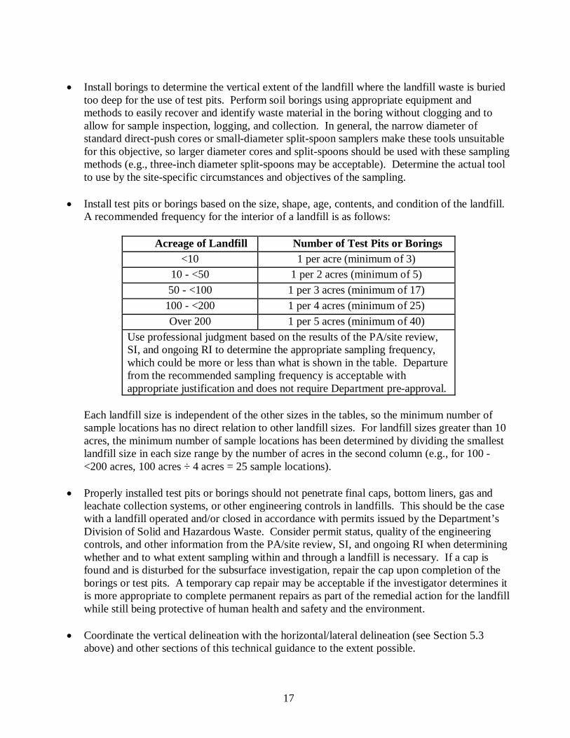
• Install test pits or borings based on the size, shape, age, contents, and condition of the landfill.
A recommended frequency for the interior of a landfill is as follows:
Acreage of Landfill Number of Test Pits or Borings <10 1 per acre (minimum of 3)
10 - <50 1 per 2 acres (minimum of 5) 50 - <100 1 per 3 acres (minimum of 17)
100 - <200 1 per 4 acres (minimum of 25) Over 200 1 per 5 acres (minimum of 40)
Use professional judgment based on the results of the PA/site review, SI, and ongoing RI to determine the appropriate sampling frequency, which could be more or less than what is shown in the table. Departure from the recommended sampling frequency is acceptable with appropriate justification and does not require Department pre-approval.
Each landfill size is independent of the other sizes in the tables, so the minimum number of sample locations has no direct relation to other landfill sizes. For landfill sizes greater than 10 acres, the minimum number of sample locations has been determined by dividing the smallest landfill size in each size range by the number of acres in the second column (e.g., for 100 - <200 acres, 100 acres ÷ 4 acres = 25 sample locations).
• Properly installed test pits or borings should not penetrate final caps, bottom liners, gas and
leachate collection systems, or other engineering controls in landfills. This should be the case with a landfill operated and/or closed in accordance with permits issued by the Department’s Division of Solid and Hazardous Waste. Consider permit status, quality of the engineering controls, and other information from the PA/site review, SI, and ongoing RI when determining whether and to what extent sampling within and through a landfill is necessary. If a cap is found and is disturbed for the subsurface investigation, repair the cap upon completion of the borings or test pits. A temporary cap repair may be acceptable if the investigator determines it is more appropriate to complete permanent repairs as part of the remedial action for the landfill while still being protective of human health and safety and the environment.
• Coordinate the vertical delineation with the horizontal/lateral delineation (see Section 5.3
above) and other sections of this technical guidance to the extent possible.
18
5.5 Test Pits and Borings For each test pit or boring installed according to sections 5.3 and 5.4 above:
• Describe the general physical and chemical (if possible) characteristics of the waste material
and determine the presence of free and/or residual product. • Log the waste material, soils, sediments, and all buried containers encountered in the test pits
or borings. • Record the location of each test pit or boring and all buried containers using a format
compatible with the Department’s GIS (see N.J.A.C. 7:1D Appendix A) and the Department's SRP Geographical Information Systems (GIS) Webpage guidance (http://www.nj.gov/dep/srp/gis/index.html) most recent to the time of the field activities.
• Collect soil samples for analysis from below the vertical limits of the waste where liners or
other buried landfill controls are not present. • Collect soil samples from beyond the horizontal/lateral limits of the waste to identify and
horizontally and vertically delineate all contaminants that have emanated or may be emanating from the waste. For horizontal delineation, generally start at the limits of the waste and then select additional sample locations proceeding out away from the landfill. Base the spacing, actual locations, and sample collection depths on site-specific conditions, the need to investigate other AOCs, the potential for vapor intrusion, and for ecological evaluation purposes.
• If buried containers (e.g., drums or pressurized gas cylinders) are found, sample and analyze
the contents of the buried containers where the location and conditions of the containers allow for such sampling. Determine whether the containers should be reburied as found, overpacked and reburied, or removed and overpacked for safe on-site or off-site disposal, or some combination of these three actions as part of the RI or remedial action.
• Collect samples of waste for bulk chemical and RCRA waste classification analyses where
such data will be of use in the CSM, to target contaminants for analysis in samples from other AOCs or media in areas where contaminants have emanated or may be emanating from the landfill, and for use in the evaluation and selection of remedial actions (e.g., hazardous versus nonhazardous disposal or closure requirements). Factors to consider in selecting samples for analysis are volume, mobility, and toxicity or other hazardous characteristics of the waste.
5.6 Landfill-Associated Areas Including Engineered Systems Evaluate the following areas associated with the landfill including the presence and effectiveness of existing engineered control systems (e.g., caps and gas and leachate collection systems), as applicable:
Pursuant to the Technical Rule and using the latest version of the Department’s Technical Guidance for Site Investigation of Soil, Remedial Investigation of Soil, and Remedial Action
19
Verification Sampling for Soil (NJDEP 2015b) for each area of soil erosion and drainage pathway around the perimeter of the landfill (1) collect and analyze soil and sediment samples from each area and sediment deposition area to determine and delineate contaminants and (2) bias initial samples to areas of potential highest contamination. • Collect water/leachate and soil/sediment samples for chemical analysis from each seep and/or
leachate drain identified on or around the perimeter of the landfill (identify, survey, and record their locations on a site map). If evidence of seeps and/or leachate drains are identified, but water/leachate is not present at the time of sampling, then collect samples when water/leachate is present. Delineate contaminants in all media at each seep and/or leachate drain area where contamination is found. Leachate from seeps and/or leachate drains may contaminate or have contaminated surface water bodies or ground water. Therefore, compare leachate sample data to the applicable remediation standards for surface water and ground water.
• Screen each vent (identify, survey, and record their locations on a site map), test pit, or boring
for lower explosive limit with an appropriate direct-reading field analytical instrument (e.g., explosimeter) properly calibrated for methane. In addition, screen the vents, test pits, and borings for volatile contaminants, methane, hydrogen sulfide, and mercury using appropriate field analytical instruments such as photoionization detector (PID), flame ionization detector (FID), or other suitable instruments (e.g., mercury analyzer) capable of detecting the contaminants pursuant to N.J.A.C. 7:26E-2.1(b). When necessary, conduct additional air investigations and take additional air measurements based on the results of the receptor evaluation, potential or known remedial action, or landfill closure permit requirements not covered in this technical guidance.
• Determine the type, extent, and condition of the landfill cap or cover. Collect soil samples of
the cap soil for chemical analysis using the latest version of the Department’s Technical Guidance for Site Investigation of Soil, Remedial Investigation of Soil, and Remedial Action Verification Sampling for Soil (NJDEP 2015b) for “Potentially Contaminated Areas Away from Process Areas Not Otherwise Addressed”. Delineate soil contaminants in each area where contamination is found, unless the cap will be repaired or restored to meet the Department’s soil remediation standards and in the professional judgment of the investigator further delineation is not necessary to select, design, and implement the remedial action for the landfill. In addition, sampling and analysis of cap soil may not be necessary if the cap was installed in accordance with a Department Solid and Hazardous Waste Program permit and would not have become potentially contaminated from another AOC (see Section 5.12 below) or migration of contaminants from landfill waste or leachate.
• Determine the location, condition, and effectiveness of all other engineering controls found at
the landfill, which may affect the selection of the remedial action(s) and the permits needed for implementation of the remedial action.
5.7 Surface Water and/or Leachate, and Sediment If landfill-related contaminants are suspected of migrating or have migrated to surface water or sediment, or evidence of a landfill-related discharge is identified, collect and analyze surface water
20
and sediment samples from appropriate locations on the landfill and/or where contaminants have migrated from the landfill to identify and delineate all contaminants pursuant to the Technical Rule and the latest version of the Department’s Ecological Evaluation Technical Guidance (NJDEP 2015a). The term “surface water” when used in this technical guidance includes leachate where leachate is present on the ground surface or is or has drained to surface water.
5.8 Soil, Surface Water, Leachate, and Sediment Sample Analyses Due to the heterogeneous nature of waste and contamination in landfills, pursuant to N.J.A.C. 7:26E-2.1(c)1ii analyze soil, surface water, leachate, and sediment samples for TCL+TICs/TAL (target compound list plus TICs/target analyte list), hexavalent chromium, extractable petroleum hydrocarbons (EPH), and pH. In addition, analyze sediment for grain size and total organic carbon. When and where appropriate, analyze sediment in-situ for oxidation-reduction potential (Eh), as sample disturbance for collection and laboratory analysis will alter sample redox conditions leading to unreliable laboratory Eh results. As discussed in the latest version of the Department’s Ecological Evaluation Technical Guidance (NJDEP 2015a), surface water samples analyzed for total metals may also require filtering for dissolved metals analysis, because some surface water quality standards are for dissolved metals. Surface water samples should also be analyzed for hardness, because some surface water quality standards are calculated based on hardness. Delineation of a targeted set of contaminants may be acceptable as a departure, with justification provided in the RI report, such as data from initial sampling and analysis of waste and/or on-site and off-site media.
5.9 Ground Water and/or Leachate Leachate within a landfill is considered ground water for purposes of the ground water investigation. Therefore, the term “ground water” when used in this technical guidance includes “leachate” as well as ground water. Collect and analyze ground water samples to identify and delineate all landfill-related contaminants pursuant to N.J.A.C. 7:26E-3.5 and 4.3, the latest version of the Department’s Ground Water Technical Guidance (NJDEP 2012), and the following supplemental technical guidance: • Pursuant to N.J.A.C. 7:26E-3.5 and 4.3 and the latest version of the Department’s Ground
Water Technical Guidance (NJDEP 2012), determine ground water flow direction within, under, and beyond the landfill including the preparation and submittal of ground water contour maps.
• Install and gauge an appropriate number of shallow (and deeper as necessary) monitor wells
within the landfill to determine whether ground water mounding is occurring within the landfill. Bias the well locations toward topographically high points in the central portion of the landfill or alternative locations based on the results of a SI and/or ongoing RI. Consider the permit status, quality of the engineering controls, and other information from the PA or site review when determining whether and to what extent monitor wells in a landfill are necessary. It is usually not necessary and difficult to double case a well that is designed for sampling of first water in or below the waste, due to lack of a competent confining layer. Sampling of deeper water below waste should have a double-cased well properly set into appropriate
21
geologic material below the landfill. However, casing of wells is a site-specific decision requiring the professional judgment of the investigator in conjunction with other professionals and application of other laws, regulations, and guidance that is beyond the scope of this technical guidance.
• Based on the ground water contour map for the new and existing monitor wells installed
within the landfill, install monitor wells just beyond the perimeter of the landfill and at additional distances from the landfill perimeter as necessary for delineation of ground water contaminants. Where radial or partial radial ground water flow from the landfill occurs, locate background/upgradient monitor wells beyond the influence of ground water flow from the landfill in the shallow and deeper aquifer zones pursuant to N.J.A.C. 7:26E-4.3(a) and the latest version of the Department’s Ground Water Technical Guidance (NJDEP 2012). An appropriate number of upgradient or background monitor wells and downgradient monitor wells are required in all directions from which ground water is flowing from or influenced by a landfill pursuant to N.J.A.C. 7:26E-4.3(a) and the latest version of the Department’s Ground Water Technical Guidance (NJDEP 2012) .
• Collect water samples from test pits installed in accordance with Sections 5.3 and 5.4 above.
Bias sampling towards test pits where visual observations, odors, free and/or residual product, and field instrument readings indicate contamination. Use these data to help design the overall ground water investigation. These data may be used to supplement and reduce the number of shallow ground water monitoring wells needed within the landfill. Include a discussion in the applicable report(s) of low bias to results for volatile contaminants due to the aeration of the water and high bias to results for nonvolatile contaminants from elevated turbidity during test pit installation.
• Collect and analyze ground water samples from all new ground-water sample locations, from
all existing wells, and test pits. Analyze ground water and leachate samples for TCL+TICs/TAL, ammonia-N, nitrate-N, and total dissolved solids (TDS). Include turbidity, temperature, dissolved oxygen (DO), oxidation-reduction capacity (ORP), pH, and specific conductance in the field measurements (NJDEP 2005). Additional target analytes may be needed based on the information from the PA/site review or other information obtained from a SI or the ongoing RI.
5.10 Soil Delineation Beyond Landfill Limits Delineate the vertical and horizontal extent of all soil contamination identified beyond the vertical and horizontal limits of the landfill material whether from migration of contaminants from the landfill or other landfill operations pursuant to N.J.A.C. 7:26E-4.2 and the latest version of the Department’s Technical Guidance for Site Investigation of Soil, Remedial Investigation of Soil, and Remedial Action Verification Sampling for Soil (NJDEP 2015b).
5.11 Radiation and Radionuclides Conduct a radiation survey of the test pits/borings using a hand-held gamma meter and delineate radiation contamination identified by the survey. A person qualified and experienced in the use of
22
radiation survey techniques shall conduct the survey and delineation. Pursuant to N.J.A.C. 7:28-12 (http://www.nj.gov/dep/rpp/njacdown.htm) and as stated on the Department’s web site for radiation (http://www.nj.gov/dep/rpp/rms/rad_cleanups.htm), staff of the Bureau of Environmental Radiation provide technical support to the Site Remediation Program (http://www.nj.gov/dep/srp/) on the investigation and remediation of radiologically contaminated sites in New Jersey, specifically, those contaminated with anthropogenic radionuclide contamination. The Licensed Site Remediation Professional (LSRP) program (http://www.nj.gov/dep/srp/regs/statutes/srra.pdf) applies to these sites with one notable exception - pursuant to N.J.A.C. 7:26C-2.3(a)3.i.(4), the LSRP cannot approve and implement any work regarding the anthropogenic radionuclide contamination without first obtaining Department approval. Sites contaminated with radioactive materials in New Jersey include former manufacturing facilities, sites that were part of the Manhattan Project (the first nuclear weapons program), other weapons program (such as the BOMARC Missile site), and various mineral/mining operations. Regulations, guidance, and a spreadsheet available for download assist LSRPs, consultants and responsible parties in complying with cleanup requirements. If radiation above background or radionuclides are found, contact the Department’s Bureau of Environmental Radiation for further guidance: New Jersey Department of Environmental Protection Radiation Protection Programs 25 Arctic Parkway Mailcode 25-01 PO Box 420 Trenton, New Jersey 08625-0420 (609) 984-5400 (voice) (609) 633-2210 (FAX) [email protected] Questions can also be sent directly to Jenny Goodman at 609-984-5498 or [email protected]
5.12 Other AOCs Collect and analyze samples of all media from all other AOCs on-site or off-site, such as access roads, storage and transfer areas, USTs, etc., to identify and delineate all contaminants.
5.13 Vapor Intrusion and Methane Gas Within and beyond the limits of the landfill, conduct a vapor intrusion investigation pursuant to the Technical Rule at N.J.A.C. 7:26E-1.15 and the latest version of the Department’s Vapor Intrusion Technical Guidance (NJDEP 2013). For methane gas, also follow appropriate requirements or guidance from the Department’s Solid and Hazardous Waste Program (e.g., see the most current version of the Technical Manual for Sanitary Landfill Permits and Approvals found at http://www.nj.gov/dep/dshw/resource/techman.htm).
23
5.14 Ecological Evaluation and Ecological Risk Assessment Using the results of the SI and/or RI, conduct an Ecological Evaluation (EE) and/or Ecological Risk Assessment (ERA) at the landfill and beyond the limits of the landfill pursuant to N.J.A.C. 7:26E-1.16 and 4.8 and the latest version of the Department’s Ecological Evaluation Technical Guidance (NJDEP 20115).
24
6 REFERENCES
NJDEP, 2005. Field Sampling Procedures Manual, August 2005 (latest version at http://www.nj.gov/dep/srp/guidance/fspm/). NJDEP, 2015a. Ecological Evaluation Technical Guidance, February 2015(latest version at http://www.nj.gov/dep/srp/guidance/srra/ecological_evaluation.pdf). NJDEP, 2011. Technical Guidance for Preparation and Submission of a Conceptual Site Model, December 2011 (latest version at http://www.nj.gov/dep/srp/guidance/srra/csm_tech_guidance.pdf). NJDEP, 2013. Vapor Intrusion Technical Guidance, March 2013 (latest version at http://www.nj.gov/dep/srp/guidance/vaporintrusion/index.html). NJDEP, 2015b. Technical Guidance for Site Investigation of Soil, Remedial Investigation of Soil, and Remedial Action Verification Sampling for Soil, March 2015 (latest version at http://www.nj.gov/dep/srp/guidance/srra/soil_inv_si_ri_ra.pdf). NJDEP, 2012. Ground Water Technical Guidance, April 2012 (latest version at http://www.nj.gov/dep/srp/guidance/srra/gw_inv_si_ri_ra.pdf). USEPA, 1991. Conducting Remedial Investigations/Feasibility Studies for CERCLA Municipal Landfill Sites, EPA/540/P-91/001, February 1991.
25
Appendix A
Acronyms
26
ACRONYMS AOC area of concern CERCLA Comprehensive Environmental Response, Compensation and Liability Act CSM conceptual site model DNAPL dense nonaqueous phase liquid DQO data quality objective EE Ecological Evaluation ERA Ecological Risk Assessment ESC ecological screening criteria ESNR environmentally sensitive natural resource FSPM Field Sampling Procedures Manual GIS Geographic Information Systems HASP Health and Safety Plan ITRC Interstate Technology and Regulatory Council LSRP Licensed Site Remediation Professional MEC munitions and explosives of concern MPPEH material presenting a potential explosive hazard N.J.A.C. New Jersey Administrative Code NJDEP New Jersey Department of Environmental Protection N.J.S.A. New Jersey Statutes Annotated PA Preliminary Assessment PAH polycyclic aromatic hydrocarbon RAWP Remedial Action Work Plan RI Remedial Investigation SI Site Investigation TCL/TAL target compound list/target analyte list USEPA United States Environmental Protection Agency VOC volatile organic compound