Embed Size (px)
Citation preview
Palaeogeography, Palaeoclimatology, Palaeoecology 264 (2008) 140–146
Contents lists available at ScienceDirect
Palaeogeography, Palaeoclimatology, Palaeoecology
j ourna l homepage: www.e lsev ie r.com/ locate /pa laeo
Late Eocene marine incursion in north-western South America
C. Santos a, C. Jaramillo b,⁎, G. Bayona c, M. Rueda d, V. Torres e
a GEMS Ltda. Grupo de Bioestratigrafía — Instituto Colombiano del Petróleo. Kilómetro 6 Vía Piedecuesta. Santander, Colombiab STRI. Smithsonian Tropical Research Institute. P.O. Box 0843 — 03092 Balboa — Ancon, Panamac Corporación Geológica ARES, Calle 57 #24-11 of 202, Bogotá, Colombiad Paleoflora Ltda. Grupo de Bioestratigrafía — Instituto Colombiano del Petróleo. Kilómetro 6 Vía Piedecuesta. Santander, Colombiae Grupo de Bioestratigrafía — Instituto Colombiano del Petróleo. Kilómetro 6 Vía Piedecuesta. Santander, Colombia
⁎ Corresponding author.E-mail addresses: [email protected] (C. Sant
(C. Jaramillo), [email protected] (G. Bayona), [email protected] (V. Torres).
0031-0182/$ – see front matter. Published by Elsevier Bdoi:10.1016/j.palaeo.2008.04.010
A B S T R A C T
A R T I C L E I N F OArticle history:
During the late Eocene in th Received 20 September 2007Received in revised form 27 February 2008Accepted 4 April 2008Keywords:Late EocenePalynologySalinity IndexMarine influenceMirador Formation, Carbonera Formation
e Colombian Subandean basins, one of the most important oil-bearing rocks ofthe country was deposited: the Mirador Formation. Palaeogeographical models have interpreted a typicallyfluvial environment for the lower Mirador Formation and marginal to marine environments for its upperlayers. The potential of marine influence in the upper Mirador beds and the overlying lower Carboneraformation as a correlation tool, and the palaeogeographic distribution of the event have not yet been defined.In order to determine the palaeogeography of this probable incursion, 80 wells and four sections wereanalysed using palynological techniques. The presence of a marine influence in the sediments wasdetermined by using a Salinity Index (SI) that describes the negative relationship between continental andmarine palynomorphs. The marine influence has been recognized in two areas: the first, in the Putumayobasin, and the second, in the Eastern Cordillera and Central Llanos Foothills. In the Putumayo basin theSalinity Index pattern reveals a southern provenance of the marine incursion, flooding the Colombianterritory in a South–North trend through the Ecuadorian coast. The marine influence of the Eastern Cordilleraand the Central-Eastern Llanos Foothills is more difficult to explain. We propose a possible corridor throughthe proto-Lower Magdalena Valley that connected the Caribbean Sea and the Central Llanos Foothills.Palaeogeographic models for the late Eocene of north-western South America should consider this marineincursion and its geographical distribution.
Published by Elsevier B.V.
1. Introduction
Depositional models for the late Eocene in north-western SouthAmerica have considered most of the sedimentary sequencesdeposited during this period to be of fluvial origin (Notestein et al.,1944; Van der Hammen, 1957; Van der Hammen, 1960; De Porta,1962). However, recent data have shown some evidence of deltaic andsporadic marine influence (Cooper et al., 1995; Villamil, 1999)associated with an increase in the subsidence rate (Bayona et al., inpress). Palaeogeographical models proposed by Cooper et al. (1995),Pindell et al. (1997) and Villamil (1999) have interpreted a marineingression that flooded the Llanos basin through Lake Maracaibo.However, sedimentological analysis carried out by Higgs (1997) inupper Eocene cores and outcrops from the Llanos Foothills did notsupport a marine influence, rejecting any marine incursion in thisarea. Information from cores, well logs and palynological analysis has
os), [email protected]@yahoo.com (M. Rueda),
.V.
shown that during the late Eocene, a marine incursion also floodedsouth-western Colombia (southern Llanos Orientales basin andwestern Putumayo basin), and probably came from the south, throughthe Ecuadorian coast (Osorio et al., 2002).
This work uses the palynological information from 84 localities toestablish the palaeogeographical distribution of a marine incursionduring the late Eocene in Eastern Colombia.
2. Regional tectonic setting of Eocene sedimentary units
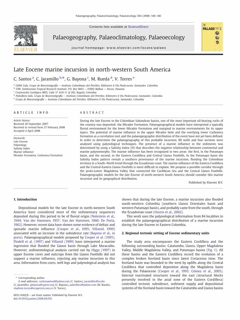
The study area encompasses the Eastern Cordillera and thefollowing surrounding basins: Catatumbo, Llanos, Upper MagdalenaValley, Middle Magdalena Valley, and Putumayo basins (Fig. 1). Allthese basins and the Eastern Cordillera record the evolution of acomplex broken foreland basin since latest Cretaceous time. Theforeland basin was bounded to the west by uplifts along the CentralCordillera that controlled deposition along the Magdalena basinduring the Palaeocene (Cooper et al., 1995; Gómez et al., 2005).Internal reactivated structures toward the east (structural blockspresently involved in the axial zone of the Eastern Cordillera)controlled tectonic subsidence, sediment supply and depositionalsystems of the foreland basin toward the Catatumbo and Llanos basins
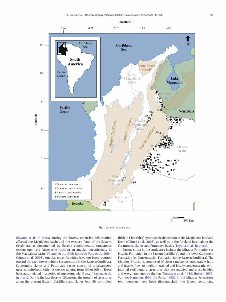
Fig. 1. Location of study area.
141C. Santos et al. / Palaeogeography, Palaeoclimatology, Palaeoecology 264 (2008) 140–146
(Bayona et al., in press). During the Eocene, extensive deformationaffected the Magdalena basin and the western flank of the EasternCordillera, as documented by Eocene conglomeratic sandstonesresting upon pre-Palaeocene rocks in an angular unconformity inthe Magdalena basin (Villamil et al., 1995; Restrepo-Pace et al., 2004;Gómez et al., 2005). Angular unconformities have not been reportedtoward the east. Lower-middle Eocene strata in the Eastern Cordillera,Catatumbo, Llanos and Putumayo basins consist of amalgamatedquartzarenite beds with thicknesses ranging from 100 to 200m. Thesebeds accumulated in a period of approximately 15 m.y. ( Bayona et al.,in press). During the late Eocene–Oligocene, the growth of structuresalong the present Eastern Cordillera and Llanos Foothills controlled
thick (N1 km thick) synorogenic deposition in the Magdalena forelandbasin (Gómez et al., 2005), as well as in the foreland basin along theCatatumbo, Llanos and Putumayo basins (Bayona et al., in press).
Eocene strata in the study area include the Mirador Formation (orPicacho Formation in the Eastern Cordillera), and the lower CarboneraFormation (or Concentración Formation in the Eastern Cordillera). TheMirador–Picacho is composed of clean sandstones, moderately hardand friable, fine- to medium-grained and locally conglomeratic, withinternal sedimentary structures that are massive and cross-beddedand wavy-laminated to the top (Notestein et al., 1944; Hubach, 1957;Van der Hammen, 1960; De Porta, 1962). In the Mirador Formation,two members have been distinguished: the lower, comprising
142 C. Santos et al. / Palaeogeography, Palaeoclimatology, Palaeoecology 264 (2008) 140–146
medium- to coarse-grained sandstones, with a thinner stratificationthan the uppermember. The uppermember, one of the subjects of thisresearch, is composed of quartzitic–conglomeratic sandstones alter-nating with light grey massive sandy mudstones and locallylaminated, organic mudstones with plant remains, which becomethicker upwards (Fajardo et al., 2000).
The depositional environment for the upper member of theMirador has been widely discussed, as sedimentary structures changefrom north to south. Outcrops and core descriptions in the northernLlanos Foothills indicate that upper Mirador sandstones showcomplete fining-upward successions and coal interbeds (Reyes,2004). In the central Llanos Foothills, fine- to medium-grainedquartzarenites have more mudstone interbeds and show evidence ofdeposition in a brackish-water environment including a diverseichnofacies association comprising Ophiomorpha, Thalassionoides,Psilonichnus and Diplocraterion (Pulham et al., 1997), couplets inforeset laminations, and wavy and flaser lamination. Several authorshave proposed a coastal to marginal-marine environment, owing tothe presence of dinoflagellates, microforaminifera and ichnofossils(Cazier et al., 1995, 1997). On the contrary, Higgs (1997) discusses thedepositional model proposed by Cazier et al. (1995) and Cooper et al.(1995), interpreting the “stunted” ichnofauna (Planolites, Ophiomor-pha and Arenicolites associations) and facies (sandstones, siltstonesand mottled, rootlet-bioturbated mudstones) as having been depos-ited in a fluvial environment including fluvial channels, overbankpalaeosols and lakes.
The Carbonera Formation overlies the Mirador Formation. Thecontact between the two formations is transitional. Carbonera stratain the northern and central Llanos Foothills consist predominantly of250 m-thick dark green and grey laminated and poorly bioturbatedmudstones (Jaramillo and Dilcher, 2001; Mora and Parra, 2004)grading to coarsening-upward successions. The lower CarboneraFormation has been interpreted as coastal plain deposits with brackishinfluence (Fajardo et al., 2000) that accumulated during the lateEocene (Jaramillo and Dilcher, 2001).
In the Upper Magdalena Valley and Putumayo basins (Fig. 1),Eocene strata consist of interbedded conglomeratic-dominant andmudstone-dominant lithological units (Gualanday Group — PepinoFormation). In the upper Magdalena basin, age control of theGualanday group is poorly constrained because the dominant faciesare varicolored and mottled mudstones that accumulated in oxidizedalluvial plains and contain poorly preserved palynomorphs andorganic matter. In the Putumayo basin, the Pepino Formation isoverlain by the Orteguaza Formation (Osorio et al., 2002), whichconsists of green–brown siltstones and limestones at its base, andcarbonaceous limestones and sandstones at the top. In both thePutumayo basin and the Oriente basin in Ecuador, this formation hasbeen interpreted as deposited in a subtidal zone (Ecopetrol and Beicip,1988; Western Atlas, 1995; Baby et al., 1997; Rivadeneira and Baby,1999; Osorio et al., 2002).
3. Late Eocene palynology
The late Eocene in Eastern Colombia can be recognized by thepresence of palynological zone T07, Echitriporites trianguliformisorbicularis of Jaramillo et al. (in press). The top of the zone isrecognized by the extinction of the pollen taxon Echitriporitestrianguliformis var. orbicularis. This palynological zone has beenrecognized throughout Colombia and Venezuela (Muller et al., 1987;Osorio et al., 2002; Jaramillo and Rueda, 2004).
The top of zone T07 in the Catatumbo, Llanos Foothills andSouthern Llanos has been found at the base of the CarboneraFormation, just a few metres above the Mirador Formation (Jaramilloand Rueda, 2004; Jaramillo et al., in press). In the Upper MagdalenaValley and Putumayo basins, the top of zone T07 occurs at the base ofthe Orteguaza Formation (Osorio et al., 2002).
4. Methods
Eighty wells and four outcrop sections, distributed in a SW–NEpattern were analysed palynologically (Fig. 1, Table 1). Well namescannot be given because of confidentiality issues. The analysis at eachsite followed two steps: In the first step several samples were analysedin order to determine the top of the palynological zone T07. In thesecond step, several samples spanning zone T07 were analysed tocalculate the proportion of marine versus terrestrial palynomorphs foreach sample. Palynomorphs were grouped into two categories:continental (pollen and spores) and marine (dinoflagellate cysts,microforaminifera lining and marine acritarchs). Three hundredpalynomorph grains were counted per slide, when possible, tostandardize the data (Buzas and Hayek, 1997).
A Salinity Index (SI) was calculated for every sample as SI=M /T,where M is the number of marine palynomorphs and T is the totalcount (marine plus terrestrial palynomorphs). A similar index hasbeen used in paleoecological and sequence stratigraphy studieselsewhere (e.g. Rull, 2000, 2002). As the environment of depositionmoves away from the shoreline, the proportion of terrestrially derivedpalynomorphs generally decreases and the proportion of marine-derived palynomorphs increases (e.g. Hoffmeister, 1954; Muller, 1959;Williams, 1971; Heusser, 1983; Traverse, 2007) mainly because apollen grain behaves as a sedimentary particle and is water-transported (Traverse, 2007). We computed the Salinity Index forthe data published by Muller (1959, his Table 1) from his study in theOrinoco delta (Fig. 2). The correlation between the Salinity Index andthe distance to the shoreline was significant (Spearmanrho=0.8632643, p-valueb2.2⁎10−16, N=118). However, it has provenvery difficult to quantitatively assess the significance of the marine/terrestrial ratio in terms of absolute water-depth or absolute distanceto the shoreline, because many factors in a particular basin can affectthe value, including the size of the drainage, offshore currents, tidalcurrents and bottom morphology (Muller, 1959; Cross et al., 1966;Williams and Sarjeant, 1967; Chowdhury, 1982; Mudie, 1982;Hofmann, 2002; Traverse, 2007). Here, we use the Salinity Index asa qualitative assessment of the degree of marine influence. Sitesfarther from the shorelinewould in general have a lower proportion ofterrestrially derived palynomorphs and a higher proportion ofmarine-derived palynomorphs.
The index that had the highest value within the upper part of zoneT07 was used as the value indicating the maximum marine influencefor that site. Maximum SI values per site were plotted on a geographicmap, and an isosalinity map was produced using the software Surfer6.02. Samples with fewer than 169 palynomorphs counted per slidewere not used to calculate the salinity index, ensuring a confidencelevel of 95% and a confidence interval of ±5%.
Palynological slides were prepared at the Colombian PetroleumInstitute using the standard palynological technique (Traverse, 1988).Palynological analyses were carried out using Axioskop Zeiss and ZeissICS KF2 microscopes.
5. Distribution of the marine influence in upper Eocene strata
Upper Eocene strata (palynological zone T07) were recognized in anorth-eastern–south-western trend located along the western side ofthe study area including the Eastern Cordillera and Llanos Foothills,Catatumbo, Middle Magdalena Valley (MMV), Upper MagdalenaValley (UMV) and Putumayo basins (Fig. 3, Table 1). In most of theLlanos basin, upper Eocene rocks either did not accumulate oraccumulated and were later eroded (Fig. 3).
There are two areas with a notable marine influence (SIN0.07,Fig. 3); the first is in the central Llanos Foothills (SI=0.19 to 0.24), andthe second is located toward the south-west, in the Putumayo basin(SI=0.07 to 0.1) (Fig. 3). The Central Llanos Foothills exhibit the highestSI values: 0.24 at site 51 and 0.2 at site S44 (Table 1). The overall
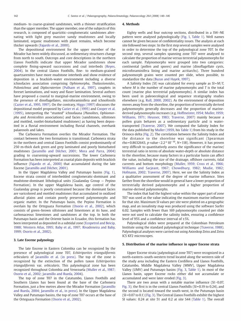
Table 1Coordinates and Salinity Index of studied wells and sections
Well/section Latitude (N) Longitude (W) Salinity Index
1 9° 5′ 47″ 72° 54′ 17″ 02 8° 35′ 19″ 72° 40′ 38″ 0.0093 8° 16′ 41″ 72° 34′ 44″ 04 8° 12′ 46″ 72° 44′ 33″ 05 8° 6′ 3″ 72° 30′ 56″ 0.004S6 7° 42′ 72° 37′ 00″ 07 7° 2′ 36″ 72° 10′ 36″ 0.028 6° 59′ 29″ 71° 31′ 50″ Upper Eocene is not present9 6° 59′ 07″ 71° 41′ 19″ Upper Eocene is not present10 6° 58′ 56″ 71° 50′ 07″ Upper Eocene is not present11 6° 58′ 06″ 71° 06′ 13″ Upper Eocene is not present12 6° 57′ 27″ 71° 04′ 35″ Upper Eocene is not present13 6° 57′ 24″ 71° 20′ 33″ Upper Eocene is not present14 6° 57′ 30″ 71° 50′ 37″ Upper Eocene is not present15 6° 57′ 17″ 71° 51′ 25″ Upper Eocene is not present16 6° 56′ 46″ 71° 05′ 54″ Upper Eocene is not present17 6° 56′ 34″ 71° 08′ 22″ Upper Eocene is not present18 6° 54′ 46″ 71° 25′ 26″ Upper Eocene is not present19 6° 44′ 47″ 71° 36′ 26″ Upper Eocene is not present20 6° 43′ 35″ 71° 21′ 04″ Upper Eocene is not present21 6° 26′ 26″ 73° 06′ 09″ Upper Eocene is not present22 6° 24′ 22″ 71° 45′ 29″ Upper Eocene is not present23 6° 16′ 38″ 71° 48′ 17″ Upper Eocene is not presentS24 6° 03′ 25″ 72° 59′ 09″ 0.0125 5° 37′10″ 72° 18′ 20″ 026 5° 26′ 32″ 72° 27′ 22″ 0.00927 5° 23′ 47″ 71° 52′ 25″ Upper Eocene is not present28 5°23′ 37″ 72° 09′ 14″ Upper Eocene is not present29 5° 22′ 27″ 71° 58′ 33″ Upper Eocene is not present30 5° 14′ 08″ 71° 57′ 05″ Upper Eocene is not present31 5° 09′ 08″ 72° 16′ 38″ Upper Eocene is not present32 5° 07′ 39″ 71° 50′ 47″ Upper Eocene is not present33 5° 6′ 50″ 72° 39′ 37″ 034 5° 06′ 11″ 72° 12′ 03″ Upper Eocene is not present35 5° 04′ 29″ 72° 30′ 51″ Upper Eocene is not present36 5° 03′ 01″ 72° 27′ 28″ Upper Eocene is not present37 5° 02′ 46″ 72° 21′ 08″ Upper Eocene is not present38 5° 01′ 52″ 72° 21′ 29″ Upper Eocene is not present39 5° 01′ 21″ 71° 58′ 45″ Upper Eocene is not present40 4° 59′ 72° 44′ 46″ 041 4° 58′ 26″ 72° 12′ 23″ Upper Eocene is not present42 4° 57′ 55″ 72° 36′ 24″ Upper Eocene is not present43 4° 54′ 30″ 72° 15′ 10″ Upper Eocene is not presentS44 4° 54′ 73° 1′ 0.19945 4° 48′ 52″ 72° 05′ 05″ Upper Eocene is not present46 4° 41′ 52″ 73° 9′ 49″ 047 4° 16′ 14″ 72° 50′ 46″ Upper Eocene is not present48 4°15′34″ 73° 21′ 3″ 0.03549 4° 4′ 23″ 73° 23′ 16″ 050 4° 01′ 50″ 73° 04′ 48″ Upper Eocene is not present51 3° 58′ 39″ 73° 30′ 48″ 0.24152 3° 56′ 16″ 73° 35′ 11″ 053 3° 49′ 06″ 71° 31′ 10″ Upper Eocene is not present54 3° 47′ 49″ 72° 02′ 46″ Upper Eocene is not present55 3° 47′ 54″ 72° 59′ 51″ Upper Eocene is not present56 3° 46′ 22″ 73° 44′ 1″ 0.0657 3° 40′ 01″ 72° 46′ 39″ Upper Eocene is not present58 3° 38′ 28″ 73° 24′ 6″ 059 3° 32′ 10″ 71° 38′ 47″ Upper Eocene is not present60 3° 31′ 13″ 73° 41′ 38″ 0.02761 3° 29′ 22″ 73° 36′ 53″ 062 3° 28′ 35″ 72° 11′ 05″ Upper Eocene is not present63 3° 26′ 45″ 73° 56′ 48″ 0.02164 3° 24′ 28″ 73° 3′ 17″ Upper Eocene is not present65 3° 22′ 45″ 73° 51′ 20″ 0.03666 3° 18′ 36″ 73° 38′ 1″ 067 3° 17′ 54″ 73° 54′ 2″ 068 3° 16′ 44″ 72° 38′ 11″ Upper Eocene is not present69 3° 15′ 26″ 73° 14′ 17″ 070 3° 6′ 55″ 73° 44′ 419″ 0.04171 3° 05′ 45″ 73° 13′ 50″ Upper Eocene is not present72 3° 04′ 29″ 71° 47′ 23″ Upper Eocene is not present73 3° 04′ 08″ 72° 50′ 23″ Upper Eocene is not present74 3° 01′ 51″ 73° 06′ 49″ Upper Eocene is not present
Table 1 (continued)
Well/section Latitude (N) Longitude (W) Salinity Index
75 2° 57′ 30″ 72° 4′ 48″ Upper Eocene is not present76 2° 53′ 25″ 73° 07′ 23″ Upper Eocene is not present77 2° 16′ 46″ 75° 33′ 31″ 0.01778 2° 7′ 31″ 74° 33′ 35″ 0.03579 0° 34′ 28″ 76° 52′ 49″ 0.06880 0° 34′ 6″ 76° 53′ 39″ 0.09781 7° 5′ 73° 31′ 54″ 0
143C. Santos et al. / Palaeogeography, Palaeoclimatology, Palaeoecology 264 (2008) 140–146
pattern of the SI shows a decrease both northward and southward ofthe central Llanos Foothills (Fig. 3). The Putumayo basin also shows amarine influence (SI=0.1 at site 80), with SI decreasing northward(0.07 at site 79; 0.02 and 0.04 at sites 77 and 78, respectively, Fig. 3).
Either minimal or no marine influence was recognized in theCatatumbo (0–0.02), Middle Magdalena Valley (0) and UpperMagdalena Valley (0.02–0.04) basins (Fig. 3). The Catatumbo basinshows very low SI values: 0 in sites 1, 3, 4 and 6, and 0.02 at site 7. Inthe Middle Magdalena Valley, the marine influence is null (SI=0), andin the Upper Magdalena Valley, it is low (SI=0.02 at site 77). Likewise,in the Eastern Cordillera, SI is low (0.02 at site S24, in the area of Pazdel Río, Table 1).
6. Palaeogeographic implications
The Salinity Index data show two clear patterns, amarine influencetowards the central Llanos Foothills, and a separate marine influencein the Putumayo basin (Fig. 3). Palaeogeographic models for the lateEocene in north-western South America (Cooper et al., 1995; Villamil,1999) suggest a marine ingression flooding the Llanos Foothills andLlanos basin from Lake Maracaibo through the northern Llanos. Thesemodels show a marine influence in the central Llanos Foothills that isin agreement with the data presented here (Fig. 3). Cazier et al. (1995,1997) report evidence from trace fossils and palynology that indicatesa marine influence in the Cusiana Oil Field (central Llanos Foothills). InCusiana, ichnofacies composed of Teichichnus, Arenicolites, Thalassi-noides, Ophiomorpha, Diplocraterion, Paleophycus, Macaronichnus,Skolithos, Gyrolithes and Planolites were identified. According toPemberton and MacEachern (1995) such an assemblage is generallyassociated with marginal-marine environments including intertidalzones, shallow lagoons, estuaries and deltaic platforms. The palyno-logical evidence for a marine influence in the Cusiana Oil Fieldincludes the dinoflagellate cysts Spiniferites, Polysphaeridium, Oper-culodinium, Cordosphaeridium, and Homotryblium and microforami-niferal test linings (Cazier et al., 1997).
Beyond the central Llanos Foothills our findings diverge signifi-cantly from earlier studies. The models of Cooper et al. (1995) andVillamil (1999) propose that the marine incursion should be recorded
Fig. 2. Salinity Index in relation to the distance from the shoreline for the Orinoco delta.(Data from Table 1. Muller, 1959).
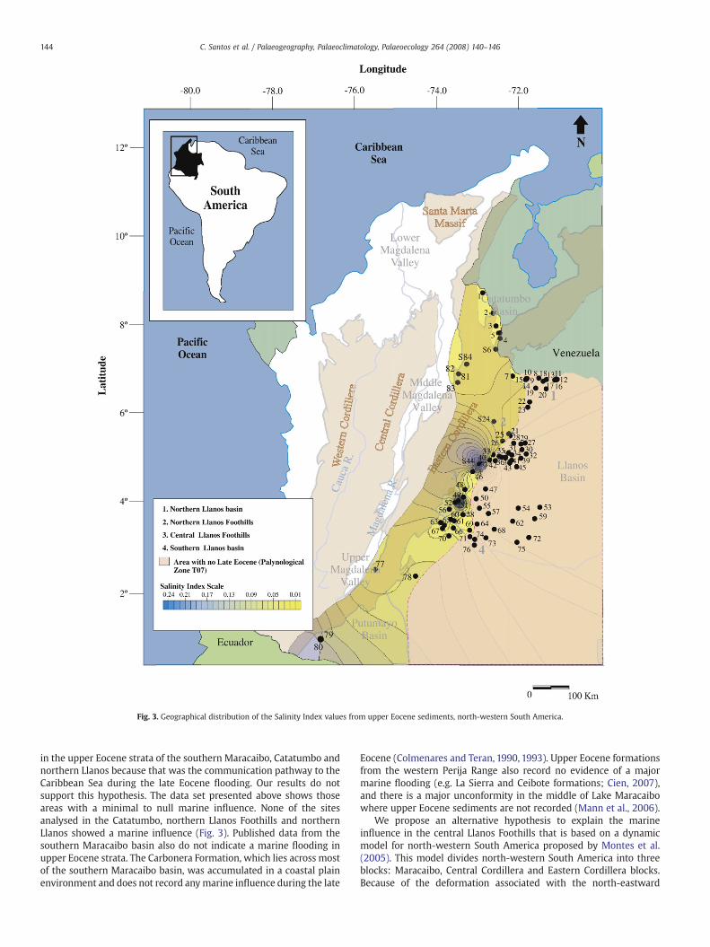
Fig. 3. Geographical distribution of the Salinity Index values from upper Eocene sediments, north-western South America.
144 C. Santos et al. / Palaeogeography, Palaeoclimatology, Palaeoecology 264 (2008) 140–146
in the upper Eocene strata of the southern Maracaibo, Catatumbo andnorthern Llanos because that was the communication pathway to theCaribbean Sea during the late Eocene flooding. Our results do notsupport this hypothesis. The data set presented above shows thoseareas with a minimal to null marine influence. None of the sitesanalysed in the Catatumbo, northern Llanos Foothills and northernLlanos showed a marine influence (Fig. 3). Published data from thesouthern Maracaibo basin also do not indicate a marine flooding inupper Eocene strata. The Carbonera Formation, which lies across mostof the southern Maracaibo basin, was accumulated in a coastal plainenvironment and does not record anymarine influence during the late
Eocene (Colmenares and Teran, 1990, 1993). Upper Eocene formationsfrom the western Perija Range also record no evidence of a majormarine flooding (e.g. La Sierra and Ceibote formations; Cien, 2007),and there is a major unconformity in the middle of Lake Maracaibowhere upper Eocene sediments are not recorded (Mann et al., 2006).
We propose an alternative hypothesis to explain the marineinfluence in the central Llanos Foothills that is based on a dynamicmodel for north-western South America proposed by Montes et al.(2005). This model divides north-western South America into threeblocks: Maracaibo, Central Cordillera and Eastern Cordillera blocks.Because of the deformation associated with the north-eastward
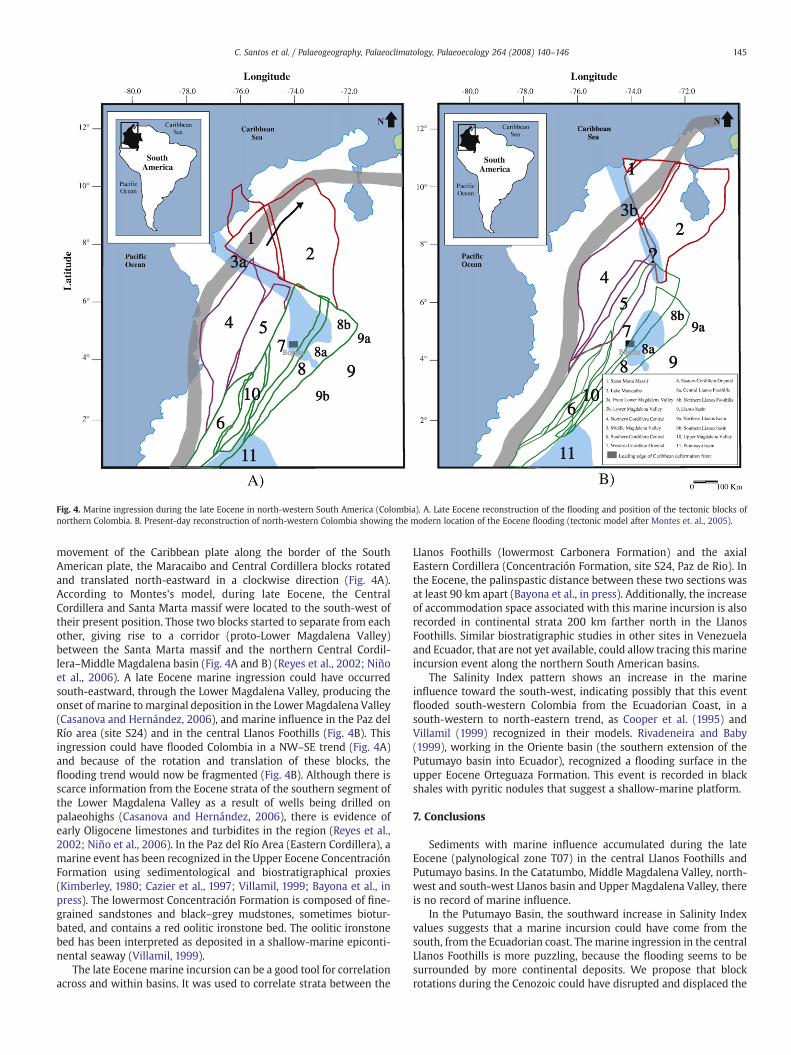
Fig. 4. Marine ingression during the late Eocene in north-western South America (Colombia). A. Late Eocene reconstruction of the flooding and position of the tectonic blocks ofnorthern Colombia. B. Present-day reconstruction of north-western Colombia showing the modern location of the Eocene flooding (tectonic model after Montes et. al., 2005).
145C. Santos et al. / Palaeogeography, Palaeoclimatology, Palaeoecology 264 (2008) 140–146
movement of the Caribbean plate along the border of the SouthAmerican plate, the Maracaibo and Central Cordillera blocks rotatedand translated north-eastward in a clockwise direction (Fig. 4A).According to Montes's model, during late Eocene, the CentralCordillera and Santa Marta massif were located to the south-west oftheir present position. Those two blocks started to separate from eachother, giving rise to a corridor (proto-Lower Magdalena Valley)between the Santa Marta massif and the northern Central Cordil-lera–Middle Magdalena basin (Fig. 4A and B) (Reyes et al., 2002; Niñoet al., 2006). A late Eocene marine ingression could have occurredsouth-eastward, through the Lower Magdalena Valley, producing theonset of marine to marginal deposition in the LowerMagdalena Valley(Casanova and Hernández, 2006), and marine influence in the Paz delRío area (site S24) and in the central Llanos Foothills (Fig. 4B). Thisingression could have flooded Colombia in a NW–SE trend (Fig. 4A)and because of the rotation and translation of these blocks, theflooding trend would now be fragmented (Fig. 4B). Although there isscarce information from the Eocene strata of the southern segment ofthe Lower Magdalena Valley as a result of wells being drilled onpalaeohighs (Casanova and Hernández, 2006), there is evidence ofearly Oligocene limestones and turbidites in the region (Reyes et al.,2002; Niño et al., 2006). In the Paz del Río Area (Eastern Cordillera), amarine event has been recognized in the Upper Eocene ConcentraciónFormation using sedimentological and biostratigraphical proxies(Kimberley, 1980; Cazier et al., 1997; Villamil, 1999; Bayona et al., inpress). The lowermost Concentración Formation is composed of fine-grained sandstones and black–grey mudstones, sometimes biotur-bated, and contains a red oolitic ironstone bed. The oolitic ironstonebed has been interpreted as deposited in a shallow-marine epiconti-nental seaway (Villamil, 1999).
The late Eocene marine incursion can be a good tool for correlationacross and within basins. It was used to correlate strata between the
Llanos Foothills (lowermost Carbonera Formation) and the axialEastern Cordillera (Concentración Formation, site S24, Paz de Rio). Inthe Eocene, the palinspastic distance between these two sections wasat least 90 km apart (Bayona et al., in press). Additionally, the increaseof accommodation space associated with this marine incursion is alsorecorded in continental strata 200 km farther north in the LlanosFoothills. Similar biostratigraphic studies in other sites in Venezuelaand Ecuador, that are not yet available, could allow tracing this marineincursion event along the northern South American basins.
The Salinity Index pattern shows an increase in the marineinfluence toward the south-west, indicating possibly that this eventflooded south-western Colombia from the Ecuadorian Coast, in asouth-western to north-eastern trend, as Cooper et al. (1995) andVillamil (1999) recognized in their models. Rivadeneira and Baby(1999), working in the Oriente basin (the southern extension of thePutumayo basin into Ecuador), recognized a flooding surface in theupper Eocene Orteguaza Formation. This event is recorded in blackshales with pyritic nodules that suggest a shallow-marine platform.
7. Conclusions
Sediments with marine influence accumulated during the lateEocene (palynological zone T07) in the central Llanos Foothills andPutumayo basins. In the Catatumbo, Middle Magdalena Valley, north-west and south-west Llanos basin and Upper Magdalena Valley, thereis no record of marine influence.
In the Putumayo Basin, the southward increase in Salinity Indexvalues suggests that a marine incursion could have come from thesouth, from the Ecuadorian coast. The marine ingression in the centralLlanos Foothills is more puzzling, because the flooding seems to besurrounded by more continental deposits. We propose that blockrotations during the Cenozoic could have disrupted and displaced the
146 C. Santos et al. / Palaeogeography, Palaeoclimatology, Palaeoecology 264 (2008) 140–146
marine corridor that probably connected the open Caribbean Seawith the central Llanos Foothills through the initial opening of theLower Magdalena Valley during the late Eocene. More data from thenorthern Middle Magdalena Valley and southern Lower MagdalenaValley basins would be needed to test this hypothesis.
Acknowledgments
This project was supported by the Smithsonian PaleobiologyEndowment Fund and the Colombian Petroleum Institute. Thanks goto two anonymous reviewers for detailed reviews of the manuscript.Natasha Atkins improved the readability of the manuscript. Specialthanks go to M. I. Barreto for her continuous support and ideas.
References
Baby, P., Rivadeneira, M., Dávila, C., Galamaga, M., Rosero, J., Vega, J., Barragán, R., 1997.Estilo Tectónico y Etapas de Deformación de la Parte Norte de La Cuenca de OrienteEcuatoriana. Convenio Postproducción-Orstom. VI Simposio Bolivariano deExploración en las Cuencas Subandinas. Asociación Colombiana de Geólogos yGeofísicos del Petróleo, Bogotá, Colombia, pp. 288–302.
Bayona, G., Cortes, M., Jaramillo, C., Ojeda, G., Aristizabal, J., And Reyes-Harker, A., inpress. An integrated analysis of an orogen-sedimentary basin pair: LatestCretaceous-Cenozoic evolution of the linked Eastern Cordillera orogen and theLlanos foreland basin of Colombia. Geological Society of America Bulletin.doi:10.1130/B26187.1.
Buzas, M.A., Hayek, L.C., 1997. Surveying Natural Populations. University Press, NewYork, Columbia, p. 563.
Casanova, C.M., Hernández, R., 2006. Rocas Almacenadoras de hidrocarburos delEoceno-Oligoceno en el Valle Inferior del Magdalena y Cinturón Plegado de SanJacinto. IX Simposio Bolivariano de Cuencas Subandinas. Asociación Colombiana deGeólogos y Geofísicos del Petróleo, Bogotá, Colombia. 8 pp., in CD.
Cazier, E.C., Hayward, A.C., Espinosa, G., Velandia, J., Mugniot, J.-E., Leel, W.G., 1995.Petroleum geology of the Cusiana Field, Llanos Basin Foothills, Colombia. AAPGBulletin 79 (10), 1444–1463.
Cazier, E.C., Cooper, M., Eaton, S.G., Pulham, A.J., 1997. Basin development and tectonichistory of the Llanos basin, Eastern Cordillera and Middle Magdalena Valley,Colombia: reply. AAPG Bulletin 81 (8), 1332–1335.
Chowdhury, K.R., 1982. Distribution of recent and fossil palynomorphs in thesoutheastern North Sea (German Bay). Senckenbergiana Marit 43, 337–341.
Cien, 2007. Código Estratigráfico de las Cuencas Petroleras de Venezuela. Petróleos deVenezuela PDVSA, Caracas, Venezuela. http://www.pdv.com/lexico/lexicoh.htm.
Colmenares, O.A., Terán, L., 1990. Formaciones Mirador y Carbonera: Edad y relacionesestratigráficas en el estado Táchira. Revista Técnica Intevep 10, 209–212.
Colmenares, O.A., Terán, L., 1993. A biostratigraphic study of Paleogene sequences insouthwestern Venezuela. Palynology 17, 67–89.
Cooper, M.A., Addison, F.T., Alvarez, R., Coral, M., Graham, R.H., Hayward, A.B., Howe, S.,Martinez, J., Naar, J., Penas, R., Pulham, A.J., Taborda, A., 1995. Basin developmentand tectonic history of the Llanos basin, Eastern Cordillera and Middle MagdalenaValley, Colombia. AAPG Bulletin 79 (10), 1421–1443.
Cross, A.T., Thompson, G.G., Zaitzeff, J.B., 1966. Source and distribution of palynomorphsin bottom sediments, southern part of Gulf of California. Marine Geology 4,467–524.
De Porta, J., 1962. Consideraciones sobre el estado actual de la Estratigrafía del Terciarioen Colombia. Boletín de Geología 9, 5–43.
Ecopetrol, Bureau d´etudes industrielles et de cooperation de L´Intitut Francais duPetrole-Beicip, 1988. Evaluación regional geológica y geofísica de la Cuenca delPutumayo, Informe Final. Bogotá, Colombia, p. 152.
Fajardo, A., Cristancho, J., Rojas, L., 2000. Definición del Modelo Estratigráfico en laCuenca de los Llanos Orientales, Piedemonte Llanero. Instituto Colombiano delPetróleo (ICP) - ECOPETROL, Piedecuesta, Colombia.
Gómez, E., Jordan, T., Allmendinger, R.W., Cardozo, N., 2005. Development of theColombian foreland-basin system as a consequence of diachronous exhumation ofthe northern Andes. Geological Society of America Bulletin 117, 1272–1292.
Heusser, L.E., 1983. Pollen distribution in the bottom sediments of the western NorthAtlantic ocean. Marine Micropaleontology 8, 77–88.
Higgs, R., 1997. Basin development and tectonic history of the Llanos Basin, EasternCordillera, and Middle Magdalena Valley, Colombia: discussion. AAPG Bulletin 81(8), 1330–1331.
Hoffmeister, W.S. 1954. Microfossil Prospecting for Petroleum. U.S. Patent 2686108.Hofmann, C., 2002. Pollen distribution in sub-Recent sedimentary environments of the
Orinoco Delta (Venezuela) — an actuo-palaeobotanical study. Review of Palaeobo-tany and Palynology 119, 191–217.
Hubach, E.,1957. Estratigrafía de la SabanadeBogotá yalrededores. BoletínGeológico 5 (2),93–112.
Jaramillo, C., Dilcher, D., 2001. Middle Paleogene palynology of Central Colombia, SouthAmerica: a study of pollen and spores from tropical latitudes. Palaeontographica258, 87–213.
Jaramillo, C., Rueda, M., 2004. Impact of biostratigraphy on oil exploration. IIIConvención Técnica Asociación Colombiana de Geólogos y Geofísicos del Petróleo,Bogotá, Colombia. 4 pp., in CD.
Jaramillo, C., Rueda, M., Bayona, G., Santos, C., Florez, P., Vargas, C., Parra, F. in press.Biostratigraphy breakingparadigms: dating theMirador Formation in the Llanos Basinof Colombia. SEPM special issue. Biostratigraphic Applications.
Kimberley, M., 1980. The Paz del Rio oolitic inland-sea Iron Formation. Economic Geology75, 97–106.
Mann, P., Escalona, A., Castillo, M.V., 2006. Regional geologic and tectonic setting of theMaracaibo Supergiant Basin, Western Venezuela. AAPG Bulletin 90, 445–477.
Montes, C., Hatcher, Restrepo-Pace, P., 2005. Tectonic reconstruction of the NorthernAndean blocks: oblique convergence and rotations derived from the kinematics ofthe Piedras-Girardot Area, Colombia. Tectonophysics 399, 221–250.
Mora, A., Parra, M., 2004. Secciones Estratigráficas de las Formaciones Guadalupe, Barcoy Carbonera, Anticlinal del Guavio: Informe Final. Instituto Colombiano del Petróleo,Piedecuesta, Colombia, p. 28.
Mudie, P.J.,1982. Pollen distribution in recentmarine sediments, eastern Canada. CanadianJournal of Earth Sciences 19, 729–747.
Muller, J., 1959. Palynology of Recent Orinoco delta and shelf sediments. Micropaleon-tology 5, 1–23.
Muller, J., Di Giacomo, E., Van Erve, A., 1987. A Palynologic Zonation for the Cretaceous,Tertiary and Quaternary of Northern South America. Contribution Series, vol. 19.American Association of Stratigraphic Palynologists, pp. 7–76.
Niño, H., Ojeda, G., Molinares, C., Torres, V., Suarez, M., 2006. Consideraciones para un MapaPaleoambiental del Oligoceno, Cuenca Del Valle Inferior Del Magdalena, Colombia. IXSimposio Bolivariano de exploración en Cuencas Subandinas. Asociación Colombiana deGeólogos y Geofísicos del Petróleo, Bogotá, Colombia. 8 pp., in CD.
Notestein, F.B., Hubman, C.W., Bowler, J., 1944. Geology of the Barco Concession, Republic ofColombia, South America. Geological Society of America Bulletin 55, 1165–1215.
Osorio, C., Michoux, D., Tellez, G., 2002. Stratigraphy of the Tertiary sequences — UpperMagdalena and the Putumayo basins, a different point of view for hydrocarbonexploration. Memorias de la Segunda Convención técnica de la AsociaciónColombiana de Geólogos y Geofísicos del Petróleo, Bogotá, Colombia. 10 pp, in CD.
Pemberton, G.S., MacEachern, J.A., 1995. The sequence stratigraphic significance of tracefossils: examples from the cretaceous foreland Basin of Alberta, Canada. In: VanWagoner, J.A., Bertram, G.T. (Eds.), Sequence Stratigraphy of Foreland BasinDeposits-Outcrop and Subsurface Examples from the Cretaceous of North America,American Association of Petroleum Geologists. Memoirs, vol. 64, pp. 429–475.
Pindell, J., George, R., Cristancho, J., Higgs, R., Ecopetrol, Tectonic analysis Inc.Consultant- 131 Tambridge Park-Horsham, 1997. Clarification of the Late Cretac-eous–Paleogene Evolution of Colombia. VI Simposio Bolivariano de Exploración enlas Cuencas Subandinas. Asociación Colombiana de Geólogos y Geofísicos delPetróleo, Bogotá Colombia, pp. 129–132.
Pulham, A.J., Mitchell, A., MacDonald, D., Daly, C., 1997. Reservoir modeling in theCusiana Field, Llanos Foothills, Eastern Cordillera: characterization of a deeplyburied, low-porosity reservoir. VI Simposio Bolivariano de Exploración en lasCuencas Subandinas. Asociación Colombiana de Geólogos y Geofísicos del Petróleo,Bogotá, Colombia, pp. 198–216.
Reyes, A., 2004. Taller Corazón Gibraltar-2. Instituto Colombiano del Petróleo,Piedecuesta, Colombia.
Reyes, J.P., Rueda, M.C., Gómez, P.D., Mantilla, M., 2002. Distribución y CaracterísticasEstratigráficas de las Unidades Cronoestratigráficas Cretáceas y Terciarias, Cuencadel Valle Inferior del Magdalena y Cinturones Plegados de San Jacinto y Sinú.Segunda Convención Técnica de la Asociación Colombiana de Geólogos y Geofísicosdel Petróleo. Bogotá, Colombia. 5 pp, in CD.
Restrepo-Pace, P., Colmenares, F., Higuera, C., Mayorga, M., 2004. A fold-and-thrust beltalong the western flank of the Eastern Cordillera of Colombia — style, kinematics,and timing constraints derived from seismic data and detailed surface mapping. In:McClay, K. (Ed.), Thrust tectonics and hydrocarbon systems. Memoir, vol. 82.America Association of Petroleum Geologists, Colombia, pp. 598–613.
Rivadeneira, M., Baby, P., 1999. La Cuenca Oriente: Estilo Tectónico, Etapas deDeformación y Características Geológicas de los Principales Campos de Petropro-ducción. Petroproducción — IRD (EX ORSTOM). Quito, Ecuador, p. 88.
Rull, V., 2000. Ecostratigraphic study of Paleocene and Early Eocene palynologicalcyclicity in Northern South America. Palaios 15, 14–24.
Rull, V., 2002. High-impact palynology in petroleum geology: applications forVenezuela (northern South America). AAPG Bulletin 86 (2), 279–300.
Traverse, A., 1988. Paleopalynology. Boston, Allen & Unwin Inc., Winchester, Mass, USA,p. 600.
Traverse, A., 2007. Paleopalynology, Second edition. Springer, Dordrecht, p. 814.Van der Hammen, T., 1957. Estratigrafía Palinológica de la Sabana de Bogotá. Boletín de
Geología V (2), 187–203.Van der Hammen, T., 1960. Estratigrafía del Terciario y Maestrichtiano continentales y
Tectogenésis de los Andes Colombianos. Boletín Geológico 6 (1–3), 67–128.Villamil, T., 1999. Campanian—Miocene tectonostratigraphy, depocenter evolution and
basin development of Colombia and Western Venezuela. Palaeogeography,Palaeoclimatology, Palaeoecology 153, 239–275.
Villamil, T., Arango, C., Suarez,M.,Malagon, C., Linares, R.,1995. Discordancia Paleoceno–Eoceno y depositios sobreyacentes en Colombia: Implicaciones tectónicas y degeología del Petróleo. VI Congreso Colombiano del Petróleo, Bogotá, pp. 11–16.
Western Atlas International, 1995. Regional evaluation of the upper Magdalena andPutumayo basins of Colombia. Integrated Technical Report. Empresa Colombiana dePetróleos (ECOPETROL), Bogotá, Colombia, p. 118.
Williams, D.B., 1971. The occurrence of dinoflagellates in marine sediments. In: Funnell,B.M., Riedel, W.R. (Eds.), The Micropaleontology of Oceans. Cambridge UniversityPress, Cambridge, pp. 231–243.
Williams, D.B., Sarjeant, W.A., 1967. Organic-walled microfossils as depth and shorelineindicators. Marine Geology 5, 389–412.