Embed Size (px)
Citation preview
Proceedings of the Geologists’ Association 122 (2011) 187–200
Late Quaternary environmental phases in the Eastern Cape and adjacentPlettenberg Bay-Knysna region and Little Karoo, South Africa
Colin A. Lewis *
Department of Geography, Rhodes University, Grahamstown 6140, South Africa
A R T I C L E I N F O
Article history:
Received 2 June 2009
Received in revised form 29 June 2010
Accepted 29 June 2010
Available online 5 August 2010
Keywords:
Palaeoclimate
Southern Africa
Late Quaternary
Last Glacial Maximum
Late Glacial
Holocene
A B S T R A C T
Four major climato-environmental phases have been identified in the Eastern Cape, Plettenberg Bay-
Knysna region and Little Karoo between somewhat before �40 000 cal. a BP and the present: the Birnam
Interstadial from before 40 000 cal. a BP until�24 000 cal. a BP; the Bottelnek Stadial (apparently equating
with the Last Glacial Maximum) from �24 000 cal. a BP until before �18 350 cal. a BP; the Aliwal North
(apparently equating with the Late Glacial) from before �18 350 cal. a BP until �11 000 cal. a BP; the
Dinorben (apparently equating with the Holocene) from�11 000 cal. a BP until the present. The evidence
for, and the characteristics of, these phases is briefly described.
� 2010 The Geologists’ Association. Published by Elsevier Ltd. All rights reserved.
Contents lists available at ScienceDirect
Proceedings of the Geologists’ Association
journa l homepage: www.e lsev ier .com/ locate /pgeola
1. Introduction
1.1. Purpose of this paper and use of proxy data
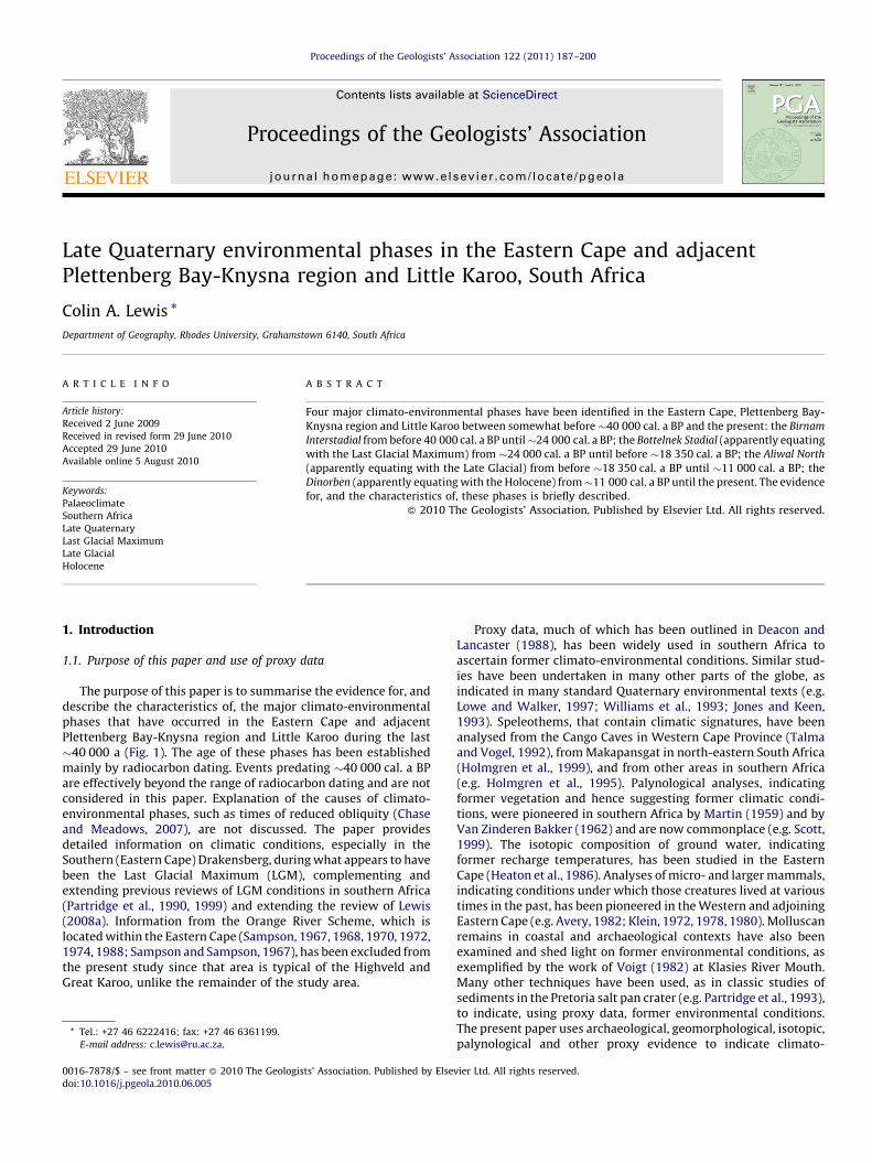
The purpose of this paper is to summarise the evidence for, anddescribe the characteristics of, the major climato-environmentalphases that have occurred in the Eastern Cape and adjacentPlettenberg Bay-Knysna region and Little Karoo during the last�40 000 a (Fig. 1). The age of these phases has been establishedmainly by radiocarbon dating. Events predating �40 000 cal. a BPare effectively beyond the range of radiocarbon dating and are notconsidered in this paper. Explanation of the causes of climato-environmental phases, such as times of reduced obliquity (Chaseand Meadows, 2007), are not discussed. The paper providesdetailed information on climatic conditions, especially in theSouthern (Eastern Cape) Drakensberg, during what appears to havebeen the Last Glacial Maximum (LGM), complementing andextending previous reviews of LGM conditions in southern Africa(Partridge et al., 1990, 1999) and extending the review of Lewis(2008a). Information from the Orange River Scheme, which islocated within the Eastern Cape (Sampson, 1967, 1968, 1970, 1972,1974, 1988; Sampson and Sampson, 1967), has been excluded fromthe present study since that area is typical of the Highveld andGreat Karoo, unlike the remainder of the study area.
* Tel.: +27 46 6222416; fax: +27 46 6361199.
E-mail address: [email protected].
0016-7878/$ – see front matter � 2010 The Geologists’ Association. Published by Else
doi:10.1016/j.pgeola.2010.06.005
Proxy data, much of which has been outlined in Deacon andLancaster (1988), has been widely used in southern Africa toascertain former climato-environmental conditions. Similar stud-ies have been undertaken in many other parts of the globe, asindicated in many standard Quaternary environmental texts (e.g.Lowe and Walker, 1997; Williams et al., 1993; Jones and Keen,1993). Speleothems, that contain climatic signatures, have beenanalysed from the Cango Caves in Western Cape Province (Talmaand Vogel, 1992), from Makapansgat in north-eastern South Africa(Holmgren et al., 1999), and from other areas in southern Africa(e.g. Holmgren et al., 1995). Palynological analyses, indicatingformer vegetation and hence suggesting former climatic condi-tions, were pioneered in southern Africa by Martin (1959) and byVan Zinderen Bakker (1962) and are now commonplace (e.g. Scott,1999). The isotopic composition of ground water, indicatingformer recharge temperatures, has been studied in the EasternCape (Heaton et al., 1986). Analyses of micro- and larger mammals,indicating conditions under which those creatures lived at varioustimes in the past, has been pioneered in the Western and adjoiningEastern Cape (e.g. Avery, 1982; Klein, 1972, 1978, 1980). Molluscanremains in coastal and archaeological contexts have also beenexamined and shed light on former environmental conditions, asexemplified by the work of Voigt (1982) at Klasies River Mouth.Many other techniques have been used, as in classic studies ofsediments in the Pretoria salt pan crater (e.g. Partridge et al., 1993),to indicate, using proxy data, former environmental conditions.The present paper uses archaeological, geomorphological, isotopic,palynological and other proxy evidence to indicate climato-
vier Ltd. All rights reserved.
Fig. 1. The distribution and nature of radiocarbon and luminescence dated sites relevant to environmental phases during the last �40 000 years in the Eastern Cape,
Plettenberg Bay/Knysna area, and Little Karoo. Altitudes are indicated by generalised form lines at 300 m intervals. Latitudes and longitudes are shown along the margins of
the figure. (Based on Lewis, 2008a, with additions.)
C.A. Lewis / Proceedings of the Geologists’ Association 122 (2011) 187–200188
environmental changes during the last �40 000 cal. a BP in theEastern Cape and in the adjoining southern Cape coastlands andLittle Karoo. In so doing, four distinct palaeo-climato-environ-mental time phases have been identified, as described anddiscussed in the remainder of this paper.
1.2. Present day climatic systems
The study area is influenced at present by two major climaticsystems. The Indian Ocean Monsoon extends westwards insummer, bringing rainfall to eastern areas of the Eastern Cape.By contrast, western areas lie near the fringes of the South Atlanticanticyclonic gyre, which extends eastwards in winter, bringingenhanced precipitation to those areas (Preston-Whyte and Tyson,1988; Meadows and Baxter, 1999). Between eastern and western(summer and winter rainfall) regions lies an area of year-roundprecipitation, centred on the Knysna region (Carr et al., 2006).
1.3. Absolute dating and other evidence
Martin (1959) provided the first radiocarbon dates from thestudy area. By the end of 2005 at least 113 relevant dates,calibrated using the Southern Hemisphere Atmospheric Calibra-tion Curve of the Pretoria program (Talma and Vogel, 1993;updated 2000), from 53 different sites in the area, had beenpublished (Lewis, 2002, 2008a). The radiocarbon dates in thepresent paper are calibrated dates from Lewis (2008a), exceptwhere stated otherwise. In order to aid the establishment ofconsistency when referring to ages (Rose, 2007), these calibratedradiocarbon dates are shown as cal. a BP. Radiocarbon dates thathave not been calibrated are shown in this paper as 14C a BP. ‘a’
represents ‘years’ regardless of whether or not calibration has beenundertaken. A few relevant optically stimulated thermolumines-cence (OSL) dates have also been obtained, from sand deposits inthe Buffelsfontein area, and are discussed in Section 2.2.3.1. OSLdates have also been obtained from a shell midden near Sedgefield(Section 2.4.4). OSL dates are expressed in this paper in ka, inconformity with the decision of the IUPAC-IUGS Task Group, 2006-016-1-200. In association with groundwater, sediments, landformsand artefacts, the overall dates evidence climatic and consequentenvironmental oscillations from the interstadial that began prior to40 000 cal. a BP, through the stadial conditions of the LGM,followed by the Late Glacial and, finally, the Holocene. Appreciableclimatic and environmental changes are hinted at during all ofthose phases. Furthermore, some areas experienced markedlydifferent environmental conditions to others, even at the sametime.
2. The major climatic and associated environmental phases
The main climatic phases are listed, with their type sites, whichprovide lithostratigraphic and chronostratigraphic units, in Table1. The Bottelnek Stadial appears to equate with the LGM,Chronozone Level 2, of Mix et al. (2001). None of theselithostratigraphic and chronostratigraphic units has yet beenforwarded for formal accreditation.
2.1. The Birnam Interstadial
2.1.1. Location of the evidence
The Birnam Interstadial is evidenced by organic lenses in whatappear to be lacustrine (possibly ox-bow lake) deposits at Birnam,
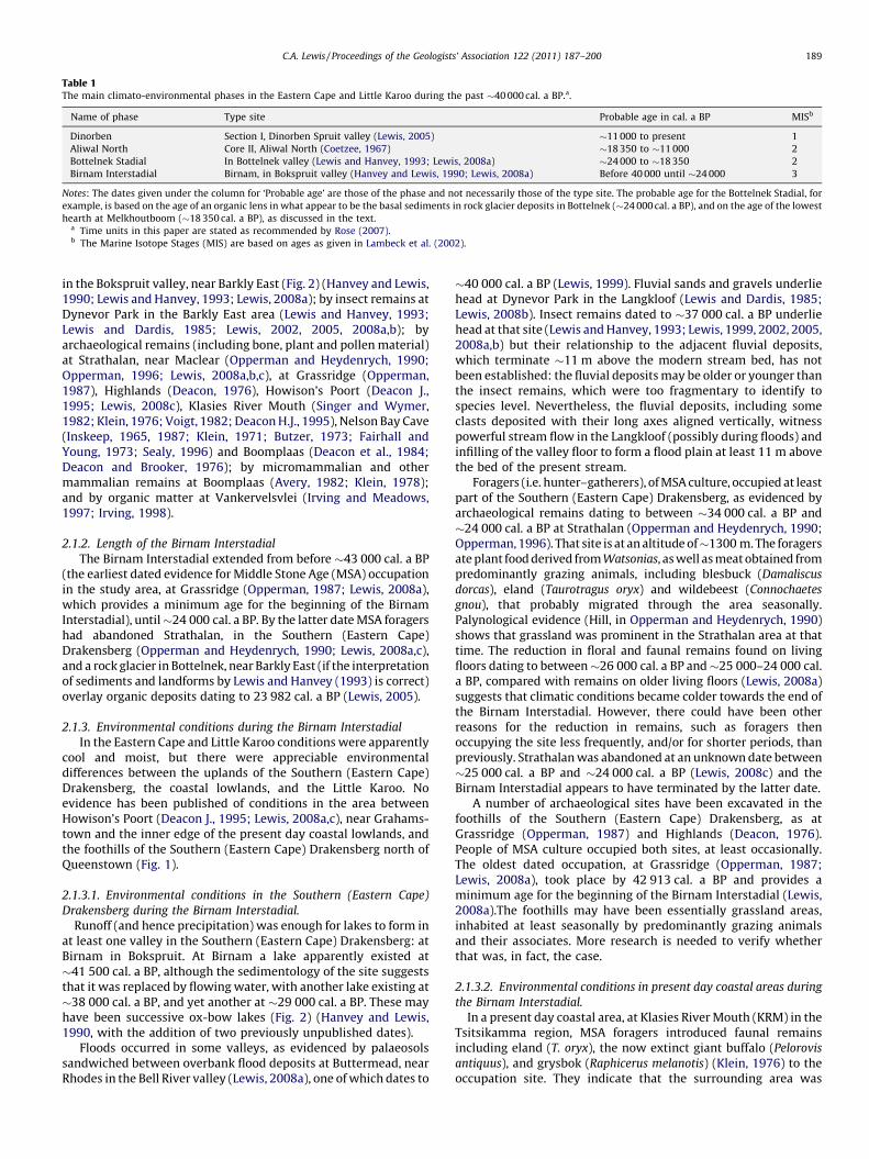
Table 1The main climato-environmental phases in the Eastern Cape and Little Karoo during the past �40 000 cal. a BP.a.
Name of phase Type site Probable age in cal. a BP MISb
Dinorben Section I, Dinorben Spruit valley (Lewis, 2005) �11 000 to present 1
Aliwal North Core II, Aliwal North (Coetzee, 1967) �18 350 to �11 000 2
Bottelnek Stadial In Bottelnek valley (Lewis and Hanvey, 1993; Lewis, 2008a) �24 000 to �18 350 2
Birnam Interstadial Birnam, in Bokspruit valley (Hanvey and Lewis, 1990; Lewis, 2008a) Before 40 000 until �24 000 3
Notes: The dates given under the column for ‘Probable age’ are those of the phase and not necessarily those of the type site. The probable age for the Bottelnek Stadial, for
example, is based on the age of an organic lens in what appear to be the basal sediments in rock glacier deposits in Bottelnek (�24 000 cal. a BP), and on the age of the lowest
hearth at Melkhoutboom (�18 350 cal. a BP), as discussed in the text.a Time units in this paper are stated as recommended by Rose (2007).b The Marine Isotope Stages (MIS) are based on ages as given in Lambeck et al. (2002).
C.A. Lewis / Proceedings of the Geologists’ Association 122 (2011) 187–200 189
in the Bokspruit valley, near Barkly East (Fig. 2) (Hanvey and Lewis,1990; Lewis and Hanvey, 1993; Lewis, 2008a); by insect remains atDynevor Park in the Barkly East area (Lewis and Hanvey, 1993;Lewis and Dardis, 1985; Lewis, 2002, 2005, 2008a,b); byarchaeological remains (including bone, plant and pollen material)at Strathalan, near Maclear (Opperman and Heydenrych, 1990;Opperman, 1996; Lewis, 2008a,b,c), at Grassridge (Opperman,1987), Highlands (Deacon, 1976), Howison’s Poort (Deacon J.,1995; Lewis, 2008c), Klasies River Mouth (Singer and Wymer,1982; Klein, 1976; Voigt, 1982; Deacon H.J., 1995), Nelson Bay Cave(Inskeep, 1965, 1987; Klein, 1971; Butzer, 1973; Fairhall andYoung, 1973; Sealy, 1996) and Boomplaas (Deacon et al., 1984;Deacon and Brooker, 1976); by micromammalian and othermammalian remains at Boomplaas (Avery, 1982; Klein, 1978);and by organic matter at Vankervelsvlei (Irving and Meadows,1997; Irving, 1998).
2.1.2. Length of the Birnam Interstadial
The Birnam Interstadial extended from before �43 000 cal. a BP(the earliest dated evidence for Middle Stone Age (MSA) occupationin the study area, at Grassridge (Opperman, 1987; Lewis, 2008a),which provides a minimum age for the beginning of the BirnamInterstadial), until�24 000 cal. a BP. By the latter date MSA foragershad abandoned Strathalan, in the Southern (Eastern Cape)Drakensberg (Opperman and Heydenrych, 1990; Lewis, 2008a,c),and a rock glacier in Bottelnek, near Barkly East (if the interpretationof sediments and landforms by Lewis and Hanvey (1993) is correct)overlay organic deposits dating to 23 982 cal. a BP (Lewis, 2005).
2.1.3. Environmental conditions during the Birnam Interstadial
In the Eastern Cape and Little Karoo conditions were apparentlycool and moist, but there were appreciable environmentaldifferences between the uplands of the Southern (Eastern Cape)Drakensberg, the coastal lowlands, and the Little Karoo. Noevidence has been published of conditions in the area betweenHowison’s Poort (Deacon J., 1995; Lewis, 2008a,c), near Grahams-town and the inner edge of the present day coastal lowlands, andthe foothills of the Southern (Eastern Cape) Drakensberg north ofQueenstown (Fig. 1).
2.1.3.1. Environmental conditions in the Southern (Eastern Cape)
Drakensberg during the Birnam Interstadial.
Runoff (and hence precipitation) was enough for lakes to form inat least one valley in the Southern (Eastern Cape) Drakensberg: atBirnam in Bokspruit. At Birnam a lake apparently existed at�41 500 cal. a BP, although the sedimentology of the site suggeststhat it was replaced by flowing water, with another lake existing at�38 000 cal. a BP, and yet another at �29 000 cal. a BP. These mayhave been successive ox-bow lakes (Fig. 2) (Hanvey and Lewis,1990, with the addition of two previously unpublished dates).
Floods occurred in some valleys, as evidenced by palaeosolssandwiched between overbank flood deposits at Buttermead, nearRhodes in the Bell River valley (Lewis, 2008a), one of which dates to
�40 000 cal. a BP (Lewis, 1999). Fluvial sands and gravels underliehead at Dynevor Park in the Langkloof (Lewis and Dardis, 1985;Lewis, 2008b). Insect remains dated to �37 000 cal. a BP underliehead at that site (Lewis and Hanvey, 1993; Lewis, 1999, 2002, 2005,2008a,b) but their relationship to the adjacent fluvial deposits,which terminate �11 m above the modern stream bed, has notbeen established: the fluvial deposits may be older or younger thanthe insect remains, which were too fragmentary to identify tospecies level. Nevertheless, the fluvial deposits, including someclasts deposited with their long axes aligned vertically, witnesspowerful stream flow in the Langkloof (possibly during floods) andinfilling of the valley floor to form a flood plain at least 11 m abovethe bed of the present stream.
Foragers (i.e. hunter–gatherers), of MSA culture, occupied at leastpart of the Southern (Eastern Cape) Drakensberg, as evidenced byarchaeological remains dating to between �34 000 cal. a BP and�24 000 cal. a BP at Strathalan (Opperman and Heydenrych, 1990;Opperman, 1996). That site is at an altitude of�1300 m. The foragersate plant food derived from Watsonias, as well as meat obtained frompredominantly grazing animals, including blesbuck (Damaliscus
dorcas), eland (Taurotragus oryx) and wildebeest (Connochaetes
gnou), that probably migrated through the area seasonally.Palynological evidence (Hill, in Opperman and Heydenrych, 1990)shows that grassland was prominent in the Strathalan area at thattime. The reduction in floral and faunal remains found on livingfloors dating to between�26 000 cal. a BP and�25 000–24 000 cal.a BP, compared with remains on older living floors (Lewis, 2008a)suggests that climatic conditions became colder towards the end ofthe Birnam Interstadial. However, there could have been otherreasons for the reduction in remains, such as foragers thenoccupying the site less frequently, and/or for shorter periods, thanpreviously. Strathalan was abandoned at an unknown date between�25 000 cal. a BP and �24 000 cal. a BP (Lewis, 2008c) and theBirnam Interstadial appears to have terminated by the latter date.
A number of archaeological sites have been excavated in thefoothills of the Southern (Eastern Cape) Drakensberg, as atGrassridge (Opperman, 1987) and Highlands (Deacon, 1976).People of MSA culture occupied both sites, at least occasionally.The oldest dated occupation, at Grassridge (Opperman, 1987;Lewis, 2008a), took place by 42 913 cal. a BP and provides aminimum age for the beginning of the Birnam Interstadial (Lewis,2008a).The foothills may have been essentially grassland areas,inhabited at least seasonally by predominantly grazing animalsand their associates. More research is needed to verify whetherthat was, in fact, the case.
2.1.3.2. Environmental conditions in present day coastal areas during
the Birnam Interstadial.
In a present day coastal area, at Klasies River Mouth (KRM) in theTsitsikamma region, MSA foragers introduced faunal remainsincluding eland (T. oryx), the now extinct giant buffalo (Pelorovis
antiquus), and grysbok (Raphicerus melanotis) (Klein, 1976) to theoccupation site. They indicate that the surrounding area was
Fig. 2. The stratigraphic arrangement of unconsolidated deposits at Birnam, in the Bokspruit valley (A), and a sedimentary log indicating the detail of the silty mud sediment
unit (B) and the calibrated radiocarbon ages BP of organic-rich units within the generally silty mud unit. (Based on Hanvey and Lewis, 1990, with the addition of two
previously unpublished radiocarbon dates; Pta-5263, 41 464 cal. a BP; Pta-5246, 29 127 cal. a BP.)
C.A. Lewis / Proceedings of the Geologists’ Association 122 (2011) 187–200190
C.A. Lewis / Proceedings of the Geologists’ Association 122 (2011) 187–200 191
probably vegetated with thick scrubby bush between �36 000 cal.a BP and �22 000 cal. a BP (Lewis, 2008a). The natural climaxvegetation of the area at present is Afro-montane forest (Low andRebelo, 1996), which requires more rainfall than scrubby bush.This suggests that rainfall was less in the Tsitsikamma area, duringat least that part of the Birnam Interstadial, than at present.
The remains of marine foods introduced to the sites at KRM byhumans: shellfish (Voigt, 1982), fish, seals and penguins (DeaconH.J., 1995), may indicate that sea levels were not markedly belowthose of the present during the Birnam Interstadial, although,based on global findings as summarised by Waelbroeck et al.(2002) (the sea levels during that Interstadial were �74–106 mbelow those of the present); that is unlikely. Deacon has drawnattention to the steep nature of the coast at KRM and hassuggested that even relatively low sea levels were unlikely tocause the shoreline to move more than �10 km from the site,which is within forager range of the archaeological site at KRM.The 25 m isobath lies only �2 km offshore, the 50 m isobath�7 km offshore, and the 100 m isobath �16 km offshore(SAN124). Birnam Interstadial sea levels, as indicated by depositsat KRM, thus remain in doubt.
Organic remains exist at Vankervelsvlei (VKV), in the coastalregion near Sedgefield in that portion of the Western Cape that isnear the political boundary of the Province of the Eastern Cape,some 70 km west of the Tsitsikamma. They indicate thatappreciable forest cover existed in that area between�40 000 cal. a BP and �35 000 cal. a BP, succeeded prior to�23 000 cal. a BP by vegetation indicative of drier conditions(Irving, 1998). The Birnam Interstadial in the Sedgefield regiontherefore seems to have been characterised by a moister climateand more forested environment prior to �35 000 cal. a BP thanafter that date. Whether climatic and environmental conditionswere the same temporally in the Sedgefield area as in Tsitsikammais unknown, since there is a time difference between the datedevidence at KRM and at VKV.
Nelson Bay Cave (NBC), near Plettenberg Bay, was occupied, atleast occasionally, by people of MSA culture during the BirnamInterstadial (Butzer, 1973) and MSA artefacts at that site have beendated to as far back as�26 000 cal. a BP (Fairhall and Young, 1973).Although Butzer (1973) has suggested environmental conditionsduring the Birnam Interstadial at NBC, based on sedimentaryanalyses, faunal and other investigations are necessary to confirm(or otherwise) his suggestions. Mammalian remains investigatedfrom NBC date to younger than �22 000 cal. a BP (Klein, 1972;Sealy, 1996) and hence fall outside the time limits of the BirnamInterstadial which, as stated in Section 2.1.2, terminated before�24 000 cal. a BP.
On the inland margin of the present day coastal lowlands, a rockshelter at Howison’s Poort, near Grahamstown, appears to havebeen occupied, at least occasionally, between�23 000 cal. a BP and�10 500 cal. a BP (Lewis, 2008c). Previous claims for earlierutilisation of the shelter (Deacon J., 1995) are not supported bycalibration of the existing radiocarbon dates (Lewis, 2008a) or bystudy of fluvial sediments and intercalated palaeosols on the floorof the Howison’s Poort valley (Lewis and Illgner, 1998). There istherefore no published information from this site that definitelyrelates to the Birnam Interstadial.
Apart from KRM, NBC and VKV, no other sites in present daycoastal areas of the Eastern and adjoining Western Cape, dating tothe Birnam Interstadial, have been discovered and investigated.
2.1.3.3. Environmental conditions in the area between the present day
coastal lowlands and the foothills of the Southern (Eastern Cape)
Drakensberg during the Birnam Interstadial.
Nothing is known of this vast area during the BirnamInterstadial.
2.1.3.4. Environmental conditions in the Little Karoo during the
Birnam Interstadial.
In the Little Karoo, at an altitude of�800 m at Boomplaas, inlandof Oudtshoorn (Deacon et al., 1984; Fig. 1), MSA artefacts existbelow a stratigraphic discontinuity that dates to between�24 000 cal. a BP and �17 000 cal. a BP (Lewis, 2008a). Theyindicate that foragers inhabited the Little Karoo during the BirnamInterstadial. Micromammalian remains at Boomplaas indicate thatafter �38 000 cal. a BP and before �24 000 cal. a BP there was‘fairly extensive dense vegetation on [the] valley floor’, with a‘grassy’ element on hillsides, as well as some semi-arid vegetation(Avery, 1982, p. 315). Examination of the remains of largermammals (of the hartebeest tribe (Alcelaphini), grey rhebuck(Pelea capreolus) and grysbok species (Raphicerus spp.); Klein,1978), dating to before �24 000 cal. a BP, shows that there was a‘significant browse component in the vegetation’ (Deacon et al.,1984, p. 342) prior to that date and that the vegetation ‘wasbroadly comparable to the historic one’ (Klein, 1978, p. 68).
By �24 000 cal. a BP micromammalian evidence indicates thatharsh cold conditions were replacing those of the interstadial(Avery, 1982), while remains of Equidae indicate that drierconditions, with grasslands, had replaced lusher interstadialvegetation in the Little Karoo by that date (Deacon et al., 1984).Deacon et al. (1984, p. 347) suggest that, when MSA foragersutilised Boomplaas between at least �38 000 cal. a BP and�24 000 cal. a BP, the habitat was ‘relatively productive’.
2.1.4. Summary, environmental conditions during the Birnam
Interstadial
The Birnam Interstadial appears to have been relatively mildand moist, but was probably drier and cooler than the present.There were occasional floods, at least in valleys in the Southern(Eastern Cape) Drakensberg. They may have occurred undervarious climatic conditions. Regional variations in climate andenvironments occurred. They were related to locational variationsin longitude, as outlined in Section 1.1, which influenced the extentto which the area concerned came under the influence of the SouthAtlantic anticyclonic gyre, and hence the winter rainfall zone(Meadows and Baxter, 1999; Chase and Meadows, 2007), or theIndian Ocean Monsoon and hence the summer rainfall zone (Lewis,2005), or the intervening year-round rainfall zone (Carr et al.,2006). Altitudinal variations in location were reflected intemperatures and other elements of climate.
Vegetation varied from predominantly grassland in theSouthern (Eastern Cape) Drakensberg to scrubby bushland/grassland in the Tsitsikamma area, with better developed forestfurther west in the Sedgefield region (although it may be that thescrubby bushland dates from more recent times than theapparently better developed forest of the Sedgefield area, andreflects the existence of drier climatic conditions in the later thanin the earlier part of the Birnam Interstadial). Vegetation in theLittle Karoo was not markedly different from that of the present,but may reflect drier, and increasingly colder, climatic conditionstowards the end of the Birnam Interstadial. Nothing is known ofthe vegetation between the present day coastal belt and thefoothills of the Southern (Eastern Cape) Drakensberg during theInterstadial.
The larger mammals throughout the greater Eastern Capeappear to have been predominantly grazers, possibly with anincrease in browsers in the drier area of the Little Karoo. The giantbuffalo (Pelerovis antiquus) existed in present day coastal areas, atleast west of Port Elizabeth, where it may have been suited to thescrubby woodland/grassland environment that seems to haveexisted at least during the latter part of the Birnam Interstadial.Nothing is known of coastal areas east and north of Port Elizabeth,or of the area between the present day coastal belt and the
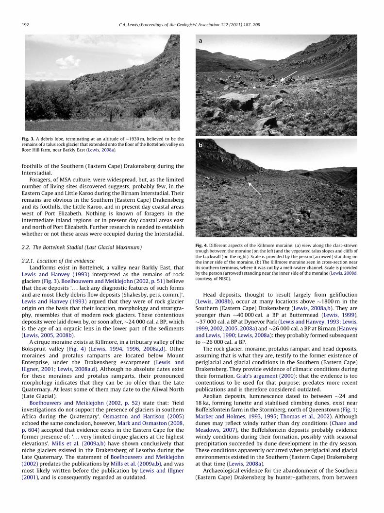
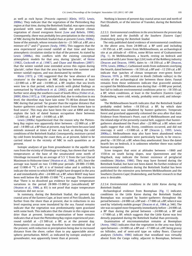
Fig. 3. A debris lobe, terminating at an altitude of �1930 m, believed to be the
remains of a talus rock glacier that extended onto the floor of the Bottelnek valley on
Rose Hill farm, near Barkly East (Lewis, 2008a).
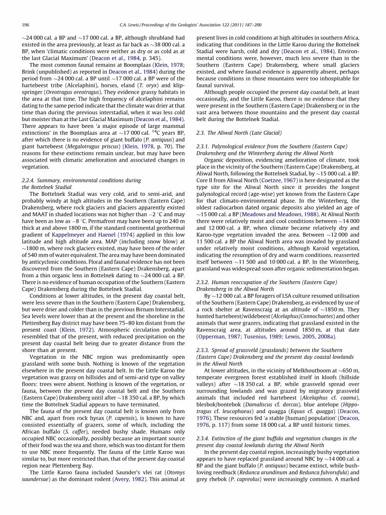
Fig. 4. Different aspects of the Killmore moraine: (a) view along the clast-strewn
trough between the moraine (on the left) and the vegetated talus slopes and cliffs of
the backwall (on the right). Scale is provided by the person (arrowed) standing on
the inner side of the moraine. (b) The Killmore moraine seen in cross-section near
its southern terminus, where it was cut by a melt-water channel. Scale is provided
by the person (arrowed) standing near the inner side of the moraine (Lewis, 2008d,
courtesy of NISC).
C.A. Lewis / Proceedings of the Geologists’ Association 122 (2011) 187–200192
foothills of the Southern (Eastern Cape) Drakensberg during theInterstadial.
Foragers, of MSA culture, were widespread, but, as the limitednumber of living sites discovered suggests, probably few, in theEastern Cape and Little Karoo during the Birnam Interstadial. Theirremains are obvious in the Southern (Eastern Cape) Drakensbergand its foothills, the Little Karoo, and in present day coastal areaswest of Port Elizabeth. Nothing is known of foragers in theintermediate inland regions, or in present day coastal areas eastand north of Port Elizabeth. Further research is needed to establishwhether or not these areas were occupied during the Interstadial.
2.2. The Bottelnek Stadial (Last Glacial Maximum)
2.2.1. Location of the evidence
Landforms exist in Bottelnek, a valley near Barkly East, thatLewis and Hanvey (1993) interpreted as the remains of rockglaciers (Fig. 3). Boelhouwers and Meiklejohn (2002, p. 51) believethat these deposits ‘. . . lack any diagnostic features of such formsand are most likely debris flow deposits (Shakesby, pers. comm.)’.Lewis and Hanvey (1993) argued that they were of rock glacierorigin on the basis that their location, morphology and stratigra-phy, resembles that of modern rock glaciers. These contentiousdeposits were laid down by, or soon after,�24 000 cal. a BP, whichis the age of an organic lens in the lower part of the sediments(Lewis, 2005, 2008b).
A cirque moraine exists at Killmore, in a tributary valley of theBokspruit valley (Fig. 4) (Lewis, 1994, 1996, 2008a,d). Othermoraines and protalus ramparts are located below MountEnterprise, under the Drakensberg escarpment (Lewis andIllgner, 2001; Lewis, 2008a,d). Although no absolute dates existfor these moraines and protalus ramparts, their pronouncedmorphology indicates that they can be no older than the LateQuaternary. At least some of them may date to the Aliwal North(Late Glacial).
Boelhouwers and Meiklejohn (2002, p. 52) state that: ‘fieldinvestigations do not support the presence of glaciers in southernAfrica during the Quaternary’. Osmaston and Harrison (2005)echoed the same conclusion, however, Mark and Osmaston (2008,p. 604) accepted that evidence exists in the Eastern Cape for theformer presence of: ‘. . . very limited cirque glaciers at the highestelevations’. Mills et al. (2009a,b) have shown conclusively thatniche glaciers existed in the Drakensberg of Lesotho during theLate Quaternary. The statement of Boelhouwers and Meiklejohn(2002) predates the publications by Mills et al. (2009a,b), and wasmost likely written before the publication by Lewis and Illgner(2001), and is consequently regarded as outdated.
Head deposits, thought to result largely from gelifluction(Lewis, 2008b), occur at many locations above �1800 m in theSouthern (Eastern Cape) Drakensberg (Lewis, 2008a,b). They areyounger than �40 000 cal. a BP at Buttermead (Lewis, 1999),�37 000 cal. a BP at Dynevor Park (Lewis and Hanvey, 1993; Lewis,1999, 2002, 2005, 2008a) and �26 000 cal. a BP at Birnam (Hanveyand Lewis, 1990; Lewis, 2008a): they probably formed subsequentto �26 000 cal. a BP.
The rock glacier, moraine, protalus rampart and head deposits,assuming that is what they are, testify to the former existence ofperiglacial and glacial conditions in the Southern (Eastern Cape)Drakensberg. They provide evidence of climatic conditions duringtheir formation. Grab’s argument (2000): that the evidence is toocontentious to be used for that purpose; predates more recentpublications and is therefore considered outdated.
Aeolian deposits, luminescence dated to between �24 and18 ka, forming lunette and stabilised climbing dunes, exist nearBuffelsfontein farm in the Stormberg, north of Queenstown (Fig. 1;Marker and Holmes, 1993, 1995; Thomas et al., 2002). Althoughdunes may reflect windy rather than dry conditions (Chase andMeadows, 2007), the Buffelsfontein deposits probably evidencewindy conditions during their formation, possibly with seasonalprecipitation succeeded by dune development in the dry season.These conditions apparently occurred when periglacial and glacialenvironments existed in the Southern (Eastern Cape) Drakensbergat that time (Lewis, 2008a).
Archaeological evidence for the abandonment of the Southern(Eastern Cape) Drakensberg by hunter–gatherers, from between
C.A. Lewis / Proceedings of the Geologists’ Association 122 (2011) 187–200 193
�25 000 cal. a BP and �24 000 cal. a BP until �12 000 cal. a BP,exists at Strathalan, near Maclear (Opperman and Heydenrych,1990), and Ravenscraig, near Barkly East (Opperman, 1987;Tusenius, 1989; Lewis, 2005). In conjunction with palynologicaland other evidence, including charcoal (Hill, in Opperman andHeydenrych, 1990; Opperman, 1987; Tusenius, 1989; Lewis, 2005,2008a), human abandonment of the uplands seems to havecoincided with the initiation of cold, dry, harsh climatic conditions,with reoccupation taking place when grasslands re-establishedduring the Late Glacial (Lewis, 2008a).
At lower altitudes, evidence of forager occupation exists atHowison’s Poort, at �600 m, between at least �23 000 cal. a BP,and �22 000 cal. a BP, but none thereafter until �13 000 cal. a BP(Deacon J., 1995; Lewis, 2008a,c). There is no evidence ofoccupation at KRM between �22 000 cal. a BP and �14 000 cal.a BP (Singer and Wymer, 1982; Lewis, 2008a). At NBC archaeo-logically sterile deposits and an erosional unconformity immedi-ately underlie evidence of occupation at �22 000 cal. a BP.Beneath the unconformity lie MSA artefacts dating as far backas at least �26 000 cal. a BP (Fairhall and Young, 1973; Lewis,2008a). The unconformity may reflect abandonment of NBC after�26 000 cal. a BP, with reoccupation before �22 000 cal. a BP.Boomplaas, in the Little Karoo, was occupied more frequently byforagers immediately prior to�24 000 cal. a BP than between thenand �17 000 cal. a BP, when it was used by ‘relatively mobilegroups’ (Deacon et al., 1984, p. 346). Melkhoutboom, some 80 kmwest of Grahamstown, was occupied by hunter–gatherers bysomewhat before 18 350 cal. a BP, as evidenced by a hearth restingon bedrock (Deacon, 1976; Lewis, 2008a). Whether it wasoccupied earlier is unknown.
Groundwater isotopic evidence exists from the Uitenhageaquifer, near Algoa Bay, for colder temperatures between �28 00014C a BP and�15 000 14C a BP than between�13 000 14C a BP and 014C a BP (Heaton et al., 1986), but these dates are uncalibrated.
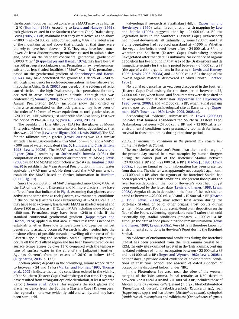
Fig. 5. Climatic conditions at various altitudes in the Southern (Eastern Cape) Drakensbe
on radiocarbon dates as discussed in the text, glacial and periglacial landforms and d
Equilibrium Line Altitude (ELA) on glaciers as given by Humlum and Christiansen (199
radiocarbon date from the lowest hearth at Melkhoutboom, and the arguments (prese
2.2.2. Length of the Bottelnek Stadial
The Bottelnek Stadial extended from�24 000 cal. a BP, as judgedby the age of organic deposits in the lower layers of rock glaciersediments in Bottelnek (Lewis, 2005), evidence of abandonment ofthe Strathalan archaeological site (Opperman and Heydenrych,1990; Lewis, 2008c), the oldest date for dune deposits atBuffelsfontein (Thomas et al., 2002), and the youngest date fororganic deposits beneath head at Birnam (Hanvey and Lewis, 1990),until somewhat before �18 350 cal. a BP: the date of the oldesthearth at Melkhoutboom (Deacon, 1976; Lewis, 2008c); vide 2.3 forevidence of temperate conditions post-dating the hearth.
2.2.3. Environmental conditions during the Bottelnek Stadial
Assuming that the landform interpretations of Lewis and his co-workers were correct (see Section 2.2.1), glacial and periglacialconditions prevailed, at least above �1800 m in the Southern(Eastern Cape) Drakensberg. At about that altitude, Mean AnnualAir Temperatures (MAAT) in shaded places were probably nohigher than �2 8C (the highest MAAT at which rock glaciersnormally occur; Humlum, 1998) and precipitation at rock glaciersites (including snow blow, as shown in Fig. 5 and discussed inSection 2.2.3.1) may have been of the order of 540 mm of waterequivalent (Lewis, 2008c). Conditions were less severe at loweraltitudes, as in the present day coastal lowlands west of PortElizabeth and in the Little Karoo. Little is known of conditionsbetween Grahamstown and the Southern (Eastern Cape) Drakens-berg (apart from Marker’s (1986) suggestion that periglacialconditions existed in the Amatola and other uplands), or ofconditions in the Transkei.
2.2.3.1. Environmental conditions in the Southern (Eastern Cape)
Drakensberg during the Bottelnek Stadial.
Rock glaciers normally form within the zone of continuouspermafrost, when MAAT is below �6.5 8C, although some occur in
rg during the Bottelnek Stadial (�24 000 cal.a BP to before �18 350 cal. a BP). Based
eposits, and on global climatic parameters pertaining to permafrost, firn and the
8). (This figure has been revised from that of Lewis, 2008b, to take account of the
nted in the text) pertaining thereto.)
C.A. Lewis / Proceedings of the Geologists’ Association 122 (2011) 187–200194
the discontinuous permafrost zone, where MAAT may be as high as�2 8C (Humlum, 1998). According to Lewis and Hanvey (1993),rock glaciers existed in the Southern (Eastern Cape) Drakensberg.Lewis (2005, 2008b) maintains that they were active, at and above�1800 m, at�24 000 cal. a BP. Consequently, MAAT in shaded areasof the mountains at and above that altitude, at that time, wereunlikely to have been above ��2 8C. They may have been muchlower. At least discontinuous permafrost existed in suitable sitesand, based on the standard continental geothermal gradient of0.0033 8C m�1 (Kappelmeyer and Haenel, 1974), may have been atleast 60 m deep at rock glacier sites. Permafrost may have been non-existent at less shaded localities. If MAAT was �8 8C, permafrost,based on the geothermal gradient of Kappelmeyer and Haenel(1974), may have penetrated the ground to a depth of �240 m,although no evidence for such deep penetration has been discoveredin southern Africa. Grab (2002) considered, on the evidence of relictsorted circles in the high Drakensberg, that permafrost formerlyoccurred in areas above 3400 m altitude, although this wascontended by Sumner (2004), to whom Grab (2004) replied. MeanAnnual Precipitation (MAP), including snow that drifted orotherwise accumulated on the rock glaciers, may have been ofthe order of 540 mm of water equivalent at rock glacier sites at�24 000 cal. a BP, which is just under 80% of MAP at Barkly East overthe period 1939–1945 (Fig. 5) (WB 40; Lewis, 2008b).
The Equilibrium Line Altitude (ELA) for the glacier at MountEnterprise, when the inner moraine was being deposited at thatsite, was�2100 m (Lewis and Illgner, 2001; Lewis, 2008d). The ELAfor the Killmore cirque glacier (Lewis, 2008d) was at a similaraltitude. These ELAs correlate with a MAAT of��8 8C, and a MAP of�500 mm of water equivalent (Fig. 5; Humlum and Christiansen,1998; Lewis, 2008d). The MAAT was calculated by Lewis andIllgner (2001) according to Sutherland’s formula (1984) forcomputation of the mean summer air temperature (MSAT). Lewis(2008b) used the MSAT in conjunction with data in Humlum (1998,Fig. 9) to establish the Mean Annual Precipitation in mm of waterequivalent (MAP mm w.e.). He then used the MAP mm w.e. toestablish the MAAT based on further information in Humlum(1998, Fig. 10).
Since the computation of MAP disregarded snow blow, MAAT atthe ELA on the Mount Enterprise and Killmore glaciers may havediffered from that indicated in Fig. 5. Assuming that glaciers wereactive at the same time as rock glaciers, environmental conditionsin the Southern (Eastern Cape) Drakensberg at �24 000 cal. a BPmay have been extremely harsh, with MAAT in shaded areas at andabove 1800 m as low as �8 8C, with MAP (including snow blow) of�500 mm. Permafrost may have been �240 m thick, if thestandard continental geothermal gradient (Kappelmeyer andHaenel, 1974) applied in that area. Further research is needed toestablish whether these low temperatures and deep permafrostpenetrations actually occurred. Research is also needed into theonshore effects of possible oceanic upwelling off the coast of theEastern Cape during the Bottelnek Stadial. Upwelling presentlyoccurs off the Port Alfred region and has been known to reduce seasurface temperatures by over 11 8C compared with the tempera-ture of ‘surface water in the core of the [adjacent] SouthernAgulhas Current’, from in excess of 26 8C to below 15 8C(Lutjeharms, 2006, p. 132).
Aeolian (dune) deposits in the Stormberg, luminescence datedto between �24 and 18 ka (Marker and Holmes, 1993; Thomaset al., 2002), indicate that windy conditions existed in the vicinityof the Southern (Eastern Cape) Drakensberg at that time. They mayhave resulted from strong anticyclonic circulation, at least over theKaroo (Thomas et al., 2002). This supports the rock glacier andglacier evidence from the Southern (Eastern Cape) Drakensberg:the regional climate was evidently cold and windy, and may havebeen semi-arid.
Palynological research at Strathalan (Hill, in Opperman andHeydenrych, 1990), taken in conjunction with mapping by Lowand Rebelo (1996), suggests that by �24 000 cal. a BP thevegetation belts in the Southern (Eastern Cape) Drakensberghad moved downwards, altitudinally, by some 1200 m, and thatalpine vegetation had replaced grassland at �1300 m. Whetherthe vegetation belts moved lower after �24 000 cal. a BP, andwhether the Southern (Eastern Cape) Drakensberg becameunvegetated after that date, is unknown. No evidence of organicdeposition has been found in that area of the Drakensberg and itsimmediate vicinity for the time period between�24 000 cal. a BP(the age of a thin organic lens in Bottelnek: Lewis and Hanvey,1993; Lewis, 2005, 2008a) and �15 000 cal. a BP (the age of thelowest organic material discovered at Aliwal North: Coetzee,1967).
No faunal evidence has, as yet, been discovered in the Southern(Eastern Cape) Drakensberg for the time period between �25/24 000 cal. a BP, when faunal and floral remains were deposited onan occupation floor at Strathalan (Opperman and Heydenrych,1990; Lewis, 2008a), and �12 000 cal. a BP, when faunal remainswere deposited at the archaeological site at Ravenscraig (Opper-man, 1987; Tusenius, 1989; Lewis, 2005, 2008a,c).
Archaeological evidence, summarised in Lewis (2008a,c),indicates that humans abandoned the Southern (Eastern Cape)Drakensberg between �24 000 cal. a BP and �12 000 cal. a BP:environmental conditions were presumably too harsh for humansurvival in those mountains during that time period.
2.2.3.2. Environmental conditions in the present day coastal belt
during the Bottelnek Stadial.
The rock shelter at Howison’s Poort, near the inland margin ofthe present day coastal belt, was occupied by human foragersduring the earlier part of the Bottelnek Stadial, between�23 000 cal. a BP and �22 000 cal. a BP (Deacon J., 1995; Lewis,2008a,c), but no faunal or floral information has been presentedfrom that site. The shelter was apparently not occupied again until�13 000 cal. a BP, after the rigours of the Bottelnek Stadial hadbeen replaced by less harsh conditions. The present flood plain andriver terrace deposits on the floor of Howison’s Poort had not yetbeen emplaced by the latter date (Lewis and Illgner, 1998; Lewis,2008a). Angular clasts in deposits on the floor of the rock shelter,dated to between �23 000 cal. a BP and �10 500 cal. a BP (DeaconJ., 1995; Lewis, 2008c), may reflect frost action during theBottelnek Stadial, or be of other origins: frost occurs duringwinter in Howison’s Poort at present. Flood plain deposition on thefloor of the Poort, evidencing appreciable runoff rather than cold,essentially dry, stadial conditions, predates �11 000 cal. a BP,although the date of flood plain initiation remains unknown (Lewisand Illgner, 1998; Lewis, 2008a). Very little is therefore known ofenvironmental conditions in Howison’s Poort during the BottelnekStadial.
No evidence of environmental conditions during the BottelnekStadial has been presented from the Tsitsikamma coastal belt.KRM, the only site examined in detail in the Tsitsikamma, containsno dated evidence of human occupation between�22 000 cal. a BPand �14 000 cal. a BP (Singer and Wymer, 1982; Lewis, 2008a),neither does it provide dated evidence of environmental condi-tions in that time period. The absence of dated evidence ofoccupation is discussed below, under NBC.
In the Plettenberg Bay area, near the edge of the westernmargins of the Tsitsikamma, faunal remains at NBC, dated tobetween�22 000 cal. a BP and�20 000 cal. a BP, included those ofAfrican buffalo (Syncerus caffer), eland (T. oryx), blesbok/bontebok(Damaliscus cf. dorcas), grysbok/steenbok (Raphicerus sp.), roan(Hippotragus spp.), red hartebeest (Alcelaphus caama), springbok(Antidorcas cf. marsupialis) and wildebeest (Connochaetes cf. gnou),
C.A. Lewis / Proceedings of the Geologists’ Association 122 (2011) 187–200 195
as well as rock hyrax (Procavia capensis) (Klein, 1972; Lewis,2008a). They indicate that the vegetation of the Plettenberg Bayregion at that time, during the Bottelnek Stadial, was open countrygrassland with some shrubland, unlike the present climaxvegetation of closed evergreen forest (Low and Rebelo, 1996).Consequently, there was probably less precipitation in the vicinityof NBC during the Bottelnek Stadial than at present (Lewis, 2008a).Some of the animals, whose remains date to�21 500 cal. a BP, ate amixture of C3 and C4 grasses (Sealy, 1996). This suggests that thearea experienced year-round rainfall at that time and henceatmospheric circulation similar to that of the present. As stated byLewis (2008a), this conflicts with the existing conceptualatmospheric models for that area, during ‘glacials’, of Heine(1982), Cockcroft et al. (1987), and Chase and Meadows (2007):that the winter rainfall zone extended across this region during‘glacials’, rather than that the area lay between the summer andwinter rainfall regions, and was dominated by neither.
Klein (1972, p. 138) suggested that the ‘near absence of seacreatures’ in the deposits at NBC dating to between at least�22 000 cal. a BP and �14 000 cal. a BP, implies that sea levelswere low in that period, which accords with global findings assummarised by Waelbroeck et al. (2002), and with discoveriesfurther west along the southern coast of South Africa (Fisher et al.,2009). Klein (1972, p. 138) postulated that, due to reduction in sealevel, the shoreline may have lain some 75–80 km distant fromNBC during that period: ‘far greater than the regular distance thathunter–gatherers could be expected to travel from home base tofood source’. This may also have been the case at KRM and mayexplain the lack of dated human occupation there between�22 000 cal. a BP and �14 000 cal. a BP.
Lewis (2008a) hypothesised that the reason why the Pletten-berg Bay region was apparently drier between �22 000 cal. a BPand�14 000 cal. a BP than at present, may have been because landextends seaward at times of low sea level, as during the coldconditions of the Bottelnek Stadial. Consequently, moisture carriedby cold fronts brushing the coast then, as at present, failed to becarried inland to the vicinity of NBC in such quantities as atpresent.
Isotopic analyses of gas from groundwater in the aquifer thatruns from the vicinity of Uitenhage to Coega, has shown that ‘earthtemperatures at the base of the unsaturated zone north ofUitenhage increased by an average of 5.5 8C from the Last GlacialMaximum to Holocene times’ (Heaton et al., 1986, p. 85). Since theaverage was based on two 13 000-year periods: 28 000–15 000,and 13 000–0 14C a BP; it is of limited value and is unlikely toindicate the extent to which MAAT might have dropped in the areaat and immediately after �24 000 cal. a BP, when MAAT may havebeen well below the 28 000–15 000 14C a average. The statementthat ‘There is no dissolved gas evidence for major temperaturevariations in the period 28 000–15 000 yr [uncalibrated] BP’(Heaton et al., 1986, p. 85) is not proof that major temperaturevariations did not occur.
In summary, during the Bottelnek Stadial, the present daycoastal area of the Eastern Cape, at least west of Port Elizabeth, layfurther from the shore than at present, due to reductions in sealevel exposing areas now inundated by the sea. Faunal remainsindicate that the vegetation was predominantly open grasslandwith some bush. This indicates that the climate in this region wasdrier than at present. Isotopic examination of bone remainsindicates that at least the Plettenberg Bay region experienced year-round rainfall at �21 500 cal. a BP, as at the present day.Atmospheric circulation may therefore have resembled that ofthe present, with reduction in precipitation being due to increaseddistance from the shore, rather than to any appreciable atmo-spheric perturbation. MAAT, as indicated by isotopic analyses ofgroundwater, was apparently lower than at present.
Nothing is known of present day coastal areas east and north ofPort Elizabeth, or of the interior of Transkei, during the BottelnekStadial.
2.2.3.3. Environmental conditions in the area between the present day
coastal belt and the foothills of the Southern (Eastern Cape)
Drakensberg during the Bottelnek Stadial.
The only published dated evidence of environmental conditionsin the above area, from 24 000 cal. a BP until and including�18 350 cal. a BP, comes from Melkhoutboom, an archaeologicalsite at an altitude of �650 m, some 80 km west of Grahamstown(Fig. 1). At Melkhoutboom, a hearth, resting on bedrock andassociated with Later Stone Age (LSA) tools of the Robberg industry(Deacon and Deacon, 1999), dates to �18 350 cal. a BP (Deacon,1976; Lewis, 2008a,c). Carbonised seeds from sediments overlyingthe hearth, dated between�18 350 cal. a BP and�12 250 cal. a BP,indicate that ‘patches of climax temperate ever-green forest’(Deacon, 1976, p. 109) existed in kloofs (hillside valleys) in thevicinity of the archaeological site between those dates. Faunalremains from those sediments indicate that grassveld animalsoccupied the Melkhoutboom area during that �6 000 year period,but fail to indicate environmental conditions prior to �18 350 cal.a BP, when conditions, at least in the Southern (Eastern Cape)Drakensberg, were cold, windy, probably semi-arid, and inhospi-table.
The Melkhoutboom hearth indicates that the Bottelnek Stadialprobably ended before �18 350 cal. a BP, by which dateMelkhoutboom was inhabited by hunter–gatherers. Temperateforest and grassland apparently colonised the area after that date.Evidence from Howison’s Poort, east of Melkhoutboom and nearthe inland edge of the presently coastal belt, suggests that hunter–gatherers abandoned the Poort after �22 000 cal. a BP, when roofspalls suggest that cold, frosty, conditions occurred, and did notreoccupy it until �13 000 cal. a BP (Deacon J., 1995; Lewis,2008a,c). Melkoutboom may also have been abandoned whenenvironmental conditions were particularly harsh, to be reoccu-pied by �18 350 cal. a BP, when they ameliorated. Since the datedhearth lies on bedrock, it is unknown whether there was earlierhuman occupation.
Scree tongues that exist at altitudes between �1860 and1550 m on south facing slopes, near Queenstown and theHogsback, may indicate the former existence of periglacialconditions (Marker, 1986). They may have formed during theBottelnek Stadial, but have not been dated. No further evidence ofenvironmental conditions during the Bottelnek Stadial has beenpublished for the extensive area between Melkhoutboom and theSouthern (Eastern Cape) Drakensberg, and further research in thatarea is desirable.
2.2.3.4. Environmental conditions in the Little Karoo during the
Bottelnek Stadial.
Archaeological evidence from Boomplaas (Fig. 1) indicatesconditions in the Little Karoo during the Bottelnek Stadial.Boomplaas was occupied by hunter–gatherers throughout theperiod between�24 000 cal. a BP and�17 000 cal. a BP, when it wasused by ‘relatively mobile groups’ (Deacon et al., 1984, p. 346). Thesite was occupied more frequently immediately before�24 000 cal.a BP than during the period between �24 000 cal. a BP and�17 000 cal. a BP, which suggests that the Little Karoo was lessdensely populated during the Bottelnek Stadial than previously.
Examination of micromammalian remains at Boomplaas(Avery, 1982) indicates that the vegetation in the area was fairlyopen between�24 000 cal. a BP and�17 000 cal. a BP, being grassyon hillsides, and of semi-arid type on valley floors. Charcoalanalyses (Scholtz, 1986) indicate that woodland was virtuallyabsent from the Cango valley, adjacent to Boomplaas, between
C.A. Lewis / Proceedings of the Geologists’ Association 122 (2011) 187–200196
�24 000 cal. a BP and �17 000 cal. a BP, although shrubland hadexisted in the area previously, at least as far back as �38 000 cal. aBP, when ‘climatic conditions were neither as dry or as cold as atthe last Glacial Maximum’ (Deacon et al., 1984, p. 345).
The most common faunal remains at Boomplaas (Klein, 1978;Brink (unpublished) as reported in Deacon et al., 1984) during theperiod from �24 000 cal. a BP until �17 000 cal. a BP were of thehartebeest tribe (Alcelaphini), horses, eland (T. oryx) and klip-springer (Oreotragus oreotragus). They evidence grassy habitats inthe area at that time. The high frequency of alcelaphini remainsdating to the same period indicate that the climate was drier at thattime than during the previous interstadial, when it was less coldbut moister than at the Last Glacial Maximum (Deacon et al., 1984).There appears to have been ‘a major episode of large mammalextinctions’ in the Boomplaas area at �17 000 cal. 14C years BP,after which there is no evidence of giant buffalo (P. antiquus) andgiant hartebeest (Megalotragus priscus) (Klein, 1978, p. 70). Thereasons for these extinctions remain unclear, but may have beenassociated with climatic amelioration and associated changes invegetation.
2.2.4. Summary, environmental conditions during
the Bottelnek Stadial
The Bottelnek Stadial was very cold, arid to semi-arid, andprobably windy at high altitudes in the Southern (Eastern Cape)Drakensberg, where rock glaciers and glaciers apparently existedand MAAT in shaded locations was not higher than �2 8C and mayhave been as low as �8 8C. Permafrost may have been up to 240 mthick at and above 1800 m, if the standard continental geothermalgradient of Kappelmeyer and Haenel (1974) applied in this lowlatitude and high altitude area. MAP (including snow blow) at�1800 m, where rock glaciers existed, may have been of the orderof 540 mm of water equivalent. The area may have been dominatedby anticyclonic conditions. Floral and faunal evidence has not beendiscovered from the Southern (Eastern Cape) Drakensberg, apartfrom a thin organic lens in Bottelnek dating to �24 000 cal. a BP.There is no evidence of human occupation of the Southern (EasternCape) Drakensberg during the Bottelnek Stadial.
Conditions at lower altitudes, in the present day coastal belt,were less severe than in the Southern (Eastern Cape) Drakensberg,but were drier and colder than in the previous Birnam Interstadial.Sea levels were lower than at the present and the shoreline in thePlettenberg Bay district may have been 75–80 km distant from thepresent coast (Klein, 1972). Atmospheric circulation probablyresembled that of the present, with reduced precipitation on thepresent day coastal belt being due to greater distance from theshore than at present.
Vegetation in the NBC region was predominantly opengrassland with some bush. Nothing is known of the vegetationelsewhere in the present day coastal belt. In the Little Karoo thevegetation was grassy on hillsides and of semi-arid type on valleyfloors: trees were absent. Nothing is known of the vegetation, orfauna, between the present day coastal belt and the Southern(Eastern Cape) Drakensberg until after �18 350 cal. a BP, by whichtime the Bottelnek Stadial appears to have terminated.
The fauna of the present day coastal belt is known only fromNBC and, apart from rock hyrax (P. capensis), is known to haveconsisted essentially of grazers, some of which, including theAfrican buffalo (S. caffer), needed bushy shade. Humans onlyoccupied NBC occasionally, possibly because an important sourceof their food was the sea and shore, which was too distant for themto use NBC more frequently. The fauna of the Little Karoo wassimilar to, but more restricted than, that of the present day coastalregion near Plettenberg Bay.
The Little Karoo fauna included Saunder’s vlei rat (Otomys
saundersae) as the dominant rodent (Avery, 1982). This animal at
present lives in cold conditions at high altitudes in southern Africa,indicating that conditions in the Little Karoo during the BottelnekStadial were harsh, cold and dry (Deacon et al., 1984). Environ-mental conditions were, however, much less severe than in theSouthern (Eastern Cape) Drakensberg, where small glaciersexisted, and where faunal evidence is apparently absent, perhapsbecause conditions in those mountains were too inhospitable forfaunal survival.
Although people occupied the present day coastal belt, at leastoccasionally, and the Little Karoo, there is no evidence that theywere present in the Southern (Eastern Cape) Drakensberg or in thevast area between those mountains and the present day coastalbelt during the Bottelnek Stadial.
2.3. The Aliwal North (Late Glacial)
2.3.1. Palynological evidence from the Southern (Eastern Cape)
Drakensberg and the Winterberg during the Aliwal North
Organic deposition, evidencing amelioration of climate, tookplace in the vicinity of the Southern (Eastern Cape) Drakensberg, atAliwal North, following the Bottelnek Stadial, by�15 000 cal. a BP.Core II from Aliwal North (Coetzee, 1967) is here designated as thetype site for the Aliwal North since it provides the longestpalynological record (age-wise) yet known from the Eastern Capefor that climato-environmental phase. In the Winterberg, theoldest radiocarbon dated organic deposits also yielded an age of�15 000 cal. a BP (Meadows and Meadows, 1988). At Aliwal Norththere were relatively moist and cool conditions between �14 000and 12 000 cal. a BP, when climate became relatively dry andKaroo-type vegetation invaded the area. Between �12 000 and11 500 cal. a BP the Aliwal North area was invaded by grasslandunder relatively moist conditions, although Karoid vegetation,indicating the resumption of dry and warm conditions, reasserteditself between �11 500 and 10 000 cal. a BP. In the Winterberg,grassland was widespread soon after organic sedimentation began.
2.3.2. Human reoccupation of the Southern (Eastern Cape)
Drakensberg in the Aliwal North
By�12 000 cal. a BP foragers of LSA culture resumed utilisationof the Southern (Eastern Cape) Drakensberg, as evidenced by use ofa rock shelter at Ravenscraig at an altitude of �1850 m. Theyhunted hartebeest/wildebeest (Alcelaphus/Connochaetes) and otheranimals that were grazers, indicating that grassland existed in theRavenscraig area, at altitudes around 1850 m, at that date(Opperman, 1987; Tusenius, 1989; Lewis, 2005, 2008a).
2.3.3. Spread of grassveld (grasslands) between the Southern
(Eastern Cape) Drakensberg and the present day coastal lowlands
in the Aliwal North
At lower altitudes, in the vicinity of Melkhoutboom at �650 m,temperate evergreen forest established itself in kloofs (hillsidevalleys) after �18 350 cal. a BP, while grassveld spread oversurrounding lowlands and was grazed by migratory grassveldanimals that included red hartebeest (Alcelaphus cf. caama),blesbok/bontebok (Damaliscus cf. dorcas), blue antelope (Hippo-
tragus cf. leucophaeus) and quagga (Equus cf. quagga) (Deacon,1976). These resources fed ‘a stable [human] population’ (Deacon,1976, p. 117) from some 18 000 cal. a BP until historic times.
2.3.4. Extinction of the giant buffalo and vegetation changes in the
present day coastal lowlands during the Aliwal North
In the present day coastal region, increasingly bushy vegetationappears to have replaced grassland around NBC by �14 000 cal. aBP and the giant buffalo (P. antiquus) became extinct, while bush-loving reedbuck (Redunca arundinum and Redunca fulvorufula) andgrey rhebok (P. capreolus) were increasingly common. A marked
C.A. Lewis / Proceedings of the Geologists’ Association 122 (2011) 187–200 197
increase in bone remains of the Cape fur seal (Arctocephalus
pusillus) in archaeological deposits argues for sea level rise by�14 000 cal. a BP, bringing the shoreline into human foragingdistance of NBC (Klein, 1972). By �13 500 cal. a BP there had beenfurther environmental changes, and the vegetation probablyconsisted of open woodlands with good grass cover (Lewis,2008a). By�12 000 cal. a BP, as evidenced by the large quantities ofmarine shells of that date in NBC, sea level seems to have risen sothat littoral areas were within easy human foraging distance of thesite (Klein, 1971).
2.3.5. Recolonisation of the Little Karoo by trees during
the Aliwal North
The Little Karoo, judging from evidence from Boomplaas,experienced recolonisation by trees after �18 000 cal. a BP,initially by Olea and Rhus spp. (shrubs or small trees normallyunder 8 m in height) but, after �14 800 cal. a BP, by Acacia karroo
that is frost and drought resistant (Deacon et al., 1984). Between�14 800 cal. a BP and �10 200 cal. a BP there were numerousclimatic fluctuations and a rapid rise in temperatures, evidenced bymicromammals (Avery, 1982). The Little Karoo, judging byevidence from Boomplaas, was occupied by foragers throughoutthe Aliwal North (Late Glacial) and ‘The best developed trace ofhuman occupation in the Boomplaas archive’ (Deacon H.J., 1995, p.123) took place between �18 000 cal. a BP and �14 800 cal. a BP,before the spread of A. karroo indicates the existence of frost anddroughts.
2.3.6. Length of the Aliwal North
The recolonisation of the Little Karoo by trees, and the spread ofgrassveld in the area between the Eastern Cape Drakensberg andthe present day coastal belt, which took place at �18 000 cal. a BP(see Sections 2.3.3 and 2.3.5) indicate that amelioration of climatetook place at about that date, which is taken as the beginning of theAliwal North. The date of termination is less clear, since there is noclear correlation throughout the area of the rapid climaticoscillations that are its characteristic. For the purposes of thispaper, the termination date is considered to be �11 000 cal. a BP.After that date flood plain deposition was widespread, asgeomorphic adjustment of landscapes took place as a result ofwhat appear to have been conditions of increased stream flow(Lewis, 2005). The Aliwal North therefore extended from�18 000 cal. a BP until �11 000 cal. a BP.
2.4. The Dinorben (Holocene)
2.4.1. Type site and age of the Dinorben
The Dinorben is named after flood plain sediments containingpalaeosols that have been radiocarbon dated at Sections I and II inthe Dinorben Spruit valley, which is a tributary of the Langkloofdrainage system near Barkly East (Lewis, 2005, 2008a). Section I(Lewis, 2005, Fig. 5) is here designated as the type site for theDinorben. The oldest palaeosols, which formed within flood plaindeposits, predate�10 000 cal. a BP, which is taken as the minimumage for the initiation of the Dinorben, which is marked by thedominance of fluvial processes. These processes still continue inthe study area, so that the Dinorben extends to the present day.
2.4.2. Climatic and environmental conditions in the Southern
(Eastern Cape) Drakensberg during the Dinorben
The palaeosols beside the Dinorben Spruit, at Sections I and II,formed within flood plain sediments from somewhat before�10 000 cal a BP. The associated flood plain/s were transformedinto river terraces after �8000 cal. a BP. The older palaeosols,overlain by flood plain deposits, contain charcoal and what appearto be reed fragments. This suggests that droughts in the Early
Dinorben, associated with veld fires, were followed by heavyrainfall events, or snow melt, causing floods. Semi-arid conditionswith limited fluvial activity characterised the Mid Dinorben in theSouthern (Eastern Cape) Drakensberg after �7 000 cal. a BP. Theywere succeeded by moister conditions with alternating flood plainerosion and deposition after �3200 cal. a BP (Lewis, 2005). Faunaland charcoal remains left by human foragers in Ravenscraig and inColwinton rock shelters in the Barkly East area, reflecting thecomposition of the former fauna and flora (Opperman, 1987;Tusenius, 1989; Lewis, 2005), generally support the geomorphicevidence. They indicate relatively moist conditions in the EarlyDinorben followed by a long dry and warm phase when a Karooplant (Euryops) dominated the charcoal assemblage, and, finally,relatively moist conditions.
2.4.3. Climatic and environmental conditions in the area between the
Southern (Eastern Cape) Drakensberg and the present day coastal
lowlands during the Dinorben
At Howison’s Poort, near the inner margin of the coastallowlands, flood plain deposition began before �10 750 cal. a BP, asslope and fluvial processes reworked weathered deposits that hadaccumulated on the valley sides. Flood plain deposition wassucceeded by fluvial erosion and transformation of flood plaindeposits into river terraces subsequent to 4870 cal. a BP, probablydue to climatic change and an increase in fluvial energy (Lewis andIllgner, 1998; Lewis, 2008a; Hattingh, 2008). Similar readjust-ments took place elsewhere as moister Dinorben (Holocene)climates replaced cooler and drier Aliwal North (Late Glacial)conditions.
Although Howison’s Poort appears to have been relatively moistfrom before �10 750 cal. a BP, the nearby Fish River basin appearsto have been too dry for human occupation until after �6300 cal. aBP: the earliest occupation site being of approximately that date(Hall, 1990). Palynological research suggests that the Winterbergwas also drier in the early Dinorben (Holocene) than subsequently(Meadows and Meadows, 1988). There has thus been appreciableenvironmental variation, spatially and temporally, even over smalldistances, in the Eastern Cape during the Dinorben.
2.4.4. Conditions in the present day coastal lowlands during
the Dinorben
Present day coastal areas west of Port Elizabeth appear to havebeen occupied by hunter–gatherers throughout the Dinorben. By�1300 cal. a BP Iron Age farmers were moving south into Transkeiand, since they grew tropical cultigens (Maggs, 1980), climaticconditions there at that date were presumably suited to such crops(Feely, 1987; Vogel and Fuls, 1999; Binneman, 1996; Prins, 1993;Cronin, 1982; Lewis, 2008a). Presumably Transkei then, as now, laywithin the summer rainfall (Indian Ocean monsoon) region ofsouthern Africa. Iron Age farmers apparently failed to penetratefurther south than the vicinity of East London, suggesting thatclimatic conditions further south and west were unsuited for theircrops.
Along the present day coast, especially between Oyster Bay andEast London, extensive headland bypass dunefields and accretion-ary dunefields accumulated during the Dinorben (Illenberger andBurkinshaw, 2008). They indicate the existence of relatively strongwinds and plentiful supplies of sediment during that time. OSLdates from a shell midden at Sedgefield, at the western extremityof the study area, suggest that dune accumulation continued intothe last 2000 cal. a BP (Bateman et al., 2008).
2.4.5. Environmental conditions in the Little Karoo during
the Dinorben
The Little Karoo was settled throughout the Dinorben(Holocene) and by �1600 cal. a BP herders, who kept sheep,
C.A. Lewis / Proceedings of the Geologists’ Association 122 (2011) 187–200198
utilised Boomplaas, replacing hunter–gatherers in the occupationrecord at that site (Deacon et al., 1984). Hunter–gathererscontinued to occupy valleys in the adjacent mountains betweenthe Little Karoo and the Algoa Basin (e.g. Binneman, 1997, 1999,2000). The remains of their food hoards suggest that there waslittle difference in the environment of that region throughout theDinorben.
3. Conclusion
There have been four major environmental phases during thelast �40 000 cal. a BP in the study region:
(i) an interstadial from before 40 000 cal. a BP until�24 000 cal. aBP, in which relatively mild conditions existed,
(ii) a stadial between �24 000 cal. a BP and before �18 350 cal. aBP, equating with the LGM, in which rock glaciers and atleast small glaciers apparently formed in the Southern(Eastern Cape) Drakensberg and in which MAAT wasremarkably low in the uplands, possibly �8 8C at 1800 min shaded areas during the harshest of that stadial. MAP(including snow blow) at that time in the same uplands wasapparently 80% or less than the MAP (excluding snow blow)of the present day,
(iii) a time of considerable climatic oscillation after �18 350 cal. aBP until �11 000 cal. a BP as readjustment took place fromLGM stadial to Post Glacial conditions,
(iv) finally, the present interglacial.
There appear to have been remarkable environmental varia-tions between the Southern (Eastern Cape) Drakensberg and thepresent day coastal lowlands. These were partly due to altitudinaldifferences between the two areas, partly to their differingdistances from the Indian Ocean and precipitation bearing winds,and possibly due to inversion effects, probably associated withanticyclonic conditions over the Southern (Eastern Cape) Drakens-berg and high interior, affecting adiabatic lapse rates. Little isknown of the area between the present day coastal lowlands andthe Southern (Eastern Cape) Drakensberg, and virtually nothing isknown of environmental conditions in Transkei prior to themovement of Iron Age farmers into the coastal and river valleys ofthat area after �1300 cal. a BP.
There is pressing need for further research throughout theEastern Cape to:
(i) establish the details of environmental change while that areahas been under human occupation and
(ii) provide environmental managers with the basic informationon temporal and spatial environmental changes that isnecessary for sympathetic environmental management basedon firm scientific foundations.
Acknowledgements
Professors R. Hepburn and M. Marker, and Dr E. Dollar, arethanked for commenting on earlier versions of this paper, Dr S.C.Mills for advice on MIS, and Mrs B. Mclean for graphic support. Thecomments of two anonymous referees and of the editors (Dr S.J.Carr and Dr S.C. Mills) were most useful and led to significantimprovements in the paper.
References
Avery, D.M., 1982. Micromammals as palaeoenvironmental indicators and aninterpretation of the Late Quaternary in the southern Cape Province, SouthAfrica. Annals of the South African Museum 85, 183–374.
Bateman, M.D., Carr, A.S., Murray-Walker, C.V., Roberts, D.L., Holmes, P.J., 2008. Adating intercomparison study on Late Stone Age coastal midden deposits, SouthAfrica. Geoarchaeology 23, 715–741.
Binneman, J.N.F., 1996. Preliminary report on the investigations at Kulubele, anEarly Iron Age farming settlement in the Great Kei River valley, Eastern Cape.Southern African Field Archaeology 5, 28–35.
Binneman, J.N.F., 1997. Results from a test excavation at The Havens Cave, Cambriavalley, south-eastern Cape. Southern African Field Archaeology 6, 93–105.
Binneman, J.N.F., 1999. Results from a test excavation at Grootkommandokloofshelter in the Baviaanskloof/Kouga region, Eastern Cape Province. SouthernAfrican Field Archaeology 8, 100–107.
Binneman, J.N.F., 2000. Results from two test excavations in the BavianskloofMountains, Eastern Cape Province. Southern African Field Archaeology 9,83–96.
Boelhouwers, J.C., Meiklejohn, K.I., 2002. Quaternary periglacial and glacial geo-morphology of southern Africa: a review and synthesis. South African Journal ofScience 98, 47–55.
Butzer, K.W., 1973. Geology of Nelson Bay Cave, Robberg, South Africa. SouthAfrican Archaeological Bulletin 28, 97–110.
Carr, A.S., Thomas, D.S.G., Bateman, M.D., Meadows, M.E., Chase, B., 2006. LateQuaternary palaeoenvironments of the winter-rainfall zone of southern Africa:palynological and sedimentary evidence from the Agulhas Plain. Palaeogeo-graphy, Palaeoclimatology, Palaeoecology 239, 147–165.
Chase, B.M., Meadows, M.E., 2007. Late Quaternary dynamics of southern Africa’swinter rainfall zone. Earth Science Reviews 84, 103–138.
Cockcroft, M.J., Wilkinson, M.J., Tyson, P.D., 1987. The application of a present-dayclimatic model to the late Quaternary in southern Africa. Climatic Change 10,161–181.
Coetzee, J.A., 1967. Pollen analytic studies in East and Southern Africa. Palaeoecol-ogy of Africa 3, 1–146.
Cronin, M., 1982. Radiocarbon dates for the Early Iron Age in Transkei. South AfricanJournal of Science 78, 38–39.
Deacon, H.J., 1976. Where Hunters Gathered: a study of Holocene Stone Age peoplein the Eastern Cape. South African Archaeological Society Monograph Series,Claremont, vol. 1. .
Deacon, H.J., 1995. Two Late Pleistocene–Holocene archaeological depositoriesfrom the southern Cape, South Africa. South African Archaeological Bulletin50, 121–131.
Deacon, H.J., Brooker, M., 1976. The Holocene and Upper Pleistocene sequence in thesouthern Cape. Annals of the South African Museum 71, 203–214.
Deacon, H.J., Deacon, J., 1999. Human Beginnings in South Africa: Uncovering theSecrets of the Stone Age. David Philip, Cape Town.
Deacon, H.J., Deacon, J., Scholtz, A., Thackeray, J.F., Brink, J.S., 1984. Correlation ofpalaeoenvironmental data from the Late Pleistocene and Holocene deposits atBoomplaas Cave, southern Cape. In: Vogel, J.C. (Ed.), Late Cainozoic Palaeoen-vironments of the Southern Hemisphere. Balkema, Rotterdam, pp. 339–351.
Deacon, J., 1995. An unsolved mystery at the Howieson’s Poort name site. SouthAfrican Archaeological Bulletin 50, 110–120.
Deacon, J., Lancaster, N., 1988. Late Quaternary Environments of Southern Africa.Clarendon Press, Oxford.
Fairhall, A.W., Young, A.W., 1973. Methodology of radiocarbon dating and radio-carbon dates from Nelson Bay Cave. South African Archaeological Bulletin 28,90–93.
Feely, J.M., 1987. The Early Farmers of Transkei, Southern Africa. British Archaeo-logical Research, Oxford.
Fisher, E.C., Bar-Mathews, M., Jerardino, A., Marean, C.W., 2009. Middle and LatePleistocene paleoscape modelling along the southern coast of South Africa.Unpublished paper delivered at the Annual Meeting of SASQUA (SouthernAfrican Society for Quaternary Research).
Grab, S.W., 2000. Periglacial phenomena. In: Partridge, T.C., Maud, R.R. (Eds.), TheCenozoic of Southern Africa. Oxford University Press, Oxford, pp. 207–217.
Grab, S.[W]., 2002. Characteristics and palaeoenvironmental significance of relictsorted patterned ground, Drakensberg plateau, southern Africa. QuaternaryScience Reviews 21, 1729–1744.
Grab, S.W., 2004. Reply to the comments by Sumner on ‘Characteristics andpalaeoenvironmental significance of relict sorted patterned ground, Drakens-berg plateau, southern Africa’. Quaternary Science Reviews 23, 1203–1204.
Hall, S.L., 1990. Hunter–gatherers of the Fish River basin: a contribution to theHolocene prehistory of the Eastern Cape. Unpublished D. Phil. Thesis, Universityof Stellenbosch.
Hanvey, P.M., Lewis, C.A., 1990. A preliminary report on the age and significance ofQuaternary lacustrine deposits at Birnam, north-east Cape Province, SouthAfrica. South African Journal of Science 86, 271–273.
Hattingh, J., 2008. Fluvial systems and landscape evolution. In: Lewis, C.A. (Ed.),Geomorphology of the Eastern Cape, South Africa. NISC, Grahamstown, pp. 21–42.
Heaton, T.H.E., Talma, A.S., Vogel, J.C., 1986. Dissolved gas paleotemperatures and18O variations derived from ground-water near Uitenhage, South Africa. Qua-ternary Research 25, 79–88.
Heine, K., 1982. The main stages of the late Quaternary evolution of the Kalahariregion, southern Africa. Palaeoecology of Africa 15, 53–76.
Holmgren, K., Karlen, W., Shaw, P., 1995. Palaeoclimatic significance in variations instable isotopic composition and petrology of a late Pleistocene stalagmite fromBotswana. Quaternary Research 43, 320–328.
Holmgren, K., Karlen, W., Lauritzen, S.E., Lee-Thorp, J.A., Partridge, T.C., Piketh, S.,Repinski, P., Stevenson, C., Svanered, O., Tyson, P.D., 1999. A 3000 year high-

C.A. Lewis / Proceedings of the Geologists’ Association 122 (2011) 187–200 199
resolution stalagmite based record of palaeoclimate for northeast South Africa.The Holocene 9, 295–309.
Humlum, O., 1998. The climatic significance of rock glaciers. Permafrost andPeriglacial Processes 9, 375–395.
Humlum, O., Christiansen, H.H., 1998. Mountain climate and periglacial phenomenain the Faeroe Islands. Permafrost and Periglacial Processes 9, 189–211.
Illenberger, W.K., Burkinshaw, J.R., 2008. Coastal dunes and dunefields. In: Lewis,C.A. (Ed.), Geomorphology of the Eastern Cape, South Africa. NISC,Grahamstown, pp. 85–106.
Inskeep, R.R., 1965. University of Cape Town excavations at Plettenberg Bay.Scientific South Africa 2, 575–577.
Inskeep, R.R., 1987. Nelson Bay Cave, Cape Province, South Africa: the Holocenelevels. British Archaeological Reports International Series, vol. 357. Oxford.
Irving, S.J.E., 1998. Late Quaternary palaeoenvironments at Vankervelsvlei, nearKnysna, South Africa. Unpublished M.Sc. Thesis, University of Cape Town, CapeTown.
Irving, S.J.E., Meadows, M.E., 1997. Radiocarbon chronology and organic matteraccumulation at Vankervelsvlei, near Knysna, South Africa. South AfricanGeographical Journal 79, 101–105.
IUPAC-IUGS Task Group, 2006. Recommendations for Isotope Data in Geosciences.(Quoted from Rose, 2007)http://www.iupac.org/projects/2006/2006-016-1-200.html.
Jones, R.L., Keen, D.H., 1993. Pleistocene Environments in the British Isles. Chapmanand Hall, London.
Kappelmeyer, O., Haenel, R., 1974. Geothermics with special reference to applica-tion. Geopublication Associates, Geoexploration Monographs, Series 1, No. 4,238 pp.
Klein, R.G., 1971. Preliminary report on the July through September 1970 excava-tions at Nelson Bay Cave, Plettenberg Bay (Cape Province), South Africa.Palaeoecology of Africa 6, 177–208.
Klein, R.G., 1972. The Late Quaternary mammalian fauna of Nelson Bay Cave (CapeProvince South Africa): its implications for megafaunal extinctions and envi-ronmental and cultural change. Quaternary Research 2, 135–142.
Klein, R.G., 1976. The mammalian fauna of the Klasies River Mouth sites, southernCape Province, South Africa. South African Archaeological Bulletin 31, 75–98.
Klein, R.G., 1978. A preliminary report on the larger mammals from the BoomplaasStone Age cave site, Cango Valley, Oudtshoorn District, South Africa. SouthAfrican Archaeological Bulletin 33, 66–75.
Klein, R.G., 1980. Environmental and ecological implications of large mammals fromUpper Pleistocene and Holocene sites in southern Africa. Annals of the SouthAfrican Museum 81, 223–283.
Lambeck, K., Esat, T.M., Potter, E.-K., 2002. Links between climate and sea levels forthe past three million years. Nature 419, 199–206.
Lewis, C.A., 1994. Protalus ramparts and the altitude of the local equilibrium lineduring the Last Glacial Stage in Bokspruit, East Cape Drakensberg, South Africa.Geografiska Annaler 76A, 37–48.
Lewis, C.A., 1996. Periglacial features. In: Lewis, C.A. (Ed.), The Geomorphologyof the Eastern Cape, South Africa. Grocott and Sherry, Grahamstown, pp. 120–134.
Lewis, C.A., 1999. Field Guide to the Quaternary in the Eastern and Southern Cape,South Africa. Rhodes University, Grahamstown, p. 79.
Lewis, C.A., 2002. Radiocarbon dates and the Late Quaternary palaeogeography ofthe Province of the Eastern Cape, South Africa. Quaternary International 89, 59–69.
Lewis, C.A., 2005. Late Glacial and Holocene palaeoclimatology of the Drakensbergof the Eastern Cape, South Africa. Quaternary International 129, 33–48.
Lewis, C.A., 2008a. Late Quaternary climatic changes, and associated humanresponses, during the last �45 000 yr in the Eastern and adjoining WesternCape, South Africa. Earth-Science Reviews 88, 167–187.
Lewis, C.A., 2008b. Periglacial features. In: Lewis, C.A. (Ed.), Geomorphology of theEastern Cape, South Africa. NISC, Grahamstown, pp. 149–185.
Lewis, C.A., 2008c. Late Pleistocene and Early Holocene foragers in southern Africa.In: Pearson, D. (Ed.), Encyclopedia of Archaeology, vol. 1. Academic Press, NewYork, pp. 86–93.
Lewis, C.A., 2008d. Glaciations and glacial features. In: Lewis, C.A. (Ed.), Geomor-phology of the Eastern Cape, South Africa. NISC, Grahamstown, pp. 127–148.
Lewis, C.A., Dardis, G.F., 1985. Periglacial ice-wedge casts and head deposits atDynevor Park, Barkly Pass area, north-eastern Cape Province, South Africa.South African Journal of Science 81, 673–677.
Lewis, C.A., Hanvey, P.M., 1993. The remains of rock glaciers in Bottelnek, East CapeDrakensberg, South Africa. Transactions of the Royal Society of South Africa 48,265–289.
Lewis, C.A., Illgner, P.M., 1998. Fluvial conditions during the Holocene as evidencedby alluvial sediments from above Howison’s Poort, near Grahamstown, SouthAfrica. Transactions of the Royal Society of South Africa 53, 53–67.
Lewis, C.A., Illgner, P.M., 2001. Late Quaternary glaciation in southern Africa:moraine ridges and glacial deposits at Mount Enterprise in the Drakensbergof the Eastern Cape Province, South Africa. Journal of Quaternary Science 16,365–374.
Low, A.B., Rebelo, A.G. (Eds.), 1996. Vegetation of South Africa, Lesotho andSwaziland. Department of Environmental Affairs and Tourism, Pretoria.
Lowe, J.J., Walker, M.J.C., 1997. Reconstructing Quaternary Environments. Longman,Harlow.
Lutjeharms, J.R.E., 2006. The Agulhas Current. Springer, New York.Maggs, T.M., 1980. The Iron Age sequence south of the Vaal and Pongola Rivers:
some historical implications. Journal of African History 21, 1–15.
Mark, B.G., Osmaston, H.A., 2008. Quaternary glaciation in Africa: key chronologiesand climatic implications. Journal of Quaternary Science 23, 589–608.
Marker, M.E., 1986. Pleistocene evidence from the Eastern Cape South Africa: theAmatola scree tongues. In: Gardiner, V. (Ed.), International Geomorphology,Part II. Wiley, Chichester, pp. 901–913.
Marker, M.E., Holmes, P.J., 1993. A Pleistocene sand deposit in the northeasternCape, South Africa: palaeoenvironmental implications. Journal of African EarthSciences 17, 479–485.
Marker, M.E., Holmes, P.J., 1995. Lunette dunes in the northeast Cape, South Africa,as geomorphic indicators of palaeoenvironmental change. Catena 24, 259–273.
Martin, A.R.H., 1959. The stratigraphy and history of Groenvlei, a South Africancoastal fen. Australian Journal of Botany 7, 142–167.
Meadows, M.E., Baxter, A.J., 1999. Late Quaternary environments of the southwest-ern Cape, South Africa. Quaternary International 57/58, 193–206.
Meadows, M.E., Meadows, K.F., 1988. Late Quaternary vegetation history of theWinterberg Mountains, eastern Cape, South Africa. South African Journal ofScience 84, 253–259.
Mills, S.C., Grab, S.W., Carr, S.J., 2009a. Recognition and palaeoclimatic implicationsof late Quaternary niche glaciation in eastern Lesotho. Journal of QuaternaryScience 24, 647–663.
Mills, S.C., Grab, S.W., Carr, S.J., 2009b. Late Quaternary moraines along the Sekho-kong Range, eastern Lesotho: contrasting the geomorphic history of north- andsouth-facing slopes. Geografiska Annaler 91A, 121–140.
Mix, A.C., Bard, E., Schneider, R., 2001. Environmental processes of the ice age: land,oceans, glaciers (EPILOG). Quaternary Science Reviews 20, 627–657.
Opperman, H., 1987. The Later Stone Age of the Drakensberg range and its foothills.British Archaeological Research International Series, vol. 339. Oxford.
Opperman, H., 1996. Strathalan Cave B, north-eastern Cape Province, South Africa:evidence for human behaviour 29,000–26,000 years ago. Quaternary Interna-tional 33, 45–53.
Opperman, H., Heydenrych, B., 1990. A 22,000 year-old Middle Stone Age camp sitewith plant food remains from the north-eastern Cape. South African Archaeo-logical Bulletin 45, 93–99.
Osmaston, H.A., Harrison, S.P., 2005. The Late Quaternary glaciations of Africa: aregional synthesis. Quaternary International 138–139, 32–54.
Partridge, T.C., Avery, D.M., Botha, G.A., Brink, J.S., Deacon, J., Herbert, R.S., Maud,R.R., Scott, L., Talma, A.S., Vogel, J.C., 1990. Late Pleistocene and Holoceneclimatic change in southern Africa. South African Journal of Science 86,302–306.
Partridge, T.C., Kerr, S.J., Metcalfe, S.E., Scott, L., Talma, A.S., Vogel, J.C., 1993. ThePretoria Saltpan: a 200,000 year southern African lacustrine sequence. Palaeo-geography, Palaeoclimatology, Palaeoecology 101, 317–337.
Partridge, T.C., Scott, L., Hamilton, J.E., 1999. Synthetic reconstructions of southernAfrican environments during the Last Glacial Maximum (21–18 kyr) and theHolocene Altithermal (8–6 kyr). Quaternary International 57/58, 207–214.
Preston-Whyte, R.A., Tyson, P.D., 1988. The Atmosphere and Weather of SouthernAfrica. Oxford University Press, Cape Town.
Prins, F.E., 1993. Aspects of Iron Age ecology in Transkei. Unpublished M.A. Thesis,University of Stellenbosch.
Rose, J., 2007. The use of time units in Quaternary Science Reviews. QuaternaryScience Reviews 26, 1193.
Sampson, C.G., 1967. Excavations at Zaayfontein Shelter, Norvalspoort, NorthenCape, vol. 2. Researches of the National Museum, Bloemfontein, pp. 41–119.
Sampson, C.G., 1968. The Middle Stone Age industries of the Orange River schemearea. Memoir, vol. 4. National Museum, Bloemfontein.
Sampson, C.G., 1970. The Smithfield Industrial complex: further field results.Memoir, vol. 5. National Museum, Bloemfontein.
Sampson, C.G., 1972. The Stone Age industries of the Orange River Scheme andSouth Africa. Memoir, vol. 6. National Museum, Bloemfontein.
Sampson, C.G., 1974. The Stone Age archaeology of Southern Africa. Academic Press,New York.
Sampson, C.G., 1988. Stylistic Boundaries Among Mobile Hunter–Foragers. Smith-sonian Institution Press, Washington.
Sampson, [C.]G., Sampson, M., 1967. Riversmead Shelter: excavations and analysis.Memoir, vol. 3. National Museum, Bloemfontein.
SAN124, 1976. Cape Seal to Cape St Francis (Nautical Chart). Directorate of Hy-drography, Youngsfield.
Scholtz, A., 1986. Palynological and palaeobotanical studies in the Southern Cape.Unpublished M.A. Thesis, University of Stellenbosch.
Scott, L., 1999. Vegetation history and climate in the Savanna biome South Africasince 190,000 ka; a comparison of pollen data from the Tswaing Crater (thePretoria Saltpan) and Wonderkrater. Quaternay International 57/58, 215–223.
Sealy, J., 1996. Seasonality of rainfall around the Last Glacial Maximum as recon-structed from carbon isotope analyses of animal bones from Nelson Bay Cave.South African Journal of Science 92, 441–444.
Singer, R., Wymer, J.[H.] (Eds.), 1982. The Middle Stone Age at Klasies River Mouthin South Africa. Chicago University Press, Chicago.
Sumner, P.D., 2004. Comment on ‘Characteristics and palaeoenvironmental signifi-cance of relict sorted patterned ground, Drakensberg plateau, southern Africa’.Quaternary Science Reviews 23, 1203–1204.
Sutherland, D.G, 1984. Modern glacier characteristics as a basis for inferring formerclimates with particular reference to the Loch Lomond Stadial. QuaternaryScience Reviews 3, 291–309.
Talma, A.S., Vogel, J.C., 1992. Late Quaternary paleotemperatures derived from aspeleothem from Cango Caves, Cape Province South Africa. Quaternary Re-search 37, 203–213.

C.A. Lewis / Proceedings of the Geologists’ Association 122 (2011) 187–200200
Talma, A.S., Vogel, J.C., 1993. A simplified approach to calibrating 14C dates.Radiocarbon 35, 317–322.
Thomas, D.S., Holmes, P.J., Bateman, M.D., Marker, M.E., 2002. Geomorphic evidencefor late Quaternary environmental change from the eastern Great Karoo margin,South Africa. Quaternary International 89, 151–164.
Tusenius, M.L., 1989. Charcoal analytical studies in the north-eastern Cape, SouthAfrica. South African Archaeological Society Goodwin Series 6, 77–83.
Van Zinderen Bakker, E.M., 1962. Botanical evidence for Quaternary climates inAfrica. Annals of the Cape Provincial Museums 2, 16–31.
Vogel, J.C., Fuls, A., 1999. Spatial distribution of radiocarbon dates for the Iron Age insouthern Africa. South African Archaeological Bulletin 54, 97–101.
Voigt, E.A., 1982. The molluscan fauna. In: Singer, R., Wymer, J.H. (Eds.), The MiddleStone Age at Klasies River Mouth in South Africa. Chicago University Press,Chicago, pp. 155–186.
Waelbroeck, C., Labeyrie, L., Michel, E., Duplessy, J.C., McManus, J.F., Lambeck, K.,Balbon, E., Labracherie, M., 2002. Sea-level and deep water temperaturechanges derived from benthic foraminifera isotopic records. Quaternary ScienceReviews 21, 295–305.
W.B. 40, 1984. Climate of South Africa: Climate Statistics up to 1984. W.B. 40,Weather Bureau, Pretoria.
Williams, M.A.J., Dunkerly, D., De Decker, P., Kershaw, P., Chappell, J., 1993.Quaternary Environments. Edward Arnold, London.