Embed Size (px)
Citation preview
Lensatic Compass
Composed by J. B. Calvert
Created 1 September 2002
Last revised 4 December 2008
Coming across an old FM21-25, Elementary Map and Aerial Photograph Reading, from 1944
reminded me of the lensatic compass, an instrument not as commonly known these days as it
once was. A web search revealed a lot about compasses and geomagnetism, but no good
explanation of the lensatic compass. There may be a good site out there, but some I tried had
vanished, and the rest were by people who would like to sell you a compass. That's the reason for
this page, where I'll tell what I know about the lensatic compass from long acquaintance (though
not much recent use).
History
The compass appeared as a navigational aid in Europe sometime between the 12th and 13th
centuries, as a combination of the wind rose and the Chinese necromantic magnetic needle.
Before this, the odd properties of suspended or floating needles was known, but was not
connected with direction on the earth, and was regarded as magical. In the 14th century, the
Neapolitan Flavio Gioia invented an improved nautical compass. Martin Cortez discovered
declination (variation) in 1555, and a certain Norman magnetic dip in 1575. William Gilbert,
Queen Elizabeth's physician, conceived the earth as a permanent magnet around 1600. I cannot
find the origin of the word "compass" as applied to the magnetic compass. In German, it is
Kompass, in French compas, or more commonly, boussole, and in Spanish, brújula. Compass is
probably connected with the concept of direction, and the other names with the shape of its
container.
Pocket compasses seem to come in three forms, the lensatic, the mirror or Brunton (q.v), and the
orienteering. The Brunton is well adapted to field geology. Orienteering is a competitive hiking
hobby of some fame, of which I have only sketchy knowledge. It seems to use topographic maps
and a compass in a flat case with straight edges for use with the map, of which Silva is a popular
brand name. I can't see how this compass could be used for taking bearings, and its map uses
aside from orientation also escape me. However, there must be a body of lore here that I would
like to understand. You can't take bearings with a GPS
receiver, either.
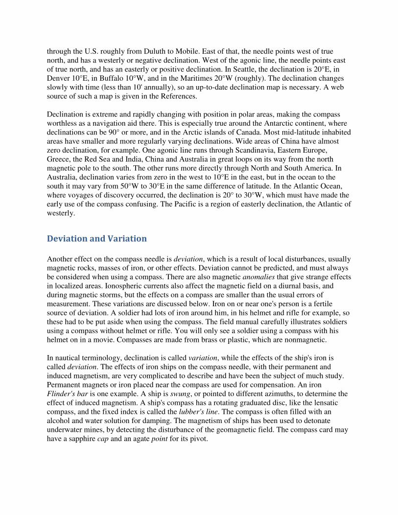
The lensatic compass is (was) the typical military field
compass, and is used principally to measure or lay out
magnetic bearings. It can also be used to orient a map. A
typical lensatic compass is shown at the right (from FM 21-
25). The "lensatic" means that the rear sight is provided with
a lens that allows you to read the dial while your eye is close
to the rear sight, as it should be. The lid of the compass
opens up to provide a slot with a crosshair as the front sight.
This "crosshair" is actually a sturdy metallic wire. When you sight a distant object, the magnetic
bearing can be read from the dial to an accuracy of a degree or two, with care. The whole dial
rotates, and the magnetic needle is out of sight below it. There are luminous lines and letters on
the dial and the cover glass that allow use in the dark, though bearings must be set previously in
the light. Some compasses have a cover glass that rotates in "clicks" of 3° each; these can be set
in the dark if required. There is a ring near the rear sight used for holding the compass; the thumb
generally is placed in the ring, and both hands are used, taking care to level the compass.
There are two luminous lines on the rotating upper cover glass, one four times longer than the
other, and at 45° to each other. FM 21-25 does not mention the use of the short line, but it can
probably be used to speed up the setting of an azimuth by saving 15 clicks. The lower, fixed
cover glass has a luminous index mark and three luminous dots to indicate E, S and W.
Inexpensive compasses have only one cover glass with the two lines, which somewhat interferes
with night use, though a preset bearing can be followed by lining up the long line and the
compass north. Also, the alignment of the index line with respect to the compass body must be
carefully set. I have one compass when the lines that should be luminous are painted green, but
are not luminous.
The surveyor's compass, now rare, had a long needle rotating relative to a fixed scale. A
magnifying glass helped to read the position of the needle accurately. It was mounted on a plate
(box) equipped with levels and two vertical sighting slots at each end. The compass was mounted
on a tripod, and a plumb bob could be attached to set it accurately over a point. The needle was
made horizontal by sliding a wire weight along it. The needle had to be straight, so that it pointed
to points exactly 180° apart, and the pivot had to be exactly in the center of the graduated circle.
Telescopic sights were rarely, if ever, used on compasses. The classical engineer's transit had a
compass in its base. The use of the compass is responsible for some of the oddities in the early
public land surveys.
Note that with the lensatic compass, we do not read the position of a needle with respect to a
graduated circle. Some compasses are like this, but they could not be used in the same way to
measure a bearing. With a hand-held compass, we cannot set the compass on line, and then look
down and note the position of a needle, as with a surveying compass, but must read the bearing
simultaneously with the sighting. This is the key to the lensatic compass and its advantages.
The geomagnetic field is not horizontal, so the needle is pulled up or down depending on the dip
of the field. In the northern hemisphere, the field points downward to the north, so the south end
of the needle must be weighted. A lensatic compass weighted for the northern hemisphere will
not work in the southern hemisphere, and vice versa. This little detail is not mentioned in the
field manual.
Declination
The compass points to magnetic north, which is a very doubful concept in most places. It does
not point toward "magnetic poles" but responds to the local field. Except along agonic lines, the
needle points east or west of true north, and this is called the declination. An agonic line runs
through the U.S. roughly from Duluth to Mobile. East of that, the needle points west of true
north, and has a westerly or negative declination. West of the agonic line, the needle points east
of true north, and has an easterly or positive declination. In Seattle, the declination is 20°E, in
Denver 10°E, in Buffalo 10°W, and in the Maritimes 20°W (roughly). The declination changes
slowly with time (less than 10' annually), so an up-to-date declination map is necessary. A web
source of such a map is given in the References.
Declination is extreme and rapidly changing with position in polar areas, making the compass
worthless as a navigation aid there. This is especially true around the Antarctic continent, where
declinations can be 90° or more, and in the Arctic islands of Canada. Most mid-latitude inhabited
areas have smaller and more regularly varying declinations. Wide areas of China have almost
zero declination, for example. One agonic line runs through Scandinavia, Eastern Europe,
Greece, the Red Sea and India, China and Australia in great loops on its way from the north
magnetic pole to the south. The other runs more directly through North and South America. In
Australia, declination varies from zero in the west to 10°E in the east, but in the ocean to the
south it may vary from 50°W to 30°E in the same difference of latitude. In the Atlantic Ocean,
where voyages of discovery occurred, the declination is 20° to 30°W, which must have made the
early use of the compass confusing. The Pacific is a region of easterly declination, the Atlantic of
westerly.
Deviation and Variation
Another effect on the compass needle is deviation, which is a result of local disturbances, usually
magnetic rocks, masses of iron, or other effects. Deviation cannot be predicted, and must always
be considered when using a compass. There are also magnetic anomalies that give strange effects
in localized areas. Ionospheric currents also affect the magnetic field on a diurnal basis, and
during magnetic storms, but the effects on a compass are smaller than the usual errors of
measurement. These variations are discussed below. Iron on or near one's person is a fertile
source of deviation. A soldier had lots of iron around him, in his helmet and rifle for example, so
these had to be put aside when using the compass. The field manual carefully illustrates soldiers
using a compass without helmet or rifle. You will only see a soldier using a compass with his
helmet on in a movie. Compasses are made from brass or plastic, which are nonmagnetic.
In nautical terminology, declination is called variation, while the effects of the ship's iron is
called deviation. The effects of iron ships on the compass needle, with their permanent and
induced magnetism, are very complicated to describe and have been the subject of much study.
Permanent magnets or iron placed near the compass are used for compensation. An iron
Flinder's bar is one example. A ship is swung, or pointed to different azimuths, to determine the
effect of induced magnetism. A ship's compass has a rotating graduated disc, like the lensatic
compass, and the fixed index is called the lubber's line. The compass is often filled with an
alcohol and water solution for damping. The magnetism of ships has been used to detonate
underwater mines, by detecting the disturbance of the geomagnetic field. The compass card may
have a sapphire cap and an agate point for its pivot.
If you have a topographic map of your area, the declination can easily be determined by direct
measurement. Locate yourself and a prominent distant object on the map, and measure its
magnetic bearing with the compass. Now draw a line between the two points on the map, and
determine the true bearing with a protractor. The difference between the bearings will be the
declination. This can be done, for example, before beginning the day's hike, and the compass will
then be useful in conjunction with the map.
Index Lines
The compass case has index marks at the top of the lid, and beneath the rear sight. These can be
lined up with a line drawn on a map to orient the map. When doing this, the lid is opened flat
with the compass case. There should be an index mark above the dial aligned with these marks.
Some recent lensatic compasses have square cases with ruler edges, bringing them closer to
orienteering compasses.
A few terms may be defined for the benefit of those not accustomed to them. A bearing is the
angular position of a line in a horizontal plane. It is magnetic, true or grid when referred to
magnetic north, geographical north or grid north, respectively. Magnetic and true bearings differ
by the declination. A diagram always helps to keep the direction of the declination straight. If the
north directions are shown on the map in a diagram, true north is a full arrowhead or a star,
magnetic north a half-arrowhead, and grid north by a "y". A bearing may be specified by angle in
a quadrant, as N 33° E, or S 40° E, and so on. The angles are measured from N or S. Or, the
azimuth can be used, which is the angle measured clockwise from north from 0° to 360°. A
forward bearing is specified from the point you occupy to the distant point, while a back bearing
is in the other direction. A line with a forward bearing of N 27° E has a back bearing of S 27° W.
Azimuths will differ by 180°. When specifying a bearing, the angle alone is never sufficient. The
reference direction and sense of measurement must be stated, by using compass directions or
quoting it as an azimuth.
The total intensity F of the geomagnetic field is now quoted in nT (nanotesla), which were once
called gammas. 100 000 nT = 1 Gauss. F varies from about 0.48 G in South Texas to over .58 G
in Minnesota, roughly constant with longitude differences. The inclination I of the magnetic
needle in a vertical plane, or dip, varies from 55° in South Texas to 75° in northern Minnesota. In
Denver, F = 0.54 G and I = 67°. The currents causing the main field are deep within the earth,
and vary only slowly and cyclically. From the direction of the field, they must circle the earth's
axis in a westerly direction. Their exact nature and cause are unknown. Some speculations on the
origin of the main field are discussed in Geomagnetism.
Direction can also be determined at night by observations of Polaris (actually, by observations of
any star, but Polaris makes the job much easier). This procedure can be rendered accurate
enough for critical use by considering the actual position of Polaris and using a transit, but just
assuming that Polaris is N will be satisfactory for compass work. Declinations can be obtained in
this way. A plumb bob can be suspended so that it cuts Polaris, and the bearing to the plumb bob
cord then measured.
If you point the hour hand of a watch in the direction of the sun, then south is halfway between
the 12 and the hour hand. This works in the northern temperate zone. In the southern temperate
zone, point the 12 in the direction of the sun, and then north is halfway between the 12 and the
hour hand. In both cases, standard time must be used (better, solar apparent time, but that is a
detail).
A Compass Exercise
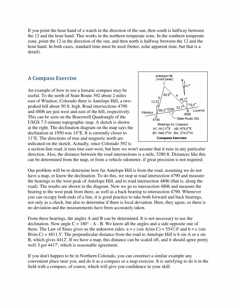
An example of how to use a lensatic compass may be
useful. To the north of State Route 392 about 2 miles
east of Windsor, Colorado there is Antelope Hill, a two-
peaked hill about 50 ft. high. Road intersections 4790
and 4806 are just west and east of the hill, respectively.
This can be seen on the Bracewell Quadrangle of the
USGS 7.5-minute topographic map. A sketch is shown
at the right. The declination diagram on the map says the
declination in 1950 was 14°E. It is currently closer to
11°E. The directions of true and magnetic north are
indicated on the sketch. Actually, since Colorado 392 is
a section-line road, it runs true east-west, but here we won't assume that it runs in any particular
direction. Also, the distance between the road intersections is a mile, 5280 ft. Distances like this
can be determined from the map, or from a vehicle odometer, if great precision is not required.
Our problem will be to determine how far Antelope Hill is from the road, assuming we do not
have a map, or know the declination. To do this, we stop at road intersection 4790 and measure
the bearings to the west peak of Antelope Hill, and to road intersection 4806 (that is, along the
road). The results are shown in the diagram. Now we go to intersection 4806 and measure the
bearing to the west peak from there, as well as a back bearing to intersection 4790. Whenever
you can occupy both ends of a line, it is good practice to take both forward and back bearings,
not only as a check, but also to determine if there is local deviation. Here, they agree, so there is
no deviation and the measurements have been accurately taken.
From these bearings, the angles A and B can be determined. It is not necessary to use the
declination. Now angle C = 180° - A - B. We know all the angles and a side opposite one of
them. The Law of Sines gives us the unknown sides: a = c (sin A/sin C) = 5547.0' and b = c (sin
B/sin C) = 4811.5'. The perpendicular distance from the road to Antelope Hill is b sin A or a sin
B, which gives 4412'. If we have a map, this distance can be scaled off, and it should agree pretty
well. I got 4417', which is reasonable agreement.
If you don't happen to be in Northern Colorado, you can construct a similar example any
convenient place near you, and do it as a compass or a map exercise. It is satisfying to do it in the
field with a compass, of course, which will give you confidence in your skill.
Another useful exercise is locating yourself on a map by taking bearings to two or more visible
points and then plotting the back bearings on a map. The intersection gives your position. Still
another is making a closed compass traverse of a field, pacing the distances. When you make a
closed traverse, there is a check on the bearings and the pacing (the traverse should close). Of
course, the forward and back bearings of each line should be measured and compared. A plot of
the traverse can then be made, and the enclosed area calculated. See any surveying text for how
to find the area from the rectangular coordinates of the points. This is exactly the way land
surveys were made in former days, except that a chain was used for the distance measurement. If
you have help (a party of three), a chain (tape) is easy to use. The compassman keeps the
chainmen on line while they are measuring, or they simply chain towards the range pole used to
mark the next turning point.
Magnetic Field Variations
If one measures the field components accurately, it is found that they vary both periodically and
irregularly by small amounts on the order of 1%. These variations are caused by ionospheric
electron currents at altitudes of about 100 km, and result from sun-earth interactions. They have
no significance for compass measurements, but are of intrinsic interest, and this seems the best
place to discuss them. One reason for studying them is that ionospheric conditions have
important effects on radio communications, and the magnetic variations are indicative of
ionospheric conditions and "space weather" in general.
The sun sends ionizing ultraviolet radiation reaching the earth in about 8 minutes after it is
emitted, and streams of particles, mainly protons, that take longer to reach the earth. These come
from sunspots in the normal sun, but in increased amounts from disturbances called solar flares.
The resulting increased ionization in the upper atmosphere, combined with tidal and wind
motions, induces currents that create the extra magnetic field. Coronal Mass Ejections (CME's),
in which large bubbles of plasma are ejected by magnetic action, are also responsible. The aurora
borealis is a visible result of ionospheric ionization from these sources.
If you examine the measurements of the field, on some days the records are smooth and only
slowly varying. These are called quiet days. On the other hand, the records may vary irregularly
by small amounts over times of 2-3 hours, and these days are called disturbed days. This is an
indication of ionospheric activity, and correlates well with solar influences, in particular with the
11-year sunspot cycle.
The regular diurnal variation, with a period of 24 hours, is associated with the daytime increase
in ionization producing the ionospheric D layer, and with solar tides in the atmosphere. Irregular
magnetic storms are periods of greatly increased ionization. "Great" storms may have an effect of
as much as 5% of the total field, and occur roughly once per year. The variation of the magnetic
field in this case is enough to induce currents in land lines, such as telegraph circuits, and is
always accompanied by large ionospheric disturbances. These storms are associated with solar
flares, so they recur at 27-day intervals, which is the rotational period of the sun.
References Lensatic Compass gives an introduction to the use of the compass.
Small maps of the inclination, declination and total intensity for the U.S. can be found at USGS
Geomagnetism. A web search for "magnetic declination" will find world maps that are quite interesting,
showing places where the compass is useless.
FM 21-25, Elementary Map and Aerial Photograph Reading (Washington, DC: War Department, 1944).
C. B. Breed and G. L. Hosmer, The Principles and Practice of Surveying: Vol. I, Elementary Surveying, 11th
ed. (New York: John Wiley & Sons, 1977). See pp. 20-29 for use of the compass, and pp. 148-150 for
compass surveys for area. The lensatic ("prismatic") compass is only mentioned briefly.