Embed Size (px)
Citation preview
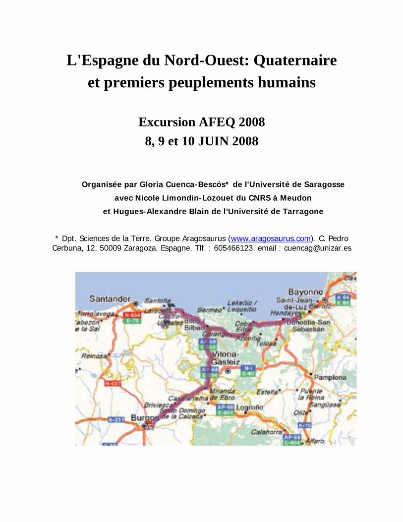
L'Espagne du Nord-Ouest: Quaternaire et premiers peuplements humains
Excursion AFEQ 2008 8, 9 et 10 JUIN 2008
Organisée par Gloria Cuenca-Bescós* de l'Université de Saragosse
avec Nicole Limondin-Lozouet du CNRS à Meudon
et Hugues-Alexandre Blain de l’Université de Tarragone
* Dpt. Sciences de la Terre. Groupe Aragosaurus (www.aragosaurus.com). C. Pedro Cerbuna, 12, 50009 Zaragoza, Espagne. Tlf. : 605466123. email : [email protected]
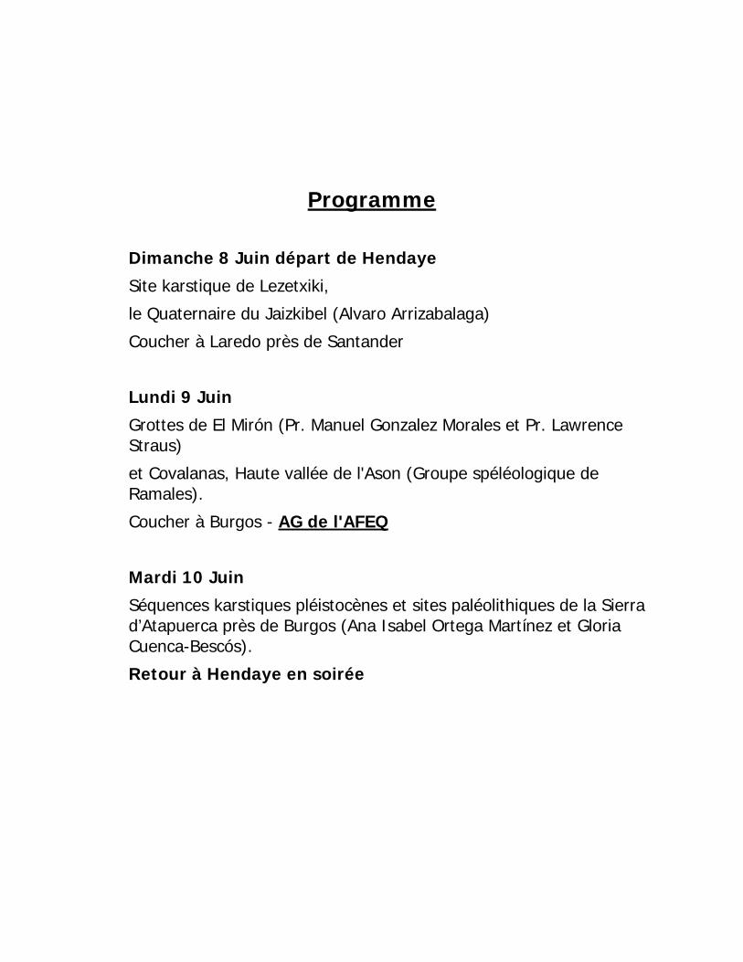
Programme
Dimanche 8 Juin départ de Hendaye
Site karstique de Lezetxiki,
le Quaternaire du Jaizkibel (Alvaro Arrizabalaga)
Coucher à Laredo près de Santander
Lundi 9 Juin
Grottes de El Mirón (Pr. Manuel Gonzalez Morales et Pr. Lawrence Straus)
et Covalanas, Haute vallée de l'Ason (Groupe spéléologique de Ramales).
Coucher à Burgos - AG de l'AFEQ
Mardi 10 Juin
Séquences karstiques pléistocènes et sites paléolithiques de la Sierra d’Atapuerca près de Burgos (Ana Isabel Ortega Martínez et Gloria Cuenca-Bescós).
Retour à Hendaye en soirée
Participants ARGANT, Alain [email protected]
BERTRAN, Pascal [email protected]
BLAIN, Hugues-Alexandre [email protected]
CHAUSSE, Christine [email protected]
CLIQUET, Dominique [email protected]
COLAS, Albert [email protected]
COUTARD, Françoise [email protected]
COUTARD, Jean-Pierre [email protected]
COUTARD, Sylvie [email protected]
CUENCA-BESCOS, Gloria [email protected]
DEBARD, Evelyne [email protected]
DEFIVE, Emmanuelle [email protected]
DUCAMP, Jean-Louis [email protected]
FERRIER, Catherine [email protected]
LE ROUX, Gildas [email protected]
LEBLANC, Jean-Claude [email protected]
LENOBLE, Arnaud [email protected]
LIMONDIN-LOZOUET, Nicole [email protected]
MANGAS FORNER, Raquel [email protected]
NICOUD, Elisa [email protected]
NICOUD, Gérard [email protected]
OCHIETTI, Serge [email protected]
PASTRE, Jean-François [email protected]
REY, Tony [email protected]
ROTH, Helga [email protected]
WENGLER, Luc [email protected]
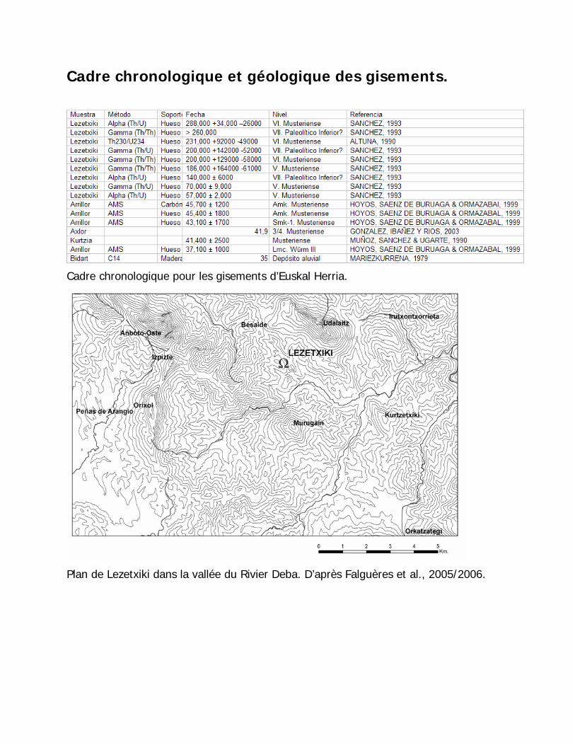
Cadre chronologique et géologique des gisements.
Cadre chronologique pour les gisements d’Euskal Herria.
Plan de Lezetxiki dans la vallée du Rivier Deba. D’après Falguères et al., 2005/2006.
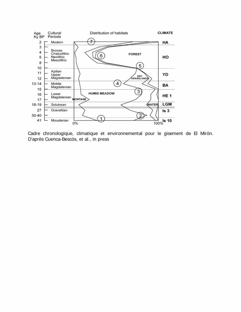
Cadre chronologique, climatique et environnemental pour le gisement de El Mirón. D’après Cuenca-Bescós, et al., in press
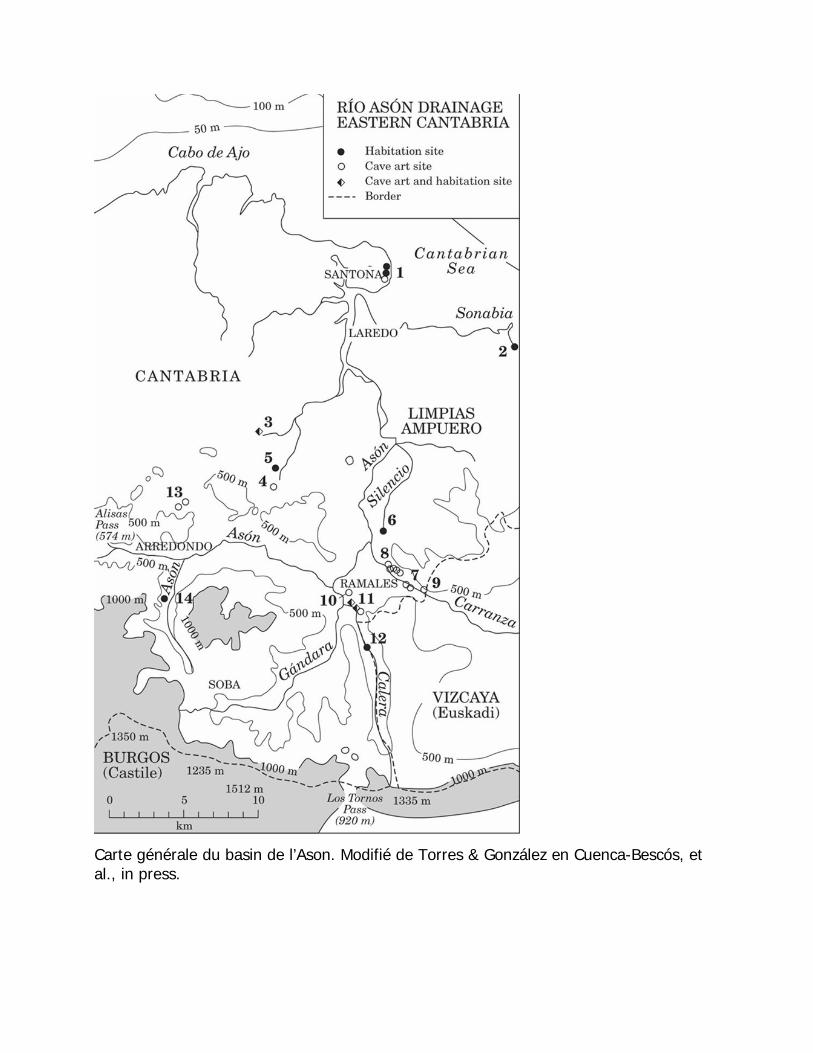
Carte générale du basin de l’Ason. Modifié de Torres & González en Cuenca-Bescós, et al., in press.
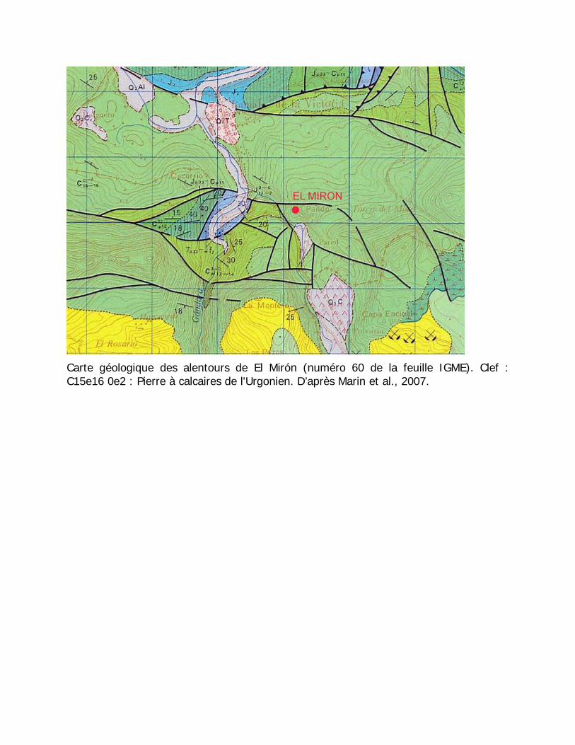
Carte géologique des alentours de El Mirón (numéro 60 de la feuille IGME). Clef : C15e16 0e2 : Pierre à calcaires de l'Urgonien. D’après Marin et al., 2007.
Rapide synthèse des gisements et localités. (Pour la plupart de ces sites, il existe une abondante littérature cf. CD ci-joint.
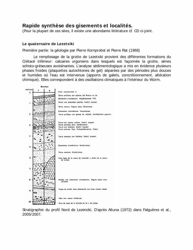
Le quaternaire de Lezetxiki
Première partie: la géologie par Pierre Kornprobst et Pierre Rat (1968)
Le remplissage de la grotte de Lezetxiki provient des différentes formations du Crétacé inférieur: calcaires urgoniens dans lesquels est façonnée la grotte, séries schisto-gréseuses avoisinantes. L'analyse sédimentologique a mis en évidence plusieurs phases froides (plaquettes autochtones de gel) séparées par des périodes plus douces et humides où l'eau est intervenue (apports de galets, concrétionnement, altération chimique). Elles correspondent à des oscillations climatiques à l'intérieur du Würm.
Stratigraphie du profil Nord de Lezetxiki. D’après Altuna (1972) dans Falguères et al., 2005/2007.
Importance paléoanthropologique et archéologique
Les archéologues de la Société des Sciences d’Aranzadi ont suggéré qu’Homo heildebergensis, une espèce humaine antérieure à l'homme de néandertal, a habité dans la grotte de Lezetxiki, en Guipúzcoa. Il est possible que le célèbre humérus découvert dans cette grotte en 1965 appartienne lui aussi à H. heildebergensis.
Arrizabalaga (2005/2006) donne une vue d’ensemble très complète des occupations humaines dans le Pays Basque.
Le territoire de Guipúzcoa est probablement celui où l’on observe les nouveautés les plus significatives. En commençant par Lezetxiki, il s'agit d'un remplissage en grotte fouillé en premier lieu par J.M. De Barandiaran et collaborateurs puis postérieurement, par nous-mêmes (en Arrizabalaga 2005/2006). La publication de l'industrie des niveaux inférieurs, la considération des datations absolues effectuées sur les niveaux V, VI et VII et des différentes informations paléoenvironnementales pour le niveau VII, ainsi que le renouveau d'intérêt pour l'humérus fossile trouvés en 1965 (qui semble montrer des similitudes avec d'autres provenant de la Sima de los Huesos, à Atapuerca), suggèrent un âge de la fin du Pléistocène moyen, avec en plus une série significative de niveaux moustériens. Dans le même site de Lezetxiki, nous fouillons un deuxième locus appelé Lezetxiki II, qui probablement permet de mettre en relation l'extérieur avec la stratigraphie de la grotte de Leibar, où a été localisé le célèbre humérus humain.
Une autre nouveauté qui peut être corrélable avec le stade isotopique 5 est constituée par le niveau inférieur de la grotte de Artazu II, cavité située dans le voisinage du complexe de Lezetxiki et qui présente des matériaux, qui rappellent ceux de Lezetxiki. Finalement, depuis 2002, Saenz de Buruaga a très probablement atteint un niveau d’occupation humaine du stade isotopique 5, en fouillant une très longue séquence stratigraphique à Zerratu, associée à des industries de caractères moustéroïdes. Alors que le niveau inférieur de la grotte de Amalda comporte une composante plus caractéristique du Moustérien.
À l'air libre, nous voulons attirer l'attention sur l'extrémité nord-est de Guipúzcoa, et plus concrètement sur la montagne de Jaizkibel, où plusieurs publications archéologiques décrivent des découvertes en surface de matériel paléolithique correspondant diverses périodes. En ce qui concerne le Paléolithique inférieur, nous pouvons signaler deux gisements (J1 et Higer). Dans le cas de J1, du matériel a été localisé en surface et sans contexte archéologique que nous pouvons peut-être assigner au Moustérien et aussi au Paléolithique inférieur, et qui proviendrait d’un petit plateau littoral, situé approximativement à 40 m au-dessus du niveau de la mer actuelle. Quant à Higer, il présente de conditions similaires, bien que le matériel du Paléolithique inférieur apparaisse comme résiduel, dans un contexte magdalénien, très altéré par l'urbanisation d’un camping. Ces gisements permettent en outre de relier les séquences de l'ancien Paléolithique côtier, tellement riches en Région cantabrique ou Asturies, peut-être avec Kurtzia en Bizkaia et donc, avec la côte de Laburdi. On a localisé
également en Jaizkibel d'autres établissements humains facilement attribuables au Moustérien (J2, par exemple).
Les travaux récents qui sont menés dans le gisement à l'air libre d'Irikaitz ont fourni un ensemble lithique stratifié, qui comprend plusieurs niveaux attribués au Paléolithique inférieur. Les données archéo-botaniques le situent dans une période interglaciaire (Eémien ou Holsteinien). On a ouvert une surface de fouille d’environt 60 mètres carrés dans deux sondages (Geltoki et Luebaki), dont le premier possède une stratigraphie de cinq mètres de puissance et deux niveaux (IV et V) spécialement riches et denses en découvertes. L'ensemble défini est clairement en position primaire.

5.- Conclusion3.- New Field Work seasons (1996-2008): New Research Perspectives
4.- The Archaeomalacological remains
First evidence of archaeomalacological remains in the Basque Country (Spain): Marine shells at Lezetxiki.
Arrizabalaga, A.*
Álvarez-Fernández, E.+
Iriarte, M.J.*
*Area of Prehistory. University of the Basque Country. C/ Francisco Tomás y Valiente s/n. 01006 Vitoria (Spain).
+Cantabria International Institute for Prehistoric Research., Av. de los Castros s/n. 39005 Santander (Spain).
2.- The Old Digs at Lezetxiki (1956-1968)Two teeth of Neanderthals
H. heidelbergensis’ humerus
The cave deposit at Lezetxiki (Arrasate, Basque Country) represents one of the classic references to research into the Middle and Upper Palaeolithic in the north of the Iberian Peninsula. It was first excavated by J. M. de Barandiaran (1956-1968) and later by A. Arrizabalaga and M. J. Iriarte(1996 and following years). In particular, it offers one of the most important sequences of the transition from the Mousterian to the EUP in CantabrianSpain, with a long stratigraphic series (up to nine metres thick), fossil human remains and a highly interesting collection of mammal fauna, as well as a large lithic assemblage. Despite certain difficulties in obtaining a good geochronological sequence in the deposit (Falguères et al., 2005/2006), the new fieldwork at the site has enabled an assessment of the conditions of the classic excavation (Arrizabalaga et al., 2005) and a re-definition of objectives, in accordance with the new methodologies and perspectives that are available (Arrizabalaga, 2006). The levels representing the transition from the Middle to the Upper Palaeolithic at Lezetxiki appear to provide evidence of a mixture of technical models (lithic knapping schemes belonging to the Mousterian and the Aurignacian found together, and a very archaic bone industry which, however, appears to be particularly old). They also display evidence of how the environment was exploited (the deposit displays a complex dynamic of alternate use by carnivores and humans), of human populations (the cave was occupied the humans of the types H. heidelbergensis, Neanderthals and AMH), and also of symbolic behaviour (Arrizabalaga, 2005 and 2005/2006; Arrizabalaga & Iriarte, 2006). In recent excavation seasons, a number of malacological remains have been recovered, whereas no evidence of this type was found by the first excavations. These are of great interest because four of the five specimens that have been found came from layers below the level in which two human teeth belonging to Neanderthals were discovered (Basabe, 1970). It seems logical to assume, therefore, that it was the Neanderthal occupants who collected and used these shells.
References
ÁLVAREZ-FERNÁNDEZ, E. (2006): Los objetos de adorno-colgantes del Paleolítico superior y del Mesolítico en la Cornisa Cantábrica y en el Valle del Ebro: una visión europea. Universidad de Salamanca (Colección Vítor, nº 195), Salamanca.
ARRIZABALAGA, A. (2005): “Últimos neandertales y primeros cromañones. Perspectivas desde la encrucijada vasca”. In: Montes, R. & de las Heras, J. A. (eds.): Neandertales cantábricos. Estado de la cuestión. Monografías del Museo y Centro de Investigación de Altamira 20. Madrid: 557-575.
ARRIZABALAGA, A. (2005/06): “Las primeras ocupaciones humanas en el Pirineo Occidental y Montes Vascos. Un estado de la cuestión en 2005”. In: Homenaje al Prof. Jesús Altuna. Vol. II. Munibe (Antropologia-Arkeologia) 57/2. San Sebastián: 53-70.
ARRIZABALAGA, A. (2006): “Lezetxiki (Arrasate, País Vasco). Nuevas preguntas acerca de un antiguo yacimiento”. In: Cabrera, V., Bernaldo de Quiros, F. & Maillo, J. M.(eds.): En el centenario de la Cueva de El Castillo: el ocaso de los Neandertales. Centro Asociadode la UNED-Cantabria, Santander: 291-310.
ARRIZABALAGA, A.; ALVAREZ-FERNÁNDEZ, E. & IRIARTE, M.J. (e.p.): “Spondylus sp. at Lezetxiki Cave (Basque Country, Spain): First Evidence of its use in Symbolic Behaviour during the Aurignacian in Europe”, in XIIth Meeting of the European Association of Archaeologists, Zadar-2006.
ARRIZABALAGA, A.; ALTUNA, J.; ARESO, P.; FALGUERES, C.; IRIARTE, M. J.; MARIEZKURRENA, K.; PEMÁN, E.; RUIZ-ALONSO, M.; TARRIÑO, A.; URIZ, A.; VALLVERDÚ, J. (2005): “Retorno a Lezetxiki (Arrasate, País Vasco): nuevas Perspectivas de la investigación”. In: Santonja, M., Pérez-González, A. & Machado, A. (eds.): Geoarqueología y Patrimonio en la Península Ibérica y el entorno mediterráneo. Madrid: 81-98.
ARRIZABALAGA, A. & IRIARTE, M. J. (2006): “El Castelperroniense y otros complejos de transición entre el Paleolítico medio y el superior en la Cornisa Cantábrica. Algunas reflexiones”. In: Maillo, J. M. & Baquedano, E. (eds.): Miscelánea en homenaje a Victoria Cabrera. Zona Arqueológica 7.I. Museo Arqueológico Regional de la Comunidad de Madrid, Alcalá de Henares: 358-370
BASABE, J. M. (1970): “Dientes humanos del paleolítico de Lezetxiki (Mondragón)”, Munibe 22: 113-124.
FALGUÈRES, C.; YOKOYAMA, Y.; ARRIZABALAGA, A. (2005/06): “La Geocronología del yacimiento pleistocénico de Lezetxiki(Arrasate, País Vasco). Crítica de las dataciones existentes y algunas nuevas aportaciones”. Munibe (Antropologia-Arkeologia) 57/2. San Sebastián: 93-106.
1. Presentation
Lz
Lk
The Basque Country, in its Spanish and French parts, occupies both sides of the western Pyrenees, dominating a corridor along which any travellers moving between the Iberian Peninsula and the European continent are forced to pass. This geographical location, and the fact the area is at a crossroads (the Basque crossroads) between the northern Spanish coast, the upper Ebro Valley, the western Pyrenees and the Aquitaine Depression, give this territory certain unusual characteristics as regards its Palaeolithic population. The archaeological site of Lezetxiki is situated at the head of the River Deva valley in the province of Guipúzcoa (there is another river with the same name between Cantabria and Asturias), at a relatively high altitude (nearly 375m above sea level). It is surrounded by other Palaeolithic sites; one of the most important of which is the site of Labeko Koba. In a radius of about 15km around the Atlantic-Mediterranean watershed, near the boundaries of the provinces of Vizcaya, Guipúzcoa and Álava, three sites contain important Mousterian sequences (Lezetxiki, Axlor and Arrillor). In all cases they are long sequences (over five metres thick), with Neanderthal fossil human remains, and also with levels representing the transition to the Early Upper Palaeolithic.
Axlor
Arrillor
The first phase of the study of the site concluded in 1968, when many of the disciplines that nowadays are linked to field and laboratory work were first being applied. Our project, which began in 1996, affects 10% of the surface excavated until 1968. It therefore has much more limited objectives, focused on confirming the observations of the first excavator and on up-dating the analytical studies. However, the results of our fieldwork are allowing us to be more ambitious in the interpretation of the site, in different ways:
1.- We can contribute new materials, of especial significance for two precise occupation phases (first population of Cantabrian Spain and Middle-Upper Palaeolithic transition).
2.- New palaeoenvironmental samples, taken simultaneously and from the same section for all disciplines, minimizing the effect of discrepancies caused by sampling criteria.
3.- New geochronological information, by the application of new procedures and by establishing the context of the available information.
4.- Improved characterization of the technological and symbolic behaviour of the cave inhabitants.
5.- Provide a precise stratigraphic context for the fossil human remains (and possibly locate new fossils) at Lezetxiki.
6.- Integrate some unpublished information from the classic excavations into the interpretative framework, such as the presence of Solutrean materials at Lezetxiki or by identifying the human humerus as a possible Homo heidelbergensis remain.
7.- New approaches, such as the analysis of lithic raw materials, traceology, Anthracology, or the taphonomic study of the accumulation of osseous remains.
The archaeomalacological remains from the Lezetxiki excavations are found in level IV (Late Mousterian) and level III (Early Aurignacian). From Level IVc two fragments of two gastropods belonging probably to the Muricidae family (Stramonita haemastoma?) were recovered. The first specimen (1) measures 22mm high by 11mm wide. It had been eroded by the sea, which has caused the loss of the apex and much of the body whorl, as well as part of its colouring.
The second (2) of the shell remains (18mm high x 7mm wide), belonging probably to the Muricidae family too, only conserves a fragment of the columella of the shell and, like the previous specimen, has been intensely eroded by wave action, so that it only partially conserves remains of its surface colouring. Both of these shells were possibly gathered on the shores of the Bay of Biscay.
From the base of Level III a fragment of the upper (right) valve of Spondylus sp. was recovered (3). The valve measures 25mm long and 11mm wide, with a maximum thickness of 6mm. Its surface has been eroded by the sea and a sandy wet beach environment, which has caused it to loose its spines and the intensity of its original colours. It has been attacked on both sides by perforating sponges. Neither the edges nor the umbo have been preserved, which has hindered its classification at species level. However, the thickness and colouring of the valve, as well as its size, suggest it probably belonged to a Spondylus gaederopus. This bivalve species now lives exclusively in the Mediterranean Sea and the immediate areas of the Atlantic (Canary Islands, Madeira, the Azores and off the Portuguese Atlantic coast). Its shell is large (up to 120mm), solid, oval to rounded, with weak and irregular auricles in the upper valve. The lower valve, in contrast, is flat and its surface is covered by strong ribs and pronounced spines. The colour of the outside of the upper valve varies from violet to wine red, while the lower valve is almost white. The interior colour is porcelain white. It was precisely the bright colouring of the specimen from Lezetxiki which made us rule out that it could be a fossil. They live at depths of between 1 and 50m, on rocky calcareous floors and coraligenous bottoms.
A fragment of an Ostrea sp. valve was found in the same level (4). The valve measures 25mm high and 16mm wide. Like the Spondylus sp. specimen, its surface showed signs of marine erosion, so it was also probably gathered on a beach. However, unlike the specimen from the Spondylidae family, this valve could have been gathered on the shores of the Bay of Biscay, as this species is very common in those waters.
The earliest evidence of the use and consumption of marine molluscs by hunter-gatherer groups in Cantabrian Spain goes back to the Middle Palaeolithic (Mousterian): Amalda, Cueva Morín and El Pendo. At these sites the molluscs were probably gathered for their bromatological value. However, this is not the case of the two specimens of the Muricidae family from Level IV at Lezetxiki. These were almost certainly gathered on beaches on the Bay of Biscay, and taken to the cave, over 30km from the coast, possibly as curiosities. The gathering of recent shells (but also of fossils) as curiosities by Neanderthal humans at the end of the Middle Palaeolithic has been documented at several European sites (e.g. in the Uluzzian at Castelcivita).
However, it is with the start of the Upper Palaeolithic that the numbers of shells in archaeological deposits become more abundant. As well as being gathered for their bromatological value or as simple curiosities (case of Lezetxiki valves), in the proto-Aurignacian shells were first used to manufacture suspended objects of adornment in Europe.
Gastropod shells were used almost exclusively. The groups living on the Atlantic coast or the Bay of Biscay would normally gather shells from their nearest beaches, as would the groups occupying the Mediterranean area. However, even in the EUP, perforated shells from both the Atlantic and the Mediterranean are found at sites located in the interior of the continent; sometimes hundreds of kilometres from the sea (specimens of Homalopoma sanguineum at Castanet in the Dordogne, or Cyclope sp. at Kostienki 14 in Russia, etc.). This can only be explained by the existence of complex networks of contacts among hunter-gatherer groups in the EUP.
The Spondylus sp. valve from the Early Aurignacian at Lezetxiki (Level III) is, on one hand, the oldest evidence of mollusc shells of Mediterranean origin at a site in Cantabrian Spain, although it shows no signs of anthropic modification in any way. On the other hand, its presence at Lezetxiki, located 500km in a straight line from the Mediterranean Sea, means it is evidence of contacts over the longest distance known in western Europe at the beginning of the Upper Palaeolithic.
3 4
1
2
Distribution of the Early Upper Paleolithic european sites with presence ofornamental objects-pendants made with recent marine shells of exclusively mediterranean origin
Sagaie in the mousterian layers
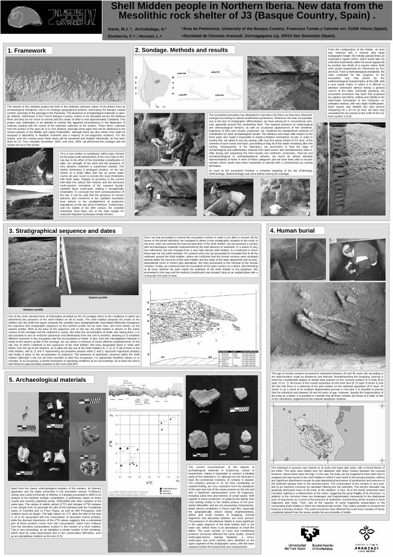
1. Framework 2. Sondage. Methods and results
4. Human burial3. Stratigraphical sequence and dates
5. Archaeological materials
Shell Midden people in Northern Iberia. New data from the Mesolithic rock shelter of J3 (Basque Country, Spain) .
*Área de Prehistoria. University of the Basque Country. Francisco Tomás y Valiente s/n. 01006 Vitoria (Spain).
+Sociedad de Ciencias Aranzadi. Zorroagagaina z/g. 20014 San Sebastián (Spain).
Iriarte, M.J. *; Arrizabalaga, A.*
Etxeberria, F.+ ; Herrasti, L.+
J3
The interest of the Jaizkibel project lies both in the relatively unknown nature of the district from an archaeological standpoint, and in its strategic geographical position, dominating the Basque coastal corridor, precisely at the passage to the Pyrenees. The presence of archaeological materials in open-air stations, well-known in the French Basque Country, seems to be disrupted across the BidasoaRiver and they do not return to normal until the centre of what is now approximately Cantabria. This project was undertaken in an attempt to resolve this apparent inconsistency in the dispersion of material, starting with the review of the materials collected on the surface. These items, collected from the surface in the open-air or in rock shelters, basically show signs that can be attributed to the various phases of the Middle and Upper Palaeolithic, although there are also others that might be assigned to Mesolithic or Neolithic moments and a majority of non-diagnostic evidence. For this reason, over the coming years these items will be assessed and studied individually, as has been done for J3. Thus, between November, 2002, and June, 2003, we performed the sondage with the results set out in this poster.
J3 is a rock shelter on sandstone, taffoni type, formed by the large-scale alveolization of the rock close to the sea due to the effect of the interstitial crystallization of salts, the strength of the wind and the presence of very abrasive sediment in suspension (sands). The shelter dominates a privileged location, on the last stretch of a small valley that has an active water course all year round to provide the local inhabitants with fresh water. Despite its proximity to the current inter-tidal line (about 200 metres) and the dominant north-western orientation of the seaward façade,Jaizkibel faces south-west, making it exceptionally inhabitable. To conclude this brief contextualization of the site, it can be said that the presence of various dolmens and cromlechs in the Jaizkibel mountains bear witness to the establishment of productive populations at this site since Prehistory. Furthermore, until the middle of the 20th century, the Jaizkibelmountains have been one of the main targets for seasonal migration by Basque sheep farmers.
From the configuration of the shelter, an area was selected with a foresee ably large stratigraphic height. We initially opened there an exploratory square metre, which would later be extended southwards (after the burial appeared) by another two thirds of a square metre. Both units would respectively be referenced as K12 and K10. From a methodological standpoint, the main constraint for the progress of the excavation was that posed by the sedimentological characteristics of the infill, with a very sandy matrix in which it is difficult to advance downward without risking a general cave-in of the sides. Generally speaking, the excavation procedure has been that proposed by Laplace and Méroc (1954a and 1954b) in his well-known formulation of the Cartesian co-ordinates method, with very slight modifications. Each square was divided into nine sectors measuring 33 x 33 cm (in K10, we have only excavated the six sectors to the north of the cut, from number 4 to 9).The excavation procedure has attempted to reproduce the floors as they were observed,
arranged according to natural stratification parameters. Whenever this was not possible, due to the lack of stratigraphic differentiation, we have advanced in conventional semi-cuts, generally around five centimetres thick. The massive presence of malacologicaland anthracological remains, as well as occasional appearances of fish vertebrae, fragments of lithic and ceramic production, etc. hindered the standardized collection of coordinates for each archaeological remain. The distance and slope with respect to the fresh water also made it impossible to install a flotation mechanism on-site. In order to resolve this, we opted to use dry sieving, with very fine sieves (mesh of 0.5 mm), of the contents of each sector and layer, proceeding to bag all of the waste remaining after this sieving. Subsequently, in the laboratory, we proceeded to float the bags of archaeological and sedimentary material from each sector and simultaneously clean it. After drying and separating the final residue into sediment, production, charcoal and archaeozoological or archaeobotanical remains, we found an almost absolute representativity of items in each of these categories and we have been able to recover remains which would have been impossible to identify with a conventional dry sieving technique.
As soon as the excavation finished, a complete sampling of the site (Palinology, Anthracology, Sedimentology) was done before closing the sondage.
Once we had proceeded to extend the excavation surface in order to be able to recover all the bones of the buried individual, we managed to detect a new stratigraphic situation to the south of the area: when we reached the external perimeter of the shell midden, we encountered a surface with archaeological materials characterized by the total absence of seashells. In a space of very few millimetres, the site changed from a very high density shell midden, to a sediment in which there was not one shell remnant. For several semi-cuts we proceeded to excavate first of all the sediment around the shell midden, where we confirmed that the human remains were arranged entirely within the structure of the shell midden and the sides of the latter apparently had no post-depositional niche or trench type alterations. We then proceeded to the removal of the human remains. Finally, we continued with the excavation of the open surface as a whole, discriminating at all times whether we were inside the sediment of the shell midden or the periphery. We proceeded in this way until the bedrock (sandstone) was located, lying on an angled plane with a strong dip from east to west.
One of the most relevant items of information provided by the J3 sondage refers to the conditions in which we determined the presence of the shell midden on all its levels. The shell midden (towards the inside of the shelter) and the shell-free layers (towards the outside) were stratigraphically interrelated differently throughout the sequence (the stratigraphic sequence on the northern profile can be seen here, and more clearly, on the eastern profile). Both at the base of the sequence and on the top, the shell midden is absent on the entire surface of the sondage and the sediment is sandy. But while the accumulation of shells was taking place, it is also possible to see an evolution (advances and withdrawals from one unit to another), allowing us to establish different moments in the occupation and the accumulation of shells. In fact, from this interdigitation followed in detail on the eastern profile of the sondage, we can detect a minimum of seven different establishments on the site, five of which contribute to the expansion of the shell midden. We have designated these in order with letters, from the top to the bedrock, as A (after the last use of the shell midden), B, C, D, E, F (all of them in the shell midden, with B, D and F representing accumulative phases while C and E represent regressive phases) and finally G (prior to the accumulation of molluscs). The presence of prehistoric ceramics within the shell midden (although it has not yet been possible to date this occupation, it is apparently Neolithic) allows us to consider J3 as occupying, a similar framework of operating conditions as its surroundings, for at least two and a half millennia (approximately between 8,500 and 6,000 BP).
Nr. Material Layer 2 sigma Calibration 1 Charcoal B (top) Cal 1670-1950 AD 2 Charcoal D (top) Cal 6690-6460 BC 3 Human bone D (bottom) Cal 7530-7180 BC 4a Charcoal F Cal 7550-6800 BC 4b Shells F Cal 7050-6400 BC 5 Charcoal G Cal 7750-7150 BC 6 Charcoal G (top) Cal 7600-7370 BC
Northern profile
Eastern profile
The age of human remains recovered is estimated between 20 and 40 years old, according to the determination made by Etxeberria and Herrasti. Notwithstanding the foregoing, bearing in mind the considerable degree of dental wear present on the occlusal surface of a tooth (K10 layer 12 no. 7), the fusion of the cranial synostosis on the inner face (K 12 layer 9 sector 5) and the fact that there is a widening of the joint surface on the odontoid apophysis (K12 layer 10 sector 1) as a result of an incipient degenerative process in the joint, it is possible to precise that the individual was between 30 and 40 years of age. However, despite the fragmentation of the body as a whole, it is possible to consider that all these remains are those of a male, in fact of the robustness suggested by the mastoid apophysis retained.
The individual in question was leaned on its body and head right sides, with a forced flexion of the limbs. The arms were floded over the abdomen with direct contact between the crossed forearms. Above these were the legs. In this way, the body can be imagined to have been tied or wrapped and was buried in the shell midden in which it was found in this primary position, without any significant disturbance except by post-depositional processes of putrefaction and pressure of the sediment (please refer to the reconstruction). The conservation of the remains is very poor, due to an intensive corrosion by rainwater filtering into the sediment. The low-pH rainwater has gradually destroyed many of the parts of the skeleton. In fact, all of the bones preserved were corroded, leading to a deterioration of the cortex, triggering the great fragility of its structures. In addition to the corrosion there are breakages and fragmentation transversal to the diaphysealaxes of long bones as a result of the pressure of sediments, transforming all the remains in bone fragments and chips. Then, one of the reasons of some fragments preservation is the surrounding shell midden in which the individual was buried. This makes possible to interpret the burial as a primary location. The same processes have affected the scant bony remains of fauna, completely absent from the areas outside the accumulation of shells.
The current circumstances of the deposit of archaeological materials in Guipúzcoa, closed to researchers, makes it impossible to conduct a detailed study of the materials in J3, although we are fortunate to have the provisional inventory of remains in deposit. The ceramics present in J3, far from constituting an isolated finding, are very consistent from the standpoint of the type and size of the vases present on the site and with a significant representation (over 50 fragments, including some rims and bottoms of small vases). With regards to stone production, to judge by the dating, they must belong mostly to the middle phases of the post-Azilian Mesolithic and are not excessively characteristic. Made almost completely in Flysch type flint, especially the geographically closed variety (Gaintxurizketa), débris and small remains of knapping, thermal fragments and discarded splinters are more present. The presence of microlaminar blanks is more significant in the upper segment of the shell midden than in the lower one, where there is an abundance of small flint flakes. The scant number of cores and conditioning products recovered reflected the same duality. Several endscraper-burins, backed bladelets, a micro-endscraper and some notches were identified on the upper segment of the stratigraphic series, with the lower segment (under the burial level) less characteristic.
Apart from the classic anthropological analysis of the remains, its funerary apparatus and the dates presented in the precedent section, Professors Jackes and Lubell (University of Alberta, in Canada) proceeded in 2005 to an analyze of the skeleton isotopic composition. A preliminary report on these results was recently published (Arias, 2005/2006) with other samples of the same type. The values of stable carbon (δ13C) and nitrogen (δ15N) isotopes in the sample from J3 associate the diet of this individual with the Cantabriancases of Colomba and La Poza l’Egua, as well as with Portuguese shell middens (such as Muge). The high values for δ13C allow the diet of the man in J3 to be associated with the consumption of abundant marine proteins, while the discreet importance of the δ15N values suggests that a substantial part of those proteins comes from fish consumption, rather from molluscs from the shoreline (consumption evident in the context of a shell midden). This is very interesting, as we identified a certain number of fish vertebrae, which must be under-represented due to the conservation difficulties, such as an unpropitious medium as the one of J3.
Arias, P., 2005/2006. Determinaciones de isótopos estables en restos humanos de la región cantábrica. Aportación al estudio de la dieta de las poblaciones del
Mesolítico y el Neolítico. Munibe (Antropologia-Arkeologia). 57-3, 359-374.
From Arias (2005/2006)
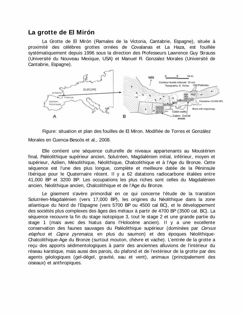
La grotte de El Mirón La Grotte de El Mirón (Ramales de la Victoria, Cantabrie, Espagne), située à
proximité des célèbres grottes ornées de Covalanas et La Haza, est fouillée systématiquement depuis 1996 sous la direction des Professeurs Lawrence Guy Strauss (Université du Nouveau Mexique, USA) et Manuel R. Gonzalez Morales (Université de Cantabrie, Espagne).
Figure: situation et plan des fouilles de El Miron. Modifiée de Torres et González
Morales en Cuenca-Bescós et al., 2008.
Elle contient une séquence culturelle de niveaux appartenants au Moustérien final, Paléolithique supérieur ancien, Solutréen, Magdalénien initial, inférieur, moyen et supérieur, Azilien, Mésolithique, Néolithique, Chalcolithique et à l’Age du Bronze. Cette séquence est l’une des plus longue, complète et meilleure datée de la Péninsule Ibérique pour le Quaternaire récent. Il y a 62 datations radiocarbone étalées entre 41,000 BP et 3200 BP. Les occupations les plus riches sont celles du Magdalénien ancien, Néolithique ancien, Chalcolithique et de l’Age du Bronze.
Le gisement s’avère primordial en ce qui concerne l'étude de la transition Solutréen-Magdalénien (vers 17,000 BP), les origines du Néolithique dans la zone atlantique du Nord de l'Espagne (vers 5700 BP ou 4500 cal BC), et le développement des sociétés plus complexes des âges des métaux à partir de 4700 BP (3500 cal. BC). La séquence recouvre la fin du stage isotopique 3, tout le stage 2 et une grande partie du stage 1 (mais avec des hiatus dans l'Holocène ancien). Il y a une excellente conservation des faunes sauvages du Paléolithique supérieur (dominées par Cervus elaphus et Capra pyrenaica, en plus du saumon) et des époques Néolithique-Chalcolithique-Age du Bronze (surtout mouton, chèvre et vache). L'entrée de la grotte a reçu des apports sédimentologiques à partir des anciennes alluvions de l'intérieur du réseau karstique, mais aussi des parois, du plafond et de l'extérieur de la grotte par des agents géologiques (gel-dégel, gravité, eau et vent), animaux (principalement des oiseaux) et anthropiques.
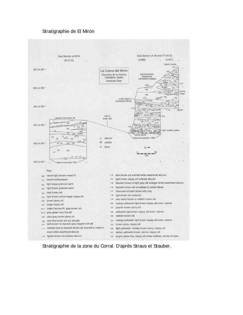
Stratigraphie de El Mirón
Stratigraphie de la zone du Corral. D’après Straus et Stauber.
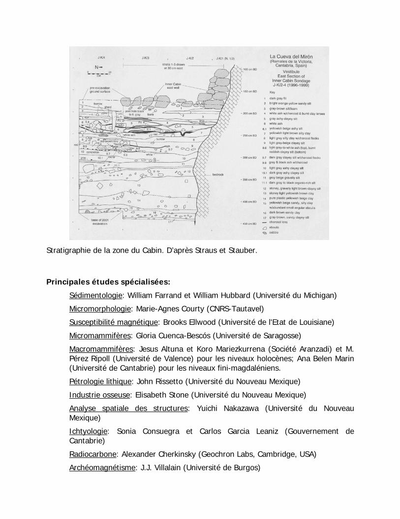
Stratigraphie de la zone du Cabin. D’après Straus et Stauber.
Principales études spécialisées:
Sédimentologie: William Farrand et William Hubbard (Université du Michigan)
Micromorphologie: Marie-Agnes Courty (CNRS-Tautavel)
Susceptibilité magnétique: Brooks Ellwood (Université de l'Etat de Louisiane)
Micromammifères: Gloria Cuenca-Bescós (Université de Saragosse)
Macromammifères: Jesus Altuna et Koro Mariezkurrena (Société Aranzadi) et M. Pérez Ripoll (Université de Valence) pour les niveaux holocènes; Ana Belen Marin (Université de Cantabrie) pour les niveaux fini-magdaléniens.
Pétrologie lithique: John Rissetto (Université du Nouveau Mexique)
Industrie osseuse: Elisabeth Stone (Université du Nouveau Mexique)
Analyse spatiale des structures: Yuichi Nakazawa (Université du Nouveau Mexique)
Ichtyologie: Sonia Consuegra et Carlos Garcia Leaniz (Gouvernement de Cantabrie)
Radiocarbone: Alexander Cherkinsky (Geochron Labs, Cambridge, USA)
Archéomagnétisme: J.J. Villalain (Université de Burgos)
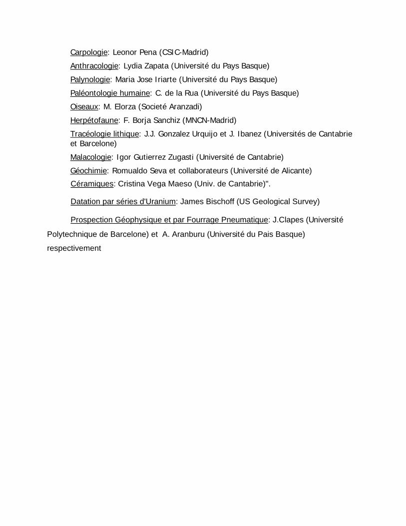
Carpologie: Leonor Pena (CSIC-Madrid)
Anthracologie: Lydia Zapata (Université du Pays Basque)
Palynologie: Maria Jose Iriarte (Université du Pays Basque)
Paléontologie humaine: C. de la Rua (Université du Pays Basque)
Oiseaux: M. Elorza (Societé Aranzadi)
Herpétofaune: F. Borja Sanchiz (MNCN-Madrid)
Tracéologie lithique: J.J. Gonzalez Urquijo et J. Ibanez (Universités de Cantabrie et Barcelone)
Malacologie: Igor Gutierrez Zugasti (Université de Cantabrie)
Géochimie: Romualdo Seva et collaborateurs (Université de Alicante)
Céramiques: Cristina Vega Maeso (Univ. de Cantabrie)".
Datation par séries d'Uranium: James Bischoff (US Geological Survey)
Prospection Géophysique et par Fourrage Pneumatique: J.Clapes (Université
Polytechnique de Barcelone) et A. Aranburu (Université du Pais Basque)
respectivement
El Alto Valle del Asón: Haute vallée de l'Ason Enrique Fernández Gibert. Cuadernos del Valle del Asón, Geología y formación de
cavidades en el Alto Valle del Río Asón, Nº 6 Diciembre 2001 - Página 19-26
Introduction
Dans la Vallée du haut Asón on trouve, certains des plus importants réseaux souterrains d'Espagne qui encore aujourd'hui, après 40 années d'explorations ininterrompues, continuent à donner de grandes surprises. La formation et l'évolution de ces cavités, comme dans le tout massif karstique, est conditionnée par des nombreux facteurs.
Nous essayerons de résumer ce que avons appris jusqu’à présent sur le sujet, en effectuant un parcours le long de la vallée jusqu'à Arredondo (FIGURE 1). Au cours des différents arrêts, nous verrons les types de roches présentes et leur disposition, l'évolution du relief au cours du temps, et ce en quoi ces facteurs affectent la formation des grottes.
Disons avant de commencer, que à chaque arrêt nous allons aborder des questions relatives à des moments très différents de l'histoire géologique, qui est très longue. Tout spécialement, il faudra distinguer les phénomènes géomorphologiques les plus récents : évolution du réseau fluvial, formation des grottes, etc.
Le parcours de l'excursion est d’environ 12 Km, en commençant aux alentours de la Gándara, et en terminant en Arredondo.
La Géologie du Haute Asón
Les roches sédimentaires présentes dans la région font partie du Complexe Urgonien, du Crétacé inférieur. Ils se sont déposés il y a environ 110 millions d'années. À cette époque, la zone était un littoral d’eaux peu profondes et de climat chaud, avec des changements fréquents du niveau de la mer (FIGURE 2). Cela a donné lieu à une importante variation dans le type de sédimentation tant en horizontale comme tout au long du temps (dans la verticale). Dans les secteurs les plus proches à la côte, se sont déposés des matériaux détritiques (sables, donnant postérieurement des grès); dans les zones d'eaux peu profondes, se sont accumulés des carbonates d'origine organique (qui ont postérieurement donné lieu à des calcaires); finalement, dans les eaux les plus profondes, se sont déposé des argiles et des carbonates riches en matière organique (qui ont donné lieu à des marnes). L'effondrement progressif de l'écorce pendant la sédimentation, a permis la déposition d’une grande épaisseur de sédiments, pouvant dépasser les 4.000 m. Nous verrons chacun de ces types de roche lors des divers arrêts.
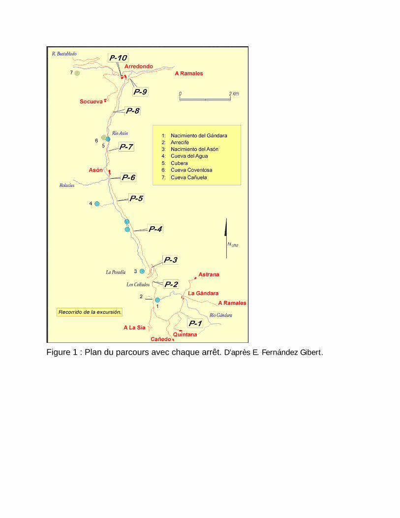
Figure 1 : Plan du parcours avec chaque arrêt. D’après E. Fernández Gibert.
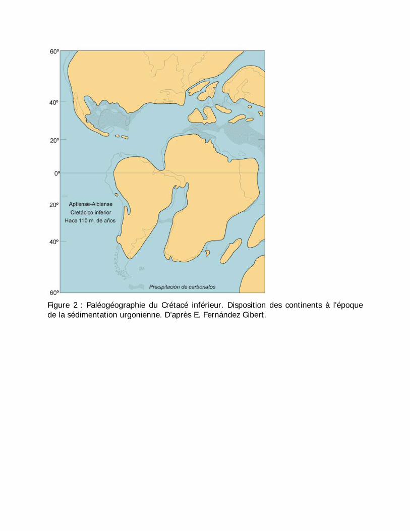
Figure 2 : Paléogéographie du Crétacé inférieur. Disposition des continents à l'époque de la sédimentation urgonienne. D’après E. Fernández Gibert.
La Géologie du Haute Asón
Les roches sédimentaires présentes dans la région font partie de le
Complexe Urgonienne, du Crétacé inférieur. Ils se sont déposés il y a quelque
110 millions d'années. À cette époque, la zone était un littoral d’eaux peu
profondes et climat chaud, avec des changements fréquents dans le niveau de
mer (FIGURE 2). Cela a donné lieu à une importante variation dans le type de
sédimentation tant en horizontale comme tout au long du temps (dans la
verticale). Dans les secteurs les plus proches à la côte on a déposé du matériel
détritique (sables, qui ont fini par être transformé sablonneuses); dans les zones
d'eaux peu profondes, on a accumulé des carbonates d'origine organique (qui ont
postérieurement donné lieu à des calcaires); finalement, dans les eaux les plus
profondes on a déposé argiles et carbonates riches en matière organique, qui ont
donné lieu à des marnes. L'effondrement progressif de l'écorce pendant la
sédimentation, a permis qu'on dépose une grande épaisseur de matériels; on
arrive à dépasser les 4.000 m nous Verrons chacun de ces types de roche dans
les divers arrêts.
Durant des millions d'années, la zone est restée stable. Depuis le Tertiaire, la zone a connu un soulèvement tectonique progressif, responsable des plis, des failles et du relief que nous observons actuellement. Par conséquent, diverses vallées fluviales se sont mises en place, en creusant des gorges profondes. Ce processus a été fortement conditionné par la karstification. Lors des périodes les plus froides du Quaternaire, les glaciers ont aussi joué un rôle important.
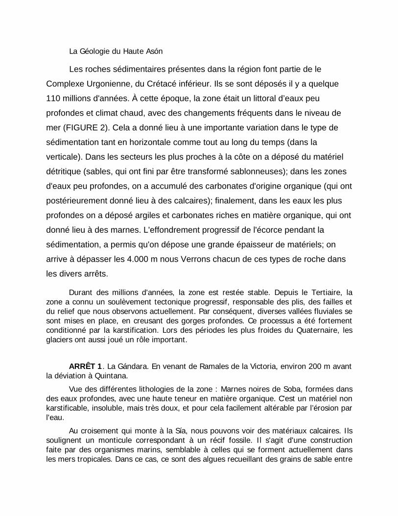
ARRÊT 1. La Gándara. En venant de Ramales de la Victoria, environ 200 m avant la déviation à Quintana.
Vue des différentes lithologies de la zone : Marnes noires de Soba, formées dans des eaux profondes, avec une haute teneur en matière organique. C'est un matériel non karstificable, insoluble, mais très doux, et pour cela facilement altérable par l’érosion par l'eau.
Au croisement qui monte à la Sía, nous pouvons voir des matériaux calcaires. Ils soulignent un monticule correspondant à un récif fossile. Il s'agit d'une construction faite par des organismes marins, semblable à celles qui se forment actuellement dans les mers tropicales. Dans ce cas, ce sont des algues recueillant des grains de sable entre
leurs filaments. Sur les deux pentes du monticule, on peut apprécier les couches inclinées (FIGURE 3).
Figure 3: Récif de la Gándara, au croisement de la route de la Sía. D’après Enrique Fernández Gibert.
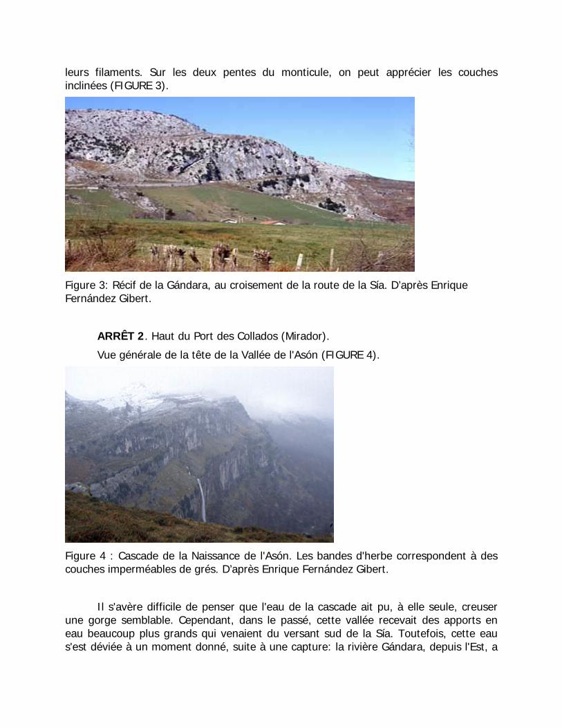
ARRÊT 2. Haut du Port des Collados (Mirador).
Vue générale de la tête de la Vallée de l'Asón (FIGURE 4).
Figure 4 : Cascade de la Naissance de l'Asón. Les bandes d'herbe correspondent à des couches imperméables de grés. D’après Enrique Fernández Gibert.
Il s'avère difficile de penser que l'eau de la cascade ait pu, à elle seule, creuser une gorge semblable. Cependant, dans le passé, cette vallée recevait des apports en eau beaucoup plus grands qui venaient du versant sud de la Sía. Toutefois, cette eau s'est déviée à un moment donné, suite à une capture: la rivière Gándara, depuis l'Est, a
facilement creusé les marnes de Soba jusqu'à couper le cours de l'Asón et prendre son eau. À peu de distance on trouve ses rapides spectaculaires, exemple de cette érosion.
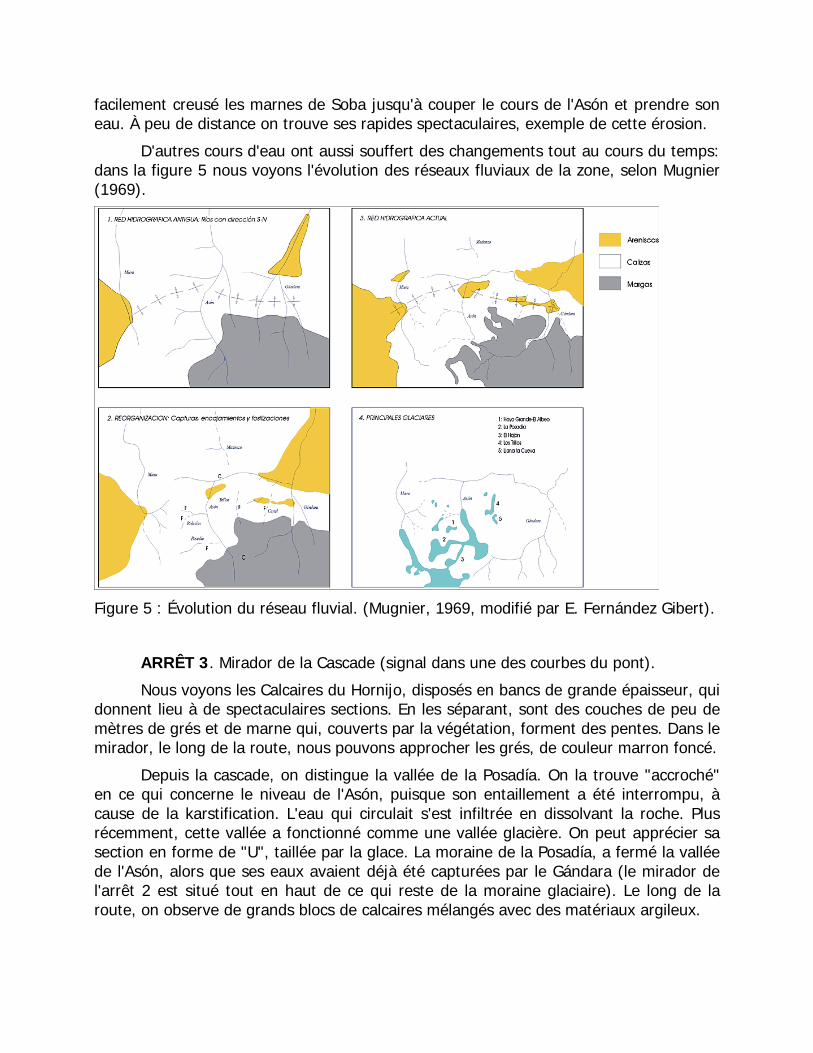
D'autres cours d'eau ont aussi souffert des changements tout au cours du temps: dans la figure 5 nous voyons l'évolution des réseaux fluviaux de la zone, selon Mugnier (1969).
Figure 5 : Évolution du réseau fluvial. (Mugnier, 1969, modifié par E. Fernández Gibert).
ARRÊT 3. Mirador de la Cascade (signal dans une des courbes du pont).
Nous voyons les Calcaires du Hornijo, disposés en bancs de grande épaisseur, qui donnent lieu à de spectaculaires sections. En les séparant, sont des couches de peu de mètres de grés et de marne qui, couverts par la végétation, forment des pentes. Dans le mirador, le long de la route, nous pouvons approcher les grés, de couleur marron foncé.
Depuis la cascade, on distingue la vallée de la Posadía. On la trouve "accroché" en ce qui concerne le niveau de l'Asón, puisque son entaillement a été interrompu, à cause de la karstification. L'eau qui circulait s'est infiltrée en dissolvant la roche. Plus récemment, cette vallée a fonctionné comme une vallée glacière. On peut apprécier sa section en forme de "U", taillée par la glace. La moraine de la Posadía, a fermé la vallée de l'Asón, alors que ses eaux avaient déjà été capturées par le Gándara (le mirador de l'arrêt 2 est situé tout en haut de ce qui reste de la moraine glaciaire). Le long de la route, on observe de grands blocs de calcaires mélangés avec des matériaux argileux.
En ce qui concerne les réseaux souterrains, nous dirons que la cascade de la Source de l'Asón est la surgescence du Système de Grand Trou (avec plus de 20 Km de développement). Comme on peut le voir, elle se trouve " accrochée "; en ce qui concerne le fond de la vallée, étant donné la présence des dits niveaux imperméables de marne et de grés. De ce côté de la rivière, la Grotte Rubicera présente une disposition identique, bien qu'ici l'eau souterraine, après avoir érodé ces couches imperméables, ait continué son entaillement dans les calcaires jusqu'au niveau de la rivière.
ARRÊT 4. Gisement de gravier (Km 7.1).
Il s'agit d'un réservoir colluvial: accumulation de matériel de l'érosion de la pente, tombé par gravité. Apparaissent des fragments des trois lithologies présentes dans la zone: calcaires, grés et marnes. On peut observer l’angulosité des fragments, qui indique un transport très faible. Ils sont localement cimentés par de la calcite, précipitée à partir de l'eau d'écoulement. On peut aussi observer des restes de fossiles dans les calcaires, ainsi que des grés de différente granulométrie.
La formation de ces réservoirs est très récente (dizaines de milliers d'années). Ils sont très poreux et peu compacts. Comme on peut le voir, ils ont été exploités comme stériles pour construction.
ARRÊT 5. Avant d'arriver à Asón (Km 5 ' 5).
Au fur et à mesure que nous avançons dans la coupe stratigraphique, nous voyons des matériaux progressivement plus anciens. Les bancs de calcaires présentent ici une épaisseur beaucoup plus petite que dans le mirador de la cascade. D'autre part, dans la partie moyenne de la pente, on distingue plusieurs récifs semblables à celui de la Gándara, bien que plus petits. À droite, tout en haut de la pente, alternent les calcaires (de couleur claire) et les grés (couverts par la végétation). Il s’agit des alentours de la Sima Tibia. Au-dessous apparaît un grand réservoir continu de grés correspondant à un delta fluvial (prés de la route, où la végétation le permet, ils peuvent être vus).
Au contact entre les deux unités, se développe le Système Aguas Sopladoras ("Eau-Souffleuses"), avec un parcours de plus de 8 Km et dont la surgescence est également trouvée "accroché" par rapport au niveau de l'Asón, comme cela se produisait avec la Cascade de la Naissance, puisque l'eau ne peut pas dissoudre les couches gréseuses.
ARRÊT 6. Localité d'Asón (Km 4.5).
Vue panoramique du Barranco de Rolacías, affluent de la Rivière Asón depuis l'Ouest. En étant creusé dans les grés, au contraire de la Posadía, ses eaux ne se sont
pas infiltrées, et sont descendues jusqu'au niveau de l'Asón. Sa section en "V" indique une origine fluviale.
Bien qu'il ne puisse pas être vu depuis ce lieu, la tête de ce barranco est creusée dans des calcaires, et des pertes souterraines se sont produites, qui ont interrompu l'installation de son lit. Cela a produit un "étage"; dans le profil de la vallée. A la base de ce dernier, dans le contact avec les grés, on trouve la Grotte de la Rivière Munío.
ARRÊT 7. Dans le pont, avant de croiser la Rivière Asón.
Les couches de grés du complexe deltaïque passent latéralement à des calcaires, d'une manière spectaculaire (Peña Lavalle). Contrairement aux calcaires observés préalablement, ceux-ci possèdent un caractère massif, sans aucune intercalation ni de marnes ni de grés (Calcaires de Picones).
Pour cette raison, contrairement à ce qui se passait avec le Réseau de Gran Hoyo (Grand Trou) ou le Système de Aguas Sopladoras, le réseau souterrain développé ici (Système Cueto-Coventosa) s’est installé progressivement au fur et à mesure que le faisait la Rivière Asón, en donnant lieu à différents "étages" avec un développement vertical de plus de 200 m. A l'étage inférieur, circule actuellement le cours actif, qui resurgie dans la Cubera.
ARRÊT 8. (Km 2.0)
Sous les Calcaires de Picones on trouve des roches sédimentaires du Purbeck-Weald. Il s'agit de matériaux imperméables (argiles et grés), non karstificables, déposés en faciès continental, beaucoup plus anciens que tout ce qui a été vu jusqu'à présent. Ils sont soulignés dans la pente Est, face à la route, étant couverts de prés.
ARRÊT 9. Dans le croisement d'Arredondo, nous tournons à droite (direction Ramales), en nous arrêtant juste après avoir croisé le pont.
On observe la structure pliée des matériaux, plus concrètement le pli anticlinal visible sur l'Arredondo. La coupe que nous avons effectuée se trouvait dans le flanc Sud de ce pli. Depuis ce lieu vers le Nord, l'immersion des couches est inverse (FIGURE 6).
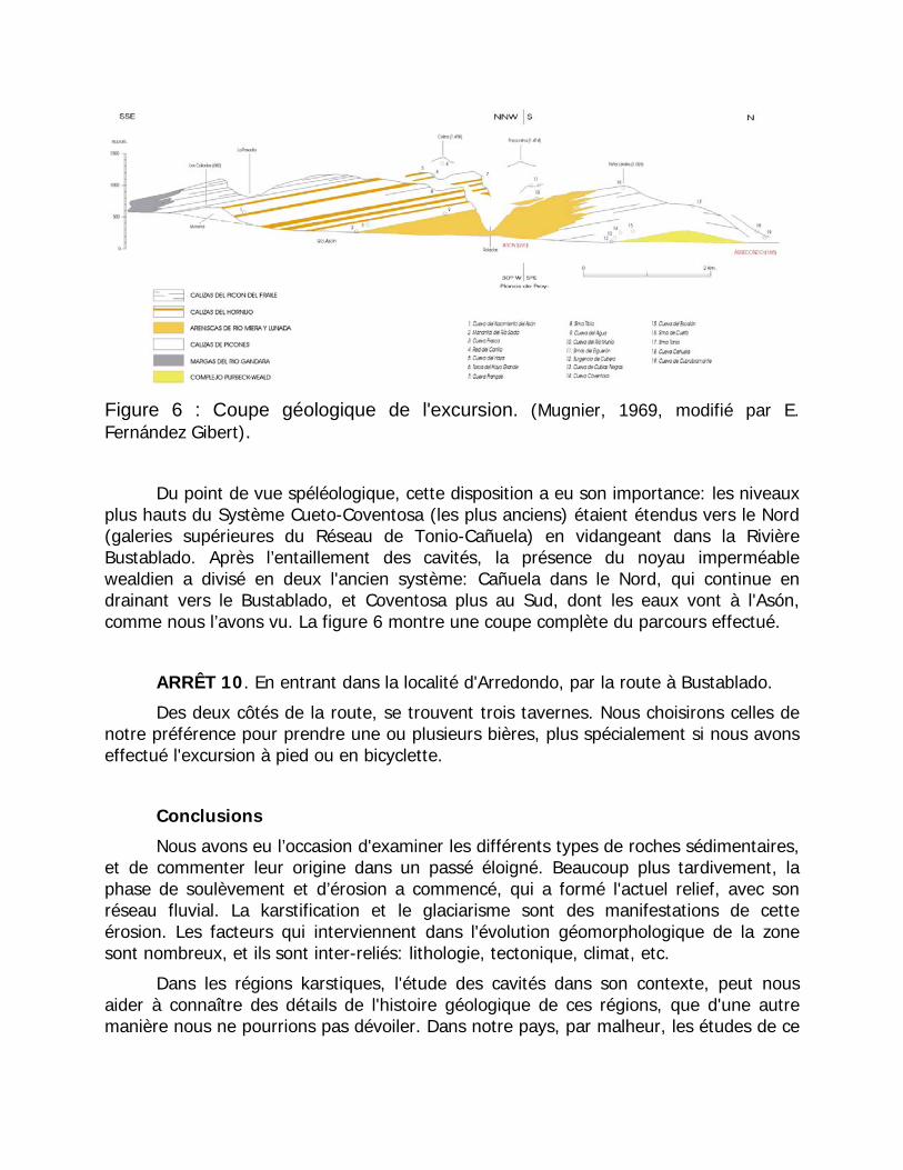
Figure 6 : Coupe géologique de l'excursion. (Mugnier, 1969, modifié par E. Fernández Gibert).
Du point de vue spéléologique, cette disposition a eu son importance: les niveaux plus hauts du Système Cueto-Coventosa (les plus anciens) étaient étendus vers le Nord (galeries supérieures du Réseau de Tonio-Cañuela) en vidangeant dans la Rivière Bustablado. Après l’entaillement des cavités, la présence du noyau imperméable wealdien a divisé en deux l'ancien système: Cañuela dans le Nord, qui continue en drainant vers le Bustablado, et Coventosa plus au Sud, dont les eaux vont à l'Asón, comme nous l’avons vu. La figure 6 montre une coupe complète du parcours effectué.
ARRÊT 10. En entrant dans la localité d'Arredondo, par la route à Bustablado.
Des deux côtés de la route, se trouvent trois tavernes. Nous choisirons celles de notre préférence pour prendre une ou plusieurs bières, plus spécialement si nous avons effectué l'excursion à pied ou en bicyclette.
Conclusions
Nous avons eu l’occasion d'examiner les différents types de roches sédimentaires, et de commenter leur origine dans un passé éloigné. Beaucoup plus tardivement, la phase de soulèvement et d’érosion a commencé, qui a formé l'actuel relief, avec son réseau fluvial. La karstification et le glaciarisme sont des manifestations de cette érosion. Les facteurs qui interviennent dans l'évolution géomorphologique de la zone sont nombreux, et ils sont inter-reliés: lithologie, tectonique, climat, etc.
Dans les régions karstiques, l'étude des cavités dans son contexte, peut nous aider à connaître des détails de l'histoire géologique de ces régions, que d'une autre manière nous ne pourrions pas dévoiler. Dans notre pays, par malheur, les études de ce
type ne sont pas nombreuses, malgré l'abondance des volumes karstiques de première ampleur.
La Grotte de l'Eau d'Asón, est développée dans la base de la couche inférieure des Calcaires du Hornijo, au contact avec les grés de Miera-Lunada. Ceux-ci ont empêché son creusement jusqu'au niveau de la rivière. Auteur : © AER.
Bibliographie
GARCIA-MONDEJAR, J. & PUJALTE, V. (1981): Jurásico superior y Cretácico inferior de la Región Vasco-Cantábrica (Parte Occidental). Santander, Burgos y Palencia. Universidad del País Vasco. 133 p.
MUGNIER, C. (1969): El karst de la Región de Asón y su evolución morfológica. Cuadernos de Espel. 4: 139 p.
SPELEO-CLUB DE PARIS & CLUB ALPIN FRANÇAIS (1989): Trente années d’exploration dans le Cueto et la Coventosa (Cantabrie, Espagne). Mémoires du Spéléo-club de Paris 15: 114 p.
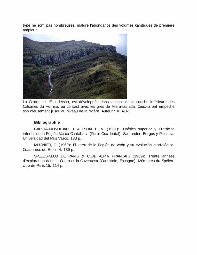
Vue panoramique du Massis de Mortillano. Dans la partie supérieure, les calcaires du Hornijo, forment une grande coupe. Au-dessous (vert foncé), les grés de Miera-Lunada passent aux Calcaires de Picones (côté gauche). Auteur : © J.A. Ortega.
Le monde souterrain du Parc Naturel des Collados de l'Asón Par Pedro Merino Múgica, miembro de la Asociación Espeleológica de Ramales
(AER). mayo de 2008
Plus de cinq décennies d'explorations
L'exploration de ce monde hypogée complexe n'est pas chose d’aujourd’hui. De fait, les premières explorations spéléologiques (sans parler d'entrées ponctuelles de voisins et curieux) datent de fin des années 1950. Des spéléologues venus de France ont été les pionniers dans l'exploration de celui-ci et d'autres massifs de Cantabria, en entamant un chemin qui ne sera pas abandonné, étant progressivement accompagnés par des explorateurs nationaux. Ainsi, entre ces pionniers doivent être mentionnés le Speleo Club de Dijon, ou le SSB. Mais certainement Claude Mugnier est l’une des personnes les plus renommées de cette première époque des explorations, qui avec sa thèse « La région de l'Asón et son évolution morphologique » a réalisé une étude complète du secteur, en soulignant l'importance de ses réseaux souterrains. Bien qu'aujourd'hui dépassée dans beaucoup de ses aspects, elle reste encore une œuvre valable pour connaître dans les grandes lignes l'évolution géologique du Haut Asón.
Toutefois, les années et les progrets de la technique ont permis, durant ces dernières décennies, que la connaissance des cavités du Haut Asón ait augmenté exponentiellement. Cette connaissance n'a fait que confirmer quelque chose qui avait déjà été deviné: l'importance non seulement au niveau national, mais mondial, des processus karstiques de ces lieux. Les nombres parlent d’eux-même: dans le Parc Naturel des Collados de l'Asón, on trouve les secondes et septièmes plus grandes cavités de la Péninsule. La majorité des explorateurs considèrent qu'il est seulement question de temps (et pas de beaucoup), pour que la zone du Haut Asón héberge la plus grande cavité d'Espagne. Effectivement, tandis que le système souterrain qui occupe aujourd'hui la tête de la liste (Ojo Guareña, dans le nord de Burgos, avec 110 km) ne se développe plus, les cavités du secteur croissent sans cesse. De toute évidence, deux systèmes perdront, dans un futur proche, l'honneur d'être les plus grandes cavités espagnoles: le Réseau du Mortillano, avec plus de 103 km explorés actuellement, et le Réseau du Gándara (le Massif du Porracolina), qui dépasse les 93 km.
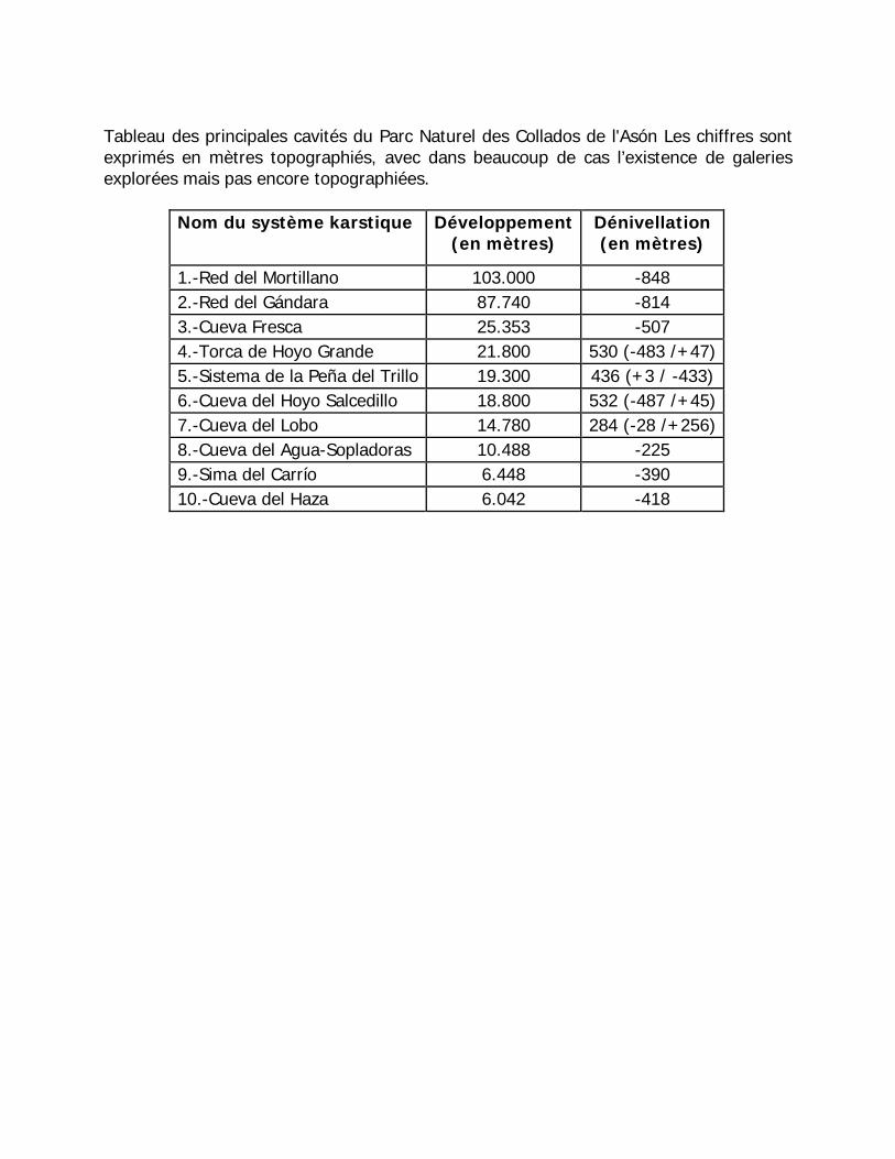
Tableau des principales cavités du Parc Naturel des Collados de l'Asón Les chiffres sont exprimés en mètres topographiés, avec dans beaucoup de cas l’existence de galeries explorées mais pas encore topographiées.
Nom du système karstique Développement (en mètres)
Dénivellation (en mètres)
1.-Red del Mortillano 103.000 -848 2.-Red del Gándara 87.740 -814 3.-Cueva Fresca 25.353 -507 4.-Torca de Hoyo Grande 21.800 530 (-483 /+47) 5.-Sistema de la Peña del Trillo 19.300 436 (+3 / -433) 6.-Cueva del Hoyo Salcedillo 18.800 532 (-487 /+45) 7.-Cueva del Lobo 14.780 284 (-28 /+256) 8.-Cueva del Agua-Sopladoras 10.488 -225 9.-Sima del Carrío 6.448 -390 10.-Cueva del Haza 6.042 -418
Les gisements de la Sierra de Atapuerca (voir Cuenca-Bescós & García, 2007, Carbonell et al., 2008, Berger et al., 2008, Blain et al., 2008)
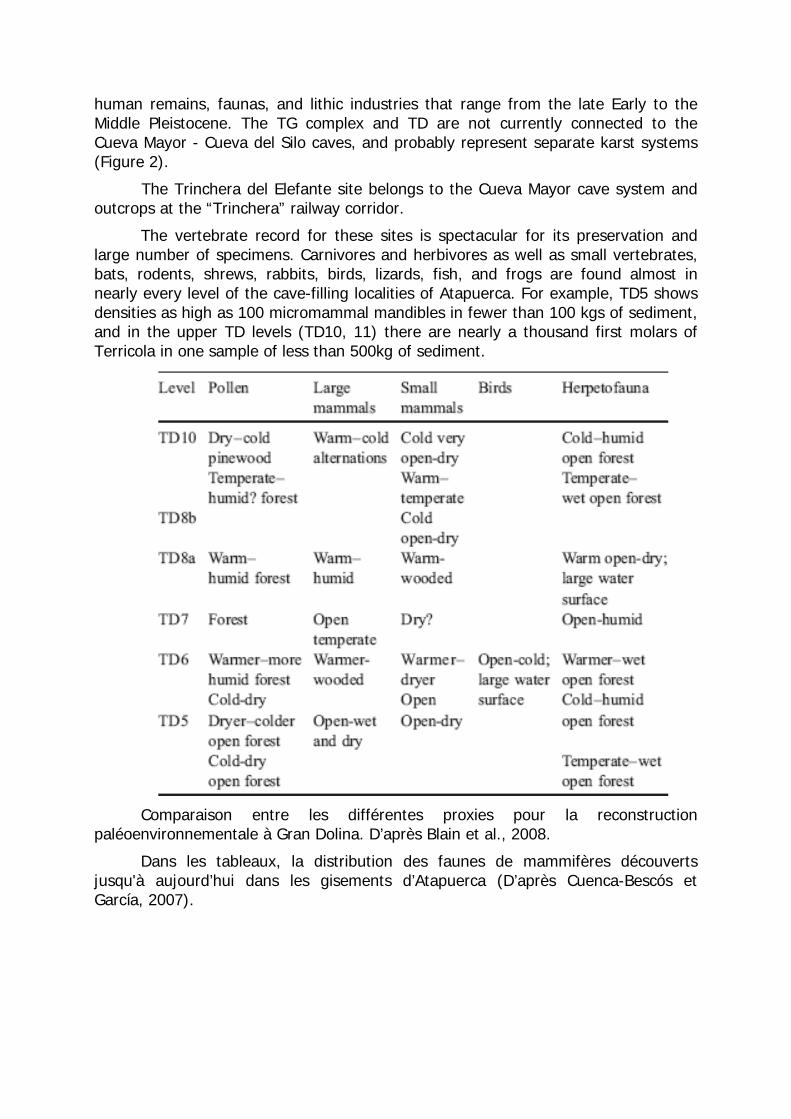
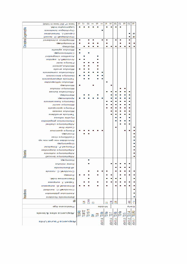
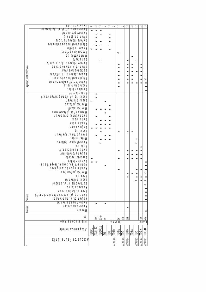
The Atapuerca cave localities (Gran Dolina -TD-, Trinchera Galería -TG-, Trinchera Elefante -TE-, Sima de los Huesos-SH-) represent one of the best records of the fauna of the Pleistocene in Europe. The sites outcrop at long and stratigraphic well documented sections, ranging from the Early to the Middle Pleistocene, with an impressive fossil contents as well as lithic industries that provide an insight into the earliest record of humans and their activities in Western Europe (cannibalism, earliest burial, food processing). The stratigraphic distribution of the mammals at the Atapuerca sites reveals 6 different local faunal assemblages, that are here defined as the Atapuerca faunal units (ATA FU), with their lower and/or upper limits characterized by the first or last appearance data (FAD and LAD respectively) of particular mammalian taxa. Moreover, the Sierra de Atapuerca sites are well known for their hominid-bearing localities of Early to Middle Pleistocene age. Level 6 of Gran Dolina (TD) site has yielded the oldest fossil hominid in Western Europe, Homo antecessor, dated to around 800 ka BP by a complex application of paleomagnetism, radiometric analysis and biostratigraphy. Thus, the level TD& characterizes the ATA FU 4. The Sierra de Atapuerca also yields the best collection of fossil hominids ever unearthed from a Middle Pleistocene site, the Homo heidelbergensis fossil remains from Sima de los Huesos (SH) and Trinchera Galería (TG). The Sima de los Huesos site, has an age of 530 ka B.P. SH and TG are refered to ATA FU 6. Other vertebrate record of the Atapuerca sites is spectacular for its preservation and number of specimens. Large carnivores and herbivores, small mammals, as well as birds, lizards, fishes, and frogs are found almost in every level of the cave-sections of Atapuerca. Up to date, 101 taxa belonging to 9 orders, 27 families and 61 genera are recorded at the Atapuerca cave localities. The research of the last decade at the sites of the Atapuerca Hill (Sierra de Atapuerca, Burgos, North-west Spain) has contributed significantly to our understanding of human evolution in Europe during the Early and Middle Pleistocene. The earliest fossil human remains in Western Europe were excavated in 1994 from level 6 of the Gran Dolina (also named Trinchera Dolina in some works) site. Gran Dolina level 6 (TD6) has yielded an important collection of fossil human remains assigned to Homo antecessor and lithic artefacts. This layer occurs just below the record of the Matuyama/Brunhes palaeomagnetic boundary, indicating an age older than 780 B.P. ka for that level, most precisely 900 Kyr. This locality has also produced abundant micro- and macromammal remains. Human presence has also been identified at other levels of the sequence (TD4, TD5, TD10 and TD11) by stone tools and human-modified ungulate remains.
The Sierra de Atapuerca also yields the best collection of fossil hominids ever unearthed from a Middle Pleistocene site, the Homo heidelbergensis fossil remains from Sima de los Huesos (SH) and Trinchera Galería (TG). Given the importance of these paleontological and archaeological discoveries, the geology, stratigraphy, geomorphology, magnetostratigraphy, radiometric ages and bioestratigraphy have been well analysed by the Atapuerca team.
Voir les publications fournies dans le CD.
The 103 mammalian taxa represented at the Atapuerca cave localities belong to 9 different orders: Primates, Carnivora, Arctiodactyla, Perissodactyla, Proboscidea, Insectivora, Rodentia, Quiroptera and Lagomorpha.
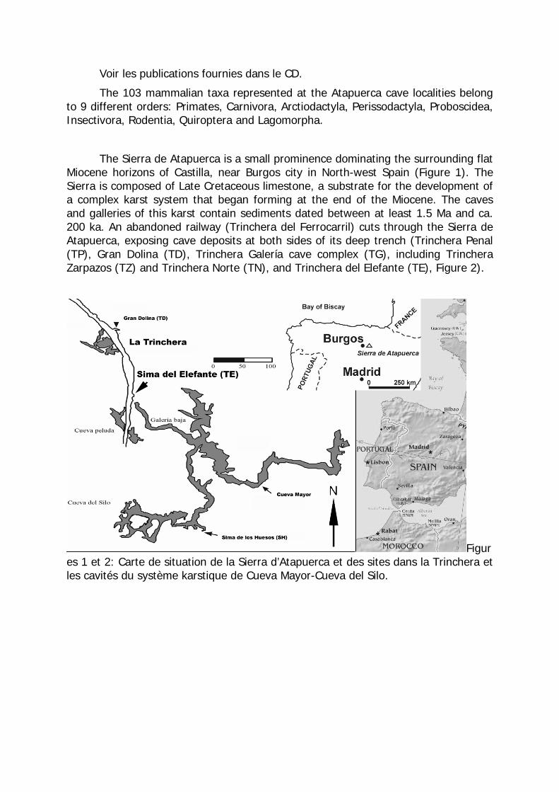
The Sierra de Atapuerca is a small prominence dominating the surrounding flat Miocene horizons of Castilla, near Burgos city in North-west Spain (Figure 1). The Sierra is composed of Late Cretaceous limestone, a substrate for the development of a complex karst system that began forming at the end of the Miocene. The caves and galleries of this karst contain sediments dated between at least 1.5 Ma and ca. 200 ka. An abandoned railway (Trinchera del Ferrocarril) cuts through the Sierra de Atapuerca, exposing cave deposits at both sides of its deep trench (Trinchera Penal (TP), Gran Dolina (TD), Trinchera Galería cave complex (TG), including Trinchera Zarpazos (TZ) and Trinchera Norte (TN), and Trinchera del Elefante (TE), Figure 2).
Figures 1 et 2: Carte de situation de la Sierra d’Atapuerca et des sites dans la Trinchera et les cavités du système karstique de Cueva Mayor-Cueva del Silo.
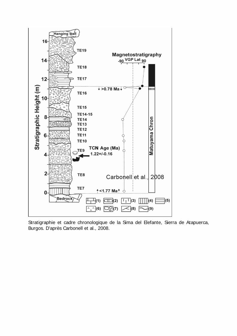
Stratigraphie et cadre chronologique de la Sima del Elefante, Sierra de Atapuerca, Burgos. D’après Carbonell et al., 2008.
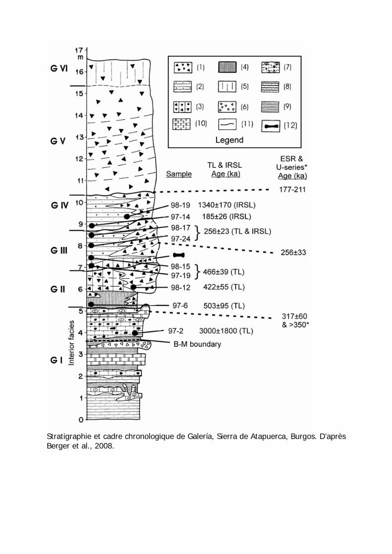
Stratigraphie et cadre chronologique de Galería, Sierra de Atapuerca, Burgos. D’après Berger et al., 2008.
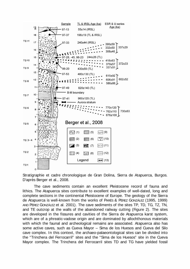
Stratigraphie et cadre chronologique de Gran Dolina, Sierra de Atapuerca, Burgos. D’après Berger et al., 2008.
The cave sediments contain an excellent Pleistocene record of fauna and lithics. The Atapuerca sites contribute to excellent examples of well-dated, long and complete sections in the continental Pleistocene of Europe. The geology of the Sierra de Atapuerca is well-known from the works of PARÉS & PÉREZ GONZÁLEZ (1995, 1999) AND PÉREZ GONZÁLEZ et al. 2001). The cave sediments of the sites TP, TD, TG, TZ, TN, and TE outcrop at the walls of the abandoned railway cutting (Figure 2). The sites are developed in the fissures and cavities of the Sierra de Atapuerca karst system, which are of a phreatic-vadose origin and are dominated by allochthonous materials with which the faunal and archeological remains are associated. Atapuerca also has some active caves, such as Cueva Mayor – Sima de los Huesos and Cueva del Silo cave complex. In this context, the archaeo-palaeontological sites can be divided into the “Trinchera del Ferrocarril” sites and the “Sima de los Huesos” site in the Cueva Mayor complex. The Trinchera del Ferrocarril sites TD and TG have yielded fossil
human remains, faunas, and lithic industries that range from the late Early to the Middle Pleistocene. The TG complex and TD are not currently connected to the Cueva Mayor - Cueva del Silo caves, and probably represent separate karst systems (Figure 2).
The Trinchera del Elefante site belongs to the Cueva Mayor cave system and outcrops at the “Trinchera” railway corridor.
The vertebrate record for these sites is spectacular for its preservation and large number of specimens. Carnivores and herbivores as well as small vertebrates, bats, rodents, shrews, rabbits, birds, lizards, fish, and frogs are found almost in nearly every level of the cave-filling localities of Atapuerca. For example, TD5 shows densities as high as 100 micromammal mandibles in fewer than 100 kgs of sediment, and in the upper TD levels (TD10, 11) there are nearly a thousand first molars of Terricola in one sample of less than 500kg of sediment.
Comparaison entre les différentes proxies pour la reconstruction
paléoenvironnementale à Gran Dolina. D’après Blain et al., 2008.
Dans les tableaux, la distribution des faunes de mammifères découverts jusqu'à aujourd’hui dans les gisements d’Atapuerca (D’après Cuenca-Bescós et García, 2007).
TEUR
Ucf
cfcf
7
TG III
TZ0.2
514
TD 10
-110.3
-0.4
cfcf
cf13
SH0.5
9
TG II
cf13
TD 8b
0
TD 8a
0.6cf
12
TD 7
0.78
0
ATA F
U 4TD
6b0.8
513
TD 6a
12
TD 5
cfcf
spcf
12
ATA F
U 2TD
3-4
~0.9
13
ATA F
U 1TE
LRU
~1.4
aff.cf
cfcf
cf15
ATA F
U 3
Earl
ºCa
rnivora
Atapuerca Faunal Units
Atapuerca levels
Pleistocene Age
Ma Macaca Homo antecessor Homo heidelbergensis Vulpes cf. V. alopecoides Canis sp. (C. arnensis/mosbachensis) Lynx cf. issiodorensis Pannonictis sp. Baranogale cf. B. antiqua Ursus dolinensis Lynx sp. Mustela palerminea Panthera gombaszoegensis Panthera sp. (jaguar/ leopard size) Canidae indet. Crocuta crocuta Vulpes praeglacialis Canis mosbachensis Felis sp. Homotherium latidens Meles meles Lynx pardinus spelaeus Ursus sp. Vulpes vulpes Panthera leo Canis lupus Cuon alpinus europaeus Martes cf. M. foina/martes Mustela nivalis Mustela putorius Ursus deningeri Ursus sp. (U. deningeri/spelaeus) Felis silvestris Cervidae indet. Hippopotamus sp. Dama "nestii" vallonnetensis Stephanorhinus etruscus Equus stenonis - E. altidens Eucladoceros giulii Bison cf. B. voigstedtensis Cervus elaphus cf. acoronatus Sus scrofa Mammuthus sp. Praeovibos priscus Equus caballus Stephanorhinus hemitoechus Cervus elaphus priscus Bison sp. (small) Hemitragus bonali Dama dama aff. D. d. clactoniana
49 = T º taxan
y
Ungul
ates a
nd Pro
boscid
eaPri
mates
Middle
ATA F
U 6
ATA F
U 5
Bref listing bibliographique, voir aussi CD. Arrizabalaga, A. 2005/2006. Las primeras ocupaciones humanas en el Pirineo
Occidental y Montes Vascos. Un estado de la cuestión en 2005. Munibe 57, 53-70
Berger, G.W. et al., Luminescence chronology of cave sediments at the Atapuerca paleoanthropological site, Spain, J. Hum. Evol. (2008), doi:10.1016/j.jhevol.2008.02.012
Bischoff, J.L.; Williams, R. W.; Rosenbauer, R.J.; Aramburu, A.; Arsuaga, J.L.; García, N.; Cuenca-Bescós, G. (2007). High-resolution U-series dates from the Sima de los Huesos hominids yields kyrs: Implications for the evolution of the early Neanderthals. Journal of Archaeological Science, 34, 763-770.
Blain, H.-A., Bailon, S., Cuenca-Bescós, G. 2008. The Early-Middle Pleistocene palaeoenvironmental change based on the squamate reptile and amphibian proxies at the Gran Dolina site, Atapuerca, Spain. Palaeogeography, Palaeoclimatology, Palaeocology, 261(1/2), 177-192.
Carbonell, E.; Bermúdez de Castro, J.M.; Parés, J.M.; Pérez-González, A.; Cuenca-Bescós, G.; Ollé, A.; Mosquera, M.; Huguet, R.; van der Made, J.; Rosas, A.; Sala, R.; Vallverdú, J.; García, N.; Granger, D.E.; Martinón-Torres, M.; Rodríguez, X.P.; Stock, G.M.; Vergès, J.M.; Allué, E.; Burjachs, F.; Cáceres, I.; Canals, A.; Benito, A.; Díez, C.; Lozano, M.; Mateos, A.; Navazo, M.; Rodríguez, J.; Rosell, J.; Arsuaga, J.L. (2008): The first hominin of Europe. Nature, London 452, 465-470.
Cuenca-Bescós, G.; García, N. 2007. Biostratigraphic succession on the Early and Middle Pleistocene mammal faunas of the Atapuerca cave sites (Burgos, Spain). Cour. Forsch.-Inst. Senckenberg. 259, 99-110.
Cuenca-Bescós, G., Straus, L. G., González Morales, M. R., García Pimienta, J.C. 2008: Paleoclima y paisaje del final del cuaternario en Cantabria: los pequeños mamíferos del Mirón (Ramales de la Victoria). Revista Española de Paleontología, 23, 91-126.
Falguères, C., Yokoyama, Y., Arrizabalaga, A. 2005/2006. La Geocronología del yacimiento pleistocénico de Lezetxiki (Arrasate, País Vasco). Crítica de las dataciones existentes y algunas nuevas aportaciones. Munibe, 57, 93-106.
Marín Arroyo, A.B., Landete Ruiz, M.D., Vidal Bernabeu, G., Seva Román, R, González Morales, M.R., Straus, L.G. 2007 Archaeological implications of human-derived manganese coatings: a study of blackened bones in El Mirón Cave, Cantabrian Spain. Journal of Archaeological Science 35, 801-813.
Straus, L.G. & González Morales, M. 2007. Further Radiocarbon dates for the Upper Paleolithic of El Mirón Cave (Ramales de la Victoria, Cantabria, Spain). Radiocarbon, 49, 1205-1214.