Embed Size (px)
Citation preview
Level 4 Diploma in Utility Mapping and Surveying
Qualification Specification
© ProQual 2016
July 2016 Level 4 Diploma in Utility Mapping and Surveying
2
Contents
Page
Introduction 3
Entry requirements 3
Qualification profile 4
Centre requirements 4
Support for candidates 5
Assessment 5
Internal quality assurance 5
Adjustments to assessment 5
Results enquiries and appeals 5
Certification 6
Learning Outcomes, Assessment Criteria and Assessment Requirements 7
July 2016 Level 4 Diploma in Utility Mapping and Surveying
3
Introduction
The ProQual Utility Mapping and Surveying suite of qualifications provides nationally recognised qualifications for those working in a surveying or construction environment. The Level 4 Diploma is aimed at those working in a utility detection and mapping supervisor role. The awarding body for this qualification is ProQual Awarding Body and the regulatory body is the Office of Qualifications and Examinations Regulation (Ofqual). The specification for these qualifications has been approved by the Welsh Government for use by centres in Wales and by the Council for the Curriculum Examinations and Assessment (CCEA) for use by centres in Northern Ireland. This qualification has been accredited onto the Regulated Qualifications Framework, and it provides a progression route to further qualifications in ProQual’s Utility Mapping and Surveying qualifications suite or other discipline-related qualifications.
Entry Requirements
Candidates should hold the ProQual Level 3 Certificate in Utility Mapping and Surveying before registering onto the Level 4 Diploma in Utility Mapping and Surveying. Centres should carry out an initial assessment of candidate skills and knowledge to identify any gaps and help plan the assessment.
Qualification Profile Level 4 Diploma in Utility Mapping and Surveying
Qualification title ProQual Level 4 Diploma in Utility Mapping and Surveying
Ofqual qualification number 601/8910/1
Level Level 4
Guided learning hours 210
Total qualification time 260 hours
Assessment Pass or fail Internally assessed and verified by centre staff External quality assurance by ProQual verifiers
Qualification start date 1/6/16
Qualification end date

July 2016 Level 4 Diploma in Utility Mapping and Surveying
4
Candidates must complete 4 Mandatory units.
Mandatory Units
Unit Reference Number
Unit Title Unit Level
H/507/1372 Site surveying procedures for construction and the built environment 4
K/507/1373 Establish and maintain the dimensional control and setting out of construction projects in geomatics and site surveying
4
M/507/1374 Establish and operate technical information systems in geomatics and site surveying management
5
T/507/1375 Identify, assess and present spatial data in geomatics and site surveying management
6
Centre Requirements Centres must be approved to offer this qualification. If your centre is not approved please complete and submit form ProQual Additional Qualification Approval Application. Staff Staff delivering this qualification must be appropriately qualified and occupationally competent. Assessors/Internal Quality Assurance For each competence-based unit centres must be able to provide at least one assessor and one internal quality assurance verifier who are suitably qualified for the specific occupational area. Assessors and internal quality assurance verifiers for competence-based qualifications will normally need to hold appropriate assessor or quality assurance verifier qualifications, such as:
Award in Assessing Competence in the Work Environment
Award in Assessing Vocationally Related Achievement
Certificate in Assessing Vocational Achievement
Award in the Internal Quality Assurance of Assessment Processes and Practices
Certificate in Leading the Internal Quality Assurance of Assessment Processes and Practices
Support for Candidates Materials produced by centres to support candidates should:
enable them to track their achievements as they progress through the learning outcomes and assessment criteria;
provide information on where ProQual’s policies and procedures can be viewed;
provide a means of enabling Internal and External Quality Assurance staff to authenticate evidence
July 2016 Level 4 Diploma in Utility Mapping and Surveying
5
Assessment This qualification must be assessed in a work environment by an appropriately experienced and qualified assessor. Learning outcomes set out what a candidate is expected to know, understand or be able to do. Assessment criteria specify the standard a candidate must meet to show the learning outcome has been achieved. Assessment guidance is provided with the unit learning outcomes and assessment criteria. For learning outcomes and assessment criteria for this qualification, see page 7.
Internal Quality Assurance An internal quality assurance verifier confirms that assessment decisions made in centres are made by competent and qualified assessors, that they are the result of sound and fair assessment practice and that they are recorded accurately and appropriately.
Adjustments to Assessment
Adjustments to standard assessment arrangements are made on the individual needs of candidates. ProQual’s Reasonable Adjustments Policy and Special Consideration Policy sets out the steps to follow when implementing reasonable adjustments and special considerations and the service that ProQual provides for some of these arrangements. Centres should contact ProQual for further information or queries about the contents of the policy.
Results Enquiries and Appeals All enquiries relating to assessment or other decisions should be dealt with by centres, with reference to ProQual’s Enquiries and Appeals Procedures.
July 2016 Level 4 Diploma in Utility Mapping and Surveying
6
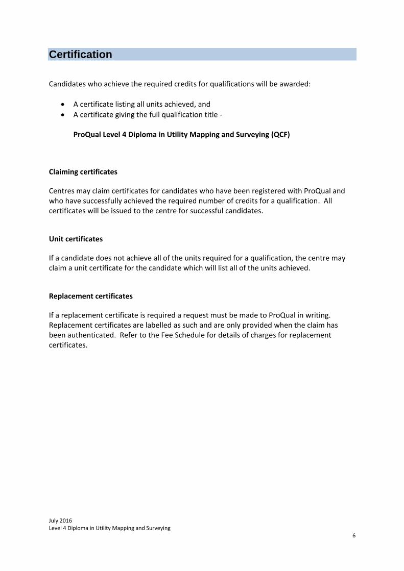
Certification
Candidates who achieve the required credits for qualifications will be awarded:
A certificate listing all units achieved, and
A certificate giving the full qualification title -
ProQual Level 4 Diploma in Utility Mapping and Surveying (QCF)
Claiming certificates
Centres may claim certificates for candidates who have been registered with ProQual and who have successfully achieved the required number of credits for a qualification. All certificates will be issued to the centre for successful candidates.
Unit certificates
If a candidate does not achieve all of the units required for a qualification, the centre may claim a unit certificate for the candidate which will list all of the units achieved.
Replacement certificates
If a replacement certificate is required a request must be made to ProQual in writing. Replacement certificates are labelled as such and are only provided when the claim has been authenticated. Refer to the Fee Schedule for details of charges for replacement certificates.
July 2016 Level 4 Diploma in Utility Mapping and Surveying
7
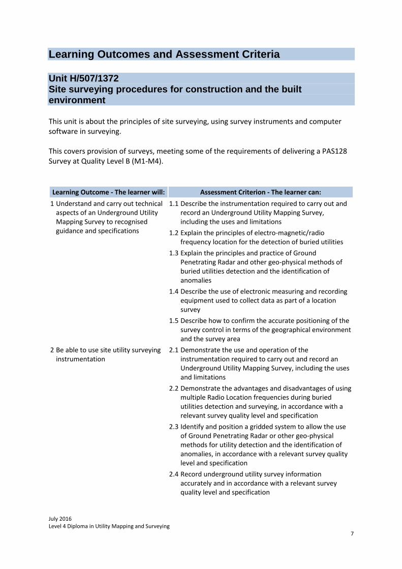
Learning Outcomes and Assessment Criteria Unit H/507/1372 Site surveying procedures for construction and the built environment This unit is about the principles of site surveying, using survey instruments and computer software in surveying. This covers provision of surveys, meeting some of the requirements of delivering a PAS128 Survey at Quality Level B (M1-M4).
Learning Outcome - The learner will: Assessment Criterion - The learner can:
1 Understand and carry out technical aspects of an Underground Utility Mapping Survey to recognised guidance and specifications
1.1 Describe the instrumentation required to carry out and record an Underground Utility Mapping Survey, including the uses and limitations
1.2 Explain the principles of electro-magnetic/radio frequency location for the detection of buried utilities
1.3 Explain the principles and practice of Ground Penetrating Radar and other geo-physical methods of buried utilities detection and the identification of anomalies
1.4 Describe the use of electronic measuring and recording equipment used to collect data as part of a location survey
1.5 Describe how to confirm the accurate positioning of the survey control in terms of the geographical environment and the survey area
2 Be able to use site utility surveying instrumentation
2.1 Demonstrate the use and operation of the instrumentation required to carry out and record an Underground Utility Mapping Survey, including the uses and limitations
2.2 Demonstrate the advantages and disadvantages of using multiple Radio Location frequencies during buried utilities detection and surveying, in accordance with a relevant survey quality level and specification
2.3 Identify and position a gridded system to allow the use of Ground Penetrating Radar or other geo-physical methods for utility detection and the identification of anomalies, in accordance with a relevant survey quality level and specification
2.4 Record underground utility survey information accurately and in accordance with a relevant survey quality level and specification
July 2016 Level 4 Diploma in Utility Mapping and Surveying
8
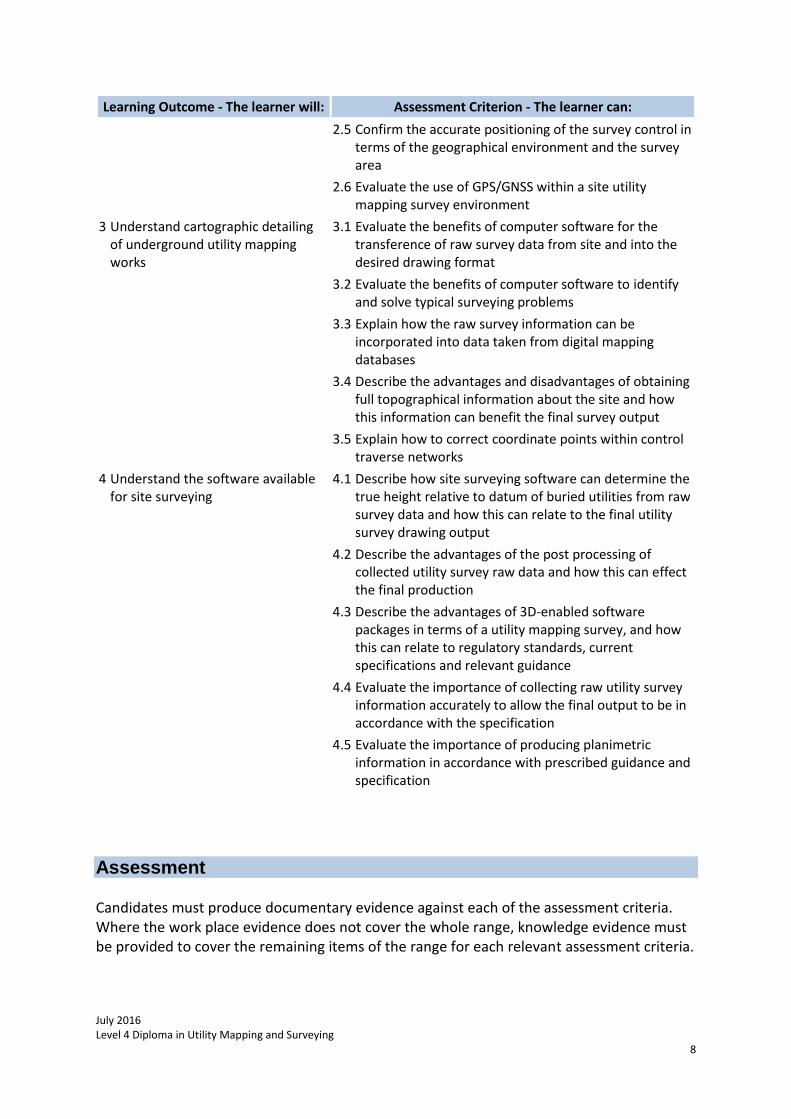
Learning Outcome - The learner will: Assessment Criterion - The learner can:
2.5 Confirm the accurate positioning of the survey control in terms of the geographical environment and the survey area
2.6 Evaluate the use of GPS/GNSS within a site utility mapping survey environment
3 Understand cartographic detailing of underground utility mapping works
3.1 Evaluate the benefits of computer software for the transference of raw survey data from site and into the desired drawing format
3.2 Evaluate the benefits of computer software to identify and solve typical surveying problems
3.3 Explain how the raw survey information can be incorporated into data taken from digital mapping databases
3.4 Describe the advantages and disadvantages of obtaining full topographical information about the site and how this information can benefit the final survey output
3.5 Explain how to correct coordinate points within control traverse networks
4 Understand the software available for site surveying
4.1 Describe how site surveying software can determine the true height relative to datum of buried utilities from raw survey data and how this can relate to the final utility survey drawing output
4.2 Describe the advantages of the post processing of collected utility survey raw data and how this can effect the final production
4.3 Describe the advantages of 3D-enabled software packages in terms of a utility mapping survey, and how this can relate to regulatory standards, current specifications and relevant guidance
4.4 Evaluate the importance of collecting raw utility survey information accurately to allow the final output to be in accordance with the specification
4.5 Evaluate the importance of producing planimetric information in accordance with prescribed guidance and specification
Assessment Candidates must produce documentary evidence against each of the assessment criteria. Where the work place evidence does not cover the whole range, knowledge evidence must be provided to cover the remaining items of the range for each relevant assessment criteria.
July 2016 Level 4 Diploma in Utility Mapping and Surveying
9
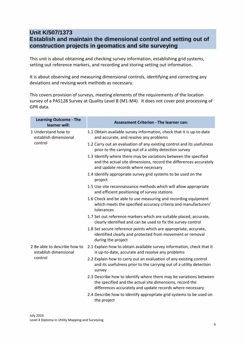
Unit K/507/1373 Establish and maintain the dimensional control and setting out of construction projects in geomatics and site surveying This unit is about obtaining and checking survey information, establishing grid systems, setting out reference markers, and recording and storing setting out information. It is about observing and measuring dimensional controls, identifying and correcting any deviations and revising work methods as necessary. This covers provision of surveys, meeting elements of the requirements of the location survey of a PAS128 Survey at Quality Level B (M1-M4). It does not cover post processing of GPR data.
Learning Outcome - The learner will:
Assessment Criterion - The learner can:
1 Understand how to establish dimensional control
1.1 Obtain available survey information, check that it is up-to-date and accurate, and resolve any problems
1.2 Carry out an evaluation of any existing control and its usefulness prior to the carrying out of a utility detection survey
1.3 Identify where there may be variations between the specified and the actual site dimensions, record the differences accurately and update records where necessary
1.4 Identify appropriate survey grid systems to be used on the project
1.5 Use site reconnaissance methods which will allow appropriate and efficient positioning of survey stations
1.6 Check and be able to use measuring and recording equipment which meets the specified accuracy criteria and manufacturers' tolerances
1.7 Set out reference markers which are suitable placed, accurate, clearly identified and can be used to fix the survey control
1.8 Set secure reference points which are appropriate, accurate, identified clearly and protected from movement or removal during the project
2 Be able to describe how to establish dimensional control
2.1 Explain how to obtain available survey information, check that it is up-to-date, accurate and resolve any problems
2.2 Explain how to carry out an evaluation of any existing control and its usefulness prior to the carrying out of a utility detection survey
2.3 Describe how to identify where there may be variations between the specified and the actual site dimensions, record the differences accurately and update records where necessary
2.4 Describe how to identify appropriate grid systems to be used on the project
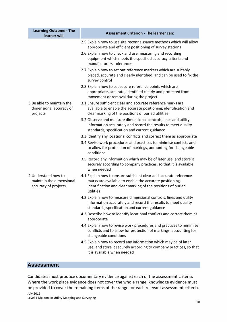
July 2016 Level 4 Diploma in Utility Mapping and Surveying
10
Learning Outcome - The learner will:
Assessment Criterion - The learner can:
2.5 Explain how to use site reconnaissance methods which will allow appropriate and efficient positioning of survey stations
2.6 Explain how to check and use measuring and recording equipment which meets the specified accuracy criteria and manufacturers' tolerances
2.7 Explain how to set out reference markers which are suitably placed, accurate and clearly identified, and can be used to fix the survey control
2.8 Explain how to set secure reference points which are appropriate, accurate, identified clearly and protected from movement or removal during the project
3 Be able to maintain the dimensional accuracy of projects
3.1 Ensure sufficient clear and accurate reference marks are available to enable the accurate positioning, identification and clear marking of the positions of buried utilities
3.2 Observe and measure dimensional controls, lines and utility information accurately and record the results to meet quality standards, specification and current guidance
3.3 Identify any locational conflicts and correct them as appropriate
3.4 Revise work procedures and practices to minimise conflicts and to allow for protection of markings, accounting for changeable conditions
3.5 Record any information which may be of later use, and store it securely according to company practices, so that it is available when needed
4 Understand how to maintain the dimensional accuracy of projects
4.1 Explain how to ensure sufficient clear and accurate reference marks are available to enable the accurate positioning, identification and clear marking of the positions of buried utilities
4.2 Explain how to measure dimensional controls, lines and utility information accurately and record the results to meet quality standards, specification and current guidance
4.3 Describe how to identify locational conflicts and correct them as appropriate
4.4 Explain how to revise work procedures and practices to minimise conflicts and to allow for protection of markings, accounting for changeable conditions
4.5 Explain how to record any information which may be of later use, and store it securely according to company practices, so that it is available when needed
Assessment Candidates must produce documentary evidence against each of the assessment criteria. Where the work place evidence does not cover the whole range, knowledge evidence must be provided to cover the remaining items of the range for each relevant assessment criteria.
July 2016 Level 4 Diploma in Utility Mapping and Surveying
11
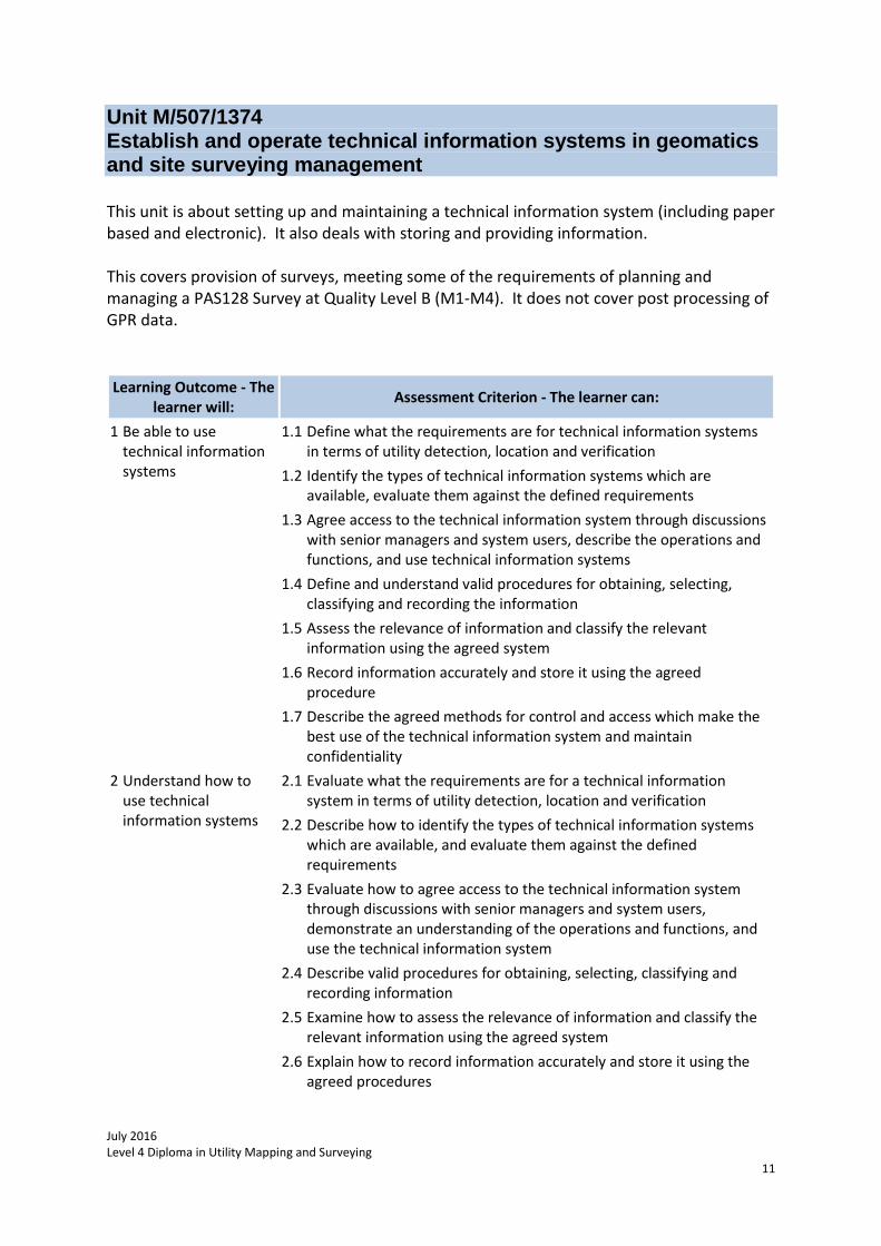
Unit M/507/1374 Establish and operate technical information systems in geomatics and site surveying management This unit is about setting up and maintaining a technical information system (including paper based and electronic). It also deals with storing and providing information. This covers provision of surveys, meeting some of the requirements of planning and managing a PAS128 Survey at Quality Level B (M1-M4). It does not cover post processing of GPR data.
Learning Outcome - The learner will:
Assessment Criterion - The learner can:
1 Be able to use technical information systems
1.1 Define what the requirements are for technical information systems in terms of utility detection, location and verification
1.2 Identify the types of technical information systems which are available, evaluate them against the defined requirements
1.3 Agree access to the technical information system through discussions with senior managers and system users, describe the operations and functions, and use technical information systems
1.4 Define and understand valid procedures for obtaining, selecting, classifying and recording the information
1.5 Assess the relevance of information and classify the relevant information using the agreed system
1.6 Record information accurately and store it using the agreed procedure
1.7 Describe the agreed methods for control and access which make the best use of the technical information system and maintain confidentiality
2 Understand how to use technical information systems
2.1 Evaluate what the requirements are for a technical information system in terms of utility detection, location and verification
2.2 Describe how to identify the types of technical information systems which are available, and evaluate them against the defined requirements
2.3 Evaluate how to agree access to the technical information system through discussions with senior managers and system users, demonstrate an understanding of the operations and functions, and use the technical information system
2.4 Describe valid procedures for obtaining, selecting, classifying and recording information
2.5 Examine how to assess the relevance of information and classify the relevant information using the agreed system
2.6 Explain how to record information accurately and store it using the agreed procedures
July 2016 Level 4 Diploma in Utility Mapping and Surveying
12
Learning Outcome - The learner will:
Assessment Criterion - The learner can:
2.7 Describe methods for control and access which make the best use of the technical information system and maintain confidentiality
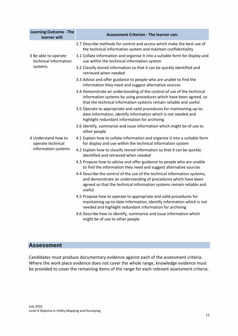
3 Be able to operate technical information systems
3.1 Collate information and organise it into a suitable form for display and use within the technical information system
3.2 Classify stored information so that it can be quickly identified and retrieved when needed
3.3 Advise and offer guidance to people who are unable to find the information they need and suggest alternative sources
3.4 Demonstrate an understanding of the control of use of the technical information systems by using procedures which have been agreed, so that the technical information systems remain reliable and useful
3.5 Operate to appropriate and valid procedures for maintaining up-to-date information, identify information which is not needed and highlight redundant information for archiving
3.6 Identify, summarise and issue information which might be of use to other people
4 Understand how to operate technical information systems
4.1 Explain how to collate information and organise it into a suitable form for display and use within the technical information system
4.2 Explain how to classify stored information so that it can be quickly identified and retrieved when needed
4.3 Propose how to advise and offer guidance to people who are unable to find the information they need and suggest alternative sources
4.4 Describe the control of the use of the technical information systems, and demonstrate an understanding of procedures which have been agreed so that the technical information systems remain reliable and useful
4.5 Propose how to operate to appropriate and valid procedures for maintaining up-to-date information, identify information which is not needed and highlight redundant information for archiving
4.6 Describe how to identify, summarise and issue information which might be of use to other people
Assessment Candidates must produce documentary evidence against each of the assessment criteria. Where the work place evidence does not cover the whole range, knowledge evidence must be provided to cover the remaining items of the range for each relevant assessment criteria.
July 2016 Level 4 Diploma in Utility Mapping and Surveying
13
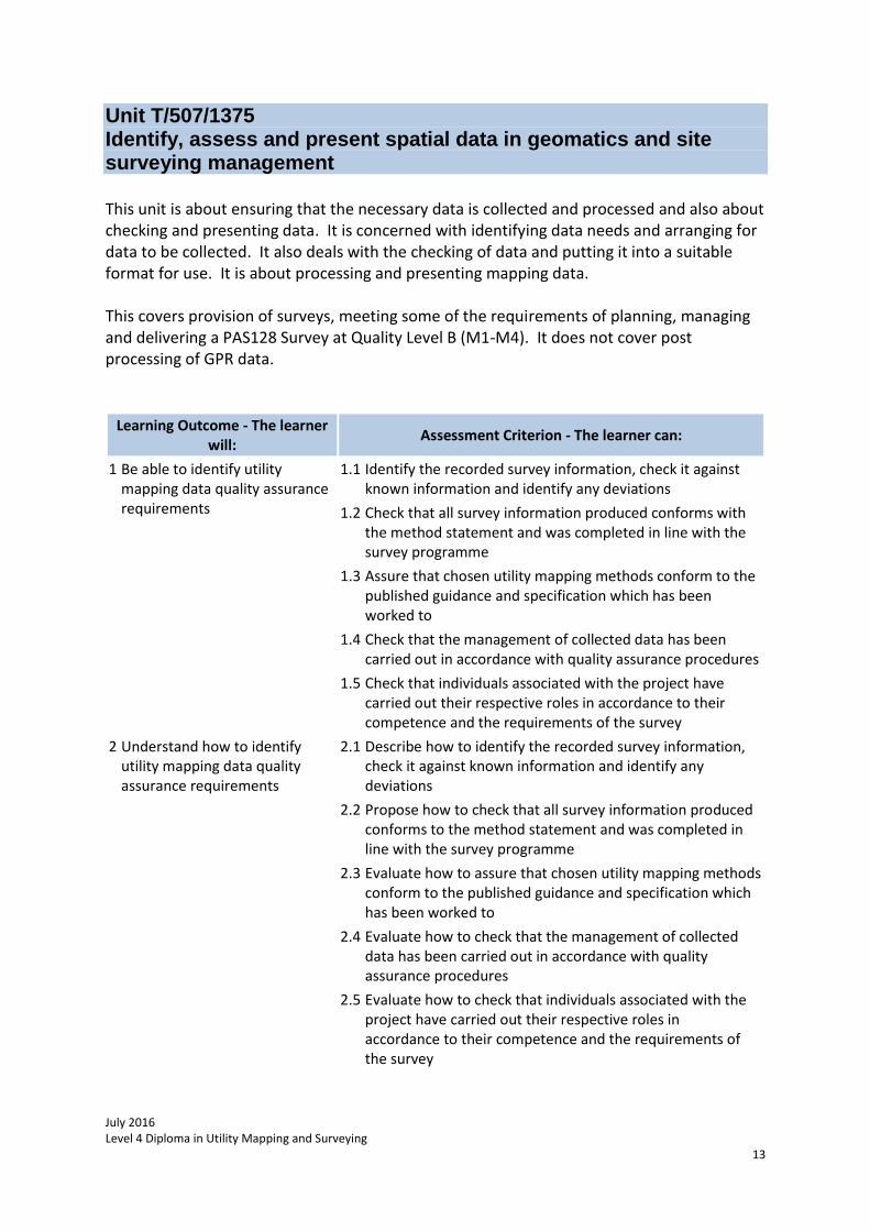
Unit T/507/1375 Identify, assess and present spatial data in geomatics and site surveying management This unit is about ensuring that the necessary data is collected and processed and also about checking and presenting data. It is concerned with identifying data needs and arranging for data to be collected. It also deals with the checking of data and putting it into a suitable format for use. It is about processing and presenting mapping data. This covers provision of surveys, meeting some of the requirements of planning, managing and delivering a PAS128 Survey at Quality Level B (M1-M4). It does not cover post processing of GPR data.
Learning Outcome - The learner will:
Assessment Criterion - The learner can:
1 Be able to identify utility mapping data quality assurance requirements
1.1 Identify the recorded survey information, check it against known information and identify any deviations
1.2 Check that all survey information produced conforms with the method statement and was completed in line with the survey programme
1.3 Assure that chosen utility mapping methods conform to the published guidance and specification which has been worked to
1.4 Check that the management of collected data has been carried out in accordance with quality assurance procedures
1.5 Check that individuals associated with the project have carried out their respective roles in accordance to their competence and the requirements of the survey
2 Understand how to identify utility mapping data quality assurance requirements
2.1 Describe how to identify the recorded survey information, check it against known information and identify any deviations
2.2 Propose how to check that all survey information produced conforms to the method statement and was completed in line with the survey programme
2.3 Evaluate how to assure that chosen utility mapping methods conform to the published guidance and specification which has been worked to
2.4 Evaluate how to check that the management of collected data has been carried out in accordance with quality assurance procedures
2.5 Evaluate how to check that individuals associated with the project have carried out their respective roles in accordance to their competence and the requirements of the survey
July 2016 Level 4 Diploma in Utility Mapping and Surveying
14
Learning Outcome - The learner will:
Assessment Criterion - The learner can:
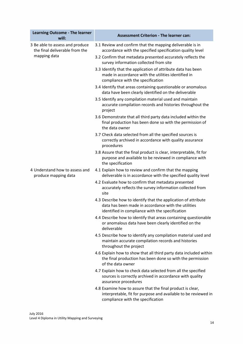
3 Be able to assess and produce the final deliverable from the mapping data
3.1 Review and confirm that the mapping deliverable is in accordance with the specified specification quality level
3.2 Confirm that metadata presented accurately reflects the survey information collected from site
3.3 Identify that the application of attribute data has been made in accordance with the utilities identified in compliance with the specification
3.4 Identify that areas containing questionable or anomalous data have been clearly identified on the deliverable
3.5 Identify any compilation material used and maintain accurate compilation records and histories throughout the project
3.6 Demonstrate that all third party data included within the final production has been done so with the permission of the data owner
3.7 Check data selected from all the specified sources is correctly archived in accordance with quality assurance procedures
3.8 Assure that the final product is clear, interpretable, fit for purpose and available to be reviewed in compliance with the specification
4 Understand how to assess and produce mapping data
4.1 Explain how to review and confirm that the mapping deliverable is in accordance with the specified quality level
4.2 Evaluate how to confirm that metadata presented accurately reflects the survey information collected from site
4.3 Describe how to identify that the application of attribute data has been made in accordance with the utilities identified in compliance with the specification
4.4 Describe how to identify that areas containing questionable or anomalous data have been clearly identified on the deliverable
4.5 Describe how to identify any compilation material used and maintain accurate compilation records and histories throughout the project
4.6 Explain how to show that all third party data included within the final production has been done so with the permission of the data owner
4.7 Explain how to check data selected from all the specified sources is correctly archived in accordance with quality assurance procedures
4.8 Examine how to assure that the final product is clear, interpretable, fit for purpose and available to be reviewed in compliance with the specification
July 2016 Level 4 Diploma in Utility Mapping and Surveying
15
Assessment Candidates must produce documentary evidence against each of the assessment criteria. Where the work place evidence does not cover the whole range, knowledge evidence must be provided to cover the remaining items of the range for each relevant assessment criteria.
ProQual Awarding Body ProQual House
Annie Med Lane South Cave HU15 2HG
Tel: 01430 423822
www.proqualab.com