Embed Size (px)
Citation preview
CLARK FORTUNE McDONALD Queenstown - Dunedin - Christchurch
Licensed Land Surveyors
Land Development & Planning Consultants
ON TIME | ON BUDGET | WITH COMPLIANCE
OFFICE LOCATIONS
QUEENSTOWN309 Lower Shotover Road
P.O. Box 553
Queenstown
New Zealand
Chris Hansen (mobile): 027 229 6026
Telephone: +643 441 6044
Facsimilie: +643 442 1066
DUNEDINBracken Court
Unit 6B, Level 1
480 Moray Place
PO Box 5960, Dunedin
Toby Stoff (mobile): 027 437 4491
Telephone: +643 470 1582
CHRISTCHURCH1st Floor, 2/107 Wrights Road
PO Box 42018
Addington
Christchurch
Gavin Read (mobile): 027 2848487
Telephone: +643 339 0428
Email: [email protected]
www.cfma.co.nz
COMPANY OVERVIEW
The practice has considerable experience in urban land development projects in the district
creating new roading and services associated with urban and rural residential subdivision.
The practice has experience in the provision of services associated with resource management
planning, including the preparation of resource consents, plan changes and other matters relating
to legislative actions pertaining to land.
The practice is also experienced in asset management surveys, particularly in the use of G.P.S.
(Global Positioning Surveys) associated with ‘Asbuilt’ surveys G.I.S. systems. Clark Fortune
McDonald is experienced in the collection and use of digital data for design and reporting
purposes.
Clark Fortune McDonald has highly qualified staff experienced in all facets of the described areas
of practice.
The practice has a history of early adoption of new technology and professional innovation. The
practice was the first in the Central Otago District to introduce computer mapping techniques and
was also the first in the Central Otago District to own and have a permanently available survey
accurate G.P.S. system.
The practice has a sufficiently sized client base and staff resource to be able to sustain a high
level of technology use and has for some considerable time used the Terraview Software for
survey data index searches and Land Title Link Software for on line title and plan searches.
As such the practice is experienced with the use of G.I.S. and digital data searching techniques.
Clark Fortune McDonald is a locally owned company which has a continuous connection
back to an Otago/Southland surveying practice established in 1898. With branches in
Queenstown, Dunedin and Christchurch the company has been heavily involved in many of the
largest development projects in the Queenstown Area, including Millbrook Country Club, The
Commonage subdivision, Aspen Grove, Lake Hayes Estate, Quail Rise, Jacks Point, Kawarau
Village and Shotover Country.
Current projects include:
• LakeHayesEstate
• MillbrookWest
• Threepwood
• RemarkablesView
• JacksPointGolfRetreat
• JacksPointVillage
• KawarauVillage
• PukakiAirport
• ShotoverCountry
• QueenstownTrailsTrust
• CommunityHousingTrust
Clark Fortune McDonald has a highly qualified staff experienced in all facets of cadastral land
surveying and land development and administration. We are conversant with legislation relating
to land surveying, mining, resource management and general property issues.
Clark Fortune McDonald has a long experience of project and engineering surveying in the Otago,
Southland and Lakes District, in particular relating to construction site surveys, investigation,
setting out and monitoring, a number of which require innovative and new approaches to deal
with both the topography of the district and the specialised types of land use associated with
adventure tourism.
OFFICE LOCATIONS COMPANY OVERVIEW
SERVICES PROVIDED SPECIALIST WORK
Topographical SurveyThis is a survey of the features and contours of a site. A plan will consist of vegetation, driplines
houses, services, spot heights, contours, legal boundaries and asbuilt data.
GPS SurveyGPS or global positioning system is a survey management tool that utilises radio signals from
orbiting satellites to obtain 3D positions. GPS is ideal in open air areas and can speed up the
survey process considerably.
Asbuilt SurveyAn asbuilt survey is the collection of information showing the location and description of the
infrastructure and structures after or during construction. Plans and digital information are
prepared for submission to Council and recorded for future reference.
Pegging/Redefinition SurveyRedefining the boundary is a process where the surveyor will locate the boundary positions for a
piece of land. This information is used when the site is about to be developed or sold. Pegs can
also be placed along the line of any boundary or offset from any boundary line if required.
SubdivisionsDividing a large portion of land is known as a subdivision. The process will require a variety of
surveys including a land transfer survey. The end result will be a survey plan which is submitted
to Land Information New Zealand for approval. This may also involve other professionals such
as engineers, landscape and building architects. Part of the process includes submitting plans
and paying fees to the local Council.
223 ApprovalThis is the submission of the final plan for Council approval showing the lots, lot information and
easements. During the 223 approval stage the survey plan can be lodged with Land Information
New Zealand for approval.
224 ApprovalThe next step is to complete any works required as a condition of consent, pay any outstanding
contributions/fees and then apply to Council for a completion certificate.
Obtaining TitleFollowing the completion of the conditions and obtaining a 224 certificate from Council, Clark
Fortune McDonald will then send the 224 certificate to your solicitor who submits this with any
other legal documents required to Land Information New Zealand for issue of new titles.
Subdivision Feasibility StudyA study of relevant information is carried out to determine the feasibility of subdivision of a
property. A report will be prepared outlining relevant issues and conditions.
Land Transfer SurveyThis involves the pegging of the boundaries and producing various reports, calculations and
plans that make up the cadastral survey dataset. This work must be up to LINZ e-survey
standards and can only be carried out by licensed cadastral surveyors.
Unit Title SurveyA unit title, under the Unit Titles Act 1972, provides individual ownership or freehold title in multi-
unit developments. The main unit such as an apartment or office is known as the principal unit
while other associated units such as car parks are known as accessory units. There will also
generally be areas of common ownership such as foyers, lifts and driveways, etc termed common
property.
Boundary Relocation/Adjustment SurveyWhen moving the boundary between neighbouring properties a simplified subdivision process is
followed to legalise the boundary adjustment.
Removal of Limitations SurveyIf your title is limited as to parcels a removal of this limitation is required before boundary
positions can be confirmed. This type of survey requires a high level of specialist knowledge
of the cadastral system. After consideration of all relevant spatial evidence the position of the
boundaries is determined and lodged for approval (and issue of new title) with Land Information
New Zealand.
Clark Fortune McDonald have extensive experience in the provision of services associated with
resource management planning, including the preparation of resource consents, plan changes
and other matters relating to legislative actions pertaining to land.
The practice employs two full time planners based in Queenstown offering a comprehensive
service taking in all aspects of resource management planning.
Work carried out by the company as part of the resource management process often leads to a
project management role particularly for larger subdivision developments.
Clark Fortune McDonald’s project management service enables clients to place their projects in
the hands of experts who have a clear vision and understanding of the demands of the project.
Our expert planners and surveyors are well qualified for the role of project manager and the
increasing number of developments being overseen in the district by Clark Fortune McDonald
underlines the growing reputation the company has in this field.
Employing a project manager simplifies communication at all levels particularly for the client and
ensures developments are completed in a hassle free environment on schedule and on budget.
Asset Management SurveysClark Fortune McDonald has vast experience in asset management surveys for regional councils
and private companies. Since 1994 we have been heavily involved in creating a database of
asbuilt surveys for both the Otago and Southland District Councils and the Queenstown Lakes
District Council. This digital data known as Geographic Information Systems (GIS) is compiled
to create mapping information for design and reporting purposes.
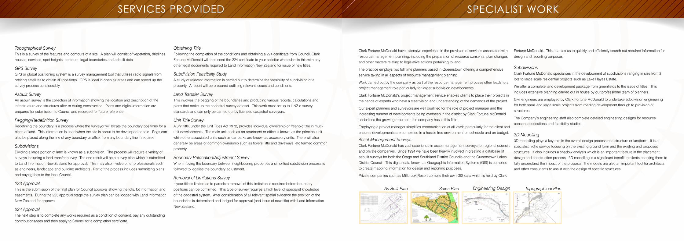
Private companies such as Millbrook Resort compile their own GIS data which is held by Clark
As Built Plan Sales Plan Engineering Design Topographical Plan
Fortune McDonald. This enables us to quickly and efficiently search out required information for
design and reporting purposes.
SubdivisionsClark Fortune McDonald specialises in the development of subdivisions ranging in size from 2
lots to large scale residential projects such as Lake Hayes Estate.
We offer a complete land development package from greenfields to the issue of titles. This
includes extensive planning carried out in house by our professional team of planners.
Civil engineers are employed by Clark Fortune McDonald to undertake subdivision engineering
for both small and large scale projects from roading development through to provision of
structures.
The Company’s engineering staff also complete detailed engineering designs for resource
consent applications and feasibility studies.
3D Modelling3D modelling plays a key role in the overall design process of a structure or landform. It is a
specialist niche service focusing on the existing ground form and the existing and proposed
structures. It also includes a shadow analysis which is an important feature in the placement,
design and construction process. 3D modelling is a significant benefit to clients enabling them to
fully understand the impact of the proposal. The models are also an important tool for architects
and other consultants to assist with the design of specific structures.
OUR TEAM OUR TEAM cont.
Principal Neil McDonald
B.Sc. (Surv) 1977 (Otago)
Registered Surveyor 1978
Executive MCSNZ, Corporate MNZIS, MRMLA
Neil is experienced in all facets of urban and cadastral surveying and administration. Neil has
held an annual practicing certificate for over 30 years. Neil’s extensive work experience covers
various development projects including large greenfield type residential developments, rural
residential developments, apartment and commercial developments, resort developments,
horticulture and resort developments, mining and quarrying activities, and tourism associated
activities. All of these projects have required project management and administration,
coordination of various disciplines, consultation and negotiation, project planning and design.
Neil also has specialist skills in data and resource collection, including topographical data, aerial
photographs, land ownership information and hazards records etc.
Survey ManagerChris Hansen
B.Surv 1998 (Otago)
Registered Professional Surveyor
MCSNZ, MNZIS
Chris joined Clark Fortune McDonald in 1998 as a graduate surveyor. After three years
experience Chris completed his registration as a Surveyor
Shortly after registration Chris worked abroad gaining overseas experience as a Land Surveyor
and Site Engineer in Canada and the United Kingdom respectively. On his return in 2004 Chris
took up the position as Survey Manager of Clark Fortune McDonald.
With over 17 years post graduate experience, Chris has developed a wide range of skills in all
aspects of Land Development. In this time Chris has been involved in many large scale land
development projects.
Christchurch ManagerGavin Read
B.Surv 1998 (Otago)
Licensed Cadastral Surveyor
After the completion of his Degree, Gavin moved to Northland where he became a registered
surveyor after two and a half years. Shortly after he headed overseas to England where he spent
the next four years working as a site engineer on a range of construction projects such as mutli-
storey buildings, bridges and major road bypasses throughout London and the Midlands. He
returned to Christchurch in 2005 where he has been working as a Licensed Cadastral Surveyor.
During his time in New Zealand he has been involved in all aspects of land development on a
range of large and small developments. Since the Canterbury earthquakes he has been involved
in the reconstruction effort and has undertaken and overseen surveys in the hardest hit areas.
With over twelve years work experience both in New Zealand and abroad, Gavin has considerable
knowledge and experience in all aspects of land development with a strong background in
construction.
Licensed Cadastral Surveyor Hayden Knight
B.Surv 1998 (Otago)
Registered Professional Surveyor
MNZIS
Hayden has been a member of Clark Fortune McDonald since 2006. After completing his
surveying degree at the University of Otago, Hayden moved to Northland where he gained
work experience becoming a registered surveyor in 2002. Shortly after becoming registered he
moved to London where he worked as a Site Engineer on several large construction projects
throughout the city. In 2006 Hayden moved back to New Zealand and took up a position as a
Licensed Surveyor with Clark Fortune McDonald in Queenstown. Since commencing work as a
graduate surveyor in 1999 Hayden has obtained a wide range of skills in all aspects of the land
development process while being involved in a variety of both very large to small developments.
Senior Resource Management PlannerNick Geddes
BSc Geog, Grad Dip EnvSci
Nick holds a Bachelor of Science Degree in Geography and a Graduate Diploma in
Environmental Science. He graduated from Otago University in 1999 and began his working
career in Queenstown as a planning consultant.
In 2001 he was employed by Auckland City Council as a senior planner until he travelled to the
United Kingdom in 2005. In London Nick worked within Borough Councils as a consents planner
before returning to Queenstown in 2008 to resume his role as a planning consultant. During his
time working in local government and private practice Nick has been involved in a wide range of
developments, resource consent preparation, development of bylaw policy and administration,
district and regional plan policy development and the preparation and presentation of expert
evidence at Council Hearings and Environment Court.
Nick’s work experience traverses both the urban and rural environments. His core work is centred
round subdivision and land use consent preparation as it relates to land development in the
Queenstown Lakes District. However, Nick has prepared and successfully obtained consents
relating to; Coastal Marine Areas, Department of Conservation and New Zealand Historic
Places Trust concessions, Crown Minerals, Licences to occupy, Utility provisions, Notices of
Requirement, Outline Plans, National Environmental Standards, Regional Air and Water Permits.
While a majority of Nick’s work is based in the Queenstown Lakes District he has prepared
consent applications and plan changes within a number of other Districts including; Selwyn,
Christchurch, Dunedin, Invercargill, Auckland, Tauranga and Westland.
PlannerEmma Dixon
BSc (Land Planning and Development) 2005 (Otago)
Emma joined Clark Fortune McDonald and Associates in January 2006 as a graduate from
Otago University. Since then Emma has gained valuable experience in planning, engineering and
project management from working on projects such as Jacks Point, Millbrook and a number of
other smaller urban subdivisions and developments within the wider Wakatipu region.
Senior SurveyorsToby Stoff (Dunedin)
Registered Professional Surveyor
MCSNZ, MNZIS
Toby has been with Clark Fortune Donald for 11 years, specialising in land development
engineering and construction. Previous work experience includes seven years private practice
surveying and engineering design in Coastal Otago, two years large-scale construction
surveying in South Australia, 12 months seismic surveying in Saudi Arabia, and 12 months
freelance hydrographic surveying around Europe and the Middle East. Toby has almost 20
years experience in the engineering and construction field, and has a strong understanding of
the needs of our clients and the requirements of territorial authorities. Toby believes in a team
approach where the client, consultant and the contractor work together in a fun environment to
deliver a quality product on time and on budget. Toby is married to Thera and has two daughters,
Maria and Katie.
Craig Woodcock
B.Surv (Otago)
Licensed Cadastral Surveyor
MNZIS
Craig joined Clark Fortune McDonald in early 2014 as a Licensed Cadastral Surveyor.
After graduating in 2003 he shifted to Christchurch to work for a multi-disciplined consultancy as
a graduate surveyor. After two years of this he decided to shift closer to home and took up a role
with another Queenstown surveying firm where he worked towards gaining his Cadastral License.
After gaining his license the boom in Australia was Craig’s next calling. Here he spent four and
a half years in Brisbane working on large transport infrastructure projects followed by 18 months
as a FIFO surveyor on large industrial infrastructure projects based in Gladstone, while his family
was based in Queenstown. Family and the international commute lead to Craig seeking work
back in Queenstown.
OUR TEAM cont. OUR TEAM cont.
Planning ConsultantKaren Hanson
BSc MREP (Otago and Massey)
Karen Hanson is currently contracted to Clark Fortune McDonald. Karen holds a Bachelor
of Science Degree in Geography and a Masters Degree in Resource Management and
Environmental Planning. She has over 13 years experience as a resource management
consultant here in Queenstown with past experience in Local Government.
Karen has considerable experience in subdivision and land use development with wide spread
knowledge of the Queenstown area. Her experience includes residential, rural and resort
development, commercial, recreational, industrial and mining activities. Karen is involved in
district and regional plan implementation, consultation, negotiation and strategic advice to
clients in both the public and private sectors. Her work also involves project management and
implementation of consented development. Karen makes regular appearances in representing
clients before resource consent hearing panels and the Environment Court.
Consultant SurveyorPaul Cook
B.Surv (with Credit) 1993 (Otago)
NZCLS
Crown Accredited Agent
Paul began his surveying career in Alexandra in 1984 as a trainee Survey Technician for the
local firm of McGeorge & Elder moving onto Assistant Survey Engineer on the Clyde Dam, New
Zealand’s largest concrete gravity dam.
Following the Dam construction Paul completed his New Zealand Certificate in Land Surveying
(NZCLS) in 1991 and continued his education graduating from Otago University in 1993 with a
Bachelor of Surveying Degree (with Credit).
For the next ten years Paul worked for City Consultants, a division of the Dunedin City Council,
gaining Professional Registration in 1996, rising to the position of Survey Section Team Leader,
comprising the management and planning of all survey engineering related activities undertaken
by the Dunedin City Council.
In 2002 Paul began work for MWH (NZ) Ltd as the regional Senior Surveyor undertaking Project
Surveying work for the DCC and MWH both locally and internationally.
Paul joined Clark Fortune McDonald from 2005 to 2011 to specialise in professional consultation
to large project developments in Coastal and Central Otago.
From 2011 to 2013 Paul worked for AAM in North Western Australia as a Senior Project Surveyor
on mine expansion construction projects for Rio Tinto on a fly in fly out basis from
New Zealand.
Since late 2013 Paul has worked as a Consultant Surveyor for Clark Fortune McDonald on large
subdivision developments in Central Otago such as Northlake in Wanaka and Shotover Country.
Paul is also Clark Fortune McDonald’s resident Crown Accredited Agent.
Jamie Kirk
B.Surv Hons 2000 (Otago)
Licensed Cadastral Surveyor
After graduating from Otago University Jamie worked in Whakatane for four years and completed
his Cadastral License in 2003. He then spent three years overseas working as a surveyor in
Canada and as both a surveyor and site engineer in the United Kingdom.
Jamie joined Clark Fortune McDonald in 2007 as a Licensed Cadastral Surveyor and has over
15 years’ experience including; subdivision and services design, urban and rural subdivisions,
topographical surveys, engineering surveying, monitoring surveys and industrial measurement.
SurveyorsRoy Buchanan
B.Surv (Dist) 2008 (Otago)
Licensed Cadastral Surveyor
MNZIS
Roy joined Clark Fortune McDonald in 2008 as a graduate and worked in the Wanaka office on a
number of projects before moving over to Queenstown in 2010.
After becoming licensed in 2013 Roy left Queenstown and began working in Central Queensland,
Australia, working on coal seam gas projects throughout the region. His time included a role as
a Survey Manager for the $1.6 billion Woleebee Creek Central Processing Plant. Following the
completion of the project, Roy returned to Clark Fortune McDonald in 2014.
Roy has developed a range of skills in all aspects of land development and construction
surveying which can be applied to any project.
Eddie Murray
B.Surv (Otago)
Surveyor
After graduating from Otago University in 2003 Eddie worked for Paterson Pitts in Wanaka
for 12 months then headed over to Australia working as lead surveyor on a multi stage urban
subdivision. He travelled to Canada working for six months as a survey technologist. Eddie
worked between Australia and Canada as an engineering surveyor for two years and then
headed to England where he gained further engineering experience as part of the construction
management team which bid, planned, phased and delivered nine million pounds worth of
construction for the London Olympic Games.
In 2012 Eddie outgrew his backpack and returned to beautiful Queenstown joining the Clark
Fortune team where he is currently the head surveyor on the Shotover Country subdivision
project.
Eddie looks forward to meeting new clients and the opportunity to make their proposals a
successful reality.
Dan Purvis
B.Surv (Otago)
Survey Technician
Graduate Surveyor
Dan joined Clark Fortune McDonald in January 2014 after graduating from Otago University. Dan
had already completed a National Diploma in Surveying in 2008.
Before joining Clark Fortune McDonald and attending University, Dan worked with Harrison
Grierson Consultants in Auckland. He has considerable experience in topographical,
infrastructure, monitoring, building setout, BOMA and cadastral surveys. Dan is currently working
towards gaining his professional license.
Logan Ross
B.Surv (Hons)
Surveyor
ANZIS
Logan joined Clark Fortune McDonald in November 2012 as a Graduate Surveyor. Since joining
Clark Fortune McDonald, Logan has gained valuable experience in a variety of projects and is
currently working towards gaining his cadastral license.
RECENT PROJECTS
ON TIME | ON BUDGET | WITH COMPLIANCE
LAKE HAYES ESTATE
ON TIME | ON BUDGET | WITH COMPLIANCE
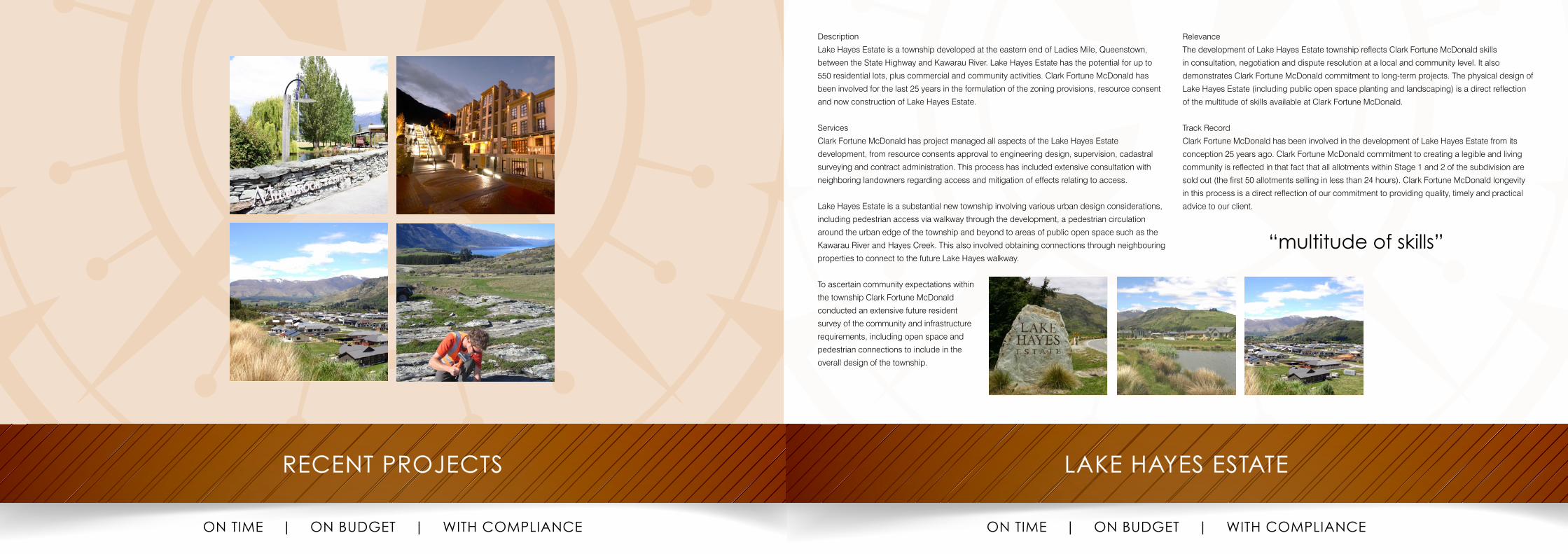
Description
Lake Hayes Estate is a township developed at the eastern end of Ladies Mile, Queenstown,
between the State Highway and Kawarau River. Lake Hayes Estate has the potential for up to
550 residential lots, plus commercial and community activities. Clark Fortune McDonald has
been involved for the last 25 years in the formulation of the zoning provisions, resource consent
and now construction of Lake Hayes Estate.
Services
Clark Fortune McDonald has project managed all aspects of the Lake Hayes Estate
development, from resource consents approval to engineering design, supervision, cadastral
surveying and contract administration. This process has included extensive consultation with
neighboring landowners regarding access and mitigation of effects relating to access.
Lake Hayes Estate is a substantial new township involving various urban design considerations,
including pedestrian access via walkway through the development, a pedestrian circulation
around the urban edge of the township and beyond to areas of public open space such as the
Kawarau River and Hayes Creek. This also involved obtaining connections through neighbouring
properties to connect to the future Lake Hayes walkway.
To ascertain community expectations within
the township Clark Fortune McDonald
conducted an extensive future resident
survey of the community and infrastructure
requirements, including open space and
pedestrian connections to include in the
overall design of the township.
Relevance
The development of Lake Hayes Estate township reflects Clark Fortune McDonald skills
in consultation, negotiation and dispute resolution at a local and community level. It also
demonstrates Clark Fortune McDonald commitment to long-term projects. The physical design of
Lake Hayes Estate (including public open space planting and landscaping) is a direct reflection
of the multitude of skills available at Clark Fortune McDonald.
Track Record
Clark Fortune McDonald has been involved in the development of Lake Hayes Estate from its
conception 25 years ago. Clark Fortune McDonald commitment to creating a legible and living
community is reflected in that fact that all allotments within Stage 1 and 2 of the subdivision are
sold out (the first 50 allotments selling in less than 24 hours). Clark Fortune McDonald longevity
in this process is a direct reflection of our commitment to providing quality, timely and practical
advice to our client.
“multitude of skills”
MILLBROOK WEST
ON TIME | ON BUDGET | WITH COMPLIANCE
REMARKABLES VIEW
ON TIME | ON BUDGET | WITH COMPLIANCE
Description
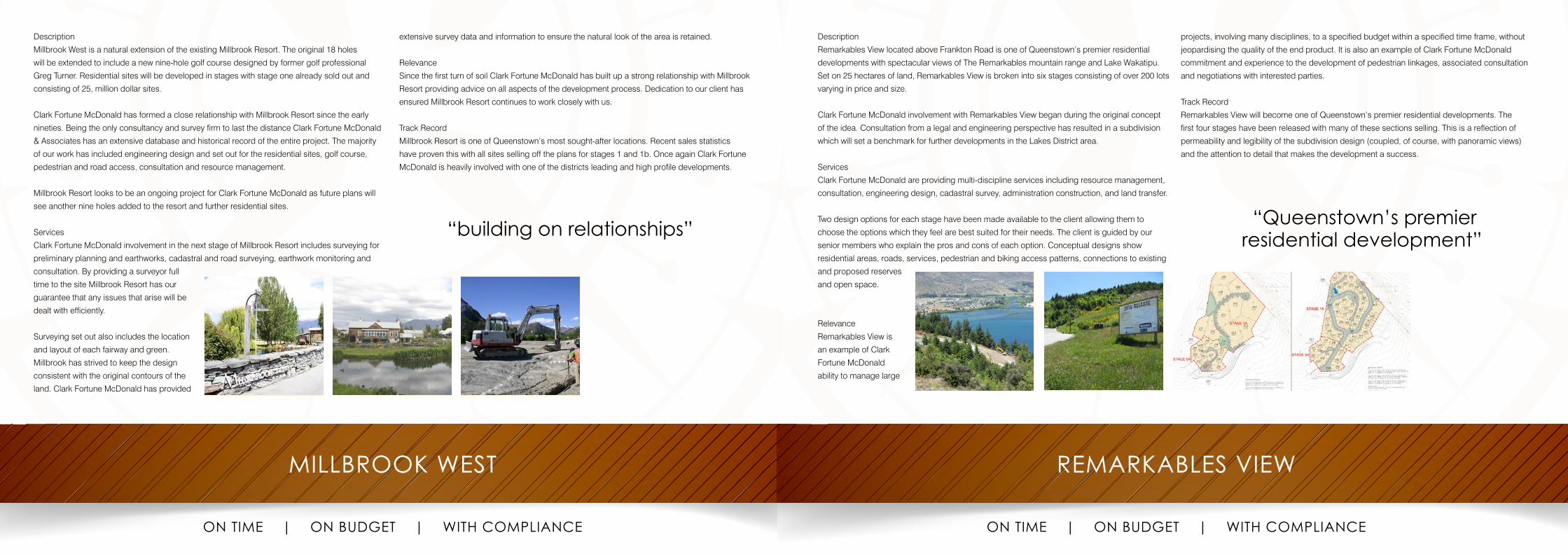
Millbrook West is a natural extension of the existing Millbrook Resort. The original 18 holes
will be extended to include a new nine-hole golf course designed by former golf professional
Greg Turner. Residential sites will be developed in stages with stage one already sold out and
consisting of 25, million dollar sites.
Clark Fortune McDonald has formed a close relationship with Millbrook Resort since the early
nineties. Being the only consultancy and survey firm to last the distance Clark Fortune McDonald
& Associates has an extensive database and historical record of the entire project. The majority
of our work has included engineering design and set out for the residential sites, golf course,
pedestrian and road access, consultation and resource management.
Millbrook Resort looks to be an ongoing project for Clark Fortune McDonald as future plans will
see another nine holes added to the resort and further residential sites.
Services
Clark Fortune McDonald involvement in the next stage of Millbrook Resort includes surveying for
preliminary planning and earthworks, cadastral and road surveying, earthwork monitoring and
consultation. By providing a surveyor full
time to the site Millbrook Resort has our
guarantee that any issues that arise will be
dealt with efficiently.
Surveying set out also includes the location
and layout of each fairway and green.
Millbrook has strived to keep the design
consistent with the original contours of the
land. Clark Fortune McDonald has provided
extensive survey data and information to ensure the natural look of the area is retained.
Relevance
Since the first turn of soil Clark Fortune McDonald has built up a strong relationship with Millbrook
Resort providing advice on all aspects of the development process. Dedication to our client has
ensured Millbrook Resort continues to work closely with us.
Track Record
Millbrook Resort is one of Queenstown’s most sought-after locations. Recent sales statistics
have proven this with all sites selling off the plans for stages 1 and 1b. Once again Clark Fortune
McDonald is heavily involved with one of the districts leading and high profile developments.
“building on relationships”
Description
Remarkables View located above Frankton Road is one of Queenstown’s premier residential
developments with spectacular views of The Remarkables mountain range and Lake Wakatipu.
Set on 25 hectares of land, Remarkables View is broken into six stages consisting of over 200 lots
varying in price and size.
Clark Fortune McDonald involvement with Remarkables View began during the original concept
of the idea. Consultation from a legal and engineering perspective has resulted in a subdivision
which will set a benchmark for further developments in the Lakes District area.
Services
Clark Fortune McDonald are providing multi-discipline services including resource management,
consultation, engineering design, cadastral survey, administration construction, and land transfer.
Two design options for each stage have been made available to the client allowing them to
choose the options which they feel are best suited for their needs. The client is guided by our
senior members who explain the pros and cons of each option. Conceptual designs show
residential areas, roads, services, pedestrian and biking access patterns, connections to existing
and proposed reserves
and open space.
Relevance
Remarkables View is
an example of Clark
Fortune McDonald
ability to manage large
projects, involving many disciplines, to a specified budget within a specified time frame, without
jeopardising the quality of the end product. It is also an example of Clark Fortune McDonald
commitment and experience to the development of pedestrian linkages, associated consultation
and negotiations with interested parties.
Track Record
Remarkables View will become one of Queenstown’s premier residential developments. The
first four stages have been released with many of these sections selling. This is a reflection of
permeability and legibility of the subdivision design (coupled, of course, with panoramic views)
and the attention to detail that makes the development a success.
“Queenstown’s premier residential development”
JACKS POINT/HENLEY DOWNS/HOMESTEAD BAY
ON TIME | ON BUDGET | WITH COMPLIANCE
CORONET PEAK & THE REMARKABLES
ON TIME | ON BUDGET | WITH COMPLIANCE
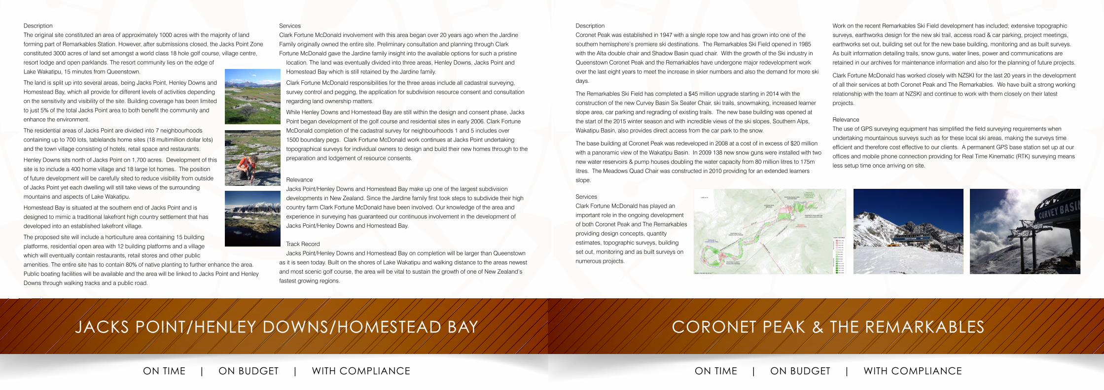
Description
The original site constituted an area of approximately 1000 acres with the majority of land
forming part of Remarkables Station. However, after submissions closed, the Jacks Point Zone
constituted 3000 acres of land set amongst a world class 18 hole golf course, village centre,
resort lodge and open parklands. The resort community lies on the edge of
Lake Wakatipu, 15 minutes from Queenstown.
The land is split up into several areas, being Jacks Point, Henley Downs and
Homestead Bay, which all provide for different levels of activities depending
on the sensitivity and visibility of the site. Building coverage has been limited
to just 5% of the total Jacks Point area to both benefit the community and
enhance the environment.
The residential areas of Jacks Point are divided into 7 neighbourhoods
containing up to 700 lots, tablelands home sites (18 multimillion dollar lots)
and the town village consisting of hotels, retail space and restaurants.
Henley Downs sits north of Jacks Point on 1,700 acres. Development of this
site is to include a 400 home village and 18 large lot homes. The position
of future development will be carefully sited to reduce visibility from outside
of Jacks Point yet each dwelling will still take views of the surrounding
mountains and aspects of Lake Wakatipu.
Homestead Bay is situated at the southern end of Jacks Point and is
designed to mimic a traditional lakefront high country settlement that has
developed into an established lakefront village.
The proposed site will include a horticulture area containing 15 building
platforms, residential open area with 12 building platforms and a village
which will eventually contain restaurants, retail stores and other public
amenities. The entire site has to contain 80% of native planting to further enhance the area.
Public boating facilities will be available and the area will be linked to Jacks Point and Henley
Downs through walking tracks and a public road.
Services
Clark Fortune McDonald involvement with this area began over 20 years ago when the Jardine
Family originally owned the entire site. Preliminary consultation and planning through Clark
Fortune McDonald gave the Jardine family insight into the available options for such a pristine
location. The land was eventually divided into three areas, Henley Downs, Jacks Point and
Homestead Bay which is still retained by the Jardine family.
Clark Fortune McDonald responsibilities for the three areas include all cadastral surveying,
survey control and pegging, the application for subdivision resource consent and consultation
regarding land ownership matters.
While Henley Downs and Homestead Bay are still within the design and consent phase, Jacks
Point began development of the golf course and residential sites in early 2006. Clark Fortune
McDonald completion of the cadastral survey for neighbourhoods 1 and 5 includes over
1500 boundary pegs. Clark Fortune McDonald work continues at Jacks Point undertaking
topographical surveys for individual owners to design and build their new homes through to the
preparation and lodgement of resource consents.
Relevance
Jacks Point/Henley Downs and Homestead Bay make up one of the largest subdivision
developments in New Zealand. Since the Jardine family first took steps to subdivide their high
country farm Clark Fortune McDonald have been involved. Our knowledge of the area and
experience in surveying has guaranteed our continuous involvement in the development of
Jacks Point/Henley Downs and Homestead Bay.
Track Record
Jacks Point/Henley Downs and Homestead Bay on completion will be larger than Queenstown
as it is seen today. Built on the shores of Lake Wakatipu and walking distance to the areas newest
and most scenic golf course, the area will be vital to sustain the growth of one of New Zealand’s
fastest growing regions.
Description
Coronet Peak was established in 1947 with a single rope tow and has grown into one of the
southern hemisphere’s premiere ski destinations. The Remarkables Ski Field opened in 1985
with the Alta double chair and Shadow Basin quad chair. With the growth of the Ski industry in
Queenstown Coronet Peak and the Remarkables have undergone major redevelopment work
over the last eight years to meet the increase in skier numbers and also the demand for more ski
days.
The Remarkables Ski Field has completed a $45 million upgrade starting in 2014 with the
construction of the new Curvey Basin Six Seater Chair, ski trails, snowmaking, increased learner
slope area, car parking and regrading of existing trails. The new base building was opened at
the start of the 2015 winter season and with incredible views of the ski slopes, Southern Alps,
Wakatipu Basin, also provides direct access from the car park to the snow.
The base building at Coronet Peak was redeveloped in 2008 at a cost of in excess of $20 million
with a panoramic view of the Wakatipu Basin. In 2009 138 new snow guns were installed with two
new water reservoirs & pump houses doubling the water capacity from 80 million litres to 175m
litres. The Meadows Quad Chair was constructed in 2010 providing for an extended learners
slope.
Services
Clark Fortune McDonald has played an
important role in the ongoing development
of both Coronet Peak and The Remarkables
providing design concepts, quantity
estimates, topographic surveys, building
set out, monitoring and as built surveys on
numerous projects.
Work on the recent Remarkables Ski Field development has included; extensive topographic
surveys, earthworks design for the new ski trail, access road & car parking, project meetings,
earthworks set out, building set out for the new base building, monitoring and as built surveys.
As built information detailing trails, snow guns, water lines, power and communications are
retained in our archives for maintenance information and also for the planning of future projects.
Clark Fortune McDonald has worked closely with NZSKI for the last 20 years in the development
of all their services at both Coronet Peak and The Remarkables. We have built a strong working
relationship with the team at NZSKI and continue to work with them closely on their latest
projects.
Relevance
The use of GPS surveying equipment has simplified the field surveying requirements when
undertaking mountainous surveys such as for these local ski areas, making the surveys time
efficient and therefore cost effective to our clients. A permanent GPS base station set up at our
offices and mobile phone connection providing for Real Time Kinematic (RTK) surveying means
less setup time once arriving on site.
BUTEL PARK
ON TIME | ON BUDGET | WITH COMPLIANCE
SOFITEL HOTEL
ON TIME | ON BUDGET | WITH COMPLIANCE
Description
Butel Park is a residential subdivision in Manse Road, Arrowtown between the existing industrial
area and Millbrook Resort. Clark Fortune McDonald have been involved in the conception of this
development since 1993, when the then owner Vivid Holdings Limited proposed to establish an
equestrian centre and residential development on the site. Clark Fortune McDonald eventually
developed a Meadow Park Zone through the Proposed District Plan process, resulting in a
consent order from the Environment Court after extensive mediation. The Meadow Park Zone
is a special zone designed to facilitate a comprehensive approach to retaining the urban fabric
that makes Arrowtown unique, enhances visibility of outstanding natural features and enhances
ecological restoration of adjoining vegetation. The subdivision itself is known as Butel Park.
Services
Clark Fortune McDonald has a long history in the development of the Meadow Park Zone and the
eventual Butel Park subdivision. Clark Fortune McDonald provided resource management advise
in the conception of the zone, including drafting subdivisions, presenting evidence, drafting
appeal documents, negotiations with the Council, consultation and mediation with various
neighbours, community groups and environmental organizations. Clark Fortune McDonald
developed the design of the Butel
Park subdivision alongside landscape
architects Baxter Brown Limited, and
was instrumental in getting the resource
consent approval for the development.
Clark Fortune McDonald retains an
active role in the development, including
resource management and surveying
advice and set-out.
Relevance
The development of the Meadow Park Zone demonstrates the exceptional skills of Clark Fortune
McDonald in negotiating development proposals against all adversity (or various interests). It also
demonstrates community and environmental organizations trust in Clark Fortune McDonald. The
implementation of the zone through the resource consent process demonstrates Clark Fortune
McDonald ability to deliver an end product.
Track Record
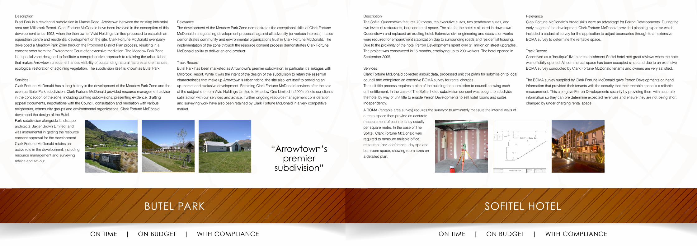
Butel Park has been marketed as Arrowtown’s premier subdivision, in particular it’s linkages with
Millbrook Resort. While it was the intent of the design of the subdivision to retain the essential
characteristics that make up Arrowtown’s urban fabric, the site also lent itself to providing an
up-market and exclusive development. Retaining Clark Fortune McDonald services after the sale
of the subject site from Vivid Holdings Limited to Meadow One Limited in 2000 reflects our clients
satisfaction with our services and advice. Further ongoing resource management consideration
and surveying work have also been retained by Clark Fortune McDonald in a very competitive
market.
“Arrowtown’s premier
subdivision”
Description
The Sofitel Queenstown features 70 rooms, ten executive suites, two penthouse suites, and
two levels of restaurants, bars and retail space. The site for the hotel is situated in downtown
Queenstown and replaced an existing hotel. Extensive civil engineering and excavation works
were required for embankment stabilization due to surrounding roads and residential housing.
Due to the proximity of the hotel Perron Developments spent over $1 million on street upgrades.
The project was constructed in 15 months, employing up to 200 workers. The hotel opened in
September 2005.
Services
Clark Fortune McDonald collected asbuilt data, processed unit title plans for submission to local
council and completed an extensive BOMA survey for rental charges.
The unit title process requires a plan of the building for submission to council showing each
unit entitlement. In the case of The Sofitel hotel, subdivision consent was sought to subdivide
the hotel by way of unit title to enable Perron Developments to sell hotel rooms and suites
independently.
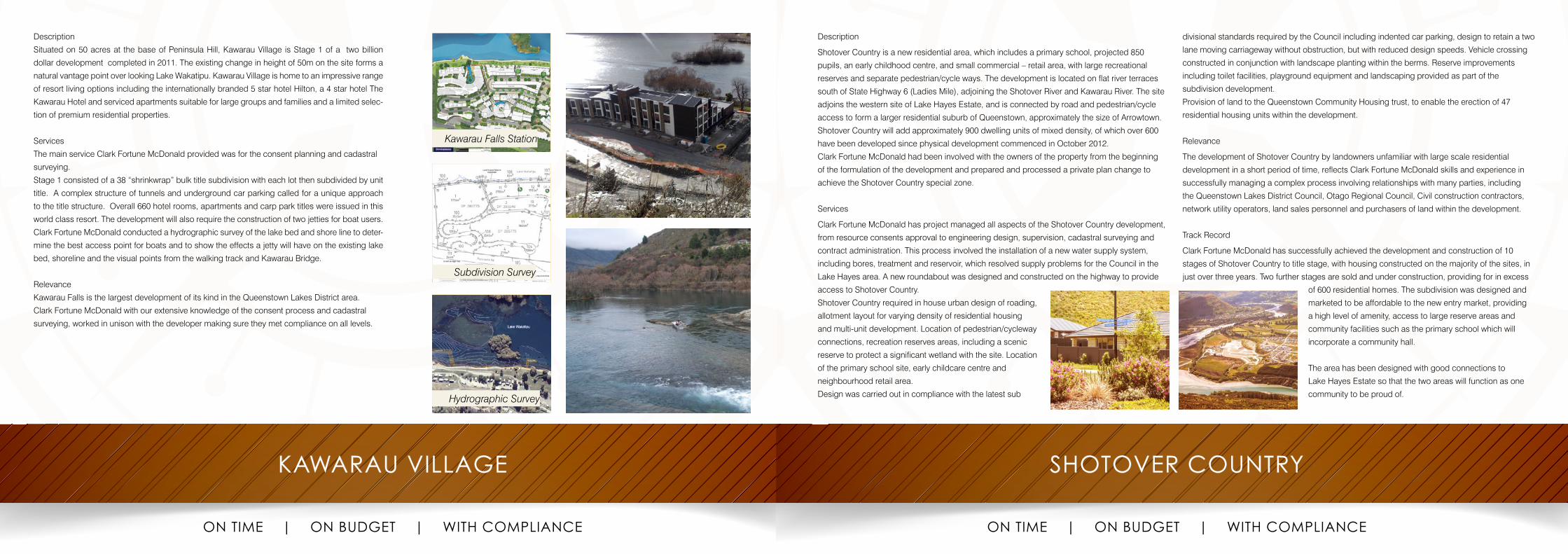
A BOMA (rentable area survey) requires the surveyor to accurately measure the internal walls of
a rental space then provide an accurate
measurement of each tenancy usually
per square metre. In the case of The
Sofitel, Clark Fortune McDonald was
required to measure multiple office,
restaurant, bar, conference, day spa and
bathroom space, showing room sizes on
a detailed plan.
Relevance
Clark Fortune McDonald’s broad skills were an advantage for Perron Developments. During the
early stages of the development Clark Fortune McDonald provided planning expertise which
included a cadastral survey for the application to adjust boundaries through to an extensive
BOMA survey to determine the rentable space.
Track Record
Conceived as a ‘boutique’ five-star establishment Sofitel hotel met great reviews when the hotel
was officially opened. All commercial space has been occupied since and due to an extensive
BOMA survey conducted by Clark Fortune McDonald tenants and owners are very satisfied.
The BOMA survey supplied by Clark Fortune McDonald gave Perron Developments on hand
information that provided their tenants with the security that their rentable space is a reliable
measurement. This also gave Perron Developments security by providing them with accurate
information so they can pre determine expected revenues and ensure they are not being short
changed by under charging rental space.
KAWARAU VILLAGE
ON TIME | ON BUDGET | WITH COMPLIANCE
Description
Situated on 50 acres at the base of Peninsula Hill, Kawarau Village is Stage 1 of a two billion
dollar development completed in 2011. The existing change in height of 50m on the site forms a
natural vantage point over looking Lake Wakatipu. Kawarau Village is home to an impressive range
of resort living options including the internationally branded 5 star hotel Hilton, a 4 star hotel The
Kawarau Hotel and serviced apartments suitable for large groups and families and a limited selec-
tion of premium residential properties.
Services
The main service Clark Fortune McDonald provided was for the consent planning and cadastral
surveying.
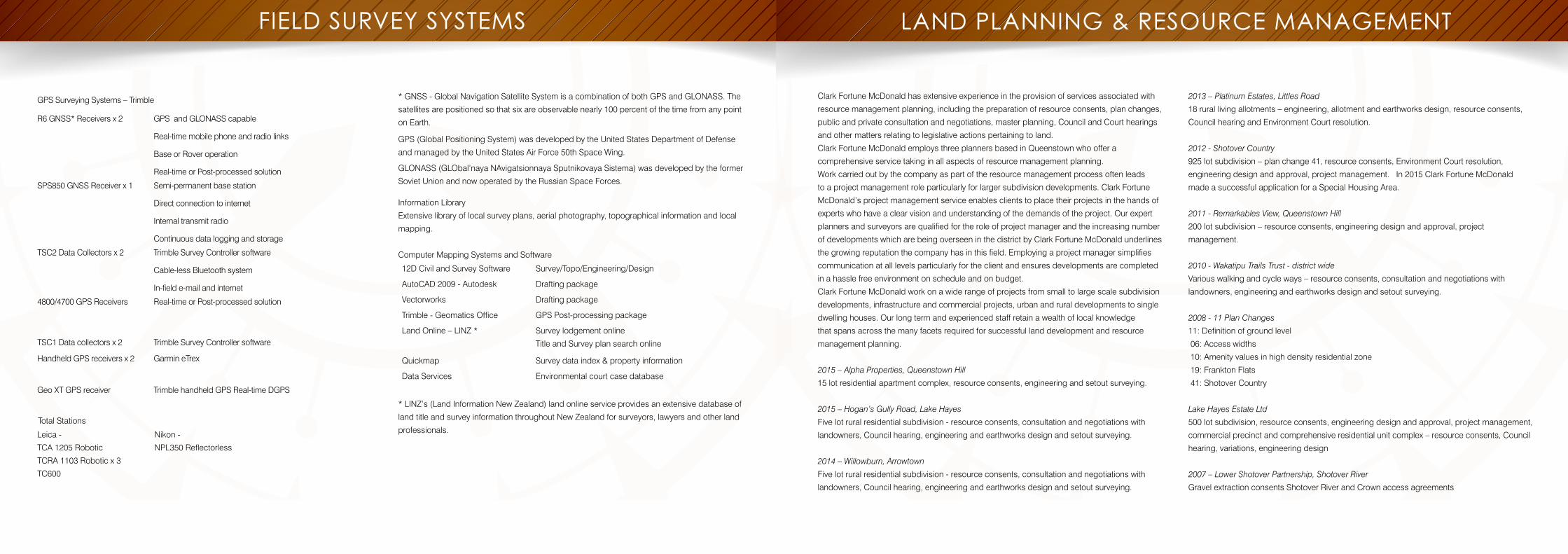
Stage 1 consisted of a 38 “shrinkwrap” bulk title subdivision with each lot then subdivided by unit
title. A complex structure of tunnels and underground car parking called for a unique approach
to the title structure. Overall 660 hotel rooms, apartments and carp park titles were issued in this
world class resort. The development will also require the construction of two jetties for boat users.
Clark Fortune McDonald conducted a hydrographic survey of the lake bed and shore line to deter-
mine the best access point for boats and to show the effects a jetty will have on the existing lake
bed, shoreline and the visual points from the walking track and Kawarau Bridge.
Relevance
Kawarau Falls is the largest development of its kind in the Queenstown Lakes District area.
Clark Fortune McDonald with our extensive knowledge of the consent process and cadastral
surveying, worked in unison with the developer making sure they met compliance on all levels.
Subdivision Survey
Hydrographic Survey
Kawarau Falls Station
SHOTOVER COUNTRY
ON TIME | ON BUDGET | WITH COMPLIANCE
Description
Shotover Country is a new residential area, which includes a primary school, projected 850
pupils, an early childhood centre, and small commercial – retail area, with large recreational
reserves and separate pedestrian/cycle ways. The development is located on flat river terraces
south of State Highway 6 (Ladies Mile), adjoining the Shotover River and Kawarau River. The site
adjoins the western site of Lake Hayes Estate, and is connected by road and pedestrian/cycle
access to form a larger residential suburb of Queenstown, approximately the size of Arrowtown.
Shotover Country will add approximately 900 dwelling units of mixed density, of which over 600
have been developed since physical development commenced in October 2012.
Clark Fortune McDonald had been involved with the owners of the property from the beginning
of the formulation of the development and prepared and processed a private plan change to
achieve the Shotover Country special zone.
Services
Clark Fortune McDonald has project managed all aspects of the Shotover Country development,
from resource consents approval to engineering design, supervision, cadastral surveying and
contract administration. This process involved the installation of a new water supply system,
including bores, treatment and reservoir, which resolved supply problems for the Council in the
Lake Hayes area. A new roundabout was designed and constructed on the highway to provide
access to Shotover Country.
Shotover Country required in house urban design of roading,
allotment layout for varying density of residential housing
and multi-unit development. Location of pedestrian/cycleway
connections, recreation reserves areas, including a scenic
reserve to protect a significant wetland with the site. Location
of the primary school site, early childcare centre and
neighbourhood retail area.
Design was carried out in compliance with the latest sub
divisional standards required by the Council including indented car parking, design to retain a two
lane moving carriageway without obstruction, but with reduced design speeds. Vehicle crossing
constructed in conjunction with landscape planting within the berms. Reserve improvements
including toilet facilities, playground equipment and landscaping provided as part of the
subdivision development.
Provision of land to the Queenstown Community Housing trust, to enable the erection of 47
residential housing units within the development.
Relevance
The development of Shotover Country by landowners unfamiliar with large scale residential
development in a short period of time, reflects Clark Fortune McDonald skills and experience in
successfully managing a complex process involving relationships with many parties, including
the Queenstown Lakes District Council, Otago Regional Council, Civil construction contractors,
network utility operators, land sales personnel and purchasers of land within the development.
Track Record
Clark Fortune McDonald has successfully achieved the development and construction of 10
stages of Shotover Country to title stage, with housing constructed on the majority of the sites, in
just over three years. Two further stages are sold and under construction, providing for in excess
of 600 residential homes. The subdivision was designed and
marketed to be affordable to the new entry market, providing
a high level of amenity, access to large reserve areas and
community facilities such as the primary school which will
incorporate a community hall.
The area has been designed with good connections to
Lake Hayes Estate so that the two areas will function as one
community to be proud of.
FIELD SURVEY SYSTEMS LAND PLANNING & RESOURCE MANAGEMENT
GPS Surveying Systems – Trimble
R6 GNSS* Receivers x 2 GPS and GLONASS capable
Real-time mobile phone and radio links
Base or Rover operation
Real-time or Post-processed solution
SPS850 GNSS Receiver x 1 Semi-permanent base station
Direct connection to internet
Internal transmit radio
Continuous data logging and storage
TSC2 Data Collectors x 2 Trimble Survey Controller software
Cable-less Bluetooth system
In-field e-mail and internet
4800/4700 GPS Receivers Real-time or Post-processed solution
TSC1 Data collectors x 2 Trimble Survey Controller software
Handheld GPS receivers x 2 Garmin eTrex
Geo XT GPS receiver Trimble handheld GPS Real-time DGPS
Total Stations
Leica -
TCA 1205 Robotic
TCRA 1103 Robotic x 3
TC600
Nikon -
NPL350 Reflectorless
* GNSS - Global Navigation Satellite System is a combination of both GPS and GLONASS. The
satellites are positioned so that six are observable nearly 100 percent of the time from any point
on Earth.
GPS (Global Positioning System) was developed by the United States Department of Defense
and managed by the United States Air Force 50th Space Wing.
GLONASS (GLObal’naya NAvigatsionnaya Sputnikovaya Sistema) was developed by the former
Soviet Union and now operated by the Russian Space Forces.
Information Library
Extensive library of local survey plans, aerial photography, topographical information and local
mapping.
Computer Mapping Systems and Software
12D Civil and Survey Software Survey/Topo/Engineering/Design
AutoCAD 2009 - Autodesk Drafting package
Vectorworks Drafting package
Trimble - Geomatics Office GPS Post-processing package
Land Online – LINZ * Survey lodgement online
Title and Survey plan search online
Quickmap Survey data index & property information
Data Services Environmental court case database
* LINZ’s (Land Information New Zealand) land online service provides an extensive database of
land title and survey information throughout New Zealand for surveyors, lawyers and other land
professionals.
Clark Fortune McDonald has extensive experience in the provision of services associated with
resource management planning, including the preparation of resource consents, plan changes,
public and private consultation and negotiations, master planning, Council and Court hearings
and other matters relating to legislative actions pertaining to land.
Clark Fortune McDonald employs three planners based in Queenstown who offer a
comprehensive service taking in all aspects of resource management planning.
Work carried out by the company as part of the resource management process often leads
to a project management role particularly for larger subdivision developments. Clark Fortune
McDonald’s project management service enables clients to place their projects in the hands of
experts who have a clear vision and understanding of the demands of the project. Our expert
planners and surveyors are qualified for the role of project manager and the increasing number
of developments which are being overseen in the district by Clark Fortune McDonald underlines
the growing reputation the company has in this field. Employing a project manager simplifies
communication at all levels particularly for the client and ensures developments are completed
in a hassle free environment on schedule and on budget.
Clark Fortune McDonald work on a wide range of projects from small to large scale subdivision
developments, infrastructure and commercial projects, urban and rural developments to single
dwelling houses. Our long term and experienced staff retain a wealth of local knowledge
that spans across the many facets required for successful land development and resource
management planning.
2015 – Alpha Properties, Queenstown Hill
15 lot residential apartment complex, resource consents, engineering and setout surveying.
2015 – Hogan’s Gully Road, Lake Hayes
Five lot rural residential subdivision - resource consents, consultation and negotiations with
landowners, Council hearing, engineering and earthworks design and setout surveying.
2014 – Willowburn, Arrowtown
Five lot rural residential subdivision - resource consents, consultation and negotiations with
landowners, Council hearing, engineering and earthworks design and setout surveying.
2013 – Platinum Estates, Littles Road
18 rural living allotments – engineering, allotment and earthworks design, resource consents,
Council hearing and Environment Court resolution.
2012 - Shotover Country
925 lot subdivision – plan change 41, resource consents, Environment Court resolution,
engineering design and approval, project management. In 2015 Clark Fortune McDonald
made a successful application for a Special Housing Area.
2011 - Remarkables View, Queenstown Hill
200 lot subdivision – resource consents, engineering design and approval, project
management.
2010 - Wakatipu Trails Trust - district wide
Various walking and cycle ways – resource consents, consultation and negotiations with
landowners, engineering and earthworks design and setout surveying.
2008 - 11 Plan Changes
11: Definition of ground level
06: Access widths
10: Amenity values in high density residential zone
19: Frankton Flats
41: Shotover Country
Lake Hayes Estate Ltd
500 lot subdivision, resource consents, engineering design and approval, project management,
commercial precinct and comprehensive residential unit complex – resource consents, Council
hearing, variations, engineering design
2007 – Lower Shotover Partnership, Shotover River
Gravel extraction consents Shotover River and Crown access agreements
LAND PLANNING & RESOURCE MANAGEMENT cont.
2006 - 09 Bush Creek Investments
Arrowtown retail and supermarket development. Resource consent, Council hearings and
resolution of appeals.
2006 - 10 Jacks Point Ltd
Subdivision and land use consents, cadastral survey work
2005 – 09 Motutapu Station - Homestead
Resource consent and Council hearing - stables and farm buildings
Frasers Broadview, Fernhill
27 unit comprehensive residential development. Resource consent, Council hearing and
Environment Court evidence
2005 - Scope Resources Limited
Oasis development of 20 residential units and ecological rehabilitation of abandoned quarry.
Resource consent, Council hearing, Engineering design
2000 – 09 Wensley Developments
Resource consent, Council hearings, engineering design, setout surveying
- The Shore
- The Club
- The Beacon
- Mantra Marina
1994 – 99 Shotover Resort Zone
Plan change
Subdivision and land use consents, cadastral survey work
1988 - 94 Remarkables Village Park
Project management - residential and golf course development, 420 allotments, Scheme
Change
1986 – 99 Queenstown Lakes District Council
Submission to Plan Change and Proposed District Plan
1984 - 91 Queenstown Lakes District Council
Nine Scheme Changes to District Plan
- Rural/Residential Zones
- Hotel Zones
- Petrol Station Sites
1982 - 86 New Vale Coal Mine
Management Plan
1981 - 91 Town Planning Applications
Relating to land use and subdivision. Representation through to Planning Tribunal level
Southland-Otago area


![CARIBBEAN COURT OF JUSTICEbelizejudiciary.org/wp-content/uploads/2017/01/... · Land Surveyors [22] The regulation of Land Surveyors is governed by the Land Surveyors Act7. This Act](https://img.pdfslide.net/doc/110x75/5ea00002421e156f8a1631ca/caribbean-court-of-ju-land-surveyors-22-the-regulation-of-land-surveyors-is-governed.jpg)