Embed Size (px)
Citation preview
d-G?
BROOKHAUEN NATI o N-KL LAB o RATO RY
~ /"-*
BNL- 73671-2005-CP
Lower Passaic River Sediment Pollution Study Using GIs, New Jersey, USA
Huan Feng,' Victor Onwueme,' Walter J. Jaslanek,'
Eric A. Stern: and Keith W. Jones3
Presented at the International Conference on Urban Dimensions of Environmental Change: Science, Exposures, Policies and Technologies
Shanghai, China May 25-28, 2004
November 2004
'Montclair State University US Enviroimental Protection Agency-Region 2 Brookhaven National Laboratory
Broo khaven National Laboratory P.O. Box 5000
Upton, NY 1 1973-5000 www. bn I .gov
Managed by Brookhaven Science Associates, LLC
for the United States Department of Energy under Contract No. DE-AC02-98CH10886
This is a preprint of a paper intended for publication in a journal or proceedings. Since changes may be made before publication, this preprint is made available with the understanding that it will not be cited or reproduced without the permission of the author.
DISCLAIMER
This report was prepared as an account of work sponsored by an agency of the United States Government. Neither the United States Government nor any agency thereof, nor any of their employees, nor any of their contractors. subcontractors, or their employees, makes any warranty, express or implied, or assumes any legal liability or responsibility for the accuracy, completeness, or any third party’s use or the results of such use of any information, apparatus, product, or process disclosed, or represents that its use would not infringe privately owned rights. Reference herein to any specific commercial product, process, or service by trade name, trademark, manufacturer, or otherwise, does not necessarily constitute or imply its endorsement, recommendation, or favoring by the United States Government or any agency thereof or its contractors or subcontractors. The views and opinions of authors expressed herein do not necessarily state or reflect those of the United States Government or any agency thereof
Lower Passaic River Sediment Pollution Study Using GIs, New Jersey, LJSA
Huan Feng’, Victor Onwueme’, Walter J. Jaslanek’, Eric A. Stern’.2 and Keith W. Jones3
1. Montclair State University, Montclair, NJ 07043, USA 2. US Environmental Protection Agency Region 2, New York, NY 10007-1 866, USA 3. Brookhaven National Laboratory, Upton, New York, NY 1 1973, USA
Abstract
The Passaic River is located in the New Jersey-New York metropolitan area. This river has been heavily polluted by dioxins, PAHs, PCBs and heavy metals due to agricultural, industrial activities, and urbanization. Contaminated sediments in the Passaic River have received considerable attention because contaminants (metals, PCBs. PAHs, dioxins) in the sediments have potential to release into the aquatic system and air through diffusion and/or volatilization, causing human health hazards. Identification of high concentration areas of these Contaminants in the river-estuarine system is critical to the Passaic River environmental restoration and watershed protection. In this study, we analyzed portion of 10 years (1 99 1-2000) data using Geographic Information Systems (GIs) as a tool to study the distributions of contaminants in the sediments. The results from this study provide important information for developing environmental management strategies for the lower Passaic River system.
1. Introduction
The Passaic River is about 14 miles west to New York City, located in the New Jersey-New York metropolitan area. The Passaic River system consists of major and minor tributaries, and drains much or part of eight New Jersey counties as well portions of two New York counties and ultimately reaches Newark Bay at its confluence with the Hackensack River (Fig. 1). The drainage basin of northern New Jersey’s Passaic River system covers approximately 2200 km2, about 11% of the state’s surface area (NJDEP, 1987). The basin contains some of the most densely populated land in the nation and is afflicted with numerous environmental problems, including major industrial pollution and suburban sprawl. This river has been heavily polluted by dioxins, PAHs, PCBs and heavy metals due to industrial activities and urbanization.
The Passaic River environmental status is drawing much regional and national attention due to its urban environmental setting. The lower 6-mile reach of the Passer River is one of EPA Superfund Sites (Fig. 1). In the lower Passaic River, fine-grained contaminated sediments have received considerable attention because these contaminants (metals, PCBs, PAHs, dioxins, etc.) have a potential to release into the aquatic system and air through diffusion, resuspension and/or evaporation, causing human health hazardous affect (Fu et al., 2001; Huntley et al., 1997; Walker et al., 1999; Wenning et al., 1994). Identification of these contaminant sources. “hot spots” and the factors controlling the distribution and accumulation of these contaminants in the river-estuarine system are not yet clearly addressed in a way that the results can be used to pinpoint
1
specific land-use practices, which presumably are the major causes of contamination. This study is designed to use available data with Geographic Information Systems (GIS) as a tool to study the distributions of contaminants in the sediments and address these issues of concern adequately.
2. Methodology
Since early 1990s, federal and NJ state agencies and private sectors have funded a series of remedial investigation of the lower six miles of the Passaic River to determine the horizontal and vertical distributions and concentrations of dioxins, pcbs, and metals in its sediment (Crawford et al., 1995; Finley et al., 1990; Hutley et al. 1995, 1997; Tierra Solutions, Inc., 2003; Wenning et al., 1993; Wolfskill and McNutt, 2000). Our present study area is in the six miles reach of the lower Passaic River, where is US EPA Superfund site (Fig. 1). The present study is mainly focused on analyzing the data from the 1995 RI-IWP Sampling program (e.g., R-EMAP, 1998), which includes taking 78 sediment core borings comprising of 3 borings taken along 26 equally spaced transects about 360 m apart, extending downstream from the 6 mile (or 9.6 km) study boundary (Fig. 1). The sampling dataset is being compiled and stored as a relational (i.e. all data in one table) database in MicrosofiB Access 2000 that can be queried to extract specific sets of data to be analyzed and used with a geographic information system (GIs). The advantage of using a GIS system is the ability to view and analyze data spatially. GIS combined with the methods of geostatitcs can be a very useful tool for managing, analyzing, and visualizing contaminant sediments in rivers, lakes, and harbors. ESRI ArcviewB 3.2 GIS system is used to analyze the data and characterize the contaminant distribution in the lower Passaic River. Due to uncontrolled discharge of industrial waste water and sewage in the past, organic and inorganic pollutant, such as dioxin, PCBs, PAHs and heavy metals are present in this area. The parameters used in this study include dioxin, PAHs, PCBs and selected heavy metals.
3. Results and Discussion
The origin of these organic and inorganic contaminants are mainly from past industrial activities, oil spills and point-source release. Since the early 1900’s the Passaic River has been degraded by oil spills, heavy metal pollution, coal tar/PAH pollution, sewage disposal, organic chemical spills, and sediment deposition and dredging activities. Many industries have bordered its shorelines including paper mills, petroleum plants, electroplating, and dye, paint, and chemical companies. (Cunningham, 1954; Hutley et al., 1997; Iannuzzi et al., 1997; Tierra Solutions, Inc., 2003; Walker et al., 1999). The results of selected contaminant concentrations and distributions found in this study are discussed below:
3.1 Dioxin
Dioxin is an anthropogenic toxic organic compound and is a general term that describes a group of hundreds of chemicals that are highly persistent in the environment (Fu et al., 2001; Finley et al, 1990; Gills et al, 1995). Dioxin could be formed by burning
2

chlorine-based chemical compounds with hydrocarbons. The major source of dioxin in the environment comes from waste-burning incinerators of various sorts and also fiom some point sources. The most toxic compound is 2,3.7,8-tetracl~orodibenzo-p-dioxin or TCDD (Finley et al., 1990; Wenning et al., 1993). Dioxin exposure has been linked to birth defects, decreased fertility, diabetes, learning disabilities, immune system suppression, lung problems, skin disorders, lowered testosterone levels and much more. Of all contaminants in the Passaic River sediments, dioxins have received the most attention. Dioxins are a short expression for polychlorinated dibenzo-p-dioxins (PCDDS) and polychlorinated dibenzofurans (PCDFs). They are also persistent and lipophilic compounds that can be bioaccumulated and bioconcentrated in natural organisms and human bodies. Dioxins are both very toxic acutely and chronically and can be carcinogens. Of all congeners of dioxins 2,3.7,8 tetrachlorodibenzo-p-dioxin is the most toxic, persistent, and bioaccumulative (Fu et al.. 2001; Wenning et al., 1992a).
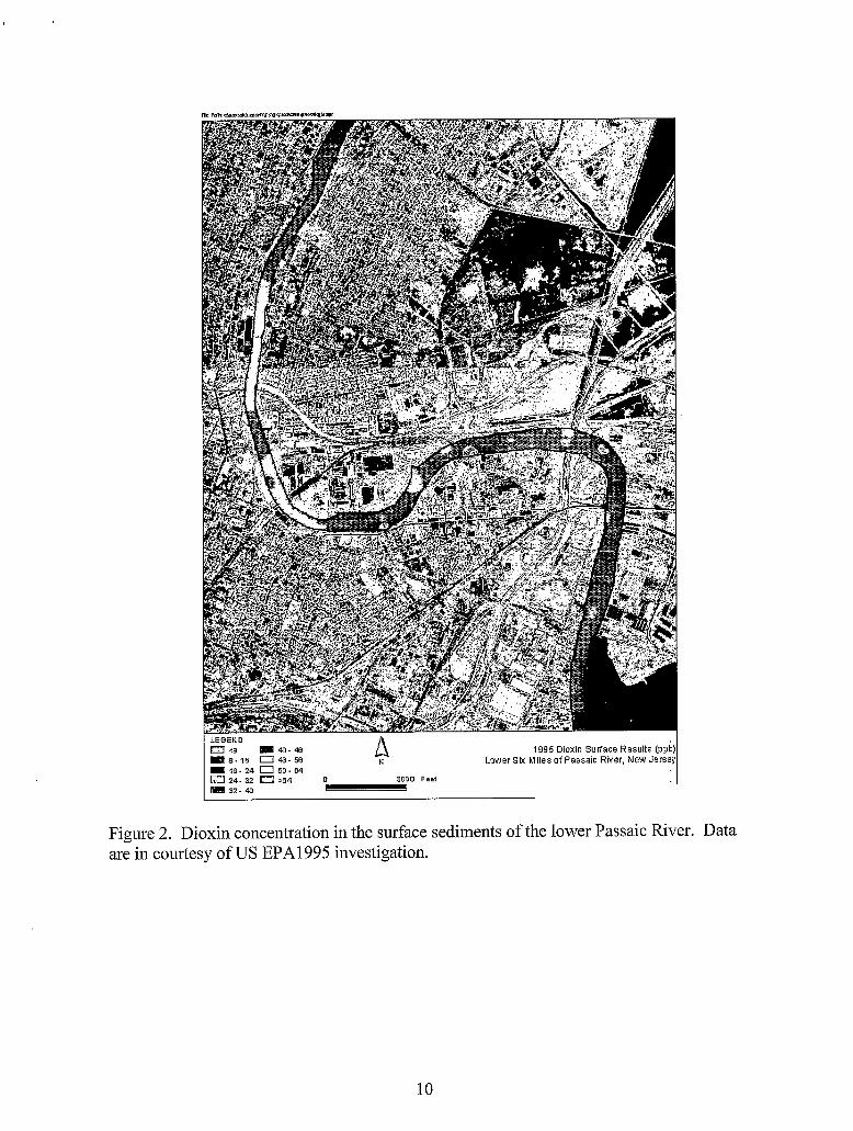
Dioxin contamination in the lower Passaic River is especially of concern, which is under investigation by the EPA for evaluation of dioxins contaminants from a 2,4,5-T pesticide manufacturing company known as Diamond Alkali , now Occidental Corporation, as well as other non-point sources along the river (Huntley et a1..1995; Wenning et ai., 1993). Huntley et ai. (1 995) found that heavily contaminated sediments from previous uncontrolled industrial discharge have been buried by relatively cleaner, recent sediments. However, sediment contamination nowadays is still present and may be caused by some point and non-point sources in the system. The variability of dioxin concentrations may be associated to various combined sewage overflows and diffuse sources such as stormwater runoff and the deposition of atmospheric combustion related activities (Crawford et al., 1995; Huntley et al., 1997).
In this study, we used EPA 1995 investigation data to map dioxin concentration in surface sediments (SO. 15 meter i.e. 10.5 feet) in the lower Passaic River. It is found that dioxin concentration in surface sediments ranges from 0.0788 pg kg-' to 72.3 pg kg" in the study area (Fig. 2). The highest concentration is found at a location within the Harrison Reach (mile point (mp) = 2, or km point = 3.2) of the study area
In this study, we investigated the transport of dioxin in the lower Passaic River. As the lower Passaic River is a tidal influenced estuary, using dioxin concentration in surface sediments to disceim the long-term mass transport of dioxin could be skewed by sedimentation and vertical burials. Considering this factor, we use dioxin inventory in the sediments to study the along-channel dioxin transpoi-t. As an inventory of a contaminant is a vertical integration of the contaminant in the unit area, the estimation is not affected by the sedimentation rate and deep burials. We used three years data. which are 1991, 1993 and 1995, to evaluate the transport of dioxin with time. Based on our limited data, we found that dioxin inventory in the lower Passaic River ranges from 0.0079 to 1.5 1 pg cm-2 for year of 199 1,O.OO 12 to 2.9 1 pg cm-2 for year of 1993 and 0.0004 to 228.9 pg cm-2 for year of 1995, respectively, and that high dioxin inventory seemed gradually moving down stream (Fig. 3). It should be pointed out that the 1995 sampling resulted in a relatively complete data set, which includes the data fiom cross section of the river and the data at depths. The 1991 and 1993 sampling did not cover as
3
broad area and depths as the 1995 sampling. Therefore, the inventories resulted from the 1991 and 1993 investigations can only represent the minimum inventory values. Nevertheless, the information from these inventory estimate still suggest that, as a result of hydrodynamics and sediment dynamics caused by fresh water discharge and tidal currents, the contaminated sediment has patch distributions and could be resuspended and gradually transported down stream.
3.2 Polycyclic Aromatic Hydrocarbons (PAHs)
Polycyclic aromatic hydrocarbons (PAHs) are a group of over 100 different chemicals that are formed during the incomplete burning of coal, oil and gas, garbage, or other organic substances. PAHs are usually found as a mixture containing two or more of these compounds (Lamoureux et al., 1996). Microorganisms can break down PAHs in soils, sedments or water after a period of weeks to months (Wenning et al., 1994). Through diffusive-exchange processes, gaseous PAHs can be emitted to air across the air-water interface (Nelson et al., 1998).
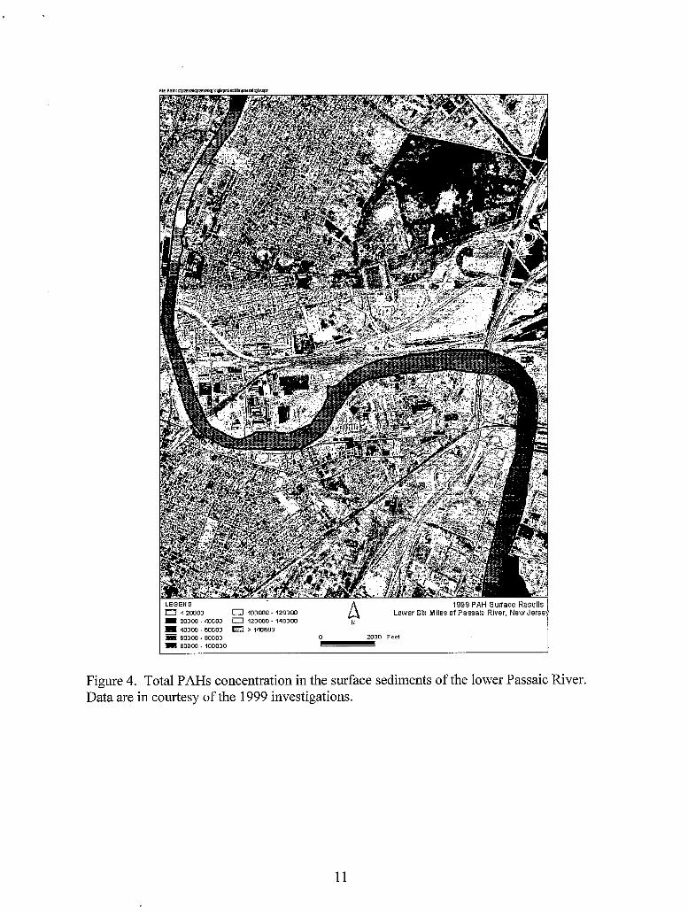
We studied PAHs distributions in surface sediments of the lower Passaic River based on the 1999 sampling data and found that total PAHs concentration ranges from 361 to 167000 pg kg" with an average of 34070 pg kg" (Fig. 4). High concentration of PAHs are found at mile point = 6 in the river. As discharge of contaminants to the river has been strictly controlled in recent years by federal and state regulations, these high concentrations of PAHs contaminants are very like the residuals from uncontrolled discharge in the past or accidental oil spills. But, the results indicate that PAH contamination in this area is still very serious and a remedial action is needed to recover the system (Gills et al., 1993).
3.3 Polychlorinated biphenyls (PCBs)
Polychlorinated biphenyls (PCBs) are a group of 209 related compounds. which differ only in the number and pattern of chlorine atoms that are attached to the biphenyl molecule. These compounds are termed congeners of PCBs. The physical and chemical properties of PCBs show a gradation in increasing chlorination, with the more highly chlorinated congeners being the most fat soluble and the most stable (Wenning et al., 1994). Of the 209 congeners of PCBs, a small number, less than 10% of the total, have been reported as having toxicological effects (Danse et al., 1997; Longnecker et al., 1997). As same as dioxin, the problem with PCBs is that their presence in the environment is ubiquitous and compounds degrade very slowly (Lamoureux et al., 1996).
In this study, we only finished analyzing total PCB data for the 1995 sampling. Data shows that the concentrations of total PCBs concentration in the lower Passaic River surface sediment ranges from 76.1 to 17200 pg kg-' with an average of 1713 pg kg-' (Fig. 5). The high total PCB concentrations are found at mile point -2 and 5 (km point -3 and 8), respectively (Fig. 5).
4
3.4 Selected Heavy Metals (, Cr, Hg, Pb, Zn)
Heavy metal contamination in the lower Passaic River is also of big concern because of these toxic metals directly affect water and sediment quality and aquatic life. The knowledge of metal contamination in the lower Passaic River is critical to the decision-making of Passaic River ecosystem restoration. In this study, we only performed data analysis for 1995 sampling. Heavy metal contaminant (Cr, Hg, Pb and Zn) distributions surface sediments in six miles of the lower Passaic River are shown in Figs. 6-9. We found that Cr concentration ranges from yg kg-], 7900 ta 58900 pg kg-* (Fig. 6). Hg, 100 to 10700 yg kg" (Fig. 7), Pb, 4400 to 751000 yg kg'' (Fig. 8), and Zn, 20500 to 1620000 pg kg-' (Fig. 9), respectively. High concentration areas of these toxic metal contaminants are focused within Harrison reach in mile point 2 to 3 (or km point 3 to 5 ) of the study area. As there were and are numerous of industrial manufactures situated on the both side of the lower Passaic River, they are sources of these contaminants (Bonnevie et al., 1992, 1993, 1994;Crawford et al., 1995; Gills et al, 1993; Huntley et al., 1997) . This is especially true in the past when the discharge of various contaminants to the Passaic River system is uncontrolled and unlimited (Huntley et al., 1995; Iannuzzi and Wenning, 1995; Iannuzzi et al., 1997; Meyserson et al., 1981).
Summary and Recommendation
Analyzing the existing large data sets, our research shows that the lower Passaic River is still one of the nation's most polluted rivers and estuaries. Remediation and restoration actions are needed to recover the system. This study demonstrates that Geographic Infoimation System (GIS) analysis of contaminant data not only enhances the characterization of the contaminant spatial distribution, but also serves as an informative management tool to provide important information for the strategic development of environmental management and restoration.
For the future work, our preliminary data analysis suggests that an in-depth understanding of the source, transport and fate of these contaminants be necessary for effective environmental management and ecosystem restoration of the lower Passaic River. As found in this study, some critical data at depths are missing. These data are important and useful for precise analysis of contaminant focusing sites and accurate estimate of contaminant loads. Therefore, a comprehensive review, analysis and assessment of contaminant data, including further data collection, are recommended by this study. After a more comprehensive study is done, an integrated information and better understanding of the lower Passaic River environmental status will be achieved.
Acknowledgement
Research supported in part by New Jersey Sea Grant College Program under Project No. WD-2003-2 (HF, VO), the US Department of Energy under Contract No. DE-AC02- 98CH10886 and through Interagency Agreement DW89941761-01 between the US Environmental Protection Agency and US Department of Energy (HF).
5
References
Ayres, R. U., Rod, S. R., 1986, Patterns of Pollution in the Hudson-Raritan Basin,
Bonnevie N. L., Wenning R.J., Gunster, G.D., 1992, Lead Contamination in Surf-icial Environment 28 (4): 14-43
Sediments from Newark Bay, New Jersey, Environmental International 1 8: 497- 508
in Sediments from Three Wateiways in Northern NJ. Env. Contamination and Toxicology 5 1 : 672-680
Contamination in Surficial Sediments from Newark Bay, New Jersey, Science of Total Environment 144: 1 - 16
Bopp, R. F., Simpson, H. J., 1991, Sediment Sampling and Radionuclide and Chlorinated Hydrocarbon Analysis in Newark Bay and the Hackensack and Passaic Rivers: Final Report to the State of New Jersey Department of Environmental Protection, Division of Science and Research, Palisades, NY: Lamont-Doherty Geological Observatory of Columbia University
Brydon, N., 1974, The Passaic River: Past, Present, and Future, New Brunswick: Rutgers University Press
Crawford, D. W.. Bonnevie, N. L., Wenning, R. J., 1995, Sources of Pollution and Sediment Contamination in Newark Bay, New Jersey, Ecotoxicol. Environ. Safety 30:85-100
Brunswick: Rutgers University Press
Position paper of the American Council on Science and Health: public health concerns about environmental polychlorinated biphenyls (PCBs). Ecoloxicology and Environmental Safety, 38, 71-84.
Finley, B., Wenning, R. J., Ungs, M. J., Huntley, S.L., Paustenbach, D. J.. 1990. PCDDs and PCDFs in Surficial Sediments from the Lower Passaic River and Newark Bay, p.409-4 14, In: Short Papers from the 1 Ofh International Meeting, Dioxin '90. Volume 1
Gillis, C. A., Bonnevie, N. L., Su, S. H., Ducey, G. J., Huntley. S. L., Wenning, R. J., 1995, DDT, DDD, DDE Contamination of Sediment in Newark Bay Estuary. New Jersey, Arch. Environ. Contam. Toxicol. 2835-92
Petroleum and Hazardous Chemical Spills in Newark Bay, New Jersey, USA from 1982 to 199 1, Environmental Pollution 82:245-253
Gillis, C.A., Bonnevie, N.L., Wenning. J., 1993. Mercury Contamination in the Newark Bay Estuary Ecotoxicology and Environmental Safety 25: 214-226
Gunster, D.G., Bonnevie, N.L., Wenning, J., et al., 1993, Assessment of Chemical Loadings to Newark Bay, New Jersey from Petroleum and Hazardous Chemical Accidents Occurring from 1986 to 199 1. Ecotoxicology and Environmental Safety 25: 202-213
Bonnevie N. L., Wenning R.J., Huntley S.L., 1993, Distribution of Inorganic Compounds
Bonnevie, N. L., Huntley, S. L., Found, B. W., Wenning, R. J., 1994, Trace Metal
Cunningham, J. T., 1954, Made in New Jersey: The Industrial Story of a State, New
Danse, I.R., London, W.M., Newell, G.W., Jaeger, R.J., Lu, C. Frand, et. al. 1997.
Gillis, C. A., Gunster, D. G., Bonnevie, N. L., Abel. T. B.. Wenning, R. J., 1993,
6
Huntley, S. L., Iannuzzi, T. J., Avantaggio, J. D., Carlson -Lynch, H., Schmidt, C. W., Finley, B. L., 1997, Combined Sewer Overflows as Sources of Sediment Contamination in the Lower Passaic River, New Jersey, 11, Polychlorinated Dibenze-p-dioxins, Polychlorinated Dibenzofurans, and Polychlorinated Biphenyls, Chemosphere 34:233-250
Huntley, S.L., Bonnevie, N. L., et al., 1995, Distribution of Polycyclic Aromatic Hydrocarbons and Petroleum Hydrocarbon Contamination in Sediment from Newark Bay Estuary, New Jersey, Arch. Environ. Contam. Toxicol. 28: 93-107
Geochronology and sedimentology of the lower Passaic River, New Jersey Estuaries, 18: 351-361
Iannuzzi, T. J., Huntley S.L., Schmidt, C. W., Finley, B. L., McNutt, R. P., Burton, S. J., 1997, Combined Sewer Overflows (CSOs) as Source of Sediment Contamination in the Lower Passaic River, New Jersey. 1. Priority Pollutant and Inorganic Chemicals, Chemosphere 34:213-23 1
Iannuzzi, T. J., Huntley, S. L., Finley, B. L., Wenning, R. J., 1995, DistTibution of Possible Sources of Polychlorinated Biphenyls in Dated Sediments from Newark Bay Estuary, New Jersey, Arch. Environ. Contam. Toxicol. 28: 108- 1 17
Iannuzzi, T. J., Ludwig, D. F., Kinnell, J. C.. Wallin, J. M., Desvousges, W. H., Dunford, R. W., 2002, A Common Tragedy: History of an Urban River, Amherst Scientific Publishers
Iannuzzi, T. J., Wenning, R. J., 1995, Distribution and Possible Sources of Total Mercury in Sediments from the Newark Bay Estuary, New Jersey, Bull. Environ. Contam. Toxicol. 55:901-908
Lamourem, E.M., Brownawell, B.J., Bothner, M.H. 1996. Linear alkylbenzenes as tracers of sewage-sludge-derived inputs of organic matter, PCBs and PAHs to sediments at the 106 mile deep water disposal site. Journal of Marine Environmental Engineering, 2, 325-342
Longnecker, M.P., Rogan, W.J., and Lucier, G. 1997. The human health effects of DDT (dichlorodiplienyl-trichloroethane) and PCBs (polychlorinated biphenyls) and an overview of organochlorines in public health. Annu. Rcv. Public Health, 18,2 1 1 - 244.
Meyerson, A. L.. Luther, G. W. 111, Krajewski, J., Hires, R. I., 1981, Heavy Metal Distribution in Newhrk Bay Sediments, Marine Pollution Bulletin 12( 7): 244-250
Nelson, E.D., McConnell, L.L.,, and Baker, J.E. 1998. Diffusive exchange of gaseous polycyclic aromatic hydrocarbons and polychlorinated biphenyls across the air- water interface of the Chesapeake Bay. Environmental Science and Technology,
Huntley, S.L., Wenning, R.J., Su, S.H., Bonnevie, N.L., and Paustenbach, D.J., 1995,
32,912-919. NJDEP [New Jersey Department of Environmental Protection], 1987, Passaic River
Water Quality Management Study, NJDEP, Division of Water Resources R-EMAP (Regional Environmental Monitoring and Assessment Program), 1998, Final
Report: Sediment Quality of the NY/NJ Harbor System Shear, N. M., Schmidt, C. W., Huntley, S. L., Crawford, D. W., Finley, B. L.. 1996,
Evaluation of the Factors Relating Combined Sewer Overflows With Sediment Contamination of the Lower Passaic River, Marine Pollution Bulletin 32(3): 288- 304
7

Tiei-ra Solutions, Inc., 2003, Executive Summary: Passaic River Study Area Preliminary
Walker, W. J.. McNutt, R. P., Maslanka, C. K., 1999, The Potential Contribution of Findings
Urban Runoff to Surface Sediments if the Passaic River: Source and Chemical Characteristics, Chemosphere 3 8 : 3 63-3 77
Dibenzo-p-Dioxin and Dibenzofuran Residue in Surficial Sediments from Newark Bay, New Jersey and other Industrialized Waterways Arch. Environ. Contam. Toxicol. 22: 397-413
Dioxin in the Aquatic Environment, Ecotoxicology and Environmental Safety 23 :
Wenning, J., Harris, M., Finley, B. Paustenbach, D. J., Bedbury, H., 1993, Application of
Wenning, J., Harris, M., et al., 1992 Chemometric Comparisons of Polychlorinated
Wenning, J., Harris, M., et al., 1992, Potential Sources of 1,2,8,9-Tetrachlorodibenzo-p-
133- 146
Pattern Recognition Technique to Evaluate Polychlorinated Dibenzo-p-Dioxin and Dibenzofuran Distributions in Surficial Sediments From the Lower Passaic River and Newark Bay, Ecotoxicology and Environmental Safety 25: 103-125
Wenning, J., Harris, M., Paustenbach, D. J., Bedbury, H., 1993, Principal Component Analysis of Potential Sources of Polychlorinated Dibenzo-p-Dioxin and Dibenzofuran Residues in Surficial Sediments fi-om Newark Bay. New Jersey, Arch. Environ. Contam. Toxicol. 24: 271-289
Polychlorinated biphenyls, and Polycyclic Aromatic Hydrocarbons in Sediment fi-om Lower Passaic River, New Jersey. Arch. Environ. Contam. Toxicol. 27:64- 81
Estuary, Steton Hall Law Review, 29:37-46
Wenning, R. J., Bonnevie, N. L., Huntley, S. L., 1994, Accumulation of Metals,
Wolfskill L. A., McNutt R.P., 2000, An Environmental Study of the Passaic River and its
Zhang, J., & Liu, C. L.. 2002. Riverine composition and estuarine geochemistry of particulate metals in China - Weathering features, anthropogenic impact and chemical fluxes. Estuarine, Coastal and Shelf Science, 54, 105 1-1070.
8
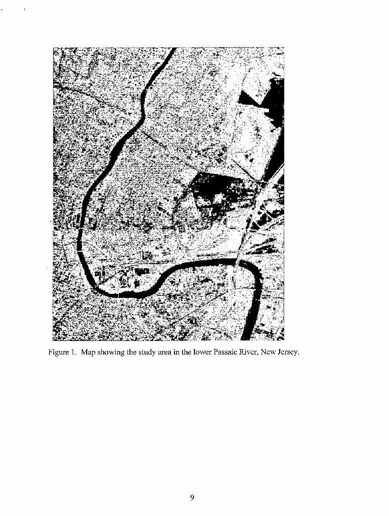
Figure 1. Map showing the study area in the lower Passaic River, New Jersey.
9
LEGEND m c s a m . 4 3 a 8 - 1 5 [=I 48-66
10- 24 c=] 5 6 - 64 a 24- 32 a S64 0 3ono Feet 32- 40 .
Figure 2. Dioxin concentration in the surface sediments of the lower Passaic River. Data are in courtesy of US EPAl995 investigation.
10
N
LEGEND 1999 PAH surface Results E3 e 20000 A Lower Six Miles of Passaic River, New Jerse
Ra 40000 - 60000 5 80000 - 100000 3.
0 I 0 100000 - 120000
a > 140000 20000 - 40000
60000~80000
0 120000 - 140000
2000 Feet
Figure 4. Total PAHs concentration in the surface sediments of the lower Passaic River. Data are in courtesy of the 1999 investigations.
11
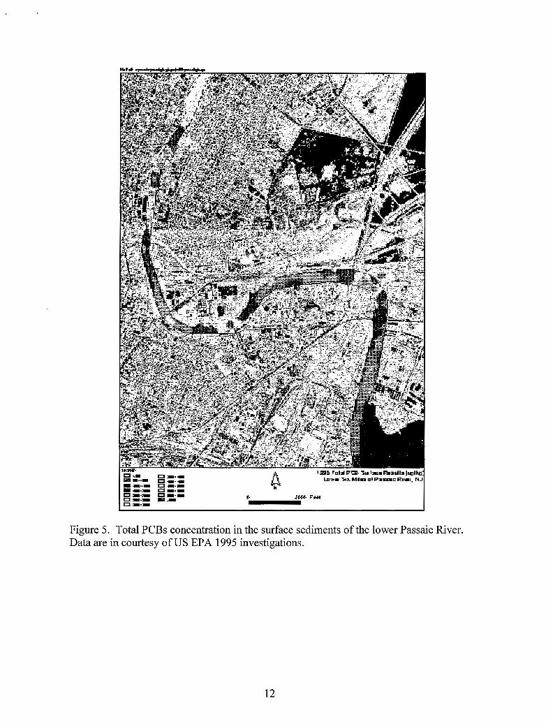
Figure 5. Total PCBs concentration in the surface sediments of the lower Passaic River. Data are in courtesy of US EPA 1995 investigations.
12

Figure 6 . Chromium (Cr) concentration in the surface sediments of the lower Passaic River. Data are in courtesy of US EPAl995 investigations.
13
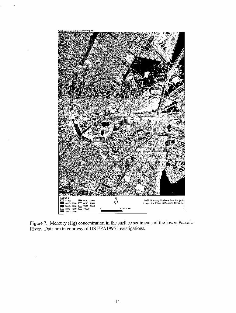
1995 Mercury Surface Results (ppb) Lower SI:: M des of Passaic River, NJ - I L E G E N D
0 c1000 5000-0000 B 1000-2000 0 8000.7000
2000 - 3000 0 7000 - SOW 0 3000-4000 ,8000 0 3000 Feet rn moo. m o o -
Figure 7. Mercury (Hg) concentration in the surface sediments of the lower Passaic River. Data are in courtesy of US EPA1995 investigations.
14
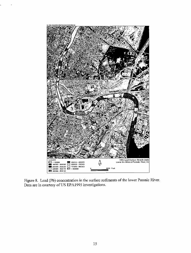
Lower S k Milesof Passaic River, WJ 4 < I00000 500000 - BOO000 I 100000~200000 0 005005 - 700000
200000~300000 0 705050 - 800000
405500 - 500000
0 3000 Feet 'I
0 300000~400005 0 > 800000
Figure 8. Lead (Pb) concentration in the surface sediments of the lower Passaic River. Data are in courtesy of US EPA1995 investigations.
15
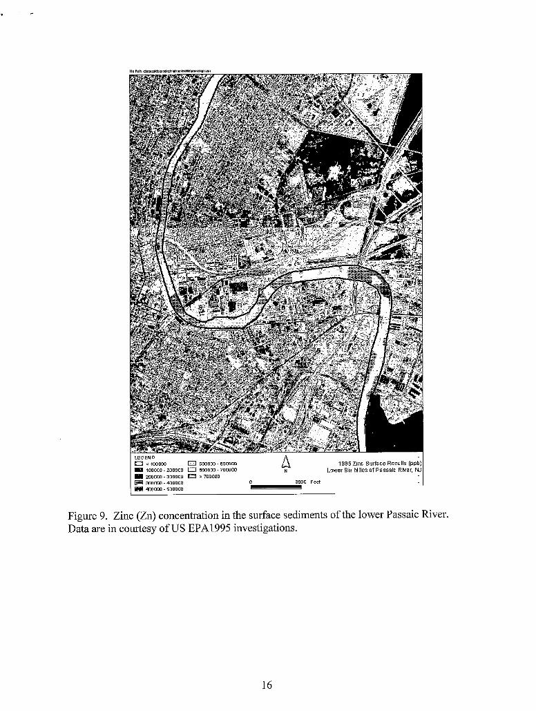
LEGEND I 3 c 100000 0 500000. BOO000 81 I00000 - 200000 0 800000 - 700000
200000 - 300000 > 700000 3000 Feet , 300000 - 400000 o 4
400000 - 500000 . Figure 9. Zinc (Zn) concentration in the surface sediments of the lower Passaic River. Data are in courtesy of US EPAl995 investigations.
16