Embed Size (px)
Citation preview
LUPZ Blueline 2014
VOLCANO HEIGHTS SECTOR DEVELOPMENT PLAN – LUPZ BLUELINE 2014ii
City of Albuquerque Richard J. Berry, MayorRobert J. Perry, Chief Administrative Offi cer
City CouncilKen Sanchez, District 1, Vice PresidentRoxanna Meyers, District 2Isaac Benton, District 3 Brad Winter, District 4Dan Lewis, District 5, PresidentRey Garduño, District 6Janice E. Arnold-Jones, District 7Trudy E. Jones, District 8Don Harris, District 9
Environmental Planning CommissionRon O. Garcia, Council District 1 Vacant, Council District 2Moises Gonzalez, Council District 3 Peter Nicholls, Council District 4Hugh Floyd, Chair, Council District 5Maia Mullen, Council District 6James Peck, Council District 7Doug Peterson, Vice Chair, Council District 8Michael Dickson, Council District 9
Special Th anks to: Kurt Anschuetz, Rick Beltramo, Ron Bohannan, John Edward, Will Gleason, Dr. Gerald Gold, James Hoff man, Rene Horvath, John Ransom, Richard Ransom, Keith Sheffl er, Jerold Widdison, Jolene Wolfl ey, Steve Metro
City and Technical Staff Council Services: Laura Mason, Director, Kara Shair-Rosenfi eld,
Sara Mancini, and Andrew Webb, Policy Analysts
Planning Department: Suzanne Lubar, Director; Russell Brito, Manager, Urban Design & Development Division; Petra Morris and Mikaela Renz-Whitmore, Long Range Planning; Tim Gaulden, AGIS; Curtis Cherne, Hydrology; Tony Loyd and Kristal Metro, Transportation Review
Parks and Recreation: Matthew Schmader, Superintendent, Jay Lee Evans, and Susannah Abbey, Open Space Division; Christina Sandoval, Carol Dumont, and James Lewis, Parks and Recreation
Legal: Anita Miller, Kevin Curran, Jenica Jacobi, and Blake Whitcomb
Economic Development: John Garcia and Dierdre Firth Municipal Development: Debbie Bauman and Willfred GallegosABQ RIDE: Lawrence Kline and Andrew de GarmoMid-Region Council of Governments: Th addeus Lucero, Tony Sylvester, Terry
Doyle, Dave Panella, Kendra Watkins, Aaron Sussman, Steve Montiel, Julie Luna, and Caeri Th omas, as well as members of the Transportation Coordinating Committee and Roadway Access Committee
Albuquerque-Bernalillo County Water Utility Authority: Allan Porter and Frank RothAlbuquerque Metropolitan Area Flood Control Authority: Brad Bingham and Karen StearnsNational Park Service: Diane SouderGateway Planning Group: Scott Polikov and Brad Lonberger Nelson\Nygaard: Jeremy Nelson and Colin Burgett
VOLCANO HEIGHTS SECTOR DEVELOPMENT PLAN
[NOTE: Items in red are changes made during the EPC process. Th ose followed by a number in brackets are Conditions of Approval added during the EPC hearing Feburary 14, 2014. Changes in blue indicate new recommendations from staff .]
VOLCANO HEIGHTS SECTOR DEVELOPMENT PLAN – LUPZ BLUELINE 2014 iii
VOLCANO HEIGHTS SECTOR DEVELOPMENT PLANAs Adopted by the Mayor and the City Council
File No. R-13-132 / City Enactment No. R-2013-068
Amendments: Th is Plan incorporates the City of Albuquerque amendments in the following referenced Resolutions, which are on fi le with the City Clerk’s Offi ce.
Month / Year Adopted Council Bill No.
City Enactment
No.
Description[include purpose, summary, and EPC Case number]
Pending 2014 Update transportation network map and cross sections for consistency with all Volcano Mesa Plans, edit building frontage defi nition and calculation, address residential and mixed-use development to prevent fugitive dust, and fi x errata.
[Note: Amendments as of 2014 are refl ected in the Plan text. For more information, search for the Council Bill No. in City Council’s Legistar webpage.]
VOLCANO HEIGHTS SECTOR DEVELOPMENT PLAN – LUPZ BLUELINE 2014iv
VOLCANO HEIGHTS SECTOR DEVELOPMENT PLAN – LUPZ BLUELINE 2014 v
VOLCANO HEIGHTS SECTOR DEVELOPMENT PLAN – LUPZ BLUELINE 2014vi
VOLCANO HEIGHTS SECTOR DEVELOPMENT PLAN – LUPZ BLUELINE 2014 vii
VOLCANO HEIGHTS SECTOR DEVELOPMENT PLAN – LUPZ BLUELINE 2014viii
VOLCANO HEIGHTS SECTOR DEVELOPMENT PLAN – LUPZ BLUELINE 2014 ix
VOLCANO HEIGHTS SECTOR DEVELOPMENT PLAN – LUPZ BLUELINE 2014x
Page Left Intentionally Blank
VOLCANO HEIGHTS SECTOR DEVELOPMENT PLAN – LUPZ BLUELINE 2014 xi
CHAPTER I: INTRODUCTION
1.0 Executive Summary Page 3
1.1 Plan Area 41.2 Purpose 41.3 Intent 41.4 Strategy for Zoning 41.5 Strategy for Development Standards 61.6 Anticipated Build-out by 2035 71.7 Plan Components 81.8 Using Th is Plan 10
CHAPTER II: REGULATIONS
2.0 Plan Authority Page 15
2.1 Rank Plans 162.2 Northwest Mesa Escarpment Plan (NWMEP) 172.3 Unser Boulevard Design Overlay Zone (DOZ) 182.4 City Zoning Code 202.5 City Subdivision Ordinance 202.6 Development Process Manual (DPM) 202.7 Other City Regulations 20
3.0 Administration Page 21
3.1 Applicability 223.2 Development Review and Approval Process 223.3 Amendments to the SDP and/or Zoning Map 343.4 Public Notifi cation 353.5 Defi nitions 40
4.0 Zoning Page 55
4.1 Adoption of Volcano Heights Zoning 574.2 Establishment of Character Zones 614.3 Table of Land Uses 634.4 Criteria for Conditional Uses 71
5.0 Site Development and Building Design Standards Specifi c to Zones
Page 77
5.1 Town Center 785.2 Regional Center 845.3 Village Center 905.4 Mixed-Use 955.5 Escarpment Transition 1015.6 Neighborhood Transition 106
6.0 Site Development Standards General to All Zones Page 109
6.1 Gated Communities 1106.2 Neighborhood Design 1106.3 Structure Heights 1106.4 Optional Height Bonus for Buildings 1116.5 Grading 1166.6 Construction Mitigation 1176.7 Infrastructure 1206.8 Street Screens 1226.9 Design of Site Elements for Automobile-related
Uses123
TABLE OF CONTENTS
VOLCANO HEIGHTS SECTOR DEVELOPMENT PLAN – LUPZ BLUELINE 2014xii
CHAPTER III: STREET AND STREETSCAPE STANDARDS
10.0 Street Standards Page 163
10.1 Purpose / Intent 16410.2 Applicability 16410.3 How to Use Th ese Standards 16410.4 Access 16910.5 Street Designations 17110.6 Primary Street Cross Sections 17310.7 Secondary Street Design Standards 199
11.0 Streetscape Standards Page 205
11.1 Adjustments 20611.2 General Streetscape Standards 20611.3 Street Tree Standards 20711.4 Street Lighting Standards 20911.5 Street Furniture and Materials Standards 210
7.0 Building Design Standards General to All Zones Page 125
7.1 Purpose / Intent 1267.2 Building Orientation 1267.3 Building Massing and Scale 1267.4 Zero Lot Line Structures 1277.5 Structure Color 127
7.6 Design of Parking Structures 1287.7 Design of Residential Garages 1297.8 Design of Automobile-related Buildings 1317.9 Wireless Telecommunications Facilities (WTFs) 131
8.0 Sign Standards Page 133
8.1 Applicability 1348.2 Unique Sign Applications 134
9.0 Open Space, Landscaping, and Site Lighting Design Standards
Page 141
9.1 Purpose / Intent 1429.2 Applicability 1429.3 Open Space Requirements 1429.4 Detached Open Space Standards 1439.5 Usable Open Space Standards 1449.6 Petroglyphs 1469.7 Landscaping Standards 1519.8 Site Lighting Standards 159
Table of Contents (cont’d)
VOLCANO HEIGHTS SECTOR DEVELOPMENT PLAN – LUPZ BLUELINE 2014 xiii
APPENDIX [UNDER SEPARATE COVER]Appendix A. Pre-existing ConditionsAppendix B. Sector Planning ProcessAppendix C. 2013 Access Resolution for Paseo del Norte
and Unser Boulevard and Traffi c StudyAppendix D. Private Preservation OptionsAppendix E. Fiscal Impact Analysis
EXHIBITS Page
1.1 Volcano Mesa Sector Development Plan Areas 51.2 Volcano Heights Plan Area 62.1 NWMEP and WSSP Volcano Mesa Amendment Boundaries 172.2 Unser Boulevard Design Overlay Zone Boundary 193.1 Volcano Heights Approval Process Diagram 234.1 Zoning Established by the VHSDP 564.2 Zoning Demarcation for Properties with Multiple Zones 576.1 Impact Area and 200-foot Buff er 1107.1 Sample Colors 1277.2 Residential Garage Type Diagrams 130
8.1 Unser Design Overlay Zone within the Volcano Heights Plan Area
135
9.1 Signifi cant Rock Outcroppings 14710.1 Primary Streets and Designations Map 16510.2 Character Zones and Street Types 16610.3 Approved Limited-access Intersections 16910.4 Street Type 1 – Town Center Cross Section 19310.5 Street Type 1 – Typical Intersection (Plan View) 19410.6 Street Type 2 – Connector Street Cross Section 18310.7 Street Type 2 – Typical Intersection (Plan View) 18410.8 Street Type 3 – Neighborhood Street Cross Section 17910.9 Street Type 3 – Typical Intersection (Plan View) 18010.10 Street Type 4.1 – Park Edge Single-Loaded Cross Section 19610.11 Street Type 4.2 – Park Edge Double-Loaded Cross Section 19610.12 Street Type 4.1 – Typical Intersection (Plan View) 19710.13 Street Type 4.2 – Typical Intersection (Plan View) 19810.14 Street Type 5 – Transit Boulevard Cross Section 19110.15 Street Type 5 – Typical Intersection (Plan View) 19210.16 Street Type 6 – Unser Boulevard Cross Section 18910.17 Street Type 7 – Paseo del Norte Cross Section 190
Table of Contents (cont’d)
CHAPTER IV: GOALS, POLICIES, AND IMPLEMENTATION
12.0 Goals Page 213
12.1 Environment and Open Space 21412.2 Economic Development 21512.3 Transportation 21712.4 Land Use and Urban Design 21812.5 Infrastructure 221
13.0 Policies Page 223
13.1 Environment and Open Space 22413.2 Economic Development 22513.3 Transportation 22613.4 Land Use and Design 23813.5 Infrastructure 241
14.0 Implementation Page 245
14.1 Priority Capital Improvement Projects 24614.2 Implementation Responsibilities 24714.3 Optional Financial Tools 24814.4 Amending Th is Sector Development Plan 24914.5 Implementation Matrix 249
VOLCANO HEIGHTS SECTOR DEVELOPMENT PLAN – LUPZ BLUELINE 2014xiv
Table of Contents (cont’d)
TABLES Page
1.1 Volcano Heights Anticipated Development Total by Land Use 71.2 Anticipated Development by Character Zone 71.3 Street Hierarchy and Street Designations Matrix 92.1 Relevant Ranked Plans 163.1 Applicability of Plan Sections by Development Type 243.2 Minor Deviation Criteria 313.3 Major Deviation Criteria 333.4 Approval Process and Notifi cations: Site Plans for Subdivision 363.5 Approval Process and Notifi cations: Site Plans for Building
Permit37
3.6 Approval Process by Development Type 384.1 Zone Demarcation for Properties with Multiple Zones 584.2 Alphabetical Index of Properties with Multiple Zones 614.3 Character Zones by Land Use Category 62
EXHIBITS Page
10.18 Street Type 8 – Universe Boulevard Cross Section 18210.19 Example Diagrams: Alley Confi gurations with ‘A’ vs. ‘B’
Street Percentages199
10.20 Typical ‘A’ Street 20110.21 Typical ‘B’ Street 20210.22 Typical Residential Alley Cross Section 20310.23 Typical Commercial Alley Cross Section 20313.1 Volcano Mesa Road Network [11, 12] 22713.1 Circuitous vs. Direct Pedestrian Routes to Transit Stops 23213.2 Reverse-angle Parking Examples 23413.3 Roundabout vs. Typical Intersection Confl ict Points 23513.4 Sample Transition to Density Over Time 24013.5 Recommended Rainwater Design Techniques 243
TABLES Page
4.4 Land Use Table by Character Zone 644.5 Conditional Use Criteria 716.1 Total Points for Building Height Bonus by Character Zone 1126.2 Bonus Height Points Per Criterion 1136.3 Standards for Optional Height Bonus Criteria 1147.1 Garage Types 1298.1 Sign Types by Character Zone 1369.1 Types of Open Space 1429.2 Detached Open Space: Residential Uses 1439.3 Detached Open Space: Non-Residential Uses 1439.4 Open Space Criteria 1489.5 Plant List 15310.1 Adjustment Criteria 16810.2 Secondary Street Requirements 19910.3 Typical Secondary Street and Alley Cross Section Options 20013.1 Appropriate Density and Land Use by Zone 23813.2 Locations Appropriate for Low-Impact Design (LID) by Scale 24213.3 Objectives and Recommendations for LID by Design Element 24314.1 Implementation Matrix 250
(cont’d)
(cont’d)
VOLCANO HEIGHTS SECTOR DEVELOPMENT PLAN – LUPZ BLUELINE 2014 xv
LIST OF ACRONYMS
AASHTO: American Association of State Highway and Transportation Offi cials
ABCWUA: Albuquerque-Bernalillo County Water Utility Authority
ADA: Americans with Disabilities Act AMAFCA: Albuquerque Metropolitan Area Flood
Control Authority AMPA: Albuquerque Metropolitan Planning Area BID: Business Improvement District BRT*: Bus Rapid Transit BTZ*: Build-to Zone CABQ: City of Albuquerque DMD: City Department of Municipal
Development DOZ: Design Overlay Zone DPM: Development Process Manual DRB: Development Review Board DRC: City Design Review/Construction Section DRT: Design Review Team EIFS: Exterior Insulating Finishing System EPC: Environmental Planning Commission FAABS: Future Albuquerque Area Bikeways and
Streets FHWA: Federal Highway Administration FTE: Full Time Equivalent (Employee) GSF*: Gross Square Feet HOA: Homeowners AssociationHOV: High-occupancy Vehicle ITE: Institute of Transportation Engineers ITS*: Intelligent Transportation Systems
LID*: Low Impact DesignLRV: Light Refl ective ValueMAC: Major Activity CenterMPO: Metropolitan Planning OrganizationMPOS: Major Public Open SpaceMRCOG: Mid-Region Council of GovernmentsMRMPO: Mid-Region Metropolitan Planning
OrganizationMTB: Metropolitan Transportation BoardMTP: Metropolitan Transportation PlanMUTCD: Manual on Uniform Traffi c Control
DevicesNMDOT: New Mexico Department of TransportationNOD: Notice of DecisionNWMEP: Northwest Mesa Escarpment PlanONC: City Offi ce of Neighborhood CoordinationPOA: Property Owners AssociationPID: Public Improvement DistrictPNM: Public Service Company of New Mexico
(Electric Utility)PRT: Pre-application Review TeamPUE: Public Utility EasementRI/RO: Right-in / Right-out (Intersection)ROW: Right-of-Way
* See Section 3.5. Defi nitions starting on page 40 for full defi nitions, which include any term other than a section heading or cross reference that appears as bold in this Plan.
SAD: Special Assessment DistrictSDP: Sector Development PlanSF: Square FeetSIA: Subdivision Improvement AgreementTCC: Transportation Coordinating CommitteeTDM: Travel Demand ModelTIF: Tax Increment FinancingTIDD: Tax Increment Development DistrictVHET: Volcano Heights Escarpment Transition
ZoneVHMX: Volcano Heights Mixed-use ZoneVHNT: Volcano Heights Neighborhood Transition
ZoneVHRC: Volcano Heights Regional Center ZoneVHRT: Volcano Heights Review TeamVHSDP: Volcano Heights Sector Development PlanVHTC: Volcano Heights Town CenterWSSP: West Side Strategic PlanWTF: Wireless Telecommunications FacilityZHE: City Zoning Hearing Examiner
VOLCANO HEIGHTS SECTOR DEVELOPMENT PLAN – LUPZ BLUELINE 2014xvi
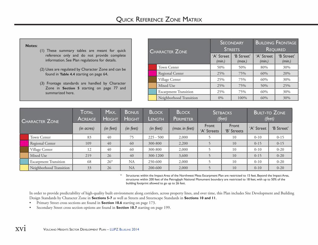
CHARACTER ZONE
TOTAL ACREAGE
MAX. HEIGHT
BONUS HEIGHT
BLOCK LENGTH
BLOCK PERIMETER
SETBACKS (feet)
BUILT-TO ZONE(feet)
(in acres) (in feet) (in feet) (in feet) (max. in feet) Front‘A’ Streets
Front ‘B’ Streets ‘A’ Street ‘B Street’
Town Center 83 40 75 225 - 500 2,000 5 10 0-10 0-15Regional Center 109 40 60 300-800 2,200 5 10 0-15 0-15Village Center 12 40 60 300-800 2,000 5 10 0-10 0-20Mixed Use 219 26 40 300-1200 3,600 5 10 0-15 0-20Escarpment Transition 68 26* NA 250-600 2,000 5 10 0-10 0-20Neighborhood Transition 33 26 NA 200-600 2,000 5 10 0-10 0-20
* Structures within the Impact Area of the Northwest Mesa Escarpment Plan are restricted to 15 feet. Beyond the Impact Area, structures within 200 feet of the Petroglyph National Monument boundary are restricted to 18 feet, with up to 50% of the building footprint allowed to go up to 26 feet.
CHARACTER ZONE
SECONDARY STREETS
BUILDING FRONTAGE
REQUIRED
‘A’ Street(min.)
‘B Street’(max.)
‘A’ Street(min.)
‘B Street’(min.)
Town Center 50% 50% 80% 30%Regional Center 25% 75% 60% 20%Village Center 25% 75% 60% 30%Mixed Use 25% 75% 50% 25%Escarpment Transition 25% 75% 60% 30%Neighborhood Transition 0% 100% 60% 30%
In order to provide predictability of high-quality built environment along corridors, across property lines, and over time, this Plan includes Site Development and Building Design Standards by Character Zone in Sections 5-7 as well as Streets and Streetscape Standards in Sections 10 and 11. • Primary Street cross sections are found in Section 10.6 starting on page 173. • Secondary Street cross section options are found in Section 10.7 starting on page 199.
Notes: (1) These summary tables are meant for quick
reference only and do not provide complete information. See Plan regulations for details.
(2) Uses are regulated by Character Zone and can be found in Table 4.4 starting on page 64.
(3) Frontage standards are handled by Character Zone in Section 5 starting on page 77 and summarized here.
QUICK REFERENCE ZONE MATRIX
VOLCANO HEIGHTS SECTOR DEVELOPMENT PLAN – LUPZ BLUELINE 2014 1
CHAPTER 1: INTRODUCTION
introduction
CHAPTER 1: INTRODUCTIONChapter I

VOLCANO HEIGHTS SECTOR DEVELOPMENT PLAN – LUPZ BLUELINE 20142
Th is Page Left Intentionally Blank
VOLCANO HEIGHTS SECTOR DEVELOPMENT PLAN – LUPZ BLUELINE 2014 3
1.0 EXECUTIVE SUMMARY
VOLCANO HEIGHTS SECTOR DEVELOPMENT PLAN – LUPZ BLUELINE 20144
CHAPTER I: INTRODUCTION
1.0 EXECUTIVE SUMMARY
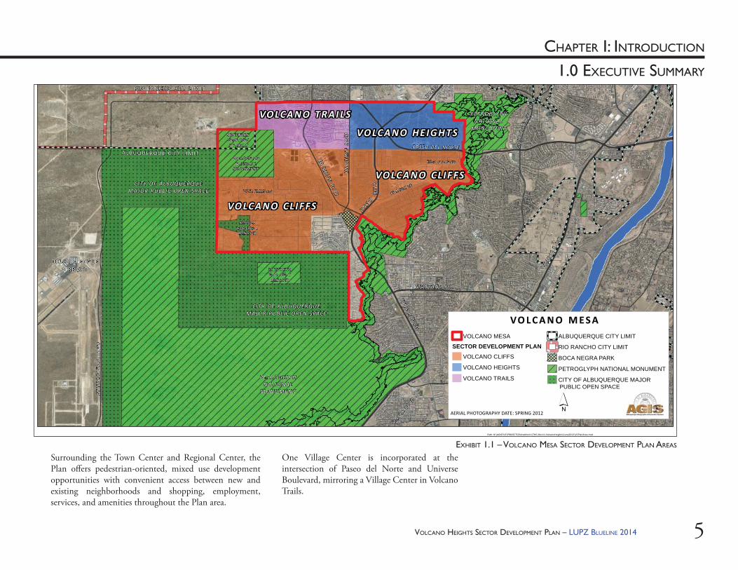
1.1. Plan AreaVolcano Heights is one of three Sector Development Plan areas in Volcano Mesa. [See Exhibit 1.1].
Th e Volcano Heights Sector Development Plan (SDP) is bordered by Paseo del Norte to the north before it curves southeast, the Petroglyph National Monument on the east, Volcano Cliff s SDP boundary on the south, and Universe Boulevard on the west. Th e Plan area includes approximately 570 acres and surrounds the intersection of Paseo del Norte and Unser Boulevard— two vital, regional traffi c arteries.
1.2. PurposeTh e purpose of the Plan is to support pedestrian-friendly and transit-supportive development with particular emphasis on employment, while buff ering pre-existing single-family neighborhoods and sensitive lands on the borders of the Plan area from higher-density development toward the center of the Plan area. Th e Plan seeks to create a walkable, urban center with a sense of place rooted in its unique volcanic context and with development that respects the Petroglyph National Monument, which includes over 10,000 acres of open space preserved in perpetuity by an act of Congress in 1990.
1.3. IntentTh e intent of this Plan is to encourage development that creates an attractive, vibrant Major Activity Center that respects and honors the unique cultural, historical, geological, and volcanological setting, while providing employment, services, amenities, housing, and transportation choices for the larger region as part of a sustainable community on Albuquerque’s West Side.
Adding jobs, urban and mixed-use housing options, and regional retail opportunities in Volcano Heights is part of a larger strategy to provide a center on the West Side that can begin to address the imbalance of jobs and housing that is expected to contribute to increasing traffi c congestion on the region’s river crossings in the future.
Th e zoning and corresponding standards are created to support economic development, a sustainable tax base, and job creation by establishing the predictability of private development along corridors and across property lines to support and leverage investment in Volcano Heights. Infrastructure and utilities, such as safe, reliable electric service, are essential to economic development for the Plan area.
Th e Plan aims to encourage attractive development through the use of recognized principles of urban design and to allow property owners fl exibility in land use, while providing predictability through a higher level of detail in proscribed site development standards, building design, and the form of the built environment.
1.4. Strategy for ZoningAll zones in Volcano Heights allow a mix of residential and non-residential development in order to provide maximum fl exibility to property owners to adapt to market conditions over time and to encourage a mix of housing and services within walking and biking distance. [See Exhibit 4.1 on page 64.]
East of the intersection of Paseo del Norte and Unser Boulevard, the Plan envisions a Town Center with employment-oriented development and entertainment uses organized around a planned transit corridor. Development lining these vital regional auto transportation corridors in the Regional Center Zone is intended to support auto-oriented, destination retail and businesses accessed from local roads.
VOLCANO HEIGHTS SECTOR DEVELOPMENT PLAN – LUPZ BLUELINE 2014 5
CHAPTER I: INTRODUCTION
1.0 EXECUTIVE SUMMARY
COO
RSBL
VD
UNSERBLV
D
ATR
ISCO
VI S
TAB
LVD
DOUB LE EAGL EAIRPORT
PA SEO D E L NO RTE
RAINBO
WBLVD
UN
IVER
SEB
LVD
PETR OG LYPHNAT IO NAL
M ON U M EN T
PETR OG LYPHNAT IO NAL
M ON U M EN T
GO
LFCO
UR
SER
D
RI O R AN CHO C I TY L IM IT
ALB U Q U ERQ U E C IT Y L I M IT
VO LCA N O HE IGH TS
VO LCA N O TRAI LS
VO LCA N O CLIF FS
VO LCA N O CLIF FS
UNSER
N ORTH ER N GEO LOG ICWINDOW
M ID D L EGEO LOG ICWINDOW
SOU T HE R NGEO LOG ICWINDOW
PE T ROG LYP HN ATIO N AL
M ON U M E N T
CI TY O F ALB U QU ERQU EM AJ O R PU BL I C O PEN S PAC E
CI TY O F ALB U QU ERQU EM AJ O R PU BL I C O PEN S PAC E
RO SA PARKS RD
ROSA PARKS RD
KIMMICK DR
M ON TA NO R D~
UN
SERBLVD
BLV
D
UNSER
Path: N:\AGISFILE\PROJECTS\PetraMorris\THG-Nov11-VolcanoHeights\June2012\VCPlanArea.mxd
´AERIAL PHOTOGRAPHY DATE: SPRING 2012
VO L C A N O M E S A
PUBLIC OPEN SPACE
VOLCANO MESA
SECTOR DEVELOPMENT PLANVOLCANO CLIFFS
VOLCANO HEIGHTS
VOLCANO TRAILS
ALBUQUERQUE CITY LIMIT
RIO RANCHO CITY LIMIT
BOCA NEGRA PARK
PETROGLYPH NATIONAL MONUMENT
CITY OF ALBUQUERQUE MAJOR
EXHIBIT 1.1 – VOLCANO MESA SECTOR DEVELOPMENT PLAN AREAS Surrounding the Town Center and Regional Center, the Plan off ers pedestrian-oriented, mixed use development opportunities with convenient access between new and existing neighborhoods and shopping, employment, services, and amenities throughout the Plan area.
One Village Center is incorporated at the intersection of Paseo del Norte and Universe Boulevard, mirroring a Village Center in Volcano Trails.
VOLCANO HEIGHTS SECTOR DEVELOPMENT PLAN – LUPZ BLUELINE 20146
CHAPTER I: INTRODUCTION
1.0 EXECUTIVE SUMMARY
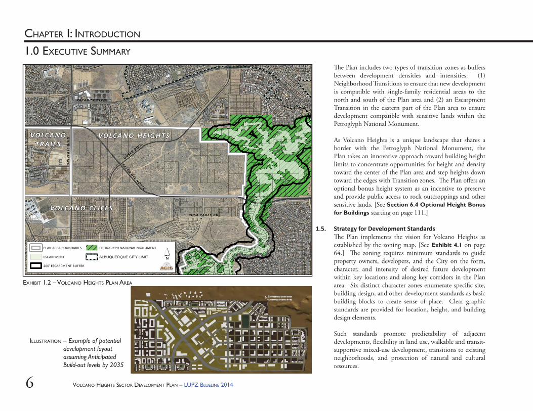
EXHIBIT 1.2 – VOLCANO HEIGHTS PLAN AREA
UNSER BLVD.
PASEO DEL NORTE
RO SA PA R KS R D
UN
I VE R
SE B
L VD
PAR A D IS E B LV D
VO LCA N O HE IGH TS
VO LCA N O CLIF FS
VO LCA N OTRAIL S
PLAN AREA BOUNDARIES
ESCARPMENT
200' ESCARPMENT BUFFER
PETROGLYPH NATIONAL MONUMENT
ALBUQUERQUE CITY LIMIT
P h Q \AGISFILE\PROJECTS\P M i \THG N 11 V l H i h \D b 2012\VHE B ff d�
´
Th e Plan includes two types of transition zones as buff ers between development densities and intensities: (1) Neighborhood Transitions to ensure that new development is compatible with single-family residential areas to the north and south of the Plan area and (2) an Escarpment Transition in the eastern part of the Plan area to ensure development compatible with sensitive lands within the Petroglyph National Monument.
As Volcano Heights is a unique landscape that shares a border with the Petroglyph National Monument, the Plan takes an innovative approach toward building height limits to concentrate opportunities for height and density toward the center of the Plan area and step heights down toward the edges with Transition zones. Th e Plan off ers an optional bonus height system as an incentive to preserve and provide public access to rock outcroppings and other sensitive lands. [See Section 6.4 Optional Height Bonus for Buildings starting on page 111.]
1.5. Strategy for Development StandardsTh e Plan implements the vision for Volcano Heights as established by the zoning map. [See Exhibit 4.1 on page 64.] Th e zoning requires minimum standards to guide property owners, developers, and the City on the form, character, and intensity of desired future development within key locations and along key corridors in the Plan area. Six distinct character zones enumerate specifi c site, building design, and other development standards as basic building blocks to create sense of place. Clear graphic standards are provided for location, height, and building design elements.
Such standards promote predictability of adjacent developments, fl exibility in land use, walkable and transit-supportive mixed-use development, transitions to existing neighborhoods, and protection of natural and cultural resources.
ILLUSTRATION – Example of potential development layout assuming Anticipated Build-out levels by 2035
VOLCANO HEIGHTS SECTOR DEVELOPMENT PLAN – LUPZ BLUELINE 2014 7
CHAPTER I: INTRODUCTION
1.0 EXECUTIVE SUMMARY
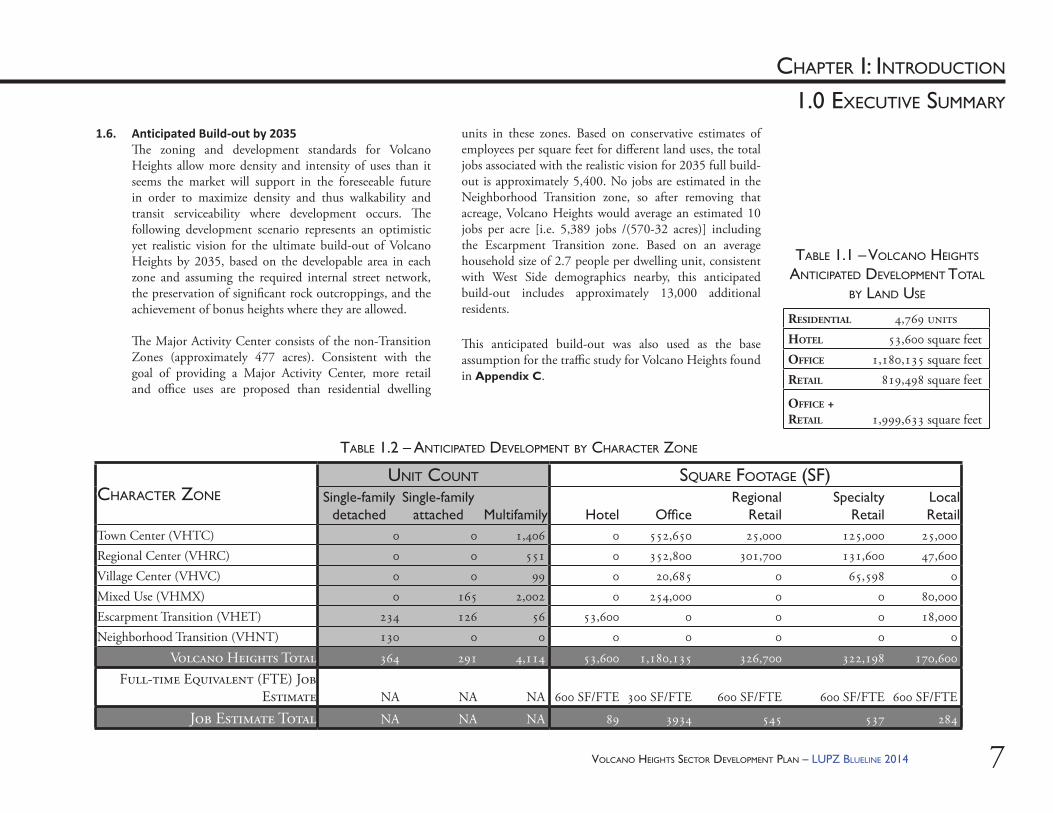
1.6. Anticipated Build-out by 2035Th e zoning and development standards for Volcano Heights allow more density and intensity of uses than it seems the market will support in the foreseeable future in order to maximize density and thus walkability and transit serviceability where development occurs. Th e following development scenario represents an optimistic yet realistic vision for the ultimate build-out of Volcano Heights by 2035, based on the developable area in each zone and assuming the required internal street network, the preservation of signifi cant rock outcroppings, and the achievement of bonus heights where they are allowed.
Th e Major Activity Center consists of the non-Transition Zones (approximately 477 acres). Consistent with the goal of providing a Major Activity Center, more retail and offi ce uses are proposed than residential dwelling
CHARACTER ZONECHARACTER ZONEUNIT COUNT SQUARE FOOTAGE (SF)
Single-family detached
Single-family attached Multifamily Hotel Offi ce
Regional Retail
Specialty Retail
Local Retail
Town Center (VHTC) 0 0 1,406 0 552,650 25,000 125,000 25,000Regional Center (VHRC) 0 0 551 0 352,800 301,700 131,600 47,600Village Center (VHVC) 0 0 99 0 20,685 0 65,598 0Mixed Use (VHMX) 0 165 2,002 0 254,000 0 0 80,000Escarpment Transition (VHET) 234 126 56 53,600 0 0 0 18,000Neighborhood Transition (VHNT) 130 0 0 0 0 0 0 0
Volcano Heights Total 364 291 4,114 53,600 1,180,135 326,700 322,198 170,600
Full-time Equivalent (FTE) Job Estimate NA NA NA 600 SF/FTE 300 SF/FTE 600 SF/FTE 600 SF/FTE 600 SF/FTE
Job Estimate Total NA NA NA 89 3934 545 537 284
RESIDENTIAL 4,769 unitsHOTEL 53,600 square feetOFFICE 1,180,135 square feetRETAIL 819,498 square feet
OFFICE + RETAIL 1,999,633 square feet
TABLE 1.2 – ANTICIPATED DEVELOPMENT BY CHARACTER ZONE
TABLE 1.1 – VOLCANO HEIGHTS ANTICIPATED DEVELOPMENT TOTAL
BY LAND USE
units in these zones. Based on conservative estimates of employees per square feet for diff erent land uses, the total jobs associated with the realistic vision for 2035 full build-out is approximately 5,400. No jobs are estimated in the Neighborhood Transition zone, so after removing that acreage, Volcano Heights would average an estimated 10 jobs per acre [i.e. 5,389 jobs /(570-32 acres)] including the Escarpment Transition zone. Based on an average household size of 2.7 people per dwelling unit, consistent with West Side demographics nearby, this anticipated build-out includes approximately 13,000 additional residents.
Th is anticipated build-out was also used as the base assumption for the traffi c study for Volcano Heights found in Appendix C.
VOLCANO HEIGHTS SECTOR DEVELOPMENT PLAN – LUPZ BLUELINE 20148
CHAPTER I: INTRODUCTION
1.0 EXECUTIVE SUMMARY
Th e hotel noted in the Escarpment Transition zone was an idea fl oated by community members during a public meeting. If realized, this facility could honor the unique geological, cultural, and historical context of this area and leverage the permanent open space, recreation opportunities, and spectacular views to create a destination spa/retreat/resort that would set the tone for the character of surrounding development and help anchor the area as a unique destination. While it is a use allowed by zoning, there is no requirement in this Plan that it be constructed or recommendation of its exact location.
1.7. Plan ComponentsTh e VHSDP shall provide the offi cial zoning map. It establishes the development standards for all properties within the Plan area, including the following:
1.7.1. Character ZonesTh e zoning map designates all property in Volcano Heights as one of six character zones, described in Section 4.0 Zoning starting on page 55. Each character zone is intended to create a distinct urban form and a mix of residential and commercial uses.
Each character zone establishes the following: (i) Th e intended character of each zone in
Section 4.0 Zoning, with land uses for each zone per Table 4.4 on page 64, including permitted, conditional, and prohibited uses.
(ii) Site Development and Building Design Standards, including building and parking location, height, massing, glazing, materials, and design, for each character zone per Section 5.0 starting on page 77.
1.7.2. Regula ons General to All ZonesTh e Plan provides standards applicable to all development regardless of character zone. Th ese are presented in separate sections according to subject.(i) Section 6.0 Site Development
Standards starting on page 109, including an optional bonus height system for buildings, grading standards, construction mitigation, utilities, screening, and rainwater harvesting equipment. Th e optional bonus height system is intended to provide additional height and density incentives for developments in appropriate locations that enhances the built and natural environments.
(ii) Section 7.0 Building Design Standards starting on page 125, including building orientation, mass, scale, and color; parking structure and residential garage design; auto-oriented design and street screens; and communication antennae.
(iii) Section 8.0 Sign Standards starting on page 133 with a table for anticipated sign elements.
(iv) Section 9.0 Open Space, Landscaping, and Site Lighting Design Standards starting on page 141, including detached and usable open space, landscape, and site lighting.
VOLCANO HEIGHTS SECTOR DEVELOPMENT PLAN – LUPZ BLUELINE 2014 9
CHAPTER I: INTRODUCTION
1.0 EXECUTIVE SUMMARY
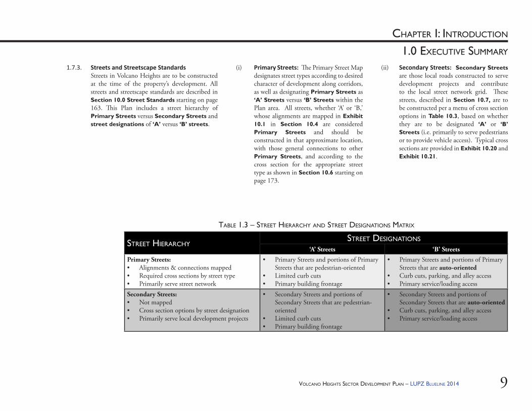
(ii) Secondary Streets: Secondary Streets are those local roads constructed to serve development projects and contribute to the local street network grid. Th ese streets, described in Section 10.7, are to be constructed per a menu of cross section options in Table 10.3, based on whether they are to be designated ‘A’ or ‘B’ Streets (i.e. primarily to serve pedestrians or to provide vehicle access). Typical cross sections are provided in Exhibit 10.20 and Exhibit 10.21.
(i) Primary Streets: Th e Primary Street Map designates street types according to desired character of development along corridors, as well as designating Primary Streets as ‘A’ Streets versus ‘B’ Streets within the Plan area. All streets, whether ‘A’ or ‘B,’ whose alignments are mapped in Exhibit 10.1 in Section 10.4 are considered Primary Streets and should be constructed in that approximate location, with those general connections to other Primary Streets, and according to the cross section for the appropriate street type as shown in Section 10.6 starting on page 173.
1.7.3. Streets and Streetscape StandardsStreets in Volcano Heights are to be constructed at the time of the property’s development. All streets and streetscape standards are described in Section 10.0 Street Standards starting on page 163. Th is Plan includes a street hierarchy of Primary Streets versus Secondary Streets and street designations of ‘A’ versus ‘B’ streets.
STREET HIERARCHYSTREET DESIGNATIONS
‘A’ Streets ‘B’ Streets
Primary Streets:• Alignments & connections mapped• Required cross sections by street type• Primarily serve street network
• Primary Streets and portions of Primary Streets that are pedestrian-oriented
• Limited curb cuts• Primary building frontage
• Primary Streets and portions of Primary Streets that are auto-oriented
• Curb cuts, parking, and alley access• Primary service/loading access
Secondary Streets:• Not mapped• Cross section options by street designation• Primarily serve local development projects
• Secondary Streets and portions of Secondary Streets that are pedestrian-oriented
• Limited curb cuts• Primary building frontage
• Secondary Streets and portions of Secondary Streets that are auto-oriented
• Curb cuts, parking, and alley access• Primary service/loading access
TABLE 1.3 – STREET HIERARCHY AND STREET DESIGNATIONS MATRIX
VOLCANO HEIGHTS SECTOR DEVELOPMENT PLAN – LUPZ BLUELINE 201410
CHAPTER I: INTRODUCTION
1.0 EXECUTIVE SUMMARY
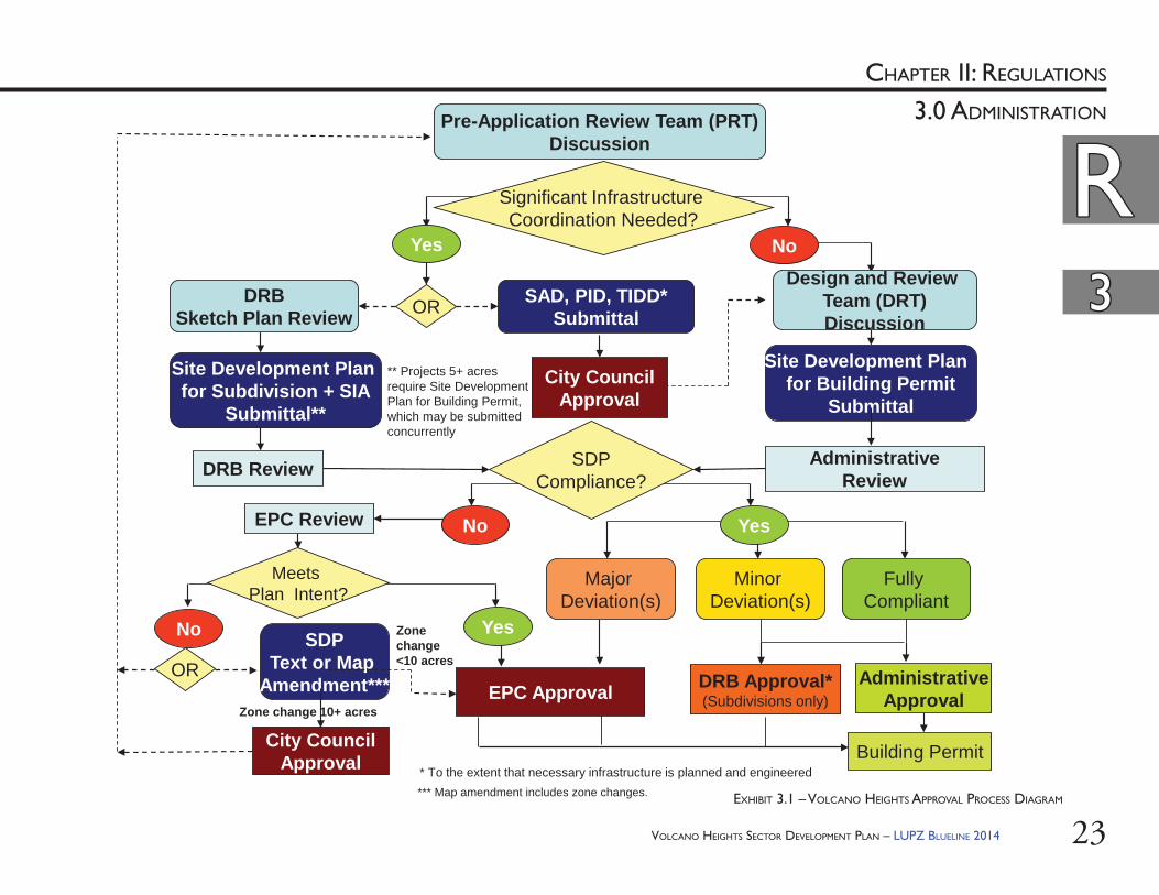
1.8.2. Project Development Steps: Th e following basic steps should be followed to determine the uses and development standards applicable on property within Volcano Heights, including where the building can sit on the lot, limits on its three-dimensional form, range of uses allowed, and palette of materials that will cover it.(i) Review Exhibit 3.1, the development
review fl ow chart, on page 23 [copied for convenience at the end of this section] to determine the level of review required based on whether signifi cant infrastructure coordination is needed for the proposed project.
(ii) Locate the subject property in Exhibit 10.2 on page 166 and identify:a. the character zone(s) in which the
property is located andb. the Street Type designation along all
its Primary Street frontages, if any. (iii) Review Table 4.4 – Land Use Table by
Character Zone starting on page 64 to determine allowed uses.
(iv) Review Table 3.1 – Applicability of Plan Sections by Development Type starting on page 24 to evaluate the applicability of the uses and design standards/regulations based on the size and scope of the proposed project.
1.8. Using This Plan1.8.1. Plan Organiza on
(i) Chapter I summarizes the purpose and intent of the Plan.
(ii) Only Chapter II includes regulations with the power of law, including zoning and all design and development regulations and standards.
(iii) Chapter III provides standards for streets and streetscapes to be followed as properties develop individually and/or infrastructure is constructed as part of a coordinated eff ort.
(iv) Chapter IV provides goals, policy and implementation guidance for City staff and developers organized around fi ve main topics: Environment and Open Space; Economic Development; Transportation; Land Use and Urban Design; and Infrastructure.
(v) Th e Appendix includes supplementary information, including conditions prior to the Plan’s adoption, templates for conservation easements, and a traffi c study performed for the Primary Street grid and recommended intersections with the limited-access roadways.
This document must be read in its entirety to
ensure full comprehension of the policies and
regulations governing properties within the
boundaries of the Volcano Heights Sector
Development Plan.
VOLCANO HEIGHTS SECTOR DEVELOPMENT PLAN – LUPZ BLUELINE 2014 11
CHAPTER I: INTRODUCTION
1.0 EXECUTIVE SUMMARY
(xii) Prior to any application, schedule a free Pre-Application Review Team (PRT) meeting with the Planning Department to confi rm the necessary review process based on the project scope.a. If signifi cant infrastructure is required,
submit Site Development Plans for Subdivision to the Development Review Board for a free sketch plat review.
b. If no signifi cant infrastructure is required, schedule a free Design Review Team (DRT) meeting with the Planning Department to review Site Plans for Building Permit and determine compliance with the policies and regulations in this Plan.
(v) Examine Section 5.0 Site Development and Building Design Standards Specifi c to Zones starting on page 77 to determine the applicable development standards and any special frontage standards for each character zone.
(vi) Refer to Section 6.0 Site Development Standards starting on page 109 for regulations at the site level that apply generally to all zones.
(vii) Refer to Section 7.0 Building Design Standards starting on page 125 for regulations at the building level that apply generally to all zones.
(viii) Refer to Section 8.0 Sign Standards starting on page 133 for regulations about signage that apply generally to all zones.
(ix) Refer to Section 9.0 Open Space, Landscaping, and Site Lighting Design Standards starting on page 141 for regulations about open space, landscaping, and site lighting design that apply generally to all zones.
(x) Review Section 10.0 Street Standards starting on page 163 for relevant Primary Streets and options for Secondary Streets proposed to serve the project.
(xi) Projects are also subject to the City’s Development Process Manual (DPM) [under separate cover], ordinances, and regulations not in confl ict with this Plan.
VOLCANO HEIGHTS SECTOR DEVELOPMENT PLAN – LUPZ BLUELINE 201412
CHAPTER I: INTRODUCTION
1.0 EXECUTIVE SUMMARY
Pre-Application Review Team (PRT)Discussion
Significant Infrastructure Coordination Needed?
NoYes
Site Development Plan for Building Permit
Submittal
Administrative Review
Site Development Plan for Subdivision + SIA
Submittal**
DRBSketch Plan Review OR SAD, PID, TIDD*
Submittal
City CouncilApproval
DRB Approval*(Subdivisions only)EPC Approval
Building Permit
AdministrativeApproval
Major Deviation(s)
Yes
Fully Compliant
Minor Deviation(s)
SDPCompliance?
No Yes
No
Meets Plan Intent?
DRB Review
EPC Review
ORSDP
Text or Map Amendment***
City CouncilApproval
** Projects 5+ acres require Site Development Plan for Building Permit, which may be submitted concurrently
Zone change 10+ acres
Zone change <10 acres
Design and Review Team (DRT)Discussion
* To the extent that necessary infrastructure is planned and engineered*** Map amendment includes zone changes.
VOLCANO HEIGHTS APPROVAL PROCESS DIAGRAM
VOLCANO HEIGHTS SECTOR DEVELOPMENT PLAN – LUPZ BLUELINE 2014 13
CHAPTER 2: REGULATIONS
regulat ions
CHAPTER 2: REGULATIONSChapter II

VOLCANO HEIGHTS SECTOR DEVELOPMENT PLAN – LUPZ BLUELINE 201414
Th is Page Left Intentionally Blank
VOLCANO HEIGHTS SECTOR DEVELOPMENT PLAN – LUPZ BLUELINE 2014 15
CHAPTER II: REGULATIONS
2.0 PLAN AUTHORITY
RR

VOLCANO HEIGHTS SECTOR DEVELOPMENT PLAN – LUPZ BLUELINE 201416
RR22
CHAPTER II: REGULATIONS
2.0 PLAN AUTHORITY
Th e Volcano Heights SDP (“Th e Plan” or “VHSDP”) is a Rank 3 plan that includes both regulations (i.e. law) and policies (i.e. guidance) as instruments to implement the goals, objectives, and policies of the Rank 1 Albuquerque/Bernalillo Comprehensive Plan, and more specifi cally the Rank 2 West Side Strategic Plan (WSSP).
2.1. Rank PlansTh e City of Albuquerque uses a system of ranked plans, starting with the Rank 1 Albuquerque/Bernalillo County Comprehensive Plan, which sets the vision, goals, and overall policies from a City-wide perspective. Th ere are also lower-ranked plans that must comply with the intent, policies, and goals of higher-ranked plans. Rank 2 Plans, such as the WSSP or the Arroyos Facility Plan, are exclusively policy documents that provide more detail and give more direction about large but distinct areas or facilities within Albuquerque. Rank 3 Plans, including Sector Development Plans (SDPs) such as this Volcano Heights SDP, take the most detailed look at smaller areas and can include both policy and regulations.
Th is Rank 3 VHSDP is intended to further and comply with the policies and intents of the adopted plans in Table 2.1. Where other plans and procedures are silent, the regulations and standards of this Plan shall prevail.
RELEVANT RANKED PLANS AREA PLAN TYPE
Rank 1: Albuquerque / Bernalillo County Comprehensive Plan
Entire Albuquerque Area
Policy
Rank 2: Area / Facility Plans• West Side Strategic Plan• Facility Plan for Arroyos• CABQ Major Public Open Space Facility Plan• Trails and Bikeways Facility Plan• Facility Plan: Electric System Generation and
Transmission (2010-2020)
Relevant Albuquerque Areas, including Volcano
Mesa
Predominantly Policy
Rank 3: Northwest Mesa Escarpment Plan (NWMEP) Specifi c Area Policy & Regulation
TAB LE 2.1 – RELEVANT RANKED PLANS
VOLCANO HEIGHTS SECTOR DEVELOPMENT PLAN – LUPZ BLUELINE 2014 17
RR22
CHAPTER II: REGULATIONS
2.0 PLAN AUTHORITY
!(!(
!(
!(
!(!(
!( !( !( !( !( !( !( !( !( !( !(
!(!(!(!(!(!(!(!(!(!(!(
!(!(
!(!(
!(!(
!(!( !(
!(!(
!(!(
!(!(
!(!(
!(!(
!(!(
!(!(
!(!(
!(!(
!(!(
!(!(!(!(!(!(!(!(!(!(!(!(!(
!(!(
!(!(
!(!(
!(!(!(!(!(!(!(!(!(!(!(!(!(!(!(!(!(!(!(
!(!(
!(!(
!(!(
!( !( !( !( !( !( !( !( !( !( !( !( !( !( !( !( !( !( !(
!(!(
!(!(
!(
2.2. Northwest Mesa Escarpment Plan (NWMEP) Th e Rank 3 NWMEP provides policy guidance and regulations for development within its boundaries. Adopted in 1988, it sets regulations and policies to control design, construction mitigation, view preservation, and drainage to protect sensitive lands in and around the Escarpment, parts of which became the Petroglyph National Monument.
Th e NWMEP designates three distinct areas and distinguishes regulations and policies accordingly: Conservation, Impact, and View. Volcano Heights is included in the NWMEP boundary and contains a small portion of Impact Area along the boundary of the Petroglyph National Monument to the east, while the rest of Volcano Heights is designated as View Area and subject to policies applicable to that designation. [See Exhibit 2.1.]
EXHIBIT 2.1 – NWMEP AND WSSP VOLCANO MESA AMENDMENT BOUNDARIES
DETAIL: NWMEP IMPACT AREA IN VOLCANO HEIGHTS
!(!(!(!(!(!(!(!(!(!(
!(!(
!( !( !( !( !( !( !( !( !(!(!(
!(!(
!(!(
!(
!(!(!(!(!(!(!(!(!(!(!(!(
!(!(
!(!(
!(!(
!(!(
!(
!( !( !( !( !( !( !( !( !( !( !(
!(!(
!(!(
!(!(
!(
!(!(
!(
!(!(
!(!(!(
!(!(!(!(!(
!(
!(!(
!(!(
!(
!(!(
!(!(
!(!(
!(!(!(
!(
!(!(!(
!(
!(!(
!(!(
!(
!(!(
!(!(!(!(!(!(
!(!(
!(
!(!(
!(!(
!(!(
!(!(
!(!(!(!(
!(!(
!(!(
!(
!(!(
!(
!(!(
!(!(
!(!(
!(
!(
!(
!(
!(
!(
!(
!(
!(
!(
!(!( !( !( !(
!(!( !(
!(!(
!(!(
!(
!(!(
!(!(
!(!(
!(
!( !( !( !( !( !( !( !( !( !( !( !( !( !( !( !( !( !( !( !( !( !( !( !( !( !( !( !( !(!(
!( !( !(
!(!(
!(
!(!(
!(
!(
!(!(
!(
!(!(
!(!(
!(!(
!(!(
!(!(
!(
!(
!(
!(
!(!(
!( !(!(
!(!(
!(!(
!( !(!( !(
!(!(
!(
!(
!(
!( !( !(!(
!(!(
!(
!(
!(
!(!(
!( !(
!(!(
!( !(!(
!(!( !( !(
!(
!(!(
!(!(
!(
!(
!(!(
!( !( !(
!(!(!(!(!(
!(
!(!(
!(!(
!(!(!(
!(
!(!(!(!(!(!(
!( !( !( !(
!(!( !( !( !( !( !(
PETROGLYPHNATIONAL
MONUMENT
PETROGLYPHNATIONAL
MONUMENT
PETROGLYPHNATIONAL
MONUMENT
Albuquerque City Limits
!( !( !(!(
!(!( PETROGLYPH NATIONAL MONUMENT
VOLCANO MESA WSSP BOUNDARY
ALBUQUERQUE CITY LIMITS
NORTHWEST MESA ESCARPMENT SDPCONSERVATION
IMPACT
VIEW ±0 2,500 5,0001,250 Feet
See detail at leftSee detail at left
VOLCANO HEIGHTS SECTOR DEVELOPMENT PLAN – LUPZ BLUELINE 201418
RR22
CHAPTER II: REGULATIONS
2.0 PLAN AUTHORITY
(ii) Portions of the Escarpment Transition Zone and Regional Center Zone that are also within the NWMEP Impact Area have structure height restrictions of 15 feet per the NWMEP, with the exception that heights shall be measured from approved grade. No variances or deviations shall be granted.
(iii) No bonus heights shall be granted within the Escarpment Transition or Neighborhood Transition Zones.
2.2.3. Color shall be regulated per this Plan. All structures and fences shall have exterior colors within a light refl ective value of 20-50 percent. Th is restriction includes building walls and surfaces, roofs, mechanical equipment, and landscaping walls and fences [See Section 7.5 starting on page 127 for building color restrictions. See Section 9.7.3 starting on page 152 for walls and fences.] Th e intent is to minimize visibility for the purpose of views into the Plan area and maximize harmony with the natural environment within the Petroglyph National Monument, as the NWMEP intended.
2.3. Unser Boulevard Design Overlay Zone (DOZ): Th e Unser Boulevard Design Overlay Zone, adopted in 1992, sets design regulations regarding signs along the Unser Boulevard corridor between I-40 and the Sandoval County line. [See Exhibit 2.2 and Exhibit 8.1 on page 135.]
2.2.1. Because the VHSDP and the NWMEP are both Rank 3 plans with overlapping boundaries, where a policy or regulation confl icts, the VHSDP prevails, unless otherwise stated in this Plan. Where one plan is silent, the policies/regulations of the other plan prevail.
2.2.2. Maximum heights by right in Town Center, Regional Center, Mixed-Use, and Neighborhood Transition Zones in Volcano Heights comply with the 40-foot maximum height allowed in the NWMEP View area, although the NWMEP measures from natural grade, and this Plan measures from approved grade, which in some cases may include a minimum amount of fi ll necessary for construction or to connect to infrastructure. Within Volcano Heights, the approved grade is used to govern structure height.(i) In order to balance the intent of respecting
and protecting the fabric of unique cultural and geological features of this area with the intent of creating opportunities for a regional employment center and Major Activity Center, the VHSDP includes an optional bonus height system that allows building height above 40 feet for the Center and Mixed-Use Zones. Projects must meet additional criteria intended to provide commensurate benefi ts to both the natural and built environments as a trade-off for bonus height and density.
VOLCANO HEIGHTS SECTOR DEVELOPMENT PLAN – LUPZ BLUELINE 2014 19
RR22
CHAPTER II: REGULATIONS
2.0 PLAN AUTHORITY
EXHIBIT 2.2 – UNSER BOULEVARD DESIGN OVERLAY ZONE BOUNDARY
§̈¦40
§̈¦25C O
ORS
BLV
D
UNSER BLV
D
RAINBO
W BLVD
PETRO GLYP HNATI ONA L
M ONU M EN T
PE T ROG LYP HNATIO N AL
M ON U M E N T
VOLCA NO HEI GHTS
VOLCA NO TRA I LS
VOLCA NO CLI F FS
GO
L F C
OU
R SE
RD
N ORTH ER N GEO LOG ICWINDOW
MIDDL EGEO LOG ICWINDOW
SOU T HE R NGEO LOG ICWINDOW
PE T ROG LYP HN ATIO NAL
M ON U M E N T
CIT Y OF A L BU Q U E RQ UEM A JOR P U B LI C
O PE N SPAC E
CITY OF ALBU QU ERQU EMAJOR PU BL IC O PEN SPACE
ALAME DA BLV D
PASEO DEL N ORT E
MO N TANO RD
UN
SER
BLV
D
UN
IVER
SE B
LVD
MCM AHON BLV D
LADE RA DR
UN
SER BLVD
PA RA DISE BLVD
PAS EO DE L NORTE
BOC AN EGR A
PA RK
~
Path: Q:\AGISFILE\PROJECTS\PetraMorris\THG-Nov11-VolcanoHeights\December2012\UnserDesignOverlayZone.mxd
´
U N S E R D E S I G N O V E R L AY Z O N EUNSER DESIGN OVERLAY ZONE
ALBUQUERQUE CITY LIMIT
PETROGLYPH NATIONAL MONUMENT
CITY OF ALBUQUERQUE MAJOR PUBLIC OPEN SPACE
0 1 2 30.5Miles
VOLCANO HEIGHTS SECTOR DEVELOPMENT PLAN – LUPZ BLUELINE 201420
RR22
CHAPTER II: REGULATIONS
2.0 PLAN AUTHORITY
2.5. City Subdivision Ordinance: Development projects shall be subject to the City Subdivision Ordinance with the following exception: Right-of-way widths identifi ed in Section 10.6 starting on page 173 in this Plan shall prevail over those in the Subdivision Ordinance, where confl icting. Where the Subdivision Ordinance is silent in regard to street or streetscape standards in this Plan, the standards in this Plan apply.
2.6. Development Process Manual (DPM): Development projects shall be subject to the City DPM. Where the DPM is silent in regard to street or streetscape standards in this Plan, the standards in this Plan apply.
2.7. Other City Regulations: In order to meet the intent of development in this unique area, the provisions of this Plan, when in confl ict, shall take precedence over those of other City codes, ordinances, regulations, and standards as amended except for the New Mexico Electrical Code, the New Mexico Electrical Safety Code and as noted elsewhere in this Plan. Where this Plan is silent, relevant City of Albuquerque codes, ordinances, regulations, and standards shall apply.
Enacted to preserve views of the Rio Grande Valley, the Sandia Mountains and the West Mesa Escarpment, it aff ects an area extending 500 feet on either side of the centerline of the roadway. Th e DOZ prohibits off -premise signs, portable signs, and signs that fl ash, move, or rotate. On-premise signs within the DOZ boundaries are generally limited to one wall or permanent free-standing sign per façade per business, the height and size of which are regulated based on façade area. For additional details and regulations, please consult the Unser Boulevard DOZ, available on the Planning Department’s publications webpage: http://www.cabq.gov/planning/publications/
Because the VHSDP and the Unser Boulevard DOZ have overlapping boundaries, where a policy or regulation confl icts, the more restrictive prevails, except as noted in Section 8.1.2 starting on page 134. Where one plan is silent, the policies/regulations of the other plan prevail.
2.4. City Zoning Code: Development standards not addressed in this Plan shall be governed by the City Zoning Code to the extent they are not in confl ict with the intent or provisions of this Plan. Where in confl ict with this Plan, the development standards under City Zoning Code §14-16-3-18 General Building and Site Design Regulations for Non-Residential Uses, as amended, shall not apply to property within Volcano Heights.

VOLCANO HEIGHTS SECTOR DEVELOPMENT PLAN – LUPZ BLUELINE 2014 21
CHAPTER II: REGULATIONS
3.0 ADMINISTRATION
RR
VOLCANO HEIGHTS SECTOR DEVELOPMENT PLAN – LUPZ BLUELINE 201422
RRCHAPTER II: REGULATIONS
33
3.0 ADMINISTRATION
3.1. Applicability3.1.1. Th e uses, buildings, and structures on all land
within Volcano Heights shall conform to this Plan. Table 3.1 shall determine which sections of the Plan apply to any proposed development based on the type and scope of the proposed development.
3.1.2. Provisions of this Plan are activated by “shall” when required, “should” when recommended, and “may” when optional.
3.1.3. Terms used throughout this Plan [as noted in bold] are defi ned in Section 3.5 starting on page 40 of this Plan. Development within Volcano Heights shall be held to these defi nitions. For those terms not defi ned in this Plan, City Zoning Code §14-16-1-5 shall apply. Terms not defi ned in either section shall be accorded commonly accepted meanings. In the event of confl ict, the defi nitions of this Plan shall prevail.
3.1.4. Where in confl ict, numerical metrics shall prevail over graphic metrics.
3.1.5. In order to meet the intent of development in this unique area, the provisions of this Plan, when in confl ict, shall take precedence over those of other City of Albuquerque codes, ordinances, regulations, standards, and plans as amended except as noted elsewhere in this Plan. Where this Plan is silent, relevant City of Albuquerque codes, ordinances, regulations, and standards shall apply. [See Section 2.0 Plan Authority starting on page 15].
3.1.6. Projects Subject to Review: (i) All private development and
redevelopment projects are subject to administrative review by the Planning Department and/or offi cial review by the Development Review Board (DRB) and/or Environmental Planning Commission (EPC) for compliance with the Plan. Table 3.1 establishes the standards for the applicability of the various sections of this Plan to development and redevelopment projects.
(ii) Applications for redevelopment projects shall be accompanied by a full-size set of the approved Site Development Plan for Building Permit or Subdivision, whichever is relevant. No building permit shall be approved unless it is consistent with the approved Site Development Plan and landscaping plan, particularly for any items contributing to a bonus height granted for buildings on the property. [See Section 6.4 starting on page 111.]
3.2. Development Review and Approval Process3.2.1. Intent / Purpose: In order to encourage and
support development in Volcano Heights, review and approval of proposed projects should be conducted as speedily as possible. As such, this Plan proposes several opportunities to streamline approval, notwithstanding any eff orts needed to coordinate infrastructure for development in the short-term.
VOLCANO HEIGHTS SECTOR DEVELOPMENT PLAN – LUPZ BLUELINE 2014 23
RRCHAPTER II: REGULATIONS
33
3.0 ADMINISTRATIONPre-Application Review Team (PRT)Discussion
Significant Infrastructure Coordination Needed?
NoYes
Site Development Plan for Building Permit
Submittal
Administrative Review
Site Development Plan for Subdivision + SIA
Submittal**
DRBSketch Plan Review OR SAD, PID, TIDD*
Submittal
City CouncilApproval
DRB Approval*(Subdivisions only)EPC Approval
Building Permit
AdministrativeApproval
Major Deviation(s)
Yes
Fully Compliant
Minor Deviation(s)
SDPCompliance?
No Yes
No
Meets Plan Intent?
DRB Review
EPC Review
ORSDP
Text or Map Amendment***
City CouncilApproval
** Projects 5+ acres require Site Development Plan for Building Permit, which may be submitted concurrently
Zone change 10+ acres
Zone change <10 acres
Design and Review Team (DRT)Discussion
* To the extent that necessary infrastructure is planned and engineered
EXHIBIT 3.1 – VOLCANO HEIGHTS APPROVAL PROCESS DIAGRAM*** Map amendment includes zone changes.
VOLCANO HEIGHTS SECTOR DEVELOPMENT PLAN – LUPZ BLUELINE 201424
RRCHAPTER II: REGULATIONS
33
3.0 ADMINISTRATION
PLAN SECTION
4. 1
Lan
d U
se T
able
5.X
.2 B
uild
ing
Plac
emen
t
5.X
.4 H
eigh
t St
anda
rds
5.X
. 6 P
arki
ng &
Ser
vice
5.X
.7.i
Enc
roac
hmen
ts
5.X
.7.ii
i Sin
gle-
Fam
ily B
uffe
r
5.X
.9-1
2 Bu
ildin
g D
esig
n St
anda
rds
by Z
one
6.0
Gen
eral
Site
D
evel
opm
ent
Stan
dard
s
7.0
Gen
eral
Bui
ldin
g D
esig
n St
anda
rds
8.0
Sign
age
9.0
Ope
n Sp
ace
Stan
dard
s
9.6
Land
scap
ing
& L
ight
ing
10.0
Str
eet
Stan
dard
s
11.0
Str
eets
cape
Sta
ndar
ds
TYPE OF DEVELOPMENT
Residential (including single-family attached and detached buildings)
New construction X X X X X X X X X X X X XChange of Use with no expansion of building X X X X XExpansion of use/structure (any building addition, deck, porch, etc.) X X X X X X X X XExpansion of use/structure (new accessory building/structure on the lot) X X X X X X X XFaçade changes to existing buildings*
‘A’ Street façade X X X X XAll other street façades X X X X
Non-residential or Mixed UseNew Construction X X X X X X X X X X X X X X
Renovations associated with change of use/expansion of use with no expansion of building
X X X X X
Building Expansion
0% - 49% increase in building square footageX X X X X X X X X X X X
(Standards in applicable sections shall apply only to the expansions)
50% or greater increase of building areaX X X X X X X X X X X X X X(Standards in applicable sections shall apply the entire building including
retrofi tting of the existing building if non-conforming)
TABLE 3.1 – APPLICABILITY OF PLAN SECTIONS BY DEVELOPMENT TYPE
* Restuccoing with a color other than originally approved requires a permit in order to ensure compliance with color regulations per Section 7.5 starting on page 127.
VOLCANO HEIGHTS SECTOR DEVELOPMENT PLAN – LUPZ BLUELINE 2014 25
RRCHAPTER II: REGULATIONS
33
3.0 ADMINISTRATION
TABLE 3.1 – APPLICABILITY OF PLAN SECTIONS BY DEVELOPMENT TYPE (Cont’d)
PLAN SECTION
4. 1
Lan
d U
se T
able
5.X
.2 B
uild
ing
Plac
emen
t
5.X
.4 H
eigh
t St
anda
rds
5.X
. 6 P
arki
ng &
Ser
vice
5.X
.7.i
Enc
roac
hmen
ts
5.X
.7.ii
i Sin
gle-
Fam
ily B
uffe
r
5.X
.9-1
2 Bu
ildin
g D
esig
n St
anda
rds
by Z
one
6.0
Gen
eral
Site
D
evel
opm
ent
Stan
dard
s
7.0
Gen
eral
Bui
ldin
g D
esig
n St
anda
rds
8.0
Sign
age
9.0
Ope
n Sp
ace
Stan
dard
s
9.6
Land
scap
ing
& L
ight
ing
10.0
Str
eet
Stan
dard
s
11.0
Str
eets
cape
Sta
ndar
ds
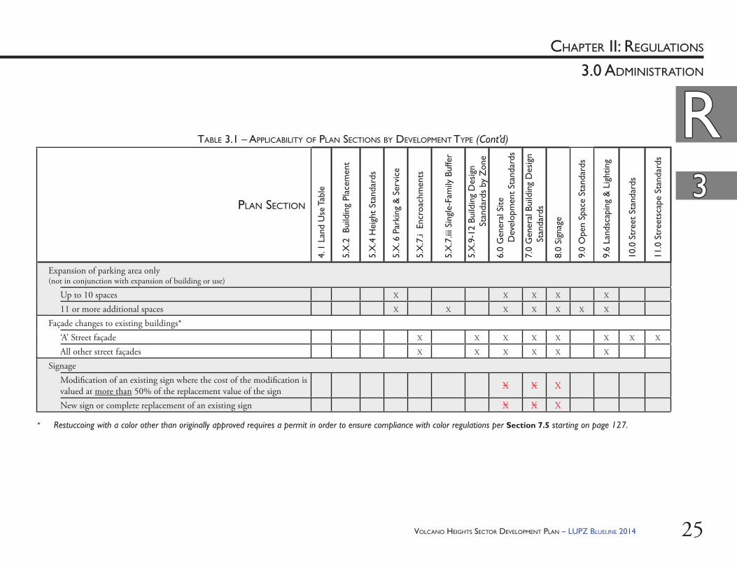
Expansion of parking area only (not in conjunction with expansion of building or use)
Up to 10 spaces X X X X X
11 or more additional spaces X X X X X X X
Façade changes to existing buildings*‘A’ Street façade X X X X X X X X
All other street façades X X X X X X
SignageModifi cation of an existing sign where the cost of the modifi cation is valued at more than 50% of the replacement value of the sign X X X
New sign or complete replacement of an existing sign X X X
* Restuccoing with a color other than originally approved requires a permit in order to ensure compliance with color regulations per Section 7.5 starting on page 127.
VOLCANO HEIGHTS SECTOR DEVELOPMENT PLAN – LUPZ BLUELINE 201426
RRCHAPTER II: REGULATIONS
33
3.0 ADMINISTRATION
a. Once approved by the DRB, Site Plans for Subdivision for projects less than 5 acres may proceed directly to building permit.
b. Subject to approval by the DRB, Site Plans for Subdivision 5 acres or greater shall require a Site Plan for Building Permit, eligible for Administrative Review and Approval per Section 3.2.5 in this Plan. Th ese site plans may be submitted concurrently.
(ii) Applications for a Special Assessment District (SAD), Tax Increment Development District (TIDD), or Public Improvement District (PID) may be submitted to the City Council for approval, per the following City Ordinances. a. SAD: Albuquerque Code of
Ordinances Section 6-8.b. TIDD: Albuquerque Code of
Ordinances Section 4-10.c. PID: Albuquerque Code of
Ordinances Section 6-9.d. To the extent that these processes
include planning for signifi cant infrastructure and provide a fi nancial mechanism to fund infrastructure improvements, applications that receive City Council approval are eligible for Administrative Approval of Site Development Plans for Building Permit.
3.2.2. Pre-Applica on Review Team (PRT) Discussions: Prior to submitting an application for a new development project, all potential applicants shall schedule and attend a discussion with the Planning Director or his/her designee. Th e Planning Department holds Pre-Application Review Team discussions weekly to provide informal guidance to property owners and/or developers during the conceptual design phase. Th is discussion will help determine whether major infrastructure will be needed, options for infrastructure planning and coordination, and opportunities for streamlining approvals. Based on conceptual plans, a staff planner may be assigned to the project to help applicants navigate necessary approval processes.
3.2.3. Signifi cant Infrastructure Coordina on: Signifi cant infrastructure is determined on a case-by-case basis but generally applies to a major street, drainage or utility facility, etc. that is necessary for the subject property as well as other nearby properties to develop. Applicants have two process options to coordinate signifi cant infrastructure: (i) A Site Development Plan for Subdivision
may be submitted to the Development Review Board (DRB). Th is submittal includes a Subdivision Improvement Agreement, which documents fi nancial guarantees of funds available to provide infrastructure. Th e developer must provide evidence that adequate and appropriate coordination with private utilities has occurred and may be required to show evidence of coordination with nearby property owners for other necessary infrastructure.
VOLCANO HEIGHTS SECTOR DEVELOPMENT PLAN – LUPZ BLUELINE 2014 27
RRCHAPTER II: REGULATIONS
33
3.0 ADMINISTRATION
a. Minor Deviation per Section 3.2.10 and Table 3.2 below and therefore eligible for Administrative Approval;
b. Major Deviation per Section 3.2.11 and Table 3.3 below and therefore required to obtain approval by the EPC;
c. Non-compliance without meeting the intent of this Plan and therefore required to modify the Project or amend this Sector Development Plan per City Zoning Code §14-16-4-3; OR
d. Non-compliance yet still meeting the intent of this Plan and therefore eligible for approval by the EPC with an exception per Section 3.2.13 in this Plan.
(vi) Determining the public notice required for proposed projects, based on the approval process determined abovea. Public Notice for Site Plans for
Subdivision per Table 3.4 ORb. Public Notice for Site Plans for
Building Permit per Table 3.5.(vii) Mailing Public Notice, at the applicant’s
expense, to relevant Property Owners as noted by (PO) in Table 3.4 or Table 3.5;
(viii) Determining whether convening the Volcano Heights Review Team is appropriate;
(ix) Convening a Volcano Heights Review Team of relevant City staff and/or members of the public, if deemed appropriate;
3.2.4. DRB Sketch Plat Review: All applicants shall schedule and attend a discussion with the DRB before submitting a Site Development Plan for Subdivision or a Site Development Plan for Building Permit that requires infrastructure. Th e DRB holds weekly sketch plat reviews for no fee.
3.2.5. Administra ve Review and Approval: Once infrastructure is either in place or coordinated with fi nancial guarantees in place per Section 3.2.3 of this Plan, Site Development Plans for Building Permit that fully comply with all standards of the Plan shall be processed administratively by the Planning Director or his/her designee and, if approved, proceed to building permit.
Th e Planning Department off ers Design Review Team (DRT) appointments to applicants every other week to review projects within Sector Development Plan areas. Projects that comply with design regulations may receive a stamp from the DRT and proceed to building permit.
Th e Planning Director or his/her designee shall be responsible for the following:(i) Conducting Pre-Application Review Team
Discussions;(ii) Assigning Staff to follow the project
through the necessary approvals;(iii) Conducting DRT Discussions;(iv) Reviewing Site Plans for Building Permit
for compliance with the intent, policies, and requirements of the Plan;
(v) Determining whether a Site Plan for Building Permit deviates from any standard within the thresholds for:
VOLCANO HEIGHTS SECTOR DEVELOPMENT PLAN – LUPZ BLUELINE 201428
RRCHAPTER II: REGULATIONS
33
3.0 ADMINISTRATION
Th e VHRT may include, but is not limited to, the following City staff and/or agency representatives:• Planning Director or his/her
designee• Staff Planner assigned to proposed
project;• City Planning & Zoning;• City Hydrologist;• City Department of Municipal
Development (DMD);• City Open Space Division;• City Parks and Recreation; • City Offi ce of Neighborhood
Coordination;• Albuquerque-Bernalillo Water Utility
Authority (ABCWUA);• Albuquerque Metropolitan
Area Flood Control Authority (AMAFCA)
• Mid-Region Council of Governments (MRCOG);
• Public Service Company of New Mexico (PNM);
• New Mexico Gas Company; • Telecommunications companies;• Adjacent property owners;• Potential tenants;• Neighborhood Association
representatives; • Merchants’ Associations
representatives; and/or• American Institute of Architects
(AIA) representative(s) or other licensed design professional(s).
(x) Processing Site Development Plans for Building Permit that fully comply with the intent, policies, and requirements of the Plan;
(xi) Approving minor deviations to Site Development Plans for Building Permit that comply with this Plan and all applicable City ordinances, as per Section 3.2.10 in this Plan and City Zoning Code §14-16-2-22(A)(6), including Site Development Plans previously approved either by the EPC or administratively;
(xii) Forwarding any major deviations to the EPC per Section 3.2.11 starting on page 32 below; and
(xiii) Forwarding any appeals of the decision of the Planning Director, DRB, or EPC to the City Council, per City Zoning Code §14-16-4-4.
3.2.6. Volcano Heights Review Team (VHRT)(i) As part of the Administrative Review
Process, a Volcano Heights Review Team (“the Review Team” or VHRT) may be convened by the Planning Director or his/her designee for projects that require interpretation or discretionary judgment with respect to the project’s compliance with standards. Th is non-judicial Review Team shall be charged with working cooperatively and creatively with the applicant to solve problems and resolve confl icts regarding elements of a proposed development project that seem to meet the intent and policies of this Plan but face logistic challenges in meeting its numeric or text regulations or standards.
VOLCANO HEIGHTS SECTOR DEVELOPMENT PLAN – LUPZ BLUELINE 2014 29
RRCHAPTER II: REGULATIONS
33
3.0 ADMINISTRATION
3.2.8. Environmental Planning Commission (EPC) Approval: Th e EPC shall be responsible for the following:(i) Reviewing/approving Major Deviations
from the standards beyond Minor Deviations as defi ned in Table 3.2 below, which includes an opportunity for public review and comment at a public hearing. Major Deviation thresholds shall be allowed per Table 3.3. Th e EPC shall not approve projects that fail to meet the intent of this Plan.
(ii) Reviewing/approving requests for adjustments to street standards beyond the thresholds specifi ed in Table 10.1 on page 168 that meet the intent of this Plan and can demonstrate policy justifi cation for such requests to the satisfaction of the EPC.
(iii) Reviewing/approving requests for exceptions to the regulations of this Plan that still meet the Plan’s intent, per Section 3.2.13 in this Plan.
(iv) Reviewing/approving requests for zone changes 10 acres or less in size and reviewing/recommending to City Council approval or denial of zone change requests for more than 10 acres.
(ii) City Planning shall designate a staff planner to specialize in this Plan and participate in all VHRT meetings.
(iii) City Open Space Division shall be included in the review process where development is proposed within the Impact Area as defi ned by the NWMEP or within 200 feet of a signifi cant rock outcropping as shown in Exhibit 9.1 on page 147.
(iv) As the Plan area develops, PNM shall be involved in all aspects of signifi cant infrastructure development in order to allow for adequate utility planning and placement.
3.2.7. Development Review Board (DRB) ApprovalTh e DRB shall be responsible for the following:(i) Conducting sketch plat reviews weekly;(ii) Reviewing/acting on Site Development
Plans for Subdivisions that comply with this Plan, the DPM, and City ordinances;
(iii) Reviewing/acting on minor deviations from any dimensional standard in a Site Development Plan for Subdivision per Section 3.2.10 starting on page 30 of this Plan;
(iv) Reviewing/acting on Site Development Plans for Building Permit that involve 4 or more feet of fi ll; and
(v) Reviewing/acting on Site Development Plans for Building Permit that involve construction within the Impact Area as defi ned by the NWMEP. [See Exhibit 2.1 on page 17.]
VOLCANO HEIGHTS SECTOR DEVELOPMENT PLAN – LUPZ BLUELINE 201430
RRCHAPTER II: REGULATIONS
33
3.0 ADMINISTRATION
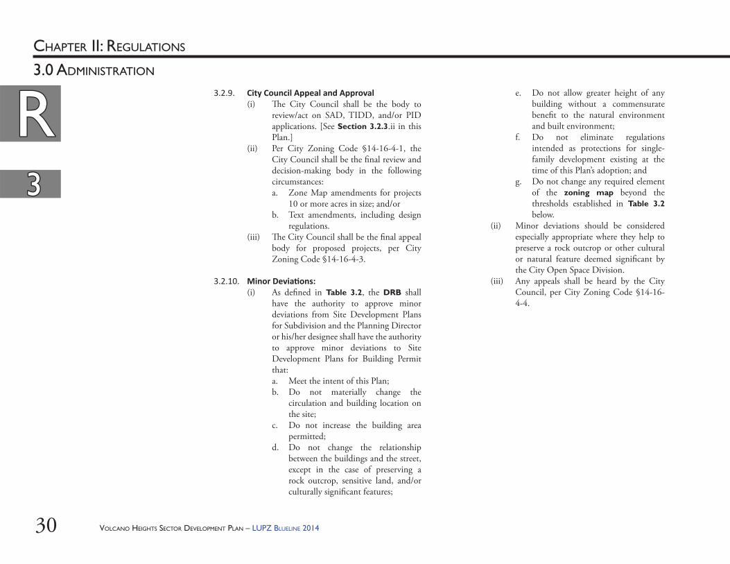
3.2.9. City Council Appeal and Approval(i) Th e City Council shall be the body to
review/act on SAD, TIDD, and/or PID applications. [See Section 3.2.3.ii in this Plan.]
(ii) Per City Zoning Code §14-16-4-1, the City Council shall be the fi nal review and decision-making body in the following circumstances:a. Zone Map amendments for projects
10 or more acres in size; and/orb. Text amendments, including design
regulations.(iii) Th e City Council shall be the fi nal appeal
body for proposed projects, per City Zoning Code §14-16-4-3.
3.2.10. Minor Devia ons: (i) As defi ned in Table 3.2, the DRB shall
have the authority to approve minor deviations from Site Development Plans for Subdivision and the Planning Director or his/her designee shall have the authority to approve minor deviations to Site Development Plans for Building Permit that:a. Meet the intent of this Plan;b. Do not materially change the
circulation and building location on the site;
c. Do not increase the building area permitted;
d. Do not change the relationship between the buildings and the street, except in the case of preserving a rock outcrop, sensitive land, and/or culturally signifi cant features;
e. Do not allow greater height of any building without a commensurate benefi t to the natural environment and built environment;
f. Do not eliminate regulations intended as protections for single-family development existing at the time of this Plan’s adoption; and
g. Do not change any required element of the zoning map beyond the thresholds established in Table 3.2 below.
(ii) Minor deviations should be considered especially appropriate where they help to preserve a rock outcrop or other cultural or natural feature deemed signifi cant by the City Open Space Division.
(iii) Any appeals shall be heard by the City Council, per City Zoning Code §14-16-4-4.
VOLCANO HEIGHTS SECTOR DEVELOPMENT PLAN – LUPZ BLUELINE 2014 31
RRCHAPTER II: REGULATIONS
33
3.0 ADMINISTRATION
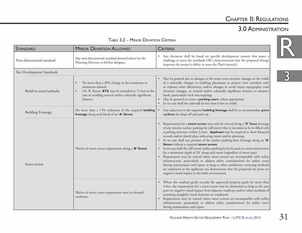
STANDARD MINOR DEVIATION ALLOWED CRITERIA
Non-dimensional standard Any non-dimensional standard deemed minor by the Planning Director or his/her designee.
• Any deviation shall be based on specifi c development context that poses a challenge to meet the standards OR a demonstration that the proposed change improves the project’s ability to meet the Plan’s intent(s).
Site Development Standards
Build-to zones/setbacks
• No more than a 20% change in the maximum or minimum setback.
• On ‘B’ Streets, BTZ may be extended to 75 feet in the case of avoiding natural and/or culturally signifi cant features.
• May be granted due to changes to the street cross sections; changes in the width of a sidewalk; changes to building placement to protect view corridors and/or enhance solar effi ciencies; and/or changes to avoid major topography, road elevation changes, or natural and/or culturally signifi cant features or sensitive lands, particularly rock outcroppings.
• May be granted to create a parking court, where appropriate.• In no case shall the sidewalk be less than 6 feet in width.
Building Frontage No more than a 15% reduction in the required building frontage along each block of an ‘A’ Street.
• Any reduction in the required building frontage shall be to accommodate porte cocheres for drop-off and pick-up.
Street screen
Waiver of street screen requirement along a ‘B’ Street.
• Requirement for a street screen may only be waived along a ‘B’ Street frontage of any interim surface parking lot (off -street) that is intended to be in-fi lled with a parking structure within 2 years. Applicant may be required to show fi nancial records and/or sketch plats indicating intent and/or planning.
• In no case shall any portion of the surface parking have frontage along an ‘A’ Street without a required street screen.
• In no case shall the (off -street) surface parking lot be located at a street intersection for a minimum depth of 20’ along each street (regardless of street type).
• Requirement may be waived where street screens are incompatible with utility infrastructure, particularly to address safety considerations for utility crews during maintenance and repair, as long as other satisfactory screening methods are employed or the applicant can demonstrate that the proposed use poses no negative visual impact to the built environment.
Waiver of street screen requirement next to elevated roadways.
• Where the roadway grade exceeds the approved property grade by more than 4 feet, the requirement for a street screen may be eliminated as long as the uses pose no negative visual impact from adjacent roadways and/or other methods of screening unsightly visual elements are employed.
• Requirement may be waived where street screens are incompatible with utility infrastructure, particularly to address safety considerations for utility crews during maintenance and repair.
TABLE 3.2 – MINOR DEVIATION CRITERIA
VOLCANO HEIGHTS SECTOR DEVELOPMENT PLAN – LUPZ BLUELINE 201432
RRCHAPTER II: REGULATIONS
33
3.0 ADMINISTRATION
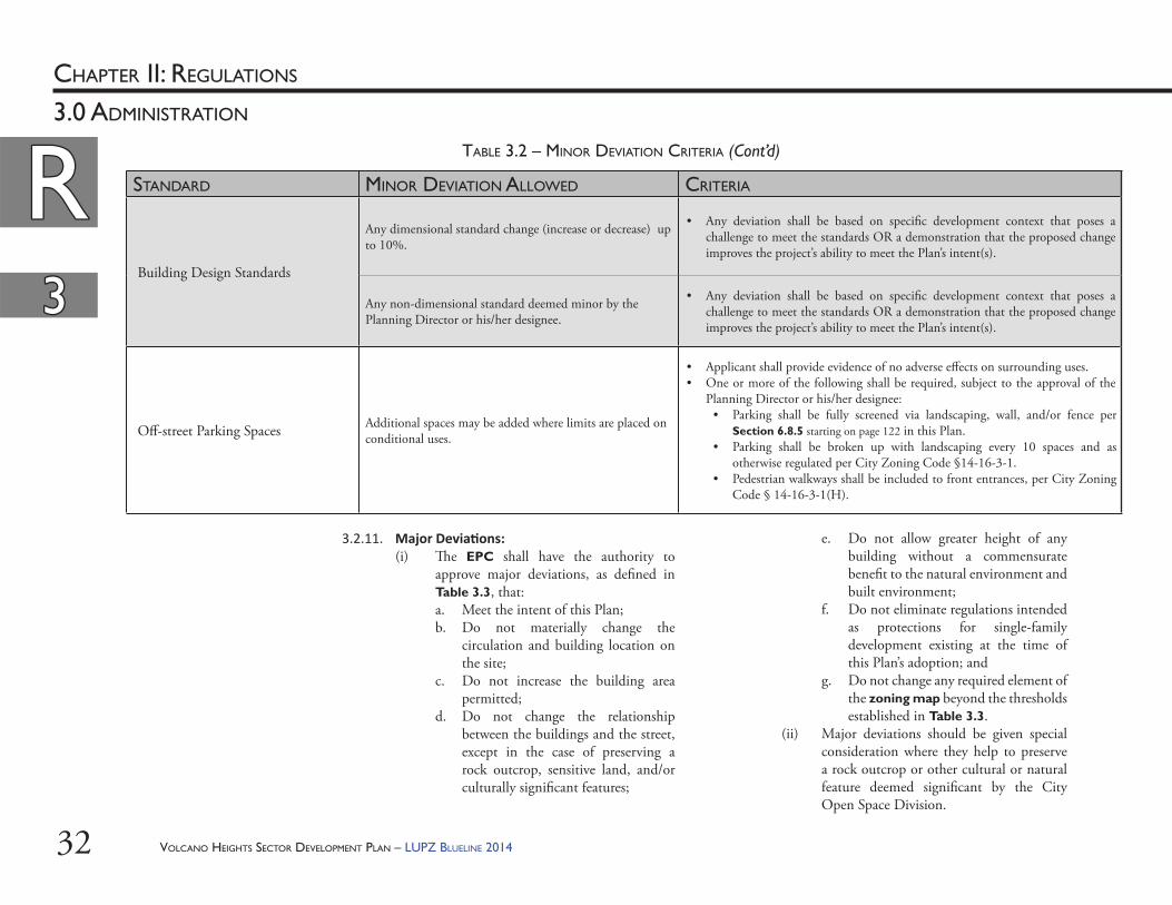
STANDARD MINOR DEVIATION ALLOWED CRITERIA
Building Design Standards
Any dimensional standard change (increase or decrease) up to 10%.
• Any deviation shall be based on specifi c development context that poses a challenge to meet the standards OR a demonstration that the proposed change improves the project’s ability to meet the Plan’s intent(s).
Any non-dimensional standard deemed minor by the Planning Director or his/her designee.
• Any deviation shall be based on specifi c development context that poses a challenge to meet the standards OR a demonstration that the proposed change improves the project’s ability to meet the Plan’s intent(s).
Off -street Parking Spaces Additional spaces may be added where limits are placed on conditional uses.
• Applicant shall provide evidence of no adverse eff ects on surrounding uses.• One or more of the following shall be required, subject to the approval of the
Planning Director or his/her designee: • Parking shall be fully screened via landscaping, wall, and/or fence per
Section 6.8.5 starting on page 122 in this Plan.• Parking shall be broken up with landscaping every 10 spaces and as
otherwise regulated per City Zoning Code §14-16-3-1.• Pedestrian walkways shall be included to front entrances, per City Zoning
Code § 14-16-3-1(H).
TABLE 3.2 – MINOR DEVIATION CRITERIA (Cont’d)
3.2.11. Major Devia ons: (i) Th e EPC shall have the authority to
approve major deviations, as defi ned in Table 3.3, that:a. Meet the intent of this Plan;b. Do not materially change the
circulation and building location on the site;
c. Do not increase the building area permitted;
d. Do not change the relationship between the buildings and the street, except in the case of preserving a rock outcrop, sensitive land, and/or culturally signifi cant features;
e. Do not allow greater height of any building without a commensurate benefi t to the natural environment and built environment;
f. Do not eliminate regulations intended as protections for single-family development existing at the time of this Plan’s adoption; and
g. Do not change any required element of the zoning map beyond the thresholds established in Table 3.3.
(ii) Major deviations should be given special consideration where they help to preserve a rock outcrop or other cultural or natural feature deemed signifi cant by the City Open Space Division.
VOLCANO HEIGHTS SECTOR DEVELOPMENT PLAN – LUPZ BLUELINE 2014 33
RRCHAPTER II: REGULATIONS
33
3.0 ADMINISTRATION
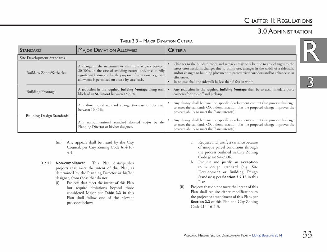
STANDARD MAJOR DEVIATION ALLOWED CRITERIA
Site Development Standards
Build-to Zones/Setbacks
A change in the maximum or minimum setback between 20-50%. In the case of avoiding natural and/or culturally signifi cant features or for the purpose of utility use, a greater allowance is permitted on a case-by-case basis.
• Changes to the build-to zones and setbacks may only be due to any changes to the street cross sections, changes due to utility use, changes in the width of a sidewalk, and/or changes to building placement to protect view corridors and/or enhance solar effi ciences.
• In no case shall the sidewalk be less than 6 feet in width.
Building Frontage A reduction in the required building frontage along each block of an ‘A’ Street between 15-30%.
• Any reduction in the required building frontage shall be to accommodate porte cocheres for drop-off and pick-up.
Building Design Standards
Any dimensional standard change (increase or decrease) between 10-40%.
• Any change shall be based on specifi c development context that poses a challenge to meet the standards OR a demonstration that the proposed change improves the project’s ability to meet the Plan’s intent(s).
Any non-dimensional standard deemed major by the Planning Director or his/her designee.
• Any change shall be based on specifi c development context that poses a challenge to meet the standards OR a demonstration that the proposed change improves the project’s ability to meet the Plan’s intent(s).
TABLE 3.3 – MAJOR DEVIATION CRITERIA
(iii) Any appeals shall be heard by the City Council, per City Zoning Code §14-16-4-4.
3.2.12. Non-compliance: Th is Plan distinguishes projects that meet the intent of this Plan, as determined by the Planning Director or his/her designee, from those that do not.(i) Projects that meet the intent of this Plan
but require deviations beyond those considered Major per Table 3.3 in this Plan shall follow one of the relevant processes below:
a. Request and justify a variance because of unique parcel conditions through the process outlined in City Zoning Code §14-16-4-2 OR
b. Request and justify an exception to a design standard (e.g. Site Development or Building Design Standards) per Section 3.2.13 in this Plan.
(ii) Projects that do not meet the intent of this Plan shall require either modifi cation to the project or amendment of this Plan, per Section 3.3 of this Plan and City Zoning Code §14-16-4-3.
VOLCANO HEIGHTS SECTOR DEVELOPMENT PLAN – LUPZ BLUELINE 201434
RRCHAPTER II: REGULATIONS
33
3.0 ADMINISTRATION
(ii) In order to justify requests for exceptions, the applicant shall submit suffi cient design sketches, photographs, and other detailed information as may be necessary to demonstrate the case and solution requested for an exception to the adopted regulations.
(iii) Site Development Plans may require additional analysis and/or documentation, such as, but not limited to: site elevations, site sections, and building heights showing impacts to views and/or relationship to nearby sensitive lands.
3.2.14. Review of Phased Projects: To minimize review steps for phased projects, the DRB may approve a Site Development Plan for Subdivision for all phases provided that the applicant submits drawings that depict the initial phase as well as all future phases. Th e Site Development Plan is valid for seven years from the date of the approval and may be amended administratively per City Zoning Code §14-16-2-22.
3.3. Amendments to the Sector Development Plan and/or Zoning Map: Amendments and/or changes to the zoning map shall be considered by the EPC for sites 10 acres or less. For sites more than 10 acres and for all text amendments, the EPC is the recommending body, and the City Council is the decision-making body per City Zoning Code §14-16-4-1.
3.2.13. Excep ons from Design Standards in this Plan, Subdivision Ordinance, and/or DPM(i) As long as a proposed project meets the
intent of this Plan, the EPC shall be authorized to approve Site Development Plan submittals with appropriate exceptions to adopted standards and regulations, provided a project meets at least one of the following conditions, as justifi ed by the applicant:a. Th e project includes exceptional
civic, architectural, or environmental design. Th ese design elements should provide a benefi t to the City, adjacent property owners, and/or the built or natural environment that justifi es the requested exception to the satisfaction of the EPC.
b. Th e exception will help to preserve and/or enhance signifi cant views, rock outcroppings, or other natural features.
c. Th e exception will help to coordinate and/or enhance development or improvements on adjacent properties and/or accommodate utility use or public utility structures.
d. Th e exception is needed to accommodate a major employer. Such an exception may be subject to a development agreement with the City that includes clawback provisions in the event that the major employer leaves the Plan area within 5 years of project approval.
VOLCANO HEIGHTS SECTOR DEVELOPMENT PLAN – LUPZ BLUELINE 2014 35
RRCHAPTER II: REGULATIONS
33
3.0 ADMINISTRATION
(iii) Notifi cation shall be sent by certifi ed mail, return receipt requested, and postmarked at least fi fteen (15) days in advance of the hearing.
(iv) Th e applicant shall give copies of the ONC notifi cation list and proof of mailings to the Approval Body for the hearing record. Failure by the applicant to show proof of notifi cation shall be grounds for a deferral of the applicant’s proposal at the Hearing until proper proof of notifi cation is provided by the applicant.
3.4.4. Planning Director Responsibili es: When required (as noted with “PO” in Table 3.4 or Table 3.5), the Planning Director or his/her designee shall provide mailed notifi cation to property owners within one hundred (100) feet of the boundaries of the proposed project site, excluding public rights-of-way, at the applicant’s expense.
Notifi cation shall be postmarked a minimum of fi fteen (15) days prior to the hearing and shall include reduced copies of the proposed Site Development Plan, the Landscape Plan, and contact information for the Planning Department and the applicant.
3.4. Public No fi ca on 3.4.1. Notifi cation for Site Plans for Subdivision shall
be required as per Table 3.4.
3.4.2. Notifi cation for Site Plans for Building Permit shall be required as per Table 3.5.
3.4.3. Applicant Responsibili es: When required (as noted with “NA” in Table 3.4 or Table 3.5), the applicant shall give written notifi cation of the Application for Site Development Plan to the relevant groups registered with the Offi ce of Neighborhood Coordination. Th is may include recognized Neighborhood Associations, Neighborhood Coalition, non-recognized neighborhood organization, homeowner association, property owner association, or merchant association that covers, abuts, or is across the public right-of-way (ROW) from the project site. (i) Th e Offi ce of Neighborhood Coordination
(ONC) shall provide the applicant with a complete list of the names and addresses for all people who require notifi cation, including any interested parties in the area who have registered with ONC to receive notice. Th e applicant shall not be held responsible for notifying people who are not on the ONC list.
(ii) Notifi cation shall include a reduced version of the proposed Site Development Plan, including the Landscape Plan; the date, time, and location of the DRB or EPC hearing; contact information for the applicant; and the name, e-mail, and phone number of the Staff Planner.

VOLCANO HEIGHTS SECTOR DEVELOPMENT PLAN – LUPZ BLUELINE 201436
RRCHAPTER II: REGULATIONS
33
3.0 ADMINISTRATION
ZONES PROPOSED PROJECT COMPLIANCEAPPROVAL PROCESS
NOTIFICATION
Transition Zones
Any Project < 5 acresFully Compliant DRB NRMinor Deviation(s) DRB NRMajor Deviation(s) EPC NA PO
Any Project 5+ acresFully Compliant DRB NRMinor Deviation(s) DRB NA POMajor Deviation(s) EPC NA PO
Center Zones + VHMX
Any Project < 5 acresFully Compliant DRB NRMinor Deviation(s) DRB NRMajor Deviation(s) EPC NA PO
Any Project 5+ AcresFully Compliant DRB NRMinor Deviation(s) DRB NRMajor Deviation(s) EPC NA PO
Approval Process Abbreviations Notifi cation AbbreviationsDRB = Development Review Board NA = Neighborhood Associations (Includes relevant Merchants Associations
registered with the Offi ce of Neighborhood Coordination. Notice shall be the responsibility of the applicant.)
EPC = Environmental Planning Commission PO = Property Owners within 100 feet (Notice shall be the responsibility of the Planning Director or his/her designee at the applicant’s expense.)
NR = Not Required
TABLE 3.4 – APPROVAL PROCESS AND NOTIFICATIONS: SITE PLANS FOR SUBDIVISION
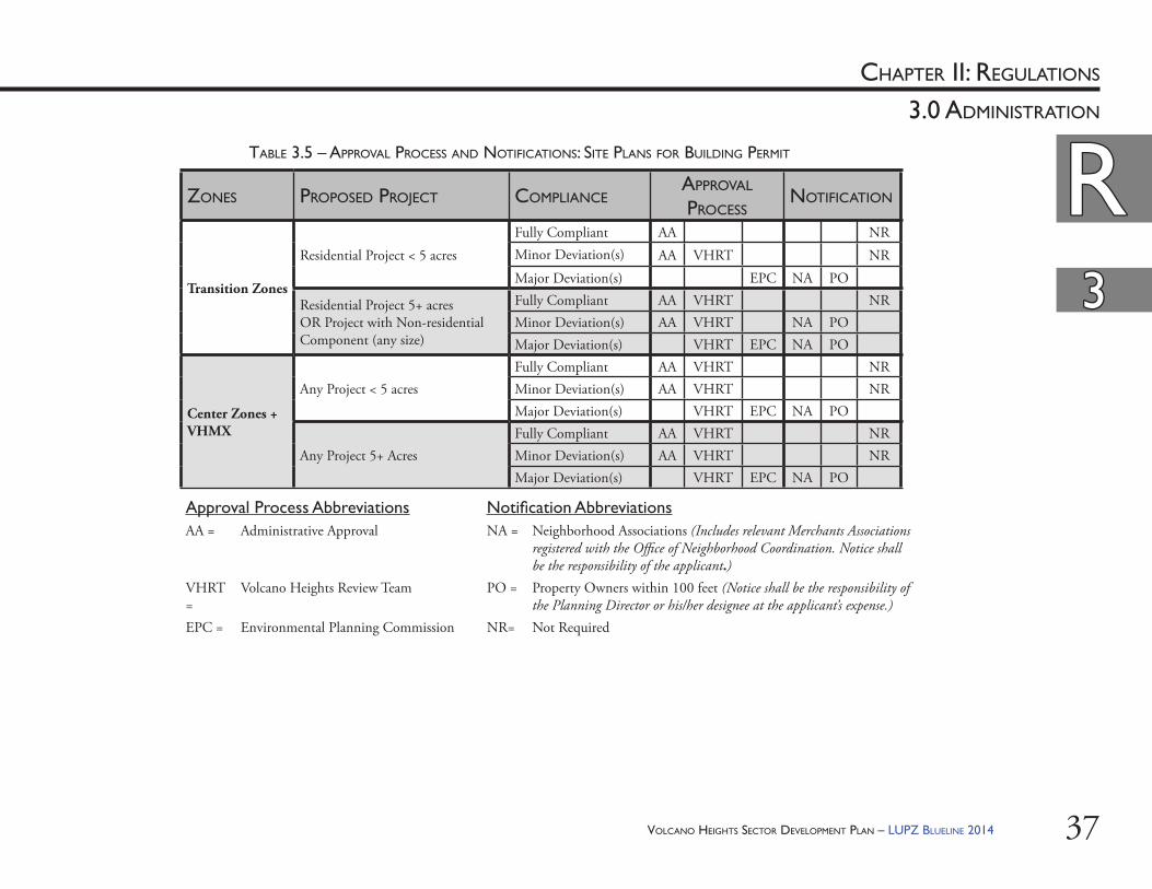
VOLCANO HEIGHTS SECTOR DEVELOPMENT PLAN – LUPZ BLUELINE 2014 37
RRCHAPTER II: REGULATIONS
33
3.0 ADMINISTRATION
ZONES PROPOSED PROJECT COMPLIANCEAPPROVAL PROCESS
NOTIFICATION
Transition Zones
Residential Project < 5 acresFully Compliant AA NRMinor Deviation(s) AA VHRT NRMajor Deviation(s) EPC NA PO
Residential Project 5+ acres OR Project with Non-residential Component (any size)
Fully Compliant AA VHRT NRMinor Deviation(s) AA VHRT NA POMajor Deviation(s) VHRT EPC NA PO
Center Zones + VHMX
Any Project < 5 acresFully Compliant AA VHRT NRMinor Deviation(s) AA VHRT NRMajor Deviation(s) VHRT EPC NA PO
Any Project 5+ AcresFully Compliant AA VHRT NRMinor Deviation(s) AA VHRT NRMajor Deviation(s) VHRT EPC NA PO
Approval Process Abbreviations Notifi cation AbbreviationsAA = Administrative Approval NA = Neighborhood Associations (Includes relevant Merchants Associations
registered with the Offi ce of Neighborhood Coordination. Notice shall be the responsibility of the applicant.)
VHRT =
Volcano Heights Review Team PO = Property Owners within 100 feet (Notice shall be the responsibility of the Planning Director or his/her designee at the applicant’s expense.)
EPC = Environmental Planning Commission NR= Not Required
TABLE 3.5 – APPROVAL PROCESS AND NOTIFICATIONS: SITE PLANS FOR BUILDING PERMIT
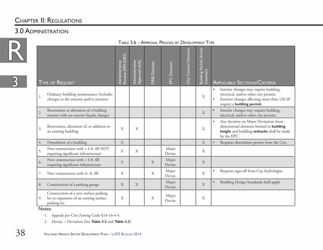
VOLCANO HEIGHTS SECTOR DEVELOPMENT PLAN – LUPZ BLUELINE 201438
RRCHAPTER II: REGULATIONS
33
3.0 ADMINISTRATION
TYPE OF REQUEST Adm
inis
trat
ive
Rev
iew
(PR
T/D
RT)
Adm
inis
trat
ive
App
rova
l (A
A)
DR
B D
ecis
ion
EPC
Dec
isio
n
City
Cou
ncil
Dec
isio
n
Build
ing
Perm
it (F
ront
C
ount
er)
APPLICABLE SECTIONS/CRITERIA
1. Ordinary building maintenance (includes changes to the exterior and/or interior) X
• Interior changes may require building, electrical, and/or other city permits
• Exterior changes aff ecting more than 120 SF require a building permit.
2. Renovation or alteration of a building interior with no exterior façade changes X • Interior changes may require building,
electrical, and/or other city permits.
3. Renovation, alteration of, or addition to an existing building X X X
• Any decision on Major Deviations from dimensional elements limited to building height and building setbacks shall be made by the EPC.
4. Demolition of a building X X • Requires demolition permit from the City.
5. New construction with < 4 ft. fi ll NOT requiring signifi cant infrastructure X X Major
Deviat. X
6. New construction with < 4 ft. fi ll requiring signifi cant infrastructure X X Major
Deviat. X
7. New construction with 4+ ft. fi ll X X Major Deviat. X • Requires sign-off from City hydrologist.
8. Construction of a parking garage X X Major Deviat. X • Building Design Standards shall apply.
9.Construction of a new surface parking lot or expansion of an existing surface parking lot
X X Major Deviat. X
TABLE 3.6 – APPROVAL PROCESS BY DEVELOPMENT TYPE
Notes:1. Appeals per City Zoning Code §14-16-4-42. Deviat. = Deviation [See Table 3.2 and Table 3.3]
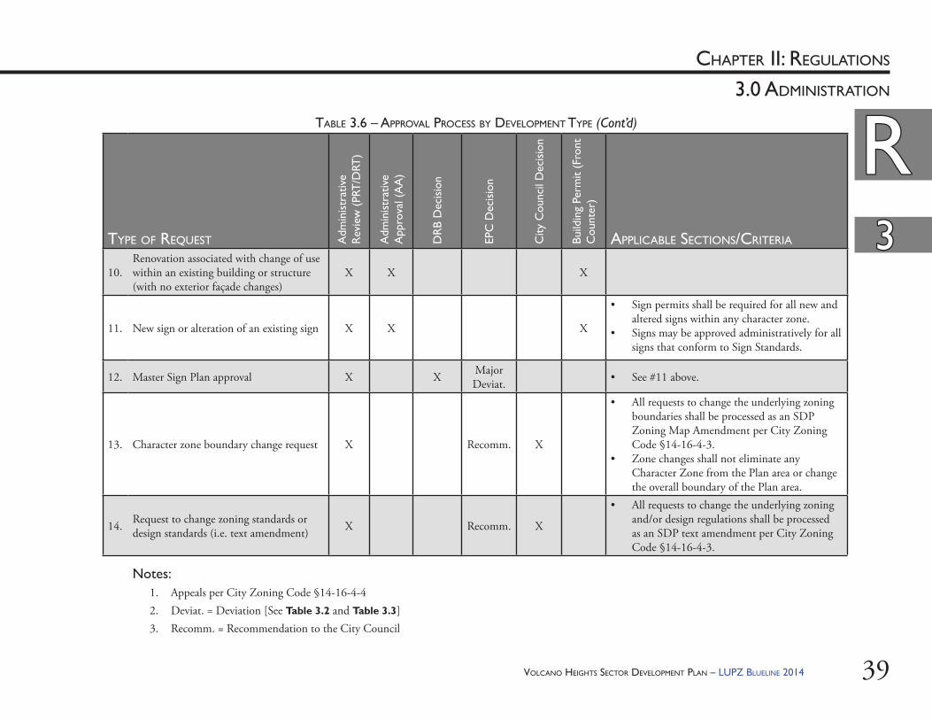
VOLCANO HEIGHTS SECTOR DEVELOPMENT PLAN – LUPZ BLUELINE 2014 39
RRCHAPTER II: REGULATIONS
33
3.0 ADMINISTRATION
TYPE OF REQUEST Adm
inis
trat
ive
Rev
iew
(PR
T/D
RT)
Adm
inis
trat
ive
App
rova
l (A
A)
DR
B D
ecis
ion
EPC
Dec
isio
n
City
Cou
ncil
Dec
isio
n
Build
ing
Perm
it (F
ront
C
ount
er)
APPLICABLE SECTIONS/CRITERIA
10.Renovation associated with change of use within an existing building or structure (with no exterior façade changes)
X X X
11. New sign or alteration of an existing sign X X X
• Sign permits shall be required for all new and altered signs within any character zone.
• Signs may be approved administratively for all signs that conform to Sign Standards.
12. Master Sign Plan approval X X Major Deviat. • See #11 above.
13. Character zone boundary change request X Recomm. X
• All requests to change the underlying zoning boundaries shall be processed as an SDP Zoning Map Amendment per City Zoning Code §14-16-4-3.
• Zone changes shall not eliminate any Character Zone from the Plan area or change the overall boundary of the Plan area.
14. Request to change zoning standards or design standards (i.e. text amendment) X Recomm. X
• All requests to change the underlying zoning and/or design regulations shall be processed as an SDP text amendment per City Zoning Code §14-16-4-3.
TABLE 3.6 – APPROVAL PROCESS BY DEVELOPMENT TYPE (Cont’d)
Notes:1. Appeals per City Zoning Code §14-16-4-42. Deviat. = Deviation [See Table 3.2 and Table 3.3]3. Recomm. = Recommendation to the City Council
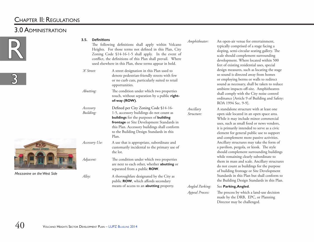
VOLCANO HEIGHTS SECTOR DEVELOPMENT PLAN – LUPZ BLUELINE 201440
RRCHAPTER II: REGULATIONS
33
3.0 ADMINISTRATION
3.5. Defi ni ons Th e following defi nitions shall apply within Volcano Heights. For those terms not defi ned in this Plan, City Zoning Code §14-16-1-5 shall apply. In the event of confl ict, the defi nitions of this Plan shall prevail. Where used elsewhere in this Plan, these terms appear in bold.
‘A’ Street: A street designation in this Plan used to denote pedestrian-friendly streets with few or no curb cuts, particularly suited to retail opportunities.
Abutting: Th e condition under which two properties touch, without separation by a public right-of-way (ROW).
Accessory Building:
Defi ned per City Zoning Code §14-16-1-5, accessory buildings do not count as buildings for the purposes of building frontage or Site Development Standards in this Plan. Accessory buildings shall conform to the Building Design Standards in this Plan.
Accessory Use: A use that is appropriate, subordinate and customarily incidental to the primary use of the lot.
Adjacent: Th e condition under which two properties are next to each other, whether abutting or separated from a public ROW.
Alley: A thoroughfare designated by the City as public ROW, which aff ords secondary means of access to an abutting property.
Amphitheater: An open-air venue for entertainment, typically comprised of a stage facing a sloping, semi-circular seating gallery. Th e scale should complement surrounding development. Where located within 500 feet of existing residential uses, special design measures, such as locating the stage so sound is directed away from homes or employing berms or walls to redirect sound as necessary, shall be taken to reduce ambient impacts off -site. Amphitheatres shall comply with the City noise control ordinance [Article 9 of Building and Safety: ROA 1994 Sec. 9-9].
Ancillary Structure:
A standalone structure with at least one open side located in an open space area. While it may include minor commercial uses, such as small food or news vendors, it is primarily intended to serve as a civic element for general public use to support and complement more passive activities. Ancillary structures may take the form of a pavilion, pergola, or kiosk. Th e style should complement surrounding buildings while remaining clearly subordinate to them in mass and scale. Ancillary structures do not count as buildings for the purpose of building frontage or Site Development Standards in this Plan but shall conform to the Building Design Standards in this Plan.
Angled Parking: See Parking, Angled.Appeal Process: Th e process by which a land-use decision
made by the DRB, EPC, or Planning Director may be challenged.
Mezzanine on the West Side
33
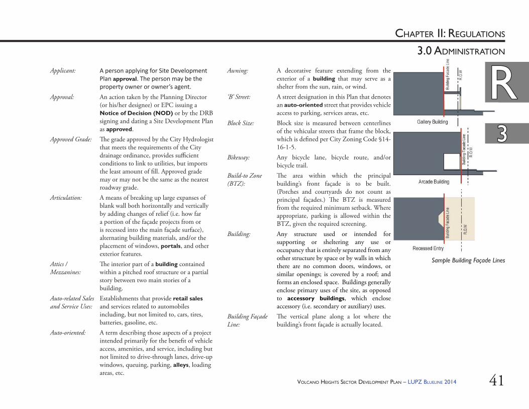
VOLCANO HEIGHTS SECTOR DEVELOPMENT PLAN – LUPZ BLUELINE 2014 41
RRCHAPTER II: REGULATIONS
33
3.0 ADMINISTRATION
Applicant: A person applying for Site Development Plan approval. The person may be the property owner or owner’s agent.
Approval: An action taken by the Planning Director (or his/her designee) or EPC issuing a Notice of Decision (NOD) or by the DRB signing and dating a Site Development Plan as approved.
Approved Grade: Th e grade approved by the City Hydrologist that meets the requirements of the City drainage ordinance, provides suffi cient conditions to link to utilities, but imports the least amount of fi ll. Approved grade may or may not be the same as the nearest roadway grade.
Articulation: A means of breaking up large expanses of blank wall both horizontally and vertically by adding changes of relief (i.e. how far a portion of the façade projects from or is recessed into the main façade surface), alternating building materials, and/or the placement of windows, portals, and other exterior features.
Attics / Mezzanines:
Th e interior part of a building contained within a pitched roof structure or a partial story between two main stories of a building.
Auto-related Sales and Service Uses:
Establishments that provide retail sales and services related to automobiles including, but not limited to, cars, tires, batteries, gasoline, etc.
Auto-oriented: A term describing those aspects of a project intended primarily for the benefi t of vehicle access, amenities, and service, including but not limited to drive-through lanes, drive-up windows, queuing, parking, alleys, loading areas, etc.
Sample Building Façade Lines
Awning: A decorative feature extending from the exterior of a building that may serve as a shelter from the sun, rain, or wind.
‘B’ Street: A street designation in this Plan that denotes an auto-oriented street that provides vehicle access to parking, services areas, etc.
Block Size: Block size is measured between centerlines of the vehicular streets that frame the block, which is defi ned per City Zoning Code §14-16-1-5.
Bikeway: Any bicycle lane, bicycle route, and/or bicycle trail.
Build-to Zone (BTZ):
Th e area within which the principal building’s front façade is to be built. (Porches and courtyards do not count as principal façades.) Th e BTZ is measured from the required minimum setback. Where appropriate, parking is allowed within the BTZ, given the required screening.
Building: Any structure used or intended for supporting or sheltering any use or occupancy that is entirely separated from any other structure by space or by walls in which there are no common doors, windows, or similar openings; is covered by a roof; and forms an enclosed space. Buildings generally enclose primary uses of the site, as opposed to accessory buildings, which enclose accessory (i.e. secondary or auxiliary) uses.
Building Façade Line:
Th e vertical plane along a lot where the building’s front façade is actually located.
33
RR
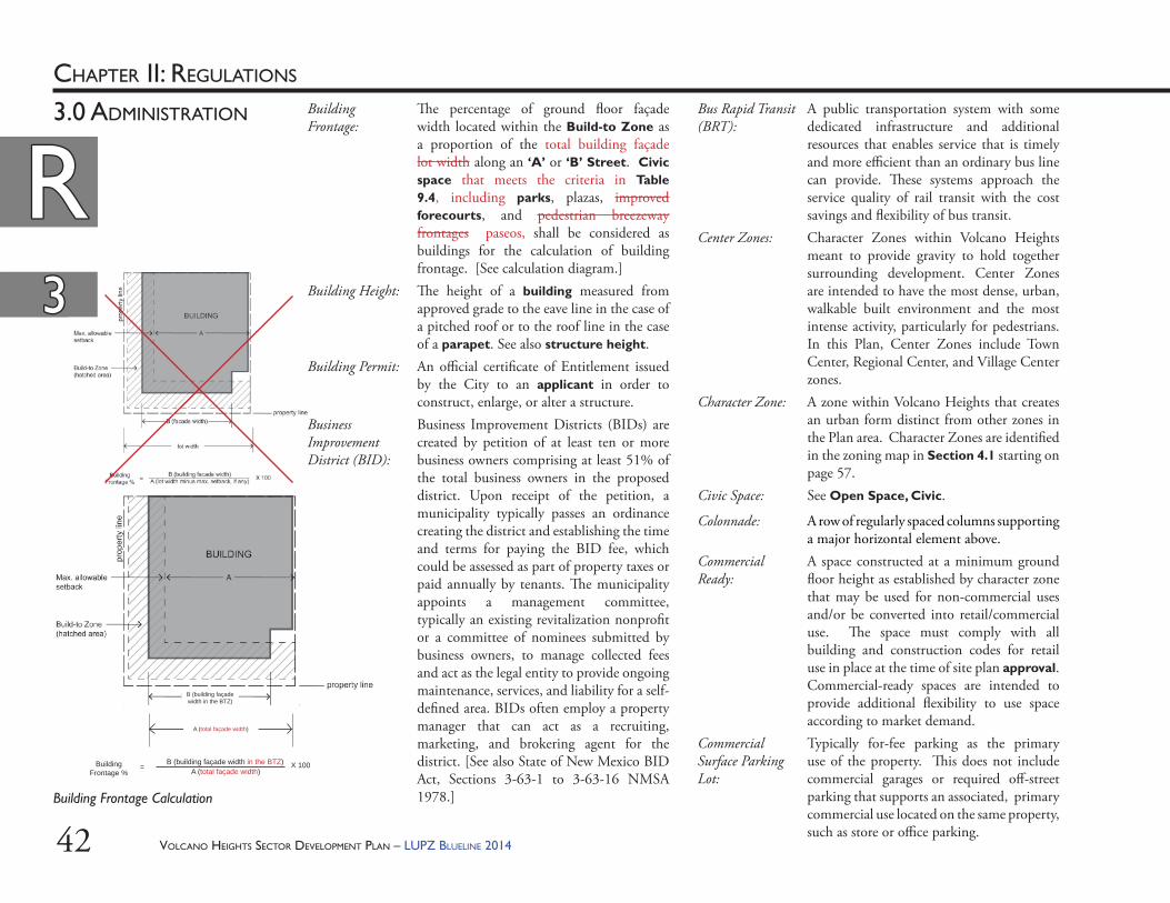
VOLCANO HEIGHTS SECTOR DEVELOPMENT PLAN – LUPZ BLUELINE 201442
RRCHAPTER II: REGULATIONS
33
3.0 ADMINISTRATION Bus Rapid Transit (BRT):
A public transportation system with some dedicated infrastructure and additional resources that enables service that is timely and more effi cient than an ordinary bus line can provide. Th ese systems approach the service quality of rail transit with the cost savings and fl exibility of bus transit.
Center Zones: Character Zones within Volcano Heights meant to provide gravity to hold together surrounding development. Center Zones are intended to have the most dense, urban, walkable built environment and the most intense activity, particularly for pedestrians. In this Plan, Center Zones include Town Center, Regional Center, and Village Center zones.
Character Zone: A zone within Volcano Heights that creates an urban form distinct from other zones in the Plan area. Character Zones are identifi ed in the zoning map in Section 4.1 starting on page 57.
Civic Space: See Open Space, Civic.
Colonnade: A row of regularly spaced columns supporting a major horizontal element above.
Commercial Ready:
A space constructed at a minimum ground fl oor height as established by character zone that may be used for non-commercial uses and/or be converted into retail/commercial use. Th e space must comply with all building and construction codes for retail use in place at the time of site plan approval. Commercial-ready spaces are intended to provide additional fl exibility to use space according to market demand.
Commercial Surface Parking Lot:
Typically for-fee parking as the primary use of the property. Th is does not include commercial garages or required off -street parking that supports an associated, primary commercial use located on the same property, such as store or offi ce parking.
33
RR
Building Frontage Calculation
B (building façade width in the BTZ)
A (total façade width)
Building Frontage %
= A (total façade width)B (building façade width in the BTZ) X 100
Building Frontage:
Th e percentage of ground fl oor façade width located within the Build-to Zone as a proportion of the total building façade lot width along an ‘A’ or ‘B’ Street. Civic space that meets the criteria in Table 9.4, including parks, plazas, improved forecourts, and pedestrian breezeway frontages paseos, shall be considered as buildings for the calculation of building frontage. [See calculation diagram.]
Building Height: Th e height of a building measured from approved grade to the eave line in the case of a pitched roof or to the roof line in the case of a parapet. See also structure height.
Building Permit: An offi cial certifi cate of Entitlement issued by the City to an applicant in order to construct, enlarge, or alter a structure.
Business Improvement District (BID):
Business Improvement Districts (BIDs) are created by petition of at least ten or more business owners comprising at least 51% of the total business owners in the proposed district. Upon receipt of the petition, a municipality typically passes an ordinance creating the district and establishing the time and terms for paying the BID fee, which could be assessed as part of property taxes or paid annually by tenants. Th e municipality appoints a management committee, typically an existing revitalization nonprofi t or a committee of nominees submitted by business owners, to manage collected fees and act as the legal entity to provide ongoing maintenance, services, and liability for a self-defi ned area. BIDs often employ a property manager that can act as a recruiting, marketing, and brokering agent for the district. [See also State of New Mexico BID Act, Sections 3-63-1 to 3-63-16 NMSA 1978.]
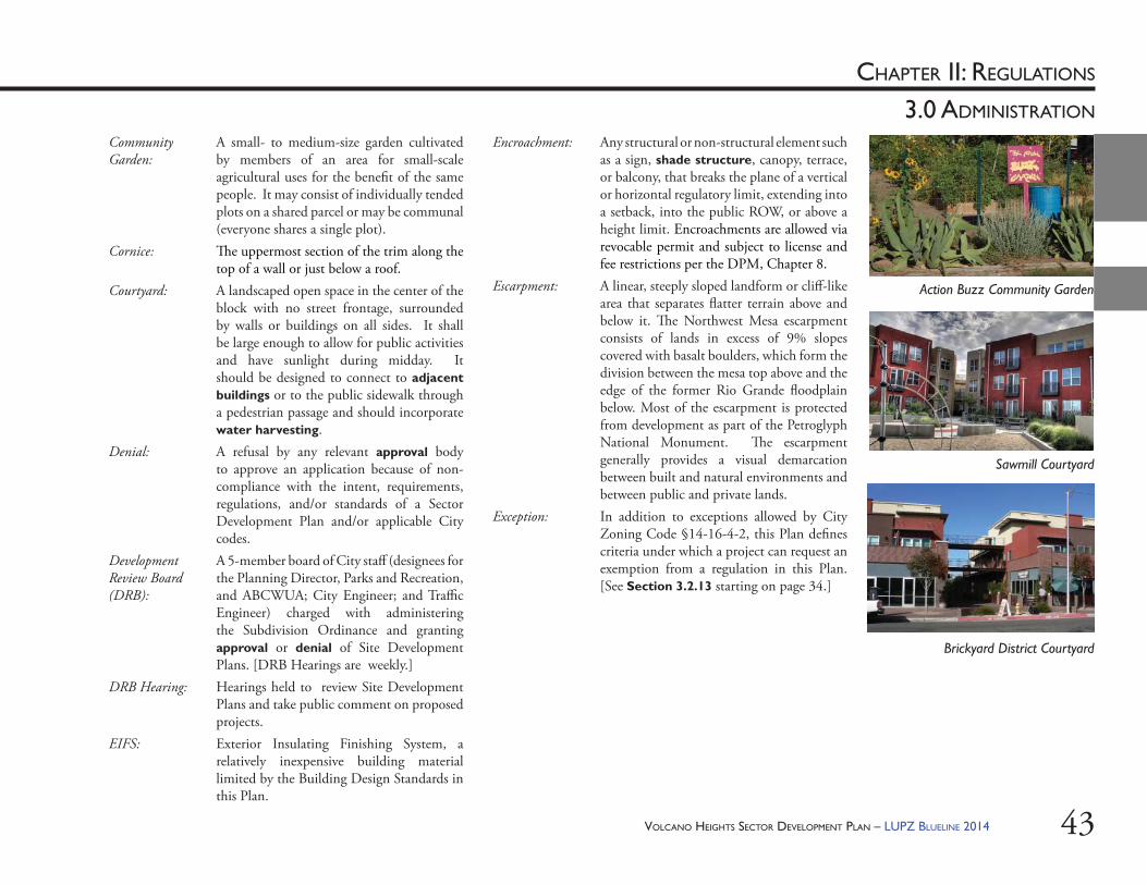
VOLCANO HEIGHTS SECTOR DEVELOPMENT PLAN – LUPZ BLUELINE 2014 43
CHAPTER II: REGULATIONS
3.0 ADMINISTRATION
Community Garden:
A small- to medium-size garden cultivated by members of an area for small-scale agricultural uses for the benefi t of the same people. It may consist of individually tended plots on a shared parcel or may be communal (everyone shares a single plot).
Cornice: Th e uppermost section of the trim along the top of a wall or just below a roof.
Courtyard: A landscaped open space in the center of the block with no street frontage, surrounded by walls or buildings on all sides. It shall be large enough to allow for public activities and have sunlight during midday. It should be designed to connect to adjacent buildings or to the public sidewalk through a pedestrian passage and should incorporate water harvesting.
Denial: A refusal by any relevant approval body to approve an application because of non-compliance with the intent, requirements, regulations, and/or standards of a Sector Development Plan and/or applicable City codes.
Development Review Board (DRB):
A 5-member board of City staff (designees for the Planning Director, Parks and Recreation, and ABCWUA; City Engineer; and Traffi c Engineer) charged with administering the Subdivision Ordinance and granting approval or denial of Site Development Plans. [DRB Hearings are weekly.]
DRB Hearing: Hearings held to review Site Development Plans and take public comment on proposed projects.
EIFS: Exterior Insulating Finishing System, a relatively inexpensive building material limited by the Building Design Standards in this Plan.
Encroachment: Any structural or non-structural element such as a sign, shade structure, canopy, terrace, or balcony, that breaks the plane of a vertical or horizontal regulatory limit, extending into a setback, into the public ROW, or above a height limit. Encroachments are allowed via revocable permit and subject to license and fee restrictions per the DPM, Chapter 8.
Escarpment: A linear, steeply sloped landform or cliff -like area that separates fl atter terrain above and below it. Th e Northwest Mesa escarpment consists of lands in excess of 9% slopes covered with basalt boulders, which form the division between the mesa top above and the edge of the former Rio Grande fl oodplain below. Most of the escarpment is protected from development as part of the Petroglyph National Monument. Th e escarpment generally provides a visual demarcation between built and natural environments and between public and private lands.
Exception: In addition to exceptions allowed by City Zoning Code §14-16-4-2, this Plan defi nes criteria under which a project can request an exemption from a regulation in this Plan. [See Section 3.2.13 starting on page 34.]
Action Buzz Community Garden
Sawmill Courtyard
Brickyard District Courtyard
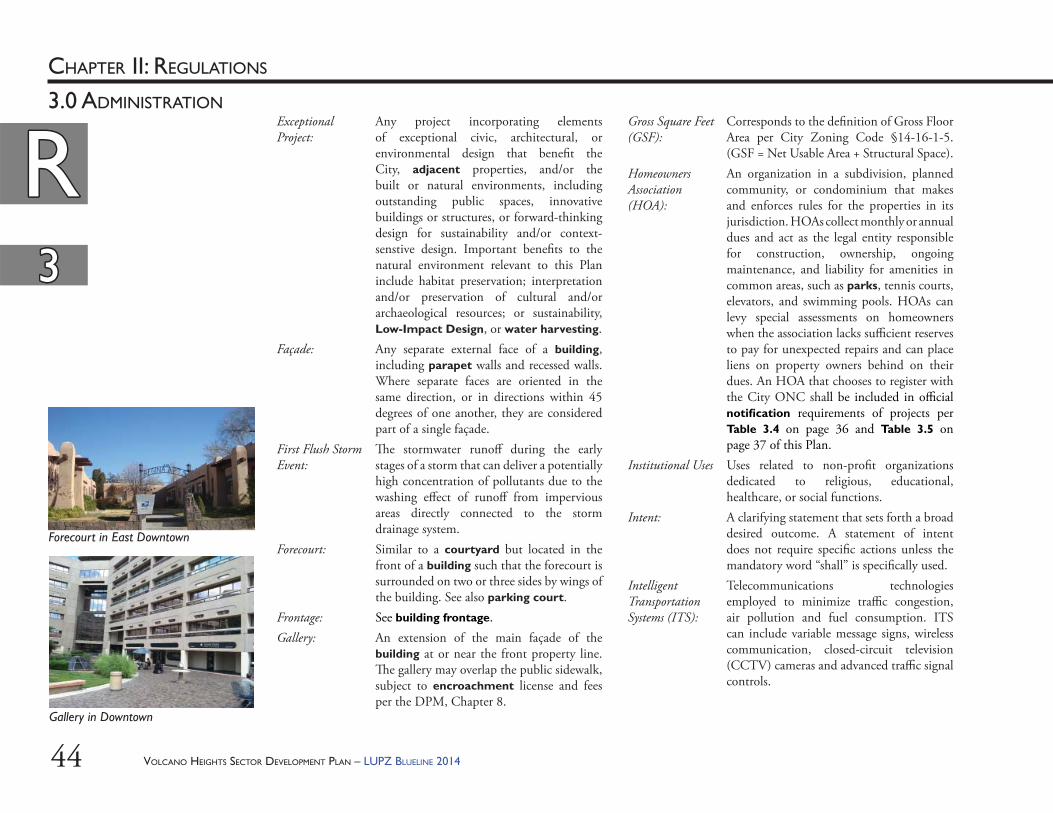
VOLCANO HEIGHTS SECTOR DEVELOPMENT PLAN – LUPZ BLUELINE 201444
RRCHAPTER II: REGULATIONS
33
3.0 ADMINISTRATIONExceptional Project:
Any project incorporating elements of exceptional civic, architectural, or environmental design that benefi t the City, adjacent properties, and/or the built or natural environments, including outstanding public spaces, innovative buildings or structures, or forward-thinking design for sustainability and/or context-senstive design. Important benefi ts to the natural environment relevant to this Plan include habitat preservation; interpretation and/or preservation of cultural and/or archaeological resources; or sustainability, Low-Impact Design, or water harvesting.
Façade: Any separate external face of a building, including parapet walls and recessed walls. Where separate faces are oriented in the same direction, or in directions within 45 degrees of one another, they are considered part of a single façade.
First Flush Storm Event:
Th e stormwater runoff during the early stages of a storm that can deliver a potentially high concentration of pollutants due to the washing eff ect of runoff from impervious areas directly connected to the storm drainage system.
Forecourt: Similar to a courtyard but located in the front of a building such that the forecourt is surrounded on two or three sides by wings of the building. See also parking court.
Frontage: See building frontage.Gallery: An extension of the main façade of the
building at or near the front property line. Th e gallery may overlap the public sidewalk, subject to encroachment license and fees per the DPM, Chapter 8.
Gross Square Feet (GSF):
Corresponds to the defi nition of Gross Floor Area per City Zoning Code §14-16-1-5. (GSF = Net Usable Area + Structural Space).
Homeowners Association (HOA):
An organization in a subdivision, planned community, or condominium that makes and enforces rules for the properties in its jurisdiction. HOAs collect monthly or annual dues and act as the legal entity responsible for construction, ownership, ongoing maintenance, and liability for amenities in common areas, such as parks, tennis courts, elevators, and swimming pools. HOAs can levy special assessments on homeowners when the association lacks suffi cient reserves to pay for unexpected repairs and can place liens on property owners behind on their dues. An HOA that chooses to register with the City ONC shall be included in offi cial notifi cation requirements of projects per Table 3.4 on page 36 and Table 3.5 on page 37 of this Plan.
Institutional Uses Uses related to non-profi t organizations dedicated to religious, educational, healthcare, or social functions.
Intent: A clarifying statement that sets forth a broad desired outcome. A statement of intent does not require specifi c actions unless the mandatory word “shall” is specifi cally used.
Intelligent Transportation Systems (ITS):
Telecommunications technologies employed to minimize traffi c congestion, air pollution and fuel consumption. ITS can include variable message signs, wireless communication, closed-circuit television (CCTV) cameras and advanced traffi c signal controls.
33
RR
Forecourt in East Downtown
Gallery in Downtown
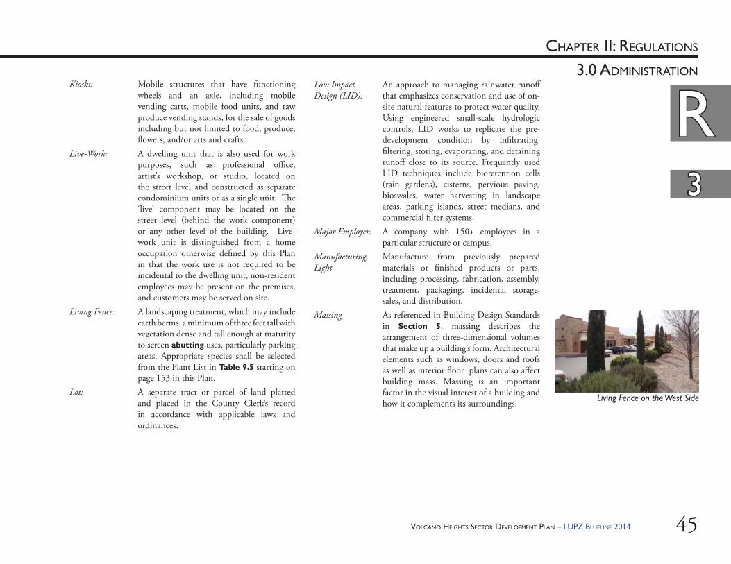
VOLCANO HEIGHTS SECTOR DEVELOPMENT PLAN – LUPZ BLUELINE 2014 45
RRCHAPTER II: REGULATIONS
33
3.0 ADMINISTRATIONKiosks: Mobile structures that have functioning
wheels and an axle, including mobile vending carts, mobile food units, and raw produce vending stands, for the sale of goods including but not limited to food, produce, fl owers, and/or arts and crafts.
Live-Work: A dwelling unit that is also used for work purposes, such as professional offi ce, artist’s workshop, or studio, located on the street level and constructed as separate condominium units or as a single unit. Th e ‘live’ component may be located on the street level (behind the work component) or any other level of the building. Live-work unit is distinguished from a home occupation otherwise defi ned by this Plan in that the work use is not required to be incidental to the dwelling unit, non-resident employees may be present on the premises, and customers may be served on site.
Living Fence: A landscaping treatment, which may include earth berms, a minimum of three feet tall with vegetation dense and tall enough at maturity to screen abutting uses, particularly parking areas. Appropriate species shall be selected from the Plant List in Table 9.5 starting on page 153 in this Plan.
Lot: A separate tract or parcel of land platted and placed in the County Clerk’s record in accordance with applicable laws and ordinances.
Low Impact Design (LID):
An approach to managing rainwater runoff that emphasizes conservation and use of on-site natural features to protect water quality. Using engineered small-scale hydrologic controls, LID works to replicate the pre-development condition by infi ltrating, fi ltering, storing, evaporating, and detaining runoff close to its source. Frequently used LID techniques include bioretention cells (rain gardens), cisterns, pervious paving, bioswales, water harvesting in landscape areas, parking islands, street medians, and commercial fi lter systems.
Major Employer: A company with 150+ employees in a particular structure or campus.
Manufacturing, Light
Manufacture from previously prepared materials or fi nished products or parts, including processing, fabrication, assembly, treatment, packaging, incidental storage, sales, and distribution.
Massing As referenced in Building Design Standards in Section 5, massing describes the arrangement of three-dimensional volumes that make up a building’s form. Architectural elements such as windows, doors and roofs as well as interior fl oor plans can also aff ect building mass. Massing is an important factor in the visual interest of a building and how it complements its surroundings.
RR33
Living Fence on the West Side
VOLCANO HEIGHTS SECTOR DEVELOPMENT PLAN – LUPZ BLUELINE 201446
RRCHAPTER II: REGULATIONS
33
3.0 ADMINISTRATION
Merchants Association:
A voluntary member organization of businesses within a self-defi ned area. Merchants Associations typically collect regular dues to pool funds that pay for maintenance, improvements, property management, marketing, etc. for privately owned amenities. Merchants Associations that choose to register with the City Offi ce of Neighborhood Coordination (ONC) shall be included in offi cial notifi cation of projects per Table 3.4 on page 36 and Table 3.5 on page 37 of this Plan.
Mixed Use: Any legal combination of permitted or approved conditional land uses, typically referring to a mix of residential and non-residential uses. In this Plan, all Character Zones include a mix of uses. Th e particular mix of uses is tailored for each zone based on location, access, and surrounding context. One character zone is named Mixed Use to distinguish it from the Center Zones and the Transition Zones.
Neighborhood Association:
A voluntary member organization of residents within a self-defi ned area. Membership in a Neighborhood Association is defi ned by each individual Neighborhood Association’s by-laws. A neighborhood association that chooses to register with the City ONC shall be included in offi cial notifi cation requirements of projects per Table 3.4 on page 36 and Table 3.5 on page 37 of this Plan.
Notice of Decision (NOD):
Th e offi cial document issued by the Planning Director or his/her designee, the DRB, or the EPC that contains the decision regarding a given application.
Notifi cation: Notifi cation is the requirement of an applicant to notify, by certifi ed/return receipt mail, two duly authorized representatives of any Neighborhood Association or other association registered with the Offi ce of Neighborhood Coordination within, abutting, or adjacent to the area covered by the Site Development Plan. See Table 3.4 and Table 3.5 for projects requiring the Planning Director or his/her designee to notify property owners within 100 feet of the project boundary, at the applicant’s expense.
Open Space: In lowercase letters, a generic term for any outdoor space or amenity intended to retain access to open air and sunlight, regardless of location, ownership, or management responsibility—e.g., landscaped medians, buff ers, paseos, setbacks, courtyards, community gardens, or balconies. Open space is required through various means in order to provide a psychological and physical respite from development densities. Healthy places balance density vs. openness, urban vs. natural environments. For City-owned open space, see Open Space, Major Public.
Open Space, Civic:
Publicly accessible areas within the Build-to Zone along public rights-of-way, such as plazas, paseos, and patios, or other private open space areas to which the public has been granted access through a public access easement. Th ese spaces may count as either usable or detached open space.
33
RR
VOLCANO HEIGHTS SECTOR DEVELOPMENT PLAN – LUPZ BLUELINE 2014 47
RRCHAPTER II: REGULATIONS
33
3.0 ADMINISTRATION
Open Space, Detached:
Outdoor space required by zone to balance development densities in a developing area. Detached open space shall be provided via dedication, on-site, or cash-in-lieu per City Zoning Code §14-16-3-8. See requirements in Section 9.4 starting on page 143. Management responsibilities for dedicated lands shall be determined as part of the developer’s dedication agreement. Detached open space requirements are in addition to, and calculated and administered separately, from usable open space or Impact Fees.
Open Space, Developed:
Any portion of usable open space that has been improved from its natural state with a constructed private open space amenity, whether accessible privately or publicly (i.e. plaza, amphitheater, playground, balcony, etc.) .
Open Space, Major Public (MPOS):
Publicly-owned spaces managed by City Open Space Division. Th ese are typically greater than fi ve acres and may include natural resources, preserves, recreational facilities, dedicated lands, or trail corridors. Th e Petroglyph National Monument is Major Public Open Space, managed jointly by the National Park Service and City Open Space Division.
Open Space, Usable:
Outdoor space to be preserved on-site and managed privately to help ensure livable conditions on each site. See Section 9.5 starting on page 144. On-site open space in non-residential and mixed use developments shall be accessible to the public, with the exception of balconies, porches, courtyards, and landscape areas.
Open Space Network:
Th e totality of Major Public Open Space managed by the City Open Space Division, comprising native or minimally-developed areas such as public rights-of-way, trail corridors, and environmentally sensitive lands that are preferably (but not necessarily) visually or physically linked.
Open Space, Private:
Any open space owned, managed, and maintained privately. Private open space may count as usable or detached open space, depending on whether it is provided on the same site as the proposed project. For all residential and mixed uses, privately accessible open spaces such as courtyards, porches, and balconies may count as usable open space. Private open space amenities shall be the responsibility of property owners/developers for the cost of construction, and ongoing maintenance and liability shall also be privately funded, such as by a POA or HOA. Property owners may grant public access to private open space via a public access easement that remains with the property in perpetuity. To be dedicated to the City for ongoing maintenance and liability responsibility, such spaces must meet City standards and be acceptable to and accepted by the relevant City department.
Parapet: A low wall that serves as a vertical barrier at the edge of a roof, terrace, or other raised area; in an exterior wall, the part entirely above the roof.
Park: A civic space programmed for active recreation, available for passive recreation, and accessible to the public.
RR33
VOLCANO HEIGHTS SECTOR DEVELOPMENT PLAN – LUPZ BLUELINE 201448
CHAPTER II: REGULATIONS
3.0 ADMINISTRATION
Parking, Angled: Refers to both “head-in” parking and “reverse-angle” parking, sometimes referred to as “back-in” angle parking. [See also “Reverse-angle Parking.”]
Parking Court: A small parking area surrounded by three wings of a building, served by one-way access from an ‘A’ Street, with angled parking spaces screened by vegetation or living fence.
Paseo: Linear urban spaces that connect one street to another at through-block locations. Th ese civic open spaces are dedicated to pedestrian movement between blocks and buildings or along alleys. Paseos may terminate public streets within the Plan area.
Patio: An outdoor space for dining or recreation that adjoins a residence or non-residential use and is often paved. It may also be a roofl ess inner courtyard within a residential or non-residential use.
Pedestrian-oriented:
A term describing those aspects of a project intended primarily for the benefi t of access, amenities, or services for people on foot or bicycle, including design details at the scale of the human body.
Permeable Paving:
Hardscape material used as a means of allowing water and air to penetrate to underlying soil or gravel reservoir for storm water control, reduction in heat island eff ect, and the health of planted materials. Examples include pave stones, matrix materials, permeable asphalt, or permeable concrete.
Planning Director:
Th e Director of the City of Albuquerque Planning Department or his/her designee.
Petroglyph National Monument:
Over 7,000 acres of Major Public Open Space designated a national monument by the U.S. Congress in 1990 and jointly managed in the public interest by the City Open Space Division and the National Park Service. Th e Plan area abuts the Monument to the east.
Playgrounds Civic open spaces designed and equipped for children’s recreation. Playgrounds should serve as quiet, safe places – protected from the street and typically located where children do not have to cross major streets to access. Playgrounds may be fenced. An open shelter, play structures, interactive art and/or fountains may be included. A larger playground may be incorporated into a park, whereas a more intimate playground may be incorporated into a recreation area.
Plaza: A primarily hardscaped, civic open space with formal landscaping, available for civic purposes and commercial activities. A plaza shall be defi ned spatially by buildings but may have street frontage on up to two sides.
Pilaster: A pier or pillar attached to the wall or portion of the wall that projects slightly to resemble a column, often with capital and base.
Portal: A portion of the ground-level, main façade of the building that is recessed, with a colonnade supporting the upper fl oors of the building. Portals are intended to provide weather protection for pedestrians to access buildings with ground-fl oor commercial or retail uses.
Porte Cocheres: A roofed structure covering a driveway at the entrance of a building to provide shelter while entering or leaving a vehicle.
Paseo in Downtown
Patio on the West Side
Parking Court in Nob Hill
Paseo
VOLCANO HEIGHTS SECTOR DEVELOPMENT PLAN – LUPZ BLUELINE 2014 49
CHAPTER II: REGULATIONS
3.0 ADMINISTRATION
Primary Street: See Streets, Primary.Private Open Space Amenity:
Could include a pool (swimming, lap pool, spa area), play courts (basket ball, tennis), picnic areas with shade structures, etc.
Property Owners Association (POA):
Typically a non-voluntary organization that collects regular dues from all property owners within a self-defi ned area to pay for ongoing maintenance, liability, and operations of privately owned amenities that benefi t properties within the self-defi ned area. A POA that chooses to register with the City ONC shall be included in offi cial notifi cation requirements of projects per Table 3.4 on page 36 and Table 3.5 on page 37 of this Plan.
Public Improvement District (PID):
A method of funding subdivision improvements, such as roads, public buildings, drainage infrastructure and recreational facilities through special assessments added to property taxes for properties within the defi ned boundaries of the district. See Section 14.3.2
Public Utility Structure:
Per City Zoning Code §14.16.1.5.
Recreation Area: A civic open space intended for passive, unprogrammed, low-impact recreation not typically defi ned spatially by building façades. Recreational areas are typically naturalistic with minimal improvements.
Retail Sales: Retail establishments are the fi nal step in the distribution of merchandise. Th ey are organized to sell items in small quantities to many customers. Establishments in stores operate as fi xed point-of-sale locations, which are designed to attract walk-in customers. Retail establishments often have displays of merchandise and sell to the general public for personal or household consumption, though they may also serve businesses and institutions. Some establishments may further provide after-sales services, such as repair and installation. Included in, but not limited to, this category are durable consumer goods sales and service, consumer goods, other grocery, food, specialty food, beverage, dairy, etc., and health and personal services.
Reverse-angle Parking:
On-street, angled parking where cars back into a parking space, sometimes referred to as “back-in angled parking.” Th e procedure is generally easier than parallel parking and safer for multimodal streets – particularly for cyclists – because of greater visibility when cars pull into the travel lane. [See Exhibit 13.2 for examples.]
Right-of-Way (ROW):
Th e area of land dedicated to or acquired by the city, county, or state primarily for the use of the public for the movement of people, goods, and vehicles.
Rock Outcropping:
Bedrock or other stratum a minimum of 6 feet high on its steepest side as measured from the adjacent 10% slope line and in excess of 500 SF in surface area.
Playground on the West Side
Portal on the West Side
Rock Outcropping in Volcano Heights
VOLCANO HEIGHTS SECTOR DEVELOPMENT PLAN – LUPZ BLUELINE 201450
RRCHAPTER II: REGULATIONS
33
3.0 ADMINISTRATION
33
Senior Housing Facility:
An age restricted residential complex that may be in a variety of housing forms— attached or detached dwelling units, apartments, private or semi-private rooms — occupied by senior citizens. Th e property shall be operated as “Housing for Older Persons” as defi ned in the Federal Housing for Older Persons Act (42U.S.S., para 3607(b)(2)) and uses will include related facilities and services, such as a common dining area, private recreational facilities, housekeeping assistance, medical services including but not limited to dietary and nutritional assistance, or incidental services related to daily living. Facilities meeting the defi nition of a Community Residential Program cannot be included under the Senior Facility Housing use.
Sign, Building Blade:
A pedestrian-oriented sign affi xed perpendicular to the corner of a building or along the front façade of a building above the ground fl oor to provide identifi cation for the whole building.
Sign, Freestanding:
Includes both permanent and temporary signs placed within a building’s front yard. Freestanding signs may be pole or monument signs.
Roof Terraces/Gardens:
Flat areas on top of a building that are accessible for use as a recreation or gardening space for the residents and users of the building.
Sensitive Lands: Areas with environmental concerns that warrant special consideration for nearby development. Sensitive lands include, but are not limited to, the volcanic Escarpment; the Petroglyph National Monument; Major Public Open Space; or archaeologically, culturally, and/or geologically signifi cant areas.
Service Uses: A category for limited personal service establishments that off er a range of personal services including (but not limited to) clothing alterations, shoe repair, dry cleaners, laundry, health and beauty spas, tanning and nail salons, hair care, etc.
Setback: Th e required minimum distance between the property line and the building façade or structure.
Secondary Dwelling Unit:
A minor second dwelling unit up to 650 SF associated with a single-family detached dwelling unit permitted anywhere on the lot except the front yard.
Secondary Street: See Streets, Secondary.
Building Blade Sign in Downtown
Roof Terrace in East Downtown
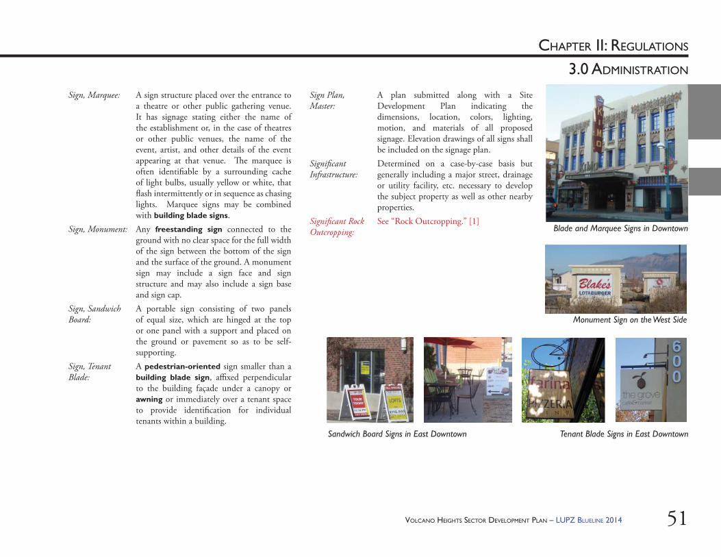
VOLCANO HEIGHTS SECTOR DEVELOPMENT PLAN – LUPZ BLUELINE 2014 51
CHAPTER II: REGULATIONS
3.0 ADMINISTRATION
Sign, Marquee: A sign structure placed over the entrance to a theatre or other public gathering venue. It has signage stating either the name of the establishment or, in the case of theatres or other public venues, the name of the event, artist, and other details of the event appearing at that venue. Th e marquee is often identifi able by a surrounding cache of light bulbs, usually yellow or white, that fl ash intermittently or in sequence as chasing lights. Marquee signs may be combined with building blade signs.
Sign, Monument: Any freestanding sign connected to the ground with no clear space for the full width of the sign between the bottom of the sign and the surface of the ground. A monument sign may include a sign face and sign structure and may also include a sign base and sign cap.
Sign, Sandwich Board:
A portable sign consisting of two panels of equal size, which are hinged at the top or one panel with a support and placed on the ground or pavement so as to be self-supporting.
Sign, Tenant Blade:
A pedestrian-oriented sign smaller than a building blade sign, affi xed perpendicular to the building façade under a canopy or awning or immediately over a tenant space to provide identifi cation for individual tenants within a building.
Sign Plan, Master:
A plan submitted along with a Site Development Plan indicating the dimensions, location, colors, lighting, motion, and materials of all proposed signage. Elevation drawings of all signs shall be included on the signage plan.
Signifi cant Infrastructure:
Determined on a case-by-case basis but generally including a major street, drainage or utility facility, etc. necessary to develop the subject property as well as other nearby properties.
Signifi cant Rock Outcropping:
See “Rock Outcropping.” [1]Blade and Marquee Signs in Downtown
Sandwich Board Signs in East Downtown
Monument Sign on the West Side
Tenant Blade Signs in East Downtown
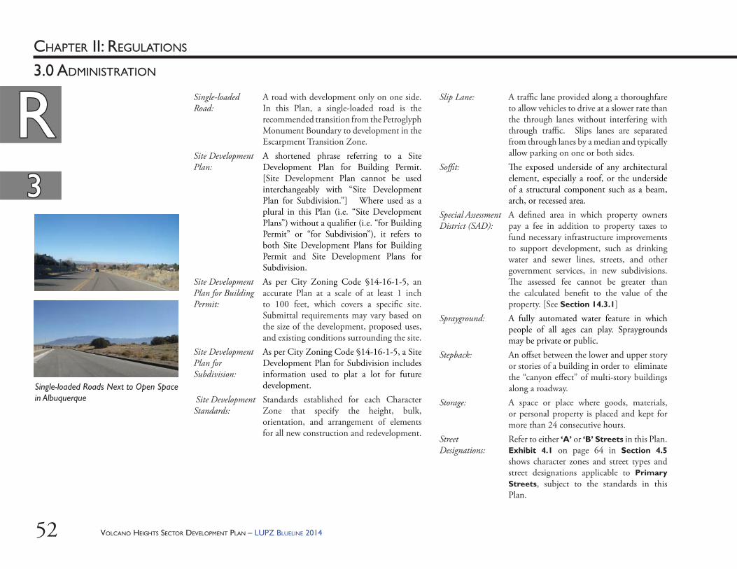
VOLCANO HEIGHTS SECTOR DEVELOPMENT PLAN – LUPZ BLUELINE 201452
RRCHAPTER II: REGULATIONS
33
3.0 ADMINISTRATION
Single-loaded Road:
A road with development only on one side. In this Plan, a single-loaded road is the recommended transition from the Petroglyph Monument Boundary to development in the Escarpment Transition Zone.
Site Development Plan:
A shortened phrase referring to a Site Development Plan for Building Permit. [Site Development Plan cannot be used interchangeably with “Site Development Plan for Subdivision.”] Where used as a plural in this Plan (i.e. “Site Development Plans”) without a qualifi er (i.e. “for Building Permit” or “for Subdivision”), it refers to both Site Development Plans for Building Permit and Site Development Plans for Subdivision.
Site Development Plan for Building Permit:
As per City Zoning Code §14-16-1-5, an accurate Plan at a scale of at least 1 inch to 100 feet, which covers a specifi c site. Submittal requirements may vary based on the size of the development, proposed uses, and existing conditions surrounding the site.
Site Development Plan for Subdivision:
As per City Zoning Code §14-16-1-5, a Site Development Plan for Subdivision includes information used to plat a lot for future development.
Site Development Standards:
Standards established for each Character Zone that specify the height, bulk, orientation, and arrangement of elements for all new construction and redevelopment.
Slip Lane: A traffi c lane provided along a thoroughfare to allow vehicles to drive at a slower rate than the through lanes without interfering with through traffi c. Slips lanes are separated from through lanes by a median and typically allow parking on one or both sides.
Soffi t: Th e exposed underside of any architectural element, especially a roof, or the underside of a structural component such as a beam, arch, or recessed area.
Special Assessment District (SAD):
A defi ned area in which property owners pay a fee in addition to property taxes to fund necessary infrastructure improvements to support development, such as drinking water and sewer lines, streets, and other government services, in new subdivisions. Th e assessed fee cannot be greater than the calculated benefi t to the value of the property. [See Section 14.3.1]
Sprayground: A fully automated water feature in which people of all ages can play. Spraygrounds may be private or public.
Stepback: An off set between the lower and upper story or stories of a building in order to eliminate the “canyon eff ect” of multi-story buildings along a roadway.
Storage: A space or place where goods, materials, or personal property is placed and kept for more than 24 consecutive hours.
Street Designations:
Refer to either ‘A’ or ‘B’ Streets in this Plan. Exhibit 4.1 on page 64 in Section 4.5 shows character zones and street types and street designations applicable to Primary Streets, subject to the standards in this Plan.
Single-loaded Roads Next to Open Space in Albuquerque
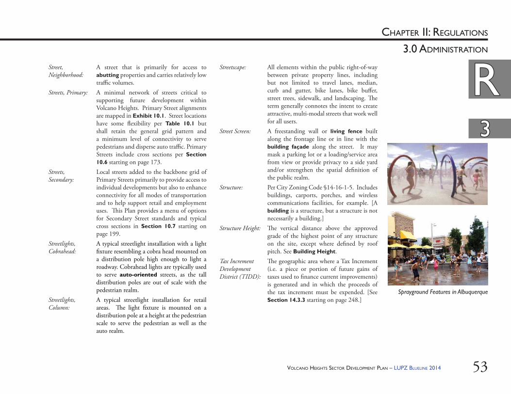
VOLCANO HEIGHTS SECTOR DEVELOPMENT PLAN – LUPZ BLUELINE 2014 53
RRCHAPTER II: REGULATIONS
33
3.0 ADMINISTRATION
Street, Neighborhood:
A street that is primarily for access to abutting properties and carries relatively low traffi c volumes.
Streets, Primary: A minimal network of streets critical to supporting future development within Volcano Heights. Primary Street alignments are mapped in Exhibit 10.1. Street locations have some fl exibility per Table 10.1 but shall retain the general grid pattern and a minimum level of connectivity to serve pedestrians and disperse auto traffi c. Primary Streets include cross sections per Section 10.6 starting on page 173.
Streets, Secondary:
Local streets added to the backbone grid of Primary Streets primarily to provide access to individual developments but also to enhance connectivity for all modes of transportation and to help support retail and employment uses. Th is Plan provides a menu of options for Secondary Street standards and typical cross sections in Section 10.7 starting on page 199.
Streetlights, Cobrahead:
A typical streetlight installation with a light fi xture resembling a cobra head mounted on a distribution pole high enough to light a roadway. Cobrahead lights are typically used to serve auto-oriented streets, as the tall distribution poles are out of scale with the pedestrian realm.
Streetlights, Column:
A typical streetlight installation for retail areas. Th e light fi xture is mounted on a distribution pole at a height at the pedestrian scale to serve the pedestrian as well as the auto realm.
Streetscape: All elements within the public right-of-way between private property lines, including but not limited to travel lanes, median, curb and gutter, bike lanes, bike buff er, street trees, sidewalk, and landscaping. Th e term generally connotes the intent to create attractive, multi-modal streets that work well for all users.
Street Screen: A freestanding wall or living fence built along the frontage line or in line with the building façade along the street. It may mask a parking lot or a loading/service area from view or provide privacy to a side yard and/or strengthen the spatial defi nition of the public realm.
Structure: Per City Zoning Code §14-16-1-5. Includes buildings, carports, porches, and wireless communications facilities, for example. [A building is a structure, but a structure is not necessarily a building.]
Structure Height: Th e vertical distance above the approved grade of the highest point of any structure on the site, except where defi ned by roof pitch. See Building Height.
Tax Increment Development District (TIDD):
Th e geographic area where a Tax Increment (i.e. a piece or portion of future gains of taxes used to fi nance current improvements) is generated and in which the proceeds of the tax increment must be expended. [See Section 14.3.3 starting on page 248.]
Sprayground Features in Albuquerque
VOLCANO HEIGHTS SECTOR DEVELOPMENT PLAN – LUPZ BLUELINE 201454
RRCHAPTER II: REGULATIONS
33
3.0 ADMINISTRATION
Transition Zones: Areas intended to buff er existing and planned lower-density and single-family residential development and sensitive lands from higher-density, higher-intensity uses toward the center of the Plan area. In this Plan, Neighborhood Transition zones are located on the northern and southern boundaries of the Plan area, and Escarpment Transition zone is located along the eastern edge of the Plan area. Transition Zones include limits on building heights and scale, as well as business operations for conditional uses.
Transom: A bar, typically wood or stone, across the top of a door or window , or a small hinged window above a door or another window.
Undevelopable Land:
Land that is not suitable for cut or fi ll and includes, but is not limited to, signifi cant rock outcroppings as defi ned by this Plan.
Water Harvesting:
A water conservation method used to capture, divert, and/or store rainwater for plant irrigation and other uses. A simple system usually consists of an area to catch water (i.e. catchment area or cistern) and a means to distribute water using gravity. Water is directed to landscape holding areas, concave or plated areas with “edges” to retain water, which can be used immediately by nearby plants.
Zoning Map: A regulatory map that shows the character zones applicable to the Volcano Heights Plan area subject to the standards in this Plan.
VOLCANO HEIGHTS SECTOR DEVELOPMENT PLAN – LUPZ BLUELINE 2014 55
CHAPTER II: REGULATIONS
4.0 ZONING
RR
VOLCANO HEIGHTS SECTOR DEVELOPMENT PLAN – LUPZ BLUELINE 201456
RRCHAPTER II: REGULATIONS
44
4.0 ZONING
EXHIBIT 4.1 – ZONING ESTABLISHED BY THE VOLCANO HEIGHTS SECTOR DEVELOPMENT PLAN
VHRC
VHMXVHMX
VHNT
VHNT
VHTC
VHRC
VHMX
R-1
VCUR
R-LTSU-1
for SchoolR-2
SU-1for C-2
(limited)R-LT
VTUR
VCMX
VTVC
SU-1for C-1
VTRD
R-LT
VCLLSTATE/
APS
VTSL
SU-1for PRD
SU-1for C-1
VCLL
R-LT
VALIENTE RD
UR
RA
CA
ST
ROSA PARKS RD
ALF
AN
JE S
T
PER
CH
A D
R
MA
RG
AR
ITA
DR
LYO
N B
LVD
HIELO RD A LOE RD
BUCKTHORN TRL
FRA
MB
UE
SA
RD
JUNIPERO RD
AZUCENA PL
HE
LAD
A S
T
AVENIDA DE JAIMITO
COLD CREEK AV
MONOLITH DR
TER
NE
RO
ST
CA
LLE
PLA
TA JUANA PL
ADINA
LA
JEMEZ PL
AB
EJA
RR
ON
ST
JAC
KS
CR
EE
K D
R
BASIL WY
TREELINE AV
OAKRIDGE ST
GOLDENSEAL TRL
CA
LLE
NO
RTE
NA
TAP
ATI
OD
R
RED RIVE R RD
FELICIDAD
PL
WOODMONT AV
CE
RR
O A
ZUL
PLVALIENTE RD
ROSA PARKS RDHIELO RD
AZUCENA PL
VALIENTE RD
ROSA PARKS RD
AVENIDA DE JAIMITO AVENIDA DE JAIMITO
±XYXY XY
XYXY Volcano Heights SDP Boundary
Parcels
Volcano Heights (VH) Zones Town Center (SU-2/VHTC)
Regional Center (SU-2/VHRC)
Village Center (SU-2/VHVC)
Mixed-Use (SU-2/VHMX)
Escarpment Transition (SU-2/VHET)
Neighborhood Transition (SU-2/VHNT)
0 500 1,000 1,500Feet
Path
: N:\
AGIS
FILE
\PRO
JECT
S\Pe
traM
orris
\TH
G-N
ov11
-Vol
cano
Hei
ghts
\JU
LY_2
013\
Prop
osed
Zoni
ng7_
24_1
3.m
xd
VHVC
VHET
PASEO DEL NORTEPASEO DEL NORTE
UNSER BOULE
VARD
UNSER BOULE
VARD
TR
AN
SIT B
OU
LEVA
RD
TR
AN
SIT B
OU
LEVA
RD
PASEO DEL NO
RTE
PASEO DEL NO
RTE
*
PARADISE BLVD.PARADISE BLVD.
UN
IVER
SE B
LVD.
UN
IVER
SE B
LVD.
ROSA PARKS RD.ROSA PARKS RD.
VOLCANO HEIGHTS SECTOR DEVELOPMENT PLAN – LUPZ BLUELINE 2014 57
RRCHAPTER II: REGULATIONS
4.0 ZONING(i) Property Index: Th e properties with multiple zones are also shown in Table 4.2, organized alphabetically by property as an index for easy reference.
(ii) Property Ownership: See Exhibit A.39 in Appendix A.
(iii) Legal Descrip ons: Available for each property on the City of Albuquerque Geographic Information Systems (GIS) page: http://www.cabq.gov/gis
4.1. Adop on of Volcano Heights Zoning 4.1.1. Th e Volcano Heights Zoning Map (Exhibit 4.1)
is hereby adopted as the offi cial zoning map. Within any area subject to the approved zoning map, this Plan establishes mandatory regulations and governs all subject properties.
4.1.2. Zone Lines and Property Lines: In Exhibit 4.2, properties designated with more than one zone are identifi ed by labels A-V. Where zone lines do not correspond to property lines, they shall begin at or be measured according to the methods corresponding to Exhibit 4.2 and Table 4.1.
RDR ST
AVENIDA DE JAIMITO
COLD CREEK AV
O S
T
LATA
LA
ON
ST
TEN
A
INE AV
DGE ST
MISA
S
MADRESELVAR PL
LA R
VALIENTE RD
AVENIDA DE JAIMITO
VALIENTE RD
AVENIDA DE JAIMITO
MADRESELVA RD
±
XY XYV l H i ht SDP B d
0 500 1,000 1,500Feet
400 feet
A B C D
400 feet
F G
NWNWNENE
NWNWNENE
H I
JNENE
SESE
Urraca St.
300 feet
K
JLM
MM
N
O P Q R M
TUV S
J
J
M300 feet
EXHIBIT 4.2 – ZONING DEMARCATION FOR PROPERTIES WITH MULTIPLE ZONES
PASEO DEL NORTEPASEO DEL NORTE
UNSER B
OULEVA
RD
UNSER B
OULEVA
RD
PASEO DEL NO
RTE
PASEO DEL NO
RTE
VHNT
VHMX
VHMXVHNT
VHRC
VHTC
VHRCVHMX
VHET
VHETVHMX
E
VHRC
1550 feet
1550 feet
1410 1410
feetfeet 400
feet
400 feet
400 feet 225 feet
VHVC
VOLCANO HEIGHTS SECTOR DEVELOPMENT PLAN – LUPZ BLUELINE 201458
RRCHAPTER II: REGULATIONS
44
4.0 ZONING
ITEMVOLCANO HEIGHTS SU-2 ZONE
ZONE DEMARCATION DESCRIPTIONRELEVANT PROPERTIES
TC 1 Town Center For properties labeled A, B, C, or D, the Town Center zone shall extend 225 feet from the southern property edge due north. Th e remaining portion of the property shall be zoned RC. [See also RC 1.]
ABCD
TC 2 For properties labeled J and K, the eastern edge of Town Center shall follow the same bearing as the line formed between the northeast and southeast corners (i.e. the eastern property edge) of the property to the north as shown in Exhibit 4.2 to the southern edge of the subject property.
JK
TC 3 For the property labeled L, the portion of the property north of Paseo del Norte shall be zoned Town Center; the remainder of the property shall be zoned MX. [See also MX 5.]
L
TC 4 For the portion of the property labeled M that is northeast of Paseo del Norte, the RC zone shall be designated per RC 3 in this table, with the remainder zoned Town Center. [For the portion of the property southwest of Paseo del Norte, see also RC 5, MX 6, NT 1, and NT 2.]
M
TC 5 For properties labeled S through V, the Regional Center zone shall be designated per RC 3 in this table; the remainder of the properties shall be zoned Town Center.
STUV
RC 1 Regional Center For the properties labeled A through D, the Town Center zone shall be designated per TC 1 in this table. Th e remaining portion of the property to the northern property line shall be zoned Regional Center.
ABCD
RC 2 For the property labeled E, the portion of the property southeast of Unser Boulevard shall be designated the Regional Center zone.
E
TABLE 4.1 – ZONE DEMARCATION FOR PROPERTIES WITH MULTIPLE ZONES
VOLCANO HEIGHTS SECTOR DEVELOPMENT PLAN – LUPZ BLUELINE 2014 59
RRCHAPTER II: REGULATIONS
44
4.0 ZONING
ITEMVOLCANO HEIGHTS SU-2 ZONE
ZONE DEMARCATION DESCRIPTIONRELEVANT PROPERTIES
RC 3 Regional Center (continued) Where this zone applies to a portion of the property only, the zone shall extend 400 feet from the centerline of Unser Boulevard or Paseo del Norte as of 2013, whichever is closer to the property, except for the four properties labeled A through D.
JMOPSTUV
RC 4 For the property labeled J, the western edge of Regional Center shall be defi ned per the line described in TC 2 in this table. [See also RC 3, RC 4, MX 3, and ET 3.]
J
RC 5 For the properties labeled M and O, the edge of the Regional Center zone not defi ned by a property line shall be defi ned by a line perpendicular to the centerline of Paseo del Norte as of 2013 beginning at the intersection approved by TCC Resolution R-13-03. [See Appendix C.]
MO
MX 1 Mixed Use For properties labeled E, F, and G the portion northwest of Unser Boulevard shall be zoned Mixed Use.
EFG
MX 2 For properties labeled H and I, Escarpment Transition zone shall be designated per ET 2. Th e remaining portion of the property shall be zoned Mixed Use.
HI
MX 3 For the property labeled J, the portions of the property not zoned as noted below shall be zoned Mixed Use:• Th e portion of the property zoned Town Center shall be designated per TC 2 in this table.• Th e portion of the property zoned Regional Center shall be designated per RC 3 and RC 4 in
this table.• Th e portion of the property zoned Escarpment Transition shall be designated per ET 3 in this
table.
J
MX 4 For the property labeled K, the Town Center portion of the property shall be zoned per TC 2 in this table; the remainder of the property shall be zoned MX.
K
MX 5 For the property labeled L, the Town Center portion of the property shall be zoned per TC 3 in this table; the remainder of the property southwest of Paseo del Norte shall be zoned MX.
L
TABLE 4.1 – ZONE DEMARCATION FOR PROPERTIES WITH MULTIPLE ZONES (Cont’d.)
VOLCANO HEIGHTS SECTOR DEVELOPMENT PLAN – LUPZ BLUELINE 201460
RRCHAPTER II: REGULATIONS
44
4.0 ZONING
ITEMVOLCANO HEIGHTS SU-2 ZONE
ZONE DEMARCATION DESCRIPTIONRELEVANT PROPERTIES
MX 6 Mixed Use (continued) For the property labeled M:• the portion of the property zoned TC shall be designated per TC 4 in this table; and • the portion of the property zoned RC shall be designated per RC 3 and RC 5 in this table;
and• the portion of the property zoned NT shall be designated per NT 1 and NT 2 in this table;
and• the remainder of the property shall be zoned MX.
M
MX 7 Where a property is zoned a combination of Mixed Use and Neighborhood Transition and/or Regional Center:• the portion of the property zoned RC shall be designated per RC 3 in this table; and/or• the portion of the property zoned NT shall be designated per NT 1 in this table; and• the remainder of the property shall be zoned MX.
NOPQR
ET 1 Escarpment Transition For the properties labeled E, F, and G, the portion of the subject property southeast of Unser Boulevard shall be zoned Escarpment Transition. [See also MX 1 in this table.]
EFG
ET 2 For the properties labeled H and I, the Escarpment Transition zone shall extend from the northernmost property edge south to a line following the same bearing as the line formed between the northwest and northeast corners (i.e. the northern property edge) of the property to the west as shown in Exhibit 4.2 extending to the eastern edge of the subject property.
HI
ET 3 For the property labeled J, the Escarpment Transition zone shall extend from the northernmost property edge south to a line following the same bearing as the line formed between the northwest and northeast corners (i.e. the northern property edge) of the property to the east as shown in Exhibit 4.2 extending to the western edge of the subject property. [See also TC 2, RC 3, RC 4, and MX 3 in this table.]
J
NT 1 Neighborhood Transition Where this zone applies to a portion of the property only, the zone shall extend 300 feet from the border of the Plan area, which corresponds to property edges.
MNPQR
NT 2 For the property labeled M, the eastern edge of the Neighborhood Transition zone shall follow the same bearing as the line formed by the eastern edge of the platted roadway Urraca St. to the south. [See also NT 1 and MX 6.]
M
TABLE 4.1 – ZONE DEMARCATION FOR PROPERTIES WITH MULTIPLE ZONES (Cont’d.)
VOLCANO HEIGHTS SECTOR DEVELOPMENT PLAN – LUPZ BLUELINE 2014 61
RRCHAPTER II: REGULATIONS
4.0 ZONING4.2. Establishment of Character Zones
Th e zoning map designates the following character zones.
4.2.1. Town Center: Th e Volcano Heights Town Center (SU-2/VHTC) zone is intended to implement the City’s vision for an urban center. Development in this zone is intended to create a major employment center with offi ce, entertainment, urban residential, and supporting retail uses. Development can be a mix of employment centers, destination retail, and entertainment, restaurant, and urban residential uses. In addition to general standards in Sections 6-9, development within the Town Center Zone shall meet the Site Development and Building Design Standards in Section 5.1 of this Plan.
4.2.2. Regional Center: Th e Volcano Heights Regional Center (SU-2/VHRC) zone is intended to provide an appropriate transition into Volcano Heights from the regional, limited-access Paseo del Norte and Unser Boulevard. Th is area is also intended for large-format and destination retail and offi ce development. In addition to general standards in Sections 6-9, development within the Regional Center Zone shall meet the Site Development and Building Design Standards in Section 5.2 of this Plan.
4.2.3. Village Center: Th e Volcano Heights Village Center (SU-2/VHVC) zone is intended for smaller-scale, neighborhood-oriented retail and offi ce development with gateway elements at key intersections. In addition to general standards in Sections 6-9, development within the Village Center Zone shall meet the Site Development and Building Design Standards in Section 5.3 of this Plan.
Town Center Character Zone
Regional Center Character Zone
Village Center Character Zone
SUBJECT PROPERTY LABEL(S)
VOLCANO HEIGHTS SU-2 ZONES
RELEVANT ITEMS PER TABLE 4.1
ABCD
Town CenterRegional Center
TC 1RC 1
E Regional CenterMixed Use
RC 2MX 1
FG
Mixed UseEscarpment Transition
MX 1ET 1
HI
Mixed UseEscarpment Transition
MX 2ET 2
J Town CenterRegional CenterMixed UseEscarpment Transition
TC 2RC 3 and RC 4
MX 3ET 3
K Town CenterMixed Use
TC 2MX 4
L Town CenterMixed Use
TC 3MX 5
M Town CenterRegional CenterMixed UseNeighborhood Transition
TC 4RC 3 and RC 5
MX 6NT 1 and NT 2
N Mixed UseNeighborhood Center
MX 7NT 1
OP
Regional CenterMixed Use
RC 3 and RC 5MX 7
QR
Mixed UseNeighborhood Transition
MX 7NT 1
STUV
Town CenterRegional Center
TC 5RC 3
TABLE 4.2 – ALPHABETICAL INDEX OF PROPERTIES WITH MULTIPLE ZONES
VOLCANO HEIGHTS SECTOR DEVELOPMENT PLAN – LUPZ BLUELINE 201462
RRCHAPTER II: REGULATIONS
44
4.0 ZONING 4.2.4. Mixed-Use: Th e Volcano Heights Mixed Use (SU-2 VHMX) zone is intended to provide the most fl exibility of use and development standards surrounding the Regional and Town Centers. VHMX also serves to buff er Transition zones from the auto-oriented uses of the Regional Center and the more intensive urban uses and taller buildings allowed within the Town Center. In addition to general standards in Sections 6-9, development within the Mixed Use Zone shall meet the Site Development and Building Design Standards in Section 5.4 of this Plan.
4.2.5. Escarpment Transi on: Th e Volcano Heights Escarpment Transition (SU-2 VHET) zone is intended to protect sensitive lands in the eastern portion of the Plan area adjacent to the Petroglyph National Monument from the higher-density and intensity mixed uses in adjacent zones. Properties adjacent to or abutting the Monument are subject to the Rank 3 NWMEP regulations for “Impact Area” designation where it covers this area.
Th is zone is intended for single-family residential, live-work, and townhouse uses as well as smaller-scale offi ce, and neighborhood retail in key locations. In addition to general standards in Sections 6-9, development within the Escarpment Transition zone shall meet the Site Development and Building Design Standards in Section 5.5 of this Plan.
4.2.6. Neighborhood Transi on: Th e Volcano Heights Neighborhood Transition (SU-2 VHNT) zone is intended to provide transitions of building scale and uses from the more dense, urban Mixed Use zone to adjoining neighborhoods north and south of the Plan area.
Th is zone is intended for single-family residential, live-work, and townhouse uses as well as some smaller-scale offi ce uses in appropriate areas. In addition to general standards in Sections 6-9, development within the Neighborhood Transition zone shall meet the Site Development and Building Design Standards in Section 5.6 of this Plan.
Neighborhood Transition Character Zone
Escarpment Transition Character Zone
Mixed-Use Character Zone
CHARACTER ZONELAND USE CATEGORY
CENTER ZONES
Town Center Mixed Use / Non-residential
Regional Center Mixed Use / Non-residential
Village Center Mixed Use / Non-residential
Mixed Use Mixed Use / Non-residential
TRANSITION ZONES
Escarpment Transition Mixed Use / Residential
Neighborhood Transition Residential
TABLE 4.3 – CHARACTER ZONES BY LAND USE CATEGORY
VOLCANO HEIGHTS SECTOR DEVELOPMENT PLAN – LUPZ BLUELINE 2014 63
RRCHAPTER II: REGULATIONS
44
4.0 ZONING
4.3. Table of Land Uses: Due to the emphasis on urban form over land uses, general land use categories have been identifi ed by character zone in Table 4.4. Zones allow a mix of appropriate uses from the following categories, listed on a separate page(s) in this order: • Residential Uses• Commercial Uses (Offi ce, Retail, Sales, and Service
Uses)• Arts, Entertainment, and Recreation Uses• Educational, Public Administration, Health Care, and
Other Institutional Uses• Manufacturing, Transportation, Communication,
and Utility Uses• Other Uses
Where a use is allowed on a conditional basis, Table 4.5 provides performance criteria relevant to protect the quality of the built environment and intent of the vision of this Plan, in addition to the criteria for conditional uses in City Zoning Code §14-16-4-2.
4.3.1. Uses not listed but substantially similar and that meet the intent of the Zone in which it is proposed may be permitted upon approval of the Planning Director or his/her designee.
4.3.2. All uses shall be conducted in a fully-enclosed building, except as provided below, and shall have no noise, vibration, particulate, or odor that poses an adverse impact on adjacent properties.(i) Where allowed by zone per Table 4.4, the
following may be conducted partially or completely outdoors:a. Auto-related sales, including vehicle
fuel sales;b. Any permitted use with a drive
through facility;c. Plant nurseries, retail garden centers,
and community gardens;d. Recreational uses; e. Wind and solar energy equipment;f. Transit facilities;g. Public utility facilities;h. Sales from kiosks;i. Commercial surface parking lots;j. Structured parking
(ii) See Section 6.9.3 starting on page 123 for regulations aff ecting outdoor storage.
(iii) See Section 6.9.4 starting on page 123 for design regulations aff ecting loading/unloading areas on ‘B’ Streets.
(iv) See Section 6.8.4 starting on page 122 for street screen requirements.
VOLCANO HEIGHTS SECTOR DEVELOPMENT PLAN – LUPZ BLUELINE 201464
RRCHAPTER II: REGULATIONS
44
4.0 ZONING
CHARACTER ZONE TO
WN
CEN
TER
REG
ION
AL
CEN
TER
VIL
LAG
E C
ENT
ER
MIX
ED-U
SE
ESC
AR
PMEN
T
TR
AN
SIT
ION
NEI
GH
BOR
HO
OD
TR
AN
SIT
ION
LAND USE
RESIDENTIAL USES
RU-1 Home Occupations P P P P P PRU-2 Multi-family residentialRU-2 G Ground fl oor C P C P P CRU-2 U Upper fl oors P P P P P CRU-3 Residential Lofts P P P P P PRU-4 Single-family residential attached dwelling unit (Townhomes) P NP P P P PRU-5 Single-family residential detached NP NP NP NP P PRU-6 Secondary dwelling unit P NP P P P PRU-7 Live-work unit P NP P P P PRU-8 Senior housing facility C C P P C C
P= Permitted by right NP= Not Permitted
C = Permitted with specifi c criteria as established in Table 4.5 (i.e. conditional)
A = Accessory Use, not to exceed 25% of the primary use building square footage
NA= Not applicable
TABLE 4.4 – LAND USE TABLE BY CHARACTER ZONE
VOLCANO HEIGHTS SECTOR DEVELOPMENT PLAN – LUPZ BLUELINE 2014 65
RRCHAPTER II: REGULATIONS
44
4.0 ZONING
P= Permitted by right NP= Not Permitted
C = Permitted with specifi c criteria as established in Table 4.5 (i.e. conditional)
A = Accessory Use, not to exceed 25% of the primary use building square footage
NA= Not applicable
* Note for CU-6: Included in this category is café seating within a public or private sidewalk area with no obstruction of pedestrian circulation. Also included in this category is the sale of alcoholic beverages for consumption on and off-premise.
TABLE 4.4 – LAND USE TABLE BY CHARACTER ZONE (Cont’d)
CHARACTER ZONE TO
WN
CEN
TER
REG
ION
AL
CEN
TER
VIL
LAG
E C
ENT
ER
MIX
ED-U
SE
ESC
AR
PMEN
T
TR
AN
SIT
ION
NEI
GH
BOR
HO
OD
TR
AN
SIT
ION
LAND USE
COMMERCIAL USES (OFFICE, RETAIL, SALES, AND SERVICE USES)CU-1 Retail Sales or Service with no drive through facility (includes
alcohol sales). Excluded from this category are retail sales and service establishments geared toward the automobile.
P P P P C NP
CU-2 Auto-related Sales or Service establishments C P C C NP NPCU-3 Finance and Real Estate establishments including banks, credit
unions, real estate, and property management services, with no drive through facility
P P P P C NP
CU-4 Offi ces for business, professional, administrative, and technical services such as, but not limited to, accountants, architects, lawyers, doctors, insurance sales/services , etc.
P P P P C C
CU-5 Research laboratory headquarters, laboratories and associated facilities P P P P NP NP
CU-6 Food Service Uses such as full-service restaurants, cafeterias, bakeries and snack bars with no drive-through facilities* P P P P C NP
CU-7 Pet and animal sales or service (including vet clinic) P P P P C NPCU-8 Any permitted use with a drive through facility C P C C NP NP

VOLCANO HEIGHTS SECTOR DEVELOPMENT PLAN – LUPZ BLUELINE 201466
RRCHAPTER II: REGULATIONS
44
4.0 ZONING
TABLE 4.4 – LAND USE TABLE BY CHARACTER ZONE (Cont’d)
P= Permitted by right NP= Not Permitted
C = Permitted with specifi c criteria as established in Table 4.5 (i.e. conditional)
A = Accessory Use, not to exceed 25% of the primary use building square footage
NA= Not applicable
* Note for AU-6: A separation of at least 1,000 feet shall be maintained between adult amusement establishments or adult stores. No adult amusement establishments or adult stores shall be allowed within 500 feet of a residential zone, including but not limited to Volcano Heights Transition Zones.
CHARACTER ZONE TO
WN
CEN
TER
REG
ION
AL
CEN
TER
VIL
LAG
E C
ENT
ER
MIX
ED-U
SE
ESC
AR
PMEN
T
TR
AN
SIT
ION
NEI
GH
BOR
HO
OD
TR
AN
SIT
ION
LAND USE
ARTS, ENTERTAINMENT, AND RECREATION USES
AU-1 Art galleries P P P P C NPAU-2 Art, antique, furniture or electronics studio (retail, repair or
fabrication; excludes auto electronics sales or service) P P P P C NP
AU-3 Games establishments (includes arcades) P P P P NP NPAU-4 Th eater, cinema, dance, or music establishment P P P P NP NPAU-5 Museums and other special purpose recreational institutions P P P P NP NPAU-6 Adult amusement establishments or adult store* NP P NP NP NP NPAU-7 Fitness, recreational sports, gym, or athletic club P P P P C NPAU-8 Parks, greens, plazas, squares, and playgrounds P P P P P P
VOLCANO HEIGHTS SECTOR DEVELOPMENT PLAN – LUPZ BLUELINE 2014 67
RRCHAPTER II: REGULATIONS
44
4.0 ZONING
TABLE 4.4 – LAND USE TABLE BY CHARACTER ZONE (Cont’d)
P= Permitted by right NP= Not Permitted
C = Permitted with specifi c criteria as established in Table 4.5 (i.e. conditional)
A = Accessory Use, not to exceed 25% of the primary use building square footage
NA= Not applicable
CHARACTER ZONE TO
WN
CEN
TER
REG
ION
AL
CEN
TER
VIL
LAG
E C
ENT
ER
MIX
ED-U
SE
ESC
AR
PMEN
T
TR
AN
SIT
ION
NEI
GH
BOR
HO
OD
TR
AN
SIT
ION
LAND USE
EDUCATIONAL, PUBLIC ADMINISTRATION, HEALTH CARE, AND OTHER INSTITUTIONAL USES
EU-1 Business associations, professional membership organizations, social & fraternal organizations P P P P NP NP
EU-2 Child day care and preschools P P P P P PEU-3 Schools, libraries, and community halls P P P P P NPEU-4 Universities and colleges P P P P NP NPEU-5 Technical, trade, and specialty schools P P P P NP NPEU-6 Hospitals and nursing establishments P P P P NP NPEU-7 Social services and philanthropic organizations P P P P C CEU-8 Rehabilitative clinics P P P P NP NPEU-9 Public administration uses (including local, state, and federal
government uses, public safety, health and human services) P P P P C C
EU-10 Religious institutions P P P P C NPEU-11 Funeral homes P P P P NP NP
VOLCANO HEIGHTS SECTOR DEVELOPMENT PLAN – LUPZ BLUELINE 201468
RRCHAPTER II: REGULATIONS
44
4.0 ZONING
TABLE 4.4 – LAND USE TABLE BY CHARACTER ZONE (Cont’d)
P= Permitted by right NP= Not Permitted
C = Permitted with specifi c criteria as established in Table 4.5 (i.e. conditional)
A = Accessory Use, not to exceed 25% of the primary use building square footage
NA= Not applicable
* Note for MU-7-A: Bus maintenance facilities shall only be permitted in Regional Center.
CHARACTER ZONE TO
WN
CEN
TER
REG
ION
AL
CEN
TER
VIL
LAG
E C
ENT
ER
MIX
ED-U
SE
ESC
AR
PMEN
T
TR
AN
SIT
ION
NEI
GH
BOR
HO
OD
TR
AN
SIT
ION
LAND USE
MANUFACTURING, TRANSPORTATION, COMMUNICATION, AND UTILITY USES
MU-1 Food, beverage, and textile product manufacturing C P NP P NP NPMU-2 Wood, paper, and printing products manufacturing NP P NP NP NP NPMU-3 Machinery, electronics, and transportation equipment
manufacturing NP P NP P NP NP
MU-4 Miscellaneous light manufacturing (included in this category are jewelry, silverware, personal metal goods, fl atware, dolls, toys, games, musical instruments, offi ce supplies, and signs.)
NP P NP C NP NP
MU-5 Wholesale trade establishment NP P NP P NP NPMU-6 Warehouse and storage services NP P NP P NP NPMU-7-A Transit Facilities* P P P P P CMU-7-B Transportation services (air, rail, road, truck and freight) NP P NP NP NP NPMU-8 Publishing (newspaper, books, periodicals, software) P P P P NP NPMU-9 Motion picture and sound recording P P P P C NPMU-10 Telecommunications and broadcasting (radio, TV, cable, wireless
communications, telephone, etc) P P P P NP NP
MU-11 Information services and data processing P P P P NP NP
VOLCANO HEIGHTS SECTOR DEVELOPMENT PLAN – LUPZ BLUELINE 2014 69
RRCHAPTER II: REGULATIONS
44
4.0 ZONING
CHARACTER ZONE TO
WN
CEN
TER
REG
ION
AL
CEN
TER
VIL
LAG
E C
ENT
ER
MIX
ED-U
SE
ESC
AR
PMEN
T
TR
AN
SIT
ION
NEI
GH
BOR
HO
OD
TR
AN
SIT
ION
LAND USE
MU-12 Electric switching stations, electric generation stations, natural gas regulating stations, public water system treatment plants and storage facilities, wastewater treatment plants, and/or other major utility services
NP P NP P NP NP
MU-13 Electric substations, telephone switching stations, and/or other minor utility services P P P P P P
P= Permitted by right NP= Not Permitted
C = Permitted with specifi c criteria as established in Table 4.5 (i.e. conditional)
A = Accessory Use, not to exceed 25% of the primary use building square footage
NA= Not applicable
TABLE 4.4 – LAND USE TABLE BY CHARACTER ZONE (Cont’d)
VOLCANO HEIGHTS SECTOR DEVELOPMENT PLAN – LUPZ BLUELINE 201470
RRCHAPTER II: REGULATIONS
44
4.0 ZONING
TABLE 4.4 – LAND USE TABLE BY CHARACTER ZONE (CONT’D)
CHARACTER ZONE TO
WN
CEN
TER
REG
ION
AL
CEN
TER
VIL
LAG
E C
ENT
ER
MIX
ED-U
SE
ESC
AR
PMEN
T
TR
AN
SIT
ION
NEI
GH
BOR
HO
OD
TR
AN
SIT
ION
LAND USE
OTHER USES
OU-1 Model homes for sales and promotion* P P P P P POU-2 Hotels P P P P P NPOU-3 Bed and Breakfast NP NP NP P P POU-4 Commercial surface parking lot (primary use of property) C C C C NP NPOU-5 Parking, structured P P P P NP NP OU-6 Private attached garage** C NP C P P P OU-7 Private detached garage** NP NP NP P P POU-8 Sales from kiosks (includes food carts) C C C C C NPOU-9 Veterinary clinic P P P P NP NPOU-10 Community garden C C C P P POU-11 Concealed Antennas including cell, accessory, and mounted on top
of buildings. (Excluded from this category are freestanding and commercial antennas and equipment buildings.) [See Section 7.9 starting on page 131.]
P/A P/A P/A P/A NP P/A
OU-12 Wind energy equipment*** P/A P/A P/A P/A C/A C/AOU-13 Solar energy equipment*** P/A P/A P/A P/A P/A P/A
P= Permitted by right NP= Not Permitted
C = Permitted with specifi c criteria as established in Table 4.5 (i.e. conditional)
A = Accessory Use, not to exceed 25% of the primary use building square footage
NA= Not applicable
* Note for OU-1: Model homes are limited to a time period until all the homes are sold in the neighborhood.** Note for OU-6: Subject to Garage design standards in Section 7.7 starting on page 129.*** Note for OU-12 and OU-13: As defi ned and regulated by the Rank 2 Facility Plan: Electric System Generation and Transmission (2010-2020).
VOLCANO HEIGHTS SECTOR DEVELOPMENT PLAN – LUPZ BLUELINE 2014 71
RRCHAPTER II: REGULATIONS
44
4.0 ZONING
USE ZONE LOCATION & DESIGN CRITERIA
RESIDENTIAL USES
RU-2-G Multi-family residential(Ground Floor)
Town Center, Village Center, and Neighborhood Transition
• Where possible, along ‘A’ Streets ground fl oor of multi-family buildings should be a commercial use in Center zones.
• All ground fl oors of a building along the Transit Boulevard ‘A’ Street section shall be built to commercial-ready standards for a minimum of the fi rst 30 feet of the building’s depth, as measured from the front façade.
• For Neighborhood Transition zone, off -street parking required per City Zoning Code §14-16-3-1. For Town Center and Village Center zones, no off -street parking required.
RU-2-U Multi-family residential (Upper fl oors)
Neighborhood Transition
• Character complements nearby single-family development.• Scale and massing complementary to nearby single-family development.• Off -street parking required as per City Zoning Code §14-16-3-1.
RU-8 Senior housing facility Town Center, Regional Center, and Transition Zones
• Service entrances shall be along a ‘B’ Street or alley.• Any buildings associated with the use shall also have a pedestrian entrance at an ‘A’ Street.• For Regional Center and Transition Zones, off -street parking required as per City Zoning Code §14-
16-3-1. For Town Center zone, no off -street parking required.• ADA access elements shall be located internal of the building or by ramping the entire sidewalk to meet
a fl ush entryway.
TABLE 4.5 – CONDITIONAL USE CRITERIA (Cont’d)
4.4. Criteria for Condi onal Uses: All uses listed as Conditional (C) in Table 4.4 shall also meet the following standards in Table 4.5, in addition to the City Zoning Code §14-16-4-2.
VOLCANO HEIGHTS SECTOR DEVELOPMENT PLAN – LUPZ BLUELINE 201472
RRCHAPTER II: REGULATIONS
44
4.0 ZONING
USE ZONE LOCATION & DESIGN CRITERIA
NON-RESIDENTIAL USES
CU-1Retail sales or service with no drive-through facility (includes alcohol sales)
Escarpment Transition
• Character complements nearby single-family development.• Scale and massing complementary to nearby single-family development.• Location restricted to any corner of the intersection of two streets.• Surface parking lot restricted to no more than 10 spaces.• Any buildings associated with the use shall also have a pedestrian entrance at an ‘A’ Street.
CU-2 Auto-related sales and service
Town Center and Village Center
• Gas pumps, canopies, and/or service bays shall not be located along any ‘A’ Street frontage.• No more than 50% of a lot’s frontage along a Primary Street shall be occupied by gas pumps,
canopies, and/or service bays.• Any buildings associated with the use shall also have a pedestrian entrance at an ‘A’ Street.• No outdoor storage of vehicles or other products sold shall be permitted along ‘A’ Streets or Primary
Streets. All auto-related sales displays shall be inside storefronts or along ‘B’ Streets.Mixed Use • Gas pumps, canopies, and/or service bays shall not be located along any ‘A’ Street frontage.
• No more than 50% of a lot’s frontage along a Primary Street shall be occupied by gas pumps, canopies, and/or service bays.
• Any buildings associated with the use shall also have a pedestrian entrance at an ‘A’ Street.• Outdoor storage of vehicles or other products sold shall not be permitted along ‘A’ Streets. Along
Paseo del Norte or Unser Boulevard, outdoor storage of vehicles or other products sold shall not exceed 50% of a lot’s frontage. Th ere shall be no such limitation along Secondary ‘B’ Streets or alleys.
CU-3 Finance and real estate establishments
Escarpment Transition
• Character complements nearby single-family development.• Scale and massing complementary to nearby single-family development.• Any buildings associated with the use shall also have a pedestrian entrance at an ‘A’ Street.
CU-4 Offi ces Transition Zones • Character complements nearby single-family development.• Scale and massing complementary to nearby single-family development.• Any buildings associated with the use shall also have a pedestrian entrance at an ‘A’ Street.
CU-6 Food service uses Escarpment Transition
• Character complements nearby single-family development.• Scale and massing complementary to nearby single-family development.• Location restricted to any corner of the intersection of two streets.• Off -street parking lots required but restricted to no more than 30 spaces.• Any buildings associated with the use shall also have a pedestrian entrance at an ‘A’ Street.
TABLE 4.5 – CONDITIONAL USE CRITERIA (Cont’d)
VOLCANO HEIGHTS SECTOR DEVELOPMENT PLAN – LUPZ BLUELINE 2014 73
RRCHAPTER II: REGULATIONS
44
4.0 ZONING
USE ZONE LOCATION & DESIGN CRITERIA
CU-7 Pet and animal sales or service Escarpment Transition
• Character complements nearby single-family development.• Scale and massing complementary to nearby single-family development.• Any buildings associated with the use shall also have a pedestrian entrance at an ‘A’ Street.• Any overnight pet boarding shall be indoors.
CU-8 Any permitted use with a drive- through facility
Town Center, Village Center, Mixed Use
• All drive-through access (driveways) shall be from a ‘B’ Street only. If the lot has no access to any ‘B’ Street, then access may be from an ‘A’ Street with approval by the Planning Director or his/her designee.
• Drive through lanes and/or canopies shall not have frontage or be located along any ‘A’ Street.• Drive through areas shall be screened by a 4-foot high street screen along ‘B’ Streets.• Drive through facilities shall meet the standards in Section 6.8 and 6.9 starting on page 123.
AU-1 Art galleries Escarpment Transition
• Character complements nearby single-family development.• Scale and massing complementary to nearby single-family development.• Any buildings associated with the use shall also have a pedestrian entrance at an ‘A’ Street.• Off -street parking lots restricted to no more than 10 spaces.
AU-2 Art, antique, furniture or electronics studio
Escarpment Transition
• Character complements nearby single-family development.• Scale and massing complementary to nearby single-family development.
AU-7 Fitness, recreational sports, gym, or athletic club
Escarpment Transition
• Off -street parking lot required but limited to no more than 4.5 spaces per 1,000 square feet.• Character complements nearby single-family development.• Scale and massing complementary to nearby single-family development.• Any buildings associated with the use shall also have a pedestrian entrance at an ‘A’ Street.
EU-7 Social services and philanthropic organizations
Transition Zones • Character complements nearby single-family development.• Scale and massing complementary to nearby single-family development.• Any buildings associated with the use shall also have a pedestrian entrance at an ‘A’ Street.
EU-9 Public administration uses Escarpment Transition
• Character complements nearby single-family development.• Scale and massing complementary to nearby single-family development.
EU-10 Religious Institutions Escarpment Transition
• Off -street parking required but limited to no more than 1 space per 3 sanctuary seats.• Character complements nearby single-family development.• Scale and massing complementary to nearby single-family development.• Any buildings associated with the use shall also have a pedestrian entrance at an ‘A’ Street.
TABLE 4.5 – CONDITIONAL USE CRITERIA (Cont’d)
VOLCANO HEIGHTS SECTOR DEVELOPMENT PLAN – LUPZ BLUELINE 201474
RRCHAPTER II: REGULATIONS
44
4.0 ZONING
USE ZONE LOCATION & DESIGN CRITERIA
MU-1 Food and textile product manufacturing
Town Center • Scale and massing complementary to walkable, urban built environment.• Off -street parking required but may be provided off -site.• Any buildings associated with the use shall also have a service entrance on a ‘B’ Street for deliveries
and maintenance equipment.MU-4 Miscellaneous manufacturing Mixed-Use • Scale and massing complementary to walkable, urban built environment.
• Off -street parking required but may be provided off -site.• Any buildings associated with the use shall also have a service entrance on an ‘B’ Street for deliveries
and maintenance equipment.• Activities shall be buff ered appropriately to mitigate noise and emission impact on neighboring
properties.MU-9 Motion picture and sound
recordingEscarpment Transition
• Character complements nearby single-family development.• Scale and massing complementary to nearby single-family development.• Activities shall be buff ered appropriately to mitigate noise impact on neighboring properties.
OTHER USES
OU-4 Commercial surface parking lot (primary use of property)
Town Center, Regional Center, Village Center, and Mixed Use
• Shall be permitted as an interim use of property (permits provided in 5-year increments).• Applications for new surface lots shall include phasing of infi ll building concepts on the lot.• New surface parking shall be set back a minimum of 30 feet from the edge of the ROW of ‘A’ Streets,
with street screen and buff er landscaping provided within setback area.• New surface parking shall not be located at a street intersection for a minimum distance of 30 feet along
each street from the intersection.OU-6 Attached garage Town Center,
Village Center• Shall be alley-accessed only.
TABLE 4.5 – CONDITIONAL USE CRITERIA (Cont’d)
VOLCANO HEIGHTS SECTOR DEVELOPMENT PLAN – LUPZ BLUELINE 2014 75
RRCHAPTER II: REGULATIONS
44
4.0 ZONING
USE ZONE LOCATION & DESIGN CRITERIA
OU-8 Sales from kiosks on private property
Center Zones, Mixed Use, and Escarpment Transition
• Sales of goods from mobile kiosks are permitted as a temporary land use, typically limited to 6 months or less but subject to determination by the ZHE on a case-by-case basis.
• Kiosks shall be placed in appropriate locations, such as off -street parking areas or paved areas with the permission of the property owner.
• If one location has more than fi ve (5) kiosks, the site layout and location shall be indicated on a site plan on fi le with the City of Albuquerque Environmental Health Department, Fire Department, and the Planning Department, and shall include authorization from the property owner. [A special event permit may be required.]
• If located in an existing parking lot, kiosks shall not encumber more than 25% of the required off -street parking. Th e impacted parking spaces shall be considered “available” and therefore still meeting off -street parking requirements. No off -street parking is required to serve kiosks.
• All food sales are subject to permitting and regulation by the City of Albuquerque Environmental Health Department.
• Outdoor seating areas are permitted in the public ROW provided that they maintain a minimum 6-foot clear pedestrian path per DPM Chapter 23, Section 7, Part B.5.
• Other conditions shall be per the discretion of the ZHE and decided on a case-by-case basis.OU-10 Community garden Center Zones • Shall be no larger than 1.0 acre.
• Gardens shall be enclosed by a fence on all open sides. • Fences shall be installed straight and plumb, with vertical supports at a minimum of 8 feet on center. • Chicken wire is permitted if used with another permitted fencing material. Where used, chicken wire
shall be continuously supported along all edges.Fencing Materials:• Permitted: wood, chicken wire, wrought iron, painted galvanized steel• Not permitted: materials including but not limited to chain link, barbed or razor wire and/or tape,
vinyl, and/or plywoodOU-12 Wind energy equipment Escarpment
Transition• Freestanding wind turbines shall be placed on the rear of the property and shall not front an ‘A’ Street. • Building-mounted wind turbines shall be permitted pending design review by the Planning Director or
his/her designee. Th ey shall not be mounted on the ground fl oor.
TABLE 4.5 – CONDITIONAL USE CRITERIA (Cont’d)

VOLCANO HEIGHTS SECTOR DEVELOPMENT PLAN – LUPZ BLUELINE 201476
Th is Page Left Intentionally Blank
VOLCANO HEIGHTS SECTOR DEVELOPMENT PLAN – LUPZ BLUELINE 2014 77
5.0 SITE DEVELOPMENT AND BUILDING DESIGN STANDARDS SPECIFIC TO ZONES
CHAPTER II: REGULATIONS
RR
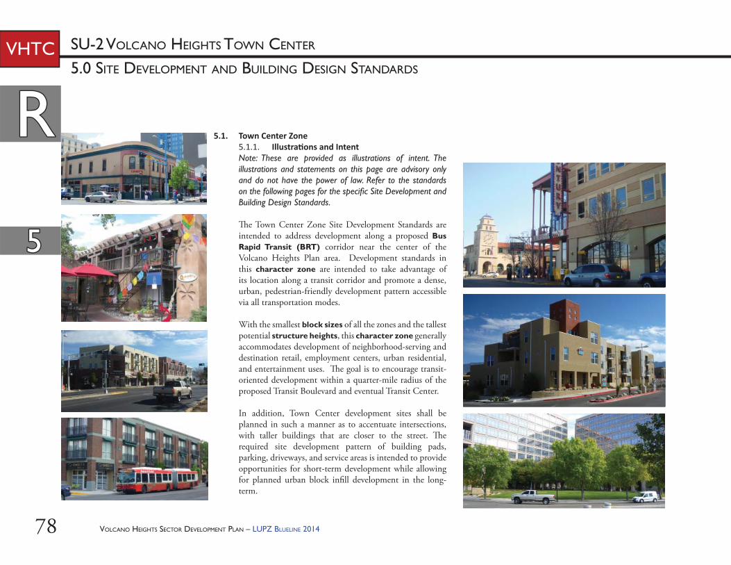
VOLCANO HEIGHTS SECTOR DEVELOPMENT PLAN – LUPZ BLUELINE 201478
RR
55
SU-2 VOLCANO HEIGHTS TOWN CENTERVHTC
5.1. Town Center Zone5.1.1. Illustra ons and IntentNote: These are provided as illustrations of intent. The illustrations and statements on this page are advisory only and do not have the power of law. Refer to the standards on the following pages for the specifi c Site Development and Building Design Standards.
Th e Town Center Zone Site Development Standards are intended to address development along a proposed Bus Rapid Transit (BRT) corridor near the center of the Volcano Heights Plan area. Development standards in this character zone are intended to take advantage of its location along a transit corridor and promote a dense, urban, pedestrian-friendly development pattern accessible via all transportation modes.
With the smallest block sizes of all the zones and the tallest potential structure heights, this character zone generally accommodates development of neighborhood-serving and destination retail, employment centers, urban residential, and entertainment uses. Th e goal is to encourage transit-oriented development within a quarter-mile radius of the proposed Transit Boulevard and eventual Transit Center.
In addition, Town Center development sites shall be planned in such a manner as to accentuate intersections, with taller buildings that are closer to the street. Th e required site development pattern of building pads, parking, driveways, and service areas is intended to provide opportunities for short-term development while allowing for planned urban block infi ll development in the long-term.
5.0 SITE DEVELOPMENT AND BUILDING DESIGN STANDARDS
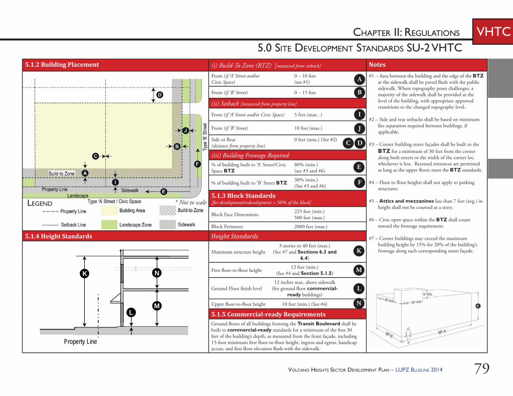
VOLCANO HEIGHTS SECTOR DEVELOPMENT PLAN – LUPZ BLUELINE 2014 79
CHAPTER II: REGULATIONS
5.0 SITE DEVELOPMENT STANDARDS SU-2 VHTCVHTC
5.1.2 Building Placement (i) Build-To Zone (BTZ) [measured from setback] Notes
Front (if ‘A’ Street and/or Civic Space)
0 – 10 feet(see #1)
#1 – Area between the building and the edge of the BTZ at the sidewalk shall be paved fl ush with the public sidewalk. Where topography poses challenges, a majority of the sidewalk shall be provided at the level of the building, with appropriate approved transitions to the changed topography level.
#2 – Side and rear setbacks shall be based on minimum fi re separation required between buildings, if applicable.
#3 – Corner building street façades shall be built to the BTZ for a minimum of 30 feet from the corner along both streets or the width of the corner lot, whichever is less. Recessed entrances are permitted as long as the upper fl oors meet the BTZ standards.
#4 – Floor to fl oor heights shall not apply to parking structures.
#5 – Attics and mezzanines less than 7 feet (avg.) in height shall not be counted as a story.
#6 – Civic open space within the BTZ shall count toward the frontage requirement.
#7 – Corner buildings may exceed the maximum building height by 15% for 20% of the building’s frontage along each corresponding street façade.
Front (if ‘B’ Street) 0 – 15 feet
(ii) Setback [measured from property line]
Front (if ‘A’ Street and/or Civic Space) 5 feet (max. .)
Front (if ‘B’ Street) 10 feet (max.)
Side or Rear (distance from property line)
0 feet (min.) (See #2)
(iii) Building Frontage Required% of building built to ‘A’ Street/Civic Space BTZ
80% (min.)(see #3 and #6)
% of building built to ‘B’ Street BTZ 30% (min.)(See #3 and #6)
5.1.3 Block Standards [for development/redevelopment > 50% of the block]
Block Face Dimensions 225 feet (min.)500 feet (max.)
Block Perimeter 2000 feet (max.)
5.1.4 Height Standards Height Standards
Maximum structure height3 stories or 40 feet (max.)
(See #7 and Sections 6.3 and 6.4)
First fl oor-to-fl oor height 12 feet (min.) (See #4 and Section 5.1.5)
Ground Floor fi nish level12 inches max. above sidewalk
(for ground fl oor commercial-ready buildings)
Upper fl oor-to-fl oor height 10 feet (min.) (See #4)
5.1.5 Commercial-ready RequirementsGround fl oors of all buildings fronting the Transit Boulevard shall be built to commercial-ready standards for a minimum of the fi rst 30 feet of the building’s depth, as measured from the front façade, including 15-foot minimum fi rst fl oor-to-fl oor height, ingress and egress, handicap access, and fi rst fl oor elevation fl ush with the sidewalk.
L
K
M
Property Line
N
A
B
C D
E
F
I
J
K
L
M
N
* Not to scaleLEGEND
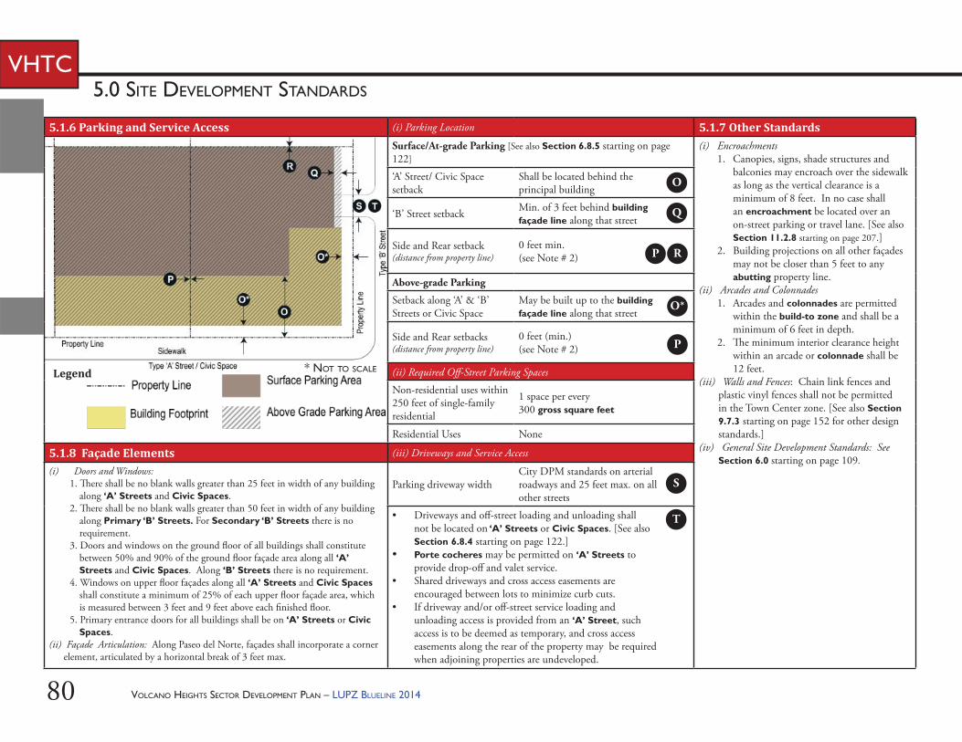
VOLCANO HEIGHTS SECTOR DEVELOPMENT PLAN – LUPZ BLUELINE 201480
5.0 SITE DEVELOPMENT STANDARDS
VHTC
5.1.6 Parking and Service Access (i) Parking Location 5.1.7 Other StandardsSurface/At-grade Parking [See also Section 6.8.5 starting on page 122]
(i) Encroachments1. Canopies, signs, shade structures and
balconies may encroach over the sidewalk as long as the vertical clearance is a minimum of 8 feet. In no case shall an encroachment be located over an on-street parking or travel lane. [See also Section 11.2.8 starting on page 207.]
2. Building projections on all other façades may not be closer than 5 feet to any abutting property line.
(ii) Arcades and Colonnades1. Arcades and colonnades are permitted
within the build-to zone and shall be a minimum of 6 feet in depth.
2. Th e minimum interior clearance height within an arcade or colonnade shall be 12 feet.
(iii) Walls and Fences: Chain link fences and plastic vinyl fences shall not be permitted in the Town Center zone. [See also Section 9.7.3 starting on page 152 for other design standards.]
(iv) General Site Development Standards: See Section 6.0 starting on page 109.
‘A’ Street/ Civic Space setback
Shall be located behind the principal building
‘B’ Street setback Min. of 3 feet behind building façade line along that street
Side and Rear setback (distance from property line)
0 feet min. (see Note # 2)
Above-grade Parking
Setback along ‘A’ & ‘B’ Streets or Civic Space
May be built up to the building façade line along that street
Side and Rear setbacks (distance from property line)
0 feet (min.) (see Note # 2)
(ii) Required Off -Street Parking Spaces
Non-residential uses within 250 feet of single-family residential
1 space per every 300 gross square feet
Residential Uses None
5.1.8 Façade Elements (iii) Driveways and Service Access
(i) Doors and Windows:1. Th ere shall be no blank walls greater than 25 feet in width of any building
along ‘A’ Streets and Civic Spaces. 2. Th ere shall be no blank walls greater than 50 feet in width of any building
along Primary ‘B’ Streets. For Secondary ‘B’ Streets there is no requirement.
3. Doors and windows on the ground fl oor of all buildings shall constitute between 50% and 90% of the ground fl oor façade area along all ‘A’ Streets and Civic Spaces. Along ‘B’ Streets there is no requirement.
4. Windows on upper fl oor façades along all ‘A’ Streets and Civic Spaces shall constitute a minimum of 25% of each upper fl oor façade area, which is measured between 3 feet and 9 feet above each fi nished fl oor.
5. Primary entrance doors for all buildings shall be on ‘A’ Streets or Civic Spaces.
(ii) Façade Articulation: Along Paseo del Norte, façades shall incorporate a corner element, articulated by a horizontal break of 3 feet max.
Parking driveway widthCity DPM standards on arterial roadways and 25 feet max. on all other streets
• Driveways and off -street loading and unloading shall not be located on ‘A’ Streets or Civic Spaces. [See also Section 6.8.4 starting on page 122.]
• Porte cocheres may be permitted on ‘A’ Streets to provide drop-off and valet service.
• Shared driveways and cross access easements are encouraged between lots to minimize curb cuts.
• If driveway and/or off -street service loading and unloading access is provided from an ‘A’ Street, such access is to be deemed as temporary, and cross access easements along the rear of the property may be required when adjoining properties are undeveloped.
Legend
O
Q
P R
S
T
O*
P
* NOT TO SCALE
VOLCANO HEIGHTS SECTOR DEVELOPMENT PLAN – LUPZ BLUELINE 2014 81
55
CHAPTER II: REGULATIONS VHTC5.0 BUILDING DESIGN STANDARDS SU-2 VHTC
Elaborate Parapet
Portals
ParapetCornice
TallerGround Floor
Building Design Standards Specific to Town Center Character Zone: The following standards shall be used for new development or redevelopment within the Town Center Zone.
(v) Storefronts should be inset with recessed entry or under an arcade or fi t into arch openings, covered with shade structures. [See Example C for an illustration.]
(vi) Shade structures, blade signs, arcades, galleries, café seating, and balconies should be used along commercial storefronts fronting an ‘A’ Street or Civic Space to add pedestrian interest.
(vii) Courtyards and plazas should be incorporated where possible, particularly along ‘A’ Streets.
5.1.11. Massing and Façade Composi on(i) Articulation along the base façade shall
maintain a prevalent rhythm of 20-30 feet along all ‘A’ Streets. Th is façade rhythm may be expressed by changing materials or color, using design elements such as columns and pilasters, or varying the setback of portions of the building façade.
(ii) Doors or windows shall form regular patterns of openings, accentuated by balconies or equivalent architectural features.
(iii) An expression line or equivalent architectural element shall delineate the base and cap of all buildings. A parapet cornice or equivalent architectural element shall delineate the caps of façades that do not use a pitched roof.
(iv) Commercial and mixed-use building façades shall maintain the alignment of horizontal elements along the block.
5.1.9. Intent/Purpose: Building Design Standards provide performance-based requirements intended to result in high-quality development and pedestrian-friendly environment in order to provide predictability over time and along corridors for property owners, neighbors, investors, and the public.
5.1.10. Guidelines(i) Buildings should generally have a
rectangular layout scheme with single or multiple components with mostly fl at front and square, round, or octagonal corner towers.
(ii) Building façades may be symmetrical or asymmetrical, but the central part of the building should be expressed with well-balanced façade compositions.
(iii) Th e ground fl oor should be taller and include heavier massing (i.e. clad in masonry or with a high proportion of fenestration to opaque wall area) than fl oors above. A portal, arcade, or colonnade may be incorporated and need not be massive if built at the ground fl oor. [See Example A for an illustration.]
(iv) Buildings should be capped with wide and continuous eaves supported by open rafters and decorative brackets or fi nished with elaborate parapet walls covered by tile and very shallow eaves. [See Example B for an illustration.]
CorniceUpper FacadeStorefront Cornice
Shade Structure
Recessed EntryPier with Pilaster
Transom
Bulkhead
Display Window
Square Corner TowerEaves with Brackets
Blade Sign
EXAMPLE C – STOREFRONT
EXAMPLE A – PORTAL AND PARAPET
EXAMPLE B – EAVES AND TOWER ELEMENT
RR
VOLCANO HEIGHTS SECTOR DEVELOPMENT PLAN – LUPZ BLUELINE 201482
RR
55
VHTC5.0 BUILDING DESIGN STANDARDS
a. EIFS shall be limited to no more than 50% of the upper fl oor façades along ‘B’ Streets and alleys.
b. Cementitious-fi ber clapboard shall be prohibited on mixed-use or residential frontages. On the upper fl oors of any commercial frontage, no more than 20% of a ‘B’ Street or alley façade may be cementitious-fi ber clapboard (not sheet), which shall have at least a 50-year warranty.
(i) Other primary building materials shall be considered on a case-by-case basis by the Planning Director or his/her designee.
(ii) Roofi ng materials for pitched roofs visible from any public ROW shall be predominantly barrel clay tile, copper, factory fi nished standing seam metal, slate, synthetic slate, or similar materials.
5.1.13. Windows(i) Glazing along ‘A’ Streets shall not be
opaque.(ii) To reduce mirror eff ect, windows shall be
either glazing rated low-refl ective value or a combination of glass and coating or fi nish to satisfy the equivalent standard. Highly refl ective coatings and/or fi nishes are prohibited.
(iii) Ornamental arches of various designs, where used, shall be deeper on the ground fl oor and shallower on upper fl oors.
(v) If a single-family building (e.g. townhouse) is set back less than 10 feet from the front property line, the grade of the slab or fi rst fl oor elevation shall be elevated at least 18 inches above the grade of the sidewalk. If a single-family building is set back 10 feet or more from the property line and is not elevated at least 18 inches above the grade of the sidewalk, a 3-foot high fence or wall shall be provided at the front property line.
5.1.12. Building Materials (i) At least 75% of a building’s base façade
along all ‘A’ Streets and Civic Spaces shall be composed of masonry, brick, or stucco using a process other than a one-step process.
(ii) No more than 25% of a building’s base façade along ‘A’ Streets or Civic Spaces shall use other accent materials such as wood, architectural metal panel, split-face concrete block, tile, or pre-cast concrete panels. Exterior Insulating Finishing System (EIFS) shall not be permitted along any ‘A’ Street or Civic Space façade.
(iii) In addition to those permitted for the base façade, upper fl oors may include glass curtain wall, split-face concrete, or cementitious fi ber board.
(iv) All façades along ‘B’ Streets or alleys shall be of a similar fi nished quality and color that blend with the front of the building. Building materials for these façades may be any of the primary and accent façade materials listed above.
VOLCANO HEIGHTS SECTOR DEVELOPMENT PLAN – LUPZ BLUELINE 2014 83
RR
55
CHAPTER II: REGULATIONS VHTC5.0 BUILDING DESIGN STANDARDS SU-2 VHTC
5.1.14. Architectural Details and Other Elements At least two (2) of the following detail elements shall be incorporated to provide visual interest:(i) detailing around principal openings
including but not limited to decorative trim, carving, transoms, columns, pilasters, pediments, and/or architraves,
(ii) window details such as but not limited to window sills, decorative leading, color, opaque treatments, multipane windows, soldier course, transoms, and/or lintels,
(iii) metal railings at balconies,(iv) shade structures, (v) roof towers, (vi) forecourts,(vii) fountains or water features using recycled
or reclaimed water,(viii) plazas,(ix) pedestrian furniture and/or life-size game
boards,(x) masonry screen products for see-through
walls or portions of walls, (xi) free-standing arbors, canopies, or towers, (xii) tower elements, and/or(xiii) other equivalent element, as approved by
the Planning Director or his/her designee.
VOLCANO HEIGHTS SECTOR DEVELOPMENT PLAN – LUPZ BLUELINE 201484
RR
55
SU-2 VOLCANO HEIGHTS REGIONAL CENTERVHRC5.0 Site Development and Building Design Standards
5.2. Regional Center Zone5.2.1. Illustra ons and IntentNote: These are provided as illustrations of intent. The illustrations and statements on this page are advisory only and do not have the power of law. Refer to the standards on the following pages for the specifi c Site Development Standards.
Th e Regional Center Zone site development standards are intended to address development along Paseo del Norte and Unser Boulevard in the central portion of the Volcano Heights Plan area. Development standards in this character zone are intended to acknowledge the primary regional traffi c function of these roads while also capitalizing on the commercial and retail opportunities for auto-oriented development provided by the signifi cant visibility and high-traffi c fl ow of these regional arteries.
Generally, this character zone allows for a wide range of retail, offi ce, service, and light industrial uses more dependent on the automobile. Th e goal is to encourage employment and destination retail that serves a broader, regional area as well as new residents and existing neighbors.
In addition, Regional Center Zone sites shall be planned in such a manner as to encourage buildings to be closer to the street at intersections in order to provide attractive, quality development along corridors in the short-term, as well as leaving room for urban block infi ll as the area becomes more dense and/or redevelops over time.
VOLCANO HEIGHTS SECTOR DEVELOPMENT PLAN – LUPZ BLUELINE 2014 85
CHAPTER II: REGULATIONS
5.0 SITE DEVELOPMENT STANDARDS SU-2 VHRCVHRC
5.2.2 Building Placement (i) Build-To Zone (BTZ) [measured from setback] Notes
Front (if ‘A’ Street and/or Civic Space)
0 – 15 feet(see #1)
#1 – Area between the building and the edge of the BTZ at the sidewalk shall be paved fl ush with the public sidewalk. Where topography poses challenges, a majority of the sidewalk shall be provided at the level of the building, with appropriate approved transitions to the changed topography level.
#2 – Side and rear setbacks shall be based on minimum fi re separation required between buildings, if applicable.
#3 – Corner building street façades shall be built to the BTZ for a minimum of 25 feet from the corner along both streets or the width of the corner lot, whichever is less. Recessed entrances are permitted as long as the upper fl oors meet the BTZ standards.
#4 – Floor to fl oor heights shall not apply to parking structures.
#5 – Attics and mezzanines less than 7 feet (avg.) in height shall not be counted as a story.
#6 – Civic open space within the BTZ shall count toward the frontage requirement.
#7 – Corner buildings may exceed the maximum building height by 15% for 20% of the building’s frontage along each corresponding street façade.
Front (if ‘B’ Street) 0 – 15 feet
(ii) Setback [measured from property line]
Front (if ‘A’ Street and/or Civic Space) 5 feet (max.)
Front (if ‘B’ Street) 10 feet (max.)
Side or Rear (distance from property line)
0 feet min. (see #2)
(iii) Building Frontage Required% of building built to ‘A’ Street/Civic Space BTZ
60% (min.)(see #3 and #6)
% of building built to ‘B’ Street BTZ 20% (min.)(see #3 and #6)
5.2.3 Block Standards [for development/redevelopment > 50% of the block]
Block Face Dimensions 300 feet (min.)800 feet (max.)
Block Perimeter 2200 feet (max.)
5.2.4 Height Standards Height Standards
Maximum structure height3 stories or 40 feet (max.)
(See also #7 and Sections 6.3 and 6.4)
First fl oor-to-fl oor height 12 feet (min.) (see #4)
Ground fl oor fi nish level12 inches max. above sidewalk
(for ground fl oor commercial-ready buildings)
Upper fl oor-to-fl oor height 10 feet (min.) (see #4)
5.2.5 Commercial-ready RequirementsCommercial-ready buildings are not required. Where non-residential or mixed-use buildings are constructed, see requirement for ground fl oor fi nish level in Height Standards above.
Legend
L
K
M
Property Line
N
A
B
C D
E
F
I
J
K
L
M
N
* Not to scale
VOLCANO HEIGHTS SECTOR DEVELOPMENT PLAN – LUPZ BLUELINE 201486
5.0 SITE DEVELOPMENT STANDARDS
SU-2 VOLCANO HEIGHTS REGIONAL CENTERVHRC
5.2.6 Parking and Service Access (i) Parking Location 5.2.7 Other StandardsSurface/At-grade Parking [See also Section 6.8.5 starting on page 122]
(i) Encroachments1. Canopies, signs, shade structures and
balconies may encroach over the sidewalk as long as the vertical clearance is a minimum of 8 feet. In no case shall an encroachment be located over an on-street parking or travel lane. [See also Section 11.2.8 starting on page 207.]
2. Building projections on all other façades may not be closer than 5 feet to any abutting property line.
(ii) Arcades and Colonnades1. Arcades and colonnades are permitted
within the build-to zone and shall be a minimum of 6 feet in depth.
2. Th e minimum interior clearance height within an arcade or colonnade shall be 12 feet.
(iii) Walls and Fences: Chain link fences and plastic vinyl fences shall not be permitted in the Regional Center Zone. [See also Section 9.7.3 starting on page 152 for other design standards.]
(iv) General Site Development Standards: See Section 6.0 starting on page 109.
‘A’ Street/ Civic Space setback
Shall be located behind the principal building
‘B’ Street setback Min. of 3 feet behind building façade line along that street
Side and Rear setback (distance from property line)
0 feet min. (see Note # 2)
Above-grade Parking
Setback along ‘A’ & ‘B’ Streets or Civic Space
May be built up to the building façade line along that street
Side and Rear setbacks (distance from property line)
0 feet min. (see Note # 2)
(ii) Required Off -Street Parking Spaces
Non-residential uses within 250 feet of single-family residential
1 space per every 300 gross square feet
Residential Uses 1 space/unit minimum
5.2.8 Façade Elements (iii) Driveways and Service Access
(i) Doors and Windows:1. Th ere shall be no blank walls greater than 50 feet in width of any
building along ‘A’ Streets, Primary ‘B’ Streets, and Civic Spaces. For Secondary ‘B’ Streets there is no requirement.
2. Doors and windows on the ground fl oor of all buildings shall constitute a minimum of 30% of the ground fl oor façade area along all ‘A’ Streets and Civic Spaces. Along ‘B’ Streets there is no requirement.
3. Windows on upper fl oor façades along all ‘A’ Streets and Civic Spaces shall constitute a minimum of 20% of each upper fl oor façade area, which is measured between 3 feet and 9 feet above each fi nished fl oor.
4. Primary entrance doors for all buildings shall be on ‘A’ Streets or Civic Spaces.
Parking driveway widthCity DPM standards on Arterial Roadways and 25 feet max. on all other streets
• Driveways and off -street loading and unloading shall not be located on ‘A’ Streets or Civic Spaces. [See also Section 6.8.4 starting on page 122.]
• Porte cocheres may be permitted on ‘A’ Streets to provide drop-off and valet service.
• Shared driveways and cross access easements are encouraged between lots to minimize curb cuts.
• If driveway and/or off -street service loading and unloading access is provided from an ‘A’ Street, such access is to be deemed as temporary, and cross access easements along the rear of the property may be required when adjoining properties are undeveloped.
LEGEND
O
Q
P R
S
T
O*
P
* Not to scale
VOLCANO HEIGHTS SECTOR DEVELOPMENT PLAN – LUPZ BLUELINE 2014 87
55
CHAPTER II: REGULATIONS VHRC5.0 BUILDING DESIGN STANDARDS SU-2 VHRC
Building Design Standards Specific to Regional Center Character Zone: The following standards shall be used for new development or redevelopment within the Regional Center Zone.
5.2.11. Massing and Façade Composi on(i) Buildings shall maintain a rhythm of
façade articulation between 30-50 feet along all ‘A’ Streets or Civic Spaces. Th is articulation rhythm may be expressed by changing materials or color; using design elements such as fenestration, columns, and pilasters; or varying the setback of portions of the façade.
(ii) Buildings shall be designed and built with a distinct Base, Middle, and Cap.
(iii) An expression line or equivalent architectural element shall delineate the Base and Cap of all buildings. A parapet cornice or equivalent architectural element shall delineate the caps of façades that do not use a pitched roof.
(iv) Retail storefront buildings shall include a transom, display window area, and bulkhead at the base.
(v) Storefronts on façades that span multiple tenants shall use architecturally compatible materials, colors, details, shade structures, signage, and lighting fi xtures.
(vi) Buildings located on axis with a terminating street or at the intersection of streets shall be considered feature buildings. Such buildings shall be designed with features that take advantage of that location, such as an accentuated entry and a unique building articulation off -set from the front wall planes that rises above the main building eave or parapet line.
5.2.9. Intent/Purpose: Building Design Standards provide performance-based requirements intended to result in high-quality development and pedestrian-friendly environment in order to provide predictability over time and along corridors for property owners, neighbors, investors, and the public.
5.2.10. Guidelines(i) Building entrances should be defi ned and
articulated by architectural elements such as lintels, pediments, pilasters, columns, porticos, porches, overhangs, railings, balustrades, and others as appropriate. All building elements should be compatible with the architectural style, materials, colors, and details of the building as a whole. Entrances to upper level uses may be defi ned and integrated into the design of the overall building façade.
(ii) Buildings should generally maintain the alignment of horizontal elements along the block.
(iii) Architectural features emphasizing the corners of buildings, such as pedimented, gabled parapets; cornices; shade structures; blade signs; arcades; colonnades; projecting roofs, and balconies should be used along commercial storefronts to add pedestrian interest. [See Examples A-C for illustrations.]
Elaborate Parapet
Portals
ParapetCornice
TallerGround Floor
Square Corner TowerEaves with Brackets
Blade Sign
EXAMPLE C – STOREFRONT
EXAMPLE A – PORTAL AND PARAPET
EXAMPLE B – EAVES AND TOWER ELEMENT
RR
CorniceUpper FacadeStorefront Cornice
Shade Structure
Recessed EntryPier with Pilaster
Transom
Bulkhead
Display Window
VOLCANO HEIGHTS SECTOR DEVELOPMENT PLAN – LUPZ BLUELINE 201488
RR
55
SU-2 VOLCANO HEIGHTS REGIONAL CENTERVHRC5.0 BUILDING DESIGN STANDARDS
5.2.12. Non-residen al and Mixed-use Building Materials(i) Th e following materials shall be permitted
as principal building materials along all ‘A’ Street or Civic Space fronting façades:a. masonry, stone, cast stone, brick,
glass, glass block, or stucco using a process other than a one-step process;
b. split face concrete block or pre-cast or poured-in-place concrete;
c. cementitious fi ber clapboard (not sheet) with at least a 50-year warranty;
d. architectural metal panel (not including galvanized or unfi nished metal); and/or
e. other primary building materials approved on a case-by-case basis by the Planning Director or his/her designee, particularly for buildings over 26 feet high.
(ii) No more than 50% of each façade along any ‘A’ Street shall use accent materials such as other metal fi nishes, wood, or EIFS.
(iii) All façades along ‘B’ Streets or alleys shall be of a similar fi nished quality and color that blend with the front of the building. Building materials for these façades may be any of the primary and accent façade materials listed above. a. EIFS shall be limited to 40% of any
‘B’ Street- or alley-facing façade.(iv) Roofi ng materials visible from any public
ROW shall be clay barrel tile, copper, factory fi nished standing seam metal, slate, synthetic slate, or similar materials.
5.2.13. Residen al Building Materials(i) Th e following shall be permitted fi nishes
for all street-fronting façades (except alleys) of residential buildings. No more than three (3) diff erent materials shall be used on any single façade:a. cementitious-fi ber clapboard (not
sheet) with at least a 50-year warranty;b. masonry, brick, stone, man-made
stone, or stucco using a process other than a one-step process.
(ii) Th e following shall only be allowed up to 40% as an accent material:a. EIFS or similar material over a
cementitious base, rock, glass block and tile.
(iii) Side and rear façades shall be of fi nished quality and of the same color and materials that blend with the front of the building.
(iv) Other primary building materials shall be considered on a case-by-case basis by the Planning Director or his/her designee, particularly for buildings above 26 feet.
(v) Roofi ng materials visible from any public ROW shall be clay barrel tile, copper, factory fi nished standing seam metal, slate, synthetic slate, or similar materials.
5.2.14. Windows(i) Glazing along ‘A’ Streets shall not be
opaque.(ii) To reduce mirror eff ect, windows shall be
either glazing rated low-refl ective value or a combination of glass and coating or fi nish to satisfy the equivalent standard. Highly refl ective coatings and/or fi nishes are prohibited.
VOLCANO HEIGHTS SECTOR DEVELOPMENT PLAN – LUPZ BLUELINE 2014 89
RR
55
CHAPTER II: REGULATIONS VHRC5.0 BUILDING DESIGN STANDARDS SU-2 VHRC
5.2.15. Architectural Details and Other ElementsAt least one (1) of the following detail elements shall be incorporated to provide visual interest:(i) detailing around principal openings
including but not limited to decorative trim, carving, transoms, columns, pilasters, pediments, and/or architraves,
(ii) window details such as but not limited to window sills, decorative leading, color, opaque treatments, multipane windows, soldier course, transoms, and/or lintels,
(iii) metal railings at balconies,(iv) shade structures, (v) roof towers, (vi) forecourts,(vii) fountains or water features using recycled
or reclaimed water,(viii) plazas,(ix) pedestrian furniture and/or lifesize game
boards,(x) masonry screen products for see-through
walls or portions of walls, (xi) free-standing arbors, canopies, or towers, (xii) tower elements, and/or(xiii) other equivalent element, as approved by
the Planning Director or his/her designee.
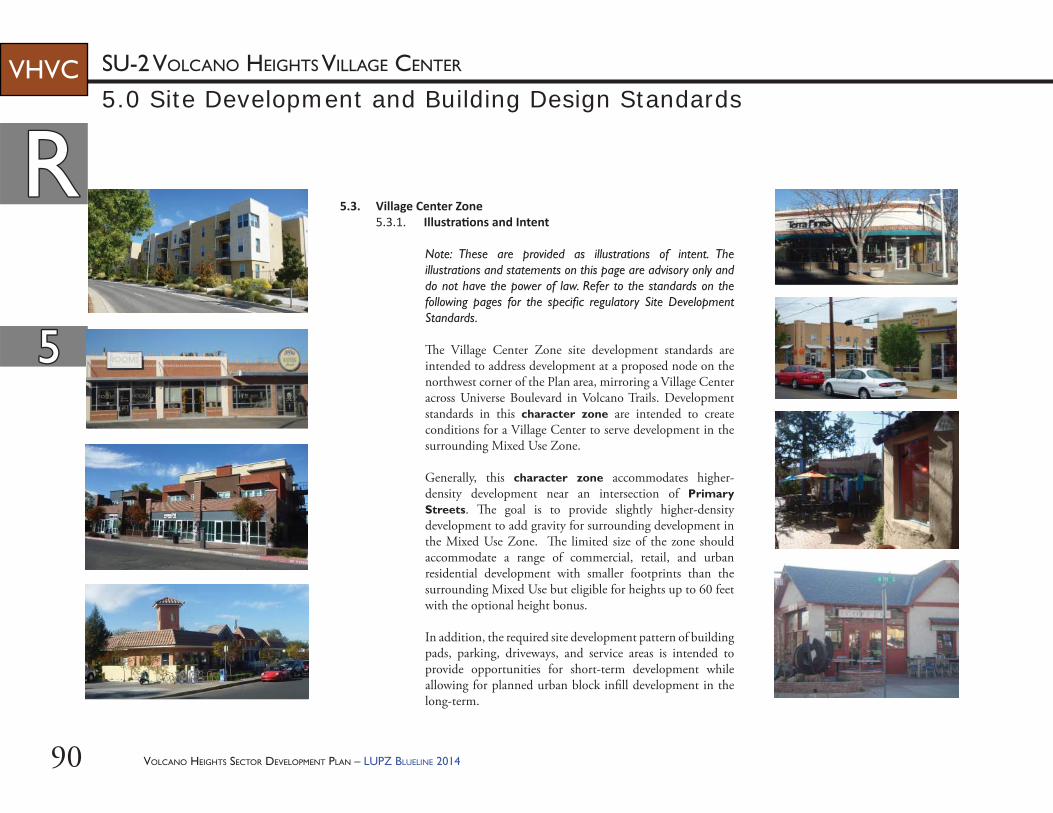
VOLCANO HEIGHTS SECTOR DEVELOPMENT PLAN – LUPZ BLUELINE 201490
RR
55
SU-2 VOLCANO HEIGHTS VILLAGE CENTERVHVC
5.3. Village Center Zone5.3.1. Illustra ons and Intent
Note: These are provided as illustrations of intent. The illustrations and statements on this page are advisory only and do not have the power of law. Refer to the standards on the following pages for the specifi c regulatory Site Development Standards.
Th e Village Center Zone site development standards are intended to address development at a proposed node on the northwest corner of the Plan area, mirroring a Village Center across Universe Boulevard in Volcano Trails. Development standards in this character zone are intended to create conditions for a Village Center to serve development in the surrounding Mixed Use Zone.
Generally, this character zone accommodates higher-density development near an intersection of Primary Streets. Th e goal is to provide slightly higher-density development to add gravity for surrounding development in the Mixed Use Zone. Th e limited size of the zone should accommodate a range of commercial, retail, and urban residential development with smaller footprints than the surrounding Mixed Use but eligible for heights up to 60 feet with the optional height bonus.
In addition, the required site development pattern of building pads, parking, driveways, and service areas is intended to provide opportunities for short-term development while allowing for planned urban block infi ll development in the long-term.
5.0 Site Development and Building Design Standards
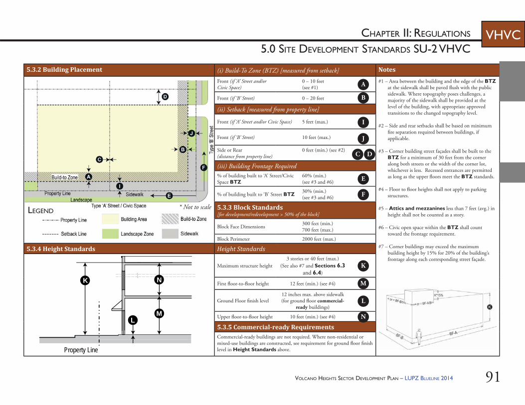
VOLCANO HEIGHTS SECTOR DEVELOPMENT PLAN – LUPZ BLUELINE 2014 91
CHAPTER II: REGULATIONS
5.0 SITE DEVELOPMENT STANDARDS SU-2 VHVCVHVC
5.3.2 Building Placement (i) Build-To Zone (BTZ) [measured from setback] Notes
Front (if ‘A’ Street and/or Civic Space)
0 – 10 feet(see #1)
#1 – Area between the building and the edge of the BTZ at the sidewalk shall be paved fl ush with the public sidewalk. Where topography poses challenges, a majority of the sidewalk shall be provided at the level of the building, with appropriate approved transitions to the changed topography level.
#2 – Side and rear setbacks shall be based on minimum fi re separation required between buildings, if applicable.
#3 – Corner building street façades shall be built to the BTZ for a minimum of 30 feet from the corner along both streets or the width of the corner lot, whichever is less. Recessed entrances are permitted as long as the upper fl oors meet the BTZ standards.
#4 – Floor to fl oor heights shall not apply to parking structures.
#5 – Attics and mezzanines less than 7 feet (avg.) in height shall not be counted as a story.
#6 – Civic open space within the BTZ shall count toward the frontage requirement.
#7 – Corner buildings may exceed the maximum building height by 15% for 20% of the building’s frontage along each corresponding street façade.
Front (if ‘B’ Street) 0 – 20 feet
(ii) Setback [measured from property line]
Front (if ‘A’ Street and/or Civic Space) 5 feet (max.)
Front (if ‘B’ Street) 10 feet (max.)
Side or Rear (distance from property line)
0 feet (min.) (see #2)
(iii) Building Frontage Required% of building built to ‘A’ Street/Civic Space BTZ
60% (min.)(see #3 and #6)
% of building built to ‘B’ Street BTZ 30% (min.)(see #3 and #6)
5.3.3 Block Standards [for development/redevelopment > 50% of the block]
Block Face Dimensions 300 feet (min.)700 feet (max.)
Block Perimeter 2000 feet (max.)
5.3.4 Height Standards Height Standards
Maximum structure height3 stories or 40 feet (max.)
(See also #7 and Sections 6.3 and 6.4)
First fl oor-to-fl oor height 12 feet (min.) (see #4)
Ground Floor fi nish level12 inches max. above sidewalk (for ground fl oor commercial-
ready buildings)
Upper fl oor-to-fl oor height 10 feet (min.) (see #4)
5.3.5 Commercial-ready RequirementsCommercial-ready buildings are not required. Where non-residential or mixed-use buildings are constructed, see requirement for ground fl oor fi nish level in Height Standards above.
LEGEND
L
K
M
Property Line
N
A
B
C D
E
F
I
J
K
L
M
N
* Not to scale
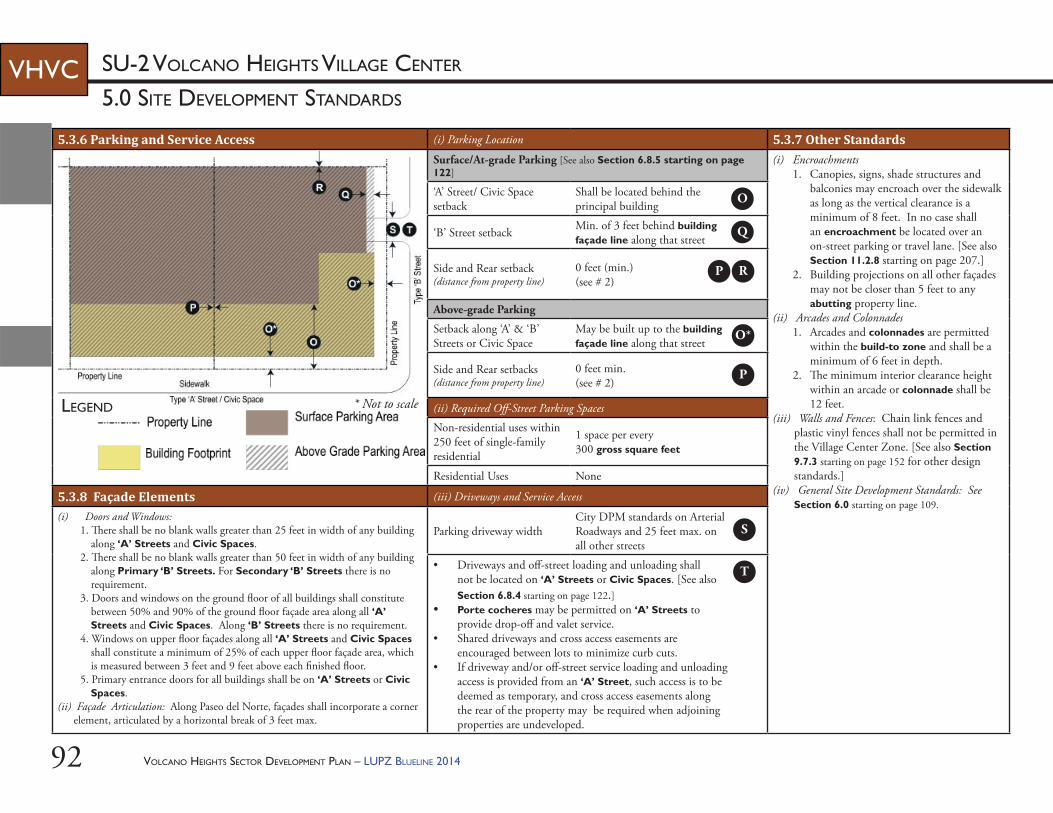
VOLCANO HEIGHTS SECTOR DEVELOPMENT PLAN – LUPZ BLUELINE 201492
5.0 SITE DEVELOPMENT STANDARDS
SU-2 VOLCANO HEIGHTS VILLAGE CENTERVHVC
5.3.6 Parking and Service Access (i) Parking Location 5.3.7 Other StandardsSurface/At-grade Parking [See also Section 6.8.5 starting on page 122]
(i) Encroachments1. Canopies, signs, shade structures and
balconies may encroach over the sidewalk as long as the vertical clearance is a minimum of 8 feet. In no case shall an encroachment be located over an on-street parking or travel lane. [See also Section 11.2.8 starting on page 207.]
2. Building projections on all other façades may not be closer than 5 feet to any abutting property line.
(ii) Arcades and Colonnades1. Arcades and colonnades are permitted
within the build-to zone and shall be a minimum of 6 feet in depth.
2. Th e minimum interior clearance height within an arcade or colonnade shall be 12 feet.
(iii) Walls and Fences: Chain link fences and plastic vinyl fences shall not be permitted in the Village Center Zone. [See also Section 9.7.3 starting on page 152 for other design standards.]
(iv) General Site Development Standards: See Section 6.0 starting on page 109.
‘A’ Street/ Civic Space setback
Shall be located behind the principal building
‘B’ Street setback Min. of 3 feet behind building façade line along that street
Side and Rear setback (distance from property line)
0 feet (min.) (see # 2)
Above-grade Parking
Setback along ‘A’ & ‘B’ Streets or Civic Space
May be built up to the building façade line along that street
Side and Rear setbacks (distance from property line)
0 feet min. (see # 2)
(ii) Required Off -Street Parking Spaces
Non-residential uses within 250 feet of single-family residential
1 space per every 300 gross square feet
Residential Uses None
5.3.8 Façade Elements (iii) Driveways and Service Access
(i) Doors and Windows:1. Th ere shall be no blank walls greater than 25 feet in width of any building
along ‘A’ Streets and Civic Spaces. 2. Th ere shall be no blank walls greater than 50 feet in width of any building
along Primary ‘B’ Streets. For Secondary ‘B’ Streets there is no requirement.
3. Doors and windows on the ground fl oor of all buildings shall constitute between 50% and 90% of the ground fl oor façade area along all ‘A’ Streets and Civic Spaces. Along ‘B’ Streets there is no requirement.
4. Windows on upper fl oor façades along all ‘A’ Streets and Civic Spaces shall constitute a minimum of 25% of each upper fl oor façade area, which is measured between 3 feet and 9 feet above each fi nished fl oor.
5. Primary entrance doors for all buildings shall be on ‘A’ Streets or Civic Spaces.
(ii) Façade Articulation: Along Paseo del Norte, façades shall incorporate a corner element, articulated by a horizontal break of 3 feet max.
Parking driveway widthCity DPM standards on Arterial Roadways and 25 feet max. on all other streets
• Driveways and off -street loading and unloading shall not be located on ‘A’ Streets or Civic Spaces. [See also Section 6.8.4 starting on page 122.]
• Porte cocheres may be permitted on ‘A’ Streets to provide drop-off and valet service.
• Shared driveways and cross access easements are encouraged between lots to minimize curb cuts.
• If driveway and/or off -street service loading and unloading access is provided from an ‘A’ Street, such access is to be deemed as temporary, and cross access easements along the rear of the property may be required when adjoining properties are undeveloped.
LEGEND
O
Q
P R
S
T
O*
P
* Not to scale
VOLCANO HEIGHTS SECTOR DEVELOPMENT PLAN – LUPZ BLUELINE 2014 93
55
CHAPTER II: REGULATIONS
5.0 BUILDING DESIGN STANDARDS SU-2 VHVCVHVC
Elaborate Parapet
Portals
ParapetCornice
TallerGround Floor
RRBuilding Design Standards Specific to Village Center Character Zone: The following standards shall be used for new development or redevelopment within the Village Center Zone.
5.3.11. Massing and Façade Composi on(i) Buildings shall maintain a prevalent
façade articulation rhythm of 20-30 feet or multiples thereof along all ‘A’ Streets or Civic Spaces. Th is articulation rhythm may be expressed by changing materials or color, using design elements such as columns and pilasters, or varying the setback of portions of the building façade.
(ii) Doors or windows shall form regular patterns of openings, some accentuated by balconies.
(iii) Commercial and mixed-use building façades shall be designed with a distinct base, middle, and cap and shall maintain the alignment of horizontal elements along the block.
(iv) If a single-family building is set back less than 10 feet from the front property line, the grade of the slab or fi rst fl oor elevation shall be elevated at least 18 inches above the grade of the sidewalk. If a single-family structure is set back 10 feet or more from the property line and is not elevated at least 18 inches above the grade of the sidewalk, a 3-foot high fence shall be provided at the front property line.
5.3.9. Intent/Purpose: Building Design Standards provide performance-based requirements intended to result in high-quality development and pedestrian-friendly environment in order to provide predictability over time and along corridors for property owners, neighbors, investors, and the public.
5.3.10. Guidelines(i) Buildings should generally have a
rectangular layout scheme with single or multiple components with mostly fl at front and square, round, or octagonal corner towers.
(ii) Building façades may be symmetrical or asymmetrical, but the central part of the building should be expressed with well-balanced façade compositions.
(iii) Th e ground fl oor should be taller and include heavier massing than fl oors above. An arcade or colonnade may be incorporated. [See Examples A for illustration.]
(iv) Storefronts should be inset with recessed entry, under the portal, arcade, or fi t into arches openings, often with shade structures. [See Examples A-C for illustrations.]
(v) Shade structures, blade signs, arcades, galleries, café seating and balconies should be used along commercial storefronts fronting an ‘A’ Street or Civic Space to add pedestrian interest. [See Examples B & C for illustrations.]
CorniceUpper FacadeStorefront Cornice
Shade Structure
Recessed EntryPier with Pilaster
Transom
Bulkhead
Display Window
Square Corner TowerEaves with Brackets
Blade Sign
EXAMPLE C – STOREFRONT
EXAMPLE A – PORTAL AND PARAPET
EXAMPLE B – EAVES AND TOWER ELEMENT
VOLCANO HEIGHTS SECTOR DEVELOPMENT PLAN – LUPZ BLUELINE 201494
RR
55
5.0 BUILDING DESIGN STANDARDS
SU-2 VOLCANO HEIGHTS VILLAGE CENTERVHVC
5.3.13. Windows(i) Glazing along ‘A’ Streets shall not be opaque.(ii) To reduce mirror eff ect, windows shall be
either glazing rated low-refl ective value or a combination of glass and coating or fi nish to satisfy the equivalent standard. Highly refl ective coatings and/or fi nishes are prohibited.
(iii) Ornamental arches of various designs, where used, shall be deeper on the ground fl oor and shallower on upper fl oors.
5.3.14. Architectural Details and Other ElementsAt least two (2) of the following detail elements shall be incorporated to provide visual interest:(i) detailing around principal openings including
but not limited to decorative trim, carving, transoms, columns, pilasters, pediments, and/or architraves,
(ii) window details such as but not limited to window sills, decorative leading, color, opaque treatments, multipane windows, soldier course, transoms, and/or lintels,
(iii) metal railings at balconies,(iv) shade structures, (v) roof towers, (vi) forecourts,(vii) fountains or water features using recycled or
reclaimed water,(viii) plazas,(ix) pedestrian furniture and/or lifesize game boards,(x) masonry screen products for see-through walls
or portions of walls, (xi) free-standing arbors, canopies, or towers, (xii) tower elements, and/or(xiii) other equivalent element, as approved by the
Planning Director or his/her designee.
5.3.12. Building Materials (i) At least 60% of a building’s façade along
all ‘A’ Streets or Civic Spaces shall be composed of masonry, brick, or stucco using a process other than a one-step process.
(ii) No more than 40% of a building’s façade along all ‘A’ Streets or Civic Spaces shall use other accent materials wood, architectural metal panel, split-face concrete block, tile, or pre-cast concrete panels. EIFS shall not be permitted along any ‘A’ Street or Civic Space façade.
(iii) All façades along ‘B’ Streets or alleys shall be of a similar fi nished quality and color that blend with the front of the building. Building materials for these façades may be any of the primary and accent façade materials listed above. a. EIFS shall be limited to no more than
10% of the upper fl oor façades along ‘B’ Streets and alleys.
b. Cementitious-fi ber clapboard (not sheet) with at least a 50-year warranty may only be used on the upper fl oors of any ‘B’ Street or alley façades.
(iv) Other primary building materials shall be considered on a case-by-case basis by the Planning Director or his/her designee, particularly for buildings above 26 feet.
(v) Roofi ng materials visible from any public ROW shall be clay tile, copper, factory fi nished standing seam or corrugated metal, metal shingle, slate, synthetic slate, or similar materials.
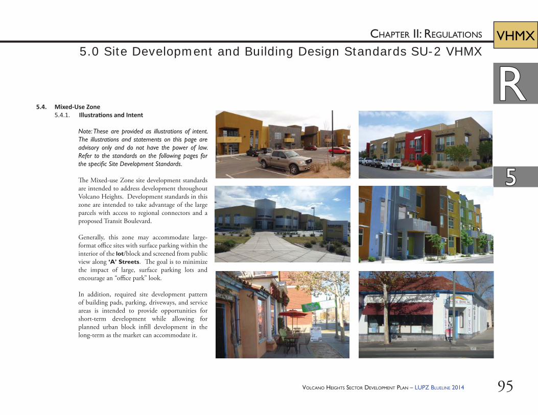
VOLCANO HEIGHTS SECTOR DEVELOPMENT PLAN – LUPZ BLUELINE 2014 95
RR
55
CHAPTER II: REGULATIONS VHMX5.0 Site Development and Building Design Standards SU-2 VHMX
5.4. Mixed-Use Zone5.4.1. Illustra ons and Intent
Note: These are provided as illustrations of intent. The illustrations and statements on this page are advisory only and do not have the power of law. Refer to the standards on the following pages for the specifi c Site Development Standards.
Th e Mixed-use Zone site development standards are intended to address development throughout Volcano Heights. Development standards in this zone are intended to take advantage of the large parcels with access to regional connectors and a proposed Transit Boulevard.
Generally, this zone may accommodate large-format offi ce sites with surface parking within the interior of the lot/block and screened from public view along ‘A’ Streets. Th e goal is to minimize the impact of large, surface parking lots and encourage an “offi ce park” look.
In addition, required site development pattern of building pads, parking, driveways, and service areas is intended to provide opportunities for short-term development while allowing for planned urban block infi ll development in the long-term as the market can accommodate it.
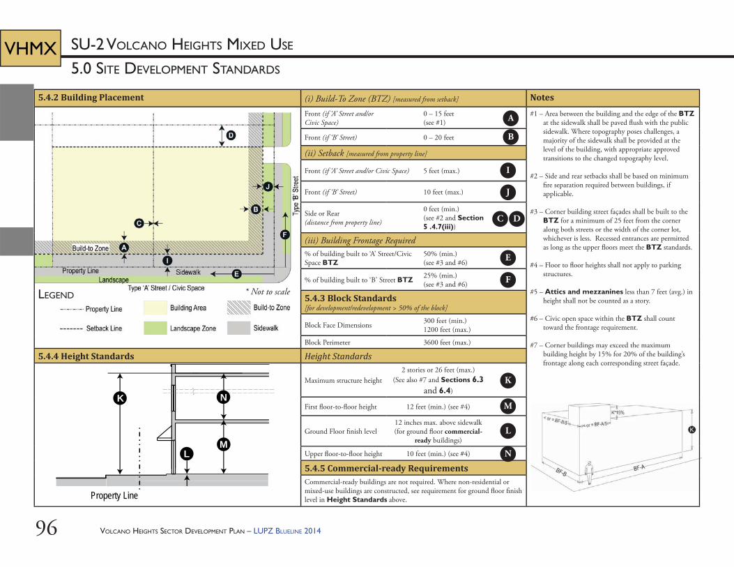
VOLCANO HEIGHTS SECTOR DEVELOPMENT PLAN – LUPZ BLUELINE 201496
5.0 SITE DEVELOPMENT STANDARDS
SU-2 VOLCANO HEIGHTS MIXED USEVHMX
5.4.2 Building Placement (i) Build-To Zone (BTZ) [measured from setback] Notes
Front (if ‘A’ Street and/or Civic Space)
0 – 15 feet(see #1)
#1 – Area between the building and the edge of the BTZ at the sidewalk shall be paved fl ush with the public sidewalk. Where topography poses challenges, a majority of the sidewalk shall be provided at the level of the building, with appropriate approved transitions to the changed topography level.
#2 – Side and rear setbacks shall be based on minimum fi re separation required between buildings, if applicable.
#3 – Corner building street façades shall be built to the BTZ for a minimum of 25 feet from the corner along both streets or the width of the corner lot, whichever is less. Recessed entrances are permitted as long as the upper fl oors meet the BTZ standards.
#4 – Floor to fl oor heights shall not apply to parking structures.
#5 – Attics and mezzanines less than 7 feet (avg.) in height shall not be counted as a story.
#6 – Civic open space within the BTZ shall count toward the frontage requirement.
#7 – Corner buildings may exceed the maximum building height by 15% for 20% of the building’s frontage along each corresponding street façade.
Front (if ‘B’ Street) 0 – 20 feet
(ii) Setback [measured from property line]
Front (if ‘A’ Street and/or Civic Space) 5 feet (max.)
Front (if ‘B’ Street) 10 feet (max.)
Side or Rear (distance from property line)
0 feet (min.) (see #2 and Section 5 .4.7(iii))
(iii) Building Frontage Required% of building built to ‘A’ Street/Civic Space BTZ
50% (min.)(see #3 and #6)
% of building built to ‘B’ Street BTZ 25% (min.)(see #3 and #6)
5.4.3 Block Standards [for development/redevelopment > 50% of the block]
Block Face Dimensions 300 feet (min.)1200 feet (max.)
Block Perimeter 3600 feet (max.)
5.4.4 Height Standards Height Standards
Maximum structure height2 stories or 26 feet (max.)
(See also #7 and Sections 6.3 and 6.4)
First fl oor-to-fl oor height 12 feet (min.) (see #4)
Ground Floor fi nish level12 inches max. above sidewalk (for ground fl oor commercial-
ready buildings)
Upper fl oor-to-fl oor height 10 feet (min.) (see #4)
5.4.5 Commercial-ready RequirementsCommercial-ready buildings are not required. Where non-residential or mixed-use buildings are constructed, see requirement for ground fl oor fi nish level in Height Standards above.
LEGEND
L
K
M
Property Line
N
A
B
C D
E
F
I
J
K
L
M
N
* Not to scale
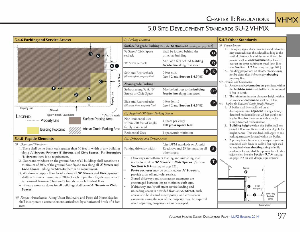
VOLCANO HEIGHTS SECTOR DEVELOPMENT PLAN – LUPZ BLUELINE 2014 97
CHAPTER II: REGULATIONS
5.0 SITE DEVELOPMENT STANDARDS SU-2 VHMXVHMX
D
D*
Single-FamilyResidential
Lot/Use
Property Line
6’ HighMasonry Fence
Transition Zone
K*
BUFFER
5.4.6 Parking and Service Access (i) Parking Location 5.4.7 Other StandardsSurface/At-grade Parking [See also Section 6.8.5 starting on page 122] (i) Encroachments
1. Canopies, signs, shade structures and balconies may encroach over the sidewalk as long as the vertical clearance is a minimum of 8 feet. In no case shall an encroachment be located over an on-street parking or travel lane. [See also Section 11.2.8 starting on page 207.]
2. Building projections on all other façades may not be closer than 5 feet to any abutting property line.
(ii) Arcades and Colonnades1. Arcades and colonnades are permitted within
the build-to zone and shall be a minimum of 6 feet in depth.
2. Th e minimum interior clearance height within an arcade or colonnade shall be 12 feet
(iii) Buff ers for Detached Single-family Housing1. A buff er shall be established on all
development sites adjacent to single family detached residential lots at 25 feet parallel to any lot line that is common with a single-family detached residential lot.
2. Building height within this buff er shall not exceed 2 fl oors or 26 feet and is not eligible for height bonus. Th is standard shall apply to any parking structures located within the buff er.
3. A privacy fence (masonry or opaque vegetation combined with fence or wall) 6 feet high shall be required when abutting a single-family residential lot and shall be optional for all other adjacencies. See also Section 9.7.4 starting on page 152 for wall design requirements.
‘A’ Street/ Civic Space setback
Shall be located behind the principal building
‘B’ Street setback Min. of 3 feet behind building façade line along that street
Side and Rear setback (distance from property line)
0 feet min. (see # 2 and Section 5.4.7(iii))
Above-grade Parking
Setback along ‘A’ & ‘B’ Streets or Civic Space
May be built up to the building façade line along that street
Side and Rear setbacks (distance from property line)
0 feet (min.) (see # 2 and Section 5.4.7(iii))
(ii) Required Off -Street Parking Spaces
Non-residential uses within 250 feet of single-family residential
1 space per every 400 gross square feet
Residential Uses 1 space/unit minimum
5.4.8 Façade Elements (iii) Driveways and Service Access
(i) Doors and Windows:1. Th ere shall be no blank walls greater than 50 feet in width of any building
along ‘A’ Streets, Primary ‘B’ Streets, and Civic Spaces. For Secondary ‘B’ Streets there is no requirement.
2. Doors and windows on the ground fl oor of all buildings shall constitute a minimum of 30% of the ground fl oor façade area along all ‘A’ Streets and Civic Spaces. Along ‘B’ Streets there is no requirement.
3. Windows on upper fl oor façades along all ‘A’ Streets and Civic Spaces shall constitute a minimum of 20% of each upper fl oor façade area, which is measured between 3 feet and 9 feet above each fi nished fl oor.
4. Primary entrance doors for all buildings shall be on ‘A’ Streets or Civic Spaces.
(ii) Façade Articulation: Along Unser Boulevard and Paseo del Norte, façades shall incorporate a corner element, articulated by a horizontal break of 3 feet max.
Parking driveway widthCity DPM standards on Arterial Roadways and 25 feet max. on all other streets
• Driveways and off -street loading and unloading shall not be located on ‘A’ Streets or Civic Spaces. [See also Section 6.8.4 starting on page 122.]
• Porte cocheres may be permitted on ‘A’ Streets to provide drop-off and valet service.
• Shared driveways and cross access easements are encouraged between lots to minimize curb cuts.
• If driveway and/or off -street service loading and unloading access is provided from an ‘A’ Street, such access is to be deemed as temporary, and cross access easements along the rear of the property may be required when adjoining properties are undeveloped.
LEGEND
O
Q
P R
S
T
O*
P
* Not to scale
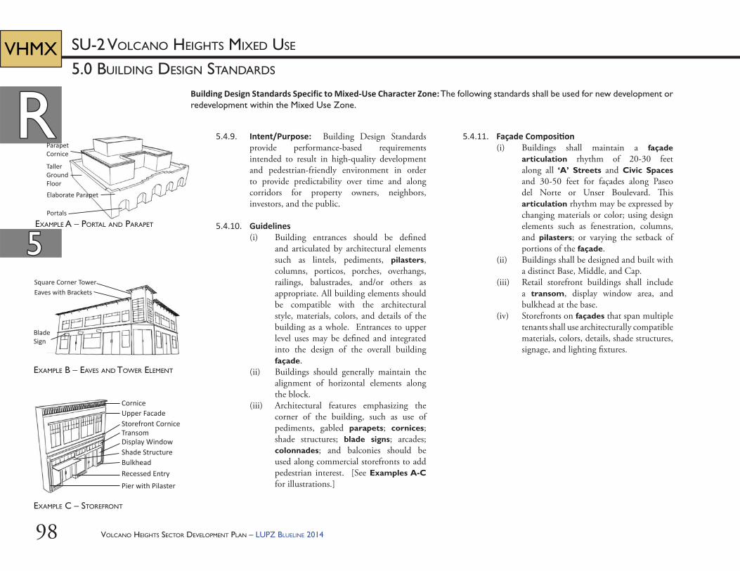
VOLCANO HEIGHTS SECTOR DEVELOPMENT PLAN – LUPZ BLUELINE 201498
RR
55
5.0 BUILDING DESIGN STANDARDS
SU-2 VOLCANO HEIGHTS MIXED USEVHMX
Building Design Standards Specific to Mixed-Use Character Zone: The following standards shall be used for new development or redevelopment within the Mixed Use Zone.
5.4.11. Façade Composi on(i) Buildings shall maintain a façade
articulation rhythm of 20-30 feet along all ‘A’ Streets and Civic Spaces and 30-50 feet for façades along Paseo del Norte or Unser Boulevard. Th is articulation rhythm may be expressed by changing materials or color; using design elements such as fenestration, columns, and pilasters; or varying the setback of portions of the façade.
(ii) Buildings shall be designed and built with a distinct Base, Middle, and Cap.
(iii) Retail storefront buildings shall include a transom, display window area, and bulkhead at the base.
(iv) Storefronts on façades that span multiple tenants shall use architecturally compatible materials, colors, details, shade structures, signage, and lighting fi xtures.
5.4.9. Intent/Purpose: Building Design Standards provide performance-based requirements intended to result in high-quality development and pedestrian-friendly environment in order to provide predictability over time and along corridors for property owners, neighbors, investors, and the public.
5.4.10. Guidelines(i) Building entrances should be defi ned
and articulated by architectural elements such as lintels, pediments, pilasters, columns, porticos, porches, overhangs, railings, balustrades, and/or others as appropriate. All building elements should be compatible with the architectural style, materials, colors, and details of the building as a whole. Entrances to upper level uses may be defi ned and integrated into the design of the overall building façade.
(ii) Buildings should generally maintain the alignment of horizontal elements along the block.
(iii) Architectural features emphasizing the corner of the building, such as use of pediments, gabled parapets; cornices; shade structures; blade signs; arcades; colonnades; and balconies should be used along commercial storefronts to add pedestrian interest. [See Examples A-C for illustrations.]
Elaborate Parapet
Portals
ParapetCornice
TallerGround Floor
CorniceUpper FacadeStorefront Cornice
Shade Structure
Recessed EntryPier with Pilaster
Transom
Bulkhead
Display Window
Square Corner TowerEaves with Brackets
Blade Sign
EXAMPLE C – STOREFRONT
EXAMPLE A – PORTAL AND PARAPET
EXAMPLE B – EAVES AND TOWER ELEMENT
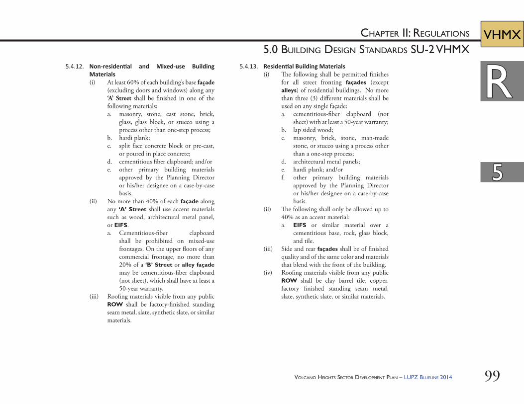
VOLCANO HEIGHTS SECTOR DEVELOPMENT PLAN – LUPZ BLUELINE 2014 99
RR
55
CHAPTER II: REGULATIONS
5.0 BUILDING DESIGN STANDARDS SU-2 VHMXVHMX
5.4.13. Residen al Building Materials(i) Th e following shall be permitted fi nishes
for all street fronting façades (except alleys) of residential buildings. No more than three (3) diff erent materials shall be used on any single façade:a. cementitious-fi ber clapboard (not
sheet) with at least a 50-year warranty;b. lap sided wood;c. masonry, brick, stone, man-made
stone, or stucco using a process other than a one-step process;
d. architectural metal panels;e. hardi plank; and/orf. other primary building materials
approved by the Planning Director or his/her designee on a case-by-case basis.
(ii) Th e following shall only be allowed up to 40% as an accent material:a. EIFS or similar material over a
cementitious base, rock, glass block, and tile.
(iii) Side and rear façades shall be of fi nished quality and of the same color and materials that blend with the front of the building.
(iv) Roofi ng materials visible from any public ROW shall be clay barrel tile, copper, factory fi nished standing seam metal, slate, synthetic slate, or similar materials.
5.4.12. Non-residen al and Mixed-use Building Materials(i) At least 60% of each building’s base façade
(excluding doors and windows) along any ‘A’ Street shall be fi nished in one of the following materials:a. masonry, stone, cast stone, brick,
glass, glass block, or stucco using a process other than one-step process;
b. hardi plank;c. split face concrete block or pre-cast,
or poured in place concrete;d. cementitious fi ber clapboard; and/ore. other primary building materials
approved by the Planning Director or his/her designee on a case-by-case basis.
(ii) No more than 40% of each façade along any ‘A’ Street shall use accent materials such as wood, architectural metal panel, or EIFS. a. Cementitious-fi ber clapboard
shall be prohibited on mixed-use frontages. On the upper fl oors of any commercial frontage, no more than 20% of a ‘B’ Street or alley façade may be cementitious-fi ber clapboard (not sheet), which shall have at least a 50-year warranty.
(iii) Roofi ng materials visible from any public ROW shall be factory-fi nished standing seam metal, slate, synthetic slate, or similar materials.
VOLCANO HEIGHTS SECTOR DEVELOPMENT PLAN – LUPZ BLUELINE 2014100
RR
55
5.0 BUILDING DESIGN STANDARDS
SU-2 VOLCANO HEIGHTS MIXED USEVHMX
5.4.14. Windows(i) Glazing along ‘A’ Streets shall not be
opaque.(ii) To reduce mirror eff ect, windows shall be
either glazing rated low-refl ective value or a combination of glass and coating or fi nish to satisfy the equivalent standard. Highly refl ective coatings and/or fi nishes are prohibited.
(iii) Ornamental arches of various designs, where used, shall be deeper on the ground fl oor and shallower on upper fl oors.
5.4.15. Architectural Details and Other ElementsAt least one (1) of the following detail elements shall be incorporated to provide visual interest:(i) detailing around principal openings
including but not limited to decorative trim, carving, transoms, columns, pilasters, pediments, and/or architraves,
(ii) window details such as but not limited to window sills, decorative leading, color, opaque treatments, multipane windows, soldier course, transoms, and/or lintels,
(iii) metal railings at balconies,(iv) shade structures, (v) roof towers, (vi) forecourts,(vii) fountains or water features using recycled
or reclaimed water,(viii) plazas,(ix) pedestrian furniture and/or lifesize game
boards,(x) masonry screen products for see-through
walls or portions of walls, (xi) free-standing arbors, canopies, or towers, (xii) tower elements, and/or(xiii) other equivalent element, as approved by
the Planning Director or his/her designee.
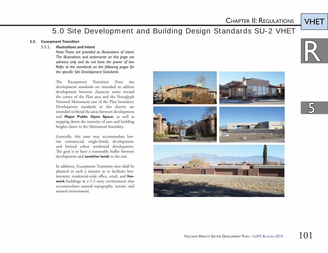
VOLCANO HEIGHTS SECTOR DEVELOPMENT PLAN – LUPZ BLUELINE 2014 101
RR
55
CHAPTER II: REGULATIONS VHET5.0 Site Development and Building Design Standards SU-2 VHET
5.5. Escarpment Transi on5.5.1. Illustra ons and Intent
Note: These are provided as illustrations of intent. The illustrations and statements on this page are advisory only and do not have the power of law. Refer to the standards on the following pages for the specifi c Site Development Standards.
Th e Escarpment Transition Zone site development standards are intended to address development between character zones toward the center of the Plan area and the Petroglyph National Monument east of the Plan boundary. Development standards in this district are intended to blend the areas between development and Major Public Open Space, as well as stepping down the intensity of uses and building heights closer to the Monument boundary.
Generally, this zone may accommodate low-rise commercial, single-family development, and limited urban residential development. Th e goal is to have a reasonable buff er between development and sensitive lands to the east.
In addition, Escarpment Transition sites shall be planned in such a manner as to facilitate low-intensity, residential-scale offi ce, retail, and live-work buildings in a 1-2 story environment that accommodates natural topography, terrain, and natural environment.
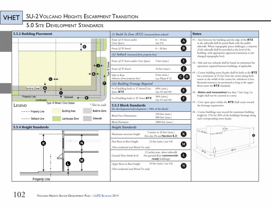
VOLCANO HEIGHTS SECTOR DEVELOPMENT PLAN – LUPZ BLUELINE 2014102
5.0 SITE DEVELOPMENT STANDARDS
SU-2 VOLCANO HEIGHTS ESCARPMENT TRANSITIONVHET
5.5.2 Building Placement (i) Build-To Zone (BTZ) [measured from setback] Notes
Front (if ‘A’ Street and/or Civic Space)
0 – 10 feet(see #1)
#1 – Area between the building and the edge of the BTZ at the sidewalk shall be paved fl ush with the public sidewalk. Where topography poses challenges, a majority of the sidewalk shall be provided at the level of the building, with appropriate approved transitions to the changed topography level.
#2 – Side and rear setbacks shall be based on minimum fi re separation required between buildings, if applicable.
#3 – Corner building street façades shall be built to the BTZ for a minimum of 25 feet from the corner along both streets or the width of the corner lot, whichever is less. Recessed entrances are permitted as long as the upper fl oors meet the BTZ standards.
#4 – Attics and mezzanines less than 7 feet (avg.) in height shall not be counted as a story.
#5 – Civic open space within the BTZ shall count toward the frontage requirement.
#6 – Corner buildings may exceed the maximum building height by 15% for 20% of the building’s frontage along each corresponding street façade.
Front (if ‘B’ Street) 0 – 20 feet
(ii) Setback [measured from property line]
Front (if ‘A’ Street and/or Civic Space) 5 feet (max.)
Front (if ‘B’ Street) 10 feet (max.)
Side or Rear (distance from property line)
0 feet (min.) (see Note # 2)
(iii) Building Frontage Required% of building built to ‘A’ Street/Civic Space BTZ
60% (min.)(see #3 and #6)
% of building built to ‘B’ Street BTZ 30% (min.)(see #3 and #6)
5.5.3 Block Standards [for development/redevelopment > 50% of the block]
Block Face Dimensions 250 feet (min.)600 feet (max.)
Block Perimeter 2000 feet (max.)
5.5.4 Height Standards Height Standards
Maximum structure height2 stories or 26 feet (max.)
(See also #6 and Section 6.3)
First fl oor-to-fl oor height 12 feet (min.) (see #4)
(Non-residential and Mixed Use only)
Ground Floor fi nish level12 inches max. above sidewalk
(for ground fl oor commercial-ready buildings)
Upper fl oor-to-fl oor height 10 feet (min.) (see #4)
(Non-residential and Mixed Use only)
LEGEND
L
K
M
Property Line
N
A
B
C D
E
F
I
J
K
L
M
N
* Not to scale
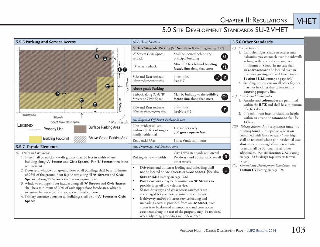
VOLCANO HEIGHTS SECTOR DEVELOPMENT PLAN – LUPZ BLUELINE 2014 103
CHAPTER II: REGULATIONS
5.0 SITE DEVELOPMENT STANDARDS SU-2 VHETVHET
5.5.5 Parking and Service Access (i) Parking Location 5.5.6 Other StandardsSurface/At-grade Parking [See Section 6.8.5 starting on page 122] (i) Encroachments
1. Canopies, signs, shade structures and balconies may encroach over the sidewalk as long as the vertical clearance is a minimum of 8 feet. In no case shall an encroachment be located over an on-street parking or travel lane. [See also Section 11.2.8 starting on page 207.]
2. Building projections on all other façades may not be closer than 5 feet to any abutting property line.
(ii) Arcades and Colonnades1. Arcades and colonnades are permitted
within the BTZ and shall be a minimum of 6 feet deep.
2. Th e minimum interior clearance height within an arcade or colonnade shall be 14 feet.
(iii) Privacy Screen: A privacy screen (masonry or living fence with opaque vegetation combined with fence or wall) 6 feet high shall be required where non-residential uses abut an existing single-family residential lot and shall be optional for all other adjacencies. [See also Section 9.7.3 starting on page 152 for design requirements for wall design.]
(iv) General Site Development Standards: See Section 6.0 starting on page 109.
‘A’ Street/ Civic Space setback
Shall be located behind the principal building
‘B’ Street setback Min. of 3 feet behind building façade line along that street
Side and Rear setback (distance from property line)
0 feet min. (see # 2)
Above-grade Parking
Setback along ‘A’ & ‘B’ Streets or Civic Space
May be built up to the building façade line along that street
Side and Rear setbacks (distance from property line)
0 feet min. (seeNote # 2)
(ii) Required Off -Street Parking Spaces
Non-residential uses within 250 feet of single-family residential
1 space per every 300 gross square feet
Residential Uses 1 space/unit minimum
5.5.7 Façade Elements (iii) Driveways and Service Access
(i) Doors and Windows:1. Th ere shall be no blank walls greater than 30 feet in width of any
building along ‘A’ Streets and Civic Spaces. For ‘B’ Streets there is no requirement.
2. Doors and windows on ground fl oor of all buildings shall be a minimum of 25% of the ground fl oor façade area along all ‘A’ Streets and Civic Spaces. Along ‘B’ Streets there is no requirement.
3. Windows on upper fl oor façades along all ‘A’ Streets and Civic Spaces shall be a minimum of 20% of each upper fl oor façade area, which is measured between 3-9 feet above each fi nished fl oor.
4. Primary entrance doors for all buildings shall be on ‘A’ Streets or Civic Spaces.
Parking driveway widthCity DPM standards on Arterial Roadways and 25 feet max. on all other streets
• Driveways and off -street loading and unloading shall not be located on ‘A’ Streets or Civic Spaces. [See also Section 6.8.4 starting on page 122.]
• Porte cocheres may be permitted on ‘A’ Streets to provide drop-off and valet service.
• Shared driveways and cross access easements are encouraged between lots to minimize curb cuts.
• If driveway and/or off -street service loading and unloading access is provided from an ‘A’ Street, such access is to be deemed as temporary, and cross access easements along the rear of the property may be required when adjoining properties are undeveloped.
LEGEND
O
Q
P R
S
T
O*
P
* Not to scale
VOLCANO HEIGHTS SECTOR DEVELOPMENT PLAN – LUPZ BLUELINE 2014104
RR
55
5.0 BUILDING DESIGN STANDARDS
SU-2 VOLCANO HEIGHTS NEIGHBORHOOD AND ESCARPMENT TRANSITION
VHNT
VHET
Building Design Standards Specific to Neighborhood and Escarpment Transition Character Zones: The following standards shall be used for new development or redevelopment within the Neighborhood and Escarpment Transition Zones.
(ii) Buildings shall be designed and built with a distinct base, middle, and cap.
(iii) If a single-family building is set back less than 10 feet from the front property line, the grade of the slab or fi rst fl oor elevation shall be elevated at least 18 inches above the grade of the sidewalk. If a single-family structure is set back 10 feet or more from the property line and is not elevated at least 18 inches above the grade of the sidewalk, a 3-foot high fence shall be provided at the front property line.
5.5.11. Non-residen al and Mixed-Use Building Materials(i) Th e following primary building materials
shall be permitted for façades (excluding doors and windows) along any ‘A’ Street or Civic Space:a. masonry, stone, cast stone, brick,
glass, glass block, split-face concrete, pre-cast concrete panels, tile, or stucco using a process other than a one-step process;
b. cementitious-fi ber clapboard (not sheet) with at least a 50-year warranty;
c. wood;d. architectural metal panels; and/ore. other materials as approved on a
case-by-case basis by the Planning Director or his/her designee.
(ii) EIFS shall not be permitted along any ‘A’ Street or Civic Space façade.
5.5.8. Intent/Purpose: Building Design Standards provide performance-based requirements intended to result in high-quality development and pedestrian-friendly environment in order to provide predictability over time and along corridors for property owners, neighbors, investors, and the public.
5.5.9. Guidelines(i) Building entrances should be defi ned and
articulated by architectural elements such as lintels, pediments, pilasters, columns, porticos, porches, overhangs, railings, balustrades, and others as appropriate. All building elements should be compatible with the architectural style, materials, colors, and details of the building as a whole. Entrances to upper level uses may be defi ned and integrated into the design of the overall building façade.
(ii) Buildings should generally maintain the alignment of horizontal elements along the block.
5.5.10. Façade Composi on(i) Buildings shall maintain a façade
articulation rhythm of 20-30 feet along all ‘A’ Streets. Th is articulation rhythm may be expressed by changing materials or color; using design elements such as fenestration, columns, and pilasters; or varying the setback of portions of the façade.
VOLCANO HEIGHTS SECTOR DEVELOPMENT PLAN – LUPZ BLUELINE 2014 105
RR
55
CHAPTER II: REGULATIONS
5.0 BUILDING DESIGN STANDARDS SU-2 VHNT & VHET
VHNT
VHET
f. other primary building materials approved by the Planning Director or his/her designee on a case-by-case basis.
(ii) Th e following shall only be allowed up to 40% as an accent material:a. EIFS or similar material over a
cementitious base, rock, glass block, and tile.
(iii) Side and rear façades shall be of fi nished quality and of the same color and materials that blend with the front of the building.
(iv) Roofi ng materials visible from any public ROW shall be clay barrel tile, copper, factory fi nished standing seam metal, slate, synthetic slate, or similar materials.
(v) An enclosed garage or carport shall be designed and constructed of the same material as the primary building. [See also Section 7.7 starting on page 129.]
(vi) Glazing along ‘A’ Streets shall not be opaque.
(vii) To reduce mirror eff ect, windows shall be either glazing rated low-refl ective value or a combination of glass and coating or fi nish to satisfy the equivalent standard. Highly refl ective coatings and/or fi nishes are prohibited.
(iii) All building façades along all other streets or alleys shall be of a similar fi nished quality and color that blend with the front of the building. Building materials for these façades may be any of the primary materials listed above. a. EIFS shall be limited to 25% of all
other façades. (iv) Roofi ng materials visible from any public
ROW shall be factory fi nished standing seam metal, slate, synthetic slate, or similar materials.
(v) Glazing along ‘A’ Streets shall not be opaque.
(vi) To reduce mirror eff ect, windows shall be either glazing rated low-refl ective value or a combination of glass and coating or fi nish to satisfy the equivalent standard. Highly refl ective coatings and/or fi nishes are prohibited.
5.5.12. Residen al Building Materials (i) Th e following shall be permitted fi nishes
for all street-fronting façades (except alleys) of residential buildings. No more than three (3) diff erent materials shall be used on any single façade:a. cementitious-fi ber clapboard (not
sheet) with at least a 50-year warranty;b. lap sided wood;c. masonry, brick, stone, man-made
stone, or stucco using a process other than a one-step process ;
d. architectural metal panels; e. hardi plank; and/or
VOLCANO HEIGHTS SECTOR DEVELOPMENT PLAN – LUPZ BLUELINE 2014106
RR
55
5.0 SITE DEVELOPMENT STANDARDS
SU-2 VOLCANO HEIGHTS NEIGHBORHOOD TRANSITIONVHNT
5.6. Neighborhood Transi on5.6.1. Illustra ons and Intent
Note: These are provided as illustrations of intent. The illustrations and statements on this page are advisory only and do not have the power of law. Refer to the standards on the following pages for the specifi c Site Development Standards.
Th e Neighborhood Transition Zone site development standards are intended to address development between proposed Volcano Heights character zones and existing residential areas. Development standards in this zone are intended to appropriately blend the areas between new construction and existing buildings outside the Plan area.
Generally, this zone may accommodate small-scale, low-rise commercial and urban residential development. Th e goal is to have a reasonable buff er between existing buildings and any higher-density new construction in other character zones.
In addition, the site shall be planned in such a manner as to facilitate low-intensity, residential-scale offi ce, and live-work buildings in a 1-2 story environment.
5.6.2. Building Design Standards Specifi c to Neighborhood Transition shall be as per Section 5.5.8-5.5.12 in this Plan.
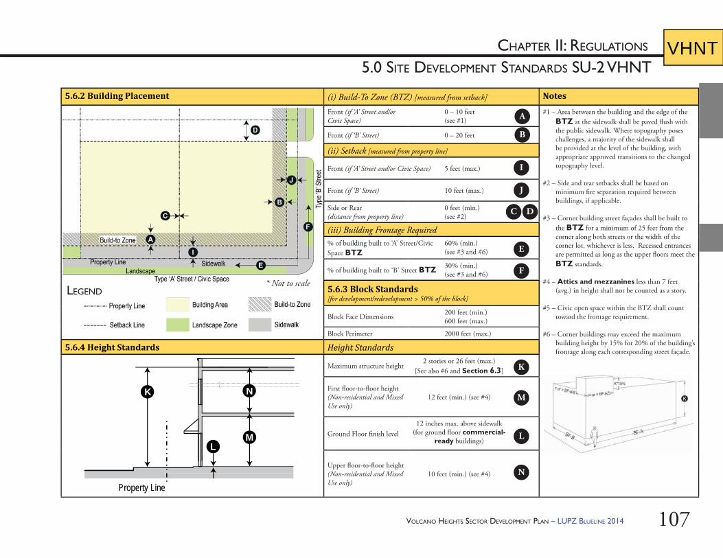
VOLCANO HEIGHTS SECTOR DEVELOPMENT PLAN – LUPZ BLUELINE 2014 107
CHAPTER II: REGULATIONS
5.0 SITE DEVELOPMENT STANDARDS SU-2 VHNTVHNT
5.6.2 Building Placement (i) Build-To Zone (BTZ) [measured from setback] Notes
Front (if ‘A’ Street and/or Civic Space)
0 – 10 feet(see #1)
#1 – Area between the building and the edge of the BTZ at the sidewalk shall be paved fl ush with the public sidewalk. Where topography poses challenges, a majority of the sidewalk shall be provided at the level of the building, with appropriate approved transitions to the changed topography level.
#2 – Side and rear setbacks shall be based on minimum fi re separation required between buildings, if applicable.
#3 – Corner building street façades shall be built to the BTZ for a minimum of 25 feet from the corner along both streets or the width of the corner lot, whichever is less. Recessed entrances are permitted as long as the upper fl oors meet the BTZ standards.
#4 – Attics and mezzanines less than 7 feet (avg.) in height shall not be counted as a story.
#5 – Civic open space within the BTZ shall count toward the frontage requirement.
#6 – Corner buildings may exceed the maximum building height by 15% for 20% of the building’s frontage along each corresponding street façade.
Front (if ‘B’ Street) 0 – 20 feet
(ii) Setback [measured from property line]
Front (if ‘A’ Street and/or Civic Space) 5 feet (max.)
Front (if ‘B’ Street) 10 feet (max.)
Side or Rear (distance from property line)
0 feet (min.) (see #2)
(iii) Building Frontage Required% of building built to ‘A’ Street/Civic Space BTZ
60% (min.)(see #3 and #6)
% of building built to ‘B’ Street BTZ 30% (min.)(see #3 and #6)
5.6.3 Block Standards [for development/redevelopment > 50% of the block]
Block Face Dimensions 200 feet (min.)600 feet (max.)
Block Perimeter 2000 feet (max.)
5.6.4 Height Standards Height Standards
Maximum structure height2 stories or 26 feet (max.)
[See also #6 and Section 6.3]
First fl oor-to-fl oor height(Non-residential and Mixed Use only)
12 feet (min.) (see #4)
Ground Floor fi nish level12 inches max. above sidewalk
(for ground fl oor commercial-ready buildings)
Upper fl oor-to-fl oor height (Non-residential and Mixed Use only)
10 feet (min.) (see #4)
LEGEND
L
K
M
Property Line
N
A
B
C D
E
F
I
J
K
L
M
N
* Not to scale
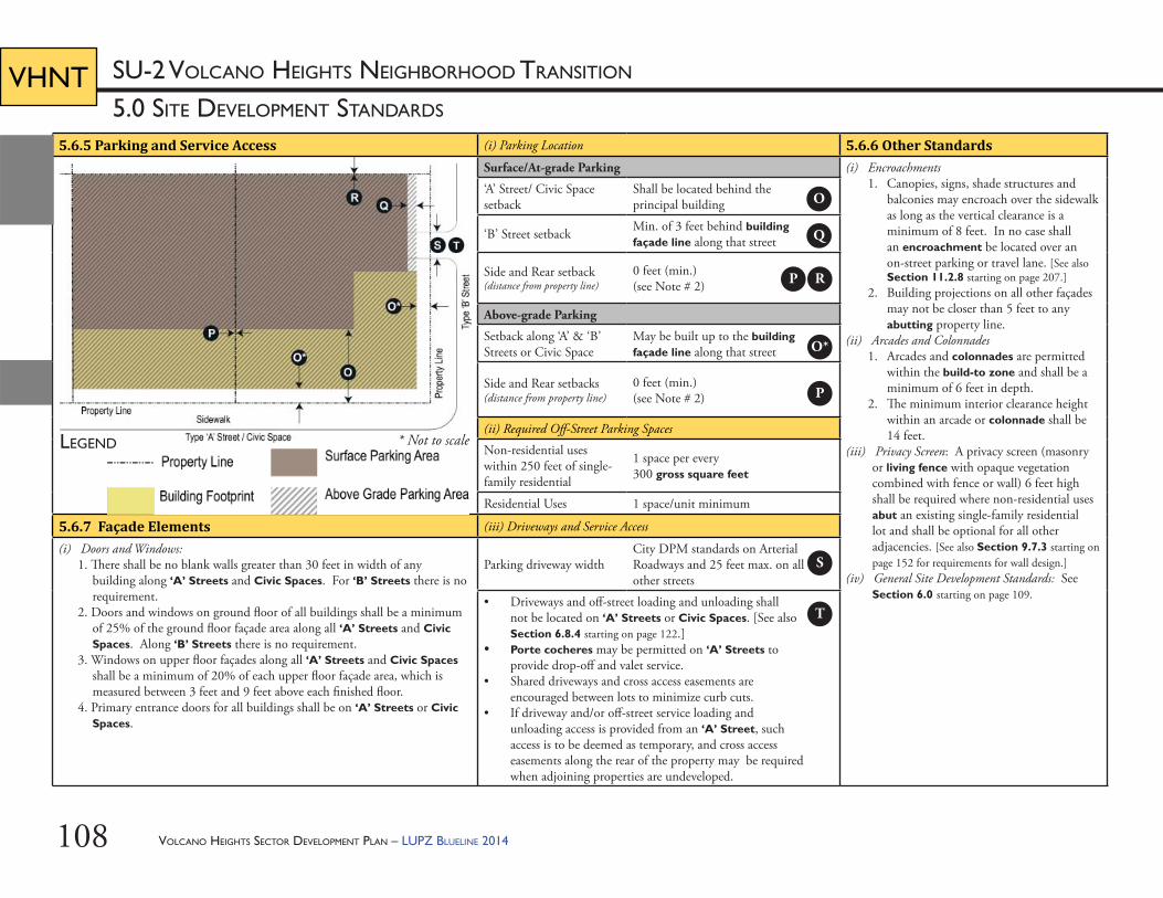
VOLCANO HEIGHTS SECTOR DEVELOPMENT PLAN – LUPZ BLUELINE 2014108
5.0 SITE DEVELOPMENT STANDARDS
SU-2 VOLCANO HEIGHTS NEIGHBORHOOD TRANSITIONVHNT
5.6.5 Parking and Service Access (i) Parking Location 5.6.6 Other StandardsSurface/At-grade Parking (i) Encroachments
1. Canopies, signs, shade structures and balconies may encroach over the sidewalk as long as the vertical clearance is a minimum of 8 feet. In no case shall an encroachment be located over an on-street parking or travel lane. [See also Section 11.2.8 starting on page 207.]
2. Building projections on all other façades may not be closer than 5 feet to any abutting property line.
(ii) Arcades and Colonnades1. Arcades and colonnades are permitted
within the build-to zone and shall be a minimum of 6 feet in depth.
2. Th e minimum interior clearance height within an arcade or colonnade shall be 14 feet.
(iii) Privacy Screen: A privacy screen (masonry or living fence with opaque vegetation combined with fence or wall) 6 feet high shall be required where non-residential uses abut an existing single-family residential lot and shall be optional for all other adjacencies. [See also Section 9.7.3 starting on page 152 for requirements for wall design.]
(iv) General Site Development Standards: See Section 6.0 starting on page 109.
‘A’ Street/ Civic Space setback
Shall be located behind the principal building
‘B’ Street setback Min. of 3 feet behind building façade line along that street
Side and Rear setback (distance from property line)
0 feet (min.) (see Note # 2)
Above-grade Parking
Setback along ‘A’ & ‘B’ Streets or Civic Space
May be built up to the building façade line along that street
Side and Rear setbacks (distance from property line)
0 feet (min.) (see Note # 2)
(ii) Required Off -Street Parking Spaces
Non-residential uses within 250 feet of single-family residential
1 space per every 300 gross square feet
Residential Uses 1 space/unit minimum
5.6.7 Façade Elements (iii) Driveways and Service Access
(i) Doors and Windows:1. Th ere shall be no blank walls greater than 30 feet in width of any
building along ‘A’ Streets and Civic Spaces. For ‘B’ Streets there is no requirement.
2. Doors and windows on ground fl oor of all buildings shall be a minimum of 25% of the ground fl oor façade area along all ‘A’ Streets and Civic Spaces. Along ‘B’ Streets there is no requirement.
3. Windows on upper fl oor façades along all ‘A’ Streets and Civic Spaces shall be a minimum of 20% of each upper fl oor façade area, which is measured between 3 feet and 9 feet above each fi nished fl oor.
4. Primary entrance doors for all buildings shall be on ‘A’ Streets or Civic Spaces.
Parking driveway widthCity DPM standards on Arterial Roadways and 25 feet max. on all other streets
• Driveways and off -street loading and unloading shall not be located on ‘A’ Streets or Civic Spaces. [See also Section 6.8.4 starting on page 122.]
• Porte cocheres may be permitted on ‘A’ Streets to provide drop-off and valet service.
• Shared driveways and cross access easements are encouraged between lots to minimize curb cuts.
• If driveway and/or off -street service loading and unloading access is provided from an ‘A’ Street, such access is to be deemed as temporary, and cross access easements along the rear of the property may be required when adjoining properties are undeveloped.
LEGEND
O
Q
P R
S
T
O*
P
* Not to scale

VOLCANO HEIGHTS SECTOR DEVELOPMENT PLAN – LUPZ BLUELINE 2014 109
6.0 SITE DEVELOPMENT STANDARDS
GENERAL TO ALL ZONES
CHAPTER II: REGULATIONS
RR
VOLCANO HEIGHTS SECTOR DEVELOPMENT PLAN – LUPZ BLUELINE 2014110
RRCHAPTER II: REGULATIONS
66
6.0 SITE DEVELOPMENT STANDARDS GENERAL TO ALL ZONES
6.1. Gated Communi es: In order to meet the intent of a walkable, urban environment that serves as a Major Activity Center, gated and/or walled developments are prohibited.
6.2. Neighborhood Design: Where new residential development is adjacent to a Connector street, new lots and homes shall face Connector streets, except where the Planning Director or his/her designee approves exceptions related to technical reasons, such as grading and drainage requirements.
6.3. Structure Heights6.3.1. Structures within the Impact Area as designated
by the Rank 3 Northwest Mesa Escarpment Plan shall be limited to 15 feet. Per the Northwest Mesa Escarpment Plan, no exceptions or variances shall be granted.
6.3.2. Structures within 200 feet of either the Rank 3 Northwest Mesa Escarpment Plan Impact Area or a Park Edge Street shall be limited to 18 feet, with a second story up to 26 feet permitted for no more than 50% of the building footprint. [See Exhibit 6.1.]
6.3.3. In Town Center only, if a developer can show documentation that a major employer (i.e. 150+ employees on-site) will be part of the project, that project is exempt from building height maximums and bonus height criteria, subject to a Development Agreement with the City, including clawback provisions in the case the employer leaves the Plan area before 5 years have passed. Th is provision is subject to approval by the City Economic Development Department.
6.3.4. In all but the Transition Zones, projects within a SAD, TIDD, PID or similar coordinated development eff ort that plans and engineers signifi cant infrastructure involving multiple property owners as acceptable to the Planning Director or his/her designee may be granted a 10-foot building height bonus to the maximum heights allowed by right in each zone and above and beyond the bonus heights described in Table 6.1 and Section 6.4.
6.3.5. Structure height shall be measured from approved grade to the eave line in the case of a pitched roof or to the roof line in the case of a parapet. [See Section 6.5 for grading standards.]
6.3.6. A stepback may occur at a minimum height of 26 feet, but no building shall be built taller than 40 feet without a stepback. Th e minimum depth of a stepback shall be 12 feet.
6.3.7. Cupolas may extend 10 feet beyond height limits. Flagpoles may extend 6 feet above the height limit. Solar panels shall not count toward height limits. Equipment on the roof other than solar panels visible from the public ROW shall be screened by louvered or metal screen, or by a parapet for fl at roofs. Screened equipment shall not exceed 6 feet beyond height limits. Screened equipment on the roof shall be set back 15 feet from façades. Equipment screening shall not be made of chain link or vinyl materials.
EXHIBIT 6.1 – IMPACT AREA AND 200-FOOT BUFFER
Path
: N:\
AGIS
FILE
\PRO
JECT
S\Pe
traM
orris
\THG
-Nov
11-V
olca
noH
eigh
ts\J
ULY
2013
\Mon
umen
tBuf
fer.m
xd
XYXYXYXYXYXYXYXYXYXYXYXYXYXYXYXYXYXYXYXYXYXYXYXYXYXYXYXYXYXYXYXYXYXYXYXYXYXYXYXYXYXYXYXYXYXYXYXYXYXYXYXYXYXYXY
XY
XY
XY
XY
XY
XY
XY
XY
XY
XY
XY
XY
XY XY XY XY XY XY XY XY XY XY XY XY XY XY XY XY XY XY XY XY XY XY XY XY XY XY XY XY XY
XY
XY
XY
XY
XY
XY
XY
XY
XY
XY
XY
XY
XY XY XY XY XY XY XY XY XY XY XY XY XY XY XY XY XY XY
XY
XY
XY
XY
XY
XY
XY
XY
XYXY
XY
XY
XY
XY
XY
XY
XY
XY
XY
XY
XY
XYXY
XY
XY
XY
XY
XY
XY
XY
XY
XY
XY
XYXYXY
XY
XY
XY
XY
XY
XY
XY
XY
XY
XY
XY
XYPASEO DEL NORTE
Ü0 200 400 600
Feet
PRIMARY STREETS
XY
XY
XY XY XY XY XY XY XY
XY
XY
XYXYXYXYXYXYXY
VOLCANO HEIGHTS SDP AREA
PARCELS
PETROGLYPH NATIONAL MONUMENT
NWMEP IMPACT AREA
200 FOOT BUFFER
VOLCANO HEIGHTS SECTOR DEVELOPMENT PLAN – LUPZ BLUELINE 2014 111
RRCHAPTER II: REGULATIONS
66
6.0 SITE DEVELOPMENT STANDARDS GENERAL TO ALL ZONES
6.4. Op onal Height Bonus for Buildings6.4.1. Purpose / Intent: Th is Plan off ers an optional
bonus height system for buildings in order to balance the intent to create an urban, walkable Major Activity Center with the intent to respect and honor the unique cultural, historical, geological, and volcanological area. In order to go beyond height maximums in the Center and Mixed-Use Zones (which correspond to maximum heights in the City’s NWMEP), development projects shall provide commensurate benefi ts to both the Natural and Built Environments.
6.4.2. Structure height maximums are set by Site Development Standards for each zone. Projects within all non-Transition Zones are eligible to opt in to a voluntary bonus building height system per Table 6.1 and Table 6.2, with associated criteria in Table 6.3.
6.4.3. In order to earn a building height bonus in non-Transition Zones, projects shall incorporate required criteria to earn points for both the Built Environment and Natural Environment, per Table 6.1, Table 6.2, and Table 6.3. (i) Th ese points have been assigned values
relative to the priorities and goals that meet the intent of this Plan for a high-quality built environment balanced with respect for a unique natural environment that enhances property value and adds to the quality of life for existing and future residents , employers, and employees. Point values are weighted toward their contribution to either the built or natural environment. Point values also refl ect an assumed diff erence in cost and ease of implementation.
(ii) Th e total points required for each zone are calibrated based on the desired balance of urban character versus open space amenities in each zone, as well as a relative balance among all zones within the Plan area.
6.4.4. A project may shift up to 10 points between the Natural and Built Environment totals in order to better meet the intent of this Plan and/or accommodate site context.
6.4.5. Th e Planning Director or his/her designee shall certify and approve projects that meet the criteria for height bonuses in Table 6.3. Th e Volcano Heights Review Team may be consulted to assess whether individual standards have been met to satisfy the bonus criteria. [See Section 3.2.6
starting on page 28.]
6.4.6. Projects that incorporate a bonus shall be required to provide a Site Development Plan for Building Permit or Site Development Plan for Subdivision that documents bonus criteria.
6.4.7. Th is requirement does not aff ect the eligibility of Site Development Plans for administrative approval by the Planning Director.
6.4.8. Projects incorporating bonus heights are subject to code enforcement to ensure ongoing provision of bonus criteria in the future, including maintenance of private amenities accessible by the public and preservation of natural vegetation in perpetuity.
VOLCANO HEIGHTS SECTOR DEVELOPMENT PLAN – LUPZ BLUELINE 2014112
RRCHAPTER II: REGULATIONS
66
6.0 SITE DEVELOPMENT STANDARDS GENERAL TO ALL ZONES
BUILDING HEIGHT BONUS CRITERIA HEIGHT BONUS
VHTC VHRC VHVC VHMXMaximum Structure Height Allowed by Zone 40 ft. 40 ft. 40 ft. 26 ft.Maximum Building Height with Bonus 75 ft. 60 ft. 60 ft. 40 ft.
I. Natural Environment Bonus Criteria 50 pts. 35 pts. 25 pts. 50 pts.II. Built Environment Bonus Criteria 50 pts. 40 pts. 25 pts. 50 pts.Total Points Required to Receive Height Bonus 100 pts. 75 pts. 50 pts. 100 pts.
TABLE 6.1 – TOTAL POINTS FOR BUILDING HEIGHT BONUS BY CHARACTER ZONE*
6.4.9. Private property owners may pay for or construct improvements to City-owned open space that meet bonus requirements and transfer this bonus to the property they own. Such improvements shall be coordinated with and acceptable to the City Open Space Division and meet all City standards as well as relevant requirements in this Plan.
* See also Section 6.4.4.
VOLCANO HEIGHTS SECTOR DEVELOPMENT PLAN – LUPZ BLUELINE 2014 113
RRCHAPTER II: REGULATIONS
66
6.0 SITE DEVELOPMENT STANDARDS GENERAL TO ALL ZONES
CRITERIA FOR OPTIONAL HEIGHT BONUSES POINTS
I. Natural Environment Bonus Criteriaa. Rock outcropping dedications 25b. Rock outcropping private preservation* 20
Public Access Easement (Optional Bonus) 5c. Open space dedications 20
For dedications abutting rock outcroppings or other features deemed signifi cant by the City Open Space Division (Optional Bonus)
5
d. Private park construction 20e. Public park land dedication of at least 2 acres 15f. Pedestrian walkway connection to rock outcropping, parks,
trails, rock outcroppings, or other features deemed signifi cant by the City Open Space Division
10
Up to 2 additional connections to features deemed signifi cant by the City Open Space Division (Optional Bonus)
5 each
g. Landscaping / natural buff ers in addition to what’s required by Zone
10
h. Shared drainage/swales on adjacent developments / Low Impact Design (LID)
10
i. View preservation 10j. Community garden 10k. Interpretive signage 5l. Preservation of native vegetation 5m. Other benefi ts to the natural environment 5
II. Built Environment Bonus Criteria
TABLE 6.2 – BONUS HEIGHT POINTS PER CRITERION
CRITERIA FOR OPTIONAL HEIGHT BONUSES POINTS
a. Publicly accessible plazas / courtyards in addition to what’s required by Section 9.5.4 starting on page 144.
25
b. Living roof or accessible roof garden 25c. Grey water retention system 25d. Transit shelters on transit corridors 20e. LEED certifi cation 20f. Transit Center within 500 feet of proposed project 15g. Public art 15h. Solar panels 15
i. Permeable paving 10j. Permanent streetscape/plaza furniture and/or features 10k. Gateway feature at key intersections 10l. Rooftop water harvesting / cisterns 5m. Other sustainable building practices 5
* See also Policy 13.1.3 starting on page 224 and Appendix D.
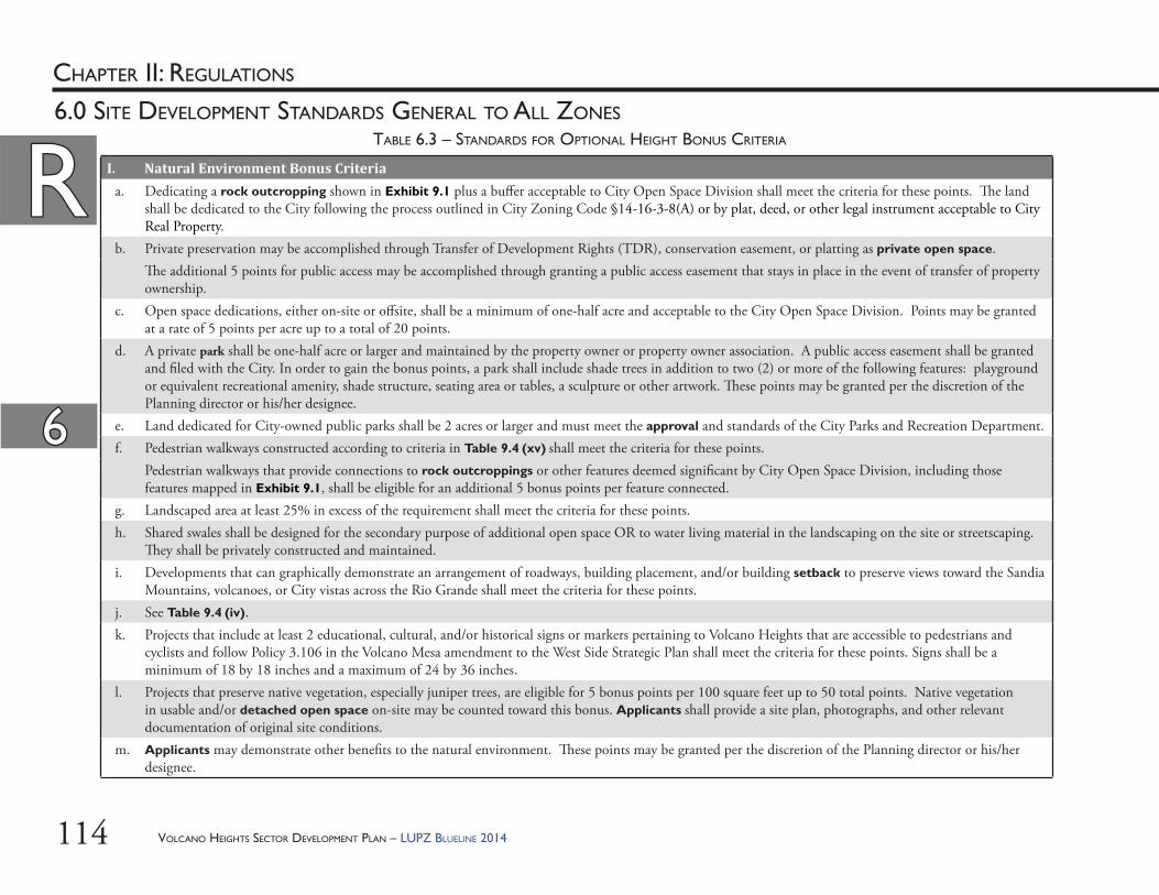
VOLCANO HEIGHTS SECTOR DEVELOPMENT PLAN – LUPZ BLUELINE 2014114
RRCHAPTER II: REGULATIONS
66
6.0 SITE DEVELOPMENT STANDARDS GENERAL TO ALL ZONES
I. Natural Environment Bonus Criteria a. Dedicating a rock outcropping shown in Exhibit 9.1 plus a buff er acceptable to City Open Space Division shall meet the criteria for these points. Th e land
shall be dedicated to the City following the process outlined in City Zoning Code §14-16-3-8(A) or by plat, deed, or other legal instrument acceptable to City Real Property.
b. Private preservation may be accomplished through Transfer of Development Rights (TDR), conservation easement, or platting as private open space. Th e additional 5 points for public access may be accomplished through granting a public access easement that stays in place in the event of transfer of property ownership.
c. Open space dedications, either on-site or off site, shall be a minimum of one-half acre and acceptable to the City Open Space Division. Points may be granted at a rate of 5 points per acre up to a total of 20 points.
d. A private park shall be one-half acre or larger and maintained by the property owner or property owner association. A public access easement shall be granted and fi led with the City. In order to gain the bonus points, a park shall include shade trees in addition to two (2) or more of the following features: playground or equivalent recreational amenity, shade structure, seating area or tables, a sculpture or other artwork. Th ese points may be granted per the discretion of the Planning director or his/her designee.
e. Land dedicated for City-owned public parks shall be 2 acres or larger and must meet the approval and standards of the City Parks and Recreation Department. f. Pedestrian walkways constructed according to criteria in Table 9.4 (xv) shall meet the criteria for these points. Pedestrian walkways that provide connections to rock outcroppings or other features deemed signifi cant by City Open Space Division, including those
features mapped in Exhibit 9.1, shall be eligible for an additional 5 bonus points per feature connected. g. Landscaped area at least 25% in excess of the requirement shall meet the criteria for these points. h. Shared swales shall be designed for the secondary purpose of additional open space OR to water living material in the landscaping on the site or streetscaping.
Th ey shall be privately constructed and maintained. i. Developments that can graphically demonstrate an arrangement of roadways, building placement, and/or building setback to preserve views toward the Sandia
Mountains, volcanoes, or City vistas across the Rio Grande shall meet the criteria for these points.j. See Table 9.4 (iv).
k. Projects that include at least 2 educational, cultural, and/or historical signs or markers pertaining to Volcano Heights that are accessible to pedestrians and cyclists and follow Policy 3.106 in the Volcano Mesa amendment to the West Side Strategic Plan shall meet the criteria for these points. Signs shall be a minimum of 18 by 18 inches and a maximum of 24 by 36 inches.
l. Projects that preserve native vegetation, especially juniper trees, are eligible for 5 bonus points per 100 square feet up to 50 total points. Native vegetation in usable and/or detached open space on-site may be counted toward this bonus. Applicants shall provide a site plan, photographs, and other relevant documentation of original site conditions.
m. Applicants may demonstrate other benefi ts to the natural environment. Th ese points may be granted per the discretion of the Planning director or his/her designee.
TABLE 6.3 – STANDARDS FOR OPTIONAL HEIGHT BONUS CRITERIA
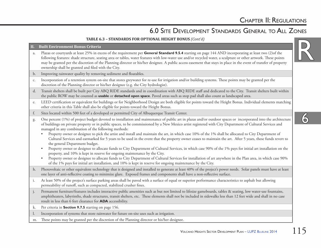
VOLCANO HEIGHTS SECTOR DEVELOPMENT PLAN – LUPZ BLUELINE 2014 115
RRCHAPTER II: REGULATIONS
66
6.0 SITE DEVELOPMENT STANDARDS GENERAL TO ALL ZONES
II. Built Environment Bonus Criteria a. Plazas or courtyards at least 25% in excess of the requirement per General Standard 9.5.4 starting on page 144 AND incorporating at least two (2)of the
following features: shade structure, seating area or tables, water features with low-water use and/or recycled water, a sculpture or other artwork. Th ese points may be granted per the discretion of the Planning director or his/her designee. A public access easement that stays in place in the event of transfer of property ownership shall be granted and fi led with the City.
b. Improving rainwater quality by removing sediment and fl oatables. c. Incorporation of a retention system on-site that stores greywater for re-use for irrigation and/or building systems. Th ese points may be granted per the
discretion of the Planning director or his/her designee (e.g. the City hydrologist). d. Transit shelters shall be built per City ABQ RIDE standards and in coordination with ABQ RIDE staff and dedicated to the City. Transit shelters built within
the public ROW may be counted as usable or detached open space. Paved areas such as stop pad shall also count as landscaped area. e. LEED certifi cation or equivalent for buildings or for Neighborhood Design are both eligible for points toward the Height Bonus. Individual elements matching
other criteria in this Table shall also be eligible for points toward the Height Bonus. f. Sites located within 500 feet of a developed or permitted City of Albuquerque Transit Center.
g. One percent (1%) of project budget devoted to installation and maintenance of public art in plazas and/or outdoor spaces or incorporated into the architecture of buildings on private property or in public spaces, to be commissioned by a New Mexico artist registered with City Department of Cultural Services and managed in any combination of the following methods:• Property owner or designee to pick the artist and install and maintain the art, in which case 10% of the 1% shall be allocated to City Department of
Cultural Services and earmarked for 5 years to be used in the event that the property owner ceases to maintain the art. After 5 years, these funds revert to the general Department budget.
• Property owner or designee to allocate funds to City Department of Cultural Services, in which case 90% of the 1% pays for initial art installation on the property, and 10% is kept in reserve for ongoing maintenance by the City.
• Property owner or designee to allocate funds to City Department of Cultural Services for installation of art anywhere in the Plan area, in which case 90% of the 1% pays for initial art installation, and 10% is kept in reserve for ongoing maintenance by the City.
h. Photovoltaic or other equivalent technology that is designed and installed to generate at least 40% of the project’s power needs. Solar panels must have at least one layer of anti-refl ective coating to minimize glare. Exposed frames and components shall have a non-refl ective surface.
i. At least 50% of the project’s surface parking areas shall be paved with a surface of equal or superior performance characteristics to asphalt but allowing permeability of runoff , such as compacted, stabilized crusher fi nes.
j. Permanent furniture/features includes interactive public amenities such as but not limited to lifesize gameboards, tables & seating, low water-use fountains, amphitheaters, labyrinths, shade structures, transit shelters, etc. Th ese elements shall not be included in sidewalks less than 12 feet wide and shall in no case result in less than 6 feet clearance for ADA accessibility.
k. Per criteria in Section 9.7.5 starting on page 156. l. Incorporation of systems that store rainwater for future on-site uses such as irrigation. m. Th ese points may be granted per the discretion of the Planning director or his/her designee.
TABLE 6.3 – STANDARDS FOR OPTIONAL HEIGHT BONUS (Cont’d)
VOLCANO HEIGHTS SECTOR DEVELOPMENT PLAN – LUPZ BLUELINE 2014116
RRCHAPTER II: REGULATIONS
66
6.0 SITE DEVELOPMENT STANDARDS GENERAL TO ALL ZONES
6.5. Grading6.5.1. Purpose / Intent: Th is Plan restricts grading in
order to protect natural topography and distinct topographic and natural character to the extent possible. Natural terrain and geological features make the area unique, desirable, and of value to residents and the larger community.
6.5.2. Cut and fi ll slopes shall be no steeper than 3:1 on average, and retaining walls shall not exceed 4 feet in height unless incorporated within a building’s foundation or approved by the City Hydrologist as necessary for development.
6.5.3. Graded areas shall maintain the character of the natural terrain by varying gradients, undulating contours, and rounding the toe and crest of any slope greater than 10 feet in height.
6.5.4. Fill shall be limited to four (4) feet except as deemed necessary for site development and drainage by the City Hydrologist. When more than 4 feet of fi ll is proposed, a project shall require DRB approval in order to ensure coordination with the City Hydrologist, City Open Space Division, and other relevant City staff .
6.5.5. Fill shall not exceed the existing highest natural grade point on site, unless approved by the City Hydrologist for required drainage. Fill height shall be measured from the natural grade.
6.5.6. In the selection of alignment and in site design, grading plans shall demonstrate that cut and fi ll has been kept to a minimum consistent with the standards in this Plan. Generally, the overall topography of the site is not to be substantially altered. Development must comply with the joint Albuquerque-Bernalillo County Fugitive Dust Ordinance found in the New Mexico Administrative Code 20.11.20, as well as the most recently approved City Air Quality Control Division standards and requirements. [2]
6.5.7. In order to minimize opportunities for fugitive dust during site development and construction, development shall comply with the following standards: [2](i) All development ¾ acres or over [16]
must comply with the joint Albuquerque and Bernalillo County Fugitive Dust Ordinance found in the New Mexico Administrative Code 20.11.20.
(ii) All development must comply with the City Drainage Control Ordinance and the Flood Hazard Control Ordinance, including a requirement for an approved Erosion and Settlement Control Plan prior to being issued a grading permit.
(iii) Due to the area’s proximity to the Petroglyph National Monument and the importance of protecting petroglyphs from fugitive dust, preferred methods for soil stabilization should be incorporated where appropriate.
VOLCANO HEIGHTS SECTOR DEVELOPMENT PLAN – LUPZ BLUELINE 2014 117
RRCHAPTER II: REGULATIONS
66
6.0 SITE DEVELOPMENT STANDARDS GENERAL TO ALL ZONES
6.6. Construc on Mi ga on6.6.1. Purpose / Intent: Any damage to the vegetation,
slope, or placement of boulders due to or related to construction shall be mitigated as provided herein.
6.6.2. Grading permits for commercial lot developments in the Volcano Heights Sector Development Plan area shall only be issued concurrently with the respective commercial building permits for non-residential and mixed-use developments, as well as residential developments over two lots. Applicants shall provide proof of a fugitive dust permit from Environmental Health prior to being issued a grading permit. If any soil stabilization is proposed, straw crimp plus seeding is the preferred method. Grading permits for residential developments greater than 10 acres shall require soil stabilization, approved by the Environmental Health Department, which shall be applied to the disturbed area within three months after grading of the site commences. Grading within public rights-of-way or public drainage easements is exempt. [2]
6.6.3. Prior to beginning any construction, the property owner, developer, or infrastructure contractor (whichever is the most relevant) shall complete the following requirements.(i) A temporary silt fence shall be constructed
at the site boundary adjacent to sensitive lands (i.e. the Escarpment buff er, Major Public Open Space, archeological site, or public or private conservation area to be maintained in natural desertscape) to eff ectively protect them from heavy equipment and vehicles. a. Construction or silt fencing shall
be placed no less than 12” from the Petroglyph National Monument boundary. [76]
(iv) For all non-residential and mixed-use developments, grading permits shall only be issued concurrently with building permits. For developments ¾ of an acre or over [16], applicants shall provide proof of a 20.11.20 NMAC Fugitive Dust Control Permit from the Environmental Health Department prior to being issued a building permit.
(v) For exclusively residential developments, a grading permit shall only be issued after a preliminary plat and an Erosion and Sediment Control Plan have been approved.
(vi) In situations that require grading without a building permit or a preliminary plat, or in advance of a building permit or a preliminary plat, the City Engineer may grant a grading permit if an applicant makes a special request, provided that the requirements in items (i) through (iii) above are met, as well as other requirements from both the City Engineer and the City Environmental Health Department. [17]
(vii) Grading within public rights-of-way or public easements is exempt.
VOLCANO HEIGHTS SECTOR DEVELOPMENT PLAN – LUPZ BLUELINE 2014118
RRCHAPTER II: REGULATIONS
66
6.0 SITE DEVELOPMENT STANDARDS GENERAL TO ALL ZONES
causing erosion or caving of the slopes and boulders, threatening public safety or welfare, or otherwise damaging archeological resources.a. Clear limits of construction shall
be established so that construction activities do not encroach on Petroglyph National Monument. Th e National Park Service and/or City Open Space Division shall be permitted to monitor any construction staking and/or blasting activities within the Escarpment Transition zone. No construction easements on the Monument shall be granted.
b. For any construction within the Escarpment Transition zone that includes blasting, the City Open Space in coordination with the National Park Service may require monitors to be placed between the blast site and the Petroglyph National Monument boundary in order to record blast data to ensure that disturbance remains within approved levels. Monitor data may be required to be maintained for up to one year following fi nal completion of the project.
6.6.4. Replacement of boulders shall approximate the original location, angle, and surface exposure, based on pre-construction photographs and/or comprehensive video recording.
b. Th e temporary silt fence shall comply with the most recently approved City Air Quality Control Division standards and requirements.
(ii) Clear limits of construction shall be established so that construction activities do not encroach on Petroglyph National Monument.
(iii) Photographs of the project site in its original condition shall be submitted with the application for building permit, subdivision, and/or site development plan. Within the Escarpment Transition zone only, in lieu of photographs, a comprehensive video recording of existing conditions and situations of rocks and boulders shall be submitted to inform compliance with permitting and other approvals.
(iv) For any construction within the Escarpment Transition zones that includes blasting, the City Open Space in coordination with the National Park Service may require monitors to be placed between the blast site and the Petroglyph National Monument boundary in order to record blast data to ensure that disturbance remains within approved levels. Where required, monitor data may be required to be maintained for up to one year following fi nal completion of the subject project. Applications for public- and private-sector projects, especially infrastructure, within the Escarpment Transition zone or adjacent to archeological sites shall include geotechnical data and analysis that demonstrate to the satisfaction of the City Engineer, in coordination with the City Open Space Division and National Park Service, that proposed trenching or blasting will not aff ect the face of the Escarpment, whether by potentially
VOLCANO HEIGHTS SECTOR DEVELOPMENT PLAN – LUPZ BLUELINE 2014 119
RRCHAPTER II: REGULATIONS
66
6.0 SITE DEVELOPMENT STANDARDS GENERAL TO ALL ZONES
6.6.9. Signifi cant archaeological sites shall be protected as appropriate to respect the area’s unique cultural history.(i) For purposes of this section, archaeological
resource and archaeological site shall be defi ned as set forth in the City Zoning Code §14-16-3-20 (i.e., the Albuquerque Archaeological Ordinance).
(ii) In addition to the applicability set out in the City Zoning Code §14-16-3-20, the Archaeological Ordinance shall apply when an applicant initiates the approval process for any of the following:a. A site development plan or master
development plan for a project that is 2 or more acres in size on property that is zoned SU-1 Special Use or an SU-2 zone that requires site plan review; or
b. An archaeological resource is discovered that the City Archaeologist deems signifi cant. In the event that a potential archaeological resource is discovered during development or land disturbance activity, the property owner shall temporarily cease all development activities and shall contact the City Archaeologist to determine whether the discovery has signifi cant research or other value. If the site is determined to be signifi cant, the property owner shall submit a preservation plan or data recovery and documentation plan for those resources that the City Archaeologist has determined to have signifi cant research or other value per
6.6.5. Revegetation to approximate original cover with native or xeric plants as appropriate from the Plant List in Table 9.5 is required within 90 days of project completion. [See Section 9.7.8 starting on page 158 to determine whether native or xeric species are required.] A deviation may be granted by the Planning Director or his/her designee if the type of vegetation or time of year make revegetation within 90 days impossible or undesirable. For infrastructure projects on public lands, the construction company shall post a warranty bond eff ective for three years after completion of the infrastructure work to ensure successful revegetation.
6.6.6. Applications for public- and private-sector projects, especially infrastructure, within the Escarpment Transition zone or adjacent to archeological sites shall include geotechnical data and analysis that demonstrate to the satisfaction of the City Engineer, in coordination with the City Open Space Division and National Park Service, that proposed trenching or blasting will not aff ect the face of the Escarpment, whether by potentially causing erosion or caving of the slopes and boulders, threatening public safety or welfare, or otherwise damaging archeological resources.
6.6.7. Th e National Park Service and/or City Open Space Division shall be permitted to monitor any construction staking and/or blasting activities within the Escarpment Transition zone. No construction easements on the Monument shall be granted.
6.6.8. To minimize the negative impact of fugitive dust on petroglyphs, no stockpiling of rock or basalt or rock crushing shall be permitted within 1320 feet (1/4 mile) of the Petroglyph National Monument boundary.
VOLCANO HEIGHTS SECTOR DEVELOPMENT PLAN – LUPZ BLUELINE 2014120
RRCHAPTER II: REGULATIONS
66
6.0 SITE DEVELOPMENT STANDARDS GENERAL TO ALL ZONES
6.7. Infrastructure6.7.1. U li es
(i) Easements a. In order to facilitate pedestrian
movement and maintain accessibility, utility infrastructure such as poles, transformers, boxes, and access panels shall be planned for minimal visual intrusion and mobility impediment to pedestrians. Overhead and underground electric distribution lines are typically located within public utility easements (PUE) or private easements. Th ey are compatible with other “dry” utilities such as cable, telephone, and fi ber optic facilities. Th e width of the PUE is typically 10 feet in order to provide necessary clearances for safety.
b. Water lines, sewer lines and storm water drainage or “wet” utilities are not compatible with “dry” utilities, and separation is required for safety purposes. Dry utility easements (electric, cable, phone, fi ber optics) and wet utility easements (water, sewer) are located subject to provisions of all applicable codes including the New Mexico Electrical Safety Code for safety reasons.
c. In all zones, utility easements shall be located in alleys or rear access and parking areas, if available. Where there is no alley, utility infrastructure may be placed in a PUE or private easement in the front setback of the property, provided it does not
the requirements in the City Zoning Code §14-16-3-20. Upon approval of the plan by the City Archaeologist, the property owner may proceed with development.
(iii) No petroglyph shall be defaced, altered, or moved without approval of the City Archaeologist or other appropriate City staff in consultation with a National Park Service representative from the Petroglyph National Monument. To the extent possible, rock outcroppings containing petroglyphs should be protected per City Zoning Code §14-16-3-20.
(iv) All other signifi cant archaeological sites shall be protected or mitigated per City Zoning Code §14-16-3-20. Site treatment shall consider preservation, avoidance, testing, and/or documentation of surface and/or subsurface remains and/or artifacts. Any buff ers or setbacks included as part of the treatment plan may be counted as usable open space.
VOLCANO HEIGHTS SECTOR DEVELOPMENT PLAN – LUPZ BLUELINE 2014 121
RRCHAPTER II: REGULATIONS
66
6.0 SITE DEVELOPMENT STANDARDS GENERAL TO ALL ZONES
c. Aesthetic improvements, such as painting, are encouraged to minimize visual impact of ground-mounted utility equipment. PNM may have guidelines for the most appropriate types of paint and/or other materials to use. Any identifying numbers shall not be obscured. All improvements are subject to removal as necessary for repair and/or maintenance.
d. Trees and shrubs planted in the PUE should be planted to minimize impacts on facilities maintenance and repair. Th ey are subject to removal as necessary for repair and/or maintenance.
6.7.2. Roads: See Section 10.0 Street Standards starting on page 163.
substantially aff ect the pedestrian realm and is located on the edge or side of property and as far away from the main entrance and pedestrian access paths as possible. Main service line utility infrastructure connecting with public utility easements in alleys shall be accommodated in front setbacks and/or Build-to Zones. [See also Section 10.7.7 starting on page 204.]
(ii) Construc on: For any construction within the Escarpment Transition zones that includes blasting, see Section 6.6.3 starting on page 117.
(iii) Clearancea. Any screening and vegetation
surrounding ground-mounted transformers and utility pads shall allow 10 feet of clearance in front of the equipment door and 5 feet of clearance on the remaining 3 sides for access and to ensure work crew and public safety during maintenance and repair.
b. Non-permanent use of clearance, such as for parking, is permitted. All uses shall require an encroachment agreement with PNM.
VOLCANO HEIGHTS SECTOR DEVELOPMENT PLAN – LUPZ BLUELINE 2014122
RRCHAPTER II: REGULATIONS
66
6.0 SITE DEVELOPMENT STANDARDS GENERAL TO ALL ZONES
6.8. Street Screens6.8.1. Except as noted elsewhere in this Plan, all
required street screens shall be made up of (a) the same material as the principal building or (b) a combination of masonry and living fence. Required street screens shall be located at the setback line unless otherwise noted in this Plan. [See also Section 9.7.3 starting on page 152 for requirements for wall design.]
6.8.2. Where provided, the living fence shall be within a minimum 3-foot wide planting strip located on the pedestrian, residential, or public street side. [See also Section 9.7.3 starting on page 152.]
6.8.3. Any frontage along all ‘A’ Streets and Civic Space not defi ned by a building at the BTZ shall be defi ned by a 4-foot high street screen. Th e required street screen shall be located at the setback line along the corresponding frontage.
6.8.4. Any off -street loading, unloading, storage, service, or trash pick-up areas shall be screened using a street screen at least as tall as the trash containers and/or service equipment it is screening at the BTZ.
6.8.5. Parking visible from the public ROW along an ‘A’ or ‘B’ Street shall have a street screen of masonry and/or metal railing 3-6 feet high combined with a landscape strip at least 3 feet wide on the pedestrian, residential or public street side.(i) Along a ‘B’ Street frontage, this
requirement may be waived as a minor deviation if the applicant can show suffi cient evidence of intent to build a parking structure within 2 years. [See Table 3.2 starting on page 31.]
(ii) If construction of a parking structure has not commenced within 2 years, a street screen shall be required.
6.8.6. Drive-through facilities, where allowed by zone and located on a ‘B’ Street, shall be screened from view via location behind a building on-site or a street screen, specifi cally:(i) Screening: A street screen shall be
provided for drive-up service windows and associated drive-up queue lanes that abut public streets or pedestrian areas. Screening may also be provided by placing the drive-up service windows and/or queue lanes between two adjacent and parallel buildings.
(ii) Drive-up Service Windows: a. Drive-up service windows shall not
be on a façade that faces or fronts an ‘A’ Street.
b. Drive-up service windows shall be oriented away from pedestrian areas, such as sidewalks and plazas, and residentially-zoned areas, where possible.
(iii) Queue Lanes: Queue lanes shall not be located parallel to ‘A’ Streets, unless they are located behind a building.
6.8.7. Utility equipment, including electrical
transformers, gas meters, etc., shall be screened with a street screen at least as high as the equipment being screened.
6.8.8. All street screening shall be designed to be compatible with utility infrastructure, particularly to address safety considerations for utility crews during maintenance and repair.
VOLCANO HEIGHTS SECTOR DEVELOPMENT PLAN – LUPZ BLUELINE 2014 123
RRCHAPTER II: REGULATIONS
66
6.0 SITE DEVELOPMENT STANDARDS GENERAL TO ALL ZONES
6.8.9. Rainwater harvesting equipment is not permitted on any ‘A’ Street. On all other frontages, they shall be screened with a street screen at least as high as the equipment being screened.
6.9. Design of Site Elements for Automobile-related Uses6.9.1. Drive-through lanes for commercial uses shall
not be located along ‘A’ Streets or Primary ‘B’ Streets.
6.9.2. Gas pumps, canopies, and/or service bays shall not be located along ‘A’ Streets. No more than 50% of a lot’s frontage along a ‘B’ Street may be occupied by gas pumps, canopies, and/or service bays.
6.9.3. Outdoor storage of vehicles or other products sold shall not be permitted along any ‘A’ Street. Along ‘B’ Streets, outdoor storage of vehicles or other products sold shall not exceed 50% of a lot’s frontage. [See also Section 6.8.4.]
6.9.4. All off -street loading, unloading, and trash pick-up areas shall be located along ‘B’ Streets or alleys unless permitted in the specifi c Site Development Standards in Section 5 and/or 6. [See also Section 6.8.4.]
6.9.5. See also Section 7.8 starting on page 131 for building design requirements for auto-related uses.

VOLCANO HEIGHTS SECTOR DEVELOPMENT PLAN – LUPZ BLUELINE 2014124
Th is Page Left Intentionally Blank
VOLCANO HEIGHTS SECTOR DEVELOPMENT PLAN – LUPZ BLUELINE 2014 125
CHAPTER II: REGULATIONS
7.0 BUILDING DESIGN STANDARDS
GENERAL TO ALL ZONES
RR
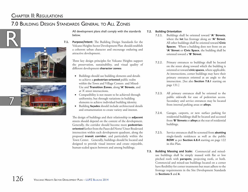
VOLCANO HEIGHTS SECTOR DEVELOPMENT PLAN – LUPZ BLUELINE 2014126
RRCHAPTER II: REGULATIONS
77
7.0 BUILDING DESIGN STANDARDS GENERAL TO ALL ZONES
7.2. Building Orienta on7.2.1. Buildings shall be oriented toward ‘A’ Streets,
where the lot has frontage along an ‘A’ Street. All other buildings shall be oriented toward Civic Spaces. Where a building does not front on an ‘A’ Street or Civic Space, the building shall be oriented toward a ‘B’ Street.
7.2.2. Primary entrances to buildings shall be located on the street along toward which the building is oriented or toward civic spaces, where applicable. At intersections, corner buildings may have their primary entrances oriented at an angle to the intersection. [See also Section 7.8.1 starting on page 131.]
7.2.3. All primary entrances shall be oriented to the public sidewalk for ease of pedestrian access. Secondary and service entrances may be located from internal parking areas or alleys.
7.2.4. Garages, carports, or new surface parking for residential buildings shall be located and accessed from ‘B’ Streets or alleys at the rear of residential buildings.
7.2.5. Service entrances shall be screened from abutting single-family residences as well as the public ROW as per Section 6.8.4 starting on page 122 in this Plan.
7.3. Building Massing and Scale: Commercial and mixed-use buildings shall be simply massed with fl at or low pitched roofs with parapets, projecting roofs, or both. Commercial and mixed-use buildings located on a corner have fl exibility for corner treatments but must adhere to the frontage requirements in the Site Development Standards in Sections 5 and 6.
7.1. Purpose/Intent: Th e Building Design Standards for the Volcano Heights Sector Development Plan should establish a coherent urban character and encourage enduring and attractive development.
Th ree key design principles for Volcano Heights support the preservation, sustainability, and visual quality of diff erent development character zones:
Buildings should use building elements and details to achieve a pedestrian-oriented public realm within the Town and Village Centers and Mixed-Use and Transition Zones, along ‘A’ Streets, and at ‘A’ street intersections.
Compatibility is not meant to be achieved through uniformity, but through variations in building elements to achieve individual building identity.
Building façades should include architectural details and ornamentation to create variety and interest.
Th e design of buildings and their relationship to adjacent streets should depend on the context of the development. Generally, the corridor should become more pedestrian-oriented farther from the Paseo del Norte/ Unser Boulevard intersection within each development quadrant, along the proposed transit corridor, and particularly within the Town Center. Generally, buildings should be located and designed to provide visual interest and create enjoyable, human-scaled spaces between and among buildings.
All development plans shall comply with the standards below.
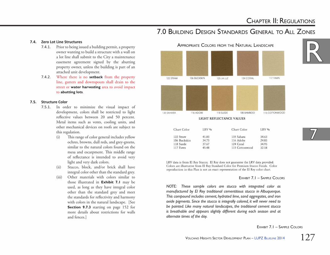
VOLCANO HEIGHTS SECTOR DEVELOPMENT PLAN – LUPZ BLUELINE 2014 127
RRCHAPTER II: REGULATIONS
77
7.0 BUILDING DESIGN STANDARDS GENERAL TO ALL ZONES
7.4. Zero Lot Line Structures 7.4.1. Prior to being issued a building permit, a property
owner wanting to build a structure with a wall on a lot line shall submit to the City a maintenance easement agreement signed by the abutting property owner, unless the building is part of an attached unit development.
7.4.2. Where there is no setback from the property line, gutters and downspouts shall drain to the street or water harvesting area to avoid impact to abutting lots.
7.5. Structure Color7.5.1. In order to minimize the visual impact of
development, colors shall be restricted to light refl ective values between 20 and 50 percent. Metal items such as vents, cooling units, and other mechanical devices on roofs are subject to this regulation. (i) Th is range of color general includes yellow
ochres, browns, dull reds, and grey-greens, similar to the natural colors found on the mesa and escarpment. Th is middle range of refl ectance is intended to avoid very light and very dark colors.
(ii) Stucco, block, and/or brick shall have integral color other than the standard grey.
(iii) Other materials with colors similar to those illustrated in Exhibit 7.1 may be used, as long as they have integral color other than the standard grey and meet the standards for refl ectivity and harmony with colors in the natural landscape. [See Section 9.7.3 starting on page 152 for more details about restrictions for walls and fences.]
EXHIBIT 7.1 – SAMPLE COLORS
NOTE: These sample colors are stucco with integrated color as manufactured by El Rey traditional cementitious stucco in Albuquerque. This compound includes cement, hydrated lime, sand aggregates, and iron oxide pigments. Since the stucco is integrally colored, it will never need to be painted. Like many natural landscapes, the traditional cement stucco is breathable and appears slightly different during each season and at alternate times of the day.
APPROPRIATE COLORS FROM THE NATURAL LANDSCAPE
EXHIBIT 7.1 – SAMPLE COLORS
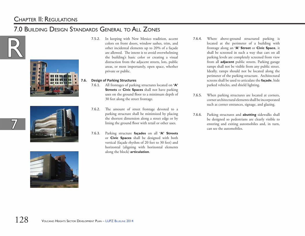
VOLCANO HEIGHTS SECTOR DEVELOPMENT PLAN – LUPZ BLUELINE 2014128
RRCHAPTER II: REGULATIONS
77
7.0 BUILDING DESIGN STANDARDS GENERAL TO ALL ZONES
7.6.4. Where above-ground structured parking is located at the perimeter of a building with frontage along an ‘A’ Street or Civic Space, it shall be screened in such a way that cars on all parking levels are completely screened from view from all adjacent public streets. Parking garage ramps shall not be visible from any public street. Ideally, ramps should not be located along the perimeter of the parking structure. Architectural screens shall be used to articulate the façade, hide parked vehicles, and shield lighting.
7.6.5. When parking structures are located at corners, corner architectural elements shall be incorporated such as corner entrances, signage, and glazing.
7.6.6. Parking structures and abutting sidewalks shall be designed so pedestrians are clearly visible to entering and exiting automobiles and, in turn, can see the automobiles.
7.5.2. In keeping with New Mexico tradition, accent colors on front doors, window sashes, trim, and other incidental elements up to 20% of a façade are allowed. Th e intent is to avoid overwhelming the building’s basic color or creating a visual distraction from the adjacent streets, lots, public areas, or most importantly, open space, whether private or public.
7.6. Design of Parking Structures7.6.1. All frontages of parking structures located on ‘A’
Streets or Civic Spaces shall not have parking uses on the ground fl oor to a minimum depth of 30 feet along the street frontage.
7.6.2. Th e amount of street frontage devoted to a parking structure shall be minimized by placing the shortest dimension along a street edge or by lining the ground fl oor with retail or other uses.
7.6.3. Parking structure façades on all ‘A’ Streets or Civic Spaces shall be designed with both vertical (façade rhythm of 20 feet to 30 feet) and horizontal (aligning with horizontal elements along the block) articulation.
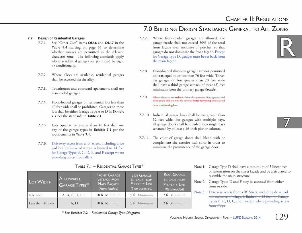
VOLCANO HEIGHTS SECTOR DEVELOPMENT PLAN – LUPZ BLUELINE 2014 129
RRCHAPTER II: REGULATIONS
77
7.0 BUILDING DESIGN STANDARDS GENERAL TO ALL ZONES
7.7. Design of Residen al Garages7.7.1. See “Other Uses” items OU-6 and OU-7 in the
Table 4.4 starting on page 64 to determine whether garages are permitted in the relevant character zone. Th e following standards apply where residential garages are permitted by right or conditionally.
7.7.2. Where alleys are available, residential garages shall be accessed via the alley.
7.7.3. Townhouses and courtyard apartments shall use rear-loaded garages.
7.7.4. Front-loaded garages on residential lots less than 40 feet wide shall be prohibited. Garages on these lots shall be either Garage Type A or D in Exhibit 7.2 per the standards in Table 7.1.
7.7.5. Lots equal to or greater than 40 feet shall use any of the garage types in Exhibit 7.2 per the requirements in Table 7.1.
7.7.6. Driveway access from a ‘B’ Street, including drive pad but exclusive of wings, is limited to 14 feet for Garage Types B, C, D, E, and F except where providing access from alleys.
7.7.7. Where front-loaded garages are allowed, the garage façade shall not exceed 50% of the total front façade area, inclusive of porches, so that garages do not dominate the front façade. Except for Garage Type D, garages must be set back from the main façade.
7.7.8. Front-loaded three-car garages are not permitted on lots equal to or less than 70 feet wide. Th ree-car garages on lots greater than 70 feet wide shall have a third garage setback of three (3) feet minimum from the primary garage façade.
7.7.9. Where there is no setback from the property line, gutters and downspouts shall drain to the street or water harvesting area to avoid
impact to abutting lots.
7.7.10. Individual garage bays shall be no greater than 12 feet wide. For garages with multiple bays, all garage doors shall be divided into single bays separated by at least a 16-inch pier or column.
7.7.11. Th e color of garage doors shall blend with or complement the exterior wall color in order to minimize the prominence of the garage door.
LOT WIDTHALLOWABLE GARAGE TYPES*
FRONT GARAGE SETBACK FROM MAIN FAÇADE
(Front-loaded)
SIDE GARAGE SETBACK FROM PROPERTY LINE
(Side-accessed)
REAR GARAGE SETBACK FROM PROPERTY LINE
(Rear-loaded)
40+ Feet A, B, C, D, E, F 10 ft. Minimum 5 ft. Minimum 2 ft. Minimum
Less than 40 Feet A, D 10 ft. Minimum 5 ft. Minimum 2 ft. Minimum
Note 1: Garage Type D shall have a minimum of 5 linear feet of fenestration on the street façade and be articulated to resemble the main structure.
Note 2: Garage Types D and F may be accessed from either front or side.
Note 3: Driveway access from a ‘B’ Street, including drive pad but exclusive of wings, is limited to 12 feet for Garage Types B, C, D, E, and F except where providing access from alleys.
TABLE 7.1 – RESIDENTIAL GARAGE TYPES*
* See Exhibit 7.2 – Residential Garage Type Diagrams
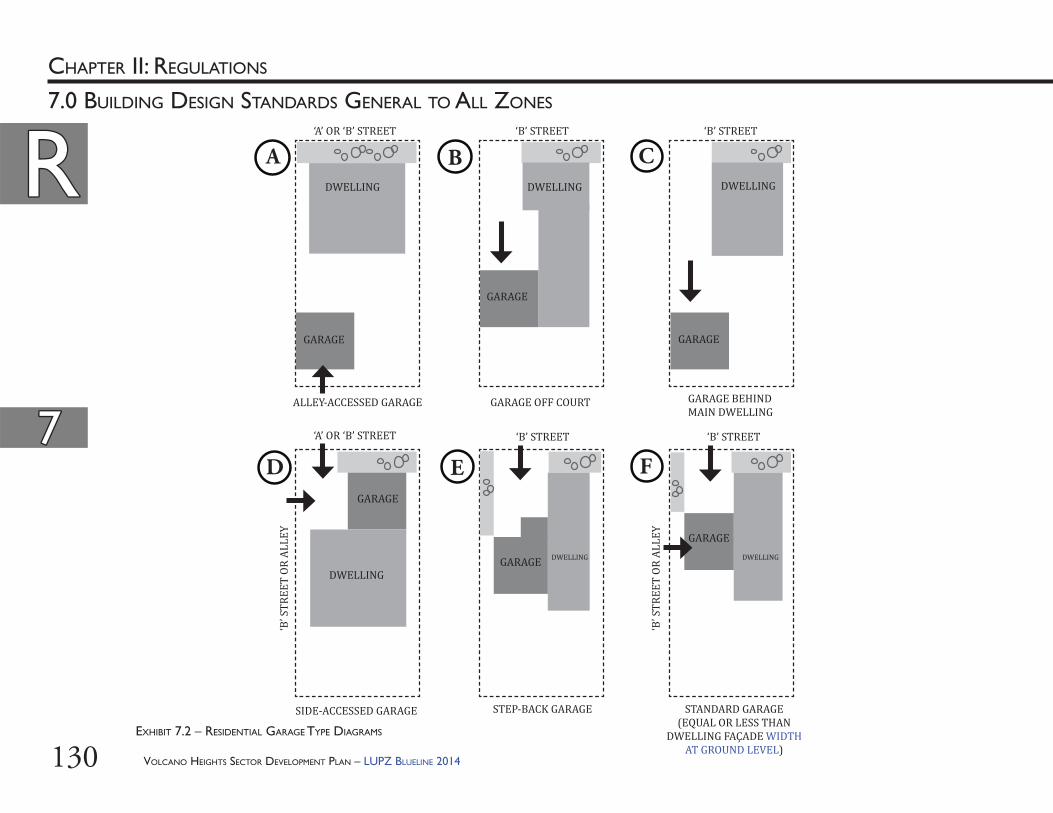
VOLCANO HEIGHTS SECTOR DEVELOPMENT PLAN – LUPZ BLUELINE 2014130
RRCHAPTER II: REGULATIONS
77
7.0 BUILDING DESIGN STANDARDS GENERAL TO ALL ZONES
EXHIBIT 7.2 – RESIDENTIAL GARAGE TYPE DIAGRAMS
DWELLING DWELLING DWELLING
DWELLING
DWELLING DWELLING
GARAGE
GARAGE
GARAGE
GARAGE
GARAGE
GARAGE
ALLEY-ACCESSED GARAGE GARAGE OFF COURT GARAGE BEHIND MAIN DWELLING
SIDE-ACCESSED GARAGE STEP-BACK GARAGE STANDARD GARAGE(EQUAL OR LESS THAN
DWELLING FAÇADE WIDTH AT GROUND LEVEL)
‘A’ OR ‘B’ STREET ‘B’ STREET ‘B’ STREET
‘B’ STREET ‘B’ STREET‘A’ OR ‘B’ STREET
‘B’ S
TREE
T OR
ALL
EY
‘B’ S
TREE
T OR
ALL
EY
A B C
D E F
VOLCANO HEIGHTS SECTOR DEVELOPMENT PLAN – LUPZ BLUELINE 2014 131
RRCHAPTER II: REGULATIONS
77
7.0 BUILDING DESIGN STANDARDS GENERAL TO ALL ZONES
7.9. Wireless Telecommunica ons Facili es (WTFs)7.9.1. Wireless telecommunications antennas shall be
permitted, pursuant to City Zone Code §14-16-3-17, on rooftops and shall be architecturally integrated and/or screened entirely with a screen the same color as the principal building on which it is mounted. Antennas shall not be visible from any adjacent ‘A’ street.
7.9.2. Concealed, free-standing WTFs are not permitted. Free-standing, array WTFs are not permitted, consistent with City Zoning Code §14-16-3-17, the Wireless Telecommunications Regulations.
7.9.3. Co-location on existing structures, including but not limited to public utility structures, is encouraged.
7.8. Design of Automobile-related Buildings7.8.1. Any buildings associated with any automobile-
related use shall also have a pedestrian entrance on an ‘A’ Street.
7.8.2. See also Section 6.8. Street Screens starting on page 122.
7.8.3. See also Section 6.9. Design of Site Elements for Automobile-related Uses starting on page 123.

VOLCANO HEIGHTS SECTOR DEVELOPMENT PLAN – LUPZ BLUELINE 2014132
Th is Page Left Intentionally Blank
VOLCANO HEIGHTS SECTOR DEVELOPMENT PLAN – LUPZ BLUELINE 2014 133
CHAPTER II: REGULATIONS
8.0 SIGN STANDARDS
RR
VOLCANO HEIGHTS SECTOR DEVELOPMENT PLAN – LUPZ BLUELINE 2014134
RRCHAPTER II: REGULATIONS
88
8.0 SIGN STANDARDS
8.2. Unique Sign Applica ons: An applicant has the option to establish unique sign standards including size, color, type, design, and location. Such applications shall be reviewed as “Unique Sign Plans” by the Planning Director or his/her designee and are subject to approval of the DRB. In evaluating a Unique Sign Plan, the DRB shall consider the extent to which the application meets the following: 8.2.1. Promotes consistency among signs within a
development thus creating visual harmony among signs, buildings, and other components of the property;
8.2.2. Enhances the compatibility of signs with the architectural and site design features within a development;
8.2.3. Encourages signage that is in character with planned and existing uses, thus creating a unique sense of place; and/or
8.2.4. Encourages multi-tenant commercial uses to develop a unique set of sign regulations in conjunction with development standards.
8.1. Applicability 8.1.1. Except as specifi cally listed below, all other
signage and sign standards shall comply with City Zoning Code §14-16-3-5, as amended.
8.1.2. Signs along Unser Boulevard must also comply with the Design Overlay Zone (DOZ) for that roadway adopted in 1992. [See Exhibit 8.1 on page 135.] Where confl icting, the most restrictive regulation prevails, except that sandwich board signs and blade signs (including both building and tenant signs) are permitted within Volcano Heights per the regulations in Table 8.1.
8.1.3. Where the Zoning Code, Unser DOZ, or Plan is silent, relevant regulations in the other locations prevail.
8.1.4. For new signs, the standards in Table 8.1 shall apply, and sign permits may be approved administratively unless specifi cally noted in this section.
8.1.5. Properties are allowed as many sign types as permitted by zone.
8.1.6. Defi nitions and examples of each sign type are included in Section 3.5 of this Plan.
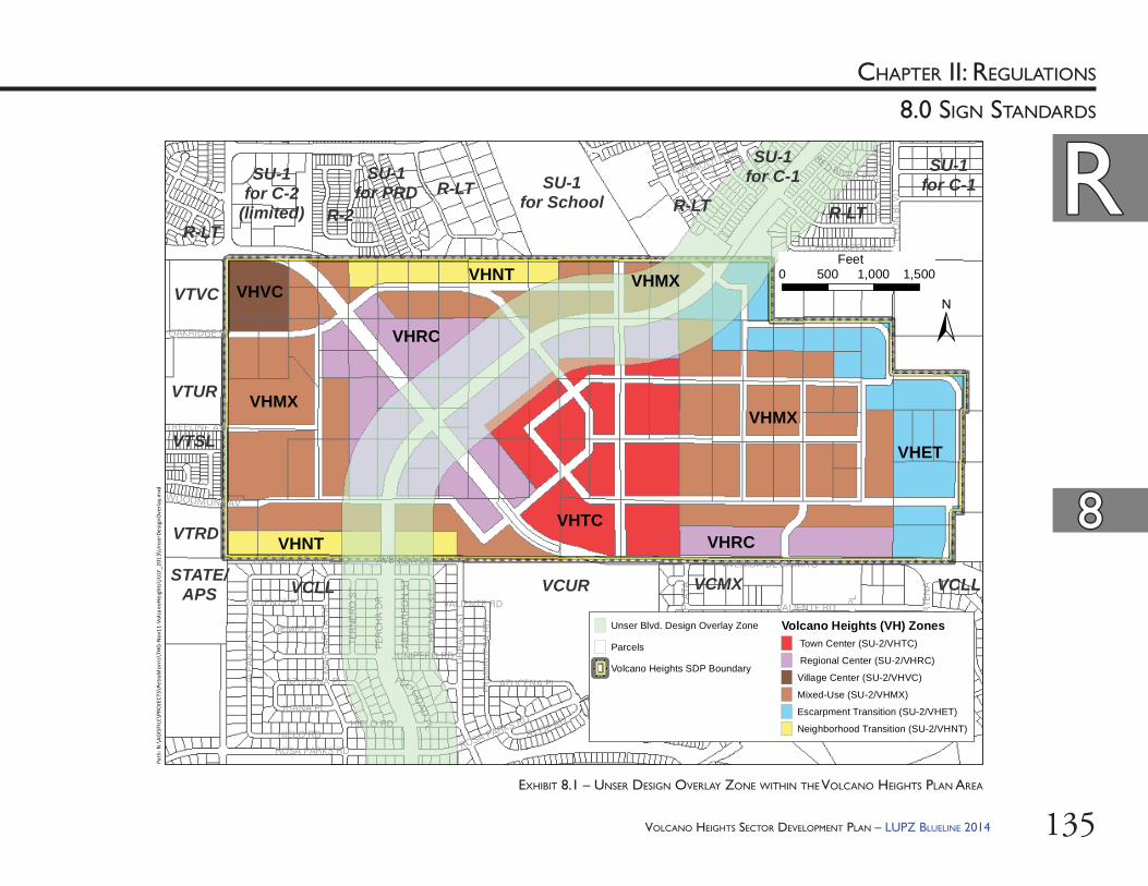
VOLCANO HEIGHTS SECTOR DEVELOPMENT PLAN – LUPZ BLUELINE 2014 135
RRCHAPTER II: REGULATIONS
88
8.0 SIGN STANDARDS
VHRC
VHMXVHMX
VHNT
VHNT
VHTC
VHRC
VHMX
R-1
VCUR
R-LTSU-1
for SchoolR-2
SU-1for C-2
(limited)R-LT
VTUR
VCMX
VTVC
SU-1for C-1
VTRD
R-LT
VCLLSTATE/
APS
VTSL
SU-1for PRD
SU-1for C-1
VCLL
R-LT
VALIENTE RD
UR
RA
CA
ST
ROSA PARKS RD
ALF
AN
JE S
T
PER
CH
A D
R
MA
RG
AR
ITA
DR
LYO
N B
LVD
HIELO RD A LOE RDBUCKTHORN TRL
FRA
MB
UE
SA
RD
REDROOT TRL
JUNIPERO RD
AZUCENA PL
HE
LAD
A S
T
AVENIDA DE JAIMITO
COLD CREEK AV
MONOLITH DR
TER
NE
RO
ST
CA
LLE
PLA
TA
JUANA PL
ADINA
LA
JEMEZ PL
AB
EJA
RR
ON
ST
JAC
KS
CR
EE
K D
R
BASIL WY
TREELINE AV
OAKRIDGE ST
GOLDENSEAL TRL
CA
LLE
NO
RTE
NA
TAP
ATI
OD
R
RED RIVE R RD
BURDO
CK
WYFELICID
ADPL
WOODMONT AV
CE
RR
O A
ZUL
PLVALIENTE RD
ROSA PARKS RDHIELO RD
AZUCENA PL
VALIENTE RD
ROSA PARKS RD
AVENIDA DE JAIMITO AVENIDA DE JAIMITO
±
Unser Blvd. Design Overlay Zone
Parcels
XYXY XY
XYXYXY Volcano Heights SDP Boundary
Volcano Heights (VH) Zones Town Center (SU-2/VHTC)
Regional Center (SU-2/VHRC)
Village Center (SU-2/VHVC)
Mixed-Use (SU-2/VHMX)
Escarpment Transition (SU-2/VHET)
Neighborhood Transition (SU-2/VHNT)
0 500 1,000 1,500Feet
Path
: N:\
AGIS
FILE
\PRO
JECT
S\Pe
traM
orris
\TH
G-N
ov11
-Vol
cano
Hei
ghts
\JU
LY_2
013\
Uns
erDe
sign
Ove
rlay.
mxd
VHVC
VHET
EXHIBIT 8.1 – UNSER DESIGN OVERLAY ZONE WITHIN THE VOLCANO HEIGHTS PLAN AREA
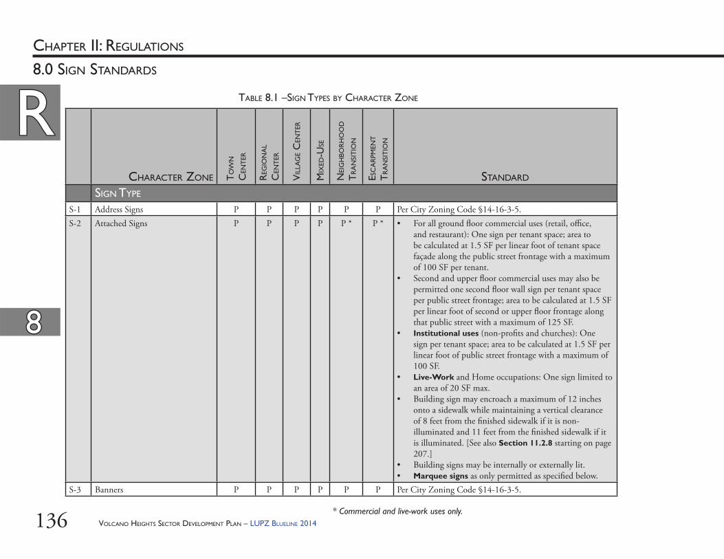
VOLCANO HEIGHTS SECTOR DEVELOPMENT PLAN – LUPZ BLUELINE 2014136
RRCHAPTER II: REGULATIONS
88
8.0 SIGN STANDARDS
CHARACTER ZONE TO
WN
CEN
TER
REG
ION
AL
CEN
TER
VIL
LAG
E C
ENT
ER
MIX
ED-U
SE
NEI
GH
BOR
HO
OD
TR
AN
SIT
ION
ESC
AR
PMEN
T
TR
AN
SIT
ION
STANDARD
SIGN TYPE
S-1 Address Signs P P P P P P Per City Zoning Code §14-16-3-5.S-2 Attached Signs P P P P P * P * • For all ground fl oor commercial uses (retail, offi ce,
and restaurant): One sign per tenant space; area to be calculated at 1.5 SF per linear foot of tenant space façade along the public street frontage with a maximum of 100 SF per tenant.
• Second and upper fl oor commercial uses may also be permitted one second fl oor wall sign per tenant space per public street frontage; area to be calculated at 1.5 SF per linear foot of second or upper fl oor frontage along that public street with a maximum of 125 SF.
• Institutional uses (non-profi ts and churches): One sign per tenant space; area to be calculated at 1.5 SF per linear foot of public street frontage with a maximum of 100 SF.
• Live-Work and Home occupations: One sign limited to an area of 20 SF max.
• Building sign may encroach a maximum of 12 inches onto a sidewalk while maintaining a vertical clearance of 8 feet from the fi nished sidewalk if it is non-illuminated and 11 feet from the fi nished sidewalk if it is illuminated. [See also Section 11.2.8 starting on page 207.]
• Building signs may be internally or externally lit.• Marquee signs as only permitted as specifi ed below.
S-3 Banners P P P P P P Per City Zoning Code §14-16-3-5.
* Commercial and live-work uses only.
TABLE 8.1 –SIGN TYPES BY CHARACTER ZONE
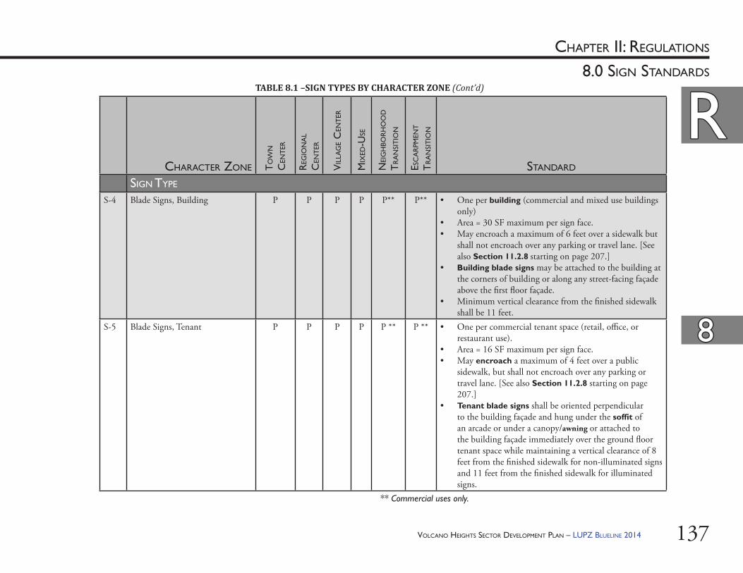
VOLCANO HEIGHTS SECTOR DEVELOPMENT PLAN – LUPZ BLUELINE 2014 137
RRCHAPTER II: REGULATIONS
88
8.0 SIGN STANDARDS
CHARACTER ZONE TO
WN
CEN
TER
REG
ION
AL
CEN
TER
VIL
LAG
E C
ENT
ER
MIX
ED-U
SE
NEI
GH
BOR
HO
OD
TR
AN
SIT
ION
ESC
AR
PMEN
T
TR
AN
SIT
ION
STANDARD
SIGN TYPE
S-4 Blade Signs, Building P P P P P** P** • One per building (commercial and mixed use buildings only)
• Area = 30 SF maximum per sign face.• May encroach a maximum of 6 feet over a sidewalk but
shall not encroach over any parking or travel lane. [See also Section 11.2.8 starting on page 207.]
• Building blade signs may be attached to the building at the corners of building or along any street-facing façade above the fi rst fl oor façade.
• Minimum vertical clearance from the fi nished sidewalk shall be 11 feet.
S-5 Blade Signs, Tenant P P P P P ** P ** • One per commercial tenant space (retail, offi ce, or restaurant use).
• Area = 16 SF maximum per sign face.• May encroach a maximum of 4 feet over a public
sidewalk, but shall not encroach over any parking or travel lane. [See also Section 11.2.8 starting on page 207.]
• Tenant blade signs shall be oriented perpendicular to the building façade and hung under the soffi t of an arcade or under a canopy/awning or attached to the building façade immediately over the ground fl oor tenant space while maintaining a vertical clearance of 8 feet from the fi nished sidewalk for non-illuminated signs and 11 feet from the fi nished sidewalk for illuminated signs.
** Commercial uses only.
TABLE 8.1 –SIGN TYPES BY CHARACTER ZONE (Cont’d)
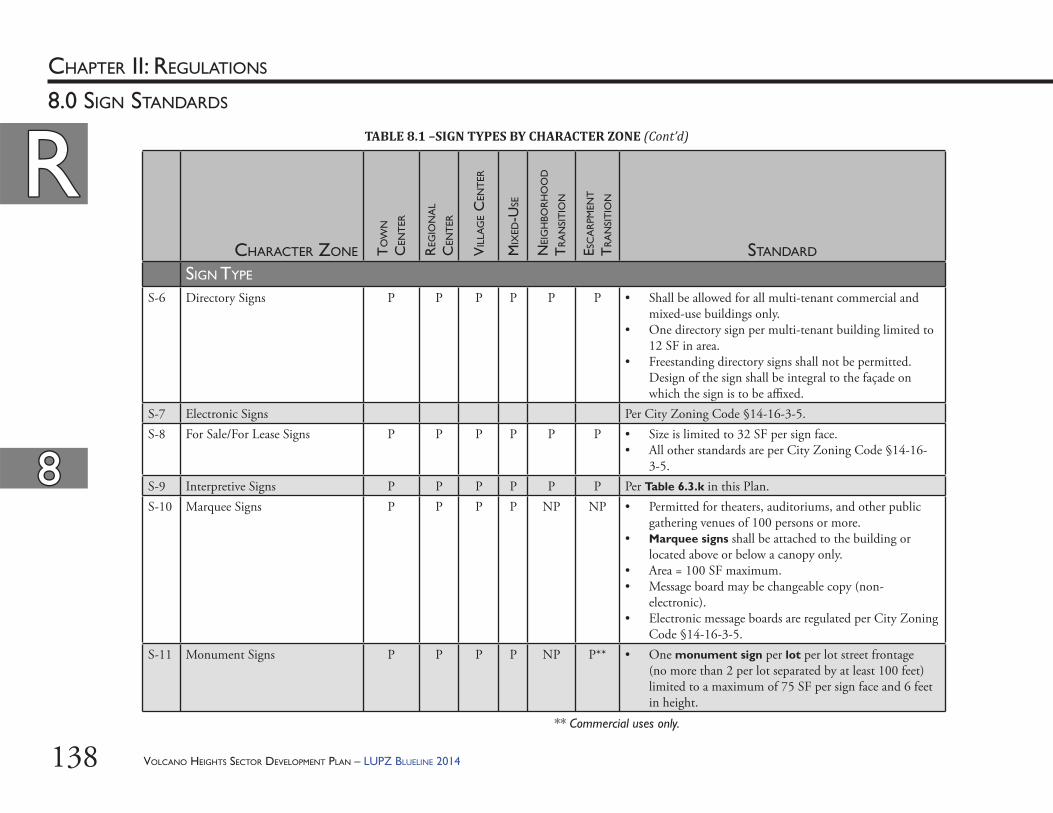
VOLCANO HEIGHTS SECTOR DEVELOPMENT PLAN – LUPZ BLUELINE 2014138
RRCHAPTER II: REGULATIONS
88
8.0 SIGN STANDARDS
CHARACTER ZONE TO
WN
CEN
TER
REG
ION
AL
CEN
TER
VIL
LAG
E C
ENT
ER
MIX
ED-U
SE
NEI
GH
BOR
HO
OD
TR
AN
SIT
ION
ESC
AR
PMEN
T
TR
AN
SIT
ION
STANDARD
SIGN TYPE
S-6 Directory Signs P P P P P P • Shall be allowed for all multi-tenant commercial and mixed-use buildings only.
• One directory sign per multi-tenant building limited to 12 SF in area.
• Freestanding directory signs shall not be permitted. Design of the sign shall be integral to the façade on which the sign is to be affi xed.
S-7 Electronic Signs Per City Zoning Code §14-16-3-5.S-8 For Sale/For Lease Signs P P P P P P • Size is limited to 32 SF per sign face.
• All other standards are per City Zoning Code §14-16-3-5.
S-9 Interpretive Signs P P P P P P Per Table 6.3.k in this Plan.S-10 Marquee Signs P P P P NP NP • Permitted for theaters, auditoriums, and other public
gathering venues of 100 persons or more.• Marquee signs shall be attached to the building or
located above or below a canopy only.• Area = 100 SF maximum.• Message board may be changeable copy (non-
electronic). • Electronic message boards are regulated per City Zoning
Code §14-16-3-5.S-11 Monument Signs P P P P NP P** • One monument sign per lot per lot street frontage
(no more than 2 per lot separated by at least 100 feet) limited to a maximum of 75 SF per sign face and 6 feet in height.
** Commercial uses only.
TABLE 8.1 –SIGN TYPES BY CHARACTER ZONE (Cont’d)
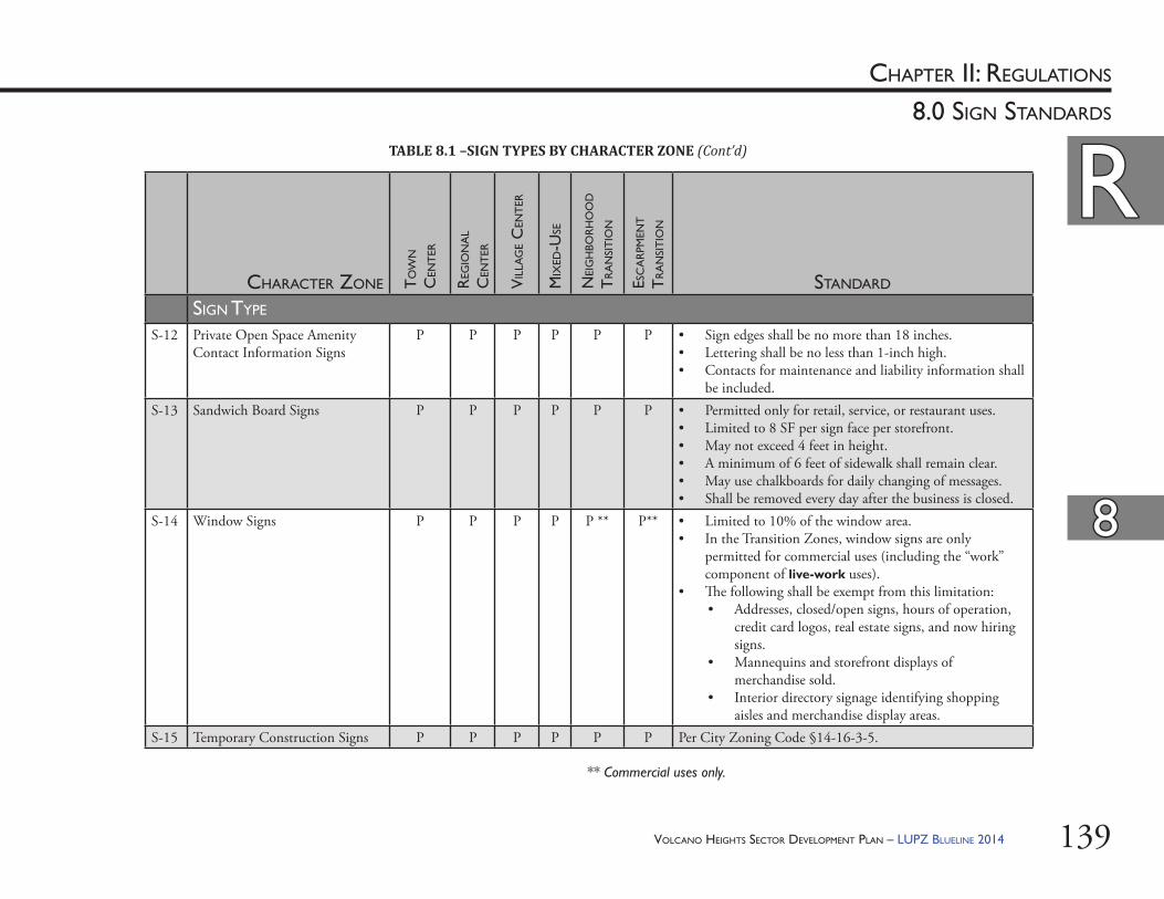
VOLCANO HEIGHTS SECTOR DEVELOPMENT PLAN – LUPZ BLUELINE 2014 139
RRCHAPTER II: REGULATIONS
88
8.0 SIGN STANDARDS
CHARACTER ZONE TO
WN
CEN
TER
REG
ION
AL
CEN
TER
VIL
LAG
E C
ENT
ER
MIX
ED-U
SE
NEI
GH
BOR
HO
OD
TR
AN
SIT
ION
ESC
AR
PMEN
T
TR
AN
SIT
ION
STANDARD
SIGN TYPE
S-12 Private Open Space Amenity Contact Information Signs
P P P P P P • Sign edges shall be no more than 18 inches.• Lettering shall be no less than 1-inch high.• Contacts for maintenance and liability information shall
be included.S-13 Sandwich Board Signs P P P P P P • Permitted only for retail, service, or restaurant uses.
• Limited to 8 SF per sign face per storefront.• May not exceed 4 feet in height. • A minimum of 6 feet of sidewalk shall remain clear. • May use chalkboards for daily changing of messages. • Shall be removed every day after the business is closed.
S-14 Window Signs P P P P P ** P** • Limited to 10% of the window area.• In the Transition Zones, window signs are only
permitted for commercial uses (including the “work” component of live-work uses).
• Th e following shall be exempt from this limitation:• Addresses, closed/open signs, hours of operation,
credit card logos, real estate signs, and now hiring signs.
• Mannequins and storefront displays of merchandise sold.
• Interior directory signage identifying shopping aisles and merchandise display areas.
S-15 Temporary Construction Signs P P P P P P Per City Zoning Code §14-16-3-5.
TABLE 8.1 –SIGN TYPES BY CHARACTER ZONE (Cont’d)
** Commercial uses only.

VOLCANO HEIGHTS SECTOR DEVELOPMENT PLAN – LUPZ BLUELINE 2014140
Th is Page Left Intentionally Blank
VOLCANO HEIGHTS SECTOR DEVELOPMENT PLAN – LUPZ BLUELINE 2014 141
9.0 OPEN SPACE, LANDSCAPING, AND SITE LIGHTING DESIGN STANDARDS
CHAPTER II: REGULATIONS
RR
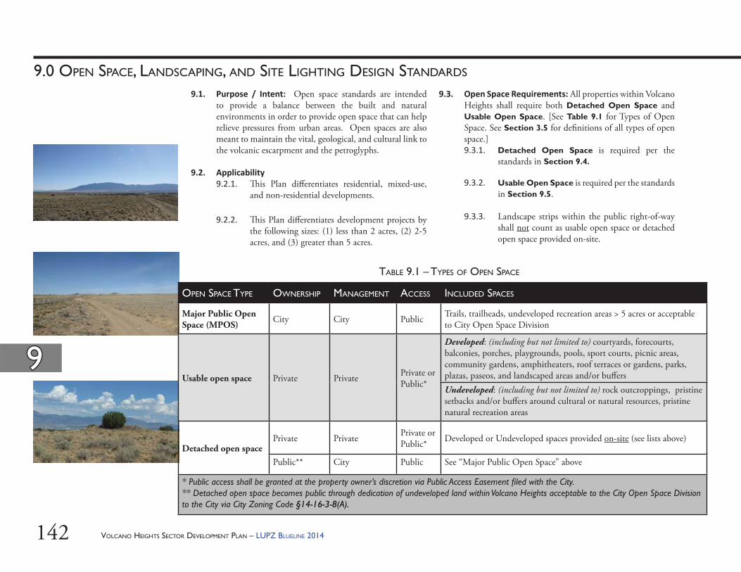
VOLCANO HEIGHTS SECTOR DEVELOPMENT PLAN – LUPZ BLUELINE 2014142
99
9.0 OPEN SPACE, LANDSCAPING, AND SITE LIGHTING DESIGN STANDARDS
9.1. Purpose / Intent: Open space standards are intended to provide a balance between the built and natural environments in order to provide open space that can help relieve pressures from urban areas. Open spaces are also meant to maintain the vital, geological, and cultural link to the volcanic escarpment and the petroglyphs.
9.2. Applicability9.2.1. Th is Plan diff erentiates residential, mixed-use,
and non-residential developments.
9.2.2. Th is Plan diff erentiates development projects by the following sizes: (1) less than 2 acres, (2) 2-5 acres, and (3) greater than 5 acres.
9.3. Open Space Requirements: All properties within Volcano Heights shall require both Detached Open Space and Usable Open Space. [See Table 9.1 for Types of Open Space. See Section 3.5 for defi nitions of all types of open space.]9.3.1. Detached Open Space is required per the
standards in Section 9.4.
9.3.2. Usable Open Space is required per the standards in Section 9.5.
9.3.3. Landscape strips within the public right-of-way shall not count as usable open space or detached open space provided on-site.
OPEN SPACE TYPE OWNERSHIP MANAGEMENT ACCESS INCLUDED SPACES
Major Public Open Space (MPOS) City City Public Trails, trailheads, undeveloped recreation areas > 5 acres or acceptable
to City Open Space Division
Usable open space Private Private Private or Public*
Developed: (including but not limited to) courtyards, forecourts, balconies, porches, playgrounds, pools, sport courts, picnic areas, community gardens, amphitheaters, roof terraces or gardens, parks, plazas, paseos, and landscaped areas and/or buff ersUndeveloped: (including but not limited to) rock outcroppings, pristine setbacks and/or buff ers around cultural or natural resources, pristine natural recreation areas
Detached open spacePrivate Private Private or
Public* Developed or Undeveloped spaces provided on-site (see lists above)
Public** City Public See “Major Public Open Space” above
* Public access shall be granted at the property owner’s discretion via Public Access Easement fi led with the City.** Detached open space becomes public through dedication of undeveloped land within Volcano Heights acceptable to the City Open Space Division to the City via City Zoning Code §14-16-3-8(A).
TABLE 9.1 – TYPES OF OPEN SPACE
VOLCANO HEIGHTS SECTOR DEVELOPMENT PLAN – LUPZ BLUELINE 2014 143
99
9.0 OPEN SPACE, LANDSCAPING, AND SITE LIGHTING DESIGN STANDARDS
9.4. Detached Open Space Standards9.4.1. Purpose / Intent: Detached open space is
required to help provide relief from density to balance the urban environment of the proposed Major Activity Center. In addition, detached open space is intended to help preserve the integrity and fabric of this unique natural, cultural, geological, and volcanological area.
Th e detached open space requirements below are calibrated to result in desired development densities with enough open space to preserve rock outcroppings [see Exhibit 9.1] and other sensitive lands as well as to create private parks and other civic and open space amenities through optional height bonuses in the non-Transition Zones.
9.4.2. Detached open space standards are a zoning regulation separate from any subdivision regulations, such as those associated with Impact Fees. Th e City calculates and tracks these fees and any associated credits separately. Th e detached open space standards shall not count toward Subdivision Impact Fee credits associated with parks and/or open space.
9.4.3. Detached open space standards are separate from the usable open space requirement.
9.4.4. Detached open space may be counted toward optional height bonus criteria. [See Section 6.4 starting on page 111.]
VHTC VHRC VHVC VHMX VHNT VHET TOTAL
Available Acreage* 61.2 89.1 10.8 162 28.8 54.9 406.8
Detached OS Requirement (square feet/dwelling unit)
400 400 400 400 400 400 —
Detached OS Requirement Cap(dwelling unit/acre)
40 20 30 30 6 6 —
Intended Resulting Detached Open Space Acreage**
22 16 3 45 2 3 91
* Total acreage minus Primary Streets minus 10% for usable open space** For purposes of analysis only
TABLE 9.2 – DETACHED OPEN SPACE: RESIDENTIAL USES
VHTC VHRC VHVC VHMX VHNT VHET TOTAL
Available Acreage* 61.2 89.1 10.8 162 28.8 54.9 406.8
Detached OS Requirement (square feet/30,000 SF building area)
2,400 2,400 2,400 2,400 NA NA —
Maximum Stories with Height Bonus 5 4 4 3 NA NA —
Intended Total Detached Open Space Acreage**
17 20 3 27 0 0 66
* Total acreage minus Primary Streets minus 10% for usable open space** For purposes of analysis only
TABLE 9.3 – DETACHED OPEN SPACE: NON-RESIDENTIAL USES
VOLCANO HEIGHTS SECTOR DEVELOPMENT PLAN – LUPZ BLUELINE 2014144
99
9.0 OPEN SPACE, LANDSCAPING, AND SITE LIGHTING DESIGN STANDARDS
9.5. Usable Open Space Standards9.5.1. All sites in Volcano Heights shall provide a
minimum of 10% of their site acreage as usable open space on-site with the following exception:(i) Usable open space is not required for
mixed-use or non-residential properties if located within 1,500 feet of a park, plaza or other usable open space that is at least one acre in size and accessible to the public.
9.5.2. Up to 60% of the required 10% of usable open space may be transferred across property lines and/or pooled to create larger open space areas within the Volcano Heights Plan area. In this event, the development and open space improvements shall be constructed concurrently.
9.5.3. When phasing of a Site Development Plan is involved, each phase must meet the 10% usable open space requirement. Subsequent phases shall not be built until the preceding phase’s usable open space has been built and/or landscaped. Under no circumstances shall the applicant be allowed to defer providing and developing the required open space for each phase.
9.5.4. Required Ameni es on Usable Open Space by Project Size (i) Projects 5+ Acres: As part or all of their
required usable open space, projects greater than 5 acres shall incorporate a publicly accessible plaza/patio/courtyard, or amphitheater a minimum of 5,000 SF in size. Th is may be counted toward an optional height bonus. [See Table 6.2 for criteria, Table 6.3 for standards, and Table 9.4 for private open space standards.]
9.4.5. Detached open space shall be provided via the alternatives listed in the City Zoning Code §14-16-3-8(A): (1) on-site, (2) dedication, or (3) cash-in-lieu. Dedications shall be for undeveloped land within Volcano Heights acceptable to the City Open Space Division.
9.4.6. Residen al or Mixed-Use Development: Following the intent of the R-D Zoning per City Zoning Code §14-16-2-14(F) that these SU-2 zones have replaced in Volcano Heights, for all residential or mixed-use development, 400 SF of detached open space shall be provided per residential dwelling unit until the density threshold (i.e. dwelling unit per acre) per Table 9.2 is reached on the site. Th is regulation and density threshold for each zone have been analyzed and calibrated to achieve a target open space acreage that can balance the density/intensity of proposed development as well as help to protect the rock outcroppings and sensitive lands within the Plan area.
9.4.7. Non-Residen al Development: Following the intent to preserve open space in Developing Urban areas per City Zoning Code §14-16-3-18, for all exclusively non-residential developments, a minimum of 2,400 SF of open space shall be provided for every 30,000 SF of building area. [See Table 9.3 on page 143.] Th is regulation has been analyzed and calibrated to achieve a target open space acreage that can balance the density/intensity of proposed development as well as help to protect the rock outcroppings and sensitive lands within the Plan area.
VOLCANO HEIGHTS SECTOR DEVELOPMENT PLAN – LUPZ BLUELINE 2014 145
99
9.0 OPEN SPACE, LANDSCAPING, AND SITE LIGHTING DESIGN STANDARDS
9.5.6. Any developed usable open space (i.e. plaza, amphitheater, playground, etc.) shall include a landscaped portion equal to a minimum of 40% of the on-site usable open space. A minimum of 25% of all developed open space shall be shaded from the summer sun with trees and/or permanent or temporary shade structures.
9.5.7. All living material (i.e. plants, trees, etc.) shall be irrigated per City standards. [Contact the City DRC Section for the latest standards.] If native species are chosen from the Plant List in Table 9.5 in this Plan [see also Section 9.7.8 starting on page 158], irrigation shall be provided for a minimum of the fi rst three (3) growing seasons or until the plant/tree is fi rmly established.
9.5.8. All private open space, regardless of public access, shall be privately owned and the responsibility of property owners/developers for the cost of construction, ongoing maintenance, and liability. Th ese costs may be privately funded through homeowner or merchants associations. [In the event that they are ever dedicated to the City for ongoing maintenance and liability responsibility, open space amenities must meet City standards and be acceptable to and accepted by the relevant City department.]
9.5.9. Any open space amenity as provided per criteria in Table 9.4 starting on page 148 shall count toward satisfying the 10% usable open space requirement. Table 9.4 identifi es whether each amenity is eligible for access by the public (i.e. civic open space), private only, or both.
(ii) Projects 2-5 Acresa. Residential: Projects 2-5 acres in
size that are exclusively residential development shall incorporate a recreational area or playground a minimum of 2,400 SF in size as part or all of their required usable open space, which can also count toward an optional height bonus. [See Table 6.2 for criteria, Table 6.3 for standards, and Table 9.4 for private open space standards.]
b. Non-residential or Mixed Use: Projects 2-5 acres in size that are non-residential or mixed use shall incorporate a publicly accessible plaza/patio/courtyard, amphitheater, or roof garden at least 1,500 SF in size, which can also count toward an optional height bonus [86]. [See Table 6.2 for criteria, Table 6.3 for standards, and Table 9.4 for private open space standards.]
(iii) Projects <2 acres: Projects less than 2 acres in size may incorporate any combination of open space elements to satisfy the 10% usable open space requirement. [See Table 9.4 for private open space standards.]
9.5.5. A minimum of 40% of the required on-site usable open space shall be permeable to rainwater. Th is requirement may be met through landscape area, permeable paving, unpaved pedestrian walkways, etc. Th is area may be broken up on the site but shall remain accessible and intended for public use.
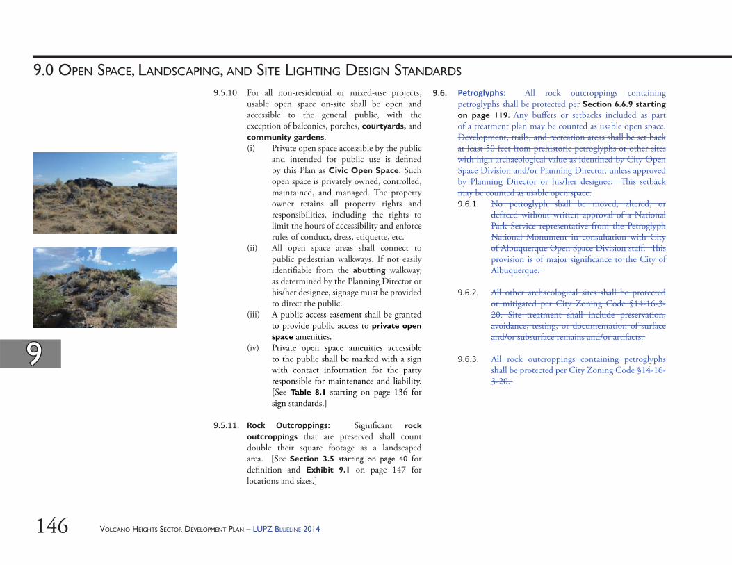
VOLCANO HEIGHTS SECTOR DEVELOPMENT PLAN – LUPZ BLUELINE 2014146
99
9.0 OPEN SPACE, LANDSCAPING, AND SITE LIGHTING DESIGN STANDARDS
9.6. Petroglyphs: All rock outcroppings containing petroglyphs shall be protected per Section 6.6.9 starting on page 119. Any buff ers or setbacks included as part of a treatment plan may be counted as usable open space. Development, trails, and recreation areas shall be set back at least 50 feet from prehistoric petroglyphs or other sites with high archaeological value as identifi ed by City Open Space Division and/or Planning Director, unless approved by Planning Director or his/her designee. Th is setback may be counted as usable open space.9.6.1. No petroglyph shall be moved, altered, or
defaced without written approval of a National Park Service representative from the Petroglyph National Monument in consultation with City of Albuquerque Open Space Division staff . Th is provision is of major signifi cance to the City of Albuquerque.
9.6.2. All other archaeological sites shall be protected or mitigated per City Zoning Code §14-16-3-20. Site treatment shall include preservation, avoidance, testing, or documentation of surface and/or subsurface remains and/or artifacts.
9.6.3. All rock outcroppings containing petroglyphs shall be protected per City Zoning Code §14-16-3-20.
9.5.10. For all non-residential or mixed-use projects, usable open space on-site shall be open and accessible to the general public, with the exception of balconies, porches, courtyards, and community gardens. (i) Private open space accessible by the public
and intended for public use is defi ned by this Plan as Civic Open Space. Such open space is privately owned, controlled, maintained, and managed. Th e property owner retains all property rights and responsibilities, including the rights to limit the hours of accessibility and enforce rules of conduct, dress, etiquette, etc.
(ii) All open space areas shall connect to public pedestrian walkways. If not easily identifi able from the abutting walkway, as determined by the Planning Director or his/her designee, signage must be provided to direct the public.
(iii) A public access easement shall be granted to provide public access to private open space amenities.
(iv) Private open space amenities accessible to the public shall be marked with a sign with contact information for the party responsible for maintenance and liability. [See Table 8.1 starting on page 136 for sign standards.]
9.5.11. Rock Outcroppings: Signifi cant rock outcroppings that are preserved shall count double their square footage as a landscaped area. [See Section 3.5 starting on page 40 for defi nition and Exhibit 9.1 on page 147 for locations and sizes.]
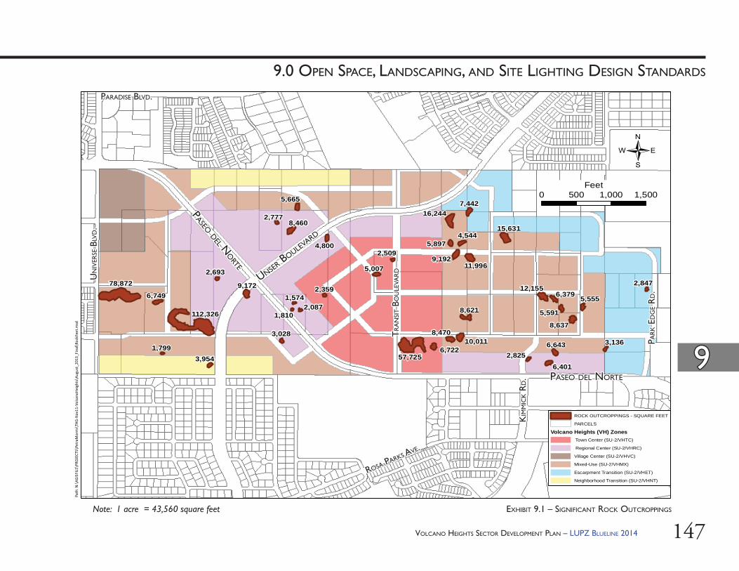
VOLCANO HEIGHTS SECTOR DEVELOPMENT PLAN – LUPZ BLUELINE 2014 147
99
9.0 OPEN SPACE, LANDSCAPING, AND SITE LIGHTING DESIGN STANDARDS
78,872
6,749
112,326
1,7993,954
9,172
2,693
3,028
57,7256,722
8,47010,011
8,621
6,401
6,6432,825
12,1556,379
5,591
8,637
5,555
3,136
9,19211,996
15,631
5,007
2,509
2,847
5,8974,544
16,2447,442
1,8102,087
1,5742,359
5,665
4,800
8,4602,777
0 500 1,000 1,500Feet
Path
: N:\A
GISF
ILE\P
ROJE
CTS\
Petra
Mor
ris\T
HG-N
ov11
-Vol
cano
Heigh
ts\A
ugus
t_20
13_F
inal\
Rock
Feet
.mxd
ROCK OUTCROPPINGS - SQUARE FEET
PARCELS
Volcano Heights (VH) Zones Town Center (SU-2/VHTC)
Regional Center (SU-2/VHRC)
Village Center (SU-2/VHVC)
Mixed-Use (SU-2/VHMX)
Escarpment Transition (SU-2/VHET)
Neighborhood Transition (SU-2/VHNT)
/
EXHIBIT 9.1 – SIGNIFICANT ROCK OUTCROPPINGS
PASEO DEL NORTEPASEO DEL NORTE
UNSER BOULE
VARD
UNSER BOULE
VARD
TR
AN
SIT B
OU
LEVA
RD
TR
AN
SIT B
OU
LEVA
RD
PASEO DEL NO
RTE
PASEO DEL NO
RTE
PARADISE BLVD.PARADISE BLVD.U
NIV
ERSE
BLV
D.
UN
IVER
SE B
LVD.
KIM
MIC
K R
D.
KIM
MIC
K R
D.
ROSA PARKS AVE.
ROSA PARKS AVE.
PAR
K E
DG
E R
D.
PAR
K E
DG
E R
D.
Note: 1 acre = 43,560 square feet
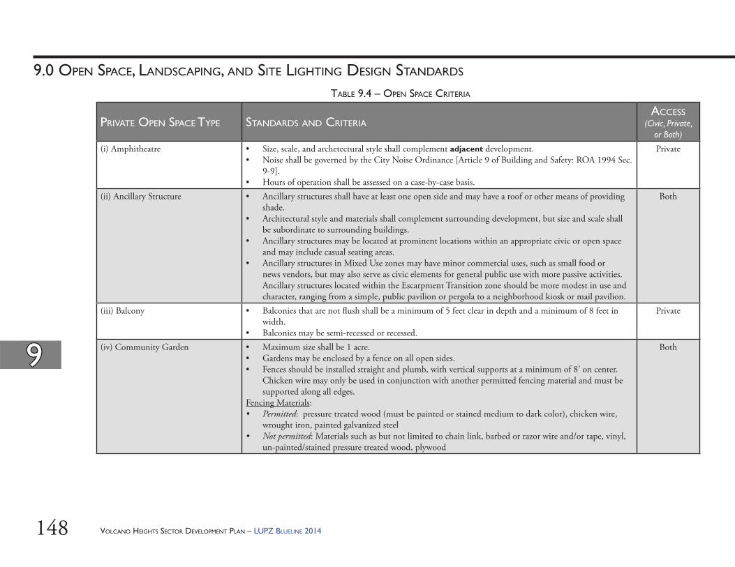
VOLCANO HEIGHTS SECTOR DEVELOPMENT PLAN – LUPZ BLUELINE 2014148
99
9.0 OPEN SPACE, LANDSCAPING, AND SITE LIGHTING DESIGN STANDARDS
TABLE 9.4 – OPEN SPACE CRITERIA
PRIVATE OPEN SPACE TYPE STANDARDS AND CRITERIAACCESS
(Civic, Private, or Both)
(i) Amphitheatre • Size, scale, and archetectural style shall complement adjacent development. • Noise shall be governed by the City Noise Ordinance [Article 9 of Building and Safety: ROA 1994 Sec.
9-9]. • Hours of operation shall be assessed on a case-by-case basis.
Private
(ii) Ancillary Structure • Ancillary structures shall have at least one open side and may have a roof or other means of providing shade.
• Architectural style and materials shall complement surrounding development, but size and scale shall be subordinate to surrounding buildings.
• Ancillary structures may be located at prominent locations within an appropriate civic or open space and may include casual seating areas.
• Ancillary structures in Mixed Use zones may have minor commercial uses, such as small food or news vendors, but may also serve as civic elements for general public use with more passive activities. Ancillary structures located within the Escarpment Transition zone should be more modest in use and character, ranging from a simple, public pavilion or pergola to a neighborhood kiosk or mail pavilion.
Both
(iii) Balcony • Balconies that are not fl ush shall be a minimum of 5 feet clear in depth and a minimum of 8 feet in width.
• Balconies may be semi-recessed or recessed.
Private
(iv) Community Garden • Maximum size shall be 1 acre.• Gardens may be enclosed by a fence on all open sides. • Fences should be installed straight and plumb, with vertical supports at a minimum of 8’ on center.
Chicken wire may only be used in conjunction with another permitted fencing material and must be supported along all edges.
Fencing Materials:• Permitted: pressure treated wood (must be painted or stained medium to dark color), chicken wire,
wrought iron, painted galvanized steel• Not permitted: Materials such as but not limited to chain link, barbed or razor wire and/or tape, vinyl,
un-painted/stained pressure treated wood, plywood
Both
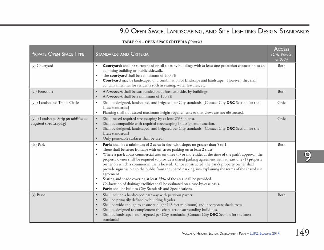
VOLCANO HEIGHTS SECTOR DEVELOPMENT PLAN – LUPZ BLUELINE 2014 149
99
9.0 OPEN SPACE, LANDSCAPING, AND SITE LIGHTING DESIGN STANDARDS
PRIVATE OPEN SPACE TYPE STANDARDS AND CRITERIAACCESS
(Civic, Private, or Both)
(v) Courtyard • Courtyards shall be surrounded on all sides by buildings with at least one pedestrian connection to an adjoining building or public sidewalk.
• Th e courtyard shall be a minimum of 200 SF.• Courtyard may be landscaped or a combination of landscape and hardscape. However, they shall
contain amenities for residents such as seating, water features, etc.
Both
(vi) Forecourt • A forecourt shall be surrounded on at least two sides by buildings.• A forecourt shall be a minimum of 150 SF.
Both
(vii) Landscaped Traffi c Circle • Shall be designed, landscaped, and irrigated per City standards. [Contact City DRC Section for the latest standards.]
• Planting shall not exceed maximum height requirements so that views are not obstructed.
Civic
(viii) Landscape Strip (in addition to required streetscaping)
• Shall exceed required streetscaping by at least 25% in area.• Shall be compatible with required streetscaping in design and function.• Shall be designed, landscaped, and irrigated per City standards. [Contact City DRC Section for the
latest standards.]• Only permeable surfaces shall be used.
Civic
(ix) Park • Parks shall be a minimum of 2 acres in size, with slopes no greater than 5 to 1. • Th ere shall be street frontage with on-street parking on at least 2 sides. • Where a park abuts commercial uses on three (3) or more sides at the time of the park’s approval, the
property owner shall be required to provide a shared parking agreement with at least one (1) property owner on which a commercial use is located. Once constructed, the park’s property owner shall provide signs visible to the public from the shared parking area explaining the terms of the shared use agreement.
• Seating and shade covering at least 25% of the area shall be provided. • Co-location of drainage facilities shall be evaluated on a case-by-case basis. • Parks shall be built to City Standards and Specifi cations.
Both
(x) Paseo • Shall include a hardscaped pathway with pervious pavers.• Shall be primarily defi ned by building façades.• Shall be wide enough to ensure sunlight (12-feet minimum) and incorporate shade trees.• Shall be designed to complement the character of surrounding buildings.• Shall be landscaped and irrigated per City standards. [Contact City DRC Section for the latest
standards]
Both
TABLE 9.4 – OPEN SPACE CRITERIA (Cont’d)
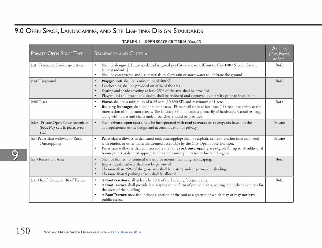
VOLCANO HEIGHTS SECTOR DEVELOPMENT PLAN – LUPZ BLUELINE 2014150
99
9.0 OPEN SPACE, LANDSCAPING, AND SITE LIGHTING DESIGN STANDARDS
PRIVATE OPEN SPACE TYPE STANDARDS AND CRITERIAACCESS
(Civic, Private, or Both)
(xi) Permeable Landscaped Area • Shall be designed, landscaped, and irrigated per City standards. [Contact City DRC Section for the latest standards.]
• Shall be constructed and use materials to allow rain or stormwater to infi ltrate the ground.
Both
(xii) Playground • Playgrounds shall be a minimum of 400 SF. • Landscaping shall be provided on 80% of the area. • Seating and shade covering at least 25% of the area shall be provided. • Playground equipment and design shall be reviewed and approved by the City prior to installation.
Both
(xiii) Plaza • Plazas shall be a minimum of 0.25 acre (10,890 SF) and maximum of 1 acre.• Building frontages shall defi ne these spaces. Plazas shall front at least one (1) street, preferably at the
intersection of important streets. Th e landscape should consist primarily of hardscape. Casual seating, along with tables and chairs and/or benches, should be provided.
Both
(xiv) Private Open Space Amenities (pool, play courts, picnic area, etc.)
• Such private open space may be incorporated with roof terraces or courtyards based on the appropriateness of the design and accommodation of privacy.
Private
(xv) Pedestrian walkway to Rock Outcroppings
• Pedestrian walkways to dedicated rock outcroppings shall be asphalt, cement, crusher fi nes stabilized with binder, or other materials deemed acceptable by the City Open Space Division.
• Pedestrian walkways that connect more than one rock outcropping are eligible for up to 10 additional bonus points as deemed appropriate by the Planning Director or his/her designee.
Private
(xvi) Recreation Area • Shall be limited to minimal site improvements, including landscaping.• Impermeable surfaces shall not be permitted.• No more than 25% of the gross area shall be seating and/or permanent shading.• No more than 5 parking spaces shall be allowed.
Both
(xvii) Roof Garden or Roof Terrace • A Roof Garden shall at least be 50% of the building footprint area.• A Roof Terrace shall provide landscaping in the form of potted plants, seating, and other amenities for
the users of the building.• A Roof Terrace may also include a portion of the roof as a green roof which may or may not have
public access.
Both
TABLE 9.4 – OPEN SPACE CRITERIA (Cont’d)
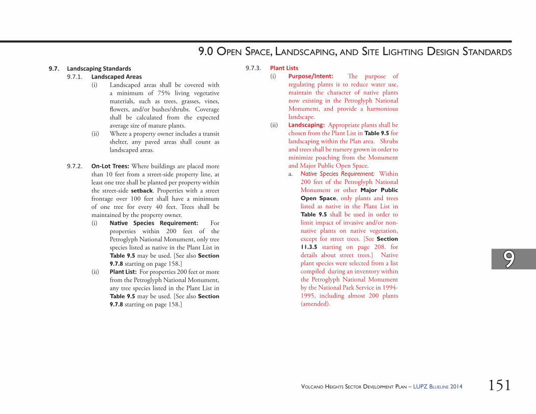
VOLCANO HEIGHTS SECTOR DEVELOPMENT PLAN – LUPZ BLUELINE 2014 151
99
9.0 OPEN SPACE, LANDSCAPING, AND SITE LIGHTING DESIGN STANDARDS
9.7.3. Plant Lists(i) Purpose/Intent: Th e purpose of
regulating plants is to reduce water use, maintain the character of native plants now existing in the Petroglyph National Monument, and provide a harmonious landscape.
(ii) Landscaping: Appropriate plants shall be chosen from the Plant List in Table 9.5 for landscaping within the Plan area. Shrubs and trees shall be nursery grown in order to minimize poaching from the Monument and Major Public Open Space. a. Native Species Requirement: Within
200 feet of the Petroglyph National Monument or other Major Public Open Space, only plants and trees listed as native in the Plant List in Table 9.5 shall be used in order to limit impact of invasive and/or non-native plants on native vegetation, except for street trees. [See Section 11.3.5 starting on page 208. for details about street trees.] Native plant species were selected from a list compiled during an inventory within the Petroglyph National Monument by the National Park Service in 1994-1995, including almost 200 plants (amended).
9.7. Landscaping Standards9.7.1. Landscaped Areas
(i) Landscaped areas shall be covered with a minimum of 75% living vegetative materials, such as trees, grasses, vines, fl owers, and/or bushes/shrubs. Coverage shall be calculated from the expected average size of mature plants.
(ii) Where a property owner includes a transit shelter, any paved areas shall count as landscaped areas.
9.7.2. On-Lot Trees: Where buildings are placed more than 10 feet from a street-side property line, at least one tree shall be planted per property within the street-side setback. Properties with a street frontage over 100 feet shall have a minimum of one tree for every 40 feet. Trees shall be maintained by the property owner. (i) Na ve Species Requirement: For
properties within 200 feet of the Petroglyph National Monument, only tree species listed as native in the Plant List in Table 9.5 may be used. [See also Section 9.7.8 starting on page 158.]
(ii) Plant List: For properties 200 feet or more from the Petroglyph National Monument, any tree species listed in the Plant List in Table 9.5 may be used. [See also Section 9.7.8 starting on page 158.]
VOLCANO HEIGHTS SECTOR DEVELOPMENT PLAN – LUPZ BLUELINE 2014152
99
9.0 OPEN SPACE, LANDSCAPING, AND SITE LIGHTING DESIGN STANDARDS
9.7.4. Walls & Fences Material Finishes & Design(i) Height & Placement
a. Walls and fences shall not exceed a height of 36 inches where allowed within street-facing setbacks (except for columns that support arcades or trellises). Retaining walls in all locations shall not exceed 48 inches, unless approved by the City Hydrologist. Fences and walls shall not exceed a height of 72 inches inside required setbacks along rear and interior side property lines. Height shall be measured from the lower side on the public side of the side or rear yard. Public utility structures are excluded from these requirements.
b. Where new single-family residential lots and homes back up to Connector streets, solid rear and/or side-yard walls bordering the street and pedestrian realm shall not exceed a height of 48 inches. Twenty-four (24) additional inches of transparent fence material (but not chain-link fencing) are permitted above the solid portion of the wall.
b. Plant List Requirement: Two-hundred (200) feet or more from the Petroglyph National Monument or other Major Public Open Space, any plant from the Plant List in Table 9.5 may be used. In addition to species native to the Petroglyph National Monument, additional plant species were selected from the offi cial xeric or low-water use plant list of the Albuquerque Bernalillo County Water Utility Authority (ABCWUA).
(iii) Streetscaping: See Section 11.3.5 starting on page 208.
(iv) Construc on Mi ga on: Land disturbed in development shall be re-vegetated using either native or xeric plants as appropriate from the Plant List in Table 9.5. [See also Section 6.6 starting on page 117.]
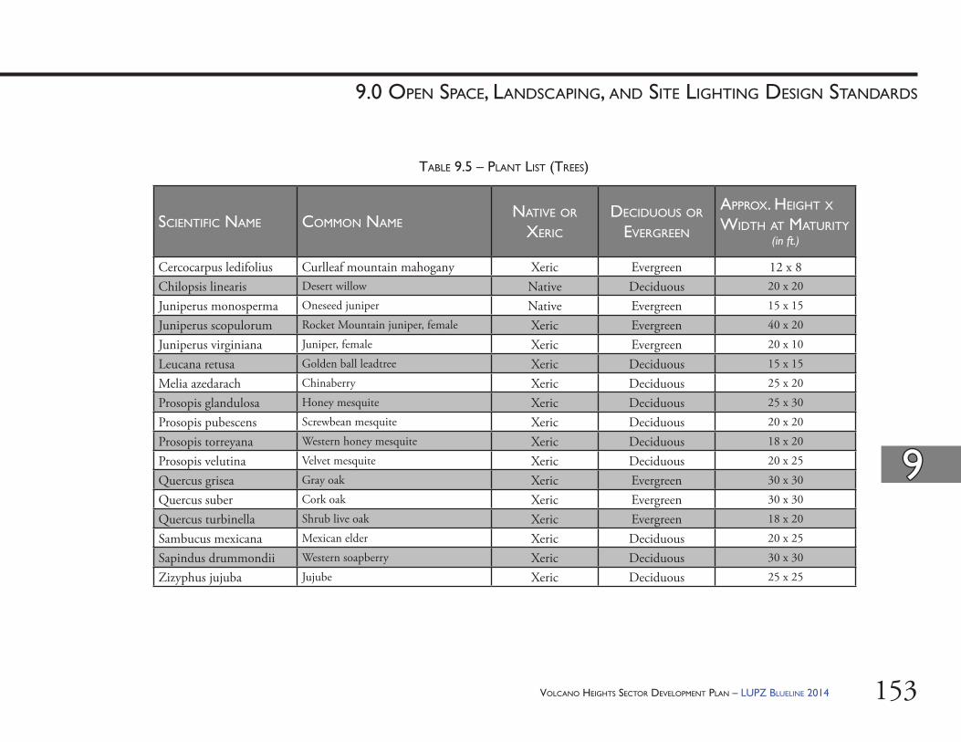
VOLCANO HEIGHTS SECTOR DEVELOPMENT PLAN – LUPZ BLUELINE 2014 153
99
9.0 OPEN SPACE, LANDSCAPING, AND SITE LIGHTING DESIGN STANDARDS
SCIENTIFIC NAME COMMON NAMENATIVE OR
XERIC
DECIDUOUS OR EVERGREEN
APPROX. HEIGHT X WIDTH AT MATURITY
(in ft.)
Cercocarpus ledifolius Curlleaf mountain mahogany Xeric Evergreen 12 x 8Chilopsis linearis Desert willow Native Deciduous 20 x 20
Juniperus monosperma Oneseed juniper Native Evergreen 15 x 15
Juniperus scopulorum Rocket Mountain juniper, female Xeric Evergreen 40 x 20
Juniperus virginiana Juniper, female Xeric Evergreen 20 x 10
Leucana retusa Golden ball leadtree Xeric Deciduous 15 x 15
Melia azedarach Chinaberry Xeric Deciduous 25 x 20
Prosopis glandulosa Honey mesquite Xeric Deciduous 25 x 30
Prosopis pubescens Screwbean mesquite Xeric Deciduous 20 x 20
Prosopis torreyana Western honey mesquite Xeric Deciduous 18 x 20
Prosopis velutina Velvet mesquite Xeric Deciduous 20 x 25
Quercus grisea Gray oak Xeric Evergreen 30 x 30
Quercus suber Cork oak Xeric Evergreen 30 x 30
Quercus turbinella Shrub live oak Xeric Evergreen 18 x 20
Sambucus mexicana Mexican elder Xeric Deciduous 20 x 25
Sapindus drummondii Western soapberry Xeric Deciduous 30 x 30
Zizyphus jujuba Jujube Xeric Deciduous 25 x 25
TABLE 9.5 – PLANT LIST (TREES)
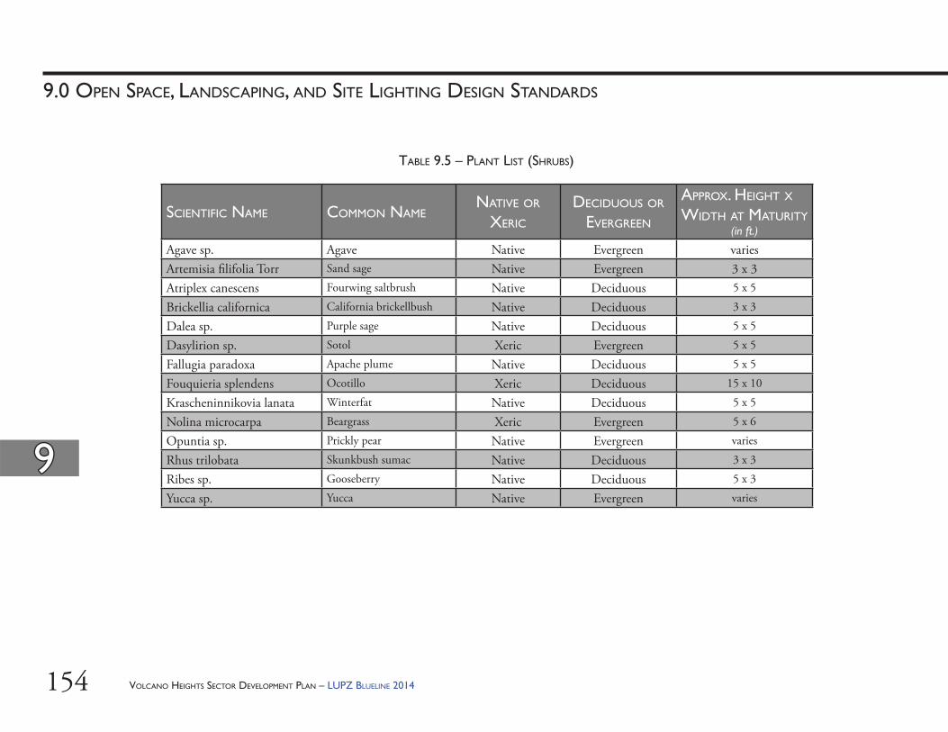
VOLCANO HEIGHTS SECTOR DEVELOPMENT PLAN – LUPZ BLUELINE 2014154
99
9.0 OPEN SPACE, LANDSCAPING, AND SITE LIGHTING DESIGN STANDARDS
SCIENTIFIC NAME COMMON NAMENATIVE OR
XERIC
DECIDUOUS OR EVERGREEN
APPROX. HEIGHT X WIDTH AT MATURITY
(in ft.)
Agave sp. Agave Native Evergreen variesArtemisia fi lifolia Torr Sand sage Native Evergreen 3 x 3Atriplex canescens Fourwing saltbrush Native Deciduous 5 x 5
Brickellia californica California brickellbush Native Deciduous 3 x 3
Dalea sp. Purple sage Native Deciduous 5 x 5
Dasylirion sp. Sotol Xeric Evergreen 5 x 5
Fallugia paradoxa Apache plume Native Deciduous 5 x 5
Fouquieria splendens Ocotillo Xeric Deciduous 15 x 10
Krascheninnikovia lanata Winterfat Native Deciduous 5 x 5
Nolina microcarpa Beargrass Xeric Evergreen 5 x 6
Opuntia sp. Prickly pear Native Evergreen varies
Rhus trilobata Skunkbush sumac Native Deciduous 3 x 3
Ribes sp. Gooseberry Native Deciduous 5 x 3
Yucca sp. Yucca Native Evergreen varies
TABLE 9.5 – PLANT LIST (SHRUBS)
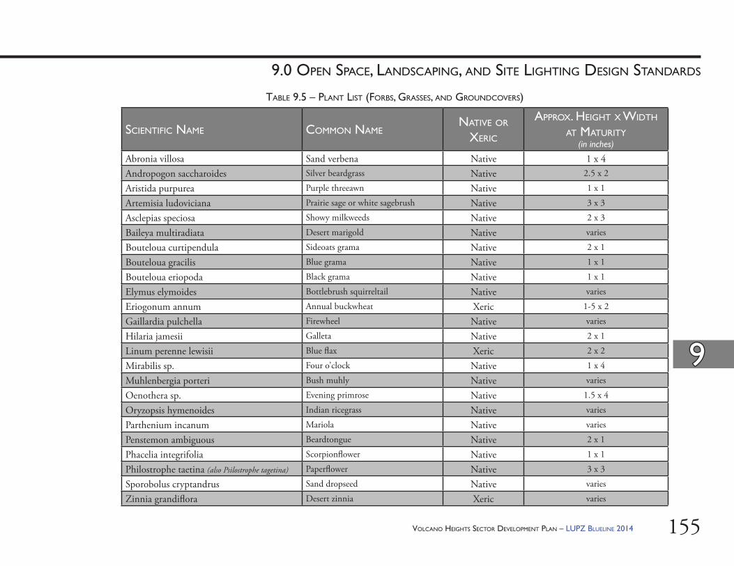
VOLCANO HEIGHTS SECTOR DEVELOPMENT PLAN – LUPZ BLUELINE 2014 155
99
9.0 OPEN SPACE, LANDSCAPING, AND SITE LIGHTING DESIGN STANDARDS
SCIENTIFIC NAME COMMON NAMENATIVE OR
XERIC
APPROX. HEIGHT X WIDTH AT MATURITY
(in inches)
Abronia villosa Sand verbena Native 1 x 4Andropogon saccharoides Silver beardgrass Native 2.5 x 2
Aristida purpurea Purple threeawn Native 1 x 1
Artemisia ludoviciana Prairie sage or white sagebrush Native 3 x 3
Asclepias speciosa Showy milkweeds Native 2 x 3
Baileya multiradiata Desert marigold Native varies
Bouteloua curtipendula Sideoats grama Native 2 x 1
Bouteloua gracilis Blue grama Native 1 x 1
Bouteloua eriopoda Black grama Native 1 x 1
Elymus elymoides Bottlebrush squirreltail Native varies
Eriogonum annum Annual buckwheat Xeric 1-5 x 2
Gaillardia pulchella Firewheel Native varies
Hilaria jamesii Galleta Native 2 x 1
Linum perenne lewisii Blue fl ax Xeric 2 x 2
Mirabilis sp. Four o’clock Native 1 x 4
Muhlenbergia porteri Bush muhly Native varies
Oenothera sp. Evening primrose Native 1.5 x 4
Oryzopsis hymenoides Indian ricegrass Native varies
Parthenium incanum Mariola Native varies
Penstemon ambiguous Beardtongue Native 2 x 1
Phacelia integrifolia Scorpionfl ower Native 1 x 1
Philostrophe taetina (also Psilostrophe tagetina) Paperfl ower Native 3 x 3
Sporobolus cryptandrus Sand dropseed Native varies
Zinnia grandifl ora Desert zinnia Xeric varies
TABLE 9.5 – PLANT LIST (FORBS, GRASSES, AND GROUNDCOVERS)
VOLCANO HEIGHTS SECTOR DEVELOPMENT PLAN – LUPZ BLUELINE 2014156
99
9.0 OPEN SPACE, LANDSCAPING, AND SITE LIGHTING DESIGN STANDARDS
e. Living Fence: A living fence shall be a minimum of three feet tall, which may include an earth berm, with vegetation dense and tall enough at maturity to provide suffi cient screening and/or sense of delineation. Appropriate species shall be selected from the Plant List in Table 9.5 starting on page 153. Additional low-water, non-invasive species may be used to supplement the living fence if approved by the Planning Director and City Open Space Division.
9.7.5. Pedestrian Walkways: In surface parking lots, pedestrian walkways shall not extend more than 75 feet without one of the following features to provide shade, spatial defi nition, and pedestrian-friendly amenities:(i) arcades, (ii) trellises, (iii) shade structures, and/or (iv) trees.
9.7.6. Gateway Monuments: Pillars or walls are permitted at entry points to neighborhoods and developments. Walls shall not be more than 12 feet long and conform with Section 9.7.4 in this Plan. Pillars shall not be more than 3 feet wide and 10 feet high. Pillars and walls shall be stucco, masonry, rammed earth, adobe, native stacked stone (or synthetic equivalent), or straw bale. Exposed plain block, of any color, is not allowed. Stucco and concrete shall have an integral color other than grey.
(ii) Adjacency to Monument and City Major Public Open Space: Properties abutting the Petroglyph National Monument and/or Major Public Open Space shall use coyote fencing, post and wire (not barbed), or view fencing. View fencing allows for a general sense of openness, visual transparency, and passive surveillance, while still maintaining perimeter security.
(iii) Design & Prohibited Materials: Wood board, cyclone, chain link, and barbed and/or razor wire and/or tape fencing are prohibited except at public utility structures. Th e end of walls shall have a pier or pilaster at least 12 inches wide to give a substantial appearance. Use of block to create patterns is encouraged.a. Perimeter Walls: Exposed plain block,
including all colors, is not allowed on walls visible from or adjacent to the public ROW, private open space, or private or public parks.
b. Site Walls: Block walls not visible from or adjacent to the public ROW, private open space or Major Public Open Space, or private or public parks must have integral color (i.e. plain, grey cement blocks are prohibited).
c. Color: In order to assure durability and minimize the visual impact of development, stucco and concrete shall have an integral color with a “light refl ective value” (LRV) rating within the range of 20-50 percent [See Exhibit 7.1 on page 127.]
d. Screen Walls: See Section 6.8. Street Screens starting on page 122.
VOLCANO HEIGHTS SECTOR DEVELOPMENT PLAN – LUPZ BLUELINE 2014 157
99
9.0 OPEN SPACE, LANDSCAPING, AND SITE LIGHTING DESIGN STANDARDS
(iv) Materials and treatments used for rainwater management shall be natural in appearance. Channels lined by concrete or rip-rap are prohibited, unless necessary for public safety.
(v) Th e potential impacts of water retention shall be thoroughly studied prior to use of detention areas to control fl ows.
(vi) Fencing of detention ponds shall be avoided. Th e bottom slopes of detention basins shall be designed for safety. In addition, a hydrological study and design may be required of new development by the City of Albuquerque to identify appropriate rainwater detention and energy dissipation features.
(vii) Within large unbuilt areas, developed fl ows shall be modifi ed through check dams or other means to approximate undeveloped fl ows to minimize impacts on the Escarpment and to minimize the intensity of channel treatment required. Th e impact of check dams as a method of controlling fl ows shall be thoroughly studied prior to their use.
(viii) Developed fl ows shall be managed to minimize their impact on Major Public Open Space, Northern Geologic Window, archeological sites, and the Escarpment.
(ix) Developed fl ows into the Petroglyph National Monument shall not be permitted in excess of, or more concentrated than, natural fl ows and shall require approval by City Open Space Division in coordination with the National Park Service.
9.7.7. Rainwater Quality and Management(i) Sites shall be required to retain the fi rst
fl ush storm event. It may be possible to employ a regional solution.
(ii) All new developments shall incorporate water harvesting methods to supplement landscape irrigation. Water harvesting shall capture the fi rst 1/2-inch of rainfall. Parking surfaces and other impermeable surfaces shall route rainwater through water harvesting areas on-site with 5% grade or less. [See also Section 6.8.9 starting on page 123 for screening requirements.]
(iii) Where appropriate, development projects shall incorporate unobtrusive rainwater features that facilitate the detention and infi ltration of rainwater and the fi ltration of pollutants from urban run-off . [See also policies in Section 13.5.3 starting on page 242.] At all densities and intensities, appropriate techniques include:a. permeable pavers & concrete,b. infi ltration beds placed below paved
areas,c. stone-fi lled reservoirs and dry-wells, d. roof storage systems & cisterns
designed with materials allowed by this Plan,
e. small “rain gardens” (low-lying with moisture-tolerant grasses, wildfl owers, shrubs, and trees), and
f. vegetated swales (in courtyards, street medians, and landscape strips).
VOLCANO HEIGHTS SECTOR DEVELOPMENT PLAN – LUPZ BLUELINE 2014158
99
9.0 OPEN SPACE, LANDSCAPING, AND SITE LIGHTING DESIGN STANDARDS
d. Protection of canyons from erosion through control of developed fl ows and through stabilization techniques that are consistent with the visual character of the open space.
9.7.9. Plant Lists(i) Purpose/Intent: Th e purpose of regulating plants
is to reduce water use, maintain the character of native plants now existing in the Petroglyph National Monument, and provide a harmonious landscape.
(ii) Landscaping: Appropriate plants shall be chosen from the Plant List in Table 9.5 for landscaping within the Plan area. Shrubs and trees shall be nursery grown in order to minimize poaching from the Monument and Major Public Open Space. a. Native Species Requirement: Within 200 feet
of the Petroglyph National Monument or other Major Public Open Space, only plants and trees listed as native in the Plant List in Table 9.5 shall be used in order to limit impact of invasive and/or non-native plants on native vegetation, except for street trees. [See Section 11.3.5 starting on page 208. for details about street trees.] Native plant species were selected from a list compiled during an inventory within the Petroglyph National Monument by the National Park Service in 1994-1995, including almost 200 plants (amended).
b. Plant List Requirement: Two-hundred (200) feet or more from the Petroglyph National Monument or other Major Public Open Space, any plant from the Plant List in Table 9.5 may be used. In addition to species native to the Petroglyph National Monument, additional plant species were selected from the offi cial xeric or low-water use plant list of the Albuquerque Bernalillo County Water Utility Authority (ABCWUA).
(iii) Streetscaping: See Section 11.3.5 starting on page 208.
(iv) Construc on Mi ga on: Land disturbed in development shall be re-vegetated using either native or xeric plants as appropriate from the Plant List in Table 9.5. [See also Section 6.6 starting on page 117.]
(x) Developments that propose more than 4 feet of fi ll shall be required to go through the DRB for approval and require sign-off from the City Hydrologist.
(xi) All developments within the Impact Area as defi ned by the NWMEP shall be required to go through the DRB for approval and require sign-off from the City hydrologist.
9.7.8. Channel Design(i) Purpose/Intent: Improved naturalistic
channel design shall retain as much undisturbed desert vegetation and rock formations insofar as practicable.
(ii) Channel Treatments: Shall meet the following requirements:a. Limited stabilization of natural
channels, according to the policies contained in the City of Albuquerque Facility Plan for Arroyos, unless such treatment is determined to be infeasible by the City Hydrologist or the Albuquerque Metropolitan Area Flood Control Authority (AMAFCA) as appropriate.
b. Use of many small, unobtrusive structures, such as check dams or small drop structures, rather than larger, more obtrusive structures, when structural solutions are required.
c. Use of materials in treated channels that blend visually with the Escarpment and adjacent open space. Naturalistic treatments are the preferred treatment types.
VOLCANO HEIGHTS SECTOR DEVELOPMENT PLAN – LUPZ BLUELINE 2014 159
99
9.0 OPEN SPACE, LANDSCAPING, AND SITE LIGHTING DESIGN STANDARDS
9.8. Site Ligh ng Standards9.8.1. Lighting shall have a cut-off angle that directs
light downward and only toward the property on which the light source is located, per the New Mexico Night Sky Ordinance [74-12-1 to 74-12-10 NMSA 1978]. Light fi xtures shall be of a type that throws light downward and have baffl es, hoods or diff users so that no light point source shall be visible from a distance greater than 1,000 feet. On-site light poles shall not exceed a height of 16 feet. High-intensity discharge lamps and sodium lamps shall not be used.
9.8.2. All new developments shall provide pedestrian-scaled streetlights. [See Section 11.4 starting on page 209.]
9.8.3. Shoe box style lighting shall not be used, except in large parking areas. Metal halide lights are encouraged. High pressure sodium lights are discouraged since they visually render all colors the same.

VOLCANO HEIGHTS SECTOR DEVELOPMENT PLAN – LUPZ BLUELINE 2014160
Th is Page Left Intentionally Blank
VOLCANO HEIGHTS SECTOR DEVELOPMENT PLAN – LUPZ BLUELINE 2014 161
street and streetscape standardsChapter III

VOLCANO HEIGHTS SECTOR DEVELOPMENT PLAN – LUPZ BLUELINE 2014162
Th is Page Left Intentionally Blank
VOLCANO HEIGHTS SECTOR DEVELOPMENT PLAN – LUPZ BLUELINE 2014 163
10.0 STREET STANDARDS
CHAPTER III: STREET AND STREETSCAPE STANDARDS
RR
VOLCANO HEIGHTS SECTOR DEVELOPMENT PLAN – LUPZ BLUELINE 2014164
1010
10.0 STREET STANDARDS
CHAPTER III: STREET AND STREETSCAPE STANDARDS
(i) Any adjustments needed that exceed these thresholds, including the following, will require EPC approval to ensure the Plan’s intent and purpose are still met with the proposed changes:a. Eliminating a street cross section
element and/orb. Adjusting a dimension beyond the
20% that DRB can grant.(ii) Changes to a Primary Street cross section
may only be due to utility use, drainage requirement, engineering for safety, or to respond to site context.
(iii) Th e applicant is to provide engineering drawings demonstrating the need for an adjustment to the street cross section and proposing an improved cross section that works for the project site and adjacent sites, while still meeting the intent of this Plan.
10.2.6. Maintenance of all streetscape is to be per City Code of Ordinances Chapter 6, Article 5. [See Section 13.3.13 starting on page 236 for policies relating to roles and responsibilities for maintenance.]
10.3. How to Use These Standards10.3.1. Cross Sec ons: Th e cross sections in Volcano
Heights are designed to accommodate all modes of transportation safely, with a special emphasis on creating a high-quality pedestrian environment that can contribute to the success of the Major Activity Center. For this reason, travel lane widths are minimized to help calm traffi c and reduce crossing distances for pedestrians. Travel lanes where transit is anticipated are planned for 12 feet wide.
10.1. Purpose/ Intent: Streets in Volcano Heights need to support the overall intent and character of each corridor. Th ey should balance all forms of mobility while maximizing convenience for residents and visitors. Streets are also used to convey drainage and support water harvesting. Auto-oriented streets serve more regional trips as well as providing access for service, trucking, and maintenance for non-residential uses.
10.2. Applicability: Street and streetscape standards apply to all streets and development within Volcano Heights. 10.2.1. Streets within Volcano Heights are to be designed
and constructed per the standards in this Plan. 10.2.2. Bicycle facilities, including on-street bicycle
lanes and multi-use trails, should be designed and developed to meet safety considerations as provided in the Institute for Transportation Engineers (ITE) or American Association of State Highway Transportation Offi cials (AASHTO) standards. [15]
10.2.3. Streetscape standards address all elements between the building face and edge of the curb. Typical streetscape elements addressed are street trees, lighting, street furniture and pedestrian amenities, and materials.
10.2.4. Street cross sections have been carefully designed to work with frontage requirements in the Site Development Standards for each character zone in order to provide a consistent, predictable built environment along corridors, across property lines, and over time.
10.2.5. Th ese standards may be adjusted by the DRB per the thresholds and criteria specifi ed in Table 10.1 on page 168.
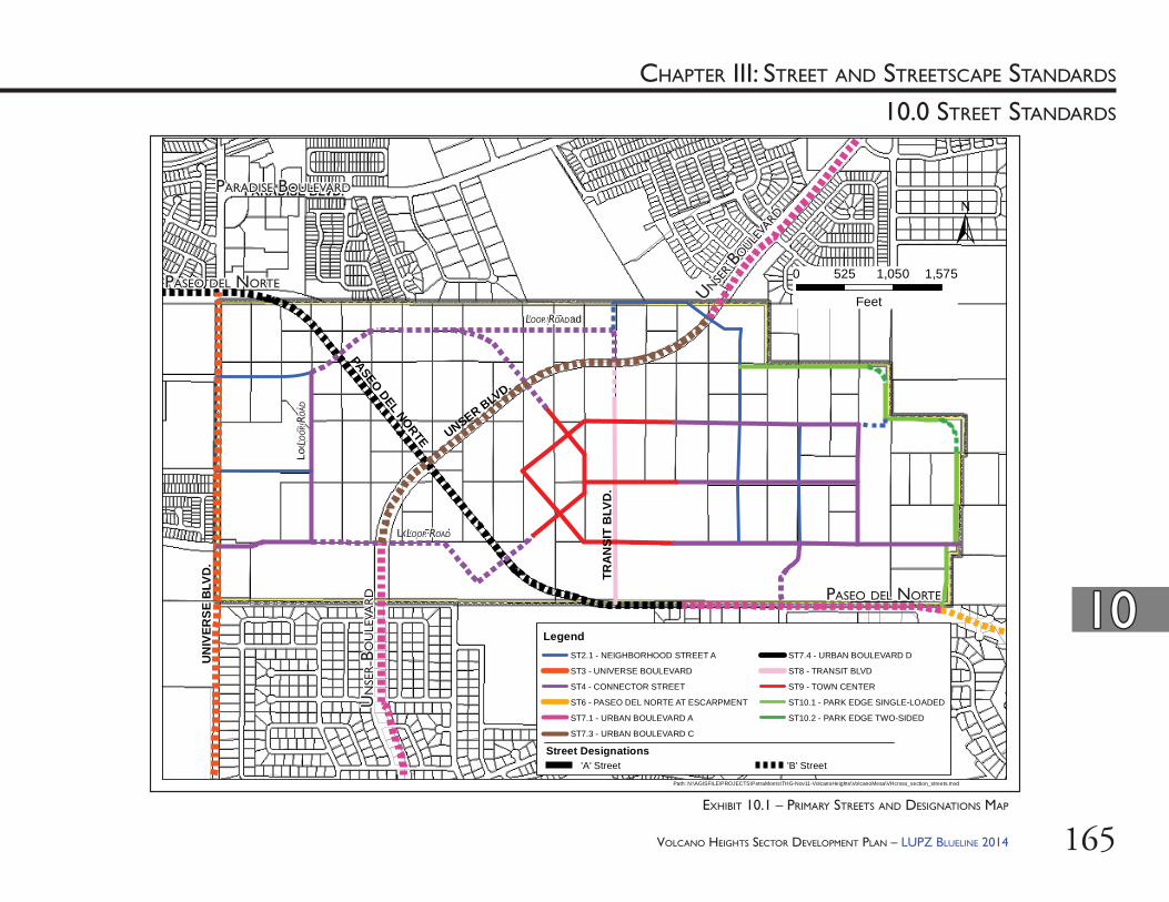
VOLCANO HEIGHTS SECTOR DEVELOPMENT PLAN – LUPZ BLUELINE 2014 165
1010
10.0 STREET STANDARDS
CHAPTER III: STREET AND STREETSCAPE STANDARDS
UNSER BLVD.
PASEO DEL NORTE
UN
IVER
SE B
LVD
.
TRA
NSI
T B
LVD
.
PARADISE BLVD.
0 525 1,050 1,575
Feet
Path: N:\AGISFILE\PROJECTS\PetraMorris\THG-Nov11-VolcanoHeights\VolcanoMesa\VHcross_section_streets.mxd
'A' Street 'B' StreetStreet Designations
LegendST2.1 - NEIGHBORHOOD STREET A
ST3 - UNIVERSE BOULEVARD
ST4 - CONNECTOR STREET
ST6 - PASEO DEL NORTE AT ESCARPMENT
ST7.1 - URBAN BOULEVARD A
ST7.3 - URBAN BOULEVARD C
ST7.4 - URBAN BOULEVARD D
ST8 - TRANSIT BLVD
ST9 - TOWN CENTER
ST10.1 - PARK EDGE SINGLE-LOADED
ST10.2 - PARK EDGE TWO-SIDED
Loop Road
Loop Road
Loop
Roa
d
EXHIBIT 10.1 – PRIMARY STREETS AND DESIGNATIONS MAP
PASEO DEL NORTEPASEO DEL NORTE
UN
SER B
OU
LEVA
RD
UN
SER B
OU
LEVA
RD
PARADISE BOULEVARDPARADISE BOULEVARD
PASEO DEL NORTEPASEO DEL NORTE
UNSER B
OULE
VARD
UNSER B
OULE
VARD
LOOP ROADLOOP ROAD
LOOP ROADLOOP ROAD
LOO
P RO
ADLO
OP R
OAD
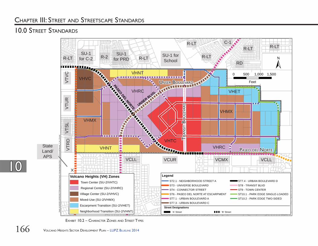
VOLCANO HEIGHTS SECTOR DEVELOPMENT PLAN – LUPZ BLUELINE 2014166
1010
10.0 STREET STANDARDS
CHAPTER III: STREET AND STREETSCAPE STANDARDS
EXHIBIT 10.2 – CHARACTER ZONES AND STREET TYPES
UNSER BLVD.
PASEO DEL NORTE
0 500 1,000 1,500
Feet
Path
: N:\A
GIS
FILE
\PR
OJE
CTS
\Pet
raM
orris
\TH
G-N
ov11
-Vol
cano
Hei
ghts
\JU
LY_2
013\
Zone
s&S
treet
s_7_
24_1
3.m
xd
Volcano Heights (VH) Zones Town Center (SU-2/VHTC)
Regional Center (SU-2/VHRC)
Village Center (SU-2/VHVC)
Mixed-Use (SU-2/VHMX)
Escarpment Transition (SU-2/VHET)
Neighborhood Transition (SU-2/VHNT)
LegendST2.1 - NEIGHBORHOOD STREET AST3 - UNIVERSE BOULEVARDST4 - CONNECTOR STREETST6 - PASEO DEL NORTE AT ESCARPMENTST7.1 - URBAN BOULEVARD A ST7.3 - URBAN BOULEVARD C
ST7.4 - URBAN BOULEVARD DST8 - TRANSIT BLVDST9 - TOWN CENTERST10.1 - PARK EDGE SINGLE-LOADEDST10.2 - PARK EDGE TWO-SIDED
'A' Street 'B' Street
Street Designations
SU-1 for C-2 R-2 R-LT
SU-1 for PRD
SU-1 for School
R-LT
R-LT
C-1R-LT R-LT
RD
VCMXVCLL VCUR
VTU
RV
TVC
VTS
LV
TRD
State Land/APS
PASEO DEL NORTEPASEO DEL NORTE
UNSER BOULEVARDUNSER BOULEVARD
TR
AN
SIT B
OU
LEVA
RD
TR
AN
SIT B
OU
LEVA
RD
R-LT
VCLL
X
VHMX
VHVC
VHNT
VHNT
VHET
VHTC
VHRC
VHMX
VHRC
VOLCANO HEIGHTS SECTOR DEVELOPMENT PLAN – LUPZ BLUELINE 2014 167
1010
10.0 STREET STANDARDS
CHAPTER III: STREET AND STREETSCAPE STANDARDS
(ii) See Table 10.1 for allowable adjustments to the Primary Street standards. Adjustments should be considered carefully to ensure that the intended character of each street type is maintained or enhanced.
(iii) See Section 10.5.4 starting on page 172 for more on intersection design.
10.3.3. Secondary Streets: Th is Plan specifi es standards for all new local streets in Volcano Heights in Section 10.7 starting on page 199. Th e platting and construction of new streets will be addressed on a project-by-project basis and reviewed by the City Department of Municipal Development (DMD) the City Engineer and/or other agencies or sections, as relevant. [4]
10.3.2. Primary Streets: Th e character of streets in Volcano Heights will vary based on location. Th e Primary Streets and Designations Map [see Exhibit 10.1] illustrates the street network within the Plan area. Street alignments as shown coincide with the existing 20-foot access easement on the edge of each parcel wherever possible. Section 10.6 starting on page 173 includes cross sections for the typical confi guration of each Primary Street type. Th e specifi cations address vehicular lane width, parkway widths, ROW widths, number of travel lanes, on-street parking, and pedestrian accommodation. (i) Cross sections for each type of Primary
Street depict specifi c elements and associated dimensions. Th e arrangement of these elements may change to suit local conditions, particularly when a Primary Street is intended for Bus Rapid Transit (BRT). Th e fi nal location of these lanes — whether the BRT will run in the median, the outside, or the inside lanes, or a combination of the above based on adjacent land uses, ROW, etc. — will be determined during the road design process. Similarly, the fi nal location of the multi-use trail required along Paseo del Norte and Unser Boulevard will be determined in coordination with City Parks and Recreation. Trails should be situated to provide the best pedestrian access to the Town Center area. Intersections should be carefully planned and designed to facilitate connections to surrounding areas. [3]
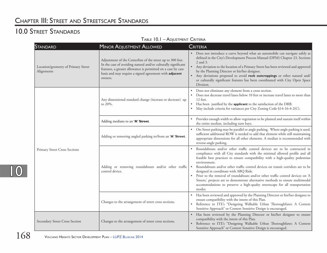
VOLCANO HEIGHTS SECTOR DEVELOPMENT PLAN – LUPZ BLUELINE 2014168
1010
10.0 STREET STANDARDS
CHAPTER III: STREET AND STREETSCAPE STANDARDS
STANDARD MINOR ADJUSTMENT ALLOWED CRITERIA
Location/geometry of Primary Street Alignments
Adjustment of the Centerline of the street up to 300 feet. In the case of avoiding natural and/or culturally signifi cant features, a greater allowance is permitted on a case by case basis and may require a signed agreement with adjacent owners.
• Does not introduce a curve beyond what an automobile can navigate safely as defi ned in the City’s Development Process Manual (DPM) Chapter 23, Sections 2 and 3.
• Any deviation to the location of a Primary Street has been reviewed and approved by the Planning Director or his/her designee.
• Any deviations proposed to avoid rock outcroppings or other natural and/or culturally signifi cant features has been coordinated with City Open Space Division.
Primary Street Cross Sections
Any dimensional standard change (increase or decrease) up to 20%.
• Does not eliminate any element from a cross section.• Does not decrease travel lanes below 10 feet or increase travel lanes to more than
12 feet.• Has been justifi ed by the applicant to the satisfaction of the DRB.• May include criteria for variances per City Zoning Code §14-16-4-2(C).
Adding medians to an ‘A’ Street. • Provides enough width to allow vegetation to be planted and sustain itself within the entire median, including turn bays.
Adding or removing angled parking to/from an ‘A’ Street.
• On-Street parking may be parallel or angle parking. Where angle parking is used, suffi cient additional ROW is needed to add that element while still maintaining appropriate dimensions for all other elements. A median is recommended with reverse-angle parking.
Adding or removing roundabouts and/or other traffi c control device.
• Roundabouts and/or other traffi c control devices are to be contructed in compliance with all City standards with the minimal allowed profi le and all feasible best practices to ensure compatibility with a high-quality pedestrian environment.
• Roundabouts and/or other traffi c control devices on transit corridors are to be designed in coordinate with ABQ Ride.
• Prior to the removal of roundabouts and/or other traffi c control devices on ‘A Streets,’ projects are to demonstrate alternative methods to ensure multimodal accommodations to preserve a high-qualty streetscape for all transportation modes.
Changes to the arrangement of street cross sections.
• Has been reviewed and approved by the Planning Director or his/her designee to ensure compatibility with the intent of this Plan.
• Reference to ITE’s “Designing Walkable Urban Th oroughfares: A Context Sensitive Approach” or Context Sensitive Design is encouraged.
Secondary Street Cross Section Changes to the arrangement of street cross sections.
• Has been reviewed by the Planning Director or his/her designee to ensure compatibility with the intent of this Plan.
• Reference to ITE’s “Designing Walkable Urban Th oroughfares: A Context Sensitive Approach” or Context Sensitive Design is encouraged.
TABLE 10.1 – ADJUSTMENT CRITERIA
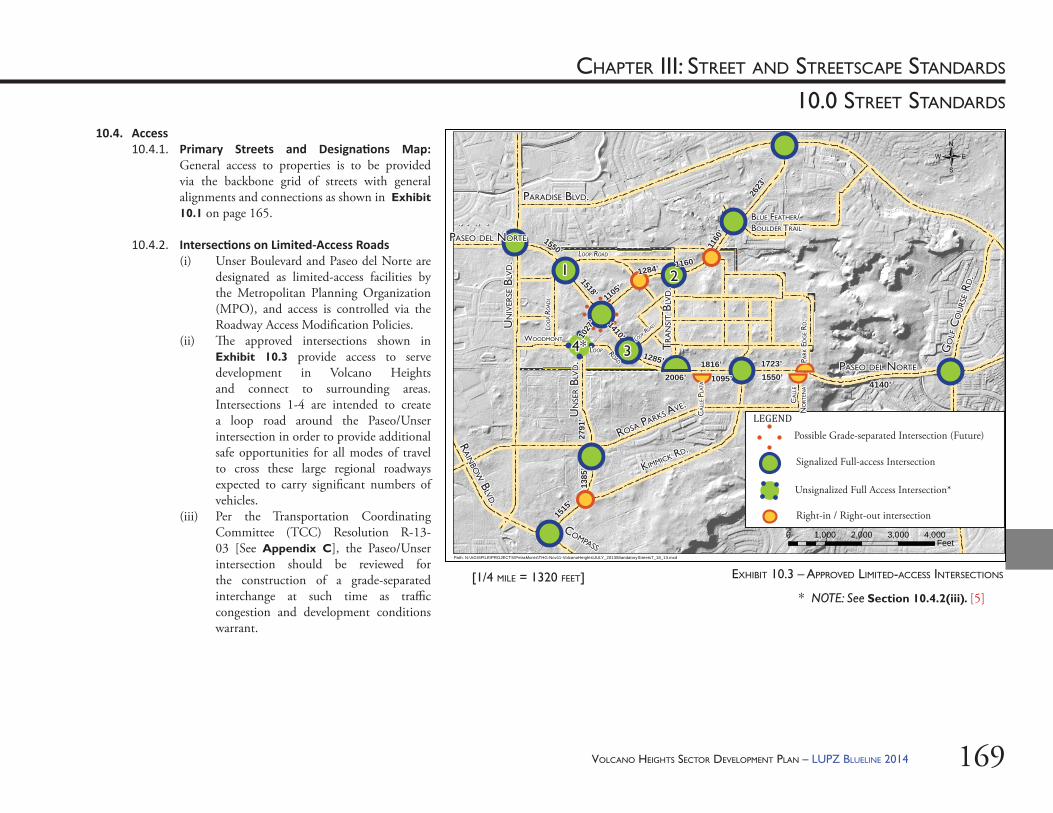
VOLCANO HEIGHTS SECTOR DEVELOPMENT PLAN – LUPZ BLUELINE 2014 169
10.0 STREET STANDARDS
CHAPTER III: STREET AND STREETSCAPE STANDARDS
* NOTE: See Section 10.4.2(iii). [5]
10.4. Access10.4.1. Primary Streets and Designa ons Map:
General access to properties is to be provided via the backbone grid of streets with general alignments and connections as shown in Exhibit 10.1 on page 165.
10.4.2. Intersec ons on Limited-Access Roads(i) Unser Boulevard and Paseo del Norte are
designated as limited-access facilities by the Metropolitan Planning Organization (MPO), and access is controlled via the Roadway Access Modifi cation Policies.
(ii) Th e approved intersections shown in Exhibit 10.3 provide access to serve development in Volcano Heights and connect to surrounding areas. Intersections 1-4 are intended to create a loop road around the Paseo/Unser intersection in order to provide additional safe opportunities for all modes of travel to cross these large regional roadways expected to carry signifi cant numbers of vehicles.
(iii) Per the Transportation Coordinating Committee (TCC) Resolution R-13-03 [See Appendix C], the Paseo/Unser intersection should be reviewed for the construction of a grade-separated interchange at such time as traffi c congestion and development conditions warrant.
EXHIBIT 10.3 – APPROVED LIMITED-ACCESS INTERSECTIONS
/
0 1,000 2,000 3,000 4,000Feet
Path: N:\AGISFILE\PROJECTS\PetraMorris\THG-Nov11-VolcanoHeights\JULY_2013\MandatoryStreets7_18_13.mxd
TR
AN
SIT B
LVD.
TR
AN
SIT B
LVD.
[1/4 MILE = 1320 FEET]
PASEO DEL NORTEPASEO DEL NORTE
GO
LF C
OU
RSE R
D.
GO
LF C
OU
RSE R
D.
KIMMICK RD.
KIMMICK RD.
UN
IVER
SE B
LVD.
UN
IVER
SE B
LVD.
PARADISE BLVD.PARADISE BLVD.
RAIN
BOW
BLVD.
RAIN
BOW
BLVD.
UN
SER B
LVD.
UN
SER B
LVD.
PASEO DEL NORTEPASEO DEL NORTE
WOODMONTWOODMONT
ROSA PARKS AVE.
ROSA PARKS AVE.
COMPASS
COMPASS
BLUE FEATHER/BLUE FEATHER/BOULDER TRAILBOULDER TRAIL
Unsignalized Full Access Intersection*
LEGEND
Signalized Full-access Intersection
Right-in / Right-out intersection
Possible Grade-separated Intersection (Future)
1550’1550’
1410’1410’
1285’1285’ 1816’1816’
1105’1105’
1284’1284’ 1160’1160’
1027
’10
27’
1518’1518’
1160
’11
60’
2791
’27
91’
1723’1723’
1095’1095’2006’2006’
2623
’26
23’
1550’1550’
1385
’13
85’
1515
’15
15’
11 22
334*4*
PARK
ED
GE R
D.
PARK
ED
GE R
D.
CA
LLE P
LATA
CA
LLE P
LATA
CA
LLE
CA
LLE
NO
RTEN
AN
ORT
ENA 4140’4140’
LOOP ROADLOOP ROAD
LOO
P RO
ADL
LOO
P RO
ADL
LOOPLOOP ROADROAD
LOOP ROAD
LOOP ROAD
VOLCANO HEIGHTS SECTOR DEVELOPMENT PLAN – LUPZ BLUELINE 2014170
1010
10.0 STREET STANDARDS
CHAPTER III: STREET AND STREETSCAPE STANDARDS
10.4.3. Access to Proper es(i) As envisioned in this Plan, the Primary
Street grid respects the purpose of limited-access roadways as regional thoroughfares and eliminates the need for individual curb cuts for developments along these corridors. Each access point on Unser Boulevard or Paseo del Norte connects to a Primary Street to provide general access to local development. For individual developments, further access is to be provided via Secondary Streets as necessary. Th e planned grid provides coordinated access to properties in the Plan area and connections to Volcano Trails to the west and Volcano Cliff s to the south. Together with intersections on the limited-access roadways, planned streets in Volcano Heights create a walkable, urban district with a high degree of connectivity for all modes of transportation.
(ii) Th e provision of Primary and Secondary Streets using the appropriate cross sections as shown in this Plan (See Exhibit 10.1 on page 165) will occur via the City development review process. Streets will only be required to be constructed to serve projects at the time of their development.
Until this time, the intersection should be constructed as a traditional at-grade, signalized intersection. At such time as a grade-separated interchange is recommended by the TCC, it should be designed to complement this urban, multimodal area and minimize negative impacts to the surrounding land uses, trails, and sensitive lands. [See also Section 13.3.1 starting on page 229.]
(iv) Intersection #4 is to be unsignalized until such time as Paseo del Norte/Unser Boulevard intersection becomes grade-separated, at which time #4 may be signalized.
(v) Th e intersection at the southern terminus of the Transit Boulevard is approved for a “high T-intersection,” which, to the extent practical, preserves the eastbound through free-fl ow movement on Paseo del Norte with a dedicated eastbound to northbound left-turn lane and a southbound to eastbound left-turn lane combined with an eastbound merge lane, in order to minimize traffi c signal phasing and cycle length and to minimize red-signal time for Paseo del Norte. Until such time as Paseo del Norte is constructed to a four or six lane facility and the “High-T” intersection is constructed, the intersection may be constructed as a traditional at-grade, signalized intersection.
VOLCANO HEIGHTS SECTOR DEVELOPMENT PLAN – LUPZ BLUELINE 2014 171
1010
10.0 STREET STANDARDS
CHAPTER III: STREET AND STREETSCAPE STANDARDS
b. DRB-approved Site Plan for Subdivision that includes such streets as well as letter(s) of cross access easement and construction approval among aff ected property owners.
[See Transportation Policies in Section 13.3 starting on page 226. ]
10.5. Street Designa ons: Th e following street designations are established for all streets within the Plan area.
10.5.1. ‘A’ Streets: ‘A’ Streets are intended to provide the most pedestrian-friendly development context. Buildings along ‘A’ Streets should be held to the highest standard of pedestrian-oriented design. Th ese streets are the main connectors for local development and adjacent neighborhoods.(i) Curb cuts are not allowed on ‘A’ Streets,
except for porte cochere entries for hotels or other substantial uses, per the discretion of the Planning Director or his/her designee.
(ii) Development on ‘A’ Streets may incorporate a parking court, surrounded on three sides by the development, served via one-way access, and with dimensions not to exceed 110 feet wide and 150 feet deep.
(iii) In order to provide pedestrian connectivity where blocks are more than 300 feet long, pedestrian walkways are to be provided every 300-500 feet. Th ese walkways count toward usable open space requirements per Section 9.5 starting on page 144 of this Plan.
(iii) Roads are to follow the recommended Primary Street alignments where possible, as shown in Exhibit 10.3 on page 169. Where Primary Street alignments are infeasible or unhelpful to serve new development, new street alignments should be planned to provide the most direct path between the subject property and either an existing street or approved access point along Paseo del Norte and Unser Boulevard following existing 20-foot access easements around property edges wherever possible.
(iv) In order to allow for more rapid advancement to full development conditions, property owners are encouraged to coordinate to plan alignments and share the cost of infrastructure in whatever manner they deem fair.
(v) Although outside the purview of this Plan, property owners should consider infrastructure fi nancing tools (e.g. PID, TIDD, etc.) as mechanisms to pool costs and coordinate development, particularly utilities and other infrastructure to be constructed along roadway alignments.
(vi) Suffi cient documentation of coordination and agreement among all aff ected property owners adjacent to new streets is required prior to the issuance of permits. Suffi cient documentation includes but is not limited to:a. Council-approved TIDD, SAD, or
PID that includes such streets and/or
172
1010
10.0 STREET STANDARDS
CHAPTER III: STREET AND STREETSCAPE STANDARDS
10.5.4. Intersec on Design (i) Mul modal Accommoda on:
Intersections are to designed and constructed to accommodate safe crossing for all modes of transportation.
(ii) Signal Warrants: Th e determination of where and when traffi c signals and/or roundabouts are to be installed is based upon the evaluation of traffi c conditions at an intersection in accordance with the warrants contained within the Manual for Uniform Traffi c Control Devices (MUTCD).
(iii) Development Review: Intersection design and cross section confi guration surrounding intersections shall be subject to judgment of the City Engineer and/or the Department of Municipal Development to ensure safety and appropriate connectivity.
(iv) In order to support their purpose as pedestrian and cyclist-friendly corridors as well as supportive of retail and neighborhood services, ‘A’ Streets are to be engineered for speeds within 5 miles per hour of posted speeds.
(i) Addi onal ‘A’ Street standards are included in Section 10.6 for Primary Streets, as well as Section 10.7.3 for Secondary Streets.
10.5.2. ‘B’ Streets: ‘B’ Streets are intended to accommodate more auto-oriented uses, surface parking, and service functions. Individual standards are included in Section 10.6.4 for Unser Boulevard, Section 10.6.5 for Paseo del Norte, and Section 10.7.5 for Secondary ‘B’ Streets.
10.5.3. Alleys: Alleys are an optional way to provide access for service and maintenance vehicles and access to parking areas for private vehicles while separating these vehicle uses from the public realm. Alleys can be either residential or commercial. (i) Typically narrower than ‘B’ Streets,
alleys can be a functional element within a commercial block and can provide a pleasant walking option in residential areas. [See more standards in Sections 10.7 and 11.0 Streetscape Standards in this Plan.]
(ii) See Section 13.3.13 starting on page 236 in this Plan for policies relating to roles and responsibilities for alley maintenance.
VOLCANO HEIGHTS SECTOR DEVELOPMENT PLAN – LUPZ BLUELINE 2014
VOLCANO HEIGHTS SECTOR DEVELOPMENT PLAN – LUPZ BLUELINE 2014 173
1010
10.0 STREET STANDARDS
CHAPTER III: STREET AND STREETSCAPE STANDARDS
(iv) Roundabouts: a. Excepting intersections on principal
arterials, roundabouts are to be considered for every location that meets or is anticipated to meet MUTCD criteria for a traffi c signal.
b. Th e criteria to be used for selecting a roundabout over other forms of intersection control such as signals or stop signs include, but are not limited to: safety, operational improvements, effi ciency, traffi c calming, construction and operating costs, right-of-way requirements, protection of sensitive lands, and community enhancement. [See also Section 13.3.11 starting on page 235.]
c. Roundabouts are the preferred design solution when rock outcroppings lie within a Primary Street corridor as shown in Exhibit 9.1 on page 147.
d. Roundabouts are be the preferred option for intersection control on all single-lane minor arterials and collectors. Th ey should also be considered as alternatives to signals on two-lane minor arterials.
e. All Traffi c Impact Studies should include a comparison of the theoretical intersection delay for a roundabout versus a signal at all warranted signal locations.
(v) Pedestrian and/or Cyclist Ac vated Signals: Safe multimodal access is key to the success of the Volcano Heights Major Activity Center. Pedestrian- and cyclist-activated signals should be considered where traffi c conditions warrant in order to provide safe crossing to land uses in the area.
10.5.5. Site Distance: Site distance requirements shall
follow current AASHTO standards.
10.5.6. Americans with Disability (ADA) Compliance: ADA guidelines shall govern minimum sidewalk widths to provide unobstructed passage from impedances, including but not limited to landscaping, street furniture, pedestrian amenities, utilities, signage, and grade changes.
10.6. Primary Street Cross Sec ons: Primary Streets are those whose alignments are shown in Exhibit 10.1 on page 165, which also designates ‘A’ vs. ‘B’ streets. Th e following cross sections for each Primary Street, together with frontage standards for each zone per Section 5.0 starting on page 77, are intended to create a predictable built environment along corridors, across property lines, and over time.
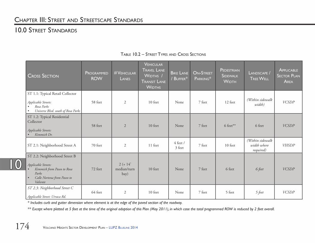
174
1010
10.0 STREET STANDARDS
CHAPTER III: STREET AND STREETSCAPE STANDARDS
CROSS SECTIONPROGRAMMED
ROW# VEHICULAR
LANES
VEHICULAR TRAVEL LANE WIDTHS /
TRANSIT LANE WIDTHS
BIKE LANE / BUFFER*
ON-STREET PARKING*
PEDESTRIAN SIDEWALK WIDTH
LANDSCAPE / TREE WELL
APPLICABLE SECTOR PLAN
AREA
ST 1.1: Typical Retail Collector
Applicable Streets:• Rosa Parks• Universe Blvd. south of Rosa Parks
58 feet 2 10 feet None 7 feet 12 feet (Within sidewalk width) VCSDP
ST 1.2: Typical Residential Collector
Applicable Streets:• Kimmick Dr.
58 feet 2 10 feet None 7 feet 6 feet** 6 feet VCSDP
ST 2.1: Neighborhood Street A 70 feet 2 11 feet 4 feet / 3 feet 7 feet 10 feet
(Within sidewalk width where
required)VHSDP
ST 2.2: Neighborhood Street B
Applicable Streets:• Kimmick from Paseo to Rosa
Parks• Calle Nortena from Paseo to
Valiente
72 feet2 (+ 14’
median/turn bay)
10 feet None 7 feet 6 feet 6 feet VCSDP
ST 2.3: Neighborhood Street C
Applicable Street: Urraca Rd.64 feet 2 10 feet None 7 feet 5 feet 5 feet VCSDP
* Includes curb and gutter dimension where element is at the edge of the paved section of the roadway.
** Except where platted at 5 feet at the time of the original adoption of this Plan (May 2011), in which case the total programmed ROW is reduced by 2 feet overall.
TABLE 10.2 – STREET TYPES AND CROSS SECTIONS
VOLCANO HEIGHTS SECTOR DEVELOPMENT PLAN – LUPZ BLUELINE 2014
175
1010
10.0 STREET STANDARDS
CHAPTER III: STREET AND STREETSCAPE STANDARDS
CROSS SECTIONPROGRAMMED
ROW# VEHICULAR
LANES
VEHICULAR TRAVEL LANE WIDTHS /
TRANSIT LANE WIDTHS
BIKE LANE / BUFFER*
ON-STREET PARKING*
PEDESTRIAN SIDEWALK WIDTH
LANDSCAPE / TREE WELL
APPLICABLE SECTOR PLAN
AREA
ST 3: Universe Blvd.Minor ArterialApplicable Street: Universe Blvd.
77 feet2 (+ 16’
median/center turn bay)
11 feet 5 feet None 7 feet 5 feet VCSDPVHSDP
ST 4: Connector Street 84 feet2
(+ 12’ median/turn bay)
10 feet 4 feet / 3 feet 7 feet 12 feet (optional within
sidewalk width) VHSDP
ST 5: Suburban Boulevard
Applicable Streets:• Unser Boulevard at Escarpment • Rainbow Boulevard
128 feet 4 11 feet 7 feet None 10 feet 10 feet VCSDP
ST 6: Paseo del Norte at Escarpment 135 feet 4 (+2 transit
lanes) 11 / 12 feet 9 feet None (See cross section) None VCSDP
VHSDP
* Includes curb and gutter dimension where element is at the edge of the paved section of the roadway.
TABLE 10.2 – STREET TYPES AND CROSS SECTIONS (Cont’d)
VOLCANO HEIGHTS SECTOR DEVELOPMENT PLAN – LUPZ BLUELINE 2014
176
1010
10.0 STREET STANDARDS
CHAPTER III: STREET AND STREETSCAPE STANDARDS
CROSS SECTIONPROGRAMMED
ROW# VEHICULAR
LANES
VEHICULAR TRAVEL LANE WIDTHS /
TRANSIT LANE WIDTHS
BIKE LANE / BUFFER*
ON-STREET PARKING*
PEDESTRIAN SIDEWALK WIDTH
LANDSCAPE / TREE WELL
APPLICABLE SECTOR PLAN
AREA
ST 7.1: Urban Boulevard A
Applicable Streets:• Paseo del Norte from Calle
Nortena to Kimmick • Unser Boulevard from southern
boundary of Volcano Cliff s to Escarpment
• Unser Boulevard from Kimmick to Woodmont
156 feet 4 (+ 50’ median) 11 feet 6 feet None 10 feet 10 feet VCSDP
ST 7.2: Urban Boulevard BApplicable Streets:• Unser Boulevard from Escarpment
to Kimmick
156 feet 4 (+36’ median) 12 feet 8 feet None None None VCSDP
ST 7.3: Urban Boulevard CApplicable Streets:• Unser Boulevard from Woodmont
to northernmost right-in/right-out in Volcano Heights
156 feet 4 (+2 slip lanes) 11 / 12 feet 4 feet /
2 feet None (See cross section) (See cross section) VHSDP
ST 7.4: Urban Boulevard D
Applicable Street: Paseo del Norte from Kimmick to western boundary of Volcano Trails
156 feet6
(+2 transit lanes)
11 / 12 feet 6 feet / 2 feet None 10 feet (Within sidewalk
width)VHSDPVTSDP
* Includes curb and gutter dimension where element is at the edge of the paved section of the roadway.
TABLE 10.2 – STREET TYPES AND CROSS SECTIONS (Cont’d)
VOLCANO HEIGHTS SECTOR DEVELOPMENT PLAN – LUPZ BLUELINE 2014
177
1010
10.0 STREET STANDARDS
CHAPTER III: STREET AND STREETSCAPE STANDARDS
CROSS SECTIONPROGRAMMED
ROW# VEHICULAR
LANES
VEHICULAR TRAVEL LANE WIDTHS /
TRANSIT LANE WIDTHS
BIKE LANE / BUFFER*
ON-STREET PARKING*
PEDESTRIAN SIDEWALK WIDTH
LANDSCAPE / TREE WELL
APPLICABLE SECTOR PLAN
AREA
ST 8: Transit Boulevard 120 feet2
(+2 transit lanes)
10 / 12 feet 4 feet / 3 feet 7 feet 12 feet 6 feet VHSDP
ST 9: Town Center 96 feet 2 11 feet 4 feet / 3 feet
18 feet (reverse-angle) 12 feet (Within sidewalk
width) VHSDP
ST 10.1: Park Edge – Single-loaded 76 feet
2 (+12’ median/
turn bay)11 feet 6.5 feet /
2.5 feet7 feet (one side only) 10 feet (Within sidewalk
width) VHSDP
ST 10.2: Park Edge – Double-loaded 70 feet 2 11 feet 4 feet / 3
feet 7 feet 10 feet (Within sidewalk width) VHSDP
ST 11: Local Street 52 feet 2 9 feet None 6 feet 6 feet** 5 feet VCSDP
* Includes curb and gutter dimension where element is at the edge of the paved section of the roadway.
TABLE 10.2 – STREET TYPES AND CROSS SECTIONS (Cont’d)
VOLCANO HEIGHTS SECTOR DEVELOPMENT PLAN – LUPZ BLUELINE 2014
178
1010
10.0 STREET STANDARDS
CHAPTER III: STREET AND STREETSCAPE STANDARDS
STREET TYPE 1.2 – TYPICAL RESIDENTIAL COLLECTOR (2 LANES)
STREET TYPE 1.1 – TYPICAL RETAIL COLLECTOR (2 LANES)
* Note: c/g stands for “curb and gutter”
ST 1.1: RETAIL COLLECTOR
ST 1.2: RESIDENTIAL COLLECTOR
[Note: Street Types 1.1 and 1.2 are not used within the Volcano Heights SDP]
VOLCANO HEIGHTS SECTOR DEVELOPMENT PLAN – LUPZ BLUELINE 2014
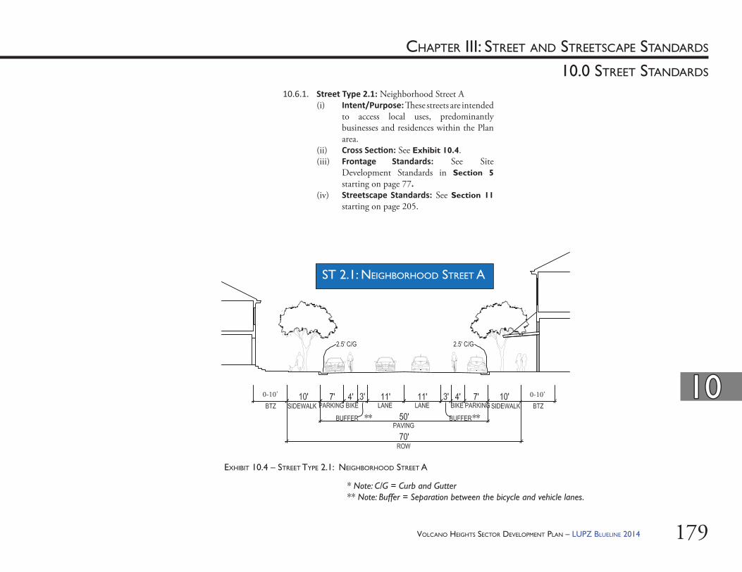
179
1010
10.0 STREET STANDARDS
CHAPTER III: STREET AND STREETSCAPE STANDARDS
EXHIBIT 10.4 – STREET TYPE 2.1: NEIGHBORHOOD STREET A
* Note: C/G = Curb and Gutter** Note: Buffer = Separation between the bicycle and vehicle lanes.
ST 2.1: NEIGHBORHOOD STREET A
0-10’ 0-10’
** **
10.6.1. Street Type 2.1: Neighborhood Street A(i) Intent/Purpose: Th ese streets are intended
to access local uses, predominantly businesses and residences within the Plan area.
(ii) Cross Sec on: See Exhibit 10.4. (iii) Frontage Standards: See Site
Development Standards in Section 5 starting on page 77.
(iv) Streetscape Standards: See Section 11 starting on page 205.
VOLCANO HEIGHTS SECTOR DEVELOPMENT PLAN – LUPZ BLUELINE 2014
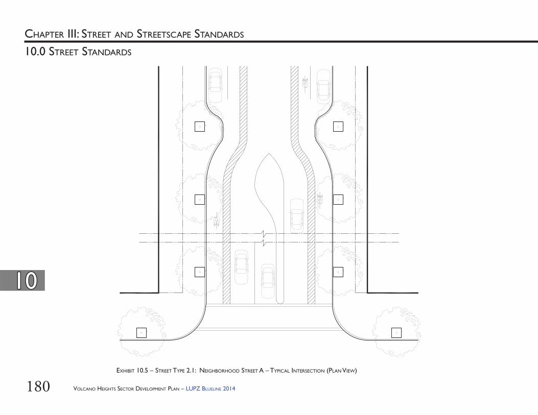
180
1010
10.0 STREET STANDARDS
CHAPTER III: STREET AND STREETSCAPE STANDARDS
EXHIBIT 10.5 – STREET TYPE 2.1: NEIGHBORHOOD STREET A – TYPICAL INTERSECTION (PLAN VIEW)
VOLCANO HEIGHTS SECTOR DEVELOPMENT PLAN – LUPZ BLUELINE 2014
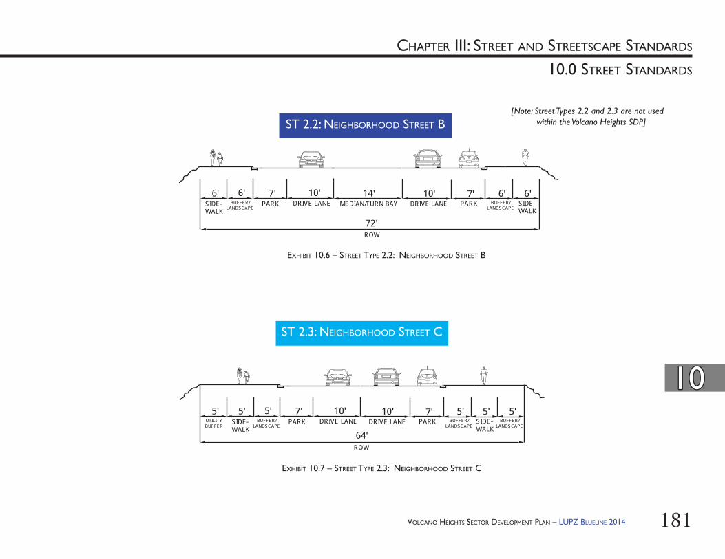
181
1010
10.0 STREET STANDARDS
CHAPTER III: STREET AND STREETSCAPE STANDARDS
EXHIBIT 10.6 – STREET TYPE 2.2: NEIGHBORHOOD STREET B
ST 2.2: NEIGHBORHOOD STREET B [Note: Street Types 2.2 and 2.3 are not used
within the Volcano Heights SDP]
EXHIBIT 10.7 – STREET TYPE 2.3: NEIGHBORHOOD STREET C
ST 2.3: NEIGHBORHOOD STREET C
SIDE-WALK
6' 10' 14'
ROW
10'
72'
6'BUFFER/
LANDSCAPEMEDIAN/TURN BAY DRIVE LANE
6' 6'7'PARK DRIVE LANE
7'PARK SIDE-
WALKBUFFER/
LANDSCAPE
SIDE-WALK
5' 10'
ROW
10'
64'
5'BUFFER/
LANDSCAPEDRIVE LANE
5' 5'7'PARK DRIVE LANE
7'PARK SIDE-
WALKBUFFER/
LANDSCAPE
5'5'UTILITYBUFFER
BUFFER/LANDSCAPE
VOLCANO HEIGHTS SECTOR DEVELOPMENT PLAN – LUPZ BLUELINE 2014
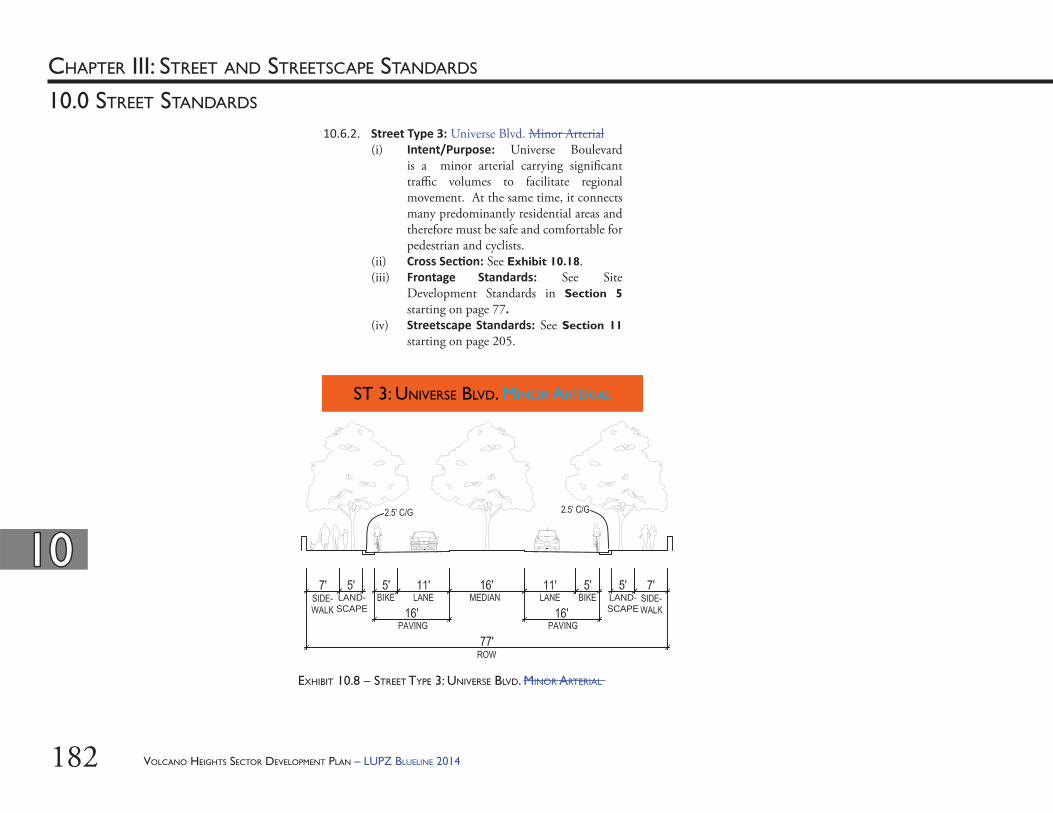
182
1010
10.0 STREET STANDARDS
CHAPTER III: STREET AND STREETSCAPE STANDARDS
EXHIBIT 10.8 – STREET TYPE 3: UNIVERSE BLVD. MINOR ARTERIAL
ST 3: UNIVERSE BLVD. MINOR ARTERIAL
LAND-SCAPE
LAND-SCAPE
10.6.2. Street Type 3: Universe Blvd. Minor Arterial(i) Intent/Purpose: Universe Boulevard
is a minor arterial carrying signifi cant traffi c volumes to facilitate regional movement. At the same time, it connects many predominantly residential areas and therefore must be safe and comfortable for pedestrian and cyclists.
(ii) Cross Sec on: See Exhibit 10.18.(iii) Frontage Standards: See Site
Development Standards in Section 5 starting on page 77.
(iv) Streetscape Standards: See Section 11 starting on page 205.
VOLCANO HEIGHTS SECTOR DEVELOPMENT PLAN – LUPZ BLUELINE 2014
183
1010
10.0 STREET STANDARDS
CHAPTER III: STREET AND STREETSCAPE STANDARDS
ST 4: CONNECTOR STREET
0-10’ 0-10’
** **TURNBAY
***
EXHIBIT 10.9 – STREET TYPE 4: CONNECTOR STREET
* Note: C/G = Curb and Gutter** Note: Buffer = Separation between the bicycle and vehicle lanes.*** Note: The center lane is a two-way left-turning lane and/or median as appropriate.
10.6.3. Street Type 4: Connector Street(i) Intent/Purpose: Th ese streets are
intended to access neighborhood streets and promote multi-modal transportation to reach businesses and residences within the Plan area.
(ii) Cross Sec on: See Exhibit 10.6.(iii) Frontage Standards: See Site
Development Standards in Section 5 starting on page 77.
(iv) Streetscape Standards: See Section 11 starting on page 205.
VOLCANO HEIGHTS SECTOR DEVELOPMENT PLAN – LUPZ BLUELINE 2014
184
1010
10.0 STREET STANDARDS
CHAPTER III: STREET AND STREETSCAPE STANDARDS
EXHIBIT 10.10 – STREET TYPE 4: CONNECTOR STREET – TYPICAL INTERSECTION (PLAN VIEW)
VOLCANO HEIGHTS SECTOR DEVELOPMENT PLAN – LUPZ BLUELINE 2014
185
1010
10.0 STREET STANDARDS
CHAPTER III: STREET AND STREETSCAPE STANDARDS
ST 5: SUBURBAN BOULEVARD
EXHIBIT 10.11 – STREET TYPE 5: SUBURBAN BOULEVARD
[Note: Street Type 5 is not used within the Volcano Heights SDP]
VOLCANO HEIGHTS SECTOR DEVELOPMENT PLAN – LUPZ BLUELINE 2014
186
1010
10.0 STREET STANDARDS
CHAPTER III: STREET AND STREETSCAPE STANDARDS
EXHIBIT 10.12 – STREET TYPE 6: PASEO DEL NORTE AT ESCARPMENT (6 LANES WITH TRANSIT)
* Note: Median width varies according to right-of way through the Petroglyph National Monument
*
Transit Transit
ST 6: PASEO DEL NORTE AT ESCARPMENT
[Note: Street Type 6 is not used within the Volcano Heights SDP]
VOLCANO HEIGHTS SECTOR DEVELOPMENT PLAN – LUPZ BLUELINE 2014
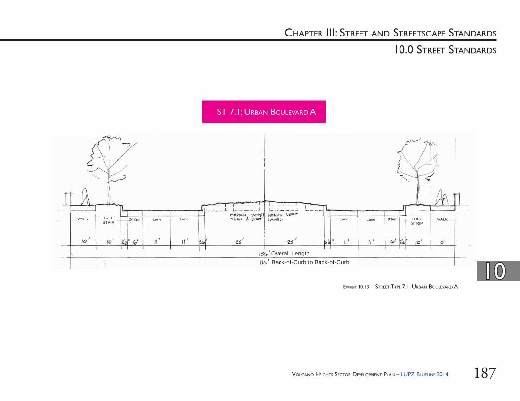
187
1010
10.0 STREET STANDARDS
CHAPTER III: STREET AND STREETSCAPE STANDARDS
Back-of-Curb to Back-of-CurbOverall Length
Lane LaneLane LaneWALK WALKTREE STRIP
TREE STRIP
EXHIBIT 10.13 – STREET TYPE 7.1: URBAN BOULEVARD A
ST 7.1: URBAN BOULEVARD A
VOLCANO HEIGHTS SECTOR DEVELOPMENT PLAN – LUPZ BLUELINE 2014
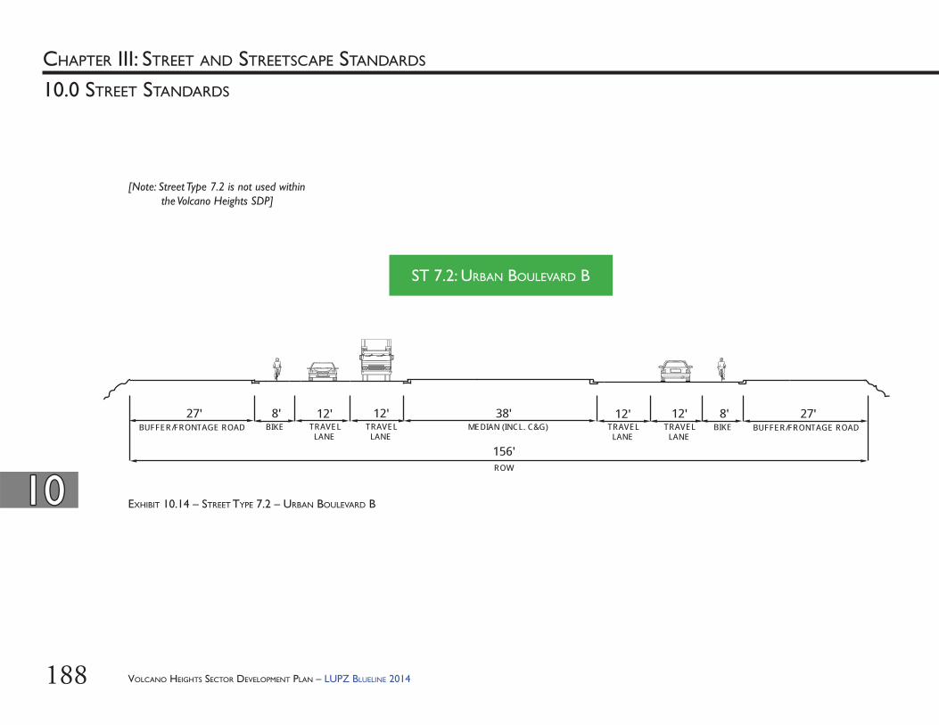
188
1010
10.0 STREET STANDARDS
CHAPTER III: STREET AND STREETSCAPE STANDARDS
EXHIBIT 10.14 – STREET TYPE 7.2 – URBAN BOULEVARD B
ST 7.2: URBAN BOULEVARD B
BIKE8'
TRAVEL LANE
12' 12'TRAVEL LANE
ROW
27'BUFFER/FRONTAGE ROAD
TRAVEL LANE
12' 12'TRAVEL LANE
38'MEDIAN (INCL. C&G) BIKE
8' 27'BUFFER/FRONTAGE ROAD
156'
[Note: Street Type 7.2 is not used within the Volcano Heights SDP]
VOLCANO HEIGHTS SECTOR DEVELOPMENT PLAN – LUPZ BLUELINE 2014
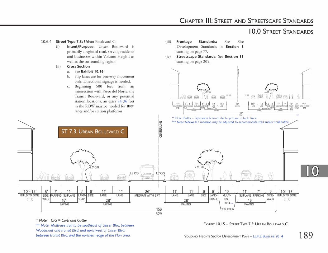
189
10.0 STREET STANDARDS
CHAPTER III: STREET AND STREETSCAPE STANDARDS
10.6.4. Street Type 7.3: Urban Boulevard C(i) Intent/Purpose: Unser Boulevard is
primarily a regional road, serving residents and businesses within Volcano Heights as well as the surrounding region.
(ii) Cross Sec ona. See Exhibit 10.16.b. Slip lanes are for one-way movement
only. Directional signage is needed.c. Beginning 500 feet from an
intersection with Paseo del Norte, the Transit Boulevard, or any potential station locations, an extra 24 36 feet in the ROW may be needed for BRT lanes and/or station platforms.
(iii) Frontage Standards: See Site Development Standards in Section 5 starting on page 77.
(iv) Streetscape Standards: See Section 11 starting on page 205.
EXHIBIT 10.15 – STREET TYPE 7.3: URBAN BOULEVARD C
ST 7.3: URBAN BOULEVARD C
* Note: C/G = Curb and Gutter** Note: Multi-use trail to be southeast of Unser Blvd. between Woodmont and Transit Blvd. and northwest of Unser Blvd. between Transit Blvd. and the northern edge of the Plan area.
1010
VOLCANO HEIGHTS SECTOR DEVELOPMENT PLAN – LUPZ BLUELINE 2014
10-15’ 10-15’
****
***
MEDIAN WITH BRT26’
28’ 28’
10’ - 15’
2’ BUFFER
10’ - 15’
**
** Note: Buff er = Separation between the bicycle and vehicle lanes.*** Note: Sidewalk dimension may be adjusted to accommodate trail and/or trail buffer.
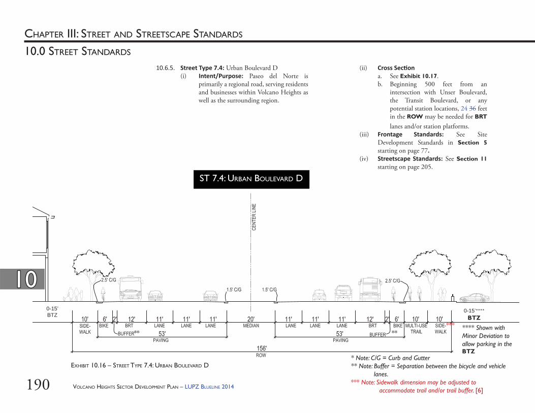
190
10.0 STREET STANDARDS
CHAPTER III: STREET AND STREETSCAPE STANDARDS
0-15’BTZ
0-15’****BTZ
**** Shown with Minor Deviation to allow parking in the BTZ
** **
10.6.5. Street Type 7.4: Urban Boulevard D(i) Intent/Purpose: Paseo del Norte is
primarily a regional road, serving residents and businesses within Volcano Heights as well as the surrounding region.
(ii) Cross Sec on a. See Exhibit 10.17. b. Beginning 500 feet from an
intersection with Unser Boulevard, the Transit Boulevard, or any potential station locations, 24 36 feet in the ROW may be needed for BRT lanes and/or station platforms.
(iii) Frontage Standards: See Site Development Standards in Section 5 starting on page 77.
(iv) Streetscape Standards: See Section 11 starting on page 205.
EXHIBIT 10.16 – STREET TYPE 7.4: URBAN BOULEVARD D
ST 7.4: URBAN BOULEVARD D
* Note: C/G = Curb and Gutter** Note: Buffer = Separation between the bicycle and vehicle
lanes.*** Note: Sidewalk dimension may be adjusted to
accommodate trail and/or trail buffer. [6]
1010
***
VOLCANO HEIGHTS SECTOR DEVELOPMENT PLAN – LUPZ BLUELINE 2014
191
1010
10.0 STREET STANDARDS
CHAPTER III: STREET AND STREETSCAPE STANDARDS
LANELANE
ST 8: TRANSIT BOULEVARD
0-10’ 0-10’
** **
* Note: C/G = Curb and Gutter** Note: Buffer = Separation between the bicycle and vehicle lanes.*** Note: Median becomes Turn Bay or equivalent in ‘B’ Street segments. EXHIBIT 10.17 – STREET TYPE 8: TRANSIT BOULEVARD
***
10.6.6. Street Type 8: Transit Boulevard(i) Intent/Purpose: Th e Transit Boulevard
serves multiple modes of transportation, including the proposed BRT. Th e walkable, dense, urban Town Center is organized around this Transit Boulevard, which acts as a “Main Street” for Volcano Heights.
(ii) Cross Sec on a. See Exhibit 10.14. b. Beginning 500 feet from intersections
on Paseo del Norte, Unser Boulevard, and any other potential station locations, an extra 36 feet of ROW may be needed for BRT lanes and/or station platforms.
(iii) Frontage Standards: See Site Development Standards in Section 5 starting on page 77.
(iv) Streetscape Standards: See Section 11 starting on page 205.
VOLCANO HEIGHTS SECTOR DEVELOPMENT PLAN – LUPZ BLUELINE 2014
192
1010
10.0 STREET STANDARDS
CHAPTER III: STREET AND STREETSCAPE STANDARDS
EXHIBIT 10.18 – STREET TYPE 8: TYPICAL INTERSECTION (PLAN VIEW)
VOLCANO HEIGHTS SECTOR DEVELOPMENT PLAN – LUPZ BLUELINE 2014
ST 8: TRANSIT BOULEVARD
193
1010
10.0 STREET STANDARDS
CHAPTER III: STREET AND STREETSCAPE STANDARDS
10.6.7. Street Type 9: Town Center Street(i) Intent/Purpose: Th ese streets are
intended to be the most pedestrian-friendly while supporting multiple modes of transportation circulating throughout the Plan area and surrounding region.
(ii) Cross Sec on: See Exhibit 10.4.(iii) Frontage Standards: See Site
Development Standards in Section 5.1 starting on page 78.
(iv) Streetscape Standards: See Section 11 starting on page 205.
EXHIBIT 10.19 – STREET TYPE 9: TOWN CENTER STREET
ST 9: TOWN CENTER STREET
* Note: C/G = Curb and Gutter** Note: Buffer = Separation between the bicycle and vehicle lanes.*** Note: Parking shown is reverse-angle parking. See Section 13.3.10(ix).
0-10’ 0-10’
** ***** ***
VOLCANO HEIGHTS SECTOR DEVELOPMENT PLAN – LUPZ BLUELINE 2014
194
1010
10.0 STREET STANDARDS
CHAPTER III: STREET AND STREETSCAPE STANDARDS
EXHIBIT 10.20 – STREET TYPE 9: TYPICAL INTERSECTION (PLAN VIEW)
ST 9: TOWN CENTER STREET
VOLCANO HEIGHTS SECTOR DEVELOPMENT PLAN – LUPZ BLUELINE 2014
195
1010
10.0 STREET STANDARDS
CHAPTER III: STREET AND STREETSCAPE STANDARDS
10.6.8. Street Type 10: Park Edge(i) Intent/Purpose: Th e Park Edge road is
intended to access local development, predominantly residences and businesses within the Plan area, by multiple modes of transportation, including on-street bicycle lanes as well as connections to an off -street trail along the Petroglyph National Monument. Major Public Open Space is best enhanced and protected as a public amenity when buff ered from development by a single-loaded road along Major Public Open Space edges (i.e. development only occurs on the side of the road farthest from the Major Public Open Space). Th e City Open Space Division and the National Park Service prefer the single-loaded road as the best transition between development and sensitive lands within the Petroglyph National Monument. Single-loaded roads increase safety for open space users and nearby property owners by providing visibility for surveillance and monitoring, as well as improving accessibility for park users. Single-loaded roads are also the most eff ective means of protecting important views into and out of the Monument, as well as to the Sandia Mountains to the east. Th e Park Edge road cross sections are designed to incorporate landscaping and medians that act as transitions from the built environment to sensitive lands within the Monument.
DETAIL OF EXHIBIT 10.2 – CHARACTER ZONES AND STREET TYPES: PARK EDGE ROAD
0 500 1,000 1,500
Feet
VHRC
VHMX VHET
VOLCANO HEIGHTS SECTOR DEVELOPMENT PLAN – LUPZ BLUELINE 2014
'A' Street
Street Designations'B' Street
Street Types
ST2.1 - NEIGHBORHOOD STREET AST4 - CONNECTOR STREETST6 - PASEO DEL NORTE AT ESCARPMENTST7.1 - URBAN BOULEVARD A ST7.3 - URBAN BOULEVARD C
ST10.1 - PARK EDGE SINGLE-LOADEDST10.2 - PARK EDGE TWO-SIDED
Legend
196
1010
10.0 STREET STANDARDS
CHAPTER III: STREET AND STREETSCAPE STANDARDS
MONUMENT BOUNDARY FENCE
ST 10.1: PARK EDGE SINGLE-LOADED
BTZ
** **
EXHIBIT 10.22 – STREET TYPE 10.2: PARK EDGE DOUBLE-LOADED
EXHIBIT 10.21 – STREET TYPE 10.1: PARK EDGE SINGLE-LOADED
ST 10.2: PARK EDGE TWO-SIDED
* Note: C/G = Curb and Gutter** Note: Buffer = Separation between
the bicycle and vehicle lanes.
* Note: C/G = Curb and Gutter** Note: Buffer = Separation between the bicycle and vehicle lanes.
** **
(ii) Cross Sec ons: Two cross sections are provided for the Park Edge Street. a. Where the street abuts the Petroglyph
National Monument and/or where development is only intended on the west side of the road, Street Type 4.1 is to be constructed. [See Exhibit 10.10.]
b. Where development will occur on both sides of the street, Street Type 4.2 is to be used. [See Exhibit 10.11.]
c. Th e Park Edge and additional east-west streets in the SU-2 Volcano Heights Escarpment Transition (VHET) zone should shall be sited to provide pedestrian access to the Petroglyph National Monument. Access shall be determined by the National Park Service Monument Visitor Plan and/or by the City Open Space Division in lieu thereof.
d. Where a median is incorporated, it should be perforated for hydrology and rainwater drainage and control, subject to approval by the City Hydrologist.
(iii) Frontage Standards: See Site Development Standards in Section 5 starting on page 77.
(iv) Streetscape Standards: See Section 11 starting on page 205.
VOLCANO HEIGHTS SECTOR DEVELOPMENT PLAN – LUPZ BLUELINE 2014
197
1010
10.0 STREET STANDARDS
CHAPTER III: STREET AND STREETSCAPE STANDARDS
MEDIAN
EXHIBIT 10.23 – STREET TYPE 10.1: TYPICAL INTERSECTION (PLAN VIEW)
ST 10.1: PARK EDGE SINGLE-LOADED
(v) Linear pond/bioswale: Th e median and/or eastern edge of the Park Edge Road is an appropriate and benefi cial location for a bioswale/linear pond. Such a pond, designed in consultation with the City Engineer can help to meet the City’s water quality goals. [See also Goal 12.5.5 starting on page 222 and Policy 13.5.3 starting on page 242.]
VOLCANO HEIGHTS SECTOR DEVELOPMENT PLAN – LUPZ BLUELINE 2014
198
1010
10.0 STREET STANDARDS
CHAPTER III: STREET AND STREETSCAPE STANDARDS
EXHIBIT 10.24 – STREET TYPE 10.2: TYPICAL INTERSECTION (PLAN VIEW)
ST 10.2: PARK EDGE DOUBLE-LOADED
VOLCANO HEIGHTS SECTOR DEVELOPMENT PLAN – LUPZ BLUELINE 2014
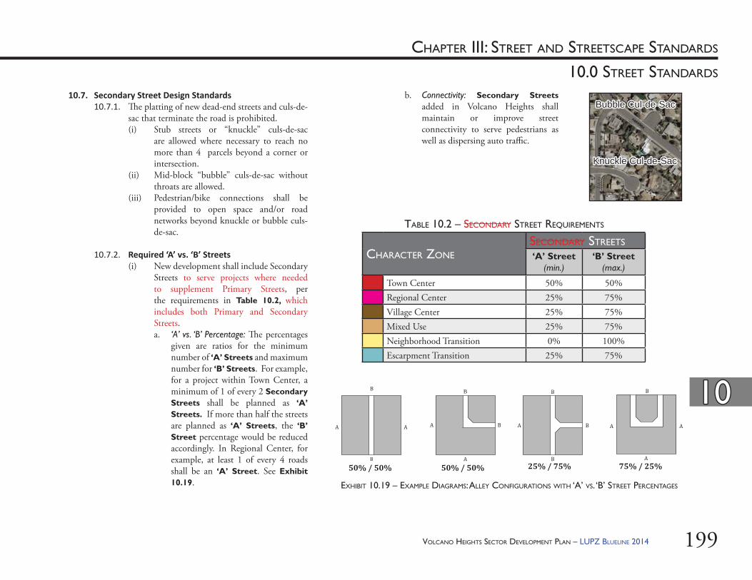
199
1010
10.0 STREET STANDARDS
CHAPTER III: STREET AND STREETSCAPE STANDARDS
Bubble Cul-de-SacBubble Cul-de-Sac
Knuckle Cul-de-SacKnuckle Cul-de-Sac
b. Connectivity: Secondary Streets added in Volcano Heights shall maintain or improve street connectivity to serve pedestrians as well as dispersing auto traffi c.
10.7. Secondary Street Design Standards10.7.1. Th e platting of new dead-end streets and culs-de-
sac that terminate the road is prohibited. (i) Stub streets or “knuckle” culs-de-sac
are allowed where necessary to reach no more than 4 parcels beyond a corner or intersection.
(ii) Mid-block “bubble” culs-de-sac without throats are allowed.
(iii) Pedestrian/bike connections shall be provided to open space and/or road networks beyond knuckle or bubble culs-de-sac.
10.7.2. Required ‘A’ vs. ‘B’ Streets(i) New development shall include Secondary
Streets to serve projects where needed to supplement Primary Streets, per the requirements in Table 10.2, which includes both Primary and Secondary Streets. a. ‘A’ vs. ‘B’ Percentage: Th e percentages
given are ratios for the minimum number of ‘A’ Streets and maximum number for ‘B’ Streets. For example, for a project within Town Center, a minimum of 1 of every 2 Secondary Streets shall be planned as ‘A’ Streets. If more than half the streets are planned as ‘A’ Streets, the ‘B’ Street percentage would be reduced accordingly. In Regional Center, for example, at least 1 of every 4 roads shall be an ‘A’ Street. See Exhibit 10.19.
TABLE 10.2 – SECONDARY STREET REQUIREMENTS
EXHIBIT 10.19 – EXAMPLE DIAGRAMS: ALLEY CONFIGURATIONS WITH ‘A’ VS. ‘B’ STREET PERCENTAGES
CHARACTER ZONESECONDARY STREETS
‘A’ Street(min.)
‘B’ Street(max.)
Town Center 50% 50%Regional Center 25% 75%Village Center 25% 75%Mixed Use 25% 75%Neighborhood Transition 0% 100%Escarpment Transition 25% 75%
B
50% / 50% 50% / 50% 25% / 75% 75% / 25%
VOLCANO HEIGHTS SECTOR DEVELOPMENT PLAN – LUPZ BLUELINE 2014

VOLCANO HEIGHTS SECTOR DEVELOPMENT PLAN – LUPZ BLUELINE 2014200
1010
10.0 STREET STANDARDS
CHAPTER III: STREET AND STREETSCAPE STANDARDS
STREET ELEMENTS
STREET ROW # VEHICULAR LANES
VEHICULAR TRAVEL LANE
WIDTHS (max.)
BIKE LANEON-STREET PARKING
PEDESTRIAN SIDEWALK
WIDTH (max.)* includes
easement(s)
PARKWAY/TREE WELL
‘A’ Street 54-96 feet2-3
(includes 12-ft. center turn lane)
10 (11) feet None
7-18 feet(reverse-angle
parking requires 16-18 feet)
10 (12) feet (optional within sidewalk width)
‘B’ Street 48-96 feet 2-4 11 (13) feet None 7 feet 6 (10) feet(optional with
sidewalks at least 8 feet wide)
Commercial Alley 20-36 feet (all paved) N/A N/A None None None None
Residential Alley20-30 feet
(12 feet minimum paved)
N/A N/A None None None None
TABLE 10.3 – TYPICAL SECONDARY STREET AND ALLEY CROSS SECTION OPTIONS
(i) Th e fi rst development in shall determine Secondary Street designation (i.e. whether ‘A’ or ‘B’) for the block. Streets shall be platted as such during the TIDD/SAD/PID and/or Site Development Plan for Subdivision process. Street designations may only change at intersections. Street designations may only change from an ‘A’ Street to a ‘B street when intersectioning with another ‘A’ street to ensure connectivity for the pedestrian. [8]
10.7.3. Secondary Street Cross Sec ons (i) Table 10.3 specifi es typical sections for
Secondary Streets. (ii) Th e elements may be arranged to best meet
local conditions and intended character of the corridor.
(iii) Where a Secondary Street crosses property lines, adjacent property owners may be required to sign a legally binding agreement duly executed and acknowledged for the agreed-to cross section as the fi rst project is being planned and before fi nal project approval is granted.
(iv) Typical cross sections for ‘A’ Streets and ‘B’ Streets are illustrated in Exhibit 10.20 and Exhibit 10.21, respectively. Typical Cross Sections for Residential and Commercial Alleys are illustrated in Exhibit 10.22 and Exhibit 10.23, respectively.
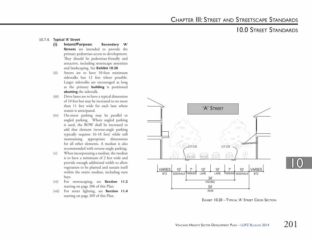
VOLCANO HEIGHTS SECTOR DEVELOPMENT PLAN – LUPZ BLUELINE 2014 201
1010
10.0 STREET STANDARDS
CHAPTER III: STREET AND STREETSCAPE STANDARDS
EXHIBIT 10.20 – TYPICAL ‘A’ STREET CROSS SECTION
10.7.4. Typical ‘A’ Street(i) Intent/Purpose: Secondary ‘A’
Streets are intended to provide the primary pedestrian access to development. Th ey should be pedestrian-friendly and attractive, including streetscape amenities and landscaping. See Exhibit 10.20.
(ii) Streets are to have 10-foot minimum sidewalks but 12 feet where possible. Larger sidewalks are encouraged as long as the primary building is positioned abutting the sidewalk.
(iii) Drive lanes are to have a typical dimension of 10 feet but may be increased to no more than 11 feet wide for each lane where transit is anticipated.
(iv) On-street parking may be parallel or angled parking. Where angled parking is used, the ROW shall be increased to add that element (reverse-angle parking typically requires 16-18 feet) while still maintaining appropriate dimensions for all other elements. A median is also recommended with reverse-angle parking.
(v) When incorporating a median, the median is to have a minimum of 2 feet wide and provide enough additional width to allow vegetation to be planted and sustain itself within the entire median, including turn bays.
(vi) For streetscaping, see Section 11.2 starting on page 206 of this Plan.
(vii) For street lighting, see Section 11.4 starting on page 209 of this Plan.
‘A’ STREET
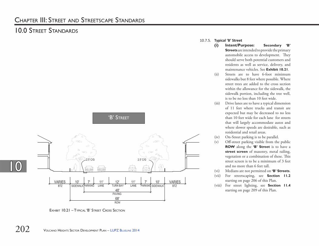
VOLCANO HEIGHTS SECTOR DEVELOPMENT PLAN – LUPZ BLUELINE 2014202
1010
10.0 STREET STANDARDS
CHAPTER III: STREET AND STREETSCAPE STANDARDS
EXHIBIT 10.21 – TYPICAL ‘B’ STREET CROSS SECTION
10.7.5. Typical ‘B’ Street(i) Intent/Purpose: Secondary ‘B’
Streets are intended to provide the primary automobile access to development. Th ey should serve both potential customers and residents as well as service, delivery, and maintenance vehicles. See Exhibit 10.21.
(ii) Streets are to have 6-foot minimum sidewalks but 8 feet where possible. Where street trees are added to the cross section within the allowance for the sidewalk, the sidewalk portion, including the tree well, is to be no less than 10 feet wide.
(iii) Drive lanes are to have a typical dimension of 11 feet where trucks and transit are expected but may be decreased to no less than 10 feet wide for each lane for streets that will largely accommodate autos and where slower speeds are desirable, such as residential and retail areas.
(iv) On-Street parking is to be parallel. (v) Off -street parking visible from the public
ROW along the ‘B’ Street is to have a street screen of masonry, metal railing, vegetation or a combination of these. Th is street screen is to be a minimum of 3 feet and no more than 6 feet tall.
(vi) Medians are not permitted on ‘B’ Streets.(vii) For streetscaping, see Section 11.2
starting on page 206 of this Plan.(viii) For street lighting, see Section 11.4
starting on page 209 of this Plan.
‘B’ STREET
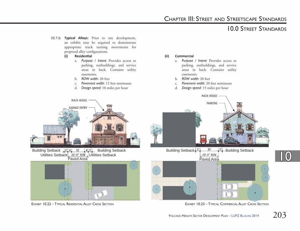
VOLCANO HEIGHTS SECTOR DEVELOPMENT PLAN – LUPZ BLUELINE 2014 203
1010
10.0 STREET STANDARDS
CHAPTER III: STREET AND STREETSCAPE STANDARDS
10.7.6. Typical Alleys: Prior to site development, an exhibit may be required to demonstrate appropriate truck turning movements for proposed alley confi gurations.(i) Residen al
a. Purpose / Intent: Provides access to parking, outbuildings, and service areas in back. Contains utility easements.
b. ROW width: 20 feetc. Pavement width: 12 feet minimumd. Design speed: 10 miles per hour
(ii) Commerciala. Purpose / Intent: Provides access to
parking, outbuildings, and service areas in back. Contains utility easements.
b. ROW width: 20 feetc. Pavement width: 20 feet minimumd. Design speed: 15 miles per hour
EXHIBIT 10.22 – TYPICAL RESIDENTIAL ALLEY CROSS SECTION EXHIBIT 10.23 – TYPICAL COMMERCIAL ALLEY CROSS SECTION
Building SetbackUtilities Setback
Paved AreaUtilities Setback
Building Setback
Paved Area
Building Setback Building Setback
VOLCANO HEIGHTS SECTOR DEVELOPMENT PLAN – LUPZ BLUELINE 2014204
1010
10.0 STREET STANDARDS
CHAPTER III: STREET AND STREETSCAPE STANDARDS
10.7.7. Typical Streets with Public U lity Easement(i) Utilities are typically to be provided via
alleys. Where alley access is not possible, electric utility facilities need to be accommodated on streets.
(ii) Where electric utility facilities must be accommodated on streets, a 10-foot setback is to be placed between the sidewalk and the Build-to-Zone behind the private property line for this purpose. Th is setback may be landscaped with the understanding that it might be removed as necessary for maintenance and/or repair of utilities.
VOLCANO HEIGHTS SECTOR DEVELOPMENT PLAN – LUPZ BLUELINE 2014 205
11.0 STREETSCAPE STANDARDS
CHAPTER III: STREET AND STREETSCAPE STANDARDS

VOLCANO HEIGHTS SECTOR DEVELOPMENT PLAN – LUPZ BLUELINE 2014206
CHAPTER III: STREET AND STREETSCAPE STANDARDS
1111
11.0 STREETSCAPE STANDARDS
11.2.3. Streetscape Maintenance: Maintenance of all landscape materials is the responsibility of the adjacent property owner and shall meet the requirements of Chapter 6, Article 6 in the City Code of Ordinances.
11.2.4. Sidewalk Design: Sidewalks in the public ROW are to be designed to facilitate pedestrian accessibility and effi cient travel. Curvilinear sidewalks are strongly discouraged. Where possible, landscape strips should be used to buff er pedestrians from vehicle traffi c and set the pedestrian path back from driveway ramps.
11.2.5. Grading: Bikeways and other amenities within the ROW are to be provided in such a way as to minimize the extent of disturbance to slopes and vegetation and the need for cut and fi ll.
11.2.6. Medians: Medians are to be constructed and landscaped per City standards. [For medians: DPM Chapter 23, Section 5, Part C. For landscaping: contact DRC Section for the latest standards.]
11.2.7. Bike Lanes and Bike Buff er(i) Where cross sections incorporate a bike
buff er in addition to a bike lane, the buff er is to be no less than 2 feet wide.
(ii) Best practices to minimize confl ict between bicycles and vehicles turning right at intersections are to be followed, including design solutions, pavement painting, signage, and/or other accommodations.
11.1. Adjustments11.1.1. Th e following streetscape standards, including
street tree planting and street lighting, may be adjusted based on the development context and street cross section.
11.1.2. Any adjustments to the streetscape standards should be assessed based on specifi c development context such as vegetation, natural features, drainage, and fi re access and are subject to approval by the Planning Director or his/her designee and/or relevant City department.
11.2. General Streetscape Standards11.2.1. Groundcover:
(i) Where clearly visible from a street or alley, all unpaved ground areas are to be planted with low-growing shrubs or ground cover, ornamental grasses, or a combination thereof selected from the Plant List in Table 9.5 starting on page 153. [For more detail, see Section 9.7.8 starting on page 158.]
(ii) Within 200 feet of the Petroglyph National Monument, only species listed as native in the Plant List in Table 9.5 starting on page 153 are to be used, except for street trees. [See Section 11.3 for street tree standards.]
11.2.2. Irriga on: Irrigation is to be provided by the property owner for all plants and trees in the streetscape, per City standards. [Contact City Design Review/Construction (DRC) Section in the Planning Department for the latest standards].
VOLCANO HEIGHTS SECTOR DEVELOPMENT PLAN – LUPZ BLUELINE 2014 207
CHAPTER III: STREET AND STREETSCAPE STANDARDS
1111
11.0 STREETSCAPE STANDARDS
11.3. Street Tree Standards11.3.1. Purpose/Intent: Street trees are an amenity fi rst
for pedestrian comfort and enjoyment, next for enhancement of abutting properties, and fi nally for passing motorists, cyclists, or transit riders. Street trees are to be chosen and incorporated to serve the following intents:(i) Enclose or frame the space of the street
with a canopy.(ii) Provide shade.(iii) Provide a buff er between traffi c and
pedestrian to enhance the feeling of safety for the pedestrian.
(iv) Provide an aesthetic accompaniment to nearby architecture.
(v) Reduce the heat island eff ect created by paved surfaces.
(vi) Aid in storm water management through transvaporation.
(vii) Work within their context (i.e. region- and climate-appropriate, native species that are disease resistant and drought-tolerant).
11.3.2. On all ‘A’ Streets, street trees are to be provided, irrigated, and maintained by adjacent property owners per the Street Tree Ordinance, Section 6-6-2-1.
11.3.3. Wherever used, all street trees shall be maintained by the adjacent property owner, per the Street Tree Ordinance, Section 6-6-2-1.
11.2.8. Encroachments(i) Encroachments are permitted by a
revocable permit and subject to license and fees per the DPM, Chapter 8.
(ii) Projections such as, portals, stoops, colonnades, arcades, shop fronts, projecting signs in public utility easements and other projections are to be coordinated with the electric utility to accommodate existing easements and to avoid confl icts with utility infrastructure. Projections adjacent to electric utilities are to be carefully located in order to avoid interference and to accommodate equipment for the maintenance and repair of electric utilities.
VOLCANO HEIGHTS SECTOR DEVELOPMENT PLAN – LUPZ BLUELINE 2014208
CHAPTER III: STREET AND STREETSCAPE STANDARDS
1111
11.0 STREETSCAPE STANDARDS
11.3.4. Street tree location and selection is to be coordinated with the Planning Director or his/her designee and consistent with the Street Tree Ordinance 6-6-2-1. (i) PNM will need to provide input on street
tree location and selection if impacting electric facilities.
(ii) Shade structures may be substituted for street trees in select locations subject to approval of the Planning Director or his/her designee. An encroachment permit may be required. [See Section 11.2.8 starting on page 207 for details about encroachments.]
11.3.5. In order to ensure that street trees are appropriate for the region and climate and are not invasive species, street trees are to be selected from the Plant List in Table 9.5 starting on page 153 of this Plan [see also Section 9.7.8 starting on page 158]. Non-invasive low-water and/or xeric species may be selected with approval from the Planning Director or his/her designee in consultation with the City Forester. Street trees should be disease resistant and drought tolerant.
11.3.6. Where available, street trees are to be planted within the landscape area in the public right-of-way. [See cross sections in Section 10.0 starting on page 163.] Otherwise, street trees are to be planted between the sidewalk and the street curb using tree grates.
11.3.7. Where provided, spacing is to be an average of 30 feet on center (measured per block face) in order to provide a continuous canopy. On narrow streets, spacing may vary on each side of the street. Spacing may be adjusted as appropriate to accommodate optimum root growth for native species.
11.3.8. Each planting area is to be no less than 36 square feet (SF). Th e tree well is to be no less than 25 SF. On ‘A’ Streets, trees are to be in a grated or permeable planting square a minimum of 4 feet wide. Metal tree grates are preferred for ‘A’ Streets.
11.3.9. Th e minimum caliper size (i.e. diameter of the tree truck measured six inches above grade) for each tree is to be 3 inches at planting. Caliper size for a multi-trunk tree is to be the total of the diameter of the largest trunk and half (1/2) the diameter of each additional trunk, measured at a height of 4 1/2 feet above the ground.
11.3.10. Planting is to be planned to provide a canopy with a base no less than 7 feet high at time of maturity for vertical clearance of pedestrians and vehicles. On ‘A’ Streets, the base of the canopy is to be planned for a minimum of 14 feet so as to not obscure windows and signage.
11.3.11. Planters for street trees are to be a minimum of 36 inches wide.
VOLCANO HEIGHTS SECTOR DEVELOPMENT PLAN – LUPZ BLUELINE 2014 209
CHAPTER III: STREET AND STREETSCAPE STANDARDS
1111
11.0 STREETSCAPE STANDARDS
11.4. Street Ligh ng Standards11.4.1. Purpose/Intent
(i) Outdoor lighting should create and encourage a pedestrian-friendly environment, which is especially benefi cial to residential neighborhoods and neighborhood business districts. Pedestrian-scale lights should improve walkway illumination for pedestrian traffi c and enhance community safety and business exposure.
(ii) Street lighting should be designed to be appropriate to location and context. Lamp post height, lamp head, lighting source, and spacing should all be calibrated. Th e light standard selected should be compatible with the design of the street and dominant architectural style of adjacent buildings.
11.4.2. Street lights are to be placed at 30 feet on center and in-line with street trees. Street trees and light poles are to be alternated along the street.
11.4.3. All street lighting is to be “full-cutoff ” or “fully shielded” to minimize light pollution and save energy, per the New Mexico Night Sky Ordinance [74-12-1 to 74-12-10 NMSA 1978].
11.4.4. Lamp post height is to be designed to be proportional to the width of the street. Street lamps are to be 12 to 15 feet high along ‘A’ Streets. ‘B’ Streets are to incorporate 15-foot lampposts. [See Section 9.8 starting on page 159 for parking area lighting requirements.]
11.4.5. For those intersections that require more light, the 20-foot lamppost can be instituted for safety, but should be used only if necessary.
11.4.6. Cobraheads are to only be used on Paseo del Norte and Unser Boulevard to light vehicle lanes as necessary. A supplemental non-cobrahead light is to be mounted between 12 to 14 feet to light sidewalks, pedestrian paths, or multi-use trails.
11.4.7. Th e minimum clearance from a street light pole to the face of curb is 2 feet. Th e minimum clearance from a street light pole to the edge of a sidewalk is 1 foot. Th e minimum clearance from a street light pole to the centerline of a street is 20 feet.
11.4.8. Light posts are to be placed within the landscape strip where available.
11.4.9. All lamp posts are to have a base, middle, and top.
11.4.10. Shoe box style lighting is not to be used, except in large parking areas. Metal halide lights are encouraged. High pressure sodium lights are discouraged since they visually render all colors the same.
11.4.11. Column streetlights are to be used on ‘A’ Streets.
11.4.12. Multi-head column streetlights are to be used on ‘A’ streets, Unser Boulevard, and Paseo del Norte.
11.4.13. All new alleys are to have lights mounted on outbuildings or garages.
VOLCANO HEIGHTS SECTOR DEVELOPMENT PLAN – LUPZ BLUELINE 2014210
CHAPTER III: STREET AND STREETSCAPE STANDARDS
1111
11.0 STREETSCAPE STANDARDS
11.5.4. Trash receptacles and bike racks are to be placed along ‘A’ Streets within Town Center, with a minimum of one each per block face.
11.5.5. Where provided, street furniture and pedestrian amenities such as benches are to be placed to maximize pedestrian access and circulation along ‘A’ Streets. All street furniture is to be located in such a manner as to allow a clear sidewalk passageway of a minimum of 6 feet.
11.5. Street Furniture and Materials Standards11.5.1. Purpose/Intent
(i) Street furniture should create and encourage a pedestrian-friendly environment, which is especially benefi cial to residential neighborhoods and neighborhood business districts.
(ii) Street furniture should be designed to be appropriate to location and context. Street furniture should be compatible with the design of the street and dominant architectural style of adjacent buildings.
(iii) Materials for paving and street furniture should be selected based on durability, quality, and minimal maintenance requirements.
11.5.2. Responsibility: Street furniture and streetscape amenities are the responsibility of the property owner and/or property owner association or merchants association. Th e cost for construction, maintenance, operations, and liability is to be borne by private entities.
11.5.3. Placement: Street furniture placement and procedure is to follow the DPM Chapter 8. (i) Street furniture is not to be placed within
the public ROW without the approval of the relevant City agency, which may include the City Engineer, Zoning Enforcement Offi cer, and/or Code Administration Division.
(ii) Where street furniture is placed within a public utility easement, approval by utility companies will be required.
VOLCANO HEIGHTS SECTOR DEVELOPMENT PLAN – LUPZ BLUELINE 2014 211
goals , pol icies , and implementationChapter IV
VOLCANO HEIGHTS SECTOR DEVELOPMENT PLAN – LUPZ BLUELINE 2014212
Th is Page Left Intentionally Blank
VOLCANO HEIGHTS SECTOR DEVELOPMENT PLAN – LUPZ BLUELINE 2014 213
CHAPTER IV: GOALS, POLICIES, AND IMPLEMENTATION
12.0 GOALS
VOLCANO HEIGHTS SECTOR DEVELOPMENT PLAN – LUPZ BLUELINE 2014214
CHAPTER IV: GOALS, POLICIES, AND IMPLEMENTATION
12.0 GOALS
1212
Intent: The following goals are intended to support the policies set forth in the Rank 1 Albuquerque Bernalillo Comprehensive Plan, the Planned Growth Strategy, the Rank 2 West Side Strategic Plan, and the Rank 3 Northwest Mesa Escarpment Plan. The goals represent the overarching intent of the Plan. These goals are furthered in Section 13.0 Policies starting on page 223.
12.1.2. Respect Albuquerque’s culture and history, including Hispanic and Na ve American, through context-sensi ve development in Volcano Mesa.
Volcano Mesa provides a unique portal to understand the rich interplay of cultures that is New Mexico. Th e stories and meaning of this place to Native Americans can be told through living in and visiting Volcano Heights, which should infl uence the way this special area develops. Volcano Heights should be an entry point for Albuquerque residents into diff erent and important perspectives on humanity’s place on earth and our spiritual paths.
12.1.3. Conserve Volcano Heights’ archaeological resources and protect and emphasize views and visual connec ons to the volcanoes, Sandia Mountains, and the Rio Grande.
Th e volcanoes, Petroglyph National Monument, outcrops of basalt (especially those containing petroglyphs), the Sandia Mountains, and other locations are sacred places for many Native Americans, and they still fi gure into their ceremonial practices. Views can be protected and enhanced through considerate site planning and by creating view corridors using streets and arroyos. Important views from locations within Volcano Heights to the Rio Grande basin, across the city of Albuquerque, and to the Sandia Mountains should be protected.
12.1. Environment and Open Space: Th e following goals are furthered with policies found in Section 13.1 starting on page 224.
12.1.1. Establish an interconnected open space network comprised of parks, arroyos, the Petroglyph Na onal Monument, and other open spaces.
An organized system of open space can help conserve the natural environment, mitigate the impacts of development, provide exceptional recreational opportunities, and increase property values and quality of life for residents, employees, and visitors in and around Volcano Heights. Opportunities to experience and enjoy nature should be plentiful, especially for children. Often, these open space features can form the boundary of neighborhoods and maintain views to the Volcanoes and Sandia Mountains.
VOLCANO HEIGHTS SECTOR DEVELOPMENT PLAN – LUPZ BLUELINE 2014 215
12.0 GOALS
CHAPTER IV: GOALS, POLICIES, AND IMPLEMENTATION
1212
12.1.4. Maintain scenic edges, protect important views, and minimize the visual impact of development that can be seen throughout the city.
Th e built environment and landscape along the edge of the Petroglyph National Monument will form a pleasant transition from the natural area to the developed area. Open space constitutes an important resource that demands special landscape and architectural treatments. As development within the Volcano Heights Major Activity Center will be visible from most of the City of Albuquerque, care should be taken to achieve development that is not visually intrusive, especially in the lower-density residential areas adjacent to the Petroglyph National Monument. Appropriate building heights, sizes, and refl ectivity will minimize the visual impact of development.
12.1.5. Encourage infrastructure strategies that are economically, aesthe cally and environmentally sound.Electrical utility distribution lines should be placed underground. Infrastructure improvements should promote and make visible an environmental ethic for the area. Infrastructure should be designed and constructed to enhance and/or encourage sustainable developments. Drainage treatments should respect sensitive lands such as Piedras Marcadas Canyon, the Petroglyph National Monument, and signifi cant rock outcroppings, as well as the unique aesthetics of the area. Transportation infrastructure should enhance the economic sustainability of the community by off ering viable choices for multiple modes of travel for people of all ages and abilities.
12.1.6. Minimize the nega ve eff ects of blas ng and fugi ve dust to the Petroglyph Na onal Monument.
Development design and construction activities should be carefully planned to minimize negative impacts to the Petroglyph National Monument. Property owners should consult with the City Open Space Division and National Park Service on strategies, monitoring, and construction techniques to ensure compliance with requirements and standards.
12.2. Economic Development: Th e following goals are furthered with policies found in Section 13.2 starting on page 225.
12.2.1. Provide a variety of employment opportunities that provide livable wages and high-quality work environments.
Economic development and recruitment eff orts should emphasize businesses that provide livable wages and high-quality work environments.
12.2.2. Achieve a sustainable and vital mix of regional- and local-serving retail and services.
Th is Plan seeks to help minimize the jobs/housing imbalance between Albuquerque’s West and East sides by creating a Major Activity Center that serves local and neighboring populations. A densely-developed mix of commercial activities that meets a wide range of needs will encourage visitors to “park once and walk” to multiple destinations and attract residents and large employers to the area.
VOLCANO HEIGHTS SECTOR DEVELOPMENT PLAN – LUPZ BLUELINE 2014216
CHAPTER IV: GOALS, POLICIES, AND IMPLEMENTATION
12.0 GOALS
1212
12.2.3. Coordinate development across property lines and among mul ple property owners.
Th is Plan advocates coordination among property owners, including the possibility of working with a Master Development Coordinator who can partner with owners to oversee the improvement of all properties. Th is strategy is particularly helpful to coordinate infrastructure planning and construction, including grading, roads, and utilities to prepare properties for development. A master development coordinator would be instrumental in preparing an application for a TIDD, an SAD, or a PID to benefi t multiple property owners, if not the whole Plan area.
An experienced, third-party master developer and/or marketing strategist can also help to coordinate complex projects with a variety of development types and/or projects that will overlap and/or follow one another.
12.2.4. Establish a Major Ac vity Center in order to provide signifi cant long-term economic development opportuni es while also providing for the social, cultural, and environmental needs of the Volcano Mesa area.
Th e development of a Major Activity Center in this area can help achieve a diverse and balanced set of uses that would spur economic development and reduce the need for West Side residents to travel long distances to access employment and other daily services. Allowing a wide range of uses that support the establishment of a Major Activity Center can serve as a catalyst for private investment and the creation of much-needed jobs west of the Rio Grande. Capitalizing on and respecting the unique resources and features of the area, such as the Petroglyph National Monument and rock outcroppings, will strengthen “sense of place” and contribute to successful development.
VOLCANO HEIGHTS SECTOR DEVELOPMENT PLAN – LUPZ BLUELINE 2014 217
12.0 GOALS
CHAPTER IV: GOALS, POLICIES, AND IMPLEMENTATION
1212
12.3.3. Create “Complete Streets” for people as well as cars, by providing street trees, landscaping, wide sidewalks, and ac ve uses.
Streets should feel safe and comfortable for pedestrians and work well for all other modes of transportation. Th e design of streets and the buildings that face them infl uences whether someone will choose to walk. Pedestrian-friendly streets have sidewalks that promote both circulation and activity, street trees, and slow-moving traffi c. Th ey also have pedestrian-scaled buildings with frequent entries, windows, and attractive features. Parking lots and blank walls should be minimized along pedestrian routes.
12.3.4. Connect diff erent uses and areas by an effi cient and convenient street network.
Streets should create safe and direct connections between common destinations, not act as barriers that separate people and neighborhoods. Streets should be designed to control vehicle speeds and be a comfortable place for neighbors to interact. Rather than concentrate traffi c, highly connected streets form a grid and distribute traffi c among roadways. A street network grid also creates redundancy for additional safety and emergency response.
12.3. Transporta on: Th e following goals are furthered with policies found in Section 13.3 starting on page 226.
12.3.1. Provide a choice of viable transporta on op ons for commu ng and daily needs.
Walking is a safe, viable travel option, especially for children and the elderly, for recreation, commuting, and shopping. For greater distances, transit should off er a convenient alternative to single-occupancy vehicles. Transit, in particular, could lessen reliance on the automobile, reducing pollution, congestion, and pressures to widen roads and bridges, especially at regional “pinch points” like the Rio Grande and the Escarpment.
12.3.2. Support an effi cient and reliable transit system.
To support as frequent service as possible and maximize ridership with less public subsidy, transit stop locations should be coordinated with the development of higher density residential and employment uses. More intense corridors should include major retail, commercial, and employment destinations. Doing so will allow the earliest implementation of traditional transit service, which can eventually segue to BRT systems using specialized vehicles and techniques that make transit travel times competitive with the single-occupancy vehicle. While transit service may initially share general purpose travel lanes, all arterial streets in this Plan have ultimate cross-sections with enough right-of-way and fl exibility to accommodate transit in multiple confi gurations, including as dedicated transit lanes on the outside edges or along extra-wide medians.
VOLCANO HEIGHTS SECTOR DEVELOPMENT PLAN – LUPZ BLUELINE 2014218
CHAPTER IV: GOALS, POLICIES, AND IMPLEMENTATION
12.0 GOALS
1212
12.3.5. Retain the primary purpose of Paseo del Norte and Unser Boulevard to serve regional traffi c, while balancing the needs of the local road network to serve new development and mul ple modes of traffi c, including pedestrians.
Th e Plan recognizes the limited-access nature and classifi cation of Paseo del Norte and Unser Boulevard. At the same time, the Plan proposes land uses and a Primary Street network intended for safe, attractive, dense, pedestrian-friendly urban environment, including a “loop road” of connector streets that provides alternative access to development off Paseo del Norte and Unser Boulevard. As the area develops over time, the goal is to “tame” these roads to help create a gateway to a more urban, walkable environment. Th ese regional roads will give the fi rst “sense of place” to many potential visitors to Volcano Heights and should refl ect and complement the area’s character accordingly, while still functioning as limited-access, primary regional arterials.
12.3.6. Remove restric ons on truck traffi c on key roads to provide truck access necessary to support retail and commercial uses.
Several roads on the West Side restrict truck traffi c. Th e City DMD should work with the Mid-Region Council of Governments (MRCOG) and its constituent jurisdictions to remove or modify several of these restrictions in order to facilitate truck movement to serve businesses and improve services on the West Side.
12.4. Land Use and Urban Design: Th e following goals are furthered with policies found in Section 13.4 starting on page 238.
12.4.1. Recognize walkable neighborhoods and districts as the essen al building blocks of a more sustainable city and region.
Strong and healthy neighborhoods, because they operate at a scale where people walk and interact, are essential to successful and sustainable development. Organizing development within walkable mixed-use districts and neighborhoods supports transit, economizes on infrastructure, and respects the environment. Requiring that development comply with design standards that support the creation of safe, comfortable, and visually attractive settings supports a community’s long-term economic, cultural, and social viability.
12.4.2. Bring homes, businesses, and daily des na ons — like retail and community facili es — closer together within neighborhoods and districts.
Homes should be within walking distance of a mixed-use center containing retail, community services, park and plazas. Studies have shown that this walkable pattern of development can reduce the number of vehicle-trips dramatically. Walkable districts and neighborhoods also have proven social and economic benefi ts resulting from better access to basic needs, services, and amenities; safer and more active streets; and improved health through physical activity.
VOLCANO HEIGHTS SECTOR DEVELOPMENT PLAN – LUPZ BLUELINE 2014 219
12.0 GOALS
CHAPTER IV: GOALS, POLICIES, AND IMPLEMENTATION
1212
12.4.3. Encourage architectural and landscape treatments that are consistent with the region’s tradi ons and climate and help to establish a unique sense of place.
New development in Volcano Heights should continue to respect and enrich Albuquerque’s design traditions that spring from its arid climate, intense sun, local materials, and the cultural background of its inhabitants. Th ese considerations deserve continued attention to respect the past and work toward an energy- and water-effi cient future. Th e quality of individual buildings contributes to a sense of place and permanence. High standards for architectural and landscape design for individual buildings, lighting, utilities, walls, and landscaping materials help to create a built environment with lasting character that draws on southwestern regional styles and traditions. Standard franchise architecture should be discouraged. Individual design expression within distinctive character districts should contribute to an overall framework of quality. Buildings should be designed to the address the unique climatic conditions of the southwest, including orientation to conserve water, protect pedestrians from intense summer sunlight and heat, provide adequate heating during cold winters, and take advantage of natural lighting.
12.4.4. Promote diverse housing op ons throughout Volcano Heights.
A variety of housing types—at varying densities—allows the opportunity for residents to move through all stages of life within the same neighborhood. Housing diversity will also promote and attract businesses to balance residential development on the West Side.
12.4.5. Support the crea on of a major employment center in Volcano Heights.
Most working West Side residents commute to work on the east side of the Rio Grande (many in downtown Albuquerque or along Interstate 25), which contributes to regional traffi c congestion at river crossings and on the West Side. Major job growth in Volcano Heights will provide opportunities for working closer to home, minimizing the need for river crossings or reversing commutes in a direction where roads have existing capacity. A frequent and reliable transit service for this Major Activity Center will further improve commuting times.
VOLCANO HEIGHTS SECTOR DEVELOPMENT PLAN – LUPZ BLUELINE 2014220
CHAPTER IV: GOALS, POLICIES, AND IMPLEMENTATION
12.0 GOALS
1212
12.4.6. Establish a mixed-use Major Ac vity Center as a transit-oriented development that off ers a range of retail, commercial, and entertainment des na ons; urban housing; and employment opportuni es.
A Major Activity Center should encourage higher-density and higher-intensity opportunities for residential options and employment areas. While neighborhood retail can meet most daily requirements, many needs must be met within larger centers that serve larger populations. A mixed-use Major Activity Center should encourage opportunities for comparison shopping, entertainment, restaurants, cultural activities, and government services.
Unlike many exclusively single-family residential subdivisions, Volcano Heights should off er dense urban housing in mixed-use environments for those who prefer them, which greatly increases the likelihood of walking and transit use. Transit, amenities, and housing in the Major Activity Center will help attract employment to the West Side.
12.4.7. Incorporate street infrastructure and streetscape details that support the crea on of dis nct, pedestrian-friendly districts.
Where taller lights are required, for example a major thoroughfare, consideration should be given to a design appropriate to the larger scale. Reproductions of historic lamps such as the “bishops crook” poles are a more aesthetic solution than the cobra head.
12.4.8. Locate more ac ve uses nearest to transit, bikeway, and pedestrian facili es. Locate auto-oriented uses near ‘B’ streets.
Th is Plan distinguishes between ‘A’ streets, which are designed to best accommodate pedestrians, transit users, and cyclists, and ‘B’ streets, which are meant to be more auto-oriented. Development that includes active street life, such as theatres and restaurants with patio seating, should be located along ‘A’ streets, as near to transit as possible. Auto-oriented development should be located along ‘B’ streets to provide the primary auto access to development.
12.4.9. Achieve a walkable built environment through a vital mix of retail and services near higher-density residen al development.
Pedestrian-friendly commercial areas will benefi t from the additional “eyes on the street” and customer base provided by high-density residential development like apartments, lofts, and condominiums. Ultimately, this vibrant “critical mass” of residents and retail and service providers will contribute to the creation of a “sense of place” in Volcano Heights that can help attract additional employers and businesses to the area.
VOLCANO HEIGHTS SECTOR DEVELOPMENT PLAN – LUPZ BLUELINE 2014 221
12.0 GOALS
CHAPTER IV: GOALS, POLICIES, AND IMPLEMENTATION
1212
12.5.3. Invest in and incorporate the most up-to-date technology and maximum capacity for infrastructure and u li es.
Th e best technology and highest capacity should be planned for infrastructure and utilities, particularly telecommunications, in order to attract and support high-tech businesses as well as a diverse spectrum of desirable commercial activity.
12.5.4. Coordinate among property owners to leverage investment in water source and water quality improvements.
Volcano Heights spans two water pressure zones, one of which is smaller than the City’s standards size, as it was previously owned by New Mexico Utilities. Th e amount of bedrock in the area, the presence of arsenic, and the need for a new water tank to support new development will pose signifi cant front-end costs before any development can occur. Th ese improvements could be included in a TIDD, SAD, or PID, which would provide a mechanism to share the costs across property owners based on the potential benefi ts to each property. [See Section 14.0 Implementation starting on page 245 in this Plan and Appendix A for more explanation of pre-Existing conditions, including water systems.]
12.5. Infrastructure: Th e following goals are furthered with policies found in Section 13.5 starting on page 241.
12.5.1. Provide for the orderly expansion of infrastructure and public facili es in the area.
Infrastructure improvements in Volcano Heights will need to be phased in a way that recognizes technical limitations and available funding and that provides infrastructure and facilities in a timely way to meet the needs of residents, businesses, and local employees.
12.5.2. Leverage public/private partnerships and fi nancing for infrastructure improvements that posi on the area for development.
Th e dense, transit- and pedestrian-friendly development envisioned in this Major Activity Center will require transportation infrastructure that serves all users with enhanced pedestrian realms, dedicated transit facilities, and other features not found in conventional residential subdivisions. Collaboration among property owners to use existing public/private partnership mechanisms, like TIDD, SAD, or PID for the orderly construction of transportation and other necessary infrastructure on a large scale, rather than piecemeal, will help attract development and employment to the area.
VOLCANO HEIGHTS SECTOR DEVELOPMENT PLAN – LUPZ BLUELINE 2014222
CHAPTER IV: GOALS, POLICIES, AND IMPLEMENTATION
12.0 GOALS
1212
12.5.5. Clean stormwater by natural processes prior to entering the storm drain system.
In general, the Volcano Heights area drains to the southeast corner, Paseo del Norte, and the escarpment. Drainage ponds are required due to the limited capacity of the Piedras Marcadas arroyo. Where possible, alternatives to stormwater/sewer lines are preferred. Bioswale/linear ponds, as well as other natural treatments, particularly in the Park Edge Zone (VHET), perhaps in conjunction with or incorporated into the Park Edge Road, could add natural amenities to the area as well as improve stormwater quality.
VOLCANO HEIGHTS SECTOR DEVELOPMENT PLAN – LUPZ BLUELINE 2014 223
13.0 POLICIES
CHAPTER IV: GOALS, POLICIES, AND IMPLEMENTATION
VOLCANO HEIGHTS SECTOR DEVELOPMENT PLAN – LUPZ BLUELINE 2014224
CHAPTER IV: GOALS, POLICIES, AND IMPLEMENTATION
1313
13.0 POLICIES
[See Section 6.4 starting on page 111 and Table 6.1 on page 112 for the bonus height system and Section 9.5.11 starting on page 146 for the square footage incentive.]
13.1.4. Property owners should provide public access to rock outcroppings via nearby sidewalks and pedestrian walkways. Where such access is provided, the property owner should grant a public access easement that remains with the property in perpetuity. Appendix D off ers additional options for private preservation options, including Conservations Easements, which may be eligible for tax rebates. Th ese areas are excellent places to incorporate water harvesting, as coordinated and approved by the City Open Space Division and the City Hydrologist.
13.1.5. Th e City should adopt an ordinance to allow Transfer of Development Rights (TDR). Th is would allow property owners with rock outcroppings to “send” density to “receiving” properties where density is more appropriate. Similarly, property owners with multiple properties — some with rock outcroppings and some without — would be able to transfer development densities and height bonuses between properties.
13.1.6. Dedications of land to the City for Major Public Open Space, detached open space, and/or parks are preferred abutting the Petroglyph National Monument, rock outcroppings, multi-use trails, or parks. Dedications are subject to approval by City Parks and Recreation and/or Open Space Division.
13.1. Environment and Open Space: Th e following policies further goals found in Section 12.1 starting on page 214.
13.1.1. Th e City Open Space Division should prioritize signifi cant rock outcroppings, the archaeologically signifi cant playa area, and double-loaded portions of the Park Edge road for acquisition or land swaps. Areas identifi ed for acquisition should be reviewed by the Open Space Advisory Board for inclusion in the Major Public Open Space priority acquisition list.
13.1.2. Future open space acquisitions within the Plan area should be considered for future General Obligation Bonds.
13.1.3. Sensitive lands – whether rock outcrops or signifi cant cultural, archaeological, volcanic, or geologic land – that cannot be or have not been purchased by City Open Space should be permanently protected privately through either a Transfer of Development Rights, a Conservation Easement, or replatting as private open space. [See Appendix D for more about options for private preservation options.]
Th e costs of archaeological resource mitigation tend to be much higher than the alternative of in-place avoidance. Th e protection of archaeological sites through avoidance is included in this Plan as an incentive for greater development density and height through the optional bonus height system as well as rock outcroppings counting double their square footage to satisfy either usable or detached open space requirements.
VOLCANO HEIGHTS SECTOR DEVELOPMENT PLAN – LUPZ BLUELINE 2014 225
CHAPTER IV: GOALS, POLICIES, AND IMPLEMENTATION
1313
13.0 POLICIES
13.2. Economic Development: Th e following policies further goals found in Section 12.2 starting on page 215.
13.2.1. Th e City should designate all but the Transition zones as the Volcano Heights Major Activity Center, including updating the Centers and Corridors map in the Albuquerque-Bernalillo County Comprehensive Plan.
13.2.2. Economic development should include a range of retail, offi ce, and light manufacturing. Non-residential development should include goods and services for regional and local residents and visitors.
13.2.3. Business recruitment should focus on employment opportunities that provide livable wages and high-quality work environments.
13.2.4. Mixed-use development should include opportunities for retail and services for local and nearby residents.
13.2.5. Innovative businesses, green businesses, and new businesses that add employment opportunities, as opposed to cannibalizing commercial uses in other areas, should receive priority consideration for public-private partnerships, matching funds, and leeway in standards within the range acceptable as Minor or Major per Table 3.2 and Table 3.3 starting on page 31.
13.2.6. City Economic Development should work with property owners, prospective businesses, and the Double Eagle Airport to recruit businesses for Volcano Heights.
13.1.7. Th e City should swap land it owns within Volcano Heights for any portions of properties rendered undevelopable by Primary Streets, particularly the Park Edge Road. Where a land swap is not possible, the City should purchase undevelopable remnants of land.
13.1.8. Open space areas should be considered for LID techniques. [See Table 13.2 and Exhibit 13.5 on page 242.]
13.1.9. Infrastructure and development projects within the Escarpment Transition zone should be designed to minimize potential negative impacts to the Petroglyph National Monument. Construction activities should be carefully planned in consultation with the City Open Space Division and the National Park Service to minimize fugitive dust and vibration impact on the Monument and ensure compliance with standards and requirements.
13.1.10. Protecting the area’s natural resources, including the Escarpment within the Petroglyph National Monument, is important while balancing the opportunity to create an urban district with an identity, character, and sense of place inextricably linked to the volcanic landscape. For development within the Escarpment Transition zone, abutting archaeological sites, or adjacent to Major Public Open Space, the City Open Space Division should coordinate with property owners and City Planning staff to create a process to suffi ciently document existing conditions on the subject property as well as the nearby natural resource to enable eff ective monitoring, implementation, and oversight of construction activities – particularly blasting.

VOLCANO HEIGHTS SECTOR DEVELOPMENT PLAN – LUPZ BLUELINE 2014226
CHAPTER IV: GOALS, POLICIES, AND IMPLEMENTATION
1313
13.0 POLICIES
13.2.7. Th e most up-to-date and forward-thinking communications infrastructure should be incorporated throughout Volcano Heights to allow maximum fl exibility for prospective businesses and industries.
13.3. Transporta on: Th e following policies further goals found in Section 12.3 starting on page 217.
Th ese transportation policies provide guidance for the development of a transportation network within the Volcano Heights Plan area. Th e goal is to facilitate a range of transportation options that support lifestyle choices and quality of life for people of all ages and abilities. Th is Plan advocates strategies to create a street network that distributes local traffi c effi ciently and maintains regional traffi c movement through the Plan area. Th is street network is multi-modal, serving automobiles but also providing bicycle facilities and pedestrian amenities to serve commuters as well as recreational users, and all modes are linked to public transit routes. Th e intent is to create a transportation system that provides easy access to where people live, work, and play. Th is Plan proposes and defi nes a network of Primary Streets, for which a transportation assessment was conducted in 2012. [See Appendix C].
Th ese policies are intended to support and implement goals set by the Mid-Region Council of Governments (MRCOG) to shift the mode of travel to mitigate congestion at river crossings, promote the integration of alternative modes of transportation, and encourage higher-density land use in appropriate areas oriented to multiple modes of traffi c, including pedestrians, transit, and cyclists.
Th e designated Major Activity Center (MAC) in the Volcano Heights incorporates the higher-densities and mixed land uses that can promote walkability and ultimately support frequent high-capacity transit such as BRT. Th is type of development can also play a role in preserving open space and views and buff ering existing lower-density areas from higher-activity areas.
Well-connected, context-sensitive local street systems work together with the form-based zoning to shorten block lengths, provide a variety of transportation options for commuters and for resident’s daily needs, reduce traffi c on arterial roadways, and support transit, bicycling, and walking as viable modes of travel.
Linking land use and transportation planning to investment is a key factor in managing congestion and improving the balance of housing and jobs west of the Rio Grande. More specifi cally, higher-density mixed use development in appropriate locations and densities is necessary to support vital local communities and a cost-eff ective transportation system for all modes. Th e Volcano Heights MAC is intended to provide a center of activity to address transportation needs throughout the metropolitan area.
Intensive uses and population density are critical to successful transit. In return, transit will play a vital role in reducing regional traffi c congestion, but to be widely used it must be fast, frequent, and reliable. Th is Plan’s emphasis on walkability and urban development will help to make more frequent transit service viable.
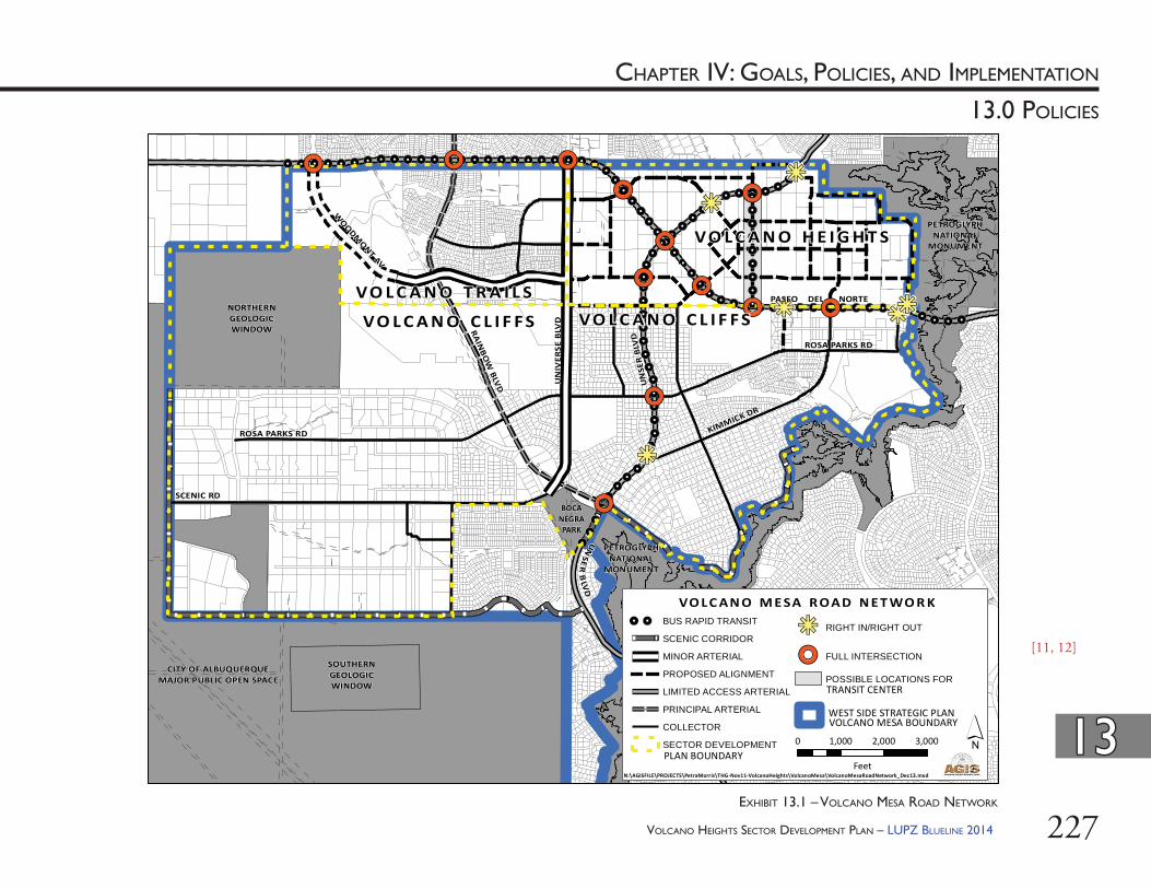
VOLCANO HEIGHTS SECTOR DEVELOPMENT PLAN – LUPZ BLUELINE 2014 227
CHAPTER IV: GOALS, POLICIES, AND IMPLEMENTATION
1313
13.0 POLICIES
!.!.!.!.!.!.
!.!.
!.!.!.
!.!.
!.!.!.!.!.!.
!.!.
!.
!.!.!.!.!.!.!.!.!.!.
!.!.!.!.!.!.!.!.!.!.!.
!.!.!.!.!.!.!.!.!.!.!.!.!.!.!.!.!.!.!.!.!.!.!.!.!.
!.!.!.!.!.!.!.!.!.!.
!.
!.!.!.
!.!.!.!.!.!.!. !. !. !. !.
!.
!.
!.!.
!.!.!.
!.!.
!.!.
!.!.!.!.!.!.
!.!.
!.!.!.
!.!.
!.!.!.!.!.!.
!.!.
!.
!.!.!.!.!.!.!.!.!.!.
!.!.!.!.!.!.!.!.!.!.!.
!.!.!.!.!.!.!.!.!.!.!.!.!.!.!.!.!.!.!.!.!.!.!.!.!.
!.!.!.!.!.!.!.!.!.!.
!.
!.!.!.
!.!.!.!.!.!.!. !. !. !. !.
!.
!.
!.!.
!.!.!.
!.!.
!.!.
,,/ ,,/,,/
,,/
,,/
,,/ ,,/,,/
,,/
kj
kj,,/
kj
kj
,,/
,,/
kjkj
ROSA PARKS RD
SCENIC RD
KIMMICK DR
RAINBO
W BLVD U
NIV
ERSE
BLV
DUN
SER
BLV
D
PASEO DEL NORTE
WOODM
ONT AV
ROSA PARKS RD
PETROGLYPHNATIONAL
MONUMENT
NORTHERNGEOLOGICWINDOW
BOCANEGRAPARK
SOUTHERNGEOLOGICWINDOW
´0 1,000 2,000 3,000
Feet
VO LC AN O M E SA R OAD N E T WO R K
VO L C A N O H E I G H T S
VO L C A N O C L I F F S VO L C A N O C L I F F SVO L C A N O T R A I L S
TRANSIT CENTER
CITY OF ALBUQUERQUEMAJOR PUBLIC OPEN SPACE
PETROGLYPHNATIONAL
MONUMENT
N:\AGISFILE\PROJECTS\PetraMorris\THG-Nov11-VolcanoHeights\VolcanoMesa\VolcanoMesaRoadNetwork_Dec13.mxd
!. !. BUS RAPID TRANSIT
SCENIC CORRIDOR
MINOR ARTERIAL
PROPOSED ALIGNMENT
LIMITED ACCESS ARTERIAL
PRINCIPAL ARTERIAL
COLLECTOR
SECTOR DEVELOPMENT
kj RIGHT IN/RIGHT OUT
,,/ FULL INTERSECTION
POSSIBLE LOCATIONS FOR
WEST SIDE STRATEGIC PLANVOLCANO MESA BOUNDARY
UN
SER
BLV
D
PLAN BOUNDARY
[11, 12]
EXHIBIT 13.1 – VOLCANO MESA ROAD NETWORK
VOLCANO HEIGHTS SECTOR DEVELOPMENT PLAN – LUPZ BLUELINE 2014228
CHAPTER IV: GOALS, POLICIES, AND IMPLEMENTATION
1313
13.0 POLICIES
Developing walkable urban centers is key to ensuring pedestrian safety. Th e Federal Highway Administration (FHWA) recently designated Albuquerque as a Pedestrian Safety Focus City because of the high rate of pedestrian fatalities. Focus cities were identifi ed based on more than 20 average annual pedestrian fatalities or a pedestrian fatality rate greater than 2.33 per 100,000 population. Th e FHWA will provide technical assistance to conduct training on street designs for pedestrian safety, including a Road Safety Audit in locations that have a high number of pedestrian involved crashes. A Road Safety Audit looks at all modes using the street, the current design and signalization, and the location of transit to provide short- and long-term recommendations for improvement.
MRCOG has conducted a street connectivity analysis of developed areas in the region. Th e analysis shows that a well-connected street network has lower levels of congestion than a less-connected network. Th e more connected the surrounding street network is, the less congestion there is on major arterials. Th e connectivity analysis is currently done by calculating the number of intersections per mile. Enhanced street connectivity can disperse traffi c, enhance safety, provide alternative emergency routes, and support the use of alternative transportation modes to the single occupancy vehicle.
MRCOG stresses the connection between land use and transportation planning in the 2035 MTP. In conjunction with the MTP, the Metropolitan Transportation Board established mode share goals of 10% of river crossing trips to be completed by transit by 2025 and 20% by 2035. MRCOG views transit-supportive developments such as Volcano Heights to be critical towards ensuring regional mobility and achieving regional mode share goals.
Th e BRT system proposed for the area in the future incorporates dedicated bus lanes and emerging technologies to make travel times competitive with the car. MRCOG is conducting a high-capacity transit study as of 2013. Potential alignments identifi ed for high-capacity transit routes include Unser Boulevard and Paseo del Norte in the Volcano Mesa area and extend to the Journal Center / North I-25 area and ultimately to the UNM/CNM area and downtown. High-capacity transit would transport area residents and workers to and from the Plan area and established West Side communities, as well as provide mass transit to central Albuquerque and jobs in the I-25 corridor as well as other employment and activity centers east of the Rio Grande. Th is route alternative responds to the projected growth throughout the region’s West Side and the pressure that growth would impose on the roadway network and river crossings. Rio Metro is analyzing the potential for compact and transit-oriented development to increase ridership on West Side transit routes relative to existing conditions as part of the transit study.
MRCOG will seek federal and other funding sources to implement the route that is ultimately selected as the locally-preferred alternative. Th e timeframe for implementation of service though Volcano Heights is dependent in part upon the approval and realization of the Volcano Heights SDP.
VOLCANO HEIGHTS SECTOR DEVELOPMENT PLAN – LUPZ BLUELINE 2014 229
CHAPTER IV: GOALS, POLICIES, AND IMPLEMENTATION
1313
13.0 POLICIES
13.3.1. Regionally Signifi cant Roads: Paseo del Norte and Unser Boulevard through the Plan area are vital to the realization of the Major Activity Center and associated benefi ts of job creation and alleviation of regional traffi c congestion. Both also serve a vital regional transportation function and will continue to serve existing and future development beyond the Plan area. Th e cross sections in this Plan are specifi cally designed to serve both regional transportation needs and the proposed multi-modal urban development pattern envisioned by the Plan. (i) Funding for Construc on: As such,
the City should prioritize and attempt to secure funding to help with the construction of Paseo del Norte and Unser Boulevard within the Plan area per the cross sections within this Plan. Segments that are necessary for implementing enhanced transit service should be prioritized for funding.
(ii) Grade-separated Interchange: Per Th e Mid-Region Metropolitan Planning Organization Transportation Coordinating Committee (TCC) Resolution R-13-03 [See Appendix C], the intersection of these two regionally signifi cant roads should be reviewed for the construction of a grade separated interchange at such time as traffi c congestion and development conditions warrant.
Until this time, the intersection should be constructed as a traditional at-grade, signalized intersection. At such time as a grade-separated interchange is recommended by the TCC, it should be designed to complement this urban, multimodal area and minimize negative impacts to the surrounding land uses, trails, and sensitive lands, specifi cally:a. Th e interchange should be designed
with the smallest footprint that works operationally for the defi ned design horizon, and
b. Th e interchange should incorporate the best practices for urban, multimodal interchanges, in order to support safe crossings for all modes of transportation in all directions.
(iii) Limited-access Intersec ons: In order to protect the regional function of these roads, all access to new development in Volcano Heights should be from streets connected to the approved intersections on Paseo del Norte and Unser Boulevard shown in Exhibit 10.3 on page 169. Streets providing access to new development may be either Primary or Secondary Streets as most appropriate.a. For Primary Street locations and
designations, see Exhibit 10.1 on page 165.
b. For Primary Street cross sections and design standards, see Section 10.6 starting on page 173.
c. For Secondary Street design standards, see Section 10.7.3 starting on page 200.
VOLCANO HEIGHTS SECTOR DEVELOPMENT PLAN – LUPZ BLUELINE 2014230
CHAPTER IV: GOALS, POLICIES, AND IMPLEMENTATION
1313
13.0 POLICIES
(v) Reasonably direct auto routes and acceptable system-wide travel speeds should be maintained.
13.3.4. Transit Center: A major transit center should be located in the Town Center abutting the Transit Boulevard to serve the Paseo del Norte and Unser Boulevard corridors. Th e Transit Boulevard should connect with both Unser Boulevard and Paseo del Norte at signalized intersections. A secondary transit center should be located south and west of the Neighborhood Activity Center proposed near Rainbow Boulevard and Hielo Road in the Volcano Cliff s Sector Development Plan area.
13.3.5. Long-Range Transporta on System Guidelines (i) Th e policies and regulations in this Plan
should be updated to conform with MRCOG’s Long Range Transportation System Guidelines [formerly called Future Albuquerque Area Bikeways & Streets or FAABS Guidelines], which will be an addendum to the Metropolitan Transportation Plan, expected in 2013. Th is document will contain guidelines on roadway design that are driven by land use context, are multi-modal, and that provide a fl exible range of right-of-way and design options.
13.3.2. Transit System: Th e transit system in the Volcano Mesa area should serve three signifi cant corridors: (i) east-west along Paseo Del Norte; (ii) north-south along Unser Boulevard, and (iii) southeast-northwest along Rainbow
Boulevard.
13.3.3. Transit Network (i) Th e Primary Street network and
Secondary Streets should form a grid as much as possible in order to facilitate the movement of transit vehicles, pedestrian access to transit stops, and the dispersion of automobile traffi c away from potential congestion points.
(ii) Transit stops and/or stations should be located to maximize the number of residents and workers within a one-quarter mile walk to a stop or station.
(iii) On these transit routes, crossings of a limited-access arterial will need special design treatment to ensure safe and easy pedestrian crossings. Possible treatments include pedestrian delays, raised center medians (pedestrian refuges), clearly identifi ed pedestrian crossings, pedestrian yield signage, reduced curb radii, and pedestrian starts or leading pedestrian intervals, which give pedestrians authority to start crossing before non-yielding, right-turning vehicles.
(iv) Transit stops or stations should be placed on ‘A’ Streets adjacent to planned retail conveniences, schools, and public amenities.
VOLCANO HEIGHTS SECTOR DEVELOPMENT PLAN – LUPZ BLUELINE 2014 231
CHAPTER IV: GOALS, POLICIES, AND IMPLEMENTATION
1313
13.0 POLICIES
13.3.6. Transit Center and BRT/HOV Lanes: Travel lanes dedicated solely to buses and other high-occupancy vehicles (HOVs) reduce travel times for those who carpool or use transit. (i) Paseo del Norte and Unser Boulevard
should be designed to accommodate BRT/HOV travel lanes.
(ii) Transfer between BRT routes and local buses should occur at a Transit Center maintained near the center of Volcano Heights to enhance its pedestrian and locational advantages.
(iii) Beginning 500 feet before intersections on Paseo del Norte and Unser and any other potential station locations, a minimum of 36 feet in the rights-of-way should be provided on BRT routes for BRT lanes and station platforms.
(iv) Th e fi nal location and confi guration of BRT and HOV lanes will be determined during the roadway design process, as well as from fi ndings and recommendations from the MRCOG High-Capacity Transit study for Paseo del Norte expected in 2013.
(ii) Th e Long-Range Transportation System Map should designate Unser Boulevard and Paseo del Norte as suitable for High Capacity Transit. Th e plan should be amended to be consistent with recommendations adopted with this Sector Development Plan and updated as transit planning evolves. a. Th e ultimate roadway design
recommendations for Unser Boulevard and Paseo del Norte in this Plan incorporate BRT capacity in order to design them as suitable for High Capacity Transit.
a. Transit improvements may be phased, and interim routing may be diff erent from the ultimate routes in some locations.
a. If high-capacity transit is determined to be infeasible, the City should consider amending this Plan to revise cross sections to accommodate diff erent conditions. [See Section 3.3 starting on page 34 for the process to amend this Plan.]
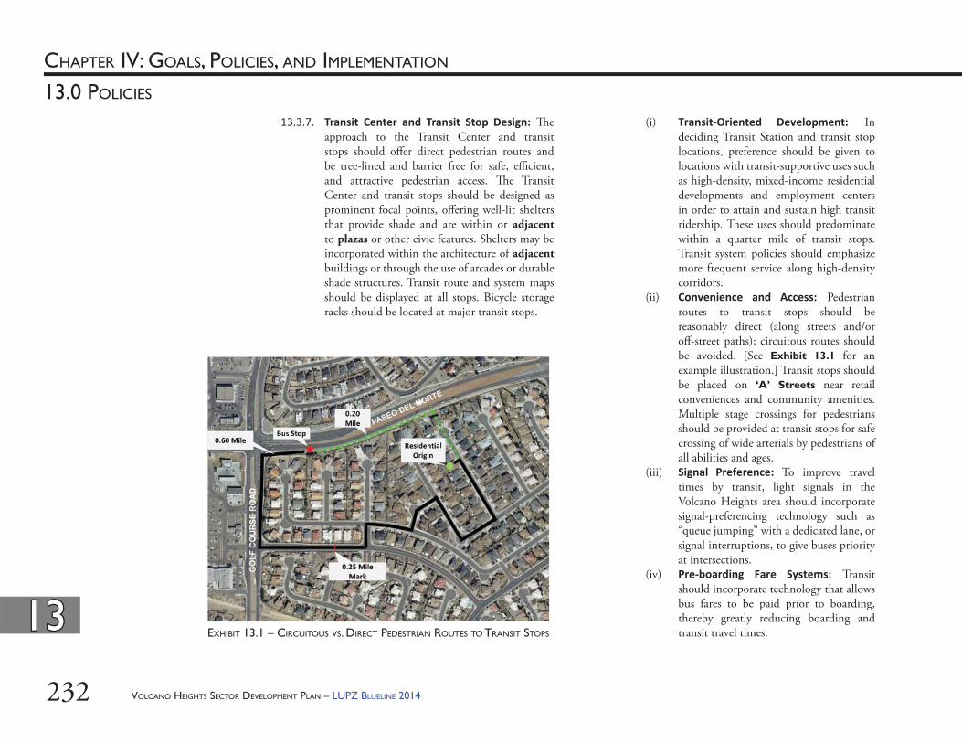
VOLCANO HEIGHTS SECTOR DEVELOPMENT PLAN – LUPZ BLUELINE 2014232
CHAPTER IV: GOALS, POLICIES, AND IMPLEMENTATION
1313
13.0 POLICIES
(i) Transit-Oriented Development: In deciding Transit Station and transit stop locations, preference should be given to locations with transit-supportive uses such as high-density, mixed-income residential developments and employment centers in order to attain and sustain high transit ridership. Th ese uses should predominate within a quarter mile of transit stops. Transit system policies should emphasize more frequent service along high-density corridors.
(ii) Convenience and Access: Pedestrian routes to transit stops should be reasonably direct (along streets and/or off -street paths); circuitous routes should be avoided. [See Exhibit 13.1 for an example illustration.] Transit stops should be placed on ‘A’ Streets near retail conveniences and community amenities. Multiple stage crossings for pedestrians should be provided at transit stops for safe crossing of wide arterials by pedestrians of all abilities and ages.
(iii) Signal Preference: To improve travel times by transit, light signals in the Volcano Heights area should incorporate signal-preferencing technology such as “queue jumping” with a dedicated lane, or signal interruptions, to give buses priority at intersections.
(iv) Pre-boarding Fare Systems: Transit should incorporate technology that allows bus fares to be paid prior to boarding, thereby greatly reducing boarding and transit travel times.
13.3.7. Transit Center and Transit Stop Design: Th e approach to the Transit Center and transit stops should off er direct pedestrian routes and be tree-lined and barrier free for safe, effi cient, and attractive pedestrian access. Th e Transit Center and transit stops should be designed as prominent focal points, off ering well-lit shelters that provide shade and are within or adjacent to plazas or other civic features. Shelters may be incorporated within the architecture of adjacent buildings or through the use of arcades or durable shade structures. Transit route and system maps should be displayed at all stops. Bicycle storage racks should be located at major transit stops.
EXHIBIT 13.1 – CIRCUITOUS VS. DIRECT PEDESTRIAN ROUTES TO TRANSIT STOPS
VOLCANO HEIGHTS SECTOR DEVELOPMENT PLAN – LUPZ BLUELINE 2014 233
CHAPTER IV: GOALS, POLICIES, AND IMPLEMENTATION
1313
13.0 POLICIES
13.3.8. Transporta on Demand Management (TDM) Plans: Major employers should consider implementing Transportation Demand Management (TDM) strategies to provide alternatives to the use of single-occupancy vehicles. TDM off ers incentives for ridesharing, transit use, bicycling, and walking. Incentives may include reduced parking requirements, reduced development fees, development intensity bonuses, and/or the creation of transportation management associations to coordinate eff orts among multiple users in the same area.
13.3.9. Transporta on Agency and Plan Coordina on (i) As development occurs, all transportation
modes should be integrated, which will require coordination among property owners, City DMD, ABQ RIDE, MRCOG, and the MRMPO. Roadways on MRCOG’s Long Range Major Street Plan must include appropriate access management strategies, which also requires coordination across transportation agencies.
(ii) New Primary Streets should be added to the functional classifi cation system in the FAABS.
(iii) ABQ RIDE should coordinate with MRCOG and property owners to identify a short-term Park & Ride facility and Long-term Transit Center on the Transit Boulevard within the Volcano Heights Town Center.
(iv) Th e City DMD should work with MRCOG and constituent jurisdictions to remove and/or alter truck restrictions on Unser Boulevard as established by R-455.
Other provisions in that resolution, relating to road design, character of the roadway as a boulevard with wide median, etc., should remain.
13.3.10. Roadway Design(i) Roads in Volcano Heights should follow
best practices for multi-modal, urban streets. Excellent sources include Context Sensitive Design and Context Sensitive Solutions, as defi ned by the Federal Highway Administration, the Institute of Transportation Engineer’s “Designing Walkable Urban Th oroughfares: A Context Sensitive Approach, An ITE Recommended Practice.” Local sources include the New Mexico Department of Transportation’s “Guide to Context Sensitive Solutions” and “New Mexico Architectural and Visual Quality Design Guidelines for Context Sensitive Design and Context Sensitive Solutions.”
(ii) Bicycle facilities, including on-street bicycle lanes and multi-use trails, should be designed and developed to meet safety considerations as provided in the Institute for Transportation Engineers (ITE) or American Association of State Highway Transportation Offi cials (AASHTO) standards. [15]
(iii) Roadways should be sited and designed to minimize negative impact on views from within the Plan area to the Sandia Mountains on the east.
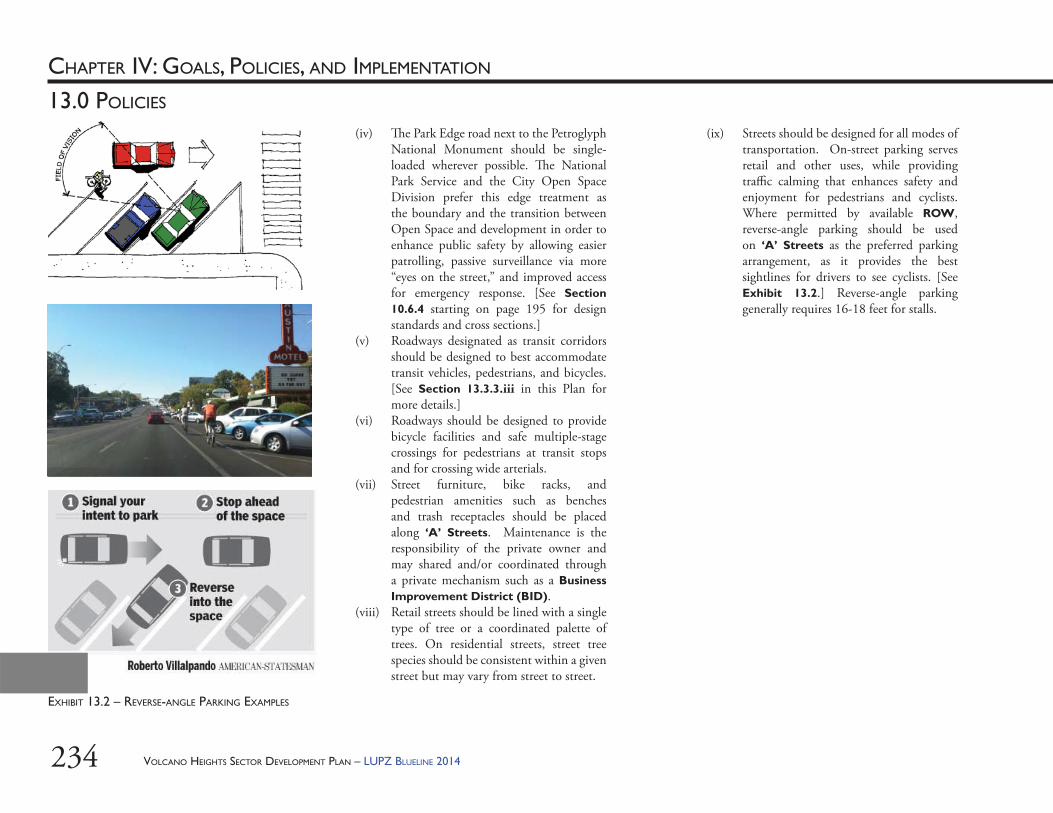
VOLCANO HEIGHTS SECTOR DEVELOPMENT PLAN – LUPZ BLUELINE 2014234
CHAPTER IV: GOALS, POLICIES, AND IMPLEMENTATION
13.0 POLICIES
(iv) Th e Park Edge road next to the Petroglyph National Monument should be single-loaded wherever possible. Th e National Park Service and the City Open Space Division prefer this edge treatment as the boundary and the transition between Open Space and development in order to enhance public safety by allowing easier patrolling, passive surveillance via more “eyes on the street,” and improved access for emergency response. [See Section 10.6.4 starting on page 195 for design standards and cross sections.]
(v) Roadways designated as transit corridors should be designed to best accommodate transit vehicles, pedestrians, and bicycles. [See Section 13.3.3.iii in this Plan for more details.]
(vi) Roadways should be designed to provide bicycle facilities and safe multiple-stage crossings for pedestrians at transit stops and for crossing wide arterials.
(vii) Street furniture, bike racks, and pedestrian amenities such as benches and trash receptacles should be placed along ‘A’ Streets. Maintenance is the responsibility of the private owner and may shared and/or coordinated through a private mechanism such as a Business Improvement District (BID).
(viii) Retail streets should be lined with a single type of tree or a coordinated palette of trees. On residential streets, street tree species should be consistent within a given street but may vary from street to street.
(ix) Streets should be designed for all modes of transportation. On-street parking serves retail and other uses, while providing traffi c calming that enhances safety and enjoyment for pedestrians and cyclists. Where permitted by available ROW, reverse-angle parking should be used on ‘A’ Streets as the preferred parking arrangement, as it provides the best sightlines for drivers to see cyclists. [See Exhibit 13.2.] Reverse-angle parking generally requires 16-18 feet for stalls.
EXHIBIT 13.2 – REVERSE-ANGLE PARKING EXAMPLES
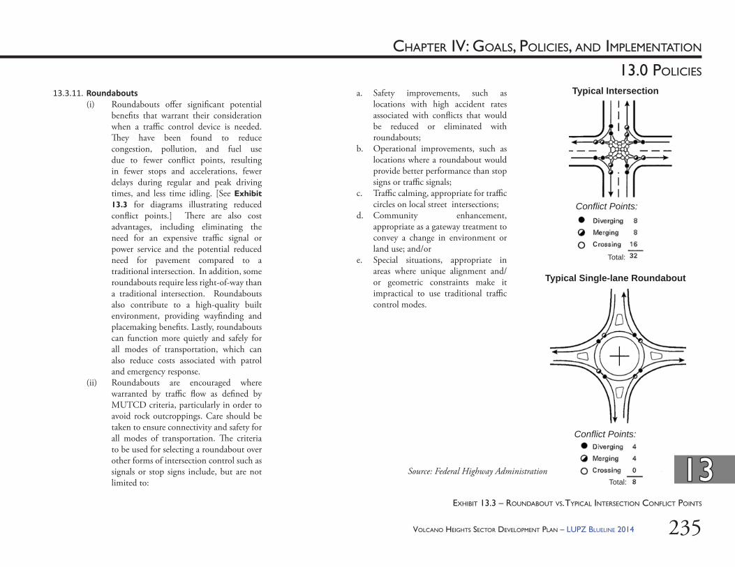
VOLCANO HEIGHTS SECTOR DEVELOPMENT PLAN – LUPZ BLUELINE 2014 235
CHAPTER IV: GOALS, POLICIES, AND IMPLEMENTATION
1313
13.0 POLICIES
13.3.11. Roundabouts(i) Roundabouts off er signifi cant potential
benefi ts that warrant their consideration when a traffi c control device is needed. Th ey have been found to reduce congestion, pollution, and fuel use due to fewer confl ict points, resulting in fewer stops and accelerations, fewer delays during regular and peak driving times, and less time idling. [See Exhibit 13.3 for diagrams illustrating reduced confl ict points.] Th ere are also cost advantages, including eliminating the need for an expensive traffi c signal or power service and the potential reduced need for pavement compared to a traditional intersection. In addition, some roundabouts require less right-of-way than a traditional intersection. Roundabouts also contribute to a high-quality built environment, providing wayfi nding and placemaking benefi ts. Lastly, roundabouts can function more quietly and safely for all modes of transportation, which can also reduce costs associated with patrol and emergency response.
(ii) Roundabouts are encouraged where warranted by traffi c fl ow as defi ned by MUTCD criteria, particularly in order to avoid rock outcroppings. Care should be taken to ensure connectivity and safety for all modes of transportation. Th e criteria to be used for selecting a roundabout over other forms of intersection control such as signals or stop signs include, but are not limited to:
a. Safety improvements, such as locations with high accident rates associated with confl icts that would be reduced or eliminated with roundabouts;
b. Operational improvements, such as locations where a roundabout would provide better performance than stop signs or traffi c signals;
c. Traffi c calming, appropriate for traffi c circles on local street intersections;
d. Community enhancement, appropriate as a gateway treatment to convey a change in environment or land use; and/or
e. Special situations, appropriate in areas where unique alignment and/or geometric constraints make it impractical to use traditional traffi c control modes.
Typical Intersection
Typical Single-lane Roundabout
Confl ict Points:
Total:Source: Federal Highway Administration
EXHIBIT 13.3 – ROUNDABOUT VS. TYPICAL INTERSECTION CONFLICT POINTS
Confl ict Points:
Total:
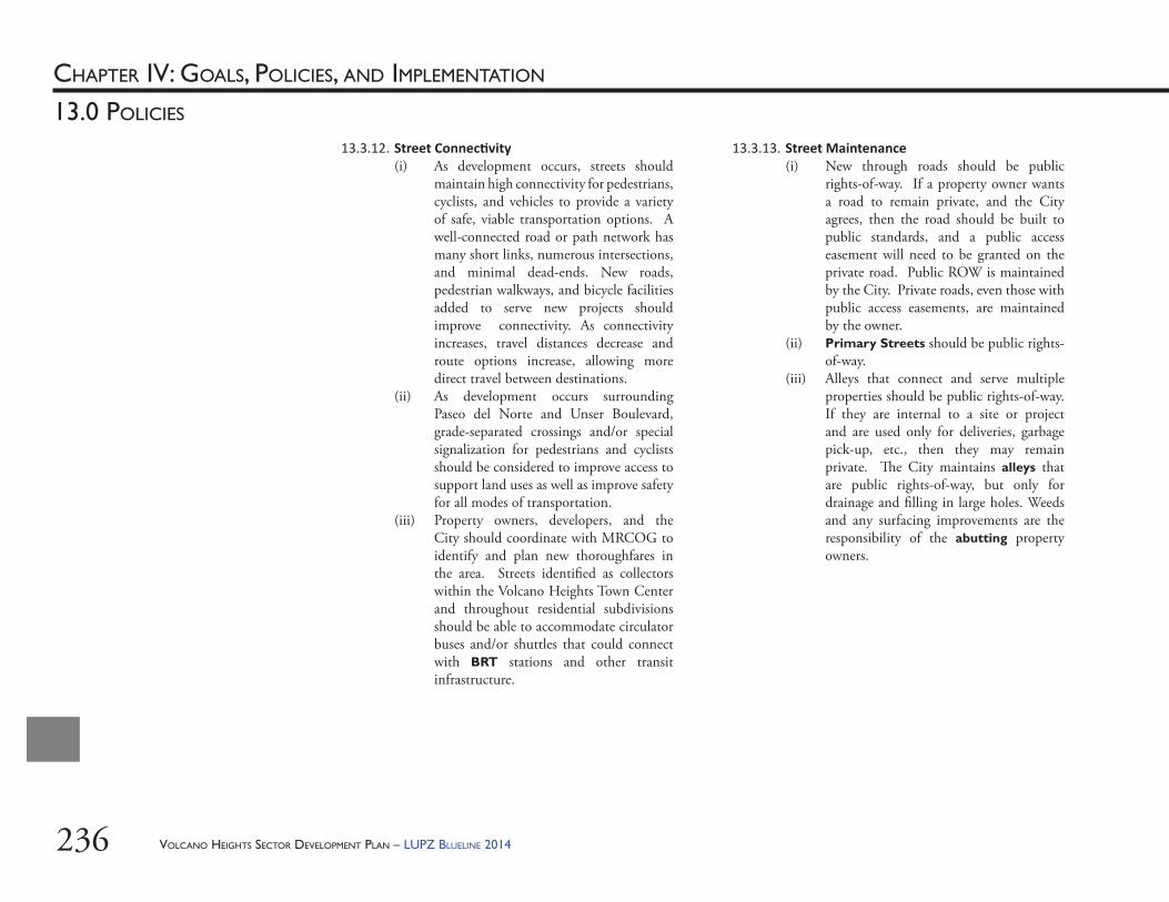
VOLCANO HEIGHTS SECTOR DEVELOPMENT PLAN – LUPZ BLUELINE 2014236
CHAPTER IV: GOALS, POLICIES, AND IMPLEMENTATION
13.0 POLICIES
13.3.12. Street Connec vity(i) As development occurs, streets should
maintain high connectivity for pedestrians, cyclists, and vehicles to provide a variety of safe, viable transportation options. A well-connected road or path network has many short links, numerous intersections, and minimal dead-ends. New roads, pedestrian walkways, and bicycle facilities added to serve new projects should improve connectivity. As connectivity increases, travel distances decrease and route options increase, allowing more direct travel between destinations.
(ii) As development occurs surrounding Paseo del Norte and Unser Boulevard, grade-separated crossings and/or special signalization for pedestrians and cyclists should be considered to improve access to support land uses as well as improve safety for all modes of transportation.
(iii) Property owners, developers, and the City should coordinate with MRCOG to identify and plan new thoroughfares in the area. Streets identifi ed as collectors within the Volcano Heights Town Center and throughout residential subdivisions should be able to accommodate circulator buses and/or shuttles that could connect with BRT stations and other transit infrastructure.
13.3.13. Street Maintenance(i) New through roads should be public
rights-of-way. If a property owner wants a road to remain private, and the City agrees, then the road should be built to public standards, and a public access easement will need to be granted on the private road. Public ROW is maintained by the City. Private roads, even those with public access easements, are maintained by the owner.
(ii) Primary Streets should be public rights-of-way.
(iii) Alleys that connect and serve multiple properties should be public rights-of-way. If they are internal to a site or project and are used only for deliveries, garbage pick-up, etc., then they may remain private. Th e City maintains alleys that are public rights-of-way, but only for drainage and fi lling in large holes. Weeds and any surfacing improvements are the responsibility of the abutting property owners.
VOLCANO HEIGHTS SECTOR DEVELOPMENT PLAN – LUPZ BLUELINE 2014 237
CHAPTER IV: GOALS, POLICIES, AND IMPLEMENTATION
1313
13.0 POLICIES
(iv) Where bike lanes are included in a street cross section, bike lane widths should not exceed 7 feet to minimize the potential for misuse as a motor vehicle travel lane. In addition to the bike lane, a striped bicycle buff er of no less than 2 feet wide should also be included to improve safety for cyclists and motorists. Bicycle lanes plus buff er placed next to on-street parking should be wide enough to allow bicyclists to avoid open car doors without having to enter motor vehicle lanes.
13.3.14. Bicycle and Mul -use Trail Network (i) Existing plans for regional trails
within the Volcano Mesa area should be implemented as funding resources become available. Please refer to the Rank 2 Trails and Bikeways Facilities Plan and the Rank 2 West Side Strategic Plan for more information on the area-wide trail network.
(ii) Because of the checkerboard property ownership, this Plan does not specifi cally recommend any new trails within Volcano Heights. [See Appendix A for existing plans for regional trail locations within the Volcano Heights area.]
(iii) If property owners wish to collaborate to build a private trail within Volcano Heights, this may be done through the subdivision or TIDD/SAD/PID process. Th is trail should be privately constructed and maintained through a property owners association, merchants association, or BID that can manage maintenance requirements, carry liability, and assure an ongoing source of funds. Any such trail should be coordinated with City Parks and Recreation and built according to City standards. Preference should be given to locations that connect rock outcroppings and sensitive lands; follow arterial streets; or provide access to existing trails, Major Public Open Space, parks, or recreational areas.
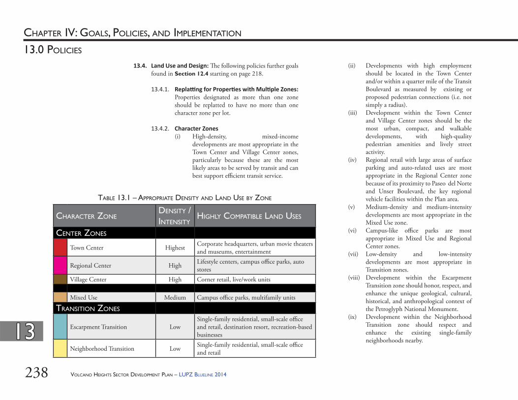
VOLCANO HEIGHTS SECTOR DEVELOPMENT PLAN – LUPZ BLUELINE 2014238
CHAPTER IV: GOALS, POLICIES, AND IMPLEMENTATION
1313
13.0 POLICIES
13.4. Land Use and Design: Th e following policies further goals found in Section 12.4 starting on page 218.
13.4.1. Repla ng for Proper es with Mul ple Zones: Properties designated as more than one zone should be replatted to have no more than one character zone per lot.
13.4.2. Character Zones(i) High-density, mixed-income
developments are most appropriate in the Town Center and Village Center zones, particularly because these are the most likely areas to be served by transit and can best support effi cient transit service.
(ii) Developments with high employment should be located in the Town Center and/or within a quarter mile of the Transit Boulevard as measured by existing or proposed pedestrian connections (i.e. not simply a radius).
(iii) Development within the Town Center and Village Center zones should be the most urban, compact, and walkable developments, with high-quality pedestrian amenities and lively street activity.
(iv) Regional retail with large areas of surface parking and auto-related uses are most appropriate in the Regional Center zone because of its proximity to Paseo del Norte and Unser Boulevard, the key regional vehicle facilities within the Plan area.
(v) Medium-density and medium-intensity developments are most appropriate in the Mixed Use zone.
(vi) Campus-like offi ce parks are most appropriate in Mixed Use and Regional Center zones.
(vii) Low-density and low-intensity developments are most appropriate in Transition zones.
(viii) Development within the Escarpment Transition zone should honor, respect, and enhance the unique geological, cultural, historical, and anthropological context of the Petroglyph National Monument.
(ix) Development within the Neighborhood Transition zone should respect and enhance the existing single-family neighborhoods nearby.
CHARACTER ZONEDENSITY / INTENSITY
HIGHLY COMPATIBLE LAND USES
CENTER ZONES
Town Center Highest Corporate headquarters, urban movie theaters and museums, entertainment
Regional Center High Lifestyle centers, campus offi ce parks, auto stores
Village Center High Corner retail, live/work units
Mixed Use Medium Campus offi ce parks, multifamily units
TRANSITION ZONES
Escarpment Transition LowSingle-family residential, small-scale offi ce and retail, destination resort, recreation-based businesses
Neighborhood Transition Low Single-family residential, small-scale offi ce and retail
TABLE 13.1 – APPROPRIATE DENSITY AND LAND USE BY ZONE
VOLCANO HEIGHTS SECTOR DEVELOPMENT PLAN – LUPZ BLUELINE 2014 239
CHAPTER IV: GOALS, POLICIES, AND IMPLEMENTATION
1313
13.0 POLICIES
13.4.3. Pedestrian Interest: Development in all zones should contribute to a high-quality built environment, with particular emphasis on providing visual interest at the scale of the pedestrian in order to create a walkable district for residents, employees, and visitors. (i) Large expanses of wall or building façade
should include a variety of building materials, colors, and/or openings to break up the plane.
(ii) Civic spaces should include seating and interactive elements accessible to the public.
13.4.4. Entrances(i) Service entrances should be located to
minimize visual, noise, olfactory, and air quality impacts on surrounding uses.
(ii) Pedestrian entrances for multi-family development and non-residential development should be located to provide the most direct access to nearby transit stops.
13.4.5. Sidewalk Loca ons: Th e location of sidewalks shall refl ect the desired character and density of the surrounding land uses. In Center and Mixed-Use Zones, sidewalks are essential to creating a vibrant, pedestrian lifestyle.
13.4.6. Single-family Buff ers: Single-family residences should be buff ered to the extent possible from the most intense uses. Landscape and screening buff ers are adequate for buff ering single-family residences from multifamily, light retail, and small-scale offi ce developments. Multifamily or small-scale retail and offi ce developments are appropriate uses to buff er single-family residences from heavier commercial or manufacturing uses.
13.4.7. Building Placement: Site development standards, specifi cally building frontage standards, are designed to create high-quality pedestrian environments to support the Major Activity Center. As the area develops over time, the buildings will create an urban fabric of corridors lined with buildings. Th e frontage requirements are carefully designed to allow each site to increase in density over time, as surface parking transitions to structured parking lined with retail buildings, as shown in Exhibit 13.4, for example.
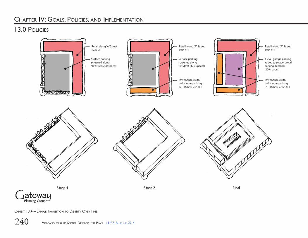
VOLCANO HEIGHTS SECTOR DEVELOPMENT PLAN – LUPZ BLUELINE 2014240
CHAPTER IV: GOALS, POLICIES, AND IMPLEMENTATION
13.0 POLICIES
Stage 1 Stage 2 Final
Retail along “A” Street(50K SF)
Surface parking screened along “B” Strret (200 spaces)
Retail along “A” Street(50K SF)
Surface parking screened along “B” Strret (170 Spaces)
Townhouses with tuck-under parking(6 TH Units; 24K SF)
Retail along “A” Street(50K SF)
3 level garage parking added to support retail parking demand(250 spaces)
Townhouses with tuck-under parking(7 TH Units; 27.6K SF)
EXHIBIT 13.4 – SAMPLE TRANSITION TO DENSITY OVER TIME
VOLCANO HEIGHTS SECTOR DEVELOPMENT PLAN – LUPZ BLUELINE 2014 241
CHAPTER IV: GOALS, POLICIES, AND IMPLEMENTATION
1313
13.0 POLICIES
13.4.8. Building Orienta on(i) Buildings should be designed and sited to
maximize solar gain and minimize solar impact on abutting properties.
(ii) Buildings should be designed and sited to minimize negative impact on views from within the Plan area to the Sandia Mountains on the east.
(iii) Buildings should be designed and sited to minimize negative visual impact on views from across the Rio Grande west toward the Volcanoes.
13.4.9. Coordina on and Maintenance: Property owners should coordinate development, maintenance costs and responsibilities, and liability for publicly accessible private amenities either through forming a BID or other private mechanism.
13.5. Infrastructure: Th e following policies further goals found in Section 12.5 starting on page 221.
13.5.1. New Infrastructure(i) Th e cost of infrastructure required
to service new development is the responsibility of the developer, unless coordinated with other property owners as part of a master development or other mechanism to leverage investment, such as a TIDD, SAD, or PID.
(ii) Infrastructure planning should be coordinated along corridors and across property owners.
(iii) Th e cost of backbone infrastructure that can support development throughout the Plan area should be coordinated across property owners, whether through private development agreements, a master developer, or a formal TIDD, SAD, or PID.
13.5.2. Electrical U li es (i) Electric infrastructure is planned
and constructed in response to new development. New electric transmission lines and multiple substations will be needed within the Plan area to provide electric service once regional employment center development occurs. Substations typically require one- to two-acre parcels of land. It may be necessary for substations to be located near the electric load in the Plan area. Transmission lines should be located along arterial streets, major drainage channels, non-residential collector streets and other potential corridors as directed by the Facility Plan: Electric System Transmission and Generation (2010-2020).
(ii) To serve future development in Volcano Heights, an additional transformer is expected to be needed. Typically, transformers require approximately two (2) acres. Property owners should consider donating or pooling land for this purpose, preferably close to the Town Center.
VOLCANO HEIGHTS SECTOR DEVELOPMENT PLAN – LUPZ BLUELINE 2014242
CHAPTER IV: GOALS, POLICIES, AND IMPLEMENTATION
1313
13.0 POLICIES
13.5.3. Rainwater Management (i) Developments should incorporate Low
Impact Design (LID) techniques wherever possible and appropriate. [See Table 13.2, Table 13.3, and Exhibit 13.5 in this Plan.]
(ii) Property owners should consult and/or incorporate AMAFCA’s Drainage Master Plan for Volcano Heights, being drafted as of 2013, for key drainage infrastructure. [See Section 14.2.5 starting on page 248.]
(iii) Where possible, natural stormwater treatments, such as bioswales, linear ponds, etc., should be used to provide fl ood control and for stormwater quality.
(iv) A bioswale/linear pond should be designed and incorporated into the median and/or eastern edge of the Park Edge Road. Such a pond, designed in consultation with the City Hydrologist, can help provide a preferred alternative to stormwater drains while helping to meet the City’s water quality goals. [See also Section 10.6.4 starting on page 195 and Goal 12.5.5 starting on page 222 in this Plan.]
MICRO
1 Tree wells2 Medians3 Parking lot islands4 Pocket parks5 Backyard/front yard ponds and landscape areas6 Parkway between curb and sidewalk7 Area behind sidewalk8 Unused or rarely used areas of parking lots
LOCAL
1 Small parks and open spaces2 On-site drainage ponds retrofi t for “fi rst fl ush” and fl oatables
treatment3 Re-graded parking lot landscape areas (use speed bumps/dips as
diversions)4 Channel tributary entrances5 Subdivision scale detention basins6 Subdivision entry features
REGIONAL
1 Regional detention basins2 Pump stations3 Pump station discharges into Rio Grande4 Regional parks and open space5 Diversion channel and arroyo outfalls to river
TABLE 13.2 – LOCATIONS APPROPRIATE FOR LOW-IMPACT DESIGN (LID) BY SCALE
VOLCANO HEIGHTS SECTOR DEVELOPMENT PLAN – LUPZ BLUELINE 2014 243
CHAPTER IV: GOALS, POLICIES, AND IMPLEMENTATION
1313
13.0 POLICIES
EXHIBIT 13.5 – RECOMMENDED RAINWATER DESIGN TECHNIQUES
Parking Raingarden
Decorative Grill and Curb Cut
Permeable Paving
D E D O RImpervious Surfaces Minimize the amount of directly connected impervious material. Transition to
permeable material under parking areas and/or create breaks in impervious material with open curbs or fl ush-mount curbs that allow water to fl ow into landscaped areas.
Roadway Section Roadway sections should be as open and as minimal as possible. Pedestrian zones should be separated from vehicular zones with a landscaped area bordered by open curbs or fl ush-mount curbs to allow for water fl ow.
Intersections At large intersections, introduce a traffi c circle designed to accept stormwater runoff and act as a landscaped bioretention area. At all intersections, minimize turning radii to slow traffi c and reduce paved area.
Looped Turnaround Where possible along the corridor, cluster development and design a looped turnaround for access. Th e center of the loop can be bordered by fl ush-mount curbs and act as a landscaped bioretention area.
Driveways Where possible, share driveways and transition to permeable pavement in the driveway.Sidewalks Slope/grade sidewalks horizontally so they drain toward landscaped areas.
TABLE 13.3 – OBJECTIVES AND RECOMMENDATIONS FOR LID BY DESIGN ELEMENT
Vegetated Swales
VOLCANO HEIGHTS SECTOR DEVELOPMENT PLAN – LUPZ BLUELINE 2014244
CHAPTER IV: GOALS, POLICIES, AND IMPLEMENTATION
1313
13.0 POLICIES
13.5.5. Wastewater Improvements(i) All necessary, required infrastructure
improvements to provide wastewater collection services to Volcano Heights will be constructed by the developer.
(ii) All new infrastructure must be built to ABCWUA standards before the Water Authority accepts the new infrastructure.
(iii) All collected waste water fl ows from the study area will outfall to the existing interceptor in the Paseo del Norte/Avenida de Jaimito Corridor. Extension of this line to the west from its current terminus (near Calle Norteña) will be required.
13.5.6. ABCWUA Development Agreements(i) All new water services within the study
area will require the execution of a Development Agreement between the owner/developers and the ABCWUA before either water or wastewater service is provided.
(ii) Th e Development Agreement will detail the extent of the required water and wastewater infrastructure that must be constructed before service is provided by the ABCWUA.
(iii) Th e Development Agreement does not replace or supersede the development requirements of the City of Albuquerque as detailed in the Development Process Manual.
13.5.4. Water Improvements: As of adoption of this Plan, the Albuquerque-Bernalillo County Water Utility Authority (ABCWUA) was reviewing a 2012 draft Northwest Service Area Integrated Infrastructure Plan for an area that includes Volcano Heights, which identifi es the size of water transmission trunk lines, storage capacity, water treatment, and fi re storage necessary to support development. (i) Increased demand within both the
Corrales and Volcano Trunks will require additional treatment capacity at the wells within both these trunks.
(ii) Additional storage capacity (i.e. an additional water tank) may be needed to provide fi re protection to new development within Volcano Heights. Th e ABCWUA will determine future storage requirements based on details as new development is proposed.
(iii) All necessary, required infrastructure improvements to provide water service to Volcano Heights will be constructed by the developer. Th is includes the internal distribution systems in the study area.
(iv) All new infrastructure must be built to ABCWUA standards before the Water Authority accepts the new infrastructure.
(v) As Volcano Heights is outside of the existing ABCWUA service area, all development will be assessed Water Supply Charges as well as Utility Expansion Charges. Th e Water Supply Charges relate to the acquisition of new water rights necessary to provide service outside of the defi ned ABCWUA service area.
VOLCANO HEIGHTS SECTOR DEVELOPMENT PLAN – LUPZ BLUELINE 2014 245
14.0 IMPLEMENTATION
CHAPTER IV: GOALS, POLICIES, AND IMPLEMENTATION
VOLCANO HEIGHTS SECTOR DEVELOPMENT PLAN – LUPZ BLUELINE 2014246
CHAPTER IV: GOALS, POLICIES, AND IMPLEMENTATION
1414
14.0 IMPLEMENTATION
14.1. Priority Capital Improvement ProjectsDevelopment of the Volcano Heights Plan area and the Major Activity Center is expected to occur over a period of decades and will require a high level of infrastructure to attract high-quality development and major employers, as discussed further in the fi scal impact analysis in Appendix E.
Th e fi scal impact analysis estimates the potential for over $150 million in additional development value from the mixed-use, walkable environment envisioned by this Plan and enabled by its zoning and design standards, in comparison to the more typical suburban development model, with its high initial investment but steep drop off in development value. Based on this analysis, the high initial investment needed to create a “sense of place” will more than be recovered by the long-term value as the area continues to increase in value over time.
As the fi scal impact analysis indicates, the potential for better outcomes is compelling, and the City should carefully consider how to invest in Volcano Heights’ success to reap the fi nancial benefi ts, as well as the enhanced opportunities for economic development and placemaking, this model off ers. By investing in appropriate catalytic improvements, the City can support a sustainable development model for Albuquerque and, in particular, the West Side.
Priority infrastructure includes, but is not limited to the following needs:14.1.1. Th e Primary Street network, especially the
Transit Boulevard through the Town Center and the loop road to provide access to Primary Streets surrounding the intersection of Paseo del Norte/Unser Boulevard;
14.1.2. Complete buildout of Paseo del Norte and Unser Boulevard to the City’s required cross sections;
14.1.3. An internal, local road network to access residences and businesses and designed to meet block size requirements for each district;
14.1.4. Telecommunications and utility infrastructure;
14.1.5. Water, sewer and drainage infrastructure, including regional retention pond facilities, an additional water tank, and water source and water quality improvements;
14.1.6. Trails, bike facilities, and other recreational facilities;
14.1.7. Civic spaces, parks and open space; and
14.1.8. Transit facilities, including bus stops and a multi-modal transit center in Town Center serving proposed high-capacity transit.
VOLCANO HEIGHTS SECTOR DEVELOPMENT PLAN – LUPZ BLUELINE 2014 247
CHAPTER IV: GOALS, POLICIES, AND IMPLEMENTATION
1414
14.0 IMPLEMENTATION
(iii) Department of Municipal DevelopmentCoordination with agencies and private
utilities to develop infrastructure in a timely manner;
Creation and evaluation of road cross-sections; and
Coordination to address truck restrictions within Volcano Heights.
14.2.3. State, County, Mid-Region Council of Governments(i) Transportation coordination, including
approving an impending update of the Future Albuquerque Area Bikeways and Streets (FAABS) Plan to better coordinate transportation and land use;
(ii) Adding Primary Street alignments to the Long Range Transportation System map;
(iii) Reviewing a grade-separated interchange at Paseo/Unser when traffi c and development conditions warrant; and
(iv) Assistance with infrastructure costs where feasible.
14.2.4. Albuquerque-Bernalillo County Water U lity Authority (ABCWUA): Planning guidance to verify compliance with the ongoing ABCWUA Master Planning eff orts.
14.2. Implementa on Responsibili esTh ough it is likely that some funding will be available for certain projects from the City, County, State and other regional agencies, the bulk of the cost for infrastructure in Volcano Heights is the responsibility of land owners and developers. Broad coordination among multiple land owners and robust fi nancing mechanisms will be necessary for development.
14.2.1. Property Owners(i) Coordination – engagement of a master
developer is recommended;(ii) Infrastructure costs;(iii) Development costs;(iv) Implementation of fi nance mechanisms,
such as Special Assessment Districts (SADs) or Tax Increment Development Districts (TIDD).
14.2.2. City of Albuquerque(i) Sector Development Plan
Development of land use and zoning regulations;
Development of design requirements;Development and implementation of
streamlined review process; andAdoption and update of the Plan.
(ii) Economic DevelopmentCoordination among multiple
jurisdictions;Promotion of area and recruitment of
business; andCollaboration with businesses and
development of incentives, such as Industrial Revenue Bonds.
VOLCANO HEIGHTS SECTOR DEVELOPMENT PLAN – LUPZ BLUELINE 2014248
CHAPTER IV: GOALS, POLICIES, AND IMPLEMENTATION
1414
14.0 IMPLEMENTATION
14.2.5. Albuquerque Metropolitan Area Flood Control Authority (AMAFCA): As of 2013, AMAFCA is preparing a Drainage Master Plan for the Volcano Heights Area. Th e Drainage Master Plan will identify the major drainage infrastructure needed in Volcano Heights, recommend a construction plan and schedule, and work through a mechanism with property owners to fi nance the infrastructure. All public and private stakeholders are encouraged to participate in the process.
14.3. Op onal Financial ToolsCity Ordinances allow for a variety of fi nancial tools that enable rising property values from development to pay for infrastructure. Desired outcomes at Volcano Heights will likely require the use of one or more of the following methods:14.3.1. Special Assessment District (SAD): Described
in the Albuquerque Code of Ordinances, Section 6-8, Special Assessment Districts (SADs) involve an additional charge added to property taxes to fund necessary improvements in new subdivisions, such as drinking water and sewer lines, paving and other government services. SADs can be requested by a percentage of landowners in an area or imposed by a local government, and SAD revenues are used to pay back city general funds or service debts, such as bonds, incurred for infrastructure construction.
14.3.2. Public Improvement District (PID): Described in the Albuquerque Code of Ordinances, Section 6-9 and enabled by New Mexico Statute Section 5-11-1 to 5-11-27 NMSA 1978 (2001), Public Improvement Districts involve an additional charge added to property taxes to fund a broad array of improvements in a subdivision, ranging from roads and drainage to recreational facilities, trails, parks, public buildings, libraries and other amenities. Like SADs, PID revenues are used to pay back general funds or debts incurred for the construction of infrastructure. Th e City of Albuquerque currently requires unanimous vote of property owners to establish a PID, though state statutes allow PIDs to be created with ¾ of property owners in agreement.
14.3.3. Tax Increment Development District (TIDD): Described in the City of Albuquerque Code of Ordinances, Section 4-10, Tax Increment Development Districts (TIDDs) capture a portion of the increase in property and gross receipts taxes resulting from the area’s development. Funds can be used to pay back debt on a range of projects similar to PIDs, including elaborate streetscapes like the urban boulevard, parks and trails, civic spaces, and other amenities. TIDDs are typically used for a large, master-planned development, rather than a single subdivision. Unlike other funding mechanisms, they do not impose new costs or taxes on property owners (except those incurred by rising property values caused by development). TIDD proceeds can also be used for ongoing maintenance and improvement of facilities.
VOLCANO HEIGHTS SECTOR DEVELOPMENT PLAN – LUPZ BLUELINE 2014 249
CHAPTER IV: GOALS, POLICIES, AND IMPLEMENTATION
1414
14.0 IMPLEMENTATION
TIDDs require major coordination among property owners to apply for and maintain districts, issue bonds, and manage revenues and bond payment.
14.3.4. Public/Private Tax Rebate Agreement: Similar to a TIDD, this type of agreement allows for cities, counties, and other taxing entities to enter into agreements with developers that let developers obtain rebates for infrastructure in return for development that meets standards set by the aff ected governments for density, walkability, sustainability, etc. Under this type of public/private partnership, the rebates can only be requested after the development has been completed as agreed upon and new property or sales tax revenues have been generated there for a set time period. Such an arrangement can allow rebates of tax revenues for a fl exible range of infrastructure improvements, such as streets and utilities, but unlike TIDDs, developers must pay those costs upfront themselves – the agreement cannot be collateralized to allow bonding or other debt acquisition based on expected rebates. At least one such agreement has been made in New Mexico – a project in Rio Rancho whose developer may request up to $2.8 million in rebates for infrastructure costs from gross-receipts (sales) taxes generated on site, after the development is complete and has been in use long enough that those revenues have been collected by the New Mexico Taxation and Revenue Department.
14.4. Amending this Sector Development Plan: Changes to the text, graphics, or zone map shall be per City Zoning Code §14-16-4-1 and §14-16-4-3.
14.5. Implementa on Matrix: See Table 14.1.
VOLCANO HEIGHTS SECTOR DEVELOPMENT PLAN – LUPZ BLUELINE 2014250
CHAPTER IV: GOALS, POLICIES, AND IMPLEMENTATION
1414
14.0 IMPLEMENTATION
ELEMENT ID POLICY IMPLEMENTED
PRIORITY ACTION LEAD AGENCYCOORDINATION
REQUIRED
A. ENVIRONMENT AND OPEN SPACE
Open Space Acquisition
A-1 13.1.1 Short-term Prioritize open space acquisitions in Volcano Heights City Open Space Division
Council
Transfer-of-Development Rights (TDRs)
A-2 13.1.3, 13.1.5 Medium-term
Create legal framework allowing TDRs in the City of Albuquerque or within Volcano Heights
Council/Legal City Open Space Division
Monitoring Process for Blasting
A-3 13.1.9, 13.1.10 Medium-term
Create development process for suffi ciently documenting existing conditions on a subject property and on adjacent natural resources within Escarpment Transition zone, abutting archaeological sites, and adjacent to Major Public Open Space prior to any blasting required by new development and/or infrastructure
City Open Space Division
City Development staff , Property Owners
B. ECONOMIC DEVELOPMENT
Economic Development & Recruitment
B-1 13.2.2, 13.2.6 Medium-term
Coordinate with property owners to form a BID and/or hire a master development coordinator
City Economic Development
Council, Property Owners
B-2 13.2.6 Medium-term
Coordinate with property owners and Double Eagle Airport to recruit businesses for Volcano Heights
City Economic Development
Property Owners, Double Eagle Airport
C. TRANSPORTATION
Transit C-1 13.3.2 Short-term Identify a site for park and ride ABQ RIDE MRCOG, Property Owners, CNM, UNM
C-2 13.3.4 Long-term Identify a site for transit center ABQ RIDE MRCOG, Property Owners
TABLE 14.1 –IMPLEMENTATION MATRIX
AMAFCA = Albuquerque Metropolitan Flood Control AuthorityABCWUA = Albuquerque-Bernalillo County Water Utility AuthorityCNM = Central New Mexico Community CollegeDMD = Department of Municipal Development (CABQ)GABAC = Greater Albuquerque Bicycling Advisory Committee
AGENCY & ORGANIZATION ACRONYMS USED IN THE FOLLOWING TABLE:GARTC = Greater Albuquerque Recreational Trails CommitteeMRCOG = Mid Region Council of GovernmentsNMDOT = New Mexico Department of TransportationPNM = Public Service Company of New Mexico (Electric Utility)UNM = Th e University of New Mexico
VOLCANO HEIGHTS SECTOR DEVELOPMENT PLAN – LUPZ BLUELINE 2014 251
CHAPTER IV: GOALS, POLICIES, AND IMPLEMENTATION
1414
14.0 IMPLEMENTATION
TABLE 14.1 –IMPLEMENTATION MATRIX (Cont’d)
ELEMENT ID POLICY IMPLEMENTED
PRIORITY ACTION LEAD AGENCYCOORDINATION
REQUIRED
Autos C-3 13.3.5 Short-term Add Primary Streets to FAABS Street Designations MRCOG DMD/PlanningC-4 13.3.1 Medium-
termStudy a grade-separated interchange when traffi c and/or development conditions warrant
DMD/MRCOG NMDOT, Planning, Bernalillo County
C-5 13.3.9 Medium-term
Study truck access to Volcano Heights to determine suffi cient routes
DMD/MRCOG NMDOT, Planning, Bernalillo County
Bikes C-6 13.3.14 Short-term Coordinate multi-use trails along Unser Blvd. with 50-mile Bike Loop and decide which side of Unser Blvd. and Paseo del Norte the multi-use trail should go
DMD/Parks/GABAC/GARTC
Mayor’s Offi ce
Peds C-7 13.3.10 Long-term Investigate grade-separated pedestrian crossings for Paseo del Norte and Unser Boulevard
DMD Property Owners
D. LAND USE AND URBAN DESIGN
Major Activity Center
D-1 13.2.1 Short-term Update the Comprehensive Plan’s Centers & Corridors Map to include Volcano Heights MAC [13]
City Planning Council
Coordination & Maintenance
D-1 13.4.9 Medium-term
Coordinate with property owners to form a BID to oversee implementation of the Plan and ongoing maintenance of private amenities accessible to the public.
City Economic Development
Council, Property Owners
E. INFRASTRUCTURE
Drainage Master Plan
E-1 13.5.3 Short-term Coordinate with property owners to create a Drainage Management Plan to identify needed infrastructure and plan for its implementation
AMAFCA Property Owners, City Hydrology
Water/Wastewater
E-2 13.5.4, 13.5.5, 13.5.6 Medium-term
Coordinate with property owners on needed improvements to water systems and execution of necessary development agreements
ABCWUA Property Owners
Utilities E-3 13.2.7, 13.5.2 Medium-term
Coordinate with property owners on needed improvements to electric, gas, communications, and other dry utilities
PNM, NM Gas Property Owners
PID/SAD/TIDDs
E-4 13.5.1 Medium-term
Coordinate with property owners to form PID/SAD/TIDDs when/as requested to fund infrastructure improvements
Council Property Owners, State of New Mexico

VOLCANO HEIGHTS SECTOR DEVELOPMENT PLAN – LUPZ BLUELINE 2014252
Th is Page Left Intentionally Blank