Embed Size (px)
Citation preview
CAIRT Newsletter of the Scottish Maps Forum
Issue 13 July 2008
In this issue:
• Slezer’s Theatrum Scotiae
• OS six-inch website
• Bartholomew Archive highlight : Naming of Antarctica
• Map-related talks, publications and website news
• Thomson’s Atlas of Scotland
_______________________
SCOTTISH MAPS FORUM
The Forum was initiated by the National Library of Scotland in January 2002: � To stimulate and to encourage multi-disciplinary map use, study and research, particularly relating to Scottish maps and mapmakers �To disseminate information on Scottish maps and map collections �To record information on maps and mapmaking, particularly in a Scottish context �To liaise with other groups and individuals with map related interests �To build on, and to continue, the work of Project Pont
CAIRT
The newsletter is issued twice a year. "Cairt" is Gaelic & 17th century Scots for map. For further information, or to be added to the mailing list, please contact:
Scottish Maps Forum Map Library
National Library of Scotland 33 Salisbury Place
Edinburgh EH9 1SL
Tel: 0131 623 3970 Fax: 0131 623 3971
E-mail: [email protected]
ISSN 1477-4186 © 2008 NLS Editor: D. Webster Technical editor: J Parkerson
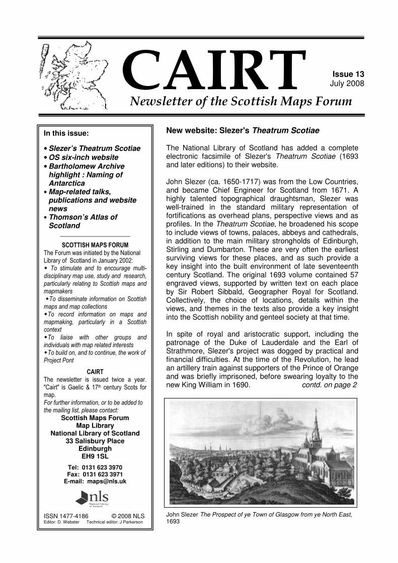
New website: Slezer's Theatrum Scotiae The National Library of Scotland has added a complete electronic facsimile of Slezer's Theatrum Scotiae (1693 and later editions) to their website. John Slezer (ca. 1650-1717) was from the Low Countries, and became Chief Engineer for Scotland from 1671. A highly talented topographical draughtsman, Slezer was well-trained in the standard military representation of fortifications as overhead plans, perspective views and as profiles. In the Theatrum Scotiae, he broadened his scope to include views of towns, palaces, abbeys and cathedrals, in addition to the main military strongholds of Edinburgh, Stirling and Dumbarton. These are very often the earliest surviving views for these places, and as such provide a key insight into the built environment of late seventeenth century Scotland. The original 1693 volume contained 57 engraved views, supported by written text on each place by Sir Robert Sibbald, Geographer Royal for Scotland. Collectively, the choice of locations, details within the views, and themes in the texts also provide a key insight into the Scottish nobility and genteel society at that time. In spite of royal and aristocratic support, including the patronage of the Duke of Lauderdale and the Earl of Strathmore, Slezer's project was dogged by practical and financial difficulties. At the time of the Revolution, he lead an artillery train against supporters of the Prince of Orange and was briefly imprisoned, before swearing loyalty to the new King William in 1690. contd. on page 2
John Slezer The Prospect of ye Town of Glasgow from ye North East, 1693
2
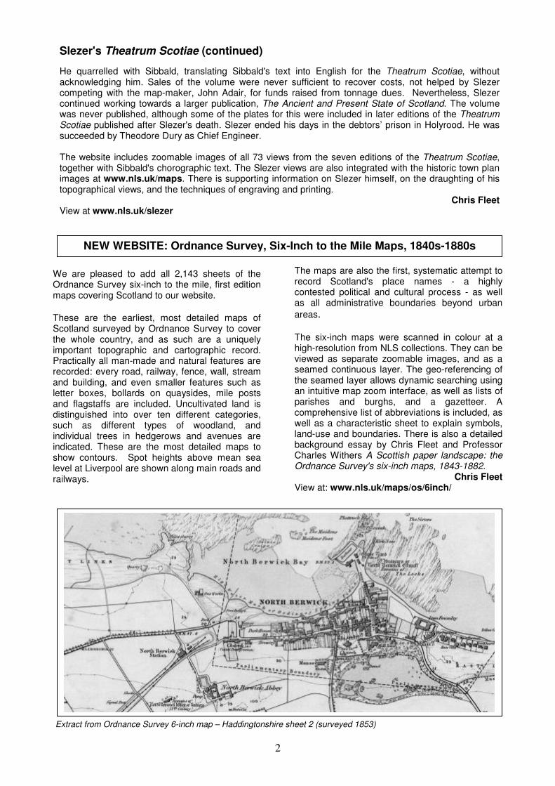
We are pleased to add all 2,143 sheets of the Ordnance Survey six-inch to the mile, first edition maps covering Scotland to our website.
These are the earliest, most detailed maps of Scotland surveyed by Ordnance Survey to cover the whole country, and as such are a uniquely important topographic and cartographic record. Practically all man-made and natural features are recorded: every road, railway, fence, wall, stream and building, and even smaller features such as letter boxes, bollards on quaysides, mile posts and flagstaffs are included. Uncultivated land is distinguished into over ten different categories, such as different types of woodland, and individual trees in hedgerows and avenues are indicated. These are the most detailed maps to show contours. Spot heights above mean sea level at Liverpool are shown along main roads and railways.
The maps are also the first, systematic attempt to record Scotland's place names - a highly contested political and cultural process - as well as all administrative boundaries beyond urban
areas. The six-inch maps were scanned in colour at a high-resolution from NLS collections. They can be viewed as separate zoomable images, and as a seamed continuous layer. The geo-referencing of the seamed layer allows dynamic searching using an intuitive map zoom interface, as well as lists of parishes and burghs, and a gazetteer. A comprehensive list of abbreviations is included, as well as a characteristic sheet to explain symbols, land-use and boundaries. There is also a detailed background essay by Chris Fleet and Professor Charles Withers A Scottish paper landscape: the Ordnance Survey's six-inch maps, 1843-1882.
Chris Fleet View at: www.nls.uk/maps/os/6inch/
NEW WEBSITE: Ordnance Survey, Six-Inch to the Mile Maps, 1840s-1880s
Slezer's Theatrum Scotiae (continued)
He quarrelled with Sibbald, translating Sibbald's text into English for the Theatrum Scotiae, without acknowledging him. Sales of the volume were never sufficient to recover costs, not helped by Slezer competing with the map-maker, John Adair, for funds raised from tonnage dues. Nevertheless, Slezer continued working towards a larger publication, The Ancient and Present State of Scotland. The volume was never published, although some of the plates for this were included in later editions of the Theatrum Scotiae published after Slezer's death. Slezer ended his days in the debtors’ prison in Holyrood. He was succeeded by Theodore Dury as Chief Engineer.
The website includes zoomable images of all 73 views from the seven editions of the Theatrum Scotiae, together with Sibbald's chorographic text. The Slezer views are also integrated with the historic town plan images at www.nls.uk/maps. There is supporting information on Slezer himself, on the draughting of his topographical views, and the techniques of engraving and printing.
Chris Fleet View at www.nls.uk/slezer
Extract from Ordnance Survey 6-inch map – Haddingtonshire sheet 2 (surveyed 1853)
3
A campaign has been launched to restore what must be one of the most unusual maps of Scotland. General Stanisław Maczek (1892-1994) was a renowned Polish commander in World War II. As a symbol of gratitude to the Scottish people for the hospitality he and other Polish exiles had received during the war, he conceived the idea of constructing a large relief map of Scotland at Barony Castle, Eddleston, later the Black Barony Hotel, which was owned by his son-in-law.
Inspired by an outdoor map of land and water he had seen in the Netherlands in 1945, he arranged for a large concrete relief map to be built in an oval tank, and this pool is fed by a pipe from a weir in the adjacent stream to surround the land mass with water. Water was also plumbed to create a source for the major rivers to have flowing water. The coastline and relief of Scotland were laid out precisely by Kazimierz Trafas, a
young Polish student geographer-planner brought in from the Jagiellonian University at Cracow. The map was constructed by former Free Polish Army soldiers probably in the mid to late 1950s. The pool is approximately 175 metres in
circumference and the vertical scale of the relief
map is possibly three times exaggerated. Originally it was painted in 2 or 3 colours like a physical map but most of the paint has now gone.
The structure has been derelict for many years, but has recently been drained and cleared of undergrowth by Barony Castle’s current owners, De Vere Venues. More intrepid visitors may also see an aerial view by sliding down the ‘flying fox’ which has been installed. Roger Kelly, David Cameron and others are leading a campaign to restore the Great Map to working order. Find out more at their website:
www.makers.org.uk/place/Maczek
NEW WEBSITE: General Maczek’s Great Polish Map of Scotland
RECENT MAP PUBLICATIONS Aaron M. Allen. ‘Occupational mapping of 1635 Edinburgh: an introduction.’ (Proceedings of the Society of Antiquaries of Scotland, 136, 2006, 259-296). Christopher Fleet & Kimberly C. Kowal. ‘The Roy military survey of Scotland (1747-55): mosaicing, geo-referencing and web-delivery’,(e-perimetron Vol. 2(4) Autumn 2007, pp.194-208) www.eperimetron.org/Vol_2_4/Fleet_Kowal.pdf John Mitchell. ‘Loch Lomond and the Trossachs tourist map.’ (The Glasgow Naturalist, 25(1), 2008, 25-28). Diana Webster. ‘OS Mapping of Scotland circa 1820.’ (Sheetlines 79 , Aug.2007, 67-68).
NLS MAP LIBRARY 50th ANNIVERSARY
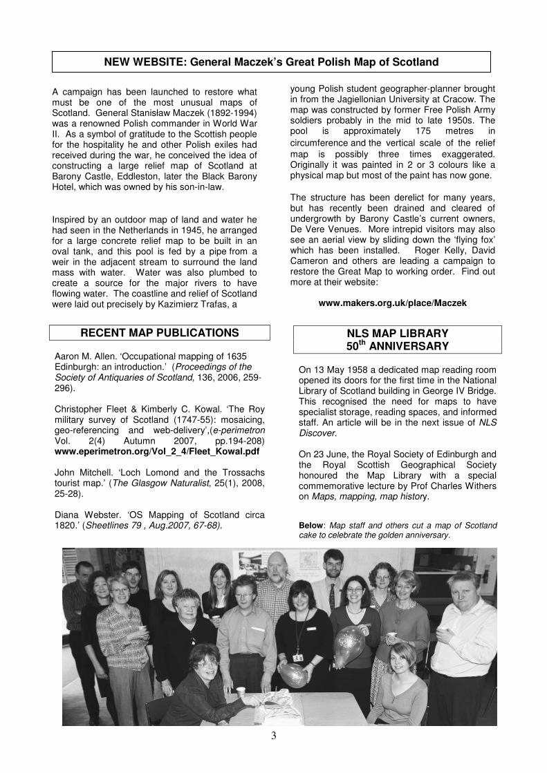
On 13 May 1958 a dedicated map reading room opened its doors for the first time in the National Library of Scotland building in George IV Bridge. This recognised the need for maps to have specialist storage, reading spaces, and informed staff. An article will be in the next issue of NLS Discover. On 23 June, the Royal Society of Edinburgh and the Royal Scottish Geographical Society honoured the Map Library with a special commemorative lecture by Prof Charles Withers on Maps, mapping, map history. Below: Map staff and others cut a map of Scotland cake to celebrate the golden anniversary.
4
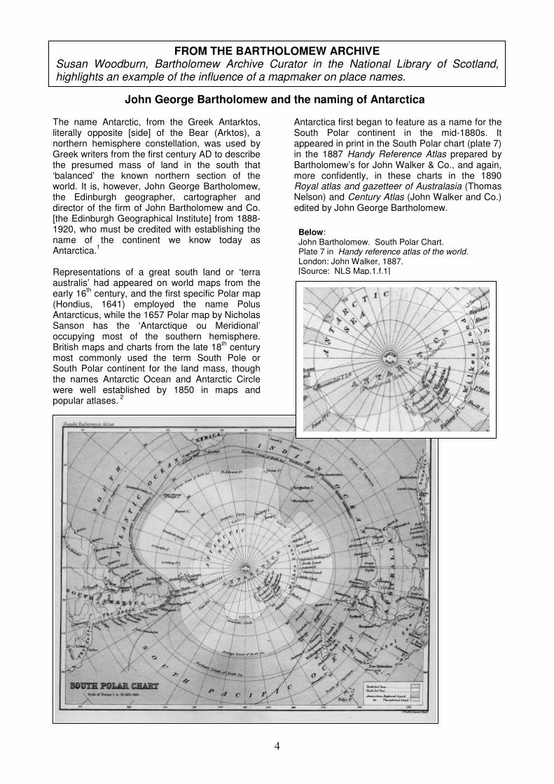
Below: John Bartholomew. South Polar Chart. Plate 7 in Handy reference atlas of the world. London: John Walker, 1887. [Source: NLS Map.1.f.1]
The name Antarctic, from the Greek Antarktos, literally opposite [side] of the Bear (Arktos), a northern hemisphere constellation, was used by Greek writers from the first century AD to describe the presumed mass of land in the south that ‘balanced’ the known northern section of the world. It is, however, John George Bartholomew, the Edinburgh geographer, cartographer and director of the firm of John Bartholomew and Co. [the Edinburgh Geographical Institute] from 1888-1920, who must be credited with establishing the name of the continent we know today as Antarctica.
1
Representations of a great south land or ‘terra australis’ had appeared on world maps from the early 16
th century, and the first specific Polar map
(Hondius, 1641) employed the name Polus Antarcticus, while the 1657 Polar map by Nicholas Sanson has the ‘Antarctique ou Meridional’ occupying most of the southern hemisphere. British maps and charts from the late 18
th century
most commonly used the term South Pole or South Polar continent for the land mass, though the names Antarctic Ocean and Antarctic Circle were well established by 1850 in maps and popular atlases.
2
Antarctica first began to feature as a name for the South Polar continent in the mid-1880s. It appeared in print in the South Polar chart (plate 7) in the 1887 Handy Reference Atlas prepared by Bartholomew’s for John Walker & Co., and again, more confidently, in these charts in the 1890 Royal atlas and gazetteer of Australasia (Thomas Nelson) and Century Atlas (John Walker and Co.) edited by John George Bartholomew.
FROM THE BARTHOLOMEW ARCHIVE Susan Woodburn, Bartholomew Archive Curator in the National Library of Scotland, highlights an example of the influence of a mapmaker on place names.
John George Bartholomew and the naming of Antarctica
5
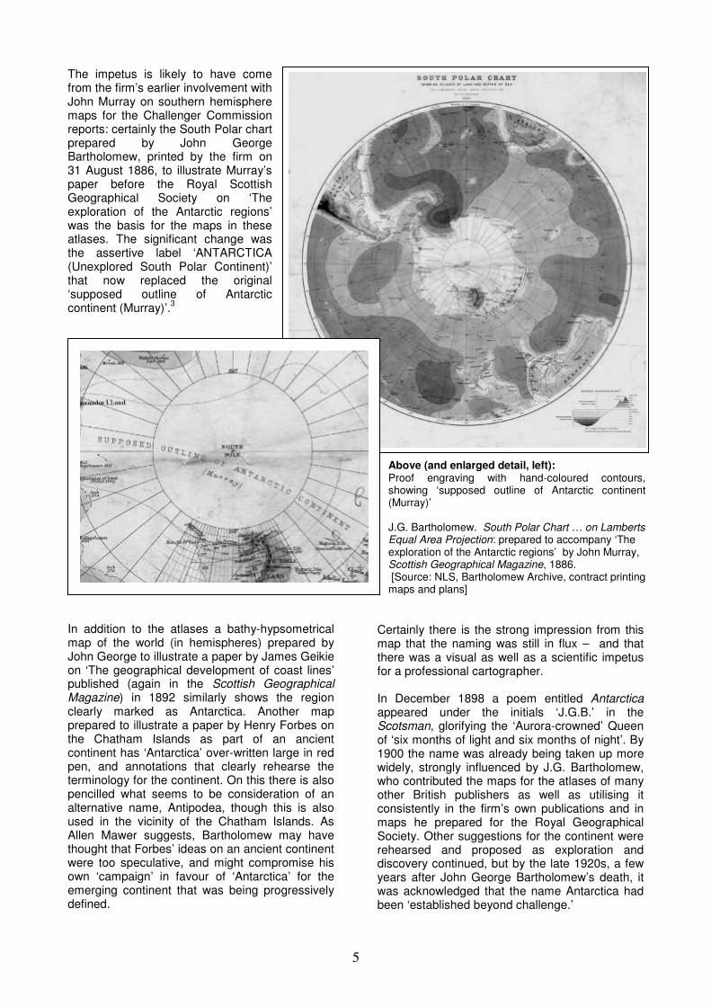
The impetus is likely to have come from the firm’s earlier involvement with John Murray on southern hemisphere maps for the Challenger Commission reports: certainly the South Polar chart prepared by John George Bartholomew, printed by the firm on 31 August 1886, to illustrate Murray’s paper before the Royal Scottish Geographical Society on ‘The exploration of the Antarctic regions’ was the basis for the maps in these atlases. The significant change was the assertive label ‘ANTARCTICA (Unexplored South Polar Continent)’ that now replaced the original ‘supposed outline of Antarctic continent (Murray)’.
3
In addition to the atlases a bathy-hypsometrical map of the world (in hemispheres) prepared by John George to illustrate a paper by James Geikie on ‘The geographical development of coast lines’ published (again in the Scottish Geographical Magazine) in 1892 similarly shows the region clearly marked as Antarctica. Another map prepared to illustrate a paper by Henry Forbes on the Chatham Islands as part of an ancient continent has ‘Antarctica’ over-written large in red pen, and annotations that clearly rehearse the terminology for the continent. On this there is also pencilled what seems to be consideration of an alternative name, Antipodea, though this is also used in the vicinity of the Chatham Islands. As Allen Mawer suggests, Bartholomew may have thought that Forbes’ ideas on an ancient continent were too speculative, and might compromise his own ‘campaign’ in favour of ‘Antarctica’ for the emerging continent that was being progressively defined.
Certainly there is the strong impression from this map that the naming was still in flux – and that there was a visual as well as a scientific impetus for a professional cartographer. In December 1898 a poem entitled Antarctica appeared under the initials ‘J.G.B.’ in the Scotsman, glorifying the ‘Aurora-crowned’ Queen of ‘six months of light and six months of night’. By 1900 the name was already being taken up more widely, strongly influenced by J.G. Bartholomew, who contributed the maps for the atlases of many other British publishers as well as utilising it consistently in the firm’s own publications and in maps he prepared for the Royal Geographical Society. Other suggestions for the continent were rehearsed and proposed as exploration and discovery continued, but by the late 1920s, a few years after John George Bartholomew’s death, it was acknowledged that the name Antarctica had been ‘established beyond challenge.’
Above (and enlarged detail, left): Proof engraving with hand-coloured contours, showing ‘supposed outline of Antarctic continent (Murray)’ J.G. Bartholomew. South Polar Chart … on Lamberts Equal Area Projection: prepared to accompany ‘The exploration of the Antarctic regions’ by John Murray, Scottish Geographical Magazine, 1886. [Source: NLS, Bartholomew Archive, contract printing maps and plans]

6
Manuscript annotations, including names Antarctica and Antipodea.
Sources and further reading 1. G.A. Mawer ‘Baptism of ice: J.G. Bartholomew and the naming of Antarctica’ Polar Record (2008), 44:180-183. This article owes its inspiration to his article and has benefited from his comments and corrections. 2. R.V. Tooley ‘Early Antarctica’ Map Collectors Circle 1963, online re-print at www.antarctic-circle.org/tooley.htm 3. It should be noted that in the Library Reference Atlas of the World of 1890 (Macmillan and Co.), which appeared under the name of John Bartholomew, the South Polar Regions map, with ANTARCTICA, is identified as by J.G. Bartholomew
Left (and enlarged detail, above): J.G. Bartholomew, 1890. South Polar Regions, in The Royal atlas and gazetteer of Australasia, London: Nelson, 1890. [Source: NLS Map.1.d.85]
The illustrations in this article will be available later in the year as zoomable colour images on a new web page ‘Discovering the Bartholomew Archive’ www.nls.uk/collections/maps/collections/special_collections.html
Right (and enlarged detail, above): J.G. Bartholomew, 1892. South Polar Chart showing suggested connection of Antarctic land mass to other continents, based on 1886 original, prepared to accompany an article ‘The Chatham islands and their relation to a former southern continent’ by H.O. Forbes, Proceedings of the Royal Geographical Society (Great Britain), 1893. [Source: NLS, Bartholomew Archive, contract printing maps and plans]
7
Paul Laxton provided us with a handy definition of a true map lover: someone who, when faced with the Ordnance Survey large scale towns plans, “can’t stop looking and thinking Wow!” The map lovers from all over the country who assembled at the Causwayside building of the National Library of Scotland, Edinburgh, were fortunate indeed that there were plenty of maps on show to “wow” over as the day unfolded. Dr. Pat Dennison began the day with a talk on “Urban clearances: the cartographic evidence”. Using three case studies, in Stornoway, Hamilton and Dalkeith, Dr Dennison showed how maps and views can back up archaeological evidence for the changing townscape with areas being deliberately cleared to make room for “improvements”, sometimes as dramatically as removing the whole High Street, as in the case of Hamilton Palace where the village was removed to beyond the reach of smell! It can be difficult to tell in these cases how much of the subsequent development was planned, and how much “natural” expansion. The “Geddy” map of St. Andrews is arguably one of the most recognisable Scottish town plans. Bob Smart has dated the map to about 1580 from the paper and calligraphic style. He also matched the handwriting to that of Andrew Geddy, a mathematics tutor at St. Andrews at the time. In her paper “Interpreting the Geddy Map of St. Andrews” Edwina Proudfoot proffered other explanations for the content of the map. She asserted that the content at least was earlier than 1580, possibly ca. 1550. This was based on comparisons of the internal evidence of the map and archaeological explorations within the town itself. It would appear that the depictions of individual buildings are quite accurate, while the layout is flawed. The overview, e.g. the apparently parallel main streets, may be explained by the views from the tops of the various towers in the town. It is common for people, when asked to draw a map, to plot the main landmarks first and then fill in with other details. It would seem that this map was made in the same way, possibly in sections or fragments. If the mapping was done at this earlier date then we don’t know who did it… or why! Professor Charles McKean followed with an entertaining look at civic buildings in “Symbols of what? The Scottish burgh and its public buildings”, posing the question “when is a civic monument a civic monument?”
This was a quick romp through urban development in Scotland, using examples from all over the country but mostly Dundee to illustrate development from the dissolution of the sluttery to the erection of charitable edifices on the outskirts of the town, with motivations and explanations for location ranging from the need for shelter from the wind to personal expressions of wealth and benevolence. After a tasty lunch, with time for a slide show of Scottish town plans, Prof. Paul Laxton challenged the accepted view that the Ordnance Survey large scale town plans of 5’ and 10’ to the mile scales were created to aid sanitation improvements in his talk “A great excuse to make town plans: cholera, typhus fever and drains.”. Illustrated with examples of these detailed plans, he explained that if that were the case, surely they would have included contours which are essential if you are working out water flows, and also the order in which the maps were produced in England and the rest of the British Isles bears no relation to the need as implied by the outbreaks of typhoid and cholera. Perhaps therefore we need to consider that the O.S. made the maps because that’s what good map makers would do? Or even just because they could? For those interested in the people behind the maps Dr. Malcolm Bangor-Jones’ “George Grant Mackay: Victorian surveyor and speculator” provided a fascinating insight into the men planning and profiting from urban expansion. Mackay bought up land in Inverness and Oban and sold on the plots. They were largely bought up by the emerging merchant class and gentlemen-at-large. So called “cottages” were beyond the means of working men at £200, but Mackey did provide some smaller dwellings to rent. Initially these seemed to be well received being “nice, clean, airy cottages” but later problems with the sanitation emerged… A quick overview of a few recent and future projects including the “Atlas of Edinburgh”, “Dunfermline Burgh Survey”, “The Exeter pre-1900 British town map project” and “Mapping the walking tutorial” reinforced the central idea of the day that maps are hugely important in our understanding of historical townscapes. The projects are all making those maps and accompanying interpretations available, to the benefit of all map lovers who say “Wow!”
SEMINAR REPORT
“Can’t stop looking and thinking “WOW?” Paula Williams reports on the Scottish Maps Forum Seminar on Tuesday, 22
nd April 2008,
Planning the Scottish Townscape? Exploring urban history through town plans
8
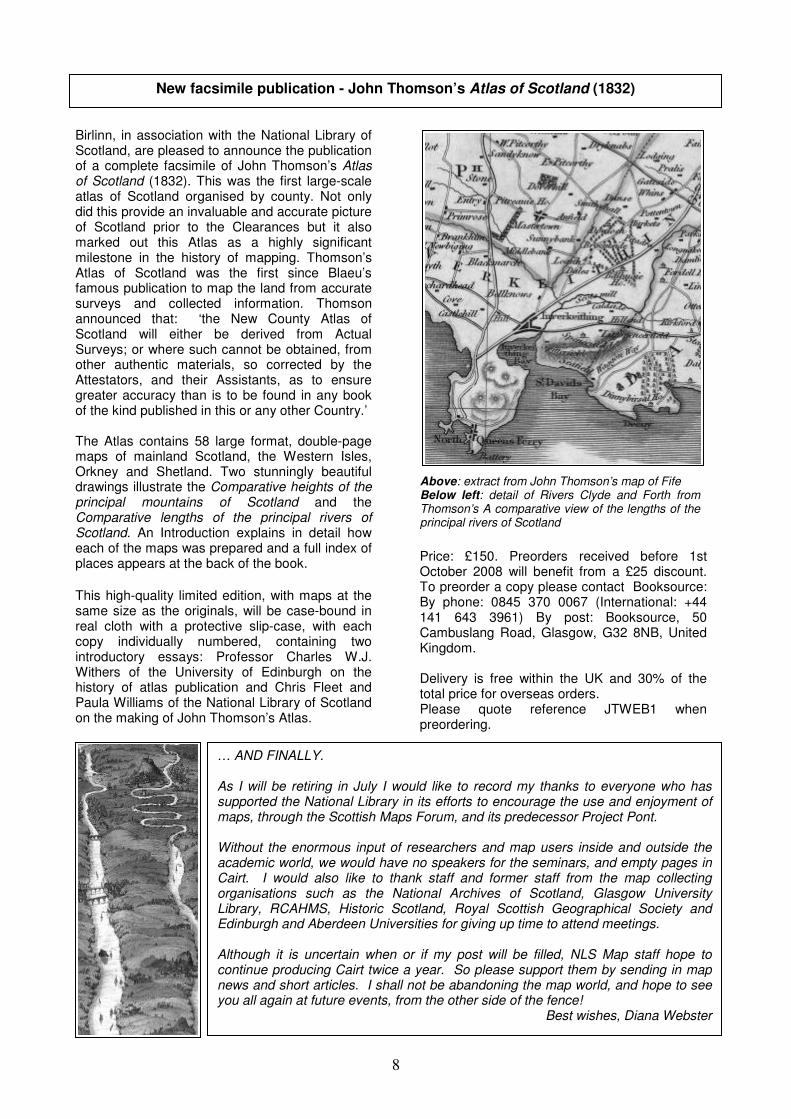
Birlinn, in association with the National Library of Scotland, are pleased to announce the publication of a complete facsimile of John Thomson’s Atlas of Scotland (1832). This was the first large-scale atlas of Scotland organised by county. Not only did this provide an invaluable and accurate picture of Scotland prior to the Clearances but it also marked out this Atlas as a highly significant milestone in the history of mapping. Thomson’s Atlas of Scotland was the first since Blaeu’s famous publication to map the land from accurate surveys and collected information. Thomson announced that: ‘the New County Atlas of Scotland will either be derived from Actual Surveys; or where such cannot be obtained, from other authentic materials, so corrected by the Attestators, and their Assistants, as to ensure greater accuracy than is to be found in any book of the kind published in this or any other Country.’ The Atlas contains 58 large format, double-page maps of mainland Scotland, the Western Isles, Orkney and Shetland. Two stunningly beautiful drawings illustrate the Comparative heights of the principal mountains of Scotland and the Comparative lengths of the principal rivers of Scotland. An Introduction explains in detail how each of the maps was prepared and a full index of places appears at the back of the book.
This high-quality limited edition, with maps at the same size as the originals, will be case-bound in real cloth with a protective slip-case, with each copy individually numbered, containing two introductory essays: Professor Charles W.J. Withers of the University of Edinburgh on the history of atlas publication and Chris Fleet and Paula Williams of the National Library of Scotland on the making of John Thomson’s Atlas.
Price: £150. Preorders received before 1st October 2008 will benefit from a £25 discount. To preorder a copy please contact Booksource: By phone: 0845 370 0067 (International: +44 141 643 3961) By post: Booksource, 50 Cambuslang Road, Glasgow, G32 8NB, United Kingdom. Delivery is free within the UK and 30% of the total price for overseas orders. Please quote reference JTWEB1 when preordering.
New facsimile publication - John Thomson’s Atlas of Scotland (1832)
… AND FINALLY. As I will be retiring in July I would like to record my thanks to everyone who has supported the National Library in its efforts to encourage the use and enjoyment of maps, through the Scottish Maps Forum, and its predecessor Project Pont. Without the enormous input of researchers and map users inside and outside the academic world, we would have no speakers for the seminars, and empty pages in Cairt. I would also like to thank staff and former staff from the map collecting organisations such as the National Archives of Scotland, Glasgow University Library, RCAHMS, Historic Scotland, Royal Scottish Geographical Society and Edinburgh and Aberdeen Universities for giving up time to attend meetings. Although it is uncertain when or if my post will be filled, NLS Map staff hope to continue producing Cairt twice a year. So please support them by sending in map news and short articles. I shall not be abandoning the map world, and hope to see you all again at future events, from the other side of the fence!
Best wishes, Diana Webster
Above: extract from John Thomson’s map of Fife Below left: detail of Rivers Clyde and Forth from Thomson’s A comparative view of the lengths of the principal rivers of Scotland