Embed Size (px)
Citation preview
Merlin Subsea Decommissioning Environmental Statement
Page 2 of 158
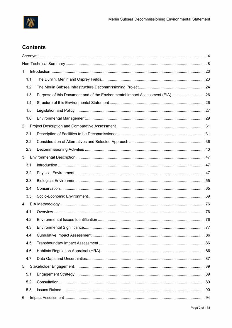
Contents
Acronyms ........................................................................................................................................................... 4
Non-Technical Summary ................................................................................................................................... 8
1. Introduction ............................................................................................................................................... 23
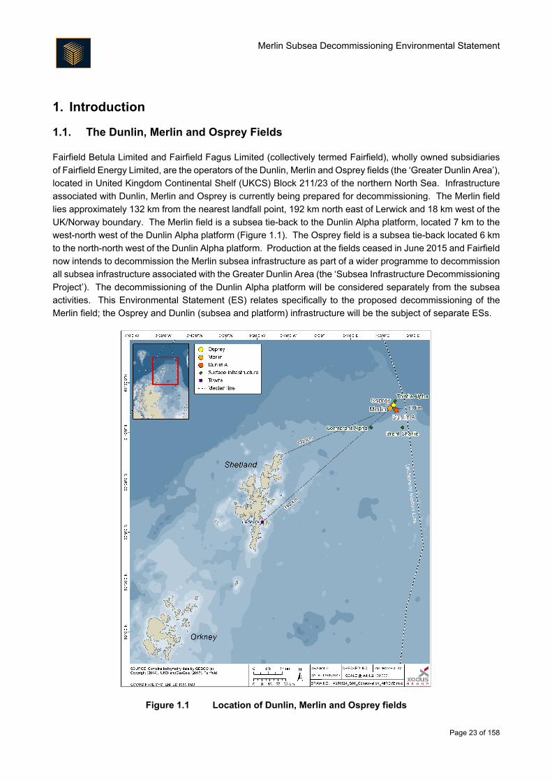
1.1. The Dunlin, Merlin and Osprey Fields................................................................................................ 23
1.2. The Merlin Subsea Infrastructure Decommissioning Project ............................................................. 24
1.3. Purpose of this Document and of the Environmental Impact Assessment (EIA) .............................. 26
1.4. Structure of this Environmental Statement ........................................................................................ 26
1.5. Legislation and Policy ........................................................................................................................ 27
1.6. Environmental Management .............................................................................................................. 29
2. Project Description and Comparative Assessment .................................................................................. 31
2.1. Description of Facilities to be Decommissioned ................................................................................ 31
2.2. Consideration of Alternatives and Selected Approach ...................................................................... 36
2.3. Decommissioning Activities ............................................................................................................... 40
3. Environmental Description ....................................................................................................................... 47
3.1. Introduction ........................................................................................................................................ 47
3.2. Physical Environment ........................................................................................................................ 47
3.3. Biological Environment ...................................................................................................................... 55
3.4. Conservation ...................................................................................................................................... 65
3.5. Socio-Economic Environment ............................................................................................................ 69
4. EIA Methodology ...................................................................................................................................... 76
4.1. Overview ............................................................................................................................................ 76
4.2. Environmental Issues Identification ................................................................................................... 76
4.3. Environmental Significance ................................................................................................................ 77
4.4. Cumulative Impact Assessment ......................................................................................................... 86
4.5. Transboundary Impact Assessment .................................................................................................. 86
4.6. Habitats Regulation Appraisal (HRA) ................................................................................................. 86
4.7. Data Gaps and Uncertainties ............................................................................................................. 87
5. Stakeholder Engagement ......................................................................................................................... 89
5.1. Engagement Strategy ........................................................................................................................ 89
5.2. Consultation ....................................................................................................................................... 89
5.3. Issues Raised ..................................................................................................................................... 90
6. Impact Assessment .................................................................................................................................. 94
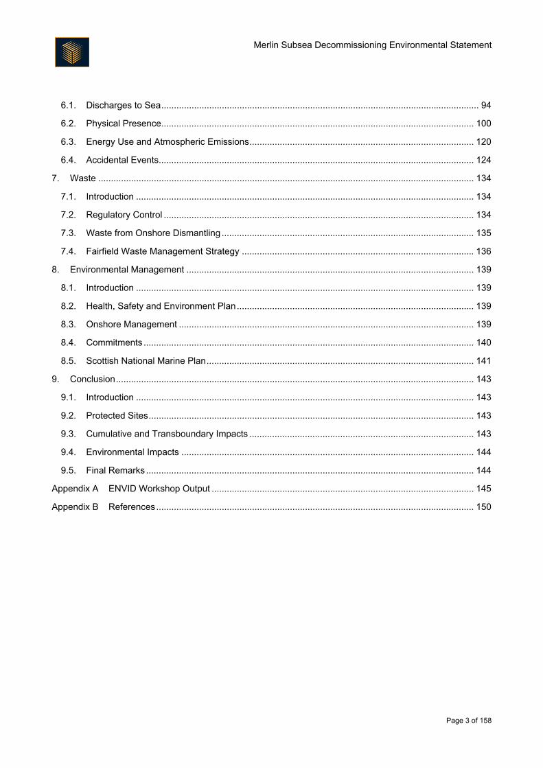
Merlin Subsea Decommissioning Environmental Statement
Page 3 of 158
6.1. Discharges to Sea .............................................................................................................................. 94
6.2. Physical Presence............................................................................................................................ 100
6.3. Energy Use and Atmospheric Emissions ......................................................................................... 120
6.4. Accidental Events............................................................................................................................. 124
7. Waste ..................................................................................................................................................... 134
7.1. Introduction ...................................................................................................................................... 134
7.2. Regulatory Control ........................................................................................................................... 134
7.3. Waste from Onshore Dismantling .................................................................................................... 135
7.4. Fairfield Waste Management Strategy ............................................................................................ 136
8. Environmental Management .................................................................................................................. 139
8.1. Introduction ...................................................................................................................................... 139
8.2. Health, Safety and Environment Plan .............................................................................................. 139
8.3. Onshore Management ..................................................................................................................... 139
8.4. Commitments ................................................................................................................................... 140
8.5. Scottish National Marine Plan .......................................................................................................... 141
9. Conclusion .............................................................................................................................................. 143
9.1. Introduction ...................................................................................................................................... 143
9.2. Protected Sites ................................................................................................................................. 143
9.3. Cumulative and Transboundary Impacts ......................................................................................... 143
9.4. Environmental Impacts .................................................................................................................... 144
9.5. Final Remarks .................................................................................................................................. 144
Appendix A ENVID Workshop Output ........................................................................................................ 145
Appendix B References .............................................................................................................................. 150
Merlin Subsea Decommissioning Environmental Statement
Page 4 of 158
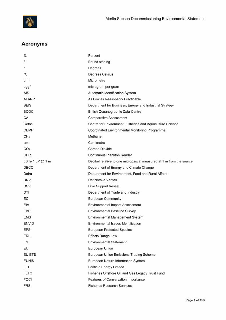
Acronyms
% Percent
£ Pound sterling
° Degrees
°C Degrees Celsius
µm Micrometre
μgg-1 microgram per gram
AIS Automatic Identification System
ALARP As Low as Reasonably Practicable
BEIS Department for Business, Energy and Industrial Strategy
BODC British Oceanographic Data Centre
CA Comparative Assessment
Cefas Centre for Environment, Fisheries and Aquaculture Science
CEMP Coordinated Environmental Monitoring Programme
CH4 Methane
cm Centimetre
CO2 Carbon Dioxide
CPR Continuous Plankton Reader
dB re 1 µP @ 1 m Decibel relative to one micropascal measured at 1 m from the source
DECC Department of Energy and Climate Change
Defra Department for Environment, Food and Rural Affairs
DNV Det Norske Veritas
DSV Dive Support Vessel
DTI Department of Trade and Industry
EC European Community
EIA Environmental Impact Assessment
EBS Environmental Baseline Survey
EMS Environmental Management System
ENVID Environmental Issues Identification
EPS European Protected Species
ERL Effects Range Low
ES Environmental Statement
EU European Union
EU ETS European Union Emissions Trading Scheme
EUNIS European Nature Information System
FEL Fairfield Energy Limited
FLTC Fisheries Offshore Oil and Gas Legacy Trust Fund
FOCI Features of Conservation Importance
FRS Fisheries Research Services
Merlin Subsea Decommissioning Environmental Statement
Page 5 of 158
GHG Greenhouse Gas
HRA Habitats Regulations Assessment
HSE Health and Safety Executive
ICES International Council for the Exploration of the Sea
IEEM Institute of Ecology and Environmental Management
IEMA Institute of Environmental Management and Assessment
IMO International Maritime Organisation
IOGP The International Association of Oil and Gas Producers
IP Institute of Petroleum
IPCC Intergovernmental Panel on Climate Change
ISO International Organisation for Standardisation
ITOPF International Tanker Owners Pollution Federation
IUCN International Union for Conservation of Nature
JNCC Joint Nature Conservation Committee
kg Kilogram
km Kilometre
km/h Kilometres per hour
km2
LTOBM
Square kilometre
Low Toxicity Oil Based Fluid
m Metre
m/s Metres per second
m2 Square metre
m3 Cubic metre
MarLIN Marine Life Information Network
MCA Maritime and Coastguard Agency
MCZ Marine Conservation Zone
MDC
mg
Merlin Drill Centre
Milligram
MMO The Marine Management Organisation
MPA Marine Protected Area
m/s Metres per second
NCMPA Nature Conservation Marine Protected Area
NFFO National Federation of Fishermen's Organisations
NIFPO Northern Ireland Federation of Fishermen's Organisations
NLGP Northern Leg Gas Pipeline
Nm Nautical mile
NMFS National Marine Fisheries Service
NMPI National Marine Plan Interactive
NO2 Nitrogen Dioxide
NORBRIT Norway-UK Joint Contingency Plan
Merlin Subsea Decommissioning Environmental Statement
Page 6 of 158
NORM Naturally Occurring 1993 Material
NOx Nitrogen Oxide
O3 Ozone
OGA UK Oil and Gas Authority
OGUK Oil and Gas UK
OSCAR Oil Spill Contingency and Response
OSPAR Oslo Paris Convention
PAH Polycyclic Aromatic Hydrocarbons
PL Pipeline
PLONOR Poses Little Or No Risk
PMF Priority Marine Feature
PPC Pollution Prevention and Control
ppm Parts per million
PTS Permanent Threshold Shift
ROV Remotely Operated Vehicle
SAC Special Area of Conservation
SAHFOS
SEL
Sir Alister Hardy Foundation for Ocean Science
Sound Exposure Level
SCI Site of Community Importance
SCOS Special Committee on Seals
SEA Strategic Environmental Assessment
SEPA Scottish Environment Protection Agency
SFF Scottish Fishermen’s Federation
SIMOP Simultaneous operations
SMRU Sea Mammal Research Unit
SNH Scottish Natural Heritage
SO2 Sulphur Dioxide
SOPEP Shipboard Oil Pollution Emergency Plans
SOX Sulphur Oxide
SPA Special Protection Area
SPL Sound Pressure Level
THC Total Hydrocarbon Content
TOC
TOM
TTS
Total Organic Content
Total Organic Matter
Temporary Threshold Shift
UK United Kingdom
UKBAP United Kingdom Biodiversity Action Plan
UKCS United Kingdom Continental Shelf
UKOOA United Kingdom Offshore Operators Association
UNESCO United Nations Educational, Scientific and Cultural Organization

Merlin Subsea Decommissioning Environmental Statement
Page 7 of 158
US CEQ United States Council on Environmental Quality
WBM Water-based Mud
WHS World Heritage Site
VMS Vessel Monitoring System
VOC Volatile Organic Compounds
Merlin Subsea Decommissioning Environmental Statement
Page 8 of 158
Non-Technical Summary
Introduction
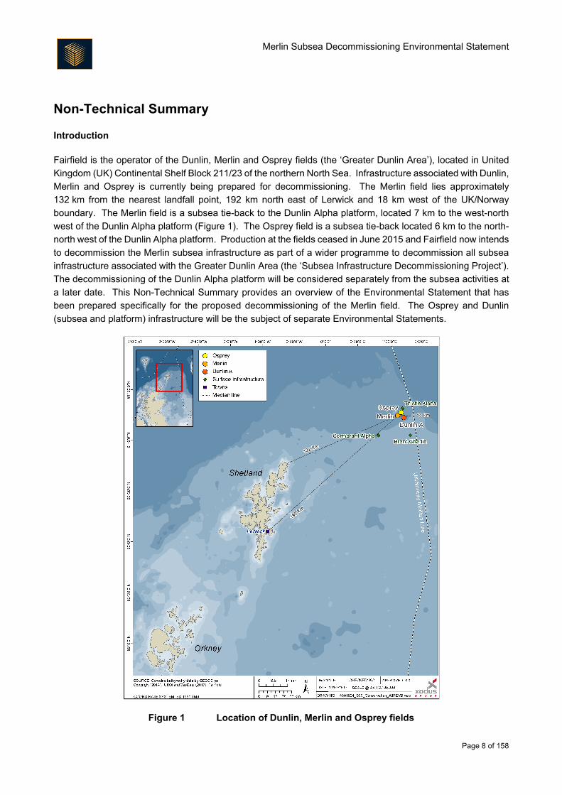
Fairfield is the operator of the Dunlin, Merlin and Osprey fields (the ‘Greater Dunlin Area’), located in United
Kingdom (UK) Continental Shelf Block 211/23 of the northern North Sea. Infrastructure associated with Dunlin,
Merlin and Osprey is currently being prepared for decommissioning. The Merlin field lies approximately
132 km from the nearest landfall point, 192 km north east of Lerwick and 18 km west of the UK/Norway
boundary. The Merlin field is a subsea tie-back to the Dunlin Alpha platform, located 7 km to the west-north
west of the Dunlin Alpha platform (Figure 1). The Osprey field is a subsea tie-back located 6 km to the north-
north west of the Dunlin Alpha platform. Production at the fields ceased in June 2015 and Fairfield now intends
to decommission the Merlin subsea infrastructure as part of a wider programme to decommission all subsea
infrastructure associated with the Greater Dunlin Area (the ‘Subsea Infrastructure Decommissioning Project’).
The decommissioning of the Dunlin Alpha platform will be considered separately from the subsea activities at
a later date. This Non-Technical Summary provides an overview of the Environmental Statement that has
been prepared specifically for the proposed decommissioning of the Merlin field. The Osprey and Dunlin
(subsea and platform) infrastructure will be the subject of separate Environmental Statements.
Figure 1 Location of Dunlin, Merlin and Osprey fields
Merlin Subsea Decommissioning Environmental Statement
Page 9 of 158
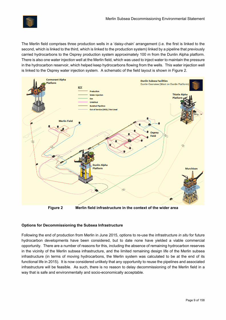
The Merlin field comprises three production wells in a ‘daisy-chain’ arrangement (i.e. the first is linked to the
second, which is linked to the third, which is linked to the production system) linked by a pipeline that previously
carried hydrocarbons to the Osprey production system approximately 100 m from the Dunlin Alpha platform.
There is also one water injection well at the Merlin field, which was used to inject water to maintain the pressure
in the hydrocarbon reservoir, which helped keep hydrocarbons flowing from the wells. This water injection well
is linked to the Osprey water injection system. A schematic of the field layout is shown in Figure 2.
Figure 2 Merlin field infrastructure in the context of the wider area
Options for Decommissioning the Subsea Infrastructure
Following the end of production from Merlin in June 2015, options to re-use the infrastructure in situ for future
hydrocarbon developments have been considered, but to date none have yielded a viable commercial
opportunity. There are a number of reasons for this, including the absence of remaining hydrocarbon reserves
in the vicinity of the Merlin subsea infrastructure, and the limited remaining design life of the Merlin subsea
infrastructure (in terms of moving hydrocarbons, the Merlin system was calculated to be at the end of its
functional life in 2015). It is now considered unlikely that any opportunity to reuse the pipelines and associated
infrastructure will be feasible. As such, there is no reason to delay decommissioning of the Merlin field in a
way that is safe and environmentally and socio-economically acceptable.
Merlin Subsea Decommissioning Environmental Statement
Page 10 of 158
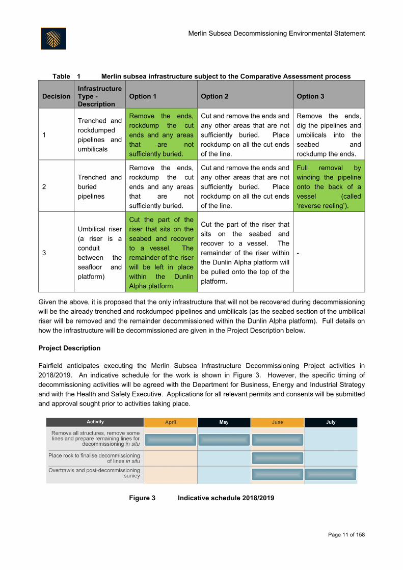
In line with the latest Department for Business, Energy and Industrial Strategy guidelines on decommissioning,
Fairfield has committed to fully removing a number of structures from the Merlin subsea area; these structures
are detailed in the Project Description below and in the following list:
Surface-laid infrastructure:
o Rigid spools (a spool is a connecting line between structures and lines);
o Flexible jumpers (a jumper is like a spool); and
o Umbilicals (an umbilical is a line that provides control and power to remote subsea
infrastructure).
Pipeline and umbilical components and structures; and
Stabilisation material (deposits such as concrete mattresses, but not including rockdump).
For the remaining infrastructure, where the option to remove is not obviously the best option, Fairfield has
followed the Department for Business, Energy and Industrial Strategy guidelines and undertaken a formal
process called ‘Comparative Assessment’. The Comparative Assessment process allows for the development
of a preferred decommissioning methodology for infrastructure, based on consideration of safety risk,
environmental impact, technical feasibility, societal impacts and economic factors. For the Merlin Subsea
Infrastructure Decommissioning Project, Comparative Assessment was undertaken on the three infrastructure
types in Table 1, with the selected options highlighted green.
To compare each option against the others to make a decision, Fairfield utilised a Multi Criteria Decision
Analysis tool. This tool allows an assembled team to review the available data for each option and determine,
using terms such as ‘neutral’, ‘stronger’, ‘much stronger’ (and so on), how each option compares to the other.
This comparison was undertaken using the five criteria described in the Department for Business, Energy and
Industrial Strategy Guidelines of safety, environmental, technical, societal and economic. The decision
outcomes of the Comparative Assessment process, supported by an appropriate amount of specialist study
work, are summarised in Table 1.
Merlin Subsea Decommissioning Environmental Statement
Page 11 of 158
Table 1 Merlin subsea infrastructure subject to the Comparative Assessment process
Decision Infrastructure Type - Description
Option 1 Option 2 Option 3
1
Trenched and
rockdumped
pipelines and
umbilicals
Remove the ends,
rockdump the cut
ends and any areas
that are not
sufficiently buried.
Cut and remove the ends and
any other areas that are not
sufficiently buried. Place
rockdump on all the cut ends
of the line.
Remove the ends,
dig the pipelines and
umbilicals into the
seabed and
rockdump the ends.
2
Trenched and
buried
pipelines
Remove the ends,
rockdump the cut
ends and any areas
that are not
sufficiently buried.
Cut and remove the ends and
any other areas that are not
sufficiently buried. Place
rockdump on all the cut ends
of the line.
Full removal by
winding the pipeline
onto the back of a
vessel (called
‘reverse reeling’).
3
Umbilical riser
(a riser is a
conduit
between the
seafloor and
platform)
Cut the part of the
riser that sits on the
seabed and recover
to a vessel. The
remainder of the riser
will be left in place
within the Dunlin
Alpha platform.
Cut the part of the riser that
sits on the seabed and
recover to a vessel. The
remainder of the riser within
the Dunlin Alpha platform will
be pulled onto the top of the
platform.
-
Given the above, it is proposed that the only infrastructure that will not be recovered during decommissioning
will be the already trenched and rockdumped pipelines and umbilicals (as the seabed section of the umbilical
riser will be removed and the remainder decommissioned within the Dunlin Alpha platform). Full details on
how the infrastructure will be decommissioned are given in the Project Description below.
Project Description
Fairfield anticipates executing the Merlin Subsea Infrastructure Decommissioning Project activities in
2018/2019. An indicative schedule for the work is shown in Figure 3. However, the specific timing of
decommissioning activities will be agreed with the Department for Business, Energy and Industrial Strategy
and with the Health and Safety Executive. Applications for all relevant permits and consents will be submitted
and approval sought prior to activities taking place.
Figure 3 Indicative schedule 2018/2019
Merlin Subsea Decommissioning Environmental Statement
Page 12 of 158
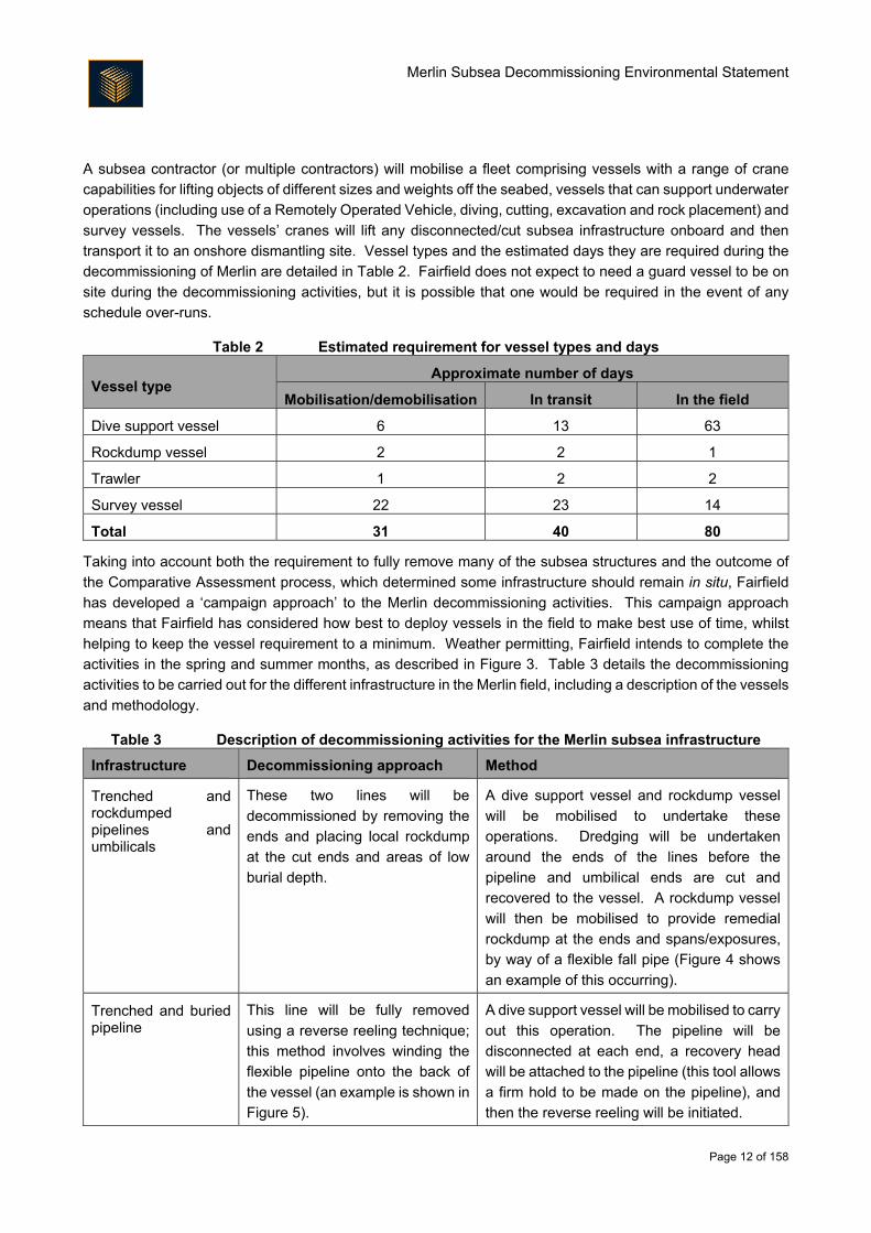
A subsea contractor (or multiple contractors) will mobilise a fleet comprising vessels with a range of crane
capabilities for lifting objects of different sizes and weights off the seabed, vessels that can support underwater
operations (including use of a Remotely Operated Vehicle, diving, cutting, excavation and rock placement) and
survey vessels. The vessels’ cranes will lift any disconnected/cut subsea infrastructure onboard and then
transport it to an onshore dismantling site. Vessel types and the estimated days they are required during the
decommissioning of Merlin are detailed in Table 2. Fairfield does not expect to need a guard vessel to be on
site during the decommissioning activities, but it is possible that one would be required in the event of any
schedule over-runs.
Table 2 Estimated requirement for vessel types and days
Vessel type Approximate number of days
Mobilisation/demobilisation In transit In the field
Dive support vessel 6 13 63
Rockdump vessel 2 2 1
Trawler 1 2 2
Survey vessel 22 23 14
Total 31 40 80
Taking into account both the requirement to fully remove many of the subsea structures and the outcome of
the Comparative Assessment process, which determined some infrastructure should remain in situ, Fairfield
has developed a ‘campaign approach’ to the Merlin decommissioning activities. This campaign approach
means that Fairfield has considered how best to deploy vessels in the field to make best use of time, whilst
helping to keep the vessel requirement to a minimum. Weather permitting, Fairfield intends to complete the
activities in the spring and summer months, as described in Figure 3. Table 3 details the decommissioning
activities to be carried out for the different infrastructure in the Merlin field, including a description of the vessels
and methodology.
Table 3 Description of decommissioning activities for the Merlin subsea infrastructure
Infrastructure Decommissioning approach Method
Trenched and rockdumped pipelines and umbilicals
These two lines will be
decommissioned by removing the
ends and placing local rockdump
at the cut ends and areas of low
burial depth.
A dive support vessel and rockdump vessel
will be mobilised to undertake these
operations. Dredging will be undertaken
around the ends of the lines before the
pipeline and umbilical ends are cut and
recovered to the vessel. A rockdump vessel
will then be mobilised to provide remedial
rockdump at the ends and spans/exposures,
by way of a flexible fall pipe (Figure 4 shows
an example of this occurring).
Trenched and buried pipeline
This line will be fully removed
using a reverse reeling technique;
this method involves winding the
flexible pipeline onto the back of
the vessel (an example is shown in
Figure 5).
A dive support vessel will be mobilised to carry
out this operation. The pipeline will be
disconnected at each end, a recovery head
will be attached to the pipeline (this tool allows
a firm hold to be made on the pipeline), and
then the reverse reeling will be initiated.
Merlin Subsea Decommissioning Environmental Statement
Page 13 of 158
Infrastructure Decommissioning approach Method
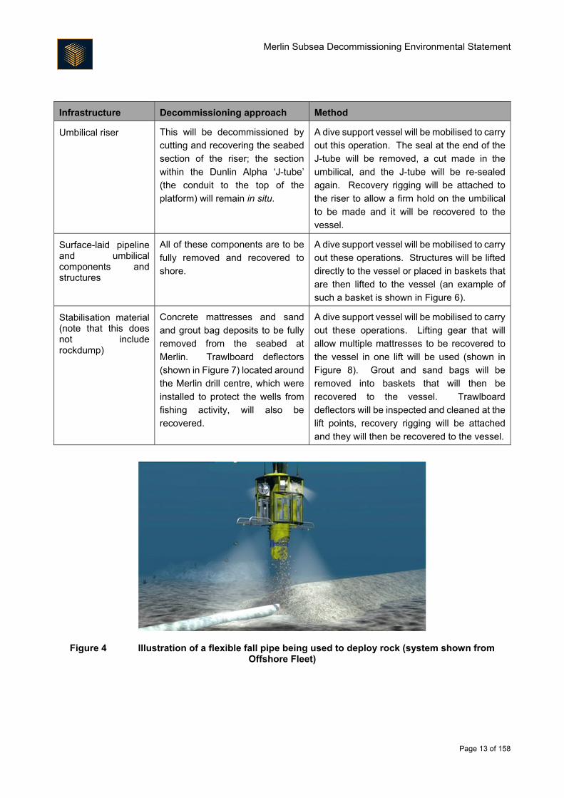
Umbilical riser This will be decommissioned by
cutting and recovering the seabed
section of the riser; the section
within the Dunlin Alpha ‘J-tube’
(the conduit to the top of the
platform) will remain in situ.
A dive support vessel will be mobilised to carry
out this operation. The seal at the end of the
J-tube will be removed, a cut made in the
umbilical, and the J-tube will be re-sealed
again. Recovery rigging will be attached to
the riser to allow a firm hold on the umbilical
to be made and it will be recovered to the
vessel.
Surface-laid pipeline and umbilical components and structures
All of these components are to be
fully removed and recovered to
shore.
A dive support vessel will be mobilised to carry
out these operations. Structures will be lifted
directly to the vessel or placed in baskets that
are then lifted to the vessel (an example of
such a basket is shown in Figure 6).
Stabilisation material (note that this does not include rockdump)
Concrete mattresses and sand
and grout bag deposits to be fully
removed from the seabed at
Merlin. Trawlboard deflectors
(shown in Figure 7) located around
the Merlin drill centre, which were
installed to protect the wells from
fishing activity, will also be
recovered.
A dive support vessel will be mobilised to carry
out these operations. Lifting gear that will
allow multiple mattresses to be recovered to
the vessel in one lift will be used (shown in
Figure 8). Grout and sand bags will be
removed into baskets that will then be
recovered to the vessel. Trawlboard
deflectors will be inspected and cleaned at the
lift points, recovery rigging will be attached
and they will then be recovered to the vessel.
Figure 4 Illustration of a flexible fall pipe being used to deploy rock (system shown from Offshore Fleet)
Merlin Subsea Decommissioning Environmental Statement
Page 14 of 158
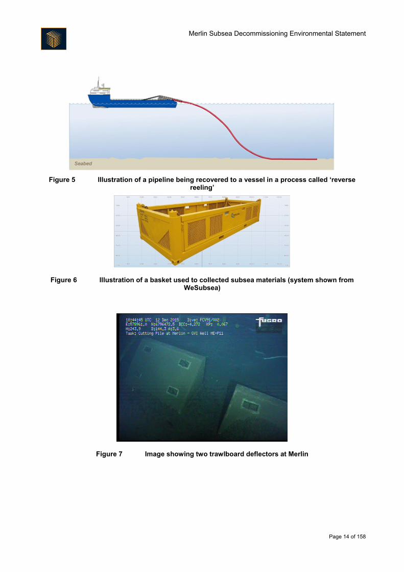
Figure 5 Illustration of a pipeline being recovered to a vessel in a process called ‘reverse
reeling’
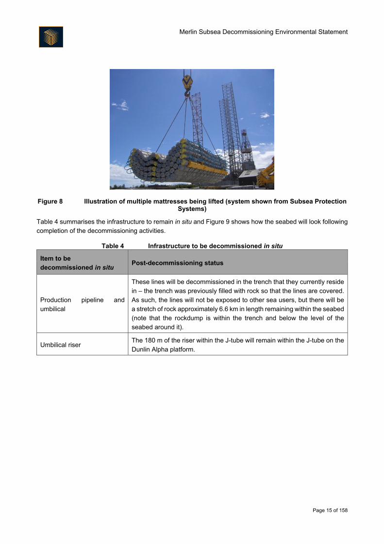
Figure 6 Illustration of a basket used to collected subsea materials (system shown from WeSubsea)
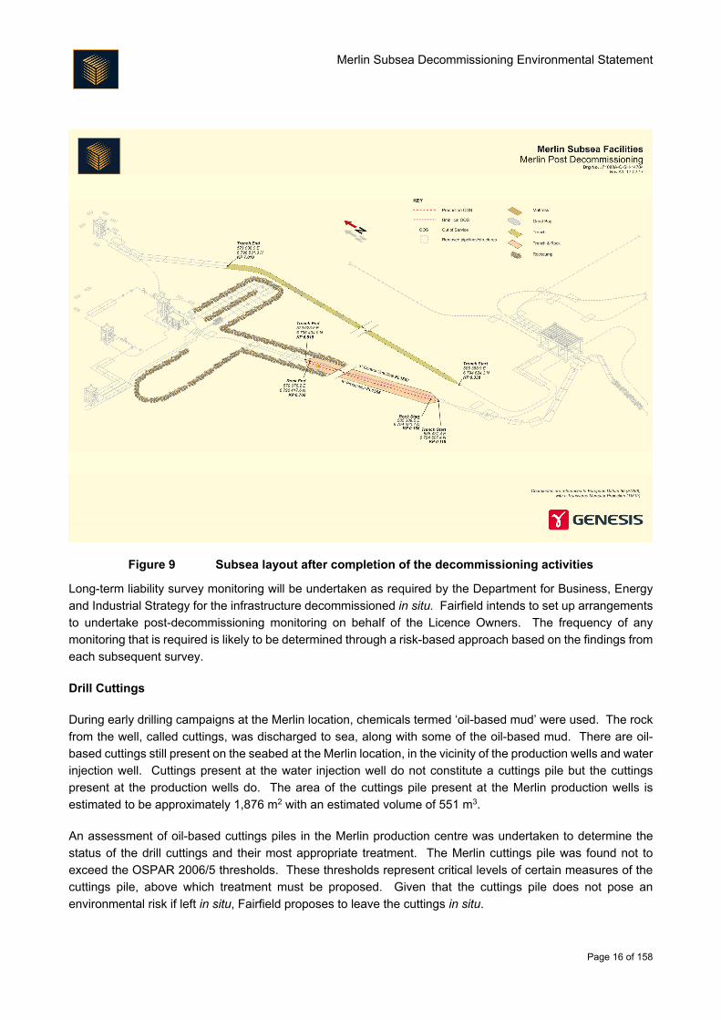
Figure 7 Image showing two trawlboard deflectors at Merlin
Merlin Subsea Decommissioning Environmental Statement
Page 15 of 158
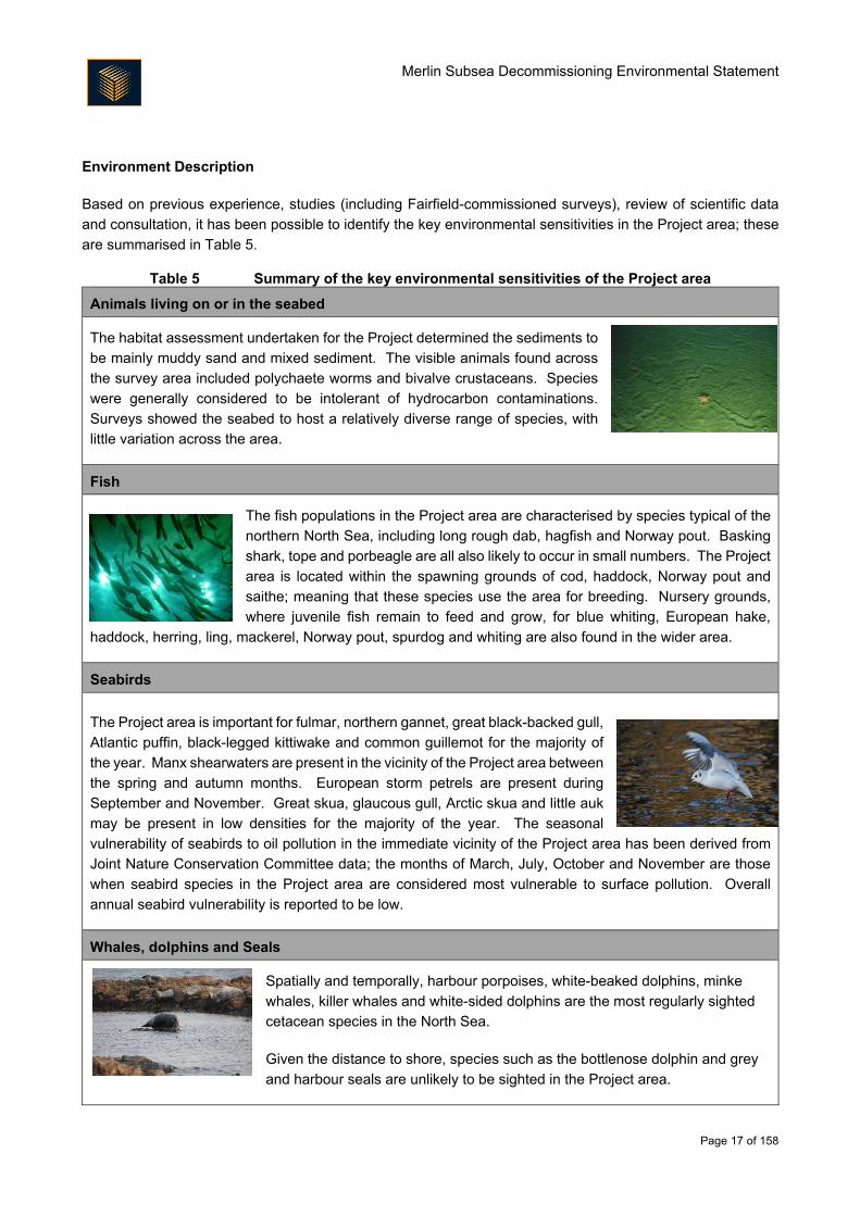
Figure 8 Illustration of multiple mattresses being lifted (system shown from Subsea Protection Systems)
Table 4 summarises the infrastructure to remain in situ and Figure 9 shows how the seabed will look following
completion of the decommissioning activities.
Table 4 Infrastructure to be decommissioned in situ
Item to be
decommissioned in situ Post-decommissioning status
Production pipeline and
umbilical
These lines will be decommissioned in the trench that they currently reside
in – the trench was previously filled with rock so that the lines are covered.
As such, the lines will not be exposed to other sea users, but there will be
a stretch of rock approximately 6.6 km in length remaining within the seabed
(note that the rockdump is within the trench and below the level of the
seabed around it).
Umbilical riser The 180 m of the riser within the J-tube will remain within the J-tube on the
Dunlin Alpha platform.
Merlin Subsea Decommissioning Environmental Statement
Page 16 of 158
Figure 9 Subsea layout after completion of the decommissioning activities
Long-term liability survey monitoring will be undertaken as required by the Department for Business, Energy
and Industrial Strategy for the infrastructure decommissioned in situ. Fairfield intends to set up arrangements
to undertake post-decommissioning monitoring on behalf of the Licence Owners. The frequency of any
monitoring that is required is likely to be determined through a risk-based approach based on the findings from
each subsequent survey.
Drill Cuttings
During early drilling campaigns at the Merlin location, chemicals termed ‘oil-based mud’ were used. The rock
from the well, called cuttings, was discharged to sea, along with some of the oil-based mud. There are oil-
based cuttings still present on the seabed at the Merlin location, in the vicinity of the production wells and water
injection well. Cuttings present at the water injection well do not constitute a cuttings pile but the cuttings
present at the production wells do. The area of the cuttings pile present at the Merlin production wells is
estimated to be approximately 1,876 m2 with an estimated volume of 551 m3.
An assessment of oil-based cuttings piles in the Merlin production centre was undertaken to determine the
status of the drill cuttings and their most appropriate treatment. The Merlin cuttings pile was found not to
exceed the OSPAR 2006/5 thresholds. These thresholds represent critical levels of certain measures of the
cuttings pile, above which treatment must be proposed. Given that the cuttings pile does not pose an
environmental risk if left in situ, Fairfield proposes to leave the cuttings in situ.
Merlin Subsea Decommissioning Environmental Statement
Page 17 of 158
Environment Description
Based on previous experience, studies (including Fairfield-commissioned surveys), review of scientific data
and consultation, it has been possible to identify the key environmental sensitivities in the Project area; these
are summarised in Table 5.
Table 5 Summary of the key environmental sensitivities of the Project area
Animals living on or in the seabed
The habitat assessment undertaken for the Project determined the sediments to
be mainly muddy sand and mixed sediment. The visible animals found across
the survey area included polychaete worms and bivalve crustaceans. Species
were generally considered to be intolerant of hydrocarbon contaminations.
Surveys showed the seabed to host a relatively diverse range of species, with
little variation across the area.
Fish
The fish populations in the Project area are characterised by species typical of the
northern North Sea, including long rough dab, hagfish and Norway pout. Basking
shark, tope and porbeagle are all also likely to occur in small numbers. The Project
area is located within the spawning grounds of cod, haddock, Norway pout and
saithe; meaning that these species use the area for breeding. Nursery grounds,
where juvenile fish remain to feed and grow, for blue whiting, European hake,
haddock, herring, ling, mackerel, Norway pout, spurdog and whiting are also found in the wider area.
Seabirds
The Project area is important for fulmar, northern gannet, great black-backed gull,
Atlantic puffin, black-legged kittiwake and common guillemot for the majority of
the year. Manx shearwaters are present in the vicinity of the Project area between
the spring and autumn months. European storm petrels are present during
September and November. Great skua, glaucous gull, Arctic skua and little auk
may be present in low densities for the majority of the year. The seasonal
vulnerability of seabirds to oil pollution in the immediate vicinity of the Project area has been derived from
Joint Nature Conservation Committee data; the months of March, July, October and November are those
when seabird species in the Project area are considered most vulnerable to surface pollution. Overall
annual seabird vulnerability is reported to be low.
Whales, dolphins and Seals
Spatially and temporally, harbour porpoises, white-beaked dolphins, minke
whales, killer whales and white-sided dolphins are the most regularly sighted
cetacean species in the North Sea.
Given the distance to shore, species such as the bottlenose dolphin and grey
and harbour seals are unlikely to be sighted in the Project area.
Merlin Subsea Decommissioning Environmental Statement
Page 18 of 158
Conservation
None of the survey work undertaken in the Project area has identified any seabed habitats or species that
are of specific conservation significance, apart from low numbers of juvenile ocean quahog, which is a
threatened species. There are no designated or proposed sites of conservation interest in the Project area;
the closest designated site, the European Site of Community Importance ‘Pobie Bank Reef’ lies 94 km to
the south west of Merlin, off the east coast of Shetland.
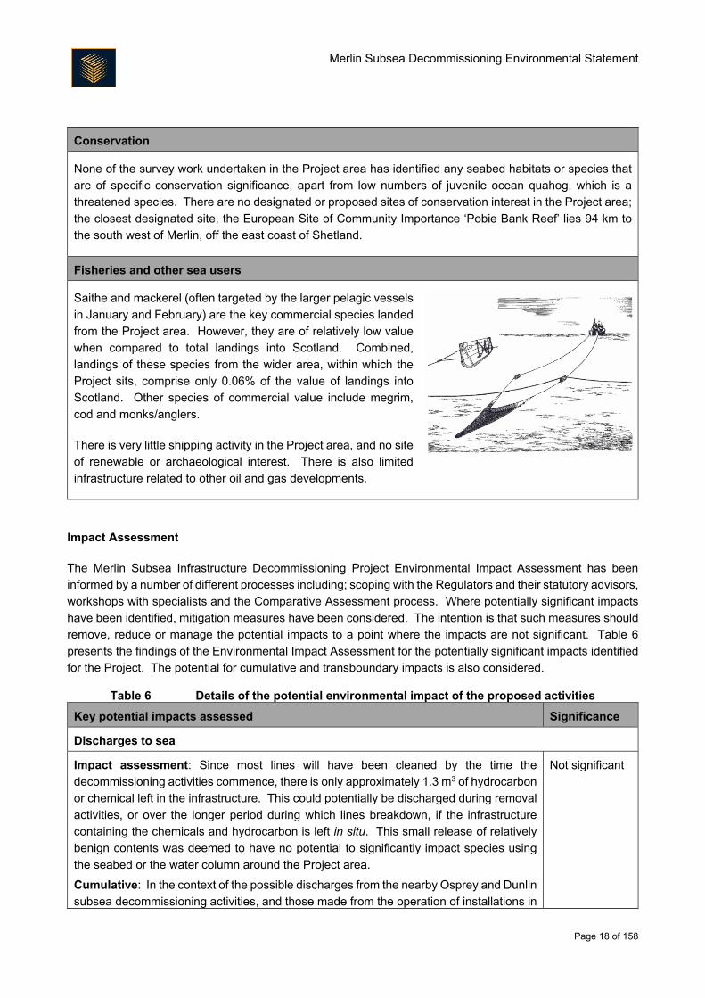
Fisheries and other sea users
Saithe and mackerel (often targeted by the larger pelagic vessels
in January and February) are the key commercial species landed
from the Project area. However, they are of relatively low value
when compared to total landings into Scotland. Combined,
landings of these species from the wider area, within which the
Project sits, comprise only 0.06% of the value of landings into
Scotland. Other species of commercial value include megrim,
cod and monks/anglers.
There is very little shipping activity in the Project area, and no site
of renewable or archaeological interest. There is also limited
infrastructure related to other oil and gas developments.
Impact Assessment
The Merlin Subsea Infrastructure Decommissioning Project Environmental Impact Assessment has been
informed by a number of different processes including; scoping with the Regulators and their statutory advisors,
workshops with specialists and the Comparative Assessment process. Where potentially significant impacts
have been identified, mitigation measures have been considered. The intention is that such measures should
remove, reduce or manage the potential impacts to a point where the impacts are not significant. Table 6
presents the findings of the Environmental Impact Assessment for the potentially significant impacts identified
for the Project. The potential for cumulative and transboundary impacts is also considered.
Table 6 Details of the potential environmental impact of the proposed activities
Key potential impacts assessed Significance
Discharges to sea
Impact assessment: Since most lines will have been cleaned by the time the
decommissioning activities commence, there is only approximately 1.3 m3 of hydrocarbon
or chemical left in the infrastructure. This could potentially be discharged during removal
activities, or over the longer period during which lines breakdown, if the infrastructure
containing the chemicals and hydrocarbon is left in situ. This small release of relatively
benign contents was deemed to have no potential to significantly impact species using
the seabed or the water column around the Project area.
Cumulative: In the context of the possible discharges from the nearby Osprey and Dunlin
subsea decommissioning activities, and those made from the operation of installations in
Not significant
Merlin Subsea Decommissioning Environmental Statement
Page 19 of 158
Key potential impacts assessed Significance
the North Sea, there is no likelihood of the 1.3 m3 of discharge from Merlin subsea
decommissioning activities causing impact through cumulative means.
Transboundary: Despite the proximity to the UK/Norway median line, the small
discharge volume means there is expected to be no way of impacting species outside of
UK waters.
Effects on protected sites: The small discharge volume and the distance to the nearest
protected site means there is expected to be no way of impacting protected sites, the
nearest of which is 94 km away.
Seabed
Impact assessment: Interaction with the seabed will occur during decommissioning
activities. In the main, this will come from the overtrawls that will be conducted to ensure
the seabed is left in a suitable condition for future use by fisheries. This could result in
approximately 2.28 km2 of seabed being trawled, and a slightly larger area experiencing
an increase in sediment as it is stirred up into the water column. Despite the size of this
area, the seabed in the Project area does not host particularly sensitive habitats or
species and recovery is likely from the activities within a few years.
The overtrawls may interact with the cuttings pile at Merlin, which may redistribute some
of the contaminated seabed material. However, estimates suggest that only a few cubic
metres of cuttings will be moved beyond the existing pile. Combined with the limited toxic
effect of the cuttings, this is expected to result in no long term discernible change to the
species using the seabed or water column.
Cumulative: In the context of the possible cumulative impact from seabed disturbance
occurring as part of the nearby Osprey and Dunlin subsea decommissioning activities,
the absence of seabed habitats and species of conservation interest and the likely
recovery of the seabed means that there is no likelihood of the subsea decommissioning
activities causing impact through cumulative means.
Transboundary: Despite the proximity to the UK/Norway median line, the highly
localised nature of the seabed interaction means there is expected to be no way of
impacting seabed habitat or species outside of UK waters.
Effects on protected sites: The distance to the nearest protected site means there is
expected to be no way of impacting protected sites.
Not significant
Underwater noise
Impact assessment: Noise emitted from vessel use and cutting of some of the seabed
structures could impact upon marine mammal and fish use of the Project area. However,
the noise emissions are predicted to be sufficiently quiet that there is no prospect of
injuring the animals or damaging their hearing. Since the cutting activities will occur for
approximately two days and since only one or two vessels will be on site for the late
spring/summer activities, there is no real prospect of disturbing animals sufficiently to
disrupt feeding or breeding activities.
Cumulative: In the context of the possible cumulative impact from noise emissions as
part of the Osprey and Dunlin subsea decommissioning activities, the fact that the Project
area is not of key importance to marine mammals or fish and that noise-emitting activities
Not significant
Merlin Subsea Decommissioning Environmental Statement
Page 20 of 158
Key potential impacts assessed Significance
will generally be limited to vessel use, there is no likelihood of the subsea
decommissioning activities causing impact through cumulative means.
Transboundary: Despite the proximity to the UK/Norway median line, the highly
localised nature of the noise emissions means there is expected to be no way of directly
impacting species outside of UK waters. It is likely, however, that animals experiencing
noise emissions in UK waters will move to non-UK waters; since there is no likely injury
or disturbance to animals in the Project area, animals moving outside of UK waters as
part of normal behaviour does not constitute a significant impact.
Effects on protected sites: Although it is possible that marine mammals from protected
sites nearshore or in the Southern North Sea could experience noise emissions from the
Project as they move through the Project area, there is expected to be no mechanism for
impacting those species and thus no impact on the protected sites to which they belong.
Other sea users
Impact assessment: The limited number of vessel days required to execute the
decommissioning project means there is no real prospect of significantly affecting
fisheries users through temporary exclusion (i.e. where Project vessels stop them using
the sea area). Additionally, the Merlin infrastructure will either be removed or
decommissioned in a buried or sufficiently rockdumped state to mean that it will pose no
risk to fisheries through snagging, which means there will also be no longer term
exclusion.
Cumulative: Since there will be no real short or long term exclusion resulting from the
Merlin decommissioning activities, there will be no negative cumulative impact with the
Osprey and Dunlin subsea decommissioning activities. In fact, decommissioning of the
Merlin subsea area will result in the removal of the current 500 m exclusion zone around
the Merlin wells. This means that seabed that was previously excluded from use will be
re-opened to fisheries users.
Transboundary: There are a number of non-UK vessels using the Project area.
However, seabed that was previously excluded from use will be re-opened and those
fisheries users will not be negatively affected by the decommissioning activities.
Not significant
Energy use and atmospheric emissions
Impact assessment: Using energy to power vessels results in emissions to the air, which
can contribute to local air quality issues; the absence of vulnerable receptors in the
offshore area means this is not an issue for the Project. However, emissions to air can
act cumulatively with those from other activities (such as onshore power generation and
use of cars) to contribute to global climate change. These emissions from the Project
may come from vessel use but also through linked activities such as the recycling of
materials brought onshore.
Cumulative: Since emissions to air offshore is largely a cumulative issue, it is important
to consider how the Merlin, Dunlin and Osprey subsea decommissioning activities sit in
the context of other UK emissions. Relative to UK offshore emissions, subsea
decommissioning activities will contribute only 0.16% of annual emissions in the year in
which they take place. Relative to the emissions which occurred annually from the
Not significant
Merlin Subsea Decommissioning Environmental Statement
Page 21 of 158
Key potential impacts assessed Significance
Greater Dunlin Area when it produced hydrocarbons, the total emissions from the subsea
decommissioning activities represent less than half of the annual Dunlin Alpha production
emissions. With such a small contribution during the activities themselves, and since the
activities are proposed to facilitate the removal of the emissions associated with the
operations of the fields, there is considered to be no cumulative impact possible.
Transboundary: In the same way as described for cumulative impacts, there is
considered to be no transboundary impact from the emissions, since the contribution of
the emission to global climate change is negligible.
Accidental events
Impact assessment: The main potential impact from an accidental event associated with
the Merlin decommissioning activities is the release of fuel from a vessel involved in a
collision. To understand the extent of any potential impact, fuel spill modelling was
undertaken. This showed that the area over which the fuel might disperse would be
limited. The conditions in the offshore environment would also mean that any release
would disperse relatively quickly. Given that fuel released from the vessel would not result
in oiling of species using the area of any fuel release (since it is not a heavy oil like seen
during tanker groundings), there is expected to be no significant impact from any release.
Cumulative: Any accidental hydrocarbon release in the Merlin Project area is expected
to dissipate within days. It is considered very unlikely that additional accidental releases
from other sources would occur in the same timeframe and produce a cumulative impact.
Transboundary: The fuel spill modelling showed only a 10 – 20% probability of fuel
crossing the UK/Norway median line. Even if it did, the limited volumes and quick
dispersion mean there is likely to be no significant cumulative impact.
Effects on protected sites: The fuel spill modelling showed that it would not reach shore
and would be highly unlikely to cross the boundaries of offshore sites. As such, there is
expected to be no mechanism for impacting protected sites.
Not significant
Environmental Management
Beyond the main period of preparation for decommissioning in situ and removal of components of the Merlin
subsea area, the Project has limited activity associated with it (there are likely to be a small number of post-
decommissioning surveys). The focus of environmental performance management for the Project is therefore
to ensure that the activities that will take place during the limited period of decommissioning happen in a
manner acceptable to Fairfield (and to stakeholders). The primary mechanism by which this will occur is
through Fairfield’s Environmental Management Policy and specifically through the associated Environmental
Management System that Fairfield operates.
Fairfield senior management is responsible for ensuring that Fairfield’s Environmental Management System is
applied to all activities. To support this, a Project Health, Safety and Environment Plan will be developed which
outlines how Health, Safety and Environment issues will be managed and how Fairfield’s Health, Safety and
Environment policies and Environmental Management System will be implemented effectively throughout the
Project. The Plan will apply to all work carried out on the Project, be it onshore or offshore. Performance will
Merlin Subsea Decommissioning Environmental Statement
Page 22 of 158
be measured to satisfy both regulatory requirements including compliance with environmental consents; as
well as to identify progress on fulfilment of project objectives and commitments.
Fairfield has developed a Waste Management Strategy for the Project, in order to describe the types of
materials identified as decommissioning waste, and to outline the processes and procedures necessary to
support the Decommissioning Programme for the Merlin field (and the other fields in the Subsea Infrastructure
Decommissioning Project). The Waste Management Strategy details the measures in place to ensure that the
principles of the Waste Management Hierarchy are followed during the decommissioning (as described in
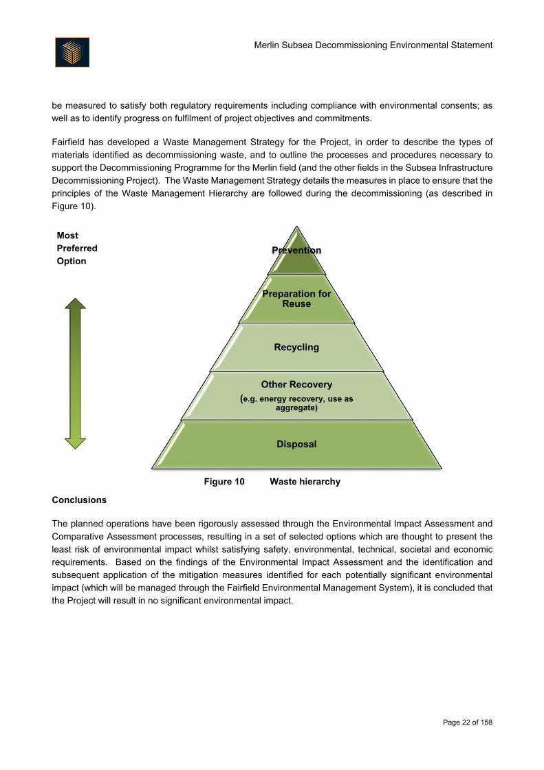
Figure 10).
Most
Preferred
Option
Figure 10 Waste hierarchy
Conclusions
The planned operations have been rigorously assessed through the Environmental Impact Assessment and
Comparative Assessment processes, resulting in a set of selected options which are thought to present the
least risk of environmental impact whilst satisfying safety, environmental, technical, societal and economic
requirements. Based on the findings of the Environmental Impact Assessment and the identification and
subsequent application of the mitigation measures identified for each potentially significant environmental
impact (which will be managed through the Fairfield Environmental Management System), it is concluded that
the Project will result in no significant environmental impact.
Prevention
Preparation for Reuse
Recycling
Other Recovery
(e.g. energy recovery, use as aggregate)
Disposal
Merlin Subsea Decommissioning Environmental Statement
Page 23 of 158
1. Introduction
1.1. The Dunlin, Merlin and Osprey Fields
Fairfield Betula Limited and Fairfield Fagus Limited (collectively termed Fairfield), wholly owned subsidiaries
of Fairfield Energy Limited, are the operators of the Dunlin, Merlin and Osprey fields (the ‘Greater Dunlin Area’),
located in United Kingdom Continental Shelf (UKCS) Block 211/23 of the northern North Sea. Infrastructure
associated with Dunlin, Merlin and Osprey is currently being prepared for decommissioning. The Merlin field
lies approximately 132 km from the nearest landfall point, 192 km north east of Lerwick and 18 km west of the
UK/Norway boundary. The Merlin field is a subsea tie-back to the Dunlin Alpha platform, located 7 km to the
west-north west of the Dunlin Alpha platform (Figure 1.1). The Osprey field is a subsea tie-back located 6 km
to the north-north west of the Dunlin Alpha platform. Production at the fields ceased in June 2015 and Fairfield
now intends to decommission the Merlin subsea infrastructure as part of a wider programme to decommission
all subsea infrastructure associated with the Greater Dunlin Area (the ‘Subsea Infrastructure Decommissioning
Project’). The decommissioning of the Dunlin Alpha platform will be considered separately from the subsea
activities. This Environmental Statement (ES) relates specifically to the proposed decommissioning of the
Merlin field; the Osprey and Dunlin (subsea and platform) infrastructure will be the subject of separate ESs.
Figure 1.1 Location of Dunlin, Merlin and Osprey fields
Merlin Subsea Decommissioning Environmental Statement
Page 24 of 158
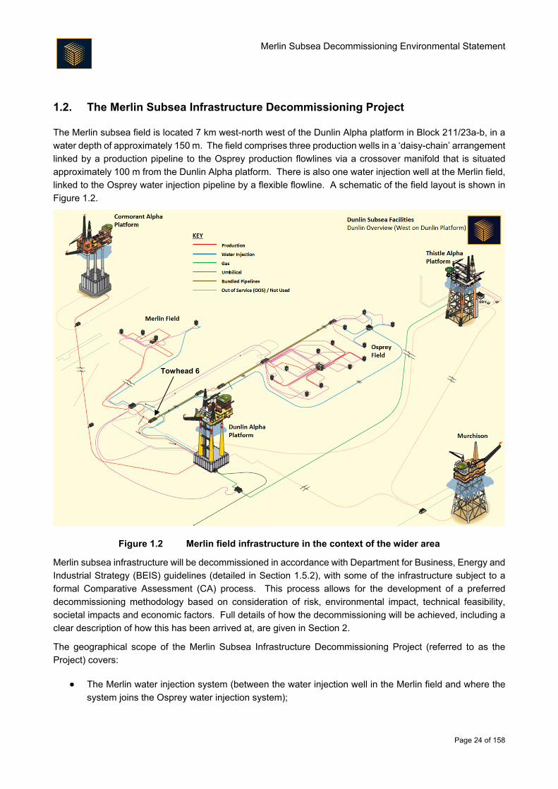
1.2. The Merlin Subsea Infrastructure Decommissioning Project
The Merlin subsea field is located 7 km west-north west of the Dunlin Alpha platform in Block 211/23a-b, in a
water depth of approximately 150 m. The field comprises three production wells in a ‘daisy-chain’ arrangement
linked by a production pipeline to the Osprey production flowlines via a crossover manifold that is situated
approximately 100 m from the Dunlin Alpha platform. There is also one water injection well at the Merlin field,
linked to the Osprey water injection pipeline by a flexible flowline. A schematic of the field layout is shown in
Figure 1.2.
Figure 1.2 Merlin field infrastructure in the context of the wider area
Merlin subsea infrastructure will be decommissioned in accordance with Department for Business, Energy and
Industrial Strategy (BEIS) guidelines (detailed in Section 1.5.2), with some of the infrastructure subject to a
formal Comparative Assessment (CA) process. This process allows for the development of a preferred
decommissioning methodology based on consideration of risk, environmental impact, technical feasibility,
societal impacts and economic factors. Full details of how the decommissioning will be achieved, including a
clear description of how this has been arrived at, are given in Section 2.
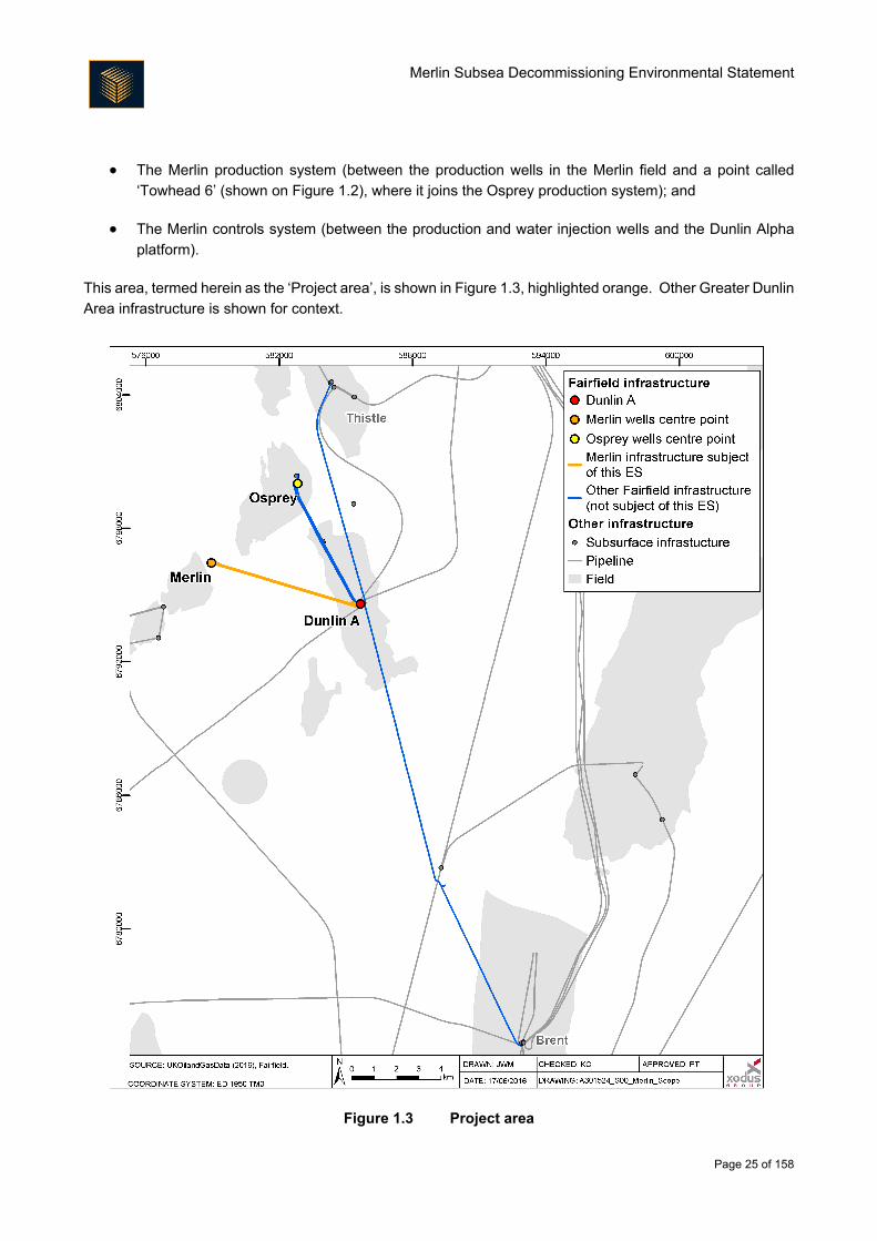
The geographical scope of the Merlin Subsea Infrastructure Decommissioning Project (referred to as the
Project) covers:
The Merlin water injection system (between the water injection well in the Merlin field and where the
system joins the Osprey water injection system);
Towhead 6
Merlin Subsea Decommissioning Environmental Statement
Page 25 of 158
The Merlin production system (between the production wells in the Merlin field and a point called
‘Towhead 6’ (shown on Figure 1.2), where it joins the Osprey production system); and
The Merlin controls system (between the production and water injection wells and the Dunlin Alpha
platform).
This area, termed herein as the ‘Project area’, is shown in Figure 1.3, highlighted orange. Other Greater Dunlin
Area infrastructure is shown for context.
Figure 1.3 Project area
Merlin Subsea Decommissioning Environmental Statement
Page 26 of 158
1.3. Purpose of this Document and of the Environmental Impact Assessment (EIA)
This ES reports the outcome of the EIA process undertaken in support of the proposed decommissioning
activities for the Merlin subsea area. The scope of the EIA was developed during scoping and wider
consultation (Section 5). Full details of the method applied during the EIA process are described in Section 4.
The overall aim of the EIA has been to assess the potential environmental impacts that may arise from the
Project and to identify any measures that will be put in place to reduce the magnitude or likelihood of these
potential impacts. The EIA process has run in parallel to the CA process and has informed decisions taken
on the approach to decommissioning, and as such is considered integral to the Project. The EIA process also
provides a framework for stakeholder involvement so that issues can be identified and addressed as
appropriate at an early stage, as well as helping the planned activities comply with environmental legislative
requirements and Fairfield’s own environmental policies.
For clarity, the following are outside the scope of this EIA:
Well plugging and abandonment will be undertaken by a drilling rig and will be covered under a Well
Intervention Permit, which will include a Chemical Permit for abandonment operations. Removal of
the wellhead and associated infrastructure will take place using an appropriate vessel. Fairfield will
apply for a Marine Licence to undertake these operations. Any potential environmental impacts will
be discussed in the impact assessment that will support these applications and they are not covered
further in this ES;
Flushing and cleaning of the production pipelines has already been completed. Flushing and cleaning
of the umbilicals will be managed in environmental terms through application of permits (either under
existing permits, under existing permits with amendments or under new permits) under relevant
regulations (e.g. Offshore Chemical Regulations 2002 (as amended), Offshore Petroleum Activities
(Oil Pollution Prevention and Control) Regulations 2005 (as amended)). Whilst the flushing and
cleaning of the flowlines and umbilicals are out of scope of the EIA, potential impacts associated with
the decommissioning of the lines is within the scope (e.g. discharge during preparatory work for
removal, long-term release from any lines decommissioned in situ);
The handling, treatment and disposal of waste will be undertaken by specialist third parties at facilities
previously subject to environmental assessment and approved irrespective of this Project. Potential
impacts arising from the onshore handling, treatment and disposal of waste in all its forms is therefore
excluded from the scope of this EIA. However, Fairfield recognises its duty of care with respect to
waste and details on how the company manages its activities with regards to the environment are
detailed in this ES; and
Decommissioning activities required for Dunlin and Osprey subsea infrastructure (these are subject to
separate Regulatory submissions).
1.4. Structure of this Environmental Statement
To clearly and concisely report the findings of the EIA, this ES has been structured as follows:
A non-technical summary of the ES;
Merlin Subsea Decommissioning Environmental Statement
Page 27 of 158
Description of the background to the Project; role of the EIA and legislative context (this section);
Description of the Project and alternatives considered, including a description of the CA process
(Section 2);
Description of the environment and identification of the key environmental sensitivities which may be
impacted by the Project (Section 3);
Description of the methods used to identify and evaluate the potential environmental impacts (Section
4);
Description of stakeholder engagement activities undertaken as part of the EIA (Section 5);
Detailed assessment of key potential impacts, including assessment of potential cumulative and
transboundary impacts (Section 6);
Consideration of how waste will be managed through the Project (Section 7);
Description of the environmental management measures (Section 8); and
Conclusions (Section 9).
1.5. Legislation and Policy
Overview
The Merlin subsea decommissioning EIA process has given due consideration to the legislative basis under
which decommissioning activities may be undertaken. This legislation and its influence on the Project are
described in Section 1.5.2. Additionally, the implications for the Project from the recently issued Scottish
National Marine Plan required consideration. This Marine Plan is summarised in Section 1.5.3.
Decommissioning
The decommissioning of offshore oil and gas installations and pipelines on the UKCS is controlled through the
Petroleum Act 1998 (as amended1). Decommissioning is also regulated under the Marine and Coastal Act
2009 and Marine (Scotland) Act 2010. The UK's international obligations on decommissioning are primarily
governed by the 1992 Convention for the Protection of the Marine Environment of the North East Atlantic (the
OSPAR Convention). The responsibility for ensuring compliance with the Petroleum Act 1998 rests with the
BEIS (formerly the Department for Energy and Climate Change, or DECC). BEIS is also the Competent
Authority on decommissioning in the UK for OSPAR purposes and under the Marine Acts.
Agreement on the process to be applied to the decommissioning of offshore oil and gas installations within the
Convention area, and hence within the UKCS, was reached at the OSPAR Commission meeting held in July
1998. That agreement was reflected in OSPAR Decision 98/3, which entered into force on 9 February 1999
1 The most recent amendment to the Petroleum Act 1998 was by the Energy Act 2016 which, amongst others, requires relevant persons to consult the UK Oil and Gas Authority (OGA) before submitting an abandonment programme to the Secretary of State, and to require the Secretary of State to consider representations from the OGA when deciding whether to approve a programme.
Merlin Subsea Decommissioning Environmental Statement
Page 28 of 158
and which brought a prohibition on the dumping and leaving wholly or partly in place of offshore oil and gas
installations. The provisions of OSPAR Decision 98/3 do not apply to pipelines. Guidance provided by BEIS
states that all feasible decommissioning options for pipelines should be considered and a CA undertaken
(DECC, 2011).
At present in the UK there is no statutory requirement to undertake an EIA to support the Decommissioning
Programme that must accompany all applications for decommissioning in the UKCS (as per the Petroleum Act
1998). However, BEIS in their ‘Guidance Notes on the Decommissioning of Offshore Oil and Gas Installations
and Pipelines under the Petroleum Act 1998’ advise that the Decommissioning Programme should be
supported by an EIA; this ES thus fulfils this requirement. In this regard, the BEIS Guidance Notes state that
an EIA should include an assessment of the following:
All potential impacts on the marine environment including exposure of biota to contaminants
associated with the installation; other biological impacts arising from physical effects; conflicts with the
conservation of species and their habitats;
All potential impacts on other environmental compartments, including emissions to the atmosphere;
Consumption of natural resources and energy associated with execution of the decommissioning
activities and with reuse and recycling;
Interference with other legitimate uses of the sea and consequential effects on the physical
environment; and
Potential impacts on amenities, the activities of communities and on future uses of the environment.
In addition, BEIS has advised the oil and gas industry that any applications related to decommissioning made
under the Marine and Coastal Act 2009 and Marine (Scotland) Act 2010 will need to be supported by an EIA.
Although such applications are not being made by Fairfield at this time (they will be required later in the
decommissioning process), Fairfield has undertaken the EIA to adequately support such applications when
they are eventually required (this may include Marine Licences and Consent to Locates).
Scottish National Marine Plan
The Scottish Government adopted the National Marine Plan in early 2015 (Scottish Government, 2015) to
provide an overarching framework for marine activity in Scottish waters, in an aim to enable sustainable
development and the use of the marine area in a way that protects and enhances the marine environment
whilst promoting both existing and emerging industries. This is underpinned by a core set of general policies
which apply across existing and future development and use of the marine environment. Policies of particular
relevance to the Project include:
General planning principle: There is a presumption in favour of sustainable development and use of
the marine environment when consistent with the policies and objectives of the Plan;
Economic benefit: Sustainable development and use which provides economic benefit to Scottish
communities is encouraged when consistent with the objectives and policies of this Plan (economics
has been considered in the CA; Section 2.2);
Natural heritage: Development and use of the marine environment must:
Merlin Subsea Decommissioning Environmental Statement
Page 29 of 158
o Comply with legal requirements for protected areas and protected species;
o Not result in significant impact on the national status of Priority Marine Features; and
o Protect and, where appropriate, enhance the health of the marine area (protected sites and
species have been considered within relevant impact assessments; Section 6).
Noise: Development and use in the marine environment should avoid significant adverse effects of
man-made noise and vibration, especially on species sensitive to such effects (potential impacts from
underwater noise are considered in Section 6.2.2 and controls for onshore noise are considered in
Section 8.3);
Air quality: Development and use of the marine environment should not result in the deterioration of
air quality and should not breach any statutory air quality limits (potential impacts from energy use and
atmospheric emissions are considered in Section 6.3);
Engagement: Early and effective engagement should be undertaken with the general public and
interested stakeholders to facilitate planning and decommissioning processes (Fairfield has engaged
actively with stakeholders during the development of the Decommissioning Programme; Section 5);
and
Cumulative impacts: Cumulative impacts affecting the ecosystem of the Marine Plan area should be
addressed in decision-making and Plan implementation (the potential for cumulative impacts has been
considered within each impact assessment; Section 6).
Specifically with regards to decommissioning of oil and gas facilities, the Marine Plan requires the following:
Where re-use of oil and gas infrastructure is not practicable, either as part of oil and gas activity or by
other sectors such as carbon capture and storage, decommissioning must take place in line with
standard practice, and as allowed by international obligations. Re-use or removal of decommissioned
assets from the seabed will be fully supported where practicable and adhering to relevant regulatory
process (the CA process that has been followed to arrive at the proposed decommissioning strategy
is outlined in Section 2.2).
Fairfield has given due consideration to the Marine Plan during Project decision making and the interactions
between the Project and Plan are summarised in Section 8.5.
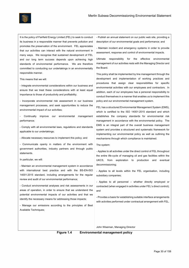
1.6. Environmental Management
Relevant to the EIA, and to all of Fairfield’s activities, is the company’s commitment to managing all
environmental impacts associated with its activities. Continuous improvement in environmental performance
is sought through effective project planning and implementation, emissions reduction, waste minimisation,
waste management, and energy conservation; this mindset has fed into the development of the mitigation
measures developed for the Project. A summary of Fairfield’s Environmental Management Policy is presented
in Figure 1.4.
Merlin Subsea Decommissioning Environmental Statement
Page 30 of 158
It is the policy of Fairfield Energy Limited (FEL) to seek to conduct
its business in a responsible manner that prevents pollution and
promotes the preservation of the environment. FEL appreciates
that our activities can interact with the natural environment in
many ways. We recognise that sustained development of FEL
and our long term success depends upon achieving high
standards of environmental performance. We are therefore
committed to conducting our undertakings in an environmentally
responsible manner.
This means that we will:
- Integrate environmental considerations within our business and
ensure that we treat these considerations with at least equal
importance to those of productivity and profitability;
- Incorporate environmental risk assessment in our business
management processes, and seek opportunities to reduce the
environmental impact of our activities;
- Continually improve our environmental management
performance;
- Comply with all environmental laws, regulations and standards
applicable to our undertakings;
- Allocate necessary resources to implement this policy; and
- Communicate openly in matters of the environment with
government authorities, industry partners and through public
statements.
In particular, we will:
- Maintain an environmental management system in accordance
with international best practice and with the BS-EN-ISO
14001:2015 standard, including arrangements for the regular
review and audit of our environmental performance;
- Conduct environmental analyses and risk assessments in our
areas of operation, in order to ensure that we understand the
potential environmental impacts of our activities and that we
identify the necessary means for addressing those impacts;
- Manage our emissions according to the principles of Best
Available Techniques;
- Publish an annual statement on our public web site, providing a
description of our environmental goals and performance; and
- Maintain incident and emergency systems in order to provide
assessment, response and control of environmental impacts.
Ultimate responsibility for the effective environmental
management of our activities rests with the Managing Director and
the Board.
This policy shall be implemented by line management through the
development and implementation of working practices and
procedures that assign clear responsibilities for specific
environmental activities with our employees and contractors. In
addition, each of our employees has a personal responsibility to
conduct themselves in a manner that enables us to implement this
policy and our environmental management system.
FEL has a structured Environmental Management System (EMS),
which is certified to the ISO 14001:2015 standard and which
establishes the company standards for environmental risk
management in accordance with the environmental policy. The
EMS is an integral part of the overall business management
system and provides a structured and systematic framework for
implementing our environmental policy as well as outlining the
mechanisms through which compliance is maintained.
The system:
- Applies to all activities under the direct control of FEL throughout
the entire life-cycle of managing oil and gas facilities within the
UKCS, from exploration to production and eventual
decommissioning;
- Applies to all levels within the FEL organisation, including
subsidiary companies;
- Applies to all personnel – whether directly employed or
contracted (when engaged in activities under FEL’s direct control);
and
- Provides a basis for establishing suitable interface arrangements
with activities performed under contractual arrangement with FEL.
John Wiseman, Managing Director
Figure 1.4 Environmental management policy
Merlin Subsea Decommissioning Environmental Statement
Page 31 of 158
2. Project Description and Comparative Assessment
2.1. Description of Facilities to be Decommissioned
Overview
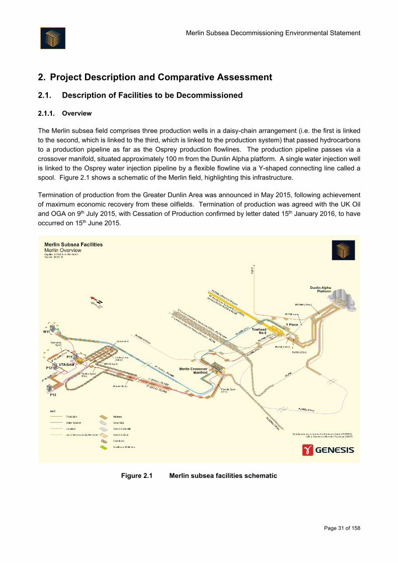
The Merlin subsea field comprises three production wells in a daisy-chain arrangement (i.e. the first is linked
to the second, which is linked to the third, which is linked to the production system) that passed hydrocarbons
to a production pipeline as far as the Osprey production flowlines. The production pipeline passes via a
crossover manifold, situated approximately 100 m from the Dunlin Alpha platform. A single water injection well
is linked to the Osprey water injection pipeline by a flexible flowline via a Y-shaped connecting line called a
spool. Figure 2.1 shows a schematic of the Merlin field, highlighting this infrastructure.
Termination of production from the Greater Dunlin Area was announced in May 2015, following achievement
of maximum economic recovery from these oilfields. Termination of production was agreed with the UK Oil
and OGA on 9th July 2015, with Cessation of Production confirmed by letter dated 15th January 2016, to have
occurred on 15th June 2015.
Figure 2.1 Merlin subsea facilities schematic
Merlin Subsea Decommissioning Environmental Statement
Page 32 of 158
Pipelines and Umbilicals
The Merlin 8" production pipeline and 3" umbilical, routed from the Merlin drill centre to the Merlin crossover
manifold, shown in Figure 2.1, are trenched and rockdumped, as detailed in Table 2.1.
Note: All dimensions, weights and quantities presented in this document are the best estimates based on the
latest engineering studies; these values may be refined as project planning progresses.
Table 2.1 Trenched and rockdumped infrastructure at Merlin
Item Material Length (m) Trenched Rockdumped
Length (m) Depth (m) Length (m) Depth (m)
PL1555 8" oil
pipeline Steel 6,805 6,673
1.1 – 1.6
below
seabed
6,573 0.6
PL1557 3"
umbilical
Polymer/ super
duplex/ copper 6,980 6,673
1 – 1.6
below
seabed
6,573 0.6
There is also a trenched and backfilled 8" water injection flexible flowline that connects the Merlin crossover
manifold to the Merlin water injection well (Figure 2.1), detailed further in Table 2.2. There is also a partially-
rockdumped umbilical riser that connects the Merlin control system to the Dunlin Alpha platform, detailed
further in Table 2.3. The rockdump on the umbilical riser is overspill from operations unrelated to the Merlin
subsea area – it was not placed on the umbilical by design.
Table 2.2 Trenched and backfilled infrastructure at Merlin
Item Material Length
(m)
Burial status
Trenched Backfilled Mattress
cover
Rockdump
cover
PL1665 8" water
injection pipeline Steel 7,043
To a depth of 0.6 m
for 6,683 m
To a depth of
0.6 m for
6,663 m
Spot
locations
that did not
achieve
burial
-
Table 2.3 Partially rockdumped infrastructure at Merlin
Item Material Length
(m)
Burial status
Trenched Backfilled Mattress cover Rockdump cover
PL1556 4"
umbilical riser Steel 475 - - -
To a depth of 0.5 m
for 60 m
Merlin Subsea Decommissioning Environmental Statement
Page 33 of 158
Other Subsea Infrastructure
There are a number of other components which have been identified as items which require decommissioning
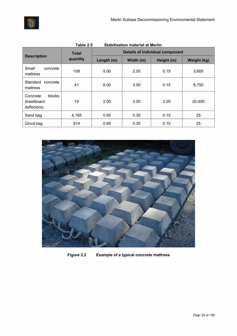
as part of the Project; these are described in Table 2.4. Table 2.5 describes the quantity and size of concrete
mattresses (an example of what these look like is given in Figure 2.2) and sand and grout bag deposits that
were previously placed in the field to provide level ground for structures or to provide protection from other sea
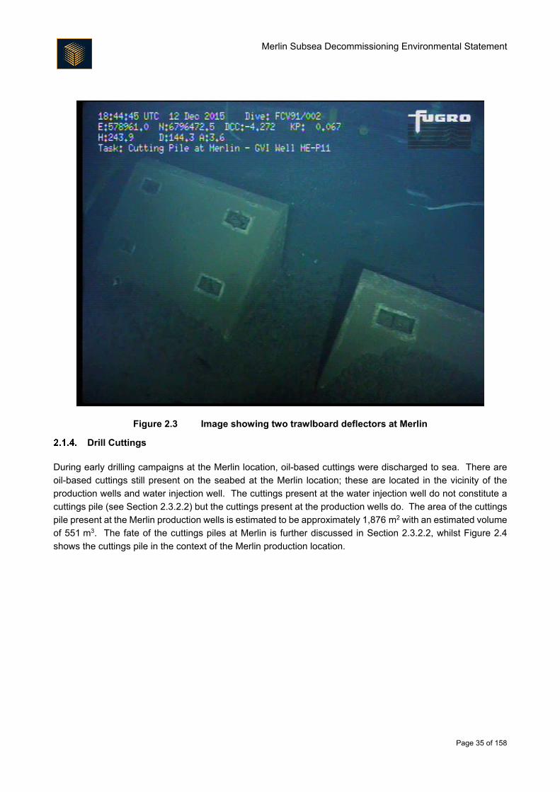
users. Trawlboard deflectors made of concrete were also previously deployed around the Merlin drill centre
to protect the other installed structures (Figure 2.3).
Table 2.4 Pipeline and umbilical components at Merlin
Description Material Total length (m) Total weight (kg) Quantity
Tree spool (a spool is a
connecting line between
structures and lines)
Super duplex 0.198 938 1
Ring pair corrosion
monitoring spool Steel 2.5 1,770 1
Merlin crossover
manifold spool Steel 2.34 924 1
Merlin umbilical
termination assembly
unit (an end point
structure for the
umbilical)
Steel 5.00 5,200 1
Tee spools Steel 6.92 5,333 5
Spools (incorporating
manual valves) Steel 3.169 4,345 3
Corrosion monitoring
spool Steel 2.05 2,519 1
Merlin crossover
manifold Steel 12.10 77,151 1
Flexible jumper (a
jumper is like a spool) Polymer/steel 367 68,492 5
Cooling spool Steel 130 12,950 1
Spool Super duplex 72 4,780 2
3.5" umbilical jumpers Thermoplastic/
stainless steel 289 1,721 4
1.5" jumpers Stainless steel/ copper 289 268 4
Hose Stainless steel/
elastomer 91 60 1
Hose Thermoplastic 25 26 1
Merlin Subsea Decommissioning Environmental Statement
Page 34 of 158
Table 2.5 Stabilisation material at Merlin
Description Total
quantity
Details of individual component
Length (m) Width (m) Height (m) Weight (kg)
Small concrete
mattress 108 5.00 2.00 0.15 3,600
Standard concrete
mattress 41 6.00 3.00 0.15 6,750
Concrete blocks
(trawlboard
deflectors)
19 2.00 3.00 2.00 20,400
Sand bag 4,185 0.60 0.30 0.15 25
Grout bag 914 0.60 0.30 0.15 25
Figure 2.2 Example of a typical concrete mattress
Merlin Subsea Decommissioning Environmental Statement
Page 35 of 158
Figure 2.3 Image showing two trawlboard deflectors at Merlin
Drill Cuttings
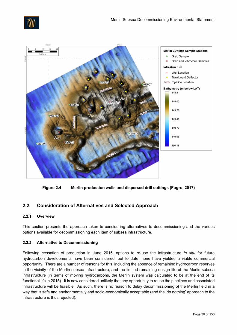
During early drilling campaigns at the Merlin location, oil-based cuttings were discharged to sea. There are
oil-based cuttings still present on the seabed at the Merlin location; these are located in the vicinity of the
production wells and water injection well. The cuttings present at the water injection well do not constitute a
cuttings pile (see Section 2.3.2.2) but the cuttings present at the production wells do. The area of the cuttings
pile present at the Merlin production wells is estimated to be approximately 1,876 m2 with an estimated volume
of 551 m3. The fate of the cuttings piles at Merlin is further discussed in Section 2.3.2.2, whilst Figure 2.4
shows the cuttings pile in the context of the Merlin production location.
Merlin Subsea Decommissioning Environmental Statement
Page 36 of 158
Figure 2.4 Merlin production wells and dispersed drill cuttings (Fugro, 2017)
2.2. Consideration of Alternatives and Selected Approach
Overview
This section presents the approach taken to considering alternatives to decommissioning and the various
options available for decommissioning each item of subsea infrastructure.
Alternative to Decommissioning
Following cessation of production in June 2015, options to re-use the infrastructure in situ for future
hydrocarbon developments have been considered, but to date, none have yielded a viable commercial
opportunity. There are a number of reasons for this, including the absence of remaining hydrocarbon reserves
in the vicinity of the Merlin subsea infrastructure, and the limited remaining design life of the Merlin subsea
infrastructure (in terms of moving hydrocarbons, the Merlin system was calculated to be at the end of its
functional life in 2015). It is now considered unlikely that any opportunity to reuse the pipelines and associated
infrastructure will be feasible. As such, there is no reason to delay decommissioning of the Merlin field in a
way that is safe and environmentally and socio-economically acceptable (and the ‘do nothing’ approach to the
infrastructure is thus rejected).
Well
Well
Well
Merlin Subsea Decommissioning Environmental Statement
Page 37 of 158
Comparative Assessment
CA is a process by which decisions can be made on the most appropriate approach to decommissioning. As
such, it is a core part of the overall decommissioning planning process being undertaken by Fairfield for the
subsea infrastructure at Merlin. Guidelines for CA were prepared in 2015 by Oil and Gas UK (OGUK), where
seven steps to the CA process were recommended. Table 2.6 provides commentary on each of these steps.
Table 2.6 Overview of the CA process
Title Scope Commentary
Scoping
Decide on appropriate CA
method, confirm criteria,
identify boundaries of CA
(physical and phase), and
identify and map
stakeholders
Scoping Reports prepared for Merlin, Dunlin and Osprey
subsea infrastructure in advance of Screening (see
below). Stakeholders identified and mapped and
Stakeholder Engagement Plan prepared. CA
methodology and criteria established for screening by
early 2016.
Screening
Consider alternative uses
and deselect unfeasible
options
Screening workshops held in the first quarter of 2016 with
external stakeholders for Merlin, Dunlin and Osprey.
Specific studies identified and agreed that would help with
the evaluation of options. CA methodology and criteria
were also revisited following screening to support option
selection.
Preparation
Undertake technical,
safety, environmental
studies plus stakeholder
engagement
Studies covering engineering, cost, safety and
environment/societal were undertaken alongside regular
stakeholder engagement.
Evaluation
Evaluate the options
using the chosen CA
methodology
Fairfield conducted two internal CA workshops as part of
the evaluation phase. The first, in August 2016, identified
areas where further information was needed in order to
make a recommendation (effectively recycling to the
preparation phase). A second internal workshop was held
in November where the results of recent study work were
used to discuss and update the decision tool. An
additional study (fisheries quantitative risk assessment)
was commissioned to run in parallel and be used to either
amend or validate the decision tool.
Recommendation
Create recommendation
in the form of narrative
supported by charts
explaining key trade-offs
The two workshops described above under the Evaluation
stage produced a set of emerging recommendations
which Fairfield presented as emerging recommendations
to external stakeholders. A Briefing Session was held in
December 2016 to review these and provide additional
data to stakeholders.
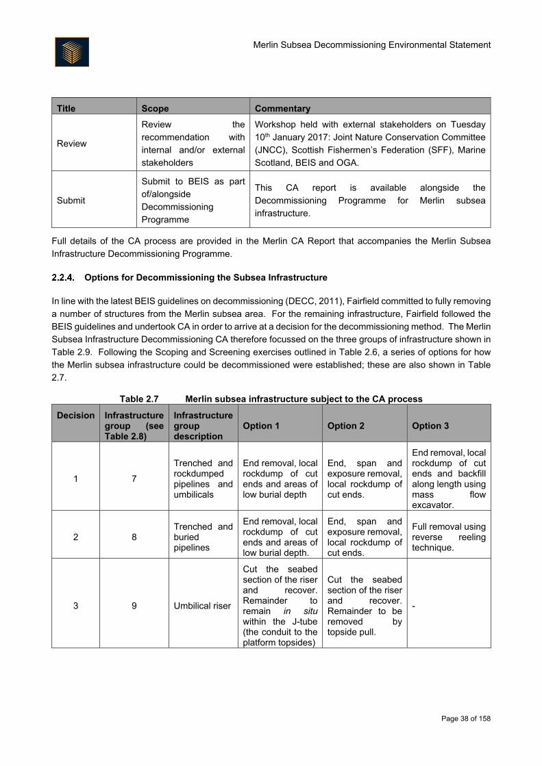
Merlin Subsea Decommissioning Environmental Statement
Page 38 of 158
Title Scope Commentary
Review
Review the
recommendation with
internal and/or external
stakeholders
Workshop held with external stakeholders on Tuesday
10th January 2017: Joint Nature Conservation Committee
(JNCC), Scottish Fishermen’s Federation (SFF), Marine
Scotland, BEIS and OGA.
Submit
Submit to BEIS as part
of/alongside
Decommissioning
Programme
This CA report is available alongside the
Decommissioning Programme for Merlin subsea
infrastructure.
Full details of the CA process are provided in the Merlin CA Report that accompanies the Merlin Subsea
Infrastructure Decommissioning Programme.
Options for Decommissioning the Subsea Infrastructure
In line with the latest BEIS guidelines on decommissioning (DECC, 2011), Fairfield committed to fully removing
a number of structures from the Merlin subsea area. For the remaining infrastructure, Fairfield followed the
BEIS guidelines and undertook CA in order to arrive at a decision for the decommissioning method. The Merlin
Subsea Infrastructure Decommissioning CA therefore focussed on the three groups of infrastructure shown in
Table 2.9. Following the Scoping and Screening exercises outlined in Table 2.6, a series of options for how
the Merlin subsea infrastructure could be decommissioned were established; these are also shown in Table
2.7.
Table 2.7 Merlin subsea infrastructure subject to the CA process
Decision Infrastructure group (see Table 2.8)
Infrastructure group description
Option 1 Option 2 Option 3
1 7
Trenched and rockdumped pipelines and umbilicals
End removal, local rockdump of cut ends and areas of low burial depth
End, span and exposure removal, local rockdump of cut ends.
End removal, local rockdump of cut ends and backfill along length using mass flow excavator.
2 8 Trenched and buried pipelines
End removal, local rockdump of cut ends and areas of low burial depth.
End, span and exposure removal, local rockdump of cut ends.
Full removal using reverse reeling technique.
3 9 Umbilical riser
Cut the seabed section of the riser and recover. Remainder to remain in situ within the J-tube (the conduit to the platform topsides)
Cut the seabed section of the riser and recover. Remainder to be removed by topside pull.
-
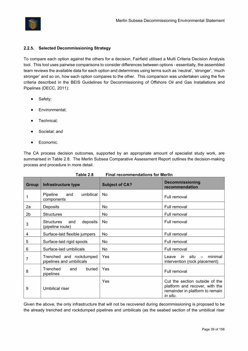
Merlin Subsea Decommissioning Environmental Statement
Page 39 of 158
Selected Decommissioning Strategy
To compare each option against the others for a decision, Fairfield utilised a Multi Criteria Decision Analysis
tool. This tool uses pairwise comparisons to consider differences between options - essentially, the assembled
team reviews the available data for each option and determines using terms such as ‘neutral’, ‘stronger’, ‘much
stronger’ and so on, how each option compares to the other. This comparison was undertaken using the five
criteria described in the BEIS Guidelines for Decommissioning of Offshore Oil and Gas Installations and
Pipelines (DECC, 2011):
Safety;
Environmental;
Technical;
Societal; and
Economic.
The CA process decision outcomes, supported by an appropriate amount of specialist study work, are
summarised in Table 2.8. The Merlin Subsea Comparative Assessment Report outlines the decision-making
process and procedure in more detail.
Table 2.8 Final recommendations for Merlin
Group Infrastructure type Subject of CA? Decommissioning recommendation
1 Pipeline and umbilical components
No Full removal
2a Deposits No Full removal
2b Structures No Full removal
3 Structures and deposits (pipeline route)
No Full removal
4 Surface-laid flexible jumpers No Full removal
5 Surface-laid rigid spools No Full removal
6 Surface-laid umbilicals No Full removal
7 Trenched and rockdumped pipelines and umbilicals
Yes Leave in situ – minimal intervention (rock placement)
8 Trenched and buried pipelines
Yes Full removal
9 Umbilical riser
Yes Cut the section outside of the platform and recover, with the remainder in platform to remain in situ.
Given the above, the only infrastructure that will not be recovered during decommissioning is proposed to be
the already trenched and rockdumped pipelines and umbilicals (as the seabed section of the umbilical riser
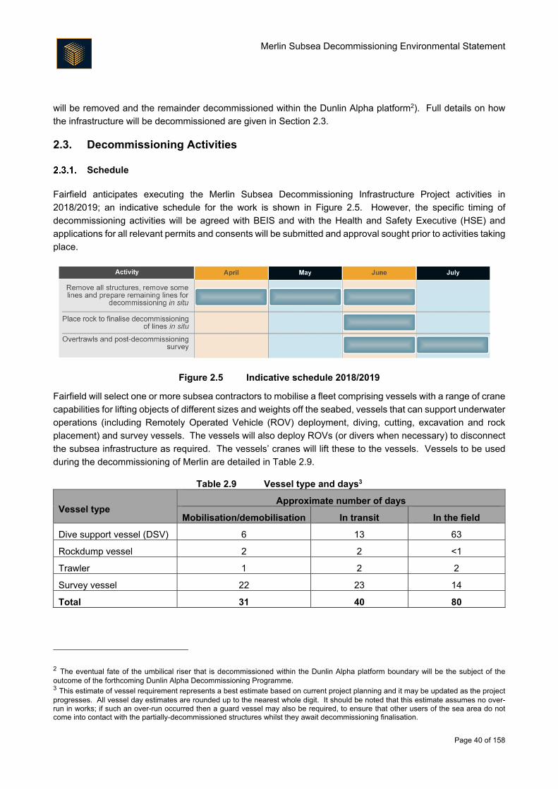
Merlin Subsea Decommissioning Environmental Statement
Page 40 of 158
will be removed and the remainder decommissioned within the Dunlin Alpha platform2). Full details on how
the infrastructure will be decommissioned are given in Section 2.3.
2.3. Decommissioning Activities
Schedule
Fairfield anticipates executing the Merlin Subsea Decommissioning Infrastructure Project activities in
2018/2019; an indicative schedule for the work is shown in Figure 2.5. However, the specific timing of
decommissioning activities will be agreed with BEIS and with the Health and Safety Executive (HSE) and
applications for all relevant permits and consents will be submitted and approval sought prior to activities taking
place.
Figure 2.5 Indicative schedule 2018/2019
Fairfield will select one or more subsea contractors to mobilise a fleet comprising vessels with a range of crane
capabilities for lifting objects of different sizes and weights off the seabed, vessels that can support underwater
operations (including Remotely Operated Vehicle (ROV) deployment, diving, cutting, excavation and rock
placement) and survey vessels. The vessels will also deploy ROVs (or divers when necessary) to disconnect
the subsea infrastructure as required. The vessels’ cranes will lift these to the vessels. Vessels to be used
during the decommissioning of Merlin are detailed in Table 2.9.
Table 2.9 Vessel type and days3
Vessel type Approximate number of days
Mobilisation/demobilisation In transit In the field
Dive support vessel (DSV) 6 13 63
Rockdump vessel 2 2 <1
Trawler 1 2 2
Survey vessel 22 23 14
Total 31 40 80
2 The eventual fate of the umbilical riser that is decommissioned within the Dunlin Alpha platform boundary will be the subject of the outcome of the forthcoming Dunlin Alpha Decommissioning Programme. 3 This estimate of vessel requirement represents a best estimate based on current project planning and it may be updated as the project progresses. All vessel day estimates are rounded up to the nearest whole digit. It should be noted that this estimate assumes no over-run in works; if such an over-run occurred then a guard vessel may also be required, to ensure that other users of the sea area do not come into contact with the partially-decommissioned structures whilst they await decommissioning finalisation.
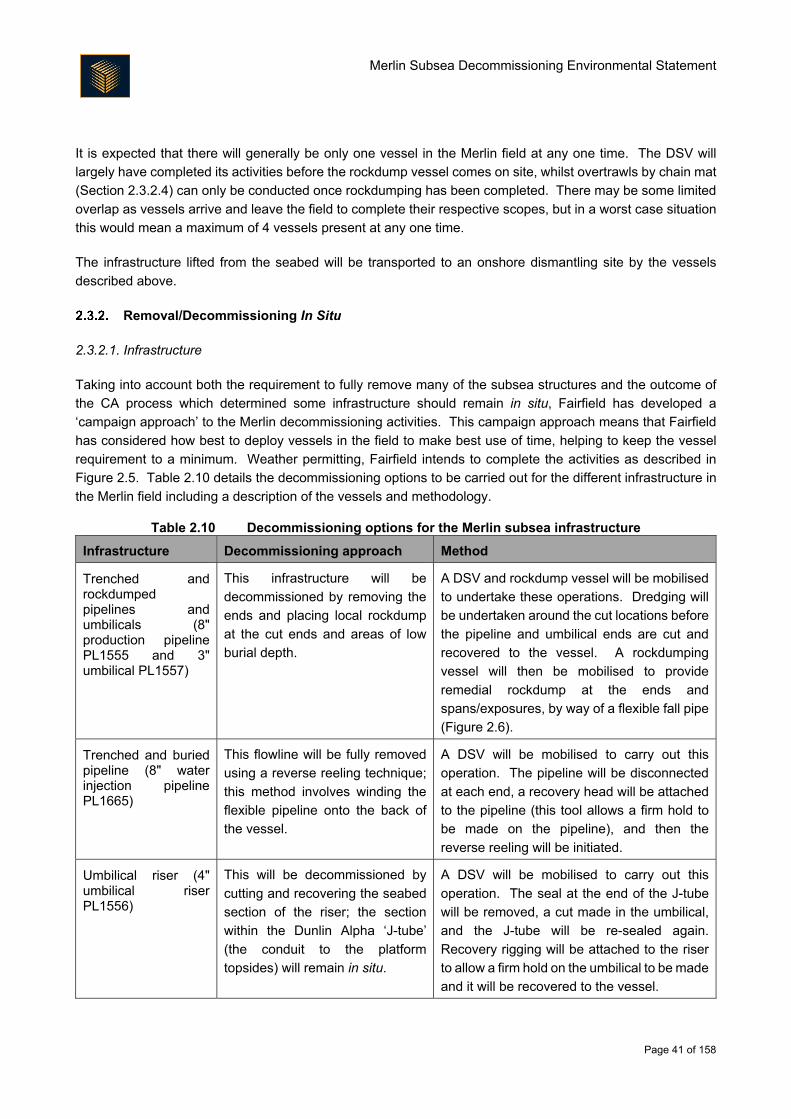
Merlin Subsea Decommissioning Environmental Statement
Page 41 of 158
It is expected that there will generally be only one vessel in the Merlin field at any one time. The DSV will
largely have completed its activities before the rockdump vessel comes on site, whilst overtrawls by chain mat
(Section 2.3.2.4) can only be conducted once rockdumping has been completed. There may be some limited
overlap as vessels arrive and leave the field to complete their respective scopes, but in a worst case situation
this would mean a maximum of 4 vessels present at any one time.
The infrastructure lifted from the seabed will be transported to an onshore dismantling site by the vessels
described above.
Removal/Decommissioning In Situ
2.3.2.1. Infrastructure
Taking into account both the requirement to fully remove many of the subsea structures and the outcome of
the CA process which determined some infrastructure should remain in situ, Fairfield has developed a
‘campaign approach’ to the Merlin decommissioning activities. This campaign approach means that Fairfield
has considered how best to deploy vessels in the field to make best use of time, helping to keep the vessel
requirement to a minimum. Weather permitting, Fairfield intends to complete the activities as described in
Figure 2.5. Table 2.10 details the decommissioning options to be carried out for the different infrastructure in
the Merlin field including a description of the vessels and methodology.
Table 2.10 Decommissioning options for the Merlin subsea infrastructure
Infrastructure Decommissioning approach Method
Trenched and rockdumped pipelines and umbilicals (8" production pipeline PL1555 and 3" umbilical PL1557)
This infrastructure will be
decommissioned by removing the
ends and placing local rockdump
at the cut ends and areas of low
burial depth.
A DSV and rockdump vessel will be mobilised
to undertake these operations. Dredging will
be undertaken around the cut locations before
the pipeline and umbilical ends are cut and
recovered to the vessel. A rockdumping
vessel will then be mobilised to provide
remedial rockdump at the ends and
spans/exposures, by way of a flexible fall pipe
(Figure 2.6).
Trenched and buried pipeline (8" water injection pipeline PL1665)
This flowline will be fully removed
using a reverse reeling technique;
this method involves winding the
flexible pipeline onto the back of
the vessel.
A DSV will be mobilised to carry out this
operation. The pipeline will be disconnected
at each end, a recovery head will be attached
to the pipeline (this tool allows a firm hold to
be made on the pipeline), and then the
reverse reeling will be initiated.
Umbilical riser (4" umbilical riser PL1556)
This will be decommissioned by
cutting and recovering the seabed
section of the riser; the section
within the Dunlin Alpha ‘J-tube’
(the conduit to the platform
topsides) will remain in situ.
A DSV will be mobilised to carry out this
operation. The seal at the end of the J-tube
will be removed, a cut made in the umbilical,
and the J-tube will be re-sealed again.
Recovery rigging will be attached to the riser
to allow a firm hold on the umbilical to be made
and it will be recovered to the vessel.
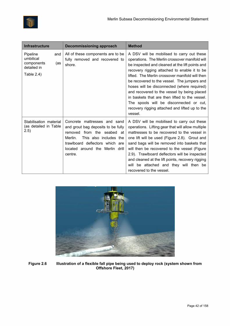
Merlin Subsea Decommissioning Environmental Statement
Page 42 of 158
Infrastructure Decommissioning approach Method
Pipeline and umbilical components (as detailed in
Table 2.4)
All of these components are to be
fully removed and recovered to
shore.
A DSV will be mobilised to carry out these
operations. The Merlin crossover manifold will
be inspected and cleaned at the lift points and
recovery rigging attached to enable it to be
lifted. The Merlin crossover manifold will then
be recovered to the vessel. The jumpers and
hoses will be disconnected (where required)
and recovered to the vessel by being placed
in baskets that are then lifted to the vessel.
The spools will be disconnected or cut,
recovery rigging attached and lifted up to the
vessel.
Stabilisation material (as detailed in Table 2.5)
Concrete mattresses and sand
and grout bag deposits to be fully
removed from the seabed at
Merlin. This also includes the
trawlboard deflectors which are
located around the Merlin drill
centre.
A DSV will be mobilised to carry out these
operations. Lifting gear that will allow multiple
mattresses to be recovered to the vessel in
one lift will be used (Figure 2.8). Grout and
sand bags will be removed into baskets that
will then be recovered to the vessel (Figure
2.9). Trawlboard deflectors will be inspected
and cleaned at the lift points, recovery rigging
will be attached and they will then be
recovered to the vessel.
Figure 2.6 Illustration of a flexible fall pipe being used to deploy rock (system shown from Offshore Fleet, 2017)
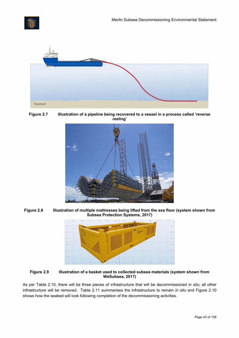
Merlin Subsea Decommissioning Environmental Statement
Page 43 of 158
Figure 2.7 Illustration of a pipeline being recovered to a vessel in a process called ‘reverse
reeling’
Figure 2.8 Illustration of multiple mattresses being lifted from the sea floor (system shown from Subsea Protection Systems, 2017)
Figure 2.9 Illustration of a basket used to collected subsea materials (system shown from WeSubsea, 2017)
As per Table 2.10, there will be three pieces of infrastructure that will be decommissioned in situ; all other
infrastructure will be removed. Table 2.11 summarises the infrastructure to remain in situ and Figure 2.10
shows how the seabed will look following completion of the decommissioning activities.
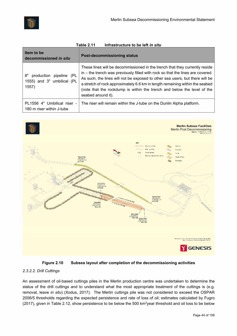
Merlin Subsea Decommissioning Environmental Statement
Page 44 of 158
Table 2.11 Infrastructure to be left in situ
Item to be
decommissioned in situ Post-decommissioning status
8" production pipeline (PL
1555) and 3" umbilical (PL
1557)
These lines will be decommissioned in the trench that they currently reside
in – the trench was previously filled with rock so that the lines are covered.
As such, the lines will not be exposed to other sea users, but there will be
a stretch of rock approximately 6.6 km in length remaining within the seabed
(note that the rockdump is within the trench and below the level of the
seabed around it).
PL1556 4" Umbilical riser -
180 m riser within J-tube
The riser will remain within the J-tube on the Dunlin Alpha platform.
Figure 2.10 Subsea layout after completion of the decommissioning activities
2.3.2.2. Drill Cuttings
An assessment of oil-based cuttings piles in the Merlin production centre was undertaken to determine the
status of the drill cuttings and to understand what the most appropriate treatment of the cuttings is (e.g.
removal, leave in situ) (Xodus, 2017). The Merlin cuttings pile was not considered to exceed the OSPAR
2006/5 thresholds regarding the expected persistence and rate of loss of oil; estimates calculated by Fugro
(2017), given in Table 2.12, show persistence to be below the 500 km2year threshold and oil loss to be below
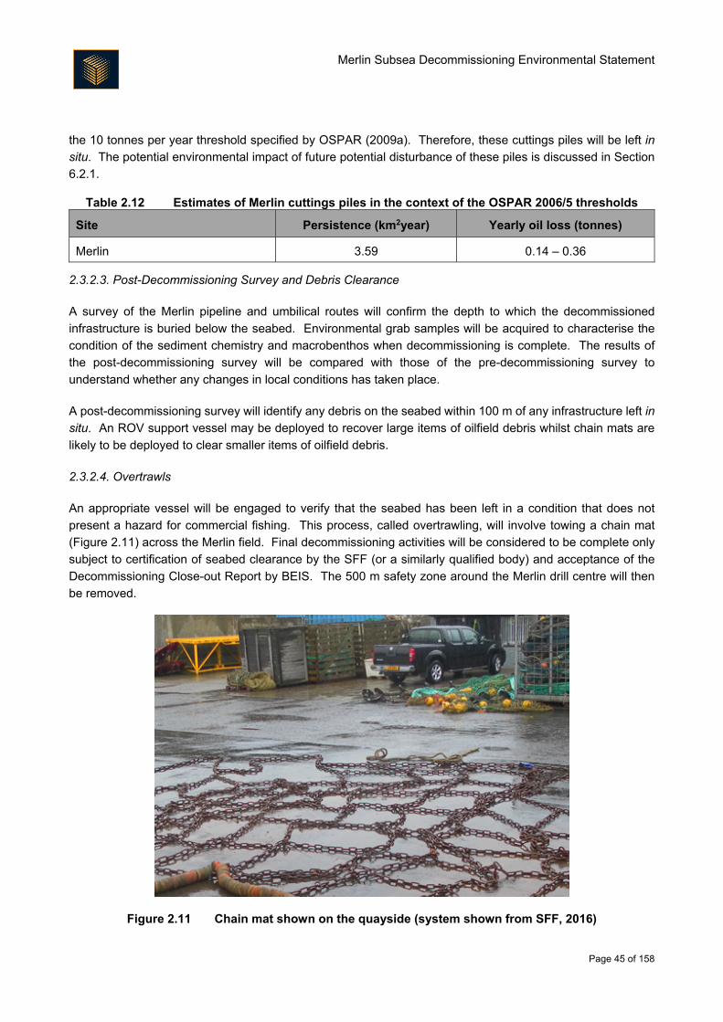
Merlin Subsea Decommissioning Environmental Statement
Page 45 of 158
the 10 tonnes per year threshold specified by OSPAR (2009a). Therefore, these cuttings piles will be left in
situ. The potential environmental impact of future potential disturbance of these piles is discussed in Section
6.2.1.
Table 2.12 Estimates of Merlin cuttings piles in the context of the OSPAR 2006/5 thresholds
Site Persistence (km2year) Yearly oil loss (tonnes)
Merlin 3.59 0.14 – 0.36
2.3.2.3. Post-Decommissioning Survey and Debris Clearance
A survey of the Merlin pipeline and umbilical routes will confirm the depth to which the decommissioned
infrastructure is buried below the seabed. Environmental grab samples will be acquired to characterise the
condition of the sediment chemistry and macrobenthos when decommissioning is complete. The results of
the post-decommissioning survey will be compared with those of the pre-decommissioning survey to
understand whether any changes in local conditions has taken place.
A post-decommissioning survey will identify any debris on the seabed within 100 m of any infrastructure left in
situ. An ROV support vessel may be deployed to recover large items of oilfield debris whilst chain mats are
likely to be deployed to clear smaller items of oilfield debris.
2.3.2.4. Overtrawls
An appropriate vessel will be engaged to verify that the seabed has been left in a condition that does not
present a hazard for commercial fishing. This process, called overtrawling, will involve towing a chain mat
(Figure 2.11) across the Merlin field. Final decommissioning activities will be considered to be complete only
subject to certification of seabed clearance by the SFF (or a similarly qualified body) and acceptance of the
Decommissioning Close-out Report by BEIS. The 500 m safety zone around the Merlin drill centre will then
be removed.
Figure 2.11 Chain mat shown on the quayside (system shown from SFF, 2016)
Merlin Subsea Decommissioning Environmental Statement
Page 46 of 158
2.3.2.5. Monitoring
Long-term liability survey monitoring will be undertaken as required by BEIS for the infrastructure
decommissioned left in situ. Fairfield intends to set up arrangements to undertake post-decommissioning
monitoring on behalf of the Licence Owners. The frequency of any monitoring that is required is likely to be
determined through a risk-based approach based on the findings from each subsequent survey. For the
purposes of this assessment, it has been assumed that up to 10 monitoring surveys will be undertaken as part
of this requirement by a survey vessel every 5 years for 50 years.
Onshore Dismantling and Disposal
The Merlin subsea structures and equipment removed from the seabed will be delivered to one or more
onshore dismantling sites. Although the dismantling site has not yet been selected, it will be chosen from a
shortlist of existing onshore disposal yards and no new facilities will be required. At the dismantling site(s):
Marine growth that has not fallen off subsea structures in transit will be removed and sent for
appropriate disposal;
Equipment suitable for reuse will be segregated;
Pipework that has been in contact with hydrocarbons and potentially contains naturally occurring
radioactive material will be assessed, and removed to a licensed facility if decontamination is
necessary;
Recovered sections of umbilical may be stripped to recover copper cable and other recyclable
materials; and
Recovered concrete will be segregated and stockpiled. The concrete will be sent for crushing and use
as aggregate in new concrete where possible.
Management of waste is detailed in Section 7.
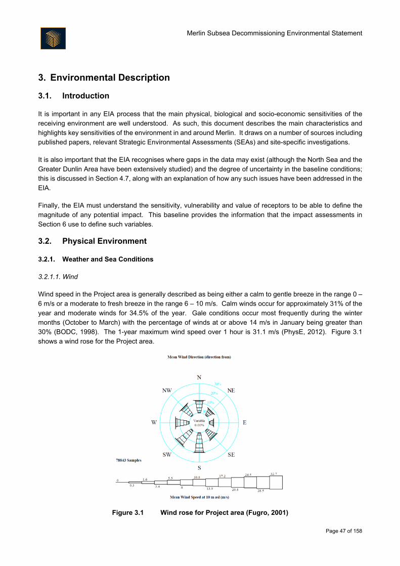
Merlin Subsea Decommissioning Environmental Statement
Page 47 of 158
3. Environmental Description
3.1. Introduction
It is important in any EIA process that the main physical, biological and socio-economic sensitivities of the
receiving environment are well understood. As such, this document describes the main characteristics and
highlights key sensitivities of the environment in and around Merlin. It draws on a number of sources including
published papers, relevant Strategic Environmental Assessments (SEAs) and site-specific investigations.
It is also important that the EIA recognises where gaps in the data may exist (although the North Sea and the
Greater Dunlin Area have been extensively studied) and the degree of uncertainty in the baseline conditions;
this is discussed in Section 4.7, along with an explanation of how any such issues have been addressed in the
EIA.
Finally, the EIA must understand the sensitivity, vulnerability and value of receptors to be able to define the
magnitude of any potential impact. This baseline provides the information that the impact assessments in
Section 6 use to define such variables.
3.2. Physical Environment
Weather and Sea Conditions
3.2.1.1. Wind
Wind speed in the Project area is generally described as being either a calm to gentle breeze in the range 0 –
6 m/s or a moderate to fresh breeze in the range 6 – 10 m/s. Calm winds occur for approximately 31% of the
year and moderate winds for 34.5% of the year. Gale conditions occur most frequently during the winter
months (October to March) with the percentage of winds at or above 14 m/s in January being greater than
30% (BODC, 1998). The 1-year maximum wind speed over 1 hour is 31.1 m/s (PhysE, 2012). Figure 3.1
shows a wind rose for the Project area.
Figure 3.1 Wind rose for Project area (Fugro, 2001)
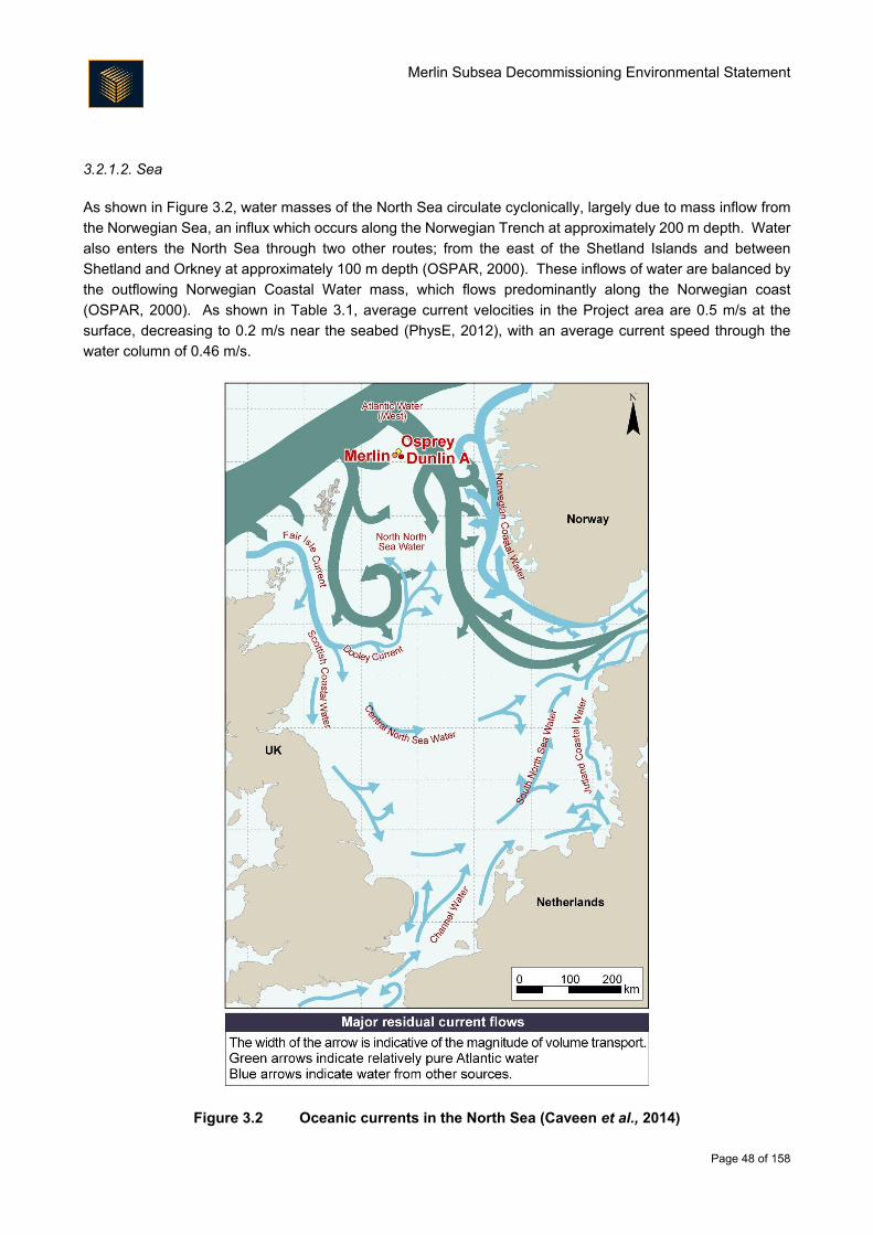
Merlin Subsea Decommissioning Environmental Statement
Page 48 of 158
3.2.1.2. Sea
As shown in Figure 3.2, water masses of the North Sea circulate cyclonically, largely due to mass inflow from
the Norwegian Sea, an influx which occurs along the Norwegian Trench at approximately 200 m depth. Water
also enters the North Sea through two other routes; from the east of the Shetland Islands and between
Shetland and Orkney at approximately 100 m depth (OSPAR, 2000). These inflows of water are balanced by
the outflowing Norwegian Coastal Water mass, which flows predominantly along the Norwegian coast
(OSPAR, 2000). As shown in Table 3.1, average current velocities in the Project area are 0.5 m/s at the
surface, decreasing to 0.2 m/s near the seabed (PhysE, 2012), with an average current speed through the
water column of 0.46 m/s.
Figure 3.2 Oceanic currents in the North Sea (Caveen et al., 2014)
Merlin Subsea Decommissioning Environmental Statement
Page 49 of 158
Table 3.1 Maximum current speeds for the Project area
Depth Current speed
1-year 10-year 50-year 100-year
Surface 0.50 0.66 0.79 0.86
50% of water depth 0.50 0.66 0.79 0.86
1% (near seabed) 0.20 0.27 0.32 0.35
Distinct density stratification occurs in the northern North Sea in the summer months at a depth of around 50 m
and the thermocline becomes increasingly distinct towards deeper water in the north. This stratification breaks
down in September as the frequency and severity of storms increases, causing mixing in the water column
(DECC, 2016).
As shown in Table 3.2, wave height in the vicinity of the Project area ranges from a 1-year significant wave
height of 11.5 m to a 1-year maximum wave height of 20.9 m. The maximum 100-year wave height is estimated
to be 28.4 m (PhysE, 2012).
Table 3.2 Maximum extreme wave conditions for the Project area
Wave
heights (m) 1-year 10-year 50-year 100-year 1,000-Year 10,000-Year
Significant
wave 11.5 13.6 15.0 15.6 17.9 20.1
Maximum
wave height 20.9 24.8 27.3 28.4 32.5 36.6
The average sea surface water temperature in the Project area varies seasonally between approximately 4°C
in winter to around 17°C in summer. Sea bottom temperatures vary between 5°C in winter to 12°C in summer
(PhysE, 2012).
Bathymetry and Seabed Conditions
The North Sea is a large shallow sea with a surface area of around 750,000 km2. Water depths gradually
deepen from south to north (DTI, 2001). The northern North Sea has a depth ranging from 100 m at the
southern point in the Fladen/Witch Ground to as deep as 1,500 m in the Faroe-Shetland Channel.
In the northern North Sea, and indeed across the North Sea, seabed sediments generally comprise a veneer
of unconsolidated terrigenous and biogenic deposits, generally much less than 1 m thick, although areas of
outcropping rock occur in coastal waters around and between Shetland, Orkney and the Scottish mainland.
Sediments in the Project area are predominantly sand and muddy sand, although the deeper areas within the
Fladen Ground consist of mud or sandy mud off the edge of the continental shelf to the north, the slope is
characterised by areas of mixed and coarse sediments, while the floor of the Faroe-Shetland Channel is
classified as mud (JNCC, 2010a).
As part of preparation for the Subsea Infrastructure Decommissioning Project, and as part of earlier operation
of the Greater Dunlin Area, the following site-specific surveys have been undertaken in recent years:
Merlin Subsea Decommissioning Environmental Statement
Page 50 of 158
Decommissioning surveys
o Osprey Pre-decommissioning Habitat Survey and Environmental Baseline Survey (EBS)
(Fugro, 2016a; Fugro, 2016b);
o Merlin Pre-decommissioning Habitat Survey and EBS (Fugro 2016c; Fugro 2016d);
o Dunlin Field Pre-decommissioning Habitat Survey and EBS (Fugro, 2016e; Fugro 2016f);
o Dunlin Fuel Gas Pre-decommissioning Habitat Survey and EBS (Fugro 2016g; Fugro 2016h);
and
o Dunlin Power Import Cable Pre-decommissioning Habitat Survey and EBS (Fugro 2016i;
Fugro 2016j).
Other surveys within and around the Project area
o Osprey Debris Clearance and Environmental Survey (Gardline, 2009a);
o Dunlin Development Debris Clearance, ‘Mud Mound’ and EBS (Gardline, 2009b);
o Dunlin Fuel Gas Import Route Survey (Gardline, 2011);
o Dunlin to Northern Leg Gas Pipeline (NLGP) Pipeline Route Survey (Gardline, 2010a); and
o Quad 211 Infield Environmental Survey (Gardline, 2010b).
The majority of locations surveyed during these campaigns are illustrated in Figure 3.3 and Figure 3.4.
The Merlin field is relatively flat, situated in a water depth of 150 m. Along the pipeline route from Merlin to
Dunlin Alpha platform, the route is also relatively flat ranging from depths of approximately 150 m to the north
west to 152 m in the south east (Fugro, 2016c).
As shown in Table 3.3, the sediments collected in the vicinity of the Merlin drill centre and along the pipeline
route were mainly classified as fine sand (nine stations) (Fugro, 2016d). One sample (J7) contained higher
proportion of gravel particles and was classified as medium sand. Mean particle diameter values recorded for
all samples ranged from 167 μm to 365 μm (mean 208 μm). These sediment types were consistent with those
recorded during the 2008 to 2009 baseline survey of UKCS Quad 211 (Gardline, 2010b). The sediment was
regularly scattered with holes, burrows, small mounds and surface tracks (Fugro 2016d).
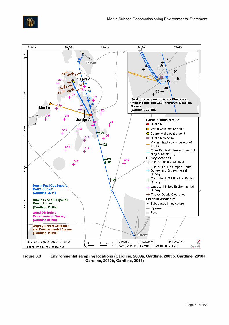
Merlin Subsea Decommissioning Environmental Statement
Page 51 of 158
Figure 3.3 Environmental sampling locations (Gardline, 2009a, Gardline, 2009b, Gardline, 2010a, Gardline, 2010b, Gardline, 2011)
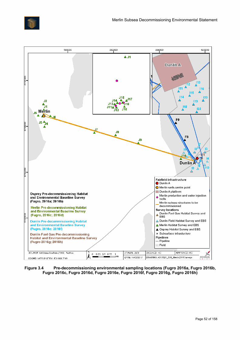
Merlin Subsea Decommissioning Environmental Statement
Page 52 of 158
Figure 3.4 Pre-decommissioning environmental sampling locations (Fugro 2016a, Fugro 2016b, Fugro 2016c, Fugro 2016d, Fugro 2016e, Fugro 2016f, Fugro 2016g, Fugro 2016h)
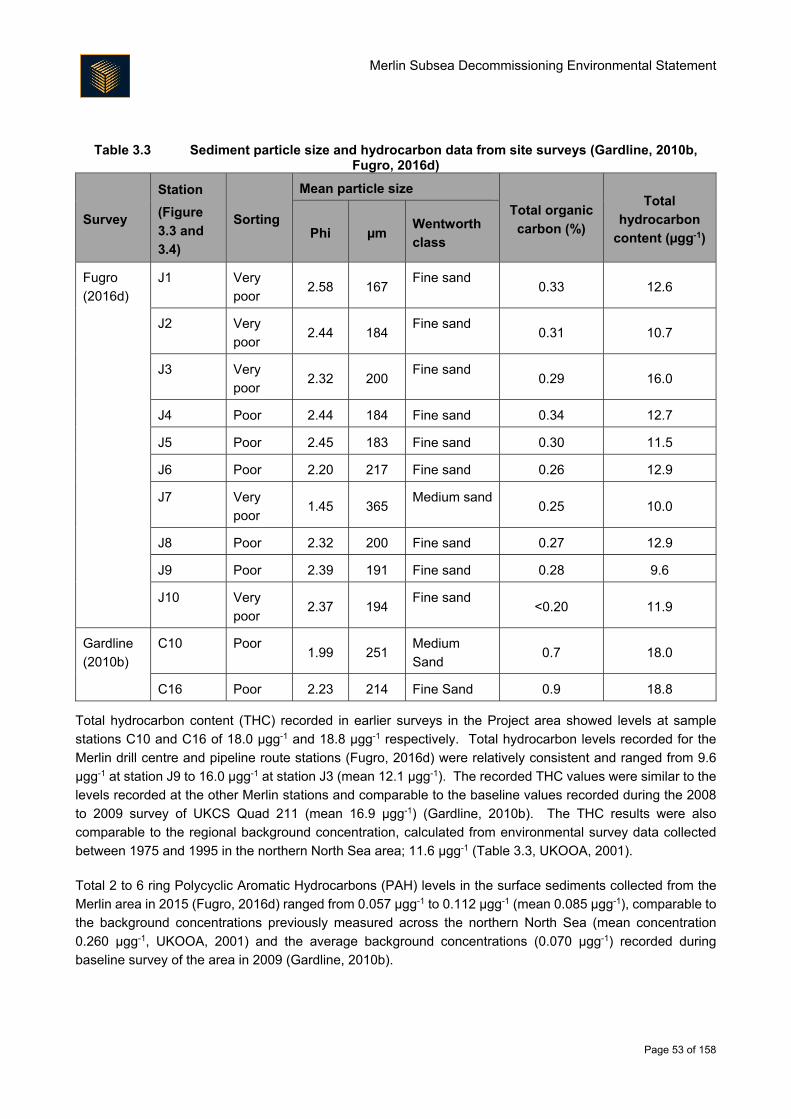
Merlin Subsea Decommissioning Environmental Statement
Page 53 of 158
Table 3.3 Sediment particle size and hydrocarbon data from site surveys (Gardline, 2010b, Fugro, 2016d)
Survey
Station
(Figure
3.3 and
3.4)
Sorting
Mean particle size
Total organic
carbon (%)
Total
hydrocarbon
content (µgg-1) Phi µm Wentworth
class
Fugro
(2016d)
J1 Very
poor 2.58 167
Fine sand 0.33 12.6
J2 Very
poor 2.44 184
Fine sand 0.31 10.7
J3 Very
poor 2.32 200
Fine sand 0.29 16.0
J4 Poor 2.44 184 Fine sand 0.34 12.7
J5 Poor 2.45 183 Fine sand 0.30 11.5
J6 Poor 2.20 217 Fine sand 0.26 12.9
J7 Very
poor 1.45 365
Medium sand0.25 10.0
J8 Poor 2.32 200 Fine sand 0.27 12.9
J9 Poor 2.39 191 Fine sand 0.28 9.6
J10 Very
poor 2.37 194
Fine sand <0.20 11.9
Gardline
(2010b)
C10 Poor 1.99 251
Medium
Sand 0.7 18.0
C16 Poor 2.23 214 Fine Sand 0.9 18.8
Total hydrocarbon content (THC) recorded in earlier surveys in the Project area showed levels at sample
stations C10 and C16 of 18.0 μgg-1 and 18.8 μgg-1 respectively. Total hydrocarbon levels recorded for the
Merlin drill centre and pipeline route stations (Fugro, 2016d) were relatively consistent and ranged from 9.6
μgg-1 at station J9 to 16.0 μgg-1 at station J3 (mean 12.1 μgg-1). The recorded THC values were similar to the
levels recorded at the other Merlin stations and comparable to the baseline values recorded during the 2008
to 2009 survey of UKCS Quad 211 (mean 16.9 μgg-1) (Gardline, 2010b). The THC results were also
comparable to the regional background concentration, calculated from environmental survey data collected
between 1975 and 1995 in the northern North Sea area; 11.6 μgg-1 (Table 3.3, UKOOA, 2001).
Total 2 to 6 ring Polycyclic Aromatic Hydrocarbons (PAH) levels in the surface sediments collected from the
Merlin area in 2015 (Fugro, 2016d) ranged from 0.057 μgg-1 to 0.112 μgg-1 (mean 0.085 μgg-1), comparable to
the background concentrations previously measured across the northern North Sea (mean concentration
0.260 μgg-1, UKOOA, 2001) and the average background concentrations (0.070 μgg-1) recorded during
baseline survey of the area in 2009 (Gardline, 2010b).
Merlin Subsea Decommissioning Environmental Statement
Page 54 of 158
Drill Cuttings
Sediment samples at the Merlin Drill Centre (MDC) were classified as poorly to very poorly sorted medium silt
to very fine sand; mean particle diameter ranged from 27 μm to 109 μm (mean 70 μm) and variability between
stations was low. Surface sediments of the MDC were finer than those recorded away from the drill centre,
where the mean diameter was 184 μm; this predominance of fine sediment is typical of areas contaminated
with drilling mud.
Total organic carbon (TOC) and total organic matter (TOM) concentrations near the MDC were 0.34% and
1.7% respectively, similar to values recorded in the wider area. Areas contaminated with oil-based drilling
muds typically exhibit high TOC/TOM concentrations; this was not apparent at the MDC.
THC from surface samples ranged from 34.5 μgg-1 to 204 μgg-1; the mean value was 96.5 μgg-1. Total n-
alkanes (n12 to n36), another measure of hydrocarbon presence, ranged from 1.17 μgg-1 to 15.7 μgg-1 (mean
4.2 μgg-1). THC exceeded the OSPAR (2006) ecological effects threshold of 50 μgg-1; it was above the
UKOOA (2001) northern North Sea background concentration of 11.6 μgg-1 but well below the UKOOA (2001)
average for stations within 500 m of an active installation (12,000 μgg-1).
Chromatograms suggested the presence of weathered low toxicity oil-based drilling mud (LTOBM) and
synthetic olefin-based fluid. No drilling fluid signatures were identified from the core samples, except from one
sample taken at 50 cm depth, where a synthetic olefin signature was identified.
Total polycyclic aromatic hydrocarbon content in the surface samples ranged from 0.175 μgg-1 to 1.63 μgg-1
(the mean concentration was 0.797 μgg-1). The OSPAR (2014) effects range low concentration is 4.1 μgg-1,
indicating PAHs at Merlin are not at a level expected to cause environmental impacts. Merlin PAH
concentrations are also well below the UKOOA (2001) average for stations within 500 m of an active installation
(18.3 μgg-1) and only slightly above the UKOOA (2001) northern North Sea background concentration (0.26
μgg-1).
Metals analysis clearly indicated the presence of drilling muds at the site. Barium, which is used as a weighting
agent in drilling muds was elevated at all surface stations, ranging from 5,560 μgg-1 to 193,000 μgg-1. Apart
from one core sample taken at 50 cm depth where a concentration of 3,780 μgg-1 was recorded, the core
samples were comparable with the average barium concentration in UKCS Quadrant 211 (478 μgg-1;
GEL, 2010), and only slightly exceeded the North Sea background concentration of 238.67 μgg-1 (bioavailable)
(UKOOA, 2001). The barium concentrations in the remainder of the core samples do not indicate the presence
of drill cuttings, suggesting the drill cuttings layer at Merlin is relatively shallow (shallower than the cuttings
deposition depth of 1.16 m interpreted from the multi-beam echosounder data; Fugro, 2017). THC across the
cuttings pile is low compared to the recorded barium concentrations; the low THC to barium ratio suggests
either that oil based mud used to drill the wells has undergone significant weathering, or that the majority of
the cuttings accumulation is composed of water-based muds.
A number of metals analysed, including cadmium, lead and mercury, exceeded UKOOA (2001) northern North
Sea background concentrations. These elevated levels are consistent with the presence of drilling mud. Most
metals were present at below effects range low (ERL) (OSPAR, 2014) concentrations.
Overall, the environmental data obtained from the pre-decommissioning survey of the MDC indicates the
presence of a surface layer of cuttings within 65 m of the drill centre. There is evidence of oil based mud
drilling fluids (synthetic and low toxicity), but the proportion of hydrocarbons to barite is low suggesting that a
Merlin Subsea Decommissioning Environmental Statement
Page 55 of 158
large proportion of the seabed deposits originate from discharges of water based muds cuttings. The cuttings
deposits are relatively shallow (up to 50 cm deep) and bathymetric survey data provide no indication of the
presence of a clearly defined cuttings pile.
3.3. Biological Environment
Plankton
Plankton consists of the plants (phytoplankton) and animals (zooplankton) that drift in the surface waters with
the tides and currents. Plankton forms the basis of marine ecosystem food webs and the composition of
planktonic communities is variable temporally, depending upon the circulation patterns of water masses, the
season and nutrient availability. The distribution and abundance of plankton is heavily influenced by water
depth, tidal mixing and thermal stratification within the water column (Edwards et al., 2010). The majority of
the plankton occurs in the photic zone (the upper 20 m or so of the sea) which receives enough light for
photosynthesis (Johns and Reid, 2001). However, zooplankton distribution can extend to greater depths and
many species undergo diurnal vertical migrations, rising to the surface to feed before returning to depth.
Natural seasonality and high small-scale variability, both in species composition and abundance, is an
important feature of planktonic communities. Many species of larger animals such as fish, birds and
cetaceans, are dependent upon the plankton for food. The distribution of plankton therefore directly influences
the movement and distribution of other marine species.
In both the northern and central areas of the North Sea, the dinoflagellate genus Ceratium dominates the
phytoplankton community, although there has been a decline in dinoflagellates in the North Sea over the last
decade (DECC, 2016). Densities of phytoplankton fluctuate during the year, with sunlight intensity and nutrient
availability driving its abundance and productivity, which ultimately is affected by water column stratification
(Johns and Reid, 2001). Based on the 10 year period between 1997 and 2007, phytoplankton levels within
the central North Sea appear to spike in April. A second, lesser spike is seen in August before levels decrease
through the winter months when light and temperature are less abundant (SAHFOS, 2015). The
characteristics of this annual cycle are determined by local weather and oceanographic conditions and are
important in biological terms as they provide important feeding areas for most animal groups within the marine
ecosystem, including zooplankton, cephalopods, pelagic fish, seabirds and cetaceans (Johns and Reid, 2001).
Analysis of data provided by the Continuous Plankton Recorder (CPR) surveys suggest that the most abundant
zooplankton species in the North Sea are the calanoid copepods, in particular Calanus spp. and smaller
copepod species such as Para-Pseudocalanus spp., Acartia and the younger stages of Calanus (Johns and
Reid, 2001). Calanus finmarchicus has historically dominated the zooplankton of the North Sea and is used
as an indication of zooplankton abundance. Analysis of data provided by the CPR surveys in the 10 year
period between 1997 and 2007 shows that the biomass of C. finmarchicus in the central North Sea attains
higher levels than in the southern North Sea but lower than in the northern North Sea. The trend indicates a
small increase in abundance between April and May within the central North Sea which corresponds to an
increase in phytoplankton in April.
Overall abundance of C. finmarchicus has declined significantly over the last 60 years. This has mainly been
attributed to changes in seawater temperature and salinity (Beare et al., 2002, FRS, 2004). C. finmarchicus
has been replaced to some degree by boreal and temperate Atlantic and neritic species; in particular, a relative
increase in the populations of C. helgolandicus has occurred (DECC, 2016, Baxter et al., 2011).
Merlin Subsea Decommissioning Environmental Statement
Page 56 of 158
Benthos
3.3.2.1. Merlin subsea area
Knowledge of the composition of the infauna (invertebrates living within benthic sediments) and epifauna
(mobile or sessile species living on the seabed) is important in predicting the potential impacts of the
disturbance that could result from the proposed operations.
The benthos across the survey area were dominated by the polychaetes Euchone incolor, Galathowenia
oculata, Prionospio cirrifera, Amythasides macroglossus, Paradoneis lyra and Aonides paucibranchiata and
the bivalves Adontorhina similis and Axinulus croulinensis. These species are all considered to be
hydrocarbon intolerant (Hiscock et al., 2005, Rygg and Norling, 2013) and are usually found to be absent or in
reduced numbers in areas of contamination. Fugro (2016d) recorded a relatively diverse and homogeneous
seabed with only one station close to the Dunlin Alpha platform showing a significantly different fauna
community.
A habitat assessment for the Merlin survey area (Fugro, 2016c) classed it as the European Nature Information
System (EUNIS) biotope complex ‘Circalittoral muddy sand’ (A5.26) and ‘Circalittoral Mixed Sediment (A5.4)’
(examples are shown in Figure 3.5). Large observable fauna was generally very sparse, a few cushion stars
(Asteroidea), some starfish (Asteroidea) and sea urchins (potentially Echinocardium cordatum) were observed,
but imagery was not sufficiently defined for conclusive identification. However, one starfish, Luidia ciliaris was
identified. One sea cucumber (Holothuroidea) and two large whelks (Buccinoidea) were recorded along
transect at Station J4 (shown on Figure 3.4). Burrows and small mounds were observed along the majority
transects at abundances between Occasional to Frequent. Other than the presence of a small number of
juvenile ocean quahog (Arctica islandica), which is on the OSPAR (2008) ‘List of threatened and declining
habitats and species’, no benthos related species or habitats of conservation significance were observed
during the 2015 survey (Fugro, 2016d).
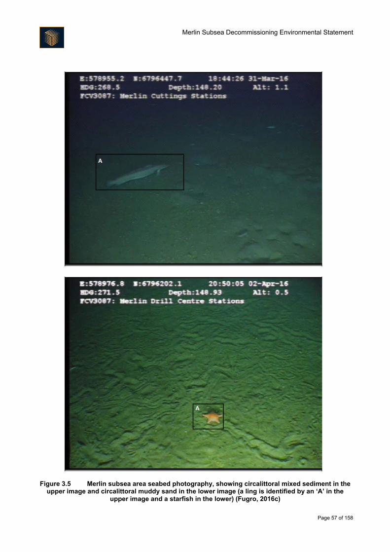
Merlin Subsea Decommissioning Environmental Statement
Page 57 of 158
Figure 3.5 Merlin subsea area seabed photography, showing circalittoral mixed sediment in the upper image and circalittoral muddy sand in the lower image (a ling is identified by an ‘A’ in the
upper image and a starfish in the lower) (Fugro, 2016c)
Merlin Subsea Decommissioning Environmental Statement
Page 58 of 158
3.3.2.2. Drill Cuttings
The macrofauna survey of the MDC, excluding juvenile records, saw 73 taxa identified. Annelids dominated
the taxa (64.4%), followed by molluscs (15.1%), arthropods (9.6%) and echinoderms (2.7%). Other taxa
(including cnidarians and nemerteans) accounted for 8.2%. Annelids accounted for a greater proportion of
taxa at the MDC compared to surveys in the wider area, and arthropod taxa were noticeably more scarce.
Across the MDC, Galathowenia oculata was the most abundant species at two stations and was within the top
three taxa at the remaining stations, which were dominated by Paramphinome jeffreysii and Aricidea
catherinae. Other abundant species included Spiophanes kroyeri and Pterolysippe vanelli. The majority of
the species identified are considered to be intolerant of hydrocarbon pollution, however species considered
indicative of hydrocarbon pollution also appeared in the top ten taxa (e.g. Thyasira sarsi). The secondary
coloniser Chaetozone setosa was in the top ten taxa at some stations in the MDC.
Analysis of the macrofaunal data showed that the stations in the MDC were different to the stations sampled
in the wider field, with a lower number of taxa, absence of several taxa in the MDC samples that were present
in the wider survey area, and a relative abundance of C. setosa. Further analysis showed two sets of strongly
correlated variables. The first was distance from the drill centre, sediment size, carbonate content and iron
content or related factors. The second was THC, sediment size and arsenic, iron and zinc concentrations.
Therefore, whilst the faunal community at the MDC is clearly being affected by the presence of the cuttings,
there is no apparent strong dominance of contaminant-tolerant taxa. Instead, the fauna is more generally
suppressed, with reduced numbers of individuals present across faunal groups, and some taxa completely
absent. This is consistent with the relatively low levels of hydrocarbons and associated contaminants recorded
in the area.
Fish and Shellfish
DECC (2016) report that species diversity within the fish community is not as great in the central and northern
North Sea as in the southern North Sea. DECC (2016) also report that the fish community between 100 and
200 m (i.e. within the depth bounds of the Project area) is characterised by long rough dab (Hippoglossoides
platessoides), hagfish (Myxine glutinosa) and Norway pout (Trisopterus esmarkii). Basking shark (Cetorhinus
maximus), tope (Galeorhinus galeus) and porbeagle (Lamna nasus) are all also likely to occur in small numbers
throughout the North Sea, and the common skate (Dipturus batis) occurs at low density throughout the northern
North Sea. However, these species are considered to be rare in the waters surrounding the Project area
(DECC, 2016).
Fisheries sensitivity data (Coull et al., 1998, Ellis et al., 2012) have been used to identify the spawning grounds (location where eggs are laid) and nursery grounds (location where juveniles are common) for fish species in the vicinity of the Project area (Table 3.4). These areas are illustrated in Figure 3.6 and Figure 3.7. No herring spawning benthic sensitivities are known to occur in the Project area (Coull et al., 1998, Ellis et al., 2012), or are likely to occur in the Project area (based on sediment type).
The fish populations in the Project area are characterised by species typical of the northern North Sea. There
are a number of spawning and nursery regions for commercially important fish and shellfish species that occur
in the vicinity of the Project area (Coull et al., 1998, Ellis et al., 2012). The Project area is located within the
spawning grounds of cod (Gadus morhua), haddock (Melanogrammus aeglefinus), Norway pout and saithe
(Pollachius virens). Nursery grounds of blue whiting (Micromesistius poutassou), European hake (Merluccius
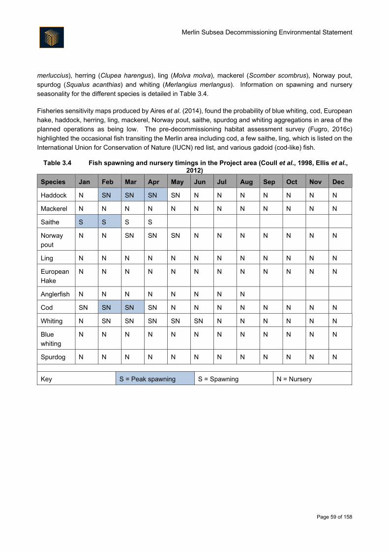
Merlin Subsea Decommissioning Environmental Statement
Page 59 of 158
merluccius), herring (Clupea harengus), ling (Molva molva), mackerel (Scomber scombrus), Norway pout,
spurdog (Squalus acanthias) and whiting (Merlangius merlangus). Information on spawning and nursery
seasonality for the different species is detailed in Table 3.4.
Fisheries sensitivity maps produced by Aires et al. (2014), found the probability of blue whiting, cod, European
hake, haddock, herring, ling, mackerel, Norway pout, saithe, spurdog and whiting aggregations in area of the
planned operations as being low. The pre-decommissioning habitat assessment survey (Fugro, 2016c)
highlighted the occasional fish transiting the Merlin area including cod, a few saithe, ling, which is listed on the
International Union for Conservation of Nature (IUCN) red list, and various gadoid (cod-like) fish.
Table 3.4 Fish spawning and nursery timings in the Project area (Coull et al., 1998, Ellis et al., 2012)
Species Jan Feb Mar Apr May Jun Jul Aug Sep Oct Nov Dec
Haddock N SN SN SN SN N N N N N N N
Mackerel N N N N N N N N N N N N
Saithe S S S S
Norway
pout
N N SN SN SN N N N N N N N
Ling N N N N N N N N N N N N
European
Hake
N N N N N N N N N N N N
Anglerfish N N N N N N N N
Cod SN SN SN SN N N N N N N N N
Whiting N SN SN SN SN SN N N N N N N
Blue
whiting
N N N N N N N N N N N N
Spurdog N N N N N N N N N N N N
Key S = Peak spawning S = Spawning N = Nursery
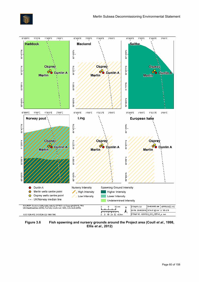
Merlin Subsea Decommissioning Environmental Statement
Page 60 of 158
Figure 3.6 Fish spawning and nursery grounds around the Project area (Coull et al., 1998, Ellis et al., 2012)
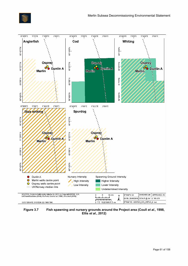
Merlin Subsea Decommissioning Environmental Statement
Page 61 of 158
Figure 3.7 Fish spawning and nursery grounds around the Project area (Coull et al., 1998, Ellis et al., 2012)
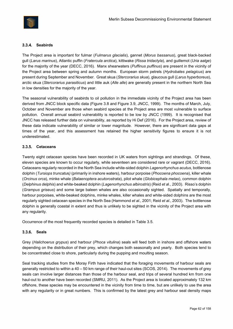
Merlin Subsea Decommissioning Environmental Statement
Page 62 of 158
Seabirds
The Project area is important for fulmar (Fulmarus glacialis), gannet (Morus bassanus), great black-backed
gull (Larus marinus), Atlantic puffin (Fratercula arctica), kittiwake (Rissa tridactyla), and guillemot (Uria aalge)
for the majority of the year (DECC, 2016). Manx shearwaters (Puffinus puffinus) are present in the vicinity of
the Project area between spring and autumn months. European storm petrels (Hydrobates pelagicus) are
present during September and November. Great skua (Stercorarius skua), glaucous gull (Larus hyperboreus),
arctic skua (Stercorarius parasiticus) and little auk (Alle alle) are generally present in the northern North Sea
in low densities for the majority of the year.
The seasonal vulnerability of seabirds to oil pollution in the immediate vicinity of the Project area has been
derived from JNCC block specific data (Figure 3.8 and Figure 3.9, JNCC, 1999). The months of March, July,
October and November are those when seabird species at the Project area are most vulnerable to surface
pollution. Overall annual seabird vulnerability is reported to be low by JNCC (1999). It is recognised that
JNCC has released further data on vulnerability, as reported by Hi Def (2016). For the Project area, review of
these data indicate vulnerability of similar or lower magnitude. However, there are significant data gaps at
times of the year, and this assessment has retained the higher sensitivity figures to ensure it is not
underestimated.
Cetaceans
Twenty eight cetacean species have been recorded in UK waters from sightings and strandings. Of these,
eleven species are known to occur regularly, while seventeen are considered rare or vagrant (DECC, 2016).
Cetaceans regularly recorded in the North Sea include white-sided dolphin Lagenorhynchus acutus, bottlenose
dolphin (Tursiops truncatus) (primarily in inshore waters), harbour porpoise (Phocoena phocoena), killer whale
(Orcinus orca), minke whale (Balaenoptera acutorostrata), pilot whale (Globicephala melas), common dolphin
(Delphinus delphis) and white-beaked dolphin (Lagenorhynchus albirostris) (Reid et al., 2003). Risso’s dolphin
(Grampus griseus) and some large baleen whales are also occasionally sighted. Spatially and temporally,
harbour porpoises, white-beaked dolphins, minke whales, killer whales and white-sided dolphins are the most
regularly sighted cetacean species in the North Sea (Hammond et al., 2001; Reid et al., 2003). The bottlenose
dolphin is generally coastal in extent and thus is unlikely to be sighted in the vicinity of the Project area with
any regularity.
Occurrence of the most frequently recorded species is detailed in Table 3.5.
Seals
Grey (Halichoerus grypus) and harbour (Phoca vitulina) seals will feed both in inshore and offshore waters
depending on the distribution of their prey, which changes both seasonally and yearly. Both species tend to
be concentrated close to shore, particularly during the pupping and moulting season.
Seal tracking studies from the Moray Firth have indicated that the foraging movements of harbour seals are
generally restricted to within a 40 – 50 km range of their haul-out sites (SCOS, 2014). The movements of grey
seals can involve larger distances than those of the harbour seal, and trips of several hundred km from one
haul-out to another have been recorded (SMRU, 2011). As the Project area is located approximately 132 km
offshore, these species may be encountered in the vicinity from time to time, but are unlikely to use the area
with any regularity or in great numbers. This is confirmed by the latest grey and harbour seal density maps
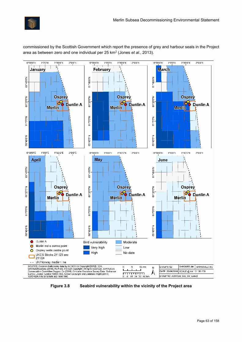
Merlin Subsea Decommissioning Environmental Statement
Page 63 of 158
commissioned by the Scottish Government which report the presence of grey and harbour seals in the Project
area as between zero and one individual per 25 km2 (Jones et al., 2013).
Figure 3.8 Seabird vulnerability within the vicinity of the Project area
Merlin Subsea Decommissioning Environmental Statement
Page 64 of 158
Figure 3.9 Seabird vulnerability within the vicinity of the Project area
Merlin Subsea Decommissioning Environmental Statement
Page 65 of 158
Table 3.5 Occurrence of cetaceans likely to be most regularly observed in the Project area (Hammond et al., 2001, Reid et al., 2003)
Species Description of occurrence
Harbour porpoise Harbour porpoise are frequently found throughout the UK waters. They usually
occur in groups of one to three individuals in shallow waters, although they have
been sighted in larger groups and in deep water. It is not thought that the species
migrate.
Killer whale Widely distributed with sightings across the North Sea all year round; seen in both
inshore waters (April to October) and the deeper continental shelf waters
(November to March). May move inshore to target seals seasonally.
Minke whale Minke whales usually occur in water depths of 200 m or less and occur throughout
the northern and central North Sea. They are usually sighted in pairs or in
solitude; however groups of up to 15 individuals can be sighted feeding. It
appears that animals return to the same seasonal feeding grounds.
Atlantic white-sided
dolphin
White-sided dolphin show both season and inter-annual variability. They have
been sighted in large groups of 10 - 100 individuals. They have been sighted in
waters ranging from 100 m to very deep waters, but also enter the continental
shelf waters. They can be sighted in the deep waters around the north of Scotland
throughout the year and enter the North Sea in search of food.
White-beaked dolphin White-beaked dolphin are usually found in water depths of between 50 and 100
m in groups of around 10 individuals, although large groups of up to 500 animals
have been seen. They are present in the UK waters throughout the year, however
more sightings have been made between June and October.
3.4. Conservation
There are no designated or proposed sites of conservation interest in the Project area. The closest designated
site, the Site of Community Importance (SCI) ‘Pobie Bank Reef’ lies 94 km to the south west of Merlin, off the
east coast of Shetland (as shown on Figure 3.10). The site has been designated for its stony and bedrock
rocky reefs (JNCC, 2013a). The closest Special Protected Area (SPA) is Hermaness, Saxa Vord and Valla
Field which lies 132 km south west of Merlin.
Marine Scotland has put forward areas with PMFs for designation as Marine Protected Areas (MPAs) under
the Marine (Scotland) Act (2010). The Marine Management Organisation (MMO) has put forward areas with
features of conservation importance (FOCI) for designation as Marine Conservation Zones (MCZs) under the
UK Marine and Coastal Access Act (2009). The closest MPA to the Project area is the North East Faroe
Shetland Channel Nature Conservation MPA (NCMPA). The site is approximately 110 km from the project
area and is the largest designated MPA in Europe (Figure 3.10). The site is designated for deep-sea sponge
aggregations, offshore deep-sea muds, offshore subtidal sands and gravels, and continental slope (JNCC,
2017).
Details of the conservation sites in the vicinity of the Project area are given in Table 3.6.
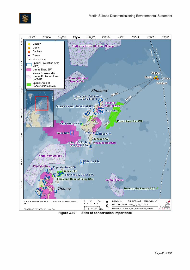
Merlin Subsea Decommissioning Environmental Statement
Page 66 of 158
Figure 3.10 Sites of conservation importance
Merlin Subsea Decommissioning Environmental Statement
Page 67 of 158
Table 3.6 Conservation sites in the vicinity of the Project area
Description Distance to
Project area (km)
Pobie Bank SCI
Reefs are the primary reason for selection of this site. The stony and bedrock reefs of
the site provide a habitat to an extensive community of encrusting and robust sponges
and bryozoans and in the shallowest areas the bedrock and boulders also support
encrusting coralline algae (JNCC, 2013a).
94
Hermaness, Saxa Vord and Valla Field SPA
This site supports:
A population of European importance of the Annex I species red throated diver (Gavia
stellata) during the breeding season;
Populations of European importance of the following migratory species during the
breeding season: northern gannet, great skua and Atlantic puffin; and
At least 20,000 seabirds. During the breeding season, the area regularly supports
152,000 individual seabirds including common guillemot, black-legged kittiwake,
European shag (Phalacrocorax aristotelis), northern fulmar, Atlantic puffin, great skua
and northern gannet (JNCC, 2005a).
132
North East Faroe Shetland Channel NCMPA
This is the largest designated MPA in Europe and the protected features are deep sea
sponge aggregations, offshore deep sea muds, offshore subtidal sands and gravel,
continental slope and a wide range of features from the West Shetland Margin Palaeo-
depositional, Miller Slide and Pilot Whale Diapirs that are considered to be ‘Key
Geodiversity Areas’ (JNCC, 2017).
110
Faroe-Shetland Sponge Belt NCMPA
The protected features of this NCMPA are deep sea sponge aggregations, offshore
subtidal sands and gravels, ocean quahog aggregations, continental slope, continental
slope channels, iceberg plough marks, prograding wedges and slide deposits
representative of the West Shetland Margin paleo-depositional system Key
Geodiversity Area and Sand wave fields and sediment wave fields representative of
the West Shetland Margin contourite deposits Key Geodiversity Area (JNCC, 2016).
162
Fetlar to Haroldswick NCMPA
This MPA supports a range of high energy habitats and species including horse mussel
beds, kelp and seaweed communities and maerl beds. It encompasses over 200 km2
of important black guillemot (Cepphus grylle) feeding grounds. The protected features
of the site are black guillemot, circalittoral sand and coarse sediment communities;
horse mussel beds, kelp and seaweed communities on sublittoral sediment, maerl
beds, shallow tide-swept coarse sands with burrowing bivalves and marine
geomorphology of the Scottish shelf seabed (SNH, 2014).
135
Merlin Subsea Decommissioning Environmental Statement
Page 68 of 158
Description Distance to
Project area (km)
Fetlar SPA
The SPA comprises a range of habitats including species-rich heathland, marshes and
lochans, cliffs and rocky shores. The principal areas of importance for birds are the
northernmost part of the island and the south-western peninsula of Lamb Hoga. This
site supports:
During the breeding season, a population of European importance of Arctic tern
(Sterna paradisaea) and red-necked phalarope (Phalaropus lobatus);
Populations of European importance of the following migratory species during the
breeding season: dunlin (Calidris alpina schinzii), great skua and whimbrel (Numenius
phaeopus); and
At least 20,000 seabirds. During the breeding season, the area regularly supports
22,000 individual seabirds including Arctic skua, northern fulmar, great skua, Arctic
tern and red-necked phalarope (JNCC, 2005b).
138
None of the survey work undertaken in the Project area has identified any benthic habitats or species that are
of specific conservation significance, apart from that for the Dunlin Fuel Gas Import route (Gardline, 2011) and
the EBS (Fugro, 2016d) where low numbers of juvenile ocean quahog (A. islandica) were identified at one of
the sampling stations. The ocean quahog is an OSPAR listed threatened and/or declining species (OSPAR,
2008) and a PMF (SNH & JNCC, 2014).
European Protected Species (EPS) are a group of animals and plants protected by law throughout the EU
listed in Annexes II and IV of the Habitats Directive 92/43/EEC. Cetaceans are the EPS most likely to be
recorded in the region, even if only in low numbers. The European sturgeon Acipenser sturio and leatherback
turtle are also classed as EPS and occur in UK waters, although the Project area is located at the furthest
extent of their ranges and their occurrence in any numbers is unlikely.
Annex II species are protected under the EU Habitats Directive. This forces core areas of habitat these species
rely upon to be protected under the Natura 2000 Network. The only species listed on Annex II of the EC
Habitats Directive that is likely to occur in the vicinity of the Project area with any regularity is the harbour
porpoise. The harbour porpoise is the most common cetacean in UK waters, being widely distributed and
abundant throughout the majority of UK shelf seas, both inshore and offshore. Due to the species’ wide
geographical distribution and the lack of knowledge with regards to their feeding and breeding habitats, there
has been difficulty in selecting sites essential for their life and reproduction, as required under the Habitats
Directive. Although potential calving grounds have been identified in the German North Sea (Sonntag et al.,
1999) no such areas are currently recognised in UK waters. However, a number of sites have been designated
as candidate SACs; none of these sites are located within the Northern North Sea. Grey and harbour seals
are also Annex II species but due to the distance from shore they are unlikely to be present in any significant
numbers in the area.
Basking sharks, spiny dogfish and blue sharks are the species listed on the IUCN red list most likely to be
encountered in the vicinity of the Project area. The basking shark and spiny dogfish are classed as vulnerable
under the IUCN red list. The blue shark is classed as near threatened. In addition, basking sharks are
protected under the Wildlife and Countryside Act 1981 (as amended).
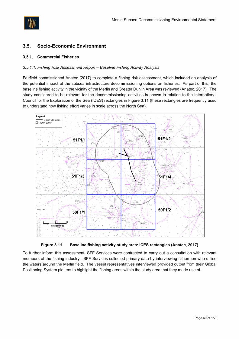
Merlin Subsea Decommissioning Environmental Statement
Page 69 of 158
3.5. Socio-Economic Environment
Commercial Fisheries
3.5.1.1. Fishing Risk Assessment Report – Baseline Fishing Activity Analysis
Fairfield commissioned Anatec (2017) to complete a fishing risk assessment, which included an analysis of
the potential impact of the subsea infrastructure decommissioning options on fisheries. As part of this, the
baseline fishing activity in the vicinity of the Merlin and Greater Dunlin Area was reviewed (Anatec, 2017). The
study considered to be relevant for the decommissioning activities is shown in relation to the International
Council for the Exploration of the Sea (ICES) rectangles in Figure 3.11 (these rectangles are frequently used
to understand how fishing effort varies in scale across the North Sea).
Figure 3.11 Baseline fishing activity study area: ICES rectangles (Anatec, 2017)
To further inform this assessment, SFF Services were contracted to carry out a consultation with relevant
members of the fishing industry. SFF Services collected primary data by interviewing fishermen who utilise
the waters around the Merlin field. The vessel representatives interviewed provided output from their Global
Positioning System plotters to highlight the fishing areas within the study area that they made use of.
Merlin Subsea Decommissioning Environmental Statement
Page 70 of 158
3.5.1.2. Types of Fishery
Commercial fishing is excluded within 500 m of the Dunlin Alpha platform and Merlin and Osprey subsea
infrastructure as a result of safety zones having been implemented, but beyond this area within the surrounding
ICES rectangle 51F1 there are two main types of fishery:
Demersal (whitefish); and
Pelagic.
Demersal fisheries target species which occur on or near the seabed whilst pelagic fisheries target species
which occupy the water column. The area surrounding the Dunlin, Merlin and Osprey fields is used by pelagic
and demersal fisheries with the demersal fishery being most productive in terms of landings values and
liveweight landed. Some shellfish species are landed from ICES rectangle 51F1 but both value and tonnes
landed are very low (Figure 3.12).
Figure 3.12 Annual average economic value and liveweight tonnage from ICES rectangle 51F1
from 2010 – 2014 (Scottish Government, 2016)
3.5.1.3. Fishery Value
Kafas et al. (2012) report the Greater Dunlin Area as being at the northern extent of a large band of higher
value demersal fishing effort, which stretches from the Outer Hebrides in the west, around Orkney and
Shetland and down into the southern North Sea. Kafas et al. (2012) also report the Greater Dunlin Area being
at the eastern most extent of a large band of higher value pelagic fishing area that runs from the northern North
Sea out to the west of the Outer Hebrides.
Saithe and mackerel (often targeted by the larger pelagic vessels in January and February) are the key
commercial species landed from ICES rectangle 51F1 by both value (46% combined) and weight (66%
combined). However, they are of relatively low value when compared to total landings into Scotland;
combined, landings of these species from ICES rectangle 51F1 comprise only 0.06% of the value (£) of
landings into Scotland (averaged from 2010 – 2014). Other species of commercial value in the same ICES
rectangle include megrim, cod and monks/anglers.
3.5.1.4. Gear and Fishing Effort
The only gear type used for fishing in ICES rectangle 51F1 by UK vessels is the trawl net. Trawls include
demersal trawls (typically contact the seabed) and midwater trawls which operate in the water column.
Merlin Subsea Decommissioning Environmental Statement
Page 71 of 158
Baseline fishing activity analysis suggests that single demersal trawlers are the single most common trawl type
(Anatec, 2017). Gear used by vessels of other nationalities includes long lines and seine nets (Anatec, 2017).
3.5.1.5. Seasonality
The average fishing effort (days at sea) in ICES Rectangle 51F1 is 130 days per year (average over 2010 -
2014) (Scottish Government, 2016). Data on monthly fishing effort were obtained from the MMO for the time
period 2010 – 2014 and analysed to establish seasonal trends. The Vessel Monitoring System (VMS) data
show that most activity is concentrated in the spring and early summer months when five to twelve vessels are
active in the area compared with fewer than four vessels per month at other times, as shown in Figure 3.13
(MMO, 2016). Review of Automatic Identification System (AIS) data, which represents an alternative method
of tracking fishing activity, suggests that activity peaked earlier in the year in 2015 (Anatec, 2017) (Figure
3.14). Seasonality must therefore be viewed as changeable over time, depending on market conditions, quota
availability and weather.
Fishing effort evidence from Vessel Monitoring System (VMS) data collected and analysed by the MMO,
representing a five year timescale from 2010 – 2014, has been mapped in Figure 3.15. This figure presents
the average annual effort (time spent fishing in minutes) within ICES sub-rectangles and ranked into four
categories, from the lowest to the highest effort, giving an indication of the relative importance of the study
area compared to the effort across the north east UKCS. For demersal fishing vessels, where there is the
potential for interaction with subsea structures, Anatec (2017) estimate there to be one such vessel actively
fishing in the study area every two days (Anatec, 2017).
3.5.1.6. Active Fishing Vessels and Ports
Peterhead and Lerwick are the nearest major commercial UK fishing ports to the Dunlin, Merlin and Osprey
fields (MMO, 2014). Data held by the MMO demonstrate that landings into Peterhead, Lerwick and Scrabster
have been recorded from ICES rectangle 51F1 in each year from 2010 – 2014. Landings from ICES rectangle
51F1 were recorded at four foreign ports, demonstrating that vessels come from afar to exploit the area. On
average, 39 vessels fish from ICES rectangle 51F1 every year with the greatest proportion landing at
Peterhead or Lerwick.
MMO data averaged from 2010 – 2014 showed that four vessels (most likely from France and Norway) landed
from ICES rectangle 51F1 annually, with a combined annual average liveweight tonnage of 284 tonnes (28%
of the average annual liveweight landed from ICES rectangle 51F1). The relatively high proportion of landings
weight associated with these four vessels is most likely because they are larger than the majority of UK vessels
active in the area.
The baseline fishing activity analysis (Anatec, 2017) indicates that the most common nationality of vessels
actively fishing in the study area was Norwegian (39%) followed by the UK (38%) and then France (23%).
Merlin Subsea Decommissioning Environmental Statement
Page 72 of 158
Figure 3.13 Seasonal distribution of vessel presence in ICES rectangle 51F1 indicated by VMS
data (average 2010 – 2014) (MMO, 2016)
Figure 3.14 Seasonal distribution of vessel presence in the 10 nautical miles (nm) surrounding the Greater Dunlin Area, based on AIS data for July 2015 – June 2016 (Anatec, 2017)
0
2
4
6
8
10
12
14
Number of V
esse
lsN
umbe
r of
Ves
sels
Merlin Subsea Decommissioning Environmental Statement
Page 73 of 158
Figure 3.15 Relative distribution of fishing effort (time in minutes) of vessels using mobile gear
(average 2010 – 2014) (MMO, 2016)
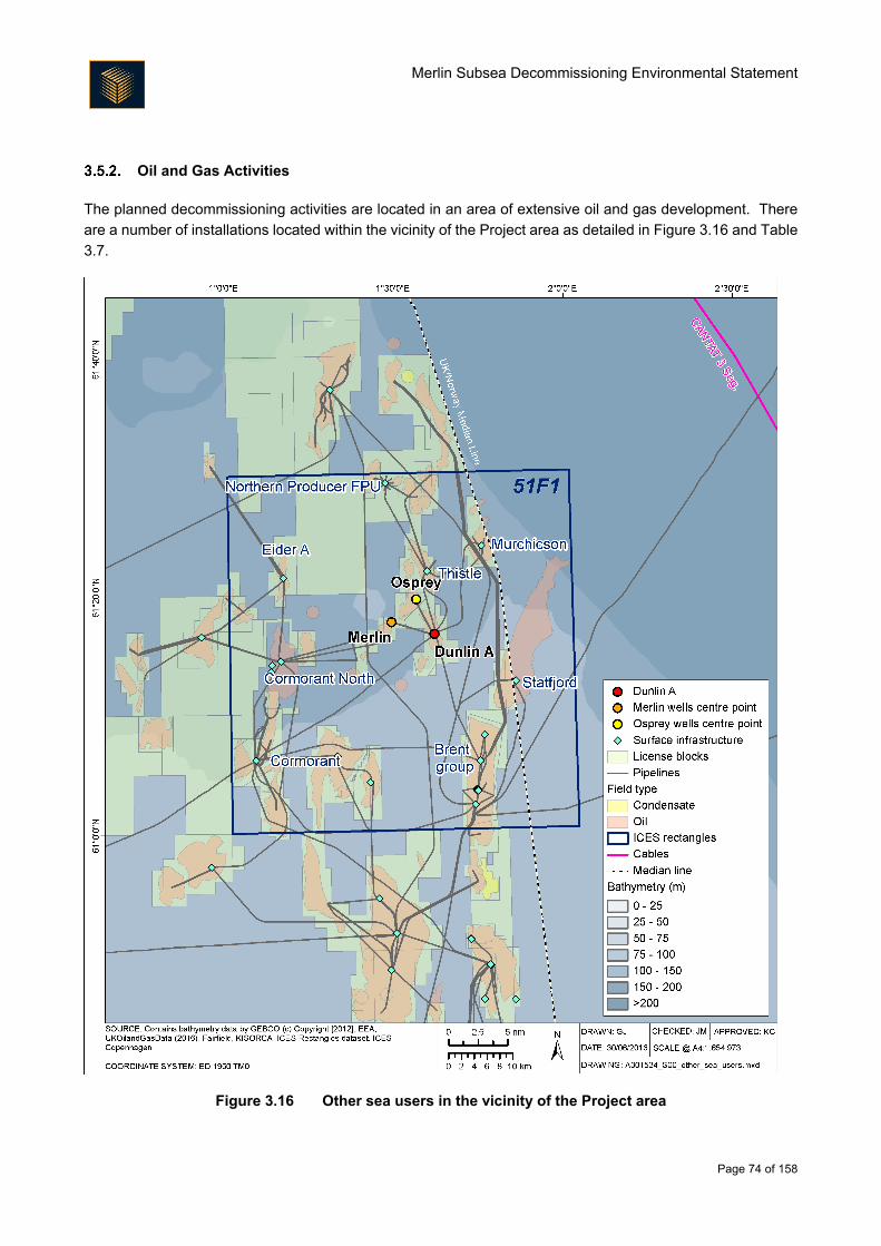
Merlin Subsea Decommissioning Environmental Statement
Page 74 of 158
Oil and Gas Activities
The planned decommissioning activities are located in an area of extensive oil and gas development. There
are a number of installations located within the vicinity of the Project area as detailed in Figure 3.16 and Table
3.7.
Figure 3.16 Other sea users in the vicinity of the Project area
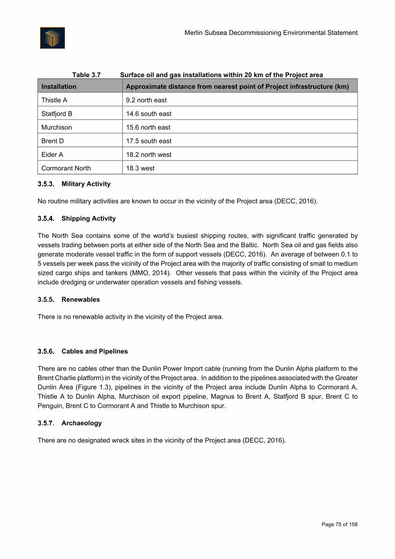
Merlin Subsea Decommissioning Environmental Statement
Page 75 of 158
Table 3.7 Surface oil and gas installations within 20 km of the Project area
Installation Approximate distance from nearest point of Project infrastructure (km)
Thistle A 9.2 north east
Statfjord B 14.6 south east
Murchison 15.6 north east
Brent D 17.5 south east
Eider A 18.2 north west
Cormorant North 18.3 west
Military Activity
No routine military activities are known to occur in the vicinity of the Project area (DECC, 2016).
Shipping Activity
The North Sea contains some of the world’s busiest shipping routes, with significant traffic generated by
vessels trading between ports at either side of the North Sea and the Baltic. North Sea oil and gas fields also
generate moderate vessel traffic in the form of support vessels (DECC, 2016). An average of between 0.1 to
5 vessels per week pass the vicinity of the Project area with the majority of traffic consisting of small to medium
sized cargo ships and tankers (MMO, 2014). Other vessels that pass within the vicinity of the Project area
include dredging or underwater operation vessels and fishing vessels.
Renewables
There is no renewable activity in the vicinity of the Project area.
Cables and Pipelines
There are no cables other than the Dunlin Power Import cable (running from the Dunlin Alpha platform to the
Brent Charlie platform) in the vicinity of the Project area. In addition to the pipelines associated with the Greater
Dunlin Area (Figure 1.3), pipelines in the vicinity of the Project area include Dunlin Alpha to Cormorant A,
Thistle A to Dunlin Alpha, Murchison oil export pipeline, Magnus to Brent A, Statfjord B spur, Brent C to
Penguin, Brent C to Cormorant A and Thistle to Murchison spur.
Archaeology
There are no designated wreck sites in the vicinity of the Project area (DECC, 2016).
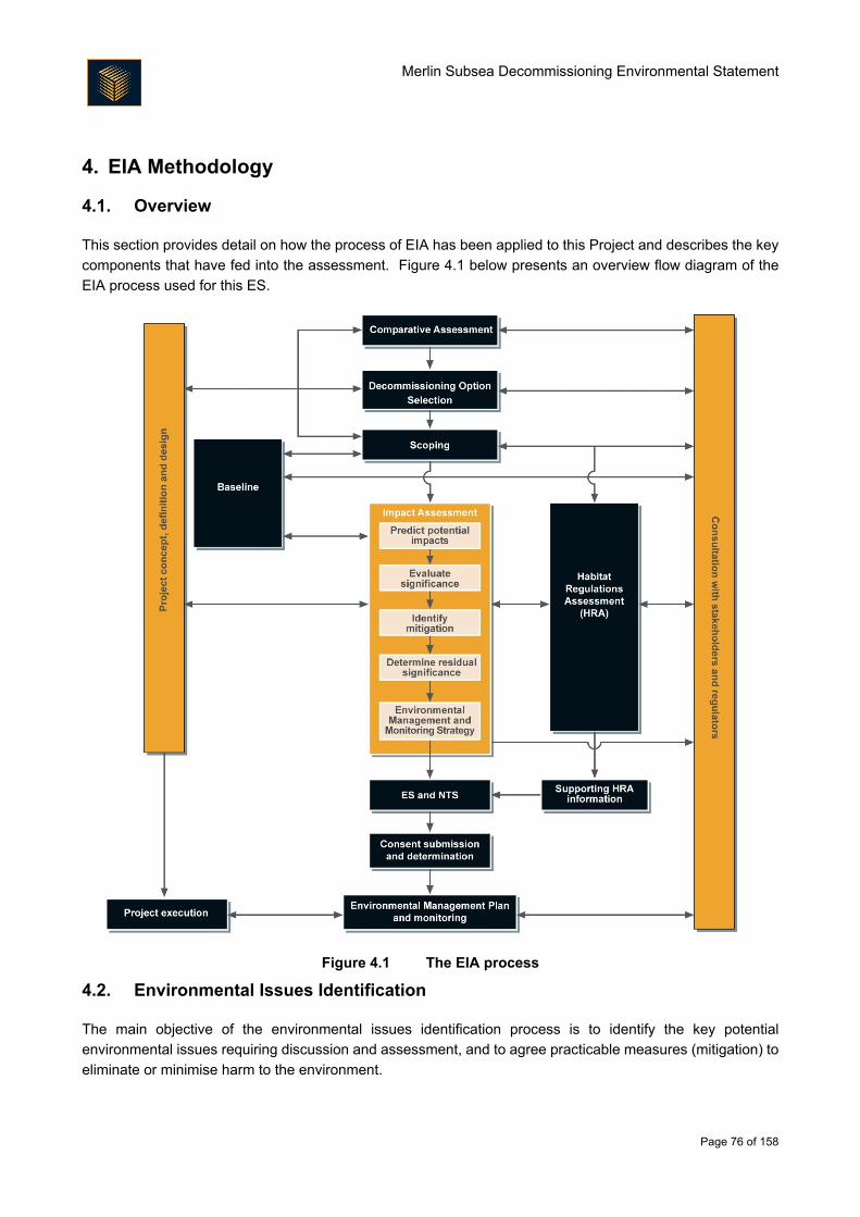
Merlin Subsea Decommissioning Environmental Statement
Page 76 of 158
4. EIA Methodology
4.1. Overview
This section provides detail on how the process of EIA has been applied to this Project and describes the key
components that have fed into the assessment. Figure 4.1 below presents an overview flow diagram of the
EIA process used for this ES.
Figure 4.1 The EIA process
4.2. Environmental Issues Identification
The main objective of the environmental issues identification process is to identify the key potential
environmental issues requiring discussion and assessment, and to agree practicable measures (mitigation) to
eliminate or minimise harm to the environment.
Merlin Subsea Decommissioning Environmental Statement
Page 77 of 158
Environmental Issues Identification (ENVID) has taken place based on:
Known potential environmental issues specifically related to the Project area. These are already well
understood due to the amount of environmental work that has been conducted during the Project’s
lifetime;
An ENVID workshop, which brought together informed judgement of environmental practitioners and
project engineers; and
Stakeholder engagement through screening workshops and consultation meetings.
The ENVID process was kept under review throughout the EIA, with mitigation revised as understanding of
the Project increased and as consultation continued. The key issues that were assessed in this ES are
therefore a combination of issues identified as significant during the early environmental issues identification
process (including ENVID workshop, the output of which is detailed in Appendix A), issues of importance raised
by consultees, and issues that have become clearer with enhanced Project definition. Issues that have not
been described in this ES were screened out; details of why issues were screened out are included in the
ENVID output in Appendix A.
4.3. Environmental Significance
Overview
The decision process related to defining whether or not a project is likely to significantly impact on the
environment is the core principle of the EIA process; the methods used for identifying and assessing potential
impacts should be transparent and verifiable.
The method presented here has been developed by reference to the Institute of Ecology and Environmental
Management (IEEM) guidelines for marine impact assessment (IEEM, 2010), the Marine Life Information
Network (MarLIN) species and ecosystem sensitivities guidelines (Tyler-Walters et al., 2001) and guidance
provided by Scottish Natural Heritage (SNH) in their handbook on EIA (SNH, 2013) and by The Institute of
Environmental Management and Assessment (IEMA) in their guidelines for EIA (IEMA, 2015, 2016).
EIA provides an assessment of the environmental effects that may result from a project’s impact on the
receiving environment. The terms impact and effect have different definitions in EIA and one drives the other.
Impacts are defined as the changes resulting from an action, and effects are defined as the consequences of
those impacts.
In general, impacts are specific, measureable changes in the receiving environment (volume, time and/or
area); for example, were a number of marine mammals to be disturbed following exposure to vessel noise
emissions. Effects (the consequences of those impacts) consider the response of a receptor to an impact; for
example, the effect of the marine mammal/noise impact example given above might be exclusion from an area
caused by disturbance, leading to a population decline. The relationship between impacts and effects is not
always so straightforward; for example, a secondary effect may result in both a direct and indirect impact on a
single receptor. There may also be circumstances where a receptor is not sensitive to a particular impact and
thus there will be no significant effects/consequences.
Merlin Subsea Decommissioning Environmental Statement
Page 78 of 158
For each impact, the assessment identifies a receptor’s sensitivity and vulnerability to that effect and
implements a systematic approach to understand the level of impact. The process considers the following:
Identification of receptor and impact (including duration, timing and nature of impact);
Definition of sensitivity, vulnerability and value of receptor;
Definition of magnitude and likelihood of impact; and
Assessment of consequence of the impact on the receptor, considering the probability that it will occur,
the spatial and temporal extent and the importance of the impact. If the assessment of consequence
of impact is determined as moderate or major, it is considered a significant impact.
Once the consequence of a potential impact has been assessed it is possible to identify measures that can be
taken to mitigate impacts through engineering decisions or execution of the project. This process also
identifies aspects of the project that may require monitoring, such as a post-decommissioning survey at the
completion of the works to inform inspection reports.
For some impacts significance criteria are standard or numerically based. For others, for which no applicable
limits, standards or guideline values exist, a more qualitative approach is required. This involves assessing
significance using professional judgement.
Despite the assessment of impact significance being a subjective process, a defined methodology has been
used to make the assessment as objective as possible and consistent across different topics. The assessment
process is summarised below. The terms and criteria associated with the impact assessment process are
described and defined; details on how these are combined to assess consequence and impact significance
are then provided.
Baseline Characterisation and Receptor Identification
In order to make an assessment of potential impacts on the environment it was necessary to firstly characterise
the different aspects of the environment that could potentially be affected (the baseline environment). The
baseline environment has been described in Section 3 and is based on desk studies combined with additional
site-specific studies such as surveys and modelling where required. Information obtained through consultation
with key stakeholders was also used to help characterise specific aspects of the environment in more detail.
Where data gaps and uncertainties remained (e.g. where there are no suitable options for filling data gaps),
as part of the EIA process these have been documented and taken into consideration as appropriate as part
of the assessment of impact significance (Section 4.3.5).
The EIA process requires identification of the potential receptors that could be affected by the Project (e.g.
marine mammals, seabed species and habitats). High level receptors are identified within the impact
assessments (Section 6).
Merlin Subsea Decommissioning Environmental Statement
Page 79 of 158
Impact Definition
4.3.3.1. Impact Magnitude
Determination of impact magnitude requires consideration of a range of key impact criteria including:
Nature of impact, whether it be beneficial or adverse;
Type of impact, be it direct or indirect etc.;
Size and scale of impact, i.e. the geographical area;
Duration over which the impact is likely to occur i.e. days, weeks;
Seasonality of impact, i.e. is the impact expected to occur all year or during specific times of the year
e.g. summer; and
Frequency of impact, i.e. how often the impact is expected to occur.
Each of these variables are expanded upon in Table 4.1 - Table 4.5 to provide consistent definitions across all
EIA topics. In each impact assessment, these terms are used in the assessment summary table to summarise
the impact, and are enlarged upon as necessary in any supporting text. With respect to the nature of the
impact (Table 4.1), it should be noted that all impacts discussed in this ES are adverse unless explicitly stated.
Table 4.1 Nature of impact
Nature of impact Definition
Beneficial Advantageous or positive effect to a receptor (i.e. an improvement).
Adverse Detrimental or negative effect to a receptor.
Table 4.2 Type of impact
Type of impact Definition
Direct Impacts that result from a direct interaction between the Project and the receptor.
Impacts that are actually caused by the introduction of Project activities into the receiving
environment.
E.g. The direct loss of benthic habitat.
Indirect Reasonably foreseeable impacts that are caused by the interactions of the Project but
which occur later in time than the original, or at a further distance from the proposed
Project location. Indirect impacts include impacts that may be referred to as ‘secondary’,
‘related’ or ‘induced’.
E.g. The direct loss of benthic habitat could have an indirect or secondary impact on by-
catch of non-target species due to displacement of these species caused by loss of
habitat.
Cumulative Impacts that act together with other impacts (including those from any concurrent or
planned future third party activities) to affect the same receptors as the proposed Project.
Definition encompasses “in-combination” impacts.
Merlin Subsea Decommissioning Environmental Statement
Page 80 of 158
Table 4.3 Duration of impact
Duration Definition
Short term Impacts that are predicted to last for a short duration (e.g. less than one year).
Temporary Impacts that are predicted to last a limited period (e.g. a few years). For example, impacts
that occur during the decommissioning activities and which do not extend beyond the main
activity period for the works or which, due to the timescale for mitigation, reinstatement or
natural recovery, continue for only a limited time beyond completion of the anticipated
activity
Prolonged Impacts that may, although not necessarily, commence during the main phase of the
decommissioning activity and which continue through the monitoring and maintenance, but
which will eventually cease.
Permanent Impacts that are predicted to cause a permanent, irreversible change.
Table 4.4 Geographical extent of impact
Geographical
extent Description
Local Impacts that are limited to the area surrounding the proposed Project footprint and
associated working areas. Alternatively, where appropriate, impacts that are restricted
to a single habitat or biotope or community.
Regional Impacts that are experienced beyond the local area to the wider region, as determined
by habitat/ecosystem extent.
National Impacts that affect nationally important receptors or protected areas, or which have
consequences at a national level. This extent may refer to either Scotland or the UK
depending on the context.
Transboundary Impacts that could be experienced by neighbouring national administrative areas.
International Impacts that affect areas protected by international conventions, European and
internationally designated areas or internationally important populations of key receptors
(e.g. birds, marine mammals).
Table 4.5 Frequency of impact
Frequency Description
Continuous Impacts that occur continuously or frequently.
Intermittent Impacts that are occasional or occur only under a specific set of circumstances that
occurs several times during the course of the Project. This definition also covers such
impacts that occur on a planned or unplanned basis and those that may be described
as ‘periodic’ impacts.
Merlin Subsea Decommissioning Environmental Statement
Page 81 of 158
4.3.3.2. Impact Magnitude Criteria
Overall impact magnitude requires consideration of all impact parameters described above. Based on these
parameters, magnitude can be assigned following the criteria outlined in Table 4.6. The resulting effect on the
receptor is considered under vulnerability and is an evaluation based on scientific judgement.
Table 4.6 Impact magnitude criteria
Magnitude Criteria
Major Extent of change: Impact occurs over a large scale or spatial geographical extent and
/or is long term or permanent in nature.
Frequency/intensity of impact: high frequency (occurring repeatedly or continuously
for a long period of time) and/or at high intensity.
Moderate Extent of change: Impact occurs over a local to medium scale/spatial extent and/or
has a prolonged duration.
Frequency intensity of impact: medium to high frequency (occurring repeatedly or
continuously for a moderate length of time) and/or at moderate intensity or occurring
occasionally/intermittently for short periods of time but at a moderate to high intensity.
Minor Extent of change: Impact occurs on-site or is localised in scale/spatial extent and is of
a temporary or short term duration.
Frequency/intensity of impact: low frequency (occurring occasionally/intermittently for
short periods of time) and/or at low intensity.
Negligible Extent of change: Impact is highly localised and very short term in nature (e.g. days/
few weeks only).
Positive An enhancement of some ecosystem or population parameter.
Notes: Magnitude of an impact is based on a variety of parameters. Definitions provided above are for
guidance only and may not be appropriate for all impacts. For example an impact may occur in a very
localised area (minor to moderate) but at very high frequency/intensity for a long period of time (major). In
such cases informed judgement is used to determine the most appropriate magnitude ranking and this is
explained through the narrative of the assessment.
4.3.3.3. Impact Likelihood for Unplanned and Accidental Events
The likelihood of an impact occurring for unplanned/accidental events is another factor that is considered in
this impact assessment. This captures the probability that the impact will occur and also the probability that
the receptor will be present.
Receptor Definition
4.3.4.1. Overview
As part of the assessment of impact significance it is necessary to differentiate between receptor sensitivity,
vulnerability and value. The sensitivity of a receptor is defined as ‘the degree to which a receptor is affected
by an impact’ and is a generic assessment based on factual information whereas an assessment of
vulnerability, which is defined as ‘the degree to which a receptor can or cannot cope with an adverse impact’
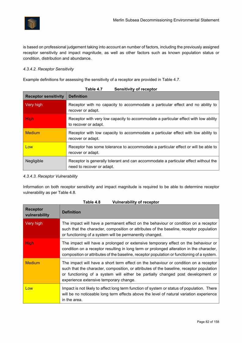
Merlin Subsea Decommissioning Environmental Statement
Page 82 of 158
is based on professional judgement taking into account an number of factors, including the previously assigned
receptor sensitivity and impact magnitude, as well as other factors such as known population status or
condition, distribution and abundance.
4.3.4.2. Receptor Sensitivity
Example definitions for assessing the sensitivity of a receptor are provided in Table 4.7.
Table 4.7 Sensitivity of receptor
Receptor sensitivity Definition
Very high Receptor with no capacity to accommodate a particular effect and no ability to
recover or adapt.
High Receptor with very low capacity to accommodate a particular effect with low ability
to recover or adapt.
Medium Receptor with low capacity to accommodate a particular effect with low ability to
recover or adapt.
Low Receptor has some tolerance to accommodate a particular effect or will be able to
recover or adapt.
Negligible Receptor is generally tolerant and can accommodate a particular effect without the
need to recover or adapt.
4.3.4.3. Receptor Vulnerability
Information on both receptor sensitivity and impact magnitude is required to be able to determine receptor
vulnerability as per Table 4.8.
Table 4.8 Vulnerability of receptor
Receptor
vulnerability Definition
Very high The impact will have a permanent effect on the behaviour or condition on a receptor
such that the character, composition or attributes of the baseline, receptor population
or functioning of a system will be permanently changed.
High The impact will have a prolonged or extensive temporary effect on the behaviour or
condition on a receptor resulting in long term or prolonged alteration in the character,
composition or attributes of the baseline, receptor population or functioning of a system.
Medium The impact will have a short term effect on the behaviour or condition on a receptor
such that the character, composition, or attributes of the baseline, receptor population
or functioning of a system will either be partially changed post development or
experience extensive temporary change.
Low Impact is not likely to affect long term function of system or status of population. There
will be no noticeable long term effects above the level of natural variation experience
in the area.
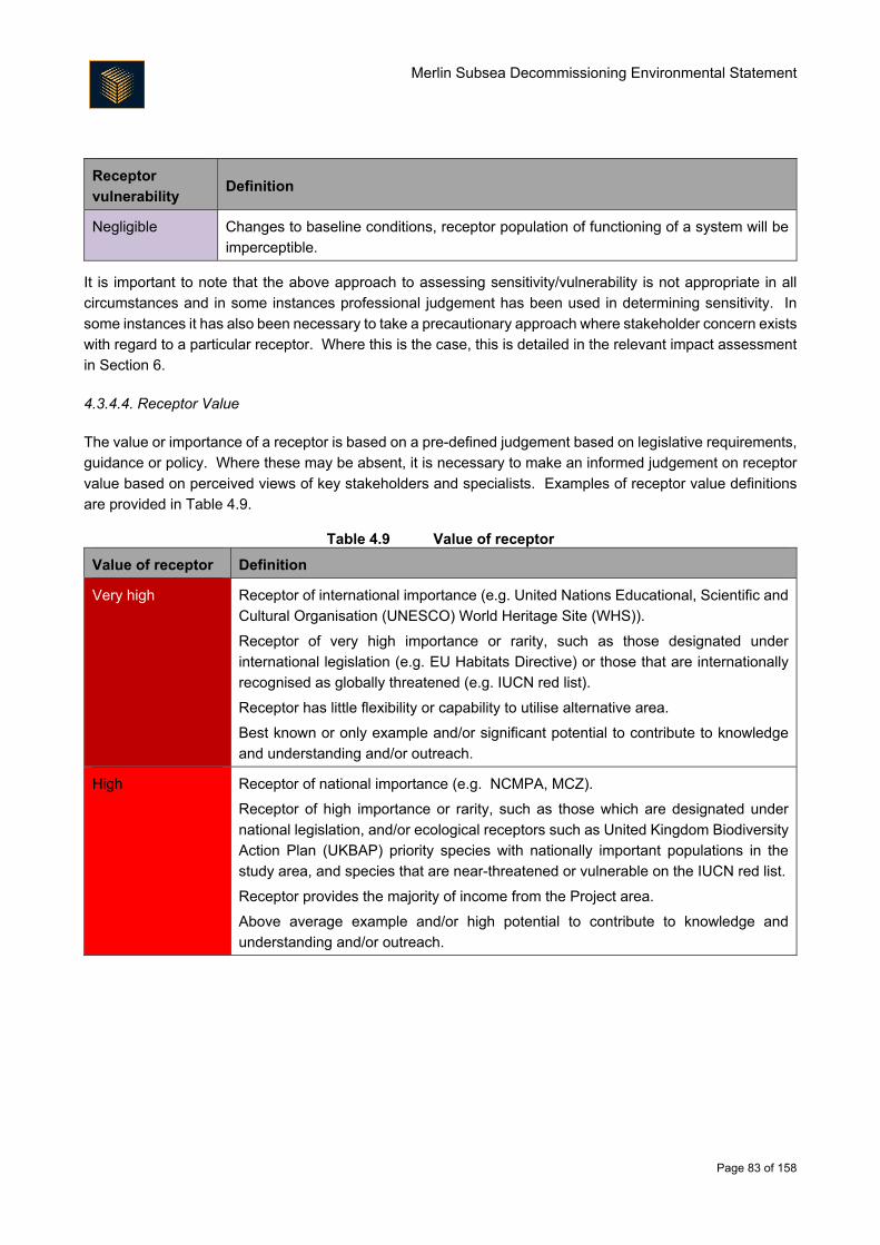
Merlin Subsea Decommissioning Environmental Statement
Page 83 of 158
Receptor
vulnerability Definition
Negligible Changes to baseline conditions, receptor population of functioning of a system will be
imperceptible.
It is important to note that the above approach to assessing sensitivity/vulnerability is not appropriate in all
circumstances and in some instances professional judgement has been used in determining sensitivity. In
some instances it has also been necessary to take a precautionary approach where stakeholder concern exists
with regard to a particular receptor. Where this is the case, this is detailed in the relevant impact assessment
in Section 6.
4.3.4.4. Receptor Value
The value or importance of a receptor is based on a pre-defined judgement based on legislative requirements,
guidance or policy. Where these may be absent, it is necessary to make an informed judgement on receptor
value based on perceived views of key stakeholders and specialists. Examples of receptor value definitions
are provided in Table 4.9.
Table 4.9 Value of receptor
Value of receptor Definition
Very high Receptor of international importance (e.g. United Nations Educational, Scientific and
Cultural Organisation (UNESCO) World Heritage Site (WHS)).
Receptor of very high importance or rarity, such as those designated under
international legislation (e.g. EU Habitats Directive) or those that are internationally
recognised as globally threatened (e.g. IUCN red list).
Receptor has little flexibility or capability to utilise alternative area.
Best known or only example and/or significant potential to contribute to knowledge
and understanding and/or outreach.
High Receptor of national importance (e.g. NCMPA, MCZ).
Receptor of high importance or rarity, such as those which are designated under
national legislation, and/or ecological receptors such as United Kingdom Biodiversity
Action Plan (UKBAP) priority species with nationally important populations in the
study area, and species that are near-threatened or vulnerable on the IUCN red list.
Receptor provides the majority of income from the Project area.
Above average example and/or high potential to contribute to knowledge and
understanding and/or outreach.
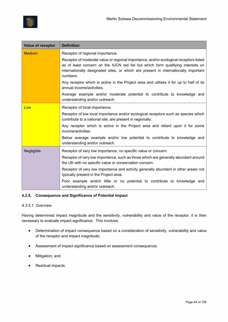
Merlin Subsea Decommissioning Environmental Statement
Page 84 of 158
Value of receptor Definition
Medium Receptor of regional importance.
Receptor of moderate value or regional importance, and/or ecological receptors listed
as of least concern on the IUCN red list but which form qualifying interests on
internationally designated sites, or which are present in internationally important
numbers.
Any receptor which is active in the Project area and utilises it for up to half of its
annual income/activities.
Average example and/or moderate potential to contribute to knowledge and
understanding and/or outreach.
Low Receptor of local importance.
Receptor of low local importance and/or ecological receptors such as species which
contribute to a national site, are present in regionally.
Any receptor which is active in the Project area and reliant upon it for some
income/activities.
Below average example and/or low potential to contribute to knowledge and
understanding and/or outreach.
Negligible Receptor of very low importance, no specific value or concern.
Receptor of very low importance, such as those which are generally abundant around
the UK with no specific value or conservation concern.
Receptor of very low importance and activity generally abundant in other areas/ not
typically present in the Project area.
Poor example and/or little or no potential to contribute to knowledge and
understanding and/or outreach.
Consequence and Significance of Potential Impact
4.3.5.1. Overview
Having determined impact magnitude and the sensitivity, vulnerability and value of the receptor, it is then
necessary to evaluate impact significance. This involves:
Determination of impact consequence based on a consideration of sensitivity, vulnerability and value
of the receptor and impact magnitude;
Assessment of impact significance based on assessment consequence;
Mitigation; and
Residual impacts.
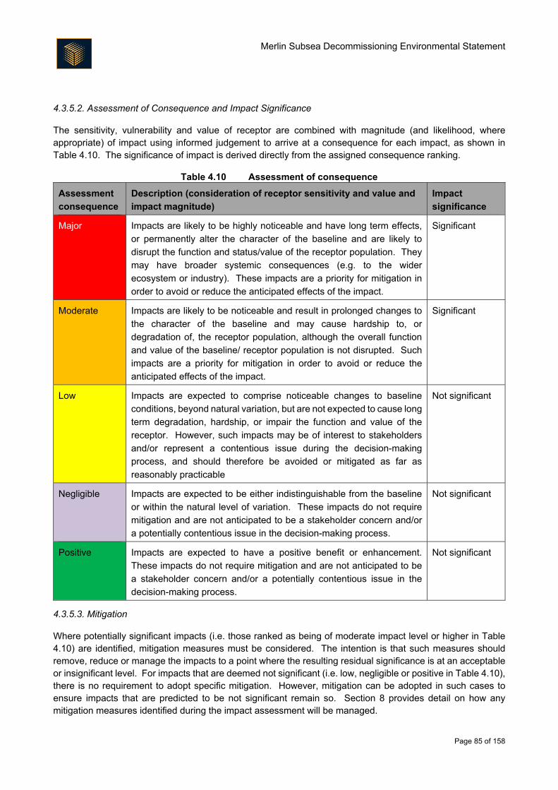
Merlin Subsea Decommissioning Environmental Statement
Page 85 of 158
4.3.5.2. Assessment of Consequence and Impact Significance
The sensitivity, vulnerability and value of receptor are combined with magnitude (and likelihood, where appropriate) of impact using informed judgement to arrive at a consequence for each impact, as shown in Table 4.10. The significance of impact is derived directly from the assigned consequence ranking.
Table 4.10 Assessment of consequence
Assessment
consequence
Description (consideration of receptor sensitivity and value and
impact magnitude)
Impact
significance
Major Impacts are likely to be highly noticeable and have long term effects,
or permanently alter the character of the baseline and are likely to
disrupt the function and status/value of the receptor population. They
may have broader systemic consequences (e.g. to the wider
ecosystem or industry). These impacts are a priority for mitigation in
order to avoid or reduce the anticipated effects of the impact.
Significant
Moderate Impacts are likely to be noticeable and result in prolonged changes to
the character of the baseline and may cause hardship to, or
degradation of, the receptor population, although the overall function
and value of the baseline/ receptor population is not disrupted. Such
impacts are a priority for mitigation in order to avoid or reduce the
anticipated effects of the impact.
Significant
Low Impacts are expected to comprise noticeable changes to baseline
conditions, beyond natural variation, but are not expected to cause long
term degradation, hardship, or impair the function and value of the
receptor. However, such impacts may be of interest to stakeholders
and/or represent a contentious issue during the decision-making
process, and should therefore be avoided or mitigated as far as
reasonably practicable
Not significant
Negligible Impacts are expected to be either indistinguishable from the baseline
or within the natural level of variation. These impacts do not require
mitigation and are not anticipated to be a stakeholder concern and/or
a potentially contentious issue in the decision-making process.
Not significant
Positive Impacts are expected to have a positive benefit or enhancement.
These impacts do not require mitigation and are not anticipated to be
a stakeholder concern and/or a potentially contentious issue in the
decision-making process.
Not significant
4.3.5.3. Mitigation
Where potentially significant impacts (i.e. those ranked as being of moderate impact level or higher in Table 4.10) are identified, mitigation measures must be considered. The intention is that such measures should remove, reduce or manage the impacts to a point where the resulting residual significance is at an acceptable or insignificant level. For impacts that are deemed not significant (i.e. low, negligible or positive in Table 4.10), there is no requirement to adopt specific mitigation. However, mitigation can be adopted in such cases to ensure impacts that are predicted to be not significant remain so. Section 8 provides detail on how any mitigation measures identified during the impact assessment will be managed.
Merlin Subsea Decommissioning Environmental Statement
Page 86 of 158
4.3.5.4. Residual Impacts
Residual impacts are those that remain once all options for removing, reducing or managing potentially
significant impacts (i.e. all mitigation) have been taken into account.
4.4. Cumulative Impact Assessment
The European Commission has defined cumulative impact as being those resulting “from incremental changes
caused by other past, present or reasonably foreseeable actions together with the project” (European
Commission, 1999). As outlined in studies by the European Commission (1999) and US CEQ (1997),
identifying the cumulative impacts of a project involves:
Considering the activities associated with the project;
Identifying potentially sensitive receptors/resources;
Identifying the geographic and time boundaries of the cumulative impact assessment;
Identifying past, present and future actions which may also impact the sensitive receptors/resources;
Identifying impacts arising from the proposed activities; and
Identifying which impacts on these resources are important from a cumulative impacts perspective.
To assist the assessment of cumulative impacts, a review of existing developments (including oil and gas,
cables and renewables) that could have the potential to interact with the Project was undertaken; the output
of this review is reported in the Environment Description (Section 3). The impact assessment has considered
these projects when defining the potential for cumulative impact (Section 6).
Although the scope of this EIA is restricted to the decommissioning of the Merlin facilities, it must be recognised
that the decommissioning workscope is one part of the Subsea Infrastructure Decommissioning Project. As
such, when considering cumulative impact with other developments in the North Sea, the potential impacts
associated with the Merlin subsea activities must be considered along with those from the Osprey and Dunlin
decommissioning activities, rather than in isolation. To this end, the cumulative impact assessment presented
within each assessment sub-section deals with the potential cumulative impacts that may arise from the
Subsea Infrastructure Decommissioning Project and other projects in the North Sea.
4.5. Transboundary Impact Assessment
The impact assessment presented in Section 6 contains sections which identify the potential for, and where
appropriate, assessment of transboundary impacts. For the Project, this is an important issue for consideration
given the proximity to the UK/Norway median line (18 km).
4.6. Habitats Regulation Appraisal (HRA)
Under Article 6.3 of the Habitats Directive, it is the responsibility of the Competent Authority to make an
Appropriate Assessment of the implications of a plan, programme or in this case project, alone or in
combination, on a Natura site (SAC or SPA) in view of the site’s conservation objectives and the overall integrity
of the site.
Merlin Subsea Decommissioning Environmental Statement
Page 87 of 158
As part of the assessment of impacts on key receptors, for those receptors that are a qualifying feature of a
Natura site, relevant information on SACs or SPAs has also been provided as part of the impact assessment
process. This information will then be used by the Competent Authority to determine the need for, and
subsequently carry out (if required), an appropriate assessment of the Project.
For offshore areas (12 – 200 nm) the requirements of the Habitats Directive are transposed through the
Offshore Marine Conservation Natural Habitats Regulations (2007) as amended. In accordance with these
Regulations, the impacts of a project on the integrity of a European site are assessed and evaluated as part
of the HRA process. In an analogous process, the Marine (Scotland) Act and the Marine and Coastal Access
Act require the potential for significant risk to the conservation objectives of NCMPAs and MCZs (respectively)
being achieved to be assessed.
4.7. Data Gaps and Uncertainties
The North Sea has been extensively studied, meaning that this EIA has been able to draw on a significant
volume of published data. This bank of published data has been supplemented by a site survey programme
and studies undertaken on behalf of Fairfield to collect Project specific environmental data, ensuring a robust
baseline is available against which to assess impact. Where appropriate, studies have been commissioned
to inform the impact assessment, including:
Survey work
o A campaign covering environmental baseline, habitat assessment, drill cuttings and subsea
ROV survey of the pipelines, umbilicals and subsea structures has been undertaken for the
Project area.
Commercial fisheries study;
o The aim of the assessment was to gain an up-to-date understanding of current and future fishing activity in the Project area and undertake a high-level assessment of potential socio-economic impacts to the fishing industry of decommissioning activities. Publicly available fishing data including fishing effort, landings value and VMS data have been used to inform the baseline description in Section 3.5.1 and the impact assessment (Section 6). Additionally, an engagement exercise has been performed by SFF Services Limited involving spending approximately three days interviewing and collecting data from vessel owners from the relevant ports likely to be fishing within the Project area. Information collected by this study has been supplemented with that collected as part of the Anatec (2017) fisheries risk assessment.
Energy and emissions inventory;
o In order to provide an indication of the energy and emissions produced during the proposed
decommissioning activities, the methodology detailed in The Institute of Petroleum (IP, 2000)
guidelines for the calculations of estimates of energy use and gaseous emissions in the
decommissioning of offshore structures methodology has been used to estimate the potential
energy use and gaseous emissions to inform the impact assessment in Section 6.
Merlin Subsea Decommissioning Environmental Statement
Page 88 of 158
Waste Management Strategy;
o A Waste Management Strategy has been developed to account for the generation and
treatment of waste. This includes consideration of the presence of hazardous and radioactive
wastes.
When evaluating and characterising potential impacts that could be associated with the Project, a variety of
inputs are used, including baseline environmental data, modelling results, estimation of emissions and Project
footprint. These inputs carry varying levels of uncertainty and conservatism and although potential impacts
may occur, they are not certain to occur (for example, there is some uncertainty in marine mammal response
to certain noise emissions). As such, all the potential impacts (whether predicted, residual, cumulative or
transboundary) described in this ES are to a greater or lesser extent potential impacts which may or may not
occur. To account for this uncertainty, worst case assumptions have been made, and where key uncertainties
exist they have been outlined within the relevant section of the impact assessment (Section 6).
Merlin Subsea Decommissioning Environmental Statement
Page 89 of 158
5. Stakeholder Engagement
5.1. Engagement Strategy
Fairfield recognises that early and ongoing engagement with stakeholders is a critical part of the development
of robust, respectful programmes for the decommissioning of North Sea installations. To ensure the efficacy
of stakeholder engagement, Fairfield has developed a Stakeholder Engagement Strategy and Action Plan.
This Plan outlines how and why stakeholder engagement should occur. It has assisted in driving engagement
through both the CA and EIA, and has been supported by a continually updated Stakeholder Engagement
Workbook and Stakeholder Alignment Plan/Matrix, through which stakeholder engagement is tracked.
5.2. Consultation
As a demonstration of Fairfield’s execution of its stakeholder strategy and the extent to which external
stakeholders have had the opportunity to influence the decommissioning project, a summary of the key
engagement activities is given in Table 5.1. As well as working with key regulatory and environmental
stakeholders, Fairfield has sought to understand the lessons that other UKCS Operators have learned during
their decommissioning activities to date. In addition, Fairfield makes information available to the general public
via a dedicated decommissioning website accessed through www.fairfield-energy.com.
Table 5.1 Summary of key stakeholder engagement activities
Activity Date Stakeholders
Introduction to the Greater Dunlin
Area Decommissioning Project
January 2010 Aberdeenshire Council, BEIS, Centre for
Environment, Fisheries and Aquaculture Science
(Cefas), Decom North Sea, HSE, JNCC, Marine
Scotland, Maritime and Coastguard Agency,
Greenpeace, Scottish Enterprise, Scottish
Environmental Protection Agency (SEPA)
(Radioactive waste), SEPA (Marine), SFF,
University of Aberdeen
Between 2010 and 2015, Fairfield continued engagement with stakeholders, including OSPAR and those
outlined above, to guide the development of Fairfield’s decommissioning strategy for the Greater Dunlin
Area.
Meet with statutory stakeholders to
discuss progress
December
2015/January
2016
JNCC, Marine Scotland, SFF
Merlin Subsea CA Screening
Workshop
March 2016 BEIS, JNCC, Marine Scotland, SFF
Update on Greater Dunlin Area
decommissioning
April 2016 BEIS
Fisheries update on Greater
Dunlin Area decommissioning
May 2016 UK Fisheries Offshore Oil and Gas Legacy Trust
Fund (FLTC) National Federation of Fishermen's
Organisations (NFFO), Northern Ireland Fish
Producers' Organisation Limited (NIFPO)

Merlin Subsea Decommissioning Environmental Statement
Page 90 of 158
Activity Date Stakeholders
Issue of note to advise on progress June 2016 BEIS, JNCC, OGA, SFF
Update on Greater Dunlin Area
decommissioning
July 2016 OGA
Workshop on decommissioning of
concrete mattresses
September 2016 SEPA, Decom North Sea
Update meetings on Greater
Dunlin Area decommissioning
September 2016 SFF, JNCC
Update on Greater Dunlin Area
decommissioning
October 2016 SEPA
Briefing session for Merlin Subsea
CA
December 2016 BEIS, JNCC, Marine Scotland, OGA, SFF
Merlin Subsea CA workshop January 2017 BEIS, JNCC, Marine Scotland, OGA, SFF
5.3. Issues Raised
The stakeholder engagement process identified a range of potential issues associated with the
decommissioning activities which were considered and taken forward into the CA and EIA processes. Where
appropriate, responses were compiled to gather details of the issues and further meetings arranged. Table
5.2 summarises the main feedback provided to date and explains how Fairfield has dealt with the issue.
Reference to the section of this ES that deals with the issue raised is also provided.
Table 5.2 Issues raised during stakeholder engagement to date
Comment Fairfield response
JNCC
JNCC stated a preference in
decommissioning solutions which are not
disruptive to the environment and which
leave the seabed in the condition in which it
was originally found. JNCC did note that this
was not always possible and so approached
every project or plan on a case by case
basis.
Fairfield has considered this position within the CA, and this
is detailed in the CA report that accompanies the
Decommissioning Programme. Where additional rockdump
is required, or where trenching or dredging is being
proposed, this EIA has assessed the impact to understand
the significance and mitigation requirements. This is
presented in Section 6.2.1.
JNCC requested that figures be made
available showing the location and vintage of
environmental surveys and the location of
any SAC or MPAs in or around the Project
area.
A full description of the pre-decommissioning surveys is
given in Section 3. Other recent, relevant surveys are also
described, and both sets have been used to inform the
assessment of impacts upon the seabed (and the species
using it). Sets of figures support the description of the
baseline environment, and these are also given in Section 3.
A review of protected sites and species, accompanied by
appropriate figures, is given in Section 3.4.
Merlin Subsea Decommissioning Environmental Statement
Page 91 of 158
Comment Fairfield response
JNCC stated that rockdump is considered a
permanent change to the environment.
The potential impact of the limited additional rockdump
proposed for the decommissioning activities is assessed in
Section 6.2.1.
Marine Scotland
Fairfield should review the fisheries value
information from Kafas et al. (2012) as part
of the preparation of the environment
baseline.
This information is presented in Section 3.5.1, supported by
two project-specific fisheries studies. This extensive data
review provides a robust baseline against which the impact
assessment on other sea users has been made.
Fairfield should provide clear, precise and
concise map-based data during the
engagement process which explains the
regional context.
The environment baseline presented in Section 3 makes
extensive use of graphics to describe the area within which
the Project is sited. Additionally, each impact assessment
specifically considers the scale of the proposed activities
within the context of other use of the northern North Sea.
Decommissioning of in situ pipelines and
other equipment that are not already
trenched and buried create a greater
potential impact on fishing activities. A key
objective for Marine Scotland is to minimise
interaction with other users of the sea.
Fairfield has considered this position within the CA, and this
is detailed in the CA report that accompanies the
Decommissioning Programme. As a result, only a limited
number of lines are decommissioned in situ and none are
outside of a trench or rock berm. The impact assessment on
other sea users presented in Section 6 considers the
potential impact of limited infrastructure being
decommissioned in situ.
Fairfield should provide details of any
contamination found at the seabed.
Fairfield undertook a suite of pre-decommissioning surveys
to understand the current condition of the seabed (details are
given in Section 3). These pre-decommissioning surveys
included investigation of the cuttings pile in the Merlin field;
details are given in Section 3. This information has been
used to support the assessment of impacts, including from
the potential disturbance of sediments contaminated with oil-
based mud (given in Section 6.2.1).
Merlin Subsea Decommissioning Environmental Statement
Page 92 of 158
Comment Fairfield response
SEPA
SEPA stated their expectation that Fairfield
will not just put all materials returned to
landfill but will instead look for opportunities
to reuse/recycle/recover as far as possible.
Fairfield’s aspirations with regards reusing, recycling and
recovering material. This is summarised in Section 7 of this
ES, with estimates for reuse/recycling/recovering provided.
Reuse of materials is the only fate that
removes items from the waste stream. All
other materials are considered waste and
Fairfield will continue to be accountable for
the fate of these items under their duty of
care. The ‘end of the line’ is either landfill, or
at the point where the material is fully
recycled e.g. aggregate for civil works or
feed into steelworks.
Fairfield has developed a Waste Management Strategy to
ensure that its duty of care in terms of waste being returned
to shore is appropriately executed. This is summarised in
Section 7 of this ES.
Fairfield may be required to demonstrate
due diligence when addressing duty of care.
This could involve undertaking site visits or
reviewing compliance history when
tendering/negotiating contracts with waste
management contractors.
Environmental auditing may occur as part of the tendering
process for the work (Section 8).
Landfill capacity is diminishing and
alternative disposal routes must be found for
concrete mattresses. SEPA is developing a
sampling regime to understand potential
leaching of contaminants from mattresses
and will engage with Fairfield once this is
developed.
Fairfield welcomes the work that SEPA describes and will
actively engage when further information is made available.
Fairfield’s Waste Management Strategy details the approach
to minimising landfill, and this is summarised in Section 8.
SEPA advised that Fairfield should confirm
that marine growth returns to shore should
be appropriately licenced (e.g. hazardous
waste licenses/Pollution Prevention and
Control (PPC) permits should include animal
bi-products for marine growth). SEPA also
advised that some waste licences and PPC
permits may have conditions regarding smell
and SEPA could undertake enforcement
notices on sites should odour issues arise.
As detailed in Section 8, Fairfield will require that onshore
dismantling yards conduct a review of records of
engagement with communities and close-out any
outstanding issues, including those related to odour.
Merlin Subsea Decommissioning Environmental Statement
Page 93 of 158
Comment Fairfield response
SFF
SFF stated that each decommissioning
project presents different challenges from a
fishing perspective but that the opening
position will always be that all infrastructure
should be removed. SFF also stated that
additional rock coverage creates risks to
fishermen.
Fairfield has considered this position within the CA, and this
is detailed in the CA report that accompanies the
Decommissioning Programme. This EIA has assessed the
impact of the decisions made to understand the significance
and mitigation requirements. This is presented in Section 6.
SFF observed that in and around the Dunlin
area at certain times of the year could see
medium-to-high levels of fishing activity with
the larger pelagic fleet vessels targeting the
shoals of mackerel in January and February.
This information has been included in the wider fisheries
baseline presented in Section 3.5.1. This has in turn
informed the impact assessment presented in Section 6. It
is worth noting that the indicative schedule for the
decommissioning activities will see the majority of the work
undertaken in summer months.
SFF noted a concern regarding the
cumulative impacts of decommissioning
structures in situ, with regards to access to
sea area.
Each impact assessment has considered the potential for
cumulative impact. For access to sea area, the potential
issues associated with the in situ decommissioning of the
rockdumped production and water injection lines has been
considered alongside the return of the sea area currently
occupied by the Merlin 500 m safety zone (Section 6).
Merlin Subsea Decommissioning Environmental Statement
Page 94 of 158
6. Impact Assessment
6.1. Discharges to Sea
Introduction
The Merlin decommissioning activities have the potential to impact on the water column and users of the water
column through the release of chemicals and hydrocarbons. This may happen during the disconnection and
cutting of lines in preparation for decommissioning, or over a longer period of time from infrastructure
decommissioned in situ.
Description and Quantification of Potential Impact
6.1.2.1. Trenched and Rockdumped Pipeline and Umbilical
The Merlin main line PL1555 and Umbilical PL1557 will be decommissioned by removing the ends of the lines
and placing local rockdump at the cut ends and areas of low burial depth. Upon disconnection of the lines, an
initial release of contents to sea is expected as hydrostatic equilibrium is reached with the surrounding water
column. Following this, contents will be exchanged with ambient water at a slower rate through the open ends,
being largely dependent on line topography at this stage. It is also possible that contents may disperse out
over a longer period of time as the lines degrade in situ, particularly with PL1555 where wall thickness is
already low in some places.
Pipeline PL1555 contains approximately 187 m3 of suspension water that has a hydrocarbon content of approximately 19 mg/l oil in water and chemicals that are considered to pose a low risk to the environment (e.g. ‘gold’ band and those classified as ‘poses little or no risk’ (PLONOR)) chemicals, as shown in Table 6.1). Umbilical PL1557 will contain ambient temperature potable water at the time of decommissioning with no residual chemicals or hydrocarbons. Therefore, the potential impacts of discharge to sea from the umbilical are not considered further within this section.
6.1.2.2. Trenched/Buried Flowline
The water injection flexible flowline (PL1665) will be disconnected at each end and fully removed from the seabed using a reverse reeling technique onto the vessel. The flowline contains 216 m3 of water injection fluid, consisting of environmentally low-risk chemicals (Table 6.1). There are no residual hydrocarbons present, so the flowline will not be further flushed, and the full contents of the line will be discharged to sea during the removal operation.
6.1.2.3. Umbilical Riser
The umbilical riser (PL1556) will be decommissioned by cutting and recovering the seabed section, with the
180 m remaining in the J-tube of the platform being decommissioned in situ. The umbilical riser will contain
ambient temperature potable water at the time of decommissioning with no residual chemicals or
hydrocarbons. Therefore the potential impacts of discharges to sea from this umbilical riser are not considered
further within this section.
Merlin Subsea Decommissioning Environmental Statement
Page 95 of 158
6.1.2.4. Pipeline and Umbilical Components
A number of pipeline and umbilical components (described in Table 2.4) will be fully disconnected, removed and recovered to shore. Some lines (e.g. the cooling spool described in Table 2.4) may be cut into shorter sections to facilitate recovery.
Where these components contain inhibited seawater, they will have been flushed with filtered seawater to substantially reduce the volume of hydrocarbons in the line and the expected contents are summarised within Table 6.1. Otherwise, components that contain produced fluid will be recovered to the surface with the end valves shut to contain the hydrocarbons (i.e. there will be no discharge to sea).
The umbilical jumpers will be recovered with the incumbent fluids (including hydraulic oil and chemicals) remaining in the jumper; this will be effected by capping the ends of the lines during disconnection.
Where infrastructure is recovered, there is a potential for discharge of a limited fraction of the inventory, resulting from subsea pressure testing. Where required, this operation would be included within the relevant chemical permit and has not been quantified further in this assessment at this time.
Accidental events which may result in loss of contents during recovery are discussed in Section 6.4.
6.1.2.5. Stabilisation Material and Deposits
Concrete mattresses, including sand and grout bag deposits (as described in Table 2.5) will be fully removed
from the seabed at Merlin. These materials are inert, self-contained and will not result in any discharge of
hydrocarbons or chemicals to sea. Therefore there are no potential impacts of stabilisation material and
deposit removal.
6.1.2.6. Summary
Table 6.1 quantifies the chemicals and/or hydrocarbons contained within the pipelines, flowlines, umbilicals and associated infrastructure at the time of decommissioning. Pipeline and umbilical components have been grouped and stabilisation material and deposits excluded. These concentrations have been taken together with the dimensions of equipment within the Project scope (Section 2) to calculate the potential worst-case volumetric chemical discharges from infrastructure to be decommissioned, shown in Table 6.2.
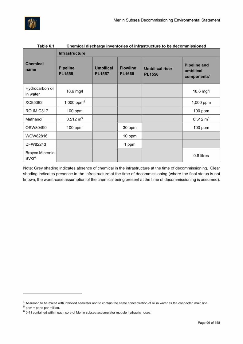
Merlin Subsea Decommissioning Environmental Statement
Page 96 of 158
Table 6.1 Chemical discharge inventories of infrastructure to be decommissioned
Chemical
name
Infrastructure
Pipeline
PL1555
Umbilical
PL1557
Flowline
PL1665
Umbilical riser
PL1556
Pipeline and
umbilical
components4
Hydrocarbon oil
in water 18.6 mg/l 18.6 mg/l
XC85383 1,000 ppm5 1,000 ppm
RO IM C317 100 ppm 100 ppm
Methanol 0.512 m3 0.512 m3
OSW80490 100 ppm 30 ppm 100 ppm
WCW82816 10 ppm
DFW82243 1 ppm
Brayco Micronic
SV/36 0.8 litres
Note: Grey shading indicates absence of chemical in the infrastructure at the time of decommissioning. Clear
shading indicates presence in the infrastructure at the time of decommissioning (where the final status is not
known, the worst-case assumption of the chemical being present at the time of decommissioning is assumed).
4 Assumed to be mixed with inhibited seawater and to contain the same concentration of oil in water as the connected main line. 5 ppm = parts per million. 6 0.4 l contained within each core of Merlin subsea accumulator module hydraulic hoses.
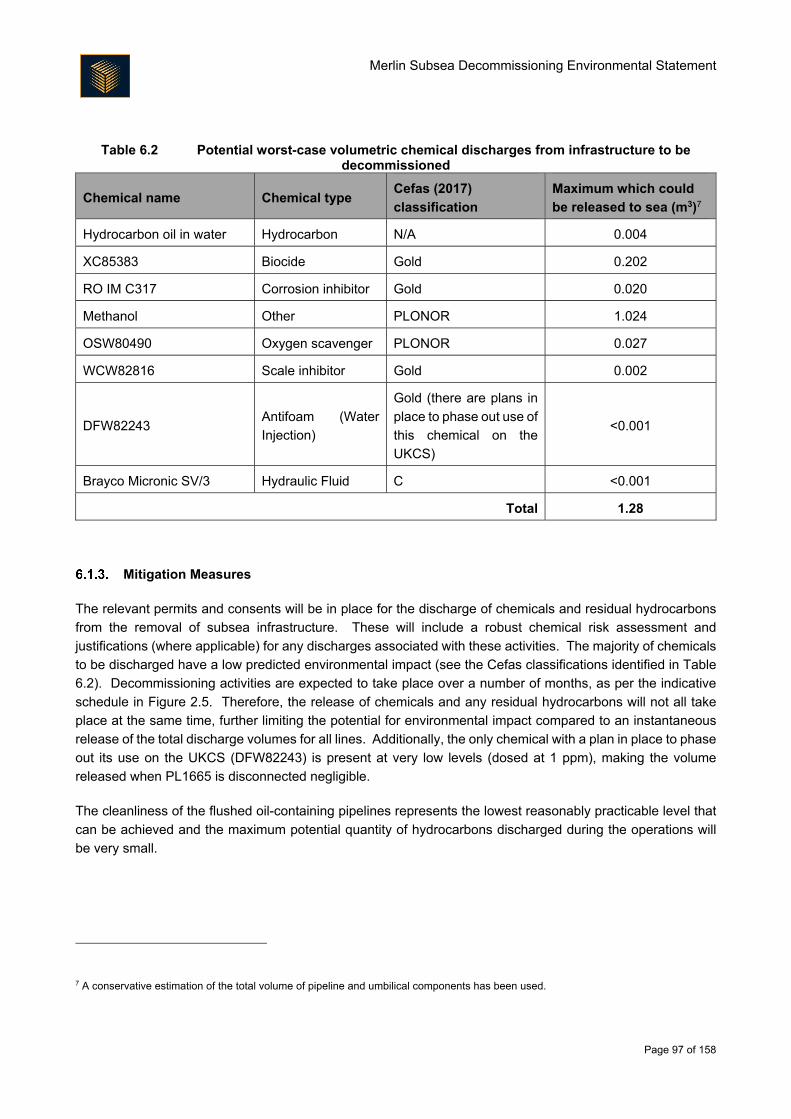
Merlin Subsea Decommissioning Environmental Statement
Page 97 of 158
Table 6.2 Potential worst-case volumetric chemical discharges from infrastructure to be decommissioned
Chemical name Chemical type Cefas (2017)
classification
Maximum which could
be released to sea (m3)7
Hydrocarbon oil in water Hydrocarbon N/A 0.004
XC85383 Biocide Gold 0.202
RO IM C317 Corrosion inhibitor Gold 0.020
Methanol Other PLONOR 1.024
OSW80490 Oxygen scavenger PLONOR 0.027
WCW82816 Scale inhibitor Gold 0.002
DFW82243 Antifoam (Water
Injection)
Gold (there are plans in
place to phase out use of
this chemical on the
UKCS)
<0.001
Brayco Micronic SV/3 Hydraulic Fluid C <0.001
Total 1.28
Mitigation Measures
The relevant permits and consents will be in place for the discharge of chemicals and residual hydrocarbons
from the removal of subsea infrastructure. These will include a robust chemical risk assessment and
justifications (where applicable) for any discharges associated with these activities. The majority of chemicals
to be discharged have a low predicted environmental impact (see the Cefas classifications identified in Table
6.2). Decommissioning activities are expected to take place over a number of months, as per the indicative
schedule in Figure 2.5. Therefore, the release of chemicals and any residual hydrocarbons will not all take
place at the same time, further limiting the potential for environmental impact compared to an instantaneous
release of the total discharge volumes for all lines. Additionally, the only chemical with a plan in place to phase
out its use on the UKCS (DFW82243) is present at very low levels (dosed at 1 ppm), making the volume
released when PL1665 is disconnected negligible.
The cleanliness of the flushed oil-containing pipelines represents the lowest reasonably practicable level that
can be achieved and the maximum potential quantity of hydrocarbons discharged during the operations will
be very small.
7 A conservative estimation of the total volume of pipeline and umbilical components has been used.
Merlin Subsea Decommissioning Environmental Statement
Page 98 of 158
Cumulative Impact Assessment
It is possible that chemical and hydrocarbon discharges occurring within the Project area, and from other
assets in the area (during other planned decommissioning activities), could act cumulatively to result in an
adverse impact to the surrounding environment.
In terms of how the likely discharges from the Subsea Infrastructure Decommissioning Project fit into the
context of existing discharges into the North Sea, information reported by (OGUK, 2016a) on operational
discharges is useful. For example, there is estimated to be 165,000,000 m3 of produced water discharged
annually from North Sea installations, containing more than 28,500 tonnes of production chemicals. There is
estimated to be less than 1.3 m3 of chemicals remaining in the lines that could be discharged during
decommissioning activities or as the decommissioned lines degrade; the small scale of the Merlin activities is
clearly demonstrated by this comparison. For hydrocarbons, there is estimated to be a maximum of 0.004 m3
that could be discharged either during decommissioning activities or as the lines degrade; this is a very small
volume in comparison to annual values for oil discharged in produced water for both Dunlin Alpha
(approximately 73 m3 discharged during the last full year of production) and annually from installations on the
UKCS (approximately 2,700 m3; OGUK, 2016a).
Furthermore, it is important to note that the activities described herein are being executed to facilitate the
decommissioning of the Merlin field; decommissioning means that there will be no further operational
discharges to sea associated with the Merlin field.
There will be other discharges to sea as a result of future decommissioning of the Osprey and Dunlin fields.
The decommissioning methodology developed during the CA process has sought to minimise the cumulative
impact of those operations in a holistic manner, and it is expected that only a further 12.9 m3 could be released
from the Osprey and Dunlin subsea decommissioning activities. As a result of the water depth (150 m) and
the operations occurring over an extended duration, any discharge of chemicals and/or residual hydrocarbons
is expected to dissipate relatively rapidly and have a very limited environmental impact. Additionally, the
Subsea Infrastructure Decommissioning Project area is a sufficient distance from other assets in the area that
there is unlikely to be any direct cumulative impact from other oil and gas production facilities.
Transboundary Impact Assessment
The Merlin Subsea Infrastructure Decommissioning Project sits in reasonably close proximity to the
UK/Norway median line (18 km) and there is a possibility that discharges to sea could therefore cross median
lines. However, the sea conditions experienced within the northern North Sea would be expected to rapidly
dilute and disperse the limited potential volume discharge of chemicals and/or of residual hydrocarbons such
that they are undetectable away from the field. As such, they will have no transboundary impact.
Protected Sites
As detailed in Section 3.4, there are no designated or proposed sites of conservation interest within the Project
area. The closest designated site, the SCI ‘Pobie Bank Reef’ lies 94 km to the south west of Merlin whilst the
closest SPA is Hermaness, Saxa Vord and Valla Field which lies 132 km south west of Merlin. As with other
chemical and hydrocarbon discharge activities in the North Sea, the prevailing hydrodynamic conditions will
assimilate these discharges to ambient conditions through natural dispersion and dilution. The pipeline and
umbilicals decommissioned in situ within the Project area could see a slow release of chemicals as the lines
degrade, but the highly limited volumes and extended period of release will have no impact on current
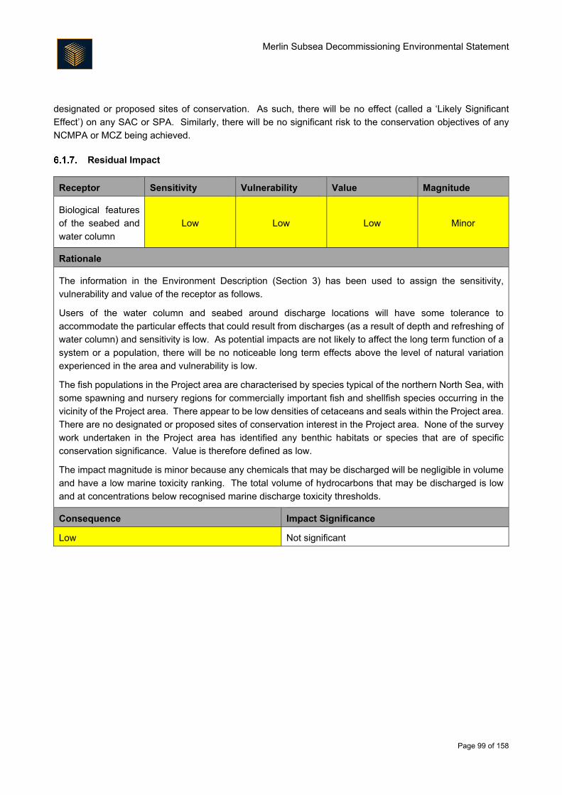
Merlin Subsea Decommissioning Environmental Statement
Page 99 of 158
designated or proposed sites of conservation. As such, there will be no effect (called a ‘Likely Significant
Effect’) on any SAC or SPA. Similarly, there will be no significant risk to the conservation objectives of any
NCMPA or MCZ being achieved.
Residual Impact
Receptor Sensitivity Vulnerability Value Magnitude
Biological features
of the seabed and
water column
Low Low Low Minor
Rationale
The information in the Environment Description (Section 3) has been used to assign the sensitivity,
vulnerability and value of the receptor as follows.
Users of the water column and seabed around discharge locations will have some tolerance to
accommodate the particular effects that could result from discharges (as a result of depth and refreshing of
water column) and sensitivity is low. As potential impacts are not likely to affect the long term function of a
system or a population, there will be no noticeable long term effects above the level of natural variation
experienced in the area and vulnerability is low.
The fish populations in the Project area are characterised by species typical of the northern North Sea, with
some spawning and nursery regions for commercially important fish and shellfish species occurring in the
vicinity of the Project area. There appear to be low densities of cetaceans and seals within the Project area.
There are no designated or proposed sites of conservation interest in the Project area. None of the survey
work undertaken in the Project area has identified any benthic habitats or species that are of specific
conservation significance. Value is therefore defined as low.
The impact magnitude is minor because any chemicals that may be discharged will be negligible in volume
and have a low marine toxicity ranking. The total volume of hydrocarbons that may be discharged is low
and at concentrations below recognised marine discharge toxicity thresholds.
Consequence Impact Significance
Low Not significant
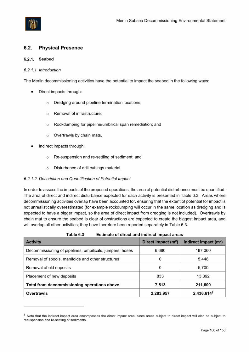
Merlin Subsea Decommissioning Environmental Statement
Page 100 of 158
6.2. Physical Presence
Seabed
6.2.1.1. Introduction
The Merlin decommissioning activities have the potential to impact the seabed in the following ways:
Direct impacts through:
o Dredging around pipeline termination locations;
o Removal of infrastructure;
o Rockdumping for pipeline/umbilical span remediation; and
o Overtrawls by chain mats.
Indirect impacts through:
o Re-suspension and re-settling of sediment; and
o Disturbance of drill cuttings material.
6.2.1.2. Description and Quantification of Potential Impact
In order to assess the impacts of the proposed operations, the area of potential disturbance must be quantified.
The area of direct and indirect disturbance expected for each activity is presented in Table 6.3. Areas where
decommissioning activities overlap have been accounted for, ensuring that the extent of potential for impact is
not unrealistically overestimated (for example rockdumping will occur in the same location as dredging and is
expected to have a bigger impact, so the area of direct impact from dredging is not included). Overtrawls by
chain mat to ensure the seabed is clear of obstructions are expected to create the biggest impact area, and
will overlap all other activities; they have therefore been reported separately in Table 6.3.
Table 6.3 Estimate of direct and indirect impact areas
Activity Direct impact (m2) Indirect impact (m2)
Decommissioning of pipelines, umbilicals, jumpers, hoses 6,680 187,060
Removal of spools, manifolds and other structures 0 5,448
Removal of old deposits 0 5,700
Placement of new deposits 833 13,392
Total from decommissioning operations above 7,513 211,600
Overtrawls 2,283,957 2,436,6148
8 Note that the indirect impact area encompasses the direct impact area, since areas subject to direct impact will also be subject to resuspension and re-settling of sediments.
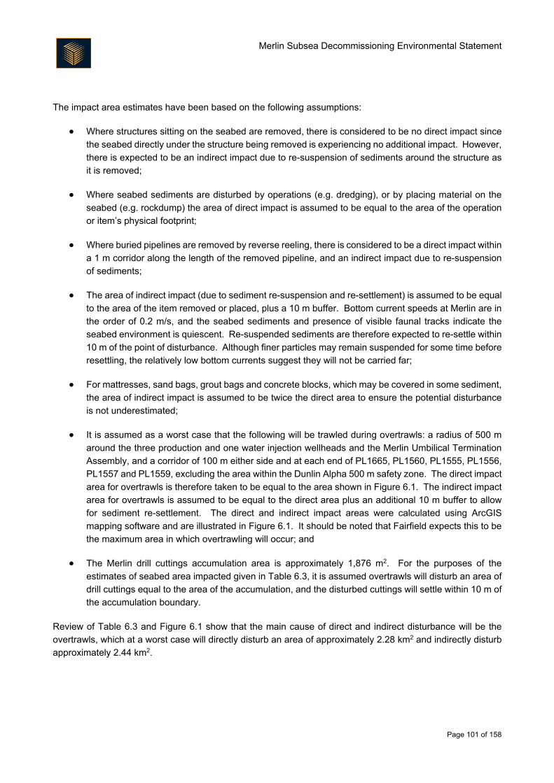
Merlin Subsea Decommissioning Environmental Statement
Page 101 of 158
The impact area estimates have been based on the following assumptions:
Where structures sitting on the seabed are removed, there is considered to be no direct impact since
the seabed directly under the structure being removed is experiencing no additional impact. However,
there is expected to be an indirect impact due to re-suspension of sediments around the structure as
it is removed;
Where seabed sediments are disturbed by operations (e.g. dredging), or by placing material on the
seabed (e.g. rockdump) the area of direct impact is assumed to be equal to the area of the operation
or item’s physical footprint;
Where buried pipelines are removed by reverse reeling, there is considered to be a direct impact within
a 1 m corridor along the length of the removed pipeline, and an indirect impact due to re-suspension
of sediments;
The area of indirect impact (due to sediment re-suspension and re-settlement) is assumed to be equal
to the area of the item removed or placed, plus a 10 m buffer. Bottom current speeds at Merlin are in
the order of 0.2 m/s, and the seabed sediments and presence of visible faunal tracks indicate the
seabed environment is quiescent. Re-suspended sediments are therefore expected to re-settle within
10 m of the point of disturbance. Although finer particles may remain suspended for some time before
resettling, the relatively low bottom currents suggest they will not be carried far;
For mattresses, sand bags, grout bags and concrete blocks, which may be covered in some sediment,
the area of indirect impact is assumed to be twice the direct area to ensure the potential disturbance
is not underestimated;
It is assumed as a worst case that the following will be trawled during overtrawls: a radius of 500 m
around the three production and one water injection wellheads and the Merlin Umbilical Termination
Assembly, and a corridor of 100 m either side and at each end of PL1665, PL1560, PL1555, PL1556,
PL1557 and PL1559, excluding the area within the Dunlin Alpha 500 m safety zone. The direct impact
area for overtrawls is therefore taken to be equal to the area shown in Figure 6.1. The indirect impact
area for overtrawls is assumed to be equal to the direct area plus an additional 10 m buffer to allow
for sediment re-settlement. The direct and indirect impact areas were calculated using ArcGIS
mapping software and are illustrated in Figure 6.1. It should be noted that Fairfield expects this to be
the maximum area in which overtrawling will occur; and
The Merlin drill cuttings accumulation area is approximately 1,876 m2. For the purposes of the
estimates of seabed area impacted given in Table 6.3, it is assumed overtrawls will disturb an area of
drill cuttings equal to the area of the accumulation, and the disturbed cuttings will settle within 10 m of
the accumulation boundary.
Review of Table 6.3 and Figure 6.1 show that the main cause of direct and indirect disturbance will be the
overtrawls, which at a worst case will directly disturb an area of approximately 2.28 km2 and indirectly disturb
approximately 2.44 km2.
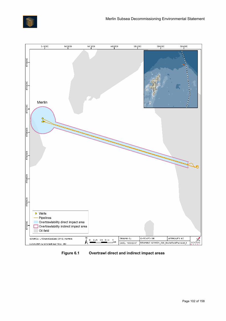
Merlin Subsea Decommissioning Environmental Statement
Page 102 of 158
Figure 6.1 Overtrawl direct and indirect impact areas
Merlin Subsea Decommissioning Environmental Statement
Page 103 of 158
6.2.1.3. Direct Disturbance of Seabed Habitats
Mechanism of potential impact
Direct interaction by physical disturbance can cause mortality or displacement of benthic species in the
potential impact zone. Potential direct impact to the seabed could occur from the placement of rock over
exposed ends of lines (which will also provide new, stable hard substrata for epifauna to colonise) and from
dredging, deburial, rock placement and overtrawling.
Dredging is not considered further in this assessment of direct impact as the rock placement will occur in the
same location and the rockdump is considered to have the greater impact (permanent change in seabed
conditions). The sites of all the decommissioning direct impacts will also be subject to overtrawling, therefore
to avoid double-counting, the total area of direct impact quoted here corresponds to the area covered by
overtrawling. It is estimated that a total of approximately 2.28 km2 of seabed will be directly impacted during
overtrawling operations, and this is the main focus of the assessment. Other activities are however discussed
below where they are considered to present different impacts.
Rockdump
Approximately 833 m2 of rockdump will be placed to protect cut pipeline ends and low burial areas. Impacts
associated with this will include direct mortality through crushing of non-mobile benthic fauna, displacement of
mobile benthic fauna and permanent loss of approximately 833 m2 of natural habitat. Surveys (Fugro, 2016d,
2017) show that the natural seabed in the Merlin subsea area is well represented in the wider area, meaning
the rockdump area comprises a very small proportion of the available similar habitat. The same surveys reveal
a diverse faunal community, suggesting there is good scope for replacement of individuals that may be lost
through rockdumping. Mortality and displacement of benthos are therefore not expected to have significant
effects at the population level. Whilst the loss of natural habitat will be a permanent impact, it is not expected
to be significant when set against the area of similar natural habitat available in the wider area (e.g. Gardline,
2010b), and the freeing-up of seabed surface habitat (approximately 7,000 m2) through removal of the majority
of the Merlin seabed infrastructure.
Overtrawls
The main mechanism of direct disturbance will come from overtrawling at the end of decommissioning
activities. Impacts from the overtrawling may include mortality and injury, arising from crushing of benthic and
epibenthic fauna that cannot move away, as well as disturbance of motile fauna as they move away from the
area of disturbance. The sediment structure, including burrows of any animals present, will be disturbed.
However, the scale of these impacts is small when compared to commercial trawling in the North Sea. A
commercial trawler with a 15 m wide beam trawl trawling at 4 km/h would take approximately 38 hours to cover
the entire Merlin overtrawl area. Average fishing effort in ICES rectangle 51F1 between 2010 and 2014 was
130 days per year, or 3,120 hours. In this context the scale of the area of impact from the overtrawls is small
and, unlike commercial fishing, will not occur on repeated occasions over many years.
The disturbance will occur within two main habitat biotope complexes, as identified in Section 3.3; EUNIS
biotope complex ‘Circalittoral Muddy Sand’ (A5.26) and ‘Circalittoral Mixed Sediment’ (A5.4). Tyler-
Walters et al. (2004) reported tolerance, recoverability and sensitivity related to disturbance of offshore biotope
complexes. ‘Circalittoral Mixed Sediment’ was deemed to be of intermediate intolerance to disturbance and
moderate recoverability, and therefore moderate sensitivity. Information on the ‘Circalittoral Muddy Sand’
Merlin Subsea Decommissioning Environmental Statement
Page 104 of 158
complex is currently deemed insufficient to assign such rankings, but two biotopes that sit within the complex
have sensitivity information available to describe them:
‘Amphiura brachiata with Astropecten irregularis and other echinoderms in circalittoral muddy sand’
was deemed to have low sensitivity (with medium resistance and high recovery) to abrasion, increases
in suspended solids and smothering (De-Bastos, 2016); and
‘Abra alba and Nucula nitidosa in circalittoral muddy sand or slightly mixed sediment’ was deemed to
have medium sensitivity to abrasion (low resistance and high recoverability), no sensitivity to increased
suspended solids and low sensitivity to smothering (medium resistance and high recovery) (Tillin and
Budd, 2016).
It is expected that some damaged individuals will recover in situ, and lost individuals will be replaced by
recruitment from the surrounding area. The seabed in the area is relatively homogenous with a diverse fauna
and represents a good source of larvae and migrating adults to support population recovery.
The ocean quahog is listed on the OSPAR (2008) List of threatened and declining habitats and species and is
a qualifying species for a UK National protected site (the Norwegian Boundary Plain NCMPA). Three juvenile
ocean quahog were identified from 30 samples recovered in the Merlin area and it is therefore considered that
the area is not currently important to this species. The ocean quahog is considered to be moderately tolerant
of smothering. It is a burrowing species that can switch between suspension and surface deposit feeding. It
is thought to preferentially engage in suspension feeding, remaining buried in the sediment with its inhalant
and exhalent siphons exposed. It periodically buries itself further in the sediment, respiring anaerobically often
for one to seven days (although the longest record is 24 days) before returning to the surface (Tyler-Walters
and Sabatini, 2008). It is therefore likely that any specimens that are buried by overtrawling will be able to
recover to the surface before succumbing to anoxia. Ocean quahog is thought to be tolerant of increased
suspended sediment levels. It is expected that it will be able to maintain its position in the sediment, and may
temporarily switch to deposit feeding whilst disturbed sediment settles out (Tyler-Walters and Sabatini, 2008).
Hiddink et al. (2006) modelled the recovery time for benthic communities following disturbance by beam-
trawling in the southern and central North Sea, which indicated that mud habitats on average took longer to
recover (approximately 4 years) than higher energy sand and gravel areas (approximately 2 years). Merlin is
located in the northern North Sea, in deeper waters than the communities investigated by Hiddink et al. (2006),
however the seabed energy is likely to be the important factor. Bottom currents at Merlin are low and the
seabed is predominantly fine sand, indicating a probable recovery time in the middle of the quoted range.
Based on the information above, trawling will impact habitats in the Merlin area, but impacts will be local and
recovery is likely to occur within a matter of a few years.
6.2.1.4. Indirect Disturbance of Seabed Habitats
The proposed activities may also lead to the smothering of benthic species and habitats due to sediment
suspension and re-settlement (indirect disturbance). The estimated area of indirect impact is approximately
2.44 km2, which represents the entire direct impact area with a 10 m buffer within which sediments may settle.
As stated in the direct impacts section above, this area is negligible compared to the area of ICES rectangle
51F1 trawled every year by commercial fishing vessels.
Indirect impacts will be increased suspended sediment load and re-settlement of sediments. The creation of
higher than normal loads of sediment suspended in the water column, and the subsequent re-settling of that
Merlin Subsea Decommissioning Environmental Statement
Page 105 of 158
sediment has the potential for negative impacts on habitats and species through burial and/or smothering.
This may particularly affect epifaunal species (Gubbay, 2003) with the degree of impact related to individuals’
ability to clear particles from their feeding and respiratory surfaces (e.g. Rogers, 1990).
There is no smothering sensitivity assessment available for the ‘Circalittoral Mixed Sediment’ biotope complex.
However, sensitivity of the two biotopes within the ‘Circalittoral Muddy Sand’ complex that are described above
is low, with medium to high resistance and high recovery (Tillin and Budd, 2016, De-Bastos, 2016). Species
characterising these biotopes are expected to be exposed to, and tolerant of, short term increases in turbidity
following sediment mobilization by storms and other events. There may be an energetic cost expended by
species to either re-establish burrow openings, to self-clean feeding apparatus or to move up through the
sediment, though this is not likely to be significant. Most animals will be able to re-burrow or move up through
the sediment within hours or days.
With regard to the settlement of re-suspended sediments, the infaunal community is adapted to fluctuations in
sedimentation levels and not likely to be particularly sensitive to temporary and localised increases. Tillin and
Budd (2016) report on the abilities of buried fauna to burrow back to the surface. Results indicate bivalves are
able to burrow between 20 – 50 cm depending on species and substrate, with results for the polychaete
Nephtys hombergii (found in the Merlin field) ranging from 60 cm in mud to 90 cm in sand. The abilities of the
Merlin fauna to recover to the sediment surface will depend on the species and the burial depth, but as
overtrawling is not expected to result in deep burial, success should generally be high.
Defra (2010) states that generally impacts to the benthic environment arising from sediment re-suspension are
short-term (over a period of a few days to a few weeks). These impacts on benthic habitats and species will
be localised and are not expected to result in changes to the benthic community in the long-term.
6.2.1.5. Disturbance of Drill Cuttings
Disturbance of the Merlin cuttings will result in re-distribution of some of the contents of the accumulation onto
the surrounding seabed, along with entrained contaminants. This disturbance may occur to a small degree
during removal of seabed structures, such as trawlboard deflectors or mattresses, but the main mechanism of
disturbance will be during the overtrawls at the end of the decommissioning activities. Modelling conducted
by DNV (DNV, 2006 reported in OSPAR, 2009a), undertaken as part of wider research on the potential impact
of drill cuttings being left in situ, estimated that trawling a medium sized oil-based cuttings pile would disturb
only the top 20 cm of material. Of that disturbed sediment, 96.7% would immediately re-settle without
becoming suspended in the water column. 3.3% of the top 20 cm of the drill cuttings would become
suspended, with 2.47% re-settling within the existing accumulation area and only 0.83% of the top 20 cm re-
settling outside of the existing accumulation area. The predicted limited extent of disturbance is corroborated
by the observations of several instances of cuttings pile disturbance reported in OSPAR (2009a), which were
as follows:
High intensity overtrawling of a cuttings accumulation in 70 m water depth resulted in spread of
contamination, but not be at a rate likely to pose wider contamination or toxicological threats to the
marine environment;
Dredging of the North West Hutton platform cuttings pile (much larger than the small accumulation at
Merlin) including repeated dredge backflushes resulting in significant re-suspension of cuttings
material showed:
Merlin Subsea Decommissioning Environmental Statement
Page 106 of 158
o Drifting of re-suspended material was low during operations;
o Hydrocarbon concentrations on dredged cuttings were similar to those on undisturbed
cuttings, and whilst levels of alkylphenol ethoxylates and barium were higher in the dredge-
recovered water at the platform topsides, hydrocarbon levels in the water remained low,
indicating that the majority of hydrocarbons remained bound to the cuttings and did not
become free in the dredged water;
o Corroborating the above, hydrocarbons were not increased significantly in the seawater
samples from monitoring stations as a result of the dredging, and there was no detectable oil
in the plumes generated during the trial; and
o There were no visible indications of an oil sheen at the surface, and little discernible effect
was seen in the water column more than 100 m from the dredging operations.
Use of high-pressure water jets to clear oil-based mud cuttings from the Hutton Tension Leg platform,
causing significant re-suspension of cuttings, had no major effect on the spatial distribution of cuttings
contamination, or on biological communities located more than 100 m from the original platform
location.
Using the DNV modelling results reported in OSPAR (2009a) it is possible to estimate the effects of
overtrawling the Merlin cuttings accumulation:
The Merlin cuttings accumulation has an area of 1,876 m2. Assuming as a worst case that the entire
accumulation was trawled to a depth of 20 cm, a total volume of 375.2 m3 of material would be
disturbed;
Of this, 362.8 m3 would resettle immediately without becoming suspended and 9.3 m3 would become
suspended and re-settle within the existing cuttings accumulation; and
Only 3.1 m3 would become suspended and settle outside the existing cuttings accumulation
boundaries.
The investigations at North West Hutton and the Hutton Tension Leg Platform suggest that release of
hydrocarbons into the water column from disturbed drill cuttings is minimal, and the majority of hydrocarbons
present would remain bound to the cuttings (OSPAR, 2009a). On this basis, the potential impact on receptor
groups is likely to be minimal; this is described for the key groups in Table 6.4. It should be noted that although
the emphasis here is on drill cuttings disturbance by overtrawls (since that activity represents the greatest
potential for interaction with the cuttings), the assessment is equally applicable to any disturbance of the
cuttings that may occur during the removal of the other Merlin field infrastructure, at either the production or
water injection locations.
Table 6.4 Potential impacts on receptor groups as a result of disturbance of the drill cuttings pile
Receptor group and discussion of potential impact
Plankton
IOGP (2016) cites a number of sources indicating the impacts of drill cuttings discharge on plankton are
negligible. Recorded deleterious effects on phytoplankton are generally attributed to light attenuation due
to suspended solids. The majority of the disturbed material is expected to re-settle almost immediately, and
Merlin Subsea Decommissioning Environmental Statement
Page 107 of 158
Receptor group and discussion of potential impact
material disturbed at the seabed (at 150 m depth) is unlikely to interact with the photic zone. No impacts on
plankton are expected.
Benthic fauna
Toxicity
Fugro (2017) indicated that the majority of the drilling fluid present at Merlin is a synthetic-based mud,
specifically a synthetic olefin-based mud, consistent with an ITOPF Group III low to negligible aromatic fluid.
One sample contained an unresolved complex mixture consistent with an LTOBM, equivalent to an ITOPF
Group II moderate aromatic content fluid. Weathering (as indicated by laboratory analysis) is likely to have
removed the majority of the aromatic content of this material, which is the main driver of direct toxicity. In
addition, the survey data indicates that the drill cuttings layer is less than 50 cm deep, reflected by lower
hydrocarbon concentrations as sampling depth within the accumulation increased, the assumption being
that the lower portions of the accumulation represent Water Based Mud (WBM) cuttings (Fugro, 2017).
Toxicity of synthetic-based mud to benthic organisms is, as summarised by Neff et al. (2000), generally low.
Neff et al. (2000) conclude that a proportion of observed harmful effects are probably due to nutrient
enrichment and subsequent anoxia in affected sediments. Hydrocarbon concentrations within the Merlin
cuttings average 96.5 µgg-1. Neff et al. (2000) suggest that if the majority of the THC is made up of synthetic-
based mud, toxic effects are unlikely. Reference to the OSPAR (2006) THC ecological effects threshold of
50 µgg-1 suggests there may be a limited impact. This apparent discrepancy arises in that the term ‘THC’
incorporates all types of hydrocarbon material, and toxic effects vary widely within the hydrocarbon grouping.
Groups which tend to cause toxicity include PAHs, which are hydrocarbons containing rings of only carbon
and hydrogen atoms. The OSPAR Coordinated Environmental Monitoring Programme (CEMP) identified
nine PAHs of specific concern. Fugro (2017) reported that maximum concentrations of these nine PAHs
across the Merlin cuttings accumulation were typically below ERL concentrations, below which toxic effects
are not expected. Only C1 naphthalene slightly exceeded the ERL concentration at one station but even
then only marginally (0.193 µgg-1 compared to ERL of 0.155 µgg-1). These results suggest the cuttings
accumulation has low potential for toxic impact outside of the existing cuttings pile, even if resuspended.
Fugro (2017) noted that the macrofauna at the Merlin cuttings did not exhibit a classic response to drill
cuttings presence. There is no strong dominance of hydrocarbon-tolerant taxa, the majority of the most
abundant taxa are considered hydrocarbon-intolerant. There was however a greater prevalence of annelids
compared to the wider area, and hydrocarbon-tolerant taxa such as Chaetozone setosa were present in
greater numbers in the cuttings samples. The fauna is considered impoverished at the cuttings
accumulation in terms of individuals and taxa present compared to the surrounding area, but the even
spread of individuals across the taxa results in a high diversity score (this means that the community is not
dominated by any one or few species, which might be expected in a contaminated environment). Fugro
(2016d) indicates that the most common species identified in the wider Merlin area included E. incolor,
G. oculata, P. cirrifera, A. macroglossus, P. lyra and A. paucibranchiata and the bivalves A. similis and
A. croulinensis, which are all considered to be hydrocarbon intolerant (Hiscock et al., 2005, Rygg and
Norling, 2013). Many of these species were also identified in the cuttings accumulation samples (albeit in
slightly reduced numbers compared to the wider Merlin area) (Fugro, 2017).
Merlin Subsea Decommissioning Environmental Statement
Page 108 of 158
Receptor group and discussion of potential impact
The available information regarding the toxicity of the cuttings accumulation, as well as the macrofaunal
community present indicates that the accumulation is having a slight effect on the composition of the
benthos, but is not causing any major community changes. Faunal composition at stations 250 m from the
Merlin cuttings is similar to more distant stations, despite showing indications of slight synthetic-based mud
and barium contamination. This suggests that the faunal community at Merlin is reasonably stable and
tolerant of the contaminants in the area. It is therefore likely that re-settling of small amounts of cuttings
around the fringes of the existing accumulation will not cause community level changes through toxicity.
Whilst disturbance of the drill cuttings will result in some spreading of contaminated material over a small
additional area, it is deemed unlikely to result in significant toxic effects; especially when considering that
much larger scale disturbance events (such as the Hutton Tension Leg Platform operations described
above) have been found to have no major effect on the spatial distribution of cuttings contamination, or on
biological communities located more than 100 m from the disturbance location (OSPAR, 2009a).
Burying
IOGP (2016) reports a threshold drilling fluid/cuttings burial depth causing mortality of benthic organisms of
0.65 cm. Given that only a small proportion of material is expected to re-settle outside the original cuttings
accumulation boundaries it is not expected that surrounding sediments will be buried to depths greater than
0.65 cm, and therefore no adverse effects on fauna, from burial by re-settling cuttings accumulation material,
are expected.
Anoxia
In addition to toxicity and burial, drill cuttings can impact the benthos through anoxia caused by a
combination of organic enrichment (which increases the biochemical oxygen demand) and introduction of
fine sediments (which restricts oxygen penetration into sediments). The Fugro (2017) survey results indicate
that the grab samples from the cuttings accumulation were anoxic below the surface, with a characteristic
odour of hydrogen sulphide and a black sediment colouration (also indicative of hydrogen sulphide) below
5 mm sediment depth. Laboratory analysis showed that the TOM content of the samples taken from the
cuttings accumulation was comparable to samples taken from the surrounding area and the pipeline route
(which were not anoxic). Further analysis indicated that the LTOBM portion of the organic material is
weathered (Fugro, 2017). While it was not possible to identify the degree of weathering to the synthetic-
based mud it is likely that it too will have undergone weathering since the initial cuttings deposition. The
low TOM content of the samples in conjunction with the weathering of the LTOBM and the relatively diverse
infauna suggests the majority of the organic enrichment in the top layer of the accumulation has already
been metabolised and the sediment is undergoing recovery. The presence of a diverse (if reduced) fauna
in the cuttings accumulation samples indicates that anoxia is not currently having a significant impact on the
fauna at the accumulation. The potential for re-settling of disturbed material to cause organic enrichment
and subsequent anoxia of the surrounding sediments is therefore likely to be limited.
In conclusion, the small amount of material likely to be moved outside the existing cuttings accumulation
area, the expected low toxicity of the cuttings, and the limited potential for smothering and anoxia suggest
there will be no significant impacts on the benthos from disturbance of the cuttings accumulation (whether
by overtrawl or other interaction during removal of the seabed infrastructure).
Merlin Subsea Decommissioning Environmental Statement
Page 109 of 158
Receptor group and discussion of potential impact
Fish
Neff et al. (2000) reports that synthetic-based fluids have very low toxicity to fish, and do not bioaccumulate
meaning there is no risk of synthetic-based mud being concentrated in the food chain. The weathered
LTOBM material is considered unlikely to be highly toxic to fish since the aromatic (toxic) components have
already disappeared. The most significant effect on fish is interference with feeding behaviour due to
increased sediment load in the water column. As discussed above, increased sediment load as a result of
overtrawls is expected to be short-term.
Seabirds
The most familiar effect of oil pollution on seabirds is the contamination of plumage, resulting in
flightlessness and lack of insulation, compounded by ingestion of toxins through preening during attempts
to remove contamination. The decommissioning of the Hutton Tension Leg Platform and the large-scale
disturbance of the cuttings accumulation resulted in no visible surface sheen. It is therefore highly unlikely
that overtrawls at the Merlin cuttings accumulation, which are anticipated to cause less disturbance than the
Hutton Tension Leg Platform operations, will result in any hydrocarbon contamination at the surface. It is
anticipated that there will therefore be no effect on seabirds from disturbance of the cuttings accumulation.
Marine mammals
There is little published data available on the impacts of synthetic-based fluid on marine mammals. The
available data on other fauna suggests that synthetic-based fluids are low in toxicity and non-
bioaccumulating. Fugro (2017) indicates the LTOBM in the accumulation is weathered, and therefore toxic
effects should be reduced. Since the majority of the drilling fluid disturbed by overtrawling events is
expected to remain bound to the drill cuttings particles, which are expected to re-settle close to the original
cuttings accumulation, marine mammals in the area will experience minimal exposure.
6.2.1.6. Mitigation Measures
Fairfield will select one or more an appropriate subsea contractors in line with its commitments to management
of environmental impact. As part of this, Fairfield will require the contractor(s) to ensure that seabed interaction
occurs in a controlled manner. For example, rock will be placed using a vessel with a flexible fall pipe, assisting
with positional accuracy and controlling the spread of the material. Additionally, the localised dredging
undertaken to enable recovery of infrastructure on the seabed will be highly targeted and controlled by diver
or ROV.
Disturbance of the cuttings pile during decommissioning operations is expected to occur during the removal of
a small number of seabed structures and from the overtrawls, but also from future fishing activity. Fairfield will
ensure that data are made available to enable the cuttings pile to be marked on Kingfisher charts and
FishSAFE plotter files. This will highlight the presence of the cuttings pile to fishermen, and assist in reducing
the frequency of trawling occurrences (over which time the cuttings pile will continue to naturally degrade).
Merlin Subsea Decommissioning Environmental Statement
Page 110 of 158
6.2.1.7. Cumulative Impact Assessment
DECC (2016) specifies that impacts are considered cumulative only if:
The physical or contamination “footprint” of a predicted project overlaps with that of adjacent activities;
or
The effects of multiple sources clearly act on a single receptor or resource (for example a fish stock
or seabird population); or
Transient effects are produced sequentially.
There are several oil and gas production facilities within the vicinity of the Merlin subsea area. The Dunlin and
the Osprey subsea infrastructure are due to be decommissioned as part of the Subsea Infrastructure
Decommissioning Project. Potential impacts from the Dunlin and Osprey decommissioning operations are
expected to act on the same receptors as the Merlin operations and there is the potential for cumulative impact
with the Dunlin and Osprey operations.
Commercial fishing produces significant physical disturbance; “in a UKCS context, the contribution of all other
sources of disturbance are minor in comparison to the direct physical effects of fishing” (DECC, 2016). The
physical footprint of the Merlin decommissioning operations is not likely to overlap with fishing activity while
decommissioning activity is ongoing, since the area experiences low fishing activity and fishing vessels will be
advised not to enter the operations area. Overtrawls at Merlin could be considered to target the same receptors
as fishing vessels, although the intent with the overtrawls is not to remove any fauna from the seabed, and the
only impact will be direct injury or mortality from the trawl mat. Merlin decommissioning effects are expected
to be transient, and fishing events are expected to be intermittent (the Merlin area is not considered to be of
high importance relative to surrounding area, as described in Section 3.5.1).
Commercial fishing may begin immediately after decommissioning activities have finished and could therefore
qualify as a sequential transient event. The Merlin decommissioning operations could be expected to produce
cumulative impacts with commercial fishing. However, the main impact mechanism at Merlin will be conducted
over approximately only two days (overtrawls), so that the impact will be spread temporally and spatially.
Overtrawls at Osprey and Dunlin will be similarly spread out, and there will also be periods of weeks or months
between the overtrawls at each field, such that recovery of sediments at Merlin will be underway before impacts
occur at Dunlin or Osprey. Overtrawling at Dunlin and Osprey will cover an area of approximately 8.51 km2
over a period of approximately 8 days. The seabed area covered by overtrawls at all three locations is likely
to equate to impacts created by just a few days’ fishing effort. As such, overtrawls are therefore not expected
to contribute to a significant cumulative impact.
In addition to the drill cuttings accumulation at Merlin, there are also cuttings pile present in the Subsea
Infrastructure Decommissioning Project area at the Osprey production wells (2,130 m3) and the Osprey water
injection wells (922 m3). In UKCS waters there are approximately 174 “potentially significant” cuttings piles
(OSPAR, 2009b), all of which fall below the OSPAR threshold values for persistence and rate of loss of oil to
the water column. As UKCS oil and gas infrastructure is decommissioned over the coming years, these
cuttings piles may be subject to disturbance either during decommissioning operations or by future commercial
fishing activity. The available literature indicates that even extensive disturbance of large cuttings piles, such
as the Hutton Tension Leg Platform, results in minimal impacts that are indistinguishable at distances greater
than 100 m from the disturbance location. Given the potential spatial extent of any disturbance will be so
Merlin Subsea Decommissioning Environmental Statement
Page 111 of 158
limited, it is considered unlikely that the cumulative impacts of UKCS cuttings pile disturbance will be
significant.
Finally, Fairfield proposes to deposit a small amount of rockdump as part of the in situ decommissioning of the
Merlin 8" production pipeline and 3" umbilical. The total expected mass of new rockdump is approximately
940 tonnes. This will be placed on or next to the existing rock berm, which is made up of approximately
35,000 tonnes; in the context of the existing rockdump on these lines, the highly limited scale of the addition
of only a further 940 tonnes is clear. The rockdump is not being added to cover lines that have previously
been unburied – the rock is being added to make safe for fishing the lines that are being decommissioned in
situ.
6.2.1.8. Transboundary Impact Assessment
The Offshore Energy SEA 3 for UKCS waters (DECC, 2016) states that seabed impacts from oil and gas
operations are unlikely to result in transboundary effects and even if they were to occur, the scale and
consequences of the environmental effects in the adjacent state territories would be less than those in UK
waters and would be considered unlikely to be significant. Although the Merlin infrastructure is close (18 km)
to the UK/Norway median line, direct seabed impacts will be limited to the immediate footprint of the overtrawls,
and indirect impacts from sediment re-suspension and re-settlement will not travel more than a few metres.
Significant transboundary impacts are therefore not expected.
6.2.1.9. Protected Sites
Any potential seabed impacts associated with the Merlin Subsea Infrastructure Decommissioning Project will
not occur within any SAC, SPA, NCMPA or MCZ. In addition, any seabed impacts do not spread sufficiently
far to interact with any protected areas. As such, there is considered to be no Likely Significant Effect on
SACs, SPAs, NCMPAs and MCZs and hence no impact on conservation objectives or site integrity.
6.2.1.10. Residual Impact
Receptor Sensitivity Vulnerability Value Magnitude
Seabed habitat and
benthos Low Low Negligible Minor
Rationale
The information in the Environment Description (Section 3) has been used to assign the sensitivity,
vulnerability and value of the receptor as follows.
Data on sensitivity of the dominant benthic species present in the area is sparse, but there is good data on
the sensitivity of the biotope complexes present. Biotope tolerance (resistance) to direct disturbance ranges
from medium to low and ability to recover or adapt ranges from high to medium. Tolerance is therefore
characterised as low and ability to recover as medium, giving a receptor sensitivity of low.
The impact is not likely to affect long term function of the benthic system or the status of the benthic
population. There will be no noticeable long-term effects above the level of natural variation experienced in
the area. Receptor vulnerability is therefore deemed to be low.
Merlin Subsea Decommissioning Environmental Statement
Page 112 of 158
The impact area contains small numbers of ocean quahog, which is listed on the OSPAR (2008) List of
threatened and declining habitats and species. However, only three juvenile individuals were identified in
three of the 30 grab samples recovered from the area, indicating the area is not currently important for the
species. Apart from ocean quahog there is no specific value or concern about the site, which supports
biotopes that are abundant across the wider area. The value of the receptor is therefore deemed to be
negligible.
Overtrawls are expected to directly impact approximately 2.28 km2 of seabed. The impact is expected to
be temporary, with recovery within a matter of a few years. The seabed in the area is reasonably
homogenous, and the available habitat is extensive, with the impact affecting a small proportion of the total
available habitat. The geographical extent of the impact is therefore deemed to be local. The impact will
have a defined start and end point, and is likely to be intermittent over the course of several days, with the
point of impact moving around the development area. The magnitude of the impact is therefore deemed to
be minor.
Consequence Impact significance
Low Not significant
Noise
6.2.2.1. Introduction
Underwater sound is generated by natural sources such as rain, breaking waves and marine life, including
whales, dolphins and fish (termed ambient sound). Industrial use of the marine environment adds additional
sound from numerous sources including shipping, oil and gas exploration and production, aircraft and military
activity. In this assessment, sound is used as a term for anything that an individual animal can hear. The term
noise is used in this assessment to mean sound that may have some form of potential impact (for example, it
may affect behaviour). Whilst all ‘noise’ is also ‘sound’, not all ‘sound’ is considered ‘noise’.
Many species found in the marine environment use sound to understand their surroundings, track prey and
communicate with members of their own species. Some species, mostly toothed whales, dolphins and
porpoise, also use sound to build up an image of their environment and to detect prey and predators through
echolocation. Exposure to natural sounds in the marine environment may elicit responses in marine species;
for example, harbour seals have been shown to respond to the calls of killer whales with anti-predator
behaviour (Deecke et al., 2002).
In addition to responding to natural sounds, marine species such as fish and marine mammals may also
respond to man-made sound. The potential impacts of industrial noise on species may include impacts to
hearing, displacement of the animals themselves and potential indirect impacts which may include
displacement of prey species. Whilst there is a lack of species specific information collected under controlled
or well-documented conditions, enough evidence exists for fish and marine mammals to suggest that sound
may have a potential biological impact and that noise from man-made sources may affect animals to varying
degrees depending on the sound source, its characteristics and the susceptibility of the species present (e.g.
Nowacek et al., 2007, report this specifically for cetaceans).
As well as potential behavioural impacts of noise, marine mammals and fish exposed to an adequately high
sound source may experience a temporary shift in hearing ability (termed a temporary threshold shift; TTS)
Merlin Subsea Decommissioning Environmental Statement
Page 113 of 158
(e.g. Finneran et al., 2005). In some cases, the source level may be sufficiently high such that the animal
exposed to the sound level might experience physical damage to the hearing apparatus and the shift may not
be reversed; in this case there may be a permanent threshold shift (PTS) (Southall et al., 2007), and the animal
could be considered as being injured.
6.2.2.2. Description and Quantification of Potential Impact
There are a number of activities that will occur during the decommissioning activities that could emit noise to
the marine environment:
Use of vessels;
Underwater cutting;
Where pipelines and umbilicals are to remain in situ, exposed ends of the lines will be cut and removed,
and they may be cut into shorter sections to facilitate recovery to the vessel;
The pipeline end spools may be cut rather than disconnected – although that will not be the base case
for the activities, it is considered here as a worst-case possibility; and
The umbilical riser will be cut where it joins the J-tube on Dunlin Alpha.
Fairfield does not intend to use explosives as part of the decommissioning activities.
Vessels and Marine Mammals
Noise emissions from vessels occur continuously during operation of the vessel, appearing louder as animals
approach the vessels, and appearing quieter as animals move away. Such continuous noise sources are
generally of less concern than intermittent sources (e.g. such as seismic conducted during exploration
activities) where relatively high doses of noise can be received by animals over a very short period of time with
little warning. In terms of the typical noise emissions from the vessels to be deployed in the decommissioning
activities, including during the post-decommissioning surveys, a review of the literature suggests that they will
be in the range 174 – 188 dB re 1 µP @ 1 m (e.g. Hannay et al., 2004, MacGillivray and Racca, 2006,
McCauley, 1998). Published thresholds at which injury (defined as permanent shift in hearing ability) might
occur for marine mammals (Southall et al., 2007) suggest that noise emissions of in excess of
215 dB re 1 µ @ 1 m would be required for injury to occur9.
Although noise emissions from vessels are not expected to cause injury, they may be sufficiently loud for
marine mammals to find the noise a nuisance and to remove themselves from the area for the duration of
activities. Such exclusion might be considered significant if it occurred for extended periods of time in areas
that were important for breeding or feeding (which does not apply to the Merlin field; see Section 3.3).
Southall et al. (2007) note that behavioural reactions to noise by marine mammals are by no means consistent
across species or individuals, and it is difficult to therefore state specific thresholds for impact. However,
9 Source levels are given as sound pressure level (SPL) in root mean square, which means that the sound pressure level has been averaged over the length of the noise emission. For the purposes of this comparison, this is equivalent to the sound exposure level (SEL) threshold given by Southall et al. (2007), which is also measured over a period of time (usually 24 hours). Source levels are presented relative to 1 m from the source (abbreviated in the text to ‘@ 1 m’).
Merlin Subsea Decommissioning Environmental Statement
Page 114 of 158
considering published data on noise emissions from vessels against possible thresholds for disturbance (e.g.
NMFS, 2005, Southall et al., 2007) it is clear that there is the potential for animals to be disturbed to some
degree.
It is important to note that behavioural changes such as moving away from an area for short periods of time,
reduced surfacing time, masking of communication signals or echolocation clicks, vocalisation changes and
separation of mothers from offspring for short periods, do not necessarily imply that detrimental effects will
result for the animals involved (JNCC, 2010b). Temporarily affecting a small proportion of a population for a
limited period of time would be unlikely to result in population level effects and would be considered as trivial.
In contrast, affecting a large proportion for a long period of time may be considered non-trivial. The majority
of vessels will be on site for a matter of a few days; even those that will remain longer will only be in the field
for a matter of weeks across the duration of the Merlin decommissioning activities. In the context of low number
of marine mammals likely to be found in the Merlin field, the likelihood of significant disturbance is low. There
will be vessel use in nearshore waters as vessels transit to and from the offshore Merlin field. However, the
time spent in nearshore waters will be extremely limited and the likelihood of significant disturbance is low.
Cutting and Marine Mammals
A number of subsea cuts will be made during the decommissioning of the Merlin infrastructure. As JNCC
(2010b) report, although advances in cutting technology have reduced the requirement to use explosives to
decommissioning structures in recent years (there will be no explosives use), the possibility of injury or
disturbance occurring to marine mammals from cutting activities must still be assessed here. Anthony et al.
(2009) reports the peak source level for oxy arc cutters as 148 dB re 1 µPa @ 1 m and for cable cutters at
163 dB re 1 µPa @ 1 m. Since field measurements undertaken to record cutting emissions in the context of
potential effects on marine life are otherwise limited, a possible worst case assumption has been made that
noise emissions from cutting may extend up to 195 dB re 1 µPa @ 1 m. Injury from these noise levels is not
considered likely, should animals approach the cutting activity. However, if cutting activities continued for a
sustained period of time and animals remained within close proximity then there exists the potential for injury
through cumulative exposure. This is not considered a likely outcome for the Project, however, as cutting
activities are likely to be intermittent and of limited duration (a matter of hours) at any one time.
As with vessel emissions, cutting noise could cause disturbance. The key proxy for the potential to disturb will
be the length of the period over which the cutting will take place. For the Merlin decommissioning activities as
a whole, it is estimated that cutting activities will take approximately 1 – 2 days over the period of the
decommissioning project. In the context of the Merlin field being of no specific importance to marine mammals,
this very short period of cutting operations is unlikely to result in disturbance that will significantly affect life
functions such as breeding or nursing.
Fish
Popper et al. (2014) outline the possibility of fish being affected by various noise emitting industries, of which
oil and gas is one. In the same way as marine mammals can be affected, it is possible that fish could be
injured or disturbed if noise emissions are sufficiently high (e.g. De Robertis and Handegard, 2012). However,
the vessels will be slow moving and fish will not experience any sudden bursts of sounds, such that they may
choose to approach or move away, thus avoiding injury. For cutting, the emissions could be considered
intermittent (even if the noise source is continuous), but the sound levels are predicted to be low. Even if some
fish were to be injured by the emissions, many millions of individuals make up most species populations (e.g.
Mood and Brooke, 2010) and limited injury is not likely to result in significant impacts at the population level.
Merlin Subsea Decommissioning Environmental Statement
Page 115 of 158
Similarly, should the noise emissions disturb fish, the short-term movement away from the short-term activities
would not constitute a large-scale movement by individuals of a species and would be highly unlikely to result
in population level impacts.
6.2.2.3. Mitigation Measures
The primary measure of reducing potential impact will be to limit the duration of the noise emitting activities;
for example, vessels will only be deployed where necessary and the number of cuts will be limited as far as is
practicable. Indeed, Fairfield has prepared a campaign approach to the activities, such that vessels can
undertake multiple tasks. It should be noted that the decommissioning of the Merlin field will result in the
minimisation of ongoing noise emissions associated with the field (there will be periodic surveys required).
6.2.2.4. Cumulative Impact Assessment
It is possible that the various noise sources associated with the Merlin decommissioning activities (i.e. multiple
vessels operating at the same time, or cutting occurring at the same time as vessels being used) could result
in an impact to marine mammals and fish. However, noise levels will be sufficiently low that injury is not
expected for marine mammals, and potential disturbance zones are likely to be small and, for the most part,
highly limited in temporal extent. For fish, the potential for injury or disturbance to result in any detectable
changes at the population level is very low. Cumulative impact from sources within the Merlin
decommissioning activities are therefore not expected. In the context of the number of vessels that use the
North Sea for fishing, shipping, passenger transport, oil and gas activity, recreation and others, which will all
emit noise, the scale of the additional 80 – 120 days of in-field/transit time required for vessels associated with
the Merlin Subsea Infrastructure Decommissioning Project is clearly limited.
In theory, any project that regularly emits underwater noise has the potential to act cumulatively with the Merlin
decommissioning activities – this includes the decommissioning of Dunlin and Osprey subsea structures that
will occur as part of the Subsea Infrastructure Decommissioning Project. Cetacean and fish populations are
free-ranging and long-distance movement is likely to be frequent, and in some cases predictable through
seasonal migration (e.g. mackerel; ICES, Undated). Any animal experiencing a noise from one part of the
Subsea Infrastructure Decommissioning Project is likely to belong to a much wider ranging population and
there is the potential for that same animal to subsequently come into contact with noise from activates related
to other parts of the Project (or indeed even from other unrelated projects). However, potential injury and
disturbance impacts resulting from any individual element of the Project are not expected to be significant (e.g.
animals will not be excluded from the area), and significant cumulative impact from an animal encountering
noise emissions from multiple activities within the Greater Dunlin Decommissioning Project within a short
period of time is therefore considered highly unlikely.
6.2.2.5. Transboundary Impact Assessment
The Merlin field is approximately 18 km from the UK/Norway median line. Given the noise sources involved
in the project, direct transboundary impact from noise emissions is not likely to occur. However, marine
mammals and fish are free-ranging animals and any impact that occurs in UK waters is likely to occur on
animals that belong to a much wider ranging population and thus likely to cross median lines. Such a potential
impact could qualify as a transboundary impact. However, since injury and disturbance from the limited
operations associated with the Merlin decommissioning activities are not expected to result in significant impact
to any population, potential transboundary impacts are also therefore considered not significant.
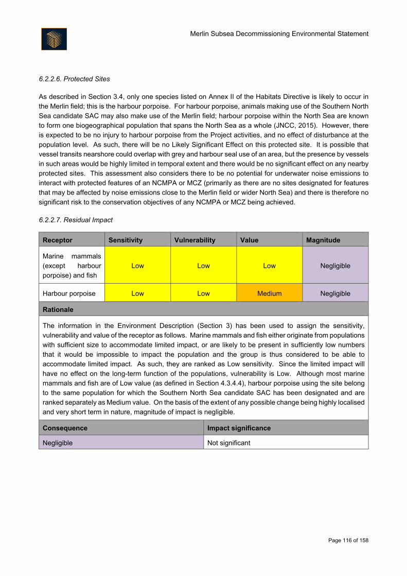
Merlin Subsea Decommissioning Environmental Statement
Page 116 of 158
6.2.2.6. Protected Sites
As described in Section 3.4, only one species listed on Annex II of the Habitats Directive is likely to occur in
the Merlin field; this is the harbour porpoise. For harbour porpoise, animals making use of the Southern North
Sea candidate SAC may also make use of the Merlin field; harbour porpoise within the North Sea are known
to form one biogeographical population that spans the North Sea as a whole (JNCC, 2015). However, there
is expected to be no injury to harbour porpoise from the Project activities, and no effect of disturbance at the
population level. As such, there will be no Likely Significant Effect on this protected site. It is possible that
vessel transits nearshore could overlap with grey and harbour seal use of an area, but the presence by vessels
in such areas would be highly limited in temporal extent and there would be no significant effect on any nearby
protected sites. This assessment also considers there to be no potential for underwater noise emissions to
interact with protected features of an NCMPA or MCZ (primarily as there are no sites designated for features
that may be affected by noise emissions close to the Merlin field or wider North Sea) and there is therefore no
significant risk to the conservation objectives of any NCMPA or MCZ being achieved.
6.2.2.7. Residual Impact
Receptor Sensitivity Vulnerability Value Magnitude
Marine mammals
(except harbour
porpoise) and fish
Low Low Low Negligible
Harbour porpoise Low Low Medium Negligible
Rationale
The information in the Environment Description (Section 3) has been used to assign the sensitivity,
vulnerability and value of the receptor as follows. Marine mammals and fish either originate from populations
with sufficient size to accommodate limited impact, or are likely to be present in sufficiently low numbers
that it would be impossible to impact the population and the group is thus considered to be able to
accommodate limited impact. As such, they are ranked as Low sensitivity. Since the limited impact will
have no effect on the long-term function of the populations, vulnerability is Low. Although most marine
mammals and fish are of Low value (as defined in Section 4.3.4.4), harbour porpoise using the site belong
to the same population for which the Southern North Sea candidate SAC has been designated and are
ranked separately as Medium value. On the basis of the extent of any possible change being highly localised
and very short term in nature, magnitude of impact is negligible.
Consequence Impact significance
Negligible Not significant
Merlin Subsea Decommissioning Environmental Statement
Page 117 of 158
Other Sea Users
6.2.3.1. Introduction
The Merlin decommissioning activities have the potential to impact upon other users of the sea. This may
happen during the decommissioning activities themselves, when vessels working in the field and transiting to
shore occupy space, and after decommissioning should any infrastructure decommissioned in situ interact
with activities such as fishing.
6.2.3.2. Description and Quantification of Impact
Increased vessel traffic leading to temporary exclusion from sea area
The temporary physical presence of Project vessels has the potential to interfere with other sea users that may
be present in the area. Vessels will be required intermittently over approximately four months for a duration
of approximately 80 days (Section 2.3.1). Once decommissioning activities are complete, vessel traffic
associated with the Merlin field will cease, except for limited vessel requirements to fulfil post-decommissioning
monitoring requirements. Therefore, once the removal/decommissioning in situ activities are complete, vessel
traffic will be much reduced compared to current levels.
Snagging risk and long-term exclusion from the Merlin field area
The Marine Accident Investigation Branch shows there have been 15 sinkings resulting from snagged fishing
gear between 1989 and 2014, resulting in 26 fatalities (Anatec, 2017). Once decommissioning activities have
been completed at the Merlin field, although most infrastructure will be removed, there remains the potential
for fishing gear to snag on infrastructure that has been decommissioned in situ; this is limited to the 8"
production pipeline, 3" umbilical and umbilical riser. However, the production pipeline and umbilical are
currently trenched and buried by rockdump and will see further small volumes of rock (at the ends of the current
rockdump and at a small number of areas of low coverage) will ensure they remain inaccessible to fishing
gear. Appropriate monitoring and remediation will take place to ensure that the two lines remain suitably
buried. The rockdump is currently appropriately graded to allow fishing gear to trawl across it without snagging.
As such, the decommissioning in situ of these lines presents no long-term snag risk. The umbilical riser piece
that is decommissioned in situ will sit within the J-tube of the Dunlin Alpha platform; it will therefore be
inaccessible to fisheries and thus pose no snag risk (note that the decommissioning of the Dunlin Alpha
platform will be considered as part of a separate CA and EIA process).
There is the potential for the loss of objects during decommissioning activities. Depending on size, dropped
objects may present a hazard to fishing activities. Should objects pose a snag hazard and it should they not
be recovered, it is possible that fisheries will not make use of the re-opened areas, resulting in continued, long-
term exclusion from the Merlin field area (but see mitigation measures in Section 6.2.3.3 for proposed recovery
strategy).
The current 500 m exclusion zone in place for fishermen at the Merlin field will be removed. This will allow
access to areas which fishermen have previously been excluded. However, there is a risk, albeit low, that if
trawl nets were used over the drill cuttings pile that the gear could dredge up cuttings, potentially tainting fish
within the net. As it will be important for the fishermen to avoid tainting their catch, it is assumed that fishermen
will avoid the drill cuttings pile and, in effect, fishing would be excluded from this small area. In the context of
the return of the 500 m zone to fishing, this would mean that less than 1% would remain inaccessible. It is
Merlin Subsea Decommissioning Environmental Statement
Page 118 of 158
also important to note that the hydrocarbon content of the cuttings pile will decline over time; Fugro (2017)
estimate between approximately 0.14 and 0.36 tonnes of hydrocarbon will leach out annually. As each year
passes, the hydrocarbon content of the cuttings pile will decline and the potential for impact on fisheries will
also decline.
6.2.3.3. Mitigation Measures
A number of mitigation measures will be employed to reduce the impact on other sea users:
During decommissioning the number of vessels and length of time required on site will be reduced as
far as practicable through careful planning of the decommissioning activities and information on the
location of vessel operations will be communicated to other sea users through the standard
communication channels including Kingfisher, Notice to Mariners and Radio Navigation Warnings (as
appropriate);
The Merlin subsea infrastructure is currently shown on Admiralty Charts and the Fishsafe system.
Once decommissioning activities are complete, updated information on the Merlin subsea area (i.e.
which infrastructure remains in situ and which has been removed) will be made available to allow the
Admiralty Charts and the Fishsafe system to be updated;
The limited infrastructure decommissioned in situ will be buried to a sufficient depth and any exposed
areas and cut ends will undergo additional rockdumping;
Any objects dropped during decommissioning activities will be removed from the seabed as
appropriate;
A post-decommissioning survey will identify any debris on the seabed within 100 m of any
infrastructure left in situ. An ROV support vessel may be deployed to recover large items of oilfield
debris whilst chain mats are likely to be deployed to clear smaller items of oilfield debris;
The post-decommissioning survey will confirm the depth to which the in situ decommissioned
infrastructure is buried below the seabed as appropriate. Environmental samples will be acquired to
characterise the condition of the sediment chemistry and macrobenthos when decommissioning is
complete;
An appropriate vessel will be engaged to carry out overtrawls to verify that the seabed has been left in a condition that does not present a hazard to commercial fishing. Final decommissioning activities will be considered to be complete subject to certification of seabed clearance by the SFF (or a similarly qualified body) and acceptance of the Decommissioning Close-out Report by BEIS. The 500 m safety zone around Merlin will then be removed; and
Fairfield recognises its commitment to monitor any structures decommissioned in situ and therefore
intends to set up arrangements to undertake post-decommissioning monitoring on behalf of the
Licence Owners. The frequency of the monitoring that will be required will be agreed with BEIS and
future monitoring will be determined through a risk-based approach based on the findings from each
subsequent survey. During the period over which monitoring is required, the status of the
infrastructure decommissioned in situ would be reviewed and any necessary remedial action
undertaken to ensure it does not pose a risk to other sea users.
Merlin Subsea Decommissioning Environmental Statement
Page 119 of 158
6.2.3.4. Cumulative Impact Assessment
Fishing effort in the vicinity of the Merlin field is considered low to moderate compared to the wider are of the
North Sea shown in Figure 3.15, with a peak of 11 vessels a day using the area. Considerably more effort is
focused elsewhere across the wider Northern North Sea, specifically targeting Nephrops grounds in the Fladen
Ground. Baseline fishing activity analysis undertaken by Anatec (2017) indicates that there are demersal
fishing vessels within 10 nm of the Greater Dunlin Area only once every two days, and that there are only, on
average, approximately 0.3 crossings of infrastructure per day in the Greater Dunlin Area (109 crossings in
the period July 2015 – June 2016). Considered alongside the relatively low levels of shipping activity in the
vicinity of the Merlin field, the wide expanse of water available to navigate in and the limited number of vessels
to be deployed for the Project, it is not anticipated that there will be any significant cumulative impacts with
respect to temporary use of the sea area by decommissioning vessels.
As all infrastructure will either be removed or decommissioned in situ in an overtrawlable condition, as the drill
cuttings represent such a small area, and as monitoring will be conducted to ensure the decommissioned in
situ infrastructure remains overtrawlable, there is expected to be no cumulative impact (with regards exclusion
from areas) with other structures decommissioned as part of the Subsea Infrastructure Decommissioning
Project, or indeed with other North Sea decommissioning projects.
In terms of the scale of the decommissioning activities with regards to other sea users, there are estimated to
be 457 safety zones in the central and northern North Sea on the UKCS (UKOilAndGasData, 2016). Since
the decommissioning of the Merlin field will see the removal of the Merlin safety zone, approximately 0.79 km2
of the total of approximately 360 km2 sea area occupied will be returned as navigable waters of the North Sea.
This will assist in reducing the areas of the North Sea currently unavailable to other sea users and thus in
reducing the potential for cumulative impact from decommissioning of North Sea structures.
6.2.3.5. Transboundary Impact Assessment
As the Merlin field is beyond the UK’s 12 nm limit, EU and non-EU vessels are also permitted to fish in the
area, subject to management agreements including, for example, quota allocation and days at sea. Anatec
(2017) report vessels of Norwegian origin to be present in the Greater Dunlin Area (up to 50% of vessels). Of
the demersal trawlers actively fishing in the study area, 38% were of Norwegian origin. It was also shown that
the majority (64%) of vessels crossing the subsea infrastructure were of Norwegian origin with an average of
0.18 subsea infrastructure crossings occurring each day by Norwegian vessels (Anatec, 2017). Despite this,
the vessel presence is still regarded as relatively low, and combined with the removal of much of the
infrastructure and the overtrawlable nature of the infrastructure that is decommissioned in situ, there is no
mechanism by which significant transboundary impacts could occur.
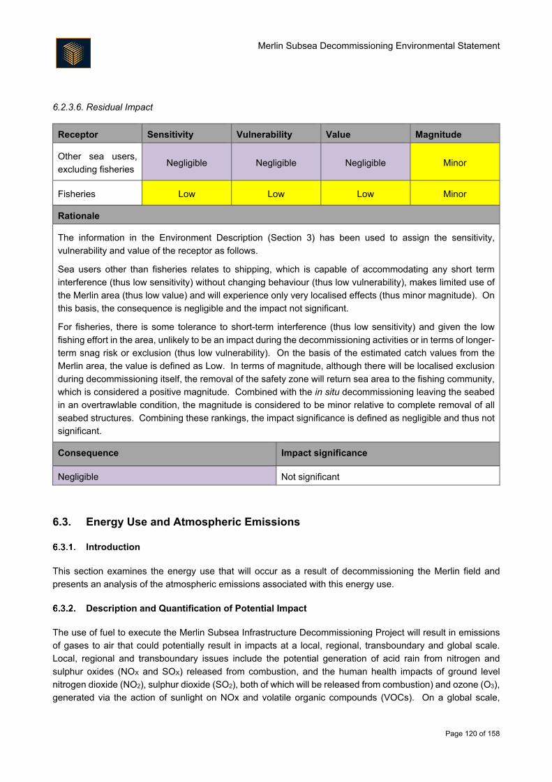
Merlin Subsea Decommissioning Environmental Statement
Page 120 of 158
6.2.3.6. Residual Impact
Receptor Sensitivity Vulnerability Value Magnitude
Other sea users,
excluding fisheries Negligible Negligible Negligible Minor
Fisheries Low Low Low Minor
Rationale
The information in the Environment Description (Section 3) has been used to assign the sensitivity,
vulnerability and value of the receptor as follows.
Sea users other than fisheries relates to shipping, which is capable of accommodating any short term
interference (thus low sensitivity) without changing behaviour (thus low vulnerability), makes limited use of
the Merlin area (thus low value) and will experience only very localised effects (thus minor magnitude). On
this basis, the consequence is negligible and the impact not significant.
For fisheries, there is some tolerance to short-term interference (thus low sensitivity) and given the low
fishing effort in the area, unlikely to be an impact during the decommissioning activities or in terms of longer-
term snag risk or exclusion (thus low vulnerability). On the basis of the estimated catch values from the
Merlin area, the value is defined as Low. In terms of magnitude, although there will be localised exclusion
during decommissioning itself, the removal of the safety zone will return sea area to the fishing community,
which is considered a positive magnitude. Combined with the in situ decommissioning leaving the seabed
in an overtrawlable condition, the magnitude is considered to be minor relative to complete removal of all
seabed structures. Combining these rankings, the impact significance is defined as negligible and thus not
significant.
Consequence Impact significance
Negligible Not significant
6.3. Energy Use and Atmospheric Emissions
Introduction
This section examines the energy use that will occur as a result of decommissioning the Merlin field and
presents an analysis of the atmospheric emissions associated with this energy use.
Description and Quantification of Potential Impact
The use of fuel to execute the Merlin Subsea Infrastructure Decommissioning Project will result in emissions
of gases to air that could potentially result in impacts at a local, regional, transboundary and global scale.
Local, regional and transboundary issues include the potential generation of acid rain from nitrogen and
sulphur oxides (NOX and SOX) released from combustion, and the human health impacts of ground level
nitrogen dioxide (NO2), sulphur dioxide (SO2), both of which will be released from combustion) and ozone (O3),
generated via the action of sunlight on NOx and volatile organic compounds (VOCs). On a global scale,
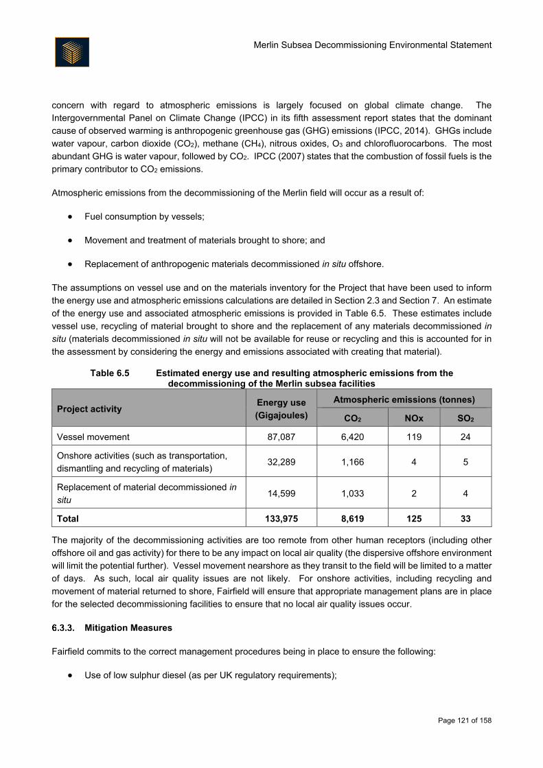
Merlin Subsea Decommissioning Environmental Statement
Page 121 of 158
concern with regard to atmospheric emissions is largely focused on global climate change. The
Intergovernmental Panel on Climate Change (IPCC) in its fifth assessment report states that the dominant
cause of observed warming is anthropogenic greenhouse gas (GHG) emissions (IPCC, 2014). GHGs include
water vapour, carbon dioxide (CO2), methane (CH4), nitrous oxides, O3 and chlorofluorocarbons. The most
abundant GHG is water vapour, followed by CO2. IPCC (2007) states that the combustion of fossil fuels is the
primary contributor to CO2 emissions.
Atmospheric emissions from the decommissioning of the Merlin field will occur as a result of:
Fuel consumption by vessels;
Movement and treatment of materials brought to shore; and
Replacement of anthropogenic materials decommissioned in situ offshore.
The assumptions on vessel use and on the materials inventory for the Project that have been used to inform
the energy use and atmospheric emissions calculations are detailed in Section 2.3 and Section 7. An estimate
of the energy use and associated atmospheric emissions is provided in Table 6.5. These estimates include
vessel use, recycling of material brought to shore and the replacement of any materials decommissioned in
situ (materials decommissioned in situ will not be available for reuse or recycling and this is accounted for in
the assessment by considering the energy and emissions associated with creating that material).
Table 6.5 Estimated energy use and resulting atmospheric emissions from the decommissioning of the Merlin subsea facilities
Project activity Energy use
(Gigajoules)
Atmospheric emissions (tonnes)
CO2 NOx SO2
Vessel movement 87,087 6,420 119 24
Onshore activities (such as transportation,
dismantling and recycling of materials) 32,289 1,166 4 5
Replacement of material decommissioned in
situ 14,599 1,033 2 4
Total 133,975 8,619 125 33
The majority of the decommissioning activities are too remote from other human receptors (including other
offshore oil and gas activity) for there to be any impact on local air quality (the dispersive offshore environment
will limit the potential further). Vessel movement nearshore as they transit to the field will be limited to a matter
of days. As such, local air quality issues are not likely. For onshore activities, including recycling and
movement of material returned to shore, Fairfield will ensure that appropriate management plans are in place
for the selected decommissioning facilities to ensure that no local air quality issues occur.
Mitigation Measures
Fairfield commits to the correct management procedures being in place to ensure the following:
Use of low sulphur diesel (as per UK regulatory requirements);
Merlin Subsea Decommissioning Environmental Statement
Page 122 of 158
Operations carefully planned to reduce vessel numbers and the duration of operations;
All vessels comply with the Merchant Shipping (Prevention of Air Pollution from Ships) (Amendment)
Regulations 2014;
All vessels have the appropriate UK Air Pollution Prevention or International Air Pollution Prevention
certificates in place as required; and
Onshore facilities have appropriate management procedures in place to ensure that atmospheric
emissions, including those from movement of materials, are below levels that could affect local air
quality.
Where a dismantling yard is selected that is outside of the UK, Fairfield will ensure the adoption of any control
measures for atmospheric emissions that exist in the selected country.
Cumulative Impact Assessment
6.3.4.1. Local Air Quality
The vast majority of the decommissioning activities are too remote from other industrial activities (including
other offshore oil and gas activity) for there to be any likely cumulative effects in terms of local air quality.
Whilst there may be an increase in emissions nearshore or onshore, the additional potential emissions are
sufficiently low that no cumulative impact on local air quality is expected.
6.3.4.2. Global Climate
The issue of atmospheric emissions in terms of global climate is a specifically cumulative one. To understand
the potential impact from the atmospheric emissions associated with the Project, it is useful to set the emissions
in the context of wider UK emissions. Whilst, an exact figure for offshore emissions in UK waters does not
exist, the contribution of emissions from shipping activities can be summed with oil and gas industry emissions
to provide a benchmark against which the Project can be considered. The latest available total annual CO2
emissions from oil and gas activity on the UKCS is estimated at 13,232,726 tonnes (for 2015, OGUK, 2016a)
and the latest total annual CO2 emissions estimate for UK shipping is approximately 11,000,000 tonnes (for
2013, DECC, 2015, cited in Committee on Climate Change, 2015), giving a total of 24,232,726 tonnes of CO2.
The total CO2 emissions from the decommissioning activities at the Merlin field are estimated to be
approximately 8,619 tonnes. This increases to 38,902 tonnes when combined with the estimated figures for
Osprey and Dunlin to give a total CO2 figure for the Subsea Infrastructure Decommissioning Project. This will
represent approximately 0.16% of the atmospheric emissions associated with UK offshore shipping and oil
and gas activities. The emissions from the Project will thus likely have a limited cumulative effect in the context
of the release of GHGs into the environment and their contribution to global climate change.
Emissions figures for the last full year of operation of the Dunlin Alpha platform (which processed produced
hydrocarbons from Dunlin, as well as Merlin and Osprey) showed 83,392 tonnes of CO2 were emitted (this
does not include supply vessel activity). The decommissioning operations from the Merlin field will emit
approximately 8,619 tonnes of CO2 and the Subsea Infrastructure Decommissioning Project as a whole will
release 38,902 tonnes of CO2. Although these emissions will add CO2 to the atmosphere that would otherwise
not be emitted should the Subsea Infrastructure Decommissioning Project not have been pursued, they are
also emitted in the context of the cessation of operational emissions from the Greater Dunlin Area itself. On
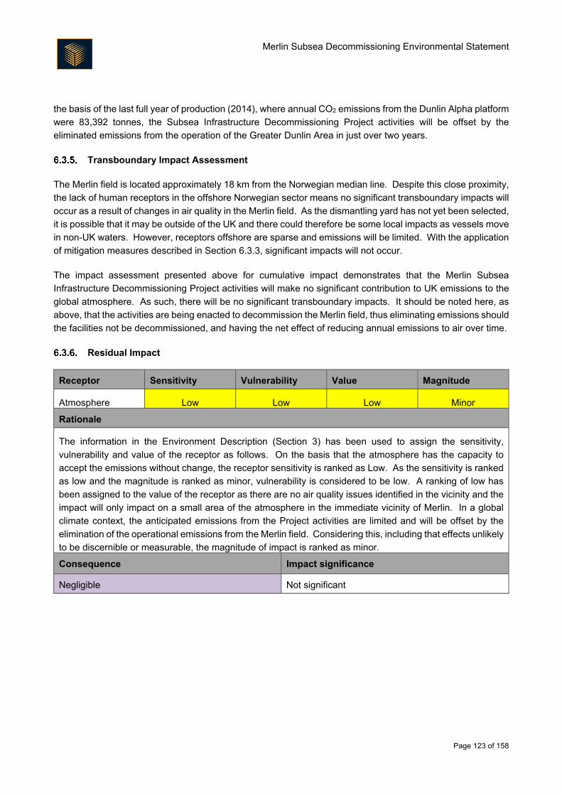
Merlin Subsea Decommissioning Environmental Statement
Page 123 of 158
the basis of the last full year of production (2014), where annual CO2 emissions from the Dunlin Alpha platform
were 83,392 tonnes, the Subsea Infrastructure Decommissioning Project activities will be offset by the
eliminated emissions from the operation of the Greater Dunlin Area in just over two years.
Transboundary Impact Assessment
The Merlin field is located approximately 18 km from the Norwegian median line. Despite this close proximity,
the lack of human receptors in the offshore Norwegian sector means no significant transboundary impacts will
occur as a result of changes in air quality in the Merlin field. As the dismantling yard has not yet been selected,
it is possible that it may be outside of the UK and there could therefore be some local impacts as vessels move
in non-UK waters. However, receptors offshore are sparse and emissions will be limited. With the application
of mitigation measures described in Section 6.3.3, significant impacts will not occur.
The impact assessment presented above for cumulative impact demonstrates that the Merlin Subsea
Infrastructure Decommissioning Project activities will make no significant contribution to UK emissions to the
global atmosphere. As such, there will be no significant transboundary impacts. It should be noted here, as
above, that the activities are being enacted to decommission the Merlin field, thus eliminating emissions should
the facilities not be decommissioned, and having the net effect of reducing annual emissions to air over time.
Residual Impact
Receptor Sensitivity Vulnerability Value Magnitude
Atmosphere Low Low Low Minor
Rationale
The information in the Environment Description (Section 3) has been used to assign the sensitivity,
vulnerability and value of the receptor as follows. On the basis that the atmosphere has the capacity to
accept the emissions without change, the receptor sensitivity is ranked as Low. As the sensitivity is ranked
as low and the magnitude is ranked as minor, vulnerability is considered to be low. A ranking of low has
been assigned to the value of the receptor as there are no air quality issues identified in the vicinity and the
impact will only impact on a small area of the atmosphere in the immediate vicinity of Merlin. In a global
climate context, the anticipated emissions from the Project activities are limited and will be offset by the
elimination of the operational emissions from the Merlin field. Considering this, including that effects unlikely
to be discernible or measurable, the magnitude of impact is ranked as minor.
Consequence Impact significance
Negligible Not significant
Merlin Subsea Decommissioning Environmental Statement
Page 124 of 158
6.4. Accidental Events
Introduction
The potential impact of any accidental hydrocarbon or chemical release will be determined by the chemical
characteristics of the release (including weathering potential), the circumstances and volume of the release,
the environmental conditions at the time, the direction of travel of the release and the presence of
environmental sensitivities in the path of the release. These environmental sensitivities will have spatial and
temporal variations. Therefore, the likelihood of any accidental release having a potential impact on the
environment must consider the likelihood of the release occurring against the probability of that hydrocarbon
or chemical reaching a sensitive area and the environmental sensitivities present in that area at the time of
hydrocarbon or chemical release.
Description and Quantification of Potential Impact
6.4.2.1. Sources and Likelihood of Occurrence
Potential sources of accidental releases were reviewed during the ENVID and scoping process and the
following were identified:
Dropped object causing pipeline rupture;
Accidental release at onshore decommissioning facilities; and
Accidental release from a vessel.
The Merlin production lines have been flushed of residual hydrocarbons and the main umbilicals will be flushed
of chemicals prior to starting the activities described in this EIA. The umbilical jumpers described in Table 2.4
will have some limited chemical and hydraulic oil inventory at the time of decommissioning and there is the
potential that a dropped object could trigger a release of the contents. However, it is likely that the maximum
volume of chemical or hydraulic oil in any one core would be limited to a maximum of tens of litres. Additionally,
in general the contents of the cores are chemicals which pose limited potential for environmental impact (e.g.
methanol). Given the limited inventory in the field, and the limited lengths of the lines that will contain residual
chemicals and hydraulic oil, it is considered extremely unlikely that there could be an accidental release of any
significant volume and these potential events are therefore not discussed further within this impact
assessment.
The only other chemicals expected to be present on the decommissioning vessels are small volumes
associated with general vessel operations and in the recovered jumpers. There are not expected to be any
bulk chemicals present (such as might be expected for drilling or workover operations). As such, chemicals
are not expected to be present in sufficient quantities to result in a significant environmental impact. Chemical
releases have therefore been excluded from further assessment.
As noted in Section 7, there are limited inventories of chemicals or hydrocarbons being returned to shore and
thus unplanned releases with the potential to result in significant impact onshore are scoped out of further
assessment.
Accidental release of hydrocarbons from a vessel is therefore the only accidental event given further
consideration in this impact assessment.
Merlin Subsea Decommissioning Environmental Statement
Page 125 of 158
6.4.2.2. Accidental Release from a Vessel
Potential sources of accidental releases from vessel operations include:
Release of fuel during bunkering operations whilst the vessel is in port;
Release of hydraulic oils from ROV or tools; and
Release of fuel inventory (e.g., as a result of collision, grounding or fire).
Release of fuel during bunkering operations in port, if it were to occur, would be likely to be observed quickly,
with spill response procedures initiated to stop the release and mitigate the impacts. Any hydraulic oil release
during operations (such as ROV or tool use) would be likely to comprise a small volume of hydrocarbons which
would not have the capacity to result in environmental impact in an open sea situation. Release of a vessel
fuel inventory is therefore considered to be scenario of greatest concern and is thus considered in more detail
below.
The likelihood of a vessel fuel inventory release is dependent on several factors including the seaworthiness
of the vessel, the quality of vessel procedures, adherence to those procedures, sea conditions, water depth
and density of shipping in the area. The vessels used for the Merlin operations will undergo auditing to ensure
seaworthiness and quality of procedures as detailed in the mitigation measures in Section 6.4.3. The Merlin
site is in deep water, excluding the possibility of grounding, and vessel activity is low, reducing the possibility
of a collision between vessels.
6.4.2.3. Behaviour of Hydrocarbons at Sea
Fairfield has commissioned modelling of the instantaneous release of the entire fuel inventory of a vessel
operating at the Dunlin Alpha platform to inform the Subsea Infrastructure Decommissioning Project. The
scenario parameters are presented in Table 6.6, Table 6.7 and Table 6.8. The results of the modelling are
summarised in Table 6.9.
Stochastic modelling indicated that a release of 3,500 m3 of fuel at the Dunlin Alpha platform would result in a
small area of visible surface oiling. The probability of surface oiling exceeding 0.3 µm is illustrated in Figure
6.2. The 0.3 µm threshold is the thickness above which an iridescent (rainbow coloured) sheen is visible. As
shown in Figure 6.2 and Table 6.9, there is a maximum 10 – 20% probability that a sheen exceeding 0.3 µm
will cross the UK/Norway transboundary line. There is zero probability of the fuel arriving to a UK shoreline
during six months of the year and very low probability in the other six months (between 1 and 5%).
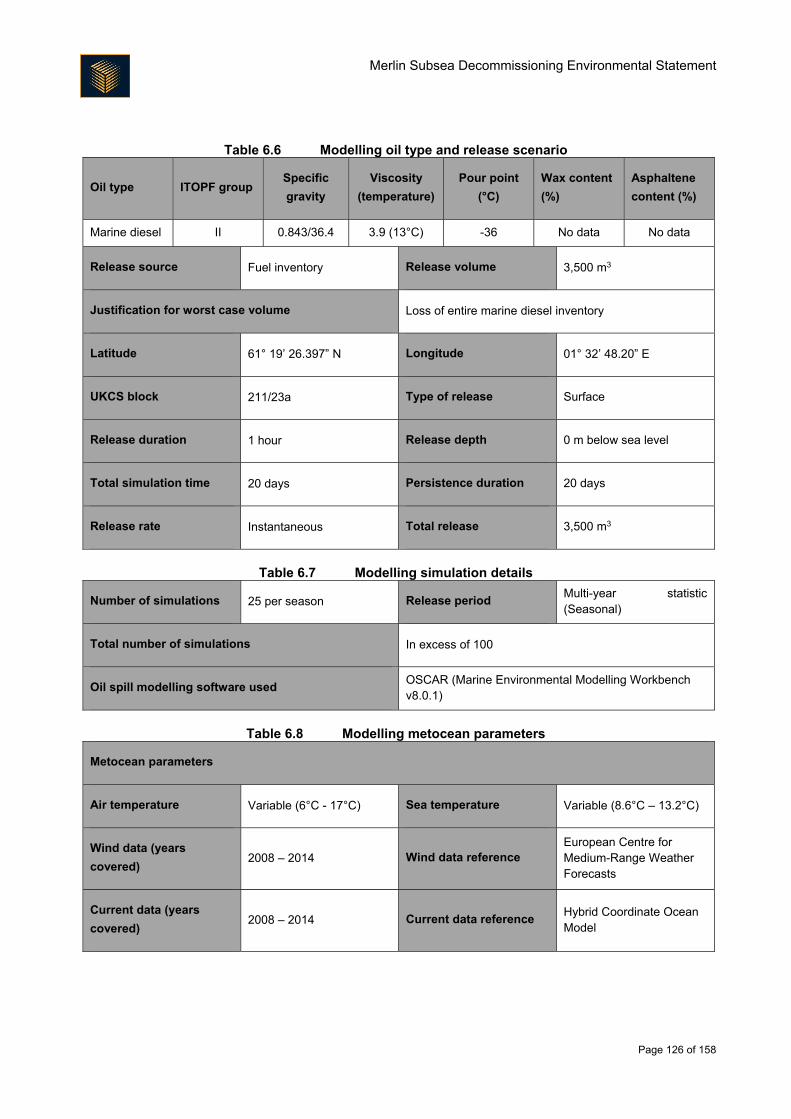
Merlin Subsea Decommissioning Environmental Statement
Page 126 of 158
Table 6.6 Modelling oil type and release scenario
Oil type ITOPF group Specific
gravity
Viscosity
(temperature)
Pour point
(°C)
Wax content
(%)
Asphaltene
content (%)
Marine diesel II 0.843/36.4 3.9 (13°C) -36 No data No data
Release source Fuel inventory Release volume 3,500 m3
Justification for worst case volume Loss of entire marine diesel inventory
Latitude 61° 19’ 26.397” N Longitude 01° 32’ 48.20” E
UKCS block 211/23a Type of release Surface
Release duration 1 hour Release depth 0 m below sea level
Total simulation time 20 days Persistence duration 20 days
Release rate Instantaneous Total release 3,500 m3
Table 6.7 Modelling simulation details
Number of simulations 25 per season Release period Multi-year statistic (Seasonal)
Total number of simulations In excess of 100
Oil spill modelling software used OSCAR (Marine Environmental Modelling Workbench v8.0.1)
Table 6.8 Modelling metocean parameters
Metocean parameters
Air temperature Variable (6°C - 17°C) Sea temperature Variable (8.6°C – 13.2°C)
Wind data (years
covered) 2008 – 2014 Wind data reference
European Centre for Medium-Range Weather Forecasts
Current data (years
covered) 2008 – 2014 Current data reference
Hybrid Coordinate Ocean Model
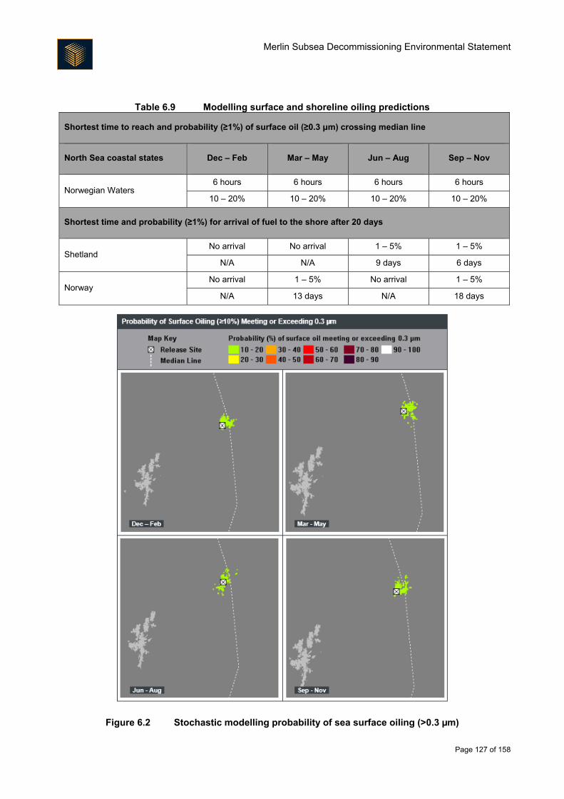
Merlin Subsea Decommissioning Environmental Statement
Page 127 of 158
Table 6.9 Modelling surface and shoreline oiling predictions
Shortest time to reach and probability (≥1%) of surface oil (≥0.3 μm) crossing median line
North Sea coastal states Dec – Feb Mar – May Jun – Aug Sep – Nov
Norwegian Waters 6 hours 6 hours 6 hours 6 hours
10 – 20% 10 – 20% 10 – 20% 10 – 20%
Shortest time and probability (≥1%) for arrival of fuel to the shore after 20 days
Shetland No arrival No arrival 1 – 5% 1 – 5%
N/A N/A 9 days 6 days
Norway No arrival 1 – 5% No arrival 1 – 5%
N/A 13 days N/A 18 days
Figure 6.2 Stochastic modelling probability of sea surface oiling (>0.3 µm)
Merlin Subsea Decommissioning Environmental Statement
Page 128 of 158
6.4.2.4. Environmental Vulnerability to Accidental Releases
Environmental vulnerability is a function of both the likelihood of impact (as considered in previous sections)
and the sensitivity of the environment. Offshore and coastal vulnerabilities need to be considered separately
as different parameters will apply.
There may be impacts on plankton in the immediate area of the release for the duration of the release due to
the dissolution of aromatic fractions into the water column (Brussaard et al., 2016). Such effects will be greater
during a period of plankton bloom and during fish spawning periods. Contamination of marine prey including
plankton and small fish species may then lead to aromatic hydrocarbons accumulating in the food chain. These
could have long-term chronic effects such as breeding failure in fish, bird and cetacean populations. This may
affect stocks of commercially fished species. The relatively small size of any release in comparison to the
available habitat and the widespread populations of plankton and small fish is expected to limit the significance
of these impacts.
Juveniles and eggs are potentially the fish life-stages most vulnerable to hydrocarbon releases. As outlined
in Section 3.3.2.2, a number of commercially important pelagic and demersal fish species are found in the
vicinity of the Merlin field. Eleven species are expected to use the project area for spawning and/or nursery
grounds at various times of the year. However, any accidental release is not expected to result in significant
impacts on fish spawning or recruitment success as the maximum release volume is small and the available
spawning and nursery areas are very large.
In a nature conservation context, seabirds are the group at greatest risk of harm due to surface oil pollution in
the offshore environment (JNCC, 2011). The most familiar effect of oil pollution on seabirds is the
contamination of plumage, resulting in the inability to fly and loss of insulation and waterproofing, which alone
may cause death. Individuals surviving these primary impacts are prone to ingest toxins whilst preening in
attempts to remove contamination; this may result in secondary toxic effects.
The seasonal vulnerability of seabirds to surface pollutants in the immediate vicinity of the Merlin field, derived
from JNCC block-specific data, suggest that seabirds in this area have a low vulnerability to surface pollution,
although some of the blocks exhibit high vulnerability at certain times of the year (see Section 3.3.4). The
magnitude of any impact will depend on the number of birds present, the percentage of the population present,
their vulnerability to hydrocarbons and their recovery rates from oil pollution. Modelling suggests that the area
of sea surface contaminated by hydrocarbons in the event of a spill will be small, with a low (10 – 20%)
probability of a surface sheen exceeding 0.3 µm extending outside of the Project area.
Cetaceans are also present in the vicinity of the Merlin subsea decommissioning area (see Section 3.3.5).
The potential impact of an accidental release will depend on the species and their feeding habits, the overall
health of individuals before exposure, and the characteristics of the hydrocarbons. Baleen whales are
particularly vulnerable whilst feeding, as oil may adhere to the baleen if the whales feed near surface slicks
(Gubbay and Earll, 2000). Cetaceans are pelagic (move freely in the oceans) and migrate. Their strong
attraction to specific areas for breeding or feeding may override any tendency cetaceans have to avoid
hydrocarbon contaminated areas (Gubbay and Earll, 2000). It is considered unlikely that a population of
cetaceans in the open sea would be affected in the long-term.
The likelihood of an accidental hydrocarbon release impacting the coastal environment is a function of the
likelihood of such an event occurring and the probability of the hydrocarbon beaching. The level of impact is
also directly related to the volume of the hydrocarbons released, the volume of hydrocarbon beaching, the
Merlin Subsea Decommissioning Environmental Statement
Page 129 of 158
composition of the beached hydrocarbons, and the type of beach and receptors present on the shore at the
time of beaching. Based on the available modelling of the fuel inventory being released at the Dunlin Alpha
platform, it is considered highly unlikely that any vessel inventory release at the Merlin site would reach a UK
shoreline (zero probability for six months of the year and between 1 and 5% for the other six months).
Mitigation Measures
The following provides an overview of proposed measures that either reduce the probability of an accidental
release, or reduce the consequences:
All accessible Merlin infrastructure will be flushed of hydrocarbons prior to starting decommissioning
operations;
Vessels will be selected which comply with International Maritime Organisation (IMO)/Maritime and
Coastguard Agency (MCA) codes for prevention of oil pollution;
Vessel pre-mobilisation audits will be carried out and will cover:
o Review of spill prevention and response procedures;
o Procedural controls;
o Bunkering and storage arrangements;
o Vessel condition certificates;
o Vessel maintenance records;
o Evidence of crew competency; and
o Certification of equipment.
Vessel personnel will be given full training (by Fairfield or the contractor(s) as appropriate) in chemical
release prevention and actions to be taken in the event of an accidental chemical release;
Operational procedures onboard vessels will include use of drip trays under valves, use of pumps to
decant lubricating oils and use of lockable valves on storage tanks and drums;
Shipboard Oil Pollution Emergency Plans (SOPEPs) including modelling and appropriate response
planning will be in place where appropriate;
The Dunlin Alpha Oil Pollution Emergency Plan, which includes both the Merlin and Osprey fields , will
be adhered to within the Merlin 500 m safety exclusion zone;
AIS and other navigation controls will be used to reduce collision risk;
Simultaneous operations (SIMOPs) will be actively identified and managed;
Hoses and connections will be visually inspected prior to use; and
Merlin Subsea Decommissioning Environmental Statement
Page 130 of 158
Tool box talks will highlight the importance of minimising the likelihood of an accidental release occurring.
Cumulative Impact Assessment
It is important to consider the potential for cumulative impacts to arise from accidental events generated by the
Project acting in conjunction with accidental events generated by other projects or activities occurring in the
area.
Decommissioning of the Osprey production and water injection clusters, the Dunlin subsea infrastructure and
the Dunlin Alpha platform will overlap temporally and geographically with the decommissioning activities at
Merlin. The overlapping execution of these projects will result in higher than normal vessel densities in the
area, increasing the risk of a vessel collision (two moving objects striking each other) or allision (a moving
object striking a stationary object). Mitigation measures, including identification and management of SIMOPS
and use of AIS, are considered to reduce this additional risk to as low as reasonably practicable (ALARP). An
alternative would be to conduct decommissioning operations consecutively instead of concurrently, however
it is considered that the increased cost associated with doing this would be grossly disproportionate to the
reduction of risk achieved.
Any accidental hydrocarbon release at the Merlin site is expected to dissipate within days. It is considered
very unlikely that additional accidental releases from other sources would occur in the same timeframe and
produce a cumulative impact.
Transboundary Impact Assessment
There is a low probability that an accidental hydrocarbon release in the Project area would cross into the
Norwegian sector. Modelling of a release at Dunlin Alpha suggested that the probability of a surface sheen
extending into Norwegian waters was no more than 10 – 20%. If released hydrocarbons did cross the
transboundary line the volumes would be small, with limited scope for environmental impact.
As outlined in Section 6.4.2.3, fuel released is not predicted to reach a Norwegian shore with a greater
probability than between 1 and 5% for six months of the year – there is zero probability of fuel arriving at shore
for the other six months. The maximum volume of fuel that could arrive at any shoreline is predicted to be
approximately 1% of that released.
In the event of an accidental hydrocarbon release entering Norwegian waters, it may be necessary to
implement the NORBRIT Agreement (the Norway-UK Joint Contingency Plan). The NORBRIT Agreement
sets out command and control procedures for pollution incidents likely to affect both parties, as well as
channels of communication and available resources. The MCA Counter Pollution and Response Branch also
have agreements with equivalent organisations in other North Sea coastal States, under the Bonn Agreement
1983.
Protected Sites
This section considers the potential for accidental events related to the Project to impact upon the conservation
objectives (and ultimately site integrity) of important protected sites, specifically SPAs, SACs, NCMPAs and
MCZs. The output of the accidental hydrocarbon release modelling described in Section 6.4.2.3 has been
Merlin Subsea Decommissioning Environmental Statement
Page 131 of 158
compared against the location of SPAs, SACs, NCMPAs and MCZs to determine where there is considered
to be the potential for interaction.
6.4.6.1. Direct Interaction with Coastal Sites
As outlined in Section 6.4.2.3, fuel released is not predicted to reach shore in the UK with a greater probability
than between 1 and 5% for six months of the year – there is zero probability of fuel arriving at shore for the
other six months. The maximum volume of fuel that could arrive at any shoreline is predicted to be
approximately 1% of that released. Considering the very low probability and the very low volumes involved,
direct interaction with any coastal or onshore protected sites is not expected.
6.4.6.2. Direct Interaction with Receptors from Coastal Sites found Offshore
In addition to direct interaction with a site (i.e. hydrocarbons crossing the boundary of a site), it is necessary
to acknowledge that qualifying features of some sites are mobile (e.g. seabirds and marine mammals) and that
some individuals may forage or move through the area within which an accidental release has occurred. In
terms of marine mammals for which sites are designated, as outlined in Section 3.4, the Southern North Sea
candidate SAC, for which harbour porpoise is the proposed qualifying feature, is located 640 km south of the
Merlin project area. Harbour porpoise are highly mobile, and records exist of individuals travelling over
1,000 km (JNCC, 2013b). It is not expected however that individuals associated with the Southern North Sea
candidate SAC will occur in the Project area in sufficient numbers during any limited period over which a
release would take to disperse to have a significant impact on the harbour porpoise population associated with
the candidate SAC.
Sites designated for bottlenose dolphin, harbour seal and grey seal are present along the east coast of
Scotland, however the distance of the sites from the project suggests no individuals from these sites will occur
in the Project area and they are therefore excluded from further assessment.
It would be very difficult to assign seabirds identified within the Merlin Project area to specific SPAs. For many
species, once breeding is complete, individuals are no longer restricted to foraging within certain distances
(i.e. foraging ranges) from their breeding colony as there is no longer any requirement to return to eggs or
chicks. Furness (2015) defines biologically appropriate, species-specific, geographic non-breeding season
population estimates for seabirds. For a number of key species there is strong evidence that once birds leave
the breeding colony they become widely dispersed over large distances, often intermingling with birds from
other breeding colonies (typically of the same species) and in some cases birds that have migrated from
overseas breeding colonies (Furness, 2015). Consequently, the potential for an accidental vessel inventory
release at Merlin to have population level impacts on birds from any single SPA is much reduced. Potential
impacts on birds from protected sites during the non-breeding season (i.e. when they are offshore) are
therefore expected to be negligible.
6.4.6.3. Direct Interaction with Offshore Sites
For direct interaction with offshore sites without a land component, surface occurrence of released
hydrocarbon within the site is taken as an indication that the site has the potential to be impacted. Modelling
suggested that in a fuel inventory release scenario, the probability of a surface sheen 0.3 µm thick extending
outside of the Project area would not exceed 10% and even then would not extend much beyond the Project
area (Figure 6.2). The closest protected site to the Project area is the Pobie Bank SCI, which is 94 km away
at the closest approach. This site is designated for seabed features that would be unaffected by a limited
Merlin Subsea Decommissioning Environmental Statement
Page 132 of 158
volume of fuel oil being present on the surface. It is therefore considered unlikely that there would be a
significant impact on any offshore protected sites.
6.4.6.4. Protected Species
There are several species that are known or expected to occur in the area which are protected but not
associated with a site designation. Potential impacts on these species are discussed below.
The ocean quahog is on the OSPAR list of threatened or declining species, and is a PMF. This species is
known to occur in the area at low densities as detailed in Section 3.4, although the area is not thought to be
particularly important for the species. Ocean quahog is a benthic species, and since the majority of any
released hydrocarbon is expected to remain at the surface it is considered unlikely that an accidental release
from a vessel at Merlin would have a significant impact on the ocean quahog population in the area.
Basking sharks, spurdog and blue shark are all on the IUCN red list; basking sharks are also protected under
the Wildlife and Countryside Act 1981 (as amended). All three species are expected to occur in the area,
although not in numbers that are important in a population context, especially for the limited period over which
a release would take to disperse. It is not expected that a release from a vessel at Merlin would have a
significant impact on any of these three species.
Residual Impact
Receptor Sensitivity Vulnerability Value Magnitude
Seabirds High Low Very high Minor
Rationale
The information in the Environment Description (Section 3) has been used to assign the sensitivity,
vulnerability and value of the receptor as follows.
The worst case accidental event during Merlin decommissioning operations is expected to be the release
of a vessel fuel inventory, expected to comprise a maximum of 3,500 m3 of fuel oil. Direct impacts may
occur in the event of a release, the most serious of which could be the oiling of seabirds at the surface.
Impacts are expected to be short-term and local, although there is a low probability of a localised
transboundary impact. The frequency of the impact is expected to be a one-off. The likelihood of a vessel
inventory release at Merlin is considered very low. The likelihood that seabirds will be in the area in high
numbers during the summer months when the vessels will be operating is high, although the number of
seabirds present is expected to be low during most months (especially so during the summer months when
they are breeding onshore and feeding nearshore). Taking all this into account, the impact magnitude is
expected to be minor.
Seabirds are especially sensitive to surface oil pollution as it affects both their ability to fly and the
effectiveness of their insulation. Receptor sensitivity is therefore expected to be high. It is however
considered unlikely that there will be sufficient seabirds affected by a release at Merlin to cause population-
level impacts, and receptor vulnerability is therefore considered to be low.
It is likely that seabirds from the coastal SPAs on Shetland as well as other protected sites will use the Merlin
area. In addition, the majority of species expected to use the Merlin site are protected under the Birds
Directive (2009/147/EC). The receptor value is therefore considered very high.
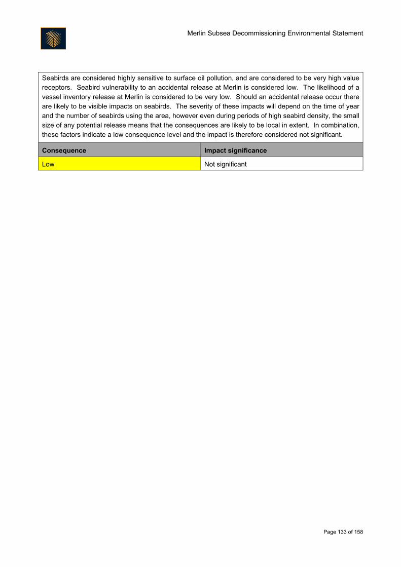
Merlin Subsea Decommissioning Environmental Statement
Page 133 of 158
Seabirds are considered highly sensitive to surface oil pollution, and are considered to be very high value
receptors. Seabird vulnerability to an accidental release at Merlin is considered low. The likelihood of a
vessel inventory release at Merlin is considered to be very low. Should an accidental release occur there
are likely to be visible impacts on seabirds. The severity of these impacts will depend on the time of year
and the number of seabirds using the area, however even during periods of high seabird density, the small
size of any potential release means that the consequences are likely to be local in extent. In combination,
these factors indicate a low consequence level and the impact is therefore considered not significant.
Consequence Impact significance
Low Not significant

Merlin Subsea Decommissioning Environmental Statement
Page 134 of 158
7. Waste
7.1. Introduction
The duty of care with regards to appropriate handling and disposal of waste rests with Fairfield. In order to
enable Fairfield to manage waste appropriately, it is necessary to first understand the types and sources of
waste. A description of the Merlin subsea facilities to be decommissioned is provided in Section 2.1 and a
summary of the types and quantities of materials associated with the Project is provided in Table 7.1.
Table 7.1 Merlin subsea material summary
Item Description Approximate weight (tonnes)
Metals
Ferrous (steel) 1,528
Non-ferrous (e.g. copper, aluminium, zinc,
indium) 6.7
Concrete Aggregates (mattresses, grout bags, sand
bags) 1,181
Plastic Rubbers, polymers 264
Hazardous
substances
Residual fluids (hydrocarbons, chemicals,
control fluid) 0.64
Naturally occurring radioactive material
(NORM) 5.7
Other Fibre optics 0.1
Total 2,986
Table 7.1 provides an estimate of the total weight of subsea materials associated with the Merlin Subsea
Decommissioning Programmes, including approximately 212 tonnes of steel associated with the removal of
Merlin wellheads.
Section 7.2 describes the regulatory control of waste material whilst Section 7.3 outlines the types and
quantities of materials to be decommissioned. Section 7.4 details the measures that will be in place to ensure
waste is appropriately managed. Although the focus of this ES is the Merlin Subsea Decommissioning
Infrastructure Project, it should be noted that waste operations for the Subsea Infrastructure Decommissioning
Project (Dunlin, Merlin and Osprey) will be managed as one.
7.2. Regulatory Control
The EU’s Revised Waste Framework Directive (Directive 2008/98/EC) was adopted in December 2008. The
aim of the directive is to ensure that waste management is carried out without endangering human health and
without harming the environment. Article 4 of the directive also states that the waste hierarchy shall be applied
as a priority order in waste prevention and management legislation and policy.
The Waste (Scotland) Regulations 2012 control the generation, transportation and disposal of waste within the
European Union and the shipment of waste into and out of the EU. It covers controlled waste, duty of care,
registration of carriers and brokers, waste management licensing, landfill, hazardous waste, producer
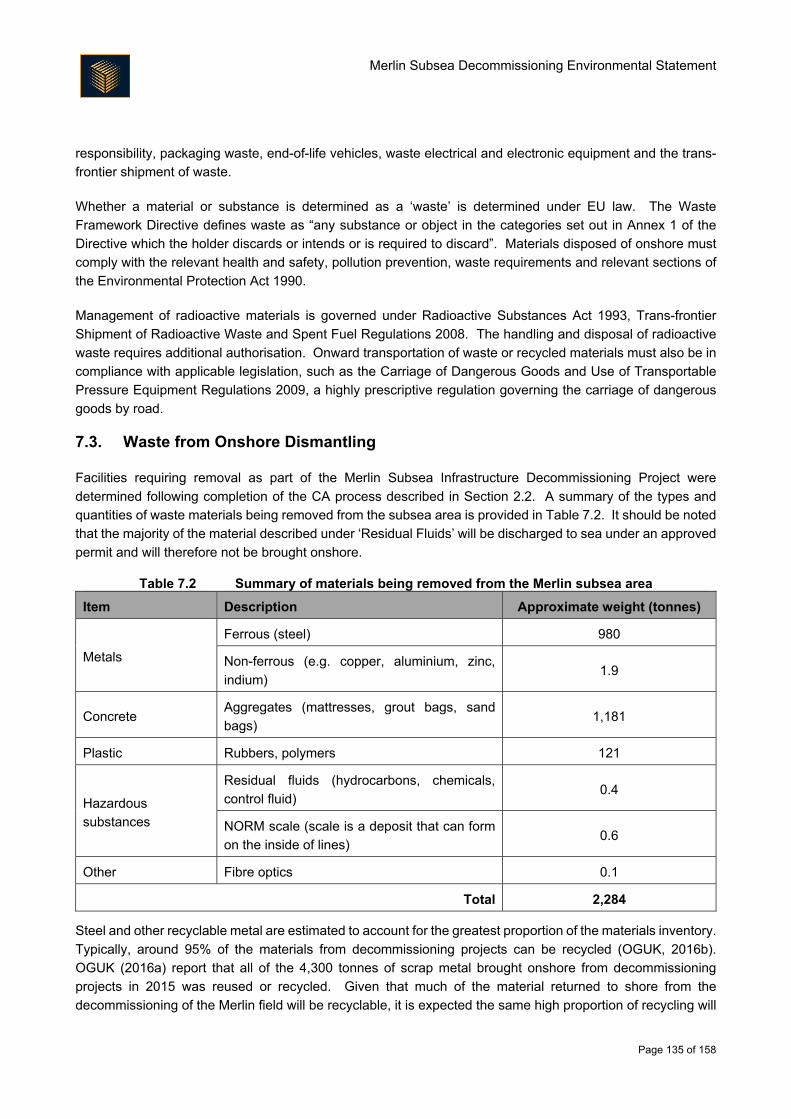
Merlin Subsea Decommissioning Environmental Statement
Page 135 of 158
responsibility, packaging waste, end-of-life vehicles, waste electrical and electronic equipment and the trans-
frontier shipment of waste.
Whether a material or substance is determined as a ‘waste’ is determined under EU law. The Waste
Framework Directive defines waste as “any substance or object in the categories set out in Annex 1 of the
Directive which the holder discards or intends or is required to discard”. Materials disposed of onshore must
comply with the relevant health and safety, pollution prevention, waste requirements and relevant sections of
the Environmental Protection Act 1990.
Management of radioactive materials is governed under Radioactive Substances Act 1993, Trans-frontier
Shipment of Radioactive Waste and Spent Fuel Regulations 2008. The handling and disposal of radioactive
waste requires additional authorisation. Onward transportation of waste or recycled materials must also be in
compliance with applicable legislation, such as the Carriage of Dangerous Goods and Use of Transportable
Pressure Equipment Regulations 2009, a highly prescriptive regulation governing the carriage of dangerous
goods by road.
7.3. Waste from Onshore Dismantling
Facilities requiring removal as part of the Merlin Subsea Infrastructure Decommissioning Project were
determined following completion of the CA process described in Section 2.2. A summary of the types and
quantities of waste materials being removed from the subsea area is provided in Table 7.2. It should be noted
that the majority of the material described under ‘Residual Fluids’ will be discharged to sea under an approved
permit and will therefore not be brought onshore.
Table 7.2 Summary of materials being removed from the Merlin subsea area
Item Description Approximate weight (tonnes)
Metals
Ferrous (steel) 980
Non-ferrous (e.g. copper, aluminium, zinc,
indium) 1.9
Concrete Aggregates (mattresses, grout bags, sand
bags) 1,181
Plastic Rubbers, polymers 121
Hazardous
substances
Residual fluids (hydrocarbons, chemicals,
control fluid) 0.4
NORM scale (scale is a deposit that can form
on the inside of lines) 0.6
Other Fibre optics 0.1
Total 2,284
Steel and other recyclable metal are estimated to account for the greatest proportion of the materials inventory.
Typically, around 95% of the materials from decommissioning projects can be recycled (OGUK, 2016b).
OGUK (2016a) report that all of the 4,300 tonnes of scrap metal brought onshore from decommissioning
projects in 2015 was reused or recycled. Given that much of the material returned to shore from the
decommissioning of the Merlin field will be recyclable, it is expected the same high proportion of recycling will
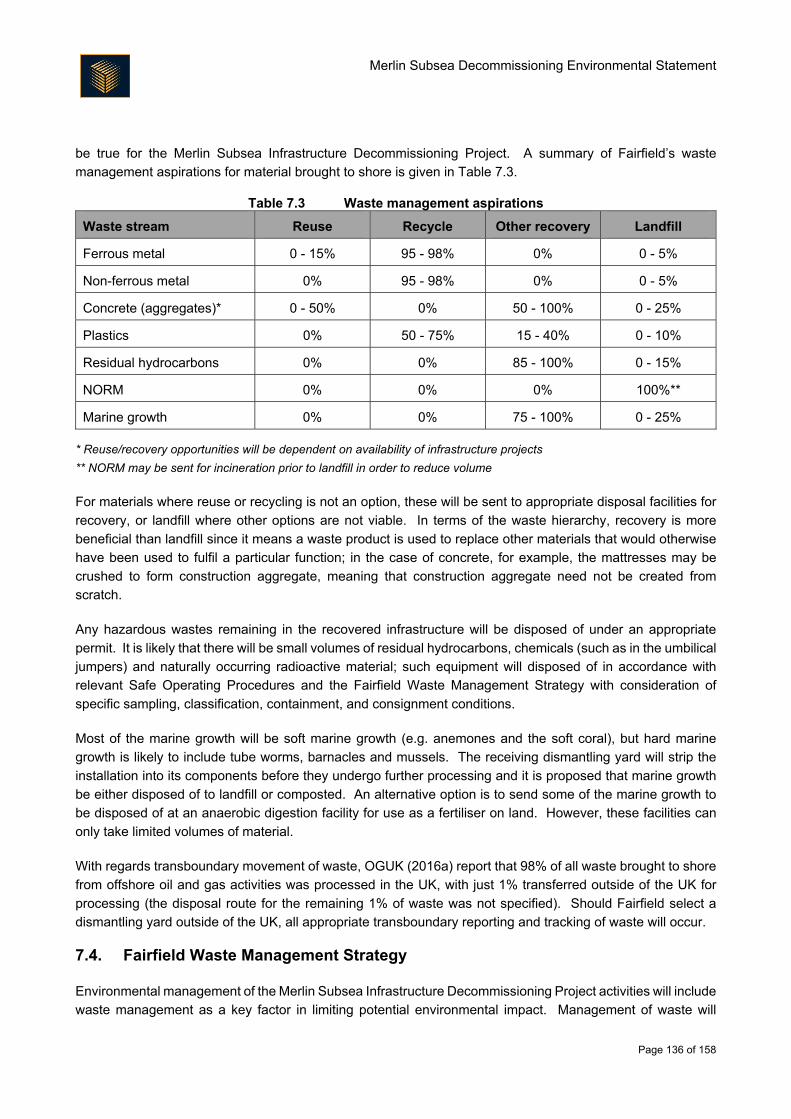
Merlin Subsea Decommissioning Environmental Statement
Page 136 of 158
be true for the Merlin Subsea Infrastructure Decommissioning Project. A summary of Fairfield’s waste
management aspirations for material brought to shore is given in Table 7.3.
Table 7.3 Waste management aspirations
Waste stream Reuse Recycle Other recovery Landfill
Ferrous metal 0 - 15% 95 - 98% 0% 0 - 5%
Non-ferrous metal 0% 95 - 98% 0% 0 - 5%
Concrete (aggregates)* 0 - 50% 0% 50 - 100% 0 - 25%
Plastics 0% 50 - 75% 15 - 40% 0 - 10%
Residual hydrocarbons 0% 0% 85 - 100% 0 - 15%
NORM 0% 0% 0% 100%**
Marine growth 0% 0% 75 - 100% 0 - 25%
* Reuse/recovery opportunities will be dependent on availability of infrastructure projects
** NORM may be sent for incineration prior to landfill in order to reduce volume
For materials where reuse or recycling is not an option, these will be sent to appropriate disposal facilities for
recovery, or landfill where other options are not viable. In terms of the waste hierarchy, recovery is more
beneficial than landfill since it means a waste product is used to replace other materials that would otherwise
have been used to fulfil a particular function; in the case of concrete, for example, the mattresses may be
crushed to form construction aggregate, meaning that construction aggregate need not be created from
scratch.
Any hazardous wastes remaining in the recovered infrastructure will be disposed of under an appropriate
permit. It is likely that there will be small volumes of residual hydrocarbons, chemicals (such as in the umbilical
jumpers) and naturally occurring radioactive material; such equipment will disposed of in accordance with
relevant Safe Operating Procedures and the Fairfield Waste Management Strategy with consideration of
specific sampling, classification, containment, and consignment conditions.
Most of the marine growth will be soft marine growth (e.g. anemones and the soft coral), but hard marine
growth is likely to include tube worms, barnacles and mussels. The receiving dismantling yard will strip the
installation into its components before they undergo further processing and it is proposed that marine growth
be either disposed of to landfill or composted. An alternative option is to send some of the marine growth to
be disposed of at an anaerobic digestion facility for use as a fertiliser on land. However, these facilities can
only take limited volumes of material.
With regards transboundary movement of waste, OGUK (2016a) report that 98% of all waste brought to shore
from offshore oil and gas activities was processed in the UK, with just 1% transferred outside of the UK for
processing (the disposal route for the remaining 1% of waste was not specified). Should Fairfield select a
dismantling yard outside of the UK, all appropriate transboundary reporting and tracking of waste will occur.
7.4. Fairfield Waste Management Strategy
Environmental management of the Merlin Subsea Infrastructure Decommissioning Project activities will include
waste management as a key factor in limiting potential environmental impact. Management of waste will
Merlin Subsea Decommissioning Environmental Statement
Page 137 of 158
therefore be dealt with in accordance with Fairfield’s EMS, certified to the international standard ISO
14001:2015.
As Operator of the Merlin field, Fairfield recognises its duty of care for all waste materials generated from the
forthcoming decommissioning activities. As a result, Fairfield must consider the complete life cycle of
decommissioning waste, including:
Waste identification;
Offshore treatment and storage;
Offshore preparation/cleaning;
Shipment of waste;
Onshore deconstruction;
Onshore transportation;
Final disposal/recovery; and
Ongoing monitoring.
To this end, Fairfield has developed a Waste Management Strategy for the Project, in order to describe the
types of materials identified as decommissioning waste, and outline the processes and procedures necessary
to support the Decommissioning Programme for the Merlin field (and the other fields in the Subsea
Infrastructure Decommissioning Project). The Waste Management Strategy details the measures in place to
ensure that the principles of the Waste Management Hierarchy are followed during the decommissioning (as
described below). For example, transfer notes will accompany all non-hazardous waste to shore and
consignment notes will be in place for any hazardous waste. Furthermore, radioactive waste will be processed
by a licensed facility capable of taking contaminated material under appropriate licences and disposing
accordingly. The Waste Management Strategy details the checks that Fairfield will undertake on the selected
dismantling yard and any onward disposal facilities to ensure all permits and licenses are in place for the
handling and disposal of the waste types identified. Fairfield will ensure that waste is transferred by an
appropriately licensed carrier who should have a Waste Carrier Registration, Waste Management Licence or
Exemption, as appropriate for the type of waste. The contractor(s) that Fairfield will assign to the work will be
required to maintain a waste audit trail through to recycling or disposal facility. The strategy will be kept under
constant review and appropriately updated throughout the decommissioning activities.
The Waste Management Strategy is underpinned by the waste hierarchy shown in Figure 7.1. The hierarchy
is based on the principle of waste disposal only where re-using, recycling and waste prevention cannot be
undertaken10. Fairfield will communicate the Waste Management Strategy to all relevant members of the
decommissioning team (including contractors where relevant).
10 For decommissioning projects, the transfer of material to shore is difficult to limit in the context of the need to leave the seabed offshore in an appropriate condition. As such, waste prevention with regards the main sources of waste may not be possible. However, it is important that waste prevention is considered for other aspects, such as during day to day vessel use.
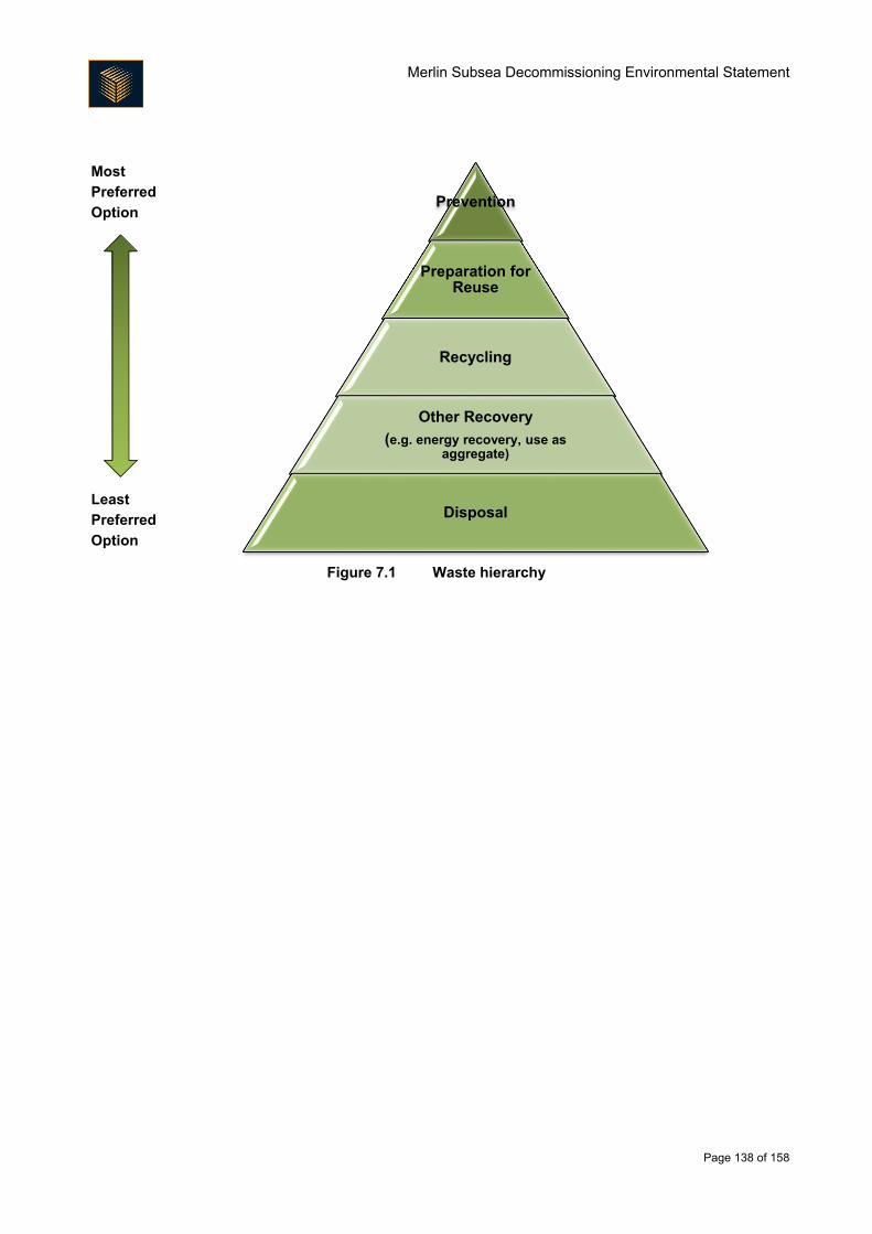
Merlin Subsea Decommissioning Environmental Statement
Page 138 of 158
Most
Preferred
Option
Least
Preferred
Option
Figure 7.1 Waste hierarchy
Prevention
Preparation for Reuse
Recycling
Other Recovery
(e.g. energy recovery, use as aggregate)
Disposal
Merlin Subsea Decommissioning Environmental Statement
Page 139 of 158
8. Environmental Management
8.1. Introduction
Beyond the main period of preparation for decommissioning in situ and removal of components of the Merlin
subsea area, the Project has limited activity associated with it (there are likely to be a small number of post-
decommissioning surveys). The focus of environmental performance management for the Project is therefore
to ensure that the activities that will take place during the limited period of decommissioning happen in a
manner acceptable to Fairfield (and to stakeholders). The primary mechanism by which this will occur is
through Fairfield’s Environmental Management Policy, described in Section 1.6, and specifically through the
EMS that it requires be operational.
8.2. Health, Safety and Environment Plan
Fairfield senior management is responsible for ensuring that Fairfield’s Environmental Management System is
applied to all activities. To support this, a Project Health, Safety and Environment Plan will be developed which
outlines how Health, Safety and Environment issues will be managed and how Fairfield’s Health, Safety and
Environment policies and EMS will be implemented effectively throughout the Project. The Plan will apply to
all work carried out on the Project, be it onshore or offshore. Performance will be measured to satisfy both
regulatory requirements including compliance with environmental consents, as well as to identify progress on
fulfilment of project objectives and commitments.
8.3. Onshore Management
There is the potential for the onshore phase of decommissioning to interact with communities in the vicinity of
the dismantling yard. The onshore location has yet to be confirmed, but locations within and outside of the UK
may be considered. Whether in or outside of the UK, dismantling will be carried out at existing sites which will
have in place site management plans and the correct licences for the proposed dismantling operations and as
such will limit potential impacts to local communities. The site selected for decommissioning activities will have
in place correct and up to date licences for operation and relevant site management plans. These will ensure
operations on site minimise any potential impacts to the local community. For example, specific requirements
are likely to include:
Noise will be managed as part of the onshore dismantling contract and as part of the selection process
for the dismantling yard, noise management will be taken into consideration. Noise emitting activities
should not occur at particularly sensitive times such as early morning and late night;
In order to mitigate odour from marine growth, Fairfield will require selection of a dismantling yard that
has procedures in place to dispose of marine growth in a manner that will avoid odour nuisance
occurrences. This could take the form of an odour management plan being in place within the
dismantling yard, management measures could include rapid removal of marine growth and spraying
of odour suppressants; and
Fairfield may require that onshore dismantling yards conduct a review of records of engagement with
communities and close-out any outstanding issues.
Environmental auditing may occur as part of the tendering process for the work.
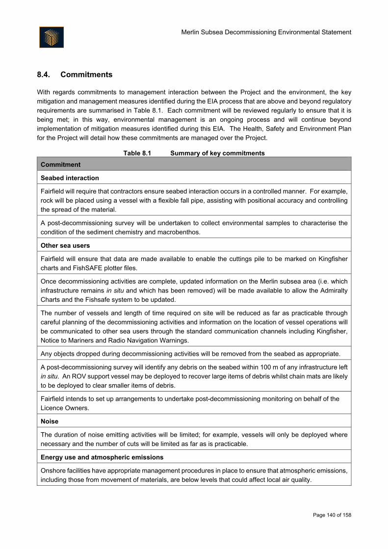
Merlin Subsea Decommissioning Environmental Statement
Page 140 of 158
8.4. Commitments
With regards commitments to management interaction between the Project and the environment, the key
mitigation and management measures identified during the EIA process that are above and beyond regulatory
requirements are summarised in Table 8.1. Each commitment will be reviewed regularly to ensure that it is
being met; in this way, environmental management is an ongoing process and will continue beyond
implementation of mitigation measures identified during this EIA. The Health, Safety and Environment Plan
for the Project will detail how these commitments are managed over the Project.
Table 8.1 Summary of key commitments
Commitment
Seabed interaction
Fairfield will require that contractors ensure seabed interaction occurs in a controlled manner. For example,
rock will be placed using a vessel with a flexible fall pipe, assisting with positional accuracy and controlling
the spread of the material.
A post-decommissioning survey will be undertaken to collect environmental samples to characterise the
condition of the sediment chemistry and macrobenthos.
Other sea users
Fairfield will ensure that data are made available to enable the cuttings pile to be marked on Kingfisher
charts and FishSAFE plotter files.
Once decommissioning activities are complete, updated information on the Merlin subsea area (i.e. which
infrastructure remains in situ and which has been removed) will be made available to allow the Admiralty
Charts and the Fishsafe system to be updated.
The number of vessels and length of time required on site will be reduced as far as practicable through
careful planning of the decommissioning activities and information on the location of vessel operations will
be communicated to other sea users through the standard communication channels including Kingfisher,
Notice to Mariners and Radio Navigation Warnings.
Any objects dropped during decommissioning activities will be removed from the seabed as appropriate.
A post-decommissioning survey will identify any debris on the seabed within 100 m of any infrastructure left
in situ. An ROV support vessel may be deployed to recover large items of debris whilst chain mats are likely
to be deployed to clear smaller items of debris.
Fairfield intends to set up arrangements to undertake post-decommissioning monitoring on behalf of the
Licence Owners.
Noise
The duration of noise emitting activities will be limited; for example, vessels will only be deployed where
necessary and the number of cuts will be limited as far as is practicable.
Energy use and atmospheric emissions
Onshore facilities have appropriate management procedures in place to ensure that atmospheric emissions,
including those from movement of materials, are below levels that could affect local air quality.
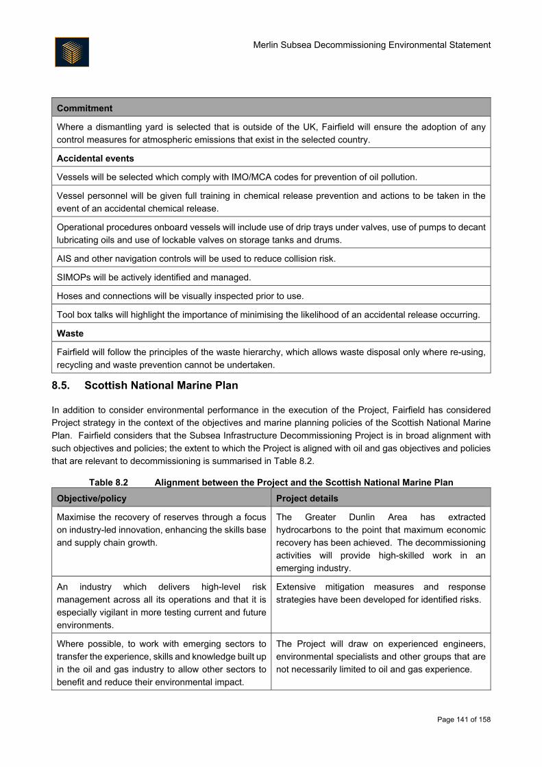
Merlin Subsea Decommissioning Environmental Statement
Page 141 of 158
Commitment
Where a dismantling yard is selected that is outside of the UK, Fairfield will ensure the adoption of any
control measures for atmospheric emissions that exist in the selected country.
Accidental events
Vessels will be selected which comply with IMO/MCA codes for prevention of oil pollution.
Vessel personnel will be given full training in chemical release prevention and actions to be taken in the
event of an accidental chemical release.
Operational procedures onboard vessels will include use of drip trays under valves, use of pumps to decant
lubricating oils and use of lockable valves on storage tanks and drums.
AIS and other navigation controls will be used to reduce collision risk.
SIMOPs will be actively identified and managed.
Hoses and connections will be visually inspected prior to use.
Tool box talks will highlight the importance of minimising the likelihood of an accidental release occurring.
Waste
Fairfield will follow the principles of the waste hierarchy, which allows waste disposal only where re-using,
recycling and waste prevention cannot be undertaken.
8.5. Scottish National Marine Plan
In addition to consider environmental performance in the execution of the Project, Fairfield has considered
Project strategy in the context of the objectives and marine planning policies of the Scottish National Marine
Plan. Fairfield considers that the Subsea Infrastructure Decommissioning Project is in broad alignment with
such objectives and policies; the extent to which the Project is aligned with oil and gas objectives and policies
that are relevant to decommissioning is summarised in Table 8.2.
Table 8.2 Alignment between the Project and the Scottish National Marine Plan
Objective/policy Project details
Maximise the recovery of reserves through a focus
on industry-led innovation, enhancing the skills base
and supply chain growth.
The Greater Dunlin Area has extracted
hydrocarbons to the point that maximum economic
recovery has been achieved. The decommissioning
activities will provide high-skilled work in an
emerging industry.
An industry which delivers high-level risk
management across all its operations and that it is
especially vigilant in more testing current and future
environments.
Extensive mitigation measures and response
strategies have been developed for identified risks.
Where possible, to work with emerging sectors to
transfer the experience, skills and knowledge built up
in the oil and gas industry to allow other sectors to
benefit and reduce their environmental impact.
The Project will draw on experienced engineers,
environmental specialists and other groups that are
not necessarily limited to oil and gas experience.
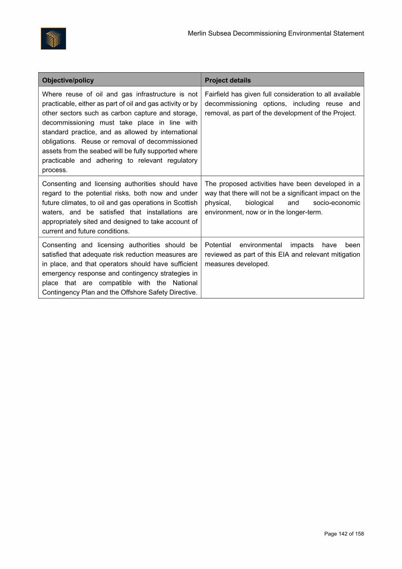
Merlin Subsea Decommissioning Environmental Statement
Page 142 of 158
Objective/policy Project details
Where reuse of oil and gas infrastructure is not
practicable, either as part of oil and gas activity or by
other sectors such as carbon capture and storage,
decommissioning must take place in line with
standard practice, and as allowed by international
obligations. Reuse or removal of decommissioned
assets from the seabed will be fully supported where
practicable and adhering to relevant regulatory
process.
Fairfield has given full consideration to all available
decommissioning options, including reuse and
removal, as part of the development of the Project.
Consenting and licensing authorities should have
regard to the potential risks, both now and under
future climates, to oil and gas operations in Scottish
waters, and be satisfied that installations are
appropriately sited and designed to take account of
current and future conditions.
The proposed activities have been developed in a
way that there will not be a significant impact on the
physical, biological and socio-economic
environment, now or in the longer-term.
Consenting and licensing authorities should be
satisfied that adequate risk reduction measures are
in place, and that operators should have sufficient
emergency response and contingency strategies in
place that are compatible with the National
Contingency Plan and the Offshore Safety Directive.
Potential environmental impacts have been
reviewed as part of this EIA and relevant mitigation
measures developed.
Merlin Subsea Decommissioning Environmental Statement
Page 143 of 158
9. Conclusion
9.1. Introduction
The EIA presented in this ES has been undertaken in support of the Decommissioning Programme that will be
submitted for the Merlin Subsea Infrastructure Decommissioning Project. The EIA has assessed the proposed
decommissioning strategy in the context of the environmental sensitivities of the Project area and described
the control measures that will be in place during Project execution. The EIA has also given due consideration
to the decisions that remain to be made (e.g. dismantling yard location). The key findings of the EIA are
summarised in the following sections.
9.2. Protected Sites
There will be no significant impact on any Annex I habitat (of the Habitats Directive). There are a number of
offshore and coastal conservation areas on the Scottish mainland that have been designated under the
Habitats Directive as SACs, under the EU Birds Directive as SPAs and under the Marine Scotland Act 2010
and Marine and Coastal Access Act 2009 as NCMPAs and MCZs. The potential for significant impacts on any
such site has been considered within each impact assessment. Given the short-term duration of the
decommissioning activities, the mitigation measures in place and the expected recovery from activities, the
Merlin Subsea Infrastructure Decommissioning Project is considered unlikely to affect the conservation
objectives or site integrity of any SAC, SPA, NCMPA or MCZ.
The majority of species protected under Annex I of the Birds Directive that are present within the North Sea
will generally be found much closer to shore and may only encounter the Project with any regularity during the
limited period of the vessel activity. Given such vessel use will result in only limited interaction with individuals
of those protected species, the Merlin Subsea Infrastructure Decommissioning Project will not result in
significant impacts to those populations.
The presence within the Merlin Project area of species protected under Annex II of the Habitats Directive is
limited to marine mammals. Marine mammal species that may be present in the area (or nearshore during
vessel transit) occur in relatively low densities, or occur only occasionally, or as casual visitors. Fairfield has
assessed whether the noise emitting operations associated with the Project have the potential to result in injury
or disturbance to any marine mammal species. This assessment concluded that there is a very low likelihood
of injury (such as temporary or permanent hearing loss), or disturbance as a result of the activities associated
with the Project and that potentially significant environmental impacts would not result in population level
impacts.
Considering all of the above, no significant impacts are expected upon protected species and habitats.
9.3. Cumulative and Transboundary Impacts
A review of each of the potentially significant environmental impacts associated with the Project, and the
mitigation measures proposed against the range of other activities in the region indicates that no significant
cumulative impacts are expected.
A review of each of the potentially significant environmental impacts associated with the Project and the
mitigation measures proposed, indicates that no significant transboundary impacts are expected.
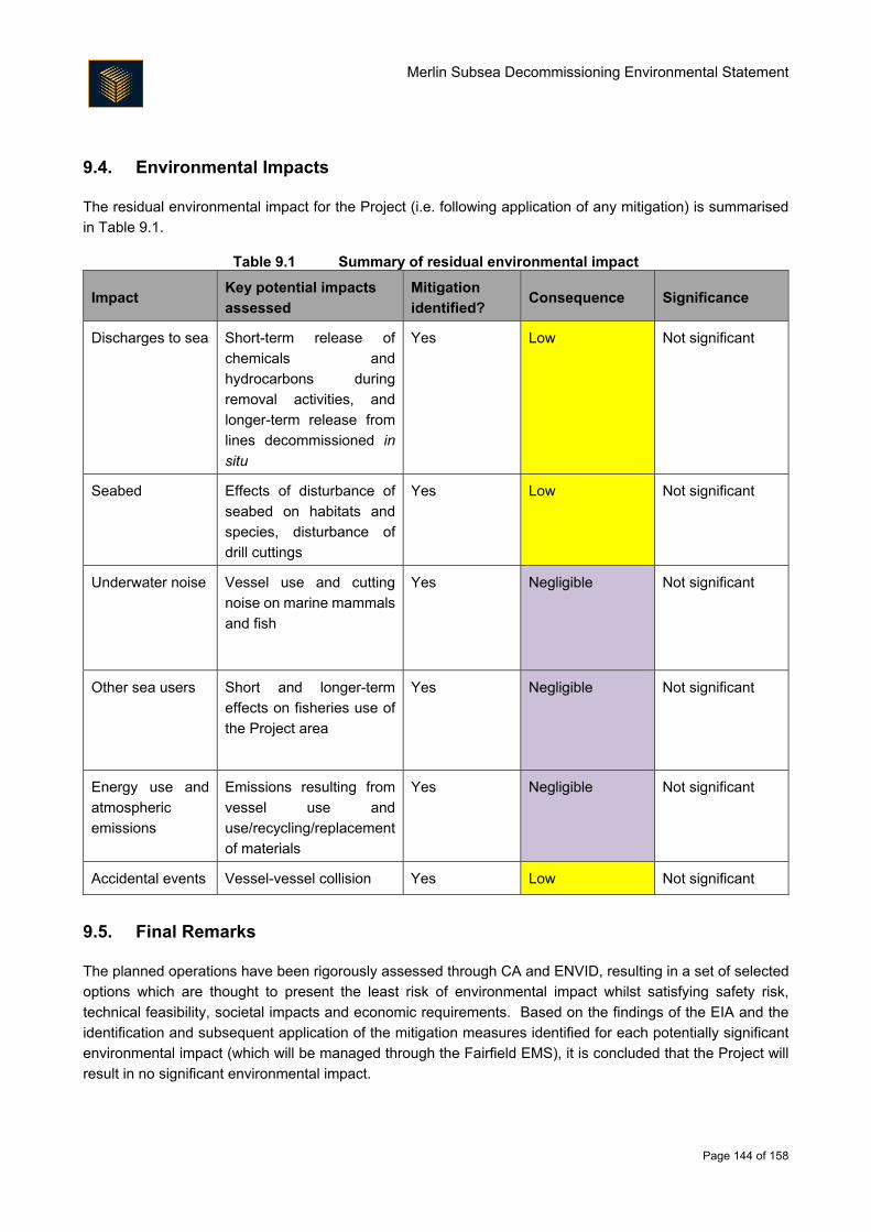
Merlin Subsea Decommissioning Environmental Statement
Page 144 of 158
9.4. Environmental Impacts
The residual environmental impact for the Project (i.e. following application of any mitigation) is summarised
in Table 9.1.
Table 9.1 Summary of residual environmental impact
Impact Key potential impacts
assessed
Mitigation
identified? Consequence Significance
Discharges to sea Short-term release of
chemicals and
hydrocarbons during
removal activities, and
longer-term release from
lines decommissioned in
situ
Yes Low Not significant
Seabed Effects of disturbance of
seabed on habitats and
species, disturbance of
drill cuttings
Yes Low Not significant
Underwater noise Vessel use and cutting
noise on marine mammals
and fish
Yes Negligible Not significant
Other sea users Short and longer-term
effects on fisheries use of
the Project area
Yes Negligible Not significant
Energy use and
atmospheric
emissions
Emissions resulting from
vessel use and
use/recycling/replacement
of materials
Yes Negligible Not significant
Accidental events Vessel-vessel collision Yes Low Not significant
9.5. Final Remarks
The planned operations have been rigorously assessed through CA and ENVID, resulting in a set of selected
options which are thought to present the least risk of environmental impact whilst satisfying safety risk,
technical feasibility, societal impacts and economic requirements. Based on the findings of the EIA and the
identification and subsequent application of the mitigation measures identified for each potentially significant
environmental impact (which will be managed through the Fairfield EMS), it is concluded that the Project will
result in no significant environmental impact.

Merlin Subsea Decommissioning Environmental Statement
Page 145 of 158
APPENDIX A ENVID WORKSHOP OUTPUT
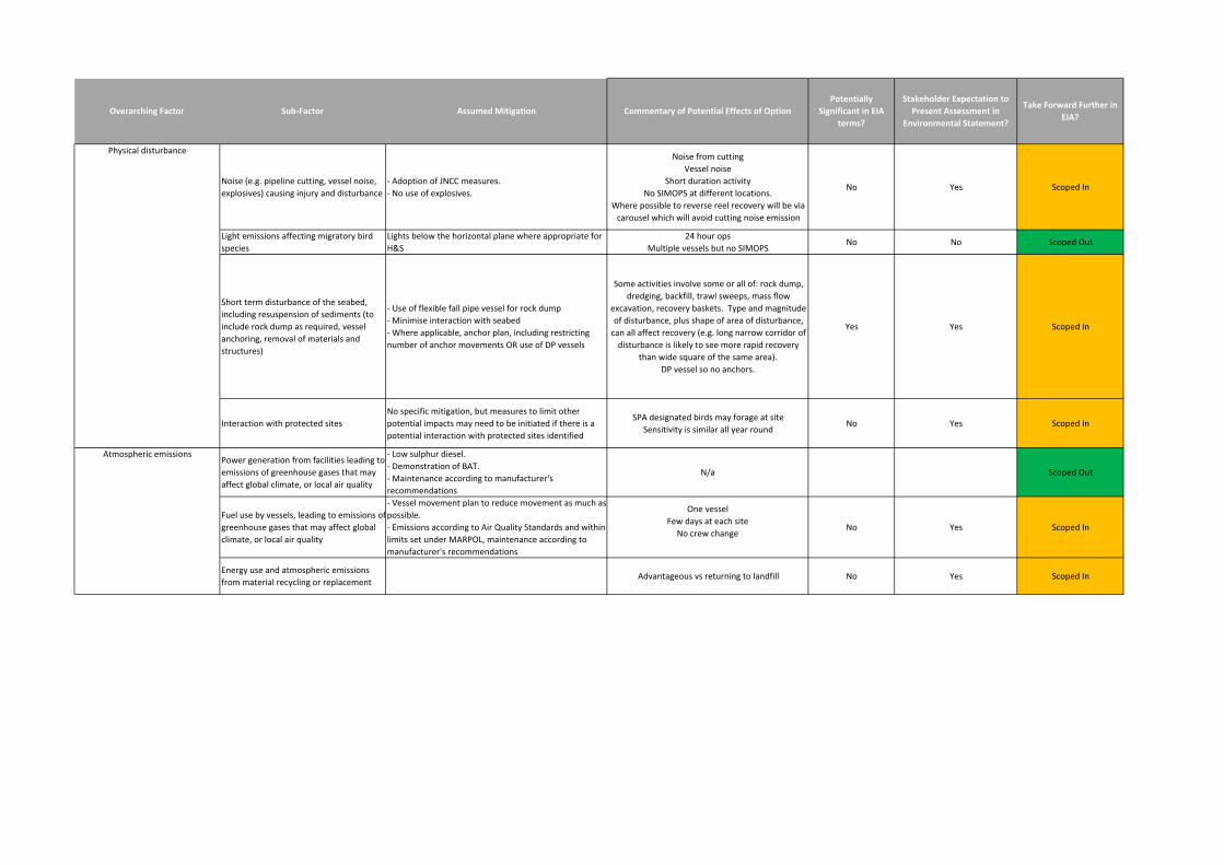
Noise (e.g. pipeline cutting, vessel noise,
explosives) causing injury and disturbance
- Adoption of JNCC measures.
- No use of explosives.
Noise from cutting
Vessel noise
Short duration activity
No SIMOPS at different locations.
Where possible to reverse reel recovery will be via
carousel which will avoid cutting noise emission
No Yes Scoped In
Light emissions affecting migratory bird
species
Lights below the horizontal plane where appropriate for
H&S
24 hour ops
Multiple vessels but no SIMOPSNo No Scoped Out
Short term disturbance of the seabed,
including resuspension of sediments (to
include rock dump as required, vessel
anchoring, removal of materials and
structures)
- Use of flexible fall pipe vessel for rock dump
- Minimise interaction with seabed
- Where applicable, anchor plan, including restricting
number of anchor movements OR use of DP vessels
Some activities involve some or all of: rock dump,
dredging, backfill, trawl sweeps, mass flow
excavation, recovery baskets. Type and magnitude
of disturbance, plus shape of area of disturbance,
can all affect recovery (e.g. long narrow corridor of
disturbance is likely to see more rapid recovery
than wide square of the same area).
DP vessel so no anchors.
Yes Yes Scoped In
Interaction with protected sites
No specific mitigation, but measures to limit other
potential impacts may need to be initiated if there is a
potential interaction with protected sites identified
SPA designated birds may forage at site
Sensitivity is similar all year roundNo Yes Scoped In
Power generation from facilities leading to
emissions of greenhouse gases that may
affect global climate, or local air quality
- Low sulphur diesel.
- Demonstration of BAT.
- Maintenance according to manufacturer's
recommendations
N/a Scoped Out
Fuel use by vessels, leading to emissions of
greenhouse gases that may affect global
climate, or local air quality
- Vessel movement plan to reduce movement as much as
possible.
- Emissions according to Air Quality Standards and within
limits set under MARPOL, maintenance according to
manufacturer's recommendations
One vessel
Few days at each site
No crew changeNo Yes Scoped In
Energy use and atmospheric emissions
from material recycling or replacementAdvantageous vs returning to landfill No Yes Scoped In
Stakeholder Expectation to
Present Assessment in
Environmental Statement?
Take Forward Further in
EIA?
Physical disturbance
Commentary of Potential Effects of Option
Potentially
Significant in EIA
terms?
Atmospheric emissions
Overarching Factor Sub-Factor Assumed Mitigation
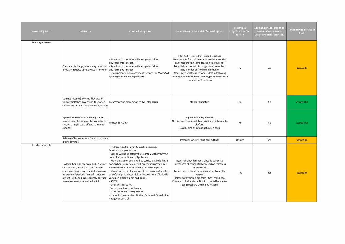
Stakeholder Expectation to
Present Assessment in
Environmental Statement?
Take Forward Further in
EIA?Commentary of Potential Effects of Option
Potentially
Significant in EIA
terms?
Overarching Factor Sub-Factor Assumed Mitigation
Chemical discharge, which may have toxic
effects to species using the water column
- Selection of chemicals with less potential for
environmental impact.
- Selection of chemicals with less potential for
environmental impact
- Environmental risk assessment through the MATs/SATs
system (OCR) where appropriate
Inhibited water within flushed pipelines
Baseline is to flush all lines prior to disconnection
but there may be some that can't be flushed.
Potentially expected discharge from one or two
lines in order of few litres discharge.
Assessment will focus on what is left in following
flushing/cleaning and how that might be released in
the short or long term
No Yes Scoped In
Domestic waste (grey and black water)
from vessels that may enrich the water
column and alter community composition
Treatment and maceration to IMO standards Standard practice No No Scoped Out
Pipeline and structure cleaning, which
may release chemicals or hydrocarbons to
sea, resulting in toxic effects to marine
species
Treated to ALARP
Pipelines already flushed
No discharge from umbilical flushing as returned to
platform
No cleaning of infrastructure on deck
No No Scoped Out
Release of hydrocarbons from disturbance
of drill cuttingsPotential for disturbing drill cuttings Unsure Yes Scoped In
Hydrocarbon and chemical spills / loss of
containment, leading to toxic or other
effects on marine species, including over
an extended period of time if structures
are left in situ and subsequently degrade
to release what is contained within
- Hydrocarbon free prior to works occurring.
Maintenance procedures.
- Vessels will be selected which comply with IMO/MCA
codes for prevention of oil pollution .
- Pre-mobilisation audits will be carried out including a
comprehensive review of spill prevention procedures.
- Preferred operational procedures to be in place
onboard vessels including use of drip trays under valves,
use of pumps to decant lubricating oils, use of lockable
valves on storage tanks and drums.
- SOPEP.
- OPEP within 500 m.
- Vessel condition certificates.
- Evidence of crew competency.
- Use of Automatic Identification System (AIS) and other
navigation controls.
Reservoir abandonments already complete
Only source of accidental hydrocarbon release is
from vessel
Accidental release of any chemical on board the
vessels
Release of hydraulic oils from ROVs, MFEs, etc.
Potential collision risk at Dunlin covered by marine
ops procedure within 500 m zone
Yes Yes Scoped In
Discharges to sea
Accidental events
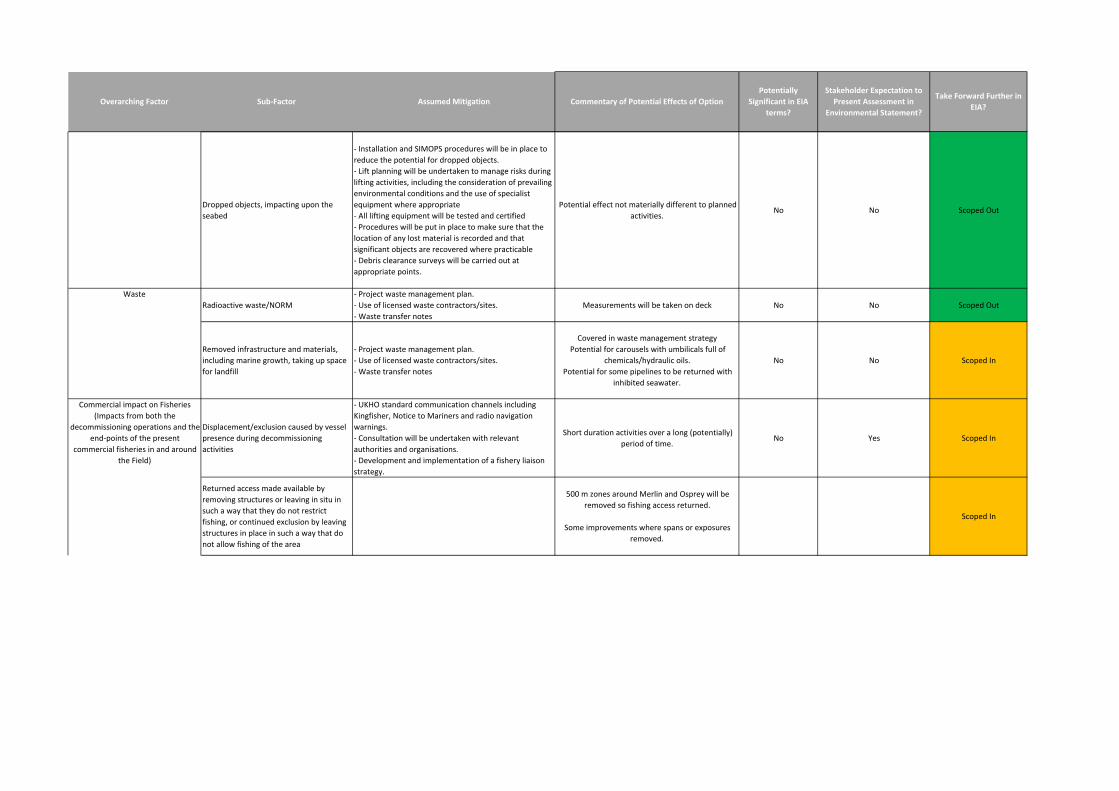
Stakeholder Expectation to
Present Assessment in
Environmental Statement?
Take Forward Further in
EIA?Commentary of Potential Effects of Option
Potentially
Significant in EIA
terms?
Overarching Factor Sub-Factor Assumed Mitigation
Dropped objects, impacting upon the
seabed
- Installation and SIMOPS procedures will be in place to
reduce the potential for dropped objects.
- Lift planning will be undertaken to manage risks during
lifting activities, including the consideration of prevailing
environmental conditions and the use of specialist
equipment where appropriate
- All lifting equipment will be tested and certified
- Procedures will be put in place to make sure that the
location of any lost material is recorded and that
significant objects are recovered where practicable
- Debris clearance surveys will be carried out at
appropriate points.
Potential effect not materially different to planned
activities.No No Scoped Out
Radioactive waste/NORM
- Project waste management plan.
- Use of licensed waste contractors/sites.
- Waste transfer notes
Measurements will be taken on deck No No Scoped Out
Removed infrastructure and materials,
including marine growth, taking up space
for landfill
- Project waste management plan.
- Use of licensed waste contractors/sites.
- Waste transfer notes
Covered in waste management strategy
Potential for carousels with umbilicals full of
chemicals/hydraulic oils.
Potential for some pipelines to be returned with
inhibited seawater.
No No Scoped In
Displacement/exclusion caused by vessel
presence during decommissioning
activities
- UKHO standard communication channels including
Kingfisher, Notice to Mariners and radio navigation
warnings.
- Consultation will be undertaken with relevant
authorities and organisations.
- Development and implementation of a fishery liaison
strategy.
Short duration activities over a long (potentially)
period of time.No Yes Scoped In
Returned access made available by
removing structures or leaving in situ in
such a way that they do not restrict
fishing, or continued exclusion by leaving
structures in place in such a way that do
not allow fishing of the area
500 m zones around Merlin and Osprey will be
removed so fishing access returned.
Some improvements where spans or exposures
removed.
Scoped In
Commercial impact on Fisheries
(Impacts from both the
decommissioning operations and the
end-points of the present
commercial fisheries in and around
the Field)
Waste
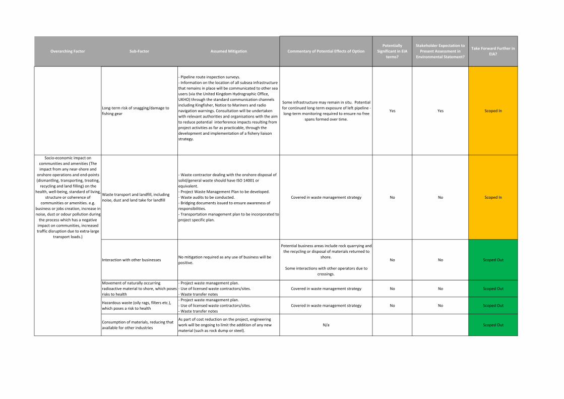
Stakeholder Expectation to
Present Assessment in
Environmental Statement?
Take Forward Further in
EIA?Commentary of Potential Effects of Option
Potentially
Significant in EIA
terms?
Overarching Factor Sub-Factor Assumed Mitigation
Long-term risk of snagging/damage to
fishing gear
- Pipeline route inspection surveys.
- Information on the location of all subsea infrastructure
that remains in place will be communicated to other sea
users (via the United Kingdom Hydrographic Office,
UKHO) through the standard communication channels
including Kingfisher, Notice to Mariners and radio
navigation warnings. Consultation will be undertaken
with relevant authorities and organisations with the aim
to reduce potential interference impacts resulting from
project activities as far as practicable, through the
development and implementation of a fishery liaison
strategy.
Some infrastructure may remain in situ. Potential
for continued long-term exposure of left pipeline -
long-term monitoring required to ensure no free
spans formed over time.
Yes Yes Scoped In
Waste transport and landfill, including
noise, dust and land take for landfill
- Waste contractor dealing with the onshore disposal of
solid/general waste should have ISO 14001 or
equivalent.
- Project Waste Management Plan to be developed.
- Waste audits to be conducted.
- Bridging documents issued to ensure awareness of
responsibilities.
- Transportation management plan to be incorporated to
project specific plan.
Covered in waste management strategy No No Scoped In
Interaction with other businessesNo mitigation required as any use of business will be
positive.
Potential business areas include rock quarrying and
the recycling or disposal of materials returned to
shore.
Some interactions with other operators due to
crossings.
No No Scoped Out
Movement of naturally occurring
radioactive material to shore, which poses
risks to health
- Project waste management plan.
- Use of licensed waste contractors/sites.
- Waste transfer notes
Covered in waste management strategy No No Scoped Out
Hazardous waste (oily rags, filters etc.),
which poses a risk to health
- Project waste management plan.
- Use of licensed waste contractors/sites.
- Waste transfer notes
Covered in waste management strategy No No Scoped Out
Consumption of materials, reducing that
available for other industries
As part of cost reduction on the project, engineering
work will be ongoing to limit the addition of any new
material (such as rock dump or steel).
N/a Scoped Out
Socio-economic impact on
communities and amenities (The
impact from any near-shore and
onshore operations and end-points
(dismantling, transporting, treating,
recycling and land filling) on the
health, well-being, standard of living,
structure or coherence of
communities or amenities. e.g.
business or jobs creation, increase in
noise, dust or odour pollution during
the process which has a negative
impact on communities, increased
traffic disruption due to extra-large
transport loads.)
Merlin Subsea Decommissioning Environmental Statement
Page 150 of 158
APPENDIX B REFERENCES
Aires, C., Gonzlez-Irusta, J.M. and Watret, R. (2014). Scottish Marine and Freshwater Science Report, Vol 5
No 10, Updating Fisheries Sensitivity Maps in British Waters' found at:
http://www.scotland.gov.uk/Publications/2014/12/3334 with further details online at
http://www.scotland.gov.uk/Topics/marine/science/MSInteractive/Themes/fish-fisheries/fsm [Accessed
17/02/2017].
Anatec (2017). Dunlin Decommissioning Fishing Risk Assessment. A3910-XG-RA-1.
Anthony, T.G., Wright, N.A. and Evans, M.A. (2009). Review of diver noise exposure. Prepared by QinetiQ
for the Health and Safety Executive. RR735 Research Report.
Baxter, J.M., Boyd, I.L., Cox, M., Donald, A.E., Malcolm, S.J., Miles, H., Miller, B. and Moffat, C.F. (Editors)
(2011). Scotland's Marine Atlas: Information for the national marine plan. Marine Scotland, Edinburgh. pp.
191. Online at http://www.scotland.gov.uk/Publications/2011/03/16182005/0 [Accessed 16/02/2017].
Beare, D.J., Batten, S., Edwards, M. and Reid, D.G. (2002). Prevalence of boreal Atlantic, temperate Atlantic
and neritic zooplankton in the North Sea between 1958 and 1998 in relation to temperature, salinity,
stratification intensity and Atlantic inflow. Journal of Sea Research, 48, 29 – 49.
BODC (1998). United Kingdom Digital Marine Atlas. An atlas of the seas around the British Isles, British
Oceanographic Data Centre, NERC.
Brussaard, C., Peperzak, L., Beggah, S., Wick, L.Y., Wuerz, B., Weber, J., Arey, J.S., van der Burg, B., Jonas,
A., Huisman, J. and van der Meer, J.R. (2016). Immediate ecotoxicological effects of short-lived oil spills on
marine biota. Nature Communications: 2016 Apr 4; 7:11206. Online at
http://www.nature.com/articles/ncomms11206 [Accessed 15/02/2017].
Caveen, A.J., Fitzsimmons, C., Pieraccini, M., Dunn, E., Sweeting, C.J., Johnson, M.L., Bloomfield, H., Jones,
E.V., Lightfoot, P., Gray, T.S., Stead, S.M. and Polunin N.V.C. (2014). Diverging Strategies to Planning an
Ecologically Coherent Network of MPAs in the North Sea: The Roles of Advocacy, Evidence and Pragmatism
in the Face of Uncertainty. Advances in Marine Biology, 69, 325 – 370.
Cefas (2017). Offshore chemical notification scheme. Online at https://www.cefas.co.uk/cefas-data-
hub/offshore-chemical-notification-scheme/ [Accessed 09/03/17].
Committee on Climate Change (2015). UK Emissions by Sector – Shipping. Online at
https://www.theccc.org.uk/charts-data/ukemissions-by-sector/shipping/ [Accessed 04/02/16].
Coull, K.A., Johnstone, R. and Rogers, S.I. (1998). Fisheries Sensitivity Maps in British Waters. UKOOA Ltd.,
London.
De Robertis, A. and Handegard, N.O. (2012). Fish avoidance of research vessels and the efficacy of noise-
reduced vessels: a review. ICES Journal of Marine Science, 70(1), 34 – 45.
De-Bastos, E.S.R. (2016). Amphiura brachiata with Astropecten irregularis and other echinoderms in
circalittoral muddy sand. In Tyler-Walters H. and Hiscock K. (eds) Marine Life Information Network: Biology
Merlin Subsea Decommissioning Environmental Statement
Page 151 of 158
and Sensitivity Key Information Reviews, [on-line]. Plymouth: Marine Biological Association of the United
Kingdom. Online at http://www.marlin.ac.uk/habitat/detail/1079 [Accessed 26/01/2017].
DECC (2016). UK Offshore Energy Strategic Environmental Assessment. OESEA3 Environmental Report.
Future Leasing/Licensing for Offshore Renewable Energy, Offshore Oil & Gas, Hydrocarbon Gas and Carbon
Dioxide Storage and Associated Infrastructure.
DECC (2011). Decommissioning of Offshore Oil and Gas Installations and Pipelines under the Petroleum Act
1998. Online at
https://www.gov.uk/government/uploads/system/uploads/attachment_data/file/69754/Guidance_Notes_v6_0
7.01.2013.pdf [Accessed 28/04/2016].
Deecke V.B., Slater, P.J.B. and Ford, J.K.B. (2002). Selective habituation shapes acoustic predator
recognition in harbour seals. Nature, 420, 171 – 173.
Defra (2010). Charting Progress 2. The State of UK Seas. Online at
http://webarchive.nationalarchives.gov.uk/20141203181034/http://chartingprogress.defra.gov.uk/ [Accessed
28/01/2017].
DTI (2001). Report to the Department of Trade and Industry. Strategic Environmental Assessment of the
Mature Areas of the Offshore North Sea SEA 2. Consultation Document, September 2001.
Edwards, M., Beaugrand, G., Halaouet, P., Licandro, P., McQuatters-Gollop, A. and Wootton, M. (2010).
Ecological Status Report: results from the CPR survey 2009/ 2010. SAHFOS Technical Report 8 1-8,
Plymouth UK.
Ellis, J.R., Milligan, S., Readdy, L., South, A., Taylor, N. and Brown, M. (2012). Mapping the spawning and
nursery grounds of selected fish for spatial planning. Report to the Department of Environment, Food and
Rural Affairs from Cefas. Defra Contract No. MB5301.
European Commission (1999). Guidelines for the Assessment of Indirect and Cumulative Impacts as well as
impact Interactions, Report Ref; NE80328/D1/3.
Finneran, J.J., Carder, D.A., Schlundt, C.E. and Ridgway, S.H. (2005). Temporary threshold shift in bottlenose
dolphins (Tursiops truncatus) exposed to mid-frequency tones. Journal of the Acoustical Society of America,
118(4), 2696 – 2705.
FRS (2004). Zooplankton and climate change – the Calanus story. Online at
http://www.marlab.ac.uk/FRS.Web/Uploads/Documents/Zooplankton.pdf [Accessed 22/02/16].
Fugro (2017). Merlin Pre-decommissioning Cuttings Assessment Survey UKCS Block 211/23 November 2015
to April 2016.
Fugro (2016a). Fairfield Pre-decommissioning Habitat Assessment Survey Report: Osprey Field and
Osprey/Dunlin Tieback November 2015 to April 2016.
Fugro (2016b). Osprey Pre-decommissioning Environmental Baseline Survey Report UKCS Blocks 211/18a
and 211/23a November 2015 to April 2016.
Merlin Subsea Decommissioning Environmental Statement
Page 152 of 158
Fugro (2016c). Fairfield Pre-decommissioning Habitat Assessment Survey Report: Merlin Field and
Merlin/Dunlin Tieback November 2015 to April 2016.
Fugro (2016d). Merlin Pre-decommissioning Environmental Baseline Survey Report UKCS Blocks 211/23 and
211/24 November 2015 to April 2016.
Fugro (2016e). Fairfield Pre-decommissioning Habitat Assessment Survey Report: Dunlin Field November
2015 to April 2016.
Fugro (2016f). Dunlin Alpha Pre-decommissioning Environmental Baseline Survey Report UKCS Block
211/23 November 2015 to April 2016.
Fugro (2016g). Fairfield Pre-decommissioning Habitat Assessment Survey Report: Dunlin Fuel Gas Import
Pipeline November 2015 to April 2016.
Fugro (2016h). Dunlin Alpha Fuel Gas Import Pipeline Pre-decommissioning Environmental Baseline Survey
Report UKCS 211/23 November 2015 to April 2016.
Fugro (2016i). Fairfield Pre-decommissioning Habitat Assessment Survey Report: Dunlin A to Brent C Power
Import Cable Route November 2015 to April 2016.
Fugro (2016j). Dunlin Alpha Power Import Cable Route Pre-decommissioning Environmental Baseline Survey
Report UKCS Block 211/23 November 2015 to April 2016.
Fugro (2001). Wind and wave frequency distributions for sites around the British Isles, Offshore technology
report 2001/030. Online at http://www.hse.gov.uk/research/otopdf/2001/oto01030.pdf [Accessed 30/06/2016].
Furness, R.W. (2015). Non-breeding season populations of seabirds in UK waters: Population sizes for
Biologically Defined Minimum Population Scales (BDMPS). Natural England Commissioned Reports, Number
164.
Gardline (2011). Dunlin Fuel Gas Import Route Survey and Environmental Survey UKCS Blocks 211/18a and
211/23a August to September 2010; Environmental Baseline Report. Gardline reference 8529.1.
Gardline (2010a). Dunlin to NLGP Pipeline Route Survey UKCS Block 211/24 August/November 2009 and
April/May 2010; Survey report. Report Ref 8371.
Gardline (2010b). UKCS Quad 211 Infield Environmental Survey. November to December 2008 and
September to October 2009. Environmental Baseline Report. Report Ref 7860.
Gardline (2009a). 2008 UKCS 211/23 Osprey Debris Clearance, Habitat Assessment and Environmental
Baseline Survey. Report Ref: 7859.1
Gardline (2009b). 2008 UKCS 211/23 Dunlin Development Debris Clearance, ‘Mud Mound’ and
Environmental Baseline Survey. Report Ref: 7859.
GEL (Gardline Environmental Limited) (2010). Fairfield Energy Ltd, UKCS Quad 211 Infield Environmental
Survey. November to December 2008 and September to October 2009. Environmental Baseline Report.
Report Reference 7860.
Merlin Subsea Decommissioning Environmental Statement
Page 153 of 158
Gubbay, S. (2003). Marine aggregate extraction and biodiversity. Information, issues and gaps in
understanding. Report to the Joint Marine Programme of the Wildlife Trusts and WWF-UK.
Gubbay, S. and Earll, R. (2000). Review of literature on the effects of oil spills on cetaceans. Scottish Natural
Heritage Review No. 3. Online at http://www.snh.org.uk/pdfs/publications/review/003.pdf [Accessed
15/02/2017].
Hammond, P.S., Gordon, J.C.D., Grellier, K., Hall, A.J., Northridge, S.P., Thompson, D. and Harwood, J.
(2001). Background information on marine mammals relevant to SEA2. Report to the Department of Trade
and Industry. Online at http://www.offshore-sea.org.uk/consultations/SEA_2/TR_SEA2_Mammals.pdf
[Accessed 17/02/2017].
Hannay, D., MacGillivray, A., Laurinolli, M. and Racca, R. (2004). Source Level Measurements from 2004
Acoustics Programme. Sakhalin Energy.
Hi Def (2016). Sensitivity of offshore seabird concentrations to oil pollution around the United Kingdom: Report
to Oil & Gas UK. DOCUMENT NUMBER: HP00061 701.
Hiddink, J., Jennings, S. and Kaiser, M.J. (2006). Indicators of the Ecological Impact of Bottom-Trawl
Disturbance on Seabed Communities. Ecosystems, 9(7), 1190 – 1199.
Hiscock, K., Langmead, O., Warwick, R. and Smith, A. (2005). Identification of Seabed Indicator Species to
Support Implementation of the EU Habitats and Water Framework Directives. Second Edition. Report to the
Joint Nature Conservation Committee and the Environment Agency from the Marine Biological Association.
Plymouth: Marine Biological Association. JNCC Contract F90-01-705.
ICES (Undated). ICES-FishMap - Mackerel. Online at http://www.ices.dk/explore-us/projects/EU-
RFP/EU%20Repository/ICES%20FIshMap/ICES%20FishMap%20species%20factsheet-mackerel.pdf
[Accessed 31/01/17].
IEEM (2010). Guidelines for Ecological Impact Assessment in Britain and Ireland, marine and Coastal. August
2010. Final Version 5.
IEMA (2016). EIA Guide to Delivering Quality Development.
IEMA (2015). EIA Guide to Shaping Quality Development.
Institute of Petroleum (2000). Guidelines for the Calculation of Estimates of Energy Use and Gaseous
Emissions in the Decommissioning of Offshore Structures.
IOGP (International Association of Oil and Gas Producers) (2016). Environmental fates and effects of ocean
discharge of drill cuttings and associated drilling fluids from offshore oil and gas operations. Report 543, March
2016. IOGP, London, UK. 144 pp.
IPCC (2014). Climate Change 2014 Synthesis Report – Summary for Policymakers. Online at
https://www.ipcc.ch/pdf/assessment-report/ar5/syr/AR5_SYR_FINAL_SPM.pdf [Accessed 31/01/2017].
IPCC (2007). Climate Change 2007: The Physical Science Basis. Contribution of Working Group I to the
Fourth Assessment Report of the Intergovernmental Panel on Climate Change [Solomon, S., D. Qin, M.
Merlin Subsea Decommissioning Environmental Statement
Page 154 of 158
Manning, Z. Chen, M. Marquis, K.B. Averyt, M.Tignor and H.L. Miller (eds.). Cambridge University Press,
Cambridge, United Kingdom and New York, NY, USA.
JNCC (2017). North East Faroe-Shetland Channel MPA. Online at http://jncc.defra.gov.uk/page-6483
[Accessed 18/01/2017]
JNCC (2016). Faroe-Shetland Sponge Belt MPA. Online at http://jncc.defra.gov.uk/page-6479 [Accessed
18/01/2017]
JNCC (2015). Management Units for cetaceans in UK waters (January 2015). Online at
http://jncc.defra.gov.uk/page-6943 [Accessed 31/01/2017].
JNCC (2013a). Pobie Bank Reef SAC Selection. Online at
http://jncc.defra.gov.uk/protectedsites/SACselection/SAC.asp?EUCode=UK0030385 [Accessed 17/02/2016].
JNCC (2013b). Third Report by the United Kingdom under Article 17 on the implementation of the Directive
from January 2007 to December 2012. Conservation status assessment for Species: S1351 - Harbour
porpoise (Phocoena phocoena). Online at:
http://jncc.defra.gov.uk/pdf/Article17Consult_20131010/S1351_UK.pdf [Accessed 14/02/2017].
Conservation Committee, Natural England and Countryside Council for Wales. June, 2010.
JNCC (2011). Memorandum submitted to the House of Commons Energy and Climate Change Select
Committee Second Report on UK Deepwater Drilling-Implications of the Gulf of Mexico Oil Spill. Online at
https://www.publications.parliament.uk/pa/cm201011/cmselect/cmenergy/450/450vw03.htm [Accessed
15/02/2017].
JNCC (2010a). UKSeaMap – Predictive mapping of seabed habitats. Online at http://jncc.defra.gov.uk/page-
2117 [Accessed 05/09/2016].
JNCC (2010b). The protection of marine European Protected Species from injury and disturbance. Guidance
for the marine area in England and Wales and the UK offshore marine area. Prepared by the Joint Nature
JNCC (2005a). Hermaness, Saxa Vord and Valla Field SPA Site Description. Online at
http://jncc.defra.gov.uk/page-1891-theme=default [Accessed 18/01/2017].
JNCC (2005b). Fetlar SPA Site Description. Online at http://jncc.defra.gov.uk/page-1893-theme=default
[Accessed 18/01/2017].
JNCC (1999). Block specific seabird vulnerability tables for the UK.
Johns, D.G. and Reid, P.C. (2001). An Overview of Plankton Ecology in the North Sea. Technical Report
TR_005 produced for Strategic Environmental Assessment-SEA2.
Jones, E., McConnell, B., Sparling, C. and Matthiopoulos, J. (2013). Grey and harbour seal density maps.
Sea Mammal Research Unit Report to Scottish Government.
Kafas, A., Jones, G., Watret, R., Davies, I. and Scott, B. (2012). Representation of the use of marine space
by commercial fisheries in marine spatial planning. ICES CM I:23.
Merlin Subsea Decommissioning Environmental Statement
Page 155 of 158
MacGillivray, A. and Racca, R. (2006). Underwater acoustic source level measurements of Castoro and Fu
Lai, Jasco Research, Vancouver, B.C.
McCauley, R. (1998). Radiated Underwater Noise Measured From the Drilling Rig Ocean General, Rig
Tenders Pacific Ariki and Pacific Frontier, Fishing Vessel Reef Venture and Natural Sources in the Timor Sea,
Northern Australia. C98-20. Centre for Marine Science and Technology, Curtin University of Technology.
MMO (2016). Active vessel numbers and port of landing for UK and non-UK vessels landing from ICES
rectangle 51F1 for the period 2010 – 2014. Data requested directly from MMO by Xodus.
MMO (2014). Mapping UK shipping density and routes from AIS. A report produced for the Marine
Management Organisation, pp 35. MMO Project No: 1066. ISBN 978-1-909452-26-8.
Mood A. and Brooke P. (2010). Estimating the Number of Fish Caught in Global Fishing Each Year. Online
at http://www.fishcount.org.uk/published/std/fishcountstudy.pdf [Accessed 17/02/2017].
Neff, J.M., McKelvie, S. and Ayers Jr, R.C. (2000). Environmental impacts of synthetic based drilling fluids.
Report prepared for MMS by Robert Ayers & Associates, Inc. August 2000. U.S. Department of the Interior,
Minerals Management Service, Gulf of Mexico OCS Region, New Orleans, LA. OCS Study MMS 2000-064.
118 pp.
NMFS (2005). Scoping Report for NMFS EIS for the National Acoustic Guidelines on Marine Mammals.
National Marine Fisheries Service.
Nowacek, D.P., Thorne, L.H., Johnston, D.W. and Tyack, P.L. (2007). Responses of cetaceans to
anthropogenic noise. Mammal Review, 37(2), 81 – 115.
Offshore fleet (2017). Rockdump vessel image. Online at http://offshore-fleet.com/data/rock-dumping-
vessel.htm [Accessed 17/02/2017].
OGUK (2016a). Environment report 2016. Online at http://oilandgasuk.co.uk/wp-
content/uploads/2016/11/Environment-Report-2016-Oil-Gas-UK.pdf [Accessed 14/03/17].
OGUK (2016b). Decommissioning insight 2016. Online at
http://oilandgasuk.co.uk/decommissioninginsight.cfm [Accessed 14/03/17].
OSPAR (2000). Quality Status report 2000, region II – Greater North Sea. OSPAR Commission, London, 136
pp.
OSPAR (2006). Harmonised Reporting Format to Compile Environmental Monitoring Data and Information
Related to Offshore Oil and Gas Activities. OSPAR 2006-07, OIC 06/7/1-E.
OSPAR (2008). Case Reports for the OSPAR List of threatened and/or declining species and habitats.
OSPAR Commission. Online at
http://qsr2010.ospar.org/media/assessments/p00358_case_reports_species_and_habitats_2008.pdf
[Accessed 28/01/2017].
Merlin Subsea Decommissioning Environmental Statement
Page 156 of 158
OSPAR (2009a). Assessment of the possible effects of releases of oil and chemicals from any disturbance of
cuttings piles. OSPAR Commission, London. Publication number 337/2009 (2009 update). Online at
www.ospar.org/documents?d=7082 [Accessed 18/01/2017].
OSPAR (2009b). Implementation report on Recommendation 2006/5 on a management regime for offshore
cutting piles. OSPAR Commission, London. Publication number 451/2009. Online at
http://www.ospar.org/documents?d=7170 [Accessed 31/01/2017].
OSPAR (2014). Levels and trends in marine contaminants and their biological effects – CEMP assessment
report 2013. Monitoring and assessment series. OSPAR Commission London. Publication No. 631/2014.
Available at http://www.ospar.org/documents?d=7366 [Accessed 06/03/2017].
PhysE (2012). Metocean criteria for the Dunlin Field Volume 1: Design Criteria. Report Ref: R-521-12-F3.
Popper, A. N., Hawkins, A. D., Fay, R. R., Mann, D., Bartol, S., Carlson, T., Coombs, S., Ellison, W. T.,
Gentry, R., Halvorsen, M. B., Løkkeborg, S., Rogers, P., Southall, B. L., Zeddies, D., and Tavolga, W. N.
(2014). Sound Exposure Guidelines for Fishes and Sea Turtles: A Technical Report. ASA S3/SC1.4 TR-
2014 prepared by ANSI-Accredited Standards Committee S3/SC1 and registered with ANSI. Springer and
ASA Press, Cham, Switzerland.
Reid, J., Evans, P.G.H. and Northridge, S. (2003). An atlas of cetacean distribution on the northwest European
Continental Shelf. Joint Nature Conservation Committee, Peterbourgh.
Rogers, C.S. (1990). Responses to coral reefs and reef organisms to sedimentation. Marine Ecological
Progress Series, 62, 185 – 202.
Rygg, B., and Norling, K. (2013). Norwegian Sensitivity Index (NSI) for Marine Invertebrates, and an Update of Indicator Species Index (ISI). NIVA Report 6475-2013, 29 January 2013.
SAHFOS (2015). Sir Alister Hardy Foundation for Ocean Science. CPR Data: Standard Areas. Online at
http://www.sahfos.ac.uk/cpr-data/standard-areas.aspx [Accessed 17/02/2017].
SCOS (2014). Scientific Advice on Matters Related to the Management of Seal Populations: 2014. Online at
http://www.smru.st-andrews.ac.uk/documents/2589.pdf [Accessed 01/04/2016].
Scottish Government (2015). Scotland’s National Marine Plan. The Scottish Government, Edinburgh 2015.
ISBN: 978-1-78544-214-8.
Scottish Government (2016). Scottish Sea Fisheries Statistics, 2010 - 2014. Online at
http://www.scotland.gov.uk/Topics/Statistics/Browse/Agriculture-Fisheries/RectangleData [Accessed
10/05/2016].
SFF (2016). Debris Clearance Vessels. Online at http://services.sff.co.uk/debris-clearance-vessels/
[Accessed 14/03/17].
SMRU (2011). Utilisation of space by grey and harbour seals in the Pentland Firth and Orkney waters. Scottish
Natural Heritage commissioned report No. 441.
SNH & JNCC (2014). Recommended list of Priority Marine Features in Scotland’s seas dated 24th July 2014.
Online at
Merlin Subsea Decommissioning Environmental Statement
Page 157 of 158
http://jncc.defra.gov.uk/pdf/Priority%20Marine%20Features%20in%20Scotlands%20seas.%2024%20July%2
02014.pdf [Accessed 17/02/2017].
SNH (2013). A handbook on environmental impact assessment Guidance for Competent Authorities,
Consultees and others involved in the Environmental Impact Assessment Process in Scotland. Online at
http://www.snh.gov.uk/docs/A1198363.pdf [Accessed 17/02/2017].
SNH (2014). Fetlar to Haroldswick MPA. Online at http://www.snh.gov.uk/protecting-scotlands-
nature/protected-areas/national-designations/mpas/mpa-fth/ [Accessed 17/02/2017].
Sonntag, R.P., Benke, H., Hiby, A.R., Lick, R. and Adelung, D. (1999). Identification of the first harbour
porpoise (Phocoena phocoena) calving ground in the North Sea. Journal of Sea Research, 41, 225 – 232.
Southall, B.L., Bowles, A.E., Ellison, W.T., Finneran, J.J., Gentry, R.L., Greene Jr, C.R. and Kastak, D. (2007).
Marine Mammal Noise-Exposure Criteria: Initial Scientific Recommendations. Aquatic Mammals, 33(4), 411
– 521.
Subsea Protection Systems (2017). Handling and deployment. Online at
http://www.subseaprotectionsystems.co.uk/handling-and-deployment [Accessed 06/03/17].
Tillin, H.M. and Budd, G. (2016). Abra alba and Nucula nitidosa in circalittoral muddy sand or slightly mixed
sediment. In Tyler-Walters H. and Hiscock K. (eds) Marine Life Information Network: Biology and Sensitivity
Key Information Reviews, [on-line]. Plymouth: Marine Biological Association of the United Kingdom. Online
at http://www.marlin.ac.uk/habitat/detail/62 [Accessed 26/01/2017].
Tyler-Walters, H. and Sabatini, M. (2008). Arctica islandica Icelandic cyprine. In Tyler-Walters H. and Hiscock
K. (eds) Marine Life Information Network: Biology and Sensitivity Key Information Reviews, [on-line].
Plymouth: Marine Biological Association of the United Kingdom. Online at
http://www.marlin.ac.uk/species/detail/1519 [Accessed 27/01/2017].
Tyler-Walters, H., Hiscock, K., Lear, D.B. and Jackson, A. (2001). Identifying species and ecosystems
sensitivities. Final report to the Department of Environment, Food and Rural Affairs from the Marine Life
Information Network (MarLIN), Marine Biological Association of the United Kingdom, Plymouth. Contract
CW0826.
Tyler-Walters, H., Lear, D. and Allen J.H. (2004). Identifying offshore biotope complexes and their sensitivities.
Report to Centre for Environmental, Fisheries, and Aquaculture Sciences from the Marine Life Information
Network (MarLIN). Plymouth: Marine Biological Association of the UK. [Sub contract reference A1148]. Online
at http://www.marlin.ac.uk/assets/pdf/Cefas_Rpt_revised.pdf [Accessed 28/01/2017].
UKOilAndGasData (2016). Oil and Gas infrastructure dataset. Online at https://www.ukoilandgasdata.com/
[Accessed 31/07/17].
UKOOA (2001). An analysis of UK offshore oil and gas environmental surveys 1975 to 1995. A study carried
out by Heriot-Watt University at the request of UKOOA. pp. 132 and appendices.
US CEQ (1997). Considering cumulative effects. Online at
http://energy.gov/sites/prod/files/nepapub/nepa_documents/RedDont/G-CEQ-ConsidCumulEffects.pdf
[Accessed 16/02/2017].

Merlin Subsea Decommissioning Environmental Statement
Page 158 of 158
WeSubsea (2017). Heavy duty debris baskets. Online at http://wesubsea.no/subsea-baskets/heavy-duty-
debris-baskets/ [Accessed 06/03/17].
Xodus (2017). Dunlin, Merlin and Osprey Drill Cuttings Screening. A301524-S00-TECH-005.


![Joint Industry Project [JIP] Proposal Issues Facing …...Joint Industry Project [JIP] Proposal Issues Facing the Subsea Decommissioning Industry Endeavor Management 2700 Post Oak](https://img.pdfslide.net/doc/110x75/5f268b263f242f154d73f51f/joint-industry-project-jip-proposal-issues-facing-joint-industry-project-jip.jpg)


![Stocking the Decommissioning Toolkitddwgom2015.weebly.com/uploads/6/5/8/1/65813501/9.30am_-_keith_caulfield_-_endeavor.pdfA Subsea Decommissioning Joint Industry Project [JIP] STOCKING](https://img.pdfslide.net/doc/110x75/5e740b0a4b2c464b4724f9ff/stocking-the-decommissioning-a-subsea-decommissioning-joint-industry-project-jip.jpg)