Embed Size (px)
Citation preview
www.cornishmining.org.uk
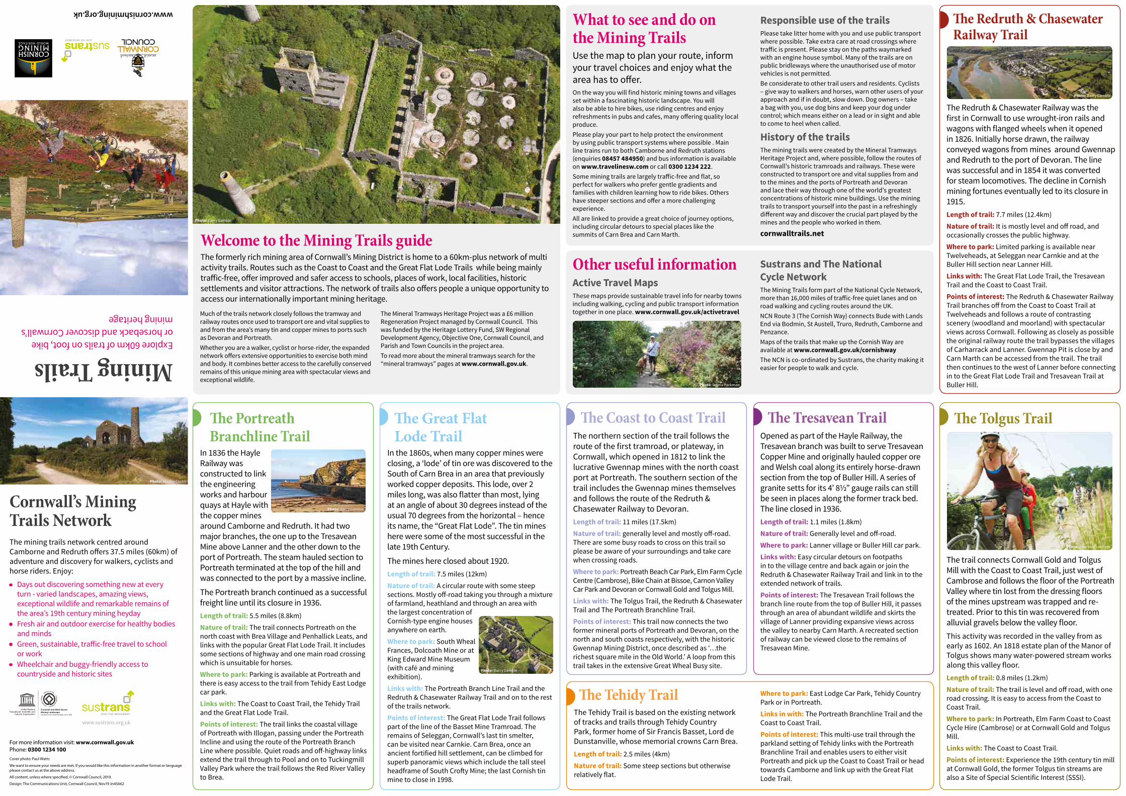
Mining Trails Explore 60km of trails on foot, bike or horseback and discover Cornwall’s mining heritage
Photo: Ainsley Cocks
Cornwall’s MiningTrails Network The mining trails network centred around Camborne and Redruth ofers 37.5 miles (60km) of adventure and discovery for walkers, cyclists and horse riders. Enjoy:
• Days out discovering something new at every turn - varied landscapes, amazing views, exceptional wildlife and remarkable remains of the area’s 19th century mining heyday
• Fresh air and outdoor exercise for healthy bodies and minds
• Green, sustainable, trafic-free travel to school or work
• Wheelchair and buggy-friendly access to countryside and historic sites
Te Great Flat Lode Trail In the 1860s, when many copper mines were closing, a ‘lode’ of tin ore was discovered to the South of Carn Brea in an area that previously worked copper deposits. This lode, over 2 miles long, was also flatter than most, lying at an angle of about 30 degrees instead of the usual 70 degrees from the horizontal – hence its name, the “Great Flat Lode”. The tin mines here were some of the most successful in the late 19th Century.
The mines here closed about 1920. Length of trail: 7.5 miles (12km) Nature of trail: A circular route with some steep sections. Mostly of-road taking you through a mixture of farmland, heathland and through an area with the largest concentration of Cornish-type engine houses anywhere on earth. Where to park: South Wheal Frances, Dolcoath Mine or at King Edward Mine Museum (with café and mining exhibition). Links with: The Portreath Branch Line Trail and the Redruth & Chasewater Railway Trail and on to the rest of the trails network. Points of interest: The Great Flat Lode Trail follows part of the line of the Basset Mine Tramroad. The remains of Seleggan, Cornwall’s last tin smelter, can be visited near Carnkie. Carn Brea, once an ancient fortified hill settlement, can be climbed for superb panoramic views which include the tall steel headframe of South Crofy Mine; the last Cornish tin mine to close in 1998.
Welcome to the Mining Trails guide The formerly rich mining area of Cornwall’s Mining District is home to a 60km-plus network of multi activity trails. Routes such as the Coast to Coast and the Great Flat Lode Trails while being mainly trafic-free, ofer improved and safer access to schools, places of work, local facilities, historic settlements and visitor attractions. The network of trails also ofers people a unique opportunity to access our internationally important mining heritage.
Much of the trails network closely follows the tramway and railway routes once used to transport ore and vital supplies to and from the area’s many tin and copper mines to ports such as Devoran and Portreath. Whether you are a walker, cyclist or horse-rider, the expanded network ofers extensive opportunities to exercise both mind and body. It combines better access to the carefully conserved remains of this unique mining area with spectacular views and exceptional wildlife.
The Mineral Tramways Heritage Project was a £6 million Regeneration Project managed by Cornwall Council. This was funded by the Heritage Lottery Fund, SW Regional Development Agency, Objective One, Cornwall Council, and Parish and Town Councils in the project area. To read more about the mineral tramways search for the “mineral tramways” pages at www.cornwall.gov.uk.
Te Portreath Branchline Trail In 1836 the Hayle Railway was constructed to link the engineering works and harbour quays at Hayle with the copper mines around Camborne and Redruth. It had two major branches, the one up to the Tresavean Mine above Lanner and the other down to the port of Portreath. The steam hauled section to Portreath terminated at the top of the hill and was connected to the port by a massive incline.
The Portreath branch continued as a successful freight line until its closure in 1936. Length of trail: 5.5 miles (8.8km) Nature of trail: The trail connects Portreath on the north coast with Brea Village and Penhallick Leats, and links with the popular Great Flat Lode Trail. It includes some sections of highway and one main road crossing which is unsuitable for horses. Where to park: Parking is available at Portreath and there is easy access to the trail from Tehidy East Lodge car park. Links with: The Coast to Coast Trail, the Tehidy Trail and the Great Flat Lode Trail. Points of interest: The trail links the coastal village of Portreath with Illogan, passing under the Portreath Incline and using the route of the Portreath Branch Line where possible. Quiet roads and of-highway links extend the trail through to Pool and on to Tuckingmill Valley Park where the trail follows the Red River Valley to Brea.
Photo: Barry Gamble
Photo: Barry Gamble
Photo: Barry Gamble
Cornwall and West Devon Mining Landscape inscribed on the World Heritage List in 2006
www.sustrans.org.uk
For more information visit: www.cornwall.gov.uk Phone: 0300 1234 100 Cover photo: Paul Watts
We want to ensure your needs are met. If you would like this information in another format or language please contact us at the above address.
All content, unless where specifed, © Cornwall Council, 2019.
Design: The Communications Unit, Cornwall Council, Nov19 Jn45662
Te Coast to Coast Trail
What to see and do on the Mining Trails Use the map to plan your route, inform your travel choices and enjoy what the area has to ofer. On the way you will find historic mining towns and villages set within a fascinating historic landscape. You will also be able to hire bikes, use riding centres and enjoy refreshments in pubs and cafes, many ofering quality local produce. Please play your part to help protect the environment by using public transport systems where possible . Main line trains run to both Camborne and Redruth stations (enquiries 08457 484950) and bus information is available on www.travelinesw.com or call 0300 1234 222. Some mining trails are largely trafic-free and flat, so perfect for walkers who prefer gentle gradients and families with children learning how to ride bikes. Others have steeper sections and ofer a more challenging experience. All are linked to provide a great choice of journey options, including circular detours to special places like the summits of Carn Brea and Carn Marth.
Responsible use of the trails Please take litter home with you and use public transport where possible. Take extra care at road crossings where trafic is present. Please stay on the paths waymarked with an engine house symbol. Many of the trails are on public bridleways where the unauthorised use of motor vehicles is not permitted. Be considerate to other trail users and residents. Cyclists – give way to walkers and horses, warn other users of your approach and if in doubt, slow down. Dog owners – take a bag with you, use dog bins and keep your dog under control; which means either on a lead or in sight and able to come to heel when called.
History of the trails The mining trails were created by the Mineral Tramways Heritage Project and, where possible, follow the routes of Cornwall’s historic tramroads and railways. These were constructed to transport ore and vital supplies from and to the mines and the ports of Portreath and Devoran and lace their way through one of the world’s greatest concentrations of historic mine buildings. Use the mining trails to transport yourself into the past in a refreshingly diferent way and discover the crucial part played by the mines and the people who worked in them.
cornwalltrails.net
The Redruth & Chasewater Railway was the first in Cornwall to use wrought-iron rails and wagons with flanged wheels when it opened in 1826. Initially horse drawn, the railway conveyed wagons from mines around Gwennap and Redruth to the port of Devoran. The line was successful and in 1854 it was converted for steam locomotives. The decline in Cornish mining fortunes eventually led to its closure in 1915. Length of trail: 7.7 miles (12.4km) Nature of trail: It is mostly level and of road, and occasionally crosses the public highway. Where to park: Limited parking is available near Twelveheads, at Seleggan near Carnkie and at the Buller Hill section near Lanner Hill. Links with: The Great Flat Lode Trail, the Tresavean Trail and the Coast to Coast Trail. Points of interest: The Redruth & Chasewater Railway Trail branches of from the Coast to Coast Trail at Twelveheads and follows a route of contrasting scenery (woodland and moorland) with spectacular views across Cornwall. Following as closely as possible the original railway route the trail bypasses the villages of Carharrack and Lanner. Gwennap Pit is close by and Carn Marth can be accessed from the trail. The trail then continues to the west of Lanner before connecting in to the Great Flat Lode Trail and Tresavean Trail at Buller Hill.
Te Redruth & Chasewater Railway Trail
Te Tolgus Trail
The trail connects Cornwall Gold and Tolgus Mill with the Coast to Coast Trail, just west of Cambrose and follows the floor of the Portreath Valley where tin lost from the dressing floors of the mines upstream was trapped and re-treated. Prior to this tin was recovered from alluvial gravels below the valley floor. This activity was recorded in the valley from as early as 1602. An 1818 estate plan of the Manor of Tolgus shows many water-powered stream works along this valley floor. Length of trail: 0.8 miles (1.2km) Nature of trail: The trail is level and of road, with one road crossing. It is easy to access from the Coast to Coast Trail. Where to park: In Portreath, Elm Farm Coast to Coast Cycle Hire (Cambrose) or at Cornwall Gold and Tolgus Mill. Links with: The Coast to Coast Trail. Points of interest: Experience the 19th century tin mill at Cornwall Gold, the former Tolgus tin streams are also a Site of Special Scientific Interest (SSSI).
Te Tresavean Trail Opened as part of the Hayle Railway, the Tresavean branch was built to serve Tresavean Copper Mine and originally hauled copper ore and Welsh coal along its entirely horse-drawn section from the top of Buller Hill. A series of granite setts for its 4’ 8½” gauge rails can still be seen in places along the former track bed. The line closed in 1936. Length of trail: 1.1 miles (1.8km) Nature of trail: Generally level and of-road. Where to park: Lanner village or Buller Hill car park. Links with: Easy circular detours on footpaths in to the village centre and back again or join the Redruth & Chasewater Railway Trail and link in to the extended network of trails. Points of interest: The Tresavean Trail follows the branch line route from the top of Buller Hill, it passes through an area of abundant wildlife and skirts the village of Lanner providing expansive views across the valley to nearby Carn Marth. A recreated section of railway can be viewed close to the remains of Tresavean Mine.
The northern section of the trail follows the route of the first tramroad, or plateway, in Cornwall, which opened in 1812 to link the lucrative Gwennap mines with the north coast port at Portreath. The southern section of the trail includes the Gwennap mines themselves and follows the route of the Redruth & Chasewater Railway to Devoran. Length of trail: 11 miles (17.5km) Nature of trail: generally level and mostly of-road. There are some busy roads to cross on this trail so please be aware of your surroundings and take care when crossing roads. Where to park: Portreath Beach Car Park, Elm Farm Cycle Centre (Cambrose), Bike Chain at Bissoe, Carnon Valley Car Park and Devoran or Cornwall Gold and Tolgus Mill. Links with: The Tolgus Trail, the Redruth & Chasewater Trail and The Portreath Branchline Trail. Points of interest: This trail now connects the two former mineral ports of Portreath and Devoran, on the north and south coasts respectively, with the historic Gwennap Mining District, once described as ‘…the richest square mile in the Old World.’ A loop from this trail takes in the extensive Great Wheal Busy site.
Other useful information Active Travel Maps These maps provide sustainable travel info for nearby towns including walking, cycling and public transport information together in one place. www.cornwall.gov.uk/activetravel
Te Tehidy Trail The Tehidy Trail is based on the existing network of tracks and trails through Tehidy Country Park, former home of Sir Francis Basset, Lord de Dunstanville, whose memorial crowns Carn Brea. Length of trail: 2.5 miles (4km) Nature of trail: Some steep sections but otherwise relatively flat.
Sustrans and The National Cycle Network The Mining Trails form part of the National Cycle Network, more than 16,000 miles of trafic-free quiet lanes and on road walking and cycling routes around the UK. NCN Route 3 (The Cornish Way) connects Bude with Lands End via Bodmin, St Austell, Truro, Redruth, Camborne and Penzance. Maps of the trails that make up the Cornish Way are available at www.cornwall.gov.uk/cornishway The NCN is co-ordinated by Sustrans, the charity making it easier for people to walk and cycle.
Where to park: East Lodge Car Park, Tehidy Country Park or in Portreath. Links in with: The Portreath Branchline Trail and the Coast to Coast Trail. Points of interest: This multi-use trail through the parkland setting of Tehidy links with the Portreath Branchline Trail and enables users to either visit Portreath and pick up the Coast to Coast Trail or head towards Camborne and link up with the Great Flat Lode Trail.
Photo: Courtesy Sustrans
Photo: Barry Gamble
Photo: Emma Parkman
Co
A30
5
6
7
8
3
9
4
11
12
13
14
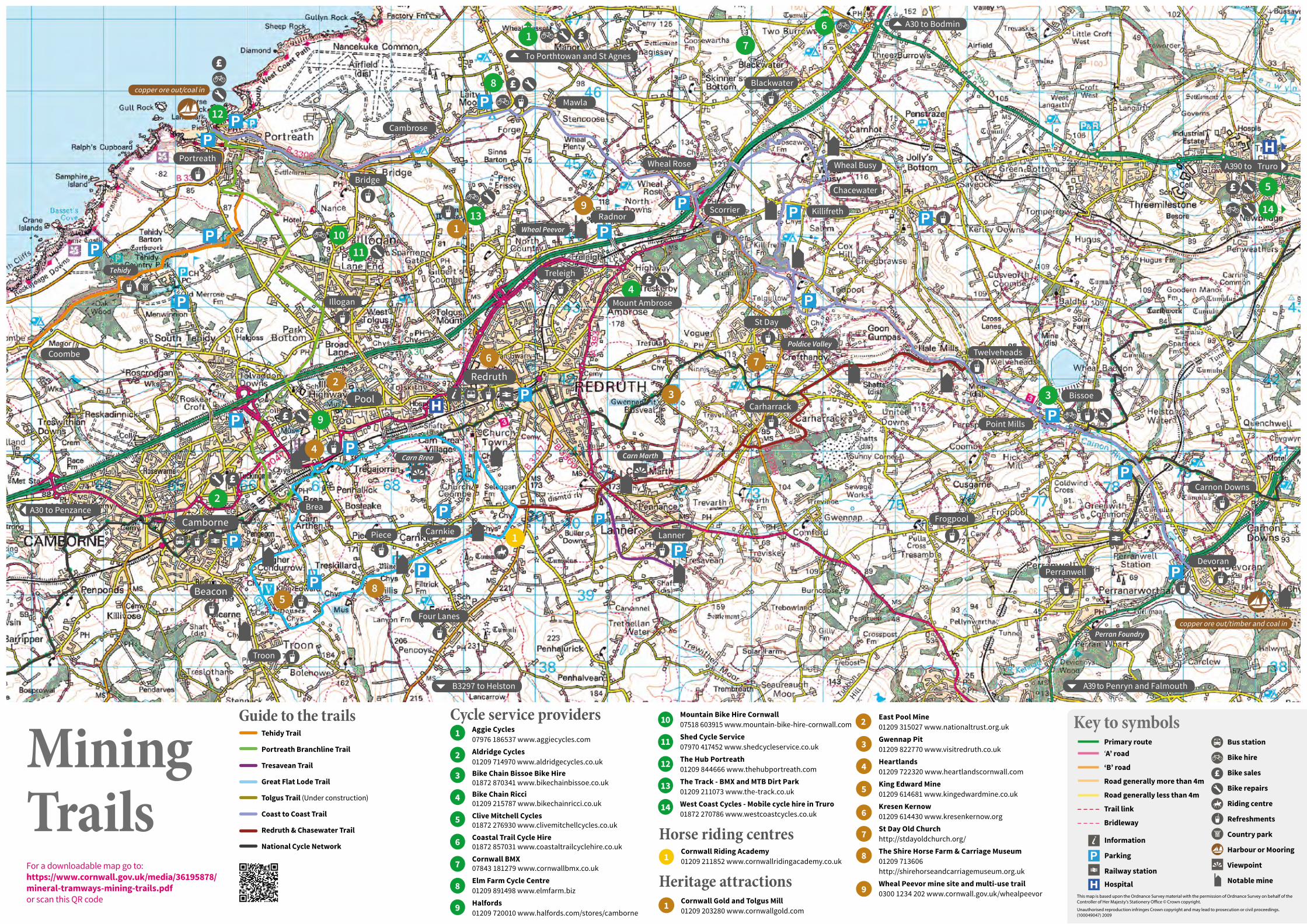
Guide to the trails
4
9
Pool
Four Lanes
Carn Brea
Troon
Camborne
Redruth
Lanner Piece
3 Bissoe
Point Mills
Perranwell
Carnon Downs
Devoran
Frogpool
Carharrack
Twelveheads
Blackwater
Mawla
Cambrose
Bridge
Illogan
Portreath
copper ore out/coal in
copper ore out/timber and coal in
Coombe
Carnkie
Beacon
Brea
St Day
Treleigh
Mount Ambrose
Scorrier
Wheal Rose
Radnor
A390 to Truro
A30 to Bodmin
A30 to Penzance
A39 to Penryn and Falmouth
5
2
6 7
2
8
1
8
3
1
Tehidy
Carn Marth
Poldice Valley
Wheal Busy
Perran Foundry
4
11
12
13
5
7
14
B3297 to Helston
To Porthtowan and St Agnes
Wheal Peevor
Killifreth
Chacewater
1
10
9
6
Cycle service providers Mountain Bike Hire Cornwall 07518 603915 www.mountain-bike-hire-cornwall.com 10 East Pool Mine 2 01209 315027 www.nationaltrust.org.uk Aggie Cycles Tehidy Trail Shed Cycle Service 07976 186537 www.aggiecycles.com Gwennap Pit 07970 417452 www.shedcycleservice.co.uk Portreath Branchline Trail
1
2
3
4
5
6
7
8
9 1
01209 822770 www.visitredruth.co.uk Aldridge Cycles The Hub Portreath 01209 714970 www.aldridgecycles.co.uk Heartlands Mining Tresavean Trail 01209 844666 www.thehubportreath.com 01209 722320 www.heartlandscornwall.com
Great Flat Lode Trail 01872 870341 www.bikechainbissoe.co.uk The Track - BMX and MTB Dirt Park King Edward Mine 01209 211073 www.the-track.co.uk
Bike Chain Bissoe Bike Hire
Bike Chain Ricci 01209 614681 www.kingedwardmine.co.uk Tolgus Trail (Under construction) 01209 215787 www.bikechainricci.co.uk West Coast Cycles - Mobile cycle hire in Truro Kresen Kernow
Coast to Coast Trail 01872 270786 www.westcoastcycles.co.uk Clive Mitchell Cycles 01209 614430 www.kresenkernow.org 01872 276930 www.clivemitchellcycles.co.uk Trails Redruth & Chasewater Trail St Day Old Church Horse riding centres Coastal Trail Cycle Hire http://stdayoldchurch.org/
National Cycle Network 01872 857031 www.coastaltrailcyclehire.co.uk 1
Cornwall Riding Academy The Shire Horse Farm & Carriage Museum Cornwall BMX 01209 211852 www.cornwallridingacademy.co.uk 01209 713606 For a downloadable map go to: 07843 181279 www.cornwallbmx.co.uk http://shirehorseandcarriagemuseum.org.uk https://www.cornwall.gov.uk/media/36195878/ Elm Farm Cycle Centre Wheal Peevor mine site and multi-use trail Heritage attractions mineral-tramways-mining-trails.pdf 01209 891498 www.elmfarm.biz 0300 1234 202 www.cornwall.gov.uk/whealpeevor
or scan this QR code Halfords Cornwall Gold and Tolgus Mill 01209 203280 www.cornwallgold.com 01209 720010 www.halfords.com/stores/camborne
Primary route ‘A’ road
‘B’ road
Road generally more than 4m
Road generally less than 4m
Trail link
Bridleway
Bus station
Bike hire
Bike sales
Bike repairs
Riding centre
Refreshments
Country park
Harbour or Mooring
Viewpoint
Notable mine
Key to symbols
This map is based upon the Ordnance Survey material with the permission of Ordnance Survey on behalf of the Controller of Her Majesty’s Stationery Ofce © Crown copyright.
Unauthorised reproduction infringes Crown copyright and may lead to prosecution or civil proceedings. (100049047) 2009
Information
Parking
Railway station
Hospital