Embed Size (px)
Citation preview
MOBBS FARM MANAGEMENT PLAN
November 2014
Final Draft for Selectboard Review
By
The Mobbs Farm Committee, Andy Dumas, Chair, with extensive input from Heather Furman and Derek Burkins, former MFC chairs, and from
Jericho residents and the public. For more information on the management of Mobbs Farm, contact the Mobbs Farm Committee, Town of Jericho P.O.
Box 39, Jericho, VT 05465, or email [email protected] Thank you!
ii
Mobbs Farm Management Plan
I. INTRODUCTION ..................................................................................................................... 1
A. LOCATION AND DESCRIPTION OF PROPERTY ........................................................................... 1
B. CURRENT TOWN PLAN AND ZONING ...................................................................................... 2
C. HISTORY OF PROPERTY ............................................................................................................. 2
D. PURPOSE OF MANAGEMENT PLAN ........................................................................................... 3
E. MOBBS FARM COMMITTEE (MFC) ROLE ................................................................................. 4
II. CURRENT USES AND INVENTORY .................................................................................. 5
A. NATURAL AREAS, HABITATS, RESOURCES ............................................................................... 5
Forested Areas ............................................................................................................................... 5
Water Resources - Wetlands and Streams .................................................................................... 6
Open Fields ................................................................................................................................... 6
Soils ............................................................................................................................................... 6
Wildlife Habitat ............................................................................................................................. 6
B. CURRENT RECREATIONAL USES ............................................................................................... 7
The Trail Network & Pedestrian Use ........................................................................................... 7
Dog Walking ........................................................................................................................... 8
Mountain Biking ..................................................................................................................... 8
Horseback Riding ................................................................................................................... 8
Winter Use (skiing, snowshoeing, sledding) ...................................................................... 9
Dispersed Recreation ..................................................................................................................... 9
Hunting and Fishing .............................................................................................................. 9
Swimming &Water Travel .................................................................................................. 10
Motorized Vehicle Use ................................................................................................................ 10
C. STRUCTURES AND INFORMATION ........................................................................................... 10
Bridges ......................................................................................................................................... 10
Information/ Kiosks ..................................................................................................................... 10
Trail Marking and Signage ......................................................................................................... 10
D. ACCESS AND PARKING............................................................................................................ 11
Parking ........................................................................................................................................ 11
Access from Trail Network .......................................................................................................... 11
III. MANAGEMENT GOALS AND RECOMMENDATIONS ......................................... 12
A. GUIDING PRINCIPLES .............................................................................................................. 12
B. NATURAL AREAS, HABITATS, AND RESOURCE RECOMMENDATIONS................................... 12
Wildlife Habitat ........................................................................................................................... 12
Forest Management Plan ............................................................................................................ 13
C. RECREATIONAL USE RECOMMENDATIONS ............................................................................ 13

iii
The Trail Network: Use, Maintenance and Improvements ........................................................ 13
General Safety Guidelines ................................................................................................... 14
General Maintenance and Improvements ........................................................................ 14
Recommended Maintenance Tasks ............................................................................. 14
Trail Maps & Signage ........................................................................................................... 15
Trail Closures ........................................................................................................................ 15
Pedestrian Use & Dog Walking .......................................................................................... 16
Group Use .............................................................................................................................. 16
Mountain Biking ................................................................................................................... 16
Equestrian Use ...................................................................................................................... 17
Winter Activities ................................................................................................................... 17
Dispersed Recreation ................................................................................................................... 18
Hunting .................................................................................................................................. 18
Nature Observation, Geo-Caching, and Other ................................................................ 18
Motorized Vehicle Use ................................................................................................................ 18
D. STRUCTURES AND SAFETY RECOMMENDATIONS ................................................................... 18
Kiosk ............................................................................................................................................ 18
Bridges ......................................................................................................................................... 19
Culverts ....................................................................................................................................... 19
Signage ........................................................................................................................................ 19
Other Structures ......................................................................................................................... 19
E. PARKING RECOMMENDATIONS .............................................................................................. 19
Parking Areas and Access to Trail Network ............................................................................... 19
F. HOURS OF OPERATION ........................................................................................................... 20
G. PROHIBITED USES .................................................................................................................... 20
H. USER COURTESY .................................................................................................................. 21
IV. FUNDING ............................................................................................................................. 22
A. ANNUAL BUDGET ................................................................................................................... 22
B. REVENUE SOURCES ................................................................................................................. 22
V. MONITORING AND RESPONSIBILITIES ...................................................................... 23
A. MOBBS FARM COMMITTEE ...................................................................................................... 23
B. JERICHO SELECTBOARD ........................................................................................................... 23
C. VOLUNTEERS AND VOLUNTEER OPPORTUNITIES .................................................................. 24
VI. PLAN UPDATES, REVISIONS AND APPROVAL ..................................................... 25
A. PLAN REVISIONS AND UPDATES ............................................................................................. 25
B. ADOPTION AND SIGNATURES ................................................................................................. 25
VII. APPENDICES....................................................................................................................... 26
iv
A. DEFINITIONS: TOWN OF JERICHO, LAND USE AND DEVELOPMENT REGULATIONS ................. 26
B. WETLANDS MAP ..................................................................................................................... 27
C. BRUSH HOGGING SCHEDULE ........................................................................................ 28
D. LIST OF ABUTTERS ................................................................................................................... 30
1
I. INTRODUCTION
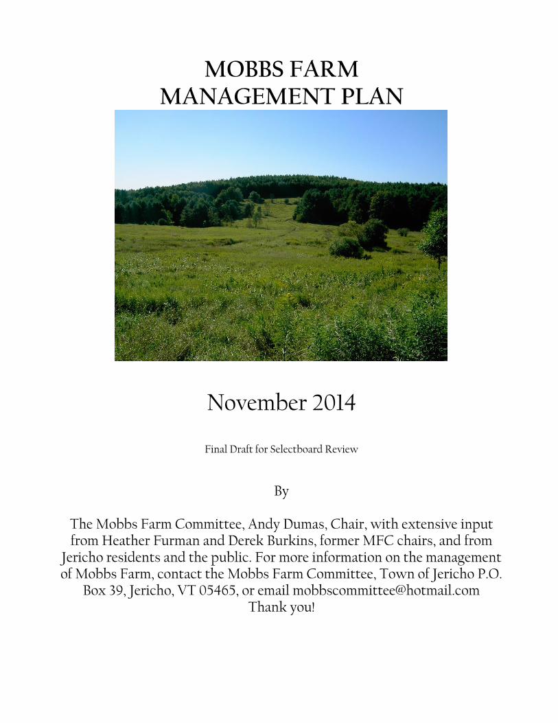
The parcel of land that has become known as the Mobbs Farm property has been owned by
the Town of Jericho since 1968. The property has become a popular recreation area for
residents throughout Chittenden County and is even a destination for out-of-state visitors.
The 278-acre property is a complex of field and forest with rolling hills and scenic vistas. A
classic example of a once-common Vermont hillside farm, the property still retains its open
pastures, hay fields, apple orchards, and utilitarian woodlots. Remnants of its agricultural
heritage are revealed as visitors wander the well-used trail network: old cars, barbed wire
fences, cellar holes and stone walls. Mobbs Farm is also host to myriad wildlife and
contains important natural resources including portions of Mill Brook and state-designated
Class II wetlands.
A. LOCATION AND DESCRIPTION OF PROPERTY
The Mobbs Farm property is in the center of a wedge of land roughly bounded by Browns
Trace, Tarbox Road, and Barber Farm Road. Located approximately one mile to the south
of the Jericho Center village, it extends westward from Browns Trace and straddles two
sides of Fitzsimonds Road. Fitzsimonds Road nearly bisects the property, with the “Valley”
section to its west and the “Hill” section to its east. Public access points are found at the
five-car pull-off on Fitzsimonds Road and from a twelve-car parking lot located on the
Town Garage access road on Browns Trace.
A 40-acre section of the property, at Mobbs Farm’s southeastern corner, is used by the town
for storage of road maintenance supplies and equipment, and is the location of the Town
Garage. There is a small area leased to a cable provider for a TV satellite station. This area
was also used as a sanitary landfill from the late 1960s to early 1990s, and it is now closed
and capped.
The remaining bulk of the Mobbs Farm property comprises meadowland, forests, and
wetlands. The gentlest terrain is found in the former agricultural land to the immediate
west of Fitzsimonds Road and to the west of Browns Trace near the capped landfill. Forest
areas range from gentle rolling slopes to steep slopes of 45% grade or more. A narrow,
steep riparian zone exists along the Mill Brook. A more detailed description of forest, soil,
and topographical characteristics can be found in the Forest Management Plan: Mobbs
Farm (Jericho, Vermont, October, 2006).
The Mobbs Farm property abuts 37 privately-owned parcels, including parcels owned by
the Town of Jericho and the University of Vermont (Jericho Research Forest). See Appendix
D for a complete list of abutters.
2
B. CURRENT TOWN PLAN AND ZONING
Most of the Mobbs Farm property is zoned Open Space District as defined in Section 3.2.1
of the Town of Jericho Land Use and Development Regulations (February 7, 2013), with the
exception of one 20-acre parcel that is zoned Rural Residential. The Mobbs Farm property
has been well-used for various recreational pursuits since its acquisition by the town.
In recognition of Jericho’s vision statement, which references public recreation facilities of
high quality as an integral part of our community, this document endeavors to align with
and support Jericho’s Comprehensive Town Plan (February 17, 2011), most specifically the
first two of its seven goals:
1: To protect the natural environment, and
2: Preserve the rural and historic character of Jericho and endeavor to improve
livability throughout Jericho.
C. HISTORY OF PROPERTY
The Mobbs Farm property was originally two farms: the Bashaw Farm and the Brooks
Farm, which were purchased in the mid-1930s by the Fitzsimonds family. John and Sarah
Fitzsimonds, and later their son Andrew, farmed the land from 1934 to 1948. In 1948,
Andrew Fitzsimonds sold the farm to Benjamin and Gladys Mobbs, who continued farming
until 1968. On June 19, 1968 the Mobbs family sold the farm to Arthur Pratt. Nine days later
Mr. Pratt sold the approximately 300-acre farm to the Town of Jericho.
The town established a landfill on the eastern portion of the former farm from 1968 to 1993.
The landfill was closed and capped in 1994. The town garage is currently located near the
landfill and houses the town’s plow trucks and other machinery. Additionally the town’s
supply of sand and salt are located near the former landfill site.
In the early 1970s, a plan was drafted to site a town community center on the property,
complete with an in-ground pool, tennis courts, and clubhouse. Fortunately, the property’s
ledgey soil, marshy fields and many naturally occurring springs, make it ill-suited for
development and its use as a low-impact passive recreational wonderland has become its
predominate asset to the town.
Even while in private ownership, the property was used by residents for hunting,
equestrian use, walking, and skiing. These activities continue today along with other newer
uses such as mountain biking and geocaching. A series of trails has been developed on the
property for visitors to enjoy. Recreational trail use and trail building activities are among
the most visible changes to occur in some of the wooded as well as open areas. Within the
past 15+/- years the trail system at Mobbs Farm has evolved from 4 miles of primarily old
logging roads used by occasional hikers, bikers and equestrians to nearly 9 miles of
purpose-built trails (approximately 5.5 on the Valley side and 3.5 on the Hill side) used

3
almost daily by Jericho residents. The current system, a cooperative effort between the
Jericho Conservation Commission, The Fellowship of the Wheel, The Vermont Youth
Conservation Corps (VYCC), and the Mobbs Farm Committee (MFC) was planned, built
and updated over the years. The MFC currently manages improvements, updates, and
additions to the system. Improved trail access and design have significantly increased the
number of pedestrians, cyclists, skiers, and snowshoers seeking recreation at Mobbs Farm.
In 2009, a 20- acre parcel was donated to the Town and incorporated into Mobbs Farm. The
property is currently listed at 278 acres.
D. PURPOSE OF MANAGEMENT PLAN
During the summer, fall, and winter of 2008-2009 the MFC, at the request of the Jericho
Selectboard, undertook an extensive public process to develop the first comprehensive
Management Plan for Mobbs Farm1. The process included a survey of uses and users, a
“public listening session” hosted by the committee, and a public hearing held by the
Selectboard. The committee carefully considered public input and developed a set of
Guiding Principles (see Section III) intended to reflect the community’s desires for the long-
term care, management, and maintenance of the property. The plan was completed and
endorsed by the Selectboard on June 1, 2009.
This document is the first planned update of the 2009 plan. While the basic guiding
principles and management objectives have remained essentially the same, the purpose of
this update is to clarify ambiguity, reflect current conditions and practices, and take into
account emerging issues and challenges.
This plan builds upon prior work. The citizens of Jericho, at the request of the Jericho
Selectboard, have produced several reports on the Mobbs Farm property. The first known
comprehensive document, A Report to the Jericho Selectboard on Utilization of Mobbs Farm
Property was written in 1993. The Report described conditions as they existed at the time,
outlined a number of concerns and made several recommendations. Noteworthy
recommendations included “an active effort…to preserve the potential value of [Mobbs
Farm] for the town and its residents into the future.” As such, the report called for the
drafting of a management plan, which would address maintenance of open space,
maintenance and enhancement of wildlife habitat, protection of wetlands, management of
timber, and enhancement of possible productive uses of the property such as haying and
1 While this plan was developed to address current uses and recommendations for recreation and habitat
management, it did not include specific forest management prescriptions. A discussion of the Forest
Management Plan commissioned by the Jericho Conservation Commission can be found in Section II.A.
4
education. This report also recommended that a committee be formed “for the purpose of
managing the Mobbs Farm property.”
In 2000, a similar Report to the Jericho Selectboard on Appropriate Public Uses and Property
Management was drafted by the Mobbs Farm Task Force. This report stated that the
“stewardship of the property would best be served by the creation of a standing ‘Mobbs
Farm Committee’ which would have broad community representation.” This report also
made a number of recommendations including prohibiting motorized vehicles, posting
limited signage, and managing the property to balance the natural environment with
recreational activities.
E. MOBBS FARM COMMITTEE (MFC) ROLE
The MFC was convened by the Jericho Selectboard on May 21, 2007. The committee
includes up to nine seats; members are approved by the Selectboard for staggered three-
year terms. The challenge to the committee is to develop and maintain a plan that
integrates management of all the area resources, balances resource protection with
responsible recreational use, and considers the public investment in and vision for this
property. In order to achieve this, the committee makes an effort to communicate with the
public on a regular basis, makes on-going evaluations of uses and needs, coordinates with
volunteers and various user groups, and develops standards and guidelines to govern
recreational management activities and property maintenance. The Committee is under the
direct purview of the Jericho Selectboard, which has the final option of accepting or
rejecting the committee’s plan and other recommendations.
5
II. Current Uses and Inventory
This section outlines the existing conditions found on the property. No attempt is made to
judge the activity or make recommendations for how the activity should be carried out in
the future. Recommendations are found in Section III.
A. NATURAL AREAS, HABITATS, RESOURCES
Forested Areas
A Forest Management Plan (FMP) for Mobbs Farm, was commissioned by the Jericho
Conservation Commission, and was completed by Greenleaf Forestry and the Chittenden
County Forester, Michael Snyder, in November, 1994. The FMP was last updated (but not
finalized or adopted) in October 2006 and describes the physical features and timber
resources and uses found on the property. The plan makes several recommendations for
timber and wildlife habitat management, and includes a harvest schedule. Stand thinnings,
as called for in the FMP, were carried out in three white pine stands in 1997. The affected
areas include Stand 3 (2 areas) and Stand 8 as shown on the Forest Plan map. These stands
occur in the eastern end of the of the parcel, primarily on upland and south-facing slopes in
the Mill Brook drainage (Stand 3), and near the northwest corner of the parcel between
Browns Trace and the Parcel high point to the east (Stand 8). Treatments in these stands
were conducted primarily to enhance saw-timber value.
Since the time of the last FMP update however, several economic, social, and
environmental changes have occurred that have influenced the objectives for forest
management at Mobbs Farm. Dramatic changes in the forest products industry and the
corresponding drop in timber sales in Vermont have made active harvest of timber
resources at Mobbs Farm uneconomical. In addition, and particularly since 2007, the
property has seen a sharp increase in recreational use that has resulted in considerable
investments in trail construction and maintenance that could be damaged by heavy timber
harvest equipment. Finally, a severe windstorm in December 2010 and other minor weather
events caused considerable damage to large stands of pine and hemlock, reducing the value
of harvestable timber, particularly on the Valley side of the property. These factors point to
the need for a revised and updated FMP that takes these changes into consideration. The
MFC has ceased all timber harvest activities, with the exception of routine trail clearing and
tree removal to ensure safety.
The reader is referred to the FMP document for detailed information regarding:
• Timber stand composition, inventory and management recommendations;
• Wildlife habitat; and
• General soils & slope characteristics.
6
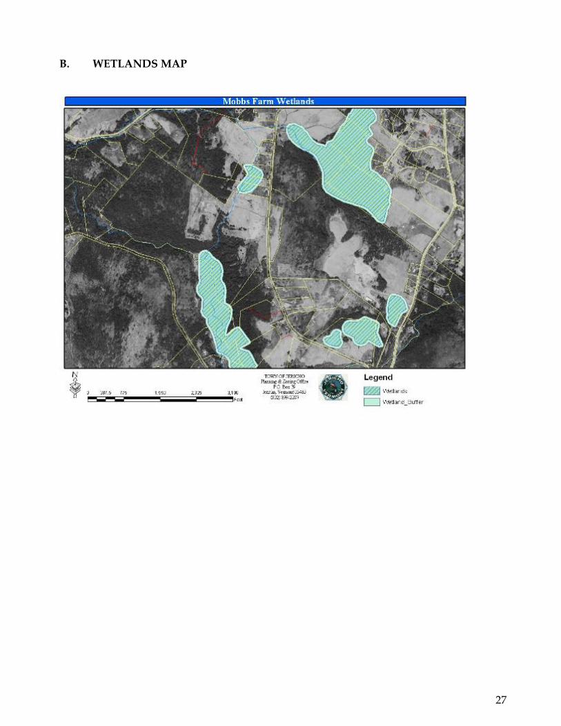
Water Resources - Wetlands and Streams
The Mobbs Farm property hosts several wetland complexes, including state-protected Class
II Wetlands, and is bounded by Mill Brook at its western-most edge (Valley side). In
addition, there are several smaller streams that drain the Valley portion of the property. A
current GIS map of Vermont wetlands and water resources, including Mobbs Farm detail,
is maintained by the Vermont Agency of Natural Resources and can be found at
http://anrmaps.vermont.gov/websites/anra/.
Open Fields
There are a number of open fields on the property which not only provide aesthetic
enhancement to the area, but provide unique habitat for grassland and edge-dwelling
species. Historically, there has been a strong desire to manage these fields for hay
production; however, as of this writing, the fields would require considerable investment to
bring them back into regular production. Based on public input to the 2009 version of this
plan, the MFC has managed the fields for recreation (mowed trails) and has brush-hogged
the various section on a rotating basis to improve habitat for field nesting birds as well as
other species.
Soils
The Mobbs Farm property is primarily located upon Lyman and Marlow series soils, which
are moderately to highly-drained, loamy glacial till. There are also small inclusions of other
glacially-derived soils that are more sandy in nature, but still well-drained. In general, these
soil types are resistant to erosion except where slopes are excessive. The height of land to
the west of the Town Garage has slopes approaching 45% and, because of this, some of the
soils in this location are considered highly erodable.
Wildlife Habitat
There is abundant wildlife on the Mobbs Farm property due to the diverse age and species
composition the site provides. There are open fields, wetlands, dense hemlock stands, and
early successional forests that create edge habitat that deer and other species require. The
Mill Brook separates Mobbs Farm property from the 478-acre University of Vermont
(UVM) Research Forest. Tarbox Road runs through the eastern section of the UVM
Research Forest, but other manmade barriers are not common at this time. Accordingly,
deer species may travel through a wide contiguous forested corridor that extends from
Route 117 at the Winooski River, to Browns Trace Road and beyond to the Bolton section of
the Green Mountains. The corridor includes a mix of open land and forest, providing
shelter and food sources for a wide variety of wildlife species. In addition to deer, smaller
common species include, but are not limited to: fox, coyote, fisher, weasel, rabbit, a variety
of rodents, and abundant birdlife (particularly owls). Less common, but still evident are
moose, black bear, bobcat, raccoon, and beaver.
7
A Bird Habitat Assessment completed by Audubon Vermont in February 2013 identified
seven habitat units at Mobbs Farm that provide different desired conditions for many avian
species including warblers, scarlet tanagers, bobolink, grouse, and kestrel. The report’s
Summary of Habitat Units calculated that hardwood, mixed wood, and softwood forest
compose 60% of the property, fields compose 22%, and wetlands 11%. Remaining land
includes shrubland and the town gravel pit. The report notes that Mobbs Farm “helps to
provide a diversity of connected native habitats in a landscape that is increasingly
fragmented by human development.”
B. CURRENT RECREATIONAL USES
The Trail Network & Pedestrian Use
In the decades following the town’s acquisition, pedestrian use of the property was
dispersed, and consisted primarily of hunting, fishing, picnicking, and swimming in the
Mill Brook swimming hole, along with some equestrian use that took advantage of the old
logging road network. Access was through private property or along a few trails that had
been formed through repeated use, but not necessarily in an organized manner. Until the
early 1990s a VAST trail crossed the hay fields in the eastern portion of the property
(Mobbs Hill) and ran down to a bridge that crossed Mill Brook. The fields on the western
portion of the property (Mobbs Valley) were accessed by a trail leading from Fitzsimonds
Road up to the top of the hill near the woods, providing access for haying and brush
hogging of those fields. There is much anecdotal evidence that there has always been a trail
leading down to the waterfalls on Mill Brook. There is also strong evidence that there was
an informal farm road that led into the southern section of Mobbs Hill, where a number of
abandoned vehicles can be found today. The small meadow on the Hill side was also
frequently used for picnicking. Anecdotal evidence supports tales of a small parking area
near this former picnic meadow. Finally, trails also exist on both the eastern and western
parcels that are the result of ATV and motorbike use.
In the early 1990s, the town of Jericho developed a forest management plan for the property
and a number of forest stands were cut and/or thinned during this time as a result of a new
forest management plan. The resulting skid trails were seen as an asset to developing
organized recreational trails on the site. From 1996 to 1998, a number of projects organized
by a local Boy Scout troop resulted in a series of trails on the Mobbs Valley side. These
trails were designed around the skid trails and were intended to trace a series of nested
loops that could provide a trail user with a number of options depending on how much
time they wanted to spend on the trails. From this time to the present, pedestrian use has
increased significantly as more area residents have discovered these enjoyable walks. The
primary pedestrian uses remain walking/hiking, dog walking, hunting, snowshoeing, and
XC skiing.
8
The current Mobbs Farm trail network was constructed by the Jericho Conservation
Commission, the Vermont Student Conservation Association (SCA), VYCC, and the local
mountain bike club, the Fellowship of the Wheel. Trails have been designed and
constructed to standards provided by the SCA (Lightly on the Land: The SCA Trail-Building
and Maintenance Manual, by Robert C. Birkby, 1996), the Vermont Trails and Greenways
Council, and the International Mountain Bike Association (IMBA) for sustainable trail
construction. A trail map was developed by the MFC and is available on the kiosks as well
as on the town website. The MFC updates the trail maps periodically. The network has seen
change in the past five years resulting from trail maintenance and significant work,
including trail relocation, completed in the aftermath of wind storms.
Dog Walking
According to a July-August 2007 user survey conducted by the MFC, dog-walking is one of
the most popular uses of the Mobbs Farm property. Informal observation confirms that this
is still true in 2014. Early morning and late afternoon see frequent use of the property by
dog-walkers. Many users (and their dogs) enjoy the freedom of walking or jogging without
the constraints of a leash.
Mountain Biking
Since the advent of mountain biking in the mid-1980s, people have been riding the existing
logging roads and trails on the Mobbs Farm property. With increased popularity in the late
1990s, usage grew. This culminated with the non-profit organization Fellowship of the
Wheel (FOTW) approaching the Jericho Conservation Commission and requesting
permission to build trails to support mountain biking. Permission was granted and in 2000
FOTW cleared many of the existing logging roads and developed a five-mile loop of
singletrack on the Mobbs Valley (west) side of the property (marked with yellow arrows).
In 2001, another four miles was developed on the Mobbs Hill (east) side of the property.
When asked, FOTW has provided tools, materials, and people-power to help the Jericho
Conservation Commission (and now, the MFC) maintain and monitor the condition of the
trail system. FOTW has also listed Mobbs Valley and Hill on their website, which has
contributed to mountain bikers being one the more visible user groups.
Horseback Riding
Horseback riding has been a popular activity at Mobbs Farm for many years. Some nearby
and neighboring property owners keep horses. Riders enter Mobbs Farm at the
Fitzsimonds Road and Browns Trace access points, having ridden along town roads. There
is also a trail that emerges on Browns Trace conveniently close to Nashville Road and
equine properties. It is possible, but uncommon, to drive a horse trailer to one of the
parking areas. Use of Mobbs for riding groups of more than two or three people is rare, but

9
in the past there have been larger gatherings. While there are many trails at Mobbs Farm
that are ideal for horseback riding, there are some that are unsuitable for horses, primarily
the trails that have bridges that would not safely support the weight of horse and
rider. Many riders like to cross Mill Brook to connect to trails in the UVM Research Forest,
and recent trail improvements along that path have been made explicitly with the equine
user in mind. Horses are not incompatible with dogs, bikers, and hikers but each must
stay aware of the other and as always treat one another with mutual respect. Riders should
exercise normal caution during Vermont’s hunting seasons, and Mobbs is closed to riding
during the rifle season.
Winter Use (skiing, snowshoeing, sledding)
During the winter months, Mobbs Farm is used frequently by walkers, skiers, and
snowshoers. While not groomed, the trails receive enough use to be packed out most of the
season and provide ample opportunity for practicing back-country skills.
Dispersed Recreation
Hunting and Fishing
Hunting and fishing have taken place on the Mobbs Farm property long before the town
acquired the parcel of open and forested property. Area residents have enjoyed hunting on
this land and fishing on the adjacent Mill Brook for generations. The Mobbs Farm property
hosts hunters who primarily pursue large game, small game and wild game birds. The
most common large game species of interest for hunters is whitetail deer. In the fall, there
are three deer hunting seasons that take place: bow hunting, which typically begins in early
October, followed by rifle and muzzleloader in November and December. Each season
requires the use of specific equipment, although both bow and muzzleloader may be used
during the two-week rifle season.
During the hunting seasons (see Vermont Department of Fish & Wildlife for dates), all
users are encouraged to wear blaze orange. In accordance with a practice that has been in
place since the 2009 version of this plan, the MFC closes the property to mountain biking
and horseback riding to help facilitate a better user experience for those choosing to hunt
during the rifle season. Hunters are most likely to be on the property well before dawn in
order to be in the best position prior to legal shooting hours, and at dusk in the evening -
usually one half hour before sunset. It is not uncommon to see hunters exiting the property
well after sunset during hunting season. Legal hunting hours typically end one half hour
after sunset for bow, rifle and muzzleloader seasons.
Most of the properties surrounding the town-owned Mobbs Farm, including the UVM
Research Forest, are not posted. Hunters tracking game from the Mobbs Farm property
onto adjacent, privately-owned land can be a frequent occurrence. Much of the privately-
10
owned land adjacent to Mobbs Farm is forested with frequent edge, a situation favored by
deer. Print identification, especially in muddy sections, reveals that deer use the trail
network on a regular basis.
Swimming &Water Travel
After winding its way through a wide and sandy floodplain at the southern end of the
Mobbs Farm property, Mill Brook forms a cobble-bottomed channel within the steep sloped
banks of the surrounding forest. As it flows northwest along the boundary of the property,
it travels through series of waterfalls, which culminate in a popular swimming hole located
just beyond the Mobbs Farm property boundary. These waterfalls and the popular
swimming hole are often accessed by individuals who travel through the Mobbs Farm
property and park at the Fitzsimonds Road parking area.
Motorized Vehicle Use
Prior to 1995, snowmobile users traversed the Mobbs Farm property to connect with other
trail networks. Remnants of an old Vermont Association of Snow Travelers (VAST) trail
can still be seen on the property, which was used until the early1990s. In accordance with
the recommendations and Selectboard endorsement of the 2009 version of this plan,
motorized vehicle use on the Mobbs Farm property is prohibited except as provided for
construction and maintenance.
C. STRUCTURES AND INFORMATION
Bridges
The trail network on the Valley side of the Mobbs Farm property contains five bridge spans
that vary in length from 12 to over 35 feet and one 45 ft boardwalk that was built over a
wetland area in 2012. In 2009, the condition of the five bridges that had originally been built
by the VYCC in 2003 began to deteriorate rapidly, and the MFC began a process of
systematic replacement. The MFC, with support from the town and the Vermont Recreation
Trails Grant program, the VYCC, and Timber & Stone, LLC, replaced all five bridges over a
period of three years, with the last 12-foot bridge replaced in October 2013. The bridges will
now be monitored and repaired or replaced as needed.
Information/ Kiosks
Informational kiosks exist at the parking areas on Fitzsimonds Road and Browns Trace.
Trail maps are posted on each kiosk board.
Trail Marking and Signage
Trails on the property are marked with white circles with the name of the trail in green
lettering. There are also yellow arrow signs from FOTW indicating mountain biking

11
directions, and laminated maps at selected trail junctions. Improvements to the trail
marking may be implemented as appropriate.
D. ACCESS AND PARKING
Parking
There are two parking areas that have been provided for access to Mobbs Farm. The first is
located on Fitzsimonds Road. This parking area was designed to hold up to five cars and is
often used up to, and well beyond, its capacity. This parking area is marked by a small
fence.
A second parking area exists with enough room for a school bus at Browns Trace, just off
the town garage access road. This parking area was approved by the Jericho Development
Review Board (DRB) in July 2007. The lot officially opened in the summer of 2013.
Access from Trail Network
There are several informal access trails from abutting property owners. Some of these
access points exist at Mill Brook, which connects Mobbs Farm with the UVM Research
Forest, and at the swimming hole, which is accessed off Tarbox Road. There are two other
public access points without parking. One is from Browns Trace in the wooded section
about halfway between the town garage access road and Nashville Rd. The other is from
Tarbox Road via a connecting trail through UVM Research Forest lands. There are also
several informal access trails from abutting property owners; users are expected to respect
these landowners' rights and privacy.
12
III. Management Goals and Recommendations
A. GUIDING PRINCIPLES
Collective public input and interest has shaped the development of three “Guiding
Principles” for the management of the property. The Guiding Principles contained in this
section provide a framework for the approach to property use, maintenance, and
management recommendations. The management recommendations should, to the greatest
extent possible, adhere to these Guiding Principles.
1. We value the rural character of the property, its history as a former working
farm, and the diversity of natural areas and wildlife.
2. We strive to sustainably balance the recreational uses and quiet enjoyment of the
property, with healthy forests and fields, and a diversity of habitats for both flora
and fauna.
3. We encourage responsible human interaction with the property, and endeavor to
provide visitors with a pleasant, safe and informed experience.
The following sections address specific recommendations for property use and
management based on these Guiding Principles.
B. NATURAL AREAS, HABITATS, AND RESOURCE RECOMMENDATIONS
Wildlife Habitat
Successful management balances ecological processes and recreation. Encountering wildlife
and observing a healthy productive ecosystem enhances the recreational experience and is
in keeping with rural character of Jericho. The management goal for natural communities
and wildlife habitat remains the same as in prior reports to the Selectboard on utilization of
the Mobbs Farm Property: to maintain and enhance landscape heterogeneity and wildlife
habitat while mitigating impact to sensitive areas including wetlands.
Wildlife habitat for many species can be adversely impacted by human activities
particularly during the spring. The following recommendations aim to minimize impact on
wildlife.
Open fields: The management goal for the open field portions of the Mobbs Farm Property
is to maintain low-stature vegetation (not forest), create landscape heterogeneity, and
provide habitat for grassland species. That is achieved by brush hogging (mowing). MFC
bears responsibility for brush hogging fields west of Fitzsimonds Road, as well as one small
meadow east of Fitzsimonds Road. Town staff have responsibility for mowing the former
landfill and other areas near their facility off Browns Trace. Most grassland nesting birds
have finished laying eggs and raising chicks by mid-summer. For that reason, brush

13
hogging should be done in August or September on a three-year rotation (see Appendix C
for schedule and map). Trails may be mowed earlier in the summer.
Forest/Field Edge: Many species of birds and small mammals use edge habitat for nesting,
roosting, and/or foraging. Edge habitats occur where mowing is used to maintain low-
stature vegetation adjacent to forest as well as along the edges of streams and wetlands.
Softening these edges is recommended by leaving an unmowed strip between the forest
and field in which shrubs and small trees can grow up or by cutting trees at the forest edge
to push the edge inward. Similarly, the brush hog operator should avoid mowing through
wet swales or close to stream banks.
Wetlands and streams: Wetlands and streams provide valuable ecosystem services in terms
of flood amelioration and nutrient retention and they provide habitat for amphibians,
reptiles, mammals, and birds. To protect wetlands, no trails should be developed in or
along the perimeter of wetlands. Trails near streams should be designed to minimize
streambank erosion while giving users the opportunity to enjoy hearing and seeing the
running water. Brush hogging should not include swales.
Winter Deeryards: Mast crops of apples, beech, and oaks have been noted on the property
and should be managed to maintain deer winter habitat. The FMP recommends avoiding
cutting and fostering the growth of mature hemlock, red maple, ash, and red oak for the
purpose of providing more browse. In addition, it is recommended that the apple trees
present in great numbers on the Mobbs Farm Property be released to further provide
suitable mast, as prescribed in Section VI of the FMP for several stands of trees.
Forest Management Plan
As detailed in Section II.A., changes in the timber market, an increase in recreational use of
Mobbs Farm, and the effects of several windstorms since 2009 on large forest stands
indicate the need for an updated FMP with a revised focus. The MFC will administer, along
with the Jericho Conservation Commission, any FMP that may be developed.
C. RECREATIONAL USE RECOMMENDATIONS
The Trail Network: Use, Maintenance and Improvements
The trail network at Mobbs Farm is a tremendous community asset. The trails
accommodate a variety of users. The trail network is open to all forms of non-motorized
recreation including, but not limited to: hiking, bicycling, horseback riding, skiing,
snowshoeing, hunting, and fishing. The following recommendations are aimed at
managing the trail network in a way that affords the best possible experience for a variety
of users.

14
To date, the trail system shows no appreciable deterioration other than wet areas, due in
equal parts to the skilled trail layout and the continued stewardship provided by
neighbors, volunteers, the FOTW and the MFC. The demand for this recreational resource
continues to prove it is one of Mobbs Farm’s most valuable assets.
General Safety Guidelines
Always stay on established trails; don’t create new ones.
Be cautious when using the area during dusk and dawn as animals are often present
on the trails. Never harass wildlife.
Keep pets under control at all time and pick up their waste (if on trail corridor or
near waterways).
Avoid wet conditions. Wet and muddy trails are vulnerable to damage.
Respect trail closures and habitat restoration areas.
Before heading out on the trails, be aware of annual hunting season dates, and be
sure to wear hunter orange in the fall.
Bring a headlamp if you think you might be out after dark.
Bring plenty of water and don’t head out alone unless someone knows where you
are.
Always be respectful of private property; do not trespass on private land.
Please pack out whatever you pack in.
General Maintenance and Improvements
There is widely accepted agreement that the number of trails at Mobbs Farm has reached
the carrying capacity for the property. As such, new trail building is prohibited without the
express consent of the MFC.
Any future trail building or rerouting of current trails will adhere to commonly accepted
standards for sustainable trail building and will take into account potential effects on
wildlife habitats. Not all trails on the property were sited correctly and re-routes will be
explored in order to make the trails more sustainable, including decommissioning seldom-
used trails.
All maintenance and improvement activities will be done to preserve the trails, reduce
erosion and improve trail durability and sustainability. Trails that are consistently wet and
have poor drainage should be improved by adding drainage channels, armoring trails with
stone, adding puncheons (elevated “boardwalk” sections) or re-routing problem sections.
Recommended Maintenance Tasks
Semi-annual work-days should be organized to involve the community in the Mobbs
Farm property and to take care of routine maintenance.
15
o A fall workday, typically held in mid-September, is a good time to clean out
drainage ditches, pipes, culverts and address wet spots to shorten drying
come springtime. It is also a good time to add puncheons, address locations
that are typically wet, or re-route trails due to unstable soil.
o A spring work day should focus on clearing leaves, blow downs, and debris
from wintertime. Drainage ditches should also be inspected and cleaned as
needed.
During the summer the meadow trails on both the Valley and Hill side become
overgrown making passage difficult. This makes it necessary to mow the trails
typically twice a summer in late June and mid-August. The MFC will determine the
mowing schedule and exact trail needs on a yearly basis. Mowing will generally be
contracted out; alternatively, MFC members or volunteers can mow the trails.
Any other maintenance needs will be established by the MFC. Any trail maintenance
issues discovered by trail users should be reported to the MFC.
Trail Maps & Signage
Trail signage and maps should be improved from time to time so that trails will be clearly
marked to provide a safe and comfortable atmosphere for all users. The intent is that
signage will be compatible with the natural setting of the property and will be kept to the
minimum level necessary. Trail signs may include direction of travel.
Trail Closures
The MFC will periodically close trails due to environmental concerns, hunting seasons, re-
vegetation efforts or for other reasons as posted. Any trail closures will be clearly signed
and should be respected. Awareness of the importance of respecting the seasonal trail
closure appears to be increasing due to coordination with the FOTW and Local Motion.
Periodic notices are sent to the Mountain Gazette, Front Porch Forum, the Mobbs Farm
Facebook page and the town website.
The MFC will make every effort to close and re-open trails in a timely manner. Impetus for
trail closures may include:
Persistently wet sections of the trail network in the spring. Spring trail closures to
mitigate environmental impacts will begin around April 15th, and will continue
through Memorial Day or until conditions permit re-opening. During this time
equestrian and mountain bike use is expressly prohibited, and walkers are urged
avoid muddy trails.
Mitigation of negative environmental impact at any time of year. As part of the
comprehensive evaluation, trails may be permanently closed or re-routed in order
reduce environmental impacts (e.g., trails through persistently wet areas or sensitive
habitats).

16
Hunting season safety. The trail network will be closed to mountain bike use during
the two-week deer rifle season in mid-November. This closure is for the safety of the
bike riders and will allow hunters an opportunity to enjoy Mobbs Farm for a brief
period undisturbed by fast-moving mountain bikes that can easily spook and disturb
deer. The MFC will be responsible for posting signage on the property for the
hunting season.
Pedestrian Use & Dog Walking
Pedestrian uses, including but not limited to walking (with or without pets), hiking, trail-
running, and nature observation are permitted uses of the Mobbs Farm property. Recent
and past user surveys at Mobbs Farm indicate that a high percentage enjoy the property
with their dog(s). Relatively few locations in Jericho can accommodate dogs off-leash –
Mobbs Farm being a notable and highly-valued exception. Users are encouraged to enjoy
Mobbs Farm free of leashing their canine companions, however, town ordinances should be
complied with and the following conventions should be strictly observed:
o Keep your dog under voice control at all times or keep your dog on a leash
(please also see Section III.H).
o Please don’t allow your dog to chase or harass wildlife.
o If your dog defecates in the trail corridor or near waterways, please bury it
off-trail or take it with you.
o Please give consideration to other users who may not be comfortable with
encountering unleashed pets.
o Please respect neighbors of Mobbs Farm and keep your dog on lead near their
residences.
o A minimum of one guardian for every four dogs is required.
o Commercial dog walking operations should contact the MFC for property use
approval.
Group Use
The Mobbs Farm property is conducive to small group use. Larger groups (12 or more)
with planned activities that may impact other users or neighbors should contact the MFC
for permission prior to scheduling the event. Large-scale events are prohibited. For more
information on permitted and prohibited group use, please see Section III.G.
Mountain Biking
Mountain biking is a permitted use of the Mobbs Farm property. However, all trails are
considered multi-use and open to all users unless signed otherwise. Cyclists must yield to
foot, ski, and equestrian traffic at all times.
17
Mountain biking can present unique safety challenges. Accordingly, recommendations for
an enhanced user experience include posting signage, and using other sources of media to
communicate the following:
Ride responsibly. Your actions will influence trail management decisions and
policies.
Riders are specifically urged to respect trail closures.
Practice low-impact cycling. Wet and muddy trails are more vulnerable to damage.
When the trail bed is soft, consider other riding options. Do not ride around wet
areas.
Stay in control of your bike at all times. This means knowing your equipment, your
ability, the area in which you are riding, and planning for your trail experience
accordingly.
o Trail maps are posted at the kiosk and at key intersections to aid in ride
planning.
Always wear a helmet and appropriate safety gear.
Always yield trail: Let your fellow trail users know you are coming. Anticipate other
trail users around corners or in blind spots. Show your respect when passing others
by slowing to a walking pace or even stopping. Yielding means slowing down,
establishing communication, and being prepared to stop if necessary in order to pass
safely.
Never scare animals. All animals are startled by an unannounced approach, a
sudden movement, or a loud noise. This can be dangerous. Give animals extra room
and time to adjust to your presence. When encountering horses always be prepared
to dismount, yield the trial and allow the horse and rider to pass.
Equestrian Use
Horseback riding is an activity that has a long history at Mobbs Farm and remains a
permitted use of the property. The present trail system has many trails that are ideal for
horses, however several trails are not suitable due slope, erodable soils, and weight
limitations of bridges. In order to enhance the user experience the following actions are
recommended:
Where suitable, new trail construction shall be compatible with horses;
Horse trailers should park at the Browns Trace lot and not at the Fitzsimonds Road
lot;
Riders are required to respect all trail closures.
Winter Activities
Winter activities such as snowshoeing, XC skiing and sledding are permitted uses of the
Mobbs Farm property, and remain very popular.
The MFC may want to consider periodically grooming some of the trails at Mobbs
Farm with a snowmobile groomer.
18
Trails should be well marked for winter users.
MFC should coordinate with the town on plowing the parking lot at Fitzsimonds
Road and Browns Trace.
Dispersed Recreation
Hunting
Hunting and fishing are permitted uses of the Mobbs Farm property. Hunters and
fisherpersons are required to observe all State of Vermont, Department of Fish and
Wildlife rules and regulations at all times.
All Mobbs Farm users should be cognizant of the Vermont hunting seasons. (See
Vermont Department of Fish & Wildlife for dates.) Signage should be posted alerting
other users of the hunting seasons and general safety during the hunting seasons.
Mountain biking and equestrian usage are prohibited during the deer rifle hunting
season. Hunters shall observe firearm safety at all times.
Nature Observation, Geo-Caching, and Other
Off-trail users engaged in wildlife tracking, geo-caching and other similar activities
are welcome at Mobbs Farm. Off-trail users should be mindful not to create new
trails that others are likely to follow, thus increasing impact on the property.
Geo-cache groups should make every attempt to retrieve cached items when not in
use.
Motorized Vehicle Use
All Motorized vehicles, including ATVs and snowmobiles, are prohibited on the property.
See Section III.G for exceptions as well as other prohibited uses.
D. STRUCTURES AND SAFETY RECOMMENDATIONS
The following recommendations will assist in providing a safe, user-friendly recreation
environment. For more information on trail maps and signage, please see Section III.C.
Kiosk
There are kiosks at the Fitzsimonds Rd. and Browns Trace parking lots that provide a
location to post maps, notices and lost-and-found items. It is recommended that kiosk
signage be as up-to-date as possible and include other information such as:
Rules and regulations including trail closings;
Contact information for emergencies and general concerns;
Trail etiquette;
Contact information for those wishing to volunteer to help with maintenance or
donate funds to assist with property maintenance.

19
Bridges
The five bridges and boardwalk on the Valley side should be inspected at least once
a year for deterioration. Any deterioration will be documented and addressed
accordingly. Keeping the bridges free of forest litter (pine needles, soil, and leaves)
will help keep deterioration in check.
Bridges are not designed for equestrian use.
Culverts
There are many culverts on the property of varying sizes and most need periodic
maintenance to keep them clear of clogging debris that blocks water flows. Seasonal
inspection will identify needed maintenance. While smaller culverts can be repaired
by volunteers, the MFC should coordinate with the town garage or contract out to
repair large culverts.
Signage
The committee recommends minimizing signage to the kiosks and major trail intersections.
Other Structures
Mobbs Farm is a unique natural area that provides a welcome respite from the
enhancements of modern life. While picnic tables and latrines are appropriate at many
parks and day-use areas, they not permitted at Mobbs Farm. As a Passive Recreation
zoning designated area, no other structures should be built.
E. PARKING RECOMMENDATIONS
Parking Areas and Access to Trail Network
There are two parking areas available for motorists to access Mobbs. Both are defined by
fencing and an informational kiosk.
The Fitzsimonds Road parking area was designed for not more than 5 spaces.
Recommendations for this parking area include:
The Fitzsimonds Road must be kept clear at all times, and there will be no parking
on the east side of the road.
Request road crew to plow the area in winter.
Encourage motorists to carpool, and to seek other parking or return at a different
time when the lot is full. Discourage motorists from parking on the roadside.
Maintain the fence that borders the parking lot.
20
The Browns Trace parking area was designed to accommodate up to 12 cars, and may
accommodate larger vehicles such as buses and trailers. Recommendations for this parking
area include:
Request road crew to plow the area in winter;
Maintain the fence that borders the parking lot;
Maintain the trail that accesses Mobbs Farm from this point;
Lot accessibility at all hours (limited hours are currently posted).
F. HOURS OF OPERATION
As the Mobbs Farm property may be accessed from a several private and public locations,
the public is permitted to use the property during non-daylight hours. Individuals who
use the property after dark should take extra precautions to ensure their safety (see section
III.C above for safety recommendations). Hunters shall observe all State of Vermont rules
and regulations relative to hunting and to observe firearm safety at all times.
G. PROHIBITED USES
Previous reports to the Selectboard regarding the utilization of the Mobbs Farm property,
as well as extensive public input through surveys and public meetings support the
prohibition of the following uses of the Mobbs Farm Property:
1. No motorized vehicles will be permitted on the Mobbs Farm property, except for
the purposes of routine maintenance, forest management and emergency access.
2. No fires or camping is permitted, except by permission of the MFC in
conjunction with the Selectboard.
3. No large-scale group events2 are permitted at any time, except by permission of
the MFC in conjunction with the Selectboard.
4. In according with town zoning designation, no building or permanent structure
shall be built, or moved onto the Mobbs Farm property.
5. Displaying and/or discharging of fireworks is prohibited at all times.
6. Users should be mindful of the close proximity of parking lots and trails to
residential properties. The volume of any music and conversation should be
limited and appropriate. Appropriate discretion should be exercised when
changing clothing in parking lots. The parking lots shall not be used as restroom
facilities.
2 A large-scale event is defined as any group use of 30 or more people, or groups that that require temporary
infrastructure or materials such as tents, bleachers, amplified sound, and other such devices, or group use that
requires parking beyond the capacity of designated parking area. Groups of 12 or more should contact the
MFC for property use permission.

21
H. USER COURTESY
Mobbs Farm is shared by many different users and “trail etiquette” can help reduce
potential conflicts. Trail courtesy includes understanding that other individuals on the trail
may be there for different reasons than you are. One trail user may want to increase her
skills by negotiating a challenging bit of trail, another to watch the birds or to hear the
silence, another to gather and talk with friends, and yet another to enjoy a trail run with his
dog.
Each trail user's desired experience is honorable as long as it respects the natural
environment as well as other visitors. But even more, each trail user gains something as he
or she adds understanding and appreciation of another trail user's circumstances and
desired experience.
Mobbs Farm is a beautiful natural area intended to be enjoyed in a safe and courteous
manner by all. Users are encouraged to value all aspects of the property and to be
considerate of the diversity of uses and users found there. Special respect for natural
features (plant life, wildlife, forests, open spaces, streams, etc.), trail networks, trail signage
and kiosks, access points, and neighbors is strongly encouraged.
Please feel free to allow your animals to accompany you to the property when you come. If
you bring an animal with you please be sure to keep him/her under your control at all
times. And please, dispose of animal waste on trail corridors or near waterways by
burying it off trail, or taking it with you when you leave. Thanks.

22
IV. Funding
A. ANNUAL BUDGET
An annual budget will be determined by fixed cost projects including trail mowing.
Whenever possible, the MFC will apply for grants to cover costs. It is recommended that
the town budget annually for brush-hogging. Other costs may include bridge and trail
improvements and maintenance, signage and construction of informational kiosks.
B. REVENUE SOURCES
MFC is responsible for submitting an annual budget request to the Town Administrator.
The request will appear as a separate line item in the Town’s budget. Citizens will have the
opportunity to discuss the request and approve or disapprove the request for funds at
Town Meeting.
In addition, there is an account held by the Town of Jericho specifically for the purpose of
managing Mobbs Farm. Donations can be made to this fund and are tax-deductible.
MFC will seek grant funding for projects whenever possible. Three possible Vermont State
sources of funding include:
a. Vermont Recreation Trails Grant Program,
b. the Bicycle and Pedestrian Program, and
c. the Transportation Enhancements Program.
Additionally, The USA Cycling and the International Mountain Bike Association (IMBA)
grant ten $500 “Trail Tune-Up” awards each year that can be applied for competitively.
IMBA keeps a list of grant resources on its webpage for trail maintenance at:
http://www.imba.com/resources/grants/index.html. The New England Mountain Bike
Association (NEMBA) grants $100 - $500 grants semi-annually for trail work pertaining to
multi-use trails.
Information should be posted at trail access points detailing where donations can be sent to
help with trail and property maintenance projects.

23
V. Monitoring and Responsibilities
A. MOBBS FARM COMMITTEE
The primary role of the MFC is advisory to the Town of Jericho Selectboard regarding the
management of the Mobbs Farm property. The MFC will be responsible for the
administration of this management approved management plan. Any change to the
management plan will require Selectboard approval.
In addition, the MFC will:
o Create and maintain informational signage at the information kiosk, as well as
updated maps and trail signage.
o Monitor the condition of property resources, especially trails, and responsibly
close any trail or portions thereof due to weather or seasonal conditions in order to
protect user safety, maintain trail integrity, and prevent soil erosion and siltation in
area waterways for appropriate amounts of time. Signage will clearly indicate these
closures along with contact information for any questions.
o Report annually to the Jericho Selectboard as well as write a summary for the
annual Town Report.
o Keep lines of communication open and active between the Jericho Selectboard,
Town Administrator, Jericho Conservation Commission, property users, local
recreation groups, and the general public by providing and dispensing property
information in a number of different formats, including: trail signage, appropriate
postings in Town Hall and around the Jericho area, postings on the Jericho Town
website, utilizing local news sources, social media, and, when necessary, holding
public informational meetings. In addition, contacts will be provided for ongoing
public feedback.
o Recruit and manage volunteers, or when necessary hire outside professionals,
for property and trail maintenance. This includes, but is not limited to: trail work,
mowing, brush hogging, bridge repair, or culvert digging/drainage repair.
o Identify and secure outside funding/grants to further identified projects and
maintenance.
B. JERICHO SELECTBOARD
The Town Selectboard will be responsible for final approval of the Mobbs Farm
Management Plan and its updates and for approval of any changes to the management
plan. The Selectboard will also provide preliminary approval for a Mobbs Farm property
budget before being presented for town-wide approval each year as part of the overall
Town budget.
24
C. VOLUNTEERS AND VOLUNTEER OPPORTUNITIES
Volunteers are an integral part of the Mobbs Farm. By involving the community in the care
and maintenance of the property, users will gain enhanced understanding of the land, and
will take ownership of and responsibility for Mobbs Farm.
Without volunteers, the upkeep and running of Mobbs Farm would be too much for the
MFC to handle. Currently the main opportunity for volunteers is trail maintenance. Other
opportunities for volunteering include creating maps, brochures, fundraising, grant
writing, and organizing and leading community events at the property.
25
VI. Plan Updates, Revisions and Approval
A. PLAN REVISIONS AND UPDATES
MFC will, at a minimum, revisit this plan on a 5-year cycle for updates and revisions based
on changing needs of the community. Public notice should be given prior to all plan
updates and revisions.
B. ADOPTION AND SIGNATURES
This plan has been reviewed and accepted by the Town of Jericho Selectboard.
_________________________________________________
Catherine McMains Date
_________________________________________________
Kim Mercer Date
________________________________________________
Tim Nulty Date

26
VII. Appendices
A. DEFINITIONS: TOWN OF JERICHO, LAND USE AND DEVELOPMENT
REGULATIONS
Open Space District:
The purpose of the Open Space District is to retain these lands for public use, nature
resource management, and conservation.
Rural Residential District:
The purpose of the Rural Residential District is to provide for land uses that are compatible
with rural areas. This district creates a transition between the denser Village, Commercial
and Village Center Districts and the lower-density Open Space, Forestry and Agricultural
Districts.
27
B. WETLANDS MAP
28
C. BRUSH HOGGING SCHEDULE
Appendix D. Brush hogging Schedule
Section Description
Years to
Brush hog
A
Southern portion of the Lower Meadow on the Valley Side. Bounded to the
east by Fitzsimonds Rd;
south by forest (being mindful to create/ maintain a soft edge);
west by draws and swales (being mindful to protect wet soils and the riparian
buffer);
north by the main trail bisecting the meadow.
Note that in earlier periods the “hidden meadow” south of the Lower Meadow
was brush hogged but with the construction of the boardwalk a tractor can no
longer easily reach that patch.
2014,
2017, …
B
Upper Meadow on the Valley Side. Bounded to the east by the swale
separating the Upper Meadow from the Lower Meadow (being mindful to
protect wet soils and the riparian buffer) and otherwise by forest (being
mindful to create/ maintain soft edges). Particularly in the southern portion of
that meadow, which is already a mix of grasses, forbs, shrubs, and small trees,
the operator is encouraged to be creative in their mowing pattern (e.g., by
leaving berry patches or by leaving islands of shrubs around some of the small
trees).
2015,
2018, …
C
Northern portion of the Lower Meadow on the Valley Side. Bounded to the
east by Fitzsimonds Rd;
south by the main trail bisecting the meadow;
west by the swale separating the Lower Meadow from the Upper Meadow
(being mindful to protect wet soils and the riparian buffer);
north by the windrow separating Mobbs Farm from the adjacent parcel
(mowing may be taken right to the windrow).
Also the sumac meadow to the east of Fitzsimonds Rd accessible via trail
from Fitzsimonds Rd.
2016,
2019, …

29
A
B
C
C

30
D. LIST OF ABUTTERS
Abutters specifically should be notified of any substantive changes to this plan or
management activities.
O'BRIEN, BURKE K TRUSTEE
O'BRIEN, SARAH F TRUSTEE
47 FITZSIMONDS RD
JERICHO, VT 05465
BRESEE, WILLIAM
BRESEE, SUSAN
PO BOX 1101
JERICHO, VT 05465
GRAY, PETER B
GRAY, PHYLLIS N
14 BIRCH LANE
JERICHO, VT 05465
VILLENEUVE, DALTON L
VILLENEUVE, SALLI
92 MAPLEWOOD AVE
MILTON, VT 05468
IRICK, RICHARD
147 BARBER FARM RD
JERICHO, VT 05465
RICHARDS, MARY ELLEN
149 BARBER FARM RD
JERICHO, VT 05465
MATTES, KEITH
MATTES, MARGARET
39 HIRAMS CROSSING
JERICHO, VT 05465
JERICHO, TOWN OF
PO BOX 67
JERICHO, VT 05465
GROSS, HENRY J
EGIDIO, ELAINE A
12 HOMESTEAD FARM RD
JERICHO, VT 05465
MANOR, CLARA T
481 BROWNS TRACE
JERICHO, VT 05465
SULLIVAN, CLAUDIA A
PO BOX 1093
JERICHO, VT 05465
HYNEK, PAUL F
HYNEK, PATRICIA M
13 HOMESTEAD FARM RD
JERICHO, VT 05465
LEFF, ERIC L
PEARL, AMY E
11 HOMESTEAD FARM RD
JERICHO, VT 05465
PAQUETTE, THERESA
70 FITZSIMONDS RD
JERICHO, VT 05465
MANOR, BERNARD C
MANOR, KATHRYN L
1 STABLE RD
HUDSON, NH 03051
COHEN, JEFFREY T
80 HIRAMS CROSSING
JERICHO, VT 05465
MILLER, WILLIAM R JR
MILLER, THERESA M

31
474 BROWNS TRACE
JERICHO, VT 05465
CHIVERS, CHRISTOPHER
CHIVERS, LAURIE
87 FITZSIMONDS RD
JERICHO, VT 05465
WINSLOW, DAVID
SMEJKAL, PETRA
PO BOX 65206
BURLINGTON, VT 05406-5206
UNIVERSITY OF VERMONT
CAMPUS PLANNING SERVICES
109 SOUTH PROSPECT ST
BURLINGTON, VT 05405
MOBBS, DANIEL
485 BROWNS TRACE
JERICHO, VT 05465
FURMAN, HEATHER M
FURMAN III, DAVID C
100 FITZSIMONDS RD
JERICHO, VT 05465
MOBBS, RAYMOND
MOBBS, GRACE
492 BROWNS TRACE
JERICHO, VT 05465
BURNELL, DENNIS W
BURNELL, NANCY G
495 BROWNS TRACE
JERICHO, VT 05465
HILL, JAMES
HILL, JUDITH A
499 BROWNS TRACE
JERICHO, VT 05465
DAVIS, PETER M REVOCABLE TRUST
DAVIS, CARYN REVOCABLE TRUST
110 FITZSIMONDS RD
JERICHO, VT 05465
HASSELER, CAROL
109 FITZSIMONDS RD
JERICHO, VT 05465
HEBERT, OLGA J
500 BROWNS TRACE
JERICHO, VT 05465
WILLIS, NANCY G
121 FITZSIMONDS RD
JERICHO, VT 05465
DALE, BRET R
DALE, AMY SCOTT
501 BROWNS TRACE
JERICHO, VT 05465
BOLIN, ROBERT H
502 BROWNS TRACE
JERICHO, VT 05465
CELANI, DAVID P
CELANI, VERONICA H
123 FITZSIMONDS RD
JERICHO, VT 05465
OMLAND, KRISTIAN S
OMLAND, LAUREL E
507 BROWNS TRACE
JERICHO, VT 05465
WHEELER, DAVID
WHEELER, JULIA
518 BROWNS TRACE
JERICHO, VT 05465
TODRIFF, CARY A
TODRIFF, THERESA H
521 BROWNS TRACE
JERICHO, VT 05465
32
BERRINGS, THOMAS III AND
BERRINGS, TAMMY L M JOINT
REVOCABLE TRUST
520 BROWNS TRACE
JERICHO, VT 05465
ANDERSON, ALAN J
ANDERSON, PATRICIA J
PO BOX 1107
JERICHO, VT 05465


![Farm Education Resource Guide[Final]s3-ap-southeast-2.amazonaws.com/juiceboxcreative-sppt/wp...Farm%Education%Resource%Guide%! 2% TableofContents! % PreShow!Activities! About%Farm%–%pg.%5%](https://img.pdfslide.net/doc/110x75/60b4b85aa02ffb795e552d7b/farm-education-resource-guidefinals3-ap-southeast-2-farmeducationresourceguide.jpg)