Embed Size (px)
Citation preview
STATE MODEL SYLLABUS FOR UNDER
GRADUATECOURSE IN GEOGRAPHY
(Bachelor of Arts Examination)
UNDERCHOICE BASED CREDIT SYSTEM
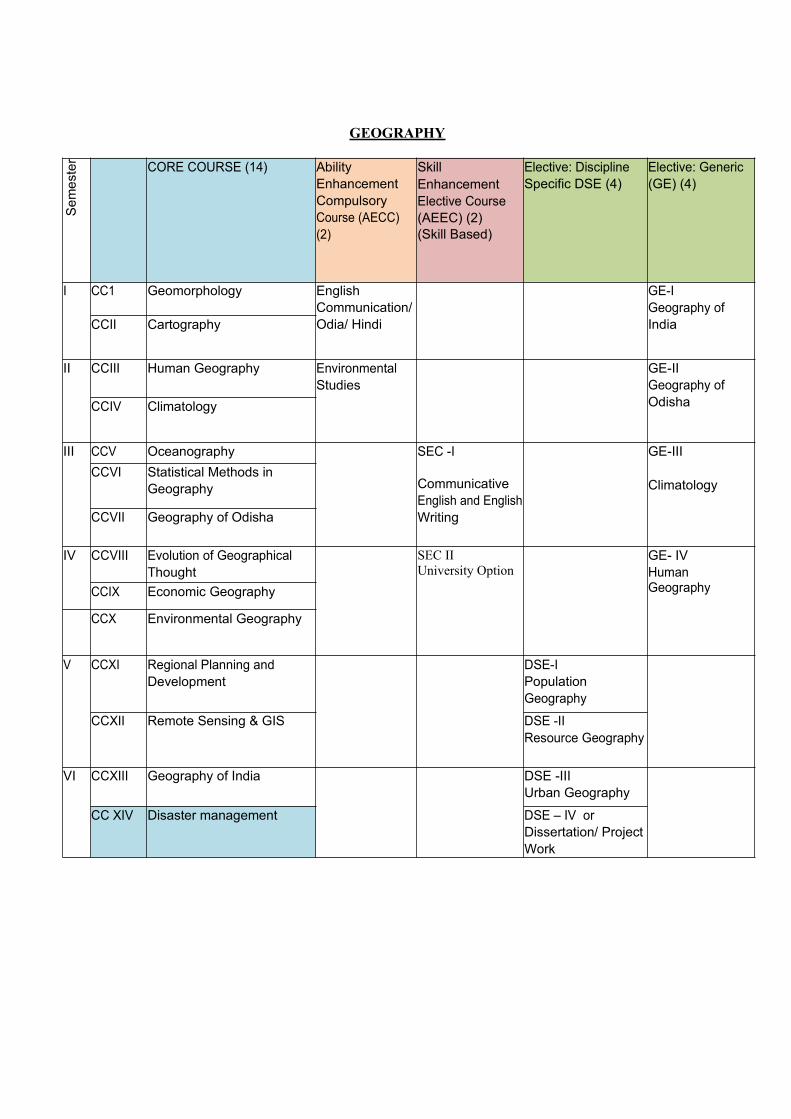
GEOGRAPHY
Se
me
ste
r
CORE COURSE (14) Ability Enhancement Compulsory Course (AECC) (2)
SkillEnhancement Elective Course (AEEC) (2)(Skill Based)
Elective: Discipline Specific DSE (4)
Elective: Generic (GE) (4)
I CC1 Geomorphology English Communication/ Odia/ Hindi
GE-IGeography of IndiaCCII Cartography
II CCIII Human Geography Environmental Studies
GE-IIGeography of OdishaCCIV Climatology
III CCV Oceanography SEC -I
Communicative English and EnglishWriting
GE-III
ClimatologyCCVI Statistical Methods in
Geography
CCVII Geography of Odisha
IV CCVIII Evolution of Geographical Thought
SEC IIUniversity Option
GE- IVHuman GeographyCCIX Economic Geography
CCX Environmental Geography
V CCXI Regional Planning and Development
DSE-IPopulation Geography
CCXII Remote Sensing & GIS DSE -IIResource Geography
VI CCXIII Geography of India DSE -IIIUrban Geography
CC XIV Disaster management DSE – IV orDissertation/ Project Work
Geography (Honours)
Core course – 14 papers, Discipline Specific Elective – 4 papersGeneric Elective for Non Geography students – 4 papers. Incase University offers 2 subjects as GE, then papers 1 and 2 will be the GE paper.
Marks per paper - Midterm: 15 marks, End term : 60 marks,Practical:25 Total – 100 marks Credit per paper – 6, Teaching hours per paper – 50 hours + 10 hours tutorial
CC - I: GeomorphologyUnit - I: Geomorphology: Meaning, Nature & Scope, Internal Structure of the Earth,
Isostasy (Airy and Pratt’s view), Rocks-Types and Characteristics, Types of Foldsand Faults
Unit - II: Earth Movements: Continental Drift, Plate Tectonics, Types of Folds and Faults, Earthquakes and Volcanoes (Types, distribution and associated Landforms). Geosynclinal theory and stages of mountain building and Convection current theory.
Unit - III: Geomorphic Processes: Types & characteristics of Weathering & Mass Wasting, Cycle of Erosion & evolution of Landforms of Davis and Penck’s evolutionary theory).
Unit - IV: Geomorphic agents and landforms : (Erosional and Depositional landforms of Fluvial, Karst, Aeolian, Glacial and Coastal origin)
Practical
1. Drawing of relief features using contour lines-Mountain, Plateau, valleys, escarpments andtheir profiles, construction and use of serial, projected and super-imposed profiles,
2. Use of Planimeter and Rotameter in measurements on maps, Longitudinal and transverseprofile of a river, Drainage Pattern and drainage Density
3. Interpretation of simple geological Maps (Introducing the concepts of Dip, Strike, BeddingPlane, Unconformity, Dykes, Folds and Faults).
4. Practical Record and Viva-voce (10 marks) Text Book1. Singh, S (2009): Physical Geography , Geomorphology, Prayag Pustak Publications ,
AllahabadReading List: Bloom A. L., 2003: Geomorphology: A Systematic Analysis of Late Cenozoic Landforms,
Prentice-Hall of India, New Delhi. Bridges E. M., 1990: World Geomorphology, Cambridge University Press, Cambridge. Christopherson, Robert W., (2011), Geosystems: An Introduction to Physical Geography, 8
Ed., Macmillan Publishing Company Kale V. S. and Gupta A., 2001: Introduction to Geomorphology, Orient Longman, Hyderabad. Knighton A. D., 1984: Fluvial Forms and Processes, Edward Arnold Publishers, London. Richards K. S., 1982: Rivers: Form and Processes in Alluvial Channels, Methuen, London. Selby, M.J., (2005), Earth’s Changing Surface, Indian Edition, OUP Skinner, Brian J. and Stephen C. Porter (2000), The Dynamic Earth: An Introduction to
physical Geology, 4th Edition, John Wiley and Sons Thornbury W. D., 1968: Principles of Geomorphology, Wiley.
Gautam, A (2010): Bhautik Bhugol, Rastogi Publications, Meerut Tikkaa, R N (1989): Bhautik Bhugol ka Swaroop, Kedarnath Ram Nath, Meerut Singh, S (2009): Geomorphology, Prayag Pustak Bhawan, Allahabad. Steers, J. A. – Unstable Earth, Kalyani Publisher.
CC - II: CartographyUnit - I: Cartography-Nature and scope
(a) Scientific basis of Cartography, needs of map making, characteristics of maps,(b) Cartography as a science of human communication(c) Branches of Cartography, Scope of cartography
Unit - II: Basic Geodesy, Scale – Concept and application(a) Spherical Earth, Ellipsoidal Earth. Geoid Earth(b) Geographical Coordinates (Latitude and Longitude), Graticules(c) Scale, Construction of types of Scales (Plain, Comparative and Diagonal Scale)
Unit - III: Map Projections(a) Meaning and Use, Brief Historical aspect.(b) Transformation of area, Distance and Direction(c) Simple Cylindrical Projection, Conical Projection with one standard projection
Unit - IV: Slope Analysis and Geological Map Gradient and slope(a) Interpretation of Bedding plane, Strike, Dip, structure & stratigraphy of Geological map.(b) Slope defined and methods of determination of slope (Wentworth’s method and Smith)
Practical1. Construction and use of Graphical, RF & Statement Scale, Diagonal Scale2. Grid Reference System, Latitude, Longitude, International Date Line, Date and Time based on
GMT & IST)3. Construction of Map Projections: Simple Cylindrical, Simple conical Projection with one and
two standard parallels, Polyconic , Gnomonic and Mercator’s4. Cartograms of one, two and three dimensions–Simple and Complex bars, circle and sphere
diagram, block diagrams.5. Drawing of Choropleth and isopleths maps, relief and slope maps6. Practical record and viva-voceText Book
1. Singh R. L. and Singh R. P. B., 1999: Elements of Practical Geography, Kalyani Publishers.
2. Mishra R.P. and Ramesh, A., 1989: Fundamentals of Cartography, Concept, New Delhi.Reference Books
Anson R. and Ormelling F. J., 1994: International Cartographic Association: BasicCartographic Vol. Pregmen Press.
Monkhouse F. J. and Wilkinson H. R., 1973: Maps and Diagrams, Methuen, London. Robinson A. H., 2009: Elements of Cartography, John Wiley and Sons, New York. Sarkar, A. (2015) Practical geography: A systematic approach. Orient Black Swan
Private Ltd., New Delhi.
CC - III: Human Geography
Unit - I: Introduction: Defining Human Geography: Nature, scope and Contemporary Relevance, Man-nature Relationship: Major racial groups and their characteristics
Unit - II: World distribution of major racial groups, language and religion, Cultural realms of the world
Unit - III: Demographic Characteristics of population: Population Composition (Male & Female,
Sex Ratio, Age and Sex, Occupational Structure, Population Density), Factor affectingpopulation distribution, Trend of World Population Growth, Demographic TransitionTheory, Population Problems in developed and under developed world.
Unit IV: Settlements: Types and pattern of Rural and urban Settlements; concept of urban area, towns and cities, Size Class and Functional Classification of towns and Trend of Urbanization of the world
PracticalI. Drawing of age sex pyramid of developed, developing and under developed countries
II. Drawing of population distribution maps using symbols–Simple and multiple dots, circles andspheres, choropleth maps of population density distribution
III. Drawing of Pie Diagram (Using population data of occupational structure, populationcomposition)
IV. Trend of population growth, growth of urban population and settlements V. Practical records and viva -voce Text Book
1. Hussain, Majid (2012) Human Geography. Rawat Publications, JaipurReference Books
Human & Economic Geography- Go cheng leong Johnston R; Gregory D, Pratt G. et al. (2008) The Dictionary of Human Geography,
Blackwell Publication. Daniel, P.A. and Hopkinson, M.F. (1989). The Geography of Settlement, Oliver & Boyd,
London. Human Geography, Rupa Publication Human Geography, B.S. Negi Chandna, R.C. (2010) Population Geography, Kalyani Publisher. Hassan, M.I. (2005) Population Geography, Rawat Publications, Jaipur Jordan-Bychkov et al. (2006) The Human Mosaic: A Thematic Introduction to Cultural
Geography. W. H. Freeman and Company, New York.
CC - IV: Climatology
Unit - I: Composition and Structure of the atmosphere, Weather and Climate : Elements andFactors, Insolation and Heat Budget of the Earth, World distribution of Temperature –Factors of Distribution, Temperature Inversion.
Unit - II: Atmospheric Pressure and Winds – Pressure Belts and Planetary Winds, Periodic andlocal winds, Factors affecting general circulation of wind, corriolis effect, Jet Stream.
Unit - III: Humidity: relative and absolute, Forms of Condensation, types of clouds, types ofprecipitation, classification of climate of Koppen and Thonrthwait.
Unit - IV: Concept of air mass, classification, characteristics, distribution and modification,thunderstorms and tornado, Tropical Cyclones, Temperate Cyclones, weatherforecasting.
Practical
1. Introduction to use of simple weather observation instruments: Thermometer, Barometer,hygrometer, anemometer, wind vane, Rain Gauge, Stevenson Screen, Interpretation ofweather maps
2. Drawing of Climograph and Hythergraph, Wind rose diagram.3. Drawing of isopleth maps : isotherms, isobars and isohyets4. Spatial and temporal distribution of rainfall using choropleth techniques and trend graphs 5. Record & Viva-Voce carries 10 marks
Text Book1. Lal, D S (2006): Climatology, Prayagn Pustak Bhavan, Allahabad
Reading List Barry R. G. and Carleton A. M., 2001: Synoptic and Dynamic Climatology, Routledge, UK. Barry R. G. and Corley R. J., 1998: Atmosphere, Weather and Climate, Routledge, New York. Critchfield H. J., 1987: General Climatology, Prentice-Hall of India, New Delhi Lutgens F. K., Tarbuck E. J. and Tasa D., 2009: The Atmosphere: An Introduction to
Meteorology, Prentice-Hall, Englewood Cliffs, New Jersey. Oliver J. E. and Hidore J. J., 2002: Climatology: An Atmospheric Science, Pearson Education,
New Delhi. Trewartha G. T. and Horne L. H., 1980: An Introduction to Climate, McGraw-Hill. Gupta L S(2000): Jalvayu Vigyan, Hindi Madhyam Karyanvay Nidishalya, Delhi Vishwa
Vidhyalaya, Delhi Vatal, M (1986): Bhautik Bhugol, Central Book Depot, Allahabad Singh, S (2009): Jalvayu Vigyan, Prayag Pustak Bhawan, Allahabad
CC - V: Oceanography
Unit - I: Bottom Relief of the Oceans: Continental shelf, slope, deep sea plain, ocean deeps, midoceanic ridges, relief features of the Atlantic, Indian and Pacific Ocean
Unit - II: Origin of ocean water, Temperature and salinity of ocean -distribution and determinants, T-S Diagram Ocean Deposits: classification and Distribution.
Unit - III: Movement of Ocean water- Waves, Currents and Tides: Types and characteristics, factors associated with the origin of ocean currents and their impacts, Ocean currents of the Atlantic, Indian and Pacific ocean
Unit -IV: Coral Reefs and atoll: Types, Theories of Origin (Subsidence theory of Darwin and Dana, Glacial Control theory of Louis Agassiz), Marine resources
Practical1. Interpretation of Topographical Maps.2. Demarcation of catchment basins and drainage networks, stream ordering and
identification and interpretation of drainage patterns. 3. Enlargement and reduction of maps: Graphical and instrumental, use of pantographs4. Practical records and viva -voce
Text Book1. Sharma R. C. and M. Vital: Oceanography2. Lal, D. S. – Oceanography.
Reference Book: King, L. C. : Oceanography Singh, S. – Physical Geography
CC - VI: Statistical Methods in Geography
Unit - I: Use of Data in Geography: Spatial and attribute data, Geographical Data Matrix, Types and Sources of Data (Discrete and grouped, primary and secondary), Scales of Measurement of data (Nominal, Ordinal, Interval, Ratio).Distribution of Data: Normal andBi-nomial
Unit - II: Descriptive Statistics: Frequency distribution (grouped and ungrouped data), measures of Central Tendency (Mean, Median and Mode), Types of Sampling-Random, stratified, systematic and purposive
Unit - III: Measures of Dispersion (Variance, Mean Deviation, Standard Deviation and Coefficient of Variation. Chi-square test
Unit - IV: Measures of Association:, Product moment correlation, Rank correlation , test of significance, coefficient of determination and linear regression.,
Practical1. Drawing of histogram, frequency curve and ogive in grouped and discrete data2. Calculation & Drawing of graphs showing mean, median, mode in grouped & discrete data3. Calculation of mean deviation, standard deviation, coefficient of variation, 4. Practical records and viva -voce
Text Book:1. Mahmood A., 1977: Statistical Methods in Geographical Studies, Concept.2. Sarkar, A. (2013) Quantitative geography: techniques and presentations. Orient Black Swan Private
Ltd., New DelhiReference Book: Hammond P. and McCullagh P. S., 1978: Quantitative Techniques in Geography: An Introduction,
Oxford University Press. Yeates M., 1974: An Introduction to Quantitative Analysis in Human Geography, McGraw Hill, NY Silk J., 1979: Statistical Concepts in Geography, Allen and Unwin, London King L. S., 1969: Statistical Analysis in Geography, Prentice-Hall Pal S. K., 1998: Statistics for Geoscientists, Tata McGraw Hill, New Delhi Ebdon D., 1977: Statistics in Geography: A Practical Approach.
CC - VII: Geography of Odisha
Unit - I: Physiography of Odisha, River System, Climate, Soil, Natural VegetationUnit - II: Agriculture: (a) Production and Distribution of Rice, Pulses, Oil seeds; (b) Agricultural
Problems and ProspectsUnit - III: Minerals and power recourses:
(a) Distribution and production of Iron Ore, Bauxite, Chromite, Coal(b) Industrialization in Odisha – Problems and prospects, Iron and steel industry, Aluminum Industry, Textile, thermal power plants
Unit - IV: (a) Population: Distribution and Growth, distribution of tribes and tribal population(b) Urbanization-Growth of urban population and urban centers(b) Transport : Roadways & Railways
Practical1. Rainfall distribution of Odisha using choropleth techniques (State &District/ District & block)2. Temperature / rainfall distribution using isopleth techniques giving point level data of
important observation centers 3. Drawing of time series graphs to depict decadal growth of population/ urban population4. Cartographic representation of socio-economic data (One, two three dimensional)5. Practical records and viva -voce Text Book:
1. Sinha, B. N. - Geography of OdishaReading List:
1.Roy, G. C.- Geography of Odisha
CC - VIII: Evolution of Geographical Thought
Unit - I: Geographical concepts of ancient and mediaval period: Contributions of Greek, Roman & Indian and Arab scholars.
Unit-II: Modern geographical thought: Contributions of Alexander Von Humboldt, Carl Ritter, Ratzel, Vidal De La Blache and Mackinder.
Unit III: Dichotomy in Geography– Environmental Determinism and Possibilism, Systematic and Regional Geography, Ideographic and Nomeothetic, Physical and Human Geography .
Unit-IV: Recent Trends in development of geography– Quantitative Revolution in Geography,
Behavioural approach in Geography, radicalism in Geography, Recent changes in methods and approaches to geography.
Practical
1. Introduction to and use of survey Instruments: Prismatic Compass, Leveling, Theodolite /Total Station,
2. Methods of Surveying: Radiation, Intersection, Resection Traversing ( Close and Open) 3. Use of GPS / DGPS in observation of coordinate values of a number of points and preparing
an outline map of an area by interpolation 4. Preparation and uses of questionnaire and schedule in a socio economic survey5. Practical records and viva -voce
Text Book:1. Evolution of Geographical Thought- Majid Hussain
Reference Books:2. Dikshit R. D., 1997: Geographical Thought: A Contextual History of Ideas, Prentice– Hall India.3. Hartshone R., 1959: Perspectives of Nature of Geography, Rand MacNally and Co.6. Martin Geoffrey J., 2005: All Possible Worlds: A History of Geographical Ideas, Oxford.7. Holt-Jensen A., 2011: Geography: History and Its Concepts: A Students Guide, SAGE.8. Kapur A., 2001: Indian Geography Voice of Concern, Concept Publications.
CC - IX: Economic Geography
Unit - I: Meaning and scope of economic geography, classification of economic activities, Factors affecting location of economic activity with special reference to agriculture and industry, Von Thunen Theory of location of agricultural activity and Weber’s theory of Industrial Location.
Unit - II: Primary economic activities: Types and problems, (Subsistence farming, shifting cultivation, forestry and fishing, mining and quarrying ), agricultural regions of the world.
Unit - III: Secondary economic activities: Manufacturing (Cotton Textile, Iron and Steel), Industrial Regions of the world: Special Economic Zones and its significance.
Unit - IV: Tertiary economic activities: Transport- Roads and Railways, Air and Water ways, Trade and commerce
Practical1. Determination of agricultural efficiency (Kendal and Bhatia method) and to show on maps2. Drawing of Isotims, Isodapanes and industrial location based on Weber’s theory,.3. Traffic flow diagram and travel time maps (Isochrones). 4. Practical records and viva -voce
Text Book1.Roy, Pritish: Economic Geography2.Gautam, Alaka: Economic Geography,
Reference Book1. Alexander J. W., 1963: Economic Geography, Prentice-Hall Inc., Englewood Cliffs, New Jersey.2. Wheeler J. O., 1998: Economic Geography, Wiley.3. Durand L., 1961: Economic Geography, Crowell.4. Willington D. E., 2008: Economic Geography, Husband Press.5. Clark, Gordon L.; Feldman, M.P. and Gertler, M.S., eds. 2000: The Oxford
CC - X: Environmental Geography
Unit - I: Environmental Geography – Concept and Scope, Types and Characteristics of environment:Biotic, abiotic and cultural, Environmental contrast (Global, Continental, Local) Environmentalcontrol and concept of tolerance (Light, Temperature, Water, Topography and Edaphic factors)
Unit - II: Ecosystem – Concept, Structure and Functions, Trophic level, food Chain and food web, Bio- geo-chemical Cycle (Nitrogen and Carbon), Energy flow in Ecosystem.
Unit -III: Concept of Biome, Major biomes of the world and their characteristics: Equatorial, Sub-tropical, Temperate and Polar, Nature and characteristics of environmental pollution of water and air
Unit -IV: Environmental degradation; causes and consequences, Environmental conservation methods,programmes and policies in India, Role of International agencies (UNO,UNEP,UNDP, IUCNin environmental management, concept and strategies of sustainable development, GreenTribunal and its functions in India.
Practical(Project Work)
Submission of a Project Report on any environmental problem of global/national/local significance
Text Book:1. Santra, S.C Environmental Science2. Singh S., 1997: Environmental Geography, Prayag Pustak Bhawan. Allahabad.
Reference Book: Chandna R. C., 2002: Environmental Geography, Kalyani, Ludhiana. Cunninghum W. P. and Cunninghum M. A., 2004: Principals of Environmental Science: Inquiry and
Applications, Tata Macgraw Hill, New Delhi. Goudie A., 2001: The Nature of the Environment, Blackwell, Oxford. Miller G. T., 2004: Environmental Science: Working with the Earth, Thomson BrooksCole, Singapore. Odum, E. P. et al, 2005: Fundamentals of Ecology, Ceneage Learning India.
CC - XI: Regional Planning and Development
Unit - I: Concept of a Region, Types of region: Formal, Functional and Planning Region, Need forRegional Planning, Evolution of Regional planning in India during five year plans,Characteristics of an Ideal Planning Region
Unit - II: Delineation of Planning Regions; Approaches and Methods, Regional disparity and imbalancesin India, Planning Regions of India
Unit - III: Theories and Models for Regional Planning: Growth Pole Model of Perroux; Myrdal,Hirschman, Rostow.
Unit - IV: Policies and Programs for Rural and Regional Development Planning in India, WelfarePrograms: IRDP, DPAP, Planning for backward regions, TDA and ITDP, planning forNational Capital Region, Urban Area Programs, Concept and application of Humandevelopment Index in planning and development
Practical1. Transport network analysis –Alfa, Beta, Gama indices2. Nearest neighbor analysis3. Mapping regional Disparity based on socio-economic data4. Mapping levels of development based on socio-economic data5. Practical record and viva-voce
Text Book1. Chand, Mahesh and V. K. Puri: Regional Planning2. Mishra R. P : Regional Planning, Concept Publishers, New Delhi
Reference Book:1. Friedmann J. and Alonso W. (1975): Regional Policy - Readings in Theory and Applications, MIT
Press, Massachusetts.2. Haynes J., 2008: Development Studies, Polity Short Introduction Series.3. Peet R., 1999: Theories of Development, The Guilford Press, New York.4. UNDP 2001-04: Human Development Report, Oxford University Press.5. World Bank 2001-05: World Development Report, Oxford University Press, New
CC - XII: Remote Sensing and GIS
Unit - I: Remote Sensing: Definition and Components, EMS and EMR, Wave and Particle theory ofEMR, Types of platforms and sensors, Advantages and limitation of Remote Sensing, Energyinteraction with Atmosphere and Earth Surface features (Water, soil and vegetation)
Unit - II: Aerial Photography, Principles of stereo vision, Geometry of Aerial Photographs, Imageelements and visual interpretation of satellite images.
Unit - III: GIS: definition and components, Types of GIS Data (Spatial and attribute), Raster and VectorData models, Special functions of GIS, GPS elements and its uses..
Unit - IV: Application of RS & GIS in land use and land cover mapping, Application in cartography andmap making, Mapping of water resources and Natural Vegetation
Practical1. Stereoscopic vision using stereo cards and identification of objects from cards2. Feature identification from aerial photographs using Pocket stereoscope/Mirror stereoscope3. Feature identification from satellite imageries using visual interpretation4. Identification and mapping of water bodies from satellite imageries5. Digitization of Odisha state/block /district map and drawing of few point, line and polygon featuresText Book1. Lillesand T. M., Kiefer R. W. and Chipman J. W., 2004: Remote Sensing and Image Interpretation,
Wiley. (Wiley Student Edition).Reference Book:1.Bhatta, B. (2008) Remote Sensing and GIS, Oxford University Press, New Delhi.2.Campbell J. B., 2007: Introduction to Remote Sensing, Guildford Press3.Chauniyal, D. (2010) Sudur Samvedana Avam Bhaugolik Suchna Pranali, Sharda Pustak Bhawan,
Allahabad.4.Jensen, J. R. (2005) Introductory Digital Image Processing: A Remote Sensing Perspective, Pearson
Prentice-Hall.5.Joseph, G. 2005: Fundamentals of Remote Sensing United Press India.
CC - XIII: Geography of India
Unit - I: Triple tectonic divisions, Physiography of the Himalayas, Indo-Gangetic Plains, Peninsular India, Climate of India : Weather characteristics of SW and NE Monsoon, soil and natural vegetation
Unit -II:Population Distribution, Demographic structure, trend of population growth and urbanization, Distribution of major tribal groups of India, India’s population problems and prospects
Unit-III: Distribution and utilisation of iron ore, nuclear minerals, coal, petroleum, natural gas, Factors of location and development of automobile, IT, Iron & Steel and Cotton Textile industries, Industrial regions of India
Unit - IV: Types of Irrigation in India, characteristics of Indian Agriculture, cropping pattern, production
and distribution of rice and wheat, Tea and Coffee, problems of Indian Agriculture
Practical1. Population density map of India by Choropleth2. Graphical & cartographic presentation of socio-economic data3. Pie chart showing occupational structure of India4. Population pyramid for India5. Practical record and viva-voce (10 marks)
Text Book1. Sharma, T.C. (2013) Economic Geography of India. Rawat Publication, Jaipur2. Khullar, D. R. India: A Comprehensive Geography
Reference Book:1. Deshpande C. D., 1992: India: A Regional Interpretation, ICSSR, New Delhi.
2. Mandal R. B. (ed.), 1990: Patterns of Regional Geography – An International Perspective. Vol. 3 – Indian Perspective.
3. Sharma, T. C. 2003: India - Economic and Commercial Geography. Vikas Publ., New Delhi.4. Singh R. L., 1971: India: A Regional Geography, National Geographical Society of India.5. Singh, Jagdish 2003: India - A Comprehensive & Systematic Geography, Gyanodaya Prakashan,
Gorakhpur.6. Spate O. H. K. and Learmonth A. T. A., 1967: India and Pakistan: A General and Regional
Geography, Methuen.
CC - XIV: Disaster ManagementUnit-I: Concept of Hazards and Disasters, Natural and manmade hazards, Types of hazards, Concept of
Vulnerability and risk, prevention, mitigation and management.
Unit-II: Disaster management cycle, Pre disaster planning, During disaster management, Post Disasterplanning and development, community based disaster preparedness, Role of various stakeholders (NGO, GO, NDMA, NIDM, NDRF, ODRAF and OSDMA) in disaster management.
Unit-III: Detail study of nature, characteristics and management of natural hazards: Flood, Cyclone,Drought, Earthquake, Tsunami and Land Slide
Unit-IV: Man made hazards and disasters, causes and impacts; Fire hazards, industrial hazards andnuclear hazards, Salient features of India’s disaster management policy.
PracticalProject work – Preparation of a case study report on a specific hazard / disaster based on literature review
and or field work
Text books
1. Singh, Savindar (2009): Disaster Management
Reference books:1. Mishra B.J : Natural hazards and disaster management2. Sundar I & Sezuiyan T : Disaster management3. Verma : Encyclopedia of Disaster management4. Eye Publication : Vulnerable India5. Sinha. A. – Disaster management, United Press6. Singh R.B – Risk Assessment and Vulnerability analysis.
DISCIPLINE SPECIFIC ELECTIVEDSE I: Population Geography
Unit- I: Defining the Field, Nature and Scope of population geography; Sources of population data with special reference to India (Census, Vital Statistics and NSS), Population problems and issues.
Unit- II: Population Size, Distribution and Growth – Factors and Determinants, Theories of Growth – Malthusian Theory and Demographic Transition Theory.
Unit-III: Determinants of Population Growth: Fertility, Mortality and Migration-Measures,determinants and implications of fertility, mortality and migration.
Unit-IV: Population Composition and Characteristics – Age-Sex, Rural-Urban, Literacy, Occupationalstructure, Contemporary population issues–Ageing of Population; Declining Sex Ratio;HIV/AIDS, Trend of urbanization and related Problems.
12
Practical1. Population projection: AP, GP and R.G India method, calculation and graphical display2. Drawing of triangular diagram and Lorenz curve3. Construction of compound and superimposed pyramids4. Calculation and presentation of population growth Rate, infant and neonatal mortality rate,
maternal mortality ratio based on supplied data 5. Practical record and Viva-Voce
Text book1.Chandna R. C. and Sidhu M. S., 1980: An Introduction to Population Geography, Kalyani Publishers.Reading List: Barrett H. R., 1995: Population Geography, Oliver and Boyd. Bhende A. and Kanitkar T., 2000: Principles of Population Studies, Himalaya Publishing House. Clarke J. I., 1965: Population Geography, Pergamon Press, Oxford. Jones, H. R., 2000: Population Geography, 3rd ed. Paul Chapman, London. Lutz W., Warren C. S. and Scherbov S., 2004: The End of the World Population Growth in the 21st
Century, Earthscan. Newbold K. B., 2009: Population Geography: Tools and Issues, Rowman and Littlefield Publishers. Pacione M., 1986: Population Geography: Progress and Prospect, Taylor and Francis. Wilson M. G. A., 1968: Population Geography, Nelson. Panda B P (1988): Janasankya Bhugol, M P Hindi Granth Academy,Bhopal Maurya S D (2009) Jansankya Bhugol, Sharda Putak Bhawan, Allahabad Chandna, R C (2006), Jansankhya Bhugol, Kalyani Publishers, Delhi
DSE - II: Resource GeographyUnit - I:Natural Resources: Concept, Types, Classification, and Functional Theory of ResourcesUnit II: Distribution and Utilization of Land Resources, Water Resources, Forest resources and Energy
Resources and mineral resources. Unit-III: Problems in exploitation, depletion and degradation of resources, Methods of conservation and
management of Land, Water, Forest, mineral & Energy ResourcesUnit IV: Resource scarcity hypothesis , Concept and approach towards sustainable development of
resources, Practical
1. Simple Correlation and interpretation of correlation coefficient2. Test of significance of correlation coefficient3. Rank Correlation4. Simple Linear Regression, Drawing of scattergram and regression line5. Practical record and viva-voce
Text book
1. Singh, R.L. 1988 (Reprint) ― India: A Regional GeographyReading List:
. Gadgil M. and Guha R., 2005: The Use and Abuse of Nature: Incorporating This Fissured Land: AnEcological History of India and Ecology and Equity, Oxford University Press. USA. Jones G. & Hollier G.,1997: Resources, Society and Environmental Management, Paul Chapman,
London. Klee G., 1991: Conservation of Natural Resources, Prentice Hall, Englewood. Mather A. S. and Chapman K., 1995: Environmental Resources, John Wiley and Sons, New York. Mitchell B., 1997: Resource and Environmental Management, Longman Harlow, England. Owen S. and Owen P. L., 1991: Environment, Resources and Conservation, Cambridge Univ. Press, N Y Rees J., 1990: Natural Resources: Allocation, Economics and Policy, Routledge. London.
13
DSE - III: Urban Geography
Unit - I:Urban geography: Introduction, nature and scope; history of urbanization, Trends and Patterns of Urbanization in developed, developing countries, world and India.
Unit -II:Functional classification of cities: Quantitative and Qualitative Methods, Christaller Theory, Morphology of Urban Settlements & Urban Sphere of Influence and umland, concept of CBD, rural-urban fringe.
Unit-III:Theories of urban growth, Urban Issues: problems of housing, slums, civic amenities (water and transport), Air Pollution and Noise Pollution,
Unit -IV: Case studies of Delhi, Mumbai, Kolkata, Bhubaneswar and Chandigarh with reference to city planning and Urban Issues.
Practical1. Functional classification of towns2. Projection of urban population 3. Delimitation of C.B.D and umland4. Gravity and population potential model.5. Practical Record and Viva-Voce (10 marks)
Text books1. Ramachandran R (1989): Urbanisation and Urban Systems of India, Oxford University Press, New Delhi
Reading List: Fyfe N. R. and Kenny J. T., 2005: The Urban Geography Reader, Routledge. Graham S. and Marvin S., 2001: Splintering Urbanism: Networked Infrastructures, Technological
Mobilities and the Urban Condition, Routledge. Hall T., 2006: Urban Geography, Taylor and Francis. Kaplan D. H., Wheeler J. O. and Holloway S. R., 2008: Urban Geography, John Wiley. Knox P. L.& McCarthy L., 2005: Urbanization: An Introduction to Urban Geography, Prentice Hall NY. Sassen S., 2001: The Global City: New York, London and Tokyo, Princeton University Press. Ramachandran R (1989): Urbanisation and Urban Systems of India, Oxford University Press, New Delhi Ramachandran, R., 1992: The Study of Urbanisation, Oxford University Press, Delhi Singh, R.B. (Eds.) (2001) Urban Sustainability in the Context of Global Change, Science Pub., Inc.,
Enfield (NH), USA and Oxford & IBH Pub., New Delhi. Singh, R.B. (Ed.) (2015) Urban development, challenges, risks and resilience in Asian megacities.
Advances in Geographical and Environmental Studies, Springer
GEOGRAPHY – DSE – IV
FIELD WORK AND RESEARCH METHODOLOGY
Aim of the CourseTo introduce research aptitude among young geographers.
Objectives of the Course* To enable students to develop a general understanding of the methodology of research in geography.* To strengthen the need of interdisciplinary research.* To inculcate the role of Case Study analysis in the methodology of geography.* To understand the value of Field Work and Primary Data in geographical research.
Unit – I : Fundamentals of Research Literacy
14
a) Meaning and objectives of research; types of research (Historical, Case Study, Descriptive andExperimental),
b) Significance of Research, Ethics in Research and Plagiarism, c) Role and Utility of Fieldwork in Geography, d) Sources & Types of Data Collection (Reconnaissance, Primary & Secondary)
Unit – II : Approaches to Researcha)Approach and Methods of Geographic Research, b)Ex-post facto, Laboratory Experiments, c)Field Study and Experiments, Field Survey Research, d)Evaluation Research and Action Research.
Unit – III : Methods and Field Techniques
a) Field Techniques in Geography, Selection of Appropriate Technique, Observation (Participant / Non Participant),
b) Preparation of Questionnaires and Schedules (Open/ Closed / Structured / Non-Structured); c) Participatory Rapid Appraisal and Focus Group Discussiond) Content Analysis
Unit – IV : Preparation of a Research Report
a) Designing the Research Report (Documentation Structure, Layout, Fonts, Setting of Maps, Diagrams, Tables , Appendices, Bibliography and Reference)
b) Review of Literature and Different Methods of In-text and End of Paper Citation,
c) Style of Citation in Science and Social Science Research(Books, Journals, Reports, Thesis, News Items, Web Sources)
Practical for DSE – IV
Field Work and Research Methodology
a) Preparation of a Observation Schedule (Participant / Non Participant) and Questionnaire (Open/ Closed / Structured / Non-Structured);
b) Preparation of a Guide Line for Focus Group Discussion and PRA
c) Field Testing of Questionnaire and FGD-PRA guidelines t on a village level socio-economic study.
d) Preparation of a Research Report
e) Viva Voce
Note:
i) Each student will prepare an individual report based on primary and secondary data collected during field work.
ii) Duration of the field work should not exceed one week
iii) The word count of the report should be around 5000 excluding figures, tables, photographs, maps, references and appendices.
iv) One copy of the report on A 4 size paper should be submitted in soft binding.
Main Books
1. Majid Hussain (1994), Methodology of Geography, Anmol Pubication, New Delhi.2. K.L.Narasimha Murthy (1999) ,Geographical Research , Concept Publishing Company, New DelhiReference Books
15
3. Research Methodology - Methods and Techniques, Revised Edited by C.R. Kothari (2004), New Age International Publishers, New Delhi.4. Quantitative Social Research Methods by Kultar Singh (2007), Sage Publication.5. Social Survey Methods by Paul Nicholas ( 2009), Oxfarm Publishers Delhi.
OR
Geography DISSERTATION/ PROJECT WORK
A project report may be given in view of discipline specific papers. It is considered as a special courseinvolving application of knowledge solving and exploring a real life situation and difficult problem.
GENERIC ELECTIVE
GE - I: Geography of India
Unit I: Physiographic Divisions of India, soil and vegetation, climate (characteristics and classification)Unit II: Population: Distribution and growth, Demographic structure, Distribution of population by race,
religion, language and tribes, urbanisationUnit III: Mineral and power resources: distribution and utilisation of iron ore, coal, Petroleum, Natural gas,
Nuclear Minerals:Irrigation,Cropping pattern, Production & distribution of rice, wheat, Tea, Coffee Unit IV: Industrial development: Iron and steel, Aluminium, Automobile and Information technology
Transport in India: Road, Rail and Airways, Waterways
Practical
1. Study and interpretation of topographic Maps2. Cartograms – Pair-Bar diagram, complex bar, wheel diagram 3. Maps drawing –Simple dot maps, Multiple dot maps 4. Practical record and viva-voceText Book1. Sharma, T.C. (2013) Economic Geography of India. Rawat Publication, Jaipur2. Khullar, D. R. India: A Comprehensive GeographyReading List:1. Deshpand C. D., 1992: India: A Regional Interpretation, ICSSR, New Delhi2. Johnson, B. L.C., ed. 2001. Geographical Dictionary of India, Vision Books, New Delhi4. Sdyasuk Galina and P. Sengupta (1967): Economic Regionalisation of India, Census of India
GE II: Geography of Odisha
Unit I: Physiography of Odisha: Coastal Plains, Middle Mountainous Region, Western Plateau, River System, Climate, Soil, Natural Vegetation
Unit II: Types of Irrigation, Agriculture: Production and Distribution of Rice, Pulses, Oil seeds, Agricultural Problems and Prospects
Unit III:Minerals and power recourses: (a) Distribution of Iron Ore, Bauxite, Coal &ChromiteIron and steel industry, Aluminum Industry, Cotton Textile
Unit IV:(a) Population: Distribution and Growth, Urbanisation, (b) Transport: Roadways & Railways
Practical
1.Drawing of isopleths maps using rainfall / temperature data2.Drawing Population Density map of Odisha by Choropleth method

16
3. Population Pyramid Diagram4. Construction of Pie diagram3. Practical Record and Viva-voce (10% of marks)Text books1. Sinha, B. N. - Geography of OdishaReading List:1. Roy, G. C. - Geography of Odisha
xxx
17
GE III: Climatology
Unit I: Composition and Structure of the atmosphere, Insolation and Heat Budget of the Earth, Horizontal distribution of Temperature and associated Factors, Temperature Inversion.
Unit II: Atmospheric Pressure, Pressure Belts of the globe, Planetary Winds, Periodic and local winds .Unit III: Atmospheric Moisture and Humidity, Forms of Condensation, Fog and Clouds, Precipitation and its
Types, Stability and Instability of the atmosphere.Unit IV: Cyclones – Tropical Cyclones, Extra Tropical Cyclones, Thunderstorm and tornado, Monsoon - Origin
and characteristicsPractical
1. Demonstration and use of weather instruments- Maximum & Minimum Thermometer, Barometer, Rain Gauge, Anemometer, Wind Vane
2. Interpretation of Weather Map, Drawing of Climograph.3. Record & Viva-Voce carries 10% of marks
Text books1. Lal, D S (2006): Jalvayu Vigyan, Prayag Pustak Bhavan, AllahabadReading List -2. Barry R. G. and Carleton A. M., 2001: Synoptic and Dynamic Climatology, Routledge, UK.3. Barry R. G. and Corley R. J., 1998: Atmosphere, Weather and Climate, Routledge, New York.4. Critchfield H. J., 1987: General Climatology, Prentice-Hall of India, New Delhi5. Oliver J. E. and Hidore J. J., 2002: Climatology: An Atmospheric Science, Pearson Education, New Delhi.6. Trewartha G. T. and Horne L. H., 1980: An Introduction to Climate, McGraw-Hill.7. Vatal, M (1986): Bhautik Bhugol, Central Book Depot, Allahabad8. Singh, S (2009): Jalvayu Vigyan, Prayag Pustak Bhawan, Allahabad
GE IV: Human GeographyUnit I: Meaning and scope of Human Geography; Major Themes; Contemporary Relevance and subfields,
Development of human geographyUnit II: Major races of mankind, their characteristics and distribution, Cultural Realms of the world; Religion
and Language of WorldUnit III: World distribution of population, world Population Growth,, Population Composition; Demographic
Transition TheoryUnit IV: Types & Patterns of Rural Settlements; Urban Settlements; Definition, size and functional
classification, characteristics, Trends and Patterns of World Urbanization
Practical1.Population distribution by multiple dots and population density2.Decadal Population Growth- Time series graphs, bar diagrams3.Pie Diagram showing occupational structure and population composition4.Population Projection by A.P and GP method5.Practical Record and Viva voce
Text Book
Hussain, Majid (2012) Human Geography. Rawat Publications, JaipurReading List:1. Hassan, M.I. (2005) Population Geography, Rawat Publications, Jaipur2. Daniel, P.A. and Hopkinson, M.F. (1989) The Geography of Settlement, Oliver & Boyd, London.3. Johnston R; Gregory D, Pratt G. et al. (2008) The Dictionary of Human Geography, Blackwell Publication.4. Jordan-Bychkov et al. (2006) The Human Mosaic: A Thematic Introduction to Cultural Geography. W. H.
Freeman and Company, New York.5. Kaushik, S.D. (2010) Manav Bhugol, Rastogi Publication, Meerut.6. Maurya, S.D. (2012) Manav Bhugol, Sharda Pustak Bhawan. Allahabad.7. Hussain, Majid (2012) Manav Bhugol. Rawat Publications, Jaipur
18
GEOGRAPHY -PASS
Semester Course Course Name
I DSC-I
DSC-I Practical
Geography of India
II DSC-II
DSC-II Practical
Geography of Odisha
III DSC-III
DSC-III Practical
Climatology
IV DSC-IV
DSC-IV Practical
Human Geography
V DSE-I
DSE-I Practical
Population Geography
VI DSE-II
DSE-II Practical
Resource Geography
19
DESCIPLINE SPECIFIC CORE
DSC I: Geography of IndiaUnit I: Physiographic Divisions of India, soil and vegetation, climate (characteristics and classification)Unit II: Population: Distribution and growth, Demographic structure, Distribution of population by race,
religion, language and tribes, urbanisationUnit III: Mineral and power resources: distribution and utilisation of iron ore, coal, Petroleum, Natural gas,
Nuclear Minerals:Irrigation,Cropping pattern, Production & distribution of rice, wheat, Tea, Coffee Unit IV: Industrial development: Iron and steel, Aluminium, Automobile and Information technology
Transport in India: Road, Rail and Airways, Waterways
Practical
1. Study and interpretation of topographic Maps2. Cartograms – Pair-Bar diagram, complex bar, wheel diagram 3. Maps drawing –Simple dot maps, Multiple dot maps 4. Practical record and viva-voce
Text Book3. Sharma, T.C. (2013) Economic Geography of India. Rawat Publication, Jaipur4. Khullar, D. R. India: A Comprehensive GeographyReading List:3. Deshpand C. D., 1992: India: A Regional Interpretation, ICSSR, New Delhi4. Johnson, B. L.C., ed. 2001. Geographical Dictionary of India, Vision Books, New Delhi4. Sdyasuk Galina and P. Sengupta (1967): Economic Regionalisation of India, Census of India
DSC II: Geography of Odisha
Unit I: Physiography of Odisha: Coastal Plains, Middle Mountainous Region, Western Plateau, River System, Climate, Soil, Natural Vegetation
Unit II: Types of Irrigation, Agriculture: Production and Distribution of Rice, Pulses, Oil seeds, Agricultural Problems and Prospects
Unit III:Minerals and power recourses: (a) Distribution of Iron Ore, Bauxite, Coal &ChromiteIron and steel industry, Aluminum Industry, Cotton Textile
Unit IV:(a) Population: Distribution and Growth, Urbanisation, (b) Transport: Roadways & Railways
Practical
6.Drawing of isopleths maps using rainfall / temperature data7.Drawing Population Density map of Odisha by Choropleth method3. Population Pyramid Diagram4. Construction of Pie diagram4. Practical Record and Viva-voce (10 marks)Text books1. Sinha, B. N. - Geography of OdishaReading List:1. Roy, G. C. - Geography of Odisha
20
DSC III: ClimatologyUnit I: Composition and Structure of the atmosphere, Insolation and Heat Budget of the Earth, Horizontal
distribution of Temperature and associated Factors, Temperature Inversion.Unit II: Atmospheric Pressure, Pressure Belts of the globe, Planetary Winds, Periodic and local winds .Unit III: Atmospheric Moisture and Humidity, Forms of Condensation, Fog and Clouds, Precipitation and its
Types, Stability and Instability of the atmosphere.Unit IV: Cyclones – Tropical Cyclones, Extra Tropical Cyclones, Thunderstorm and tornado, Monsoon - Origin
and characteristicsPractical
1. Demonstration and use of weather instruments- Maximum & Minimum Thermometer, Barometer, Rain Gauge, Anemometer, Wind Vane
2. Interpretation of Weather Map, Drawing of Climograph.3. Record & Viva-Voce carries 10% of marks
Text books1. Lal, D S (2006): Jalvayu Vigyan, Prayag Pustak Bhavan, AllahabadReading List -2. Barry R. G. and Carleton A. M., 2001: Synoptic and Dynamic Climatology, Routledge, UK.3. Barry R. G. and Corley R. J., 1998: Atmosphere, Weather and Climate, Routledge, New York.4. Critchfield H. J., 1987: General Climatology, Prentice-Hall of India, New Delhi5. Oliver J. E. and Hidore J. J., 2002: Climatology: An Atmospheric Science, Pearson Education, New Delhi.6. Trewartha G. T. and Horne L. H., 1980: An Introduction to Climate, McGraw-Hill.7. Vatal, M (1986): Bhautik Bhugol, Central Book Depot, Allahabad8. Singh, S (2009): Jalvayu Vigyan, Prayag Pustak Bhawan, Allahabad
DSC IV: Human GeographyUnit I: Meaning and scope of Human Geography; Major Themes; Contemporary Relevance and subfields,
Development of human geographyUnit II: Major races of mankind, their characteristics and distribution, Cultural Realms of the world; Religion
and Language of WorldUnit III: World distribution of population, world Population Growth,, Population Composition; Demographic
Transition TheoryUnit IV: Types & Patterns of Rural Settlements; Urban Settlements; Definition, size and functional
classification, characteristics, Trends and Patterns of World Urbanization
Practical1. Population distribution by multiple dots and population density2. Decadal Population Growth- Time series graphs, bar diagrams
a. Pie Diagram showing occupational structure and population compositionb. Population Projection by A.P and GP methodc. Practical Record and Viva voce
Text Book
1. Hussain, Majid (2012) Human Geography. Rawat Publications, JaipurReading List:
1. Hassan, M.I. (2005) Population Geography, Rawat Publications, Jaipur2. Daniel, P.A. and Hopkinson, M.F. (1989) The Geography of Settlement, Oliver & Boyd, London.3. Johnston R; Gregory D, Pratt G. et al. (2008) The Dictionary of Human Geography, Blackwell
Publication.4. Jordan-Bychkov et al. (2006) The Human Mosaic: A Thematic Introduction to Cultural
Geography. W. H. Freeman and Company, New York.
21
5. Kaushik, S.D. (2010) Manav Bhugol, Rastogi Publication, Meerut.6. Maurya, S.D. (2012) Manav Bhugol, Sharda Pustak Bhawan. Allahabad.7. Hussain, Majid (2012) Manav Bhugol. Rawat Publications, Jaipur
DSE I: Population GeographyUnit- I: Defining the Field, Nature and Scope of population geography; Sources of population data with special
reference to India (Census, Vital Statistics and NSS), Population problems and issues.Unit- II: Population Size, Distribution and Growth – Factors and Determinants, Theories of Growth – Malthusian
Theory and Demographic Transition Theory.Unit-III: Determinants of Population Growth: Fertility, Mortality and Migration-Measures, determinants and
implications of fertility, mortality and migration.Unit-IV: Population Composition and Characteristics – Age-Sex, Rural-Urban, Literacy, Occupational structure,
Contemporary population issues–Ageing of Population; Declining Sex Ratio; HIV/AIDS, Trend ofurbanization and related Problems.
Practical6. Population projection: AP, GP and R.G India method, calculation and graphical display7. Drawing of triangular diagram and Lorenz curve8. Construction of compound and superimposed pyramids9. Calculation and presentation of population growth Rate, infant and neonatal mortality rate,
maternal mortality ratio based on supplied data 10. Practical record and Viva-Voce
Text book1.Chandna R. C. and Sidhu M. S., 1980: An Introduction to Population Geography, Kalyani Publishers.Reading List:
1. Barrett H. R., 1995: Population Geography, Oliver and Boyd.2. Bhende A. and Kanitkar T., 2000: Principles of Population Studies, Himalaya Publishing House.3. Clarke J. I., 1965: Population Geography, Pergamon Press, Oxford.4. Jones, H. R., 2000: Population Geography, 3rd ed. Paul Chapman, London.5. Lutz W., Warren C. S. and Scherbov S., 2004: The End of the World Population Growth in the 21st Century,
Earthscan.6. Newbold K. B., 2009: Population Geography: Tools and Issues, Rowman and Littlefield Publishers.7. Pacione M., 1986: Population Geography: Progress and Prospect, Taylor and Francis.8. Wilson M. G. A., 1968: Population Geography, Nelson.9. Panda B P (1988): Janasankya Bhugol, M P Hindi Granth Academy,Bhopal10. Maurya S D (2009) Jansankya Bhugol, Sharda Putak Bhawan, Allahabad11. Chandna, R C (2006), Jansankhya Bhugol, Kalyani Publishers, Delhi
. DSE - II: Resource GeographyUnit - I:Natural Resources: Concept, Types, Classification, and Functional Theory of ResourcesUnit II: Distribution and Utilization of Land Resources, Water Resources, Forest resources and Energy
Resources and mineral resources. Unit-III: Problems in exploitation, depletion and degradation of resources, Methods of conservation and
management of Land, Water, Forest, mineral & Energy ResourcesUnit IV: Resource scarcity hypothesis , Concept and approach towards sustainable development of
resources, Practical
1. Simple Correlation and interpretation of correlation coefficient2. Test of significance of correlation coefficient3. Rank Correlation
22
4. Simple Linear Regression, Drawing of scattergram and regression line5. Practical record and viva-voce Text book
1. Singh, R.L. 1988 (Reprint) ― India: A Regional GeographyReading List:
.1. Gadgil M. and Guha R., 2005: The Use and Abuse of Nature: Incorporating This Fissured Land: An
Ecological History of India and Ecology and Equity, Oxford University Press. USA.2. Jones G. & Hollier G.,1997: Resources, Society and Environmental Management, Paul Chapman, London.3. Klee G., 1991: Conservation of Natural Resources, Prentice Hall, Englewood.4. Mather A. S. and Chapman K., 1995: Environmental Resources, John Wiley and Sons, New York.5. Mitchell B., 1997: Resource and Environmental Management, Longman Harlow, England.6. Owen S. and Owen P. L., 1991: Environment, Resources and Conservation, Cambridge Univ. Press, N Y7. Rees J., 1990: Natural Resources: Allocation, Economics and Policy, Routledge. London.
Geography SEC-I : Disaster Management Unit I: Concept of Hazards, Disasters, Natural and man made hazards, Types of hazards, Concept of
disaster management, Vulnerability and risk. Unit II: Disaster management cycle, Pre disaster management, During disaster management, Post
Disaster review and management, Prevention, mitigation, preparedness, Adaptation.Unit III: Detail study of nature and characteristics of hazards: Flood, Cyclone, Drought, Earthquake.
Manmade hazards – Industrial and Fire.Unit IV: Indigenous community based disaster preparedness. Role of NDMA, NIDM, NDRF,
OSDMA & ODRAF, Disaster working system. Role of NGOs and GOs in disastermanagement.
Project (Practical) – Preparation of a report on a specific hazard/ disasterText books 1.Singh, Savindar (2009): Disaster ManagementReference books:
1. Mishra B.J : Natural hazards and disaster management 2. Sundar I & Sezuiyan T : Disaster management3. Verma : Encyclopedia of Disaster management4. Eye Publication : Vulnerable India 5. Sinha. A. – Disaster management, United Press6. Singh R.B – Risk Assessment and Vulnerability analysis.
23
Training programs required for under graduate faculty
1. R.S. & G.I.S. with practical modules – 21days2. Advance cartographic & statistical techniques and its application in Geography.3. Research methodology and field work in Geography.
Laboratory Equipments Required
1. Desktop - 102. Print set - 23. Plan meter -4. Rota meter -5. Toposheets -6. Satellite image-7. Aerial photograph-8. Stereoscope9. Parallax Bar10. Tracing Table11. GPS (Garmin) - 512. Clinometers Compass
Student Project
1. Environment2. Rural Development3. Urban studies4. Natural Hazards