Embed Size (px)
Citation preview
KILMORE WALLAN BYPASS
ASSESSMENT
under
ENVIRONMENT EFFECTS ACT 1978
Minister for PlanningFebruary 2015

LIST OF ABREVIATIONS
AH Act Aboriginal Heritage Act 2006
CHMP Cultural Heritage Management Plan
EE Act Environment Effects Act 1978
EES Environment Effects Statement
EMF Environmental Management Framework
EMS Environmental Management System
EPBC Act Environment Protection and Biodiversity Conservation Act 1999 (Commonwealth)
ESD Ecologically sustainable development
EVC Ecological Vegetation Class
FFG Act Flora and Fauna Guarantee Act 1988
GVW Goulburn Valley Region Water Corporation
ha hectare
PEPS Project Environmental Protection Strategy
TRG Technical Reference Group
ii
TABLE OF CONTENTS
1 OVERVIEW.......................................................................................................................41.1 This Assessment....................................................................................................................41.2 Findings of this Assessment................................................................................................41.3 How this Assessment informs statutory decisions and approvals..................................41.4 Background to the EES process...........................................................................................5
2 PROJECT DESCRIPTION................................................................................................62.1 Overview..................................................................................................................................62.2 VicRoads project objectives.................................................................................................62.3 Road design............................................................................................................................7
3 SUBMISSIONS.................................................................................................................9
4 INTEGRATED ASSESSMENT OF EFFECTS................................................................114.1 Approach to this Assessment.............................................................................................114.2 Traffic Network Performance..............................................................................................124.3 Land Use and Economic......................................................................................................144.4 Social Effects........................................................................................................................164.5 Landscape and Visual Values.............................................................................................174.6 Biodiversity...........................................................................................................................184.7 Noise and Dust.....................................................................................................................224.8 Catchment Values................................................................................................................244.9 Cultural Heritage..................................................................................................................244.10 Environmental Management Framework...........................................................................264.11 Integrated and Sustainable Development..........................................................................27
5 CONCLUSION AND FINDINGS.....................................................................................29
iii
1 OVERVIEW
1.1 This Assessment
This document is the Minister’s Assessment (Assessment) of the Kilmore Wallan Bypass project (the Project) under the Environment Effects Act 1978.
VicRoads, the proponent for the Project, put forward the following three route options for the bypass in the Environment Effects Statement (EES) that it prepared for the Project:
Dry Creek Quinns Road Western
VicRoads did not identify its preferred route in the EES.
This Assessment identifies the recommended route for the proposed bypass of Kilmore and Wallan and the likely environmental effects of the Project. The Assessment will inform the statutory decisions needed for the Project under a range of planning and environmental laws.
The Assessment is informed by the report of the Inquiry appointed under the Environment Effects Act 1978 to consider the EES prepared for the Project by VicRoads, and submissions on the EES.
This Assessment is the final step in the EES process under the Environment Effects Act 1978.
1.2 Findings of this Assessment
This Assessment finds that:
The Western option is recommended because it will remove bypassable traffic from Kilmore and Wallan in the medium and long term and will minimise the environmental, economic and social impacts of the bypass.
This Assessment accepts the recommendation of the Inquiry that the Quinns Road option would not achieve acceptable environmental outcomes.
The impacts of the Quinns Road option are not outweighed by the modelled traffic benefits.
The VicRoads traffic model does not provide enough certainty to be used to differentiate between the three options.
The Dry Creek option is considered to only moderately meet the transport objectives set out by VicRoads because it does not have many of the benefits to existing and planned land uses in Kilmore and Wallan that the other two options have.
The impact of the Western option on the Kilmore Wastewater Management Facility is a drawback and Goulburn Valley Water and VicRoads should work together to minimise the impact to achieve an acceptable ‘whole of government’ outcome.
1.3 How this Assessment informs statutory decisions and approvals
This Assessment provides authoritative statutory advice to regulatory agencies and other decision makers to inform their decisions under applicable planning and environmental laws.
The agencies must consider this Assessment when making statutory decisions on the Project, however, they are not bound by its findings or recommendations.
4
The EES process for the Project is accredited to provide an assessment of impacts on Matters of National Environmental Significance under the Commonwealth Environment Protection and Biodiversity Conservation Act 1999 under a bilateral agreement between the State of Victoria and the Commonwealth Government. The Commonwealth Government will use this assessment when it considers the Project.
The Project is likely to require statutory decisions to be made under the following Acts:
A Planning Scheme Amendment under the Planning and Environment Act 1987. Approval under the Environment Protection and Biodiversity Conservation Act 1999. Approval of a Cultural Heritage Management Plan(s) under the Aboriginal Heritage Act 2006. A licence to remove protected flora and fauna from public land under the Flora and Fauna
Guarantee Act 1988. A licence to construct works on a waterway under the Water Act 1989. Consent to disturb historical archaeological heritage or permits to carry out works to a
heritage place under the Heritage Act 1995. A permit to remove trees containing habitat or handle wildlife under the Wildlife Act 1975. A permit to undertake works under the Road Management Act 2004.
1.4 Background to the EES process
Overview of the EES process
The Minister for Planning can require a project that may have a significant effect on the environment to be assessed under the Environment Effects Act 1978, particularly when there is a need to consider a range of effects and different project options.
The EES process is advisory and informs decisions that need to be made under planning and environmental laws. It does not provide an approval for a project, or any particular option, in itself.
The EES assessment process includes these main steps:
1. The organisation that proposes the project (the ‘proponent’) must prepare an EES with regard to the Scoping Requirements issued by the Minister for Planning.
2. The EES is placed on public exhibition and submissions are sought.3. The EES and submissions are considered by an Inquiry appointed by the Minister for
Planning.4. The Inquiry prepares a report on the environmental effects of the project to the Minister
for Planning.5. The Minister for Planning issues an assessment (this document) of the environmental
effects of the project.6. Authorities use the assessment to inform statutory decisions.
The ‘Ministerial guidelines for assessment of environmental effects under the Environment Effects Act 1978’ define the ‘environment’ as the physical, biological, heritage, cultural, social, health, safety and economic aspects of human surroundings.
The Kilmore Wallan Bypass EES
The Minister for Planning determined that an EES was required for the Project on 15 April 2013.
The Minister for Planning issued Scoping Requirements for the EES on 4 October 2013, following a period of public exhibition between 22 July and 12 August 2013. The Scoping Requirements identify the aspects of the environment likely to be affected by the Project and set out draft evaluation objectives that the EES should use to guide its consideration of issues.
5
The EES has been prepared by VicRoads in consultation with a Technical Reference Group (TRG) which includes representatives of authorities that may be required to make statutory decisions regarding the project following the EES process.
The Minister for Planning appointed an Inquiry to consider the EES and submissions in accordance with terms of reference issued by the Minister.
2 PROJECT DESCRIPTION
2.1 Overview
The Project would provide an alternative to the Northern Highway between the Hume Freeway south of Wallan and the intersection of the Northern Highway and Broadford-Kilmore Road north of Kilmore.
The Northern Highway is an important arterial road link between Melbourne and the towns of Kilmore and Wallan, as well as beyond to the northern areas of Victoria. Freight and commercial vehicles rely on the highway for intrastate and interstate access to markets, air and sea terminals in Melbourne and the rural primary production areas of the Murray Valley and southern New South Wales. The highway is also a vital link for Kilmore and Wallan communities, particularly for access to employment, as well for tourists heading north to destinations such as Echuca and New South Wales.
Increasing population growth in Kilmore and the adjoining townships of Broadford and Wallan is generating strong traffic growth along the southern sections of the Northern Highway and the local road network. This increasing local traffic, together with the increasing freight and commercial vehicle traffic, is resulting in traffic congestion in the Northern Highway sections within the Kilmore town centre (Sydney Street) and the Wallan town centre (High Street). Traffic growth on the Northern Highway south of Kilmore is growing at 4 to 6 times the average growth rate of the State arterial road network. This issue is compounded as the Northern Highway forms the only contiguous north-south route through the township.
2.2 VicRoads project objectives
The primary objective of a Kilmore-Wallan bypass is to relieve congestion and remove heavy vehicles from driving through the main streets of Kilmore and Wallan. VicRoads has defined the following Project objectives to guide the assessment of the bypass options:
1. Improve road safety and enhance the functionality of the road network in town centres.2. Improve transport connectivity, freight movement and efficiency for bypassable traffic.3. Achieve acceptable consistency with current and proposed land uses and support the long
term planning and development of the Kilmore-Wallan area.4. Minimise displacement and severance of communities, community facilities and
agricultural land to the extent practicable.5. Improve town amenity by removing bypassable traffic, minimising noise and visual impacts
of the new road and minimising impacts on key community facilities during construction and operation of the bypass.
6. Avoid or minimise impacts on areas and features of ecological significance to the extent practicable.
7. Avoid or minimise impacts on areas and features of heritage significance to the extent practicable.
8. Avoid or minimise impacts on water quality, hydrology and floodplain to the extent practicable.
6
9. Provide a balanced outcome giving consideration to environmental, economic and social factors.
2.3 Road design
VicRoads is proposing to utilise the existing Hume Freeway to provide a bypass of Wallan, with Kilmore bypassed via a new two lane road alignment between the Hume Freeway intersection at Wandong and the intersection of the Northern Highway and Broadford-Kilmore Road. At some time in the future, when traffic volumes warrant and funding is available, the bypass would be upgraded to a dual carriageway, four lane divided highway.
VicRoads put forward three alignment options for the proposed road:
Dry Creek Quinns Road Western
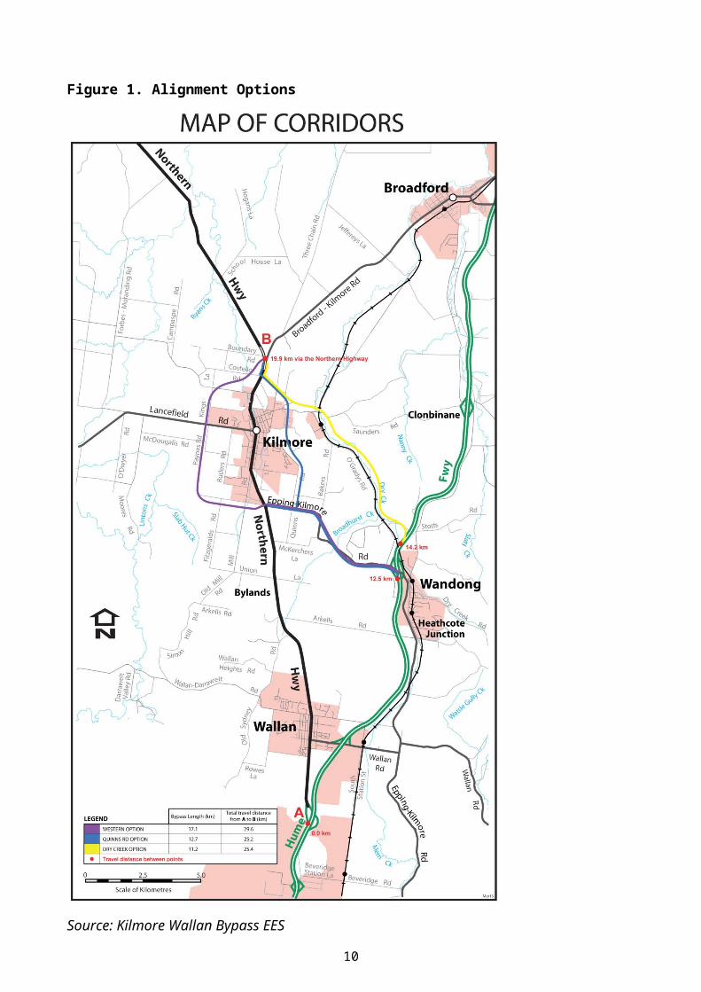
The options are shown in Figure 1.
7
Figure 1. Alignment Options
Source: Kilmore Wallan Bypass EES
8
3 SUBMISSIONS
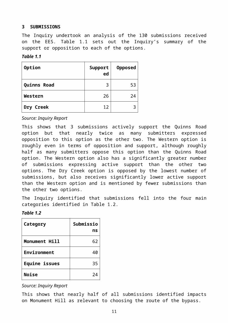
The Inquiry undertook an analysis of the 130 submissions received on the EES. Table 1.1 sets out the Inquiry’s summary of the support or opposition to each of the options.
Table 1.1
Option Supported Opposed
Quinns Road 3 53
Western 26 24
Dry Creek 12 3
Source: Inquiry Report
This shows that 3 submissions actively support the Quinns Road option but that nearly twice as many submitters expressed opposition to this option as the other two. The Western option is roughly even in terms of opposition and support, although roughly half as many submitters oppose this option than the Quinns Road option. The Western option also has a significantly greater number of submissions expressing active support than the other two options. The Dry Creek option is opposed by the lowest number of submissions, but also receives significantly lower active support than the Western option and is mentioned by fewer submissions than the other two options.
The Inquiry identified that submissions fell into the four main categories identified in Table 1.2.
Table 1.2
Category Submissions
Monument Hill 62
Environment 40
Equine issues 35
Noise 24
Source: Inquiry Report
This shows that nearly half of all submissions identified impacts on Monument Hill as relevant to choosing the route of the bypass.
Impacts on the broader environment including landscape, visual, biodiversity, noise and amenity were raised by a almost a third of submissions, including impacts from the Western and Dry Creek options as well as the Quinns Road route.
Around a quarter of submissions addressed impacts specific to the equine precinct, including access to the Kilmore Racecourse and the likely effectiveness of measures to mitigate the severance of the precinct caused by the Quinns Road and Dry Creek options.
9
Mitchell Shire Council submission
Mitchell Shire Council made a submission to the Inquiry.
Council stated that it does not support any of the three options because it believes the options have been developed in advance of an integrated examination of transport and land use. Council does not dispute the traffic modelling included in the EES, but notes that this is not the only factor that should be considered.
The submission states that the Council believes the Quinns Road option is ‘completely inconsistent’ (Council submission to Inquiry, Thursday 4 September, page 6) with the objectives for Monument Hill expressed in the Council’s Monument Hill Management Plan. The Council has also sought to amend the Significant Landscape Overlay that applies to the area through amendment C56 to the Mitchell Planning Scheme to include an updated schedule including a revised statement of significance. The Council believes that construction of a bypass through Monument Hill is inconsistent with the proposed statement of significance and landscape character objectives in the amended schedule to the Significant Landscape Overlay. Amendment C56 has been adopted by Council, but not approved at the date of this Assessment.
10
4 INTEGRATED ASSESSMENT OF EFFECTS
4.1 Approach to this Assessment
This Assessment uses ten evaluation objectives to provide a way of considering the different environmental effects of the project together to provide an overall, integrated assessment of the three alignments. Table 1.3 sets out the evaluation objectives, which are based on the Scoping Requirements issued by the Minister for Planning.
The Assessment identifies the key issues which are considered to make a difference between the options and reaches conclusions about which alignment performs better for each evaluation objective. For some evaluation objectives there may be no significant difference between the options, and for others the differences are more substantial. The analysis against evaluation objective ten on Integrated and Sustainable Development draws together the conclusions for each evaluation objective to provide findings on which option achieves the best balance of economic, social and environmental outcomes.
The Assessment considers whether any of the proposed route options fails to achieve any of the evaluation objectives and whether this means that any of the three options is unacceptable. This assessment is informed by the Inquiry Report, statutory policy and guidelines, including the Mitchell Planning Scheme. This Assessment also takes into account the project objectives put forward by VicRoads and uses these to inform its findings.
Table 1.3 Assessment Evaluation Objectives
No. Evaluation objectives
1. Transport Network Performance - To improve road safety, traffic performance and general amenity, particularly in the townships of Kilmore and Wallan, by developing a Northern Highway bypass which will be effective in attracting through traffic, especially heavy vehicles, and provide better connections to the existing local transport network.
2. Land Use and Economic - To minimise adverse effects on existing and planned land uses and to contribute to positive economic outcomes in the area.
3. Social Effects - To minimise adverse social effects, including displacement of residents and disruption of access to community facilities.
4. Landscape and Visual Values - To minimise adverse effects on landscape and visual amenity values.
5. Biodiversity - To avoid or minimise effects on native vegetation and listed flora and fauna species and ecological communities, including those listed under the Environment Protection and Biodiversity Conservation Act 1999, and address opportunities for offsetting potential losses consistent with relevant policy.
6. Noise and Dust - To minimise noise and dust effects on the amenity of residents and open space areas.
7. Catchment Values - To maintain the functions and values of surface water environments and groundwater.
8. Cultural Heritage - To avoid or minimise adverse effects on Aboriginal and non-Aboriginal cultural heritage values.
9. Environmental Management Framework - To provide a transparent framework with clear accountabilities for managing environmental effects and hazards associated with construction and operation of the project, in order to achieve acceptable environmental outcomes.
10. Integrated and Sustainable Development - Overall, to demonstrate that the project would achieve a balance of economic, social and environmental outcomes that contribute to ecologically sustainable development and provide
11
a net community benefit over the short and long-term.
4.2 Traffic Network Performance
Evaluation Objective – To improve road safety, traffic performance and general amenity, particularly in the townships of Kilmore and Wallan, by developing a Northern Highway bypass which will be effective in attracting through traffic, especially heavy vehicles, and provide better connections to the existing local transport network.
Key Issues
The key issues for transport network performance that inform this assessment are:
Whether the traffic network performance is a significant differentiator between options. The extent to which each option results in an improvement in road safety, traffic
performance and general amenity.
Discussion and Findings
The EES included a traffic model that was used to assess the effect of each option on traffic volumes in Kilmore and Wallan. The model found that all options would reduce through traffic to differing degrees. The model found that the Quinns Road option would result in the most immediate and greatest reduction in traffic through Kilmore. According to the model the Dry Creek was the next best performing alignment with the Western option having the least immediate benefit.
This Assessment considers that the findings of the traffic modelling should be put in the context of each of VicRoads project objectives, not just objectives two and five which are to remove bypassable traffic, and the EES evaluation objectives. The Quinns Road option should not be the recommended option simply because the model suggests it will remove the most bypassable traffic from Sydney Street, Kilmore. The findings of the Inquiry on how the model considers the design and performance of the road network around Kilmore and Wallan should be taken into account. The extent to which there is uncertainty about the accuracy of the model is also a factor when considering how much weight to give to its predictions when deciding on a recommended option.
Network design
The Inquiry noted that the model results should be set in the context of the design of the road network in and around Kilmore and Wallan.
VicRoads accepted in its submission to the Inquiry that ‘the bypass options should not be viewed in isolation, but as an important component of a number of strategic traffic solutions that will need to be implemented to meet Kilmore’s traffic needs’. The Inquiry found that the model alone may not provide such a strategic approach, and that a critical evaluation of its predictions is required.
For example, the Inquiry identified that a high proportion of traffic that currently passes through Wallan is bound for Kilmore and that only the Quinns Road and Western options provide an effective bypass of Wallan for Kilmore bound traffic. This is because the upgrade of the Kilmore-Epping Road between the Wandong interchange and Kilmore is part of both options and would, combined with the existing Hume Freeway, provide an attractive alternative to the Northern Highway through Wallan. The Dry Creek option does not include this element and would therefore be unlikely to perform as well as the other two options as a bypass of Wallan. This is a significant
12
drawback of the Dry Creek option, but is not clearly reflected in the model conclusions presented in the EES which place Dry Creek as the second best performing option.
The Inquiry found that none of the proposed bypass options could completely solve all the traffic issues within Kilmore. This Assessment accepts this and notes that VicRoads and the Shire of Mitchell should continue to work collaboratively to manage traffic that will still pass through Kilmore. Such an approach may include implementation of the Inquiry’s recommendation to reserve land for the Conway-Johns Street inner link.
Network performance
The model uses the estimated travel times for each of the options to make assumptions about whether motorists will chose to use the bypass or the Northern Highway. The travel time data is then used to identify Quinns Road as the best performing option from a traffic network perspective in terms of traffic volumes using the bypass or the Northern Highway.
The Inquiry found that using travel times to determine likely traffic volumes introduces some uncertainty into the model predictions. This is because the model generally assumes that traffic will use the quickest route. This does not take into account motorists’ perceptions of time and distance and the benefits of avoiding the more complex road layout in Kilmore and Wallan town centres. The Inquiry also found that the magnitude of the differences in travel times is not necessarily large enough to result in the differences in traffic volumes predicted by the model. For these reasons, the Inquiry was not convinced that the model predictions would always be correct and that therefore there is uncertainty regarding the modelled predictions of traffic volumes.
Even if the findings of the model are taken at face value, the Inquiry found that there is a relatively small difference between each of the options in the longer term because over time the difference between the three options reduces. Therefore the shorter term benefits of the Quinns Road option must be considered in the context of its permanent and longer term impacts which are discussed in detail in the sections below.
These factors reduce the level of certainty in the estimated traffic volumes predicted by the model and the weight that can be given to the model outputs when recommending a route option.
Conclusion
It is my assessment that:
All options result in improvements to traffic performance.
The Quinns Road option probably provides the most immediate reduction in through traffic in Kilmore and Wallan, although there is uncertainty regarding the extent of reduction in traffic volume.
There is uncertainty regarding the extent to which the model results consider the design and performance of the network as a whole and this reduces the weight than can be given to the model’s outputs.
VicRoads and the Shire of Mitchell should continue to work collaboratively to manage traffic that will still pass through Kilmore, which should draw upon the Inquiry’s recommendation to reserve land for the Conway-Johns Street inner link.
13
4.3 Land Use and Economic
Evaluation Objective - To minimise adverse effects on existing and planned land uses and to contribute to positive economic outcomes in the area.
Key Issues
The key land use and economic issues that inform this Assessment are:
Which option best provides for planned land use change and growth in Kilmore. The effects of the Western option on the Kilmore Wastewater Management Facility. Whether any option has an unacceptable impact on land use or economic outcomes.
Discussion and Findings
The population of Kilmore is expected to grow by around 2.5 % per year between 2011 and 2031 with the current population being around 7,140. Wallan is predicted to experience much higher population growth dues to its location within the Urban Growth Boundary of around 6.75 % from a current population of around 7,849. (Source: Transport Modelling and Economic Analysis for the Kilmore Wallan Bypass Planning Study included in the EES).
The policy for strategic land use development in Kilmore is set out in the Mitchell Planning Scheme and various documents that have been prepared by local and State government over the past decade. The future development of residential land in Kilmore is expected to be to the west and south east of the existing town.
The Inquiry found that the preferred bypass alignment should provide improved access between metropolitan Melbourne and the future development areas of Kilmore. VicRoads’ project objectives three and four both explicitly require a consideration of land use as part of selecting a preferred alignment.
Some submissions noted that the Western option may limit growth to the west of Kilmore. However, the Inquiry found that the Western option would provide for improved access to Melbourne from the growth areas to the west of Kilmore and that it would provide an effective alternative to the Northern Highway for this area. This would support residential development to the west of Kilmore and would help to meet VicRoads’ project objectives three and five. The Western option also avoids adverse impacts on existing land use at Monument Hill and the Kilmore Equine Lifestyle Precinct.
The Inquiry found that the Western option would not be likely to result in a significant adverse effect on the use of land for productive agricultural purposes in the Kilmore region.
The Western option is therefore not considered on balance to have a significant adverse effect on planned land uses in Kilmore, and could provide improved connectivity to Melbourne for residential areas to the West of Kilmore.
The Quinns Road option provides improved access to residential growth areas to the south east of Kilmore and would be likely to provide an effective alternative to the Northern Highway for traffic from this area. The Inquiry notes that it may be possible to upgrade the southern part of Quinns Road to provide this benefit without the other impacts of the Quinns Road option identified in this Assessment.
The Quinns Road option traverses the base of Monument Hill on land affected by a Significant Landscape Overlay and passes close to the Kilmore Golf Course and Kilmore Racecourse. This Assessment finds that this alignment would have an adverse effect on these existing land uses and
14
the ability to meet the strategic land use objectives for these areas expressed in the Mitchell Planning Scheme.
The Quinns Road and Dry Creek options traverse an area of Rural Living Zone (known as the Kilmore Equine Lifestyle Precinct) to the north of Kilmore. This Assessment notes that these options conflict to a degree with the strategic land use objectives for this area expressed in the Mitchell Planning Scheme.
Kilmore Wastewater Management Facility
The Western option passes through land that is currently part of the Kilmore Wastewater Management Facility (the facility). The land affected by the alignment within the facility is not currently used for wastewater treatment however, Goulburn Valley Region Water Corporation (GVW) indicated in submissions to the Inquiry that the land may be required for future expansion. GVW also raised concerns regarding the effects of odour from the facility on passing motorists and cyclists and that this may compel the Environment Protection Authority to require GVW to take remedial action which could be costly. This Assessment notes the economic costs of mitigating the potential impact of the Western option put forward by GVW.
This Assessment acknowledges the potential adverse impact of the Western option on the existing facility, however, this is one of a number of issues that are considered in this Assessment to recommend an alignment for the road. The impact on the facility is not unacceptable and cannot be the sole factor that is considered when selecting a preferred alignment.
The Assessment accepts the recommendation of the Inquiry that VicRoads and GVW should collaborate to refine the design of the bypass generally along the alignment proposed in the exhibited EES and explore reconfiguration or relocation of the plant to minimise adverse impacts and achieve an efficient whole of government outcome.
Conclusion
It is my assessment that:
The Western option best minimises impacts on existing and planned land uses.
The Western option has the potential to provide an alternative to the Northern Highway for traffic from future residential areas to the west of Kilmore.
The Quinns Road option has the greatest adverse effects on existing and planned land uses.
The Western option should be refined to minimise impacts on the Kilmore Wastewater Management Facility, with VicRoads and GVW collaborating to refine the design of the bypass generally along the alignment proposed in the exhibited EES to achieve an efficient whole of government outcome.
15
4.4 Social Effects
Evaluation Objective - To minimise adverse social effects, including displacement of residents and disruption of access to community facilities.
Key issues
The key social effects that inform this Assessment are:
The relative effects of each option on severance of access to community, recreational and sporting facilities and public open space including Monument Hill and within the equine precinct.
The differing extent of acquisition of residential and rural lifestyle properties required for each option.
Whether any option has unacceptable social effects, resulting from displacement of residents and disruption of access to community facilities.
Discussion and findings
VicRoads’ project objective four seeks to minimise displacement and severance of communities, community facilities and agricultural land to the extent practicable.
The Quinns Road and Dry Creek options both traverse areas that have a distinct social function for Kilmore. Both alignments affect the Kilmore Equine Lifestyle Precinct and Kilmore Racecourse and the Quinns Road option also affects Monument Hill and the Golf Course.
Many submissions identified Monument Hill as an area with social value to the community of Kilmore for a variety of reasons. The Quinns Road alignment traverses the lower slopes of the hill between the urbanised area of Kilmore and the public open space in the Monument Hill reserve. The alignment would significantly alter the nature of access from Kilmore to Monument Hill by requiring people to cross a new arterial road.
The Quinns Road and Dry Creek alignments affect access between the Kilmore Equine Lifestyle Precinct and Kilmore Racecourse. The relationship between these two land uses is that trainers and horses regularly commute between the racecourse and the equine precinct. If either of these two alignments were to be constructed access would be adversely affected.
This Assessment recognises that acquisition of developed residential land is highly disruptive and stressful for the individuals concerned and that this may be heightened due to the effects of bushfire on the area in recent years. The Assessment notes that the Quinns Road option will impact the highest number of properties and the largest area of residential land (73 properties / 47 hectares), with the Western option affecting 53 properties and 12.7 hectares and the Dry Creek option 33 properties and 24.1 hectares (figures from Kilmore Wallan Bypass EES, Chapter 11). Not all acquisition is of the entire land title. The Inquiry notes that rural lifestyle properties in the equine precinct affected by the Quinns Road and Dry Creek options are less easily replaced than conventional residential properties and there may be limited options in the area for people who are displaced.
The impact of the Western option on agricultural land is considered in Section 4.3 of this assessment.
16
Conclusion
Having regard to the EES, submissions and the Inquiry Report, it is my assessment that:
The Western option minimises social effects to the greatest extent, including the displacement of residents and disruption of access to community facilities at Monument Hill and the equine precinct.
The Quinns Road and Dry Creek options do not meet VicRoads’ stated objective of minimising displacement and severance of communities and community facilities in the equine precinct and Monument Hill to the extent practicable because the Western option is available and is a practical alternative that avoids these impacts.
All options require acquisition of residential land, with the Quinns Road option impacting the greatest number and largest area.
4.5 Landscape and Visual Values
Evaluation Objective – To minimise adverse effects on landscape and visual amenity values.
Key Issues
The key landscape and visual issues that inform this Assessment are:
The relative landscape and visual impacts of each option including:
o Visual and landscape impacts of elevated structures on the Dry Creek option.
o Clearing of vegetation and earthworks in Monument Hill Reserve.
The impact of the redesigned Hume Freeway interchange at Wandong.
Whether any of the options is unacceptable as a result of landscape or visual impacts.
Discussion and Findings
The effects on landscape and visual values and amenity vary in nature between each of the options.
The Dry Creek option traverses undulating topography with a number of waterways resulting in elevated structures and earthworks on this alignment. The elevated structures would be visible from the residential areas to the south east of Kilmore and will impact the ridgelines and natural landscapes of the area. The ridgelines are noted in the Mitchell Planning Scheme as significant aspects of the landscape.
The Quinns Road alignment requires the removal of vegetation from the Monument Hill reserve. The EES argued that many of the potential impacts of this alignment would be screened by the existing vegetation in the reserve that would be retained. Some submissions to the Inquiry disagreed with this assessment and suggested this would result in a significant impact on the reserve. The Inquiry supported the assessment undertaken for the EES, although it did note that the assessment’s conclusions regarding existing and future open space on the Quinns Road option appear to understate the impacts of vegetation removal of this option.
The Western option traverses open, generally flat agricultural land. The imposition of the road in this otherwise rural setting would detract from the existing character of the landscape.
The Inquiry generally supports the assessment of visual impacts undertaken to inform the EES, however, considers that impacts of the Western option have been slightly overstated.
17
The Inquiry notes that the potential impacts from the redesign of the Hume Freeway interchange at Wandong are not fully addressed in the EES. This Assessment considers this to be an omission in the EES and agrees with the Inquiry that the redesign of this interchange should seek to minimise the landscape and visual effects Hume Freeway interchange at Wandong.
Conclusion
It is my assessment that:
The Dry Creek option would have adverse impacts on the landscape and visual values of the ridgelines to the east of Kilmore.
The Quinns Road option will have some adverse impacts on landscape values, due to the clearing of vegetation at Monument Hill.
The Western option has the least significant effects on landscape and visual amenity values.
The redesign of the Hume Freeway interchange at Wandong should be undertaken to minimise its landscape and visual impacts.
4.6 Biodiversity
Evaluation Objective – To avoid or minimise effects on native vegetation and listed flora and fauna species and ecological communities, including those listed under the Environment Protection and Biodiversity Conservation Act 1999, and address opportunities for offsetting potential losses consistent with relevant policy.
Key Issues
The key biodiversity issues that inform this Assessment are:
The extent to which biodiversity impacts are a differentiating factor between the options. The avoidance or minimisation of effects on Matters of National Environmental Significance
as defined under the Environment Protection and Biodiversity Conservation Act 1999 (Commonwealth) (Golden Sun Moth).
The avoidance or minimisation of effects on native vegetation and listed flora and fauna and ecological communities.
Whether biodiversity impacts are acceptable.
Discussion and Findings
Matters of National Environmental Significance
The Dry Creek and Western options both impact on areas of habitat and potential habitat for the Golden Sun Moth which is listed as critically endangered under the Commonwealth Environment Protection and Biodiversity Conservation Act 1999.
The studies undertaken for the EES indicate that no other Matters of National Environment Significance are anticipated to be impacted by the project. The Inquiry accepted that the studies undertaken were adequate.
18
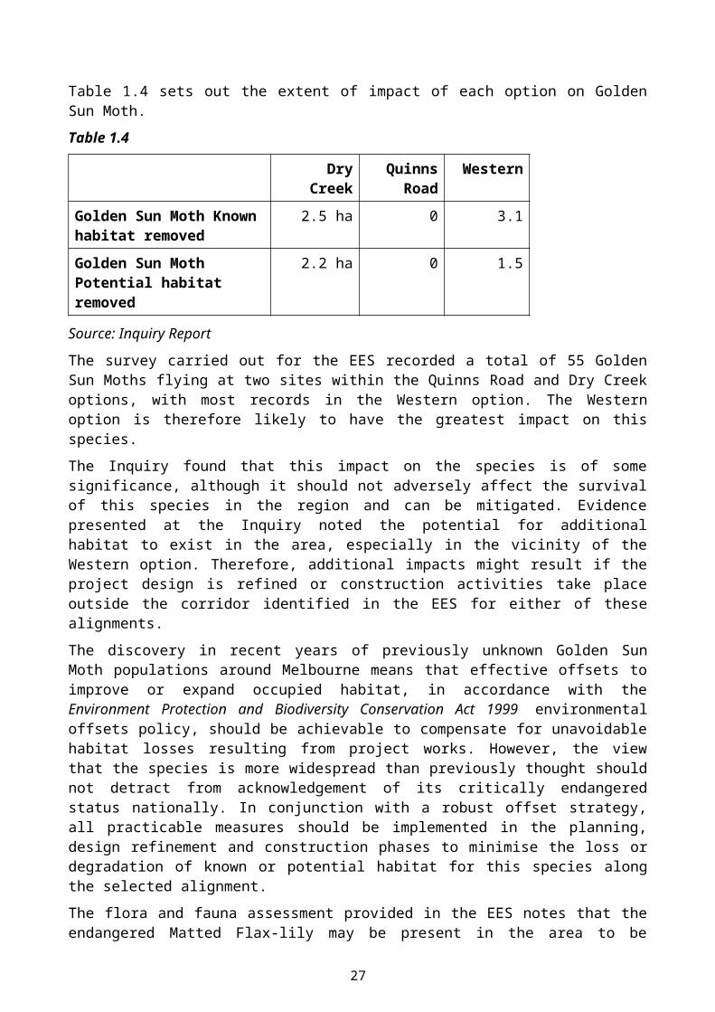
Table 1.4 sets out the extent of impact of each option on Golden Sun Moth.
Table 1.4
Dry Creek Quinns Road
Western
Golden Sun Moth Known habitat removed
2.5 ha 0 3.1
Golden Sun Moth Potential habitat removed
2.2 ha 0 1.5
Source: Inquiry Report
The survey carried out for the EES recorded a total of 55 Golden Sun Moths flying at two sites within the Quinns Road and Dry Creek options, with most records in the Western option. The Western option is therefore likely to have the greatest impact on this species.
The Inquiry found that this impact on the species is of some significance, although it should not adversely affect the survival of this species in the region and can be mitigated. Evidence presented at the Inquiry noted the potential for additional habitat to exist in the area, especially in the vicinity of the Western option. Therefore, additional impacts might result if the project design is refined or construction activities take place outside the corridor identified in the EES for either of these alignments.
The discovery in recent years of previously unknown Golden Sun Moth populations around Melbourne means that effective offsets to improve or expand occupied habitat, in accordance with the Environment Protection and Biodiversity Conservation Act 1999 environmental offsets policy, should be achievable to compensate for unavoidable habitat losses resulting from project works. However, the view that the species is more widespread than previously thought should not detract from acknowledgement of its critically endangered status nationally. In conjunction with a robust offset strategy, all practicable measures should be implemented in the planning, design refinement and construction phases to minimise the loss or degradation of known or potential habitat for this species along the selected alignment.
The flora and fauna assessment provided in the EES notes that the endangered Matted Flax-lily may be present in the area to be developed for the Project, although no individuals were located by survey work carried out for the EES. Targeted surveys for the vulnerable Striped Legless Lizard and Growling Grass Frog were carried out, however, none were found. The flora and fauna assessment recommends contingency measures be developed for these species.
This Assessment concludes that there is a potential impact on Matted Flax-lily, Striped Legless Lizard and Growling Grass Frog from the project and that this should be managed by appropriate contingency measures to be included in the Environmental Management Framework.
This Assessment notes that impacts on Matters of National Environmental Significance from the Project are subject to approval under the Environment Protection and Biodiversity Conservation Act 1999 and any conditions that the Commonwealth Minister for Environment considers appropriate to mitigate impacts.
Native vegetation and state listed flora and fauna
The Inquiry found that the EES underestimates the impact of the Quinns Road option on the biodiversity values.
19

The Quinns Road option removes at least a third more native vegetation than the other two options, but is considered by the EES to have the same level of impact.
The Inquiry noted that much of the vegetation to be removed is at Monument Hill which is a large, contiguous area of woodland that is relatively rare in the Kilmore region and which supports habitat for native vegetation and a number of species listed under the Flora and Fauna Guarantee Act 1988. The Inquiry also found that the quality, range and diversity of the species and habitat found in the reserve should be taken into consideration.
This is demonstrated by the impact on native vegetation set out in table 1.5 and impacts on Flora and Fauna Guarantee Act 1988 listed species set out in table 1.6.
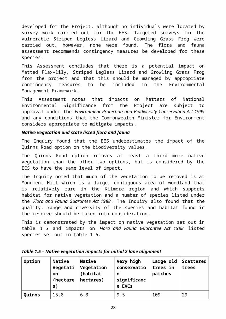
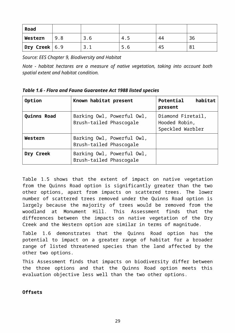
Table 1.5 – Native vegetation impacts for initial 2 lane alignment
Option Native Vegetation (hectares)
Native Vegetation (habitat hectares)
Very high conservation significance EVCs
Large old trees in patches
Scattered trees
Quinns Road 15.8 6.3 9.5 109 29
Western 9.8 3.6 4.5 44 36
Dry Creek 6.9 3.1 5.6 45 81
Source: EES Chapter 9, Biodiversity and Habitat
Note - habitat hectares are a measure of native vegetation, taking into account both spatial extent and habitat condition.
Table 1.6 - Flora and Fauna Guarantee Act 1988 listed species
Option Known habitat present Potential habitat present
Quinns Road Barking Owl, Powerful Owl, Brush-tailed Phascogale
Diamond Firetail, Hooded Robin, Speckled Warbler
Western Barking Owl, Powerful Owl, Brush-tailed Phascogale
Dry Creek Barking Owl, Powerful Owl, Brush-tailed Phascogale
Table 1.5 shows that the extent of impact on native vegetation from the Quinns Road option is significantly greater than the two other options, apart from impacts on scattered trees. The lower number of scattered trees removed under the Quinns Road option is largely because the majority of trees would be removed from the woodland at Monument Hill. This Assessment finds that the differences between the impacts on native vegetation of the Dry Creek and the Western option are similar in terms of magnitude.
Table 1.6 demonstrates that the Quinns Road option has the potential to impact on a greater range of habitat for a broader range of listed threatened species than the land affected by the other two options.
This Assessment finds that impacts on biodiversity differ between the three options and that the Quinns Road option meets this evaluation objective less well than the two other options.
20
Offsets
This evaluation objective includes identifying opportunities for offsetting the potential loss of biodiversity as a result of the Project.
This Assessment notes the commitments in the EES to providing offsets in accordance with Commonwealth and Victorian requirements, and the recommendations of the Inquiry that the environmental management regime for the Project include an offset management strategy.
This Assessment accepts the findings of the Inquiry and finds that the inclusion of conditions on the relevant statutory approvals, including a Planning Scheme Amendment to introduce an incorporated document into the Mitchell Planning Scheme, is appropriate to ensure offsets must be provided.
The Inquiry formed a view that offsets are unlikely to be able to compensate adequately for the type of habitat that will be lost at Monument Hill as a result of the Quinns Road option. This is because offsets will not necessarily be in a contiguous parcel of land, would take time to establish and may not be publicly accessible.
This Assessment finds that offsets should be able to be provided in accordance with Victoria’s Biodiversity Assessment Guidelines and does not agree with the Inquiry that offsets should also attempt to replicate public access to biodiversity values. This is because the objective for permitted clearing of native vegetation set out in the Biodiversity Assessment Guidelines is to achieve ‘no net loss in the contribution made by native vegetation to Victoria’s biodiversity’. Public access is not part of this objective.
However, this Assessment agrees with the Inquiry’s broader point that the contiguous nature of biodiversity values at Monument Hill is of value and would be compromised if the Quinns Road option were constructed, and that the Biodiversity Assessment Guidelines do not require its replacement. This Assessment finds that this is a disadvantage of the Quinns Road option relative to the other options.
Overall biodiversity impacts
The EES evaluation objective and VicRoads’ objectives for the Project both seek to avoid and minimise impacts on biodiversity and ecological values. This Assessment finds that the Western option and Dry Creek options meet these evaluation objectives significantly better than the Quinns Road option.
The Quinns Road option impacts on significantly more native vegetation than the other two options, and although both of the other two options impact on areas of habitat for the critically endangered Golden Sun Moth, on balance the Quinns Road option is considered to have the greatest adverse impact on biodiversity of the three options.
This Assessment notes that the Inquiry did not state that impacts on biodiversity from any of the options were unacceptable.
21
Conclusion
It is my assessment that:
Biodiversity impacts are a differentiating factor between the three alignments, and that the Quinns Road option has the most significant impacts on biodiversity.
Overall biodiversity impacts of each of the options are considered acceptable provided appropriate offsets are obtained in accordance with the Environment Protection and Biodiversity Conservation Act 1999 environmental offsets policy (as relevant) and the Victorian Biodiversity Assessment Guidelines, and recommendations set out below are implemented effectively.
Measures to avoid, mitigate and offset impacts on Golden Sun Moth, building upon the work undertaken for the EES, should be provided to the Commonwealth Minister for the Environment for endorsement through the Environment Protection and Biodiversity Conservation Act 1999 approval.
Subject to those measures responding adequately to the Environment Protection and Biodiversity Conservation Act 1999 environmental offsets policy, it would be appropriate for the Commonwealth Minister to approve the Project being developed along the western option that is recommended by this Assessment.
Opportunities to minimise impacts on biodiversity values through project design refinement and management of construction works, including protecting large old trees and other scattered trees, especially those containing hollows, should be taken wherever practicable.
The Environmental Management Framework or equivalent document (i.e. VicRoads Project Environmental Protection Strategy) include a salvage and translocation program and post translocation monitoring to manage potential impacts on Matters of National Environmental Significance including Golden Sun Moth, Matted Flax-lily, Striped Legless Lizard and Growling Grass Frog (noting that these species are also listed under the Flora and Fauna Guarantee Act 1988).
A condition be included in the proposed incorporated document to require an Offset Management Strategy to be provided that responds to the Biodiversity Assessment Guidelines to the satisfaction of the Department of Environment, Land, Water and Planning.
4.7 Noise and Dust
Evaluation Objective – To minimise noise and dust effects on the amenity of residents and open space areas.
Key Issues
The key issues in relation to noise and dust that inform this assessment are:
The relative increases in operational traffic noise levels at dwellings and public open space from each option.
The relative effects of dust and noise impacts during construction from each option. Whether likely dust and noise emissions are unacceptable following implementation of the
Environmental Management Framework.
22
Discussion and Findings
The VicRoads Traffic Noise Reduction Policy 2005 sets out how VicRoads will seek to limit traffic noise from new arterial roads, including noise levels to be achieved by a new or redeveloped road alignment.
The assessment of noise impacts provided in the EES included modelling of the noise generated by the new road and the likely impact of each of the three alignments after the application of the VicRoads noise policy.
The Inquiry agreed with VicRoads assessment that noise impacts on dwellings from the new road would be negligible following implementation of mitigations to reduce the noise impacts to meet the VicRoads policy.
This Assessment anticipates that VicRoads will ensure that the road will meet the noise levels required by its policy and will implement the mitigation measures described in the EES to achieve this.
VicRoads submitted that impacts of noise on open space should not be required to be mitigated to the same level as residential land uses. This Assessment also notes that the VicRoads noise policy does not require mitigation of noise impacts from new or redeveloped roads on public open space.
This Assessment accepts that the impacts of noise on open space are not the same as impacts on dwellings, however, there is still a potential impact from noise on open space that should be considered as part of a comparative assessment of the three alignments. The Inquiry found that the Quinns Road alignment would have an adverse impact from noise on public open space to a greater extent than the other three options and this Assessment accepts that view. This is because this route traverses Monument Hill and passes close to the Kilmore Golf Course. The other options do not pass through significant areas of public space and therefore do not have similar impacts.
The impacts from dust generated by the project are predominantly associated with construction. There is also likely to be localised increased noise from construction activities. The EES includes an Environmental Management Framework that outlines measures to apply a best practice approach to mitigate and minimise impacts during construction. This Assessment accepts that the Environmental Management Framework included in the EES is an acceptable approach for managing dust and noise impacts during construction.
Conclusion
It is my assessment that:
The effects of noise on dwellings from each of the three alignments can be mitigated to the extent required by the VicRoads Traffic Noise Reduction Policy 2005.
Impacts from dust during construction can be effectively managed by applying standard construction practices required by the Environment Management Framework.
23
4.8 Catchment Values
Evaluation Objective – To maintain the functions and values of surface water environments and groundwater.
Key Issues
The key issues for catchment values that inform this assessment are:
Potential negative impacts of each option on waterways including Dry Creek. Whether any option will have unacceptable impacts on catchment values following
implementation of the measures in the Environmental Management Framework.
Discussion and Findings
The Inquiry found that the EES investigations adequately address potential impacts on catchment values.
The EES found that the Dry Creek option is likely to result in an increase to water levels in Dry Creek as a result of new structures to cross the creek, but that any increase can be contained in the existing banks.
The Dry Creek option also includes the greatest number of waterway crossings of any of the options and is most likely to result in negative impacts on water quality. However, these impacts can be managed appropriately.
This Assessment notes that the design of waterway crossings will be regulated under the Water Act 1989 and the proposed works will be regulated by the relevant catchment management authority. Works will also need to be subject to standard practice environmental management procedures required by the Environmental Management Framework, which are considered to be adequate.
The Quinns Road and Western options both cross Broadhurst Creek but are not considered to have significant effects on catchment values provided adequate measures are put in place during design, construction and operation of the road.
Conclusion
It is my assessment that:
Impacts on catchment values are not a significant differentiator between alignments. The effects on catchment values can be effectively mitigated by the implementation of the
Environmental Management Framework.
4.9 Cultural Heritage
Evaluation Objective – To avoid or minimise adverse effects on Aboriginal and non-Aboriginal cultural heritage values.
Key Issues
The key issues for cultural heritage that inform this assessment are:
The differing impacts on cultural heritage from each option including:o The extent of impacts on Aboriginal cultural heritage, particularly on the Dry Creek
alignment.o The significance of historical heritage at Monument Hill.o The extent of impacts on listed historical heritage.
24
The acceptability of impacts on cultural heritage from each option.
Discussion and Findings
Aboriginal cultural heritage
The EES found that all three alignment are likely to have impacts on Aboriginal cultural heritage, but that the Dry Creek option would impact on the greatest number of known sites. This is largely due to the proximity of the alignment to Dry Creek and the higher occurrence of Aboriginal cultural heritage around waterways. The sites impacted are considered to be of common occurrence and are able to be managed through the finalisation of a Cultural Heritage Management Plan under the provisions of the Aboriginal Heritage Act 2006.
The Quinns Road and Western options impact on fewer sites, although are considered by the Inquiry to have a similar magnitude of impact as each other.
Historic heritage
The Inquiry found that the EES did not consider all the potential impacts on historical heritage values from the three proposed alignments for the road.
In particular the Inquiry found that the EES and evidence provided by experts on behalf of VicRoads in relation to the Kilmore Outdoor Recreation Heritage Precinct at and around Monument Hill did not fully reflect the likely impacts of the proposed Quinns Road alignment on historic heritage. The Inquiry did, however, agree that the aspects of historic heritage that would be impacted by each of the proposed alignments, including impacts on Monument Hill, are of local significance.
This Assessment notes that a final decision by the Heritage Council on whether all or part of the Monument Hill area has state significance is yet to be made. If the area is determined to be of state heritage significance any proposed works may require a Heritage Permit under the Heritage Act 1995 and consideration of impacts on the listed values can be managed through this process.
The Inquiry also found that historical heritage at Wandong and nine historic oak trees at Kilmore East may be impacted, depending on the preferred alignment. This Assessment finds that the detailed design for the preferred alignment should seek to avoid or minimise impacts on these areas.
This Assessment finds that the impacts of the project on historic heritage are a differentiating factor between the alignments, with the Quinns Road alignment having greater impacts than the other two because of its impact at Monument Hill and the Kilmore Outdoor Recreation Heritage Precinct.
Conclusion
It is my assessment that:
Impacts on Aboriginal cultural heritage can be managed through the Cultural Heritage Management Plan requirement of the Aboriginal Heritage Act 2006.
The Dry Creek option has the greatest impact on Aboriginal cultural heritage. The Quinns Road alignment has the greatest impact on historical heritage.
25
4.10 Environmental Management Framework
Evaluation Objective – To provide a transparent framework with clear accountabilities for managing environmental effects and hazards associated with construction and operation of the project, in order to achieve acceptable environmental outcomes.
Key Issues
The key issues that inform this Assessment are:
1. That VicRoads will implement adequate measures to manage the potential environmental impacts of the design, construction and operation of the project.
Discussion and Findings
The EES sets out how the VicRoads Environmental Management System (EMS) will apply to the project in Chapter 17 – ‘Environmental Management Framework’.
The VicRoads EMS provides the overarching system for managing the environmental performance and compliance for VicRoads projects. The EMS sets out the policy, governance processes, roles, responsibilities and measures for managing the environmental aspects affected by a VicRoads project.
The VicRoads EMS includes a risk identification and assessment process and the development of a Project Environmental Protection Strategy (PEPS) for the design, construction and operation of the Project. The PEPS will be used to track implementation of VicRoads’ environmental commitments and any conditions placed on statutory approvals for the Project.
This Assessment notes that Chapter 17 of the EES also includes a number of specific measures that would be implemented during the construction of the Project. These measures are generally considered to be appropriate and should be further developed to respond to the findings of this Assessment where necessary and be reflected in the PEPS or equivalent document.
This Assessment considers that the VicRoads EMS and the proposed PEPS is an adequate, transparent and accountable framework for managing the aspects of the environment likely to be impacted by the Project.
This Assessment supports the proposed condition in the incorporated document that would apply to the land used for the Project that the PEPS or equivalent document be to the satisfaction of my department. The potential environmental effects of the Project warrant external oversight and review of the PEPS to provide assurance that all relevant measures have been identified and will be effective.
Conclusion
It is my assessment that:
The management approach set out in Chapter 17 of the EES provide an adequate Environmental Management Framework for the Project.
That the incorporated document for the project include a condition requiring that a PEPS or equivalent document is prepared to the satisfaction of my department.
26
4.11 Integrated and Sustainable Development
Evaluation Objective – Overall, to demonstrate that the project would achieve a balance of economic, social and environmental outcomes that contribute to ecologically sustainable development and provide a net community benefit over the short and long-term.
Key Issues
The key issues that inform this Assessment are:
1. Which option achieves the best balance of impacts and benefits in the context of the evaluation objectives applied to the EES and this Assessment
2. The extent to which a combination of effects would make any option unacceptable.
Discussion and Findings
Sustainable development seeks to balance environmental, social and economic outcomes so that current needs are met without compromising the ability of future generations to meet their needs.
The EES prepared for the Project put forward three alignments that all meet the stated objectives of the Project to differing degrees.
The task of this Assessment is to balance the findings of the studies and analysis presented in the EES, submissions, the information tabled at the hearings and the Inquiry report to determine which alignment, if any, provides the optimal balance of environmental, social and economic outcomes in the context of the legislation and policy that apply to the Project.
It is recognised that no option clearly meets all of the objectives of the Project better than another, or that one option is superior for all environmental, social and economic outcomes. Therefore this Assessment must balance a number of factors to determine the recommended alignment.
This Assessment agrees with the Inquiry that the Dry Creek option has little to recommend it when compared to the Quinns Road and Western options. The Dry Creek option provides a better connection between the Hume Freeway and the Northern Highway, but cannot improve connectivity within Kilmore or provide an effective bypass of Wallan for traffic bound for Kilmore. The Assessment accepts that whilst traffic network improvements in Kilmore are not a primary objective of the project, the other two alignments can provide improvements in Kilmore and that this should be taken into consideration. The Inquiry found that the Dry Creek option performed relatively poorly on most other environmental, social and economic aspects and this Assessment generally accepts this view.
This Assessment accepts that the Quinns Road option is likely to provide the most immediate benefit to Sydney Street in Kilmore, however, this benefit may be overstated because of uncertainty regarding the results of the traffic model presented in the EES. The Inquiry found that the traffic model is not the best basis for comparing options because it does not consider broader network design and performance issues that should be taken into account when determining the best option (these issues are outlined in section 4.2). This Assessment generally accepts the advice of the Inquiry that the traffic model predictions included in the EES should therefore not be used as a key differentiating factor between the three options.
This Assessment finds that the Quinns Road option has the greatest negative social, environmental and economic impacts of the three options. These include impacts on the environmental, social and economic functions of the equine precinct and Kilmore Racecourse, impacts on access to and quality of public open space at Monument Hill, public sporting and recreational facilities including
27
Kilmore Golf course and impacts on biodiversity. These impacts are discussed in more detail in the above sections.
This Assessment accepts the recommendation of the Inquiry that the Quinns Road option would not achieve acceptable environmental outcomes.
This Assessment finds that the Western option provides the best balance of environmental, social and economic outcomes of the three options. The Assessment recognises that the immediate benefits to traffic levels in Kilmore and Wallan may not be as great as the other two options, but accepts the view of the Inquiry that the predictions of the model are equivocal and that, in any case, the Western option still meets VicRoads’ project objectives and the transport network evaluation objective of this Assessment.
This Assessment also finds that the Western option is likely to result in significantly more benefits to the overall traffic network than the Dry Creek option because it has the potential to serve the western growth area of Kilmore and reduce through traffic in Wallan as a result of the upgrade to the Kilmore-Epping Road. The Western option has significantly fewer and less detrimental environmental, social and economic impacts than the Quinns Road option. The Western option therefore achieves the best balance of outcomes of the three options.
The Assessment accepts that the Western option may impact on the Kilmore Wastewater Management Facility should it be expanded in the future and the recommendation of the Inquiry that Goulburn Valley Water and VicRoads should work together to refine the alignment to achieve the most efficient whole of government outcome.
28
5 CONCLUSION AND FINDINGS
The conclusion of my assessment is that:
1. The Kilmore Wallan Bypass project be constructed generally on the alignment of the Western option.
2. VicRoads request a Planning Scheme Amendment to introduce an incorporated document into the Mitchell Planning Scheme and apply a Public Acquisition Overlay to land required for the Project generally in accordance with the draft amendment for the Western option exhibited with the EES.
3. A condition should be included in the proposed incorporated document to require that the project is implemented in accordance with an Environmental Management Framework. The Environmental Management Framework should be consistent with Chapter 17 of the EES and include the following:
o Measures to give effect to any approval under the Environment Protection and Biodiversity Conservation Act 1999.
o A salvage and translocation program and post translocation monitoring to manage potential impacts on Flora and Fauna Guarantee Act 1988 listed species.
4. A condition should be included in the proposed incorporated document to require an Offset Management Strategy to be provided that responds to the Victorian Biodiversity Assessment Guidelines.
29
Response to Inquiry Recommendations
The Inquiry made eight recommendations. The Minister for Planning’s response to each recommendation is provided in the table below.
No.
Recommendation Response
1 The Minister for Planning, under section 20(4) of the Planning and Environment Act 1987, prepare and approve an amendment to the Mitchell Planning Scheme generally in accordance with the draft amendment published as part of the Environment Effects Statement.
Accepted, subject to a formal request from VicRoads.
2 VicRoads and Goulburn Valley Water work together to refine the detailed design of the bypass in the vicinity of the Kilmore Wastewater Management Facility generally along the alignment proposed in the Environment Effects Statement. The design should explore reconfiguration or relocation of the plant with the view of achieving an efficient ‘whole of government’ resolution of the infrastructure needs of Kilmore.
Accepted.
3 VicRoads identify any opportunities to make minor adjustment to the bypass to reduce the numbers of trees and particularly the small patches of remanent native vegetation that are affected by the construction of the bypass.
Accepted. This is in line with the Environmental Management Framework set out in chapter 17 of the EES.
4 VicRoads’ Environmental Management System be adopted as the framework for environmental management for the project.
Accepted.
5 Environmental Management Plans for the Project:
a) Include a salvage and translocation program and post-translocation monitoring plan for Environment Protection and Biodiversity Conservation Act 1999 listed species that may be impacted, approved by the Department of the Environment before construction begins.
b) Include a salvage and translocation program and post-translocation monitoring plan for Flora and Fauna Guarantee Act 1988 listed
Accepted, noting that approval of a salvage and translocation program and post-translocation monitoring plan for Flora and Fauna Guarantee Act 1988 listed species that may be impacted would be the responsibility of the Department of Environment, Land, Water and Planning.
30
species that may be impacted, approved by the Department of Environment and Primary Industries before construction begins.
6 VicRoads prepare and Offset Management Strategy to satisfy requirements under:
a) The Environment Protection and Biodiversity Conservation Act 1999 Environmental Offsets Policy (Department of Environment, 2012).
b) The Permitted clearing of native vegetation, Biodiversity Assessment Guidelines (DEPI, 2013).
Accepted.
7 VicRoads prepare a Cultural Heritage Management Plan in accordance with the requirements of the Aboriginal Heritage Act 2006 after the Minister for Planning’s Assessment of the environmental effects of the project has been issued.
Accepted. A Cultural Heritage Management Plan is a statutory requirement under the Aboriginal Heritage Act 2006.
8 The road reservation requirements for the Conway-Johns Street inner link project be preserved by the application of a Public Acquisition Overlay as soon as possible.
Accepted in principle. The Shire of Mitchell should consider initiating a Planning Scheme Amendment responding to this recommendation.
Additional recommendations – page 122 of Inquiry Report
Response
The Western option is the most suitable alignment option for the project and will substantially meet project objectives and deliver an appropriate balance of environmental, economic and social outcomes, having regard to the evaluation objectives in the EES Scoping requirements.
Accepted.
The Western and Dry Creek options could achieve acceptable environmental outcomes.
Accepted.
The Quinns Road option could not achieve acceptable environmental outcomes.
Accepted.
The Kilmore Wallan Bypass be constructed along the Western alignment.
Accepted.
31