Embed Size (px)
Citation preview
NATIONAL SENIOR CERTIFICATE EXAMINATION
GEOGRAPHY
JUNE EXAMINATION
2015
GRADE 10
This paper consists of 9 pages including the cover page.
Geography/P1 Grade 10 2 June 2015
Please turn over
Instructions: 1. This question paper consists of TWO questions 2. Read through both questions carefully
3. Question 1 and Question 2 counts 70 marks each.
4. Answer ALL questions.
5. Number your answer according to the numbering system in the question paper
6. Write neatly and legibly
Geography/P1 Grade 10 3 June 2015
Please turn over
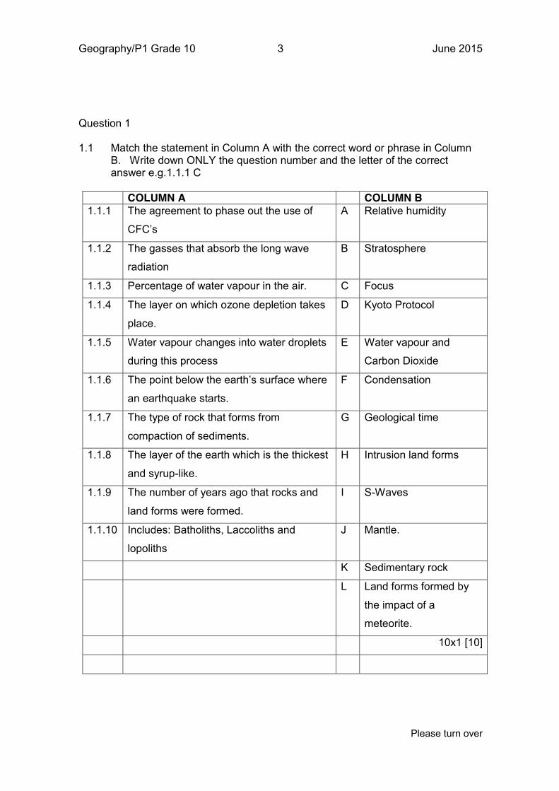
Question 1 1.1 Match the statement in Column A with the correct word or phrase in Column
B. Write down ONLY the question number and the letter of the correct answer e.g.1.1.1 C
COLUMN A COLUMN B 1.1.1 The agreement to phase out the use of
CFC’s
A Relative humidity
1.1.2 The gasses that absorb the long wave
radiation
B Stratosphere
1.1.3 Percentage of water vapour in the air. C Focus
1.1.4 The layer on which ozone depletion takes
place.
D Kyoto Protocol
1.1.5 Water vapour changes into water droplets
during this process
E Water vapour and
Carbon Dioxide
1.1.6 The point below the earth’s surface where
an earthquake starts.
F Condensation
1.1.7 The type of rock that forms from
compaction of sediments.
G Geological time
1.1.8 The layer of the earth which is the thickest
and syrup-like.
H Intrusion land forms
1.1.9 The number of years ago that rocks and
land forms were formed.
I S-Waves
1.1.10 Includes: Batholiths, Laccoliths and
lopoliths
J Mantle.
K Sedimentary rock
L Land forms formed by
the impact of a
meteorite.
10x1 [10]
Geography/P1 Grade 10 4 June 2015
Please turn over
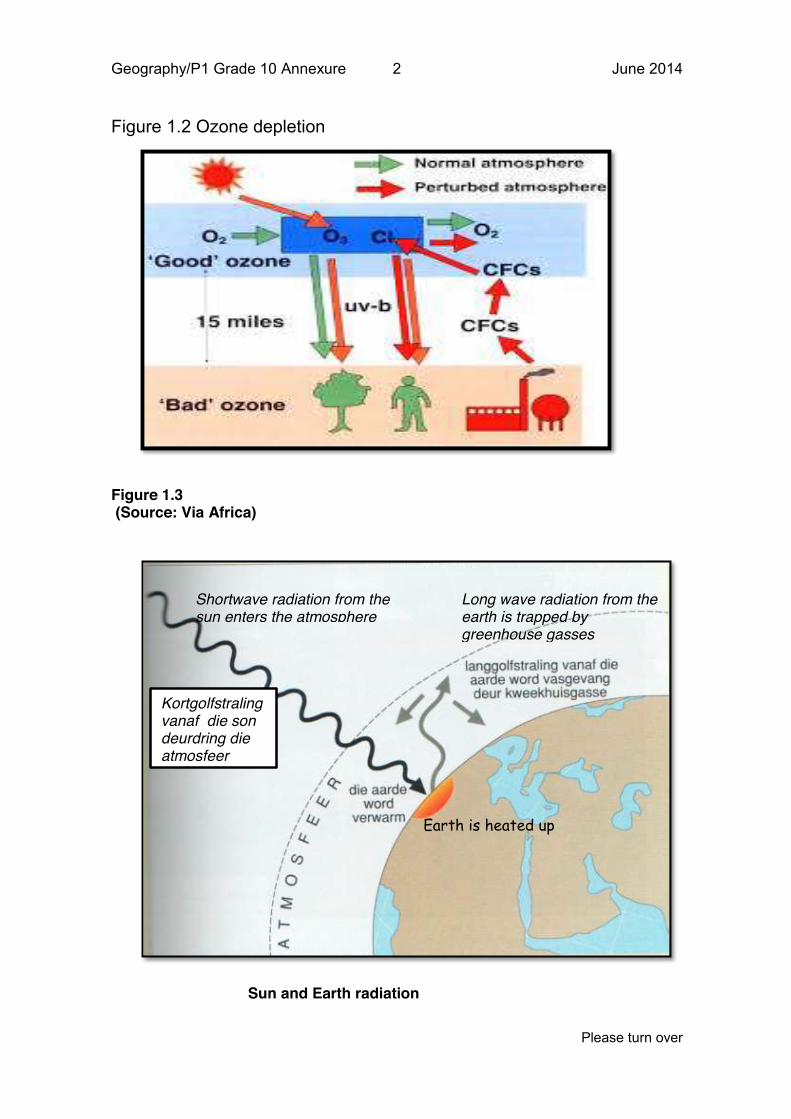
1.2 Study figure 1.2 on ozone depletion and answer the following questions : 1.2.1 From the diagram identify the greenhouse gas that causes
ozone depletion
1x2 (2)
1.2.2 What are the consequences of Ozone Depletion. 2x1 (2)
1.2.3 Suggest THREE ways of reducing the effects of Ozone
Depletion?
3x2 (6)
[10]
:
1.3 Study figure 1.3 and answer the following questions:
1.3.1 What is the process called whereby the sun radiates energy to
the earth?
1x1 (1)
1.3.2 How do wavelengths of radiation from the sun differ from the
radiation from the earth? Provide a reason for your answer.
1+2 (3)
1.3.3 In a tabular form,comapare insolation and terrestrial radiation
3x2 (6)
1.3.4 Distinguish between conduction and convection 2x1 (2)
[12]
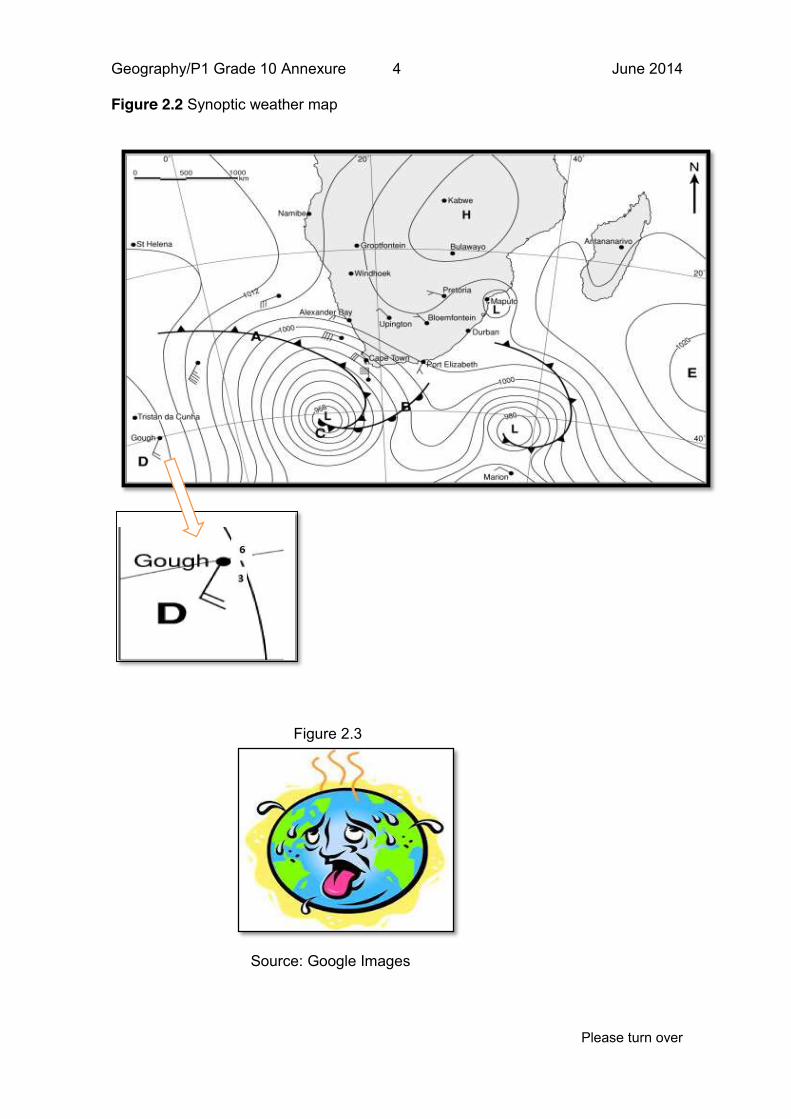
1.4 Study the synoptic weather map in Figure 1.4 and answer the
following questions.
1.4.1 What is the difference in the way a cold front and a warm front
is indicated on a synoptic weather map?
2x1 (2)
1.4.2 State whether the following statements are true or false:
(a) The atmospheric pressure of the two low (L) pressure areas
at the bottom of the map is above 1000 hPa
(b) To indicate a strong wind ,the isobars in a synoptic weather
map are further apart
(c) Cold fronts are associated with Low-pressure cells
(d) Standard atmospheric pressure at sea level is around
1000hPa
(e) The front to the south of the country has brought warm
weather to Cape Town.
(f) The isobaric interval in the map is 2 millibars 6x1 (6 )
Geography/P1 Grade 10 5 June 2015
Please turn over
[8]
1.5 answer the following questions
1.5.1 Define the term folding 1x1 (1)
1.5.2 Name the three types of folds that you have studied 3x1 (3)
1.5.3 List any four different types of tectonic plates that you have
studied
4x1 (4)
[8]
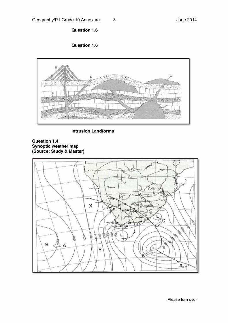
1.6 Answer the following questions:
1.6.1 How can technology help humans to protect themselves
against the damaging effects of earth quakes?
1x2 (2)
1.6.2 Refer to figure 1.6 and complete the following statements by
choosing the correct word in brackets.
(a) A very large dome shaped intrusion landform labelled F is
a (batholith/sill)
(b) A rounded mushroom-shaped intrusion landform labelled D
is a (dyke/laccolith).
(c) A concave saucer-shaped mass labelled E is a
(lopolith/volcanic pipe)
(d) The horizontal sheet of lava injected through cracks in the
Rock labelled A is a (batholith/sill)
4x1 (4) 1.6.3 Draw a detailed diagram of a volcano with sufficient
annotations.
3x2 (6)
[12]
1.7 Describe the following concepts
1.7.1 Desertification 1x2 (2)
1.7.2 The Rock Cycle 1x2 (2)
[4]
1.8 Write a paragraph in which you discuss the impact of
earthquakes on the economy and for each impact suggest
what can be done to reduce the impact.
3x2 [6]
TOTAL 70 Question 2
Geography/P1 Grade 10 6 June 2015
Please turn over
2.1 Choose the correct phrase/word from the choices to complete
the sentence. ONLY write down the question number and the
corresponding correct answer, e.g. 2.1 A
2.1.1 Moisture in the atmosphere is in the form of A water vapour
B water and oxygen
C water and greenhouse gasses
D water condensation
2.1.2 Water vapour capacity refers to: A the amount of water vapour in the air
B the maximum amount of water vapour that the air can
hold at a particular temperature
C the amount of water vapour in the air expressed as a
percentage
D warm air with no moisture in the atmosphere.
2.1.3 The following is not an aspect that influences temperature
around the earth:
A distance from the equator
B height above sea level
C ocean currents
D wind direction from the ocean
2.1.4 Convection rain refers to: A heated air that expands, rises and cools adiabatically
B air rising on the windward side of a mountain, cools
adiabatically
C warm air that rises above cold air that condensates
D warm air that rises and does not cool down.
2.1.5 The lines on a synoptic weather map that links places with the
same air pressure is called a _____________
A isohyets
B isotherms
C isobars
D isopressures
2.1.6 Extinct volcanoes are ….
Geography/P1 Grade 10 7 June 2015
Please turn over
A Volcanoes that have not erupted for a long time that
scientists do not expect them to erupt ever again.
B Most common along plate boundaries
C They have not erupted for many years but scientist cannot
be sure that they are extinct.
D They form when the lava is very fluid.
2.1.7 Plate tectonics refer to: A where earthquakes causes the most damage
B refers to the combination of earthquakes and weather
C refers to the movement of plates
D four different types of plates that occur
2.1.8 Igneous rocks are: A composed of Nife
B rocks which form from layers of compressed sediments
C contains very small crystals
D form when magma solidifies
2.1.9 A rift valley is a A steep slope which forms along a fault line
B block of land uplifted between parallel faults
C block of land which slips down between parallel faults
D Large lowland region between shields and fold mountains
2.1.10 A Tsunami can occur when: A the epicentre of the earthquake is on land
B heavy rain falls after the earthquake
C the epicentre of the earthquake occurred under the ocean
D the earthquake’s duration is longer than 10 minutes.
10x1 [10]
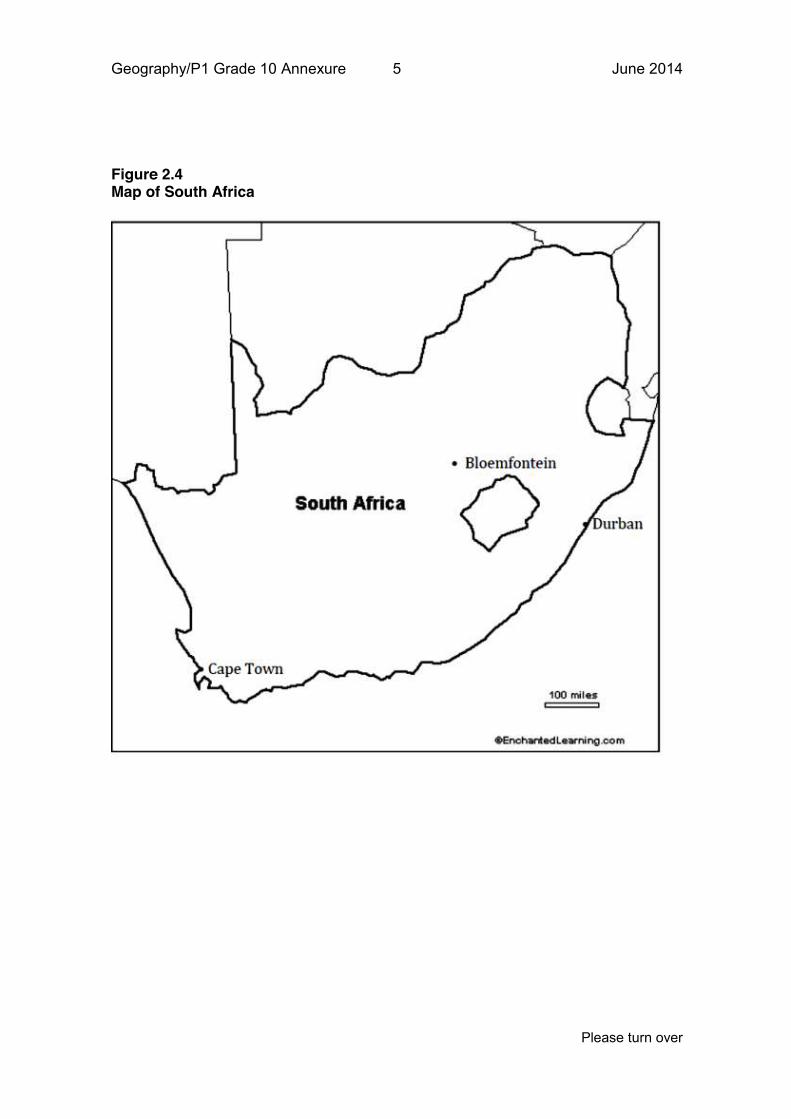
2.2 Study the synoptic weather chart in Figure 2.2 and answer the
following questions:
2.2.1 (a) Is this a summer or winter synoptic weather chart?
(b) Other than the date, provide two reasons for your answer in
2.2.1(.a)
1x2
2x1
(2)
(2)
2.2.2 Describe the weather conditions at Marion Island 6x1 (6)
Geography/P1 Grade 10 8 June 2015
Please turn over
2.2.3 What is the air pressure at East London? 1x2 (2)
2.2.4 a) Is the wind stronger at B or C?
b) state a reason for you answer in 2.3.4(a)
1x1
1x2
(1)
(2)
[12]
2.3 Study Figure 2.3 and answer the following questions
2.3.1 What climatic feature does the cartoon indicate? 1x1 (1)
2.3.2 Describe the consequences of the feature identified in question
2.3.1?
2x2 (4)
2.3.3 Name TWO things which humans can do to limit the impact of
the feature named in question 2.3.1
2x1 (2)
[7]
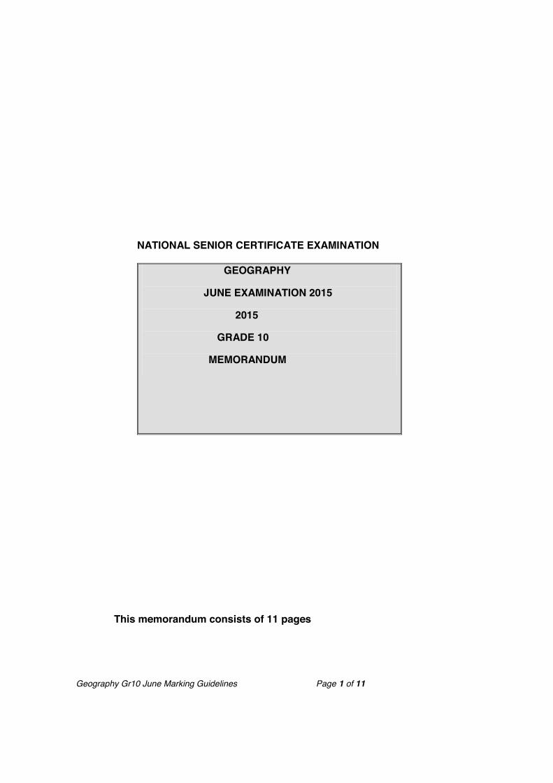
2.4 Study Figure 2.4 that indicates the location of Durban and
Cape Town and answer the following questions:
2.4.1 Other than the effect of latitude on climate, why is there a
difference in temperature between Durban, Cape Town and
Bloemfontein?
3x1 (3)
2.4.2 Write a paragraph of about six lines in which you evaluate the
impact of flooding on people
3x2
(6)
[9]
2.5 Answer the following questions
2.5.1 Define the following concepts
(a) Continental drift
(b) mesa
(c) butte
(d) Tsunami
4x1
(4)
2.5.2 Distinguish between the following terms
(a) Magma and lava
(b) weathering and erosion
(c) Caldera and volcanic neck
2x3 (6)
Geography/P1 Grade 10 9 June 2015
Please turn over
[10]
2.6 Answer the following questions:
2.6.1 In a paragraph of about eight lines, discuss both the positive
and negative impacts of volcanoes.
4x2 (8)
2.6. 2 Explain why do earthquakes have a greater impact on
developing countries than what they would have on developed
nations?
2x2 (4)
2.6.3 Distinguish between the different kinds of faults 3x2 (6)
2.6.4 Name the two types of instruments which can be used to
measure the intensity of earthquakes
2x1 (2)
[20]
Total [70]
NATIONAL SENIOR CERTIFICATE EXAMINATION
GEOGRAPHY P1
JUNE EXAMINATION
2015
GRADE 10 ANNEXURE
TOTAL MARKS: 140 DURATION
This paper consists of 5 pages.
Geography/P1 Grade 10 Annexure 2 June 2014
Please turn over
Figure 1.2 Ozone depletion
Figure 1.3 (Source: Via Africa)
Sun and Earth radiation
Shortwave radiation from the sun enters the atmosphere
Long wave radiation from the earth is trapped by greenhouse gasses
Earth is heated up
Kortgolfstraling vanaf die son deurdring die atmosfeer
Geography/P1 Grade 10 Annexure 3 June 2014
Please turn over
Question 1.6
Question 1.6
Intrusion Landforms Question 1.4 Synoptic weather map (Source: Study & Master)
Geography/P1 Grade 10 Annexure 4 June 2014
Please turn over
Figure 2.2 Synoptic weather map
Figure 2.3
Source: Google Images
Geography/P1 Grade 10 Annexure 5 June 2014
Please turn over
Figure 2.4 Map of South Africa
Geography Gr10 June Marking Guidelines Page 1 of 11
NATIONAL SENIOR CERTIFICATE EXAMINATION
GEOGRAPHY
JUNE EXAMINATION 2015
2015
GRADE 10
MEMORANDUM
This memorandum consists of 11 pages
Geography Gr10 June Marking Guidelines Page 2 of 11
1.1 Question 1 1.1.1 D√
1.1.2 E√
1.1.3 A√
1.1.4 B√
1.1.5 F√
1.1.6. C√
1.1.6 K√
1.1.8 J√
1.1.9 G√
1.1.10 H√
10x1(10) [10] 1.2 1.2.1 Greenhouse gas:
x CFCs √√
1x2(2)
1.2.2 Consequences of ozone depletion: x Influence on human’s eyes√:causes cataracts and a
reduction in vision. Could ultimately lead to blindness. √
x Skin degeneration, wrinkles and skin cancer√ x Can reduce the immune system which makes humans
more susceptible to illnesses. √ Any 2x1
2x1(2)
1.2.3 Ways to reduce ozone depletion: x Use of products that are written ‘ozone friendly’. √√
x Technicians that repair refrigirators and air conditioners
should recover and recycle the old CFCs so these are not released into the atmosphere. √√
x Drivers of cars with airconditioners should check them regularly for leaks. √√
x Internationally,people should keep high-altitude flights to a minimum as combustion in aeroplane engines
Geography Gr10 June Marking Guidelines Page 3 of 11
reduces the amount of oxygen in the atmosphere. √√ x The production of CFCs and other chemicals known to
break down ozone should be eliminated. √√ x Trees should be planted√√ x Agreements within the Montreal Protokol√√
Any 3x2
3x2(6)
[10]
1.3
1.3.1 Insolation√
1x1(1)
1.3.2 Radiation from the sun is in shortwave and
radation from the earth is in long wave. √
When the earth’s surface heats up the heat is transferred to
the surface, the surface in return radiates long-wave radiation
back in to the atmosphere. √√
1+2(3)
1.3.3 Insolation Terrestrial radiation
Heats up the earth’s surface√
Cools the earth’s surface√
Consists of short, medium and
long waves√
Consists of long waves√
Takes place during the day
only√
Takes place during the day
and night√
3x2(6)
1.3.4 Conduction is the method of heat transfer from one stationary
molecule to the next/transfer of heat by contact √and
convection is the method of heat transfer in moving air or
water/transfer of heat by vertical movement√
2x1(2)
[12]
Geography Gr10 June Marking Guidelines Page 4 of 11
1.4 1.4.1 Cold front: triangles on the line that looks like teeth√
Warm front: half circles on the line that looks like small bumps
on the line√
2x1(2)
1.4.2 a) False √
b) False√
c) True√
d) True√
e) False√
f) False√
6x1(6)
[8]
1.5
1.5.1 Folding is the compression of two plates of the
crust to form mountains√/The bending and
buckling of sedimentary strata to form
mountain ranges. √ (concept)
1x1
1x2(2)
(1)
1.5.2 Up fold/Anticline/Crest√
Down fold/syncline/valley√
Open fold/√
Overfold√
Overthust fold√
Any 3
3x1
(3)
1.5.3 North American plate√
South American plate√
African plate√
Eurasian plate√
Indo-Australian plate√
Pacific plate√
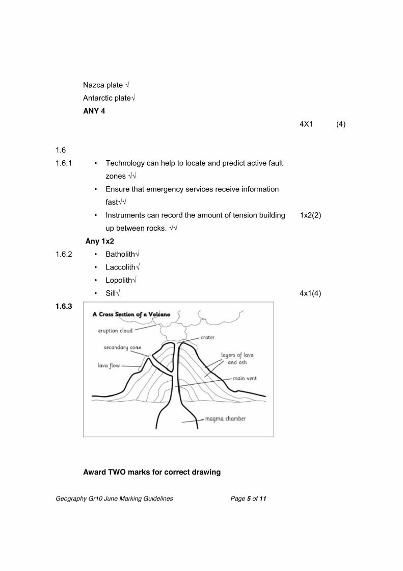
Geography Gr10 June Marking Guidelines Page 5 of 11
Nazca plate √
Antarctic plate√
ANY 4
4X1
(4)
1.6
1.6.1 • Technology can help to locate and predict active fault
zones √√
• Ensure that emergency services receive information
fast√√
• Instruments can record the amount of tension building
up between rocks. √√
Any 1x2
1x2(2)
1.6.2 • Batholith√
• Laccolith√
• Lopolith√
• Sill√
4x1(4)
1.6.3
Award TWO marks for correct drawing
Geography Gr10 June Marking Guidelines Page 6 of 11
Any FOUR labels
6x1(6)
[12]
1.7
1.7.1 • Desertification: process in which a desert or semi-arid
area expands. √√
1x2(2)
1.7.2 • The Rock Cycle: Process in which rocks on the earth
changes. It is the ongoing process of making, breaking
down and remaking of rock to create another type of
rock√√ (CONCEPT)
1x2(2) [4]
1.8 Impact of earthquakes on the economy
x Destruction of infrastructure√: Build dams along fault
lines to absorb shocks√
x Destruction of buildings√ build earthquake resistant
buildings√
x Flooding of coastal areas√ :Build strong breakwaters to
protect coastal areas against flooding√
Credit one mark for each impact and one mark for its solution in paragraph format. Accept other reasonable alternatives
3x2(6)
[6]
Total 70
Geography Gr10 June Marking Guidelines Page 7 of 11
Question 2 2.1
2.1.1 A√
2.1.2 B√
2.1.3 D√
2.1.4 A√
2.1.5 C√
2.1.6 A√
2.1.7 C√
2.1.8 D√
2.1.9 C√
2.1.10 C√ 10x1(10) [10]
2.2
2.2.1 a) winter√
b) Cold Front over Cape Town√√
Low temperatures over the interior√√
Little or no rainfall over the interior√√
Indication of rainfall over the Southern parts of the
country√√
Any ONE reason
1+2(3)
2.2.2 Environmental temperature: 5C√
Dew Point temperature: 5C√
Wind Direction: East North East (ENE) √
Precipitation: not indicated/rain√
Wind Speed: 20 Knots√
Cloud cover: Overcast√
6x1(6)
2.2.3 1016hPa√√ 1x2(2)
2.2.4 a) B√
b) Isobars are closer together which indicates a strong
1+2(3)
[14]
Geography Gr10 June Marking Guidelines Page 8 of 11
wind. √√
2.3
2.3.1 Global warming √ 1x1(1)
2.3.2 x Melting of icecaps√√
x Rising of ocean levels√√
x Rising of earths average temperatures√√
x Loss of habitat and animals√√
(Any Two, accept other reasonable answers
2x2(4)
2.3.3 x Introduce measures to reduce the use of electricit√
x Expand public transport systems√
x Reduce the use of nitrogen fertilisers√
x Reduce production of CFCs√
x Introduce an energy tax√
(Any ONE, accept any other reasonable answers)
1x1(1)
[6]
2.4
2.4.1 x Durban: Location close to the Warm Mozambique
Current√
x Cape Town: Location close to the Cold Benguela
Current√
x Bloemfontein: Distance from the ocean and height
above sea level√
3x1(3)
2.4.2 Impact of flooding on people x Floods will damage crops and lead to starvation√√
x Floods will damage homes, schools,roads and bridges
and lead to economic losses√√
x Higher/more rainfall will create ideal conditions for
mosquitoes to breed so it will increase the incidence of
Geography Gr10 June Marking Guidelines Page 9 of 11
malaria√√
x Flooding in areas where sanitation is poor will cause
epidemics of water borne diseases such as cholera,
typhoid and dysentery√√
Heavy brains and frequent flooding will affect the environment causing:
x Mudslides, landslides and erosion √√
x Topsoil will be washed away so that there is less fertile
soil for agricultural use √√ x There will be damage to vegetation and habitants√√
Any 3x2(6) Accept any reasonable answers
3x2(6)
[12]
2.5
2.5.1 (a)Continental drift: the theory that the continents were once
one land mass, but that they have drifted apart over time√
(b) Mesa is a large flat topped hill. √
(c) Butte is a flat topped hill with a small top eroded from a
mesa. √
(d) Tsunami is a series of huge sea waves caused by an
earthquake in the sea floor√
4x1(4)
2.5.2 (a) Magma is liquid rock inside the earth√ while Lava is liquid
rock that flows over the surface of the earth√
(b)Weathering is the breaking down of rocks √while Erosion
is transportation of the weathered rock√
(c) Caldera is a large crater created by volcanic explosion and
collapsed volcanic cone√ while Volcanic neck is a column of
rock above the land √
3x2(6)
[10]
2.6
2.6.1 Positive impacts of volcanoes x Volcanic ash can act as a fertilizer for soil/lava
Geography Gr10 June Marking Guidelines Page 10 of 11
weathers into fertile soil√√
x Hot springs and geysers act as tourist attractions. √√
x Hot springs and geysers associated with volcanoes can
be used to generate electricity and heating systems. √√
x Volcanic rocks is good and making roads. √√
Negative impacts of volcanoes
x Volcanic bombs can injure and kill people. √√
x Large areas of farmland can be destroyed. √√
x Lava and ash may destroy roads,buildings and
infrastructure. √√
x Eruptions can melt snow and cause mudflows that burry
settlements. √√
x Areas covered in lava cannot be reused for many years. √√
x Toxic gasses can cause acid rain and pollution. √√
x Toxic gasses can cause sicknesses to people √√
Any Four in a paragraph format. Candidates must refer to both aspects to earn full marks. Accept other reasonable alternatives
4x2(8)
2.6.2 x Developing countries will not have sufficient funds to
implement monitoring equipment or to warnings out
quickly enough. √√
x Because most of developing countries infrastructure
might be old or not built very well,it will not withstand the
impact of an earthquake in comparison to developed
nations advanced construction methods√√
Geography Gr10 June Marking Guidelines Page 11 of 11
2x2(4)
2.6.3 A normal fault: Rocks on either side of the fault move away
each other(tension pulling rocks apart) √√
A reverse fault:Where land is squeezed
together/compressional forces(rocks compressed together). √√
a tear fault: When two rock masses move sideways past each
other√√
3x2(6)
2.6.4 Seismograph√
Richter Scale√
2x1(2) [20]
Total 70
Grand Total 140