Embed Size (px)
Citation preview
NIS P TIH 008 NTIS DATEX II Service Version 10.0
Page 1
National Traffic Information Service
DATEX II Service
1 Introduction
Highways England is responsible for most Motorways and major A roads in England. Highways England has outsourced its National Traffic Information Service (NTIS) to a joint venture called Network Information Services (NIS) Ltd.
In recent years, interested parties have developed a set of Principles for exchanging traffic and travel1 information. One of the Principles recommends that data be exchanged using XML-based services and the National Traffic Information Service (NTIS) has developed a DATEX II Publisher conforming to these Principles. Details of the specification and supporting information, including schema, can be found at http://www.datex2.eu. The DATEX II service makes Highways England data, covering the motorway and trunk road network in England, available to third parties.
1.1 Overview
NTIS has installed equipment at Regional Control Centres in order to interface with the various subsystems of the Highways England Traffic Management Systems (HATMS). This equipment provides access to MIDAS traffic data and High Occupancy Alerts (HIOCC), the ability to set Variable Message Signs and also to receive VMS and Matrix Signal settings via the Message Sign and Signals Subsystems of HATMS. Traffic data is also collected from Traffic Monitoring Units and travel data from Automatic Number Plate Recognition (ANPR) cameras located at strategic locations on Highways England’s network.
NTIS connects to Highways England’s MIDAS Gold servers to receive MIDAS data at 1-minute intervals and publishes this data to subscribers within 1 minute of collection. NTIS also collects further loop-based data from Traffic Monitoring Units (TMU) and journey times from ANPR equipment every 5 minutes and publishes this to subscribers within 1 minute of collection (although there is an inherent latency in journey time data). As well as “raw” MIDAS Gold, TMU and ANPR data, NTIS also provides “processed” Traffic Data in the form of “Sensor-only” (an aggregation of all sensor data) and “FVD and Sensor” (an aggregation of both sensor data and Floating Vehicle data).
The new services are delivered in DATEX II v2 format using web services to push data to subscribers.
1.2 Purpose
Reference 1 describes the subscriber interface provided by the NTIS DATEX II Publisher.
This document enhances the detail in reference 1 with extra information to help potential subscribers’ Project Managers and engineers to develop an interface and start using the data.
Although every endeavour has been made to ensure accuracy of documentation, the specification is complex and there may be omissions or inaccuracies. Further assistance can be sought using the contact details provided in the section ‘Help and Assistance’.
1 The terms Traffic and Travel are used interchangeably throughout this document but Traffic
information generally refers to the data determined by loops in the road surface measuring actual speeds, vehicle flows and occupancy whilst Travel information refers to travel times between two locations determined by ANPR cameras. However, Traffic Data is used to refer to a publication of combined Traffic and Travel data.
NIS P TIH 008 NTIS DATEX II Service Version 10.0
Page 2
1.3 Table of Contents
1 Introduction .................................................................................................................... 1 1.1 Overview ................................................................................................................. 1 1.2 Purpose ................................................................................................................... 1 1.3 Table of Contents .................................................................................................... 2 1.4 Abbreviations .......................................................................................................... 3 1.5 References .............................................................................................................. 3
2 Information Products ...................................................................................................... 4 2.1 Legacy NTCC Services ........................................................................................... 4 2.2 New NTIS Services ................................................................................................. 4
3 Legacy NTCC Services .................................................................................................. 6 4 New NTIS Services ........................................................................................................ 7
4.1 MIDAS Gold Traffic Data ......................................................................................... 7 4.2 Journey Times ......................................................................................................... 9 4.3 TMU Traffic Data ....................................................................................................10 4.4 Processed Traffic Data ...........................................................................................12 4.5 VMS and Matrix Signals .........................................................................................14 4.6 Events ....................................................................................................................19 4.7 Network Model Update Notification ........................................................................21 4.8 Network and Asset Model.......................................................................................22
5 Help and Assistance ......................................................................................................25 5.1 Helpdesk ................................................................................................................25 5.2 Documentation .......................................................................................................25
6 Appendix A – Example XML (Legacy NTCC Services) ..................................................26 7 Appendix B – Example XML (New NTIS Services) ........................................................27
7.1 MIDAS Gold Traffic Data ........................................................................................27 7.2 Journey Times ........................................................................................................28 7.3 TMU Traffic Data ....................................................................................................30 7.4 Processed Traffic Data ...........................................................................................32 7.5 VMS and Matrix Signals .........................................................................................34 7.6 Network Model Update Notification ........................................................................38
8 Appendix C – Pictograms ..............................................................................................39
NIS P TIH 008 NTIS DATEX II Service Version 10.0
Page 3
1.4 Abbreviations
ANPR Automatic Number Plate Recognition ATM Active Traffic Management BST British Summer Time CCTV Closed Circuit Television DATEX II Data Exchange 2 – European specifications for
language independent exchange of traffic information FVD Floating Vehicle Data GMT Greenwich Mean Time GZIP GNU Zip is a compression algorithm HA Highways Agency (now Highways England) HATMS HATRIS
Highways Agency Traffic Management Systems An abstraction of the NTIS network for the HATRIS service
HTTP Hyper Text Transfer Protocol ID Identifier (unique NTIS database reference) ISO8601 International Organisation for Standardisation standard
for date and time related data LCC Local Communications Controller MIDAS Motorway Incident Detection and Automatic Signalling NMCS National Motorway Communication System NTIS National Traffic Information Service PTD Processed Traffic Data RCC Regional Control Centre SOAP Service Oriented Architecture Protocol TCC CS Traffic Control Centre Central System (referred to as
TCC Instation software) TCCI Traffic Control Centre Interface TIH Travel Information Highway TMU Traffic Monitoring Unit TPEG Transport Protocol Experts Group URL Uniform Resource Locator VMS Variable Message Sign WGS84 World Geodetic System, 1984 WSDL Web Services Description Language XML Extensible Markup Language
1.5 References
1 WA119-08-007-002-03-02-21 Publish Services: DATEX II Webservice External Interface Design Document
2 WA119-08-007-002-03-02-18 Publish Services: NTIS Model External Interface Design Document
3 WA119-08-007-002-03-02-46 Publish Services: Email External Interface Design Document
4 WA119-08-007-002-03-02-33 Publish Services: DATD External Interface Design Document
NIS P TIH 008 NTIS DATEX II Service Version 10.0
Page 4
2 Information Products
2.1 Legacy NTCC Services
All legacy services have now been replaced by new DATEX II web services providing better quality, more timely data.
2.2 New NTIS Services
The NTIS system uses web services to push data to subscribers in DATEX II v2 format. Software developers can find sample code in Java and ASP .Net and instructions to interface to new NTIS services on the GitHub website at https://github.com/ntisservices. Alternatively, developers can use the DATEX II WSDL file as published on http://www.datex2.eu to develop their own client. The data available in the latest NTIS release contains:
MIDAS Gold data (collected every minute and published within 1 minute of receipt)
Journey Times (collected every 5 minutes and published within 1 minute of receipt)
TMU data (collected every 5 minutes and published within 1 minute of receipt)
Processed data fused from all sensors (published every minute)
Processed data fused from sensors and Floating Vehicle Data (published every minute)
Network Model updates (published on occurrence)
VMS and Matrix Signal settings (collected on occurrence and published within 1 minute of receipt). These are combined in a single service.
The new NTIS DATEX II services replace all existing legacy services with web services providing better quality, more timely data. The road network model will continue to be enhanced over time.
2.2.1 Benefits
Some of the benefits of the new services to subscribers include:
Better quality data e.g.
MIDAS Gold data available on a per-lane basis
Raw data available in real-time
More timely data i.e. data published within one minute of collection
Better filtering options such as RCC regions, Highways England maintenance areas, user-defined areas
Interoperability – using standard web services in European DATEX II format
NIS P TIH 008 NTIS DATEX II Service Version 10.0
Page 5
2.2.2 Implications
The impact of the new services on subscribers includes:
The subscriber must be capable of hosting the “server-side” endpoint of the web service and be accessible via the internet. The NTIS system acts as the “client-side” endpoint of the service, sending messages (containing data) to the server-side i.e. subscriber. The interface requires no requests or acknowledgements from the subscriber.
Web service “push” requires subscribers to open a port inbound (our servers can push data to either port 80, 8080 or within the range 15500 to 15520) using both HTTP POST (for sending data) and HTTP GET (for checking connection status). The security implications of this can be alleviated by configuring firewalls to allow data from the source IP address ranges of the main and standby NTIS systems as follows:
195.188.249.32/27 or 255.255.255.224 (Main) 217.38.144.48 (Standby)
In “pull” services, it can be assumed that “active” Events and settings are present in the XML and “inactive” ones are absent. In “push” services, all state changes must be delivered i.e. New/Updated/Deleted.
As changed data is “pushed” to subscribers on occurrence, any loss of connection will result in the subscriber becoming out-of-date. This applies to Events and VMS/Matrix Signal settings only and requires all data to be “pushed” when the subscriber reconnects. This is not required for Traffic Data as data is “pushed” for all working devices every minute.
A significant increase in the quantity of data available. This can be alleviated with better filtering options.
2.2.3 Points of Note
All published location information will be in WGS84 latitude and longitude rather than ETRS89 as recommended by the DATEX II specification. This is primarily for historical reasons.
2.2.4 Sizing
The data is pushed to subscribers in compressed form at a compression ratio of approx. 10:1. Be aware that the data volumes are significant and will take time and resources to receive, uncompress and process.
NIS P TIH 008 NTIS DATEX II Service Version 10.0
Page 6
3 Legacy NTCC Services All legacy services have now been replaced by new DATEX II web services providing better quality, more timely data.
NIS P TIH 008 NTIS DATEX II Service Version 10.0
Page 7
4 New NTIS Services
4.1 MIDAS Gold Traffic Data
NTIS collects traffic data from Highways England’s MIDAS Gold servers every minute. MIDAS Gold data including speed, flows, occupancy and headway is reported on a per lane basis where the site is configured for counting. The lanes being monitored can be found by cross-reference to a Network and Asset Model XML file in DATEX II format which can be downloaded from a website or requested via a web service. See later section for details. Please note that MIDAS equipment is time-synchronised independently of the NTIS system so there may be some differences in reported timestamps.
4.1.1 MIDAS Gold Traffic Data Format
Please refer to reference 1 for details of the data to be published.
4.1.2 Further Information
4.1.2.1 Publication Time
The time and date that the message was published by the NTIS system in ISO8601 format. The time zone offset will be +01:00 in BST and Z in GMT.
4.1.2.2 Vehicle Flows
The vehicle flows (in vehicles per hour) for individual vehicle lengths are determined by roadside traffic monitoring equipment. The categorised vehicle flows are converted from the vehicles per minute value reported by the site/outstation and reported for each lane of the carriageway. The vehicle length categories are: Category 1 <=5.2m Category 2 >5.2m and <=6.6m Category 3 >6.6m and <=11.6m Category 4 >11.6m or Category 5 Total flow Each MIDAS site may have two loops installed in the road surface. If one loop is faulty, the site is unable to categorise vehicle lengths or determine speed but total flow is reported in Category 5. Occupancy and Headway can still be determined. The message will either contain the 4 vehicle length-specific values or the aggregated flow value. Some MIDAS sites may use radar or other alternative technology to inductive loops.
4.1.2.3 Regional Control Centre
Subscribers can deduce the location of Highways England assets using its electronic address (in octal) which is of the form 123/456/701/234. The constituent parts relate to RCC, LCC, Transponder and Device Address in octal. The RCC can be determined from its decimal equivalent using the table below:
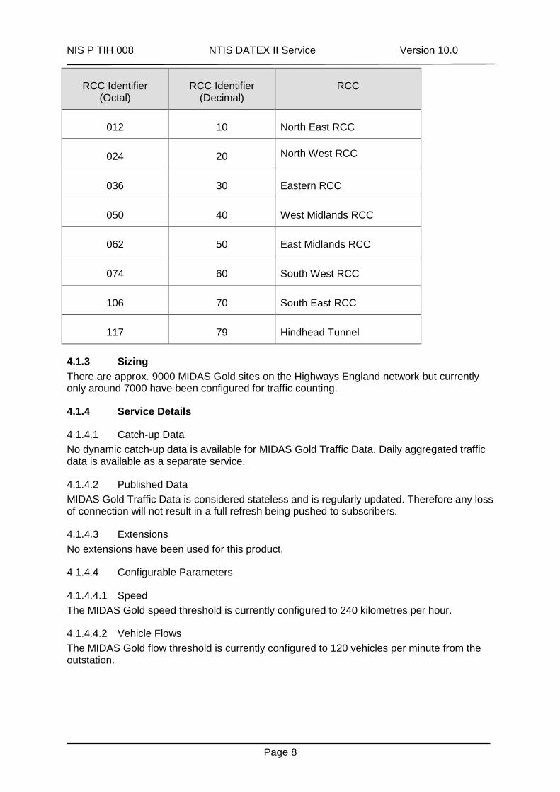
NIS P TIH 008 NTIS DATEX II Service Version 10.0
Page 8
RCC Identifier (Octal)
RCC Identifier (Decimal)
RCC
012 10 North East RCC
024 20 North West RCC
036 30 Eastern RCC
050 40 West Midlands RCC
062 50 East Midlands RCC
074 60 South West RCC
106 70 South East RCC
117 79 Hindhead Tunnel
4.1.3 Sizing
There are approx. 9000 MIDAS Gold sites on the Highways England network but currently only around 7000 have been configured for traffic counting.
4.1.4 Service Details
4.1.4.1 Catch-up Data
No dynamic catch-up data is available for MIDAS Gold Traffic Data. Daily aggregated traffic data is available as a separate service.
4.1.4.2 Published Data
MIDAS Gold Traffic Data is considered stateless and is regularly updated. Therefore any loss of connection will not result in a full refresh being pushed to subscribers.
4.1.4.3 Extensions
No extensions have been used for this product.
4.1.4.4 Configurable Parameters
4.1.4.4.1 Speed
The MIDAS Gold speed threshold is currently configured to 240 kilometres per hour.
4.1.4.4.2 Vehicle Flows
The MIDAS Gold flow threshold is currently configured to 120 vehicles per minute from the outstation.
NIS P TIH 008 NTIS DATEX II Service Version 10.0
Page 9
4.2 Journey Times
NTIS collects journey time data from ANPR cameras every 5 minutes and then publishes them within one minute of collection.
4.2.1 Journey Times Format
Please refer to reference 1 for details of the data to be published.
4.2.2 Further Information
4.2.2.1 Publication Time
The time and date that the message was published by the NTIS system in ISO8601 format. The time zone offset will be +01:00 in BST and Z in GMT.
4.2.3 Sizing
There are approx. 1100 ANPR camera sites on Highways England’s network contributing to approx. 1300 ANPR routes.
4.2.4 Service Details
4.2.4.1 Catch-up Data
Historical data is locally buffered by the ANPR outstations whenever a communication link to the NTIS system is unavailable. When communications are re-established, the historical catch-up data is sent to the NTIS system and subsequently published. A subscriber can choose to receive catch-up data if required.
4.2.4.2 Published Data
ANPR data is considered stateless and is regularly updated. Therefore any loss of connection will not result in a full refresh being pushed to subscribers.
4.2.4.3 Extensions
No extensions have been used for this product.
4.2.4.4 Configurable Parameters
There are no system configurable parameters for this product.
NIS P TIH 008 NTIS DATEX II Service Version 10.0
Page 10
4.3 TMU Traffic Data
NTIS collects traffic data from Highways England’s TMU equipment every 5 minutes. TMU data including speed, flows, occupancy and headway is reported on a per site basis; averaged across all lanes of the carriageway.
4.3.1 TMU Traffic Data Format
Please refer to reference 1 for details of the data to be published.
4.3.2 Further Information
4.3.2.1 Publication Time
The time and date that the message was published by the NTIS system in ISO8601 format. The time zone offset will be +01:00 in BST and Z in GMT.
4.3.2.2 Vehicle Flows
The vehicle flows (in vehicles per hour) for individual vehicle lengths are determined by loops. The categorised vehicle flows for all monitored lanes are summed, converted from the vehicles per minute value reported by the site/outstation and reported for the carriageway. The vehicle length categories are: Category 1 <=5.2m Category 2 >5.2m and <=6.6m Category 3 >6.6m and <=11.6m Category 4 >11.6m or Category 5 Total flow Each TMU site may have two loops installed in the road surface. If one loop is faulty, the site is unable to categorise vehicle lengths or determine speed but total flow is reported in Category 5. Occupancy and Headway can still be determined. The message will either contain the 4 vehicle length-specific values or the aggregated flow value. Some TMU sites may use radar or other alternative technology to inductive loops.
4.3.3 Sizing
There are approx. 1500 Traffic Monitoring Unit outstations monitoring both the main carriageway and slip roads at strategic points on Highways England’s network (approx. 2200 TMU sites).
4.3.4 Service Detail
4.3.4.1 Catch-up Data
Historical data is locally buffered by the TMU outstations for up to 7 days whenever a communication link to the NTIS system is unavailable. When communications are re-established, the historical catch-up data is sent to the NTIS system and subsequently published. A subscriber can choose to receive catch-up data if required.
4.3.4.2 Published Data
TMU Traffic Data is considered stateless and is regularly updated. Therefore any loss of connection will not result in a full refresh being pushed to subscribers.
4.3.4.3 Extensions
No extensions have been used for this product.
NIS P TIH 008 NTIS DATEX II Service Version 10.0
Page 11
4.3.4.4 Configurable Parameters
4.3.4.4.1 Speed
The TMU speed threshold is currently configured to 240 kilometres per hour.
4.3.4.4.2 Vehicle Flows
The TMU flow threshold is currently configured to 120 vehicles per minute from the outstation.
NIS P TIH 008 NTIS DATEX II Service Version 10.0
Page 12
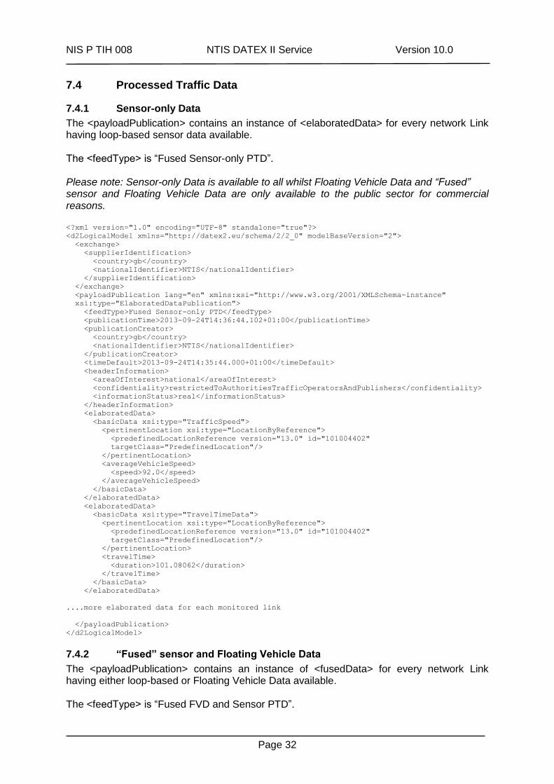
4.4 Processed Traffic Data
NTIS collects traffic data from various sensors and makes them available in isolation or as “fused” services. The processed data is averaged across all lanes of the carriageway and reported on a per network link basis every minute. Please note: Sensor-only Data is available to all whilst “Fused” sensor and Floating Vehicle Data is only available to the public sector for non-commercial use.
4.4.1 Sensor-only Data Format
Sensor-only data is that which has been collected from sensors on the road including data from MIDAS Gold sites every minute and from TMU and ANPR equipment every 5 minutes. Data such as speed, flows, occupancy, headway and travel times is processed and reported on a per network link basis rather than in previous publications (in raw format) on a per site basis. Please refer to reference 1 for details of the data to be published.
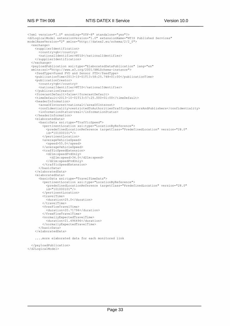
4.4.2 “Fused” sensor and Floating Vehicle Data Format
This publication includes data “fused” from both sensors and Floating Vehicle Data and reports speed and journey times on a per network link basis. Please refer to reference 1 for details of the data to be published.
4.4.3 Further Information
4.4.3.1 Publication Time
The time and date that the message was published by the NTIS system in ISO8601 format. The time zone offset will be +01:00 in BST and Z in GMT.
4.4.3.2 Default Derived Time
The time and date that the data was derived by the NTIS system in ISO8601 format. The time zone offset will be +01:00 in BST and Z in GMT.
4.4.3.3 FVD average speed
This is the average vehicle speed on the Link (in kilometres per hour) based on Floating Vehicle Data only. Note: The containing element for this data item, <d2lm:speedFvdOnly>, is an NTIS-specific extension to the standard DATEXII Schema.
4.4.4 Sizing
There are currently more than 17000 links in the HA network model and this will be enhanced in future releases. Sensor-only Processed Traffic Data will be available for links having roadside traffic monitoring equipment (approx. 6000 links) whereas “Fused” sensor and FVD Processed Traffic Data will be available for most links carrying participating2 traffic.
2 Agreements with fleet vehicles, hauliers and users of in-vehicle smartphone apps.
NIS P TIH 008 NTIS DATEX II Service Version 10.0
Page 13
4.4.5 Service Detail
4.4.5.1 Catch-up Data
No dynamic catch-up data is available for Processed Traffic Data. Daily aggregated traffic data is available as a separate service.
4.4.5.2 Published Data
Processed Traffic Data is considered stateless and is regularly updated. Therefore any loss of connection will not result in a full refresh being pushed to subscribers.
4.4.5.3 Extensions
An extension has been generated for the FVD average speed attribute of the “Fused” sensor and Floating Vehicle Data publication. Please refer to reference 1 for further details.
NIS P TIH 008 NTIS DATEX II Service Version 10.0
Page 14
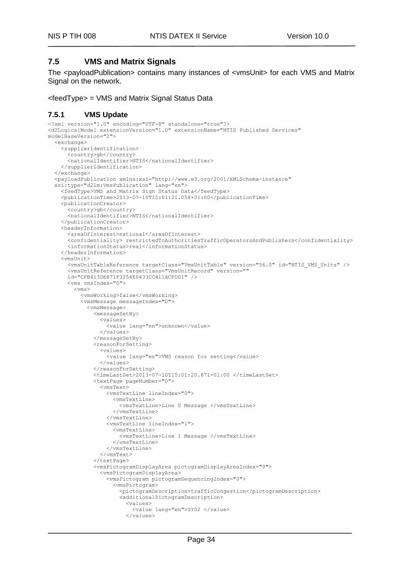
4.5 VMS and Matrix Signals
NTIS collects VMS and Matrix Signal settings using the HATMS Gateway on occurrence. The DATEXII protocol defines a Matrix Signal as a sub-type of a VMS unit. Hence, VMS and Matrix Signal status data are published in the same message, using the same DATEXII <vmsUnit> constructs. The DATEXII protocol accommodates complex VMS configurations and sequencing operations. The VMS and Matrix Signal data received by the NTIS system is significantly simpler. As a result, the following elements are only included in each containing element once, with index=0:
a. <d2lm:vms>
b. <d2lm:vmsMessage>
c. <d2lm:vmsPictogramDisplayArea>
d. <d2lm:vmsPictogram>
e. <d2lm:textPage> (VMS only)
4.5.1 VMS and Matrix Signal data Format
Please refer to reference 1 for details of the data to be published.
4.5.2 Further Information
4.5.2.1 Publication Time
The time and date that the message was published by the NTIS system in ISO8601 format. The time zone offset will be +01:00 in BST and Z in GMT.
4.5.2.1.1 Time Last Set
The time (in ISO8601 format) that the current status of the unit was set. The time zone offset will be +01:00 in BST and Z in GMT. Note that the system that supplies NTIS with Matrix Signal and VMS data does not include any source timestamps; the value is set to the time the status update was received by the NTIS system.
4.5.2.2 Pictogram Code/Pictogram Type
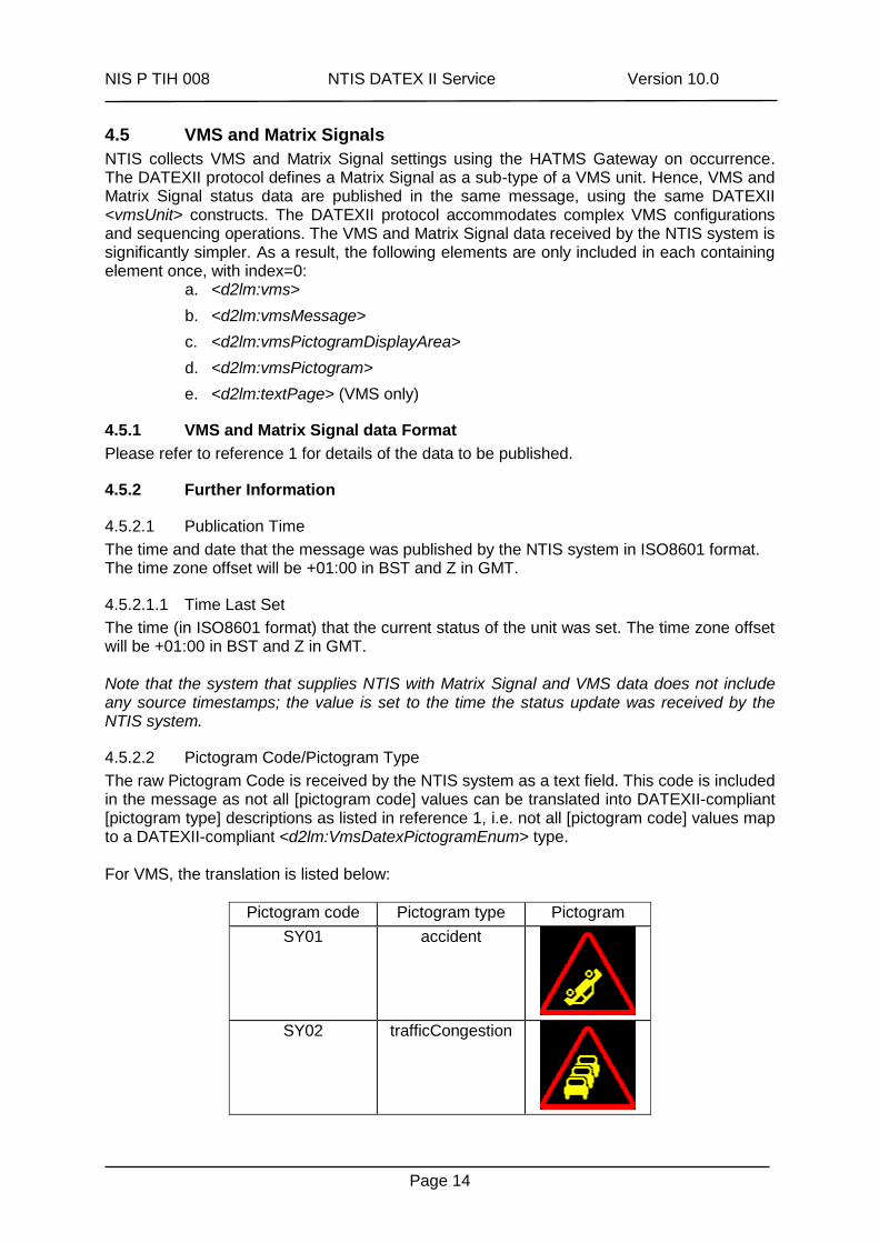
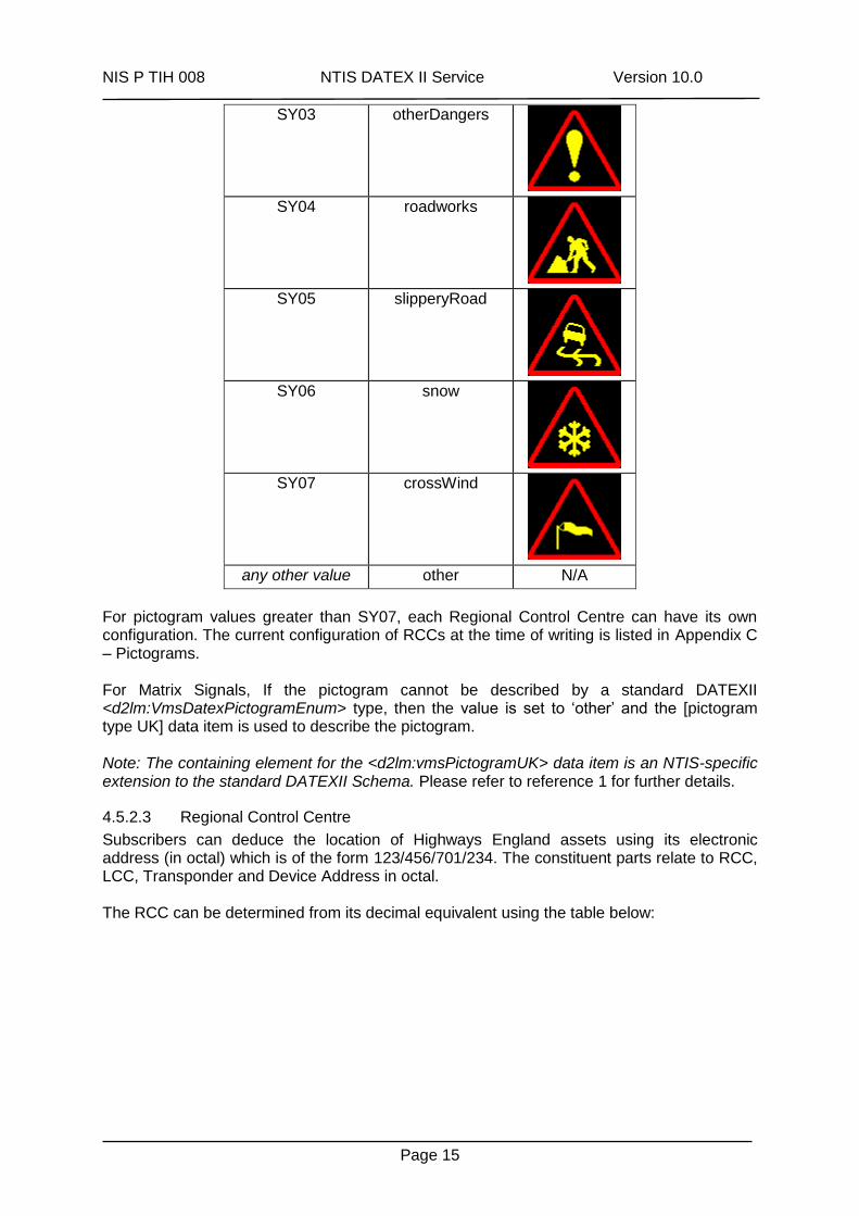
The raw Pictogram Code is received by the NTIS system as a text field. This code is included in the message as not all [pictogram code] values can be translated into DATEXII-compliant [pictogram type] descriptions as listed in reference 1, i.e. not all [pictogram code] values map to a DATEXII-compliant <d2lm:VmsDatexPictogramEnum> type. For VMS, the translation is listed below:
Pictogram code Pictogram type Pictogram
SY01 accident
SY02 trafficCongestion
NIS P TIH 008 NTIS DATEX II Service Version 10.0
Page 15
SY03 otherDangers
SY04 roadworks
SY05 slipperyRoad
SY06 snow
SY07 crossWind
any other value other N/A
For pictogram values greater than SY07, each Regional Control Centre can have its own configuration. The current configuration of RCCs at the time of writing is listed in Appendix C – Pictograms. For Matrix Signals, If the pictogram cannot be described by a standard DATEXII <d2lm:VmsDatexPictogramEnum> type, then the value is set to ‘other’ and the [pictogram type UK] data item is used to describe the pictogram. Note: The containing element for the <d2lm:vmsPictogramUK> data item is an NTIS-specific extension to the standard DATEXII Schema. Please refer to reference 1 for further details.
4.5.2.3 Regional Control Centre
Subscribers can deduce the location of Highways England assets using its electronic address (in octal) which is of the form 123/456/701/234. The constituent parts relate to RCC, LCC, Transponder and Device Address in octal. The RCC can be determined from its decimal equivalent using the table below:
NIS P TIH 008 NTIS DATEX II Service Version 10.0
Page 16
RCC Identifier (Octal)
RCC Identifier (Decimal)
RCC
012 10 North East RCC
024 20 North West RCC
036 30 Eastern RCC
050 40 West Midlands RCC
062 50 East Midlands RCC
074 60 South West RCC
106 70 South East RCC
117 79 Hindhead Tunnel
It should be noted that the RCC Identifier reported will be that of the RCC which reported the setting to NTIS and not necessarily that which originated the setting.
4.5.2.4 New Features
4.5.2.4.1 Type of VMS setting
New functionality provides more detail about the reason for a VMS setting. These can be divided into:
1.VMS that are set manually by operators at NTIS 2.VMS that are set by NTIS as part of a pre-configured strategic response plan 3.VMS that are set with Travel Time messages 4.VMS that are set by templates such as campaign messages
The translation is listed below:
Type of VMS setting DATEX II value
Manual instructionOrMessage
Strategic Response Plan trafficManagement
Travel Times on VMS (TTVMS) travelTime
Templates campaignMessage
4.5.2.4.2 Associated Event
New functionality provides the Event reference (where applicable) that caused the VMS to be set and can be used to determine all VMS set for an Event and thus the impact and geographic reach of disseminated messages for Events.
4.5.3 Sizing
There are approx. 3600 Variable Message Signs and approx. 12000 Matrix Signals on the Highways England network.
NIS P TIH 008 NTIS DATEX II Service Version 10.0
Page 17
4.5.4 Service Detail
4.5.4.1 Catch-up Data
No catch-up data is available for VMS and Matrix Signal settings.
4.5.4.2 Published Data
Please Note: HATMS pads some VMS settings with leading and trailing spaces which can appear to exceed the reported width of a VMS. To overcome this, the subscriber should remove leading and trailing spaces from the received VMS settings and then centre the message according to the reported width of the VMS. VMS and Matrix Signal settings are stateful. If the subscriber loses connection to NTIS, a full refresh of all current VMS and Matrix Signal settings will be pushed to the subscriber on successful reconnection. The Full Refresh message is identical in content, rules and formatting; the only difference is that the <d2lm:feedType> is set to the following value:
<d2lm:feedType>VMS and Matrix Signal Status Data – Full Refresh</d2lm:feedType>
4.5.4.3 Extensions
This extension is used in real-time VMSPublication payloads, specifically to extend the types of pictogram displays for Matrix Signals. The extension affects messages with the following <feedType>:
VMS and Matrix Sign Status Data
A new extension type is added to the schema to include the new VmsPictogramUK type; utilised to extend the types of Matrix pictograms to include all those utilised in the UK. <xs:complexType name="_VmsPictogramExtensionType">
<xs:sequence>
<xs:element name="vmsPictogramUK" type="D2LogicalModel:VmsPictogramUK" minOccurs="0" />
<xs:any namespace="##other" processContents="lax" minOccurs="0" maxOccurs="unbounded" />
</xs:sequence>
</xs:complexType>
The standard DATEXII VmsPictogram type is modified to use the new extension type, above <xs:complexType name="VmsPictogram">
<xs:annotation>
<xs:documentation>A main pictogram displayable on the VMS panel. Note a main pictogram may
have an associated supplementary panel which may itself contain a further pictogram and line
of text.</xs:documentation>
</xs:annotation>
<xs:sequence>
<!-- ... -->
<xs:element name="vmsPictogramExtension"
type="D2LogicalModel:_VmsPictogramExtensionType" minOccurs="0" />
</xs:sequence>
</xs:complexType>
A new complex type is created to contain the pictogram UK display types: <xs:complexType name="VmsPictogramUK">
<xs:annotation>
<xs:documentation>NTIS VMS Pictogram extension class for UK pictogram
types.</xs:documentation>
</xs:annotation>
<xs:sequence>
<xs:element name="pictogramDescriptionUK"
type="D2LogicalModel:VmsDatexPictogramEnumUK" minOccurs="1" maxOccurs="1">
<xs:annotation>
<xs:documentation>Type of UK pictogram.</xs:documentation>
</xs:annotation>
</xs:element>
</xs:sequence>
</xs:complexType>
NIS P TIH 008 NTIS DATEX II Service Version 10.0
Page 18
A new enumerate is created to include the Matrix pictogram types not included in the standard DATEXII VmsDatexPictogramEnum type: <xs:simpleType name="VmsDatexPictogramEnumUK">
<xs:annotation>
<xs:documentation>NTIS extension: includes pictogram types used in the UK, additional to
those included in the standard D2LogicalModel:VmsDatexPictogramEnum.</xs:documentation>
</xs:annotation>
<xs:restriction base="xs:string">
<xs:enumeration value="off">
<xs:annotation>
<xs:documentation>VMS is switched off.</xs:documentation>
</xs:annotation>
</xs:enumeration>
<xs:enumeration value="undefined">
<xs:annotation>
<xs:documentation>VMS has an undefined setting.</xs:documentation>
</xs:annotation>
</xs:enumeration>
<xs:enumeration value="stop">
<xs:annotation>
<xs:documentation>Stop.</xs:documentation>
</xs:annotation>
</xs:enumeration>
<xs:enumeration value="motorwayDivertLeft">
<xs:annotation>
<xs:documentation>Motorway divert left.</xs:documentation>
</xs:annotation>
</xs:enumeration>
<xs:enumeration value="motorwayDivertRight">
<xs:annotation>
<xs:documentation>Motorway divert right.</xs:documentation>
</xs:annotation>
</xs:enumeration>
<xs:enumeration value="midasOff">
<xs:annotation>
<xs:documentation>MIDAS is switched off.</xs:documentation>
</xs:annotation>
</xs:enumeration>
<xs:enumeration value="amberFlashers">
<xs:annotation>
<xs:documentation>Amber flashers are switched on.</xs:documentation>
</xs:annotation>
</xs:enumeration>
<xs:enumeration value="hardShoulderDivert">
<xs:annotation>
<xs:documentation>Divert onto hard shoulder.</xs:documentation>
</xs:annotation>
</xs:enumeration>
<xs:enumeration value="1Wicket">
<xs:annotation>
<xs:documentation>1 Wicket.</xs:documentation>
</xs:annotation>
</xs:enumeration>
<xs:enumeration value="2Wickets">
<xs:annotation>
<xs:documentation>2 Wickets.</xs:documentation>
</xs:annotation>
</xs:enumeration>
<xs:enumeration value="3Wickets">
<xs:annotation>
<xs:documentation>3 Wickets.</xs:documentation>
</xs:annotation>
</xs:enumeration>
<xs:enumeration value="4Wickets">
<xs:annotation>
<xs:documentation>4 Wickets.</xs:documentation>
</xs:annotation>
</xs:enumeration>
</xs:restriction>
</xs:simpleType>
NIS P TIH 008 NTIS DATEX II Service Version 10.0
Page 19
4.6 Events
Details of events can come from many different sources such as other Highways England systems, local authorities or other operational partners. Events will be categorised into the following types for publishing:
Unplanned
Roadworks
Major Organised events
Weather
Abnormal Indivisible Loads
4.6.1 Further Information
4.6.1.1 Confirmation Status
Although many sources of events are “trusted”, planned works are often delayed or postponed at short notice due to other factors on Highways England’s network. In order to inform subscribers of both the expected and actual times of events, all planned events will become unconfirmed before they are due to become active so that NTIS is able to “confirm” that they are taking place and can report actual start and end times. This means that events may begin as unconfirmed (the <probabilityOfOccurrence> attribute), become confirmed when details are more reliable and thus reporting expected start and end times but then return to unconfirmed before they actually affect the network. When events are confirmed as active, NTIS reports actual start times.
4.6.1.2 New Features
4.6.1.2.1 Event Association
New functionality provides more detail about the association between Events by specifying whether an Event is “Caused By” or “Related To” another Event (see SituationExtension below). Also, the associated event’s reference is provided in addition to its identifier.
4.6.2 Sizing
There is likely to be around 2000 to 3000 planned events imported into NTIS at any time including roadworks, sporting events and weather conditions. There is also likely to be several hundred unplanned events created each day consisting of congestion and other incidents.
4.6.3 Service Detail
4.6.3.1 Catch-up Data
No catch-up data is available for Events.
4.6.3.2 Published Data
Events are stateful. If the subscriber loses connection to NTIS, a full refresh of all current Events will be pushed to the subscriber on successful reconnection. The Full Refresh message is identical in content, rules and formatting; the only difference is that the <d2lm:feedType> is set to the following value:
<d2lm:feedType>Event Data – Full Refresh</d2lm:feedType>
NIS P TIH 008 NTIS DATEX II Service Version 10.0
Page 20
4.6.3.3 Extensions
Several new NTIS-specific extensions have been created to describe all of the information collected by NTIS.
4.6.3.3.1 DelaysExtension
Used to provide values of delay over freeflow conditions.
4.6.3.3.2 ImpactExtension
Used to provide details about impact on the road such as changes in capacity, damage to infrastructure and expected times for the road conditions to return to normal.
4.6.3.3.3 ManagementExtension
Used to provide details about Police Forces in charge, Emergency Services attending, vehicles involved etc.
4.6.3.3.4 SituationExtension
Used to provide details about Events having direct or indirect dependencies. For example, a direct “causeAssociation” dependency could be Congestion caused by an Accident on the same carriageway whereas an indirect “relatedAssociation” dependency could be congestion on the opposite carriageway to an Accident.
NIS P TIH 008 NTIS DATEX II Service Version 10.0
Page 21
4.7 Network Model Update Notification
Subscribers can choose to receive notifications of update to the Network and Asset Model via the DATEX II web service. Once received, subscribers can collect the latest network model from either the website or programmatically via the web service.
4.7.1 Network Model Update Notification Format
Please refer to reference 1 for details of the data to be published in this notification.
4.7.2 Further Information
4.7.2.1 Publication Time
The time and date that the message was published by the NTIS system in ISO8601 format. The time zone offset will be +01:00 in BST and Z in GMT.
4.7.2.2 NTIS Model Publication Time
The time and date (in ISO8601 format) that this version of the published NTIS Network and Asset Model was generated and made available via the NTIS Model website and web service. The time zone offset will be +01:00 in BST and Z in GMT.
4.7.2.3 Network Model Access
The Network and Asset Model can be obtained from either the website or programmatically via the web service. The website contains the last 10 network model files allowing users to identify the differences if required. Credentials will be supplied upon registration. You can use the same credentials to access the web service. The web service allows only the current network model to be downloaded. See section 4.8 for details on accessing the Network and Asset Model.
4.7.3 Sizing
The Network and Asset Model contains details of both the Highways England’s network and assets. The network changes at approx. 6-monthly intervals whilst the assets change at approx. 2-weekly intervals. A Network Model Update Notification will be published when either part of the network model changes.
4.7.4 Service Detail
4.7.4.1 Catch-up Data
No catch-up data is available for Network Model Update Notifications.
4.7.4.2 Published Data
Network Model Update Notifications are considered stateless. Therefore any loss of connection will not result in a full refresh being pushed to subscribers.
4.7.4.3 Extensions
An extension has been generated for the Network Model Update Notification publication. Please refer to reference 1 for further details.
NIS P TIH 008 NTIS DATEX II Service Version 10.0
Page 22
4.8 Network and Asset Model
This Network and Asset Model contains details and location of roadside assets including MIDAS Gold sites, ANPR Camera sites, ANPR Routes, TMU sites, VMS and Matrix Signals and details of the Network Model including Links, Link shapes and Nodes. The data is detailed in 3 separate XML files in DATEX II v2.0 format of the form:
NTISModel-MeasurementSites-yyyy-MM-dd-vnn.n.xml
NTISModel-PredefinedLocations-yyyy-MM-dd-vnn.n.xml
NTISModel-VMSTables-yyyy-MM-dd-vnn.n.xml The XML files are compressed in .Zip format with a filename of the form:
NTISModel-yyyy-MM-dd-vnn.n.zip where yyyy-MM-dd is the date of publishing and vnn.n is the version of the file. See reference 2 for details of the Network and Asset Model.
4.8.1 Obtaining the Network and Asset Model
The Network and Asset Model export is available from both a website and a web service. The website allows subscribers to download any of the last 10 network models in order to determine the changes. The web service allows subscribers to download the current network model programmatically in order to locate new equipment as soon as it is commissioned. Your access credentials for the website and web service will be supplied upon registration.
4.8.1.1 Network Model website
The URL of the Network Model website is https://trafficengland.info/subscriberportal.
4.8.1.2 Network Model web service
In future releases, the DATEX II service will “push” a notification to subscribers that the Network and Asset Model has changed. In the meantime, the latest export can be requested manually via the web service. During testing we have used the open-source “curl” command as follows: curl -OJ --trace-ascii http.txt
https://<username>:<password>@trafficengland.info/app/ntismodel/currentmodel
4.8.2 Network and Asset Model (MeasurementSites) Format
This publication describes the following assets:
Details and locations of MIDAS Gold sites on Highways England roads
Details and locations of TAME sites on Highways England roads (not published in real-time – data collected daily)
Details and locations of TMU sites on Highways England roads
Details and locations of ANPR Cameras on Highways England roads
4.8.3 Further Information
4.8.3.1 Regional Control Centre
Subscribers can deduce the location of Highways England assets using its electronic address (in octal) which is of the form 123/456/701/234. The constituent parts relate to RCC, LCC, Transponder and Device Address in octal. The RCC can be determined from its decimal equivalent using the table below:
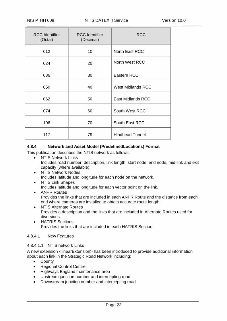
NIS P TIH 008 NTIS DATEX II Service Version 10.0
Page 23
RCC Identifier (Octal)
RCC Identifier (Decimal)
RCC
012 10 North East RCC
024 20 North West RCC
036 30 Eastern RCC
050 40 West Midlands RCC
062 50 East Midlands RCC
074 60 South West RCC
106 70 South East RCC
117 79 Hindhead Tunnel
4.8.4 Network and Asset Model (PredefinedLocations) Format
This publication describes the NTIS network as follows:
NTIS Network Links Includes road number, description, link length, start node, end node, mid-link and exit capacity (where available).
NTIS Network Nodes Includes latitude and longitude for each node on the network.
NTIS Link Shapes Includes latitude and longitude for each vector point on the link.
ANPR Routes Provides the links that are included in each ANPR Route and the distance from each end where cameras are installed to obtain accurate route length.
NTIS Alternate Routes Provides a description and the links that are included in Alternate Routes used for diversions.
HATRIS Sections Provides the links that are included in each HATRIS Section.
4.8.4.1 New Features
4.8.4.1.1 NTIS network Links
A new extension <linearExtension> has been introduced to provide additional information about each link in the Strategic Road Network including:
County
Regional Control Centre
Highways England maintenance area
Upstream junction number and intercepting road
Downstream junction number and intercepting road
NIS P TIH 008 NTIS DATEX II Service Version 10.0
Page 24
4.8.5 Network and Asset Model (VMSTables) Format
This publication describes the following assets:
Details and locations of VMS on Highways England roads
Details and locations of Matrix Signals on Highways England roads
4.8.6 Further Information
4.8.6.1 Regional Control Centre
Subscribers can deduce the location of Highways England assets using its electronic address (in octal) which is of the form 123/456/701/234. The constituent parts relate to RCC, LCC, Transponder and Device Address in octal. The RCC can be determined from its decimal equivalent using the table below:
RCC Identifier (Octal)
RCC Identifier (Decimal)
RCC
012 10 North East RCC
024 20 North West RCC
036 30 Eastern RCC
050 40 West Midlands RCC
062 50 East Midlands RCC
074 60 South West RCC
106 70 South East RCC
117 79 Hindhead Tunnel
It should be noted that the RCC Identifier reported will be that of the RCC which reported the setting to NTIS and not necessarily that which originated the setting.
NIS P TIH 008 NTIS DATEX II Service Version 10.0
Page 25
5 Help and Assistance NTIS can provide help and advice to anyone wishing to subscribe to the data services and would encourage everyone considering this approach to discuss their requirements with us before embarking on development.
Software developers can find sample code in Java and ASP .Net and instructions to interface to new NTIS services on the GitHub website at https://github.com/ntisservices.
5.1 Helpdesk
The NTIS Helpdesk is available to request assistance or report service issues by email to [email protected]. Emails concerning the DATEX II Service must be marked “DATEX II Service Problem” in the subject field.
Subscribers can register using the Traffic England website. Subscriptions will be set up on an individual basis and all access to NTIS data will be recorded. Specific connection details and user credentials will be provided as part of the subscription process.
Once approved, subscribers can request changes to their subscriptions or restrict data to required geographical areas using the Traffic England website.
5.2 Documentation
Full details and documentation for the services can be found on the subscriber pages of the Traffic England website at http://trafficengland.com/subscribers.
NIS P TIH 008 NTIS DATEX II Service Version 10.0
Page 26
6 Appendix A – Example XML (Legacy NTCC Services) All legacy services have now been replaced by new DATEX II web services providing better quality, more timely data.
NIS P TIH 008 NTIS DATEX II Service Version 10.0
Page 27
7 Appendix B – Example XML (New NTIS Services)
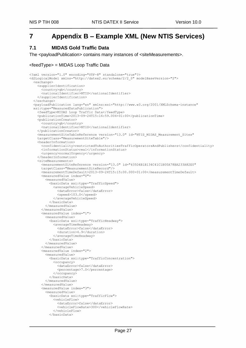
7.1 MIDAS Gold Traffic Data
The <payloadPublication> contains many instances of <siteMeasurements>. <feedType> = MIDAS Loop Traffic Data <?xml version="1.0" encoding="UTF-8" standalone="true"?>
<d2LogicalModel xmlns="http://datex2.eu/schema/2/2_0" modelBaseVersion="2">
<exchange>
<supplierIdentification>
<country>gb</country>
<nationalIdentifier>NTIS</nationalIdentifier>
</supplierIdentification>
</exchange>
<payloadPublication lang="en" xmlns:xsi="http://www.w3.org/2001/XMLSchema-instance"
xsi:type="MeasuredDataPublication">
<feedType>MIDAS Loop Traffic Data</feedType>
<publicationTime>2013-09-24T15:16:59.004+01:00</publicationTime>
<publicationCreator>
<country>gb</country>
<nationalIdentifier>NTIS</nationalIdentifier>
</publicationCreator>
<measurementSiteTableReference version="13.0" id="NTIS_MIDAS_Measurement_Sites"
targetClass="MeasurementSiteTable"/>
<headerInformation>
<confidentiality>restrictedToAuthoritiesTrafficOperatorsAndPublishers</confidentiality>
<informationStatus>real</informationStatus>
<urgency>normalUrgency</urgency>
</headerInformation>
<siteMeasurements>
<measurementSiteReference version="13.0" id="435D4B1B134C41C1B00A78BA233A82E0"
targetClass="MeasurementSiteRecord"/>
<measurementTimeDefault>2013-09-24T15:15:00.000+01:00</measurementTimeDefault>
<measuredValue index="0">
<measuredValue>
<basicData xsi:type="TrafficSpeed">
<averageVehicleSpeed>
<dataError>false</dataError>
<speed>103.0</speed>
</averageVehicleSpeed>
</basicData>
</measuredValue>
</measuredValue>
<measuredValue index="1">
<measuredValue>
<basicData xsi:type="TrafficHeadway">
<averageTimeHeadway>
<dataError>false</dataError>
<duration>4.9</duration>
</averageTimeHeadway>
</basicData>
</measuredValue>
</measuredValue>
<measuredValue index="2">
<measuredValue>
<basicData xsi:type="TrafficConcentration">
<occupancy>
<dataError>false</dataError>
<percentage>7.0</percentage>
</occupancy>
</basicData>
</measuredValue>
</measuredValue>
<measuredValue index="3">
<measuredValue>
<basicData xsi:type="TrafficFlow">
<vehicleFlow>
<dataError>false</dataError>
<vehicleFlowRate>300</vehicleFlowRate>
</vehicleFlow>
</basicData>
NIS P TIH 008 NTIS DATEX II Service Version 10.0
Page 28
</measuredValue>
</measuredValue>
<measuredValue index="4">
<measuredValue>
<basicData xsi:type="TrafficFlow">
<vehicleFlow>
<dataError>false</dataError>
<vehicleFlowRate>120</vehicleFlowRate>
</vehicleFlow>
</basicData>
</measuredValue>
</measuredValue>
<measuredValue index="5">
<measuredValue>
<basicData xsi:type="TrafficFlow">
<vehicleFlow>
<dataError>false</dataError>
<vehicleFlowRate>180</vehicleFlowRate>
</vehicleFlow>
</basicData>
</measuredValue>
</measuredValue>
<measuredValue index="6">
<measuredValue>
<basicData xsi:type="TrafficFlow">
<vehicleFlow>
<dataError>false</dataError>
<vehicleFlowRate>120</vehicleFlowRate>
</vehicleFlow>
</basicData>
</measuredValue>
</measuredValue>
....more measured values for each monitored lane
</siteMeasurements>
</payloadPublication>
</d2LogicalModel>
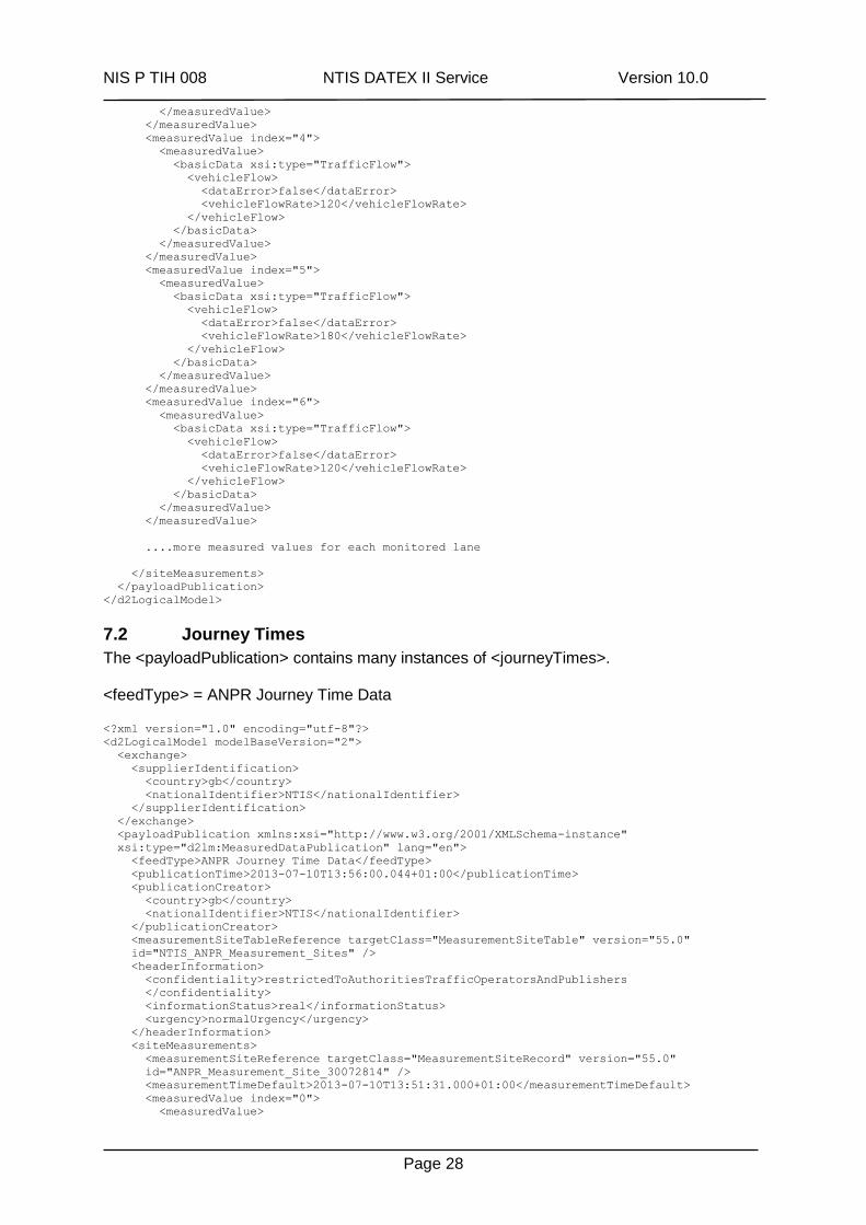
7.2 Journey Times
The <payloadPublication> contains many instances of <journeyTimes>. <feedType> = ANPR Journey Time Data <?xml version="1.0" encoding="utf-8"?>
<d2LogicalModel modelBaseVersion="2">
<exchange>
<supplierIdentification>
<country>gb</country>
<nationalIdentifier>NTIS</nationalIdentifier>
</supplierIdentification>
</exchange>
<payloadPublication xmlns:xsi="http://www.w3.org/2001/XMLSchema-instance"
xsi:type="d2lm:MeasuredDataPublication" lang="en">
<feedType>ANPR Journey Time Data</feedType>
<publicationTime>2013-07-10T13:56:00.044+01:00</publicationTime>
<publicationCreator>
<country>gb</country>
<nationalIdentifier>NTIS</nationalIdentifier>
</publicationCreator>
<measurementSiteTableReference targetClass="MeasurementSiteTable" version="55.0"
id="NTIS_ANPR_Measurement_Sites" />
<headerInformation>
<confidentiality>restrictedToAuthoritiesTrafficOperatorsAndPublishers
</confidentiality>
<informationStatus>real</informationStatus>
<urgency>normalUrgency</urgency>
</headerInformation>
<siteMeasurements>
<measurementSiteReference targetClass="MeasurementSiteRecord" version="55.0"
id="ANPR_Measurement_Site_30072814" />
<measurementTimeDefault>2013-07-10T13:51:31.000+01:00</measurementTimeDefault>
<measuredValue index="0">
<measuredValue>
NIS P TIH 008 NTIS DATEX II Service Version 10.0
Page 29
<basicData xsi:type="TravelTimeData">
<travelTime>
<dataError>false</dataError>
<duration>43.0</duration>
</travelTime>
</basicData>
</measuredValue>
</measuredValue>
</siteMeasurements>
....more measured values for each ANPR Route
</payloadPublication>
</d2LogicalModel>
NIS P TIH 008 NTIS DATEX II Service Version 10.0
Page 30
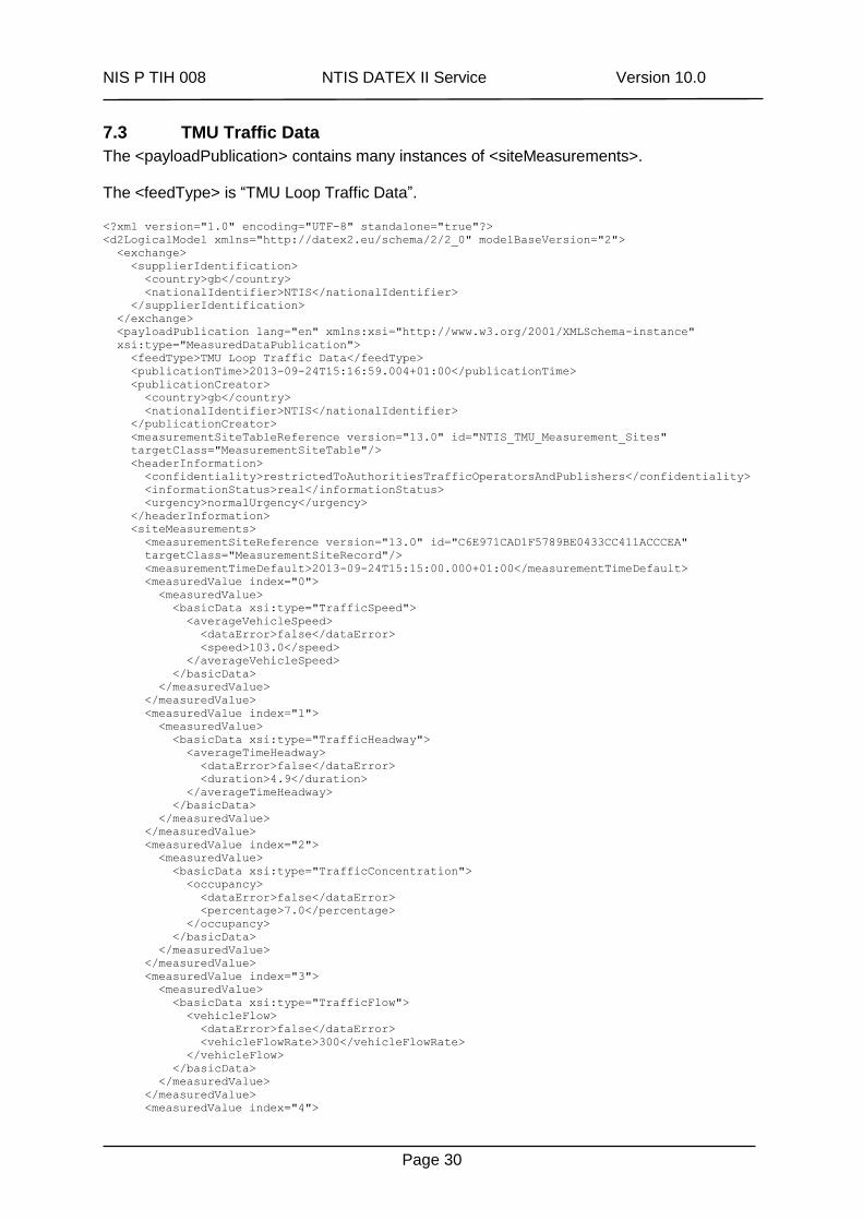
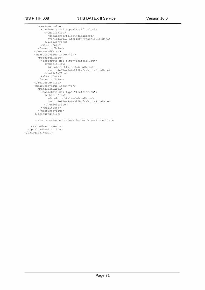
7.3 TMU Traffic Data
The <payloadPublication> contains many instances of <siteMeasurements>. The <feedType> is “TMU Loop Traffic Data”. <?xml version="1.0" encoding="UTF-8" standalone="true"?>
<d2LogicalModel xmlns="http://datex2.eu/schema/2/2_0" modelBaseVersion="2">
<exchange>
<supplierIdentification>
<country>gb</country>
<nationalIdentifier>NTIS</nationalIdentifier>
</supplierIdentification>
</exchange>
<payloadPublication lang="en" xmlns:xsi="http://www.w3.org/2001/XMLSchema-instance"
xsi:type="MeasuredDataPublication">
<feedType>TMU Loop Traffic Data</feedType>
<publicationTime>2013-09-24T15:16:59.004+01:00</publicationTime>
<publicationCreator>
<country>gb</country>
<nationalIdentifier>NTIS</nationalIdentifier>
</publicationCreator>
<measurementSiteTableReference version="13.0" id="NTIS_TMU_Measurement_Sites"
targetClass="MeasurementSiteTable"/>
<headerInformation>
<confidentiality>restrictedToAuthoritiesTrafficOperatorsAndPublishers</confidentiality>
<informationStatus>real</informationStatus>
<urgency>normalUrgency</urgency>
</headerInformation>
<siteMeasurements>
<measurementSiteReference version="13.0" id="C6E971CAD1F5789BE0433CC411ACCCEA"
targetClass="MeasurementSiteRecord"/>
<measurementTimeDefault>2013-09-24T15:15:00.000+01:00</measurementTimeDefault>
<measuredValue index="0">
<measuredValue>
<basicData xsi:type="TrafficSpeed">
<averageVehicleSpeed>
<dataError>false</dataError>
<speed>103.0</speed>
</averageVehicleSpeed>
</basicData>
</measuredValue>
</measuredValue>
<measuredValue index="1">
<measuredValue>
<basicData xsi:type="TrafficHeadway">
<averageTimeHeadway>
<dataError>false</dataError>
<duration>4.9</duration>
</averageTimeHeadway>
</basicData>
</measuredValue>
</measuredValue>
<measuredValue index="2">
<measuredValue>
<basicData xsi:type="TrafficConcentration">
<occupancy>
<dataError>false</dataError>
<percentage>7.0</percentage>
</occupancy>
</basicData>
</measuredValue>
</measuredValue>
<measuredValue index="3">
<measuredValue>
<basicData xsi:type="TrafficFlow">
<vehicleFlow>
<dataError>false</dataError>
<vehicleFlowRate>300</vehicleFlowRate>
</vehicleFlow>
</basicData>
</measuredValue>
</measuredValue>
<measuredValue index="4">
NIS P TIH 008 NTIS DATEX II Service Version 10.0
Page 31
<measuredValue>
<basicData xsi:type="TrafficFlow">
<vehicleFlow>
<dataError>false</dataError>
<vehicleFlowRate>120</vehicleFlowRate>
</vehicleFlow>
</basicData>
</measuredValue>
</measuredValue>
<measuredValue index="5">
<measuredValue>
<basicData xsi:type="TrafficFlow">
<vehicleFlow>
<dataError>false</dataError>
<vehicleFlowRate>180</vehicleFlowRate>
</vehicleFlow>
</basicData>
</measuredValue>
</measuredValue>
<measuredValue index="6">
<measuredValue>
<basicData xsi:type="TrafficFlow">
<vehicleFlow>
<dataError>false</dataError>
<vehicleFlowRate>120</vehicleFlowRate>
</vehicleFlow>
</basicData>
</measuredValue>
</measuredValue>
....more measured values for each monitored lane
</siteMeasurements>
</payloadPublication>
</d2LogicalModel>
NIS P TIH 008 NTIS DATEX II Service Version 10.0
Page 32
7.4 Processed Traffic Data
7.4.1 Sensor-only Data
The <payloadPublication> contains an instance of <elaboratedData> for every network Link having loop-based sensor data available. The <feedType> is “Fused Sensor-only PTD”. Please note: Sensor-only Data is available to all whilst Floating Vehicle Data and “Fused” sensor and Floating Vehicle Data are only available to the public sector for commercial reasons. <?xml version="1.0" encoding="UTF-8" standalone="true"?>
<d2LogicalModel xmlns="http://datex2.eu/schema/2/2_0" modelBaseVersion="2">
<exchange>
<supplierIdentification>
<country>gb</country>
<nationalIdentifier>NTIS</nationalIdentifier>
</supplierIdentification>
</exchange>
<payloadPublication lang="en" xmlns:xsi="http://www.w3.org/2001/XMLSchema-instance"
xsi:type="ElaboratedDataPublication">
<feedType>Fused Sensor-only PTD</feedType>
<publicationTime>2013-09-24T14:36:44.102+01:00</publicationTime>
<publicationCreator>
<country>gb</country>
<nationalIdentifier>NTIS</nationalIdentifier>
</publicationCreator>
<timeDefault>2013-09-24T14:35:44.000+01:00</timeDefault>
<headerInformation>
<areaOfInterest>national</areaOfInterest>
<confidentiality>restrictedToAuthoritiesTrafficOperatorsAndPublishers</confidentiality>
<informationStatus>real</informationStatus>
</headerInformation>
<elaboratedData>
<basicData xsi:type="TrafficSpeed">
<pertinentLocation xsi:type="LocationByReference">
<predefinedLocationReference version="13.0" id="101004402"
targetClass="PredefinedLocation"/>
</pertinentLocation>
<averageVehicleSpeed>
<speed>92.0</speed>
</averageVehicleSpeed>
</basicData>
</elaboratedData>
<elaboratedData>
<basicData xsi:type="TravelTimeData">
<pertinentLocation xsi:type="LocationByReference">
<predefinedLocationReference version="13.0" id="101004402"
targetClass="PredefinedLocation"/>
</pertinentLocation>
<travelTime>
<duration>101.08062</duration>
</travelTime>
</basicData>
</elaboratedData>
....more elaborated data for each monitored link
</payloadPublication>
</d2LogicalModel>
7.4.2 “Fused” sensor and Floating Vehicle Data
The <payloadPublication> contains an instance of <fusedData> for every network Link having either loop-based or Floating Vehicle Data available. The <feedType> is “Fused FVD and Sensor PTD”.
NIS P TIH 008 NTIS DATEX II Service Version 10.0
Page 33
<?xml version="1.0" encoding="UTF-8" standalone="yes"?>
<d2LogicalModel extensionVersion="1.0" extensionName="NTIS Published Services"
modelBaseVersion="2" xmlns="http://datex2.eu/schema/2/2_0">
<exchange>
<supplierIdentification>
<country>gb</country>
<nationalIdentifier>NTIS</nationalIdentifier>
</supplierIdentification>
</exchange>
<payloadPublication xsi:type="ElaboratedDataPublication" lang="en"
xmlns:xsi="http://www.w3.org/2001/XMLSchema-instance">
<feedType>Fused FVD and Sensor PTD</feedType>
<publicationTime>2013-10-01T13:58:25.748+01:00</publicationTime>
<publicationCreator>
<country>gb</country>
<nationalIdentifier>NTIS</nationalIdentifier>
</publicationCreator>
<forecastDefault>false</forecastDefault>
<timeDefault>2013-10-01T13:57:25.000+01:00</timeDefault>
<headerInformation>
<areaOfInterest>national</areaOfInterest>
<confidentiality>restrictedToAuthoritiesTrafficOperatorsAndPublishers</confidentiality>
<informationStatus>real</informationStatus>
</headerInformation>
<elaboratedData>
<basicData xsi:type="TrafficSpeed">
<pertinentLocation xsi:type="LocationByReference">
<predefinedLocationReference targetClass="PredefinedLocation" version="28.0"
id="101000101"/>
</pertinentLocation>
<averageVehicleSpeed>
<speed>55.0</speed>
</averageVehicleSpeed>
<trafficSpeedExtension>
<d2lm:speedFvdOnly>
<d2lm:speed>34.0</d2lm:speed>
</d2lm:speedFvdOnly>
</trafficSpeedExtension>
</basicData>
</elaboratedData>
<elaboratedData>
<basicData xsi:type="TravelTimeData">
<pertinentLocation xsi:type="LocationByReference">
<predefinedLocationReference targetClass="PredefinedLocation" version="28.0"
id="101000101"/>
</pertinentLocation>
<travelTime>
<duration>25.0</duration>
</travelTime>
<freeFlowTravelTime>
<duration>20.71794</duration>
</freeFlowTravelTime>
<normallyExpectedTravelTime>
<duration>21.496496</duration>
</normallyExpectedTravelTime>
</basicData>
</elaboratedData>
....more elaborated data for each monitored link
</payloadPublication>
</d2LogicalModel>
NIS P TIH 008 NTIS DATEX II Service Version 10.0
Page 34
7.5 VMS and Matrix Signals
The <payloadPublication> contains many instances of <vmsUnit> for each VMS and Matrix Signal on the network. <feedType> = VMS and Matrix Signal Status Data
7.5.1 VMS Update <?xml version="1.0" encoding="UTF-8" standalone="true"?>
<d2LogicalModel extensionVersion="1.0" extensionName="NTIS Published Services"
modelBaseVersion="2">
<exchange>
<supplierIdentification>
<country>gb</country>
<nationalIdentifier>NTIS</nationalIdentifier>
</supplierIdentification>
</exchange>
<payloadPublication xmlns:xsi="http://www.w3.org/2001/XMLSchema-instance"
xsi:type="d2lm:VmsPublication" lang="en">
<feedType>VMS and Matrix Sign Status Data</feedType>
<publicationTime>2013-07-10T15:01:21.058+01:00</publicationTime>
<publicationCreator>
<country>gb</country>
<nationalIdentifier>NTIS</nationalIdentifier>
</publicationCreator>
<headerInformation>
<areaOfInterest>national</areaOfInterest>
<confidentiality> restrictedToAuthoritiesTrafficOperatorsAndPublishers</confidentiality>
<informationStatus>real</informationStatus>
</headerInformation>
<vmsUnit>
<vmsUnitTableReference targetClass="VmsUnitTable" version="56.0" id="NTIS_VMS_Units" />
<vmsUnitReference targetClass="VmsUnitRecord" version=""
id="CFB613DE871F3254E0433CC411ACFD01" />
<vms vmsIndex="0">
<vms>
<vmsWorking>false</vmsWorking>
<vmsMessage messageIndex="0">
<vmsMessage>
<messageSetBy>
<values>
<value lang="en">unknown</value>
</values>
</messageSetBy>
<reasonForSetting>
<values>
<value lang="en">VMS reason for setting</value>
</values>
</reasonForSetting>
<timeLastSet>2013-07-10T15:01:20.871+01:00 </timeLastSet>
<textPage pageNumber="0">
<vmsText>
<vmsTextLine lineIndex="0">
<vmsTextLine>
<vmsTextLine>Line 0 Message </vmsTextLine>
</vmsTextLine>
</vmsTextLine>
<vmsTextLine lineIndex="1">
<vmsTextLine>
<vmsTextLine>Line 1 Message </vmsTextLine>
</vmsTextLine>
</vmsTextLine>
</vmsText>
</textPage>
<vmsPictogramDisplayArea pictogramDisplayAreaIndex="0">
<vmsPictogramDisplayArea>
<vmsPictogram pictogramSequencingIndex="0">
<vmsPictogram>
<pictogramDescription>trafficCongestion</pictogramDescription>
<additionalPictogramDescription>
<values>
<value lang="en">SY02 </value>
</values>
NIS P TIH 008 NTIS DATEX II Service Version 10.0
Page 35
</additionalPictogramDescription>
<presenceOfRedTriangle>false </presenceOfRedTriangle>
</vmsPictogram>
</vmsPictogram>
</vmsPictogramDisplayArea>
</vmsPictogramDisplayArea>
</vmsMessage>
</vmsMessage>
</vms>
</vms>
</vmsUnit>
....more VMS equipment
</payloadPublication>
</d2LogicalModel>
7.5.2 Matrix Signal Update <?xml version="1.0" encoding="UTF-8" standalone="true"?>
<d2LogicalModel extensionVersion="1.0" extensionName="NTIS Published Services"
modelBaseVersion="2">
<exchange>
<supplierIdentification>
<country>gb</country>
<nationalIdentifier>NTIS</nationalIdentifier>
</supplierIdentification>
</exchange>
<payloadPublication xmlns:xsi="http://www.w3.org/2001/XMLSchema-instance"
xsi:type="d2lm:VmsPublication" lang="en">
<feedType>VMS and Matrix Sign Status Data</feedType>
<publicationTime>2013-07-10T15:00:21.918+01:00</publicationTime>
<publicationCreator>
<country>gb</country>
<nationalIdentifier>NTIS</nationalIdentifier>
</publicationCreator>
<headerInformation>
<areaOfInterest>national</areaOfInterest>
<confidentiality>restrictedToAuthoritiesTrafficOperatorsAndPublishers</confidentiality>
<informationStatus>real</informationStatus>
</headerInformation>
<vmsUnit>
<vmsUnitTableReference targetClass="VmsUnitTable" version="56.0" id="NTIS_Matrix_Units"
/>
<vmsUnitReference targetClass="VmsUnitRecord" version=""
id="D2509502035B7952E0433CC411ACA994" />
<vms vmsIndex="0">
<vms>
<vmsWorking>true</vmsWorking>
<vmsMessage messageIndex="0">
<vmsMessage>
<reasonForSetting>
<values>
<value lang="en">Matrix reason for setting</value>
</values>
</reasonForSetting>
<timeLastSet>2013-07-10T15:00:21.418+01:00 </timeLastSet>
<vmsPictogramDisplayArea pictogramDisplayAreaIndex="0">
<vmsPictogramDisplayArea>
<vmsPictogram pictogramSequencingIndex="0">
<vmsPictogram>
<pictogramDescription>other</pictogramDescription>
<presenceOfRedTriangle>false</presenceOfRedTriangle>
<vmsPictogramExtension>
<vmsPictogramUK>
<pictogramDescriptionUK>stop</pictogramDescriptionUK>
</vmsPictogramUK>
</vmsPictogramExtension>
</vmsPictogram>
</vmsPictogram>
</vmsPictogramDisplayArea>
</vmsPictogramDisplayArea>
</vmsMessage>
</vmsMessage>
</vms>
</vms>
NIS P TIH 008 NTIS DATEX II Service Version 10.0
Page 36
</vmsUnit>
....more Matrix Signal equipment
</payloadPublication>
</d2LogicalModel>
7.5.3 Full Refresh
<feedType> = VMS and Matrix Signal Status Data – Full Refresh
<?xml version="1.0" encoding="UTF-8" standalone="true"?>
<d2LogicalModel extensionVersion="1.0" extensionName="NTIS Published Services"
modelBaseVersion="2">
<exchange>
<supplierIdentification>
<country>gb</country>
<nationalIdentifier>NTIS</nationalIdentifier>
</supplierIdentification>
</exchange>
<payloadPublication xmlns:xsi="http://www.w3.org/2001/XMLSchema-instance"
xsi:type="d2lm:VmsPublication" lang="en">
<feedType>VMS and Matrix Sign Status Data – Full Refresh </feedType>
<publicationTime>2013-07-10T15:46:55.149+01:00</publicationTime>
<publicationCreator>
<country>gb</country>
<nationalIdentifier>NTIS</nationalIdentifier>
</publicationCreator>
<headerInformation>
<areaOfInterest>national</areaOfInterest>
<confidentiality>restrictedToAuthoritiesTrafficOperatorsAndPublishers</confidentiality>
<informationStatus>real</informationStatus>
</headerInformation>
<vmsUnit>
<vmsUnitTableReference targetClass="VmsUnitTable" version="58.0" id="NTIS_VMS_Units" />
<vmsUnitReference targetClass="VmsUnitRecord" version=""
id="CFB613DE871E3254E0433CC411ACFD01" />
</vmsUnit>
<vmsUnit>
<vmsUnitTableReference targetClass="VmsUnitTable" version="58.0" id="NTIS_VMS_Units" />
<vmsUnitReference targetClass="VmsUnitRecord" version=""
id="CFB613DE871F3254E0433CC411ACFD01" />
<vms vmsIndex="0">
<vms>
<vmsWorking>false</vmsWorking>
<vmsMessage messageIndex="0">
<vmsMessage>
<messageSetBy>
<values>
<value lang="en">unknown</value>
</values>
</messageSetBy>
<reasonForSetting>
<values>
<value lang="en">VMS reason for setting </value>
</values>
</reasonForSetting>
<timeLastSet>2013-07-10T15:01:20.000+01:00 </timeLastSet>
<textPage pageNumber="0">
<vmsText>
<vmsTextLine lineIndex="0">
<vmsTextLine>
<vmsTextLine>Line 0 Message</vmsTextLine>
</vmsTextLine>
</vmsTextLine>
<vmsTextLine lineIndex="1">
<vmsTextLine>
<vmsTextLine>Line 1 Message</vmsTextLine>
</vmsTextLine>
</vmsTextLine>
</vmsText>
</textPage>
<vmsPictogramDisplayArea pictogramDisplayAreaIndex="0">
<vmsPictogramDisplayArea>
<vmsPictogram pictogramSequencingIndex="0">
<vmsPictogram>
NIS P TIH 008 NTIS DATEX II Service Version 10.0
Page 37
<pictogramDescription> trafficCongestion</pictogramDescription>
<additionalPictogramDescription>
<values>
<value lang="en">SY02</value>
</values>
</additionalPictogramDescription>
<presenceOfRedTriangle>false</presenceOfRedTriangle>
</vmsPictogram>
</vmsPictogram>
</vmsPictogramDisplayArea>
</vmsPictogramDisplayArea>
</vmsMessage>
</vmsMessage>
</vms>
</vms>
</vmsUnit>
<vmsUnit>
<vmsUnitTableReference targetClass="VmsUnitTable" version="58.0" id="NTIS_VMS_Units" />
<vmsUnitReference targetClass="VmsUnitRecord" version=""
id="CFB613DE87C93254E0433CC411ACFD01" />
</vmsUnit>
<vmsUnit>
<vmsUnitTableReference targetClass="VmsUnitTable" version="58.0"
id="NTIS_Matrix_Units" />
<vmsUnitReference targetClass="VmsUnitRecord" version=""
id="D2509502035B7952E0433CC411ACA994" />
<vms vmsIndex="0">
<vms>
<vmsWorking>true</vmsWorking>
<vmsMessage messageIndex="0">
<vmsMessage>
<reasonForSetting>
<values>
<value lang="en">Matrix reason for setting</value>
</values>
</reasonForSetting>
<timeLastSet>2013-07-10T15:00:21.000+01:00 </timeLastSet>
<vmsPictogramDisplayArea pictogramDisplayAreaIndex="0">
<vmsPictogramDisplayArea>
<vmsPictogram pictogramSequencingIndex="0">
<vmsPictogram>
<pictogramDescription>other</pictogramDescription>
<presenceOfRedTriangle>false</presenceOfRedTriangle>
<vmsPictogramExtension>
<vmsPictogramUK>
<pictogramDescriptionUK>undefined</pictogramDescriptionUK>
</vmsPictogramUK>
</vmsPictogramExtension>
</vmsPictogram>
</vmsPictogram>
</vmsPictogramDisplayArea>
</vmsPictogramDisplayArea>
</vmsMessage>
</vmsMessage>
</vms>
</vms>
</vmsUnit>
<vmsUnit>
<vmsUnitTableReference targetClass="VmsUnitTable" version="58.0"
id="NTIS_Matrix_Units" />
<vmsUnitReference targetClass="VmsUnitRecord" version=""
id="D2509502134C7952E0433CC411ACA994" />
</vmsUnit>
etc
</payloadPublication>
</d2LogicalModel>
NIS P TIH 008 NTIS DATEX II Service Version 10.0
Page 38
7.6 Network Model Update Notification
This message is sent to subscribers whenever details of the network model or roadside assets change. The message contains the date, time and version of the new Network and Asset Model. <feedType> = NTIS Model Update Notification <?xml version="1.0" encoding="UTF-8" standalone="true"?>
<d2LogicalModel xmlns="http://datex2.eu/schema/2/2_0" extensionVersion="1.0"
extensionName="NTIS Published Services" modelBaseVersion="2">
<exchange>
<supplierIdentification>
<country>gb</country>
<nationalIdentifier>NTIS</nationalIdentifier>
</supplierIdentification>
</exchange>
<payloadPublication lang="en" xmlns:xsi="http://www.w3.org/2001/XMLSchema-instance"
xsi:type="GenericPublication">
<feedDescription>
<values>
<value lang="en">NTIS Network and Asset Reference Model: update notification</value>
<value lang="en">This publication contains details of the new version of the NTIS
Model, available for download from the NTIS system</value>
</values>
</feedDescription>
<feedType>NTIS Model Update Notification</feedType>
<publicationTime>2013-09-24T15:18:22.460+01:00</publicationTime>
<publicationCreator>
<country>gb</country>
<nationalIdentifier>NTIS</nationalIdentifier>
</publicationCreator>
<genericPublicationName>NTIS Model Update Notification</genericPublicationName>
<genericPublicationExtension>
<ntisModelVersionInformation>
<modelVersion>14.0</modelVersion>
<modelPublicationTime>2013-09-24T15:18:09.985+01:00</modelPublicationTime>
<modelFilename>NTISModel-2013-09-24-v14.0.zip</modelFilename>
</ntisModelVersionInformation>
</genericPublicationExtension>
</payloadPublication>
</d2LogicalModel>
NIS P TIH 008 NTIS DATEX II Service Version 10.0
Page 39
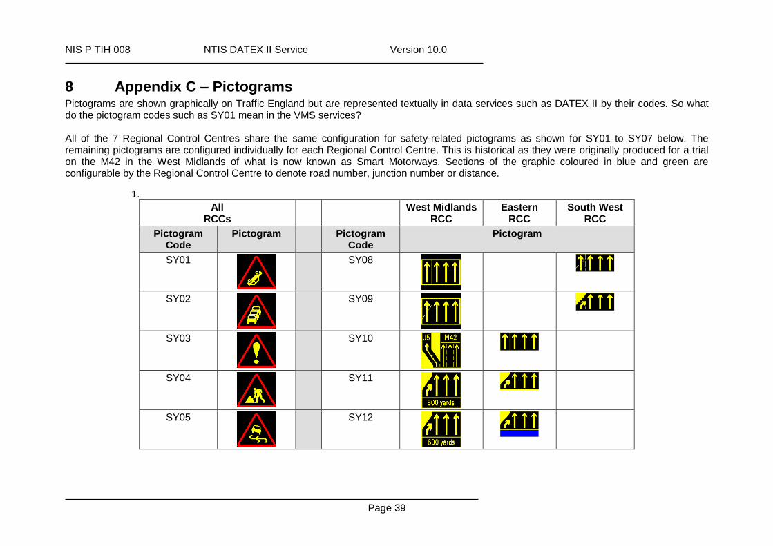
8 Appendix C – Pictograms Pictograms are shown graphically on Traffic England but are represented textually in data services such as DATEX II by their codes. So what do the pictogram codes such as SY01 mean in the VMS services? All of the 7 Regional Control Centres share the same configuration for safety-related pictograms as shown for SY01 to SY07 below. The remaining pictograms are configured individually for each Regional Control Centre. This is historical as they were originally produced for a trial on the M42 in the West Midlands of what is now known as Smart Motorways. Sections of the graphic coloured in blue and green are configurable by the Regional Control Centre to denote road number, junction number or distance.
1.
All RCCs
West Midlands RCC
Eastern RCC
South West RCC
Pictogram Code
Pictogram Pictogram Code
Pictogram
SY01
SY08
SY02
SY09
SY03
SY10
SY04
SY11
SY05
SY12
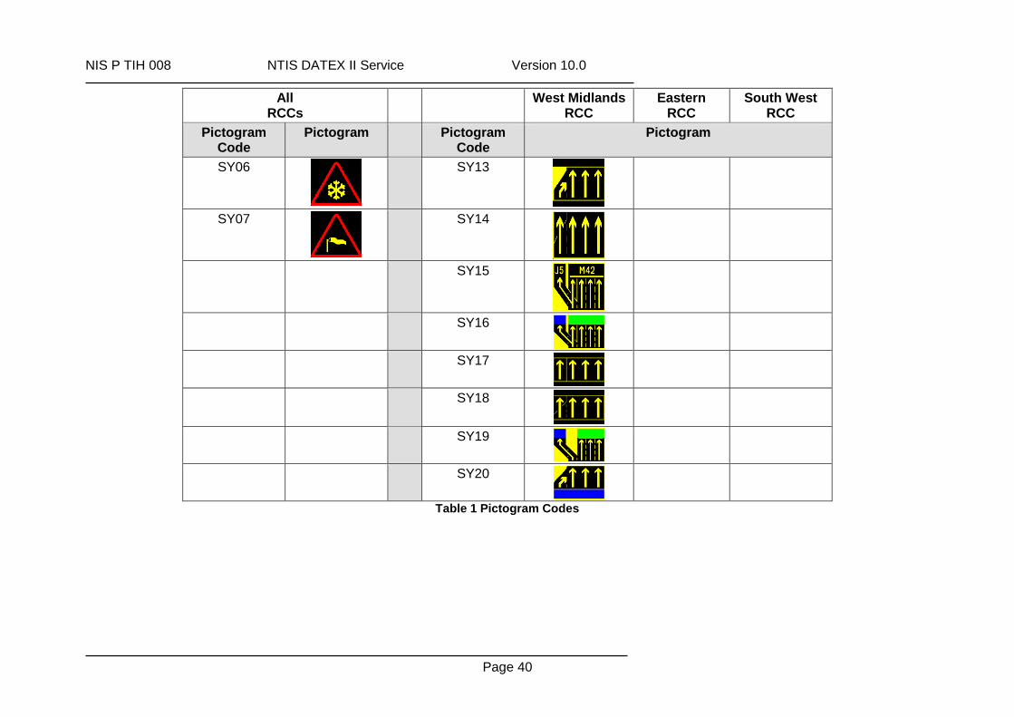
NIS P TIH 008 NTIS DATEX II Service Version 10.0
Page 40
All RCCs
West Midlands RCC
Eastern RCC
South West RCC
Pictogram Code
Pictogram Pictogram Code
Pictogram
SY06
SY13
SY07
SY14
SY15
SY16
SY17
SY18
SY19
SY20
Table 1 Pictogram Codes

NIS P TIH 008 NTIS DATEX II Service Version 10.0
Page 41


![DATEX II V2.3 SOFTWARE DEVELOPER S GUIDEd2docs.ndwcloud.nu/_static/data/v2.3/DATEXII-DevGuide.pdf · [Software developers guide] DATEX II Software developer ... [Exchange PIM] DATEX](https://img.pdfslide.net/doc/110x75/5e04a2673a74bf6b83664cc0/datex-ii-v23-software-developer-s-software-developers-guide-datex-ii-software.jpg)

![DATEX II V2.3 USER S GUIDEd2docs.ndwcloud.nu/_static/data/v2.3/DATEXII-UserGuide.pdf · [User guide] DATEX II User’s guide 2.3 30-09-2014 [Software developers guide] DATEX II Software](https://img.pdfslide.net/doc/110x75/5e728b8c324452779f1eb697/datex-ii-v23-user-s-user-guide-datex-ii-useras-guide-23-30-09-2014-software.jpg)